Embed Size (px)
Citation preview

VIIRS Cloud Mask (VCM) Validation Stage 1
Dr. Thomas Kopp – VCM Validation Lead Dr. Andrew Heidinger – Cloud Product Lead Dr. William Thomas – VCM JPSS Algorithm Manager
1

VCM Basics
• Fundamentally the VCM is a moderate band pixel-by-pixel determination of cloud cover
• As originally defined in the NPOESS system specification, it is “used in the processing of many EDRs, which classifies pixels as Confidently Clear, Confidently Cloudy, Probably Clear, and Probably Cloudy”, this logic remains in place for JPSS – The original requirements broke down the VCM performance into various
backgrounds (e.g. day/night, ocean/land/desert) and characteristics (e.g. probability of correct typing, leakage, false alarms)
– The design of the VCM also breaks down the cloud identification process by condition and background
• This logic has continued into the S-NPP and JPSS programs • The applicable JPSS Level 1 Requirements sections, including the
supplemental, are the requirements we are considering today – This is our “target”
2
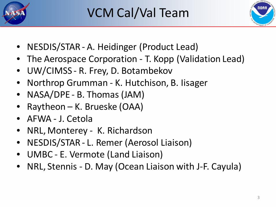
• NESDIS/STAR - A. Heidinger (Product Lead) • The Aerospace Corporation - T. Kopp (Validation Lead) • UW/CIMSS - R. Frey, D. Botambekov • Northrop Grumman - K. Hutchison, B. Iisager • NASA/DPE - B. Thomas (JAM) • Raytheon – K. Brueske (OAA) • AFWA - J. Cetola • NRL, Monterey - K. Richardson • NESDIS/STAR - L. Remer (Aerosol Liaison) • UMBC - E. Vermote (Land Liaison) • NRL, Stennis - D. May (Ocean Liaison with J-F. Cayula)
VCM Cal/Val Team
3

• The Cal/Val approach is basically a 3-legged pedestal with assistance from liaisons and program personnel – NOAA/STAR leads product development and performs large
scale analyses such as match-up comparisons – Aerospace leads the validation effort and determines when and
how threshold updates occur – Northrop Grumman leads the development of Golden Granules
and provides fundamental software support and development
• This 3-legged pedestal has been in place since 2005 • Other key contributors are our JPSS Algorithm Manager,
Raytheon (OAA) representative, and our liaisons
VCM Team Responsibilities
4
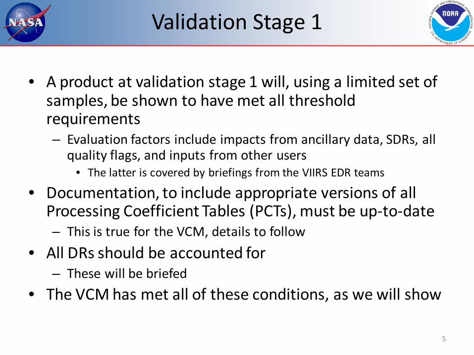
• A product at validation stage 1 will, using a limited set of samples, be shown to have met all threshold requirements – Evaluation factors include impacts from ancillary data, SDRs, all
quality flags, and inputs from other users • The latter is covered by briefings from the VIIRS EDR teams
• Documentation, to include appropriate versions of all Processing Coefficient Tables (PCTs), must be up-to-date – This is true for the VCM, details to follow
• All DRs should be accounted for – These will be briefed
• The VCM has met all of these conditions, as we will show
Validation Stage 1
5
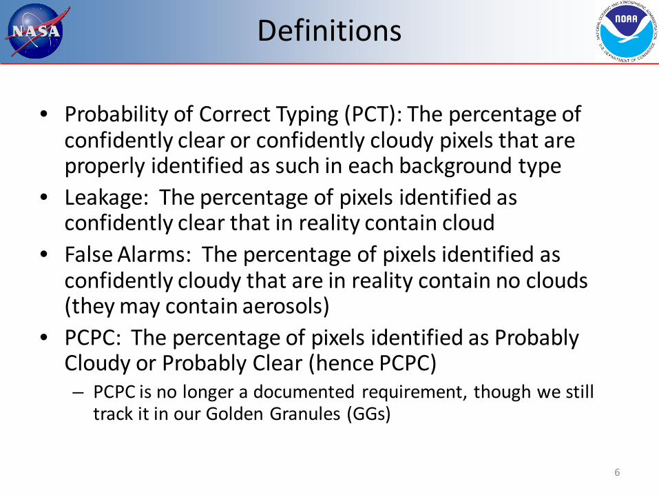
• Probability of Correct Typing (PCT): The percentage of confidently clear or confidently cloudy pixels that are properly identified as such in each background type
• Leakage: The percentage of pixels identified as confidently clear that in reality contain cloud
• False Alarms: The percentage of pixels identified as confidently cloudy that are in reality contain no clouds (they may contain aerosols)
• PCPC: The percentage of pixels identified as Probably Cloudy or Probably Clear (hence PCPC) – PCPC is no longer a documented requirement, though we still
track it in our Golden Granules (GGs)
Definitions
6

• The VCM requirements are detailed in the JPSS Level 1 requirements supplemental, section 5.3.5
• Although it does not use the word “global”, its description states “Cloud Mask describes the area of the earth’s horizontal surface that is masked by the vertical projection of detectable clouds”, making it a global product
• The VCM must also do the following (note none of the below have a quantitative value attached to them): – Determine cloud phase – Determine if a cloud is, in reality, an aerosol – Locate cloud shadows – Identify pixels that contain a fire (read in from the Fire Product)
• An older requirement for volcanic ash has been removed • Cell size is that of the Moderate bands
VCM Requirements – Part 1
7
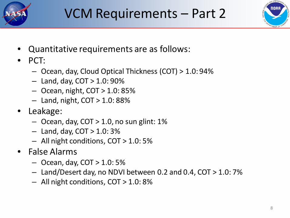
• Quantitative requirements are as follows: • PCT:
– Ocean, day, Cloud Optical Thickness (COT) > 1.0: 94% – Land, day, COT > 1.0: 90% – Ocean, night, COT > 1.0: 85% – Land, night, COT > 1.0: 88%
• Leakage: – Ocean, day, COT > 1.0, no sun glint: 1% – Land, day, COT > 1.0: 3% – All night conditions, COT > 1.0: 5%
• False Alarms – Ocean, day, COT > 1.0: 5% – Land/Desert day, no NDVI between 0.2 and 0.4, COT > 1.0: 7% – All night conditions, COT > 1.0: 8%
VCM Requirements – Part 2
8

• Quantitative requirements present some dilemmas that must be resolved up front
• Ocean requirements specifically mention “no sun glint” only for leakage, not for PCT or false alarms – VCM team interpretation is no sun glint is applicable to all ocean, day requirements
• Desert is only cited in false alarms – VCM team interprets “land” as including desert when desert is not specified
• NDVI exception is only cited for land, day, false alarms – We are ignoring this exception (more later), VCM meets the requirement under all
NDVI conditions • There are no quantitative requirements for VCM performance over snow
and ice – VCM team will still show results over these backgrounds
• All VCM requirements go towards VCM performance, no requirements were levied on the VCM explicitly for downstream EDR support – It is therefore likely that achieving VCM requirements in and of itself is not
sufficient to show the VCM is acceptable to all downstream users
VCM Requirements – Part 3
9

• The core team of NG, SSEC, and Aerospace began collaboration on the VCM in 2005
• Collective agreement was made for all software changes under the leadership of NG until the government took over the role circa 2009/2010 – Critical updates were made to numerous cloud detection tests,
cloud phase, and cloud shadows – Improvements were suggested and ultimately implemented
from all three organizations • The approach remained the same after the government
took the lead for Cal/Val and, later, the algorithms themselves
Pre-launch Work on the VCM
10

• Beta was declared after the 30-day spin-up set of threshold adjustments were implemented on the IDPS (April 2012) – 74 thresholds were adjusted during the 30 day spin up
• This implementation also opened up the VCM to analysis and critique by the other VIIRS EDR teams
• 1012 granules of VCM/MODIS/CALIPSO match-ups were produced for beta
Status at Beta
11
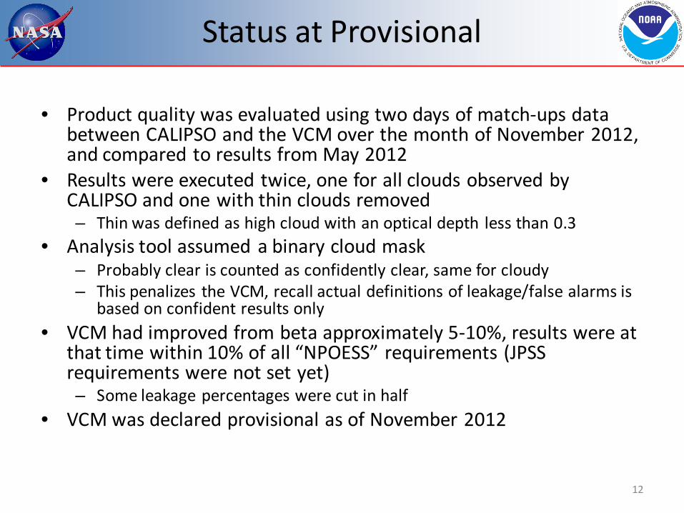
Status at Provisional
• Product quality was evaluated using two days of match-ups data between CALIPSO and the VCM over the month of November 2012, and compared to results from May 2012
• Results were executed twice, one for all clouds observed by CALIPSO and one with thin clouds removed – Thin was defined as high cloud with an optical depth less than 0.3
• Analysis tool assumed a binary cloud mask – Probably clear is counted as confidently clear, same for cloudy – This penalizes the VCM, recall actual definitions of leakage/false alarms is
based on confident results only • VCM had improved from beta approximately 5-10%, results were at
that time within 10% of all “NPOESS” requirements (JPSS requirements were not set yet) – Some leakage percentages were cut in half
• VCM was declared provisional as of November 2012
12

Improvements Since Provisional (1)
• VCM PCTs were updated (tuned) on February 8, May 10/28, and September 24 2013 – The February update improved cirrus detection over all backgrounds
and removed an incorrect latitude limit for certain low cloud detection tests
– The May update improved cloud detection over deserts, activation of the 17-day NDVI update, and major changes to cloud phase discrimination between mixed and opaque ice phase clouds
• An error occurred with the initial implementation on May 10, and was corrected on May 28
– The September update continued the effort to address climatological NDVI impacts, additional scattering angle considerations for desert and sun glint, and adjustments for precipitable water (PW) limits for thin cirrus detection
• Most important tuning effort over the past year was adjusting thresholds for negative impacts from monthly climatological values of NDVI
13

Improvements Since Provisional (2)
• Software updates were made to the VCM in association with Build 7.1 (July 10) and Build 7.2 (August 20) – Build 7.1 included:
• Adding a PW variable in the algorithm for detecting (thin) cirrus • Improved logic for dust identification over open water
– Build 7.2 included: • Significant improvement to snow/ice/cloud differentiation in daytime
granules • Added thresholds for the gross nighttime Infrared (IR) and Mid-Wave
IR difference cloud detection test • Corrected logic for cloud shadows
• Most important software update was the snow/ice/cloud differentiation logic, this was a major hurdle in reducing leakage over many areas within daytime granules
14

• The VCM relies upon 13 of the 16 M-bands and 4 of the 5 I-bands for all of its computations – The VCM is tuned for known biases and noise
• It also depends upon ancillary data critical for accurate cloud identification – Background surface temperatures at night (GFS) – Water vapor content (GFS) – Snow and ice
• Currently an updated monthly snow/ice coverage – NDVI
• Currently a monthly climatology based on MODIS and updated once every 17 days
VCM Inputs
15
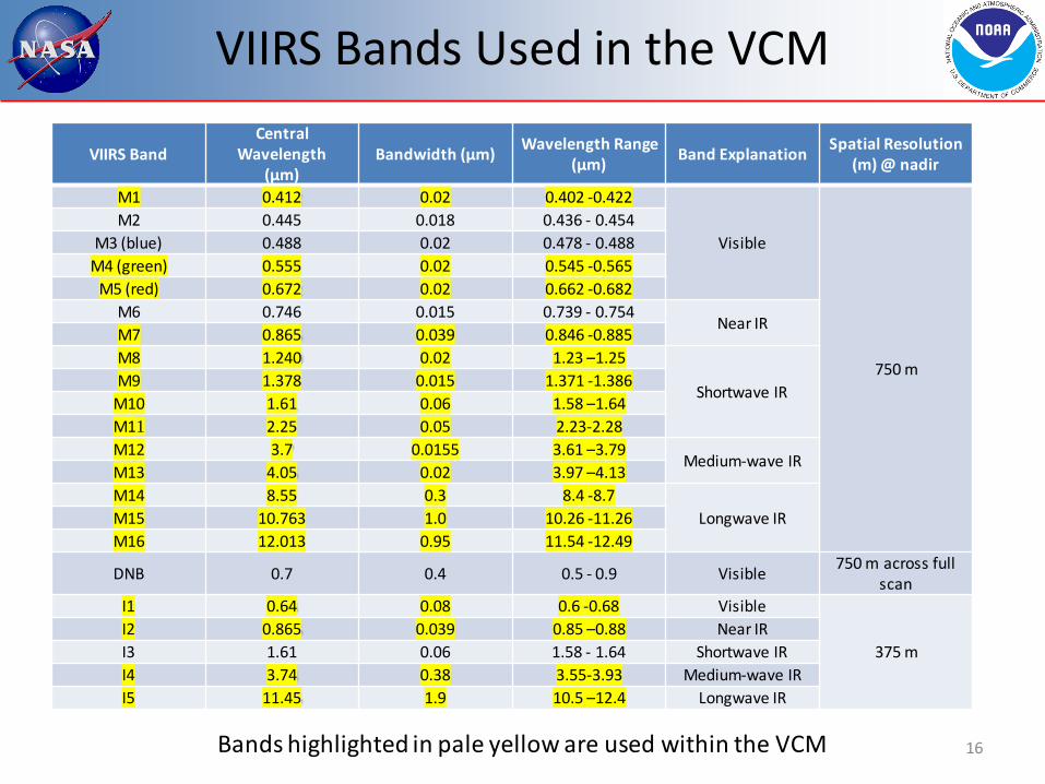
VIIRS Bands Used in the VCM
VIIRS Band
Central Wavelength
(μm) Bandwidth (μm) Wavelength Range
(μm) Band Explanation Spatial Resolution (m) @ nadir
M1 0.412 0.02 0.402 -0.422
Visible
750 m
M2 0.445 0.018 0.436 - 0.454 M3 (blue) 0.488 0.02 0.478 - 0.488
M4 (green) 0.555 0.02 0.545 -0.565 M5 (red) 0.672 0.02 0.662 -0.682
M6 0.746 0.015 0.739 - 0.754 Near IR
M7 0.865 0.039 0.846 -0.885 M8 1.240 0.02 1.23 –1.25
Shortwave IR M9 1.378 0.015 1.371 -1.386
M10 1.61 0.06 1.58 –1.64 M11 2.25 0.05 2.23-2.28 M12 3.7 0.0155 3.61 –3.79
Medium-wave IR M13 4.05 0.02 3.97 –4.13 M14 8.55 0.3 8.4 -8.7
Longwave IR M15 10.763 1.0 10.26 -11.26 M16 12.013 0.95 11.54 -12.49
DNB 0.7 0.4 0.5 - 0.9 Visible 750 m across full scan
I1 0.64 0.08 0.6 -0.68 Visible
375 m I2 0.865 0.039 0.85 –0.88 Near IR I3 1.61 0.06 1.58 - 1.64 Shortwave IR I4 3.74 0.38 3.55-3.93 Medium-wave IR I5 11.45 1.9 10.5 –12.4 Longwave IR
Bands highlighted in pale yellow are used within the VCM 16

• The following slides break the summary of results into 3 sections – Golden Granules
• Quantitative results are currently daytime only – Match up results, to include time series analysis – Quality Flags
• A small subset of the many potential examples will be shown, but any GG, single match up set, or QF result is available
• First, let’s summarize where the VCM is at as of November 2013
Results
17
VCM Overall Results (Daytime)
Requirement Level 1 Match-Up Golden Granule
PCT: Daytime, ocean 94% 95.3% 96.5%
PCT: Daytime, land 90% 93.9% 94.4%
PCT: Daytime, desert 90% 96.0% 95.7%
Leakage: Daytime, ocean 1% 0.6% 0.1%
Leakage: Daytime, land 3% 2.2% 0.7%
Leakage: Daytime, desert 3% 2.8% 1.2%
False Alarms: Daytime, ocean 5% 3.5% 2.6%
False Alarms: Daytime, land 7% 3.6% 4.2%
False Alarms: Daytime, desert 7% 1.2% 2.9%

VCM Overall Results (Nighttime)
Requirement Level 1 Match-Up Golden Granule
PCT: Nighttime, ocean 85% 95.2% N/A
PCT: Nighttime, land 88% 94.5% N/A
PCT: Nighttime, desert 88% 94.0% N/A
Leakage: Nighttime, ocean 5% 1.3% N/A
Leakage: Nighttime, land 5% 3.7% N/A
Leakage: Nighttime, desert 5% 4.9% N/A
False Alarms: Nighttime, ocean 8% 2.8% N/A
False Alarms: Nighttime, land 8% 1.5% N/A
False Alarms: Nighttime, desert 8% 0.9% N/A

Golden Granule Listing - Day (1)
20
Number Location Identifier Main Purpose
1 Gulf of Alaska D20120217_t2219 Glaciated low clouds
2 Sahel D20120220_t1425 Sun glint and NDVI
3 North Atlantic D20120220_t1615 I-band spatial test
4 Greenland D20120307_t1443 Sea ice
5 China D20120313_t0552 Heavy aerosols
6 Beaufort Sea D20120531_t1956 Cirrus over ice
7 Central Asia D20120505_t0740 False alarms over elevated terrain
8 Sahel D20120514_t1455 Heavy aerosols
9 SW USA D20120523_t2034 Smoke
10 Interior Africa D20120819_t1252 Desert

Golden Granule Listing - Day (2)
21
Number Location Identifier Main Purpose
11 Sahara D20120810_t1226 Desert
12 Antarctica D20121201_t1823 MWIR over snow
13 Guatemala D20130117_t1905 False snow
14 Argentina D20130117_t1713 False snow
15 Canada D20130123_t1904 Cloud versus ice
16 Baja California D20120609_t2014 False alarms/sun glint
17 Australia D20130401_t0535 NDVI impacts
18 Iran D20130331_t0936 Same as #17
19 Chile D20130329_t1819 Same as #17
20 Horn of Africa D20130407_t1037 Same as #17
21 Open Ocean D20130822_t2252 Cloud EDRs

Golden Granule Listing - Night (1)
22
Number Location Identifier Main Purpose
22 Ocean off Sahel D20121027_t0021 Low clouds impacting SST
23 S. Pacific D20121027_t1214 Glaciated low clouds
24 Arctic Ocean D20121217_t0028 Leakage over ice
25 Open Ocean D20130329_0740 Cloud EDRs
26 Antarctica D20130909_t0316 Same as #23
27 Open Ocean D08222013_t2219 Same as #23
28 N. Canada D20130909_t0920 Leakage over land
29 Siberia D20130909_t1931 Leakage over snow/ice
30 White Sea D20130909_t2250 Leakage over snow/ice
31 Himalayas D20130909_t1941 False alarms at higher elevations
32 Amazon D20130909_t0434 False alarms in humid
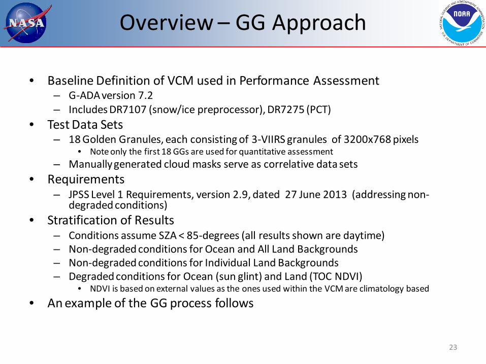
• Baseline Definition of VCM used in Performance Assessment – G-ADA version 7.2 – Includes DR7107 (snow/ice preprocessor), DR7275 (PCT)
• Test Data Sets – 18 Golden Granules, each consisting of 3-VIIRS granules of 3200x768 pixels
• Note only the first 18 GGs are used for quantitative assessment – Manually generated cloud masks serve as correlative data sets
• Requirements – JPSS Level 1 Requirements, version 2.9, dated 27 June 2013 (addressing non-
degraded conditions) • Stratification of Results
– Conditions assume SZA < 85-degrees (all results shown are daytime) – Non-degraded conditions for Ocean and All Land Backgrounds – Non-degraded conditions for Individual Land Backgrounds – Degraded conditions for Ocean (sun glint) and Land (TOC NDVI)
• NDVI is based on external values as the ones used within the VCM are climatology based
• An example of the GG process follows
Overview – GG Approach
23
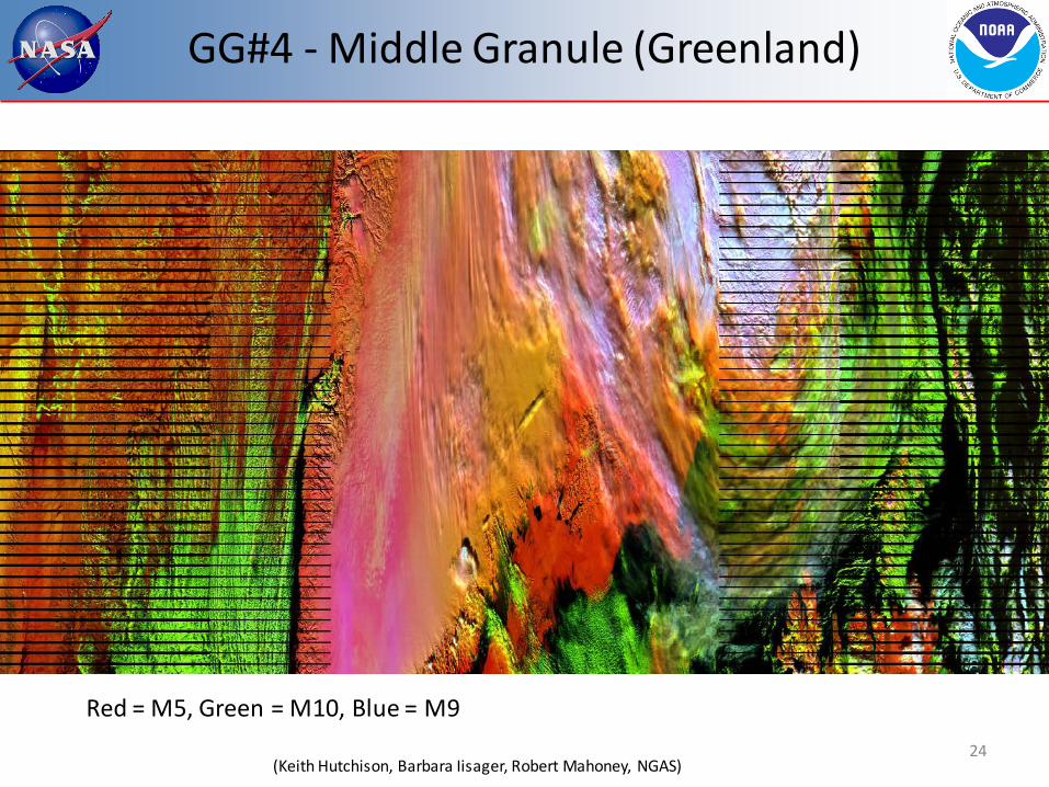
GG#4 - Middle Granule (Greenland)
24 (Keith Hutchison, Barbara Iisager, Robert Mahoney, NGAS)
Red = M5, Green = M10, Blue = M9

GG#4 Manual Cloud Mask
25 (Keith Hutchison, Barbara Iisager, Robert Mahoney, NGAS)
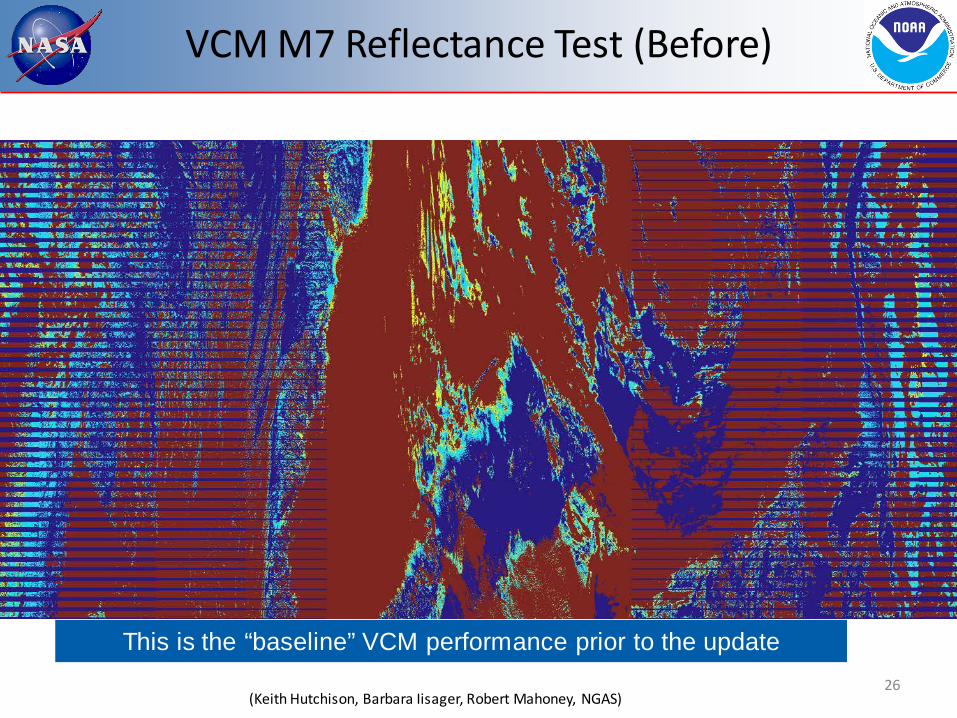
VCM M7 Reflectance Test (Before)
26 (Keith Hutchison, Barbara Iisager, Robert Mahoney, NGAS)
This is the “baseline” VCM performance prior to the update

VCM M7 Reflectance Test (After)
27 (Keith Hutchison, Barbara Iisager, Robert Mahoney, NGAS)
Improvement is realized after correcting the minimum of the SSEC thresholds to become closer to the values after 30-day spin up

VCM Performance From GGs – All
28
Ocean Day, COT Assumed > 1.0
Number of Pixels
PCT False Alarms
Leakage (Outside
Glint)
System Spec 94.0% 5.0% 1.0%
VCM Performance 38,618,862 96.5% 2.6% 0.1%
Land Background#, COT Assumed > 1.0
Number of Pixels
PCT False Alarms *
Leakage
System Spec 90.0% 7.0% 3.0%
VCM Performance 28,385,616 94.4% 4.2% 0.7%
# Includes Backgrounds of Desert, Coast, and Land - Results for individual backgrounds appears on next slide * Valid for TOC NDVI values < 0.2 or > 0.4
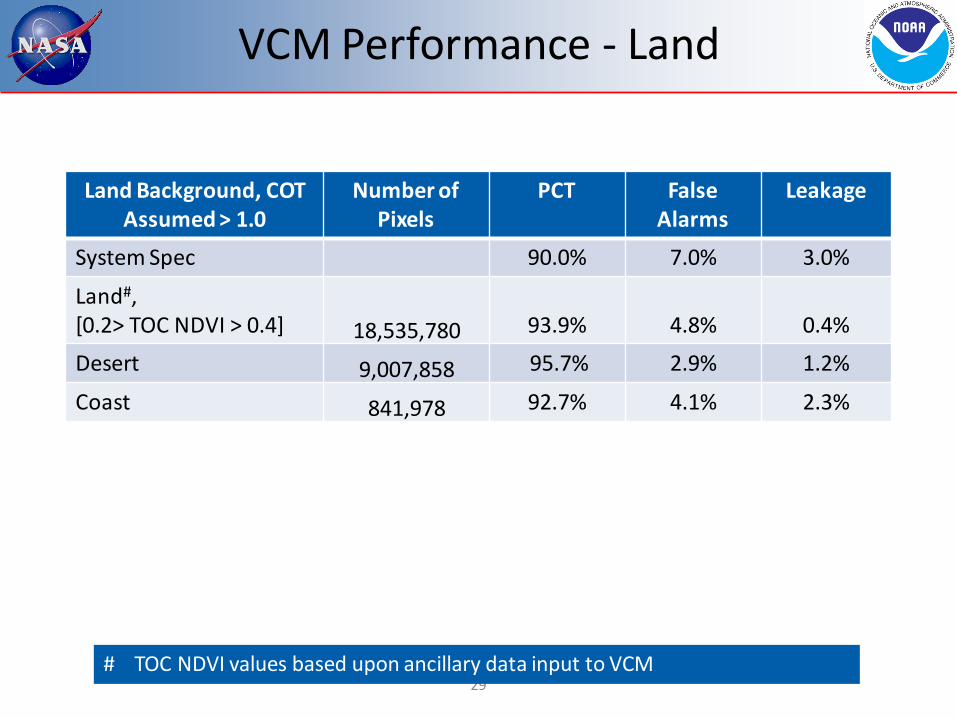
VCM Performance - Land
29
Land Background, COT Assumed > 1.0
Number of Pixels
PCT False Alarms
Leakage
System Spec 90.0% 7.0% 3.0%
Land#, [0.2> TOC NDVI > 0.4] 18,535,780
93.9%
4.8%
0.4%
Desert 9,007,858 95.7% 2.9% 1.2%
Coast 841,978 92.7% 4.1% 2.3%
# TOC NDVI values based upon ancillary data input to VCM

VCM Performance vs. Other
30
Background Type Number of Pixels
PCT False Alarms
Leakage
System Spec n/a n/a n/a
Inland Water 797,558 91.4% 7.2% 0.0%
Snow/Ice 12,097,523 89.3% 2.4% 6.4%
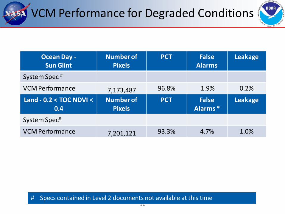
VCM Performance for Degraded Conditions
31
Ocean Day - Sun Glint
Number of Pixels
PCT False Alarms
Leakage
System Spec #
VCM Performance 7,173,487 96.8% 1.9% 0.2%
Land - 0.2 < TOC NDVI < 0.4
Number of Pixels
PCT False Alarms *
Leakage
System Spec#
VCM Performance 7,201,121 93.3% 4.7% 1.0%
# Specs contained in Level 2 documents not available at this time
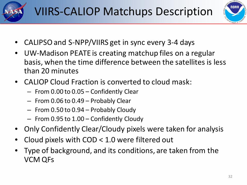
VIIRS-CALIOP Matchups Description
• CALIPSO and S-NPP/VIIRS get in sync every 3-4 days • UW-Madison PEATE is creating matchup files on a regular
basis, when the time difference between the satellites is less than 20 minutes
• CALIOP Cloud Fraction is converted to cloud mask: – From 0.00 to 0.05 – Confidently Clear – From 0.06 to 0.49 – Probably Clear – From 0.50 to 0.94 – Probably Cloudy – From 0.95 to 1.00 – Confidently Cloudy
• Only Confidently Clear/Cloudy pixels were taken for analysis • Cloud pixels with COD < 1.0 were filtered out • Type of background, and its conditions, are taken from the
VCM QFs
32
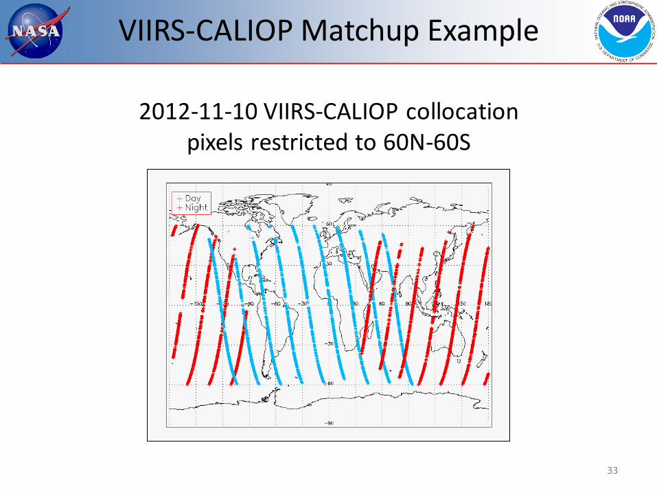
VIIRS-CALIOP Matchup Example
33
2012-11-10 VIIRS-CALIOP collocation pixels restricted to 60N-60S

VIIRS-CALIOP Matchups Stats
34
- New Build - Provisional - Thresholds Change
Build
6.3
Build
7.0
/7.1
Build
7.2

VIIRS-CALIOP Matchups Stats
35
- New Build - Provisional - Thresholds Change
Build
6.3
Build
7.0
/7.1
Build
7.2

VIIRS-CALIOP Matchups Stats
36
- New Build - Provisional - Thresholds Change
Build
6.3
Build
7.0
/7.1
Build
7.2

Summary of Match Up - Day
37
• The performance over ocean surface is very consistent – 30 day spin up addressed the major VCM issues over ocean – Sun glint is not included in these results
• Land day steady improvement over the past year is from continued focus on NDVI – Drop in the winter of 2012 from snow/cloud challenges
• These were addressed in Build 7.2, hence do not appear in 2013
• Desert day also shows steady improvement – Latest update of the PCT in September appears to have pushed
desert results to excellent values • Note barren regions in cold polar regions are treated as desert in the
algorithm, but as land in the statistics

VIIRS-CALIOP Matchups Stats
38
- New Build - Provisional - Thresholds Change
Build
6.3
Build
7.0
/7.1
Build
7.2
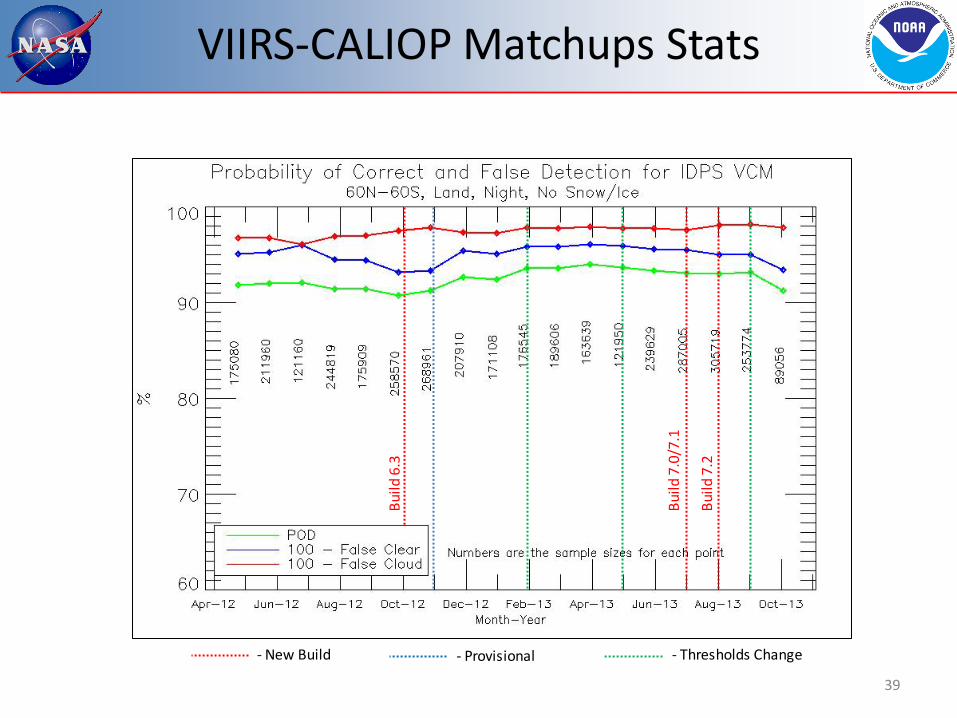
VIIRS-CALIOP Matchups Stats
39
- New Build - Provisional - Thresholds Change
Build
6.3
Build
7.0
/7.1
Build
7.2

VIIRS-CALIOP Matchups Stats
40
- New Build - Provisional - Thresholds Change
Build
6.3
Build
7.0
/7.1
Build
7.2

Summary of Match Up - Night
41
• The performance over ocean surface is again very consistent – General feedback on night results over water have
consistently been that the VCM is acceptable
• Land night appears to indicate a seasonal tendency – Since NH has the majority of land locations, the results
imply greater challenges in the autumn – This will be a focus for tuning in the coming weeks
• Desert night performance has been strong since the 30 day spin up

VIIRS-CALIOP Matchups Stats
42

Summary of Match-Up Results
43
• Explaining all of the changes in the VCM performance is complicated in part due to a high dependence on ancillary data (NDVI, Snow, etc.)
• In polar regions the performance is following the seasonal change, i.e. decreases during the winter season (a target for future improvement) – See DR list
• Trending results over snow difficult due to the inability to unquestionably determine if the background has snow/ice or not – This situation has improved with the monthly update, and
results will be generated in following validation stages • The significant effort to mitigate NDVI are evident

Quality Flags (1)
• The VCM output is all contained in the form of Quality Flags (QFs)
• As such, there are 31 (!) QFs that need to be verified in some fashion
• All of the quantitative requirements go toward only one of the thirty-one QFs (Cloud Confidence)
• Therefore the VCM team must have sufficient evidence that each of the other 30 QFs are acting as expected
44
Quality Flags (2)
• The 30 remaining QFs may be broken down as follows: – Fixed background conditions (land/ocean, day/night) – Variable background conditions (snow, fire, glint) – Results of each of the individual cloud detection tests
• This comprises 12 QFs
– Cloud Phase – Degraded conditions (NDVI, polar night) – Miscellaneous required output (aerosol, cloud shadow)
45
Quality Flags (3)
• After discussions with JPSS, especially DPA, it was agreed for the sake of this briefing to tie each QF to specific granule(s) that revealed the correctness of each QF – Examples are not needed for all 30 – However examples will be shown for particular QFs
• All but 6 of the QFs may be viewed through the use of a tuning tool developed by Aerospace
• Every QF may be evaluated by Raytheon as part of their integration testing – Each QF output may be displayed during this process
• Many statistics generated from Golden Granules apply VCM embedded QFs
• Cited granules are in the form (d)yyyymmdd_(t)hhmm
46
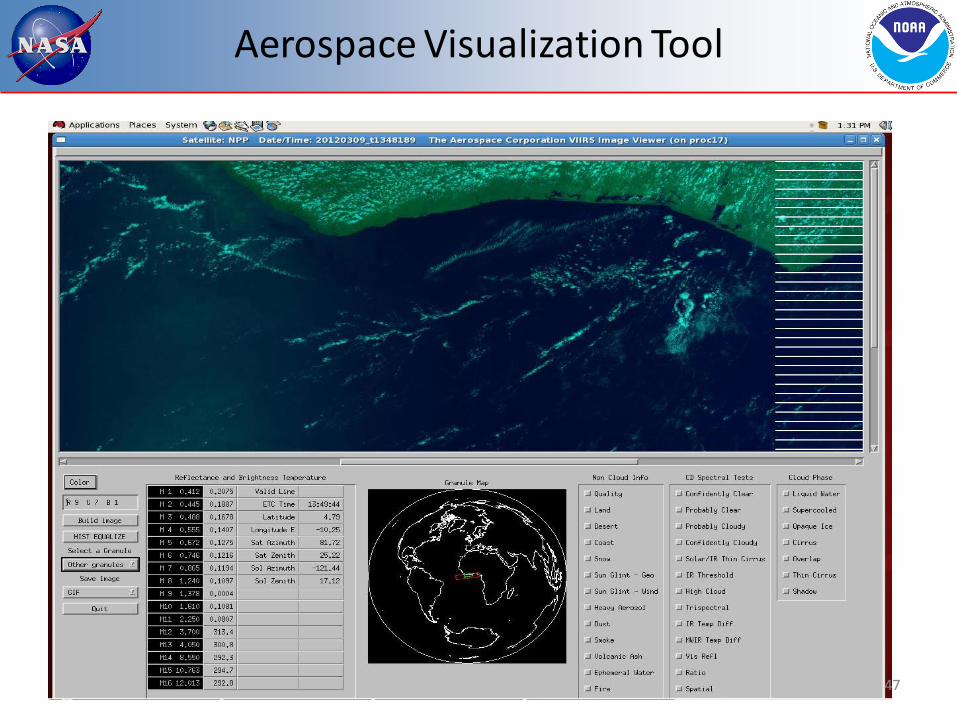
Aerospace Visualization Tool
47
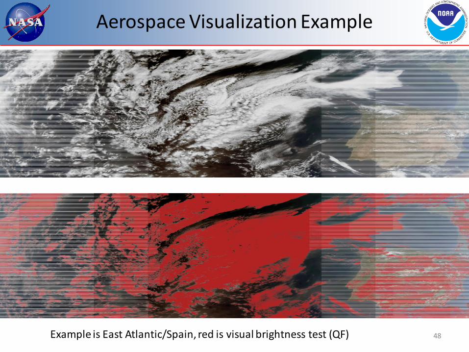
Aerospace Visualization Example
Example is East Atlantic/Spain, red is visual brightness test (QF) 48
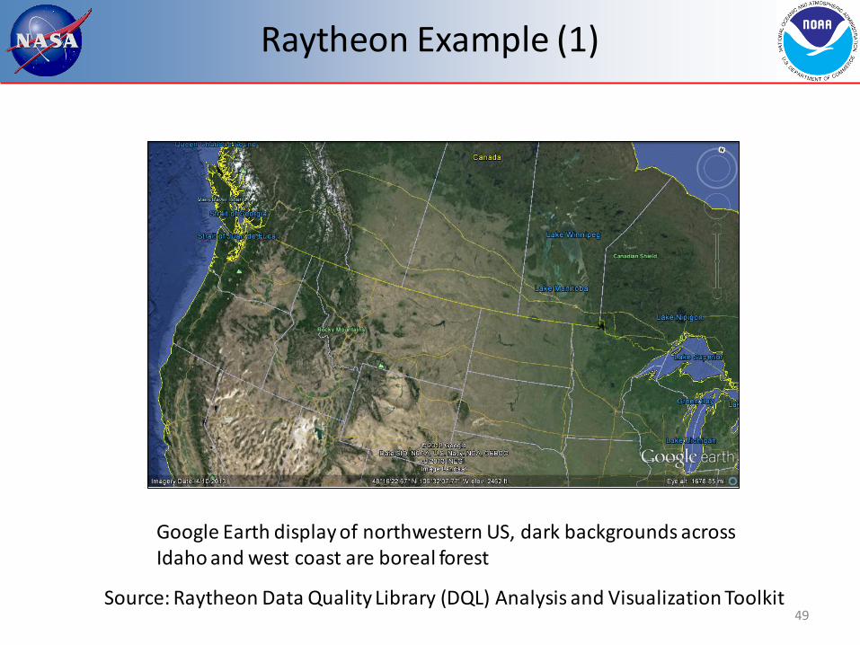
Raytheon Example (1)
Google Earth display of northwestern US, dark backgrounds across Idaho and west coast are boreal forest
49 Source: Raytheon Data Quality Library (DQL) Analysis and Visualization Toolkit

Raytheon Example (2)
Conifer Boreal Forest QF in the VCM, red is true for this QF
50 Source: Raytheon Data Quality Library (DQL) Analysis and Visualization Toolkit
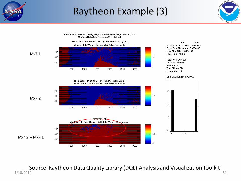
1/10/2014 51
Mx7.1
Mx7.2
Mx7.2 – Mx7.1
Raytheon Example (3)
Source: Raytheon Data Quality Library (DQL) Analysis and Visualization Toolkit

QF Set 1 (Fixed Backgrounds)
Quality Flag Output General Location Granules
Day/Night Day (1) Night (0)
Any terminator d20120515_t0129 (Norway)
Land/Water Desert (0) Land (1) Inland Water (2) Sea Water (3) Coastal (5)
Any, but best with granules covering all types (India/Pakistan, American W. Coast)
d20130108_t0510 (China) d20130110_t1942 (Mexico) All GGs
Conifer Boreal Forest
True (1) False (0)
NW US, Canada, Russia
d20130123_t1905 (Canada) d20120515_t1949 (West US) GG #15
52
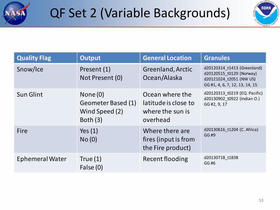
QF Set 2 (Variable Backgrounds)
Quality Flag Output General Location Granules
Snow/Ice Present (1) Not Present (0)
Greenland, Arctic Ocean/Alaska
d20120314_t1413 (Greenland) d20120515_t0129 (Norway) d20121024_t2051 (NW US) GG #1, 4, 6, 7, 12, 13, 14, 15
Sun Glint None (0) Geometer Based (1) Wind Speed (2) Both (3)
Ocean where the latitude is close to where the sun is overhead
d20120313_t0219 (EQ. Pacific) d20130902_t0922 (Indian O.) GG #2, 9, 17
Fire Yes (1) No (0)
Where there are fires (input is from the Fire product)
d20130616_t1204 (C. Africa) GG #9
Ephemeral Water True (1) False (0)
Recent flooding d20130718_t1838 GG #6
53

Snow Example
54
Granule is from May 2013 over the Midwest, this is how we identified incorrect snow logic that was corrected in Build 7.2

QF Set 3 (Individual Cloud Tests) - I
Quality Flag Output General Location Granules
Cirrus (Solar M9) Cloud (1) No Cloud (0)
Jet stream, convective outflow, Daytime only
d20130710_t1755 (Andes) d20130711_t0742 (Himalayas) d20120906_t2229 (C. Pacific) GG #5, 7, 10, 13, 14, 17
Cirrus IR (BTM15 – BTM16)
Cloud (1) No Cloud (0)
Jet stream, convective outflow
d20120319_t0752 (G. Lakes) d20120318_t1016 (C. Pacific) GG #18
IR Threshold (BTM15)
Cloud (1) No Cloud (0)
Any nighttime d20120319_t0755 (SE USA) d20120318_t1001 (E. Pacific) GG – All nighttime
High Cloud (BTM12 – BTM16)
Cloud (1) No Cloud (0)
Nighttime over land d20120319_t0752 (G. Lakes) GG #24, 28, 30, 31
IR Temperature Difference (BTM14 – BTM15) & (BTM15 – BTM16)
Cloud (1) No Cloud (0)
Oceans, especially tropical waters
GG #2, 5, 9, 16, 17, 22
55
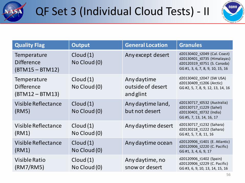
QF Set 3 (Individual Cloud Tests) - II
Quality Flag Output General Location Granules
Temperature Difference (BTM15 – BTM12)
Cloud (1) No Cloud (0)
Any except desert d20130402_t2049 (Cal. Coast) d20130401_t0735 (Himalayas) d20120319_t0751 (S. Canada) GG #1, 3, 6, 7, 8, 9, 10, 15, 16
Temperature Difference (BTM12 – BTM13)
Cloud (1) No Cloud (0)
Any daytime outside of desert and glint
d20130402_t2047 (SW USA) d20130409_t1206 (Arctic) GG #2, 5, 7, 8, 9, 12, 13, 14, 16
Visible Reflectance (RM5)
Cloud (1) No Cloud (0)
Any daytime land, but not desert
d20130717_t0532 (Australia) d20130717_t1229 (Sahel) d20130401_t0732 (India) GG #5, 7, 13, 14, 16, 17
Visible Reflectance (RM1)
Cloud (1) No Cloud (0)
Any daytime desert d20130717_t1232 (Sahara) d20130218_t1222 (Sahara) GG #2, 5, 7, 8, 11, 16
Visible Reflectance (RM1)
Cloud (1) No Cloud (0)
Any daytime ocean d20120906_t1401 (E. Atlantic) d20120906_t2220 (C. Pacific) GG #1, 3, 4, 6, 9, 17
Visible Ratio (RM7/RM5)
Cloud (1) No Cloud (0)
Any daytime, no snow or desert
d20120906_t1402 (Spain) d20120906_t2229 (C. Pacific) GG #3, 6, 9, 10, 13, 14, 15, 16
56

QF Set 3 (Individual Cloud Tests) - III
Quality Flag Output General Location Granules
Spatial Uniformity True (1) False (0)
Any ocean d20120906_t2222 (EQ. Pacific) d20120906_t0844 (Indian O.) GG #1, 3, 6, 16
Thin Cirrus Present True (1) False (0)
Same as cirrus tests d20130717_t1227 (EQ Africa) d20130218_t1222 (Sahel) d20120906_t2220 (C. Pacific) GG #2, 7, 10, 12, 15, 17
57
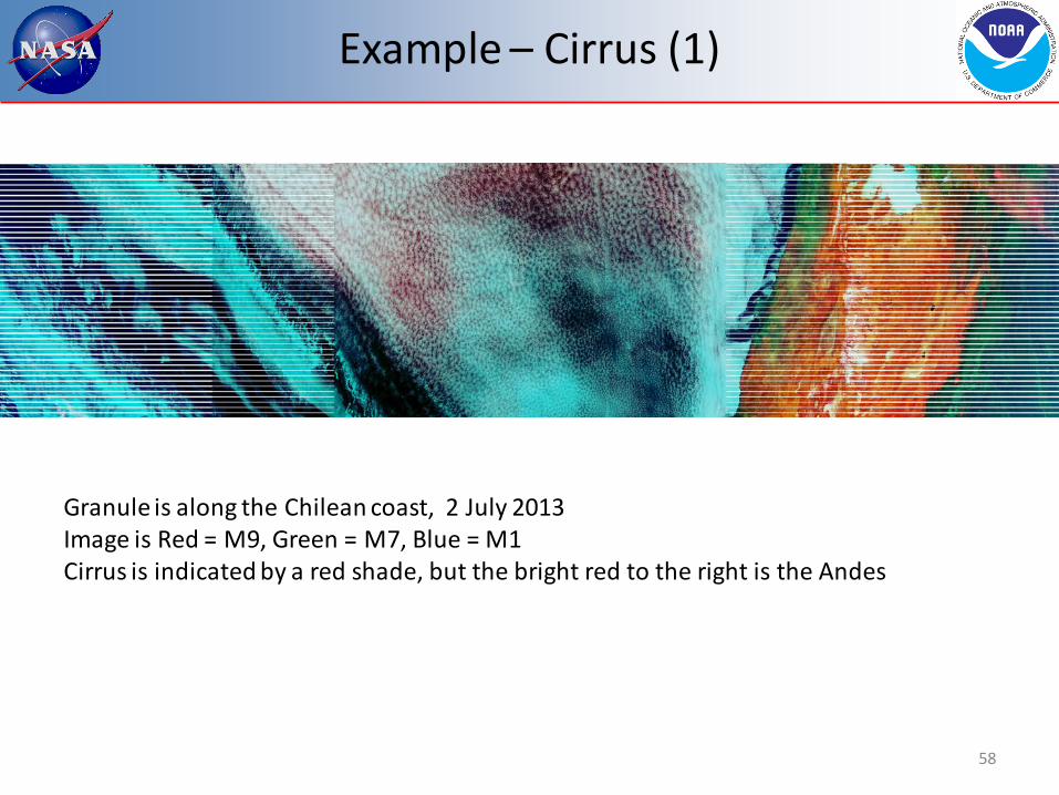
Example – Cirrus (1)
58
Granule is along the Chilean coast, 2 July 2013 Image is Red = M9, Green = M7, Blue = M1 Cirrus is indicated by a red shade, but the bright red to the right is the Andes

Example – Cirrus (2)
59 Same granule before and after tuning the cirrus test, results in green
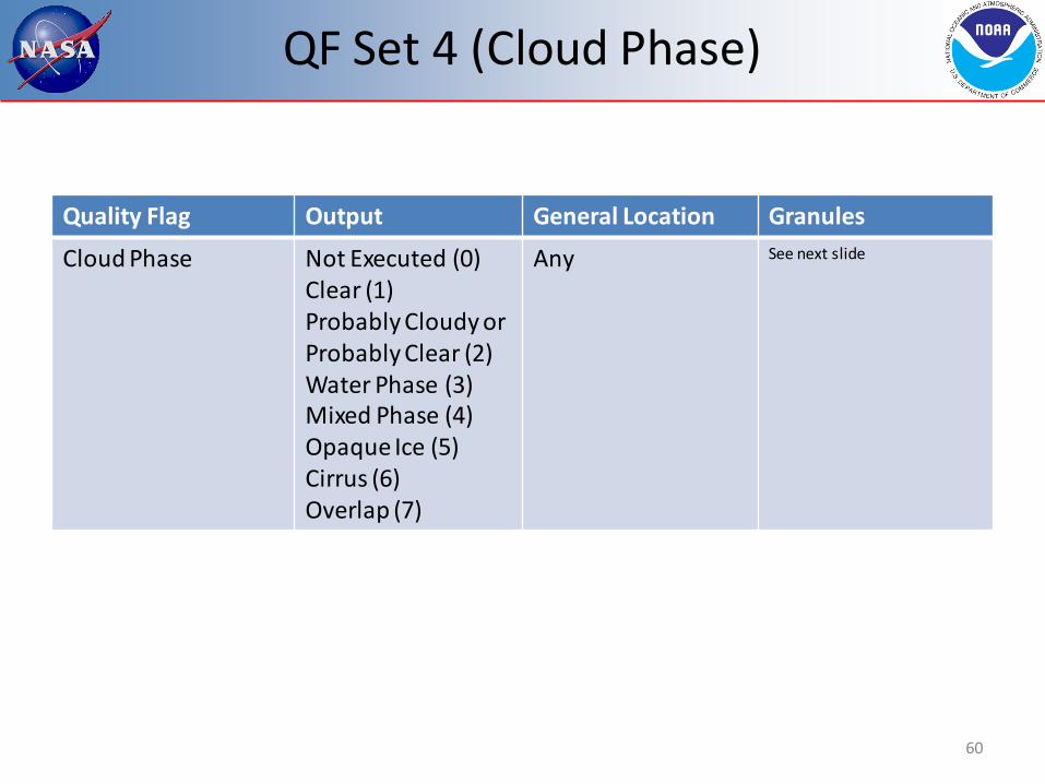
QF Set 4 (Cloud Phase)
Quality Flag Output General Location Granules
Cloud Phase Not Executed (0) Clear (1) Probably Cloudy or Probably Clear (2) Water Phase (3) Mixed Phase (4) Opaque Ice (5) Cirrus (6) Overlap (7)
Any See next slide
60

Cloud Phase Results (1)
61
> 0.0 >0.1 >0.2 >0.3 >0.4 >0.5 >2.0 All data 0.687 0.785 0.815 0.826 0.831 0.836 0.823 daytime 0.692 0.775 0.805 0.819 0.825 0.832 0.815 nighttime 0.681 0.794 0.823 0.831 0.836 0.838 0.826 Over land 0.639 0.709 0.732 0.744 0.754 0.760 0.740 Over water 0.701 0.808 0.839 0.850 0.853 0.857 0.842 Lat > 60 deg 0.648 0.693 0.717 0.728 0.734 0.739 0.744 Lat <60 deg 0.695 0.807 0.839 0.849 0.855 0.860 0.843
This chart shows the fraction of VIIRS cloudy pixels (filtered by the CALIOP optical depth) with a cloud phase that agrees with the cloud phase of the highest cloud layer as determined from CALIOP. Data is from May 10, 2012. VCM is from Build 6.7
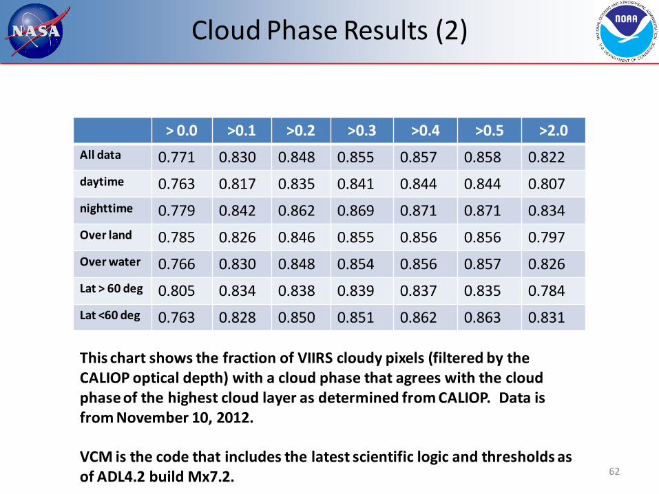
Cloud Phase Results (2)
62
> 0.0 >0.1 >0.2 >0.3 >0.4 >0.5 >2.0 All data 0.771 0.830 0.848 0.855 0.857 0.858 0.822 daytime 0.763 0.817 0.835 0.841 0.844 0.844 0.807 nighttime 0.779 0.842 0.862 0.869 0.871 0.871 0.834 Over land 0.785 0.826 0.846 0.855 0.856 0.856 0.797 Over water 0.766 0.830 0.848 0.854 0.856 0.857 0.826 Lat > 60 deg 0.805 0.834 0.838 0.839 0.837 0.835 0.784 Lat <60 deg 0.763 0.828 0.850 0.851 0.862 0.863 0.831
This chart shows the fraction of VIIRS cloudy pixels (filtered by the CALIOP optical depth) with a cloud phase that agrees with the cloud phase of the highest cloud layer as determined from CALIOP. Data is from November 10, 2012. VCM is the code that includes the latest scientific logic and thresholds as of ADL4.2 build Mx7.2.

QF Set 5 (Degraded Conditions)
Quality Flag Output General Location Granules
Degraded: TOC NDVI (0.2 < NDVI < 0.4)
False (0) True (1)
Sahel, SW USA, Mexico, Australia
d20120515_t1946 (Australia) d20131015_t1243 (Sahel) GG #2, 8, 9, 16
Degraded: Sun Glint in Pixel
False (0) True (1)
Same as glint flag d20120901_t1858 (G. Mexico) GG #2, 9, 17
Degraded: Polar Night
False (0) True (1)
Nighttime poleward of 60 degrees latitude
d20120515_t0716 (Antarctica) GG #24, 26, 28, 29, 30
63

NDVI Degraded Example (1)
64 Source: Raytheon Data Quality Library (DQL) Analysis and Visualization Toolkit

NDVI Degraded Example (2)
65
Red = True
Source: Raytheon Data Quality Library (DQL) Analysis and Visualization Toolkit

QF Set 6 (Required Conditions) - I
Quality Flag Output General Location Granules
Cloud Mask Quality Poor (0) Low (1) Medium (2) High (3)
Any with degraded conditions or known SDR errors
d20120309_t1214 (N. Africa)
Shadow Detected No (0) Yes (1)
High clouds with sharp edges
GG – All daytime
Non Cloud Obstruction (Heavy Aerosol)
No (0) Yes (1)
Off the coast of NW Africa
d20120514_t1455 (E. Atlantic) GG #5, 8, 9
Adjacent Pixel Cloud Confidence
Confident Clear (0) Probably Clear (1) Probably Cloudy (2) Confident Cloudy (3)
Any d20130804_t0658 (C. Asia)
66
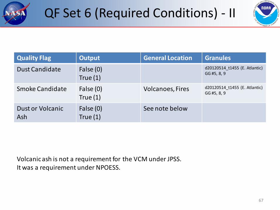
QF Set 6 (Required Conditions) - II
Quality Flag Output General Location Granules
Dust Candidate False (0) True (1)
d20120514_t1455 (E. Atlantic) GG #5, 8, 9
Smoke Candidate False (0) True (1)
Volcanoes, Fires d20120514_t1455 (E. Atlantic) GG #5, 8, 9
Dust or Volcanic Ash
False (0) True (1)
See note below
Volcanic ash is not a requirement for the VCM under JPSS. It was a requirement under NPOESS.
67

QF results
• VCM team has reviewed all 31 Quality Flags – Tuning alone has shown the benefit of many of the QFs
• Raytheon verifies QF output during integration testing
• The Golden Granules have also generated results where individual QFs are applied
• The overwhelming evidence supports the conclusion each QF is acting as it should
68

Input Comments (1)
• The VIIRS SDRs have performed well from a VCM point-of-view – No striping or artifacts are regularly seen in the VCM due to SDR inputs – Note the VCM is able to adjust for known biases and increasing levels of
noise when they occur • We have not had to do this since the 30-day spin up
• The GFS input is acceptable but there are consequences from its resolution – The GFS 2-meter temperatures is adequate at night for the IR threshold or
“cold” test – The 2-meter temperature is not adequate during the day for the same
cloud detection test due to large temperature gradients along coastlines, which the GFS cannot capture
• This was known before launch, so the test is not part of the current daytime approach of the VCM
• DR 7407 addresses how the VCM team believes this should be accounted for – The humidity fields are adequate
• Rare but sharp artificial cloud boundaries can occur when there is a sharp moisture gradient where one side of the gradient has very low values (e.g. Andes, Himalayas)
69

Input Comments (2)
• The snow/ice input has been improved with the monthly updates and the improvements within the VCM implemented in Build 7.2 – Since monthly updates are based on actual fields, not
climatology, the snow/ice backgrounds are generally good but lag reality as much as 40 days
– Build 7.2 vastly improved snow/ice/cloud discrimination in daytime granules such that the VCM now correctly identifies missing snow/ice from the ancillary data set
– The VCM is not capable to correct snow/ice errors at night, so aging snow/ice fields will impact the VCM when real time has diverged from the most recent update
• Sharp and unnatural cloud boundaries will be seen when this occurs
70

Input Comments (3)
• The VCM depends upon the Normalized Difference Vegetation Index (NDVI) to define the thresholds for its visual brightness test
• Beginning in February 2013, this devolved to a monthly climatology that updates on a 17-day rotation – Note the mismatch between the update cycle (17 days) and the
climatology being applied • The consequence is the VCM will apply improper thresholds in
locations where the actual NDVI deviates significantly from the climatological value
• The VCM team has spent more of its tuning resources on minimizing these consequences than on any other aspect of the VCM over the past year – Note that any changes made to repair the areas with incorrect values can
adversely effect where they are correct, so the ability to mitigate this issue is limited
– Nevertheless, it has been sufficiently mitigated to meet requirements
71

NDVI impacts (1)
72
Granule is over central Australia. Circled area in the far right will be our focus
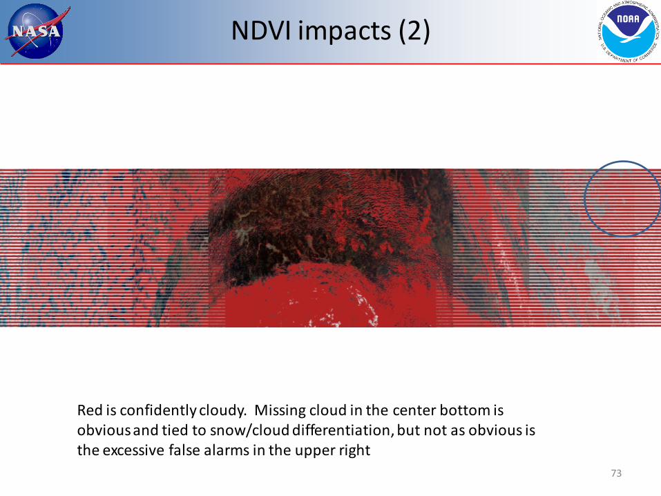
NDVI impacts (2)
73
Red is confidently cloudy. Missing cloud in the center bottom is obvious and tied to snow/cloud differentiation, but not as obvious is the excessive false alarms in the upper right
NDVI impacts (3)
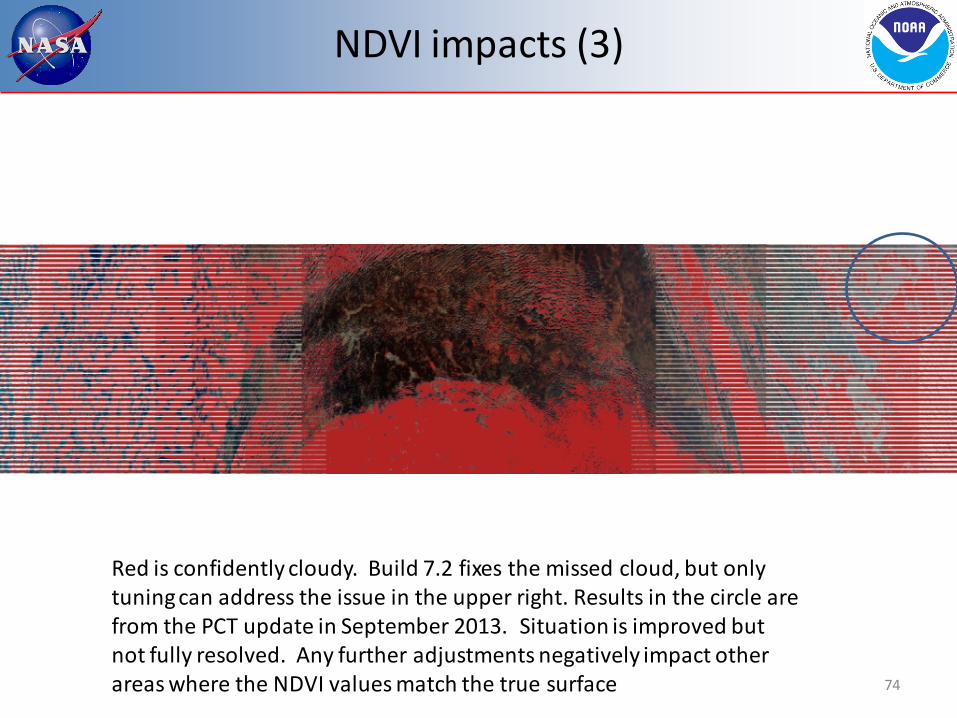
74
Red is confidently cloudy. Build 7.2 fixes the missed cloud, but only tuning can address the issue in the upper right. Results in the circle are from the PCT update in September 2013. Situation is improved but not fully resolved. Any further adjustments negatively impact other areas where the NDVI values match the true surface

Requirement Based DRs - Closed
• DRs closed since declaration of provisional: – DR 5039 – Water vapor consideration for M9
• Build 7.1 – DR 5038 – Cloud/Dust discrimination
• Build 7.1 – DR 4998 – Leakage feedback from Cal/Val teams
• PCT updates – DR 7107 – Cloud/snow discrimination in the VCM
• Build 7.2 – DR 5040 – Isolated cloud artifacts in sun glint
• PCT updates – DR 7143 – Threshold changes for cloud detection over desert (M1) and
cloud phase • PCT updates
– DR 7275 – Threshold adjustments for cloud detection over land and cirrus detection in dry atmospheres
• PCT update
75

Requirement Based DRs – Open (1)
• DR 7402: Missing cirrus in polar night – Major issue for ice EDRs – Being actively worked, delivery expected next month
• DR 7403: Increasing coverage of M12 – M16 – Impacts all nighttime EDRs – Test is being excluded in locations where it should not be – Being worked with DR 7402
• DR 7404: Add moisture consideration for M12/M15 difference test – Impacts low cloud detection over cold surfaces at night – Being worked with DR 7402
• DR 7405: Leakage over land at night (tuning #1) – The IR threshold test thresholds are too high – Will be included in next tuning update (Feb/Mar 2014)
• DR 7406: Missed low cloud at night (tuning #2) – Thresholds for M12/M15 difference also need adjustments – Will be included in next tuning update (Feb/Mar 2014)
76

Requirement Based DRs – Open (2)
• DR 7407: Add SST first-guess as input to the VCM – Addresses most critical issue for SST EDR (cloud edges) – Awaiting new field being added to the IDPS
• DR 7408: Scattering angle adjustment to cloud phase – Impacts cloud EDRs – At extreme angles some striping in the cloud phase output has been seen – Being worked by AIT
• DR 7409: Inconsistency in cloud confidence – Code is computationally correct but actual routine is different across
subroutines doing the same calculation – To be addressed in late 2014
• DR 7410: Aerosol improvements – Challenges have been identified in differentiating clouds from aerosols
over land – Study underway by some aerosol members, solution TBD
77

DR 7407 (SST)
78
Blue represents cold bias – potential cloud contamination As the VCM team understand this, there are three sources of error 1) SST algorithm at edge-of-scan 2) aerosols 3) leakage
1
2 3
Requirement Based DRs – Open (3)
• DR 7437: Issues with ephemeral water flag – Impacts cryosphere and aerosol EDRs – Ephemeral water being misidentified in cloud shadow – VCM is also changing its internal geography flag when ephemeral water is flagged – To be worked in the spring 2014
• DR 7438: Leakage over cold desert – Low clouds are being missed during the day over polar, snow free, locations at
extreme scattering angles – Issue has been tied to barren ground being treated as desert instead of land – To be worked spring 2014
• DR 7240: Cloud over fires – The VCM is placing clouds over most fires due to large differences in the MWIR
and LWIR temperatures – Root cause is known, but the fix requires a restructuring of the sequence of
processes in the VCM – To be worked spring 2014 or later, depending on the final complexity and the
priorities of other DRs
79

Requirement Based DRs – Open (4)
• DR 7276 – Add viewing angle to Mid-Wave IR difference test – In Build 8.3
• DR 7277 - Nighttime cloud confidence adjustments – In Build 8.3
• DR 4903 – Snow discontinuity at 85 degrees solar angle – Root cause is complex, fix in discussion
• DR 4326 – M12 minus M16 test adjustment – Replaced by DR 7403, but not yet formally closed
• DR 7278 – Cloud detection in sun glint – Solution is the same as DR 7407
80

Version Control - Documents
• All key documents are up-to-date • ATBD and OAD both match the operational Imagery
product – The VCM ATBD is version C and in coordination – The VCM OAD is version B and up-to-date in the repository
• The format of the VCM Intermediate Product or IP (CDFCB-X) has not changed since before launch
• The format of the output is stable and not expected to change for Block 2.0
• A User’s Guide has not been created for the VCM – To be produced as part of validation stage 2
• A JGR article on the VCM is in its second review. • See the ATBD for a bibliography of articles covering
many aspects of the VCM logic
81

Version Control - Code
• The VCM IP software was last updated in Build 7.2 (20 August 2013)
• The most recent Processing Coefficient Table (PCT) or tuning update was implemented on 24 September 2013 as CCR 1170 – The timing of the VCM becoming validation stage 1 is timed with
this PCT update • Snow is updated approximately once a month, and NDVI
every 17 days – Snow updates go through the AERB, but NDVI updates are
automated and do not – The VCM team keeps track of each of these events and sends
monthly updates of the timing of each to the program • In this manner all non-daily updates to the VCM (e.g. GFS) are tracked for
future reference
• Therefore all software, PCT, and ancillary data is tracked and under configuration control
82
Users and Product Status
• Six caveats may be found in the VCM “Read Me” file at the time provisional was declared – Dependency on two external fields (snow and NDVI) that were fixed values from
2002 • Snow updated monthly as of January 2013 • NDVI no longer a fixed field, updates occurring but only climatology actually applied
– Difficulties differentiating low clouds from snow/ice • Resolved in the daytime with Build 7.2
– Leakage, which remains a concern although the VCM is meeting requirements • Main concern is cloud edges, identified by three different Cal/Val teams
– Results near edge-of-scan • Mitigated with implementation of scattering angle curves and adjustments to the related
coefficients – Aerosol differentiation from clouds
• Concern remains especially over land, as noted in the DR list – VCM performance at night over land/snow/ice
• Also addressed in DRs, performance over snow/ice the primary focus of the next VCM software update (early February 2014)
83

Path Forward
• Primary function of the validation team in the next few months is twofold – Complete tuning for nighttime scenes – Address specific concerns from VIIRS Cal/Val teams
• Cloud edges over water • Excessive leakage over snow/ice, including polar night
• Pursue quantitative validation of cloud phase and aerosol quality flags (validation stage 2)
• Continue to interact and be responsive to other VIIRS EDR team needs – The VCM must continue to address items where the
downstream EDRs believe improvement is needed for their products to reach validation stage 1
84
Conclusion
• VCM has now achieved validation stage 1 – All quantitative requirements have been met or exceeded – All documentation is up-to-date
• User’s Guide has not been developed yet, but is not required for validation stage 1
– All DRs related to JPSS requirements are closed
• Work on the VCM is not complete – Leakage numbers are within requirements but certain
downstream products need additional improvements – Polar regions need work – Many DRs still in place that should be resolved
85