Embed Size (px)
Citation preview

121
VI. PLAN PROJECTS, INITIATIVES, AND POLICIES The “On the Move: 2007-2035 Transportation Plan” (2035 Plan) provides a vision and framework of regional transportation policy as well as lists of projects to implement. In addition, for the first time this TMACOG long range plan proposes and sets aside expected funding for a variety of regional initiatives. Some initiatives are studies that may lead to future buildable projects, while others focus on collaborative research, informational campaigns, and development of strategies for change. This chapter begins with the seven plan goals. As described in previous chapters, the problems and opportunities (related to each goal) were identified, and solutions were proposed. After evaluation, the best solutions to the highest priority needs were selected for inclusion in the plan. This selection process began with the goal groups. Each group first identified committed projects (funding already secured) and added them to the plan. Next each group completed analysis of the effectiveness of the proposed projects and initiatives and selected the top 10 percent of their projects and initiatives for inclusion. Subsequent steps were taken by the full task force (evaluating, ranking and selecting additional items), and the final draft plan was subject to the approval of the task force, the Transportation Council, and the Board of Trustees. In the first seven sections of this chapter, each goal, its related objectives and problem statements, and the selected solutions are described. The full lists of projects, initiatives, and policies are presented in the final sections of this chapter. 1. Safety and Efficiency Goal The goal of the Safety and Efficiency Goal Group was to ensure that our transportation system would be “designed and operated to promote safe and efficient travel across all modes.” The group focused on seven objectives to guide their work. Safety and Efficiency Goal Objectives:
1. High Priority for ITS, access management, and traffic safety programs 2. Reduce travel time (congestion) and delay by improving system operations 3. Safe and efficient transportation systems to all parts of the region 4. Truck traffic – safely and more efficiently move freight, including reducing through
traffic on non-interstate routes 5. Predict and handle capacity affected by suburban growth 6. Reduce/eliminate conflicts between modes of transportation 7. Establish and maintain hazardous material transportation database
The goal group began meeting in January 2006 and consisted of nine members.
David Charville, Tetra Tech Kenneth Fallows, Mayor, Village of Haskins
122
Barbara Jones, Chief Engineer, City of Toledo, Department of Public Service, Division of Transportation
Ron Myers, Traffic Engineering Associate, Lucas County Engineer’s Office Brian O’Connell, City Engineer, City of Bowling Green Gary Siegel, Point Place Business Association Mike Stormer, District Planning Engineer, ODOT District 2, Office of Planning and
Programs Rick Theilen, Planning/Zoning/Economic Development Administrator, City of
Perrysburg, Division of Planning Zoning and Economic Development Steve Way, DGL Consulting Engineers, LLC
The committee began their work by reviewing technical information on congestion locations, safety hot spots, crash data, and modal conflict locations. The public provided comments during the Needs Input public meetings that were used by the committee as their basis for developing problem statements related to the identified issues. The problem statements captured the essence of the issues and were organized into concise groups in preparation for brainstorming solutions. Overall, the committee developed 19 problem statements from the public input. The problem statements are as follows:
Reduce congestion on arterials Reduce congestion around schools Reduce congestion on highways Reduce truck-related congestion Reduce congestion at railroad crossings Reduce congestion – “general congestion issues” Improve safety for commuters Improve safety through better utilization of traffic control devices Improve safety at railroad crossings Improve safety through driver education Improve safety for pedestrians and bicyclists Traffic management on arterials Traffic management on freeways Traffic management through driver education Better access for automobiles Better access to pedestrian and bikeway facilities Increase operational efficiency of streets and highways Increase operational efficiency of transit Congestion reduction alternatives
The problem statements were ranked as high, medium or low priorities. It was the consensus of the committee to brainstorm solutions for only the high and medium priority statements. Over the next three months, the committee brainstormed and ranked solutions to address these problems. The solutions could be projects, initiatives, or solutions and could take place in either the short-term or long-term and could either fix the symptoms of the problem or fix the root cause.
123
After the brainstorming concluded, the committee ranked the solutions as high, medium, or low priority. A final recommendation was made to the 2035 task force identifying the preferred projects, initiatives and policies of the committee. To determine which projects would go in the draft plan, each goal group’s committed projects were put in the plan and then each group could select the top 10 percent of their projects for automatic inclusion. Of the projects the committee recommended, 13 were committed projects (see the project list for details). Based on their number of projects, the committee could select two projects as their top 10 percent. They chose to include Project #2 (Widen I-75 to 6 lanes from Findlay to Perrysburg) and Project #5 (US 20, widen to 5 lanes and add turn lanes at intersections, from Perrysburg to SR 420). The committee also prioritized their initiatives. Their top 10 percent initiatives were:
SE-I-20 (Work Zone Safety—Driver education on work zones) SE-I-25 (Rail Crossing Safety—Study locations for warning lights and gates at railroad
crossings) SE-I-27 (Intelligent Transportation Systems (ITS)—Identify diversion routes to
coordinate between arterials and freeways). The remaining projects were evaluated and ranked using the process described in Chapter V. Through that process, eleven additional projects were included in the fiscally constrained project list. The Safety and Efficiency Goal Group reviewed and considered how best to relate the 2035 Plan to the ODOT Safety Program. In essence, the decision was to document the Safety Program’s process and identified locations of concern in this 2035 Plan report. For more details on this issue, see Chapter VII-1. To address remaining concerns, the following policies were selected for the plan. As part of plan implementation, these policies will be actively promoted in the region: Policy 1: Our region needs to reduce congestion, improve safety, and manage traffic on arterials (major non-expressway roads). To do so, we support the following:
1. A region-wide access management policy, and effective access management in land use plans
2. Use of speed and load limit rules as appropriate 3. Signal coordination, ITS, and roundabout intersections (see Policy 8) 4. Providing better and more convenient access to public transit 5. Corridor studies to determine how a travel corridor can function more efficiently
Policy 2: To reduce truck-related congestion, our region supports appropriate use of signage (for example, trucks in right lanes), uniform speed limits among all vehicles, and increased freight railroad usage. Policy 3: Our region will work to improve safety at railroad crossings.
124
Policy 4: Our region will work to improve safety through better utilization of traffic control devices. We encourage:
1. Video detection systems at more signalized intersections (aiding detection of motorcycles and bicycles).
2. Reviewing quantity and location of signs, and removal of unwarranted traffic signals and other traffic control devices.
3. Regular upkeep of signage. Policy 5: Our region needs to improve safety for pedestrians and bicyclists on busy streets. It is regional policy to:
1. Consider adding pedestrian and bicycle facilities (bike lanes or paths) with roadway
construction projects. 2. Consider improving ped/bike access as bridges are re-decked, rebuilt or newly
constructed. Bridges over (or underpasses of) major barriers – expressways, railroad tracks, and rivers – should be considered for inclusion of raised sidewalks and striped/signed bike lanes as part of a “complete streets” policy and to eliminate choke points.
3. Provide education about and enforcement of the uniform vehicular code for bicycles. Policy 6: To improve safety at the I-80/90/SR795 and I-75 interchange, our region supports use of electronic passes to increase throughput and reduce traffic backups at the turnpike interchange. Policy 7: To increase operational efficiency in work zones, our region supports:
1. Following the state Manual of Uniform Traffic Control Devices procedures for work
zones. 2. Employing ITS equipment to detect backups and alert drivers. 3. Enforcing construction zone speed limits and the “assured clear distance” law (mandates
that a driver be able to stop within the distance he or she can clearly see).
Policy 8: Intersection policy in support of roundabouts: After completion of thorough analysis, when the analysis shows that a roundabout is a prudent and feasible alternative, it is regional policy that a roundabout should be considered a preferred alternative due to the proven substantial safety benefits and other operational benefits. General objectives for intersection planning and design are to provide adequate sight distances, minimize points of conflict, simplify conflict area, limit conflict frequency, minimize severity of conflicts, minimize delay, and provide acceptable capacity for the design year. Roundabouts are frequently able to address the above objectives better than other intersection types in both urban and rural environments and on high and low speed highways. Thus, when a project calls for new or reconstructed intersections, a roundabout alternative is to be analyzed to determine if it is a feasible solution based on site constraints including right-of-way,
125
environmental factors, and other design constraints. Exceptions to this policy are when the intersection:
Has no current or anticipated safety, capacity or other operational problems Is within a well coordinated signal system in a low speed (less than 5 mph) urban
environment with acceptable crash histories Is where signals will be installed solely for emergency vehicle preemption Has steep terrain that makes providing an area and grading at 5 percent or less for the
circulating roadways infeasible Has been deemed unsuitable for a roundabout by a qualified professional engineer with
significant experience in roundabout design and operations. 2. System Preservation Goal The system preservation goal for this transportation plan is to “Protect the region’s investment by maintaining and preserving the existing system.” The task force developed and the goal group confirmed the following objectives for this goal:
• Optimize use of existing built infrastructure • Sustainability/livability • Coordinate transportation and land use planning • Consider population trends (demographics) • System preservation
System Preservation Goal Group members comprised the following: • Imad Bdeiri, Planning & Programming, ODOT District 2 • Pamela Boyd, Transportation Planner, Michigan Department of Transportation (MDOT),
Statewide Planning Division • Layth Istefan, Highway Management Administrator, Ohio Department of Transportation
(ODOT) District 2 • Jeff Lohse, Chief Design Engineer, Lucas County Engineers Office • Ray Norris, Senior Project Manager, SSOE, Inc. • John Quinn, Mayor, City of Bowling Green • Bill Saunders, Chairman, Maumee Valley Bicycle & Pedestrian Alliance • Gary Weinandy, Administrator, City of Toledo, Department of Public Utilities, Division
of Engineering Services • Earl Wilkinson, Senior Planning Engineer, City of Toledo, Department of Public
Utilities, Division of Engineering Services The System Preservation Goal Group summarized the region’s identified needs into four problem statements: • Insufficient/problematic maintenance of road and road appurtenances • Need to maintain bicycle/pedestrian systems • Lack of funds to implement appropriate fixes
126
• Need to maintain all modal facilities
To address the first of these concerns, the group developed a new regional strategy aimed at bringing roads and bridges up to an acceptable level and maintaining them at an acceptable steady state. This initiative was dubbed the System Preservation Process: System Preservation Initiative
Establish a System Preservation Process—establish a System Preservation task force or coalition to: Step 1: Establish System Preservation Process basics (determine conditions, set goals,
determine costs/steady state budgets) Step 2: Develop management tools (Pavement Management System, etc.) Step 3: Buy-in: Develop support for Preservation Process and improved repair
techniques and materials. Buy-in: Develop support for Preservation Process and improved repair techniques and materials
Step 4: Address lack of funds to implement Process and appropriate fixes Using pavement and bridge condition maps and data (see Chapter IV-2.5), the worst road corridors and deficient bridges were identified and approximate costs for reconstructing them were estimated. Based on this information, the following resources were included in the plan’s expenditure estimates (complete table in Chapter II-4):
Thus the major road corridor reconstruction projects, represented by the map in section 8 of this chapter, are part of the plan. Unspecified bridge reconstruction or replacement projects, to be selected from the deficient bridge table, are also considered part of the plan. (See the Projects, Initiatives, and Policies Appendix G) To address remaining system preservation concerns, the following regional policies were selected for the plan. As part of plan implementation, these policies will be actively promoted in the region:
Steps Subtotal (in ‘000’s)
Number Represents
“Steady state” capital investments (investments on the system to maintain acceptable condition)
$73,929 Pavement replacement and reconstruction /replace appurtenances/replace bridges and projects not directed to new capacity improvements or current backlog of reconstruction projects – determined by system operators (can be funded through TIP or other sources)
Backlog of capital investment to maintain system
$26,657 Current backlog of reconstruction / replacement of currently deficient roadways and bridges
127
Policy 9: Our region needs to maintain bicycle/pedestrian systems. It is recommended that: 1. Political jurisdictions enforce their laws on construction and maintenance of walks. 2. Jurisdictions include in their snow/ice removal plans a policy concerning publicly
owned walks/trails, and enact/enforce laws regarding clearing facilities adjacent to private property.
3. A mechanism be established to give townships authority over maintaining and clearing sidewalks.
4. Regional consistency in sidewalk/trail maintenance regulations be promoted.
Policy 10: To preserve our transportation system, we need to overcome the lack of funds needed to implement appropriate improvements. Therefore, our region supports:
1. Appropriate impact fees 2. Placing emphasis on maintaining the system vs. capacity improvements 3. Support sufficient and appropriate funding to maintain our multi-modal system
(including seaport, airport, public transit, and rail facilities) in good condition 3. Environmental Goal The goal of the Environmental Goal Group was to ensure that our transportation system and improvements would “protect, sustain and enhance community and natural environments and natural resources.” The group focused on seven objectives to guide their work. Environmental Goal Objectives
1. Optimize use of existing built infrastructure (avoid sprawl) 2. Look creatively at issues—examine alternative development methods that protect and
sustain community and natural environments • Test assumptions (such as “land is limitless,” fuel and auto dependence, “cheaper to
build new than to rehab”) • Improve fuel consumption/reduce reliance
3. Consider population trends (demographics) (our population is stable, not growing) 4. Quality of life / sustainability / livability
• Strengthen arterials; traffic calming for local streets/neighborhoods; connectivity • Transportation that encourages walkable, intimate neighborhoods. • Transportation aesthetics–make area more pleasant • Reduce noise and lighting “pollution”
5. Coordinate transportation and land use planning • Use transportation to promote orderly/stable growth • Follow / compatible with Smart Growth principles • Create tax base through transportation planning • Conservation of open space—by improving existing roads, improving public
transportation • Protect farmlands
6. Protect cultural and ecological resources, including clean air and water
128
7. Examine alternative development methods that protect and sustain community and natural environment
The Goal Group began meeting in January 2006 and consisted of seven members.
• Keith Avers, Trustee, Freedom Township • Bill Biehl, Senior Hydrogeologist, Hull & Associates Inc • Kenneth Fallows, Mayor, Village of Haskins • Gary Samples, Black Swamp Conservancy • James Speck, Director of Planning & Construction, Metroparks of the Toledo Area • Neal Thurber, Environmental Specialist, BP Oil Toledo Refinery • Harry Ward, Westgate Neighbors
The committee began their work by reviewing technical information on population and employment trends and projections, and air and water quality. The public provided environmentally related comments during the Needs Input public meetings. The committee used these comments to develop problem statements related to the identified issues. The problem statements attempted to capture the essence of the issues and organize them into categories for which the committee could brainstorm solutions. Overall, the committee developed nine problem statements from the public input and added three more of their own. The problem statements are as follows:
• Expand energy options and reduce pollution with alternative fuels • Transportation options and choices impact the environment • Strong communities depend on economic development • Transportation/land use planning affect quality of life and sprawl • Improve quality of life by expanding pedestrian and bicycle options • Quality of life issues are important to the community • Congestion and signalization impact communities • Improving safety improves quality of life • Increasing transit options improves the environment and quality of life • Urban sprawl is consuming farmland and disrupting rural life • Wetlands need to be protected • Urban sprawl is impacting water quality
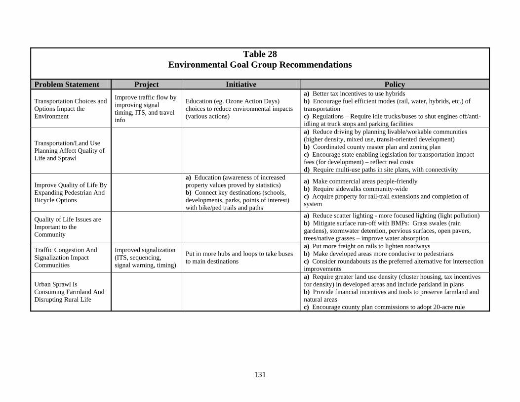
Over the course a three-month period, the committee brainstormed and ranked solutions to address these problems. The solutions could be either projects, initiatives, or solutions and could take place in either the short-term or long-term and could either fix the symptoms of the problem or fix the root cause. The brainstorming produced many very insightful solutions. After the brainstorming concluded, the committee ranked the solutions as high, medium or low priority. The majority of the solutions the committee arrived at were policies. There were fewer numbers of initiatives and projects. Table 28 shows the solutions recommended by the Environmental Goal Group.
129
To determine which projects would go in the draft plan, each goal group’s committed projects were put in the plan and then each group could select the top 10 percent of their projects for automatic inclusion. One of the projects, improve traffic flow by improving signal timing, ITS, and travel information (Project C-6) is a committed project and the other is their top 10 percent project (Project 3). Project C-6 will install surveillance cameras and changeable message signs on area expressways. They are intended to improve traffic flow by providing traveler information to motorists on construction delays, weather conditions, road closures, and other needed messages. Project 3, ITS arterial signal coordination – timing of traffic signals for better flow, is intended to improve traffic flow by coordinating traffic signals across jurisdictional boundaries. The committee also prioritized their initiatives. Their top 10 percent initiative is for a bike path connectivity study. The study will investigate key destinations (schools, parks, developments, point of interest) and plan connections with bike and pedestrian trails and paths. To address remaining concerns, the following policies were selected for the plan. As part of plan implementation, these policies will be actively promoted in the region: Policy 11: Because transportation choices and options impact the environment, our region’s policy is to encourage fuel efficient modes of transportation (rail, water, hybrids, etc.). Policy 12: We recognize that transportation and land use planning are interrelated, and both affect quality of life and patterns of development. To reduce sprawl and improve quality of life, our region will aim to:
1. Reduce driving by planning livable/workable communities (featuring higher density, mixed use, and transit-oriented development).
2. Coordinate county and local jurisdiction master plans and zoning plans. 3. Encourage state enabling legislation to establish transportation impact fees (on
development) to reflect the real costs of development. 4. Require multi-use paths in site plans, with connectivity to adjoining development.
Policy 13: Urban sprawl is consuming farmland and disrupting rural life. To protect our rural areas, we encourage governments to:
1. Require and/or provide tax incentives for greater land use density (such as cluster housing) for more efficient land use in developed areas and include parkland in development plans.
2. Provide financial incentives and tools to preserve farmland and natural areas. 3. Encourage county plan commissions to adopt a 20-acre rule (minimum lot size of 20
acres in agricultural areas). Policy 14: Our region seeks to improve quality of life by expanding pedestrian and bicycle transportation options. We urge stakeholders to make commercial areas people-friendly, require sidewalks and bicycle parking facilities region-wide, and acquire property for rail-trail extensions and completion of the bikeway system.
130
Policy 15: To protect our environment, our region will mitigate surface run-off from roads and other transportation-related facilities with best management practices (BMPs) to improve water absorption. These include grass swales (rain gardens), stormwater detention, pervious surfaces, open pavers, and plantings of trees and native grasses. Policy 16: To improve air quality through reduced traffic congestion and improved traffic flow, we will:
1. Work to put more freight on rails to lighten roadway traffic. 2. Make developed areas more conducive to walking. 3. Consider roundabouts as the preferred alternative for intersection improvements (see
Policy 8).
Policy 17: The region will work to identify techniques to reduce road impacts on wildlife and will support use of appropriate measures. Policy 18: Our region supports the ongoing development of a network of state scenic byway designated roads. Benefits of scenic byways include preservation of natural resources and economic benefits from tourism. We support byway designation for the original US 24 between Napoleon and Waterville when that section is abandoned for the new US 24. 4. Passenger Goal The passenger goal focuses on personal mobility: “Our region will be a top quality multimodal passenger transportation hub.” We will reach this goal when we have developed a robust multimodal system for personal mobility extending throughout the region. Objectives developed for this goal were:
• Region-wide transportation system for both auto and non-motorized travel • Promote alternatives to personal vehicle usage • Improve the transit system to meet the needs of those who don’t have or can’t afford
cars • Balanced spending on modes • Maximize all passenger transportation assets • Develop a transportation link to air international airport • Improve intermodal linkages
131
Table 28 Environmental Goal Group Recommendations
Problem Statement Project Initiative Policy
Transportation Choices and Options Impact the Environment
Improve traffic flow by improving signal timing, ITS, and travel info
Education (eg. Ozone Action Days) choices to reduce environmental impacts (various actions)
a) Better tax incentives to use hybrids b) Encourage fuel efficient modes (rail, water, hybrids, etc.) of transportation c) Regulations – Require idle trucks/buses to shut engines off/anti-idling at truck stops and parking facilities
Transportation/Land Use Planning Affect Quality of Life and Sprawl
a) Reduce driving by planning livable/workable communities (higher density, mixed use, transit-oriented development) b) Coordinated county master plan and zoning plan c) Encourage state enabling legislation for transportation impact fees (for development) – reflect real costs d) Require multi-use paths in site plans, with connectivity
Improve Quality of Life By Expanding Pedestrian And Bicycle Options
a) Education (awareness of increased property values proved by statistics) b) Connect key destinations (schools, developments, parks, points of interest) with bike/ped trails and paths
a) Make commercial areas people-friendly b) Require sidewalks community-wide c) Acquire property for rail-trail extensions and completion of system
Quality of Life Issues are Important to the Community
a) Reduce scatter lighting - more focused lighting (light pollution) b) Mitigate surface run-off with BMPs: Grass swales (rain gardens), stormwater detention, pervious surfaces, open pavers, trees/native grasses – improve water absorption
Traffic Congestion And Signalization Impact Communities
Improved signalization (ITS, sequencing, signal warning, timing)
Put in more hubs and loops to take buses to main destinations
a) Put more freight on rails to lighten roadways b) Make developed areas more conducive to pedestrians c) Consider roundabouts as the preferred alternative for intersection improvements
Urban Sprawl Is Consuming Farmland And Disrupting Rural Life
a) Require greater land use density (cluster housing, tax incentives for density) in developed areas and include parkland in plans b) Provide financial incentives and tools to preserve farmland and natural areas c) Encourage county plan commissions to adopt 20-acre rule
132
Members of the Passenger Goal Group, drawn from the task force plus others with needed expertise, were:
• Brian Babcock, citizen representative • Enedelia Cisneros, Rural Opportunities Inc. • Larry Clark, Executive Director, Toledo Area Ministries • Marie Curtis, FOCUS Homeless Services • Jim Gee, General Manager, TARTA • Bill Gill, Regional Coordinator, All Aboard Ohio • Joe Kahl, Director of Transportation, Toledo Public Schools • Hussein Abounaaj, City of Toledo, Dept of Neighborhoods • Royce Maniko, Director of Planning, Monroe County Planning Dept • Beth McCray, All Aboard Ohio • Sherri McNeil, TSS Director, Senior Centers Inc. • Kathy Mehl, Area Office on Aging of Northwest Ohio Inc. • Ron Myers, Traffic Engineering Associate, Lucas County Engineer's Office • Shelly Papenfuse, Ability Center of Greater Toledo • Patricia Reyes, Rural Opportunities Inc. • Bill Saunders, Maumee Valley Bicycle & Pedestrian Alliance • Rodney Shultz, Deputy City Engineer, City of Oregon • Leola Haynes, citizen representative
In addressing this goal, the passenger goal group looked at a variety of issues (problem statements):
• Public transit issues (geographic coverage, service deficiencies, new technologies) • Mobility needs (elderly and special needs populations; need for transportation choices) • Need to improve availability of air and passenger rail transportation • Opportunity to use improved personal transportation to support economic development • Need for improved bicycle and pedestrian transportation (more facilities, improved
safety) • School transportation issues • Automobile and roadway issues (congestion, safety, air quality impacts, system
condition) • Transportation system security • Need for more funding and intra/inter-regional cooperation
Following goal group and task force selection processes, the following bikeway, transit, and water transportation projects with committed funding were included in the plan:
133
Table 29 Committed Passenger Projects
Rank Mode Project Description Project
Cost ($Mil)
C-2 Bike Craig (former I-280) Bridge – convert to street with bike path & build path on I-280 trench land $21.8
C-9 Bike “Westside” Trail – buy rail corridor and construct path, Laskey Rd. to Knight Preserve (excludes bridge reconstruction, project 14)
*$10
C-13 Bike Complete Wabash Cannonball Trail North-South Connector $1.7 C-15 Bike Riverside Trail-Phase 1, build bike/walk path from downtown
Toledo to Craig Bridge $1.25
C-8 Transit Build new TARPS paratransit facility adjoining Toledo train station *$10.8
C-22 Transit Replace TARTA bus fleets (2 cycles of replacement) $100 C-1 Water Provide for passenger connection via water from Toledo to Lake
Erie Islands (marine terminal) *$5.5
* Funding from other sources The Passenger Goal Group selected five projects as their top 10 percent picks. These were (with their original project numbers):
P-2 Add rural transit circulators (requires additional funding base) P-4 Fund and build Toledo Science and Technology Corridor people-mover P-5 Downtown trolley system and link to UT ($60.0 to $77.0 million depending on corridor) P-15 Rehab or replace “upriver” rail bridge as ped-bike crossing (part of Westside Corridor
project) P-20 Bike connector, North Coast Inland Trail to Wabash Cannonball Trail across northern
Wood County Including these five projects, a total of 33 priority projects were selected for the plan. These represent an investment of $558 million, of which $153 million would come from expected regional resources. Several of the bikeway projects build on the City of Oregon bikeway network. A major addition to the regional system of bike trails will be development of a link between the Wabash Cannonball Trail and the North Coast inland trail (project 13). The projects categorized as “bike/highway” are aimed at redesigning several road segments that pose significant challenges to cyclists and pedestrians. Eliminating these choke points is in keeping with the “complete streets” philosophy of multi-functional street corridors.
134
Table 30: Passenger Goal Priority Projects
Rank Mode Project Description Project
Cost ($Mil)
13 Bike Build bike connector from North Coast Inland Trail to Wabash Cannonball Trail, across northern Wood County $6.5
14 Bike Rehab or replace upriver rail bridge as ped/bike crossing (part of Westside Corridor project C-9) $4.5
25 Bike Build connector between Oregon trail system and Craig Bridge bike path $0.53 35 Bike Build Swan Creek trail from RiverWalk/Erie St. Market to Swan Creek
Metropark $2.8
38 Bike Build Eastside Maumee River trail from Craig Bridge to International Park including ped/bike crossing of Main St. (possibly grade-separated) $1.6
45 Bike Buy rail right-of-way and extend University/Parks Trail into Michigan; provide access road right-of-way for Holland-Sylvania Rd. $2.7
47 Bike SR 65 – add paved berms from Grand Rapids to Rossford, excluding curbed sections and areas within City of Perrysburg $6.7
48 Bike Build Riverside Trail-Phase 2 from Craig Bridge to Point Place $0.5 49 Bike Build Point Place Connector Bike Trail $2.2 50 Bike SR 64 – add paved berms from Whitehouse to Waterville $1.1 51 Bike Bike network signage project–post signs on designated bike routes $0.05 52 Bike Complete Oregon bike network (19.6 miles—Figure 33) $6.8 55 Bike Complete Sylvania-Metamora Rd. (Erie St.) bike path west of Centennial Park,
and bike lanes south on Kilburn Rd. to Central Ave. $1
56 Bike Build connection between Oregon trail system and North Coast Inland Trail $1.4 20 Bike/
Hwy Eliminate Detroit Ave. and Glendale Ave. choke point, Schneider Rd. to Harvard Blvd. $7
21 Bike/ Hwy
Provide Airport Hwy ped/bike facilities from Holland-Sylvania Rd., across I-475 and accessing Spring Meadows shopping center $2.5
22 Bike/ Hwy
Eliminate Berdan choke point from Martha to Cherry Sts. $2
23 Bike/ Hwy
Eliminate Alexis Rd. choke point from Hagman Rd. to Suder Ave. $8
24 Bike/ Hwy
Eliminate Monroe/Alexis/Main St. choke point (City of Sylvania) $1
27 Bike/ Hwy
Eliminate SR 51 (Woodville Rd.) choke point from Oak St. to Curtice Rd. $33
32 Bike/ Hwy
Eliminate Detroit Ave. choke point from Waggoner to Lagrange St. $24
40 Bike/ Hwy
Eliminate Wheeling St. choke point, Navarre to Woodville Rd., and add bike facility $0.9
41 Bike/ Hwy
Add ped/bike connection across I-475 on SR 25 (Perrysburg) $2.5
8 Passenger Rail
Ohio Hub High Speed Rail implementation – may include passenger rail/rail overpass in Northwood, new Maumee River Bridge, upgrade MLK Plaza infrastructure & passenger access to multiple rail lines, etc.
*$105
30 Ped Build pedestrian bridge across Douglas Rd. at UT tied to Westside corridor path (C-9) $1.5
42 Ped Add pedestrian facilities on Wooster St crossing of I-75 (accessing stores) $2.5 6 Transit Fund and build Technology Corridor people-mover, connecting UT Health
Science Campus (former MCO) to UT to Art Museum ($70 m total) $10
135
Table 30: Passenger Goal Priority Projects (Continued)
Rank Mode Project Description Project
Cost ($Mil)
10 Transit Build downtown Toledo trolley system and link to Tech Corridor (see project 6) at Art Museum ($77 m total) $10
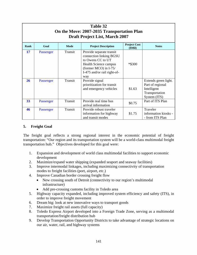
11 Transit Add rural transit circulators (requires additional funding base) $6 17 Transit Provide separate transit connection linking BGSU to Owens CC to UT Health
Science campus (former MCO) in I-75/I-475 and/or rail right-of-way *$300
26 Transit Provide signal prioritization for transit and emergency vehicles $1.63 33 Transit Provide real time bus arrival information $0.75 46 Transit Provide robust traveler information for highway and transit modes $1.75
*Special funding The seven transit projects were selected to increase the utility of public transportation and to support economic development. A significant addition to the region’s transportation options will be the implementation of the Ohio Hub high speed rail system (passenger rail, project 8). Under a plan developed by the Ohio Rail Development Commission, multiple fast trains per day would stop in Bowling Green, Toledo, and the Detroit airport, linking our region to multiple cities and states in the Midwest. The passenger initiatives that were ranked highest and selected for inclusion will require substantial regional effort. Initiatives 7, 8, and 9 call for a new approach to public transportation, one that will remove artificial barriers to providing service where needed. Initiatives 10 and 11 seek to make nonmotorized transportation a more realistic option in the region.
Table 31 Passenger Hub Goal Initiatives 7 Regional transit funding—Different / regional transit funding mechanism -
geographically fair - to allow service throughout region as needed 8 Multiple-hub transit system—As a first step, investigate feasibility (routing,
performance and costs) of multiple hubs for the public transit bus route system 9 Regional transit—Increase bus routes and other public transit in order to increase
the geographic area served (county-wide or region-wide). 10 Develop a regional safe routes to school program addressing ped/bike routes,
funding, infrastructure, etc. [addresses concerns of TMACOG Pedestrian School Survey]
11 Sidewalk Policy Committee—Establish a regional committee to examine current sidewalk policies and regulations concerning installation, maintenance and enforcement and to develop a regional policy.
Seven policies focus on meeting the passenger hub goal. Some underscore the importance of key passenger projects and initiatives aimed at improving personal transportation options. Policy 19 calls for regional support of a “complete streets” policy and articulates the overall theme of an interconnected multimodal system:
136
Passenger Goal Policies Policy 19: To provide more viable personal transportation choices, our region’s policy is to support development of a passenger transportation system providing a full range of integrated, interconnected modal choices to insure mobility of all citizens and options that improve community and natural environments. Important steps towards this goal include:
1. Adopting a regional “complete streets” policy that calls for design of street corridors to serve multiple transportation modes, including pedestrians, bicycles and transit.
2. Increasing density of development, including infill housing in urban areas, to make multiple transportation modes feasible.
Policy 20: Public transit in our region lacks sufficient geographic reach. It does not serve rural or suburban areas such as City of Oregon and Springfield Township. To provide transit throughout the region, a truly integrated transit system that services all areas / people should be developed. More state / county transit funding is needed to make this feasible. Policy 21: We need to improve transit operations and expand hours of service, which will require more money for transit. In addition, we should make transit more user-friendly, including better “policing” of bench conditions at bus stops and requiring businesses and other transit generators to provide transit amenities. Policy 22: To improve intermodal connections and travel options within our region, we urge continuation and increase of intercity bus service between communities in northwest Ohio and southeastern Michigan. Policy 23: We need to address the lack of sufficient transportation for seniors, people with disabilities / special needs, and other nondrivers:
1. All transit should be more senior-friendly, and accessible to seniors/disabled. 2. User-friendly traveler information should be made available for all transportation modes
and connectivity between modes. 3. Local regulation should require 15 percent of fleets (for example, taxi cabs) to be
accessible to people with disabilities. Policy 24: We need fast, convenient and affordable intercity passenger rail. We will join with other regions to push for implementation of the Ohio Hub Plan for fast, frequent rail service including a Toledo-Detroit connection via the Detroit airport. In addition we will support the Chicago Hub high-speed rail plan linking our region to Fort Wayne and Chicago. Policy 25: Our region supports use of passenger transportation to support economic development, including:
1. Tie multiple modes of transportation, including the bikeway network, to all major development and redevelopment areas.
2. Increase transit-oriented development, which concentrates commercial space and a variety of housing options around a transit stop. This compact, mixed use, and
137
pedestrian-oriented development encourages more transit use, reduces congestion, increases property values, and reduces infrastructure costs.
3. Build the downtown circulator trolley system and the connecting Toledo Science and Technology Corridor people-mover (see Plan Projects 6 and 10).
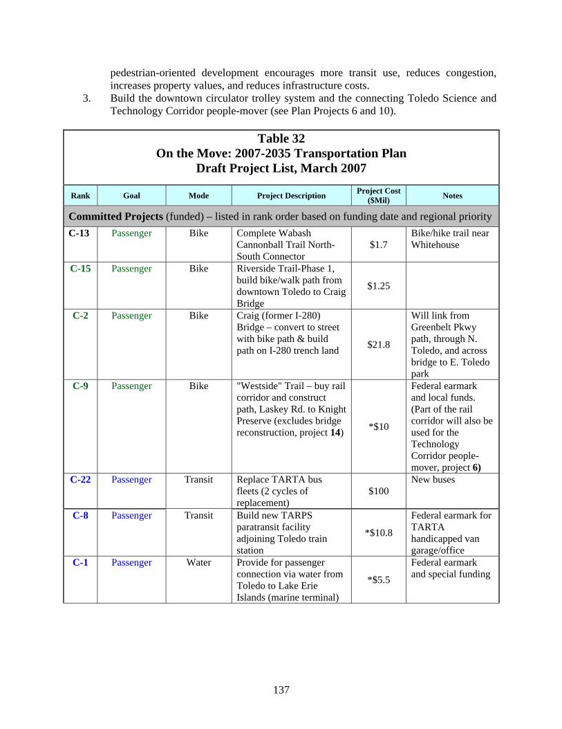
Table 32
On the Move: 2007-2035 Transportation Plan Draft Project List, March 2007
Rank Goal Mode Project Description Project Cost ($Mil) Notes
Committed Projects (funded) – listed in rank order based on funding date and regional priority C-13 Passenger Bike Complete Wabash
Cannonball Trail North-South Connector
$1.7 Bike/hike trail near Whitehouse
C-15 Passenger Bike Riverside Trail-Phase 1, build bike/walk path from downtown Toledo to Craig Bridge
$1.25
C-2 Passenger Bike Craig (former I-280) Bridge – convert to street with bike path & build path on I-280 trench land $21.8
Will link from Greenbelt Pkwy path, through N. Toledo, and across bridge to E. Toledo park
C-9 Passenger Bike "Westside" Trail – buy rail corridor and construct path, Laskey Rd. to Knight Preserve (excludes bridge reconstruction, project 14) *$10
Federal earmark and local funds. (Part of the rail corridor will also be used for the Technology Corridor people-mover, project 6)
C-22 Passenger Transit Replace TARTA bus fleets (2 cycles of replacement)
$100 New buses
C-8 Passenger Transit Build new TARPS paratransit facility adjoining Toledo train station
*$10.8
Federal earmark for TARTA handicapped van garage/office
C-1 Passenger Water Provide for passenger connection via water from Toledo to Lake Erie Islands (marine terminal)
*$5.5
Federal earmark and special funding
138
Table 32 On the Move: 2007-2035 Transportation Plan
Draft Project List, March 2007
Rank Goal Mode Project Description Project Cost ($Mil) Notes
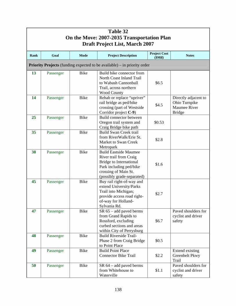
Priority Projects (funding expected to be available) – in priority order
13 Passenger Bike Build bike connector from North Coast Inland Trail to Wabash Cannonball Trail, across northern Wood County
$6.5
14 Passenger Bike Rehab or replace “upriver” rail bridge as ped/bike crossing (part of Westside Corridor project C-9)
$4.5
Directly adjacent to Ohio Turnpike Maumee River Bridge
25 Passenger Bike Build connector between Oregon trail system and Craig Bridge bike path
$0.53
35 Passenger Bike Build Swan Creek trail from RiverWalk/Erie St. Market to Swan Creek Metropark
$2.8
38 Passenger Bike Build Eastside Maumee River trail from Craig Bridge to International Park including ped/bike crossing of Main St. (possibly grade-separated)
$1.6
45 Passenger Bike Buy rail right-of-way and extend University/Parks Trail into Michigan; provide access road right-of-way for Holland-Sylvania Rd.
$2.7
47 Passenger Bike SR 65 – add paved berms from Grand Rapids to Rossford, excluding curbed sections and areas within City of Perrysburg
$6.7
Paved shoulders for cyclist and driver safety
48 Passenger Bike Build Riverside Trail-Phase 2 from Craig Bridge to Point Place
$0.5
49 Passenger Bike Build Point Place Connector Bike Trail $2.2
Extend existing Greenbelt Pkwy Trail
50 Passenger Bike SR 64 – add paved berms from Whitehouse to Waterville
$1.1 Paved shoulders for cyclist and driver safety
139
Table 32 On the Move: 2007-2035 Transportation Plan
Draft Project List, March 2007
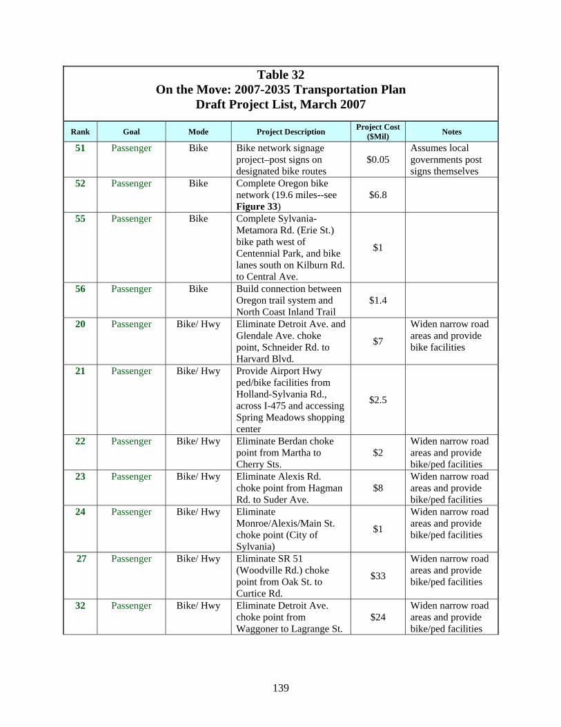
Rank Goal Mode Project Description Project Cost ($Mil) Notes
51 Passenger Bike Bike network signage project–post signs on designated bike routes
$0.05 Assumes local governments post signs themselves
52 Passenger Bike Complete Oregon bike network (19.6 miles--see Figure 33)
$6.8
55 Passenger Bike Complete Sylvania-Metamora Rd. (Erie St.) bike path west of Centennial Park, and bike lanes south on Kilburn Rd. to Central Ave.
$1
56 Passenger Bike Build connection between Oregon trail system and North Coast Inland Trail
$1.4
20 Passenger Bike/ Hwy Eliminate Detroit Ave. and Glendale Ave. choke point, Schneider Rd. to Harvard Blvd.
$7
Widen narrow road areas and provide bike facilities
21 Passenger Bike/ Hwy Provide Airport Hwy ped/bike facilities from Holland-Sylvania Rd., across I-475 and accessing Spring Meadows shopping center
$2.5
22 Passenger Bike/ Hwy Eliminate Berdan choke point from Martha to Cherry Sts.
$2 Widen narrow road areas and provide bike/ped facilities
23 Passenger Bike/ Hwy Eliminate Alexis Rd. choke point from Hagman Rd. to Suder Ave.
$8 Widen narrow road areas and provide bike/ped facilities
24 Passenger Bike/ Hwy Eliminate Monroe/Alexis/Main St. choke point (City of Sylvania)
$1
Widen narrow road areas and provide bike/ped facilities
27 Passenger Bike/ Hwy Eliminate SR 51 (Woodville Rd.) choke point from Oak St. to Curtice Rd.
$33
Widen narrow road areas and provide bike/ped facilities
32 Passenger Bike/ Hwy Eliminate Detroit Ave. choke point from Waggoner to Lagrange St.
$24 Widen narrow road areas and provide bike/ped facilities
140
Table 32 On the Move: 2007-2035 Transportation Plan
Draft Project List, March 2007
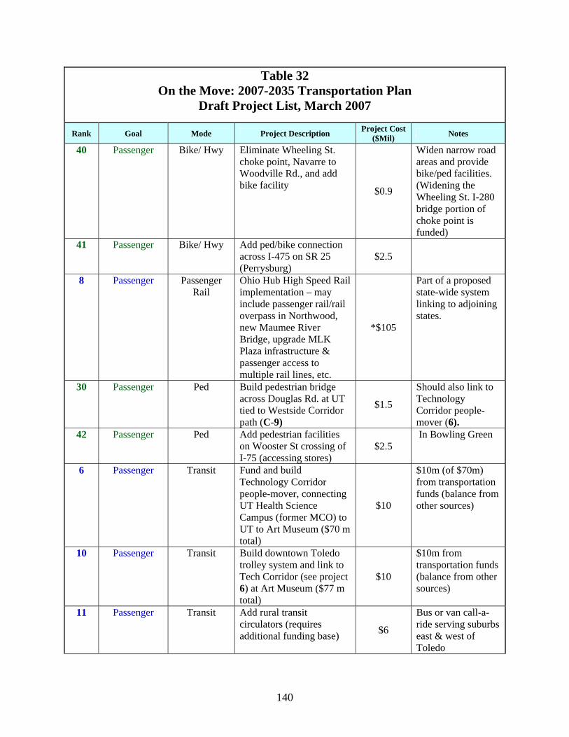
Rank Goal Mode Project Description Project Cost ($Mil) Notes
40 Passenger Bike/ Hwy Eliminate Wheeling St. choke point, Navarre to Woodville Rd., and add bike facility $0.9
Widen narrow road areas and provide bike/ped facilities. (Widening the Wheeling St. I-280 bridge portion of choke point is funded)
41 Passenger Bike/ Hwy Add ped/bike connection across I-475 on SR 25 (Perrysburg)
$2.5
8 Passenger Passenger Rail
Ohio Hub High Speed Rail implementation – may include passenger rail/rail overpass in Northwood, new Maumee River Bridge, upgrade MLK Plaza infrastructure & passenger access to multiple rail lines, etc.
*$105
Part of a proposed state-wide system linking to adjoining states.
30 Passenger Ped Build pedestrian bridge across Douglas Rd. at UT tied to Westside Corridor path (C-9)
$1.5
Should also link to Technology Corridor people-mover (6).
42 Passenger Ped Add pedestrian facilities on Wooster St crossing of I-75 (accessing stores)
$2.5 In Bowling Green
6 Passenger Transit Fund and build Technology Corridor people-mover, connecting UT Health Science Campus (former MCO) to UT to Art Museum ($70 m total)
$10
$10m (of $70m) from transportation funds (balance from other sources)
10 Passenger Transit Build downtown Toledo trolley system and link to Tech Corridor (see project 6) at Art Museum ($77 m total)
$10
$10m from transportation funds (balance from other sources)
11 Passenger Transit Add rural transit circulators (requires additional funding base) $6
Bus or van call-a-ride serving suburbs east & west of Toledo
141
Table 32 On the Move: 2007-2035 Transportation Plan
Draft Project List, March 2007
Rank Goal Mode Project Description Project Cost ($Mil) Notes
17 Passenger Transit Provide separate transit connection linking BGSU to Owens CC to UT Health Science campus (former MCO) in I-75/ I-475 and/or rail right-of-way
*$300
26 Passenger Transit Provide signal prioritization for transit and emergency vehicles $1.63
Extends green light. Part of regional Intelligent Transportation System (ITS)
33 Passenger Transit Provide real time bus arrival information $0.75 Part of ITS Plan
46 Passenger Transit Provide robust traveler information for highway and transit modes
$1.75 Traveler information kiosks -- from ITS Plan
5. Freight Goal The freight goal reflects a strong regional interest in the economic potential of freight transportation: “Our region and its transportation system will be a world-class multimodal freight transportation hub.” Objectives developed for this goal were:
1. Expansion and development of world class multimodal facilities to support economic development
2. Maximize/expand water shipping (expanded seaport and seaway facilities) 3. Improve intermodal linkages, including maximizing connectivity of transportation
modes to freight facilities (port, airport, etc.) 4. Improve Canadian border crossing freight flow
• New crossing south of Detroit (connectivity to our region’s multimodal infrastructure)
• Add pre-crossing customs facility in Toledo area 5. Highway capacity expanded, including improved system efficiency and safety (ITS), in
order to improve freight movement 6. Dream big: look at new innovative ways to transport goods 7. Maximize freight rail assets (full capacity) 8. Toledo Express Airport developed into a Foreign Trade Zone, serving as a multimodal
transportation/freight distribution hub 9. Develop Transportation Opportunity Districts to take advantage of strategic locations on
our air, water, rail, and highway systems
142
Freight Goal Group members represented a variety of organizations and interests. In addition to members from the plan task force, others were recruited to insure adequate industry input:
• Tom Blaha, Wood County Economic Development Commission and NW Ohio Regional Economic Development Association (NORED)
• James Crammond, Timiny Railroad Construction • Robert Greenlese, Toledo-Lucas County Port Authority • Raymond Huber, Wood County Engineer • Ed Nagle, Nagle Companies (trucking) • Lynette Reichle, CB Richard Ellis/Reichle Klein (commercial real estate) • Mike Schneider, R&J Tucking • Lee Springer, Regional Growth Partnership • Mark Vonderembse, Toledo University, Intermodal Transportation Institute (ITI)
In addition, Warren McCrimmon of the Toledo-Lucas County Port Authority, attended one meeting to answer questions about seaport operations and the potential for short sea shipping. In addressing this goal, the passenger goal group looked at a variety of issues (problem and opportunity statements):
• Need to increase airport capacity • Opportunity to expand our air facilities as intermodal hubs • Improve multimodal access to rail freight transportation. • Improve intermodal connectivity. • Conflicts between freight transportation modes • Utilize/improve freight transport to support economic development • Opportunities to increase usage of rail freight • Lack of freight rail capacity • Ongoing attention and improvements to highway/street access and connectivity for truck
traffic • Congestion and insufficient road capacity relating to trucks • Safety issues from mixing truck and car traffic • Need to maintain and upgrade infrastructure for trucks • Improve last mile/surface road connectors to intermodal facilities • Trucks negatively impact community • Opportunity to expand waterborne freight movement • St Lawrence Seaway cannot handle large vessels • Problems keeping river channel open • Improve utilization of and maintain access to water transport
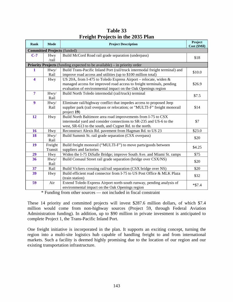
Through the goal group and task force selection processes, the following freight projects were added to the plan. These include the two projects selected by the Freight Goal Group as their top 10 percent—Project 4 (originally Project F-1) and Project 9 (originally F-7).
143
Table 33 Freight Projects in the 2035 Plan
Rank Mode Project Description Project Cost ($Mil)
Committed Projects (funded) C-7 Hwy
/rail Build McCord Road rail grade separation (underpass) $18
Priority Projects (funding expected to be available) – in priority order 1 Hwy/
Rail Build Trans-Pacific Inland Port (rail/truck intermodal freight terminal) and improve road access and utilities (up to $100 million total) $10.0
4 Hwy US 20A, from I-475 to Toledo Express Airport – relocate, widen & managed access for improved road access to freight terminals, pending evaluation of environmental impact on the Oak Openings region
$26.9
7 Hwy/ Rail
Build North Toledo intermodal (rail/truck) terminal $7.5
9 Hwy/ Rail
Eliminate rail/highway conflict that impedes access to proposed Jeep supplier park (rail overpass or relocation; or "MULTI-F" freight monorail project 19)
$14
12 Hwy Build North Baltimore area road improvements from I-75 to CSX intermodal yard and consider connections to SR-235 and US-6 to the west, SR-613 to the south, and Cygnet Rd. to the north.
$7
16 Hwy Reconstruct Alexis Rd. pavement from Hagman Rd. to US 23 $23.0 18 Hwy/
Rail Build Summit St. rail grade separation (CSX overpass) $20
19 Freight Transit
Build freight monorail (“MULTI-F”) to move parts/goods between suppliers and factories $4.25
29 Hwy Widen the I-75 DiSalle Bridge; improve South Ave. and Miami St. ramps $75 36 Hwy/
Rail Build Consaul Street rail grade separation (bridge over CSX/NS) $20
37 Rail Build Vickers crossing rail/rail separation (CSX bridge over NS) $20 39 Hwy Build efficient road connector from I-75 to US Post Office & MLK Plaza
(train station) $32
59 Air Extend Toledo Express Airport north-south runway, pending analysis of environmental impact on the Oak Openings region *$7.4
* Funding from other sources — not included in fiscal constraint These 14 priority and committed projects will invest $287.6 million dollars, of which $7.4 million would come from non-highway sources (Project 59, through Federal Aviation Administration funding). In addition, up to $90 million in private investment is anticipated to complete Project 1, the Trans-Pacific Inland Port. One freight initiative is incorporated in the plan. It supports an exciting concept, turning the region into a multi-site logistics hub capable of handling freight to and from international markets. Such a facility is deemed highly promising due to the location of our region and our existing transportation infrastructure.
144
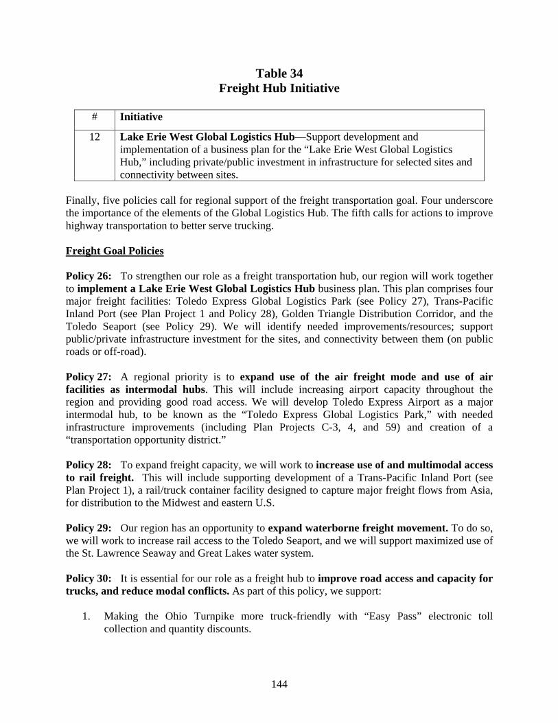
Table 34 Freight Hub Initiative
# Initiative
12 Lake Erie West Global Logistics Hub—Support development and implementation of a business plan for the “Lake Erie West Global Logistics Hub,” including private/public investment in infrastructure for selected sites and connectivity between sites.
Finally, five policies call for regional support of the freight transportation goal. Four underscore the importance of the elements of the Global Logistics Hub. The fifth calls for actions to improve highway transportation to better serve trucking. Freight Goal Policies Policy 26: To strengthen our role as a freight transportation hub, our region will work together to implement a Lake Erie West Global Logistics Hub business plan. This plan comprises four major freight facilities: Toledo Express Global Logistics Park (see Policy 27), Trans-Pacific Inland Port (see Plan Project 1 and Policy 28), Golden Triangle Distribution Corridor, and the Toledo Seaport (see Policy 29). We will identify needed improvements/resources; support public/private infrastructure investment for the sites, and connectivity between them (on public roads or off-road).
Policy 27: A regional priority is to expand use of the air freight mode and use of air facilities as intermodal hubs. This will include increasing airport capacity throughout the region and providing good road access. We will develop Toledo Express Airport as a major intermodal hub, to be known as the “Toledo Express Global Logistics Park,” with needed infrastructure improvements (including Plan Projects C-3, 4, and 59) and creation of a “transportation opportunity district.” Policy 28: To expand freight capacity, we will work to increase use of and multimodal access to rail freight. This will include supporting development of a Trans-Pacific Inland Port (see Plan Project 1), a rail/truck container facility designed to capture major freight flows from Asia, for distribution to the Midwest and eastern U.S. Policy 29: Our region has an opportunity to expand waterborne freight movement. To do so, we will work to increase rail access to the Toledo Seaport, and we will support maximized use of the St. Lawrence Seaway and Great Lakes water system. Policy 30: It is essential for our role as a freight hub to improve road access and capacity for trucks, and reduce modal conflicts. As part of this policy, we support:
1. Making the Ohio Turnpike more truck-friendly with “Easy Pass” electronic toll collection and quantity discounts.
145
2. Increasing the quality of township roads by requiring agri-business to meet same constraints as other industries, that is, eliminating exemptions that allow producers to use township roads without defraying costs of upgrades and maintenance.
3. Providing real-time information on road congestion via ITS that is suitable to trucker needs.
6. Research Goal
“Our region will be a center of transportation research and innovation,” according to this transportation plan goal. This area of pursuit, while not usually included in a metropolitan transportation plan, is a clear reflection of regional priorities and activities already underway. The University of Toledo (UT), in conjunction with TMACOG, the Toledo-Lucas County Port Authority, and other stakeholders, identified the need for research related to transportation and established the UT Intermodal Transportation Institute (ITI). The ITI is described on its website as follows: “The Intermodal Transportation Institute is an interdisciplinary Institute that promotes and coordinates UT’s research, education, and outreach relating to transportation and serves as a portal for external constituencies to access UT’s transportation-related talent and resources. The Institute also is the lead organization in the U.S. Department of Transportation funded University Transportation Center at The University of Toledo [with participating institutions, Bowling Green State University (BGSU) and Wayne State University], and is a collaborator with the MIOH (Michigan-Ohio) University Transportation Center led by The University of Detroit-Mercy. The ITI has a broad agenda of interdisciplinary activities…. These include supply chain management and business logistics, the design and planning of intermodal transportation systems, transportation infrastructure improvements, alternative energy sources for transportation, and land-use planning and transportation needs projections.” As noted, Bowling Green State University is a partner in the federal designation of UT as a University Transportation Center. BGSU’s work includes collaborative efforts in alternative fuels research. One of the current initiatives in the region is developing a “research and technology corridor.” UT introduced and is leading the efforts to realize this concept. The corridor would initially span the distance between UT’s main campus and the Health Science Campus (formerly the Medical College of Ohio) in the City of Toledo. In the future, it would expand to link these facilities with Owens Community College in northern Wood County, Bowling Green State University, and potentially even Wayne State University in Detroit. It would provide opportunity for interaction among researchers and spin-off technology-related business development. A people-mover will provide a transportation linkage, knitting the corridor together for increased interaction and productivity. Objectives developed for this goal were:
1. Develop “research and technology corridor” transit system 2. Encourage alternative fuels research 3. Look at innovative ways to transport people
146
4. Look at innovative ways to transport goods 5. Education & training to support transportation needs
The members of the Research Goal Group were:
• Robert Davis, City of Toledo • Bill Kelly, TARTA • Robert Krompak, Ottawa Community Development Corp. • Mark Vonderembse, University of Toledo • Robin Weirauch, Bowling Green State University • Harry Wyatt, University of Toledo
The Research Goal Group reviewed community input and developed strategies to address the following issues (needs and opportunities statements):
• Need to diversify fuels for transportation • Need for innovative ways for trucks to get where they need to go more easily • Need to find ways to utilize ports in the great lakes • Facilitate “research corridor” identity and passenger movement • Need to support/expand transportation logistics and supply chain research in the region • Need to research innovative traffic systems to improve traffic flow • Need to research alternative energy in signs and signals
The Research Goal Group nominated one project for the plan: fund and build the technology corridor people-mover. This project was jointly proposed by the Passenger Goal Group, and was included in the plan as Project 6: “Fund and build Toledo Science and Technology Corridor people-mover, connecting UT Health Science Campus (former MCO) to UT to Art Museum.” The extension from the University of Toledo past the Toledo Hospital, to the Toledo Museum of Art would not only link these additional institutions, but also would connect the proposed downtown Toledo circulator trolley (Project 10). Three research initiatives are incorporated in the plan. It supports an exciting concept, turning the region into a multi-site logistics hub capable of handling freight to and from international markets. Such a facility is deemed highly promising due to the location of our region and our existing transportation infrastructure.
Table 35 Research Initiatives
# Initiative 13 Freight Database—Develop comprehensive goods movement “knowledge database”
(how much freight is moving from/to and through our region and by which modes). 14 Fuels Research—Comprehensive research on production and use of ethanol/bio-fuels. 15 Transit Research—Research role of transit in establishing identity for corridor
(studies of other successful corridors, e.g. Silicone Valley, research triangle, etc.).
147
Five policies underscore the importance of transportation research and innovation. Additional proposals by the Research Goal Group, not included in the plan, can be found in the separate document, the “On the Move: 2007-2035 Transportation Plan Development Report,” a reference book available at TMACOG. Research Goal Policies Policy 31: We need to diversify fuels for transportation, to insure fuel will be available on a long-term basis, with reduced dependence on foreign sources. To do so, our region will:
1. Support the work of a consortium of area universities to develop and commercialize hybrid vehicles.
2. Analyze current state and federal policies to propose changes and/or take advantage of existing policies in order to enhance alternative fuels production and use in our region.
Policy 32: With the amount of transported freight expected to double in the next 15 years, we need innovative ways to move goods more efficiently. Therefore, it is our region’s policy that:
1. Local jurisdictions and planning/development agencies should seek to locate industrial and distribution facilities near existing transportation terminals and interchanges.
2. We encourage development of multi-trailer terminals at Ohio Turnpike interchanges. 3. We should identify examples of trucking company collaboration on deliveries, and
support implementation of such a system. 4. We should research ways to improve efficiency of transfer of goods between
transportation modes. Policy 33: To build on regional strengths, we need to support/expand transportation logistics and supply chain research in the region. This research should include looking at the potential to coordinate transportation to common suppliers/locations. Policy 34: To enhance economic and technical development, our region will work to establish the identity of the Toledo Science and Technology corridor and the movement of people and ideas within this corridor. Policy 35: Our region supports creating innovative traffic systems to improve traffic flow, such as modern roundabouts (see Policy 8), coordinated signal timing on all major arterials, and freeway management systems and other Intelligent Transportation Systems (ITS). 7. Funding Goal Supporting all the other goals, “Our region will be successful in obtaining adequate funding for transportation facilities.” This goal reflected strong community interest in aggressively pursuing more and different funding for critical needs. The task force-developed objectives for this goal were:
1. Higher priority for low-cost programs
148
2. Encourage TMACOG to pursue more or alternative funding sources 3. A fair return to this region of federal gas tax revenues 4. Innovative public/private partnering 5. Raise more funds via local, state and federal tax and fees
Funding Goal Group members were:
• Jeff Ballmer, City of Sylvania • Keith Earley, Lucas County Engineer • Kent Gardam, City of Toledo • Bill Kelly, TARTA • Diana LaBiche, Urban League • Ralph Lange (and alternate Frank Nagy), Monroe County Road Commission • Mike Ligibel, ODOT District 2 • Carol Van Sickle, Toledo Chamber of Commerce
After reviewing public comment, the Funding Goal Group developed the following six needs statements:
1. Need to more efficiently use existing funds and balance use of funds more effectively between capacity expansion, preservation of the existing system, and maintenance and operation of the system (is current money spent in right areas)
2. Need to cooperate more regionally and work to get the most out of existing funding 3. Need to ensure that our region’s transportation system gets its fair share of federal, state,
local, and other available funding 4. Need to increase dedicated funding for transportation from traditional sources at the
federal, state, and local level 5. Need to find innovative new ways to get additional funding for new transportation
system improvements 6. Need to be able to balance split of funding between modes based on priorities and needs
in our region The detailed recommendations proposed by the Funding Goal Group are included in Appendix D (Plan Development and Evaluation). Those selected for inclusion in the plan—four initiatives and six policies—are as follows. Note the balanced approach: developing community awareness and support for more funding, using existing funds more efficiently, increasing funding from existing sources, and developing new sources.
149
Table 36 Funding Initiatives
# Initiative 16 Education campaign on Funding Needs, Part 1—Local transportation stakeholders
must educate policy makers and local tax payers on the lack of adequate resources for maintenance and improvement of the current system (all modes - highway, transit, seaway, rail, air, pedestrian/bikeway) and the disproportionate inflation in material and other costs for maintenance, construction, and operation of the system that has eroded the buying power of current funding. This requires a consistent and factual message.
17 Education campaign on Funding Needs, Part 2— Local transportation stakeholders must educate policy makers and the public on the inadequacy of the current fuel tax mechanism as a means to support highway and transit investments in the future and the relationship between reduced fuel use (a positive trend) and reduced funding for transportation (a negative trend).
18 Steady State-related Research & Actions—Research efficient standards for system preservation goals, estimate required resources to maintain existing systems, and ensure that project selection criteria place priority on maintaining the system effectively while still leaving some resources for needed capacity expansion.
19 Research on increasing tax revenue—Research existing dedicated transportation tax mechanisms for the potential to provide additional funding for transportation needs including such things as:
Sales tax on bigger, heavier, and/or more expensive personal vehicles Use taxes (e.g. licenses or vehicle registrations) Fuel taxes
Funding Goal Policies Policy 36: Our region should more efficiently use currently available funds and maintain appropriate balance between system preservation and capacity expansion. We encourage government agencies to:
1. Accurately research the cost of maintaining and improving their roads with public staff,
compare those costs to private contracting, and use the most efficient approach. 2. Cost out rehabilitation strategies using life-cycle considerations, not just initial capital
comparisons and not always a “worst first” strategy. 3. Use new methods to stretch funding including design/build, and construction warranties
for extended periods. 4. Use best available technology to build long-lasting roads
Policy 37: We encourage more regional cooperation to get the most out of current funding. Recommended strategies are:
1. Research current joint projects and group purchasing to determine if they could be
expanded to other jurisdictions for even greater cost savings. Potential project types include purchase/fabrication of signs and signals, mill and fill along jurisdictional boundaries (e.g. city-township), contracting projects and services, salt purchase (bring in
150
by ship–sell to other local jurisdictions), materials purchases (e.g. asphalt), and purchase of equipment (e.g. milling machines).
2. Research current joint operations and maintenance efforts to determine if they could be expanded to other jurisdictions. Potential project types include snow plowing and traffic signal coordination.
3. Educate the public on existing cooperation to gain their support. 4. Create a regional database of existing cooperative governmental ventures and
opportunities. 5. Reward cooperative projects via regional project selection criteria. 6. Encourage jurisdictions to use state purchasing agreements and/or local multi-
jurisdictional agreements. 7. Encourage local jurisdictions to specialize in services or materials and make these
available to other jurisdictions rather than duplicating efforts.
Policy 38: We will work together to ensure that the region gets its fair share from current funding sources. We support efforts to reduce / eliminate federal earmarks, since they don’t add to the total federal transportation dollars that come to our region.
Policy 39: Our region supports increasing dedicated funding from traditional sources to meet growing transportation demands. We urge leaders to continue to ensure that dedicated transportation taxes are used for transportation purposes. We also support:
1. Efforts to implement a mechanism to maintain the purchasing power of current
transportation-related taxes over time. (This would increase gas tax revenues to keep pace with inflation in road construction costs.)
2. Research to identify correlation between transportation investment and economic development and other public benefits. (The results of such research could support more transportation investment and increased tax initiatives.)
3. Educating elected officials on how local jurisdictions are using current dollars efficiently to maintain and improve the current system, in order to gain their support for more transportation funding.
Policy 40: We support finding innovative ways to get additional funding for transportation system upgrades. As federal and state funding sources provide less for local needs, our region should research mechanisms to raise additional transportation funding locally for priorities in our region. Some possibilities include:
1. Impact fees and tax increment financing (TIF) districts on new development (including
residential), especially where new transportation facilities or improvements will be required
2. Multiple jurisdiction transportation improvement districts (TIDs), 3. Multiple jurisdiction property tax, general or fuel sales tax, and/or income tax for
transportation uses 4. Expand statewide bond issues and/or develop other statewide mechanisms directed to
local jurisdictions 5. New, different region-wide mechanisms to fund a truly regional public transit system
over the long term
151
6. Mechanisms to raise additional transportation funding locally for paratransit and shared ride services for the whole region
7. Coordination of funding / compacts across the state line to address transportation issues on a truly regional basis
8. New variable toll facilities (congestion pricing) 9. Public/private partnership mechanisms
Policy 41: Our region will work to balance the split of funding between modes based on regional priorities and needs. We encourage multi-modal design of all projects (“complete streets”). We support changing project selection criteria to reward projects that incorporate multimodal elements such as bike lanes or paths with street upgrades; street upgrades with transit shelters, bump outs, and other accommodation; and Park and Ride facilities. 8. Plan Projects to be Constructed The “On the Move: 2007-2035 Transportation Plan” contains 22 committed and 60 priority projects for construction over the 28-year time span. They were selected as high regional priorities because they will be instrumental in achieving one or more regional goals and address significant needs and opportunities identified through the plan process (analysis and public input). The projects are shown on the plan projects map and listed below in four categories. (See Chapter VIII for a table incorporating all plan projects.) The costs of these four categories of projects in millions are:
• Committed projects with special funding $26.30 • Committed projects with regular funding $949.15 • Priority projects with special funding $423.60 • Priority projects, regular funding $689.61
A map and table of reserve projects (not expected to be funded) concludes this section. 8.1 Committed Projects Committed projects were those selected as meeting regional goals and identified as already having obtained a funding commitment. After careful consideration, the On the Move Task Force included some projects that had entered the funding stream. These were project that had obtained funds for first steps of implementation and that are expected (although not guaranteed) to obtain construction funding during the life of the 2035 Plan. Specifically, projects C-18, C-19, C-20 and C-21 are included. They have been selected by the Ohio Transportation Review Advisory Council (TRAC) for the state’s 2008-2013 Major New Program List as Tier II projects. These are defined as “under active development,” which means they are under study, funded for preliminary engineering, funded for design, and/or funded for right-of-way acquisition. Committed projects were listed and numbered in an order based on when they are expected to advance to construction. Regional priority was secondarily considered in the list order.
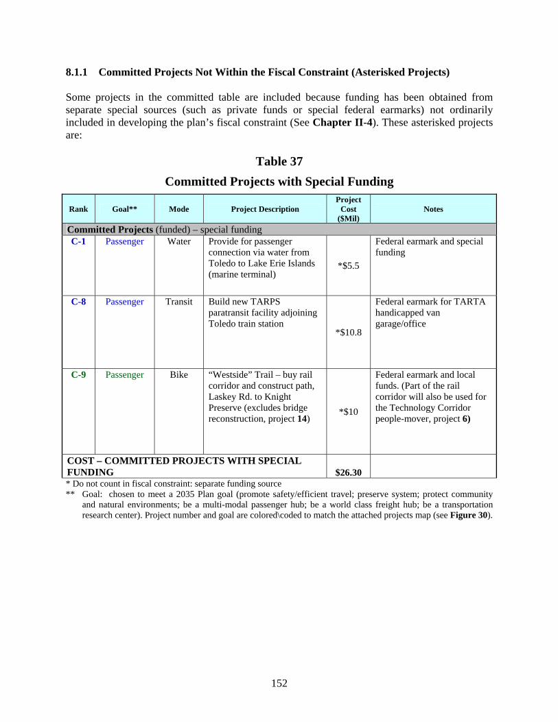
152
8.1.1 Committed Projects Not Within the Fiscal Constraint (Asterisked Projects) Some projects in the committed table are included because funding has been obtained from separate special sources (such as private funds or special federal earmarks) not ordinarily included in developing the plan’s fiscal constraint (See Chapter II-4). These asterisked projects are:
Table 37 Committed Projects with Special Funding
Rank Goal** Mode Project Description Project
Cost ($Mil)
Notes
Committed Projects (funded) – special funding C-1 Passenger Water Provide for passenger
connection via water from Toledo to Lake Erie Islands (marine terminal)
*$5.5
Federal earmark and special funding
C-8 Passenger Transit Build new TARPS paratransit facility adjoining Toledo train station
*$10.8
Federal earmark for TARTA handicapped van garage/office
C-9 Passenger Bike “Westside” Trail – buy rail corridor and construct path, Laskey Rd. to Knight Preserve (excludes bridge reconstruction, project 14)
*$10
Federal earmark and local funds. (Part of the rail corridor will also be used for the Technology Corridor people-mover, project 6)
COST – COMMITTED PROJECTS WITH SPECIAL FUNDING $26.30
* Do not count in fiscal constraint: separate funding source ** Goal: chosen to meet a 2035 Plan goal (promote safety/efficient travel; preserve system; protect community
and natural environments; be a multi-modal passenger hub; be a world class freight hub; be a transportation research center). Project number and goal are colored\coded to match the attached projects map (see Figure 30).
153
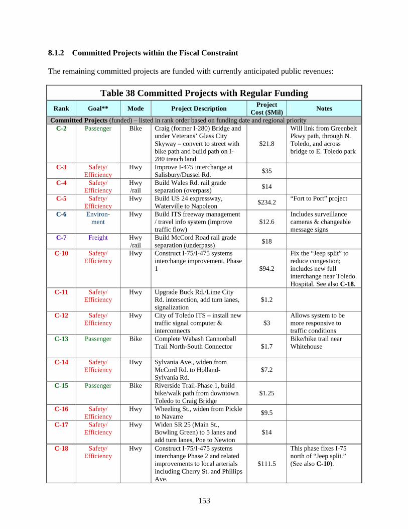
8.1.2 Committed Projects within the Fiscal Constraint The remaining committed projects are funded with currently anticipated public revenues:
Table 38 Committed Projects with Regular Funding Rank Goal** Mode Project Description Project
Cost ($Mil) Notes
Committed Projects (funded) – listed in rank order based on funding date and regional priority C-2 Passenger Bike Craig (former I-280) Bridge and
under Veterans’ Glass City Skyway – convert to street with bike path and build path on I-280 trench land
$21.8
Will link from Greenbelt Pkwy path, through N. Toledo, and across bridge to E. Toledo park
C-3 Safety/ Efficiency
Hwy Improve I-475 interchange at Salisbury/Dussel Rd. $35
C-4 Safety/ Efficiency
Hwy /rail
Build Wales Rd. rail grade separation (overpass) $14
C-5 Safety/ Efficiency
Hwy Build US 24 expressway, Waterville to Napoleon $234.2 “Fort to Port” project
C-6 Environ-ment
Hwy Build ITS freeway management / travel info system (improve traffic flow)
$12.6 Includes surveillance cameras & changeable message signs
C-7 Freight Hwy /rail
Build McCord Road rail grade separation (underpass) $18
C-10 Safety/ Efficiency
Hwy Construct I-75/I-475 systems interchange improvement, Phase 1 $94.2
Fix the “Jeep split” to reduce congestion; includes new full interchange near Toledo Hospital. See also C-18.
C-11 Safety/ Efficiency
Hwy Upgrade Buck Rd./Lime City Rd. intersection, add turn lanes, signalization
$1.2
C-12 Safety/ Efficiency
Hwy City of Toledo ITS – install new traffic signal computer & interconnects
$3 Allows system to be more responsive to traffic conditions
C-13 Passenger Bike Complete Wabash Cannonball Trail North-South Connector $1.7
Bike/hike trail near Whitehouse
C-14 Safety/ Efficiency
Hwy Sylvania Ave., widen from McCord Rd. to Holland-Sylvania Rd.
$7.2
C-15 Passenger Bike Riverside Trail-Phase 1, build bike/walk path from downtown Toledo to Craig Bridge
$1.25
C-16 Safety/ Efficiency
Hwy Wheeling St., widen from Pickle to Navarre $9.5
C-17 Safety/ Efficiency
Hwy Widen SR 25 (Main St., Bowling Green) to 5 lanes and add turn lanes, Poe to Newton
$14
C-18 Safety/ Efficiency
Hwy Construct I-75/I-475 systems interchange Phase 2 and related improvements to local arterials including Cherry St. and Phillips Ave.
$111.5
This phase fixes I-75 north of “Jeep split.” (See also C-10).
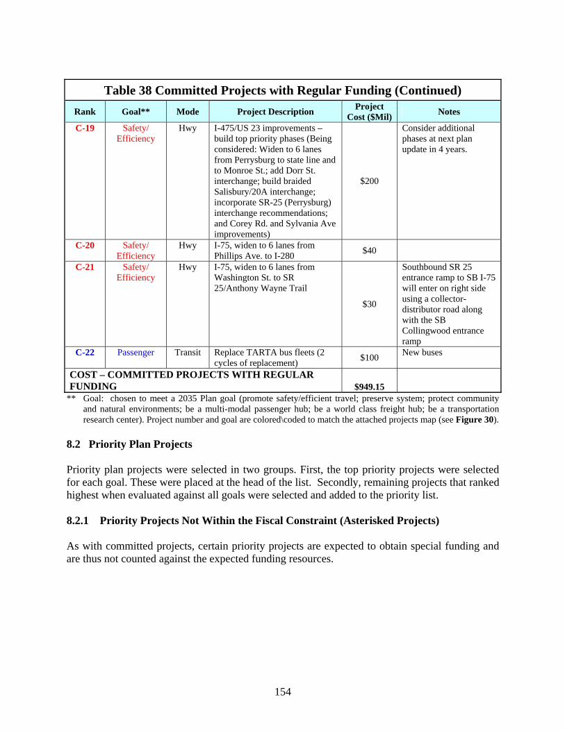
154
Table 38 Committed Projects with Regular Funding (Continued)
Rank Goal** Mode Project Description Project Cost ($Mil) Notes
C-19 Safety/ Efficiency
Hwy I-475/US 23 improvements – build top priority phases (Being considered: Widen to 6 lanes from Perrysburg to state line and to Monroe St.; add Dorr St. interchange; build braided Salisbury/20A interchange; incorporate SR-25 (Perrysburg) interchange recommendations; and Corey Rd. and Sylvania Ave improvements)
$200
Consider additional phases at next plan update in 4 years.
C-20 Safety/ Efficiency
Hwy I-75, widen to 6 lanes from Phillips Ave. to I-280 $40
C-21 Safety/ Efficiency
Hwy I-75, widen to 6 lanes from Washington St. to SR 25/Anthony Wayne Trail
$30
Southbound SR 25 entrance ramp to SB I-75 will enter on right side using a collector-distributor road along with the SB Collingwood entrance ramp
C-22 Passenger Transit Replace TARTA bus fleets (2 cycles of replacement) $100 New buses
COST – COMMITTED PROJECTS WITH REGULAR FUNDING $949.15
** Goal: chosen to meet a 2035 Plan goal (promote safety/efficient travel; preserve system; protect community and natural environments; be a multi-modal passenger hub; be a world class freight hub; be a transportation research center). Project number and goal are colored\coded to match the attached projects map (see Figure 30).
8.2 Priority Plan Projects Priority plan projects were selected in two groups. First, the top priority projects were selected for each goal. These were placed at the head of the list. Secondly, remaining projects that ranked highest when evaluated against all goals were selected and added to the priority list. 8.2.1 Priority Projects Not Within the Fiscal Constraint (Asterisked Projects) As with committed projects, certain priority projects are expected to obtain special funding and are thus not counted against the expected funding resources.
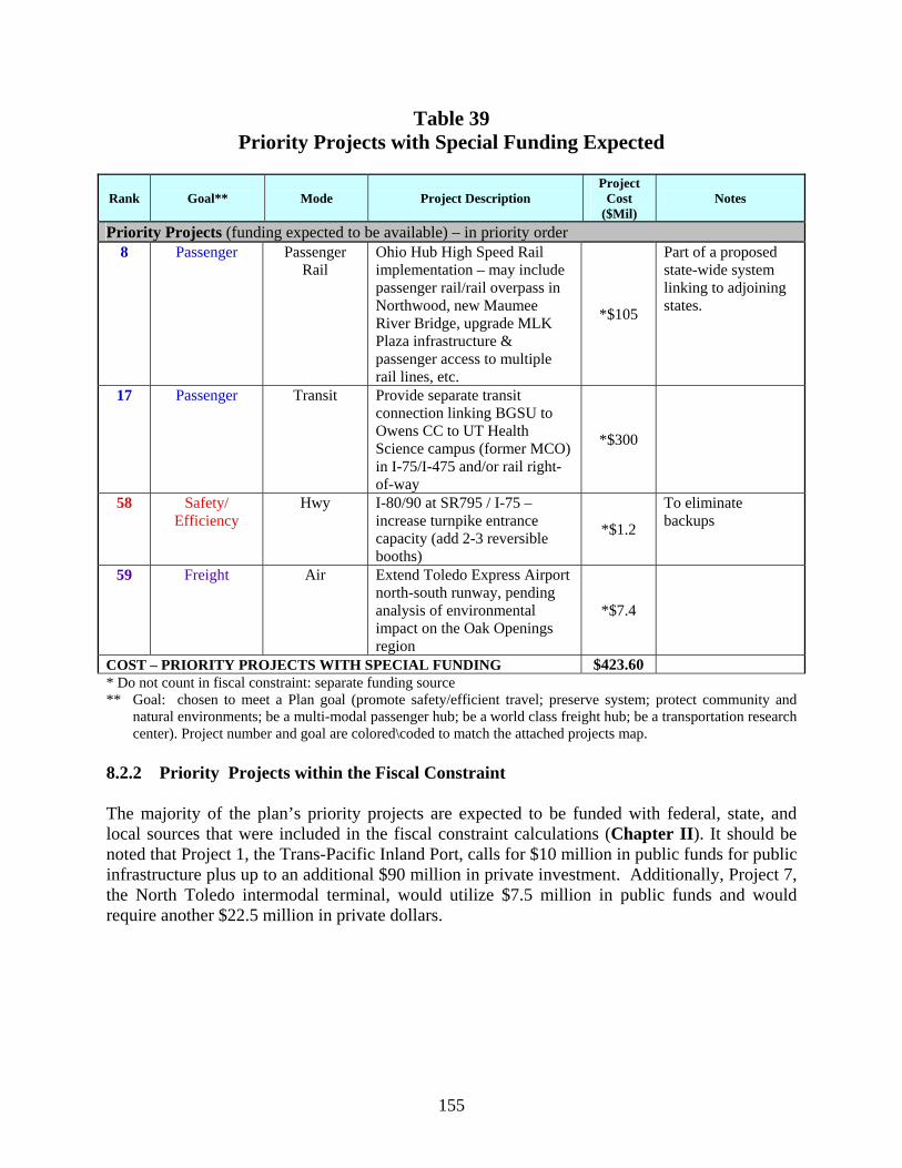
155
Table 39 Priority Projects with Special Funding Expected
Rank Goal** Mode Project Description Project
Cost ($Mil)
Notes
Priority Projects (funding expected to be available) – in priority order 8 Passenger Passenger
Rail Ohio Hub High Speed Rail implementation – may include passenger rail/rail overpass in Northwood, new Maumee River Bridge, upgrade MLK Plaza infrastructure & passenger access to multiple rail lines, etc.
*$105
Part of a proposed state-wide system linking to adjoining states.
17 Passenger Transit Provide separate transit connection linking BGSU to Owens CC to UT Health Science campus (former MCO) in I-75/I-475 and/or rail right-of-way
*$300
58 Safety/ Efficiency
Hwy I-80/90 at SR795 / I-75 – increase turnpike entrance capacity (add 2-3 reversible booths)
*$1.2
To eliminate backups
59 Freight Air Extend Toledo Express Airport north-south runway, pending analysis of environmental impact on the Oak Openings region
*$7.4
COST – PRIORITY PROJECTS WITH SPECIAL FUNDING $423.60 * Do not count in fiscal constraint: separate funding source ** Goal: chosen to meet a Plan goal (promote safety/efficient travel; preserve system; protect community and
natural environments; be a multi-modal passenger hub; be a world class freight hub; be a transportation research center). Project number and goal are colored\coded to match the attached projects map.
8.2.2 Priority Projects within the Fiscal Constraint The majority of the plan’s priority projects are expected to be funded with federal, state, and local sources that were included in the fiscal constraint calculations (Chapter II). It should be noted that Project 1, the Trans-Pacific Inland Port, calls for $10 million in public funds for public infrastructure plus up to an additional $90 million in private investment. Additionally, Project 7, the North Toledo intermodal terminal, would utilize $7.5 million in public funds and would require another $22.5 million in private dollars.
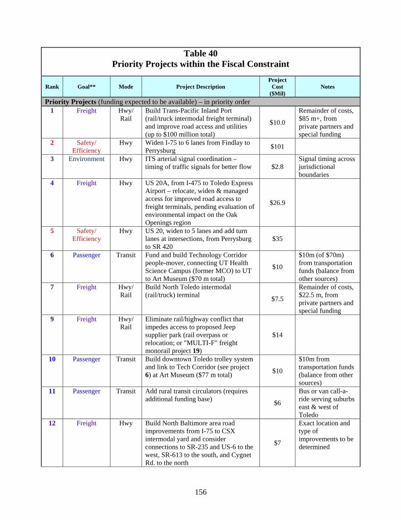
156
Table 40 Priority Projects within the Fiscal Constraint
Rank Goal** Mode Project Description Project
Cost ($Mil)
Notes
Priority Projects (funding expected to be available) – in priority order 1 Freight
Hwy/ Rail
Build Trans-Pacific Inland Port (rail/truck intermodal freight terminal) and improve road access and utilities (up to $100 million total)
$10.0
Remainder of costs, $85 m+, from private partners and special funding
2 Safety/ Efficiency
Hwy Widen I-75 to 6 lanes from Findlay to Perrysburg $101
3 Environment Hwy ITS arterial signal coordination – timing of traffic signals for better flow $2.8
Signal timing across jurisdictional boundaries
4 Freight Hwy US 20A, from I-475 to Toledo Express Airport – relocate, widen & managed access for improved road access to freight terminals, pending evaluation of environmental impact on the Oak Openings region
$26.9
5 Safety/ Efficiency
Hwy US 20, widen to 5 lanes and add turn lanes at intersections, from Perrysburg to SR 420
$35
6 Passenger Transit Fund and build Technology Corridor people-mover, connecting UT Health Science Campus (former MCO) to UT to Art Museum ($70 m total)
$10
$10m (of $70m) from transportation funds (balance from other sources)
7 Freight Hwy/ Rail
Build North Toledo intermodal (rail/truck) terminal $7.5
Remainder of costs, $22.5 m, from private partners and special funding
9 Freight Hwy/ Rail
Eliminate rail/highway conflict that impedes access to proposed Jeep supplier park (rail overpass or relocation; or "MULTI-F" freight monorail project 19)
$14
10 Passenger Transit Build downtown Toledo trolley system and link to Tech Corridor (see project 6) at Art Museum ($77 m total) $10
$10m from transportation funds (balance from other sources)
11 Passenger Transit Add rural transit circulators (requires additional funding base) $6
Bus or van call-a-ride serving suburbs east & west of Toledo
12 Freight Hwy Build North Baltimore area road improvements from I-75 to CSX intermodal yard and consider connections to SR-235 and US-6 to the west, SR-613 to the south, and Cygnet Rd. to the north
$7
Exact location and type of improvements to be determined
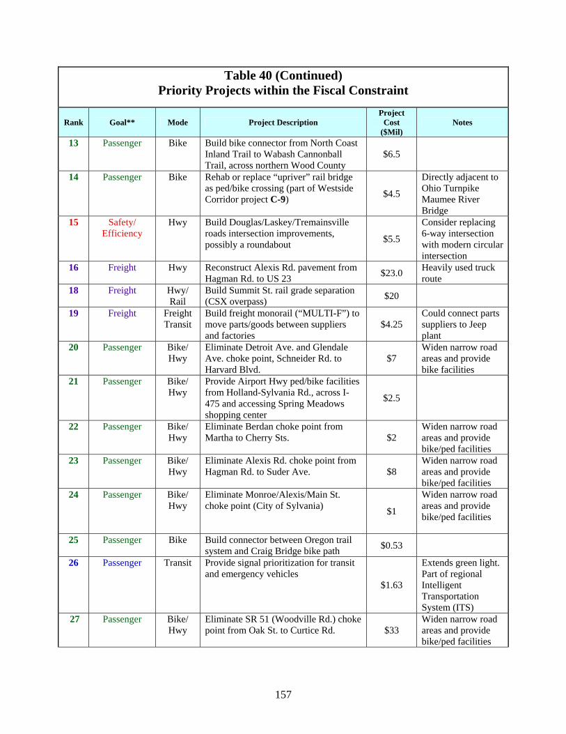
157
Table 40 (Continued) Priority Projects within the Fiscal Constraint
Rank Goal** Mode Project Description Project
Cost ($Mil)
Notes
13 Passenger Bike Build bike connector from North Coast Inland Trail to Wabash Cannonball Trail, across northern Wood County
$6.5
14 Passenger Bike Rehab or replace “upriver” rail bridge as ped/bike crossing (part of Westside Corridor project C-9) $4.5
Directly adjacent to Ohio Turnpike Maumee River Bridge
15 Safety/ Efficiency
Hwy Build Douglas/Laskey/Tremainsville roads intersection improvements, possibly a roundabout $5.5
Consider replacing 6-way intersection with modern circular intersection
16 Freight Hwy Reconstruct Alexis Rd. pavement from Hagman Rd. to US 23 $23.0 Heavily used truck
route 18 Freight Hwy/
Rail Build Summit St. rail grade separation (CSX overpass) $20
19 Freight Freight Transit
Build freight monorail (“MULTI-F”) to move parts/goods between suppliers and factories
$4.25 Could connect parts suppliers to Jeep plant
20 Passenger Bike/ Hwy
Eliminate Detroit Ave. and Glendale Ave. choke point, Schneider Rd. to Harvard Blvd.
$7 Widen narrow road areas and provide bike facilities
21 Passenger Bike/ Hwy
Provide Airport Hwy ped/bike facilities from Holland-Sylvania Rd., across I-475 and accessing Spring Meadows shopping center
$2.5
22 Passenger Bike/ Hwy
Eliminate Berdan choke point from Martha to Cherry Sts. $2
Widen narrow road areas and provide bike/ped facilities
23 Passenger Bike/ Hwy
Eliminate Alexis Rd. choke point from Hagman Rd. to Suder Ave. $8
Widen narrow road areas and provide bike/ped facilities
24 Passenger Bike/ Hwy
Eliminate Monroe/Alexis/Main St. choke point (City of Sylvania) $1
Widen narrow road areas and provide bike/ped facilities
25 Passenger Bike Build connector between Oregon trail system and Craig Bridge bike path $0.53
26 Passenger Transit Provide signal prioritization for transit and emergency vehicles
$1.63
Extends green light. Part of regional Intelligent Transportation System (ITS)
27 Passenger Bike/ Hwy
Eliminate SR 51 (Woodville Rd.) choke point from Oak St. to Curtice Rd. $33
Widen narrow road areas and provide bike/ped facilities

158
Table 40 (Continued) Priority Projects within the Fiscal Constraint
Rank Goal** Mode Project Description Project
Cost ($Mil)
Notes
28 Safety/ Efficiency
Hwy Build Detroit/Telegraph/Laskey roads intersection improvements, possibly a roundabout $3.25
Consider replacing intersection with modern circular intersection
29 Freight Hwy Widen the I-75 DiSalle Bridge; improve South Ave. and Miami St. ramps
$75
30 Passenger Ped Build pedestrian bridge across Douglas Rd. at UT tied to Westside Corridor path (C-9) $1.5
Should also link to Technology Corridor people-mover (6).
31 Safety/ Efficiency
Hwy Provide advance warning signal for blocked rail crossings (Westwood/NS, Consaul/NS&CSX, Matzinger/CSX&AA, Summit/CSX) $0.2
Like “blue light” on Woodville Rd., signals would allow traffic to divert to a grade-separated crossing
32 Passenger Bike/ Hwy
Eliminate Detroit Ave. choke point from Waggoner to Lagrange St. $24
Widen narrow road areas and provide bike/ped facilities
33 Passenger Transit Provide real time bus arrival information $0.75 Part of ITS Plan
34 Safety/ Efficiency
Hwy Heatherdowns/Garden Rd. (Holland-Sylvania Rd. to Manley Rd.) – widen road, replace bridge, improve intersections (possibly add roundabout)
$4.6
Roundabout = modern circular intersection
35 Passenger Bike Build Swan Creek trail from RiverWalk/Erie St. Market to Swan Creek Metropark
$2.8
36 Freight Hwy/ Rail
Build Consaul Street rail grade separation (bridge over CSX/NS) $20
37 Freight Rail Build Vickers crossing rail/rail separation (CSX bridge over NS) $20
$40m total: $20m public /$20m private or other
38 Passenger Bike Build Eastside Maumee River trail from Craig Bridge to International Park including ped/bike crossing of Main St. (possibly grade-separated)
$1.6
39 Freight Hwy Build efficient road connector from I-75 to US Post Office & MLK Plaza (train station)
$32
Would be a new NHS connector (designated road segment linking a major freight facility to the National Highway System)
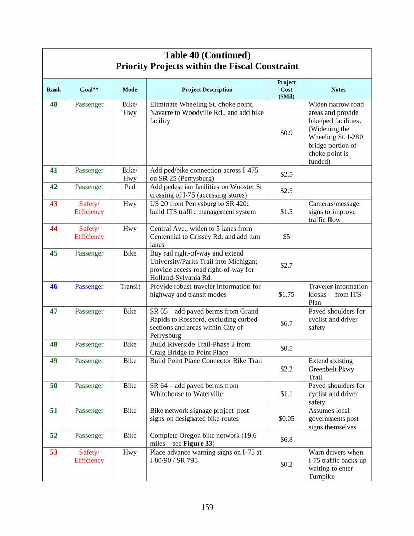
159
Table 40 (Continued) Priority Projects within the Fiscal Constraint
Rank Goal** Mode Project Description Project
Cost ($Mil)
Notes
40 Passenger Bike/ Hwy
Eliminate Wheeling St. choke point, Navarre to Woodville Rd., and add bike facility
$0.9
Widen narrow road areas and provide bike/ped facilities. (Widening the Wheeling St. I-280 bridge portion of choke point is funded)
41 Passenger Bike/ Hwy
Add ped/bike connection across I-475 on SR 25 (Perrysburg) $2.5
42 Passenger Ped Add pedestrian facilities on Wooster St crossing of I-75 (accessing stores) $2.5
43 Safety/ Efficiency
Hwy US 20 from Perrysburg to SR 420: build ITS traffic management system $1.5
Cameras/message signs to improve traffic flow
44 Safety/ Efficiency
Hwy Central Ave., widen to 5 lanes from Centennial to Crissey Rd. and add turn lanes
$5
45 Passenger Bike Buy rail right-of-way and extend University/Parks Trail into Michigan; provide access road right-of-way for Holland-Sylvania Rd.
$2.7
46 Passenger Transit Provide robust traveler information for highway and transit modes $1.75
Traveler information kiosks -- from ITS Plan
47 Passenger Bike SR 65 – add paved berms from Grand Rapids to Rossford, excluding curbed sections and areas within City of Perrysburg
$6.7
Paved shoulders for cyclist and driver safety
48 Passenger Bike Build Riverside Trail-Phase 2 from Craig Bridge to Point Place $0.5
49 Passenger Bike Build Point Place Connector Bike Trail $2.2
Extend existing Greenbelt Pkwy Trail
50 Passenger Bike SR 64 – add paved berms from Whitehouse to Waterville $1.1
Paved shoulders for cyclist and driver safety
51 Passenger Bike Bike network signage project–post signs on designated bike routes $0.05
Assumes local governments post signs themselves
52 Passenger Bike Complete Oregon bike network (19.6 miles—see Figure 33) $6.8
53 Safety/ Efficiency
Hwy Place advance warning signs on I-75 at I-80/90 / SR 795 $0.2
Warn drivers when I-75 traffic backs up waiting to enter Turnpike
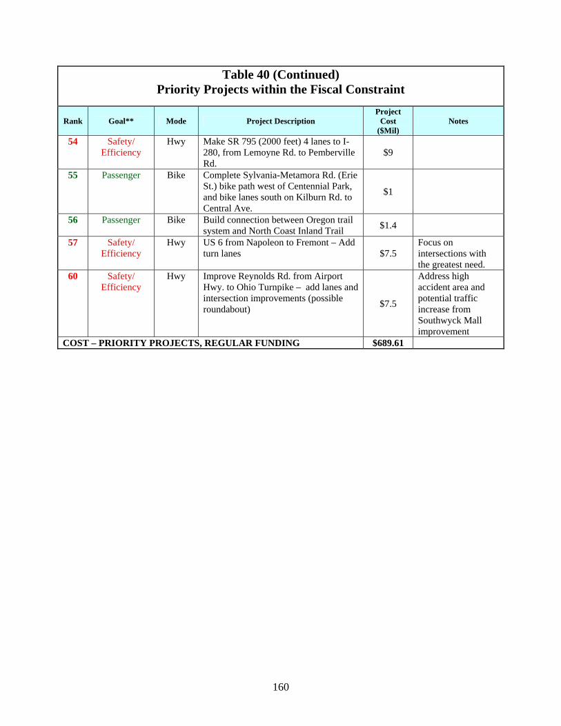
160
Table 40 (Continued) Priority Projects within the Fiscal Constraint
Rank Goal** Mode Project Description Project
Cost ($Mil)
Notes
54 Safety/ Efficiency
Hwy Make SR 795 (2000 feet) 4 lanes to I-280, from Lemoyne Rd. to Pemberville Rd.
$9
55 Passenger Bike Complete Sylvania-Metamora Rd. (Erie St.) bike path west of Centennial Park, and bike lanes south on Kilburn Rd. to Central Ave.
$1
56 Passenger Bike Build connection between Oregon trail system and North Coast Inland Trail $1.4
57 Safety/ Efficiency
Hwy US 6 from Napoleon to Fremont – Add turn lanes $7.5
Focus on intersections with the greatest need.
60 Safety/ Efficiency
Hwy Improve Reynolds Rd. from Airport Hwy. to Ohio Turnpike – add lanes and intersection improvements (possible roundabout) $7.5
Address high accident area and potential traffic increase from Southwyck Mall improvement
COST – PRIORITY PROJECTS, REGULAR FUNDING $689.61
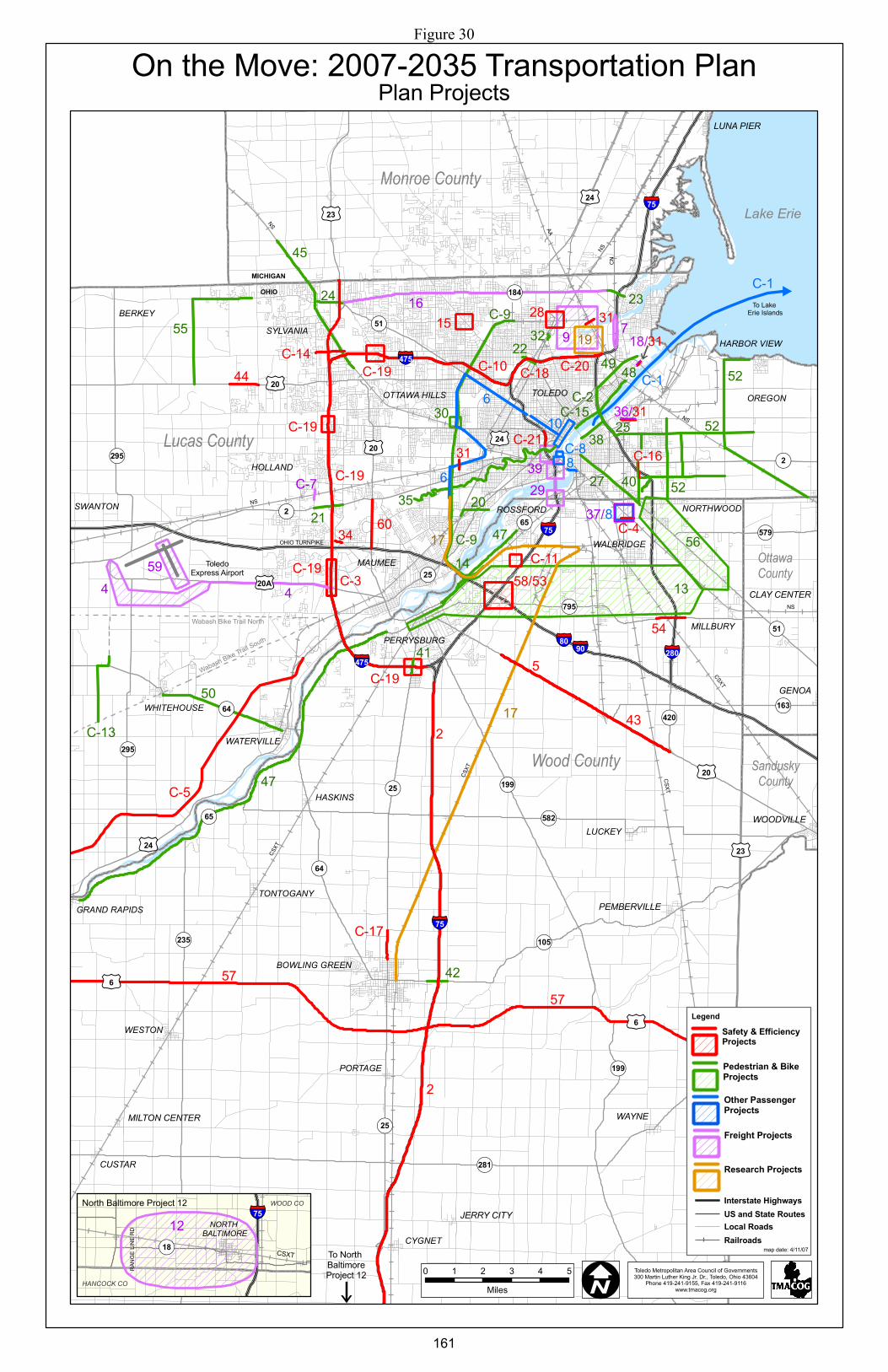
OHIO TURNPIKE
ToledoExpress Airport
MICHIGANOHIO
LUNA PIER
!(64
£¤20
£¤20
!(2
!(51
§̈¦75
§̈¦75
§̈¦75
!(25
§̈¦90
£¤24
CSXT
CSXT
NS
CSXT
CSXT
NS
AA
NSCN
NS
NS
£¤23£¤24
!(184
§̈¦475
!(295
§̈¦80
!(579
!(795
!(420
§̈¦280
£¤20A
!(295
!(64
!(65
!(235
£¤6
!(25
!(582
!(199
!(105
£¤6
§̈¦475
!(2
!(51
£¤24
!(25
!(65
Lake Erie
£¤20
£¤23
To North BaltimoreProject 12i
!(199
CLAY CENTER
GENOA
WOODVILLE
PEMBERVILLE
WAYNE
!(163
6
2
57
!(281
C-1
To Lake Erie IslandsC-9
Wabash Bike Trail North
Wabash Bike Trail South
OttawaCounty
SanduskyCounty
Wood County
Monroe County
Lucas County
JERRY CITY
MILTON CENTER
CUSTAR
4
#
52
52
36/
18/
8
7
TOLEDO OREGON
MAUMEE
PERRYSBURG
BOWLING GREEN
SYLVANIA
NORTHWOOD
BERKEY
ROSSFORD
WATERVILLE
WHITEHOUSE
HASKINS
OTTAWA HILLS
WESTON
LUCKEY
WALBRIDGE
PORTAGE
MILLBURY
HOLLAND
GRAND RAPIDS
CYGNET
SWANTON
TONTOGANY
HARBOR VIEW
2
57
17
6
4
47
5
16
C-19
C-5
35
17
C-1
50
52
45
55
27
10
49
40
48
25
C-13
C-20
38
54
44 C-10
24
8
22
C-17
C-14
20
23
21
41
31
14
C-16
42
C-21
32
34 47
31
43
C-18C-2
C-15
C-4
31
C-7
C-9
31
13
56
9 19
58/53
60
59
37/
39
2815
29
C-3C-19
C-19
30C-19
C-11
C-19
C-8
0 1 2 3 4 5Miles
§̈¦75
!(18 CSXT
North Baltimore Project 12
RANG
E LIN
E RD NORTH
BALTIMORE12
HANCOCK CO
WOOD CO
IToledo Metropolitan Area Council of Governments300 Martin Luther King Jr. Dr., Toledo, Ohio 43604
Phone 419-241-9155, Fax 419-241-9116www.tmacog.org
i
On the Move: 2007-2035 Transportation PlanPlan Projects
Legend
map date: 4/11/07
Interstate HighwaysUS and State RoutesLocal RoadsRailroads
Freight Projects
Other Passenger Projects
Pedestrian & BikeProjects
Safety & EfficiencyProjects
Research Projects
Figure 30
161

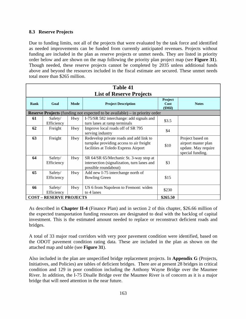
163
8.3 Reserve Projects Due to funding limits, not all of the projects that were evaluated by the task force and identified as needed improvements can be funded from currently anticipated revenues. Projects without funding are included in the plan as reserve projects or unmet needs. They are listed in priority order below and are shown on the map following the priority plan project map (see Figure 31). Though needed, these reserve projects cannot be completed by 2035 unless additional funds above and beyond the resources included in the fiscal estimate are secured. These unmet needs total more than $265 million.
Table 41 List of Reserve Projects
Rank Goal Mode Project Description Project
Cost ($Mil)
Notes
Reserve Projects (funding not expected to be available) – in priority order 61 Safety/
Efficiency Hwy I-75/SR 582 interchange: add signals and
turn lanes at ramp terminals $3.5
62 Freight Hwy Improve local roads off of SR 795 serving industry $4
63 Freight Hwy Redevelop private roads and add link to turnpike providing access to air freight facilities at Toledo Express Airport
$10
Project based on airport master plan update. May require special funding.
64 Safety/ Efficiency
Hwy SR 64/SR 65/Mechanic St. 3-way stop at intersection (signalization, turn lanes and possible roundabout)
$3
65 Safety/ Efficiency
Hwy Add new I-75 interchange north of Bowling Green
$15
66 Safety/ Efficiency
Hwy US 6 from Napoleon to Fremont: widen to 4 lanes $230
COST – RESERVE PROJECTS $265.50 As described in Chapter II-4 (Finance Plan) and in section 2 of this chapter, $26.66 million of the expected transportation funding resources are designated to deal with the backlog of capital investment. This is the estimated amount needed to replace or reconstruct deficient roads and bridges. A total of 33 major road corridors with very poor pavement condition were identified, based on the ODOT pavement condition rating data. These are included in the plan as shown on the attached map and table (see Figure 31). Also included in the plan are unspecified bridge replacement projects. In Appendix G (Projects, Initiatives, and Policies) are tables of deficient bridges. There are at present 28 bridges in critical condition and 129 in poor condition including the Anthony Wayne Bridge over the Maumee River. In addition, the I-75 Disalle Bridge over the Maumee River is of concern as it is a major bridge that will need attention in the near future.
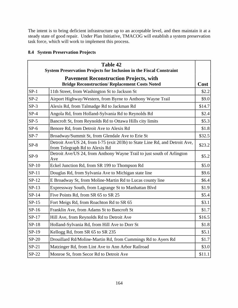
164
The intent is to bring deficient infrastructure up to an acceptable level, and then maintain it at a steady state of good repair. Under Plan Initiative, TMACOG will establish a system preservation task force, which will work to implement this process. 8.4 System Preservation Projects
Table 42 System Preservation Projects for Inclusion in the Fiscal Constraint
Pavement Reconstruction Projects, with Bridge Reconstruction/ Replacement Costs Noted Cost
SP-1 11th Street, from Washington St to Jackson St $2.2SP-2 Airport Highway/Western, from Byrne to Anthony Wayne Trail $9.0SP-3 Alexis Rd, from Talmadge Rd to Jackman Rd $14.7SP-4 Angola Rd, from Holland-Sylvania Rd to Reynolds Rd $2.4SP-5 Bancroft St, from Reynolds Rd to Ottawa Hills city limits $5.3SP-6 Benore Rd, from Detroit Ave to Alexis Rd $1.8SP-7 Broadway/Summit St, from Glendale Ave to Erie St $32.5
SP-8 Detroit Ave/US 24, from I-75 (exit 203b) to State Line Rd, and Detroit Ave, from Telegraph Rd to Alexis Rd $23.2
SP-9 Detroit Ave/US 24, from Anthony Wayne Trail to just south of Arlington Ave $5.2
SP-10 Eckel Junction Rd, from SR 199 to Thompson Rd $5.0SP-11 Douglas Rd, from Sylvania Ave to Michigan state line $9.6SP-12 E Broadway St, from Moline-Martin Rd to Lucas county line $6.4SP-13 Expressway South, from Lagrange St to Manhattan Blvd $1.9SP-14 Five Points Rd, from SR 65 to SR 25 $5.4SP-15 Fort Meigs Rd, from Roachton Rd to SR 65 $3.1SP-16 Franklin Ave, from Adams St to Bancroft St $1.7SP-17 Hill Ave, from Reynolds Rd to Detroit Ave $16.5SP-18 Holland-Sylvania Rd, from Hill Ave to Dorr St $1.8SP-19 Kellogg Rd, from SR 65 to SR 235 $5.1SP-20 Drouillard Rd/Moline-Martin Rd, from Cummings Rd to Ayers Rd $1.7SP-21 Matzinger Rd, from Lint Ave to Ann Arbor Railroad $3.0SP-22 Monroe St, from Secor Rd to Detroit Ave $11.1
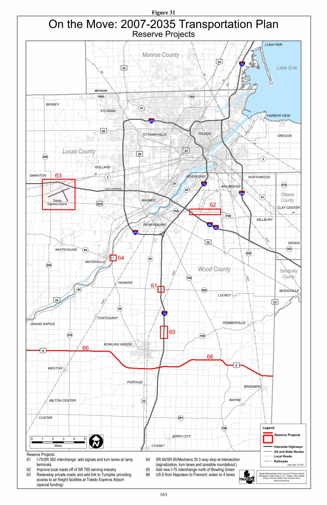
OHIO TURNPIKE
ToledoExpress Airport
MICHIGANOHIO
LUNA PIER
!(64
£¤20
£¤20
!(2
!(51
§̈¦75
§̈¦75
§̈¦75
!(25
§̈¦90
£¤24
CSXT
CSXT
NS
CSXT
CSXT
NS
AA
NSCN
NS
NS
£¤23£¤24
!(184
§̈¦475
!(295
§̈¦80
!(579
!(795
!(420
§̈¦280
£¤20A
!(295
!(64
!(65
!(235
£¤6
!(25
!(582
!(199
!(105
£¤6
§̈¦475
!(2
!(51
£¤24
!(25
!(65
Lake Erie
£¤20
£¤23
!(199
CLAY CENTER
GENOA
WOODVILLE
PEMBERVILLE
WAYNE
!(163
66
!(281
OttawaCounty
SanduskyCounty
Wood County
Monroe County
Lucas County
JERRY CITY
MILTON CENTER
CUSTAR
!(795
BRADNER
TOLEDO OREGON
MAUMEE
PERRYSBURG
BOWLING GREEN
SYLVANIA
NORTHWOOD
BERKEY
ROSSFORD
WATERVILLE
WHITEHOUSE
HASKINS
OTTAWA HILLS
WESTON
LUCKEY
WALBRIDGE
PORTAGE
MILLBURY
HOLLAND
GRAND RAPIDS
CYGNET
SWANTON
TONTOGANY
HARBOR VIEW
61
66
64
65
63
62
0 1 2 3 4 5Miles
On the Move: 2007-2035 Transportation PlanReserve Projects
Legend
map date: 4/11/07
Interstate HighwaysUS and State RoutesLocal RoadsRailroads
Reserve Projects
Reserve Projects: 61 I-75/SR 582 interchange: add signals and turn lanes at ramp
terminals 62 Improve local roads off of SR 795 serving industry 63 Redevelop private roads and add link to Turnpike providing
access to air freight facilities at Toledo Expre ss Airport (special funding)
64 SR 64/SR 65/Mechanic St 3-way stop at intersection
(signalization, turn lanes and possible roundabout ) 65 Add new I-75 interchange north of Bowling Green 66 US 6 from Napoleon to Fremont: widen to 4 lanes
I
Toledo Metropolitan Area Council of Governments300 Martin Luther King Jr. Dr., Toledo, Ohio 43604
Phone 419-241-9155, Fax 419-241-9116www.tmacog.org
Figure 31
165

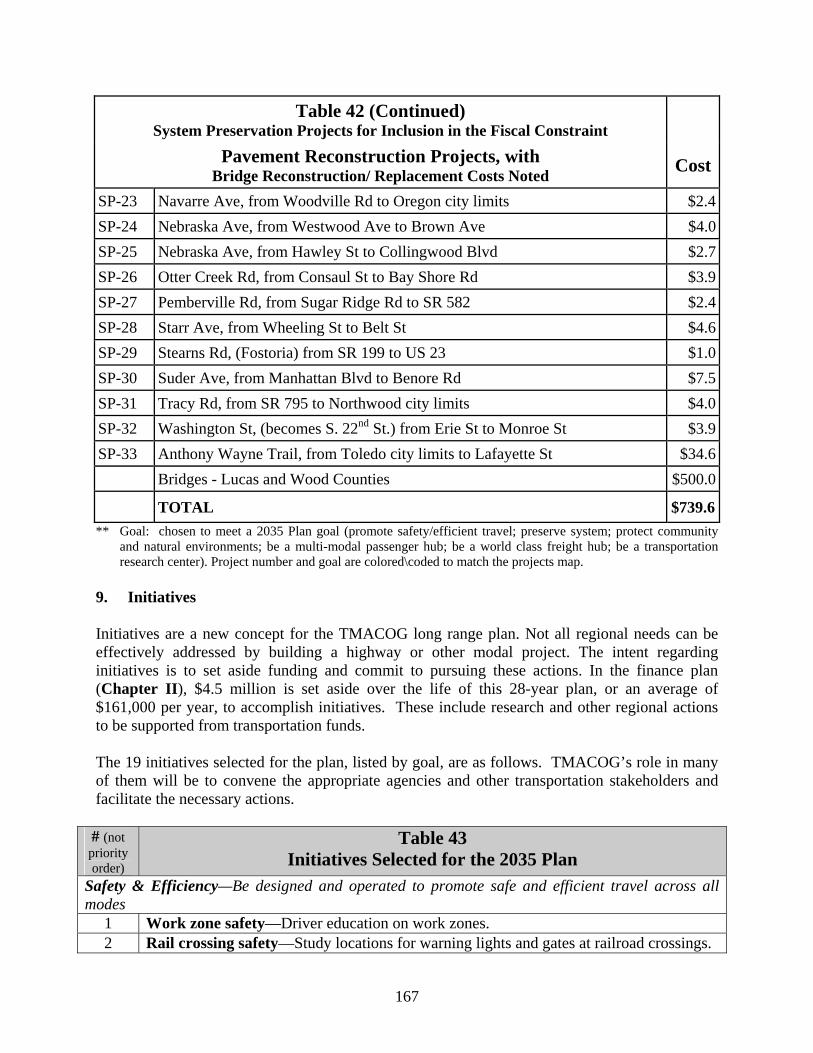
167
Table 42 (Continued) System Preservation Projects for Inclusion in the Fiscal Constraint
Pavement Reconstruction Projects, with Bridge Reconstruction/ Replacement Costs Noted Cost
SP-23 Navarre Ave, from Woodville Rd to Oregon city limits $2.4SP-24 Nebraska Ave, from Westwood Ave to Brown Ave $4.0SP-25 Nebraska Ave, from Hawley St to Collingwood Blvd $2.7SP-26 Otter Creek Rd, from Consaul St to Bay Shore Rd $3.9SP-27 Pemberville Rd, from Sugar Ridge Rd to SR 582 $2.4SP-28 Starr Ave, from Wheeling St to Belt St $4.6SP-29 Stearns Rd, (Fostoria) from SR 199 to US 23 $1.0SP-30 Suder Ave, from Manhattan Blvd to Benore Rd $7.5SP-31 Tracy Rd, from SR 795 to Northwood city limits $4.0SP-32 Washington St, (becomes S. 22nd St.) from Erie St to Monroe St $3.9SP-33 Anthony Wayne Trail, from Toledo city limits to Lafayette St $34.6 Bridges - Lucas and Wood Counties $500.0
TOTAL $739.6** Goal: chosen to meet a 2035 Plan goal (promote safety/efficient travel; preserve system; protect community
and natural environments; be a multi-modal passenger hub; be a world class freight hub; be a transportation research center). Project number and goal are colored\coded to match the projects map.
9. Initiatives Initiatives are a new concept for the TMACOG long range plan. Not all regional needs can be effectively addressed by building a highway or other modal project. The intent regarding initiatives is to set aside funding and commit to pursuing these actions. In the finance plan (Chapter II), $4.5 million is set aside over the life of this 28-year plan, or an average of $161,000 per year, to accomplish initiatives. These include research and other regional actions to be supported from transportation funds. The 19 initiatives selected for the plan, listed by goal, are as follows. TMACOG’s role in many of them will be to convene the appropriate agencies and other transportation stakeholders and facilitate the necessary actions.
# (not priority order)
Table 43 Initiatives Selected for the 2035 Plan
Safety & Efficiency—Be designed and operated to promote safe and efficient travel across all modes
1 Work zone safety—Driver education on work zones. 2 Rail crossing safety—Study locations for warning lights and gates at railroad crossings.
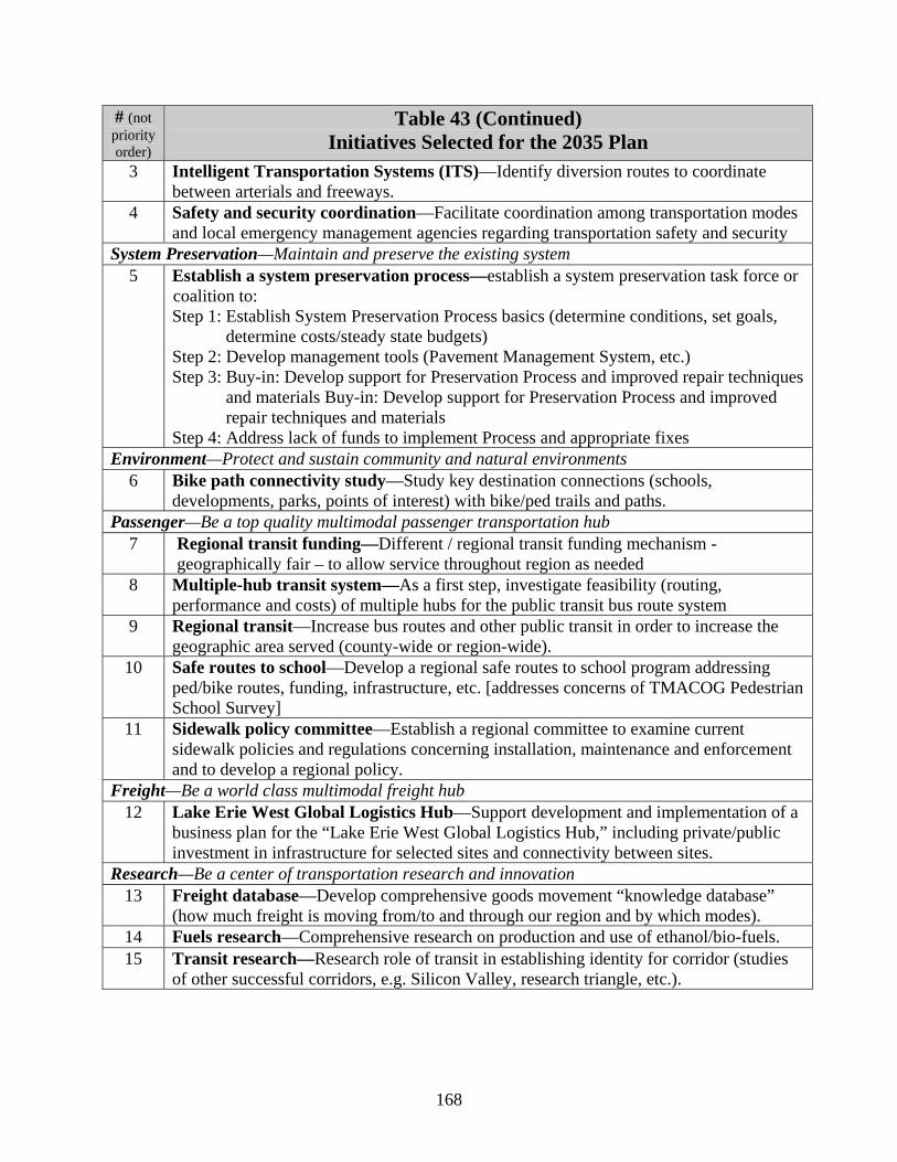
168
# (not priority order)
Table 43 (Continued) Initiatives Selected for the 2035 Plan
3 Intelligent Transportation Systems (ITS)—Identify diversion routes to coordinate between arterials and freeways.
4 Safety and security coordination—Facilitate coordination among transportation modes and local emergency management agencies regarding transportation safety and security
System Preservation—Maintain and preserve the existing system 5 Establish a system preservation process—establish a system preservation task force or
coalition to: Step 1: Establish System Preservation Process basics (determine conditions, set goals,
determine costs/steady state budgets) Step 2: Develop management tools (Pavement Management System, etc.) Step 3: Buy-in: Develop support for Preservation Process and improved repair techniques
and materials Buy-in: Develop support for Preservation Process and improved repair techniques and materials
Step 4: Address lack of funds to implement Process and appropriate fixes Environment—Protect and sustain community and natural environments
6 Bike path connectivity study—Study key destination connections (schools, developments, parks, points of interest) with bike/ped trails and paths.
Passenger—Be a top quality multimodal passenger transportation hub 7 Regional transit funding—Different / regional transit funding mechanism -
geographically fair – to allow service throughout region as needed 8 Multiple-hub transit system—As a first step, investigate feasibility (routing,
performance and costs) of multiple hubs for the public transit bus route system 9 Regional transit—Increase bus routes and other public transit in order to increase the
geographic area served (county-wide or region-wide). 10 Safe routes to school—Develop a regional safe routes to school program addressing
ped/bike routes, funding, infrastructure, etc. [addresses concerns of TMACOG Pedestrian School Survey]
11 Sidewalk policy committee—Establish a regional committee to examine current sidewalk policies and regulations concerning installation, maintenance and enforcement and to develop a regional policy.
Freight—Be a world class multimodal freight hub 12 Lake Erie West Global Logistics Hub—Support development and implementation of a
business plan for the “Lake Erie West Global Logistics Hub,” including private/public investment in infrastructure for selected sites and connectivity between sites.
Research—Be a center of transportation research and innovation 13 Freight database—Develop comprehensive goods movement “knowledge database”
(how much freight is moving from/to and through our region and by which modes). 14 Fuels research—Comprehensive research on production and use of ethanol/bio-fuels. 15 Transit research—Research role of transit in establishing identity for corridor (studies
of other successful corridors, e.g. Silicon Valley, research triangle, etc.).

Toledo Express Airport
§̈¦90
§̈¦75
§̈¦475
§̈¦475
§̈¦75
OHIO TURNPIKE
§̈¦75
®q
£¤20
!(25
!(2
!(51
!(2
SP-13
SP-30SP-21
SP-23
SP-24SP-17
SP-12
SP-2
SP-22
SP-9 SP-7
SP-10
SP-25
SP-7SP-16
SP-8SP-11
SP-1SP-32
SP-6SP-3
SP-8
SP-5SP-18
SP-31
SP-9
SP-4
SP-20
SP-15
SP-14
SP-33
SP-19
SP-27
MICHIGANOHIO
£¤23
£¤20
£¤20A
!(120
!(184
!(65
!(25
!(795
SP-28
SP-26
§̈¦280
!(795
!(51
§̈¦80
!(295
!(2
!(65
!(64
£¤20
£¤24
£¤24
!(199
!(582
!(420
!(105
!(25
!(64
!(65
!(295
!(235
£¤24
£¤6
£¤6
l
To FostoriaProject 29!(199
AA
NSCN
NS
NS
CSXT
CSXT
CSXT
CSXT
NS
NS
OREGON
Monroe County
Lucas County
Wood County
TOLEDO
MAUMEE
PERRYSBURG
BOWLING GREEN
SYLVANIA
NORTHWOOD
BERKEY
WHITEHOUSE
ROSSFORD
WATERVILLE
HASKINS
WALBRIDGE
OTTAWA HILLS
HOLLAND
LUCKEY
PEMBERVILLEGRAND RAPIDS
SWANTON
TONTOGANY
HARBORVIEW
On the Move: 2007-2035 Transportation Plan
0 1 2 3 4Miles
Fostoria Project SP-29
FOSTORIA
SP-29STEARNS RD
!(199
WOOD CO
£¤23SENECA
CO
SP-1 11th Street, from Washington St to Jackson St SP-2 Airport Highway/Western Ave, from Byrne Rd to Anthony Wayne Trail SP-3 Alexis Rd, from Talmadge Rd to Jackman Rd SP-4 Angola Rd, from Holland-Sylvania Rd to Reynolds Rd SP-5 Bancroft St, from Reynolds Rd to Ottawa Hills city limits SP-6 Benore Rd, from Detroit Ave to Alexis Rd SP-7 Broadway/Summit St, from Glendale Ave to Erie St SP-8 Detroit Ave/US 24, from I-75 (exit 203b) to State Line Rd, and Detroit Ave,
from Telegraph Rd to Alexis Rd SP-9 Detroit Ave/US 24, from Anthony Wayne Trail to just south of Arlington Ave SP-10 Eckel Junction Rd, from SR 199 to Thompson Rd SP-11 Douglas Rd, from Sylvania Ave to Michigan state line SP-12 E Broadway St, from Moline-Martin Rd to Lucas county line SP-13 Expressway South, Lagrange St to Manhattan Blvd SP-14 Five Point Rd, from SR 65 to SR 25 SP-15 Fort Meigs Rd, from Roachton Rd to SR 65 SP-16 Franklin Ave, from Adams St to Bancroft St
SP-17 Hill Ave, from Reynolds Rd to Detroit Ave SP-18 Holland-Sylvania Rd, from Hill Ave to Dorr St SP-19 Kellogg Rd, from SR 65 to SR 235 SP-20 Drouillard Rd/Moline -Martin Rd, from Cummings Rd to Ayers Rd SP-21 Matzinger Rd, from Lint Ave to Ann Arbor Railroad SP-22 Monroe St, from Secor Rd to Detroit Ave SP-23 Navarre Ave, from Woodville Rd to Oregon city limits SP-24 Nebraska Ave, from Westwood Ave to Brown Ave SP-25 Nebraska Ave, from Hawley St to Collingwood Blvd SP-26 Otter Creek Rd, from Consaul St to Bay Shore Rd SP-27 Pemberville Rd, from Sugar Ridge Rd to SR 582 SP-28 Starr Ave, from Wheeling St to Belt St SP-29 Stearns Rd (Fostoria), from SR 199 to US 23 SP-30 Suder Ave, from Manhattan Blvd to Benore Rd SP-31 Tracy Rd, from SR 795 to Northwood city limits SP-32 Washington St/S 22nd St, from Erie St to Monroe St SP-33 Anthony Wayne Trail, from Toledo city limits to Lafayette St
IToledo Metropolitan Area Council of Governments300 Martin Luther King Jr. Dr., Toledo, Ohio 43604
Phone 419-241-9155, Fax 419-241-9116www.tmacog.org
Deficient Roadway Reconstruction
i
i
map date: 4/10/07
LegendRoadwayReconstructionProjectsInterstate HighwaysUS and State RoutesLocal RoadsRailroads
Figure 32
169

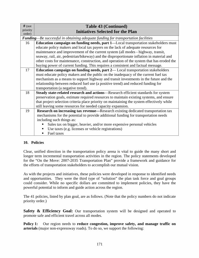
171
# (not priority order)
Table 43 (Continued) Initiatives Selected for the Plan
Funding—Be successful in obtaining adequate funding for transportation facilities 16 Education campaign on funding needs, part 1—Local transportation stakeholders must
educate policy makers and local tax payers on the lack of adequate resources for maintenance and improvement of the current system (all modes - highway, transit, seaway, rail, air, pedestrian/bikeway) and the disproportionate inflation in material and other costs for maintenance, construction, and operation of the system that has eroded the buying power of current funding. This requires a consistent and factual message.
17 Education campaign on funding needs, part 2— Local transportation stakeholders must educate policy makers and the public on the inadequacy of the current fuel tax mechanism as a means to support highway and transit investments in the future and the relationship between reduced fuel use (a positive trend) and reduced funding for transportation (a negative trend).
18 Steady state-related research and actions—Research efficient standards for system preservation goals, estimate required resources to maintain existing systems, and ensure that project selection criteria place priority on maintaining the system effectively while still leaving some resources for needed capacity expansion.
19 Research on increasing tax revenue—Research existing dedicated transportation tax mechanisms for the potential to provide additional funding for transportation needs including such things as:
Sales tax on bigger, heavier, and/or more expensive personal vehicles Use taxes (e.g. licenses or vehicle registrations) Fuel taxes
10. Policies Clear, unified direction in the transportation policy arena is vital to guide the many short and longer term incremental transportation activities in the region. The policy statements developed for the “On the Move: 2007-2035 Transportation Plan” provide a framework and guidance for the efforts of transportation stakeholders to accomplish our mutual vision. As with the projects and initiatives, these policies were developed in response to identified needs and opportunities. They were the third type of “solution” the plan task force and goal groups could consider. While no specific dollars are committed to implement policies, they have the powerful potential to inform and guide action across the region. The 41 policies, listed by plan goal, are as follows. (Note that the policy numbers do not indicate priority order.) Safety & Efficiency Goal: Our transportation system will be designed and operated to promote safe and efficient travel across all modes. Policy 1: Our region needs to reduce congestion, improve safety, and manage traffic on arterials (major non-expressway roads). To do so, we support the following:
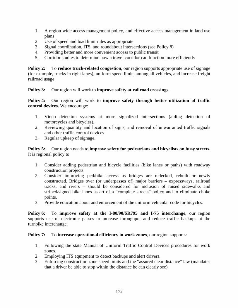
172
1. A region-wide access management policy, and effective access management in land use plans
2. Use of speed and load limit rules as appropriate 3. Signal coordination, ITS, and roundabout intersections (see Policy 8) 4. Providing better and more convenient access to public transit 5. Corridor studies to determine how a travel corridor can function more efficiently
Policy 2: To reduce truck-related congestion, our region supports appropriate use of signage (for example, trucks in right lanes), uniform speed limits among all vehicles, and increase freight railroad usage Policy 3: Our region will work to improve safety at railroad crossings. Policy 4: Our region will work to improve safety through better utilization of traffic control devices. We encourage:
1. Video detection systems at more signalized intersections (aiding detection of
motorcycles and bicycles). 2. Reviewing quantity and location of signs, and removal of unwarranted traffic signals
and other traffic control devices. 3. Regular upkeep of signage.
Policy 5: Our region needs to improve safety for pedestrians and bicyclists on busy streets. It is regional policy to:
1. Consider adding pedestrian and bicycle facilities (bike lanes or paths) with roadway construction projects.
2. Consider improving ped/bike access as bridges are redecked, rebuilt or newly constructed. Bridges over (or underpasses of) major barriers – expressways, railroad tracks, and rivers – should be considered for inclusion of raised sidewalks and striped/signed bike lanes as art of a “complete streets” policy and to eliminate choke points.
3. Provide education about and enforcement of the uniform vehicular code for bicycles. Policy 6: To improve safety at the I-80/90/SR795 and I-75 interchange, our region supports use of electronic passes to increase throughput and reduce traffic backups at the turnpike interchange. Policy 7: To increase operational efficiency in work zones, our region supports:
1. Following the state Manual of Uniform Traffic Control Devices procedures for work zones.
2. Employing ITS equipment to detect backups and alert drivers. 3. Enforcing construction zone speed limits and the “assured clear distance” law (mandates
that a driver be able to stop within the distance he can clearly see).
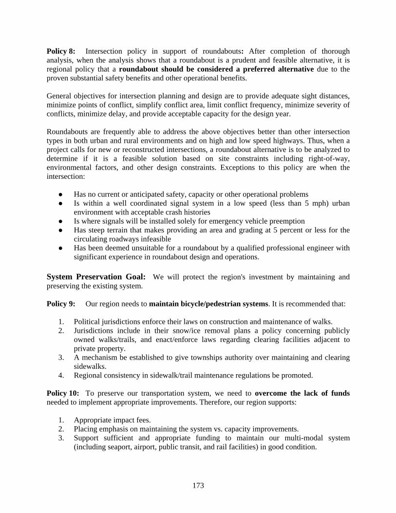
173
Policy 8: Intersection policy in support of roundabouts: After completion of thorough analysis, when the analysis shows that a roundabout is a prudent and feasible alternative, it is regional policy that a roundabout should be considered a preferred alternative due to the proven substantial safety benefits and other operational benefits. General objectives for intersection planning and design are to provide adequate sight distances, minimize points of conflict, simplify conflict area, limit conflict frequency, minimize severity of conflicts, minimize delay, and provide acceptable capacity for the design year. Roundabouts are frequently able to address the above objectives better than other intersection types in both urban and rural environments and on high and low speed highways. Thus, when a project calls for new or reconstructed intersections, a roundabout alternative is to be analyzed to determine if it is a feasible solution based on site constraints including right-of-way, environmental factors, and other design constraints. Exceptions to this policy are when the intersection:
Has no current or anticipated safety, capacity or other operational problems Is within a well coordinated signal system in a low speed (less than 5 mph) urban
environment with acceptable crash histories Is where signals will be installed solely for emergency vehicle preemption Has steep terrain that makes providing an area and grading at 5 percent or less for the
circulating roadways infeasible Has been deemed unsuitable for a roundabout by a qualified professional engineer with
significant experience in roundabout design and operations. System Preservation Goal: We will protect the region's investment by maintaining and preserving the existing system. Policy 9: Our region needs to maintain bicycle/pedestrian systems. It is recommended that:
1. Political jurisdictions enforce their laws on construction and maintenance of walks. 2. Jurisdictions include in their snow/ice removal plans a policy concerning publicly
owned walks/trails, and enact/enforce laws regarding clearing facilities adjacent to private property.
3. A mechanism be established to give townships authority over maintaining and clearing sidewalks.
4. Regional consistency in sidewalk/trail maintenance regulations be promoted.
Policy 10: To preserve our transportation system, we need to overcome the lack of funds needed to implement appropriate improvements. Therefore, our region supports:
1. Appropriate impact fees. 2. Placing emphasis on maintaining the system vs. capacity improvements. 3. Support sufficient and appropriate funding to maintain our multi-modal system
(including seaport, airport, public transit, and rail facilities) in good condition.
174
Environment Goal: Our region and its transportation system will protect and sustain community and natural environments. Policy 11: Because transportation choices and options impact the environment, our region’s policy is to encourage fuel efficient modes of transportation (rail, water, hybrids, etc.). Policy 12: We recognize that transportation and land use planning are interrelated, and both affect quality of life and patterns of development. To reduce sprawl and improve quality of life, our region will aim to:
1. Reduce driving by planning livable/workable communities (featuring higher density, mixed use, and transit-oriented development).
2. Coordinate county and local jurisdiction master plans and zoning plans. 3. Encourage state enabling legislation to establish transportation impact fees (on
development) to reflect the real costs of development. 4. Require multi-use paths in site plans, with connectivity to adjoining development.
Policy 13: Urban sprawl is consuming farmland and disrupting rural life. To protect our rural areas, we encourage governments to:
1. Require and/or provide tax incentives for greater land use density (such as cluster housing) for more efficient land use in developed areas and include parkland in development plans.
2. Provide financial incentives and tools to preserve farmland and natural areas. 3. Encourage county plan commissions to adopt a 20-acre rule (minimum lot size of 20
acres in agricultural areas).
Policy 14: Our region seeks to improve quality of life by expanding pedestrian and bicycle transportation options. We urge stakeholders to make commercial areas people-friendly, require sidewalks and bicycle parking facilities region-wide, and acquire property for rail-trail extensions and completion of the bikeway system. Policy 15: To protect our environment, our region will mitigate surface run-off from roads and other transportation-related facilities with best management practices (BMPs) to improve water absorption. These include grass swales (rain gardens), stormwater detention, pervious surfaces, open pavers, and plantings of trees and native grasses. Policy 16: To improve air quality through reduced traffic congestion and improved traffic flow, we will:
1. Work to put more freight on rails to lighten roadway traffic. 2. Make developed areas more conducive to walking. 3. Consider roundabouts as the preferred alternative for intersection improvements (see
Policy 8).
175
Policy 17: The region will work to identify techniques to reduce road impacts on wildlife and will support use of appropriate measures. Policy 18: Our region supports the ongoing development of a network of state scenic byway designated roads. Benefits of scenic byways include preservation of natural resources and economic benefits from tourism. We support byway designation for the original US 24 between Napoleon and Waterville when that section is abandoned for the new US 24. Passenger Goal: Our region will be a top quality multimodal passenger transportation hub. Policy 19: To provide more viable personal transportation choices, our region’s policy is to support development of a passenger transportation system providing a full range of integrated, interconnected modal choices to insure mobility of all citizens and options that improve community and natural environments. Important steps towards this goal include:
1. Adopting a regional “complete streets” policy that calls for design of street corridors to serve multiple transportation modes, including pedestrians, bicycles, and transit.
2. Increasing density of development, including infill housing in urban areas, to make multiple transportation modes feasible.
Policy 20: Public transit in our region lacks sufficient geographic reach. It does not serve rural or suburban areas such as City of Oregon and Springfield Township. To provide transit throughout the region, a truly integrated transit system that services all areas/people should be developed. More state/county transit funding is needed to make this feasible. Policy 21: We need to improve transit operations and expand hours of service, which will require more money for transit. In addition, we should make transit more user-friendly, including better “policing” of bench conditions at bus stops and requiring businesses and other transit generators to provide transit amenities. Policy 22: To improve intermodal connections and travel options within our region, we urge continuation and increase of intercity bus service between communities in northwest Ohio and southeastern Michigan. Policy 23: We need to address the lack of sufficient transportation for seniors, people with disabilities/special needs, and other nondrivers:
1. All transit should be more senior-friendly, and accessible to seniors/disabled. 2. User-friendly traveler information should be made available for all transportation modes
and connectivity between modes. 3. Local regulation should require 15 percent of fleets (for example, taxi cabs) to be
accessible to people with disabilities. Policy 24: We need fast, convenient and affordable intercity passenger rail. We will join with other regions to push for implementation of the Ohio Hub Plan for fast, frequent rail service including a Toledo-Detroit connection via the Detroit airport. In addition we will support the Chicago Hub high speed rail plan linking our region to Fort Wayne and Chicago.
176
Policy 25: Our region supports use of passenger transportation to support economic development, including:
1. Tie multiple modes of transportation, including the bikeway network, to all major development and redevelopment areas.
2. Increase transit-oriented development, which concentrates commercial space and a variety of housing options and around a transit stop. This compact, mixed use, and pedestrian-oriented development encourages more transit use, reduces congestion, increases property values, and reduces infrastructure costs.
3. Build the downtown circulator trolley system and the connecting Technology Corridor people-mover (see Plan Projects 6 and 10)
Freight Goal: Our region will be a world-class multimodal freight transportation hub Policy 26: To strengthen our role as a freight transportation hub, our region will work together to implement a Lake Erie West Global Logistics Hub business plan. This plan comprises four major freight facilities: Toledo Express Global Logistics Park (see Policy 27), Trans-Pacific Inland Port (see Plan Project 1 and Policy 28), Golden Triangle Distribution Corridor, and the Toledo Seaport (see Policy 29). We will identify needed improvements/resources; support public/private infrastructure investment for the sites, and connectivity between them (on public roads or off-road). Policy 27: A regional priority is to expand use of the air freight mode and use of air facilities as intermodal hubs. This will include increasing airport capacity throughout the region and providing good road access. We will develop Toledo Express Airport as a major intermodal hub, to be known as the “Toledo Express Global Logistics Park,” with needed infrastructure improvements (including Plan Projects C-3, 4, and 59) and creation of a “transportation opportunity district.” Policy 28: To expand freight capacity, we will work to increase use of and multimodal access to rail freight. This will include supporting development of a Trans-Pacific Inland Port (see Plan Project 1), a rail/truck container facility designed to capture major freight flows from Asia, for distribution to the Midwest and eastern U.S. Policy 29: Our region has an opportunity to expand waterborne freight movement. To do so, we will work to increase rail access to the Toledo Seaport, and we will support maximized use of the St. Lawrence Seaway and Great Lakes water system. Policy 30: It is essential for our role as a freight hub to improve road access and capacity for trucks, and reduce modal conflicts. As part of this policy, we support:
1. Making the Ohio Turnpike more truck-friendly with “Easy Pass” electronic toll
collection and quantity discounts. 2. Increasing the quality of township roads by requiring agri-business to meet the same
constraints as other industries, that is, eliminating exemptions that allow producers to use township roads without defraying costs of upgrades and maintenance.
177
3. Providing real-time information on road congestion via ITS that is suitable to trucker needs.
Research Goal: Our region will be a center of transportation research and innovation. Policy 31: We need to diversify fuels for transportation, to insure fuel will be available on a long-term basis, with reduced dependence on foreign sources. To do so, our region will:
1. Support the work of a consortium of area universities to develop and commercialize
hybrid vehicles. 2. Analyze current state and federal policies to propose changes and/or take advantage of
existing policies in order to enhance alternative fuels production and use in our region.
Policy 32: With the amount of transported freight expected to double in the next 15 years, we need innovative ways to move goods more efficiently. Therefore, it is our region’s policy that:
1. Local jurisdictions and planning/development agencies should seek to locate industrial
and distribution facilities near existing transportation terminals and interchanges. 2. We encourage development of multi-trailer terminals at Ohio Turnpike interchanges. 3. We should identify examples of trucking company collaboration on deliveries, and
support implementation of such a system. 4. We should research ways to improve efficiency of transfer of goods between
transportation modes. Policy 33: To build on regional strengths, we need to support/expand transportation logistics and supply chain research in the region. This research should include looking at the potential to coordinate transportation to common suppliers/locations. Policy 34: To enhance economic and technical development, our region will work to establish the identity of the Toledo Science and Technology corridor and the movement of people and ideas within this corridor. Policy 35: Our region supports creating innovative traffic systems to improve traffic flow, such as modern roundabouts (see Policy 8), coordinated signal timing on all major arterials, and freeway management systems and other Intelligent Transportation Systems (ITS). Funding Goal: Our region will be successful in obtaining adequate funding for transportation facilities. Policy 36: Our region should more efficiently use currently available funds and maintain appropriate balance between system preservation and capacity expansion. We encourage government agencies to:
1. Accurately research the cost of maintaining and improving their roads with public staff, compare those costs to private contracting, and use the most efficient approach.
2. Cost out rehabilitation strategies using life-cycle considerations, not just initial capital comparisons and not always a “worst first” strategy.
178
3. Use new methods to stretch funding including design/build, and construction warranties for extended periods.
4. Use best available technology to build long-lasting roads
Policy 37: We encourage more regional cooperation to get the most out of current funding. Recommended strategies are:
1. Research current joint projects and group purchasing to determine if they could be
expanded to other jurisdictions for even greater cost savings. Potential project types include purchase/fabrication of signs and signals, mill and fill along jurisdictional boundaries (e.g. city-township), contracting projects and services, salt purchase (bring in by ship–sell to other local jurisdictions), materials purchases (e.g. asphalt), and purchase of equipment (e.g. milling machines).
2. Research current joint operations and maintenance efforts to determine if they could be expanded to other jurisdictions. Potential project types include snow plowing and traffic signal coordination.
3. Educate the public on existing cooperation to gain their support. 4. Create a regional database of existing cooperative governmental ventures and
opportunities. 5. Reward cooperative projects via regional project selection criteria. 6. Encourage jurisdictions to use state purchasing agreements and/or local multi-
jurisdictional agreements. 7. Encourage local jurisdictions to specialize in services or materials and make these
available to other jurisdictions rather than duplicating efforts.
Policy 38: We will work together to ensure that the region gets its fair share from current funding sources. We support efforts to reduce / eliminate federal earmarks, since they don’t add to the total federal transportation dollars that come to our region. Policy 39: Our region supports increasing dedicated funding from traditional sources to meet growing transportation demands. We urge leaders to continue to ensure that dedicated transportation taxes are used for transportation purposes. We also support:
1. Efforts to implement a mechanism to maintain the purchasing power of current
transportation-related taxes over time. (This would increase gas tax revenues to keep pace with inflation in road construction costs.)
2. Research to identify correlation between transportation investment and economic development and other public benefits. (The results of such research could support more transportation investment and increased tax initiatives.)
3. Educating elected officials on how local jurisdictions are using current dollars efficiently to maintain and improve the current system, in order to gain their support for more transportation funding.
Policy 40: We support finding innovative ways to get additional funding for transportation system upgrades. As federal and state funding sources provide less for local needs, our region should research mechanisms to raise additional transportation funding locally for priorities in our region. Some possibilities include:
179
1. Impact fees and tax increment financing (TIF) districts on new development (including residential), especially where new transportation facilities or improvements will be required
2. Multiple jurisdiction transportation improvement districts (TID), 3. Multiple jurisdiction property tax, general or fuel sales tax, and/or income tax for
transportation uses 4. Expand statewide bond issues and/or develop other statewide mechanisms directed to
local jurisdictions 5. New, different region-wide mechanisms to fund a truly regional public transit system
over the long term 6. Mechanisms to raise additional transportation funding locally for paratransit and
shared ride services for the whole region 7. Coordination of funding / compacts across the state line to address transportation
issues on a truly regional basis 8. New variable toll facilities (congestion pricing) 9. Public/private partnership mechanisms
Policy 41: Our region will work to balance the split of funding between modes based on regional priorities and needs. We encourage multi-modal design of all projects (“complete streets”). We support changing project selection criteria to reward projects that incorporate multimodal elements such as bike lanes or paths with street upgrades; street upgrades with transit shelters, bump outs, and other accommodation; and Park and Ride facilities.

180