Embed Size (px)
Citation preview
Available online at www.sciencedirect.com
ARTICLE IN PRESS
www.elsevier.com/locate/comcom
Computer Communications xxx (2008) xxx–xxx
Vehicular Ad Hoc Networks: A New Challenge forLocalization-Based Systems q
Azzedine Boukerche a,*, Horacio A.B.F. Oliveira a,b,c, Eduardo F. Nakamura b,d,Antonio A.F. Loureiro b
a PARADISE Research Laboratory, SITE – University of Ottawa Canadab Department of Computer Science – Federal University of Minas Gerais, Brazil
c Department of Computer Science – Federal University of Amazonas, Brazild FUCAPI – Analysis, Research and Technological Innovation Center, Brazil
Abstract
A new kind of ad hoc network is hitting the streets: Vehicular Ad Hoc Networks (VANets). In these networks, vehicles communicatewith each other and possibly with a roadside infrastructure to provide a long list of applications varying from transit safety to driverassistance and Internet access. In these networks, knowledge of the real-time position of nodes is an assumption made by most protocols,algorithms, and applications. This is a very reasonable assumption, since GPS receivers can be installed easily in vehicles, a number ofwhich already comes with this technology. But as VANets advance into critical areas and become more dependent on localization sys-tems, GPS is starting to show some undesired problems such as not always being available or not being robust enough for some appli-cations. For this reason, a number of other localization techniques such as Dead Reckoning, Cellular Localization, and Image/VideoLocalization has been used in VANets to overcome GPS limitations. A common procedure in all these cases is to use Data Fusion tech-niques to compute the accurate position of vehicles, creating a new paradigm for localization in which several known localization tech-niques are combined into a single solution that is more robust and precise than the individual approaches. In this paper, we furtherdiscuss this subject by studying and analyzing the localization requirements of the main VANet applications. We then survey each ofthe localization techniques that can be used to localize vehicles and, finally, examine how these localization techniques can be combinedusing Data Fusion techniques to provide the robust localization system required by most critical safety applications in VANets.� 2007 Elsevier B.V. All rights reserved.
Keywords: Vehicular Networks; Localization; Data Fusion
1. Introduction
A number of interesting and desired applications ofIntelligent Transportation Systems (ITS) have been stimu-lating the development of a new kind of ad hoc network:Vehicular Ad Hoc Networks (VANets) [1–5]. In these net-
0140-3664/$ - see front matter � 2007 Elsevier B.V. All rights reserved.
doi:10.1016/j.comcom.2007.12.004
q This work was partially supported by NSERC Research Grants,Canada Research Chairs Program, Early Researcher Award, OntarioDistinguished Researcher Award, Brazilian research council (CAPES),and by the Brazilian National Council for Scientific and TechnologicalDevelopment (CNPq) under the process 474194/2007-8.
* Corresponding author.E-mail addresses: [email protected] (A. Boukerche), hora-
[email protected] (H.A.B.F. Oliveira), [email protected] (E.F.Nakamura), [email protected] (A.A.F. Loureiro).
Please cite this article in press as: A. Boukerche et al., Vehicular A(2008), doi:10.1016/j.comcom.2007.12.004
works, vehicles are equipped with communication equip-ment that allows them to exchange messages with eachother in Vehicle-to-Vehicle communication (V2V) and alsoto exchange messages with a roadside network infrastruc-ture (Vehicle-to-Roadside Communication – V2R).
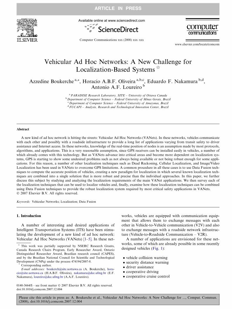
A number of applications are envisioned for these net-works, some of which are already possible in some recentlydesigned vehicles (Fig. 1):
� vehicle collision warning� security distance warning� driver assistance� cooperative driving� cooperative cruise control
d Hoc Networks: A New Challenge for ..., Comput. Commun.
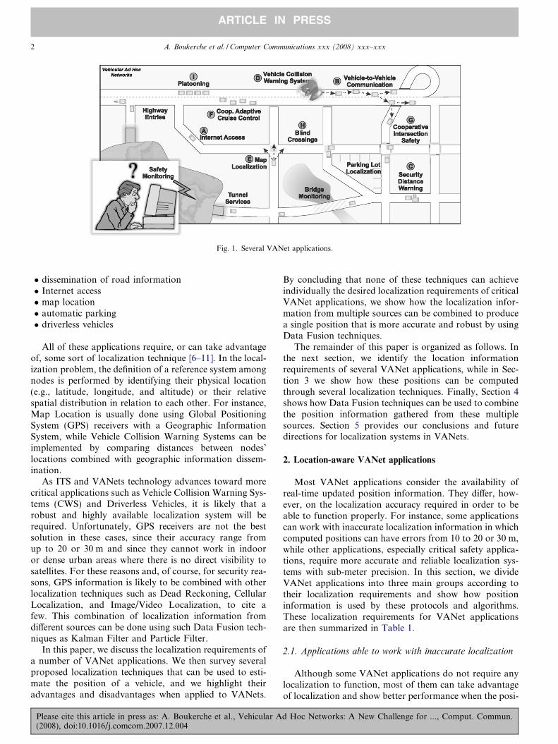
Fig. 1. Several VANet applications.
2 A. Boukerche et al. / Computer Communications xxx (2008) xxx–xxx
ARTICLE IN PRESS
� dissemination of road information� Internet access� map location� automatic parking� driverless vehicles
All of these applications require, or can take advantageof, some sort of localization technique [6–11]. In the local-ization problem, the definition of a reference system amongnodes is performed by identifying their physical location(e.g., latitude, longitude, and altitude) or their relativespatial distribution in relation to each other. For instance,Map Location is usually done using Global PositioningSystem (GPS) receivers with a Geographic InformationSystem, while Vehicle Collision Warning Systems can beimplemented by comparing distances between nodes’locations combined with geographic information dissem-ination.
As ITS and VANets technology advances toward morecritical applications such as Vehicle Collision Warning Sys-tems (CWS) and Driverless Vehicles, it is likely that arobust and highly available localization system will berequired. Unfortunately, GPS receivers are not the bestsolution in these cases, since their accuracy range fromup to 20 or 30 m and since they cannot work in indooror dense urban areas where there is no direct visibility tosatellites. For these reasons and, of course, for security rea-sons, GPS information is likely to be combined with otherlocalization techniques such as Dead Reckoning, CellularLocalization, and Image/Video Localization, to cite afew. This combination of localization information fromdifferent sources can be done using such Data Fusion tech-niques as Kalman Filter and Particle Filter.
In this paper, we discuss the localization requirements ofa number of VANet applications. We then survey severalproposed localization techniques that can be used to esti-mate the position of a vehicle, and we highlight theiradvantages and disadvantages when applied to VANets.
Please cite this article in press as: A. Boukerche et al., Vehicular A(2008), doi:10.1016/j.comcom.2007.12.004
By concluding that none of these techniques can achieveindividually the desired localization requirements of criticalVANet applications, we show how the localization infor-mation from multiple sources can be combined to producea single position that is more accurate and robust by usingData Fusion techniques.
The remainder of this paper is organized as follows. Inthe next section, we identify the location informationrequirements of several VANet applications, while in Sec-tion 3 we show how these positions can be computedthrough several localization techniques. Finally, Section 4shows how Data Fusion techniques can be used to combinethe position information gathered from these multiplesources. Section 5 provides our conclusions and futuredirections for localization systems in VANets.
2. Location-aware VANet applications
Most VANet applications consider the availability ofreal-time updated position information. They differ, how-ever, on the localization accuracy required in order to beable to function properly. For instance, some applicationscan work with inaccurate localization information in whichcomputed positions can have errors from 10 to 20 or 30 m,while other applications, especially critical safety applica-tions, require more accurate and reliable localization sys-tems with sub-meter precision. In this section, we divideVANet applications into three main groups according totheir localization requirements and show how positioninformation is used by these protocols and algorithms.These localization requirements for VANet applicationsare then summarized in Table 1.
2.1. Applications able to work with inaccurate localization
Although some VANet applications do not require anylocalization to function, most of them can take advantageof localization and show better performance when the posi-
d Hoc Networks: A New Challenge for ..., Comput. Commun.
Table 1Required localization accuracy for some VANet applications
Technique Localization Accuracy
Low Medium High
Routing X – –Data Dissemination X – –Map Localization X – –Coop. Adapt. Cruise Control – X –Coop. Intersection Safety – X –Blind Crossing – X –Platooning – X –Vehicle Col. Warn. System – – XVision Enhancement – – XAutomatic Parking – – X
A. Boukerche et al. / Computer Communications xxx (2008) xxx–xxx 3
ARTICLE IN PRESS
tion information of vehicles is available. Most of theseapplications are related to vehicle communication, whichincludes vehicle-to-vehicle (V2V) and vehicle-to-roadside(V2R) communication, and provide services such as infor-mation routing, and the data dissemination of accidents,road congestion, etc. The algorithms that deal with com-munication will accept localization errors mostly within10–20 or even 30 m, since the long transmission range ofthe vehicles’ transmitters can compensate for these localiza-tion inaccuracies. However, the greater the localizationerror, the worse the algorithms’ performance [12]. In thefollowing paragraphs we will discuss some of these applica-tions and algorithms.
Routing protocols for VANets [13] usually use positioninformation in order to improve their performance and beable to comply with such VANets requirements as dynamictopology changes and frequent network fragmentation. Thisrouting technique has long been used in Ad Hoc networks[14–16] and most of its protocols can also be applied toVANets. A classical example is Greedy Forwarding [15,16],in which, location information is used at each step to forwarda packet to the neighbor nearest to the destination node.However, some geographic routing protocols have also beendesigned specifically for VANets, taking advantage of moregeographical knowledge such as Maps [17,18] and movementinformation [19]. Routing techniques are also used to accesslocal infrastructured networks via an Internet connection(Fig. 1A). In these cases, position information as well asfuture trajectory knowledge can be used to assist routing.
Several Data Dissemination protocols [20,21] have beenproposed for VANets that aim to inform both near anddistant vehicles about transit conditions such as the roadflow, congestion, and potentially dangerous situations.Most of these protocols also consider localization knowl-edge mostly to ensure that locally disseminated informa-tion reaches only the vehicles that should be interested init. Driver direction can also be used, as proposed by theODAM algorithm [21]. In Fig. 1B, road information abouta dangerous situation is disseminated to interested vehicles.
A widely known and already in-use driver assistanceapplication is Map Localization, in which the current posi-tion of the vehicle is shown on a map. In these applications,
Please cite this article in press as: A. Boukerche et al., Vehicular A(2008), doi:10.1016/j.comcom.2007.12.004
a path direction between two points of the city, forinstance, can be drawn on a map indicating the currentlocation of the vehicle. This application can assist driversin situations when they find themselves lost in a unknownpart of the city, as depicted in Fig. 1E. Localization infor-mation with errors of about 10–20 m are proven to be use-ful for this kind of application, since map knowledge canbe used to overcome this high localization inaccuracy.
2.2. Applications requiring accurate localization
This kind of application require a certain degree of confi-ability and accuracy in the computed positions and/or in thedistance estimation between vehicles. Applications in thisgroup are usually Cooperative Driving applications, wherevehicles in a VANet exchange messages between them todrive and share the available space on the road coopera-tively. In these applications, the vehicles can assume partialcontrol over driving. In most cases, localization errors from1 to 5 meters are acceptable. In the following paragraphs wewill discuss some of these applications and algorithms.
In Cooperative Adaptive Cruise Control, the vehicle main-tains the same speed whether traveling uphill or down with-out requiring driver intervention. Usually, the driver sets thespeed and the system will take over, but in this case, vehiclescan cooperate among themselves to set this speed adaptively(Fig. 1F). This application only takes care of speed, while thedriver still has to control the direction of the vehicle.
Another interesting application of VANets is Coopera-
tive Intersection Safety, in which vehicles arriving at a roadintersection exchange messages in order to make a safecrossing as depicted in Fig. 1G. Besides ensuring a safecrossing, it is also possible to make a Blind Crossing, wherethere is no light control and the vehicles cooperate witheach other to make a cooperative crossing (Fig. 1H). Inthese applications, the localization accuracy must allowthe application to differentiate between the lanes as wellas the sides of the street.
Vehicle Following or Platooning is a technique used tomake one or more vehicles follow a leader vehicle to forma train-like system, as shown in Fig. 1I. This applicationcan be useful in situations where two or more vehiclesare going to the same location. A minimum distance mustbe ensured between vehicles. Also, vehicles must track theposition of the vehicle in front of them with a good preci-sion, both of which can be accomplished by a localizationsystem with accurate position information.
2.3. Applications requiring high-accurate localization
A third class of applications for VANets requires veryprecise and reliable localization systems. Most of theseapplications are critical safety applications such as VehicleCollision Warning Systems (CWS) and other driver assis-tance applications. In driver assistance applications,VANet resources are used to enhance the driver’s percep-tion and knowledge of the road and environment. In these
d Hoc Networks: A New Challenge for ..., Comput. Commun.
Fig. 2. Several localization techniques for VANet.
4 A. Boukerche et al. / Computer Communications xxx (2008) xxx–xxx
ARTICLE IN PRESS
applications, the driver is informed about the surroundingenvironment in order to improve safety, and, in case ofemergency, the vehicle can perform some automatic proce-dures. These are the most interesting applications forVANets, and since we are dealing with safety, positioninformation reliability and accuracy are crucial. Accuratepositioning ensures localization with a meter or sub-meterprecision in order to estimate accurately the distancesbetween vehicles, while a reliable localization will ensurethat updated information will always be available. In thefollowing paragraphs we will discuss some of these applica-tions and algorithms.
Vehicle Collision Warning Systems [1,21] are one of themost interesting applications of VANets for driver assis-tance. One part of these systems is Security Distance Warn-
ing, in which the driver is warned when a minimumdistance to another vehicle is reached (Fig. 1C). It can alsoimplement an emergency break when the distance betweentwo vehicles or between a vehicle and an obstacle decreasestoo quickly, as shown in Fig. 1D. Another part of thesesystems is when a collision has already occurred andnearby vehicles need to be warned (warn messages) so theycan avoid pile-up collisions (Fig. 1D). In these cases, mul-tihop communication can be used to disseminate collisioninformation. Since they provide a critical application forsafe driving, these applications require robust, accurate,and reliable localization systems.
Another driver assistance application is Vision Enhance-
ment, in which drivers are given a clear view of vehicles andobstacles in heavy fog conditions and can learn about theexistence of vehicles hidden by obstacles, buildings, andby other vehicles.
Automatic Parking is an application through which avehicle can park itself without the need for driver interven-tion. In order to be able to perform an automatic parking,a vehicle needs accurate distance estimators and/or a local-ization system with sub-meter precision.
3. Localization techniques for Vehicular Ad Hoc Networks
A number of localization techniques has been proposedfor computing the position of mobile nodes. An interestingaspect of VANets is that most localization techniques canbe applied easily to these networks. Fig. 2 depicts a numberof localization techniques that can be used by vehicles toestimate their positions, namely Map Matching, DeadReckoning, Cellular Localization, Image/Video Process-ing, Localization Services, and Relative Distributed AdHoc Localization. All of these techniques have their prosand cons. In this section we briefly explain each of thesetechniques and discuss when and how they can be usedto localize vehicles in Intelligent Transport Systems.
3.1. Global Positioning System – GPS/DGPS
GPS, the Global Positioning System [22,23], is com-posed of 24 satellites that operate in orbit around the earth.
Please cite this article in press as: A. Boukerche et al., Vehicular A(2008), doi:10.1016/j.comcom.2007.12.004
Each satellite circles the earth at a height of 20.200 km andmakes two complete rotations every day. The orbits havebeen defined in such a way that each region of the earthcan ‘‘see” at least four satellites in the sky.
A GPS receiver is a piece of equipment that is able toreceive the information constantly being sent by the satel-lites, and uses this information to estimate its distance toat least four known satellites using a technique called Timeof Arrival (ToA), and, finally, to compute its position usingtrilateration [10]. Once these procedures have been exe-cuted, the receiver is able to know its latitude, longitudeand altitude.
The main solution for VANet Localization is to equipeach vehicle node with a GPS receiver (Fig. 3A). This isa very reasonable solution since GPS receivers can beinstalled easily in vehicles, a number of which alreadycomes with this technology. But as VANets advance intocritical areas and become more dependent on localizationsystems, GPS, as well as other satellite-based positioningsystems (e.g., Galileo, GLONASS), are starting to showsome undesired problems such as not always being avail-able and not being robust enough for critical applications.
In order to function properly and compute its position,a GPS receiver needs access to at least three satellite signalsfor 2D positioning and at least four satellite signals for a3D position computation. At first sight, this is not a majorissue since the number of visible satellites usually variesbetween four and eleven. However, the problem is thatthese signals are easily disturbed or blocked by obstaclesincluding buildings, rocks, dense foliage, electronic inter-ference, etc. This causes position inaccuracy or unavailabil-ity in dense urban environments (urban-canyons), tunnels,indoor parking lots, forests, and any other indoor, under-ground, or underwater environment.
Also, GPS receivers have a localization error of ±10 to30 m. While this is a reasonable level of precision for mostapplications, it is definitely not enough for critical VANetapplications, as explained in Section 2. One positive aspectof these errors is that nearby GPS receivers tend to havethe same localization error pointing in the same direction.In other words, nearby GPS receivers have correlated
d Hoc Networks: A New Challenge for ..., Comput. Commun.
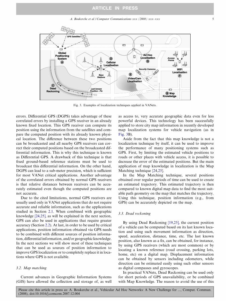
Fig. 3. Examples of localization techniques applied in VANets.
A. Boukerche et al. / Computer Communications xxx (2008) xxx–xxx 5
ARTICLE IN PRESS
errors. Differential GPS (DGPS) takes advantage of thesecorrelated errors by installing a GPS receiver in an alreadyknown fixed location. This GPS receiver can compute itsposition using the information from the satellites and com-pare the computed position with its already known physi-cal location. The difference between these two positionscan be broadcasted and all nearby GPS receivers can cor-rect their computed positions based on the broadcasted dif-ferential information. This is why this technique is knownas Differential GPS. A drawback of this technique is thatfixed ground-based reference stations must be used tobroadcast this differential information. On the other hand,DGPS can lead to a sub-meter precision, which is sufficientfor most VANet critical applications. Another advantageof the correlated errors obtained by normal GPS receiversis that relative distances between receivers can be accu-rately estimated even though the computed positions arenot accurate.
Due to the cited limitations, normal GPS receivers areusually used only in VANet applications that do not requireaccurate and reliable information, such as the applicationsstudied in Section 2.1. When combined with geographicknowledge [24,25], as will be explained in the next section,GPS can also be used in applications that require greateraccuracy (Section 2.2). At last, in order to be used by criticalapplications, position information obtained via GPS needsto be combined with different sources of position informa-tion, differential information, and/or geographic knowledge.In the next sections we will show most of these techniquesthat can be used as sources of position information toimprove GPS localization or to completely replace it in loca-tions where GPS is not available.
3.2. Map matching
Current advances in Geographic Information Systems(GIS) have allowed the collection and storage of, as well
Please cite this article in press as: A. Boukerche et al., Vehicular A(2008), doi:10.1016/j.comcom.2007.12.004
as access to, very accurate geographic data even for lesspowerful devices. This technology has been successfullyapplied to store city map information in recently developedmap localization systems for vehicle navigation (as inFig. 3B).
Aside from the fact that this map knowledge is not alocalization technique by itself, it can be used to improvethe performance of many positioning systems such asGPS. First, by limiting the estimated vehicle positions toroads or other places with vehicle access, it is possible todecrease the error of the estimated positions. But the mainapplication of map knowledge in localization is the MapMatching technique [24,25].
In the Map Matching technique, several positionsobtained over regular periods of time can be used to createan estimated trajectory. This estimated trajectory is thencompared to known digital map data to find the most suit-able path geometry on the map that matches the trajectory.Using this technique, position information (e.g., fromGPS) can be accurately depicted on the map.
3.3. Dead reckoning
By using Dead Reckoning [19,25], the current positionof a vehicle can be computed based on its last known loca-tion and using such movement information as direction,speed, acceleration, distance, time, etc. The last knownposition, also known as a fix, can be obtained, for instance,by using GPS receivers (which are most common) or bylocating a known reference (road crossing, parking lots,home, etc) on a digital map. Displacement informationcan be obtained by sensors including odometers, whiledirection can be estimated easily using such other sensorsas digital compasses and gyroscopes.
In practical VANets, Dead Reckoning can be used onlyfor short periods of GPS unavailability, or be combinedwith Map Knowledge. The reason to avoid the use of this
d Hoc Networks: A New Challenge for ..., Comput. Commun.
6 A. Boukerche et al. / Computer Communications xxx (2008) xxx–xxx
ARTICLE IN PRESS
technique over long periods of time is that it can accumu-late errors easily. For instance, positioning errors from 10to 20 m can be reached in only 30 s after the last positionfix when traveling at about 100 km/h [7,26].
Since Dead Reckoning accumulates errors rapidly overtime and distance, it is considered only as a backup systemfor periods of GPS outage, as shown in Fig. 3C, in which avehicle enters a tunnel and loses its GPS connection. In thisexample, the last GPS computed position is used as a posi-tion fix. Another viable application of Dead Reckoning, asnoted above, is to combine it with Map Knowledge. Inthese cases, the positions restrictions can be applied todecrease Dead Reckoning errors, and the traffic patternscan be used to match the estimated path within the knownmap information (map matching) [25].
3.4. Cellular localization
Cellular localization [27–30] takes advantage of themobile cellular infrastructure present in most urbanenvironments to estimate the position of an object. Knownapplications of this technology include locating mobilephones, tracking domestic animals, and vehicle locali-zation.
In order to function properly, mobile cellular systemsrequire the installation of a communication infrastructurecomposed of a number of cellular base stations distributedthrough the covered area. Each base station is responsiblefor providing communication to mobile phones located inits area. As mobile phones move around a city, they keepchanging their base station when the signal strength froma new base station becomes greater than the one in use.This procedure is called handoff.
Although only one base station is used in communica-tion, usually several base stations can listen to and commu-nicate with a mobile phone at any time. This fact allows anumber of localization techniques to be used to estimatethe position of the mobile phone. A well known techniquecalled Received Signal Strength Indicator (RSSI) uses thestrength of the received signals to derive the distance tothe base stations. It is also possible to estimate a distancebased on the time it takes for a signal to leave the senderand arrive at the base station (Time of Arrival – ToA) orthe difference between the times it takes for a single signalto arrive at multiple base stations (Time Difference of Arri-val – TDoA). Once we have the distances from the mobilephone to at least three base stations, it is possible to com-pute the position of the mobile phone using such tech-niques as trilateration and multilateration [10] (Fig. 3D).
Another common approach is possible when directiveantennas or antenna arrays are used at base stations. Inthis case, the angle at which the signal arrives at a base sta-tion can be estimated. Based on the Angle of Arrival (AoA)of a signal to three different base stations, we can computethe position of the signal source.
Fingerprinting is a localization technique based on apre-training phase in which signal characteristics from base
Please cite this article in press as: A. Boukerche et al., Vehicular A(2008), doi:10.1016/j.comcom.2007.12.004
stations are recorded at each location. After this informa-tion is recorded, a mobile node can find the position inthe database that best matches its current signal character-istics. This is a very interesting solution for small or med-ium sized areas, achieving errors of less than 5 m inindoor environments [29]. For large urban areas as inVANet applications it has questionable applicability, butin some recent studies [30], an average accuracy of 94 mis achieved after a 60-h calibration drive in a metropolitanarea.
Cellular localization is usually less precise than GPS.The accuracy depends on a number of factors such as thecurrent urban environment, the number of base stationsdetecting the signal, the positioning algorithm used, etc.In most cases, the average localization error will bebetween 90 m and 250 m [30], which is not accurate enougheven for VANet applications that do not require accurateand reliable information such as the applications studiedin Section 2.1. However, position information gatheredfrom this technique can still be useful when combined withDead Reckoning and/or Map Matching, and the availableinformation can also be used to feed Data Fusion modulesas will be explained in Section 4. Also, signals from the Cel-lular infrastructure have more availability in urban envi-ronments than signals from satellite (used by GPSreceivers) which can be useful for indoor environmentssuch as parking lots and even tunnels, especially if the fin-gerprinting technique explained above is used.
3.5. Image/video processing
Image and video information sources and data process-ing techniques can also be used for localization purposes,especially in mobile robot guidance systems [31]. In somecases, however, cameras are already available in securitysystems implemented in parking lots and tunnels, as shownin Fig. 3E. Commonly, these Image/Video Processing tech-niques are used to feed Data Fusion algorithms to estimateand predict (track) a vehicle’s location [32]. In fact, bothimage and video information are actual sources from whichwe can compute the location parameters of a vehicle. Forinstance, in [33] vision algorithms [34] are used to detectthe sides of lanes in video images. It estimates preciselythe vehicle’s geometrical parameters in a local referencesystem, including lane width, road lateral curvature, dis-tance of the vehicle from the left side of the lane, vehicle’sdirection angle, and the camera inclination angle. Theselocal data are transformed in order to be expressed in aprecise digital map of the environment. Such informationis used to feed a Data Fusion module that estimates thevehicles’ locations. Data Fusion techniques for VANetlocalization will be discussed further in Section 4.
3.6. Localization services
There are places where GPS is not available or not pre-cise enough for local applications. In VANets, as men-
d Hoc Networks: A New Challenge for ..., Comput. Commun.
A. Boukerche et al. / Computer Communications xxx (2008) xxx–xxx 7
ARTICLE IN PRESS
tioned in Section 3.1, these places include tunnels, urban-canyons, and parking lots. In these cases, an infrastructurefor communication and positioning service can be imple-mented to perform the localization of vehicles, as shownin Fig. 3F.
A Localization Service can be implemented using anyknown infrastructured localization system such as theCricket Location-Support System [35], RADAR [36],Ultra-Wideband Localization [37], or WiFi Localization[38,39]. In [39], Thangavelu et al. propose a system calledVETRAC, a vehicle tracking and location identificationsystem designed for VANets that uses WiFi access pointsas a communication infrastructure and also as landmarkswhen positioning vehicles. The proposed system can beused in tunnels, university campuses, airports, etc.
In most cases, localization services are likely to takeadvantage of the communication system in use to computea vehicle’s position based on signal propagation character-istics (e.g., strength, time, or fingerprint). However, otherindoor localization systems such as Image/Video Process-ing (explained in Section 3.5) or Laserscanners can alsobe used.
The most challenging and important task in VANetlocalization is most likely the development of infrastruc-tured localization systems to be used in tunnels, whichare one of the most critical VANet environments. Tunnelsare normally used to connect important regions separatedby natural environments with difficult access and are gener-ally the only path between these regions. Thus, a damagedtunnel can have an enormous impact on a city or a region.Also, due to the limited access inside a tunnel, emergencyrescue operations can become very difficult and even dan-gerous. In these scenarios, collision avoidance is crucial,and all available information about the state of these tun-nels’ infrastructure as well as the number and location ofall vehicles inside these tunnels are key information for res-cue teams in case of emergency operations.
VANets can also use Wireless Sensor Networks (WSNs)as the base for a VANet localization infrastructure. Thereason for doing this is that WSNs can also be used tomonitor other road variables like movement, temperature,smoke, visibility, and noise. Thus, these networks are idealfor monitoring critical environments as well as for emer-gency operations, as shown by a number of works[40,41]. Also, the use of sensor networks as a roadside com-munication infrastructure is a frequently envisioned sce-nario in many Intelligent Transportation Systems. Anumber of WSN features can also be used to improve theperformance and accuracy of an infrastructured VANetlocalization system. For instance, movement sensors canbe used to send localization packets only when vehiclesare present. These sensors can also be used to increasethe localization accuracy by making nodes exchange theirsensors’ movement detection level. Finally, a WSN usedas a VANet localization infrastructure will provide a com-plete safety monitoring system for these critical scenarios,being able not only to monitor important environment
Please cite this article in press as: A. Boukerche et al., Vehicular A(2008), doi:10.1016/j.comcom.2007.12.004
and structural variables like movement, temperature,smoke, visibility, noise, pressure, and structural health,but also the location of all vehicle nodes at a givenmoment.
3.7. Relative distributed ad hoc localization
Local relative position maps can be constructed by avehicle by estimating the distances between its neighborsand exchanging this distance information with nearbynodes in multihop communication. With this dynamicposition map, a vehicle can locate itself in relation tonearby vehicles as well as locate the vehicles in its vicinity(Fig. 3G). This type of relative localization has been usedmostly in Ad Hoc and Sensor Networks, but recently anumber of solutions [6,7,26] has been proposed forVANets.
In [6], a distributed localization algorithm is proposed toassist GPS-unequipped vehicles in estimating their posi-tions based on nearby GPS-equipped vehicles. To estimatea position, a vehicle not equipped with GPS needs to com-municate with at least three GPS-equipped vehicles in itsvicinity in order to estimate distances and gather their posi-tion information. When the number of nearby GPS-equipped vehicles is less than three, the author showshow to estimate at least the direction of the vehicle andthe distance from an event (an accident or a danger) basedon the small amount of available information. The pro-posed algorithm can successfully estimate the position ofvehicles not equipped with GPS, but it is hard to identifysituations where vehicles have network cards to communi-cate with other vehicles but have no GPS equipment. Also,the direction of the cars can be easily estimated by exchang-ing digital compass or gyroscopes information.
In [7], another distributed VANet localization system isproposed in which distances between vehicles are esti-mated using RSSI and the information is used by an opti-mization algorithm to improve the initial positionestimation of the vehicles (obtained, for instance, viaGPS). This technique is primarily intended to improveGPS’s initial position estimations, but since nearby GPSreceivers tend to have correlated errors, estimating dis-tances using RSSI will hardly improve the position infor-mation. However, this solution can also be used toimprove positions computed via the Dead Reckoningtechnique during GPS outages.
A number of distributed relative ad hoc localization sys-tems have been proposed recently for Ad Hoc and Sensornetworks [42,43], but only a few of these can be appliedto highly mobile and dynamic networks such as VANets.In [26], Kukshya et al. propose an architecture for the rel-ative positioning of a cluster of vehicles that does notrequire any GPS information and that is suitable forVANets. This architecture also relies on distance estima-tion measurements.
Most VANet applications can work with relative posi-tioning, but they would function better using global posi-
d Hoc Networks: A New Challenge for ..., Comput. Commun.
Table 2Localization techniques: a comparison
Technique Localization feature
Synchroniz. Infrastruct. Availability Accuracy
Global Pos. System Yes Yes No NoDifferential GPS Yes Yes No YesMap Matching No No Yes NoDead Reckoning No No Yes NoCellular Loc. Yes Yes No NoImg/Video Loc. No Yes No YesLoc. Services No Yes No YesRel. Ad Hoc Loc. No No Yes Yes
8 A. Boukerche et al. / Computer Communications xxx (2008) xxx–xxx
ARTICLE IN PRESS
tioning. In these cases, relative positions can usually beconverted into global positions when some vehicles withGPS or accurate global positions are available, as donein [7,6].
3.8. Techniques comparison
All of these localization techniques studied have theirpros and cons. Table 2 briefly compares these techniques.As we can see from the table, although several interestingsolutions have been reported in the literature, basicallynone of them satisfy all the requirements of critical appli-cations at the same time, such as being available any-where and anytime, with highly accurate and reliableposition computations. For these reasons, one of the mostappealing problems to be solved by VANets is how toprovide an anytime, anywhere, fine-grained, and reliablelocalization system to be used by vehicles in a VANetfor critical safety and emergency applications. An anytime
requirement means that the localization system must befree of delays when computing the current positions ofthe vehicles (e.g., no startup delay). This requirement iscritical, since the high mobility of VANets means thatslightly outdated position information cannot be usedand could even be dangerous. To be available anywhere
is also a challenge in a VANet localization system. Itmeans that the localization system cannot rely only onsatellite infrastructure, since it would then not work inenvironments without direct visibility to satellites. Also,it cannot rely only on local infrastructured localizationtechniques, since it would not be available in places with-out this infrastructure. Finally, a fine-grained localizationsystem ensures a low localization error for vehicles, whichenables most critical VANet applications to have somedegree of confidence.
As shown in Table 2, it is clear that a single techniquewill not be enough to provide a localization system withall of the features requested by critical VANetapplications. As a result, ways to combine different local-ization techniques and protocols in a single localizationsystem will be required. Data-fusion techniques, whichwill be studied in the next section, are the natural choicefor technique combinations aimed at acquiring improveddata [32].
Please cite this article in press as: A. Boukerche et al., Vehicular A(2008), doi:10.1016/j.comcom.2007.12.004
4. Data Fusion in VANets’ localization systems
Data Fusion can be simply defined as the combinationof multiple sources to obtain improved information(cheaper, greater quality, or greater relevance) [32]. DataFusion is commonly used in detection and classificationtasks in different application domains, such as roboticsand military applications [44]. Lately, these mechanismshave been used in previously unpredicted applications suchas intrusion detection [45] and Denial of Service (DoS)detection [46]. Within the domain of WSNs, simple aggre-gation techniques (e.g., maximum, minimum, and average)have been used to reduce the overall data traffic to saveenergy [47]. A detailed description of data-fusion tech-niques is not the focus of this paper, however. Furtherdetails about these techniques are described in [32].
4.1. A possible Data Fusion model
Data Fusion techniques such as Kalman Filters, Particlefilters, and Belief Theory have also been used to improvelocation estimations in many sensor-based systems [32].For instance, the SAFESPOT [48] approach for the accu-rate relative positioning of vehicles foresees the use of DataFusion to help with accurate position estimation inVANets. The key idea is to combine information from acooperative vehicle ad hoc network using a Data Fusionmodule to allow vehicular safety applications to determinenot only a vehicle’s location, but also the lane in which it istraveling. The general idea behind a location system basedon Data Fusion is to combine several information sourcesto provide an accurate location estimation.
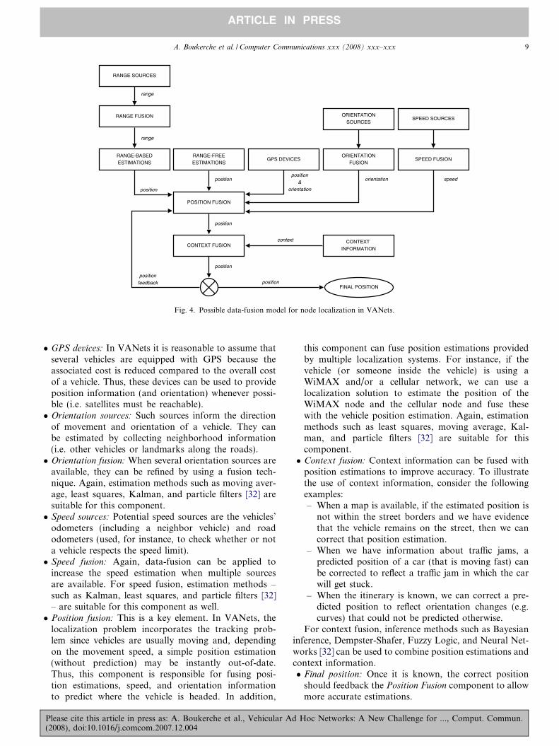
Theoretically, data-fusion techniques may be used inalmost every stage of a location estimation process forVANets. As an example, Fig. 4 depicts a possible data-fusion model that can be applied to acquire accurate posi-tion estimations. This model has the followingcomponents:
� Range sources: There are several possible data sourcesthat can provide distance estimations, such as ultra-sound, laser, RSSI, ToA, and TDoA. Such rangesources may be deployed on the road, in vehicles, andon nearby buildings.� Range fusion: Every range source may embed some level
of noise. In this context, all available distance estima-tions can be fused (filtered) to reduce the embeddednoise. Data-fusion estimation methods – such as movingaverage, Kalman, and particle filters [32] – are suitablefor this component.� Range-based estimation: Once we have a fused distance
estimation, we can use such information to computethe vehicle’s position by using, for instance, a multilater-ation process.� Range-free estimation: Occasionally, a range free locali-
zation system may be used as side information to com-plement the other position estimations available.
d Hoc Networks: A New Challenge for ..., Comput. Commun.
POSITION FUSION
CONTEXT FUSION
GPS DEVICESRANGE-FREEESTIMATIONS
CONTEXTINFORMATION
SPEED SOURCES
SPEED FUSION
ORIENTATIONSOURCES
ORIENTATIONFUSION
range
range
position
positionposition
&orientation
orientation speed
context
position
positionfeedback
FINAL POSITION
position
position
RANGE FUSION
RANGE SOURCES
RANGE-BASEDESTIMATIONS
Fig. 4. Possible data-fusion model for node localization in VANets.
A. Boukerche et al. / Computer Communications xxx (2008) xxx–xxx 9
ARTICLE IN PRESS
� GPS devices: In VANets it is reasonable to assume thatseveral vehicles are equipped with GPS because theassociated cost is reduced compared to the overall costof a vehicle. Thus, these devices can be used to provideposition information (and orientation) whenever possi-ble (i.e. satellites must be reachable).� Orientation sources: Such sources inform the direction
of movement and orientation of a vehicle. They canbe estimated by collecting neighborhood information(i.e. other vehicles or landmarks along the roads).� Orientation fusion: When several orientation sources are
available, they can be refined by using a fusion tech-nique. Again, estimation methods such as moving aver-age, least squares, Kalman, and particle filters [32] aresuitable for this component.� Speed sources: Potential speed sources are the vehicles’
odometers (including a neighbor vehicle) and roadodometers (used, for instance, to check whether or nota vehicle respects the speed limit).� Speed fusion: Again, data-fusion can be applied to
increase the speed estimation when multiple sourcesare available. For speed fusion, estimation methods –such as Kalman, least squares, and particle filters [32]– are suitable for this component as well.� Position fusion: This is a key element. In VANets, the
localization problem incorporates the tracking prob-lem since vehicles are usually moving and, dependingon the movement speed, a simple position estimation(without prediction) may be instantly out-of-date.Thus, this component is responsible for fusing posi-tion estimations, speed, and orientation informationto predict where the vehicle is headed. In addition,
Please cite this article in press as: A. Boukerche et al., Vehicular A(2008), doi:10.1016/j.comcom.2007.12.004
this component can fuse position estimations providedby multiple localization systems. For instance, if thevehicle (or someone inside the vehicle) is using aWiMAX and/or a cellular network, we can use alocalization solution to estimate the position of theWiMAX node and the cellular node and fuse thesewith the vehicle position estimation. Again, estimationmethods such as least squares, moving average, Kal-man, and particle filters [32] are suitable for thiscomponent.� Context fusion: Context information can be fused with
position estimations to improve accuracy. To illustratethe use of context information, consider the followingexamples:– When a map is available, if the estimated position is
not within the street borders and we have evidencethat the vehicle remains on the street, then we cancorrect that position estimation.
– When we have information about traffic jams, apredicted position of a car (that is moving fast) canbe corrected to reflect a traffic jam in which the carwill get stuck.
– When the itinerary is known, we can correct a pre-dicted position to reflect orientation changes (e.g.curves) that could not be predicted otherwise.
For context fusion, inference methods such as Bayesianinference, Dempster-Shafer, Fuzzy Logic, and Neural Net-works [32] can be used to combine position estimations andcontext information.� Final position: Once it is known, the correct position
should feedback the Position Fusion component to allowmore accurate estimations.
d Hoc Networks: A New Challenge for ..., Comput. Commun.
10 A. Boukerche et al. / Computer Communications xxx (2008) xxx–xxx
ARTICLE IN PRESS
4.2. Current approaches
In the specific context of emerging VANets, the poten-tial of data-fusion has not been properly explored. Consid-ering the fusion model depicted in Fig. 4, current solutionsuse data-fusion to predict where the vehicle is moving –which partially corresponds to the Position Fusion compo-nent – and use some context information to improveaccuracy – which partially corresponds to the Context
Fusion component.In [49], the authors use Particle Filters to cope with
vehicle localization in combined indoor and outdoor sce-narios. In such scenarios, the authors assess the perfor-mance of UWB sensor technology for indoorpositioning and GPS for outdoor areas, and evaluatethe use of particle filters to fuse observations from thesetwo types of sensors for vehicle localization. Particle Fil-ters are also used in [33] to combine GPS localizationwith data extracted from vision systems to determine avehicle’s location on the road. The combined informationis transformed into a global reference using a map of theenvironment.
In the context of vehicle localization for productionand logistic applications, [50] applies Kalman filters totrack the position of all transportation means when pick-ing up or putting down items by combining a wirelesslocal positioning system with an optical scan matchapproach.
Aiming at improving security on the roads, [51] uses aKalman filter for trajectory prediction and the estimationof a vehicle’s location to evaluate and anticipate therisk of collision at a crossroad. The authors show thatdespite unavoidable latencies and positioning errors, theapplication performance is still acceptable when a Kal-man filter is used for trajectory prediction andestimation.
In [52], Belief Theory and Kalman filters are used toprovide accurate position estimations for a vehicle relativeto a digital road map. In this method, the Kalman Filteris used to combine the Anti-lock Braking Systems (ABS)measurements with a GPS position, which is then used toselect the most credible roads. The selection strategy fusesdistance, direction, and velocity measurements usingBelief Theory. A new observation is then built and thevehicle’s approximate location is adjusted by a secondKalman filter.
Table 3Summary of current data fusion solutions for Localization in VANets
Solution Fusion Type
Range Orient. Speed Pos. Context
Chausse et al. [33] No No No Yes YesFernandez-Madrigal et al.
[49]No No No Yes Yes
Michel et al. [50] No Yes No Yes YesAmmoun et al. [51] No No No Yes YesNajjar and Bonnifait [52] No No No Yes Yes
Please cite this article in press as: A. Boukerche et al., Vehicular A(2008), doi:10.1016/j.comcom.2007.12.004
Note that none of these solutions exploits all of thefusion components depicted in Fig. 4. Most of themexploit some level of context information. However,depending on the application, other context informationshould be used, such as itinerary and traffic information.In general, Range Fusion, Orientation Fusion, and SpeedFusion are neglected by current solutions. Table 3 summa-rizes how current solutions fit within the data-fusionmodel depicted in Fig. 4.
5. Conclusions
In this paper, Localization Systems were studied fromthe viewpoint of Vehicular Ad Hoc Networks (VANets).We showed how GPS receivers, the most common sourceof localization information in VANets, can become erro-neous or unavailable in a number of situations. We thendiscussed how these localization inaccuracies can affectmost VANet applications, especially critical ones. A num-ber of other localization systems are available to be usedby vehicles to estimate their positions: Map Matching,Dead Reckoning, Cellular Localization, Image/Video Pro-cessing, Localization Services, and Relative DistributedAd Hoc Localization. All of these techniques have theirpros and cons. In this paper we argue that future localiza-tion systems for VANets are likely to use some kind ofData Fusion technique in order to provide position infor-mation for vehicles that is accurate and robust enough tobe applied in VANet critical applications. We then showhow Data Fusion techniques can be used to compute anaccurate position based on a number of relatively inaccu-rate position estimations.
References
[1] S. Biswas, R. Tatchikou, F. Dion, Vehicle-to-vehicle wirelesscommunication protocols for enhancing highway traffic safety, IEEECommunications Magazine 44 (1) (2006) 74–82.
[2] J. Blum, A. Eskandarian, L. Hoffman, Challenges of inter-vehicle adhoc networks, IEEE Transactions on Intelligent TransportationSystems 5 (4) (2004) 347–351.
[3] W. Kiess, J. Rybicki, M. Mauve, On the nature of inter-vehiclecommunication, in: WMAN 2007: Proceedings of the 4th Workshopon Mobile Ad-Hoc Networks, 2007, pp. 493–502.
[4] J. Luo, J.-P. Hubaux, A survey of inter-vehicle communication, Tech.Rep. IC/2004/24, School of computer and Communication Sciences,EPEL, 2004.
[5] J. Hubaux, S. Capkun, J. Luo, The security and privacy ofsmart vehicles, IEEE Security and Privacy Magazine 02 (3)(2004) 49–55.
[6] A. Benslimane, Localization in Vehicular Ad Hoc Networks, in:Proceedings Systems Communications, 2005, pp. 19–25.
[7] R. Parker, S. Valaee, Vehicle localization in Vehicular Networks, in:Vehicular Technology Conference, 2006. VTC-2006 Fall. 2006 IEEE64th, 2006, pp. 1–5.
[8] V. Zeimpekis, G.M. Giaglis, G. Lekakos, A taxonomy of indoor andoutdoor positioning techniques for mobile location services, SIGecomExchange 3 (4) (2003) 19–27, URL http://portal.acm.org/cita-tion.cfm?id=844355 .
[9] F. Gustafsson, F. Gunnarsson, Mobile positioning using wirelessnetworks: possibilities and fundamental limitations based on avail-
d Hoc Networks: A New Challenge for ..., Comput. Commun.
A. Boukerche et al. / Computer Communications xxx (2008) xxx–xxx 11
ARTICLE IN PRESS
able wireless network measurements, IEEE Signal Processing Mag-azine 22 (4) (2005) 41–53.
[10] A. Boukerche, H.A.B.F. Oliveira, E.F. Nakamura, A.A. Loureiro,Localization systems for wireless sensor networks, IEEE WirelessCommunications – Special Issue on Wireless Sensor Networks vol.14, 2007, pp. 6–12.
[11] H.A.B.F. Oliveira, E.F. Nakamura, A.A. Loureiro, A. Boukerche,Localization in time and space for sensor networks, in: AINA’07: 21stIEEE International Conference on Advanced Information Network-ing and Applications, Niagara Falls, Canada, 2007, pp. 539–546.
[12] R. Shah, A. Wolisz, J. Rabaey, On the performance of geographicalrouting in the presence of localization errors [ad hoc networkapplications], in: IEEE International Conference on Communica-tions, ICC 2005, vol. 5, 2005, pp. 2979–2985.
[13] J. Chennikara-Varghese, W. Chen, O. Altintas, S. Cai, Survey ofrouting protocols for inter-vehicle communications, in: 3rd AnnualInternational Conference on Mobile and Ubiquitous Systems -Workshops, 2006, pp. 1–5.
[14] Y.-B. Ko, N.H. Vaidya, Location-aided routing (LAR) in mobile adhoc networks, in: Mobile Computing and Networking, 1998, pp. 66–75.
[15] B. Karp, H.T. Kung, Gpsr: Greedy perimeter stateless routing forwireless networks, in: 6th International Conference on MobileComputing and Networking, Boston, MA, USA, 2000, pp. 243–254.
[16] Y. Yu, R. Govindan, D. Estrin, Geographical and energy awarerouting: A recursive data dissemination protocol for wireless sensornetworks, Tech. Rep. CSD-TR-01-0023, UCLA Computer ScienceDepartment, 2001.
[17] J. Tian, L. Han, K. Rothermel, Spatially aware packet routing formobile ad hoc inter-vehicle radio networks, in: ITS’03: IEEEIntelligent Transportation Systems, vol. 2, 2003, pp. 1546–1551.
[18] C. Lochert, H. Hartenstein, J. Tian, H. Fussler, D. Hermann, M.Mauve, A routing strategy for Vehicular Ad Hoc Networks in cityenvironments, in: IVS’03: IEEE Intelligent Vehicles Symposium,2003, pp. 156–161.
[19] T. King, H. Fußler, M. Transier, W. Effelsberg, Dead-reckoning forposition-based forwarding on highways, in: Proceedings of the 3rdInternational Workshop on Intelligent Transportation (WIT 2006),Hamburg, Germany, 2006, pp. 199–204.
[20] M.-T. Sun, W.-C. Feng, T.-H. Lai, K. Yamada, H. Okada, K.Fujimura, Gps-based message broadcast for adaptive inter-vehiclecommunications, in: Vehicular Technology Conference, 2000. IEEEVTS-Fall VTC 2000. 52nd, vol. 6, 2000, pp. 2685–2692.
[21] A. Benslimane, Optimized dissemination of alarm messages inVehicular Ad Hoc Networks (VANets), in: HSNMC, 2004, pp.655–666.
[22] B. Hofmann-Wellenho, H. Lichtenegger, J. Collins, Global Position-ing System: Theory and Practice, 4th ed., Springer-Verlag, 1997.
[23] E.D. Kaplan, Understanding GPS: Principles and Applications,Artech House, 1996.
[24] G.R. Jagadeesh, T. Srikanthan, X.D. Zhang, A map matchingmethod for gps based real-time vehicle location, Journal of Naviga-tion 57 (2005) 429–440.
[25] E. Krakiwsky, C. Harris, R. Wong, A kalman filter for integratingdead reckoning, map matching and gps positioning, in: PositionLocation and Navigation Symposium, 1988. Record. ‘Navigation intothe 21st Century’. IEEE PLANS’88., IEEE, 1988, pp. 39–46.
[26] V. Kukshya, H. Krishnan, C. Kellum, Design of a system solution forrelative positioning of vehicles using vehicle-to-vehicle radio commu-nications during gps outages, in: Vehicular Technology Conference,2005. VTC-2005-Fall. 2005 IEEE 62nd, Vol. 2, 2005, pp. 1313–1317.
[27] H.-L. Song, Automatic vehicle location in cellular communicationssystems, IEEE Transactions on Vehicular Technology 43 (4) (1994)902–908.
[28] J. Caffery, G. Stuber, Overview of radiolocation in cdma cellularsystems, IEEE Communications Magazine 36 (4) (1998) 38–45.
[29] A. Varshavsky, M.Y. Chen, E. de Lara, J. Froehlich, D. Haehnel, J.Hightower, A. LaMarca, F. Potter, T. Sohn, K. Tang, I. Smith, Are
Please cite this article in press as: A. Boukerche et al., Vehicular A(2008), doi:10.1016/j.comcom.2007.12.004
gsm phones the solution for localization? in: Mobile ComputingSystems and Applications, 2006. WMCSA’06. Proceedings of 7thIEEE Workshop on, 2006, pp. 20–28.
[30] M. Chen, D. Haehnel, J. Hightower, T. Sohn, A. LaMarca, I. Smith,D. Chmelev, J. Hughes, F. Potter, Practical metropolitan-scalepositioning for gsm phones, in: Proceedings of 8th Ubicomp, OrangeCounty, California, 2006, pp. 225–242.
[31] T. Schmitt, R. Hanek, M. Beetz, S. Buck, B. Radig, Cooperativeprobabilistic state estimation for vision-based autonomous mobilerobots, IEEE Transactions on Robotics and Automation 18 (5)(2002) 670–684.
[32] E.F. Nakamura, A.A. Loureiro, A.C. Frery, Information fusion forwireless sensor networks: Methods, models, and classifications, ACMComputing Surveys 39 (3) (2007) 55.
[33] F. Chausse, J. Laneurit, R. Chapuis, Vehicle localization on a digitalmap using particles filtering, in: Intelligent Vehicles Symposium, 2005.Proceedings of IEEE, 2005, pp. 243–248.
[34] R. Chapuis, J. Laneurit, R. Aufrere, F. Chausse, T. Chateau,Accurate vision based road tracker, Intelligent Vehicle Symposium,2002, vol. 2, IEEE, 2002, pp. 666–671.
[35] N.B. Priyantha, A. Chakraborty, H. Balakrishnan, The cricketlocation-support system, in: Mobile Computing and Networking,Boston, MA, USA, 2000, pp. 32–43.
[36] P. Bahl, V.N. Padmanabhan, Radar: An in-building rf-based userlocation and tracking system, Proceedings of the IEEE Infocom 2000,vol. 2, IEEE, Tel Aviv, Israel, 2000, pp. 775–784.
[37] J.-Y. Lee, R. Scholtz, Ranging in a dense multipath environmentusing an uwb radio link, Selected Areas in Communications, IEEEJournal 20 (9) (2002) 1677–1683.
[38] Y.-C. Cheng, Y. Chawathe, A. LaMarca, J. Krumm, Accuracycharacterization for metropolitan-scale wi-fi localization, Mobi-Sys’05: Proceedings of the 3rd International Conference on Mobilesystems, Applications, and Services, ACM Press, New York, NY,USA, 2005, pp. 233–245.
[39] A. Thangavelu, K. Bhuvaneswari, K. Kumar, K. SenthilKumar, S.Sivanandam, Location identification and vehicle tracking usingvanet (vetrac), in: International Conference on Signal Processing,Communications and Networking, 2007. ICSCN’07, 2007, pp. 112–116.
[40] A. Boukerche, R.W.N. Pazzi, R.B. Araujo, A fast and reliableprotocol for wireless sensor networks in critical conditions monitor-ing applications, MSWiM’04: Proceedings of the 7th ACM Interna-tional Symposium on Modeling, Analysis and Simulation of Wirelessand Mobile Systems, ACM Press, New York, NY, USA, 2004, pp.157–164.
[41] A. Boukerche, F.H.S. Silva, R.B. Araujo, R.W.N. Pazzi, A lowlatency and energy aware event ordering algorithm for wireless actorand sensor networks, MSWiM’05: Proceedings of the 8th ACMInternational Symposium on Modeling, Analysis and Simulation ofWireless and Mobile Systems, ACM Press, New York, NY, USA,2005, pp. 111–117.
[42] S. Capkun, M. Hamdi, J.-P. Hubaux, Gps-free positioning in mobilead hoc networks, Cluster Computing 5 (2) (2002) 157–167.
[43] A. Savvides, C.-C. Han, M.B. Strivastava, Dynamic fine-grainedlocalization in ad hoc networks of sensors, in: 7th ACM/IEEEInternational Conference on Mobile Computing and Networking,Rome, Italy, 2001, pp. 166–179.
[44] R.R. Brooks, S.S. Iyengar, Multi-Sensor Fusion: Fundamentals andApplications with Software, Prentice-Hall, Inc., Upper Saddle River,NJ, USA, 1998.
[45] T. Bass, Intrusion detection systems and multisensor data fusion,Communications of the ACM 43 (4) (2000) 99–105.
[46] C. Siaterlis, B. Maglaris, Towards multisensor data dusion for DoSdetection, in: Proceedings of the 2004 ACM Symposium on AppliedComputing (SAC), Nicosia, Cyprus, 2004, pp. 439–446.
[47] C. Intanagonwiwat, R. Govindan, D. Estrin, Directed diffusion:A scalable and robust communication paradigm for sensornetworks, in: MobiCom’00: 6th ACM International Conference
d Hoc Networks: A New Challenge for ..., Comput. Commun.
12 A. Boukerche et al. / Computer Communications xxx (2008) xxx–xxx
ARTICLE IN PRESS
on Mobile Computing and Networking, ACM Press, Boston,MA, USA, pp. 56–67.
[48] R. Schubert, M. Schlingelhof, H. Cramer, G. Wanielik, Accuratepositioning for vehicular safety applications – the safespot approach,in: Vehicular Technology Conference, 2007. VTC2007-Spring. IEEE65th, Dublin, Ireland, 2007, pp. 2506–2510.
[49] J. Fernandez-Madrigal, E. Cruz-Martin, J. Gonzßlez, C. Galindo, J.Blanco, Application of uwb and gps technologies for vehiclelocalization in combined indoor-outdoor environments, in: ISSPA’07:International Symposium on Signal Processing and its Applications,Sharja (U.A.E.), 2007.
Please cite this article in press as: A. Boukerche et al., Vehicular A(2008), doi:10.1016/j.comcom.2007.12.004
[50] J.C.F. Michel, M. Christmann, M. Fiegert, P. Gulden, M. Vossiek,Multisensor based indoor vehicle localization system for productionand logistic, in: IEEE International Conference on MultisensorFusion and Integration for Intelligent Systems, 2006, Heidelberg,2006, pp. 553–558.
[51] S. Ammoun, F. Nashashibi, C. Laurgeau, Crossroads risk assessmentusing gps and inter-vehicle communications, IET Intelligent Trans-port Systems 1 (2) (2007) 95–101.
[52] M.E.E. Najjar, P. Bonnifait, A road-matching method for precisevehicle localization using belief theory and kalman filtering, Auto-nomic Robots 19 (2) (2005) 173–191.
d Hoc Networks: A New Challenge for ..., Comput. Commun.