Embed Size (px)
Citation preview
ASX ANNOUNCEMENT 26 November 2020
BOARD & MANAGEMENT
Mr Luk Hiuming
NON-EXECUTIVE CHAIRMAN
Dr Dongyi Hua
EXECUTIVE DIRECTOR
OF MINING
Mr Michael Fry
DIRECTOR
COMPANY SECRETARY
REGISTERED OFFICE
Suite 2, Level 2, 123 Adelaide
Terrace, East Perth, WA 6004
POSTAL ADDRESS
PO Box 3347
East Perth, WA 6892
CONTACT DETAILS
Tel: (08) 9221 6739
WEBSITE
vdmgroup.com.au
SHARE REGISTRY
Computershare Investor
Services Pty Limited
GPO Box 2975
Melbourne, VIC 3001
Tel: 1300 850 505
ASX CODE
VMG
VDM Delivers Maiden Copper Resource at
Cachoeiras do Binga Project
Highlights:
o Maiden Mineral Resource Estimate (MRE) of 18.4 Mt @ 1.0% Cu for 183,845t of copper completed for VDM’s 55.25% owned CdB Project in Angola, comprising:
➢ Measured + Indicated 13.467 Mt @ 1.02% Cu for 137,590t of copper
➢ Inferred 4.937 Mt @ 0.94% Cu for 46,355t of copper
o Nine mineralised bodies delineated within Areas 3, 4 and 5 of the project
o Mineralised bodies remain open
o Resource is contained within a granted Mining Lease
o Demonstrates the potential for a large open pit mining operation
o The mineral resource is contained within less than 1% of the project area and less than 5% of the project area has been actively explored to date
o Other areas of the project remain highly prospective with little or no exploration work done to date.
o Planning for third phase of drilling to upgrade and expand the CdB Mineral Resource Estimate is underway.
VDM Group Limited (VDM or the Company) (ASX: VMG) is pleased to
advise that it has taken a further step towards its objective of developing
a portfolio of high-quality mineral assets with the announcement of a
maiden Mineral Resource Estimate (MRE) for the Company’s
Cachoeiras do Binga (CdB) Copper Project in Angola (55.25% owned by
VDM).
The MRE was undertaken by SRK Consulting China Ltd (SRK) following
a 5,691 metre drilling campaign during 2019 that complemented the
3,903 metres of previous drilling completed by the Company in 2018.

2
CdB Project Overview
The CdB Project is located east of the regional capital and coastal city of Sumbe (airport and port) and approximately 385 km south of the Angolan capital city of Luanda.
Figure 1: Location Map - CdB Project
The CdB Project covers 3,854kms2 and is approximately 32kms from East to West and 129kms from North to South.
Mineral Resource Estimate
The CdB Mineral Resource Estimate (MRE) was conducted by Dr Yiefei Jia, Principal
Consultant (Geology) of SRK Consulting China Ltd, Independent mineral industry consultants.
The MRE was prepared in compliance with the guidelines of the 2012 Edition of the
Australasian Code for Reporting of Exploration Results, Mineral Resources and Ore Reserves
(The JORC Code).
As defined in The JORC Code, Mineral Resources are classified as follows:
Measured - Tonnage, densities, shape, physical characteristics, grade and mineral
content can be estimated with a high level of confidence.
Indicated - Tonnage, densities, shape, physical characteristics, grade and mineral
content can be estimated with a reasonable level of confidence.
Inferred - Tonnage, grade, and mineral content can be estimated with a reduced
level of confidence.
The CdB MRE is summarised as follows:
Resource Category Million tonnes
(Mt)
Cu % Contained Cu
(t)
Measured 0.875 1.62 14,179
Indicated 12.592 0.98 123,411
Measured + Indicated 13.467 1.02 137,590
Inferred 4.937 0.94 46,355
Total 18.404 1.00 183,845
Notes: 1. Reported above a Cu cut-off grade of 0.2%;
2. Discrepancies may occur due to rounding.
Table 1: CdB Project – Mineral Resource as at November 2020

3
The exploration database used for the resource estimation consists of 134 diamond coreholes
and 7 trenches. A total of 1,658 intervals were sampled at the deposit. All the available data
was input into a Geovia Surpac (Surpac) database for the estimation procedure.
Figure 2: Three-Dimensional View of Mineralised Bodies, of which M3-1 is the largest
Figure 3: Plan View of Block Model for Mineralised Body 3-1
Figure 4: Resource Categories of Mineralised Body M3-1
4
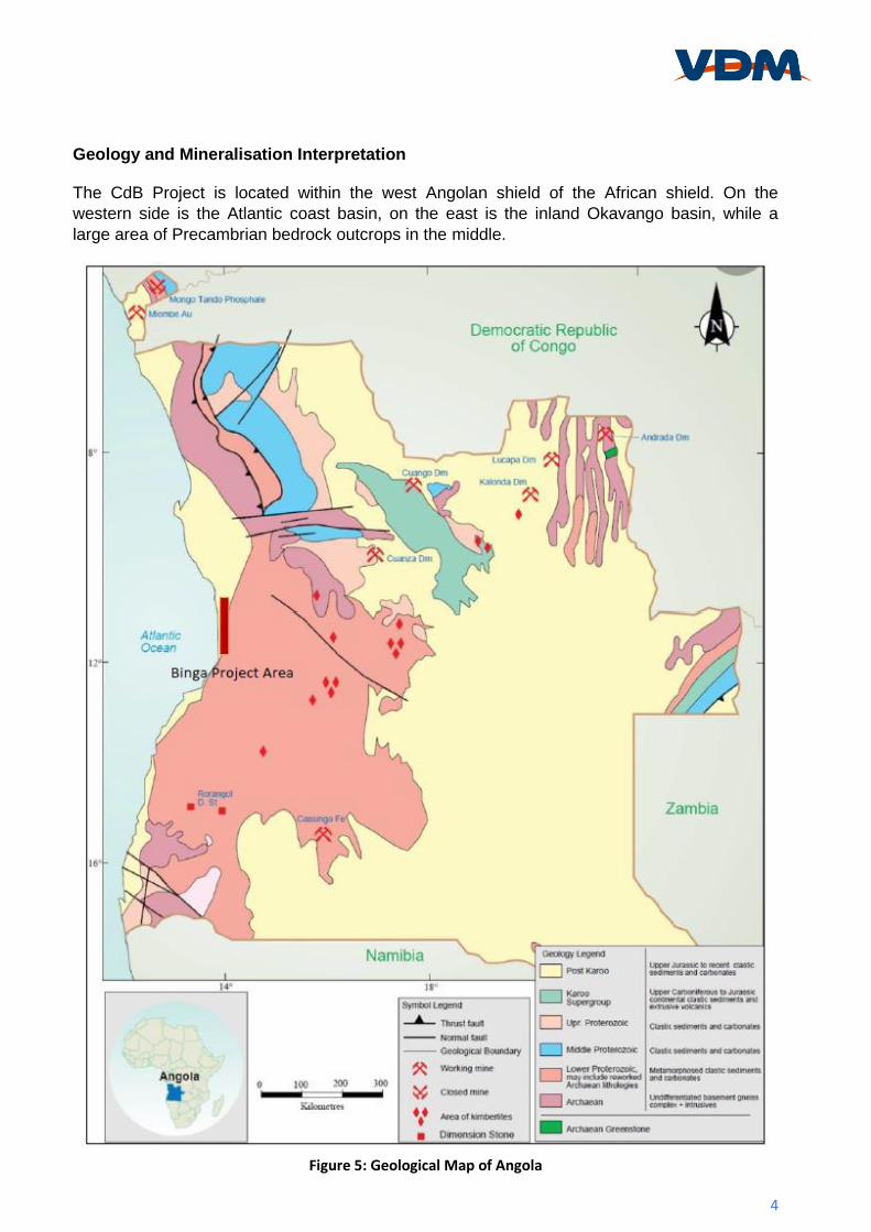
Geology and Mineralisation Interpretation
The CdB Project is located within the west Angolan shield of the African shield. On the
western side is the Atlantic coast basin, on the east is the inland Okavango basin, while a
large area of Precambrian bedrock outcrops in the middle.
Figure 5: Geological Map of Angola

5
The predominant strata in the CdB exploration tenement area consist mainly of Archaean
gneiss, schist and quartzite; Early Cretaceous Cuvo Formation, a set of continental strata
composed of conglomerate and sandstone in the lower section and a set of lagoon facies
sedimentary sequences with upward thinning, coarse-fine sandstone, siltstone and marl
interlayers in the upper section. The copper mineralisation of the project occurs in the upper
section; Early Cretaceous Binga Formation, comprising bioclastic limestone and light-yellow
medium-thick limestone; Early Cretaceous Tuenza Formation, composed of siliceous
limestone and dolomite limestone; and Quaternary sediments.
Figure 6: Local Geological Map of CdB Project
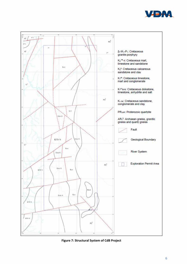
Fault structures and circular structures are relatively well developed in the exploration area.
The fault structures include north-northeast trending, northwest trending and northeast
trending faults. The circular structures are nearly circular and elliptical, with north-northeast or
northeast long axis. Based on the interpretation of remote sensing, the circular structures may
be caused by concealed rock masses.
6
Figure 7: Structural System of CdB Project

7
The intrusive rocks are mainly biotite granites, occur as rock mass and dykes intruded into the
Precambrian metamorphic rocks.
Nine (9) mineralised bodies have been delineated in the CdB deposit by trenching and drilling
exploration. The mineralised bodies are hosted in the sandstone and siltstone strata of Early
Cretaceous Cuvo Formation’s upper section and are characterised by gently dipping stratiform
and/or tabular shapes. The characteristics of the main mineralised bodies are described
below.
M3-1 mineralised body is defined by 54 drilling holes and 2 trenches at elevations of 48m to
177m above sea level (ASL) in Zone 3. The mineralised body strikes northwest (N320°W) and
dips gently 4° to 8°. It is about 1,030m long and has an average thickness of 2.71m and
average grade of 1.09% Cu.
M4-1 mineralised body is defined by 11 drilling holes and 4 trenches at elevations of 56m to
101m ASL in Zone 4. The mineralised body strikes southwest (S230°W) and dips gently 6° to
16°. It is about 450m long and has an average thickness of 2.11m and average grade of
1.16% Cu.
M5-1 mineralised body is defined by 8 drilling holes at elevations of 38m to 58m ASL in Zone
5. The mineralised body strikes northeast and dips gently. It is about 250m long and has an
average thickness of 2.62m and average grade of 0.68% Cu.
The ore minerals are mainly limonite, hematite, covellite and malachite for oxidised ore, and
pyrite, chalcopyrite, bornite, and chalcocite for the primary sulphide ore. The gangue minerals
are mainly quartz, calcite and dolomite. According to the oxidation degree of ore, there are two
ore types, the oxidised ore and the primary ore in the CdB deposit, but the primary ore is the
dominant type
The ore minerals are characterised by irregular, metasomatic or metasomatic residual
textures, and disseminated structure. The main alteration consists of silicification and
pyritization.
The CdB copper deposit is a typical sediment (mainly sandstone) hosted stratiform copper
deposit.
Exploration Data
Drilling Techniques
Diamond Core (DD) drilling methods were employed to evaluate the CdB deposit. Under
SRK’s supervision, drilling was conducted by drilling contractor Shandong Geology and
Mineral International Investment Co., Ltd (SDGM) in two phases: 2018 and 2019, with 134
holes totalling 9,594.0 metres constituting the drill data and 7 trenches with a total volume of
1,006 cubic metres (m3) used for the MRE.
SRK noted in its Report that surface geological survey and geophysical and geochemical
exploration were not systematically carried out due to the risk of landmines and other
explosives in the project area, which made it difficult to establish an optimal drill hole layout
and affected the exploration result.
8
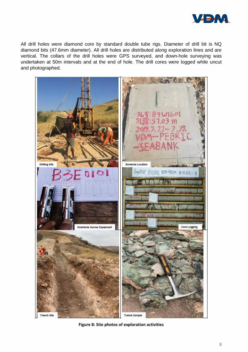
All drill holes were diamond core by standard double tube rigs. Diameter of drill bit is NQ
diamond bits (47.6mm diameter). All drill holes are distributed along exploration lines and are
vertical. The collars of the drill holes were GPS surveyed, and down-hole surveying was
undertaken at 50m intervals and at the end of hole. The drill cores were logged while uncut
and photographed.
Figure 8: Site photos of exploration activities
9
Sampling Techniques
Samples were taken from halves of drill cores by splitting along the core axis. Sample intervals
were marked by geologists and ranged from tens of centimetres to 1.0m in length. The most
common sample length was 1.0m. Wall rocks and mineralised parts were sampled separately.
The average recovery rates are 92.5% for all cores, and 95.4% for the mineralised intervals.
Sampling Analyses
A total of 1,658 samples were collected from the project and analysed by ALS Chemex
(Guangzhou) Co., Ltd (ALS). The content of copper was assayed by ICP-AES with Cu-OG62
four acid digestion. For QA/QC purpose, each 100 samples batch included about 6 QA/QC
samples, consisting of two certified reference materials (CRM), one blank, one core duplicate,
one coarse reject and one pulp duplicate. Additionally, 80 samples were randomly chosen and
sent to a second independent laboratory, SGS-CSTC Standards Technical Services (Tianjin)
Co., Ltd (SGS), for external check.
A total of 240 QA/QC samples were analysed, consisting of 80 external check samples, 29
CRMs, 32 blanks, 32 core duplicates, 37 coarse rejects, and 30 pulp duplicates.
For detailed information in relation to the assay results refer ASX announcements dated 15
March 2019 (for Phase 1 Assay Results) and 26 November 2020 (for Phase 2 Assay Results).
Mineral Resource Classification
Block model tonnages and grade estimates for the CdB Project were classified according to
The JORC Code. SRK is satisfied that the geological modelling presented in the MRE honours
the current geological information and knowledge. The locations of the samples and the assay
data are sufficiently reliable to support resource evaluation. The sampling information was
acquired primarily by core drilling on sections spaced 200m apart.
Generally, for a mineralised zone exhibiting good geological continuity investigated at an
adequate spacing with reliable sampling information accurately located, SRK considers as
reasonable the resource classification criteria presented below, which have been adopted for
this MRE.
Measured Resource - Spacing between drill hole sampling is ≤ 100m
Indicated Resource - Spacing between drill hole sampling is ≤ 200m
Inferred Resource - Spacing between drill hole sampling is ≤ 400m
Estimation Methodology
Block Model
The database used to create the block model and estimate the mineral resources was audited
by SRK. SRK is of the opinion that the current drilling information is sufficiently reliable to
interpret with confidence the boundaries of the mineralisation and that the assay data are
sufficiently reliable to support mineral resource estimation according The JORC Code.
Surpac was used to construct the geological solids, prepare assay data for geostatistical
analysis, construct the block model, estimate metal grades and tabulate mineral resources.
10
The database used for the resource estimation consists of 134 drill holes. A total of 1,658
intervals were sampled at the CdB deposit. All the available data was input into a Surpac
database for the estimation procedure. The database was validated within Surpac searching
for errors such as missing or overlapping intervals, correcting hole lengths, azimuths and dips,
and eliminating duplicated samples. Additionally, the digital topographic surface survey in UTM
coordinate system was provided to SRK for resource modelling and grade estimation.
The cell size of the block model for the deposit is 20m × 20m × 2m along the X (east), Y
(north), and Z (elevation) axes, and 10m × 10m × 1m for sub-blocks. A bulk density of 2.40t/m3
was applied for tonnage estimate, based on sample testing.
A total of nine (9) mineralised bodies were modelled using Surpac. A three-dimensional view
of these bodies is shown in Figure 2 above. Drill spacing along strike varies between 50m and
700m, with the majority at 200m. The intersected thickness of mineralised bodies is normally
less than 3m. There is a reasonable high degree of confidence that the mineralised bodies are
continuous over those distances, as evidenced by the historical surface mapping.
Cut-off Grades
A cut-off grade of 0.2% Cu has been chosen to represent the portion of the resource that may
be considered for eventual economic extraction by open-pit mining and can be processed into
copper concentrate. This cut-off grade was selected by VDM in consultation with SRK and
SDGM based on experience with similar sediment hosted copper deposits and is consistent
with reporting cut-off grades used in recent large-scale global copper estimates.
Mining Factors
SRK considers that portions of the CdB mineralisation are amenable to open pit extraction. In
order to determine the quantities of material offering “reasonable prospects for eventual
economic extraction” by an open pit, SRK used a set of mining and processing
assumptions/parameters provided by VDM, in consultation with SDGM, to evaluate the
proportions of the block model (Measured, Indicated and Inferred blocks) that could be
“reasonably expected” to be mined from open pit.
Metallurgical Factors
The mineralisation is assumed to be copper sandstone and samples for metallurgical testing
have been taken, however testing has not yet been completed. VDM, in consultation with
SDGM, considers that the copper ore can be economically extracted by open-pit mining and
can be processed into copper concentrate with a grade of 20% Cu and recovery rate of 85%.
Next Steps
Planning for the third phase of drilling at CdB is underway utilising the results of the previous
drilling phases and the MRE. This will include infill and exploratory drilling with the aim of
upgrading and increasing the resource. The MRE has identified good potential to extend and
upgrade the resources in Areas 3 and 4 as the mineralised bodies identified remain open.
In addition, the Company will review the potential for economic mineralisation of several other
minerals, including gypsum and potash, which were identified in the drill cores and which may
warrant testing in future exploration programs.

11
Conclusion
In relation to the outcome of the Mineral Resource Estimate, VDM’s Executive Director of
Mining – Dr Dongyi Hua commented:
“VDM is pleased to provide this maiden Mineral Resource Estimate demonstrating the extent
of copper mineralisation identified in Phases 1 and 2 of the Exploration Drilling Program.
Given that only 5% of the Project Area has been explored to date the potential to add
significantly to this maiden Mineral Resource Estimate is considered high. Work on gaining
access to areas considered to be of high geological merit is ongoing and is the focus ahead of
Phase 3 commencing.”
This announcement has been authorised by the Board of VDM Group Limited.
For further information please contact: Michael Fry Company Secretary VDM Group Limited (08) 9221 6739

12
Competent Person Statement
The information in this report which relates to Mineral Resources is based on information compiled by Ms Bonnie
(Yanfang) Zhao and Dr Yiefei Jia, full time employees of SRK Consulting (China) Ltd and respectively, a Member and
a Fellow of the Australasian Institute of Mining and Metallurgy. Each has sufficient experience which is relevant to the
style of mineralisation and type of deposit under consideration and to the activity which they are undertaking to
qualify as Competent Persons as defined in the 2012 Edition of the “Australasian Code for Reporting of Exploration
Results, Mineral Resources, and Ore Reserves”. Ms Zhao and Dr Jia have both consented to the reporting of this
information in the form and context in which it appears.
Forward looking statements
Information included in this release constitutes forward-looking statements. Often, but not always, forward looking
statements can generally be identified by the use of forward looking words such as “may”, “will”, “expect”, “intend”,
“plan”, “estimate”, “anticipate”, “continue”, and “guidance”, or other similar words and may include, without limitation,
statements regarding plans, strategies and objectives of management, anticipated production or construction
commencement dates and expected costs or production outputs.
Forward looking statements inherently involve known and unknown risks, uncertainties and other factors that may
cause the Company’s actual results, performance and achievements to differ materially from any future results,
performance or achievements. Relevant factors may include, but are not limited to, changes in commodity prices,
foreign exchange fluctuations and general economic conditions, increased costs and demand for production inputs,
the speculative nature of exploration and project development, including the risks of obtaining necessary licences and
permits and diminishing quantities or grades of reserves, political and social risks, changes to the regulatory
framework within which the company operates or may in the future operate, environmental conditions including
extreme weather conditions, recruitment and retention of personnel, industrial relations issues and litigation.
Forward looking statements are based on the Company and its management’s good faith assumptions relating to the
financial, market, regulatory and other relevant environments that will exist and affect the Company’s business and
operations in the future. The Company does not give any assurance that the assumptions on which forward looking
statements are based will prove to be correct, or that the Company’s business or operations will not be affected in
any material manner by these or other factors not foreseen or foreseeable by the Company or management or
beyond the Company’s control.
Although the Company attempts and has attempted to identify factors that would cause actual actions, events or
results to differ materially from those disclosed in forward looking statements, there may be other factors that could
cause actual results, performance, achievements or events not to be as anticipated, estimated or intended, and many
events are beyond the reasonable control of the Company. Accordingly, readers are cautioned not to place undue
reliance on forward looking statements. Forward looking statements in these materials speak only at the date of
issue. Subject to any continuing obligations under applicable law or any relevant stock exchange listing rules, in
providing this information the company does not undertake any obligation to publicly update or revise any of the
forward-looking statements or to advise of any change in events, conditions or circumstances on which any such
statement is based.
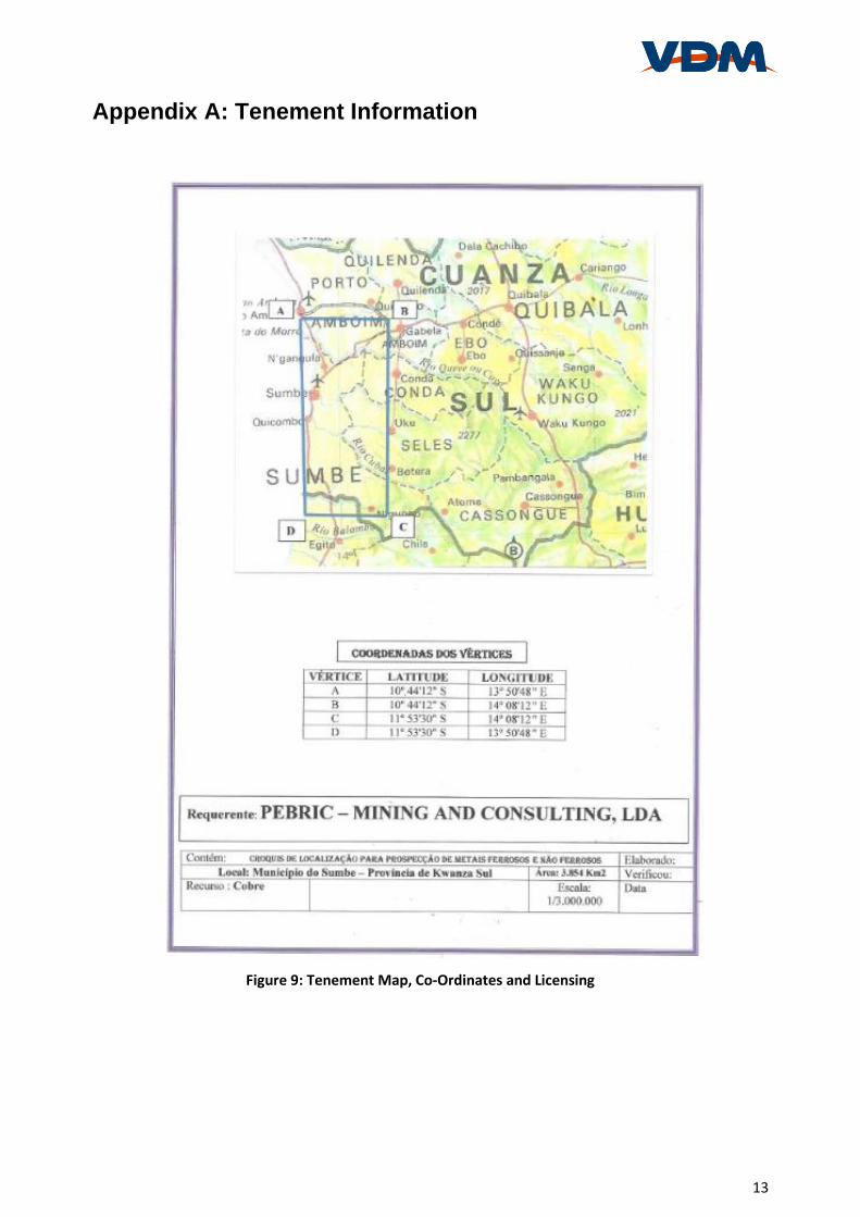
Appendix A: Tenement Information
13
Figure 9: Tenement Map, Co-Ordinates and Licensing
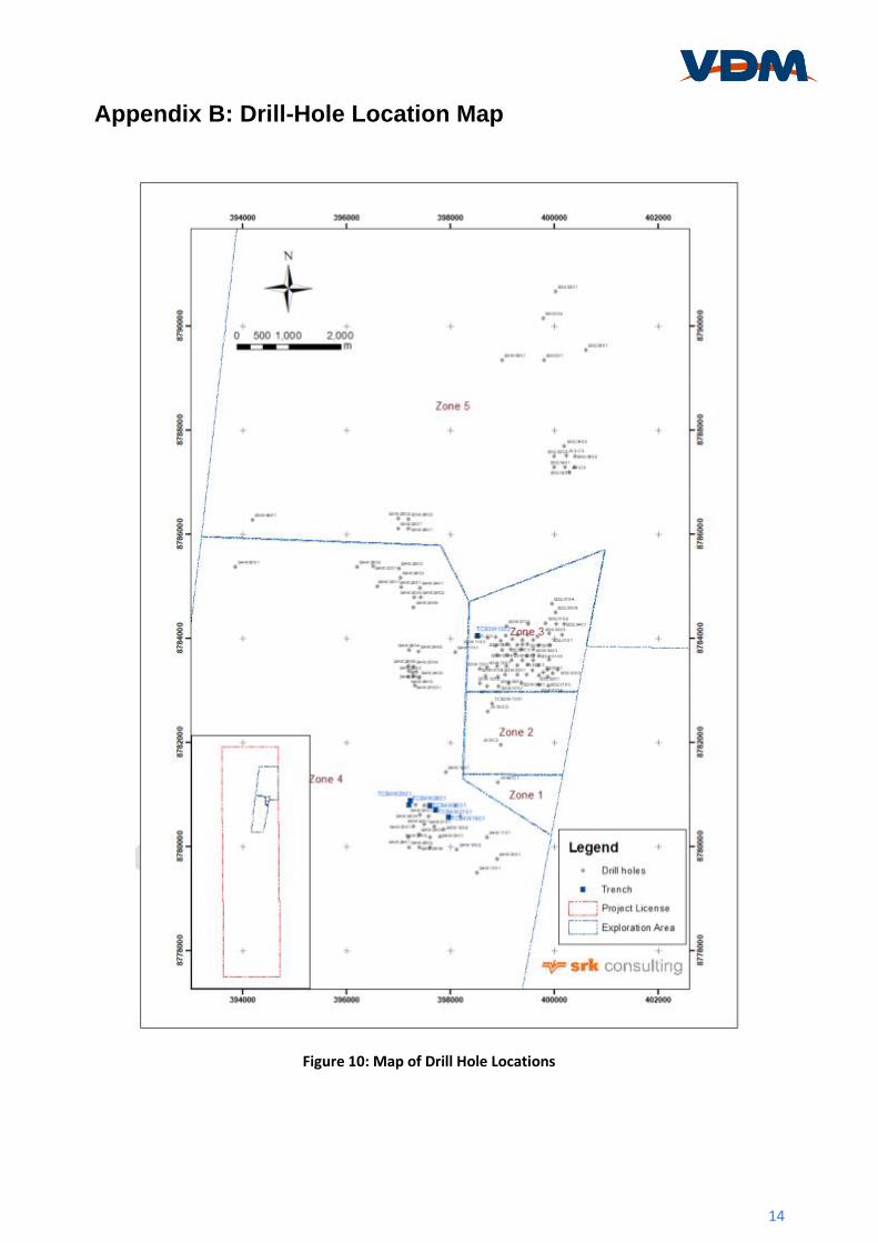
Appendix B: Drill-Hole Location Map
14
Figure 10: Map of Drill Hole Locations
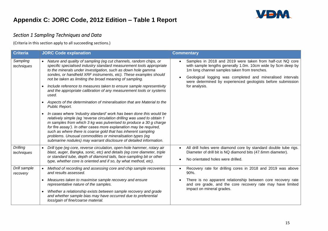
Appendix C: JORC Code, 2012 Edition – Table 1 Report
15
Section 1 Sampling Techniques and Data
(Criteria in this section apply to all succeeding sections.)
Criteria JORC Code explanation Commentary
Sampling
techniques
• Nature and quality of sampling (eg cut channels, random chips, or specific specialised industry standard measurement tools appropriate to the minerals under investigation, such as down hole gamma sondes, or handheld XRF instruments, etc). These examples should not be taken as limiting the broad meaning of sampling.
• Include reference to measures taken to ensure sample representivity and the appropriate calibration of any measurement tools or systems used.
• Aspects of the determination of mineralisation that are Material to the Public Report.
• In cases where ‘industry standard’ work has been done this would be relatively simple (eg ‘reverse circulation drilling was used to obtain 1 m samples from which 3 kg was pulverised to produce a 30 g charge for fire assay’). In other cases more explanation may be required, such as where there is coarse gold that has inherent sampling problems. Unusual commodities or mineralisation types (eg submarine nodules) may warrant disclosure of detailed information.
• Samples in 2018 and 2019 were taken from half-cut NQ core with sample lengths generally 1.0m. 10cm wide by 5cm deep by 1m long channel samples taken from trenches.
• Geological logging was completed and mineralised intervals were determined by experienced geologists before submission for analysis.
Drilling
techniques
• Drill type (eg core, reverse circulation, open-hole hammer, rotary air blast, auger, Bangka, sonic, etc) and details (eg core diameter, triple or standard tube, depth of diamond tails, face-sampling bit or other type, whether core is oriented and if so, by what method, etc).
• All drill holes were diamond core by standard double tube rigs. Diameter of drill bit is NQ diamond bits (47.6mm diameter).
• No orientated holes were drilled.
Drill sample
recovery
• Method of recording and assessing core and chip sample recoveries and results assessed.
• Measures taken to maximise sample recovery and ensure representative nature of the samples.
• Whether a relationship exists between sample recovery and grade and whether sample bias may have occurred due to preferential loss/gain of fine/coarse material.
• Recovery rate for drilling cores in 2018 and 2019 was above 90%.
• There is no apparent relationship between core recovery rate and ore grade, and the core recovery rate may have limited impact on mineral grades.

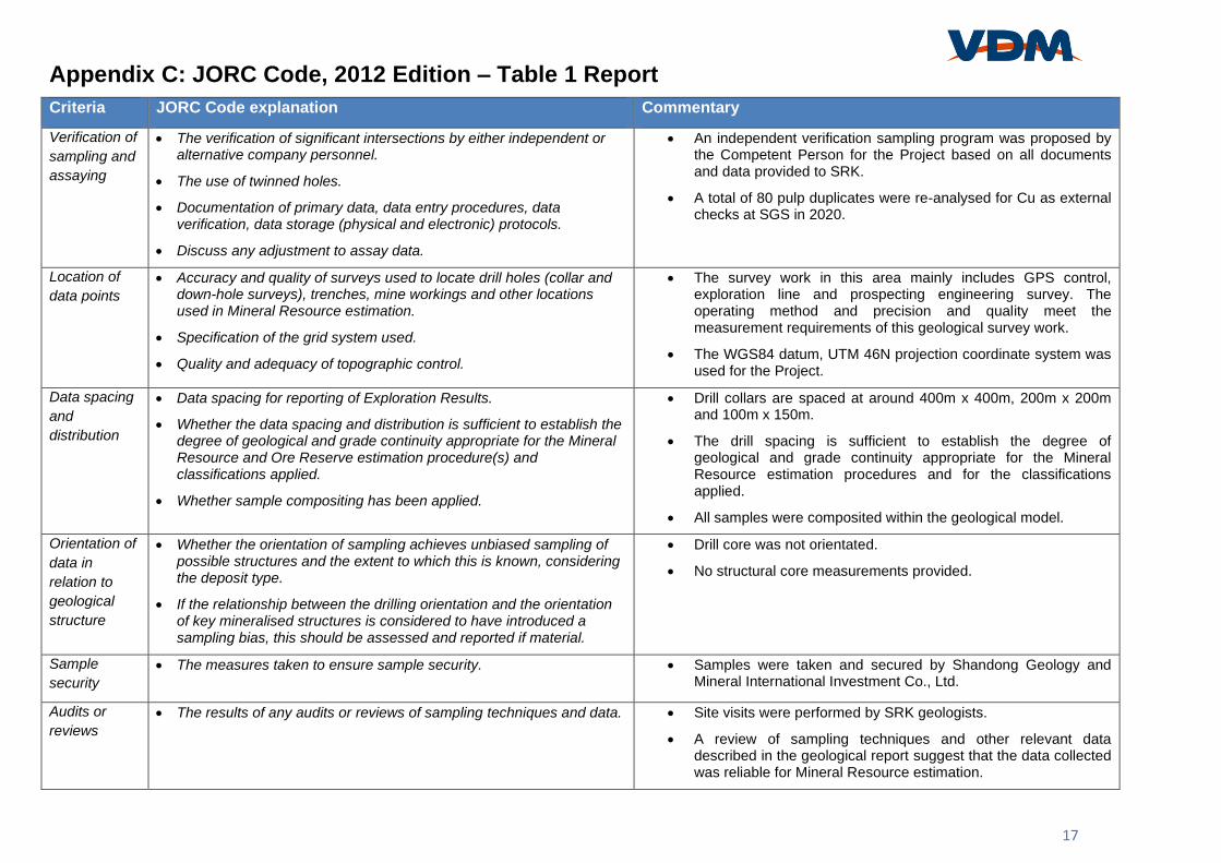
Appendix C: JORC Code, 2012 Edition – Table 1 Report
16
Criteria JORC Code explanation Commentary
Logging • Whether core and chip samples have been geologically and geotechnically logged to a level of detail to support appropriate Mineral Resource estimation, mining studies and metallurgical studies.
• Whether logging is qualitative or quantitative in nature. Core (or costean, channel, etc) photography.
• The total length and percentage of the relevant intersections logged.
• Geological logging in 2018 and 2019 was carried out by geologists to record various aspects including weathering, texture, lithology, alteration and structure.
Sub-sampling
techniques
and sample
preparation
• If core, whether cut or sawn and whether quarter, half or all core taken.
• If non-core, whether riffled, tube sampled, rotary split, etc and whether sampled wet or dry.
• For all sample types, the nature, quality and appropriateness of the sample preparation technique.
• Quality control procedures adopted for all sub-sampling stages to maximise representivity of samples.
• Measures taken to ensure that the sampling is representative of the in situ material collected, including for instance results for field duplicate/second-half sampling.
• Whether sample sizes are appropriate to the grain size of the material being sampled.
• All samples in 2018 and 2019 were submitted to certified laboratories for Cu analysis.
• Quality control samples included external checks, the results of which were provided to and reviewed by SRK.
Quality of
assay data
and
laboratory
tests
• The nature, quality and appropriateness of the assaying and laboratory procedures used and whether the technique is considered partial or total.
• For geophysical tools, spectrometers, handheld XRF instruments, etc, the parameters used in determining the analysis including instrument make and model, reading times, calibrations factors applied and their derivation, etc.
• Nature of quality control procedures adopted (eg standards, blanks, duplicates, external laboratory checks) and whether acceptable levels of accuracy (ie lack of bias) and precision have been established.
• All samples were assayed by certified laboratory ALS in China with their internal QC procedures.
• During analysis, a total of 240 QA/QC samples were inserted, consisting of 29 CRMs, 32 blanks, 37 core duplicates, 32 coarse rejects, 30 pulp duplicates.
• Using Conventional ICP-AES Analysis of Cu is considered appropriate for resource estimation purposes.
Appendix C: JORC Code, 2012 Edition – Table 1 Report
17
Criteria JORC Code explanation Commentary
Verification of
sampling and
assaying
• The verification of significant intersections by either independent or alternative company personnel.
• The use of twinned holes.
• Documentation of primary data, data entry procedures, data verification, data storage (physical and electronic) protocols.
• Discuss any adjustment to assay data.
• An independent verification sampling program was proposed by the Competent Person for the Project based on all documents and data provided to SRK.
• A total of 80 pulp duplicates were re-analysed for Cu as external checks at SGS in 2020.
Location of
data points
• Accuracy and quality of surveys used to locate drill holes (collar and down-hole surveys), trenches, mine workings and other locations used in Mineral Resource estimation.
• Specification of the grid system used.
• Quality and adequacy of topographic control.
• The survey work in this area mainly includes GPS control, exploration line and prospecting engineering survey. The operating method and precision and quality meet the measurement requirements of this geological survey work.
• The WGS84 datum, UTM 46N projection coordinate system was used for the Project.
Data spacing
and
distribution
• Data spacing for reporting of Exploration Results.
• Whether the data spacing and distribution is sufficient to establish the degree of geological and grade continuity appropriate for the Mineral Resource and Ore Reserve estimation procedure(s) and classifications applied.
• Whether sample compositing has been applied.
• Drill collars are spaced at around 400m x 400m, 200m x 200m and 100m x 150m.
• The drill spacing is sufficient to establish the degree of geological and grade continuity appropriate for the Mineral Resource estimation procedures and for the classifications applied.
• All samples were composited within the geological model.
Orientation of
data in
relation to
geological
structure
• Whether the orientation of sampling achieves unbiased sampling of possible structures and the extent to which this is known, considering the deposit type.
• If the relationship between the drilling orientation and the orientation of key mineralised structures is considered to have introduced a sampling bias, this should be assessed and reported if material.
• Drill core was not orientated.
• No structural core measurements provided.
Sample
security
• The measures taken to ensure sample security. • Samples were taken and secured by Shandong Geology and Mineral International Investment Co., Ltd.
Audits or
reviews
• The results of any audits or reviews of sampling techniques and data. • Site visits were performed by SRK geologists.
• A review of sampling techniques and other relevant data described in the geological report suggest that the data collected was reliable for Mineral Resource estimation.

Appendix C: JORC Code, 2012 Edition – Table 1 Report
18
Section 2 Reporting of Exploration Results
(Criteria listed in the preceding section also apply to this section.)
Criteria JORC Code explanation Commentary
Mineral
tenement and
land tenure
status
• Type, reference name/number, location and ownership including agreements or material issues with third parties such as joint ventures, partnerships, overriding royalties, native title interests, historical sites, wilderness or national park and environmental settings.
• The security of the tenure held at the time of reporting along with any known impediments to obtaining a licence to operate in the area.
• The CdB Project comprises prospecting title number N09/72/PC/AB and covers an area 3,854km2 and is approximately 32kms wide (from E-W) and 129 kms long (from N-S).
• The project is a Joint Venture (JV) between VDM Group Limited (65%), Pebric Mining and Consulting LDA (30%) and Seabank Resources LDA (5%).
• VDM-Pebric–Seabank has signed an agreement with Angola central government for Mining Investment Contract (MIC). This agreement has priority above prospecting license. Under the MIC the Angolan Government is entitled to a 15% free ownership interest when in production.
• VDM’s effective interest in the CdB Project is 55.25%.
• The CdB Licence was granted on 15 May 2012. Expired after 15 May
2017. The renewal application was lodged with Angola Ministry of
Mining Geology and Industry before expiry. As at the date of this
report the renewal remains pending.
Exploration
done by other
parties
• Acknowledgment and appraisal of exploration by other parties. • This area has been explored by
o Angola Institute of Geology (IGEO) during 1970-1973 (Peres)
o Simba Jamba during 2004-2006,
o United nations development program in 1983
Geology • Deposit type, geological setting and style of mineralisation. • The CdB deposit is a typical sediment hosted stratiform copper deposit.
• Copper mineralisation is found in siltstone and sandstone formations in a relatively shallow zone (i.e. less than 100 m beneath the surface).
• Both oxide and fresh copper minerals have been intersected by drilling.
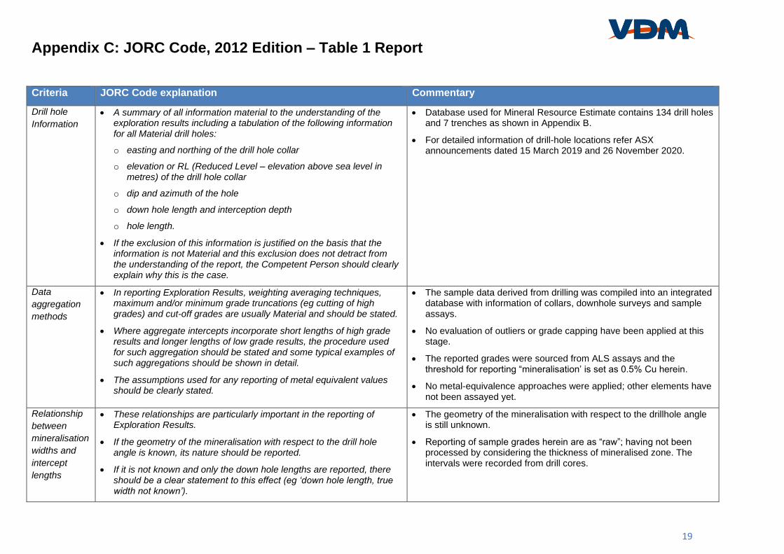
Appendix C: JORC Code, 2012 Edition – Table 1 Report
19
Criteria JORC Code explanation Commentary
Drill hole
Information
• A summary of all information material to the understanding of the exploration results including a tabulation of the following information for all Material drill holes:
o easting and northing of the drill hole collar
o elevation or RL (Reduced Level – elevation above sea level in metres) of the drill hole collar
o dip and azimuth of the hole
o down hole length and interception depth
o hole length.
• If the exclusion of this information is justified on the basis that the information is not Material and this exclusion does not detract from the understanding of the report, the Competent Person should clearly explain why this is the case.
• Database used for Mineral Resource Estimate contains 134 drill holes and 7 trenches as shown in Appendix B.
• For detailed information of drill-hole locations refer ASX announcements dated 15 March 2019 and 26 November 2020.
Data
aggregation
methods
• In reporting Exploration Results, weighting averaging techniques, maximum and/or minimum grade truncations (eg cutting of high grades) and cut-off grades are usually Material and should be stated.
• Where aggregate intercepts incorporate short lengths of high grade results and longer lengths of low grade results, the procedure used for such aggregation should be stated and some typical examples of such aggregations should be shown in detail.
• The assumptions used for any reporting of metal equivalent values should be clearly stated.
• The sample data derived from drilling was compiled into an integrated database with information of collars, downhole surveys and sample assays.
• No evaluation of outliers or grade capping have been applied at this stage.
• The reported grades were sourced from ALS assays and the threshold for reporting “mineralisation’ is set as 0.5% Cu herein.
• No metal-equivalence approaches were applied; other elements have not been assayed yet.
Relationship
between
mineralisation
widths and
intercept
lengths
• These relationships are particularly important in the reporting of Exploration Results.
• If the geometry of the mineralisation with respect to the drill hole angle is known, its nature should be reported.
• If it is not known and only the down hole lengths are reported, there should be a clear statement to this effect (eg ‘down hole length, true width not known’).
• The geometry of the mineralisation with respect to the drillhole angle is still unknown.
• Reporting of sample grades herein are as “raw”; having not been processed by considering the thickness of mineralised zone. The intervals were recorded from drill cores.

Appendix C: JORC Code, 2012 Edition – Table 1 Report
20
Criteria JORC Code explanation Commentary
Diagrams • Appropriate maps and sections (with scales) and tabulations of intercepts should be included for any significant discovery being reported These should include, but not be limited to a plan view of drill hole collar locations and appropriate sectional views.
• Refer to figures in body of text.
Balanced
reporting
• Where comprehensive reporting of all Exploration Results is not practicable, representative reporting of both low and high grades and/or widths should be practiced to avoid misleading reporting of Exploration Results.
• No other exploration results for the project.
Other
substantive
exploration
data
• Other exploration data, if meaningful and material, should be reported including (but not limited to): geological observations; geophysical survey results; geochemical survey results; bulk samples – size and method of treatment; metallurgical test results; bulk density, groundwater, geotechnical and rock characteristics; potential deleterious or contaminating substances.
• NA for this stage.
Further work • The nature and scale of planned further work (eg tests for lateral extensions or depth extensions or large-scale step-out drilling).
• Diagrams clearly highlighting the areas of possible extensions, including the main geological interpretations and future drilling areas, provided this information is not commercially sensitive.
• The exploration plan for 2020 has been suspended due to COVID-19 pandemic.
• Further drilling and exploration activities are to be undertaken.

Appendix C: JORC Code, 2012 Edition – Table 1 Report
21
Section 3 Estimation and Reporting of Mineral Resources
(Criteria listed in the preceding sections also apply to this section.)
Criteria JORC Code explanation Commentary
Database
integrity
• Measures taken to ensure that data has not been corrupted by, for example, transcription or keying errors, between its initial collection and its use for Mineral Resource estimation purposes.
• Data validation procedures used.
• The data provided by the Company in Excel format was imported into Geovia Surpac software and validated.
• Data validation steps included: Validation through constraints set in the database, e.g., overlapping/missing intervals, intervals exceeding maximum length, valid geology codes, missing assays;
• Validation through 3D visualisation to check for any obvious collar, down-hole survey, or assay import errors.
Site visits • Comment on any site visits undertaken by the Competent Person and the outcome of those visits.
• If no site visits have been undertaken indicate why this is the case.
• Pengfei Xiao and Xiaofeng Qing visited the project in June 2018 and November 2019.
Geological
interpretation
• Confidence in (or conversely, the uncertainty of) the geological interpretation of the mineral deposit.
• Nature of the data used and of any assumptions made.
• The effect, if any, of alternative interpretations on Mineral Resource estimation.
• The use of geology in guiding and controlling Mineral Resource estimation.
• The factors affecting continuity both of grade and geology.
• The geological interpretation was based on lithology, assays, structure, and geotechnical information.
• The data used in the resource estimation was from the approved exploration reports or laboratory assay results.
• 9 mineralised bodies have been modelled.
• Drill spacing along strike varies between 50 m and 700 m, with the majority at 200m. The intersected thickness of mineralised body varies from 1m to over 10 m.
Dimensions • The extent and variability of the Mineral Resource expressed as length
(along strike or otherwise), plan width, and depth below surface to the
upper and lower limits of the Mineral Resource.
• Extrapolation was limited to approximately 100 m. Internal interpolation
was normally 100 m, with a maximum of 120 m.
Estimation
and modelling
techniques
• The nature and appropriateness of the estimation technique(s) applied and key assumptions, including treatment of extreme grade values, domaining, interpolation parameters and maximum distance of extrapolation from data points. If a computer assisted estimation method was chosen include a description of computer software and
• The 3D block modelling and estimation was undertaken in Geovia Surpac software package.
• Inverse distance squared (IDS) method was used for Cu grade interpolation for each individual vein.
Appendix C: JORC Code, 2012 Edition – Table 1 Report
22
Criteria JORC Code explanation Commentary
parameters used.
• The availability of check estimates, previous estimates and/or mine production records and whether the Mineral Resource estimate takes appropriate account of such data.
• The assumptions made regarding recovery of by-products.
• Estimation of deleterious elements or other non-grade variables of economic significance (e.g., sulphur for acid mine drainage characterisation).
• In the case of block model interpolation, the block size in relation to the average sample spacing and the search employed.
• Any assumptions behind modelling of selective mining units.
• Any assumptions about correlation between variables.
• Description of how the geological interpretation was used to control the resource estimates.
• Discussion of basis for using or not using grade cutting or capping.
• The process of validation, the checking process used, the comparison of model data to drill hole data, and use of reconciliation data if available.
Moisture • Whether the tonnages are estimated on a dry basis or with natural moisture, and the method of determination of the moisture content.
• Tonnages are estimated on a dry basis.
Cut-off
parameters
• The basis of the adopted cut-off grade(s) or quality parameters applied.
• Under the assumptions of economic mining extraction and recovery, a cut-off grade of 0.2% Cu is adopted.
Mining factors
or
assumptions
• Assumptions made regarding possible mining methods, minimum mining dimensions and internal (or, if applicable, external) mining dilution. It is always necessary as part of the process of determining reasonable prospects for eventual economic extraction to consider potential mining methods, but the assumptions made regarding mining methods and parameters when estimating Mineral Resources may not always be rigorous. Where this is the case, this should be reported with an explanation of the basis of the mining assumptions made.
• Open pit mining is assumed.

Appendix C: JORC Code, 2012 Edition – Table 1 Report
23
Criteria JORC Code explanation Commentary
Metallurgical
factors or
assumptions
• The basis for assumptions or predictions regarding metallurgical amenability. It is always necessary as part of the process of determining reasonable prospects for eventual economic extraction to consider potential metallurgical methods, but the assumptions regarding metallurgical treatment processes and parameters made when reporting Mineral Resources may not always be rigorous. Where this is the case, this should be reported with an explanation of the basis of the metallurgical assumptions made.
• The mineralisation is assumed to be copper sandstone; that tests were done, but SRK did not have access to the results.
Environmenta
l factors or
assumptions
• Assumptions made regarding possible waste and process residue disposal options. It is always necessary as part of the process of determining reasonable prospects for eventual economic extraction to consider the potential environmental impacts of the mining and processing operation. While at this stage the determination of potential environmental impacts, particularly for a greenfields project, may not always be well advanced, the status of early consideration of these potential environmental impacts should be reported. Where these aspects have not been considered this should be reported with an explanation of the environmental assumptions made.
• No assumptions regarding the Environmental factors to determine reasonable prospects for eventual economic extraction
Bulk density • Whether assumed or determined. If assumed, the basis for the assumptions. If determined, the method used, whether wet or dry, the frequency of the measurements, the nature, size, and representativeness of the samples.
• The bulk density for bulk material must have been measured by methods that adequately account for void spaces (vugs, porosity, etc), moisture, and differences between rock and alteration zones within the deposit.
• Discuss assumptions for bulk density estimates used in the evaluation process of the different materials.
• Eighty-eight (88) samples were collected from the BINGA deposit for the density analysis, but the results provided to SRK were only from twenty-one (21) samples. The average bulk density of these was 2.40g/cm3 which is assigned to the mineralisation.

Appendix C: JORC Code, 2012 Edition – Table 1 Report
24
Criteria JORC Code explanation Commentary
Classification • The basis for the classification of the Mineral Resources into varying confidence categories.
• Whether appropriate account has been taken of all relevant factors (i.e., relative confidence in tonnage/grade estimations, reliability of input data, confidence in continuity of geology and metal values, quality, quantity and distribution of the data).
• Whether the result appropriately reflects the Competent Person’s view of the deposit.
• Mineral Resources have been classified in accordance with the JORC Code 2012 guidelines.
• A range of criteria was considered in determining the classification for the project, including:
o geological confidence in the interpretations,
o sample data density,
o sample/assay confidence,
o grade continuity of the mineralisation,
o estimation method and resulting estimation output variables (e.g. number of informing data, distance to data).
• The Competent Persons endorse the final results and classification for the project.
Audits or
reviews
• The results of any audits or reviews of Mineral Resource estimates.
• Dr Anson Xu, FAusIMM, internally reviewed the report including Mineral Resource estimates, and geology section.
• Mr Daniel Guibal, FAusIMM has undertaken external peer review on the report including Mineral Resource estimates.
• There are no outstanding issues arising from these reviews.
Discussion of
relative
accuracy/
confidence
• Where appropriate a statement of the relative accuracy and confidence level in the Mineral Resource estimate using an approach or procedure deemed appropriate by the Competent Person. For example, the application of statistical or geostatistical procedures to quantify the relative accuracy of the resource within stated confidence limits, or, if such an approach is not deemed appropriate, a qualitative discussion of the factors that could affect the relative accuracy and confidence of the estimate.
• The statement should specify whether it relates to global or local estimates, and, if local, state the relevant tonnages, which should be relevant to technical and economic evaluation. Documentation should include assumptions made and the procedures used.
• These statements of relative accuracy and confidence of the estimate should be compared with production data, where available.
• Relative accuracy and confidence has been assessed through validation of the model as outlined above.
• The Mineral Resource categories reflect the assumed accuracy and confidence as a global estimate.

Appendix C: JORC Code, 2012 Edition – Table 1 Report
25