Embed Size (px)
Citation preview
MISSABOTTI94361N
WENONAH HEAD95364N
NAMBUCCA95364S
MACKSVILLE94361S
Nambucca LGA
Bellingen LGA
�
�
�
�
�
�
�
Locality
Dorrigo NP
Ngambaa NR
Bindarri NP
Baalijin NR
Yarriabini NP
Bellinger River NP Bongil Bongil NP
Juugawaarri NR
Dunggir NP
Gumbaynggirr SCA
Ganay NR
Bollanolla NR
Jagun NRNunguu Mirral AA
Valla NR
Jaaningga NR
Nambucca AA
URUNGA
DORRIGO
BELLINGEN
MACKSVILLE
COFFS HARBOUR
NAMBUCCA HEADS
SOUTH WEST ROCKS
Strategy Information
Fire Season Information
Wildfires • Have been known to start as early as late August, but usually the potential for a
large fire event is greatest between October and December. This period may
extend into January in more severe years.
• During this period in dry seasons fires may exhibit high intensity behaviour
under windy conditions.
Prescribed Burning
(NPWS Fire Management Manual 4.7)
• Autumn to late Winter. Burning is possible in early Spring but not desirable on
a regular basis from an ecological or tourism point of view.
Suppression Strategies
Current FDR Forecast FDR
Low – Mod Low – Mod • Undertake direct, parallel or indirect attack along existing containment lines.
• Where practicable consider maximising the fire area in accordance with the
requirements of any proposed prescribed burns.
Low – Mod = > High • In order to minimise the fire area and secure the flanks as soon as possible,
undertake direct, parallel or indirect attack along the closest containment lines.
• Pay particular attention to the flank on the next predicted down wind side.
High All • Undertake indirect attack along existing or newly constructed containment
lines.
• Secure and deepen containment lines along the next predicted downwind side
of the fire.
• If applicable consider broader than normal containment strategies to avoid
wasted effort and high risk of failure.
All All • Ensure there is sufficient time to secure containment lines prior to the fire
impacting upon them; otherwise fall back to the next potential line.
����
�
�
� ��
�
�
�
���
��
�
�
���
�
�
�
�
�
�
�
�
�
�
�
�
�
��
�
�
�
� � �
�
�
�
��
�
�
�
�
��
��
!
�
� �
�
�
�
�
�
�
�
�
��
�
�
�
�
�
�
�
�
�� �
�
�
�
�
!
�
!�
#*!
�
�
Bridge not passable
Little Newry State Forest
Newry State Forest
Jagun Nature Reserve
Valla Nature Reserve
Nunguu Mirral Aboriginal Area
Pacifi
c H
wy
East West Rd
Valla Beach Rd
Nunguu Trl
Ocean V
iew
Dr
Kuta
Ave
Bam
ay Trl
Tuna
St
Birug
an C
lM
irra
l Trl
Deep Creek Rd
Th
om
pson S
t
Rogers
Dr
Max G
raham
Dr
Henderson St
Hib
iscus D
r
Dolphin Dr
Wentworth Smith St
Cockburn
St
Steele St
Old
Rai
lway
Acc
ess
Trl
Ketut Cl
Langsford Wy
Ocean View
Dr
Nunguu Trl
FA9
FA9 FA9
FA9
FA9
FA9
FA7
FA8
FA8
FA8
FA4
FA4
FA4
FA4
FA4
FA4
FA4FA4
FA4
FA4
FA4
FA4FA4
FA2FA2
FA2
FA3
FA3
FA8
FA8
FA8
FA3
FA3
FA3
FA3
FA3
FL2
FL2
Valla RFS Headquarters
499000m.E
499000m.E
500
500
01
01
502000m.E
502000m.E
661
50
00
m. N
661
50
00
m. N
16 16
17 17
18 18
661
90
00
m. N
661
90
00
m. N
1:15,000
Rainforest
Wet sclerophyll forest
Native regrowth
Swamp sclerophyll forest
Semi-mesic grassy forest
Grassy sclerophyll woodland
Shrubby dry sclerophyll forest
Estuarine and saline wetlands
Heathland
Agriculture/timber plantation
Cleared/weeds
Water
Rock/sand
1:30,000
Jagun HMZ
Valla East HMZ
Valla West HMZ
Valla Beach APZ
Cockburn St APZ
Bakery APZ
Tuna St SFAZ
Fire Shed APZ
ROADS
Primary (Cat 1)
Secondary (Cat 9)
Closed
Unclassified
v Powerlines
Railway
Drainage
Built-up area
NPWS Estate
SF Estate
#*! Caution
Gate - NPWS
Gate - non NPWS
! Helipad
� Threatened Property
� Threatened Flora
� Threatened Fauna
! Staging Area
� Water Point Vehicle
1:25,000
Cockburn St APZ
Jagun HMZ
Nun
guu
Trl
Mirra
l Trl
Biru
gan C
l
Rogers
Dr
Cockb
urn
St
Nun
gu
u T
rl
Valla East HMZ
Valla West HMZ
Valla Beach APZ
Bakery APZ
Fire Shed APZ
Valla Beach Rd
Bam
ay Trl
Ku
t a A
ve
Oce
an
Vie
w D
r
Hen
ders
on S
t
Hib
iscus D
r
Max Graham DrSteele St
Jo
nes S
t
Ketut Cl
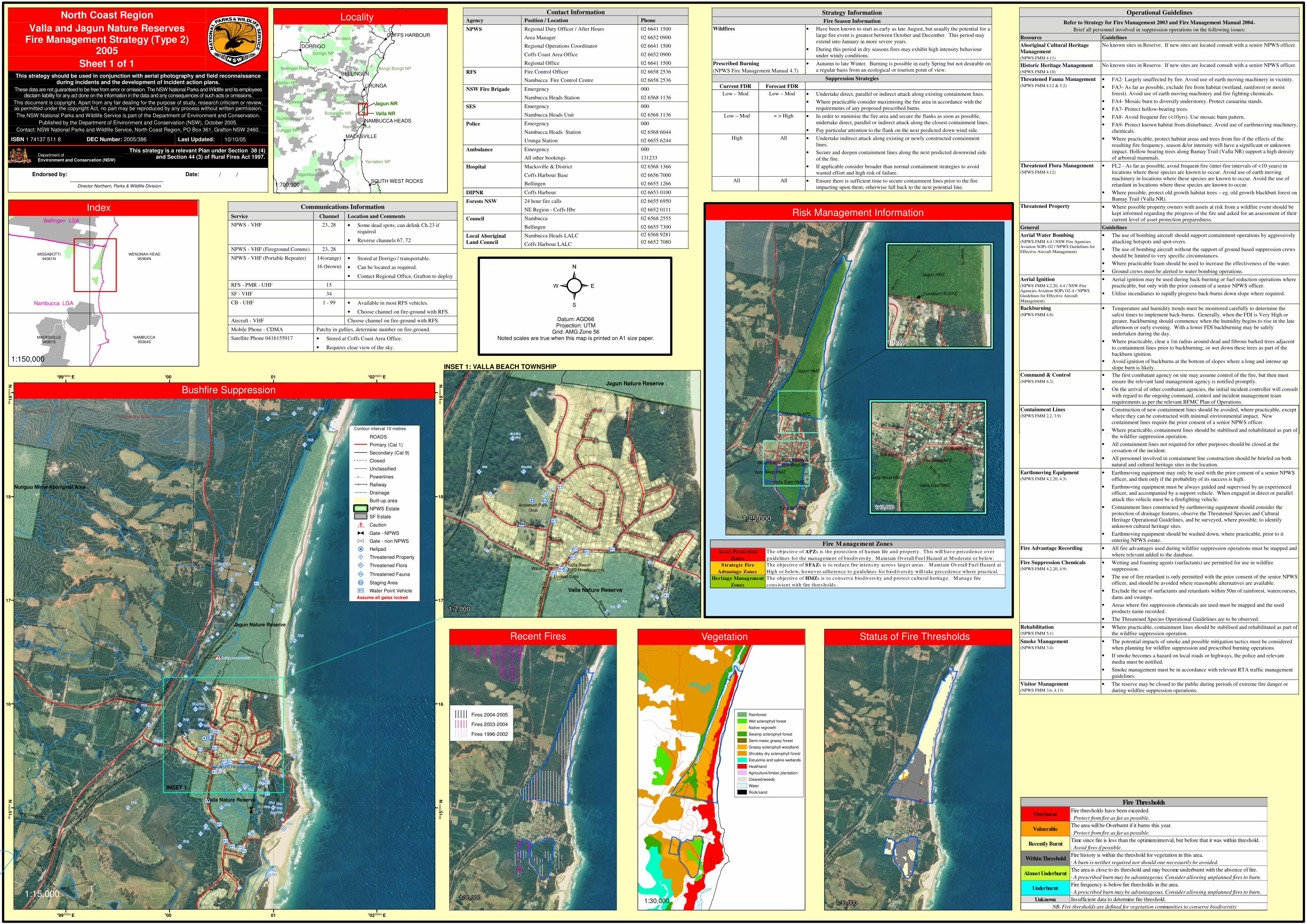
Risk Management Information
North Coast Region
Valla and Jagun Nature ReservesFire Management Strategy (Type 2)
2005
Sheet 1 of 1This strategy should be used in conjunction with aerial photography and field reconnaissance
during incidents and the development of incident action plans.
These data are not guaranteed to be free from error or omission. The NSW National Parks and Wildlife and its employeesdisclaim liability for any act done on the information in the data and any consequences of such acts or omissions.
This document is copyright. Apart from any fair dealing for the purpose of study, research criticism or review,as permitted under the copyright Act, no part may be reproduced by any process without written permission.
The NSW National Parks and Wildlife Service is part of the Department of Environment and Conservation.
Published by the Department of Environment and Conservation (NSW), October 2005.
Contact: NSW National Parks and Wildlife Service, North Coast Region, PO Box 361, Grafton NSW 2460.
ISBN 1 74137 511 8 DEC Number: 2005/386 Last Updated: 10/10/05
This strategy is a relevant Plan under Section 38 (4)and Section 44 (3) of Rural Fires Act 1997.
Endorsed by: Date: / /
Director Northern, Parks & Wildlife Division
Department ofEnvironment and Conservation (NSW)
Bushfire Suppression
Communications Information
Service Channel Location and Comments
NPWS - VHF 23, 28 • Some dead spots; can delink Ch.23 if
required
• Reverse channels 67, 72
NPWS - VHF (Fireground Comms) 23, 28
NPWS - VHF (Portable Repeater) 14(orange)
16 (brown)
• Stored at Dorrigo / transportable.
• Can be located as required.
• Contact Regional Office, Grafton to deploy
RFS - PMR - UHF 15
SF - VHF 34
CB - UHF 1 - 99 • Available in most RFS vehicles.
• Choose channel on fire-ground with RFS.
Aircraft - VHF Choose channel on fire-ground with RFS.
Mobile Phone - CDMA Patchy in gullies, determine number on fire-ground.
Satellite Phone 0416155917 • Stored at Coffs Coast Area Office.
• Requires clear view of the sky.
Contact Information
Agency Position / Location Phone
NPWS Regional Duty Officer / After Hours 02 6641 1500
Area Manager 02 6652 0900
Regional Operations Coordinator 02 6641 1500
Coffs Coast Area Office 02 6652 0900
Regional Office 02 6641 1500
RFS Fire Control Officer 02 6658 2536
Nambucca Fire Control Centre 02 6658 2536
NSW Fire Brigade Emergency 000
Nambucca Heads Station 02 6568 1136
SES Emergency 000
Nambucca Heads Unit 02 6568 1136
Police Emergency 000
Nambucca Heads Station
Urunga Station
02 6568 6044
02 6655 6244
Ambulance Emergency 000
All other bookings 131233
Hospital Macksville & District
Coffs Harbour Base
Bellingen
02 6568 1366
02 6656 7000
02 6655 1266
DIPNR Coffs Harbour 02 6653 0100
Forests NSW 24 hour fire calls
NE Region - Coffs Hbr
02 6655 6950
02 6652 0111
Council Nambucca
Bellingen
02 6568 2555
02 6655 7300
Local Aboriginal
Land Council
Nambucca Heads LALC
Coffs Harbour LALC
02 6568 9281
02 6652 7080
1:150,000
VegetationRecent Fires
Ass et Protection
Zones
Strategic Fire
Advantage Zones
Heritage Management
Zones
Fire M anagement Zones
The objective of APZs is the protection of human life and property. This will have precedence over
guidelines for the management of biodivers ity. Maintain Overall Fuel Hazard at Moderate or below.
The objective of SFAZs is to reduce fire intens ity across larger areas . M aintain Overall Fuel Hazard at
High or below, however adherence to guidelines for biodivers ity will take precedence where practical.
The objective of HMZs is to conserve biodivers ity and protect cultural heritage. Manage fire
consis tent with fire thres holds .
Contour interval 10 metres
Assume all gates locked
Locality
1:700,000
1:10,000
1:10,000
Operational Guidelines
Refer to Strategy for Fire Management 2003 and Fire Management Manual 2004.Brief all personnel involved in suppression operations on the following issues:
Resource Guidelines
Aboriginal Cultural Heritage
Management
(NPWS FMM 4.11)
No known sites in Reserve. If new sites are located consult with a senior NPWS officer.
Historic Heritage Management
(NPWS FMM 4.10)
No known sites in Reserve. If new sites are located consult with a senior NPWS officer.
Threatened Fauna Management
(NPWS FMM 4.12 & 5.2)
• FA2- Largely unaffected by fire. Avoid use of earth moving machinery in vicinity.
• FA3- As far as possible, exclude fire from habitat (wetland, rainforest or moist
forest). Avoid use of earth moving machinery and fire fighting chemicals.
• FA4- Mosaic burn to diversify understorey. Protect casuarina stands.
• FA7- Protect hollow-bearing trees.
• FA8- Avoid frequent fire (<10yrs). Use mosaic burn pattern.
• FA9- Protect known habitat from disturbance. Avoid use of earthmoving machinery,
chemicals.
• Where practicable, protect habitat areas and trees from fire if the effects of the
resulting fire frequency, season &/or intensity will have a significant or unknown
impact. Hollow bearing trees along Bamay Trail (Valla NR) support a high density
of arboreal mammals.
Threatened Flora Management
(NPWS FMM 4.12)
• FL2 - As far as possible, avoid frequent fire (inter-fire intervals of <10 years) in
locations where these species are known to occur. Avoid use of earth moving
machinery in locations where these species are known to occur. Avoid the use of
retardant in locations where these species are known to occur.
• Where possible, protect old growth habitat trees – eg. old growth blackbutt forest on
Bamay Trail (Valla NR).
Threatened Property • Where possible property owners with assets at risk from a wildfire event should be
kept informed regarding the progress of the fire and asked for an assessment of their
current level of asset protection preparedness.
General Guidelines
Aerial Water Bombing
(NPWS FMM 4.4 / NSW Fire Agencies
Aviation SOPs O2 / NPWS Guidelines for
Effective Aircraft Management)
• The use of bombing aircraft should support containment operations by aggressively
attacking hotspots and spot-overs.
• The use of bombing aircraft without the support of ground based suppression crews
should be limited to very specific circumstances.
• Where practicable foam should be used to increase the effectiveness of the water.
• Ground crews must be alerted to water bombing operations.
Aerial Ignition
(NPWS FMM 4.2.20, 4.4 / NSW Fire
Agencies Aviation SOPs O2-4 / NPWS
Guidelines for Effective Aircraft
Management)
• Aerial ignition may be used during back-burning or fuel reduction operations where
practicable, but only with the prior consent of a senior NPWS officer.
• Utilise incendiaries to rapidly progress back-burns down slope where required.
Backburning
(NPWS FMM 4.8)
• Temperature and humidity trends must be monitored carefully to determine the
safest times to implement back-burns. Generally, when the FDI is Very High or
greater, backburning should commence when the humidity begins to rise in the late
afternoon or early evening. With a lower FDI backburning may be safely
undertaken during the day.
• Where practicable, clear a 1m radius around dead and fibrous barked trees adjacent
to containment lines prior to backburning, or wet down these trees as part of the
backburn ignition.
• Avoid ignition of backburns at the bottom of slopes where a long and intense up
slope burn is likely.
Command & Control
(NPWS FMM 4.2)
• The first combatant agency on site may assume control of the fire, but then must
ensure the relevant land management agency is notified promptly.
• On the arrival of other combatant agencies, the initial incident controller will consult
with regard to the ongoing command, control and incident management team
requirements as per the relevant BFMC Plan of Operations.
Containment Lines
(NPWS FMM 2.2, 3.9)
• Construction of new containment lines should be avoided, where practicable, except
where they can be constructed with minimal environmental impact. New
containment lines require the prior consent of a senior NPWS officer.
• Where practicable, containment lines should be stabilised and rehabilitated as part of
vv
vv
v
v
v
v
v
vv
vv
v
v
v
v
v
vv
v
v
v
v v v v v v v
vv
v
v
v
v
v
vv
v
v
v
v
v
v
v
vv
v
vvv
v
v
v
v
v
v
v
v
v
v v
�
�
�
���
�
���
�
�
�� � �
��
�
��
�
!
!
�
� �
�
�
��
�
!
Water Tank
Andersen ParkOval
Valla BeachRFS Headquarters
Locked Gate
Valla Nature Reserve
Jagun Nature Reserve
Valla Beach RdK
uta
Ave
Birugan C
l
Rogers
Dr
Bam
ay T
rl
Max Graham Dr
Paci
fic H
wy
Henderson St
Hib
iscus D
r
Wentw
ort
h S
mith S
t
Thom
pson S
t
Cock
burn
St
Ocean V
iew
Dr
Buc
hana
n St
Gre
gory
St
Steele St
Jon
es S
t
Ruth Lowe Ct
Ketut Cl
Langsford Wy
Shores Cl
Rogers D
r
FL2
FL2
FA9
FA9 FA9FA8
FA4
FA4FA4
FA4
FA4
Fires 2004-2005
Fires 2003-2004
Fires 1996-2002
Status of Fire Thresholds
Datum: AGD66Projection: UTM
Grid: AMG Zone 56Noted scales are true when this map is printed on A1 size paper.
�
INSET 1
INSET 1: VALLA BEACH TOWNSHIP
1:7,000
1:30,0001:30,000
Index
Paci
fic H
ighw
ay
Fire thresholds have been exceeded.
· Protect from fire as far as possible.
The area will be Overburnt if it burns this year.
· Protect from fire as far as possible.
Time since fire is less than the optimum interval, but before that it was within threshold.
· Avoid fires if possible.
Fire history is within the threshold for vegetation in this area.
· A burn is neither required nor should one necessarily be avoided.
The area is close to its threshold and may become underburnt with the absence of fire.
· A prescribed burn may be advantageous. Consider allowing unplanned fires to burn.
Fire frequency is below fire thresholds in the area.
· A prescribed burn may be advantageous. Consider allowing unplanned fires to burn.
Unknown Insufficient data to determine fire threshold.
NB. Fire thresholds are defined for vegetation communities to conserve biodiversity
Overburnt
Fire Thresholds
Vulnerable
Recently Burnt
Almost Underburnt
Underburnt
Within Threshold
Containment Lines(NPWS FMM 2.2, 3.9)
• Construction of new containment lines should be avoided, where practicable, except
where they can be constructed with minimal environmental impact. New
containment lines require the prior consent of a senior NPWS officer.
• Where practicable, containment lines should be stabilised and rehabilitated as part of
the wildfire suppression operation.
• All containment lines not required for other purposes should be closed at the
cessation of the incident.
• All personnel involved in containment line construction should be briefed on both
natural and cultural heritage sites in the location.
Earthmoving Equipment(NPWS FMM 4.2.20, 4.3)
• Earthmoving equipment may only be used with the prior consent of a senior NPWS
officer, and then only if the probability of its success is high.
• Earthmoving equipment must be always guided and supervised by an experienced
officer, and accompanied by a support vehicle. When engaged in direct or parallel
attack this vehicle must be a firefighting vehicle.
• Containment lines constructed by earthmoving equipment should consider the
protection of drainage features, observe the Threatened Species and Cultural
Heritage Operational Guidelines, and be surveyed, where possible, to identify
unknown cultural heritage sites.
• Earthmoving equipment should be washed down, where practicable, prior to it
entering NPWS estate.
Fire Advantage Recording • All fire advantages used during wildfire suppression operations must be mapped and
where relevant added to the database.
Fire Suppression Chemicals(NPWS FMM 4.2.20, 4.9)
• Wetting and foaming agents (surfactants) are permitted for use in wildfire
suppression.
• The use of fire retardant is only permitted with the prior consent of the senior NPWS
officer, and should be avoided where reasonable alternatives are available.
• Exclude the use of surfactants and retardants within 50m of rainforest, watercourses,
dams and swamps.
• Areas where fire suppression chemicals are used must be mapped and the used
products name recorded.
• The Threatened Species Operational Guidelines are to be observed.
Rehabilitation(NPWS FMM 5.1)
• Where practicable, containment lines should be stabilised and rehabilitated as part of
the wildfire suppression operation.
Smoke Management(NPWS FMM 3.4)
• The potential impacts of smoke and possible mitigation tactics must be considered
when planning for wildfire suppression and prescribed burning operations.
• If smoke becomes a hazard on local roads or highways, the police and relevant
media must be notified.
• Smoke management must be in accordance with relevant RTA traffic management
guidelines.
Visitor Management(NPWS FMM 3.6, 4.13)
• The reserve may be closed to the public during periods of extreme fire danger or
during wildfire suppression operations.