Embed Size (px)
Citation preview
UTAH GEOLOGICAL AND MINERALOGICAL SURVEY
QUARTERLY REVIEW Vol. 5, No. 3 Geologic Investigation in the State of Utah
State Geological Surveys1
by Linn Hoover Executive director, American Geological
Institute and publisher of Geotimes
At a time when more and more public services are being allocated to the federal government and Washington bureaucracy exerts an ever-larger influence on the lives of U. S. citizens, it's refreshing to note the vitality of the state geological surveys. These organizations are an important part of the geological community in the United States and deserve more recognition than they sometimes receive .
State-sponsored geological investigations began in I 830, when the Massachusetts legislature authorized the appointment of 'some suitable person' to make a geological survey of the Commonwealth , including lists of its botanical, mineralogical and zoological species. By 1840, geological surveys were established in 15 states. principally along the Atlantic coast but including some of the newer states in the Ohio and Mississippi valleys. These state surveys preceded by more than 25 years the federal surveys of Havden. King, Powell , and Wheeler in
1 Co pyright © 1971 , American Geological Institute. Reprinted by permission .
the years after the Civil War, and they were established 40 years or more before the creation of the U. S. Geological Survey in 1879.
Despite relatively ancient origins, many state surveys for a long time were ephemeral or existed only on paper. Geological studies would be started in a state, only to be abandoned a few years later through lack of further appropriations by the legislature or upon the death of the state geologist. In some states, geological surveys were established several times over. The Pennsylvania Bureau of Topographic & Geologic Survey, for example, is the fourth in a series of state surveys that began in 1831.
As measured by publications, the first quarter of this century was an especially productive time for state surveys in all parts of the country. Money was available to support both basic research and applied studies, with the result that state after state issued scholarly monographs and technical reports on a wide variety of geological subjects. One need only to look at the publications issued between 1900 and 1925 by the state surveys of
UGMS ASSISTS IN SEARCH It is well known that the Utah Geo
logical and Mineralogical Survey investigates and publicizes the geological and mineralogical resources of the state.
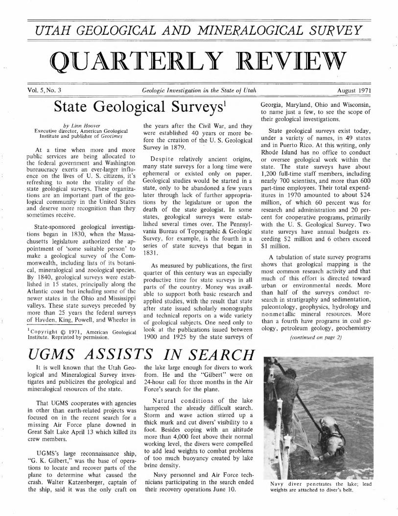
That UGMS cooperates with agencies in other than earth-related projects was focused on in the recent search for a missing Air Force plane downed in Great Salt Lake April 13 which killed its crew members.
UG MS 's large reconnaissance ship, "G. K. Gilbert ," was the base of operations to locate and recover parts of the plane to determine what caused the crash. Walter Katzenberger , captain of the ship, said it was the only craft on
the lake large enough for divers to work from. He and the "Gilbert" were on 24-hour call for three months in the Air Force's search for the plane.
Natural conditions of the lake hampered the already difficult search. Storm and wave action stirred up a thick murk and cut divers' visibility to a foot. Besides coping with an altitude more than 4,000 feet above their normal working level, the divers were compelled to add lead weights to combat problems of too much buoyancy created by lake brine density.
Navy personnel and Air Force technicians participating in the search ended their recovery operations June 10.
August 1971
Georgia, Maryland, Ohio and Wisconsin, to name just a few, to see the scope of their geological investigations.
State geological surveys exist today, under a variety of names, in 49 states and in Puerto Rico. At this writing, only Rhode Island has no office to conduct or oversee geological work within the state. The state surveys have about 1,200 full-time staff members, including nearly 700 scientists, and more than 600 part-time employees. Their total expenditures in 1970 amounted to about $24 million, of which 60 percent was for research and administration and 20 percent for cooperative programs, primarily with the U. S. Geological Survey. Two state surveys have annual budgets exceeding $2 million and 6 others exceed $1 million.
A tabulation of state survey programs shows that geological mapping is the most common research activity and that much of this effort is directed toward urban or environmental needs. More than half of the surveys conduct research in stratigraphy and sedimentation, paleontology, geophysics, hydrology and nonmetallic mineral resources. More than a fourth have programs in coal geology, petroleum geology, geochemistry
(continu ed on page 2)
Navy diver penetrates the lake; lead weights are attached to diver's belt.
Page 2
(continued from page 1)
and metals. In many states the survey provides resource materials for earth science teachers, and most surveys have an information office to answer public inquiries.
The strength of the state geological surveys lies in their intimate knowledge of local problems in applied geology and their ability to provide answers to these problems quickly. State surveys have made a significant contribution to the development of the geological sciences in the United States. It seems likely that they will have an even more important role in the future.
Matrix Check Lists Impact On Environs
An environmental impact evaluation guide based on the information "matrix" concept was issued by the U.S. Geological Survey, Department of the Interior.
According to Secretary Rogers C. B. Morton, "Using a 'matrix' of this kind, an agency planning a local or regional development can quickly check the specific actions involved, and mark the existing environmental conditions likely to be significantly affected by them."
The system lists factors which characterize existing conditions of the environment (i.e., kinds of plants, animal and earth features) vertically on the left side of a sheet and actions likely to be undertaken by man across the top. It lists a total of 88 conditions and 100 actions.
In working out the matrix the user first identifies all actions that are part of the proposed project. He then identifies those parts of the environment likely to be affected and selects a number from one to 10 which indicates the magnitude of the possible impact of the action on the existing natural condition, and enters it in the related square. Ten represents the greatest magnitude of impact, and one the least. If the impact would be beneficial, rather than detrimental, the number is preceded by a plus sign. Also, in each related box, another number is selected which indicates the importance of the possible impact; for example, regional versus local. Number 10 represents the greatest importance, and one the least.
The positions of the numbers in the checkerboard show quickly which actions are the most likely to affect the environment, and what parts of the environment are most sensitive to
QUARTERLY REVIEW August 1971
Marker Beds Determined1
Recent studies have led to the recognition, correlation and radiometric dating of Quaternary volcanic ashes in the Western United States. Distinguishable by its chemical composition, stratigraphic occurrence and age, an ash of apparent regional significance as a Holocene marker bed was recovered from the Great Salt Lake and the Raft River Mountains.
Cores from the Curelom Cirque, Raft River Mountains, clearly establish a mid-Postglacial radiocarbon age for the ash fall as well as a minimum age of about 12,000 radiocarbon years for ice withdrawal. A chronological correlation with the radiocarbon-dated pollen sequence from Swan Lake, southeast Idaho, also agrees well (within 500-1,000 radiocarbon years) with the major changes recorded in the preliminary pollen analyses of the Curelom Cirque cores.
Because of the known occurrence of this mid-Postglacial ash and Eardley's suggested Great Salt Lake deposition rates,2 the presence and probable depth of the ash layer in Great Salt Lake were anticipated.
1 Taken from research by P. J. Mehringer, Jr., and W. P. Nash, University of Utah, and R. H. Fuller, Utah State University, "A Holocene volcanic ash from northwestern Utah ."
2 Eardley, A. J., V. Gvosdetsky and R. E . Marsell, 195 7, Hydrology of Lake Bonneville and sediments and soils of its basin: Am. Bull. Geol. Soc. 68, p. 1141-1201.
a proposed action; thus, a good basis for judging overall impact and selecting the best development alternative is provided.
The environmental matrix was devised by Luna B. Leopold, Frank E. Clarke, Bruce B. Hanshaw, and James R. Balsley, U. S. Geological Survey, Washington, D. C.
It can be considered as the abstract for an environmental impact report and a check list which forces one to think realistically about the qualitative and quantitative effects of proposed actions, including cultural and social effects as well as physical impacts.
The information matrix and a sample statement concerning impact of a proposed mineral development are con-
(continued on page 7)
On the basis of age alone, the lake ash cannot be clearly and independently correlated with that from the cirque. However, a similar age is suggested by correlation of undated pollen records from the Great Salt Lake with a radiocarbon-dated profile from a playa-edge spring-fed salt marsh, west of Terrace Mountains, Utah.
The ashes from the two sites were also analyzed using microprobe analytical techniques and found chemically identical within the limits of microprobe precision.
A similar age for the two ashes is suggested by sedimentation rates and correlation with radiocarbon-dated pollen profiles. Electron microprobe analyses show similar major and trace element composition.
Therefore, Mehringer, Nash and Fuller concluded that both ashes represent the same fall.
Age and trace element composition compare best with those reported for Mt. Mazama ash from Crater Lake , Oregon.
It is likely that the range of the ash will be extended to other areas in north Utah. This will be especially important in understanding the recent climatic history of Great Basin montane glaciations and closed basin lakes and their chronological and climatic relationships.
Moenkopi Studied Ron C. Blakey, graduate student at
the University of Iowa, will complete field work on the Moenkopi Formation in southeastern Utah this fall.
His study stems from UGMS tar-sand research last summer on the San Rafael Swell. It describes the stratigraphy of the Moenkopi Formation and correlates several units of the formation across southeastern Utah, something not done previously.
Blakey completed his masters degree on the geology of the Paria northwest quadrangle in southern Utah at the Uni-versity of Utah. ·
UGMS is supplying a vehicle , salary and field expenses for the investigation.
August 1971
REFUSE REUSED
Doesn't Go To Waste
Just because save-the-environment, antipollutionary movements have found favor with the masses lately doesn't mean that the mini-masses haven't been doing their thing for a long time.
During World War II, when there was a shortage of materials, garbage was segregated and reused to minimize waste-wet refuse to the farmers for feed, combustibles (paper) to provide Btus and tin cans to be recycled.
To day the total daily per capita discard of urban refuse equals a national total of 256 million tons per year- going to waste. Why not separate and salvage its components?
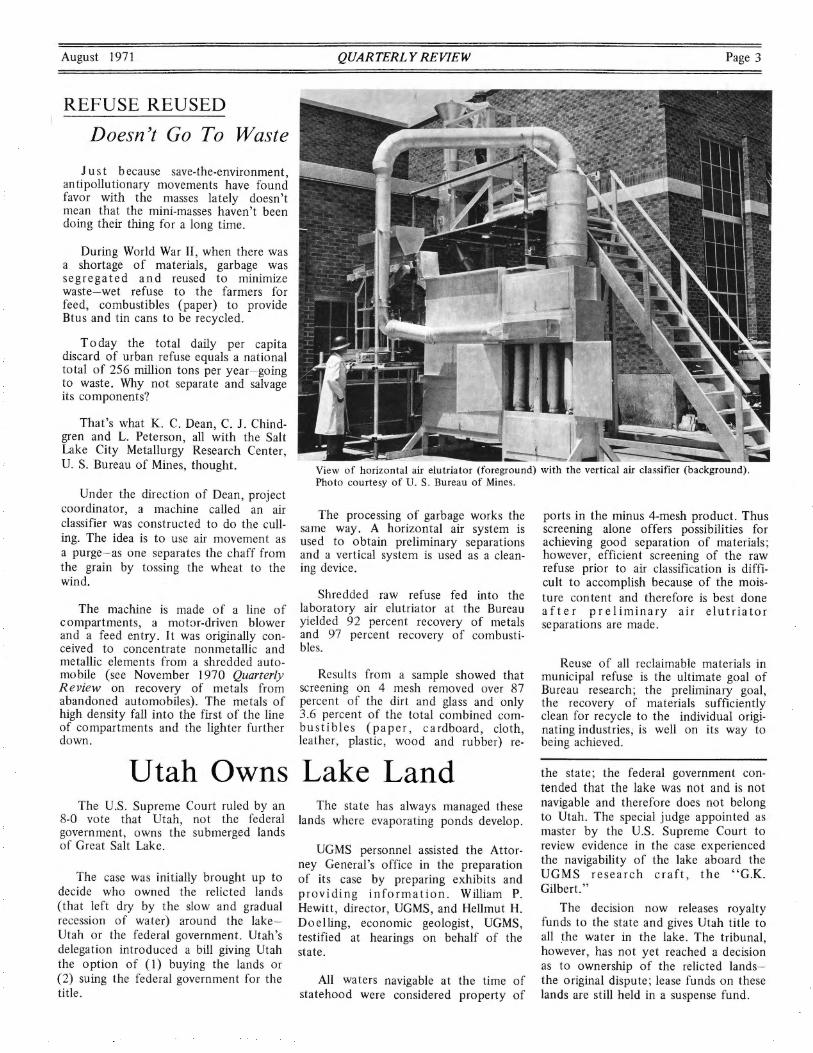
That's what K. C. Dean, C. J. Chindgren and L. Peterson, all with the Salt lake City Metallurgy Research Center, U. S. Bureau of Mines, thought.
Under the direction of Dean, project coordinator, a machine called an air classifier was constructed to do the culling. The idea is to use air movement as a purge-as one separates the chaff from the grain by tossing the wheat to the wind.
The machine is made of a line of compartments, a mot:lr-driven blower and a feed entry. It was originally conceived to concentrate nonmetallic and metallic elements from a shredded automo bile ( see November 1970 Quarterly Review on recovery of metals from abandoned automobiles). The metals of high density fall into the first of the line of compartments and the lighter further down.
QUARTERLY REVIEW Page 3
View of horizontal air elutriator (foreground) with the vertical air classifier (background). Photo courtesy of U. S. Bureau of Mines.
The processing of garbage works the same way. A horizontal air system is used to obtain preliminary separations and a vertical system is used as a cleaning device.
Shredded raw refuse fed into the laboratory air elutriator at the Bureau yielded 92 percent recovery of metals and 97 percent recovery of combustibles.
Results from a sample showed that screening on 4 mesh removed over 87 percent of the dirt and glass and only 3.6 percent of the total combined combu st i bles (paper, cardboard, cloth, leather, plastic, wood and rubber) re-
ports in the minus 4-mesh product. Thus screening alone offers possibilities for achieving good separation of materials; however, efficient screening of the raw refuse prior to air classification is difficult to accomplish because of the moisture content and therefore is best done after preliminary air elutriator separations are made.
Reuse of all reclaimable materials in municipal refuse is the ultimate goal of Bureau research; the preliminary goal, the recovery of materials sufficiently clean for recycle to the individual originating industries; is well on its way to being achieved.
Utah Owns Lake Land the state ; the federal government contended that the lake was not and is not navigable and therefore does not belong to Utah. The special judge appointed as master by the U.S. Supreme Court to review evidence in the case experienced the navigability of the lake aboard the UGMS research craft , the "G.K. Gilbert."
The U.S. Supreme Court ruled by an 8-0 vote that Utah, not the federal government , owns the submerged lands of Great Salt Lake.
The case was initially brought up to decide who owned the relicted lands (that left dry by the slow and gradual recession of water) around the lakeUtah or the federal government. Utah's delegation introduced a bill giving Utah the option of ( l) buying the lands or (2) suing the federal government for the title .
The state has always managed these lands where evaporating ponds develop.
UGMS personnel assisted the Attorney General's office in the preparation of its case by preparing exhibits and providing information . William P. Hewitt, director , UGMS, and Hellmut H. Doelling, economic geologist, UGMS , testified at hearings on behalf of the state.
All waters navigable at the time of statehood were considered property of
The decision now releases royalty funds to the state and gives Utah title to all the water in the lake. The tribunal , however, has not yet reached a decision as to ownership of the relicted landsthe original dispute ; lease funds on these lands are still held in a suspense fund.
Page 4 QUARTERLY REVIEW
Publications-Open File Releases The following publications were re
leased by UGMS in the last eight months:
Special Studies 34, Origin of pyrophyllite-rectorite, by G. V. Henderson, $2.00. A description of pyrophyllite and its association with other clay minerals, especially rectorite, is related to origin. Shales, clays and associated limestone samples have been mineralogically analyzed and the strati graphic relationship of pyrophyllite-rectorite described.
Special Studies 35, Clay mineralogy at the brine-sediment interface in the south arm of Great Salt Lake, Utah, by Leonard L. Hedburg and William T. Parry, $1.00. This latest report on the lake examines clay mineralogical composition and attempts to relate clay minerals of the lake to those carried by inflowing streams. It covers geologic setting, climatology and precipitation, topography, brine chemistry, diagensis of clay minerals, X-ray analysis and miscellaneous mineralogy.
Special Studies 36, Petrographic criteria for recognition of lacustrine and fluvial sandstone, P. R. Spring oilimpregnated sandstone area, southeast Uinta Basin, Utah, by M. Dane Picard, $1.5 0. The differences between the petrography of lacustrine and fluvial sandstone of the P.R. Spring area are analyzed and the advantages of oil exploration in lacustrine reservoirs are outlined. Results of a detailed field examination and petrographic analyses are included.
Bulletin 87, Stratigraphy of the San Rafael Group, southwest and south central Utah, revised, by A. E. Thompson and W. L. Stokes, $2.25. The bulletin deals with the geological formations exposed in the almost continuous belt of outcrops throughout the area. It unifies observations on a regional basis and describes subdivisions of formations currently recognized.
Bulletin 88, Iron deposits of Utah, by K .C. Bullock, $4.50. Each county in Utah and its ore deposits and prospects are comprehensively discussed;
iron occurrences are located on maps and tables show analyses and chemical compositions of the ores.
Bulletin 89, Palynology of the Upper Cretaceous Straight Cliffs Sandstone, Garfield County, Utah, by R. Orlansky, $2.50. This new study describes the sandstone of the Straight Cliffs region of the Kaiparowits where most of the valuable coal deposits are located. Economic and geologic factors are also evaluated.
These publications may be purchased in person or by mail from Publications 0 ffice, 103 Utah Geological Survey Bldg., University of Utah, Salt Lake City, Utah 84112. If the copies are ordered by mail, the purchase price should be increased by 10 percent to cover handling and mailing.
The "Aeromagnetic map of the central Colorado Plateau, Utah, Colorado and Arizona," by the U. S. Geological Survey and the "Geologic map of the Hall Mountain area in Copeland quadrangle, Boundary County, Idaho," by M. H. Staatz, have been released on open file by the U. S. Geological Survey.
Copies are available for inspection at 8102 Federal Office Building, Salt Lake
. City, Utah, 84111, and other USGS libraries.
Twelve additional unclassified and unpublished uranium investigation reports and maps are available for inspection at the Grand Junction, Colorado, Office of the U.S. Atomic Energy Commission, in the Technical Library. They include:
TM-83, A reconnaissance for uranium in part of the Roan and Book Cliffs area of east central Utah, by Neil B. Young (revised by Robert G. Young), 1956.
Preliminary Map No. 16, Area geologic and structural interpretation map of Long Ridge, Utah , compiled by Knox-Bergman-Shearer Corp., 1970.
Preliminary Map No. 17, Areal geologic and structural interpretation map of Thomas Range, Utah, compiled by Knox-Bergman-Shearer Corp., 1970.
Note: Prints of Preliminary Maps 12-17 and the aero-neg color photographic prints of these areas may be purchased from KnoxBergman-Shearer Corp ., 1600 Ogden Street , Denver , Colorado,
August 1971
FLOOD CONTROL INVESTIGATED
An investigation into flood control and related actions on the Virgin River and tributaries, Nevada, Arizona and Utah, initiated in September 1970, is scheduled for completion in August 1974.
Damage from inundation, sediment and bank cutting results when perennial streams originating in the higher mountains flood the Virgin River Basin.
Suggested solutions to the various flood problems include local bank protection, dams and/ or channel improvement. In addition to flood control, water conservation, recreation and fish and wildlife enhancement are project considerations.
Oil-Shale Report Prompts Policy
Results of a state committee's study completed last February to determine the possible environmental effects of oil shale development in the Uinta Basin, together with similar reports submitted by Colorado, Wyoming and the U. S. Department of the Interior, were the basis of the oil shale leasing policy announced by the Secretary of the Interior in late June.
Howard R. Ritzma, UGMS petroleum geologist, headed the committee which consisted mostly of state officials with some backup from industry.
The report, "Environmental Problems of Oil Shale," outlined the geologic setting of the oil shale region, reviewed various estimates of oil contained in the shale and discussed environmental problems likely to be encountered in development.
Also outlined were Utah's state of readiness and necessary preparations for the inception of an oil shale industry.
Copies of the report are on open file in the Survey's offices and are available for purchase from the U.S. Geological Survey Public Inquiries Office , Federal Building, Salt Lake City.
August 1971 . QUARTERLY REVIEW Page 5
.-------------------World's Deepest Well UGMS FINANCIAL ST A TEMENT
July 1, 1970 - June 30, 1971
SOURCE OF FUNDS:
Appropriations and allotments Mineral leasing fund: fiscal income .. ............ . $100,404 Land grant maintenance fund ..... ... ........... . I 00,000 General fund ............... . ............. ... 88,200 Health, Education and Welfare grant ............. .. . 27,500 _,__ ____ _
Other Publications sales (restricted) ................... . $ 25,157 Services rendered (restricted) . . . . . . . . . . . . . . . . . . . . . -Miscellaneous income and reim-
$316,104
bursement from state agency .................... 10,959 ......,;;_ _____ _ $ 36,116
Carryover Operating funds ............................ $ 82,177 Publications receipts . .............. . ............ 15,339 Services rendered . . . . . . . . . . . . . . . . . . . . . . . . . . . . . . 813 --c....::...::.. ____ _
TOTAL FUNDS AVAILABLE ...................... $450,549
TOTAL FUNDS USED (detailed below) ............. . .. 376,757
FUNDS ENCUMBERED ............................ 34,931
$ 98,329
$450,549
An onshore well in southern Louisiana holds the record as the world's deepest well. Placid Oil Company S.L. 5407 Lake Borgne, St. Bernard Parish, was bottomed at 25,600 feet in an unidentified formation late in 1970.
The well was drilled without mechanical problems until high temperatures played havoc with drilling mud viscosit.ies near t~tal depth. Temp~ratures as high as 4 73 F were recorded in the hole but were likely higher since a 500° F recorder was destroyed while logging to total depth.
Penrod Drilling Company was contractor for the current record breaker.
The depth record may not stand long. In Pecos County, Texas, Ralph Lowe Estate No. I University "I 7'' is drilling toward a 27,000-foot objective; and in Beckham County, Oklahoma, Lone Star Producing-Glover Hefner Kennedy Oil No. I Baden is drilling to a proposed 28,000 feet.
UNENCUMBERED BALANCE ........................ 38,861 ____ Parker Drilling is contractor for the Texas deep test; Loffland Brothers Rig
$450,549 $450,549 No. 32 is drilling the Oklahoma well.
EXPENDITURES BY PROGRAMS EXPENDITURES BY IBM ACCOUNTING
Administration .................. .. . .. . $ 23,350 Employment benefits .... . ....... ... .. .. 15,970
Employment costs Staff ..... .. ...... . ..... $152 ,550 Summer assistance ............ 11,956
Services to public and state ........ .... ..... 32,050
Examinations Coal ........ ... ... .. .............. 44,787
Time card wages . . . . . . . . . . . . . 17,835 Employee benefits .. .. . ..... . . _15 ..... ,,;_97_0_--=---=-"'....,....,....,.
$198,311
Hydrocarbons ......... . .... . ......... 33,950 Mineral commodity studies . . . . . . . . . . . . . . . 7,950 Great Salt Lake . .. . ... . ............... 39,600 Urban and engineering geology .. .. ........ 15,500 Regional, structural and
stratigraphic ................ . . .. ... . 6,750
Cooperative costs U. S. Geological Survey ...... $ 74,470 U.S. Bureau of Mines ......... ·=1._5..::...00.::......_ ___ _
75,970
Cooperative studies U. S. Geological Survey
Topographic mapping .. . .. . .......... 50,000 Contract service . . . . . . . . . . . . . . . . . . . . . 5,167 Water resources . ... ... . . ... ... .. ... . 20,500 Geologic mapping ... . ... .. .. . ..... . .. 3,970 Examination costs and travel . . . . . . . . . . . . 15,384
U. S. Bureau of Mines Oil field brines .. . . .. . . .... .. ........ 1,5 00 Equipment, supplies and maintenance . . . . . . 60,114
Publications (preparation) .... . .. ........... 76,122 Printing costs and consignment . . . . . . . . . . 19,253
Oil well sample library ... . ......... .. . ..... 2,200 Remodelling and University overhead . . . . . . 2,558
Remodelling and furnishings .... . . .. .... .. . . . 1,058
University overhead .. .... .. . . .. .... . .. ... . 1,5 00 TOTAL FUNDS USED . . . . . . . . . . . . . . . . $376,757
TOTAL FUNDS USED .. . .. . ... .. .. . . .. . $376,757
Page 6
Seismic Signals Boosted
Texaco, Inc., announced development of an amplifier with important applications in a petroleum exploration system; its high fidelity output extracts weak seismic signals from undesirable but stronger background noise.
The amplifier is the heart of a seismic data system that receives, instantly amplifies and records electrical signals over a dynamic range in excess of 144 decibels. It has many applications in other scientific areas, including space industries, communications research and electrical measurement and recording.
According to Petroleum Information Coiporations April 1971 "Topics" bulletin, the seismic system consists of an array of geophones, the amplifier, a converter and a recorder. Output signals from the geophones are fed directly to the amplifier, which measures their instantaneous value by repeatedly sampling small parts of each cycle.
The amplifier then determines the amount of amplification required to bring the signals within a desired range and automatically amplifies them in varying amounts for further processing. The converter changes the analog data from the amplifier into digital information suitable for processing in a computer. These data are stored on magnetic tape by the recorder.
Texaco has a number of issued and pending patents on the system , both in the United States and in other countries. The amplification system is available for licensing from Texaco Development Corporation (TDC) , a subsidiary of Texaco, Inc ., responsible worldwide for patent licensing. TDC said that Texas Instruments, Inc. , and Dresser Industries, Inc., have been licensed to produce the system.
Map Available A colored Geologic Map of the Park
City East Quadrangle , Summit and Wasatch Counties, Utah, by C.S. Bromfield and M.D. Crittenden , Jr., is now available from the U.S. Geological Survey offices, price $ I .00.
QUARTERLY REVIEW
Oil Field Effects Determined
Mountain Fuel Supply, Phillips Petroleum and Chevron Oil Companies are cooperatively financing a five-year study on the effects of oil field development on deer management and movements. The study will be conducted by Division of Wildlife Resources biologists at a cost of $7,582.
The three companies are currently developing a producing field in the Cedar Rim-Sink Draw area of Duchesne County. Part of the development is taking place on Division-owned lands. These lands were purchased and developed by the Division to increase the winter food supply for mule deer wintering in the lower Strawberry River area.
The Division of Wildlife Resources recognizes the importance of oil exploration and production to the state and n at i o n a 1 e con om y . The st u d y in Duchesne County will help determine if such exploration and development has any adverse effects on deer hunting in the area.
OIL AND GAS STATISTICS
U GM S, in cooperation with the Utah Oil and Gas Conservation Commission and the U.S. Geological Survey Oil and Gas Conservation Division, has accumulated oil and gas production statistics through 1970 on Utah fields.
The study, prepared by Carlton Stowe, information specialist for UGMS, includes field outlines as defined by the State Nomenclature Committee and shows each oil, gas, water input, injection and drilling well as well as dry holes within each field. Data are accumulated from the beginning of each discovery well.
An analysis of production characteristics of the crude oil was made and additional data were gathered on gas and water analyses made available by the U.S. Bureau of Mines .
Developments in the Utah oil and gas industry date back to the late I 890's and early I 900's. Now more than 900 wells produce more than 1.5 million barrels of oil each month.
The report presents for the first time a comprehensive analysis of the industry under one cover. The bulletin will be available in the near future.
August 1971
Statistician Takes On Data
The Utah Geological and Mineralogical Survey has accepted responsibilities of continuing statistical data compilation on Utah's mining and mineral industries which have been developed and maintained by the Utah Mining Association.
Years ago a need developed in the state for statistics on the production and value of the various mineral commodities produced in Utah, coupled with related data on employment, prices, taxes paid by the industry, etc.
This data, compiled by Walter Horne, assistant manager of the Utah Mining Association, was and is frequently requested by various departments of government, by the legis-1 at u re, schools, newspapers and the public and various segments of the mining industry itself.
Horne retires this year and Carlton Stowe, UGMS mineral information specialist, will assume accumulation responsibilities.
UGMS, in its continuing efforts to investigate and publicize the geological and mineralogical resources of Utah, is pleased to have this opportunity to be of greater service to Utah's mining industry.
Reminder The mining map of Utah, "Mining
Districts and Mineral Deposits of Utah," published by Charles A. Mardirosian, is still available at its original cost of $1.50 at UGMS offices. Published in 1966, the map lists districts alphabetically and includes county, chief metals or rock products produced and a brief description of the geology or formation mined.
Straw Fights Spills Straw was the one weapon worth its
salt in fighting the effects of the Santa Barbara Channel oil spill of 1969, according to an article in the Smithsonian magazine. Warren R. Young, author of a book on Santa Barbara's oil leak , writes that the oil company men improvised one weapon after another. When straw was mechanically shredded and spread on the water, Young says, it absorbed up to 80 percent of its own weight in oil.
August 1971
Mercury Distribution Established
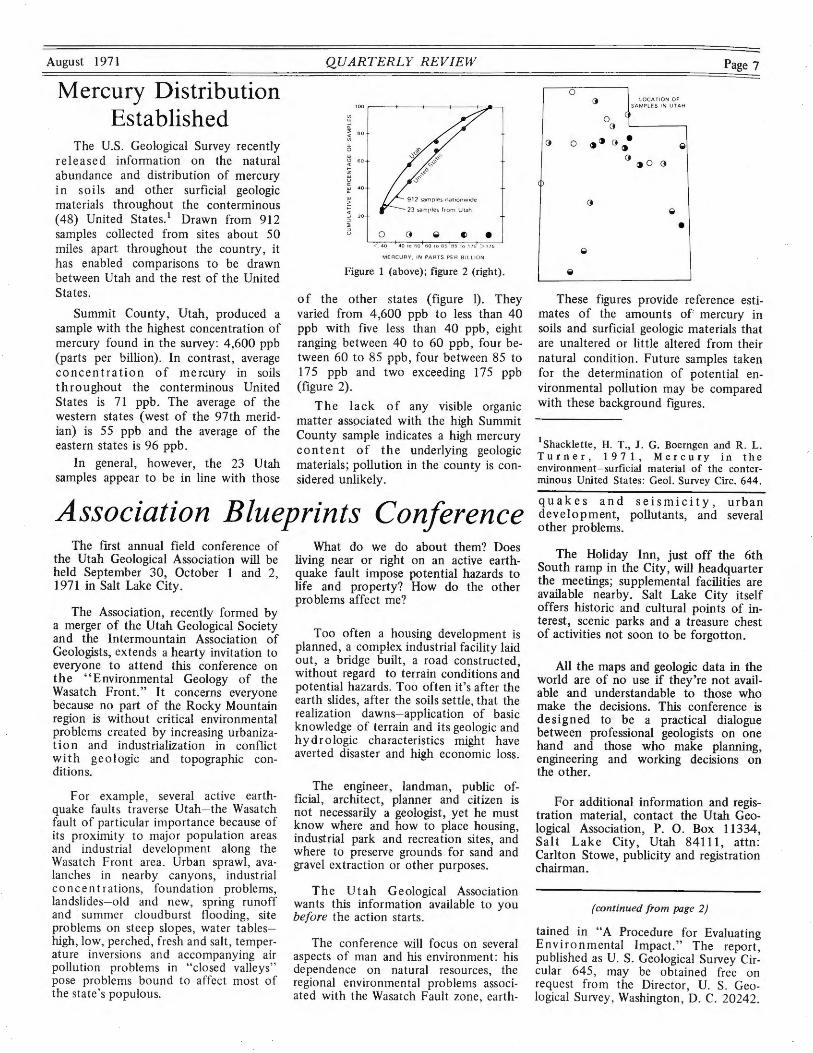
The U.S. Geological Survey recently released information on the natural abundance and distribution of mercury in soi Is and other surficial geologic materials throughout the conterminous ( 48) United States. 1 Drawn from 912 samples collected from sites about 50 miles apart throughout the country, it has enabled comparisons to be drawn between Utah and the rest of the United States.
Summit County, Utah, produced a sample with the highest concentration of mercury found in the survey: 4,600 ppb (parts per billion). In contrast, average concentration of mercury in soils throughout the conterminous United States is 71 ppb. The average of the western states (west of the 97th meridian) is 55 ppb and the average of the eastern states is 96 ppb.
In general, however, the 23 Utah samples appear to be in line with those
QUARTERLY REVIEW
~ BO
0 • < 4 0 40 10 f.i0 6 0 t o 85 8 5 ro 175 > 175
M ERCURY , IN PARTS PE R BILLI O N
Figure 1 (above); figure 2 (right).
of the other states (figure 1). They varied from 4,600 ppb to less than 40 ppb with five less than 40 ppb, eight ranging between 40 to 60 ppb, four between 60 to 85 ppb, four between 85 to 17 5 ppb and two exceeding 175 ppb (figure 2).
The lack of any visible organic matter associated with the high Summit County sample indicates a high mercury content of the underlying geologic materials; pollution in the county is considered unlikely.
Association Blueprints Conference The first annual field conference of
the Utah Geological Association will be held September 30, October 1 and 2, 1971 in Salt Lake City.
The Association, recently formed by a merger of the Utah Geological Society and the Intermountain Association of Geologists, extends a hearty invitation to everyone to attend this conference on the "Environmental Geology of the Wasatch Front." It concerns everyone because no part of the Rocky Mountain region is without critical environmental problems created by increasing urbanization and industrialization in conflict with geologic and topographic conditions.
For example , several active earthquake faults traverse Utah- the Wasatch fault of particular importance because of its proximity to major population areas and industrial development along the Wasatch Front area. Urban sprawl, avalanches in nearby canyons, industrial concentrations, foundation problems, landslides- old and new, spring runoff and summer cloudburst flooding , site problems on steep slopes, water tableshlgh, low, perched , fresh and salt , temperature inversions and accompanying air pollution problems in "closed valleys" pose problems bound to affect most of the state's populous.
What do we do about them? Does living near or right on an active earthquake fault impose potential hazards to life and property? How do the other problems affect me?
Too often a housing development is planned, a complex industrial facility laid out, a bridge built , a road constructed, without regard to terrain conditions and potential hazards. Too often it's after the earth slides, after the soils settle, that the realization dawns- application of basic knowledge of terrain and its geologic and hydrologic characteristics might have averted disaster and high economic loss.
The engineer, landman, public official , architect, planner and citizen is not necessarily a geologist, yet he must know where and how to place housing, industrial park and recreation sites, and where to preserve grounds for sand and gravel extraction or other purposes.
The Utah Geological Association wants this information available to you before the action starts.
The conference will focus on several aspects of man and hls environment: hls dependence on natural resources, the regional environmental problems associated with the Wasatch Fault zone , earth-
<D
0
0 (
L OCA TIO N O F SAM PLE S 1N UTAH
(} '-------,
0 ~~ (} ~· ~ o ~ o o
•
Page 7
These figures provide reference estimates of the amounts of mercury in soils and surficial geologic materials that are unaltered or little altered from their natural condition. Future samples taken for the determination of potential environmental pollution may be compared with these background figures.
1 Shacklette, H. T., J. G. Boerngen and R. L. Turner, 1971, Mercury in the environment-surficial material of the conterminous United States: Geol. Survey Circ. 644.
quakes and seismicity, urban development, pollutants, and several other problems.
The Holiday Inn, just off the 6th South ramp in the City, will headquarter the meetings; supplemental facilities are available nearby. Salt Lake City itself offers historic and cultural points of interest, scenic parks and a treasure chest of activities not soon to be forgotton.
All the maps and geologic data in the world are of no use if they're not available and understandable to those who make the decisions. This conference is designed to be a practical dialogue between professional geologists on one hand and those who make planning, engineering and working decisions on the other.
For additional information and registration material, contact the Utah Geological Association, P. 0. Box 11334, Salt Lake City, Utah 84111, attn: Carlton Stowe, publicity and registration chairman.
(continued from page 2)
tained in "A Procedure for Evaluating Environmental Impact." The report, published as U. S. Geological Survey Circular 645, may be obtained free on request from the Director , U. S. Geological Survey, Washington , D. C. 20242.
Page 8
EARTHQUAKE General earthquake epicenters in or
near Utah for February and March l 971, with dates of occurrence and approximate magnitude, are listed below. Unless otherwise indicated , localities are in Utah.
Magnitude feb mary
2 East of Randolph, Utah , in Wyoming < 2.0 2 North of Vernal ...... . .. .. . .. .... 2.6 3 East of Randolph , Utah , in Wyoming<2.0 4 Near Nephi ........ . . . .. .. . .. ... . 2 .2 5 Near Deer Creek Reservoir ... ... .. < 2.0 5 Near Morgon . ....... . .... .. .. .. < 2.0 5 South Utah-Nevada border . ..... ... . 2.0 7 East Nevada .... . ... .. .. .. . .. . ... 2.6 9 San Fernando, California ......... .. 6.8
10 Near Manti ... .. ........ .. ... .... 2.3 12 South Utah-Nevada border .. . .... . . . 4.3 12 East of Randolph , Utah, in Wyoming . 2.5 13 Eas t of Randolph , Utah , in Wyoming . 2.4 15 Near Manti .... . . ... . . .. . .. .... <2.0 16 East of Randolph, Utah, in Wyoming . 2.5 16 Near Mona . . . .. . .. . . . .. . . . .. .. .. 2.2 17 East of Randolph , Utah , in Wyoming . 2.3 18 North of Vernal , near Brush Creek ... 2.6 19 East of Randolph , Utah, in Wyoming< 2.0 23 Near Glenwood . .... . ...... . ...... 3.3 23 Near Salina ... .... . .... . .. .. ... < 2.0 23 East of Randolph, Utah, in Wyoming<2.0 23 Near Mayfield . .......... .. .... . . . 2.5 24 Near Salina .. ... . . ...... ... .. . .. . 3.0 24 East of Randolph , Utah , in Wyoming< 2.0 24 North of Vernal .. .. . .. . . . .. .... < 2.0 25 East of Randolph , Utah, in Wyoming< 2.0 25 Rangely, Colorado ... . .......... < 2.0 25 Sou th of Sunnyside ....... .. ..... < 2 .0 25 Rangely , Colorado ................. 2.0 25 East of Randolph , Utah, in Wyoming< 2.0 25 East of Randolph, Utah, in Wyoming .. 2.4 26 South Idaho ...... .... .. ........ . 3.0 26 Near Woodside ..... .. . . .......... 2.5 27 Utah~olorado border
near Bonanza. Utah ........ . ...... 2.9 28 Rangely. Colorado . ............... 2.5 28 Sou th of Sunnyside . . . . .... . ... . < 2 .0
March 2 Near Randolph .. .......... . .. . .. . 2.4 2 East of Randolph , Utah , in Wyoming< 2.0 2 Near Marysvale .. . . . . .. .. . .. . ..... 2.3 3 Near Morgan (possible blast) .. .. .. < 2.0 3 North of Vernal near
Diamond Mountain . . .. ............ 2.5 4 East of Randolph , Utah, in Wyoming . 2.4 4 North of Bear Lake in Idaho ... ..... 2.4 4 Near Cedar City . . ........ .. ... . < 2.0 5 East of Randolph , Utah , in Wyoming . 2.4 5 Near Morgan (possible blast) ..... .. . 2.0 7 South of Sunnyside . . .. . . .. .... <2.0 9 Near Pleasa nt Grove . . . . . . . . . . . . ... 1.3 9 East of Randolph, Utah , in Wyoming . 2.3 9 Near Nephi . . . ....... .. ........ < 2.0
10 Near Morgan (possible blast) . .... .. . 1.7 10 North of Vernal near
Diamond Mountain . .. .. .. .... .... . 2.6 10 Near Ceda r City ....... . .... .. . . <2.0 11 North of Vernal . . .. ..... . ........ 2.0 12 East of Randolph , Utah , in Wyoming . 2.0 13 Near Promontory Mountains ... .. . <2.0 14 Near Deweyville .... . ..... . ... . . < 2 .0 14 North of Bear Lake in Idaho .... ... . 2.9 14 North of Bear Lake in Idaho .. .. .. .. 2 .5 15 East of Randolph, Utah, in Wyoming . 2.3
QUARTERLY REVIEW
EPICENTERS 16 North of Vernal near
Diamond Mountain ........ .. ... . <2.0 17 East of Randolph , Utah, in Wyoming . 2.3 18 South central Utah-
Colorado border .................. 2.3 18 Near Cedar City (possible blast) ... . .. 2.1 19 North of Marysvale ..... . ........ <2.0 19 North of Marysvale ............. . < 2.0 19 South of Sunnyside ............. <2.0 19 Near Randolph, Utah ............ <2.0 19 East of Randolph, Utah, in Wyoming . 2.6 20 Hansel Valley .................. <2.0 21 Rosetta .. .... ...... .. ......... . . 2.3 22 Near Milburn .................... 1.8 22 Near Milburn ................ . . < 2.0 23 Near Morgan ................... < 2.0 24 East of Randolph, Utah, in Wyoming . 2.6 24 Near Morgan (possible blast) ........ 2.0 25 Near Nephi ...................... 2.2 26 North of Vernal, near
Brush Creek ................... < 2.0 28 South Utah-Nevada border ........ < 2.0 29 Near Cedar City ...... . .. ... .... <2.0 31 East of Randolph, Utah, in Wyoming<2 .0
These earthquakes were recorded by the University of Utah seismograph stations under the direction of Kenneth L. Cook. All locations and magnitudes are preliminary determinations; the final determinations will be printed in the University of Utah Seismological Bulletin, issued quarterly.
August 1971
Teacher Recognized The College of Mines and Mineral
Industries, Department of Geological and Geophysical Sciences, University of Utah, announced presentation of the Award for the Outstanding Secondary Earth Science Teacher in Utah.
The a ward, presented by the National Association of Geology Teachers at their Southwest Section Meeting in Socorro, New Mexico, June 18, 1971, went to Edward A. Dalton, instructor of Individualized Education in Earth Science at Tooele High School, Tooele, Utah. It is the first such award for Earth Science teaching in the state of Utah.
Dalton worked for three field seasons on the UGMS' oil-impregnated sandstone mapping project.
Nominations were made by fellow earth scientists and screened by a state committee consisting of a college and a secondary school teacher, secondary school administrator and a representative of industry.
PLANT PUSHES PRODUCTION Phosphate rock is obtained from four
general areas in the nation. The largest is in Florida followed by North Carolina and Tennessee. The remainder of the national reserves are in the western states of Idaho, Montana, Wyoming and Utah.
Utah's largest phosphate operations are those of the Stauffer Chemical Co. with underground mines in the Crawford Mountains and an open pit north of Vernal. The latter was first investigated by the San Francisco Chemical Co. in 1956, at that time 50 percent, but now 100 percent owned by Stauffer. Today phosphate production at the Vernal operation is 300,000 tons a year , where beneficia tion of low-grade western phosphate rocks was first pioneered. Stauffer plans a significant increase during the next year , raising production volume to more than 400,000 tons a year. Little additional equipment with only a slight increase in employees is anticipated.
The Vernal plant has been managed by Duncan L. King, Jr. , who was promoted recently to assistant manager of the company's operations in the tri-state area of Utah, Idaho and Wyoming. He is succeeded by Harold G. Hedgpeth as manager of the Vernal-Phoston plants.
The company operates a crushing and refining plant as well as a tailings pond at Vernal. A new tailings pond dam will be used when the old pond reaches capacity.
The operation brings an annual income into the area of more than a million dollars. Presently 63 are employed at the Vernal operation and 15 at the Phoston plant. Operations are conducted 24 hours daily with three shifts a day, seven days a week .
At current production rates, Stauffer has enough ore land holdings to last hundreds of years. The company reports the area is one of the world's large phosphate deposits.
Phosphate ore is strip-mined in the area next to the Brush Creek gorge. The ore is hauled from the plant to Phoston where it is further processed before rail shipment to world markets.
In 1920 records show 1,875 tons of phosphate rock were produced in Utah, valued at some $12,000. In 1956, 125,772 tons were produced, valued at $772,000. By 1963 phosphate production in the state approached 1 ½ million tons of phosphate rock-a significant increase from the 1,875 tons in 1920.
August 1971
Seminar Educates Educators
Approximately thirty administrators and teachers from Utah's public schools were acquainted recently with Utah's mineral industries through a 3½-week seminar at the University of Utah.
ElRoy Nelson , vice president and economist of First Security Corporation and formerly professor of economics and director of the University of Utah Bureau of Economic and Business Research, directed the course sponsored by the Natural Resources Council of the Utah Associated Chambers of Commerce.
Dr. Nelson has taught the course for 15 years to more than 850 people.
The seminar held from June 2 to 25 provided teachers with a first-hand opportunity to learn significant trends in the state's natural resource industries. The role and economic importance of Utah's natural resource industries to the economic development of the state and region was explained. Also , problems of ecology, pollution responsibilities, impacts, etc. , were studied.
The course is designed to encourage teachers to counsel qualified students to enroll in classes which will prepare them for geological, engineering and scientific classes and careers.
More than a dozen industries were toured by the group this year-from Interstate Brick Company's plant and Ideal Portland Cement Company's operations at Devils Slide to United Park City Ventures at Keetly where each phase of the lead-zinc mine operation was explained.
Rigs Drill Deep Several giant drilling rigs are on lo
cation in Utah. In the Altamont area, Duchesne County , Moran Drilling's diesel-electric Rig No. 31 drilling for Shell Oil is rated to 25,000 feet. The well being drilled at this operation is officially scheduled to 14,000 feet.
Deepest objective of wells drilling in the active Duchesne County "play" is Shell Oil No . 1-11-84 Brotherson, an 18.000-foot test contracted to Noble Drilling. The well , located 12 miles north-northeast of Duchesne , should break Utah's current depth record held
QUARTERLY REVIEW
Scholarships On May 20, 1971, the Utah Associa
tion of Petroleum and Mining Landmen presented the Robert C. Manly Scholarship Award of $150.00 to Waldemar E. Rasmussen, a law student at the University of Utah, for outstanding work and exhaustive scholarly research in the area of public land law.
The award was based primarily on Rasmussen's performance in a public land law class at the law school and on a paper which he co-authored, "Environmental Concerns in the Development of Oil Shale" for an oil and gas law course.
This award is presented annually to the most deserving student of public land and mineral law at the University of Utah in memory of the late Robert C. Manly, a former member of the Association who was killed in an airplane accident in November 1965.
Robert Vernon, Skyline Oil Company, president of the Association, and Carlton Stowe , Utah Geological Survey , Association vice-president , presented the award on behalf of the Landmen.
The Utah Geological Association scholarship in field geology at the University of Utah was awarded to David L. Bernini for 1971. It pays $350.00, the full cost of the U's summer field geology course.
Bernini worked as a field assistant for the UGMS in 1970.
by Phillips Petroleum No. 10-A Bridger Lake Unit, Summit County, drilled to 17 ,910 feet in 1970.
Utah's drilling depth record may not stand long. Reliable reports have been received that a 22,000-foot test well will be spudded near Ouray , Uintah County, in August 1971. The giant Brinkerhoff rig drilling for Continental Drilling Funds (Conoco) is expected to be on the job for eighteen months.
Metrics Favored Most U. S. businessmen who re
sponded to a recent survey by the Commerce Department favored a coordinated transition to the metric system of measurement.
Page 9
Brick Makers Open New Plant Ground-breaking ceremonies for In
terstate Brick Company's new $6.5-million fully automated plant in West Jordan , 90th South 52nd West , were held recently. When completed the new plant will be capable of doubling its brick and tile production capacity with ample room for future expansion.
Swindel-Dressler Company, a division of Pullman, Inc. , of Pittsburgh, Pennsylvania, is the prime contractor for the construction of the new plant. The site is adjacent to existing railroad lines served by D&RG.
Two multiburner gas-fired tunnel kilns will comprise the major components of the new plant. Each kiln is approximately 445 feet long with two dryers approximately 210 feet long and a four-track holding room 316 feet long. For the present time the only additional building facilities will be a garage and a general office building.
Interstate, formed in 1878, is the largest building-brick, and clay-tile industry in the state where more than 35 million bricks are produced annually and between 150-175 people are employed with a payroll of some $35,000.00 every 2 weeks. It will be known now as Interstate Brick Division of Entrada Industries, Inc., a newly formed and wholly-owned subsidiary of Mountain Fuel Supply Company. The acquisition was accomplished earlier this year by an exchange of Mountain Fuel common stock for Interstate common stock.
Sources of the raw materials are clay beds in Evanston, Wyoming; Henefer, Utah; Pelican Point (Utah Lake) ; Kimberly, west of Marysvale; the Fish Lake area; west of Fairfield , Lehi area "Five Mile" vicinity and the Big Cottonwood Canyon locality.
Markets for the building brick include out-of-state areas , especially Idaho , Wyoming and Nevada, and special quality building brick is occasionally sent to areas beyond that considered as the normal marketing territory.
APROPOS Astronaut to fellow moonwalker as
they stumble on refuse from the last fli ght "What on earth ... ?"
Page 10
Spaceport Campaign Continues
The campaign continued as Utah's Spaceport Committee battled for Utah to be considered as the site of a future spaceport.
Al tho ugh Cape Kennedy and Vandenburg Air Force Base are favored, the committee, headed by M. L. Weilenmann, contends that Utah offers the one all-encompassing solution to the requirements of the spaceport and they intend to prove it.
A comprehensive site-selection special studies was prepared arid presented to NASA, House and Senate Aerospace Committee members, Utah's Congressional delegation, U. S. Air Force and prime program contractors.
Teams of aerospace executives toured the area under the guidance of Hellmut H. Doelling, UGMS economic geologist, listening to presentations for Utah's case.
Aside from other factors, it shows construction in Utah would be at least $ 1.8 billion cheaper than in other areas making bids for selection. Or, for the same dollars, Utah could put 4.5 million more pounds of payload in orbit.
UTAH
GEOLOGICAL AND MINERALOGICAL SURVEY
103 UTAH GEOLOGICAL SuRVEY Bun.DING
THE UNIVERSITY OF UTAH SALT LAKE CITY, UTAH 84112
Address co"ection requested
QUARTERLY REVIEW
Population Flows To The Cities
During the last decade, 1960 to 1970, the population of Utah increased by nearly 169,000 persons, from 890,627 to 1,059,273.
Long extablished trends in population shifts continued through the sixties. Over 80 percent of Utah's population (along with Rhode Island's, Massachusetts', Florida's, Illinois', Nevada's and Hawaii's) now live in cities exceeding 2,500 people as the rural component dropped not only as a percentage of the total population but also in absolute numbers.
California, the most urbanized state, has 90.9 percent city dwellers; New Jersey follows with 88.9 percent and New York placed third with 85.5 percent of its population concentrated in cities.
Utah's urban population extends along the Wasatch Front, the west border of the Rocky Mountains and the east border of the Great Basin. This zone comprises the state's megalopolis from Brigham City on the north to Payson on the south.
The age shift to an older population also continued; this trend, supported in the past by increasing life expectancy, was compounded in the sixties by a declining birth rate.
August 1971
EDITOR RESIGNS Mildred R. Detling, UGMS editor, has
accepted a position with the University of Oregon's Marine Lab at Charleston, Oregon.
Mrs. Detling, who holds a masters degree in paleontology, held her survey position since June 1969. She was an avid student of the Great Salt Lake and did much to publicize events pertinent to science and the layman.
She was responsible for the IBM MTST/composer system of preparing publications at the survey and for updating survey routines.
Authors have expressed regret for the Survey's loss of an efficient, wellinformed and dynamic editor.
QUARTERLY REVIEW State of Utah ....... Calvin L. Rampton
Governor University of Utah ..... Alfred C. Emery
President , College of Mines & Mineral
Industries ........... George R. Hill Dean
Utah Geological & Mineralogical Survey ........... William P. Hewitt
Director
UTAH GEOLOGICAL AND MINERALOGICAL SURVEY
103 Utah Geological Survey Building University of Utah
Salt Lake City, Utah 84112
Nonprofit Org. U.S. Postage Paid Permit No. 1529
Salt Lake City, Utah