Embed Size (px)
Citation preview
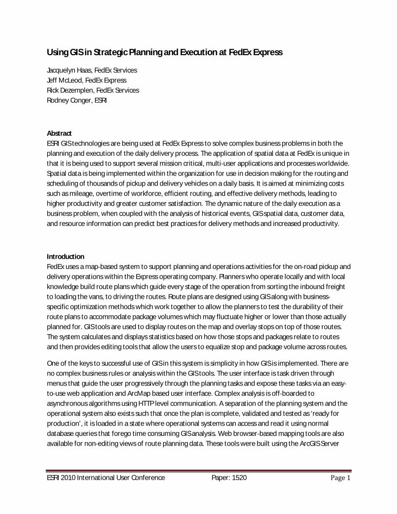
ESRI 2010 International User Conference Paper: 1520
Using GIS in Strategic Planning and Execution at FedEx Express
Jacquelyn Haas, FedEx ServicesJeff McLeod, FedEx ExpressRick Dezemplen, FedEx ServicesRodney Conger, ESRI
AbstractESRI GIS technologies are being used at FedEx Express to solve complex business problems in both theplanning and execution of the daily delivery process. The application of spatial data at FedEx is unique inthat it is being used to support several mission critical, multi user applications and processes worldwide.Spatial data is being implemented within the organization for use in decision making for the routing andscheduling of thousands of pickup and delivery vehicles on a daily basis. It is aimed at minimizing costssuch as mileage, overtime of workforce, efficient routing, and effective delivery methods, leading tohigher productivity and greater customer satisfaction. The dynamic nature of the daily execution as abusiness problem, when coupled with the analysis of historical events, GIS spatial data, customer data,and resource information can predict best practices for delivery methods and increased productivity.
IntroductionFedEx uses a map based system to support planning and operations activities for the on road pickup anddelivery operations within the Express operating company. Planners who operate locally and with localknowledge build route plans which guide every stage of the operation from sorting the inbound freightto loading the vans, to driving the routes. Route plans are designed using GIS along with businessspecific optimization methods which work together to allow the planners to test the durability of theirroute plans to accommodate package volumes which may fluctuate higher or lower than those actuallyplanned for. GIS tools are used to display routes on the map and overlay stops on top of those routes.The system calculates and displays statistics based on how those stops and packages relate to routesand then provides editing tools that allow the users to equalize stop and package volume across routes.
One of the keys to successful use of GIS in this system is simplicity in how GIS is implemented. There areno complex business rules or analysis within the GIS tools. The user interface is task driven throughmenus that guide the user progressively through the planning tasks and expose these tasks via an easyto use web application and ArcMap based user interface. Complex analysis is off boarded toasynchronous algorithms using HTTP level communication. A separation of the planning system and theoperational system also exists such that once the plan is complete, validated and tested as ‘ready forproduction’, it is loaded in a state where operational systems can access and read it using normaldatabase queries that forego time consuming GIS analysis. Web browser based mapping tools are alsoavailable for non editing views of route planning data. These tools were built using the ArcGIS Server
ESRI 2010 International User Conference Paper: 1520
Java ADF and are available to a wider group of high level users than the local plan building experts whouse the desktop tool to build plans.
This paper presents this FedEx planning system from an implementation perspective by describing thearchitecture on which it is deployed and the methods that were used to construct it. We also describemajor considerations for a system such as this which must communicate with other applications that donot employ GIS concepts and have no knowledge of GIS constructs. Finally, we will describe challengesmoving forward from a platform perspective. Rich client capabilities were only available in a Desktopformat when this development effort was begun, however the advancement of Web APIs and richfunctionality through runtime plug ins like Flash and Silverlight provide an opportunity to simplify thefield deployment architectures for similar applications in the future.
1.0 Goals and objectives for planning
FedEx Express is the world's largest express transportation company, providing fast and reliabledelivery to every U.S. address and to more than 220 countries and territories. FedEx Express uses aglobal air and ground network to speed delivery of time sensitive shipments, usually in one to twobusiness days with the delivery time guaranteed. FedEx Express handles approximately 3.4 millionshipments each day in more than 220 countries and territories, including every address in theUnited States. The transportation fleet at Express consists of 660 aircraft and 42,000 motorizedvehicles used for delivery of these shipments. There are 1083 stations (692 U.S. and 391 outside theU.S.) that are responsible for the pickup and delivery of the majority of shipments to and from ourcustomers. Within the U.S., FedEx Express offers a wide range of shipping services for delivery ofsmall packages up to 150 pounds each. Express offers multiple next business day delivery optionsas well as 2 or 3 business day delivery options. International express delivery is guaranteed to morethan 220 countries and territories, with a variety of time definite services to meet distinct customerneeds. FedEx Express offers same day or next business day pickup of customer shipments as well asdropoff points at numerous locations within the FedEx system. Delivery commitment times for all ofthe express services are based upon the destination zip code. For example, Priority Overnightservice commitments for packages shipped within the U.S. can be 10:30 am, noon, or 4:30 pmdepending on the destination’s service area designated in the most recent edition of the FedExExpress Service Guide.
With all of these statistics and information presented, it is the responsibility of FedEx Express’sPlanning and Engineering groups to provide efficient and effective plans for our pickup and deliveryoperations at each of the 1083 stations on a daily basis. These plans are derived using tools such asstatistical analysis of historical data and forecast modeling along with the GIS application. Theobjective of planning is to prescribe the most efficient use of assets, personnel, and time definitewindows to pickup and deliver all of the packages that transit through the Express system. As thepackage volumes fluctuate daily, the Express operations must also be prepared to adjust in order toprovide our superior service to our customers at an effective cost. This cycle must be repeated eachoperating day.
ESRI 2010 International User Conference Paper: 1520
2.0 Goals and Objectives for Execution
A GIS description of FedEx Express routesPickup and delivery plans are called route plans, but they do not actually describe a linear point topoint driving plan. Route plans are more accurately route areas and describe the area within which acourier operates to pickup and deliver packages. The locations of pickup and delivery sites withinthe route area are called stops. In the simplest terms, a stop that falls within a given area on a givenday of the week and for a given time period will be assigned to a specific courier. Route plans arebroken up a bit further by specifying locations inside the truck where delivery packages are placed.These locations are called load positions and the collection of all load positions constitute the route.In mapping terms, each piece of geography is a member of a load position and each load position isa member of a route.
In GIS terms, route plans are described in terms of the street segments that are members of loadpositions and routes. A street segment is the linear feature which connects one intersection to thenext or connects to the street network at only one end. So a load position and hence a route ismade up of one or more street segments. Load positions and routes are areas, but they are notstored as physical polygons except for map display purposes. The polygons are used by the mappingdisplay to allow the user to discern one route or load position from another and to easily see theboundaries between two different route or load position areas.
Addresses and stopsStops were described above as locations where pickup and delivery occur. But these stops are notphysical points that float in space, they are actually locations along a street segment and in fact anaddress must resolve to a street segment to be considered part of a route from the perspective ofplanning and execution. Resolving a stop to an address and an address to a street segment is one ofthe more complex and challenging aspects of this or any similar system due to data quality, addressquality as supplied by the package sender, and the quality and accuracy of the geocoding processesthat parse addresses and resolve them to locations. The methods for dealing with geocoding issuesare too large a topic to describe in this paper, but the challenges continually evolve as moreinternational locations are added to any address geocoding system. For the purposes of building aplan with the system described in this paper; a stop has an address and that address resolves to astreet segment in the streets feature class. More specifically, that address resolves to either the leftor right side of a street feature.
Plan “definitions” and storing GIS dataRoute and load position plans are comprised of street segments and the GIS representation of thoseare groups of street features which are unioned together. Since address points resolve to the basestreet features that make up the routes and load positions and since the systems responsible forsorting packages and loading trucks have no concept of GIS, the GIS actually stores route features intwo ways: first, routes are stored using specialized line buffers which build polygons around unionedline features. This storage scheme is used for visual display only while using the planning application
ESRI 2010 International User Conference Paper: 1520
or on printed maps. Second, the system stores definitions which are tabular representations of thestreet lines on which the polygon features are based. These definitions describe each route and loadposition with a series of records that identify the street segments that make them up, so othersystems which need to read and understand a route plan for operational sorting and loading do notrequire a GIS interface. Furthermore, the sorting and loading operations are not impacted by theprocessing time it might take to discover the spatial relationship of a point to a route feature. Tosummarize, route definition tables store a tabular description of the route and buffer polygons storethe mapping representation. This storage scheme allows the buffered polygons to be reconstructedat any time using the definitions and provides assurance that the information that is shown on themap will be accurately translated into the package sort.
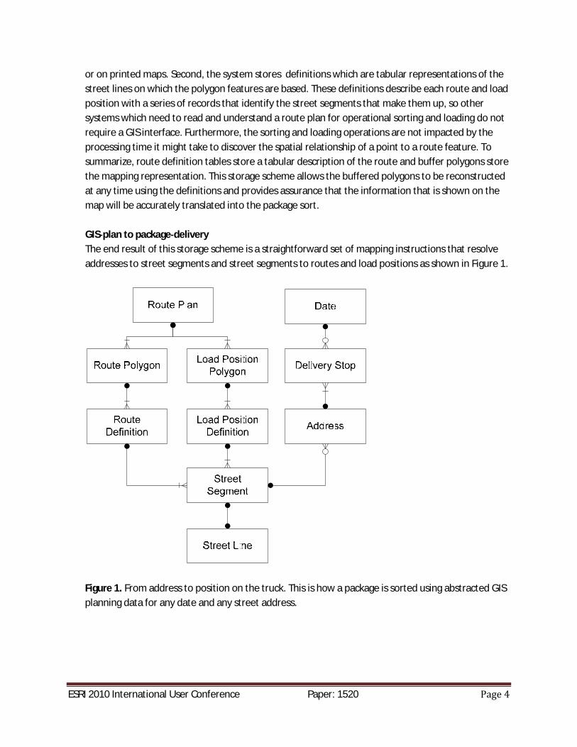
GIS plan to package deliveryThe end result of this storage scheme is a straightforward set of mapping instructions that resolveaddresses to street segments and street segments to routes and load positions as shown in Figure 1.
Figure 1. From address to position on the truck. This is how a package is sorted using abstracted GISplanning data for any date and any street address.
ESRI 2010 International User Conference Paper: 1520
3.0 Application usage and architecture
User interfaces and workflowsRoute planning begins when the user specifies the parameters for the plan. For example, a plan maybe intended to cover only a two hour delivery period for Monday morning or accommodate specialcircumstances like a parade or stadium event. Once these parameters are established, planningbegins within an ArcGIS Desktop application by checking the plan out for editing. This application iscalled the T2 Rich Client. Task specific tools are provided within the Rich Client that allow users toquickly aggregate street segments into plan elements such as routes and load positions. A moredetailed use case level description of some of these tools is provided in Section 4.
Once a basic plan structure has been established using interactive tools within the Rich Client, offboard business analysis is executed on the preliminary plan. This analysis runs asynchronously andthe user is notified when the analysis has finished. Once finished, results of the analysis are thendisplayed on the map and the user continues to work within the Rich Client to tune the plan usingfeedback from the analysis.
After the plan is finished and the validity of the plan has been confirmed using automated validationtools within the Rich Client, the plan is saved by checking it back in. Plans that are in a validgeographic state which have undergone business analysis and are checked in are available to beviewed by a read only web mapping viewer that is implemented in the ArcGIS Server Java ADFknown as the T2 Map Viewer. The Map Viewer cannot modify the plans, however users can view theplans to help select the appropriate plan for the production sort and initiate a map printing processto communicate the plans to the couriers.
Other web mapping applications that are used for tasks necessary to pre and post planning includean address geocoding re match processor (RJP) where users can view historical stops on a mapalong with listings of addresses which could not be geocoded automatically. Users are able to selectan address and click a point on the map where the address should be located. The application thenuses reverse geocoding to tie the non geocodeable address to the nearest valid address on a streetsegment for assignment to a route and load position. Also included is a route analysis tool calledPlanet Station that shows a courier’s stops after stops were made and helps identify problem areaswhich may have affected productivity or caused service failures.
More detail on the use cases of the tools mentioned in this section can be found in Sections 4 and 5.
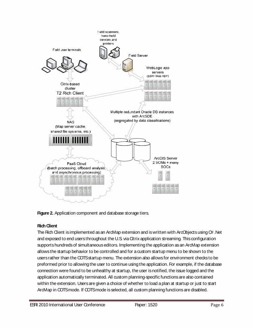
Technical implementationEach application in the system is isolated onto its own tier. The ArcGIS Server Java ADF applicationsare further isolated into sub tiers. Figure 2 shows each tier and how the tiers communicate with oneanother.
ESRI 2010 International User Conference Paper: 1520
Figure 2. Application component and database storage tiers.
Rich ClientThe Rich Client is implemented as an ArcMap extension and is written with ArcObjects using C# .Netand exposed to end users throughout the U.S. via Citrix application streaming. This configurationsupports hundreds of simultaneous editors. Implementing the application as an ArcMap extensionallows the startup behavior to be controlled and for a custom startup menu to be shown to theusers rather than the COTS startup menu. The extension also allows for environment checks to bepreformed prior to allowing the user to continue using the application. For example, if the databaseconnection were found to be unhealthy at startup, the user is notified, the issue logged and theapplication automatically terminated. All custom planning specific functions are also containedwithin the extension. Users are given a choice of whether to load a plan at startup or just to startArcMap in COTS mode. If COTS mode is selected, all custom planning functions are disabled.
ESRI 2010 International User Conference Paper: 1520
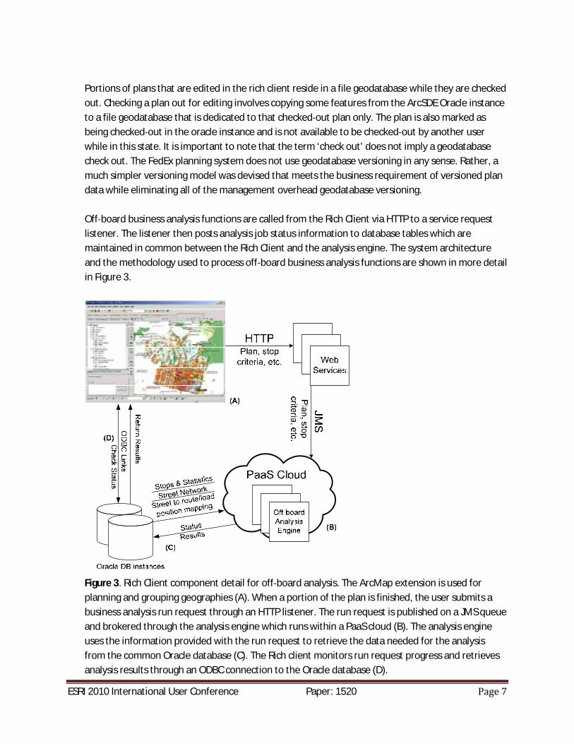
Portions of plans that are edited in the rich client reside in a file geodatabase while they are checkedout. Checking a plan out for editing involves copying some features from the ArcSDE Oracle instanceto a file geodatabase that is dedicated to that checked out plan only. The plan is also marked asbeing checked out in the oracle instance and is not available to be checked out by another userwhile in this state. It is important to note that the term ‘check out’ does not imply a geodatabasecheck out. The FedEx planning system does not use geodatabase versioning in any sense. Rather, amuch simpler versioning model was devised that meets the business requirement of versioned plandata while eliminating all of the management overhead geodatabase versioning.
Off board business analysis functions are called from the Rich Client via HTTP to a service requestlistener. The listener then posts analysis job status information to database tables which aremaintained in common between the Rich Client and the analysis engine. The system architectureand the methodology used to process off board business analysis functions are shown in more detailin Figure 3.
Figure 3. Rich Client component detail for off board analysis. The ArcMap extension is used forplanning and grouping geographies (A). When a portion of the plan is finished, the user submits abusiness analysis run request through an HTTP listener. The run request is published on a JMS queueand brokered through the analysis engine which runs within a PaaS cloud (B). The analysis engineuses the information provided with the run request to retrieve the data needed for the analysisfrom the common Oracle database (C). The Rich client monitors run request progress and retrievesanalysis results through an ODBC connection to the Oracle database (D).
ESRI 2010 International User Conference Paper: 1520
Web ApplicationsThe web mapping toolset contains the Web Viewer, RJP, and Planet Station applications describedabove. These applications provide web mapping capability to users through ArcGIS Server, the JavaWeb ADF, and fine grained ArcObjects applications written in Java. All web applications sharecommon deployment tiers. The web application client code is extensive in terms of capability and allbusiness logic for the mapping application is contained in the Java ADF tier and deployed usingWebLogic application server. The application server tier makes client use of ArcGIS Server whichresides on a separate tier. Map rendering and fine grain ArcObjects processing services are providedto the ADF tier through a SOC/SOM cluster that is distributed across several hosts to provide loadbalancing and redundancy.
Data ServicesAll of the applications make use of an Oracle database instance for persisting data and thisrepository serves as a communication mechanism between applications which mostly make no useof services based architecture methods. Permanent route plan and address data are stored inOracle and evolve through a versioning and data updating scheme on a daily basis. Vendor data suchas streets and postal code polygons are also stored in Oracle and changes are made to vendor datathrough a regular scheduled update process. File based data is also used in the planning process tosupport versioned data requirements when planning data is checked out for editing. A cached tilerepresentation of basemap data is also stored on the file system and provides vendor and businessdata map tiles to web clients and mapping applications for data which does not change very often.
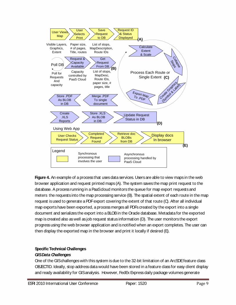
Figure 4 shows an example of one of the data services workflow patterns used in the system. In thisexample, the web application is used to request a set of exported PDF maps representing a pickupand delivery service area. Data services are used to provide the map export process with plan datadescribing the routes. The oracle database is then used to store the output of the map exportprocess for later on demand retrieval by the user.
ESRI 2010 International User Conference Paper: 1520
User ViewsMap
User Selects
Visible Layers,Graphics,
Extent
Paper size,# of pages,Title, routes
Save Request
to DB
List of stops,MapDescription,
Route IDs
Request ID& Status
Displayed
Poll DB
Poll for Requests
Andcapacity
Request & CapacityAvailable
GetRequestFrom DB
Capacity controlled by PaaS Cloud
List of stops, MapDesc, Route IDs,
paper size, # pages, title
Process Each Route or Single Extent
CalculateExtent
& Scale Collapse
Stops
Export MapTo .PDF Create
Graphic
s
(Sym
bol &
Labe
l)
Merge .PDFTo single document
Store .PDFAs BLOB
in DB
Create .XLS
Reports
Store .XLSAs BLOB
in DB
Update Request Status in DB
User ChecksRequest Status
Using Web AppCompleted Request Found
Retrieve doc BLOBs from DB
Display docsIn browser
LegendSynchronous processing that involves the user
Asynchronous processing handled by PaaS Cloud
(A)
(B)
(C)
(D)
(E)
Figure 4. An example of a process that uses data services. Users are able to view maps in the webbrowser application and request printed maps (A). The system saves the map print request to thedatabase. A process running in a PaaS cloud monitors the queue for map export requests andmeters the requests into the map processing service (B). The spatial extent of each route in the maprequest is used to generate a PDF export covering the extent of that route (C). After all individualmap exports have been exported, a process merges all PDFs created by the export into a singledocument and serializes the export into a BLOB in the Oracle database. Metadata for the exportedmap is created also as well as job request status information (D). The user monitors the exportprogress using the web browser application and is notified when an export completes. The user canthen display the exported map in the browser and print it locally if desired (E).
Specific Technical ChallengesGIS Data ChallengesOne of the GIS challenges with this system is due to the 32 bit limitation of an ArcSDE feature classOBJECTID. Ideally, stop address data would have been stored in a feature class for easy client displayand ready availability for GIS analysis. However, FedEx Express daily package volumes generate
ESRI 2010 International User Conference Paper: 1520
enough stops nationwide to exceed the 2.1 billion row limitation in a relatively short amount oftime. The solution to this challenge was to store the stop data in non spatial tables and include thelatitude and longitude as fields, without geodatabase columns or registration. When stop data isrequired for analysis or display, the appropriate stops are queried using standard SQL and then theclient either persists the results into temporary feature classes (as in the rich client) or into graphicelements that contain symbology and text elements for the labels (as in the ADF web applications).This solution is not ideal because of much of the complexity and business logic to support thisfunctionality resides at the client and is re implemented differently within each client based on thearchitecture.
Another challenge is the nationwide map cache. The map cache that supports the web applicationsis about 600 GB in size for the U.S. and the cached map scales meet a large percentage of thebusiness need. However, there are some scenarios where users need to zoom into scales that arelarger than the largest cached scale. For those cases, the web applications automatically switch todynamically rendered maps. This scenario offers a better compromise between not using caching atall and caching at very large scales when considering the time required to generate the cache duringregular data updates and the low likelihood that many of the tiles that were cached at the highestresolution would ever be accessed. More recent options for caching on demand and perhaps a mapservice that is sufficiently performant to eliminate the need for caching entirely are currently underconsideration. Building and managing an appropriate cache that is complete and can be generatedin a reasonable amount of time have been considerable challenges.
Functional and system challengesAn inherent challenge in any mapping application that displays dense point data is communicatingpoint locations accurately, but not allowing stacked points at small scales to overrun one another.There are several FedEx data scenarios that can cause multiple stops to be at the exact samelatitude and longitude or very close together at normal map viewing scales. The challenge ofdisplaying only relevant information for each overrun location was overcome by spatially clusteringthe stops before the graphic elements are created. Point stop features are collapsed and therepresentative symbol on the map is changed to indicate a cluster location based in the scale thatthe map is being rendered. Furthermore, the text label in this scenario is changed to showinformation about all of the features in the cluster. The logic for clustering runs with the other logicin the ADF tier and performance is always a consideration. A possible future solution to theperformance issue may be moving the logic into a Java Server Object Extension or perhaps clusteringon a new generation client using the FLEX API. New architecture options which did not exist whenthe current application was designed could help to more effectively overcome the limitations of anapplication server architectures to deliver better performance and more interactivity to the enduser.
Another challenge is map printing. Users of the web applications can request that map views beexported to PDF. Some of these maps can be very intense maps with lots of features and streetlevel details displayed at relatively large scales. Therefore, the exporting of these maps to .PDF is
ESRI 2010 International User Conference Paper: 1520
handled asynchronously and queued based upon hardware availability. For these maps, speed ofgetting the final product is not a primary concern and map requests are processed through thequeue as demand for resources permits.
A same day mapping which shows a courier’s route area and stops for the day is another printingchallenge. Speed is the main concern for the daily map export process and a special dedicated mapserver cache is used to produce these maps since relying on ArcGIS Server to process them wouldhave represented a bottleneck. A custom application with tile edge matching logic was developedfor this purpose. The application edge matches tiles from the tile library and places graphic symbolson the maps using java graphics libraries before outputting the end product to PDF.
4.0 Planning operations
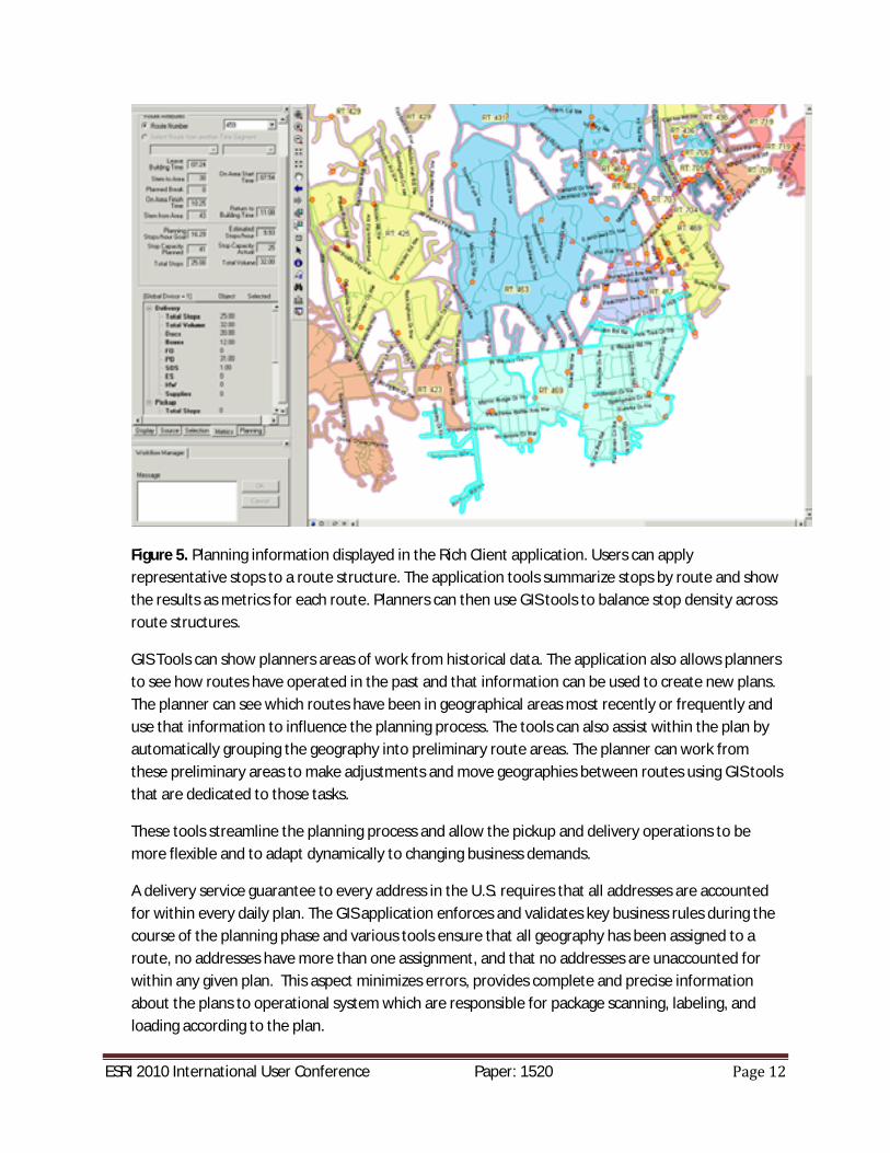
Specific planning groups at FedEx Express are responsible for analyzing, developing, communicating,and distributing plans to the operations personnel at the stations across the U.S. and other countriesfor the pickup and delivery portions of the process. The planning groups use customer and businessinformation from past dates along with the GIS application to assign addresses from a streetsegment or multiple streets to routes for delivery assignment. As the volume changes acrossdifferent weekdays within the Express system, the plans need to change as well in order to achievethe most efficient operation of the business. Planners must review vast amounts of data anddevelop plans for every day that dictates changes in the operation. Saturdays, holiday periods, andChristmas peak season represent some examples of periods when the pickup and deliveryoperations change dramatically. Almost every day of the week requires some level of fluctuationwithin the plans to ensure the Express business meets its commitments to customers’ needs andoperates in the most efficient manner as well. Operations personnel are provided differentoperating plans based upon the changing needs of these examples. The GIS tool allows planners toreview these changes on a daily basis and adjust route areas or metrics so that the pickup anddelivery operations can execute efficiently with each variation. Adjustments can be based uponvolume changes, changes in stop density, more or less routes, or schedules. All of this informationcan be viewed within the GIS application to determine optimal plans. Figure 5 shows an example ofsome of the information that is available to the planning analyst while using the application.
ESRI 2010 International User Conference Paper: 1520
Figure 5. Planning information displayed in the Rich Client application. Users can applyrepresentative stops to a route structure. The application tools summarize stops by route and showthe results as metrics for each route. Planners can then use GIS tools to balance stop density acrossroute structures.
GIS Tools can show planners areas of work from historical data. The application also allows plannersto see how routes have operated in the past and that information can be used to create new plans.The planner can see which routes have been in geographical areas most recently or frequently anduse that information to influence the planning process. The tools can also assist within the plan byautomatically grouping the geography into preliminary route areas. The planner can work fromthese preliminary areas to make adjustments and move geographies between routes using GIS toolsthat are dedicated to those tasks.
These tools streamline the planning process and allow the pickup and delivery operations to bemore flexible and to adapt dynamically to changing business demands.
A delivery service guarantee to every address in the U.S. requires that all addresses are accountedfor within every daily plan. The GIS application enforces and validates key business rules during thecourse of the planning phase and various tools ensure that all geography has been assigned to aroute, no addresses have more than one assignment, and that no addresses are unaccounted forwithin any given plan. This aspect minimizes errors, provides complete and precise informationabout the plans to operational system which are responsible for package scanning, labeling, andloading according to the plan.
ESRI 2010 International User Conference Paper: 1520
5.0 Tools for execution and using GIS for post execution analysis
The FedEx Express mapping tools described in Section 3 contain several web based applications thatprovide GIS functionality to literally thousands of internal customers who are responsible for allaspects of the business of ensuring that FedEx packages are picked up and delivered on time. TheRich Client is primarily a tool for planning and a relatively small number of experts have access to it.The web applications described in this section have a much larger base of users and areinstrumental in supporting the operational GIS needs.
Historical data analysisOne of the very first business use cases for FedEx Express pickup and delivery mapping tools is stillrelevant today and involves plotting historical stops on a map. Historical stops (as recent as one dayin the past) are shown on the map and different labeling and symbology are used to analyze thestops and routes to compare what was planned to occur versus what actually did occur. Package toroute assignments are compared to the routes that actually delivered each package and variancesare highlighted. The purpose of this mapping and analysis is to determine if productivity issues orservice failures may be problems with route design. Route boundaries can then be adjusted withinthe rich client to better distribute the stops among the routes.
Printed maps are an indispensible tool for communicating operational information such thehistorical stops use case mentioned above. The web application suite contains a map exportapplication where maps are created based on the extents/data viewed on screen as in the previoususe case. PDF documents are exported that show a map area containing at least the on screen mapextent. However, the user has the ability to specify paper size and number of pages across which tobreak the map up for formatting purposes. The user then has the ability to download that .PDF andstore, email, print as necessary.
Another distinct set of use cases center around viewing the planned route structures on a map.These are the route structures that were designed using the ArcMap Rich Client discussed earlier.There are a small number of users who are skilled and authorized to use that particular tool.However, there are thousands of employees affected by the plans those users build. The webmapping toolset includes a Web Viewer product focused upon viewing, communicating, andanalyzing those planned structures. The most basic use case for the Web Viewer is to simply displayroute features that represent the plan on a map and allow people to pan and zoom through the mapto see the geography covered by those features. Users can also choose to overlay historical stopson the same map that shows the route plan as well as user defined address points. All of thisinformation together on one map provides the user with information regarding the feasibility ofimplementing the plan based upon densities of stops.
Same day operational supportThe FedEx Express operational service model allows for flexible and customer focused serviceofferings such as same day request for shipment pick up. FedEx Express dispatchers use the webapplication to see which routes (i.e. FedEx vehicles) have historically handled a given address or
ESRI 2010 International User Conference Paper: 1520
neighborhood for the purposes of assigning an on call pickup request. Dispatchers can enter anaddress into the system which will be geocoded and the map will zoom to the area around thataddress. The dispatcher then has the ability to see which couriers have familiarity with theneighborhood and/or customer. The dispatchers can also enter multiple addresses to receive pointto point driving directions in case a driver is not familiar with a specific address.
The web application framework also provides support for planned execution by exporting andprinting map for courier use since there is no practical electronic access to this information while onthe road. Each driver can be provided a map that shows their route area along with the plannedstops for their pickup and delivery period. Preparing these maps and getting them distributed isquite a time critical process and a particular IT challenge. More detail about the implementationchallenge of this process and queuing and exporting maps in general can be found toward the endof Section3.
6.0 Summary
The implementation and use of GIS in planning and daily operations at FedEx Express has providedmany tangible and intangible benefits and has also had its share of challenges. The geographicplanning tool has provided an accurate method to predict the daily required number of routes, thestop capacity for each delivery route and recommended delivery stop sequencing. This capabilityhas minimized the number of on road hours for the workforce and balanced the route and couriercapacity. The benefits are saved fuel and improved level of service to the customer through moreefficient use of resources.
There have been many challenges in developing systems to accomplish the goals that have beenattained – both domestically and internationally. Many independent software tools and systemswere integrated to provide the required functionality and software components require distincthardware and software configurations. For example ArcMap running on Windows/Citrix was usedfor the Rich Client because many of the required functions in the Planning toolkit were full functionESRI Desktop GIS tools and Windows based enterprise applications are a deviation from thestandard FedEx IT approach of application server based web clients and service orientedarchitectures. The system described in this paper consists of both (web and thick Windows clients)and supporting both as well as developing server based applications to "talk" between the tiers andclient types has had challenges pertaining to response time, hardcopy printing output, and securityissues.
A particular challenge for any company with a service profile such as FedEx is the geocodingrequired to geo locate every address necessary for pickup or delivery of a package. Each day, thereare new addresses that the system has not encountered previously, changes to postal codes, andthe constant variability of customer supplied address information. Many addresses that come intoFedEx on a daily basis are "unresolved” or unmatched after initial automated geocoding processes.Different methods are used to correct these addresses in a small window of time and developingand maintain these methods is a challenge that will continue to grow as we roll out this planningproduct internationally. Each new country represents challenges due to the limited amount ofgeocoding and street network data available to the tools.
ESRI 2010 International User Conference Paper: 1520
Time is usually the primary driver of implementing new features or improvements to systems whenthe commitment to reliable on time service is as important as it is at FedEx Express. A major hurdleof integrating this system has been the ability to accomplish all of the execution "pieces" in such asmall amount of time. Critical shipments can be contracted late into the evening for delivery earlythe next morning and package processing according to a plan must be done for millions ofshipments on a daily basis in a very short timeframe. . Time saving methods and state of the arttechnologies (such as cloud computing) have been employed to meet the challenge of minimizeresponse and execution processing times.
Many intangible benefits have resulted directly from precise planning as well. With automaticassignment of packages to geographic areas, the workforce responsible for sorting packages andloading vehicles no longer needs to maintain thorough knowledge of the area for which they areresponsible. There is consequently less stress in the mornings during the sort because staff nolonger worry that a package for another delivery area will be loaded onto the wrong vehicle.Additionally, the planning tools have enabled route design that equalizes load across all couriers andminimizes conditions where there is too much work for some staff while others do not have enoughwork to stay busy.