Embed Size (px)
Citation preview

i
Los Angeles-Long Beach Vessel Traffic Service
(VTS)
USER MANUAL
Operated by:
Marine Exchange of and United States Southern California Coast Guard
In partnership with:
California Office of Spill Prevention & Response
Port of Long Beach
Port of Los Angeles
and all Waterway Users
Enhancing safe, environmentally sound
and efficient maritime transportation for:
San Pedro Channel Santa Monica Bay Port of Los Angeles Port of Long Beach Revised July 01, 2015
VTS USER MANUAL
INTRODUCTION San Pedro VTC Los Angeles – Long Beach VTC
The purpose of the Vessel Traffic Service is to improve vessel transit safety by providing vessel operators with advance information of other reported marine traffic and any additional information, advice and recommendations which may affect vessel traffic safety within the VTS area. The goal of the Los Angeles/Long Beach Vessel Traffic Service is to provide seamless navigational information to improve vessel transit safety. The Coast Guard/ Marine Exchange, Los Angeles Pilots and Long Beach Pilots each specializing in their own area, have worked together to create a unique system. The Vessel Traffic Service is a cooperative effort of the State of California, U.S. Coast Guard, Marine Exchange of Southern California, Ports of Los Angeles and Long Beach, and under the authority of California Government Code Section 8670.21, Harbors and Navigation Code Section 445-449.5 and the port tariffs of Los Angeles and Long Beach. The VTS is listed in the Federal Regulations under Title 33CFR Part 161 Vessel Traffic Management. Vessels outside the federal breakwater to 25 nm from Point Fermin will be provided with vessel traffic information through “San Pedro Vessel Traffic Center”. San Pedro Traffic VTC is a jointly operated by the Coast Guard and the Marine Exchange. The VTC will provide vessel operators with information. Vessels inside the federal breakwater within the boundaries of the Los Angeles and Long Beach sectors will be provided with advisory information on other reported marine traffic and any additional information available to the VTC’s that may affect vessel traffic safety within their sector. This manual is derived from a Memorandum of Agreement (MOA) for Vessel Traffic Management in the Los Angeles-Long Beach Approaches & Harbors and the Los Angeles/Long Beach Harbor Safety Plan. It is intended to provide the user with information necessary for participation within the Los Angeles/Long Beach Vessel Traffic Service (from 25nm from PT Fermin to berth or anchorage inside the federal breakwater). This manual is not intended to conflict with or modify any existing regulations in any respect, and vessels within the VTS area shall be responsible for their safe navigation in accordance with existing international and local rules (including the Harbor Safety Plan).
VTS USER MANUAL
THE MARINER IS CAUTIONED THAT INFORMATION PROVIDED BY VESSEL TRAFFIC CENTERS IS TO A LARGE EXTENT BASED UPON REPORTS OF PARTICIPATING VESSELS AND CAN BE NO MORE ACCURATE THAN THE INFORMATION RECEIVED. THE VTS CENTERS MAY NOT KNOW OF ALL HAZARDOUS CIRCUMSTANCES WITHIN THE VESSEL TRAFFIC AREA. UNREPORTED HAZARDS MAY CONFRONT THE MARINER AT ANY TIME. ANY CONFLICTING CIRCUMSTANCES OR HAZARDOUS CONDITIONS SHOULD BE REPORTED TO THE APPLICABLE VESSEL TRAFFIC CENTER IMMEDIATELY. We encourage all interested parties to visit the Marine Exchange Vessel Traffic Center, the Los Angeles Pilot Station and the Long Beach Pilot Station. We encourage suggestions for improvements to this manual or to the VTS procedures. Suggestions may be mailed to: Marine Exchange of Southern California Vessel Traffic Center P.O. Box 1949 San Pedro, CA 90733-1949; U.S.A. Phone: (310) 519-3134 (Administration Office) (310) 832-6411 (24 hour Operations Center) (310) 519-3128 (Accounting Manager) (310) 832-7238 (Fax) (Web Site): www.mxsocal.org Twitter: @mxsocal.org
Table of Contents
VTS USER MANUAL
Section 1: GENERAL RULES VTS SECTOR CHARTLET ....................................................................... 1-1 1.1 Purpose ................................................................................................. 1-2 1.2 Applicability ........................................................................................ 1-2 1.3 Definitions ............................................................................................ 1-4 1.4 Laws and Regulations Not Affected .................................................... 1-4 1.5 Emergencies ......................................................................................... 1-4 Section 2: COMMUNICATION PROCEDURES 2.1 Radio Listening Watch ........................................................................ 2-1 2.2 Radiotelephone Equipment and Procedures ........................................ 2-1 2.3 English Language ................................................................................. 2-1 2.4 Time ..................................................................................................... 2-1 2.5 Report of Emergency or Radio Failure ................................................ 2-2 2.6 Report of Impairment to the Operation of the Vessel .......................... 2-2 Section 3: VESSEL MOVEMENT AND REPORTING PROCEDURES 3.1 Vessel Participation Requirements ...................................................... 3-1 3.2 Checking into the VTS (San Pedro Sector) ........................................ 3-2 3.3 Reporting Movements within the VTS (San Pedro Sector) ................ 3-2 3.4 Checking out of the VTS (San Pedro Sector) .................................... 3-3 3.5 Additional Reporting ........................................................................... 3-3 3.6 Reporting Movements within Los Angeles / Long Beach Sectors ...... 3-4
APPENDIX A Description and Geographic Coordinates A.1 Regulated Navigation Area (RNA)/Precautionary Area ..................... A-1 A.2 Traffic Separation Scheme (TSS) ...................................................... A-4 A.3 Santa Barbara Traffic Separation Scheme Amendment..................... A-4 A.4 Traffic Lanes Description .................................................................. A-5 TRAFFIC LANE CHARTLET ................................................................. A-7 A.5 Voluntary Western Traffic Lanes ...................................................... A-8 VOLUNTARY WESTERN TRAFFIC LANE CHARTLET ................. .A-10 APPENDIX B Notice of Marine Casualty B.1 Notice of Marine Casualty 46 CFR 4.05-1 ....................................... B-1 B.2 Substance of Marine Casualty Notice 46 CFR 4.05-5 ...................... B-1 APPENDIX C Check Off List for Reporting Points ............................. C-1 APPENDIX D VTS User Fee Tariff ..................................................... D-1
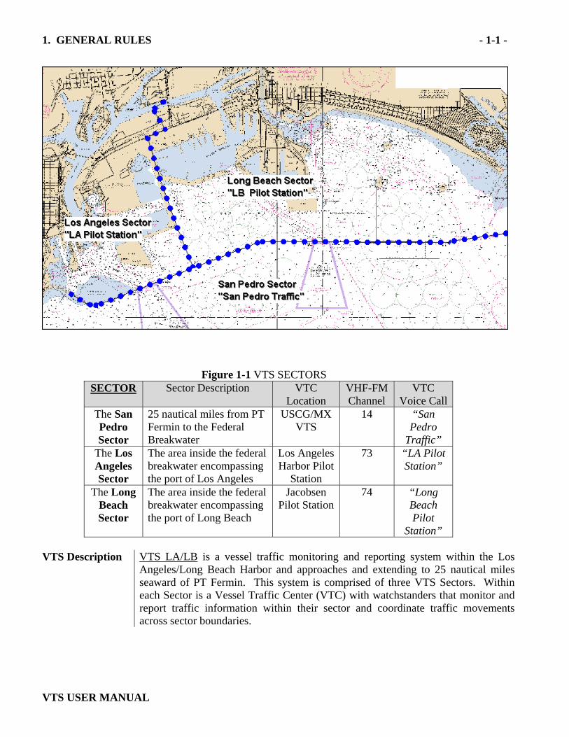
1. GENERAL RULES - 1-1 -
VTS USER MANUAL
Figure 1-1 VTS SECTORS SECTOR Sector Description VTC
Location VHF-FM Channel
VTC Voice Call
The San Pedro Sector
25 nautical miles from PT Fermin to the Federal Breakwater
USCG/MX VTS
14 “San Pedro
Traffic” The Los Angeles Sector
The area inside the federal breakwater encompassing the port of Los Angeles
Los Angeles Harbor Pilot
Station
73 “LA Pilot Station”
The Long Beach Sector
The area inside the federal breakwater encompassing the port of Long Beach
Jacobsen Pilot Station
74 “Long Beach Pilot
Station” VTS Description VTS LA/LB is a vessel traffic monitoring and reporting system within the Los
Angeles/Long Beach Harbor and approaches and extending to 25 nautical miles seaward of PT Fermin. This system is comprised of three VTS Sectors. Within each Sector is a Vessel Traffic Center (VTC) with watchstanders that monitor and report traffic information within their sector and coordinate traffic movements across sector boundaries.
1. GENERAL RULES - 1-2 -
VTS USER MANUAL
1.1 Purpose The VTS for the Los Angeles-Long Beach Harbor and approaches has been
established to monitor traffic and provide mariners with timely, relevant and accurate information for the purpose of enhancing safe, environmentally sound and efficient maritime transportation.
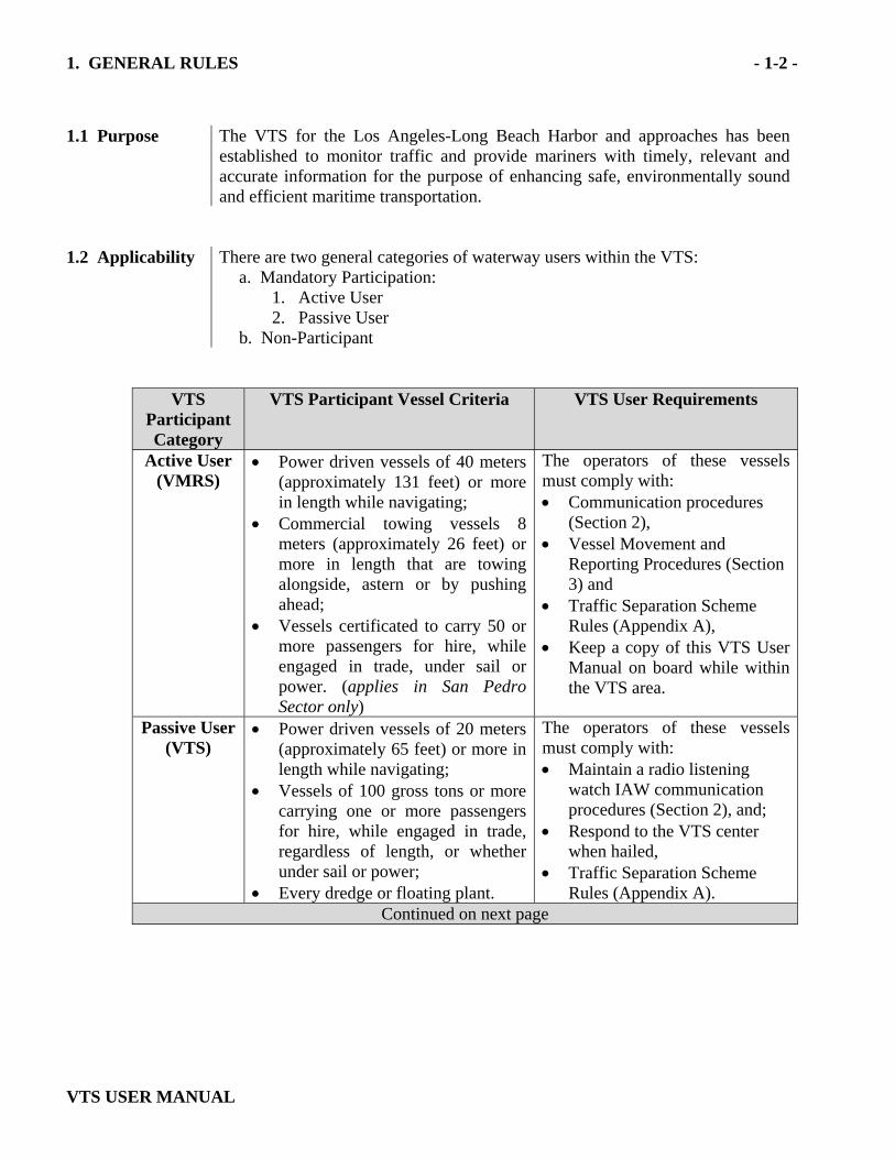
1.2 Applicability There are two general categories of waterway users within the VTS:
a. Mandatory Participation: 1. Active User 2. Passive User
b. Non-Participant
VTS Participant Category
VTS Participant Vessel Criteria
VTS User Requirements
Active User (VMRS)
• Power driven vessels of 40 meters (approximately 131 feet) or more in length while navigating;
• Commercial towing vessels 8 meters (approximately 26 feet) or more in length that are towing alongside, astern or by pushing ahead;
• Vessels certificated to carry 50 or more passengers for hire, while engaged in trade, under sail or power. (applies in San Pedro Sector only)
The operators of these vessels must comply with: • Communication procedures
(Section 2), • Vessel Movement and
Reporting Procedures (Section 3) and
• Traffic Separation Scheme Rules (Appendix A),
• Keep a copy of this VTS User Manual on board while within the VTS area.
Passive User (VTS)
• Power driven vessels of 20 meters (approximately 65 feet) or more in length while navigating;
• Vessels of 100 gross tons or more carrying one or more passengers for hire, while engaged in trade, regardless of length, or whether under sail or power;
• Every dredge or floating plant.
The operators of these vessels must comply with: • Maintain a radio listening
watch IAW communication procedures (Section 2), and;
• Respond to the VTS center when hailed,
• Traffic Separation Scheme Rules (Appendix A).
Continued on next page
1. GENERAL RULES - 1-3 -
VTS USER MANUAL
VTS
Participant Category
VTS Participant Vessel Criteria
VTS User Requirements
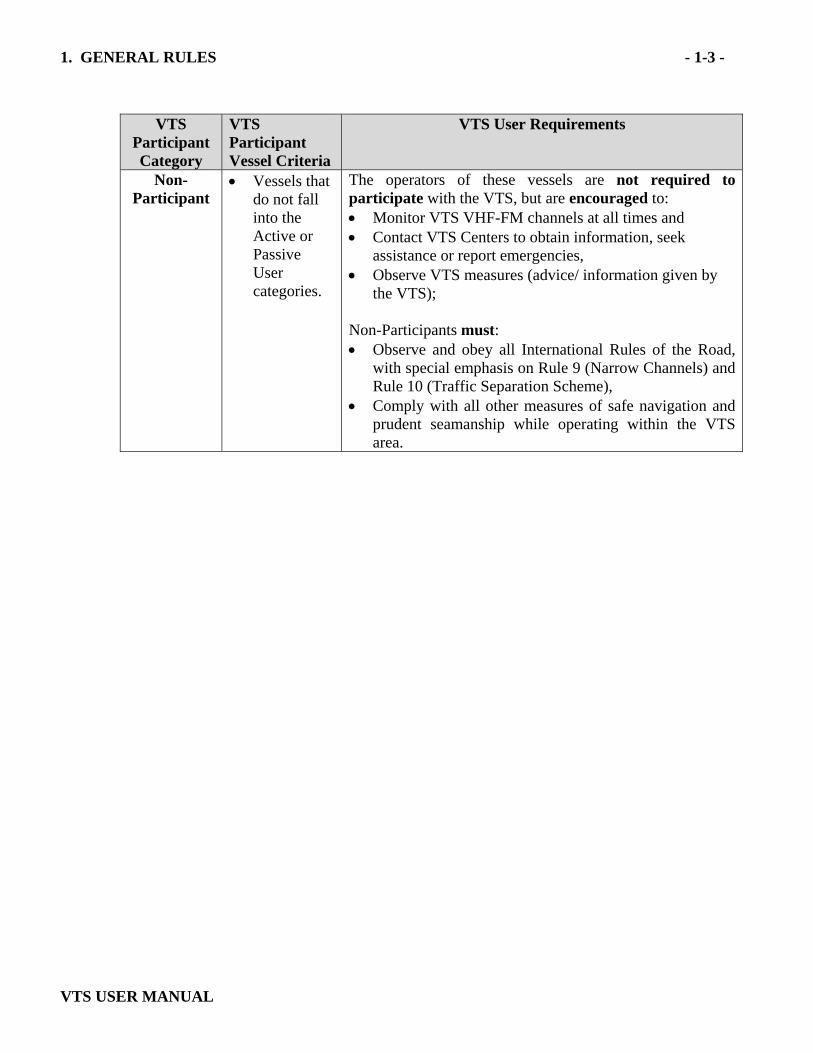
Non-Participant
• Vessels that do not fall into the Active or Passive User categories.
The operators of these vessels are not required to participate with the VTS, but are encouraged to: • Monitor VTS VHF-FM channels at all times and • Contact VTS Centers to obtain information, seek
assistance or report emergencies, • Observe VTS measures (advice/ information given by
the VTS); Non-Participants must: • Observe and obey all International Rules of the Road,
with special emphasis on Rule 9 (Narrow Channels) and Rule 10 (Traffic Separation Scheme),
• Comply with all other measures of safe navigation and prudent seamanship while operating within the VTS area.
1. GENERAL RULES - 1-4 -
VTS USER MANUAL
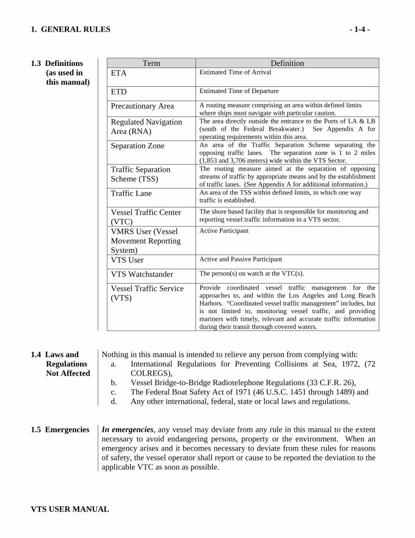
1.3 Definitions
(as used in this manual)
Term Definition ETA Estimated Time of Arrival
ETD Estimated Time of Departure
Precautionary Area A routing measure comprising an area within defined limits where ships must navigate with particular caution.
Regulated Navigation Area (RNA)
The area directly outside the entrance to the Ports of LA & LB (south of the Federal Breakwater.) See Appendix A for operating requirements within this area.
Separation Zone An area of the Traffic Separation Scheme separating the opposing traffic lanes. The separation zone is 1 to 2 miles (1,853 and 3,706 meters) wide within the VTS Sector.
Traffic Separation Scheme (TSS)
The routing measure aimed at the separation of opposing streams of traffic by appropriate means and by the establishment of traffic lanes. (See Appendix A for additional information.)
Traffic Lane
An area of the TSS within defined limits, in which one way traffic is established.
Vessel Traffic Center (VTC)
The shore based facility that is responsible for monitoring and reporting vessel traffic information in a VTS sector.
VMRS User (Vessel Movement Reporting System)
Active Participant
VTS User Active and Passive Participant
VTS Watchstander The person(s) on watch at the VTC(s).
Vessel Traffic Service (VTS)
Provide coordinated vessel traffic management for the approaches to, and within the Los Angeles and Long Beach Harbors. “Coordinated vessel traffic management” includes, but is not limited to, monitoring vessel traffic, and providing mariners with timely, relevant and accurate traffic information during their transit through covered waters.
1.4 Laws and
Regulations Not Affected
Nothing in this manual is intended to relieve any person from complying with: a. International Regulations for Preventing Collisions at Sea, 1972, (72
COLREGS), b. Vessel Bridge-to-Bridge Radiotelephone Regulations (33 C.F.R. 26), c. The Federal Boat Safety Act of 1971 (46 U.S.C. 1451 through 1489) and d. Any other international, federal, state or local laws and regulations.
1.5 Emergencies In emergencies, any vessel may deviate from any rule in this manual to the extent
necessary to avoid endangering persons, property or the environment. When an emergency arises and it becomes necessary to deviate from these rules for reasons of safety, the vessel operator shall report or cause to be reported the deviation to the applicable VTC as soon as possible.
2. COMMUNICATION PROCEDURES - 2-1 -
VTS USER MANUAL
2.1 Radio
Listening Watch
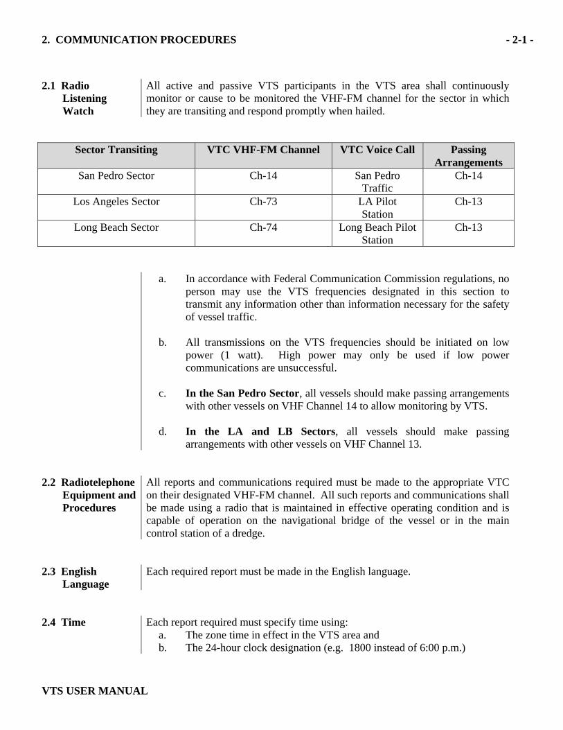
All active and passive VTS participants in the VTS area shall continuously monitor or cause to be monitored the VHF-FM channel for the sector in which they are transiting and respond promptly when hailed.
Sector Transiting VTC VHF-FM Channel
VTC Voice Call Passing Arrangements
San Pedro Sector Ch-14 San Pedro Traffic
Ch-14
Los Angeles Sector Ch-73 LA Pilot Station
Ch-13
Long Beach Sector Ch-74 Long Beach Pilot Station
Ch-13
a. In accordance with Federal Communication Commission regulations, no
person may use the VTS frequencies designated in this section to transmit any information other than information necessary for the safety of vessel traffic.
b. All transmissions on the VTS frequencies should be initiated on low
power (1 watt). High power may only be used if low power communications are unsuccessful.
c. In the San Pedro Sector, all vessels should make passing arrangements
with other vessels on VHF Channel 14 to allow monitoring by VTS.
d. In the LA and LB Sectors, all vessels should make passing arrangements with other vessels on VHF Channel 13.
2.2 Radiotelephone
Equipment and Procedures
All reports and communications required must be made to the appropriate VTC on their designated VHF-FM channel. All such reports and communications shall be made using a radio that is maintained in effective operating condition and is capable of operation on the navigational bridge of the vessel or in the main control station of a dredge.
2.3 English
Language Each required report must be made in the English language.
2.4 Time Each report required must specify time using:
a. The zone time in effect in the VTS area and b. The 24-hour clock designation (e.g. 1800 instead of 6:00 p.m.)
2. COMMUNICATION PROCEDURES - 2-2 -
VTS USER MANUAL
2.5 Report of
Emergency or Radio Failure
Whenever a vessel deviates from any rule in the Bridge to Bridge Radiotelephone Act because of an emergency or radio failure, it shall report the deviation to the San Pedro Sector VTC as soon as possible.
2.6 Report of
Impairment to the Operation of the Vessel
A vessel in the VTS area shall report to the San Pedro Sector VTC as soon as possible:
a. Any emergency or unusual event such as fire, collision, grounding, man overboard, etc,
b. Any condition on the vessel that may impair its navigation, reduce its capabilities or affect the safety of other vessels due to defective propulsion, defective steering, inoperative navigation running lights, unusual handling, impaired maneuverability, inoperative whistle or horn, navigation equipment, etc. ,
c. Any tow that the towing vessel is unable to control or can control only with difficulty,
d. Any other unusual condition which restricts or prohibits total compliance with the requirements of the VTS.
e. This report satisfies immediate reporting requirements in 46 CFR 4.05-1 (see Appendix B).
3. VESSEL MOVEMENT AND REPORTING PROCEDURES -3-1 -
VTS USER MANUAL
3.1 Vessel Participation Requirements
These reporting requirements are to provide necessary information to the VTC watchstander(s) so they can utilize and pass timely, relevant and accurate information to VTS users. Active Participants are required to: • Monitor VTS frequencies, respond promptly when hailed • Check into the system, • Advise when actually underway, • Contact the applicable VTC when passing a Position Reporting Point or VTS
Sector boundary. Additional reporting may be necessary as determined by the appropriate VTC,
• Check out of the system upon reaching their destination. Passive participants are required to: • Monitor VTS frequencies, respond promptly when hailed. Non-Participants are highly encouraged to monitor VTS frequencies and communicate with participating vessels and/or VTCs as necessary.
3. VESSEL MOVEMENT AND REPORTING PROCEDURES -3-2 -
VTS USER MANUAL
San Pedro Sector
3.2 Checking into the VTS “San Pedro Sector”
When to Report Who to Contact
What to Report
Upon entering the VTS San Pedro Sector from Sea (at 25 nm VTS Boundary)
Call: San Pedro
Traffic on VHF-FM channel
14
a. Vessel name/call sign, b. Position (lat and long), c. Course and speed, d. Vessel destination, e. Whether the vessel is taking a
pilot or being piloted by master/commanding officer,
f. ETA to the sea buoy/pilot boarding area or El Segundo offshore moorings.
3.3 Reporting Movements within the VTS “San Pedro Sector”
Upon entering or departing the Precautionary Area (see Appendix A-1 for Precautionary Area vessel movement requirements)
Call: San Pedro
Traffic on VHF-FM channel
14
a. Vessel name/call sign, b. If entering: report that the
master/ commanding officer is on the bridge and that the vessel is being steered by hand,
c. Main propulsion machinery has been successfully tested ahead and astern, as required by 33CFR 164.25 (5) referenced in U.S.C.P. 7, Chapter 2 (3240),
d. If departing: report “departing Precautionary Area”,
e. Provide ETA.
3. VESSEL MOVEMENT AND REPORTING PROCEDURES -3-3 -
VTS USER MANUAL
San Pedro Sector
3.3 Reporting Movements
within the VTS “San Pedro Sector”
When to Report Who to Contact
What to Report
(Cont) Fifteen (15) minutes prior to commencing a movement within the San Pedro Sector (Preparing to get underway from anchorages outside the federal breakwater, El Segundo or Avalon anchorages)
Call: San Pedro
Traffic on VHF-FM channel
14
a. Vessel name/call sign, b. Vessel destination port or
direction of departure. If the vessel will cross the Traffic Separation Scheme, such vessel shall exercise utmost caution and comply with COLREGS Rule 10.
Upon getting underway outside the Federal Breakwater
Call: San Pedro
Traffic on VHF-FM channel
14
a. Vessel name/call sign, b. “Underway at this time, c. Any changes/updates to 15
minute check-in call, d. If Inbound and embarking
pilot, ETA to Sea Buoy. 3.4 Checking Out
of the VTS “San Pedro Sector”
Upon departing the San Pedro Sector bound for sea (at 25 nm VTS boundary)
Call: San Pedro
Traffic on VHF-FM channel
14
a. Vessel name/call sign, b. Vessel location,
c. "Checking out of VTS".
3.5 Additional Reporting
Additional Reporting (Additional reporting may be necessary or required as determined by the appropriate VTC
Call the VTC sector
requesting the report
a. Response back to the appropriate VTC sector with requested information, e.g. (San Pedro Traffic “Vessel’s Name & abeam the Sierra Papa (SP) buoy).
3. VESSEL MOVEMENT AND REPORTING PROCEDURES -3-4 -
VTS USER MANUAL
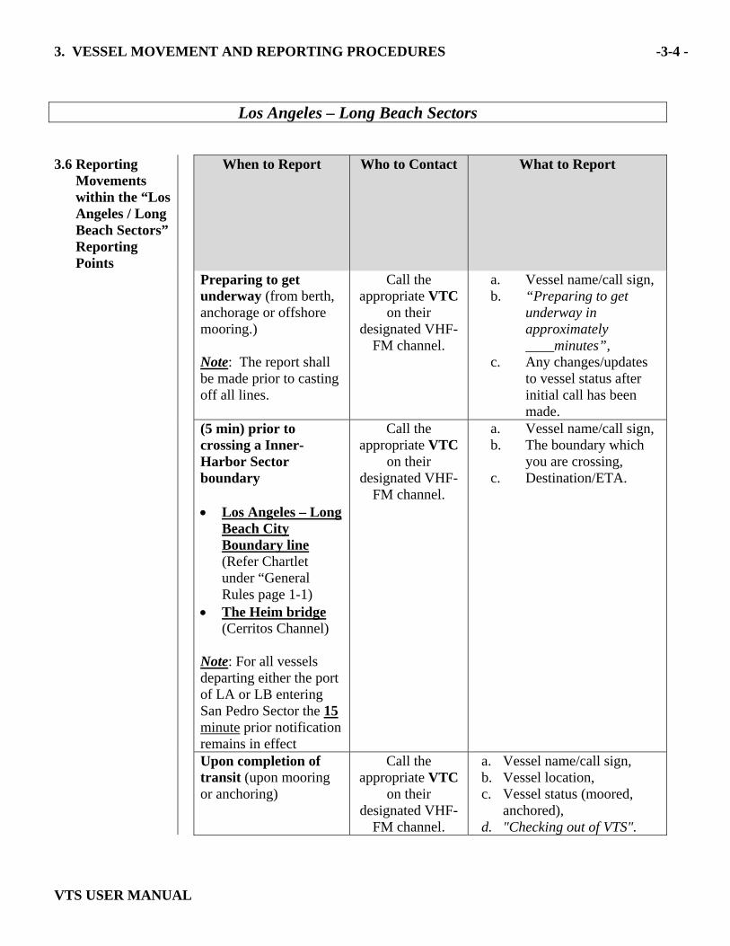
Los Angeles – Long Beach Sectors
3.6 Reporting
Movements within the “Los Angeles / Long Beach Sectors” Reporting Points
When to Report Who to Contact What to Report
Preparing to get underway (from berth, anchorage or offshore mooring.) Note: The report shall be made prior to casting off all lines.
Call the appropriate VTC
on their designated VHF-
FM channel.
a. Vessel name/call sign, b. “Preparing to get
underway in approximately ____minutes”,
c. Any changes/updates to vessel status after initial call has been made.
(5 min) prior to crossing a Inner-Harbor Sector boundary • Los Angeles – Long
Beach City Boundary line (Refer Chartlet under “General Rules page 1-1)
• The Heim bridge (Cerritos Channel)
Note: For all vessels departing either the port of LA or LB entering San Pedro Sector the 15 minute prior notification remains in effect
Call the appropriate VTC
on their designated VHF-
FM channel.
a. Vessel name/call sign, b. The boundary which
you are crossing, c. Destination/ETA.
Upon completion of transit (upon mooring or anchoring)
Call the appropriate VTC
on their designated VHF-
FM channel.
a. Vessel name/call sign, b. Vessel location, c. Vessel status (moored,
anchored), d. "Checking out of VTS".
APPENDIX (A): Description and Geographic Coordinates A-1
VTS USER MANUAL
A.1 Regulated
Navigation Area (RNA) and Precautionary Area
33 CFR 165.1152 San Pedro Bay, California--Regulated navigation area and Precautionary Area. (a) Location. The following are the geographic coordinates for the San Pedro
regulated navigation area and precautionary area: From Point Fermin Light (33-42.3’N, 118-17.6’W) thence along the shoreline to the San Pedro Breakwater, thence along the San Pedro Breakwater and the Middle Breakwater (following the COLREGS Demarcation Lines) to Long Beach Channel Entrance Light "2'' (33-43.4’N, 118-10.8’W), thence southeast to (33-37.7’N, 118-06.6’W); thence southwesterly to (33-35.5’N, 118-08.8’W); thence west to (33-35.5’N, 118-17.6’W); thence north to point of origin----.[Datum: NAD 1983]
(b) Pilot areas. There are two pilot areas within the regulated navigation area
described in paragraph (a). They are defined as follows:
(1) The Los Angeles Pilot Area is enclosed by a line beginning at Los Angeles Light (33-42.5’N, 118-15.0’W); thence easterly to Los Angeles Main Channel Entrance Light “6” (33-42.7’N, 118-14.1'W); thence southeasterly to (33-41.3'N, 118-13.5'W); thence southwesterly to (33-40.8'N, 118-14.8'W); thence north to the point of origin.[Datum: NAD 1983]
(2) The Long Beach Pilot Area is enclosed by a line beginning at Long
Beach Light (33-43.4'N, 118-11.2'W); thence easterly to Long Beach Channel Entrance Light “2” (33-43.4'N, 118-10.8'W); thence southeasterly to (33-41.5' N, 118-10.2' W); thence south to (33-40.5' N, 118-10.2' W); thence west to (33-40.5’N, 118-11.8’W), thence north to (33-41.5’ N, 118-11.8’ W), north northeasterly to the point of origin.[Datum: NAD 1983]
(3) The Los Angeles Deep Water Traffic Lane: This area is bounded by a
line beginning at (33-42’ 28.0”N, 118-14’ 56.9”W), thence easterly to (33-42’ 33.4”N, 118-14’ 45.0”W), thence southeasterly to (33-39’ 29.0”N, 118-13’ 19.4”W), thence westerly to (33-39’ 25.1”N, 118-13’ 33.0”W), thence northerly to the point of origin.
(4) The Long Beach Deep Water Traffic Lane: This area is bounded by a
line beginning at (33-43’ 25.5”N, 118-11’ 09.0”W), thence east to (33-43’ 23.3”N, 118-10’ 54.1”W), thence south to (33-41’ 30.8”N, 118-10’ 42.6”W), thence west to (33-41’30.0”N, 118-10’ 57.0”W), thence north to the point of origin.
(5) The Los Angeles Deep Water Pilot Boarding Area: This area is
defined by a circular area of 1.0nm diameter centered on position at

APPENDIX (A): Description and Geographic Coordinates A-2
VTS USER MANUAL
(33-39.0’ N, 118-13.19’ W).
(c) The following regulations apply to all vessels while operating within the regulated navigation area:
(1) Los Angeles Pilot Area:
(i) No vessel may enter the Los Angeles Pilot Area unless it is entering or departing the Los Angeles Harbor Entrance (Angel's Gate).
(ii) Vessels entering the Los Angeles Pilot Area shall pass directly through without stopping or loitering except as necessary to embark or disembark a pilot.
(2) Los Angeles Deep Water Pilot Area:
(i) When a vessel of 50 foot draft or greater is embarking or disembarking a pilot in the Los Angeles Deep Water Pilot Area no other vessel shall enter the Deep Water Pilot Area.
(3) Long Beach Pilot Area:
(i) No vessel may enter the Long Beach Pilot Area unless it is entering or departing Long Beach Harbor Entrance (Queen's Gate).
(ii) Every vessel entering the Long Beach Pilot Area shall pass directly through without stopping or loitering except as necessary to embark or disembark a pilot.
(iii)Every vessel shall leave Long Beach Approach Lighted Whistle Buoy ``LB'' to port when entering and departing Long Beach Channel and departing vessels shall pass across the southern boundary of the Long Beach Pilot Area.
(4) Los Angeles and Long Beach Deep Channels:
(i) When a vessel of 50 foot draft or greater is using the Los Angeles or Long Beach Deep Water Channel no other vessel shall enter the Deep Water Traffic Lane if it will result in a meeting, crossing or overtaking situation.
(d) The following regulations contained in paragraphs (d)(1) through (d)(4)
apply to vessels power driven vessels of 1600 or more gross tons, a towing vessels of 8 meters (approximately 26 feet) or over in length engaged in towing, vessels of 100 gross tons and upward carrying one or more passengers for hire:
(1) Such vessel's speed shall not exceed 12 knots; (2) A vessel navigating within the RNA, shall have its engine(s) ready for
immediate maneuver and shall operate its engine(s) in a control mode on fuel that will allow for an immediate response to any engine order, ahead or astern, including stopping its engine(s) for an extended period
APPENDIX (A): Description and Geographic Coordinates A-3
VTS USER MANUAL
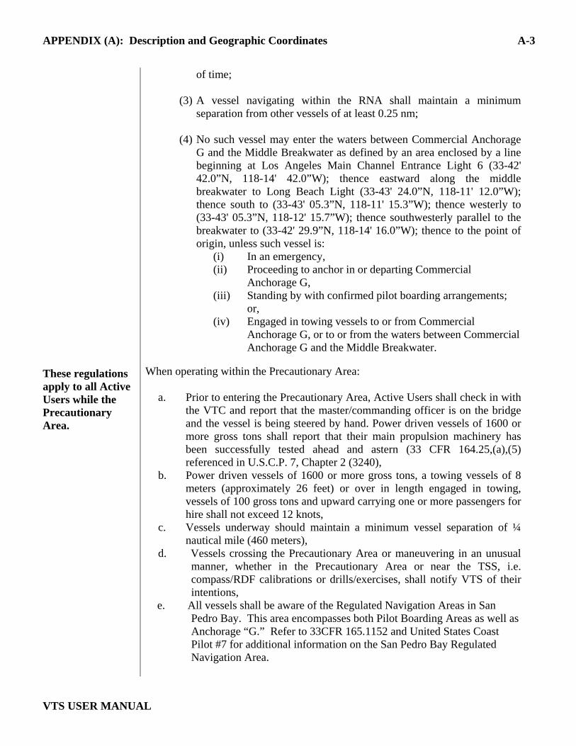
These regulations apply to all Active Users while the Precautionary Area.
of time;
(3) A vessel navigating within the RNA shall maintain a minimum separation from other vessels of at least 0.25 nm;
(4) No such vessel may enter the waters between Commercial Anchorage
G and the Middle Breakwater as defined by an area enclosed by a line beginning at Los Angeles Main Channel Entrance Light 6 (33-42' 42.0”N, 118-14' 42.0”W); thence eastward along the middle breakwater to Long Beach Light (33-43' 24.0”N, 118-11' 12.0”W); thence south to (33-43' 05.3”N, 118-11' 15.3”W); thence westerly to (33-43' 05.3”N, 118-12' 15.7”W); thence southwesterly parallel to the breakwater to (33-42' 29.9”N, 118-14' 16.0”W); thence to the point of origin, unless such vessel is:
(i) In an emergency, (ii) Proceeding to anchor in or departing Commercial
Anchorage G, (iii) Standing by with confirmed pilot boarding arrangements;
or, (iv) Engaged in towing vessels to or from Commercial
Anchorage G, or to or from the waters between Commercial Anchorage G and the Middle Breakwater.
When operating within the Precautionary Area:
a. Prior to entering the Precautionary Area, Active Users shall check in with the VTC and report that the master/commanding officer is on the bridge and the vessel is being steered by hand. Power driven vessels of 1600 or more gross tons shall report that their main propulsion machinery has been successfully tested ahead and astern (33 CFR 164.25,(a),(5) referenced in U.S.C.P. 7, Chapter 2 (3240),
b. Power driven vessels of 1600 or more gross tons, a towing vessels of 8 meters (approximately 26 feet) or over in length engaged in towing, vessels of 100 gross tons and upward carrying one or more passengers for hire shall not exceed 12 knots,
c. Vessels underway should maintain a minimum vessel separation of ¼ nautical mile (460 meters),
d. Vessels crossing the Precautionary Area or maneuvering in an unusual manner, whether in the Precautionary Area or near the TSS, i.e. compass/RDF calibrations or drills/exercises, shall notify VTS of their intentions,
e. All vessels shall be aware of the Regulated Navigation Areas in San Pedro Bay. This area encompasses both Pilot Boarding Areas as well as Anchorage “G.” Refer to 33CFR 165.1152 and United States Coast Pilot #7 for additional information on the San Pedro Bay Regulated Navigation Area.
APPENDIX (A): Description and Geographic Coordinates A-4
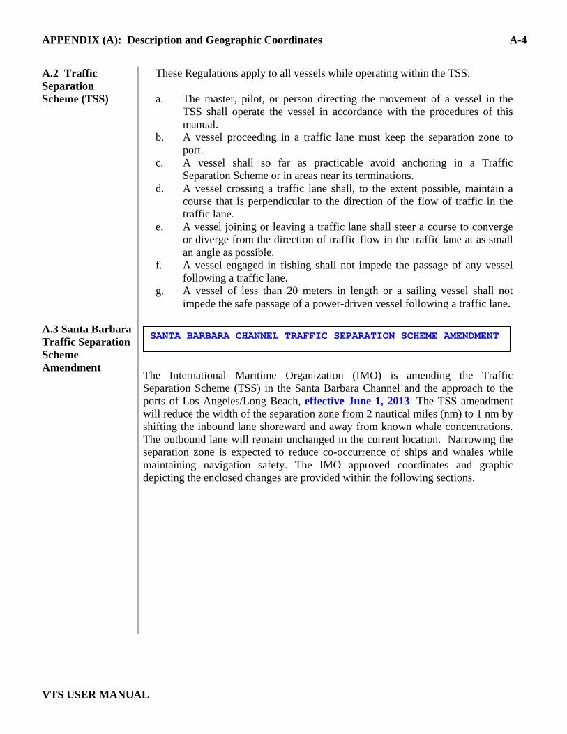
VTS USER MANUAL
A.2 Traffic Separation Scheme (TSS) A.3 Santa Barbara Traffic Separation Scheme Amendment
These Regulations apply to all vessels while operating within the TSS: a. The master, pilot, or person directing the movement of a vessel in the
TSS shall operate the vessel in accordance with the procedures of this manual.
b. A vessel proceeding in a traffic lane must keep the separation zone to port.
c. A vessel shall so far as practicable avoid anchoring in a Traffic Separation Scheme or in areas near its terminations.
d. A vessel crossing a traffic lane shall, to the extent possible, maintain a course that is perpendicular to the direction of the flow of traffic in the traffic lane.
e. A vessel joining or leaving a traffic lane shall steer a course to converge or diverge from the direction of traffic flow in the traffic lane at as small an angle as possible.
f. A vessel engaged in fishing shall not impede the passage of any vessel following a traffic lane.
g. A vessel of less than 20 meters in length or a sailing vessel shall not impede the safe passage of a power-driven vessel following a traffic lane.
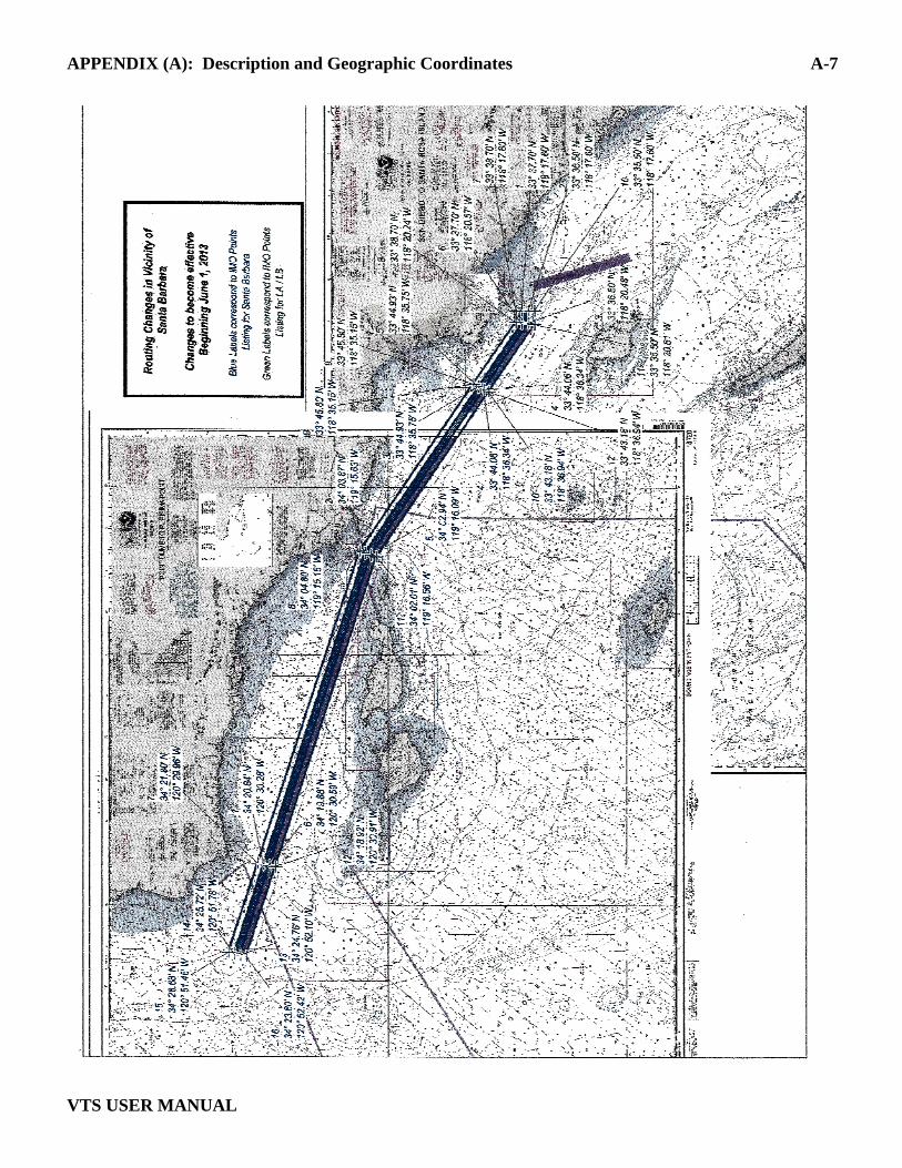
The International Maritime Organization (IMO) is amending the Traffic Separation Scheme (TSS) in the Santa Barbara Channel and the approach to the ports of Los Angeles/Long Beach, effective June 1, 2013. The TSS amendment will reduce the width of the separation zone from 2 nautical miles (nm) to 1 nm by shifting the inbound lane shoreward and away from known whale concentrations. The outbound lane will remain unchanged in the current location. Narrowing the separation zone is expected to reduce co-occurrence of ships and whales while maintaining navigation safety. The IMO approved coordinates and graphic depicting the enclosed changes are provided within the following sections.
SANTA BARBARA CHANNEL TRAFFIC SEPARATION SCHEME AMENDMENT
APPENDIX (A): Description and Geographic Coordinates A-5
VTS USER MANUAL
A.4 Traffic Lane Descriptions.
The following is a description of the Traffic Separation Scheme in the approaches to Los Angeles and Long Beach VTS AOR. Refer to NOAA Chart 18746. a. Northern Approach (from Santa Barbara Channel)
(1) A separation zone is encompassed by a line connecting the following geographical positions:
(i) 33-37.70’ N, 118-17.60’ W (ii) 33-36.50’ N, 118-17.60’ W (iii) 33-36.50’ N, 118-20.48’ W (iv) 33-48.87’ N, 118-46.63’ W (v) 33-49.89’ N, 118-46.32’ W (vi) 33-37.70’ N, 118-20.57’ W
(2) A traffic lane for northbound coastwise traffic is established between
the separation zone and a line connecting the following geographical positions:
(vii) 33-38.70’ N, 118-17.60’ W (viii) 33-38.70’ N, 118-20.24’ W (ix) 33-50.91’ N, 118-45.94’ W
(3) A traffic lane for southbound coastwise traffic is established between the separation zone and a line connecting the following geographical positions:
(x) 33-35.50’ N, 118-17.60’ W (xi) 33-35.50’ N, 118-20.81’ W (xii) 33-47.88’ N, 118-46.93’ W
(4) The main traffic directions are:
090º - 270º 120º - 300º
APPENDIX (A): Description and Geographic Coordinates A-6
VTS USER MANUAL
b. Southern Approach (from the south)
(1) A separation zone is established bounded by a line connecting the following geographic positions:
(xiii) 33-35.50’ N, 118-10.30’ W (xiv) 33-35.50’ N, 118-12.75’ W (xv) 33-19.00’ N, 118-05.60’ W (xvi) 33-19.70’ N, 118-03.50’ W
(2) A traffic lane for northbound traffic is established between the
separation zone and a line connecting the following geographical positions:
(xvii) 33-35.50’ N, 118-09.00’ W (xviii) 33-20.00’ N, 118-02.30’ W
(3) A traffic land for southbound traffic is established between the separation zone and a line connecting the following geographical positions:
(xix) 33-35.50’ N, 118-14.00’ W (xx) 33-18.70’ N, 118-06.75’ W
(3) The main traffic directions are: 160º and 340º
c. Portions of the Traffic Separation Scheme in the Northern and Southern approaches to Los Angeles and Long Beach are within the VTS area. Refer to NOAA charts 18751, 18749 and 18746.
APPENDIX (A): Description and Geographic Coordinates A-7
VTS USER MANUAL
APPENDIX (A): Description and Geographic Coordinates A-8
VTS USER MANUAL
A.5 Voluntary
Western Traffic Lanes
To address the safety concerns created by increased traffic south of the Channel Islands, on October 6, 2009, the Los Angeles/Long Beach Harbor Safety Committee (LA/LB HSC) endorsed voluntary traffic lanes in the area south of the Channel Islands (referenced herein as “voluntary western traffic lanes") The LA/LB HSC developed theses lanes as a voluntary measure to promote vessel safety. The voluntary western traffic lanes were not developed using processes established under U.S. federal law or by the IMO. As such, these lanes have not been reviewed nor approved by any U.S. federal authority, including the U.S. Coast Guard, or the IMO. The Coast Guard is taking separate action to study the increased traffic in this area, which will include an opportunity for the public to comment. Since the new voluntary western traffic lanes are not an IMO approved traffic separation scheme, the International regulations for Avoiding Collisions at Sea (COLREGS) Rule 10 does not apply. Mariners should exercise due caution when choosing to operate south of the Channel Islands and within the voluntary western traffic lanes.
The following is a description of the Voluntary Western Traffic Lanes:
a. Voluntary Western Traffic Lanes: (1) A precautionary area for the Voluntary Western Traffic Lanes is bounded by
a line connecting the following geographical positions:
(i) 33 35.50’N 118 20.81’W (ii) 33 35.50’N 118 36.35’W (iii) 33 42.90’N 118 36.35’W (iv) 33 35.50’N 118 20.81’W
(2) A separation area bounded by a line connecting the following geographical
positions:
(v) 33 36.50’N 118 36.35’W (vi) 33 38.60’N 119 05.50’W (vii) 33 40.60’N 119 05.50’W (viii) 33 38.50’N 118 36.35’W
Voluntary Western Traffic Lanes
APPENDIX (A): Description and Geographic Coordinates A-9
VTS USER MANUAL
(3) Traffic westbound to transit between the separation area and a line connecting the following geographical positions:
(ix) 33 39.50’N 118 36.35’W
(x) 33 41.60’N 119 05.50’W
(4) Traffic eastbound to transit between the separation area and a line connecting the following geographical positions:
(xi) 33 35.50’N 118 36.35’W (xii) 33 37.60’N 119 05.50’W

APPENDIX (A): Description and Geographic Coordinates A-10
VTS USER MANUAL
APPENDIX B Notice of Marine Casualty B-1
VTS USER MANUAL
B.1 Notice of Marine Casualty 46 CFR 4.05-1
a. Immediately after the addressing of resultant safety concerns, the owner, agent, master, operator, or person in charge, shall notify the nearest Coast Guard Sector Command whenever a vessel is involved in a marine casualty consisting in—
1) An unintended grounding, or an unintended strike of (allision with) a
bridge; 2) An intended grounding, or an intended strike of a bridge, that creates a
hazard to navigation, the environment, or the safety of a vessel, or that meets any criterion of paragraphs (a) (3) through (7);
3) A loss of main propulsion, primary steering, or any associated component or control system that reduces the maneuverability of the vessel;
4) An occurrence materially and adversely affecting the vessel’s seaworthiness or fitness for service or route, including but not limited to fire, flooding, or failure of or damage to fixed fire-extinguishing systems, lifesaving equipment, auxiliary power-generating equipment, or bilge-pumping systems;
5) A loss of life; 6) An injury that requires professional medical treatment
(treatment beyond first aid) and, if the person is engaged or employed on board a vessel in commercial service, that renders the individual unfit to perform his or her routine duties; or
7) An occurrence causing property-damage in excess of $25,000, this damage including the cost of labor and material to restore the property to its condition before the occurrence, but not including the cost of salvage, cleaning, gas-freeing, dry-docking, or demurrage.
b. Notice given as required by 33 CFR 160.215 satisfies the requirement of this
section if the marine casualty involves a hazardous condition as defined by 33 CFR 160.204.
B.2 Substance of
Marine Casualty Notice 46 CFR 4.05-5
The notice required in Section 4.05-1 must include the: • name and official number of the vessel involved, • name of the vessel’s owner or agent, • nature and circumstances of the casualty, • locality in which it occurred, • nature and extent of injury to persons, and • damage to property.
APPENDIX C Check Off List for Reporting Points C - 1
VTS USER MANUAL
San Pedro Sector Check-off List VTS “San Pedro Sector:
Upon entering the VTS San Pedro Sector from Sea, (at 25 nm VTS Boundary) call “San Pedro Traffic” on channel 14 and provide the following information:
a. Vessel name/call sign,
b. Vessel position, course and speed
c. Vessel destination (if anchoring outside the breakwater, within the VTS area, request an anchorage assignment)
d. State whether or not taking on a pilot
e. ETA to destination
f. Advise of any known mechanical/navigation system difficulty
g. Reduce speed to be at 12 knots upon entry to Precautionary Area
Notes of Interest: • The 25 nm Outer Limit is defined by a 25-mile arc from Point Fermin (33º 42.3’ N, 118º 17.6’ W). • There is no prescribed speed restriction between the 25 nm limit and the Precautionary Area. There is a voluntary
Air Quality Compliance Zone within a 20-mile arc from Point Fermin. It is requested that vessels maintain a speed of 12 knots or less while operating within this area. All vessels shall proceed at a safe speed. However, ships are required to be at 12 knots or less upon entering and transiting the Precautionary Area.
• A minimum vessel separation of ¼ nm is required in the Precautionary Area. • Code of Federal Regulations 33 CFR 165, subsection 1152 identifies the Precautionary Area as a Regulated
Navigation Area (see Appendix A) VTS San Pedro Sector
Upon entering or departing the Precautionary Area, call “San Pedro Traffic” on channel 14 and provide the following information:
a. Vessel name/call sign,
b. If entering: report that the master/commanding officer is on the bridge and that the vessel is being steered by hand
c. Main propulsion machinery has been successfully tested ahead and astern.
d. Contact pilots, channel 73 (LA) or 74 (LB) as appropriate
e. Provide ETA to pilot boarding area or anchorage
f. If departing: report “departing Precautionary Area ETA to 25 nm limit is _____”.
VTS San Pedro Sector
15 minutes prior to getting underway, call “San Pedro Traffic” on channel 14 and provide the following information
a. Vessel name/call sign,
b. Vessel position
If not taking on a pilot, also report:
c. Vessel type
d. Operation (e.g. Tug and Tow, Dredging, etc)
e. Destination and intended route (as necessary)
APPENDIX C Check Off List for Reporting Points C - 2
VTS USER MANUAL
San Pedro Sector Check-off List (Cont).
VTS San Pedro Sector
Upon Getting Underway outside the Federal Breakwater, Call “San Pedro Traffic” on VHF-FM channel 14 and provide the following information:
a. Vessel name/call sign,
b. “Underway at this time”,
c. Any changes/updates to 15 minute check-in call,
d. If Inbound and embarking a pilot, ETA to pilot boarding area.
NOTES OF INTEREST: • Maintain speed at 12 knots or less through Precautionary Area • Maintain a minimum vessel separation of ¼ nm while in the Precautionary Area. • Code of Federal Regulations 33 CFR 165, subsection 165.1152 identifies the Precautionary Area as a
Regulated Navigation Area (see Appendix A) • There is a voluntary Air Quality Compliance Zone within a 20-mile arc from Point Fermin. It is
requested that vessels maintain a speed of 12 kts or less while operating within this area. VTS San Pedro Sector
Upon departing the San Pedro Sector bound for sea (at 25 nm VTS boundary), Call “San Pedro Traffic” on VHF-FM channel 14 and provide the following information:
a. Vessel name/call sign
b. Vessel position
c. “Checking out of VTS”
All VTS Sectors
Additional Reporting (Additional reporting may be necessary or required as determined by the applicable VTC. Response back to the appropriate VTC sector with requested information, e.g. (San Pedro Traffic “Vessel’s Name & abeam the Sierra Papa (SP) buoy)

APPENDIX C Check Off List for Reporting Points C - 3
VTS USER MANUAL
Los Angeles-Long Beach Sector Check-off List
VTS Los Angeles & Long Beach Sectors (This report shall be made prior to casting off all lines)
Preparing to get underway (from berth, anchorage, or offshore mooring), Call the VTC of the Sector currently in (either “LA Pilot Station” on VHF-FM channel 73 or “Long Beach Pilot Station” on VHF-FM channel 74) and provide the following information:
a. Vessel name/call sign,
b. “Preparing to get underway in approximately ____minutes”,
c. Any changes/updates
VTS Los Angeles & Long Beach Sectors • LA & LB city
boundary line • Heim Bridge
(Cerritos Channel)
5 minutes prior to reaching the boundary, call the VTC of the destination Sector (“LA Pilot Station” on VHF-FM channel 73 or “Long Beach Pilot Station” on VHF-FM channel 74) and provide the following information:
a. Vessel name/call sign,
b. Vessel position, Note: If shifting from inside the breakwater, to an anchorage outside the breakwater, request an anchorage assignment from “San Pedro Traffic” at this time.
Note: • For all vessels departing either the Port of LA or LB entering San Pedro Sector the 15 minute prior notification
remains in effect VTS Los Angeles & Long Beach Sectors
Upon completion of transit (upon mooring or anchoring), call the VTC of the destination Sector (“LA Pilot Station” on VHF-FM channel 73 or “Long Beach Pilot Station” on VHF-FM channel 74) and provide the following information:
a. Vessel name/call sign
b. Vessel location c. Vessel status (moored or anchored *see note below)
d. “Checking out of VTS” Note: • For all vessels anchoring inside the federal breakwater in either the Port of Los Angeles or Long Beach, an
additional CHECK OUT call must be made to “San Pedro Traffic”. This call is to satisfy the Coast Guard notification requirement.
All VTS Sectors
Additional Reporting (Additional reporting may be necessary or required as determined by the applicable VTC. Response back to the appropriate VTC sector with requested information, e.g. (LA Pilot Station “Vessel’s Name & Location” Checking Out!)
APPENDIX C Check Off List for Reporting Points C - 1
VTS USER MANUAL
Vessel Traffic Service Los Angeles and Long Beach – USER FEES
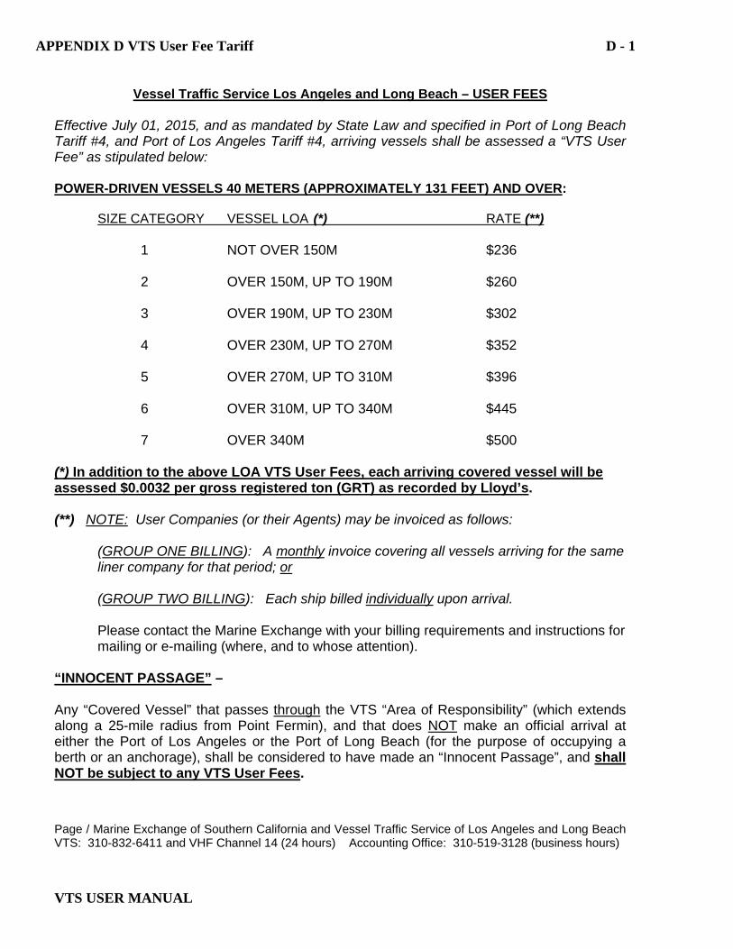
Effective July 01, 2015, and as mandated by State Law and specified in Port of Long Beach Tariff #4, and Port of Los Angeles Tariff #4, arriving vessels shall be assessed a “VTS User Fee” as stipulated below: POWER-DRIVEN VESSELS 40 METERS (APPROXIMATELY 131 FEET) AND OVER: SIZE CATEGORY VESSEL LOA (*) RATE (**) 1 NOT OVER 150M $236 2 OVER 150M, UP TO 190M $260 3 OVER 190M, UP TO 230M $302 4 OVER 230M, UP TO 270M $352 5 OVER 270M, UP TO 310M $396 6 OVER 310M, UP TO 340M $445 7 OVER 340M $500 (*) In addition to the above LOA VTS User Fees, each arriving covered vessel will be assessed $0.0032 per gross registered ton (GRT) as recorded by Lloyd’s. (**) NOTE: User Companies (or their Agents) may be invoiced as follows:
(GROUP ONE BILLING): A monthly invoice covering all vessels arriving for the same liner company for that period; or
(GROUP TWO BILLING): Each ship billed individually upon arrival. Please contact the Marine Exchange with your billing requirements and instructions for mailing or e-mailing (where, and to whose attention). “INNOCENT PASSAGE” – Any “Covered Vessel” that passes through the VTS “Area of Responsibility” (which extends along a 25-mile radius from Point Fermin), and that does NOT make an official arrival at either the Port of Los Angeles or the Port of Long Beach (for the purpose of occupying a berth or an anchorage), shall be considered to have made an “Innocent Passage”, and shall NOT be subject to any VTS User Fees. Page / Marine Exchange of Southern California and Vessel Traffic Service of Los Angeles and Long Beach VTS: 310-832-6411 and VHF Channel 14 (24 hours) Accounting Office: 310-519-3128 (business hours)
APPENDIX D VTS User Fee Tariff D - 1
APPENDIX C Check Off List for Reporting Points C - 2
VTS USER MANUAL
TUGS WITH COMMERCIAL TOWS – Every arriving power-driven vessel 8 meters (approximately 26 feet) or longer that is towing astern, alongside, or pushing ahead another vessel (or vessels) shall be assessed a “VTS User Fee” of $215). There is no fee for the towed vessel(s).
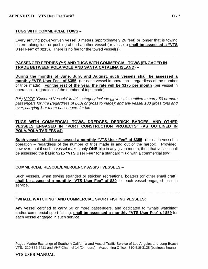
PASSENGER FERRIES (***) AND TUGS WITH COMMERCIAL TOWS (ENGAGED IN TRADE BETWEEN POLA/POLB AND SANTA CATALINA ISLAND) – During the months of June, July, and August, such vessels shall be assessed a monthly “VTS User Fee” of $355 (for each vessel in operation – regardless of the number of trips made). For the rest of the year, the rate will be $175 per month (per vessel in operation – regardless of the number of trips made). (***) NOTE “Covered Vessels” in this category include all vessels certified to carry 50 or more passengers for hire (regardless of LOA or gross tonnage); and any vessel 100 gross tons and over, carrying 1 or more passengers for hire. TUGS WITH COMMERCIAL TOWS, DREDGES, DERRICK BARGES, AND OTHER VESSELS ENGAGED IN “PORT CONSTRUCTION PROJECTS” (AS OUTLINED IN POLA/POLA TARIFFS #4) – Such vessels shall be assessed a monthly “VTS User Fee” of $355 (for each vessel in operation – regardless of the number of trips made in and out of the harbor). Provided, however, that if such a vessel makes only ONE trip in any given month, then that vessel shall be assessed the basic $215 “VTS User Fee” for a standard “Tug with a commercial tow”. COMMERCIAL RESCUE/EMERGENCY ASSIST VESSELS – Such vessels, when towing stranded or stricken recreational boaters (or other small craft), shall be assessed a monthly “VTS User Fee” of $30 for each vessel engaged in such service. “WHALE WATCHING” AND COMMERCIAL SPORT FISHING VESSELS: Any vessel certified to carry 50 or more passengers, and dedicated to “whale watching” and/or commercial sport fishing, shall be assessed a monthly “VTS User Fee” of $59 for each vessel engaged in such service. Page / Marine Exchange of Southern California and Vessel Traffic Service of Los Angeles and Long Beach VTS: 310-832-6411 and VHF Channel 14 (24 hours) Accounting Office: 310-519-3128 (business hours)
APPENDIX D VTS User Fee Tariff D - 2


![Administering Cisco VTS · admin@VTS-A:~$ sudo su [sudo] password for admin: Step2 SourcetheVTSenvironment. root@VTS-A:# source /etc/profile.d/ncs.sh Step3 VerifyVTSstatus. root@VTS-A:#](https://img.pdfslide.us/doc/110x75/5ec8e3d704a90406890d6ec6/administering-cisco-vts-adminvts-a-sudo-su-sudo-password-for-admin-step2.jpg)