Embed Size (px)
Citation preview
(COVER SHEET, CONTENTS)
UU..SS.. HHiigghhwwaayy 1144 CCoorrrriiddoorr SSttuuddyy NNeeww UUllmm ttoo NNoorrtthh MMaannkkaattoo
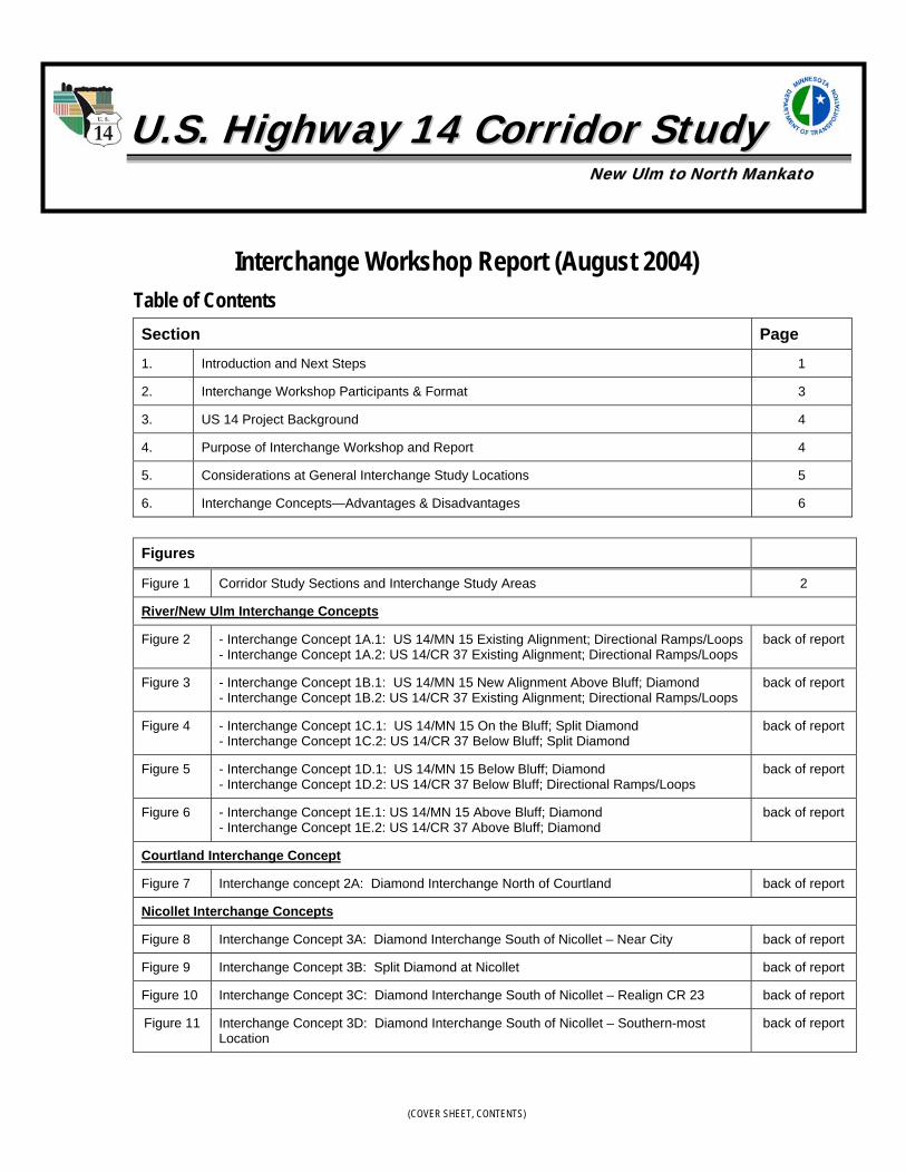
Interchange Workshop Report (August 2004)Table of ContentsSection Page
1. Introduction and Next Steps 1
2. Interchange Workshop Participants & Format 3
3. US 14 Project Background 4
4. Purpose of Interchange Workshop and Report 4
5. Considerations at General Interchange Study Locations 5
6. Interchange Concepts—Advantages & Disadvantages 6
Figures
Figure 1 Corridor Study Sections and Interchange Study Areas 2
River/New Ulm Interchange Concepts
Figure 2 - Interchange Concept 1A.1: US 14/MN 15 Existing Alignment; Directional Ramps/Loops- Interchange Concept 1A.2: US 14/CR 37 Existing Alignment; Directional Ramps/Loops
back of report
Figure 3 - Interchange Concept 1B.1: US 14/MN 15 New Alignment Above Bluff; Diamond - Interchange Concept 1B.2: US 14/CR 37 Existing Alignment; Directional Ramps/Loops
back of report
Figure 4 - Interchange Concept 1C.1: US 14/MN 15 On the Bluff; Split Diamond- Interchange Concept 1C.2: US 14/CR 37 Below Bluff; Split Diamond
back of report
Figure 5 - Interchange Concept 1D.1: US 14/MN 15 Below Bluff; Diamond- Interchange Concept 1D.2: US 14/CR 37 Below Bluff; Directional Ramps/Loops
back of report
Figure 6 - Interchange Concept 1E.1: US 14/MN 15 Above Bluff; Diamond- Interchange Concept 1E.2: US 14/CR 37 Above Bluff; Diamond
back of report
Courtland Interchange Concept
Figure 7 Interchange concept 2A: Diamond Interchange North of Courtland back of report
Nicollet Interchange Concepts
Figure 8 Interchange Concept 3A: Diamond Interchange South of Nicollet – Near City back of report
Figure 9 Interchange Concept 3B: Split Diamond at Nicollet back of report
Figure 10 Interchange Concept 3C: Diamond Interchange South of Nicollet – Realign CR 23 back of report
Figure 11 Interchange Concept 3D: Diamond Interchange South of Nicollet – Southern-mostLocation
back of report
U.S. 14 INTERCHANGE CONCEPT REPORT AUGUST 2004
1
AS THIS REPORT IS FINISHED, IT IS IMPORTANT TONOTE THAT ANY OF THE INTERCHANGE CONCEPTSCOULD BE SUBJECT TO FURTHER REFINEMENT.THEREFORE, THE INFORMATION PRESENTED HERE ISEVIDENCE OF THE VALUE OF EARLY BRAINSTORMING—EFFORTS THAT WILL LATER MAKE IT EASIER TOIDENTIFY AND SELECT THE BEST DESIGN SOLUTIONS.
1. Introduction and Next StepsThis report summarizes the results of interchange concept studies for the US 14 corridorfrom North Mankato to New Ulm. The work represented within this report was primarilybased on interchange workshop, held o0n June 17th, 2004 (see more information below aboutthis workshop). This initial milestone in the process was a “brainstorming” exercise led bythe Minnesota Department of Transportation (Mn/DOT) and its consultant team,represented by the firms CH2M HILL and Bolton & Menk.
The primary purpose of the interchange concept work was to look more closely at highwaydesign features and develop and refine the reasonable range of highway alignment andgeometric alternatives for further detailed study in the Environmental Impact Statement(EIS). As such, this interchange report should also be reviewed in conjunction with ananticipated alternatives screening technical memorandum, which will focus on thealignments, or corridor routes, to be considered for further study.
In general, an improved U.S. 14 is proposed to be a four-lane divided expressway with at-grade stop-controlled intersections at crossroads where necessary, safe, and feasible. Indeveloping the preliminary design, Mn/DOT also wishes to avoid the potential for futuretraffic signals. Therefore, the design team is planning ahead to ultimately add interchangesat appropriate locations. The specific objectives of the conceptual interchange work were to:
1) Identify the most promising interchange locations/configurations2) Consider interchange influence on alignments/alternatives3) Identify environmental and screening considerations
With reference to Figure 1, These objectives were applied to four general locations: (1) Westend—U.S. 14 at MN 15; (2) West end—U.S. 14 at Co. Highway 37; (3) North bypass ofCourtland, with a focus on U.S. 14 at Co. Highway 24; and (4) South bypass of Nicollet witha focus on connections to Highway 23 & MN 99. Still, as this report is finished, it isimportant to note that any of theinterchange concepts could be subject tofurther refinement.
Mn/DOT has presented the wide range ofcorridor alignment alternatives andinterchange concepts to a wide audience—including the US 14 Corridor Study ProjectAdvisory Committee (PAC), the generalpublic (through a series of informal open houses in July 2004), and to agencies (through anworkshop emphasizing environmental agency input held on July 21, 2004). Completion ofthis work and coordination will allow Mn/DOT to focus more closely on the mostpromising alignments and interchange design concepts, ensuring better quality design andenvironmental study than would be possible with analysis of many more alternatives.
As the process goes forward from here, the design team will periodically re-visit the detailsof this initial interchange concept work, and no final design decisions will be made until apreferred roadway alignment has been identified (anticipated by approximately mid 2005).This is evidence of the value of this early brainstorming—efforts that will later make itpossible to identify and select the best design solutions.
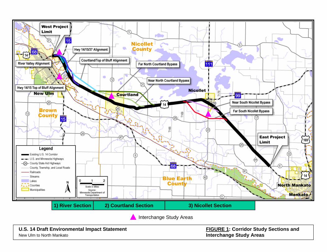
1) River Section 2) Courtland Section 3) Nicollet Section
Interchange Study Areas
FIGURE 1: Corridor Study Sections andInterchange Study Areas
U.S. 14 Draft Environmental Impact StatementNew Ulm to North Mankato
U.S. 14 INTERCHANGE CONCEPT REPORT AUGUST 2004
3
2. Interchange Workshop Participants & FormatThe US 14 Interchange Workshop was conducted as an all-day meeting on June 17th, 2004,at the New Ulm City Hall, first floor conference room, from 9:00 AM to 4:30 PM. The mainpurpose of the workshop was to refine the engineering design concepts for the US 14corridor from New Ulm to North Mankato. Mn/DOT, along with its consultant team,would like to thank everyone who participated in the US 14 Interchange ConceptWorkshop. Below is a list of individuals who participated.
Representatives from Local Communities
• Brown County—Wayne Stevens• Nicollet County—Mike Wagner• City of New Ulm—Steve Koehler• Cities of Courtland & Nicollet—Dan Wietecha
Mn/DOT • Peter Harff—Project Manager• Mary Dieken• Giles Abbe• Jim Rosenow• Ed Idzorek • Lynn Bode• David Larson
Consultant team included representatives of:
CH2M HILL• Howard Preston—Project Manager • Doug Abere• Cheng Soong• Nikki Farrington
Bolton & Menk• Brett Benzkofer
The workshop began in the morning with a review the project background—the ScopingStudy, which included development and screening of several corridor alternatives. Thegroup then discussed the four interchange study areas (in the vicinity of MN 15 and CR 37near New Ulm, and Courtland and Nicollet) and potential interchange design types. Basedon the morning discussions, CH2M HILL worked with Mn/DOT to prepare refinedinterchange concepts during the middle portion of the workshop. All workshopparticipants then reconvened later in the day to discuss the concept sketch designs.

U.S. 14 INTERCHANGE CONCEPT REPORT AUGUST 2004
4
3. US 14 Project BackgroundThe US 14 Interchange Workshop was held as part of the US 14 CorridorStudy/Environmental Impact Statement (EIS) between New Ulm and North Mankato (seeFigure 1 for an overview of the study area). The purpose of the improvements beingstudied for the US 14 Corridor is to address documented mobility and safety deficiencies ina manner that will be compatible with local communities and the area’s natural resources astraffic volumes increase.
Preliminary EIS Alternatives Screening ProcessIn general, proposed improvements to US 14 include expanding the roadway to a four-lanedivided expressway with at-grade stop-controlled intersections at crossroads wherenecessary, safe, and feasible. Mn/DOT is examining a variety of expanded four-lanealignment alternatives—including reconstruction of the existing roadway plus bypasses ofCourtland and Nicollet and a new approach to the intersection with MN 15 (see Figure 1).
Mn/DOT is in the process of developing a range of alternatives to carry forward intodetailed analysis in the Draft EIS. Mn/DOT is adjusting these alignments based onpreliminary engineering and environmental considerations. The goal is to developalignment alternatives that:
• are consistent with local land use plans, • minimize impacts to environmental resources whenever possible, and• are consistent with Mn/DOT’s corridor performance goals and design guidelines.
Potential Interchange LocationsMn/DOT is attempting to avoid the potential for future traffic signals in preliminarydesigns for US 14. This is being done in order to avoid increases in crash frequencies thathave been documented in other high speed expressway corridors and to meet theestablished performance measure of maintaining average peak hour speeds alongdesignated Interregional Corridors— US 14 is designated as an Interregional Corridor.Signal proliferation, as well as access proliferation, negatively impacts average peak hourspeeds. One way to avoid additional signals along US 14 is to plan for possible interchangesat intersections considered at risk of meeting the minimum traffic volume thresholds forinstallation of a traffic signal in the future.
4. Purpose of Interchange Workshop and ReportThe purpose of the Interchange Design Workshop held on June 17, 2004, was to study thelimited number of intersection locations along US 14 considered to be at risk (see Figure 1).The specific workshop objectives included:
• Identifying the most promising interchange locations/configurations• Considering interchange influence on alignments• Identifying environmental and screening considerations
This document discusses the interchange concepts developed during the workshop,primarily focusing on functional characteristics and balancing preliminary highway designswith potential impacts and consistency with local government comprehensive plans.
U.S. 14 INTERCHANGE CONCEPT REPORT AUGUST 2004
5
In addition to this report, key products from the workshop include a set of concept sketchdesigns for the US 14 corridor addressing potential interchanges at the following fourgeneral locations which are attached to the back of this report:
1) West end—US 14 at MN 15 (see Figures 2, 3, 4, 5, and 6);2) West end—US 14 at County Road (CR) 37 (see Figures 2, 3, 4, 5, and 6); 3) North bypass of Courtland, with a focus on US 14 at CR 24 (see Figure 7); and4) South bypass of Nicollet with a focus on connections to CR 23 & MN 99 (see Figures
8, 9, 10, and 11).
5. Considerations at General Interchange Study LocationsThe following provides a summary of the issues addressed by the design team during theworkshop. More detailed summaries of the design concepts developed will be prepared aspart of the EIS process.
West End – US 14 at MN 15 (and CR 21) and at CR 37 (see Figures 2, 3, 4, 5 and 6)• Mn/DOT has identified the potential re-designation MN 15 to follow a common portion
of US 14 on the north side of the Minnesota River, crossing on the existing CR 37 bridge.This will be reflected in some of the redesign concepts.
• The main corridor options are to: (a) follow the existing US 14 corridor along side theriver, or to (b) re-route the highway to the area along the top of the bluff, partially alonga power line corridor.
• Design challenges in this area include roadway horizontal curvature and grades (verticalcurvature), and locating potential interchanges to minimize residential and naturalresource impacts (the Minnesota River floodplain and woodlands).
• The key features of designs considered at the workshop included maintenance of localroadway access, especially at CR 21, and re-joining US 14 at the existing bridge acrossthe Minnesota River.
Courtland – US 14 North Bypass, with Emphasis on Connections to CR 12 and CR 24 (seeFigure 7)• A diamond interchange on the near-north side of Courtland was selected as the
emphasis for concept design at the workshop.
• The diamond interchange concept includes the potential to tie CR 12 and CR 24 together.
• There is potential to generally follow the “top of bluff” alignment from just east ofCourtland all the way to the west extent of the corridor (at MN 15) or to re-join US 14along the river (see the discussion on interchange concept considerations in the WestEnd of the Study area above).
Nicollet – US 14 South Bypass, with Emphasis on Connections to CR 23 and to MN 99 (seeFigures 8, 9, 10, and 11)• Four southern bypass corridors of Nicollet are being studied—three of the bypasses are
located north of the wastewater treatment ponds; and one is located south of the ponds.
U.S. 14 INTERCHANGE CONCEPT REPORT AUGUST 2004
6
• Most future residential growth and development of Nicollet is expected toward thenorth; however, the near south bypass with the interchange at CR 23 is already veryclose to current land development extending toward south.
• While a far-south diamond interchange location may have less potential conflict with theCity’s future development, it would create some potential for inconvenient access to andfrom US 14—especially as no other access to the new highway would be desirablewithin 1.5 to 2 miles from the interchange.
• Discussion at the workshop yielded a potential new geometric and functional concept—a “split diamond” access approach, with an interchange at each end of a proposedNicollet south bypass corridor. Such a design concept can also consider modified accessto county roads and re-routing of MN 99. This might result, for example, in a ½ -diamond interchange at MN 99 extended south of town. It would also likely involve asigning, or route designation, approach that would convert existing US 14 to “Business14.”
• Workshop participants also considered a full access interchange just east of Nicollet,very close to the existing US 14 alignment, but also connecting with a southern bypassalignment. This concept provides access to both CR 23 and MN 99. MN 99 would be re-routed to bypass Nicollet immediately east of town.
6. Interchange Concepts—Advantages & DisadvantagesThe following discussion provides a comparison of the interchange concepts developedduring the interchange workshop. The criteria used for comparing the interchange conceptsinclude: highway continuity, access locations, environmental impacts (wetlands, uplandforest, agriculture lands, floodplains), and potential residential displacements. The analysiswas based on the concept level designs completed for the interchange workshop. Theimpacts of the potential interchanges will be confirmed once interchange concepts havebeen modified and Mn/DOT has selected the range of alternatives to carry forward intodetailed environmental analysis.
Segment 1 - New Ulm - US 14/MN 15Interchange Concept 1A.1: US 14/MN 15 Existing Alignment. This concept would include asystem interchange at the existing intersection of US 14 and MN 15. The system interchangewould contain directional ramps for southbound MN 15 to eastbound US 14 and forwestbound US 14 to northbound MN 15. A loop ramp is used for the movement betweeneastbound US 14 to northbound MN 15.
Interchange Concept 1A.2: US 14/CR 37 Existing Alignment. The interchange at CR 37includes a directional ramp for the movement from northbound CR 37 to eastbound US 14and for westbound US 14 to southbound CR 37. A loop ramp accommodates the movementof northbound CR 37 to westbound US 14.

U.S. 14 INTERCHANGE CONCEPT REPORT AUGUST 2004
7
Table 1. Interchange Concept 1A - US 14/MN 15 Existing Alignment & Interchange Concept 1A.2 – US14/CR 37 Existing Alignment
Advantages Disadvantages
- Good continuity of both US 14 and MN 15- Potential impacts confined to existing corridor by
keeping the mainline on the existing alignment- Minimizes impacts to agricultural lands- Minimizes impacts to upland forests
- Difficult to provide access from CR 21 to US 14 dueto close spacing
- Local roadway changes and limited access to US 14- Impacts to structures (similar to 1A, 1B, and 1C)- Potential impacts to wetlands (similar to 1C)
Interchange Concept 1B: US 14/MN 15 New Alignment Above Bluff. This concept considersthe relocation of the US 14/MN 15 corridor, shifting the alignment east, on the bluff. Adiamond interchange provides access to MN 15 from US 14. MN 15 then continues west toCR 21. This concept minimizes floodplain impacts by moving north of the Minnesota Riverfloodplain. While the floodplain impact is minimized, there are additional impacts toagricultural land, residences and upland forests.
Interchange Concept 1B.2: US 14/CR 37 Existing Alignment. The same interchange used forInterchange Concept 1A at the intersection of US 14 and CR 37 is used for this concept.
Table 2. Interchange Concept 1B - US 14/MN 15 New Alignment Above Bluff & Interchange Concept 1B.2 –US 14/CR 37 Existing Alignment
Advantages Disadvantages
- Good continuity of US 14 - Interchange spacing - the distance between the US
14/MN 15 and US 14/CR 37 interchanges providesadequate spacing
- Local Access - this configuration allows for moreaccommodation of local roadway access (CR 21)
- Potentially minimizes wetland impacts
- Bluff causes high grades for mainline traffic- Discontinuity of MN 15 - Induce impacts to other locations in addition to the
existing corridor (residential area above bluff,agricultural lands above bluff ) (similar to 1C), andstructures (similar to 1A, 1B, and 1C)
- Impacts to contiguous upland forest
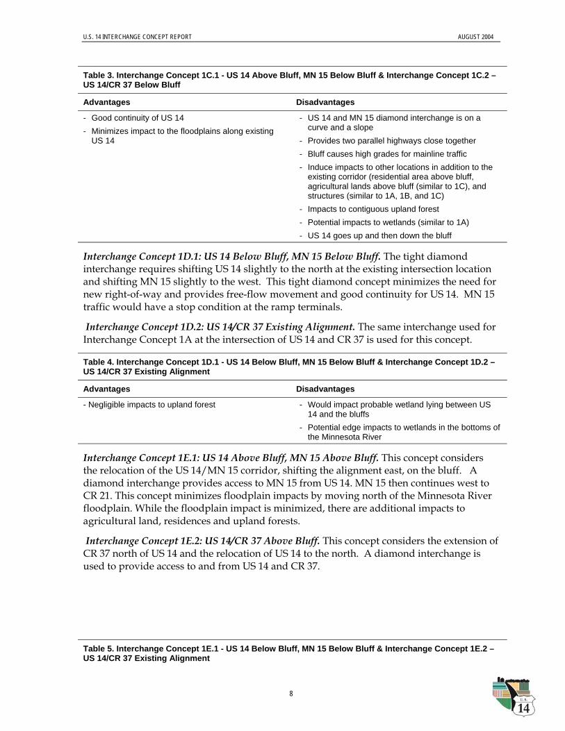
Interchange Concept 1C.1: US 14 Above Bluff, MN 15 Below Bluff. This split diamondconcept separates US 14 and MN 15. US 14 shifts east and above the bluff while MN 15 stayson the existing US 14/MN 15 alignment. The floodplain impacts are still minimized sinceMN 15 would be on the existing US 14 alignment without the need for widening, but thisconcept results in additional impacts above the bluff. Westbound traffic on US 14 isprovided access to westbound MN 15 at CR 37 only.
Interchange Concept 1C.2: US 14/CR 37 Below Bluff. As noted above, the 1C interchangeconcepts involve a split diamond that separates US 14 and MN 15. The interchange at US14/CR 37 includes a direction ramp for movement of westbound US 14 to southbound CR37 and westbound MN 15. Eastbound US 14 would not be able to access MN 15 or CR 37east of the US 14/MN 15 interchange in New Ulm. Northbound 37 would continue toprovide access to MN 15.
U.S. 14 INTERCHANGE CONCEPT REPORT AUGUST 2004
8
Table 3. Interchange Concept 1C.1 - US 14 Above Bluff, MN 15 Below Bluff & Interchange Concept 1C.2 –US 14/CR 37 Below Bluff
Advantages Disadvantages
- Good continuity of US 14 - Minimizes impact to the floodplains along existing
US 14
- US 14 and MN 15 diamond interchange is on acurve and a slope
- Provides two parallel highways close together- Bluff causes high grades for mainline traffic- Induce impacts to other locations in addition to the
existing corridor (residential area above bluff,agricultural lands above bluff (similar to 1C), andstructures (similar to 1A, 1B, and 1C)
- Impacts to contiguous upland forest- Potential impacts to wetlands (similar to 1A)- US 14 goes up and then down the bluff
Interchange Concept 1D.1: US 14 Below Bluff, MN 15 Below Bluff. The tight diamondinterchange requires shifting US 14 slightly to the north at the existing intersection locationand shifting MN 15 slightly to the west. This tight diamond concept minimizes the need fornew right-of-way and provides free-flow movement and good continuity for US 14. MN 15traffic would have a stop condition at the ramp terminals.
Interchange Concept 1D.2: US 14/CR 37 Existing Alignment. The same interchange used forInterchange Concept 1A at the intersection of US 14 and CR 37 is used for this concept.
Table 4. Interchange Concept 1D.1 - US 14 Below Bluff, MN 15 Below Bluff & Interchange Concept 1D.2 –US 14/CR 37 Existing Alignment
Advantages Disadvantages
- Negligible impacts to upland forest - Would impact probable wetland lying between US14 and the bluffs
- Potential edge impacts to wetlands in the bottoms ofthe Minnesota River
Interchange Concept 1E.1: US 14 Above Bluff, MN 15 Above Bluff. This concept considersthe relocation of the US 14/MN 15 corridor, shifting the alignment east, on the bluff. Adiamond interchange provides access to MN 15 from US 14. MN 15 then continues west toCR 21. This concept minimizes floodplain impacts by moving north of the Minnesota Riverfloodplain. While the floodplain impact is minimized, there are additional impacts toagricultural land, residences and upland forests.
Interchange Concept 1E.2: US 14/CR 37 Above Bluff. This concept considers the extension ofCR 37 north of US 14 and the relocation of US 14 to the north. A diamond interchange isused to provide access to and from US 14 and CR 37.
Table 5. Interchange Concept 1E.1 - US 14 Below Bluff, MN 15 Below Bluff & Interchange Concept 1E.2 –US 14/CR 37 Existing Alignment
U.S. 14 INTERCHANGE CONCEPT REPORT AUGUST 2004
9
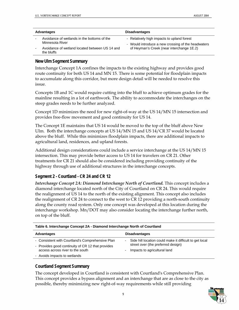
Advantages Disadvantages
- Avoidance of wetlands in the bottoms of theMinnesota River
- Avoidance of wetland located between US 14 andthe bluffs
- Relatively high impacts to upland forest- Would introduce a new crossing of the headwaters
of Heyman’s Creek (near interchange 1E.2)
New Ulm Segment SummaryInterchange Concept 1A confines the impacts to the existing highway and provides goodroute continuity for both US 14 and MN 15. There is some potential for floodplain impactsto accumulate along this corridor, but more design detail will be needed to resolve thisissue.
Concepts 1B and 1C would require cutting into the bluff to achieve optimum grades for themainline resulting in a lot of earthwork. The ability to accommodate the interchanges on thesteep grades needs to be further analyzed.
Concept 1D minimizes the need for new right-of-way at the US 14/MN 15 intersection andprovides free-flow movement and good continuity for US 14.
The Concept 1E maintains that US 14 would be moved to the top of the bluff above NewUlm. Both the interchange concepts at US 14/MN 15 and US 14/CR 37 would be locatedabove the bluff. While this minimizes floodplain impacts, there are additional impacts toagricultural land, residences, and upland forests.
Additional design considerations could include a service interchange at the US 14/MN 15intersection. This may provide better access to US 14 for travelers on CR 21. Othertreatments for CR 21 should also be considered including providing continuity of thehighway through use of additional structures in the interchange concepts.
Segment 2 - Courtland - CR 24 and CR 12Interchange Concept 2A: Diamond Interchange North of Courtland. This concept includes adiamond interchange located north of the City of Courtland on CR 24. This would requirethe realignment of US 14 to the north of the existing alignment. This concept also includesthe realignment of CR 24 to connect to the west to CR 12 providing a north-south continuityalong the county road system. Only one concept was developed at this location during theinterchange workshop. Mn/DOT may also consider locating the interchange further north,on top of the bluff.
Table 6. Interchange Concept 2A - Diamond Interchange North of Courtland
Advantages Disadvantages
- Consistent with Courtland's Comprehensive Plan- Provides good continuity of CR 12 that provides
access across river to the south- Avoids impacts to wetlands
- Side hill location could make it difficult to get localstreet over (the preferred design)
- Impacts to agricultural land
Courtland Segment SummaryThe concept developed in Courtland is consistent with Courtland's Comprehensive Plan.This concept provides a bypass alignment and an interchange that are as close to the city aspossible, thereby minimizing new right-of-way requirements while still providing
U.S. 14 INTERCHANGE CONCEPT REPORT AUGUST 2004
10
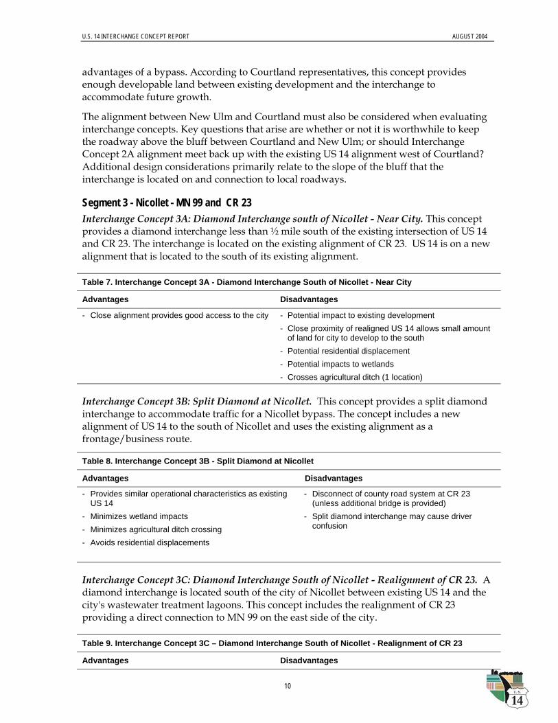
advantages of a bypass. According to Courtland representatives, this concept providesenough developable land between existing development and the interchange toaccommodate future growth.
The alignment between New Ulm and Courtland must also be considered when evaluatinginterchange concepts. Key questions that arise are whether or not it is worthwhile to keepthe roadway above the bluff between Courtland and New Ulm; or should InterchangeConcept 2A alignment meet back up with the existing US 14 alignment west of Courtland?Additional design considerations primarily relate to the slope of the bluff that theinterchange is located on and connection to local roadways.
Segment 3 - Nicollet - MN 99 and CR 23Interchange Concept 3A: Diamond Interchange south of Nicollet - Near City. This conceptprovides a diamond interchange less than ½ mile south of the existing intersection of US 14and CR 23. The interchange is located on the existing alignment of CR 23. US 14 is on a newalignment that is located to the south of its existing alignment.
Table 7. Interchange Concept 3A - Diamond Interchange South of Nicollet - Near City
Advantages Disadvantages
- Close alignment provides good access to the city - Potential impact to existing development- Close proximity of realigned US 14 allows small amount
of land for city to develop to the south- Potential residential displacement- Potential impacts to wetlands- Crosses agricultural ditch (1 location)
Interchange Concept 3B: Split Diamond at Nicollet. This concept provides a split diamondinterchange to accommodate traffic for a Nicollet bypass. The concept includes a newalignment of US 14 to the south of Nicollet and uses the existing alignment as afrontage/business route.
Table 8. Interchange Concept 3B - Split Diamond at Nicollet
Advantages Disadvantages
- Provides similar operational characteristics as existingUS 14
- Minimizes wetland impacts- Minimizes agricultural ditch crossing - Avoids residential displacements
- Disconnect of county road system at CR 23(unless additional bridge is provided)
- Split diamond interchange may cause driverconfusion
Interchange Concept 3C: Diamond Interchange South of Nicollet - Realignment of CR 23. Adiamond interchange is located south of the city of Nicollet between existing US 14 and thecity's wastewater treatment lagoons. This concept includes the realignment of CR 23providing a direct connection to MN 99 on the east side of the city.
Table 9. Interchange Concept 3C – Diamond Interchange South of Nicollet - Realignment of CR 23
Advantages Disadvantages
U.S. 14 INTERCHANGE CONCEPT REPORT AUGUST 2004
11
Table 9. Interchange Concept 3C – Diamond Interchange South of Nicollet - Realignment of CR 23
Advantages Disadvantages
- Good continuity of county road system- Close alignment provides good access to the city- Avoids residential displacement- Bypass for both US 14 and MN 99 (Removes MN
99 traffic from route through town)-
- Potential impacts to wetlands- Potential agricultural ditch crossing (1 location)
Interchange Concept 3D: Diamond Interchange south of Nicollet - Southern-most Location.US 14 is realigned approximately 1 mile south of the existing intersection of CR 23 and US14. The diamond interchange is located on the existing alignment of CR 23.
Table 10. Interchange Concept 3D - Diamond Interchange South of Nicollet - Southern-Most Location
Advantages Disadvantages
- Minimal disruption to existing development- Good continuity of county road system
- Distance from the city may impact businesses - Farmland severance due to length of new alignment
necessary to accommodate interchange so far south- Impact to upland forest- Potential displacement of residents- Impacts to wetlands- Potential agricultural ditch crossings (2 locations)
Nicollet Segment SummaryConsiderations involved in the development of interchange concepts for the Nicollet areaincluded:
• access to MN 99 (a common truck route that currently causes large number of trucks topass through the City of Nicollet's main street),
• access to CR 23 that provides a river crossing south of the city, and
• local access to US 14.
Interchange Concept 3C appears to balance all factors well and is more conventional than 3Bthat would be designed and signed as a "Business Loop". Interchange Concepts 3A and 3Dare conventional designs, but would not eliminate the through town (MN 99) traffic issues.The key alignment consideration west of Nicollet is whether the alignment should bypassthe Swan Lake Wildlife Management Area. ----------------------------------------------------------------------------------------------------------------------------NOTE: FIGURES 2-11 ARE PUBLISHED AS SEPARATE ELECTRONIC (PDF) FILES.SEE THE MN/DOT WEB SITE FOR MORE INFORMATION.-----------------------------------------------------------------------------------------------------------------------------