Embed Size (px)
Citation preview
Suffolk County Department of PlanningSuffolk County # New York
Sunrise Highway Corridor Study:Islip Town and Brookhaven Town
Suffolk County, New York
August 2009

Sunrise Highway Corridor Study:Islip Town and Brookhaven Town,
Suffolk County, New York
August 2009
Suffolk County Department of PlanningH. Lee Dennison Building - 4th Floor
100 Veterans Memorial HighwayP.O. Box 6100
Hauppauge, New York 11788
Steve LevySuffolk County Executive
Town Supervisors
Mark LeskoTown of Brookhaven
Phil NolanTown of Islip
Suffolk County Planning Commission
David L. Calone - Town of BabylonCHAIRMAN
Constantine Kontokosta, P.E., AICP - Village under 5,000 populationVICE CHAIRMAN
Adrienne Esposito - Village over 5,000 populationSECRETARY
Michael Kelly - Town of Brookhavenvacant - Town of East Hampton
Sarah Lansdale, AICP- Town of HuntingtonMatthew Chartrand - Town of IslipVince Tadone - Town of Riverhead
Linda Holmes - Town of Shelter IslandJohn J. Finn - Town of Smithtown
Barbara B. Roberts - Town of SouthamptonTom McAdam - Town of Southold
vacant - At LargeCharla E. Bolton, AICP - At Large
Joshua Y. Horton - At Large
Suffolk County Department of Planning
Thomas A. Isles, AICPDIRECTOR OF PLANNING
Daniel J. GulizioDEPUTY DIRECTOR
REPORT PREPARATIONPeter K. Lambert
EDITORCarol E. Walsh
CARTOGRAPHYCarl Lind
Kate Oheim
Suffolk County Department of PlanningHauppauge, New York
August 2009
Study Participants
Suffolk County Department of Planning
Thomas A. Isles, AICPDIRECTOR OF PLANNING
Daniel J. GulizioDEPUTY DIRECTOR
Peter K. LambertPRINCIPAL PLANNER
Suffolk County Department of Public Works
Gilbert Anderson, P.E.COMMISSIONER
William Hillman, P.E.CHIEF ENGINEER
Justin HipperlingTRAFFIC ENGINEER I
Town of Brookhaven Town of Islip
Tullio BertoliCOMMISSIONER OF PLANNING, ENVIRONMENT AND
LAND MANAGEMENT
David W. Woods, AICPFormer Commissioner
Eugene Murphy, AICPCOMMISSIONER OF PLANNING AND DEVELOPMENT
David Genaway, AICPPLANNING DIRECTOR
Paul Rogalle, AICPPLANNING DIRECTOR
Jeanmarie Brennan, AICPASSISTANT PLANNING DIRECTOR
New York State Department of TransportationRegional Planning and Program Management, Long Island Region
Wayne UgolikDIRECTOR
Geoffrey L. RickTRANSPORTATION ANALYST, MOBILITY AND SYSTEMS PLANNING

CONTENTS
Sunrise Highway Corridor Study: Islip Town and Brookhaven Town, Suffolk County, NY - August 2009 i
Executive Summary .................................................................................................................................... 1
Introduction ................................................................................................................................................. 7
Sunrise Highway History .......................................................................................................................... 11Early Years ................................................................................................................................... 13Limited Access Highway ............................................................................................................. 13Since the 1980s ............................................................................................................................ 14Previous Corridor Study .............................................................................................................. 14
Existing Transportation ............................................................................................................................. 17Sunrise Highway .......................................................................................................................... 19Sunrise Highway Service Roads .................................................................................................. 20The Oakdale Merge ...................................................................................................................... 21Sunrise Highway’s Future ............................................................................................................ 22Suffolk County Roads .................................................................................................................. 22Bus Service .................................................................................................................................. 23Rail Service .................................................................................................................................. 23Airports ........................................................................................................................................ 23
Demographics ........................................................................................................................................... 25Population Density ....................................................................................................................... 28
Area Economic Data ................................................................................................................................. 29Employment and Unemployment ................................................................................................ 31Business Establishments .............................................................................................................. 32Hotel Market ................................................................................................................................ 34Industrial Market .......................................................................................................................... 34Office Market ............................................................................................................................... 35
Development in the Study Area ................................................................................................................ 37Hotels and Motels ........................................................................................................................ 39Industrial Development ................................................................................................................ 39Office Development ..................................................................................................................... 40Shopping Centers ......................................................................................................................... 41Other Commercial Development ................................................................................................. 43Housing ........................................................................................................................................ 43Study Area Population ................................................................................................................. 45Institutional Development ............................................................................................................ 45Utilities ......................................................................................................................................... 46
Land Use ................................................................................................................................................... 47Vacant Land....................................................................................................................................51Land Use and Traffic Generation ................................................................................................. 52Redevelopment Possibilities ........................................................................................................ 53
Potential Build-Out ................................................................................................................................... 55
CONTENTS
ii Sunrise Highway Corridor Study: Islip Town and Brookhaven Town, Suffolk County, NY - August 2009
Recommendations ..................................................................................................................................... 61Sunrise Highway: Regional Significance ................................................................................... 63Patterns of development: nodes, sprawl, residential land and undeveloped land ........................ 63Specific Recommendations .......................................................................................................... 64
References ................................................................................................................................................. 71
Appendix ................................................................................................................................................... 75Appendix 1: Site Specific Recommendations Suggested by the Town Planning Departments ... 77Appendix 2: Declaration of Covenants and Restrictions Language that the Town of Islip
Uses for Zoning Applications Needing Cross Access Easements ..................... 82Appendix 3: Major Development Proposals, Sunrise Highway Corridor Study Area ................. 84
Map Appendix .......................................................................................................................................... 87Map 1: Sunrise Highway Corridor Study Area, Town of Islip Portion - Suffolk County
Land Use by Tax Map Parcel and Aerial Photo & Points of InterestMap 2: Sunrise Highway Corridor Study Area, Town of Brookhaven Portion - Suffolk County
Land Use by Tax Map Parcel and Aerial Photo & Points of InterestMap 3: Sunrise Highway Corridor Study Area, Town of Islip Portion - Generalized Zoning
Categories and Sunrise Highway Corridor Study Area, Town of BrookhavenPortion - Generalized Zoning Categories
Map 4: Sunrise Highway Corridor Study, Patterns of Development, Towns of Islip andBrookhaven, Suffolk County, New York

EXECUTIVE SUMMARY

EXECUTIVE SUMMARY
2 Sunrise Highway Corridor Study: Islip Town and Brookhaven Town, Suffolk County, NY - August 2009
EXECUTIVE SUMMARY
Sunrise Highway Corridor Study: Islip Town and Brookhaven Town, Suffolk County, NY - August 2009 3
EXECUTIVE SUMMARY
The Sunrise Highway Corridor Studyrepresents a milestone in inter-municipalcooperation in planning one of the mostsignificant transportation corridors in SuffolkCounty. The study reflects the combined efforts ofthe participants including the New York StateDepartment of Transportation, the Suffolk CountyDepartments of Planning and Public Works, theTown of Brookhaven Department of Planning,Environment and Land Management and theTown of Islip Department of Planning and itsDPW Division of Traffic Safety.
The study includes an in-depth inventory andanalysis of demographics, employment and landuse. The study found that the 14 communities thatsurround the Sunrise Highway corridor totaled apopulation of 154,000 or about 10% of thecounty’s overall population. However, the studyalso noted that population growth within thesecommunities was only 6% between 2000-2006and is likely to continue at a modest rate ofgrowth. In addition, the study noted that thecommunities along the corridor form an importantemployment center with more than 57,000persons employed in the eleven zip code areas thatadjoin the corridor. Many of these jobs are in theVeterans Memorial Highway industrial corridorand within the greater Patchogue area. It was alsonoted that the industrial vacancy rate was verylow, among the lowest of the major markets inthe nation.
Retail development in the corridor issignificant. Over 2,500,000 square feet of space isdevoted to this use. A recent occupancy survey ofthe corridor revealed a vacancy rate of 17%.Removing the outlet center in North Bellport fromthis figure lowers the vacancy rate to 11%.
The total amount of retail development alongthe corridor, both existing and proposed, is a crit-ical policy question. Since zoning is the rationalallocation of land uses, the question is raised as tohow much retail is appropriate and how muchshould be encouraged within existing centers,including existing downtowns. In addition, recentpromotion of “Smart Growth” concepts that havebeen embraced by many communities seek to
limit commercial sprawl along highways in favorof more compact development nodes indowntowns or other centers.
Finally, the study also noted the success ofprevious town planning policies to encourage theconversion of surplus commercial and industrialsites to multiple family residential use. The policyhas helped to remove excess commercial zoning,has increased the supply of diversified housingopportunities, has resulted in a much lower motorvehicle trip generation rate and has also enabledthe retention of naturally landscaped setback areasalong Sunrise Highway, aiding in the aestheticsand community impact of development projects.
To better understand the relationship betweenretail development in downtown areas and thatlocated outside of downtowns, an analysis wasperformed and revealed the following:
Town of Islip:Downtown Retail acres = 148 acresRetail Outside Downtowns = 1,933 acresRatio = 13:1 (13 acres of retail outside thedowntown for every acre of retail within thedowntown)
Town of Brookhaven:Downtown Retail Acres = 193 acresRetail Outside Downtowns = 3559 acres Ratio = 18.4:1 (18.4 acres of retail outside thedowntown for every acre of retail within thedowntown
Based on the information collected andanalyzed as part of this study and with theparticipation of the study partners, the followingrecommendations have been identified.
Summary of Recommendations
1. Continue an inter-municipal, interagencycooperative planning approach.This study has been conducted in a
cooperative manner with the involved agenciesand the direct involvement of both local andregional agencies. Within the corridorcoordination and cooperation should beencouraged and facilitated through the Countyreferral process as well as the SEQRA process.
EXECUTIVE SUMMARY
4 Sunrise Highway Corridor Study: Islip Town and Brookhaven Town, Suffolk County, NY - August 2009
2. Reinforce nodes.The six major nodes identified in the corridor
should remain as the principal retail locations andshould not be expanded in any significant manner.
3. Encourage mixed uses within nodes.While the nodes are principally retail in
nature, consideration should be given to encourag-ing mixed uses that blend retail, residential andoffice uses into a coherent, planned development.
4. Discourage retail sprawl.Limit and avoid new retail development
outside the identified nodes.
5. Encourage and retain industrial zoning. The industrial vacancy rate on Long Island
and in the Towns of Brookhaven and Islip inparticular, is very low. Conversions of industrialland to other uses should be avoided.
6. Encourage redevelopment.Limit the amount and location of new devel-
opment to encourage reinvestment in existing sitesand the adaptive reuse and redevelopment ofpoorly performing commercial sites.
7. Link development to existing sewer districts.Where appropriate, connect development to
the Patchogue municipal sewer district, theSouthwest Sewer District or other existing sewagetreatment facilities.
8. Consider the adoption of a uniform overlaydistrict within both towns.With the cooperation of both towns, establish
uniform development standards for the corridorthat are consistent across municipal boundaries.
9. Plan for appropriate non-retail commercialuses.Promote light industrial and office
development within the corridor and consider theexpansion of additional office and light industrialzoning in lieu of existing undeveloped retail sites.
10. Encourage cumulative traffic impact studies.The assessment of impacts and mitigation
measures within the corridor should take into
consideration the potential impacts associatedwith development elsewhere within the corridorstudy area as well as outside the study area withinthe County. The role of traffic impact fees shouldbe considered as part of any cumulative trafficimpact study.
11. Implement Transportation DemandManagement.Demand management should be preferred
over capital infrastructure expansion to addresstraffic impacts within the corridor.
a. Balance future growth.Land uses within the corridor should bebalanced with the ability of the trans-portation infrastructure to accommodateanticipated traffic volumes.
b. Seek to reduce trip generation.The towns should require large develop-ments to implement strategies aimed atreducing vehicular trip generation.
c. Consider expansion of transit alternatives.Bus service or other forms of jitney loopsshould be considered within the corridor.
d. Consider establishing Park-and-Ride lots.Consider the establishment of Park-and-Ride lots, where appropriate, to encouragecarpooling for regional trips.
e. Provide for non-motorized transportation.Local access to developed property forpedestrians and bicyclists should beconsidered in the site planning and capitalimprovement planning process.
12. Improve access management standards.Access management refers to the design ofmotor vehicle access to individual parcelsalong a roadway. The layout, location andnumber of access points (driveways and curbcuts) can significantly affect the capacity andsafety of the roadway. Following are someaccess management techniques.
a. Obtain cross easements.Cross access between developedproperties should be strongly encouraged
EXECUTIVE SUMMARY
Sunrise Highway Corridor Study: Islip Town and Brookhaven Town, Suffolk County, NY - August 2009 5
in order to minimize conflict points andimprove traffic flow along theservice roads.
b. Discourage direct access to theservice roads.Direct access to the service roads shouldbe discouraged or prohibited.
c. Complete the service roads.Complete the north side, one-way,westbound service road east of Route 112to Station Road, and the south side, one-way, eastbound service road east ofHospital Road to Station Road.
d. Reduce or eliminate two-way serviceroads.Consider the elimination of two-wayservice roads within the study area.
e. Consider ramp metering.Consider the implementation of rampmetering heading westbound and alsoconsider a modification to the Pond Roadnorth service road intersection.
f. Assume actual traffic speeds for trafficimpact studies along service roads.Traffic analysis should consider actualspeeds along the service road rather thanposted speed limits.
g. Relocate Beacon Drive.If the opportunity arises, consider movingor closing Beacon Drive in Holbrook atthe intersection with the North ServiceRoad of Sunrise Highway.
13. Seek innovative funding and trafficmitigation development options.After all reasonable measures are utilized toreduce traffic generation, there remains a needfor infrastructure, capacity, safety or otheroperational improvements. The financialresponsibility for implementing the additionalimprovements should be shared by those whocause, control, or benefit from thedevelopment. Other options include:
a. Require property dedications for futuretransportation improvements.As a condition of development approval,property dedications to the appropriatepublic agency that may be needed toaccommodate future transportationimprovements should be required.
b. Require off-site traffic mitigation whereimpacts are identified.Each development project should includean assessment of the traffic impacts of theproposed development and provide forcorrective measures.
c. Consider alternate funding arrangements.Where infrastructure improvements areneeded to insure that adequate capacityexists to accommodate growth,consideration should be given to thecreation of a transportation financingdistrict to offset costs and facilitate theimplementation of identified mitigationmeasures.
The input of the community and theirrepresentatives as well as input from business andproperty owner interests and other stakeholderswill be essential to the deliberation of therecommendations and the ultimate actions thatmay be taken towards implementation.

EXECUTIVE SUMMARY
6 Sunrise Highway Corridor Study: Islip Town and Brookhaven Town, Suffolk County, NY - August 2009

INTRODUCTION
INTRODUCTION
Sunrise Highway Corridor Study: Islip Town and Brookhaven Town, Suffolk County, NY - August 2009 9
INTRODUCTION
This study was initiated by the CountyExecutive in response to increasing concerns overthe impact of development along SunriseHighway for that portion extending along a 12.7mile segment straddling the towns of Islip andBrookhaven. These concerns included trafficcongestion and safety issues on Sunrise Highwayincluding the service roads, traffic impacts andland use conflicts to the neighborhoods that adjointhe highway as well as potential adverse impactsto existing centers, including downtowns.
The study was completed with a uniqueinteragency approach. From the beginning, all ofthe involved agencies came together to define theproject and contribute valuable information andprofessional assistance. The agencies included theNew York State Department of Transportation,the Suffolk County Department of Public Works,the Town of Brookhaven Department of Planning,Environmental and Land Management, the Townof Islip Department of Planning and the Town ofIslip Department of Public Works (Division ofTraffic Safety). The Suffolk County Departmentof Planning served as the coordinator ofthe project.
This approach is a recognition that agencycoordination of planning within the corridor isessential to a comprehensive understanding ofcurrent and emerging problems as well as theidentification of alternative policy options. Fromthis process, sound information can be utilized byinvolved stakeholders and decision makers tocreate and implement the desired vision forthe future.
Sunrise Highway, State Route 27, is an east-west roadway that begins in southern Queens andterminates in Montauk. Its total length is 70.6miles and its limited-access length is 49.7 miles.
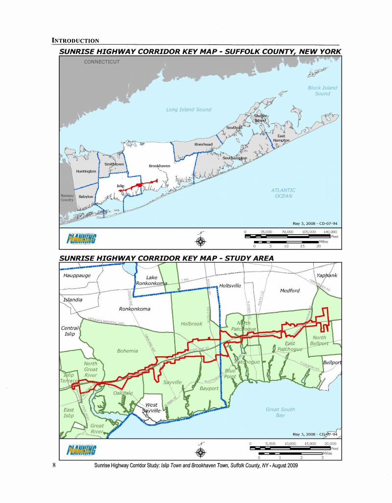
This report analyzes the area surrounding a12.7 mile segment of Sunrise Highway within thetowns of Islip and Brookhaven. The length ofSunrise Highway in the study area is 7.4 miles inthe Town of Islip, and 5.3 miles in the Town ofBrookhaven. Map 1 shows the study area in thecontext of Suffolk County as a whole and thecommunities bordering the study area.
The study area covers 3,105 acres (4.85square miles) and contains parcels of land with aclose connection to Sunrise Highway. The area is0.5% of the total area of Suffolk County. Thestudied segment includes the parcels adjacent toSunrise Highway from Islip Terrace east to NorthBellport. The western boundary of the study areais Heckscher State Parkway and the easternboundary lies just east of Bellport Station Road.
Much of the land in the study area isdeveloped, but there are some significant areas ofvacant land. There are also several properties thatcould reasonably be redeveloped. The study areacontains a significant number of units of multi-unit housing in housing complexes as well asnumerous single family residences near SunriseHighway. In addition, the study area containsmany shopping centers, other commercialdevelopment and significant industrialdevelopment.
The goal of this study is to identify policiesand practices that will help to manage growthwithin the Sunrise Highway corridor in a mannerthat will improve the quality of development,provide for a balance of land uses and a reductionof commercial sprawl, minimize the impact ontraffic and minimize the impact of land useconflicts with surrounding communities. Thestudy includes broad guidelines as well asrecommendations for land uses and trafficimpact mitigation.
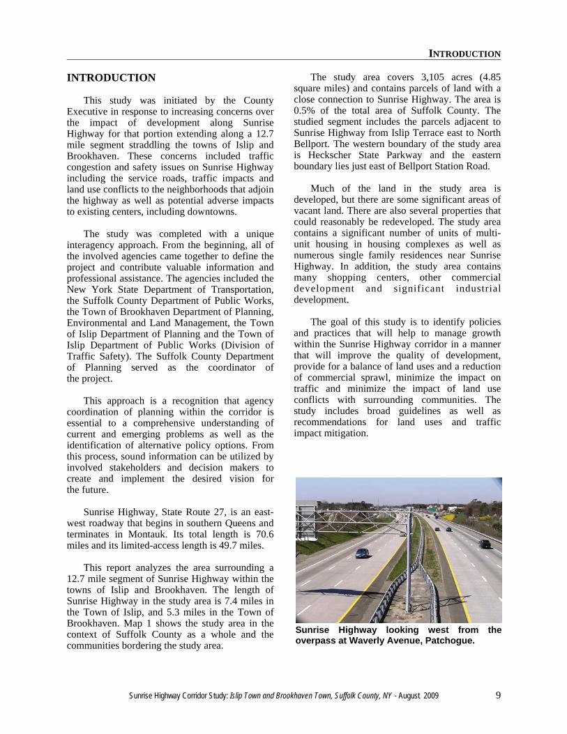
Sunrise Highway looking west from theoverpass at Waverly Avenue, Patchogue.

INTRODUCTION
10 Sunrise Highway Corridor Study: Islip Town and Brookhaven Town, Suffolk County, NY - August 2009

SUNRISE HIGHWAY HISTORY

SUNRISE HIGHWAY HISTORY
12 Sunrise Highway Corridor Study: Islip Town and Brookhaven Town, Suffolk County, NY - August 2009
SUNRISE HIGHWAY HISTORY
Sunrise Highway Corridor Study: Islip Town and Brookhaven Town, Suffolk County, NY - August 2009 13
SUNRISE HIGHWAY HISTORY
Early Years
The original main east/west road along thesouth shore of Long Island was MontaukHighway (known as Merrick Road in NassauCounty). Increased development along the southshore of the Island created additional demand forhighway capacity. The first segment of SunriseHighway was constructed in the 1920s betweenQueens and Massapequa. The highway wasextended to Great River in Suffolk County by1940 and to Phyllis Drive in East Patchogue by1953. As each section of highway was completed,the signs for NY 27 were transferred fromMontauk Highway (which became NY 27A) tothe new road.
Planning for a limited access SunriseHighway began as early as 1936, when theRegional Plan Association recommendedconstruction of a South Shore expresswayextending from Brooklyn east to Patchogue. Theexpressway would be open to all vehiclesincluding commercial vehicles and would servehighly populated areas. In 1949, the New YorkState Department of Public Works recommendedthe construction of a limited access highway thatwould extend from New York City east toMontauk Point. In the 1950s New York Stateannounced firm plans for a 50-mile-long, limitedaccess Sunrise Highway from West Babylonto Southampton.
Limited Access Highway
Construction began in 1958 on the initiallimited access segments, the first one from PhyllisDrive in East Patchogue east to Exit 61 (CountyRoute 51) in Eastport. The second segment to beconstructed was between Exit 65 (Route 24) inHampton Bays to the present terminus atShinnecock Hills. These two segments, whichwere built on new rights-of-way, were opened instages between 1960 and 1963.
Challenges to the construction of the “SunriseExpressway” soon followed. When New YorkState had first presented the plans, land along thehighway was being developed with shoppingcenters and gasoline stations. The conversion ofthe existing Sunrise Highway from a four-lane, at-grade divided highway to a six-lane limited accesshighway flanked by service roads was scheduledfor completion in 1964 but proved to be a farlonger and more arduous process. Further east,concerns were raised about building the limitedaccess highway through the environmentallysensitive Pine Barrens between Eastport andHampton Bays.
In 1972, construction converting SunriseHighway to limited access between West Babylonand Bay Shore was completed. In 1973, thelimited access portion of the highway betweenEastport and Hampton Bays was completed.
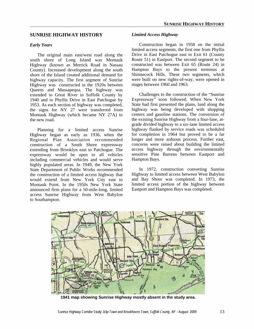
1941 map showing Sunrise Highway mostly absent in the study area.
SUNRISE HIGHWAY HISTORY
14 Sunrise Highway Corridor Study: Islip Town and Brookhaven Town, Suffolk County, NY - August 2009
Since the 1980s
In 1983, the New York State Department ofTranspor ta t ion (NYSDOT) comple tedconstruction converting the portion of SunriseHighway between Bay Shore (Brentwood Road,Exit 44) and Connetquot Avenue in Great River tolimited access. At this terminus, five eastboundlanes (three express and two service lanes)reduced to two lanes before stopping at a trafficlight at the Montauk Highway “Oakdale Merge.”For about one-half mile in this area, SunriseHighway and Montauk Highway merged to justtwo lanes in each direction.
In 1992 the limited access segment betweenVeterans Memorial Highway (Exit 51) in Bayportand Hospital Road (Exit 54) in East Patchoguewas completed by the NYSDOT. At that time, athird lane was constructed in each directionbetween Connetquot Avenue and VeteransMemorial Highway, to alleviate traffic congestionin the area around and east of the Oakdale Merge.As part of this project, a new, parallel MontaukHighway was constructed south of SunriseHighway. However, in the area along SunriseHighway at Connetquot State Park the highwayhas three express lanes in each direction but noservice roads. The gap in service roads in this areacontinues to aggravate rush hour trafficconditions.
By 1996 the segment between LakelandAvenue (Exit 49) and Veterans MemorialHighway (Exit 51) was made limited access. Thefinal segment to become limited access wasbetween the Oakdale Merge and LakelandAvenue, which opened in May 1998. The NewYork State Department of Transportation had nowsuccessfully created a major east-west limitedaccess highway from West Babylon toSouthampton.
Previous Corridor Study
The Town of Islip’s Sunrise HighwayCorridor Study, adopted in 1986, was intended toprevent an “endless pattern of strip commercialdevelopment” and to replace it with “more
coherent centers of commercial activity, well-designed housing developments…and oases ofopen space and visual relief” along the corridor.The study was completed by the Town of Islipand applied to land along Sunrise Highway withinthe town’s jurisdiction.
In proposing the elimination of nearly 100acres of commercial (retail) zoning, the studyfound that there was a “significant surplus ofcommercial zoning in the study area.” The studyalso identified three (3) perennial problemsassociated with surplus commercial zoning:
• It weakens existing centers and communityidentity
• It reduces traffic flow and safety• It is visually blighting
The Study specifically indicated thatdevelopment under existing conditions at the timewould “have three major problems, endemic tosuburban areas throughout the country which havean excess of commercial zoning:
1. Traffic volumes and conflicts resultingfrom excessive turning movements wouldbe maximized due to the high amount ofintense traffic generators permitted underexisting (retail) zoning.
2. The vitality of existing centers and oldershopping centers would be weakened asthe amount of new commercial spacewould far exceed expected gains inpopulation and disposable income tosupport it.
3. The sense of open space and visual relief,which at present still exists alongapproximately half of the study area,would be irretrievably lost.”
Consistent with the recommendations of thestudy, the Town of Islip ultimately reduced theamount of potential retail space fromapproximately 2 million square feet to 1.5 millionsquare feet through the elimination of nearly 100acres of commercial (retail) zoning. Many of theformer commercial sites became multiple familyresidential uses that have aided the Town’s goal ofproviding more diversified housing options.
SUNRISE HIGHWAY HISTORY
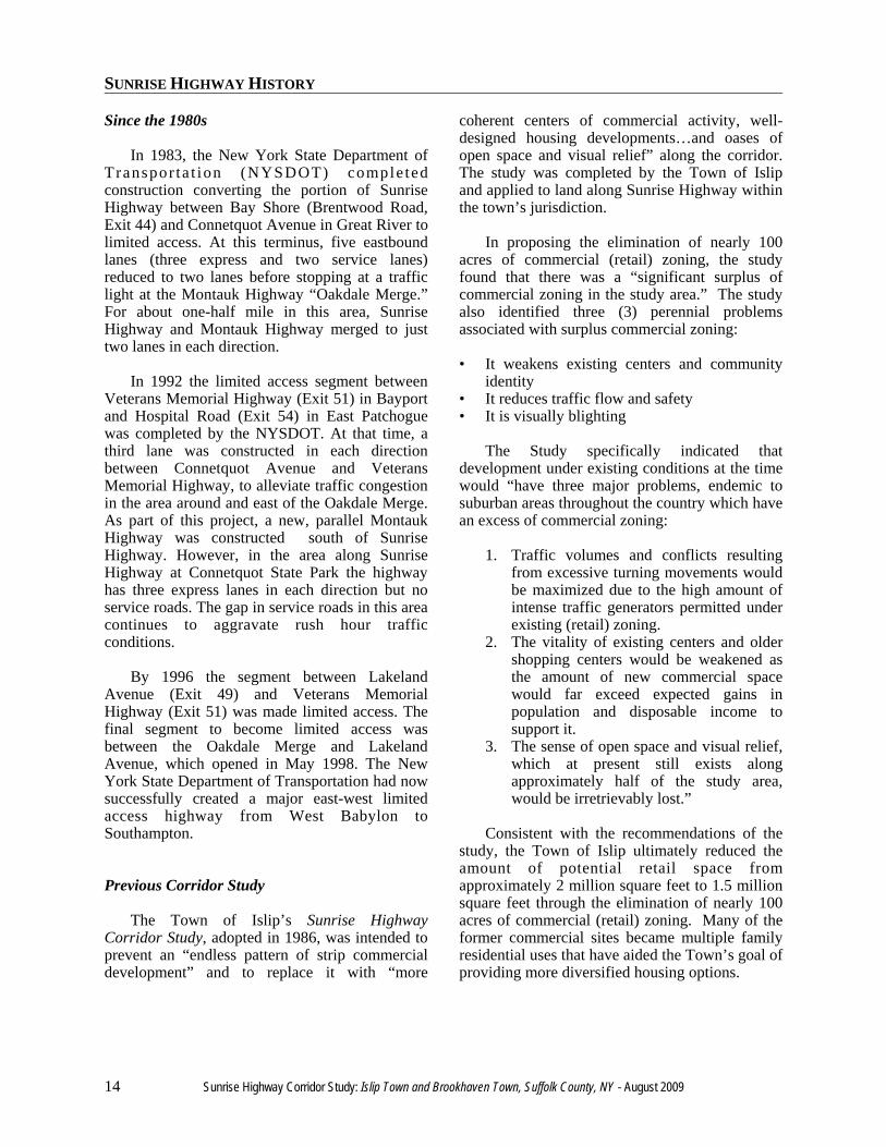
Sunrise Highway Corridor Study: Islip Town and Brookhaven Town, Suffolk County, NY - August 2009 15
Sunrise Highway in Holbrook after completion of limited access construction, with three travel lanesand two service road lanes in each direction.

SUNRISE HIGHWAY HISTORY
16 Sunrise Highway Corridor Study: Islip Town and Brookhaven Town, Suffolk County, NY - August 2009

EXISTING TRANSPORTATION

EXISTING TRANSPORTATION
18 Sunrise Highway Corridor Study: Islip Town and Brookhaven Town, Suffolk County, NY - August 2009
EXISTING TRANSPORTATION
Sunrise Highway Corridor Study: Islip Town and Brookhaven Town, Suffolk County, NY - August 2009 19
EXISTING TRANSPORTATION
Sunrise Highway
Sunrise Highway dominates the SunriseHighway Corridor Study Area. The road is alimited access highway throughout the study area,with three main travel lanes in each direction fromthe western border of the study area, east toPhyllis Drive in East Patchogue, just east of StateRoute 112. East of Phyllis Drive, the highway hastwo main travel lanes in each direction. Thehighway is also two lanes eastbound for one halfmile in East Islip and Great River east ofPacific Avenue.
Average annual daily traffic counts suppliedby the New York State Department ofTransportation are available for the road segmentswithin the Sunrise Highway Corridor study area.A summary of these traffic data are displayed inTable 1.
As expected, the highest traffic counts onSunrise Highway occur in the more westernportion of the study area, and generally decreaseas one heads east. Interestingly, however, trafficcounts on Sunrise Highway to the west of thestudy area are significantly lower than in thewestern part of the study area. In recent years,traffic counts between Route 109 and RobertMoses Causeway average in the range of 60,000to 80,000 vehicles per day, compared with over100,000 east of Heckscher Parkway. The increase
in traffic on Sunrise Highway east of HeckscherParkway happens because a large volume oftraffic uses Sunrise Highway in combination withHeckscher Parkway/Southern State Parkway totravel east-west on limited access roadways.
In Table 1, traffic counts in each segment areseparated by six years. In the past several years,traffic volumes in the study area have increased inevery road segment, sometimes dramatically. Theannual increase in traffic volume on mostsegments ranges from an increase of 1.3% to 7.2%per year, a significant increase. The mostsignificant increases have occurred betweenVeterans Highway and Waverly Avenue, wherethe segment’s traffic volume increased by 7.2%per year between 2000 and 2006. Trafficincreased by 6.3% per year between North OceanAvenue and Route 112.
In addition to the traffic volumes on SunriseHighway itself, there is significant additionaltraffic volume on the Sunrise Highway ServiceRoads. In 2004, average annual daily trafficcounts on just the westbound service roads wereobserved to be 23,100 on the westbound serviceroad between Waverly Avenue and Nicolls Road,and 34,400 on the westbound service roadbetween Nicolls Road and Veterans MemorialHighway. Other Sunrise Highway service roads inthe study area had average annual daily trafficcounts between 5,000 and 9,000 vehicles inone direction.
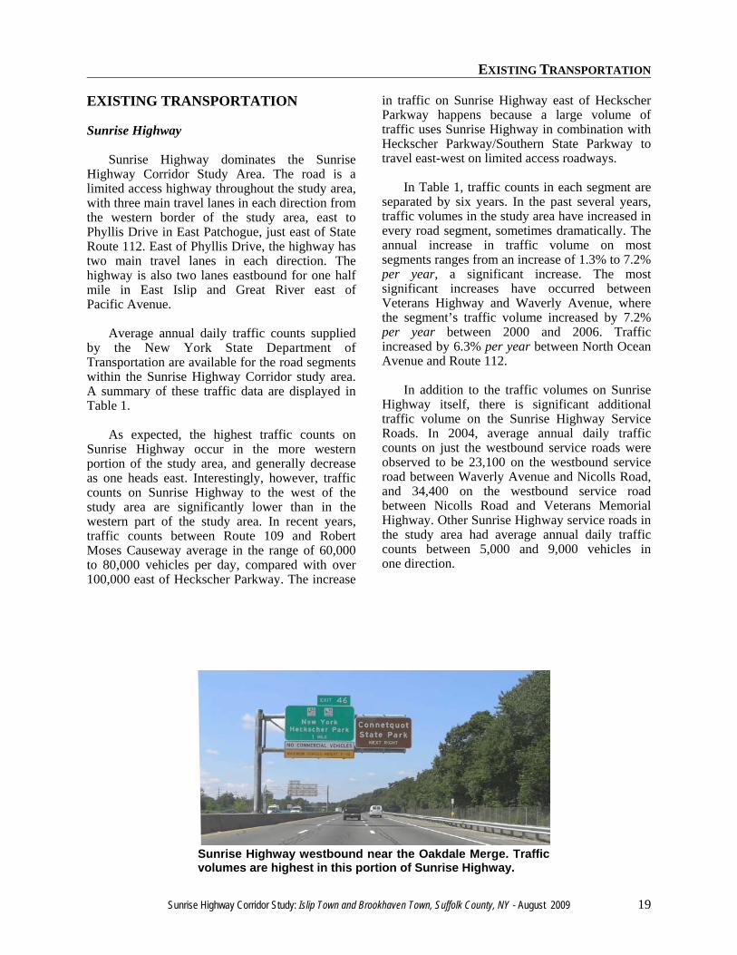
Sunrise Highway westbound near the Oakdale Merge. Trafficvolumes are highest in this portion of Sunrise Highway.
EXISTING TRANSPORTATION
20 Sunrise Highway Corridor Study: Islip Town and Brookhaven Town, Suffolk County, NY - August 2009
Table 1. Traffic Counts in the Sunrise Highway Corridor Study Area
Road Segment Count Year Count Year% Change
Over Time PeriodAnnual
% ChangeHeckscher Pkwy. to NY 27A 146,060 2006 125,450 2000 16.4% 2.6%NY 27A to Locust Ave. 133,200 2006 98,890 2000 34.7% 5.1%Locust Ave. to Lakeland Ave. 125,360 2006 95,280 2000 31.6% 4.7%Lakeland Ave. to Veterans Mem. Hwy. 105,660 2006 88,590 2000 19.3% 3.0%Veterans Mem. Hwy. to Waverly Ave. 82,890 2006 54,540 2000 52.0% 7.2%Waverly Ave. to N. Ocean Ave. 43,440 2006 40,000 2000 8.6% 1.4%N. Ocean Ave. to NY Route 112 101,080 2006 69,930 2000 44.5% 6.3%NY Route 112 to Hospital Rd. 65,870 2006 61,010 2000 8.0% 1.3%Hospital Rd. to C.R. 101 85,840 2006 65,970 2000 30.1% 4.5%C.R. 101 to Station Rd. 72,450 2006 65,330 2000 10.9% 1.7%Note: Traffic counts are average annual daily traffic volumes.June 13, 2008Source: New York State Department of Transportation
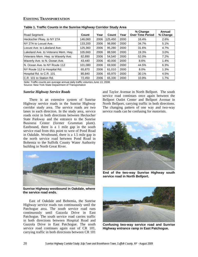
Sunrise Highway Service Roads
There is an extensive system of SunriseHighway service roads in the Sunrise Highwaycorridor study area. The service roads are twolanes in each direction. In the study area, serviceroads exist in both directions between HeckscherState Parkway and the entrance to the SunriseBusiness Center (former Grumman plant).Eastbound, there is a 1 mile gap in the southservice road from this point to west of Pond Roadin Oakdale. Westbound, there is a 1.5 mile gap inthe north service road between Pond Road inBohemia to the Suffolk County Water Authoritybuilding in North Great River.
East of Oakdale and Bohemia, the SunriseHighway service roads run continuously until thePatchogue area. The south service road runscontinuously until Gazzola Drive in EastPatchogue. The south service road carries trafficin both directions between Hospital Road andGazzola Drive in East Patchogue. The southservice road continues again east of CR 101,carrying traffic in both directions between CR 101
and Taylor Avenue in North Bellport. The southservice road continues once again between theBellport Outlet Center and Bellport Avenue inNorth Bellport, carrying traffic in both directions.The changing pattern of one way and two-wayservice roads can be confusing for motorists.
Sunrise Highway westbound in Oakdale, wherethe service road ends.
End of the two-way Sunrise Highway southservice road in North Bellport.
Confusing two-way service road and SunriseHighway entrance ramp in East Patchogue.
EXISTING TRANSPORTATION
Sunrise Highway Corridor Study: Islip Town and Brookhaven Town, Suffolk County, NY - August 2009 21
The north service road runs continuouslywestbound starting at Phyllis Drive in EastPatchogue. From the east, the north service roadcarries traffic in both directions between SouthVillage Drive and Bellport Avenue in NorthBellport. Then the south service road continuesagain for a short distance in both directionsbetween Sunset Drive in North Bellport and HaigAvenue in East Patchogue. It starts up again inboth directions between Sipp Avenue and HewlettAvenue in East Patchogue.
In certain parts of the study area, especially inthe vicinity of Nicolls Road, the service roads arefunctioning not as designed but as highway roadswith traffic moving at speeds much greater thanservice road speed limits. In particular, theintersection of Beacon Drive with the SunriseHighway north Service Road is problematicbecause it is situated relatively close to the exitramp from Nicolls Road onto the SunriseHighway service road.
The Oakdale Merge
The Oakdale Merge has long been known as apoint of heavy traffic congestion. When SunriseHighway was first constructed in Oakdale, it had ashort section overlapped by Montauk Highway,with two through lanes in each direction and fullaccess junctions at both the western and easternends of the overlap. As part of the reconstructionof Sunrise Highway into a limited accesshighway, a complete junction for Oakdale wasplanned, involving continuous service roads andcrossovers for complete access to and fromSunrise Highway. But due to the environmentalsensitivity of surrounding parklands, the completeinterchange proposal was not approved.
Instead, a separate two-lane roadway wasbuilt to carry Montauk Highway traffic, whileSunrise Highway was expanded to three lanes ineach direction. With this new configuration, allconnections to and from Sunrise Highway
westbound were cut off, except for the roadwayserving Connetquot River State Park. EastboundSunrise Highway to eastbound Montauk Highwaymovements were retained, along with u-turns toand from Montauk Highway along SunriseHighway eastbound.
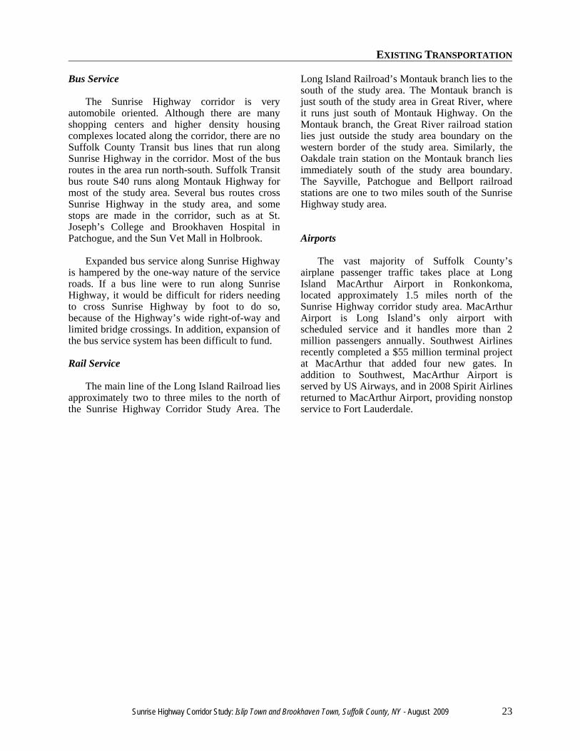
In 1999 a new eastbound Exit 47 was openedserving Pond Road. This ramp crossed the path ofthe ramp from Montauk Highway to SunriseHighway eastbound, which as a result wasremoved. This change left in place only three ofeight possible movements between SunriseHighway and Montauk Highway.
Congestion remains a problem at the OakdaleMerge, and the interchange draws considerablecriticism from motorists who frequent it, largelybecause of its lack of service roads and fullconnections. Throughout most of its length inSuffolk County, Sunrise Highway has two-laneservice roads and three travel lanes in eachdirection. Through the Oakdale Merge, the usualfive lanes in each direction are reduced to three.
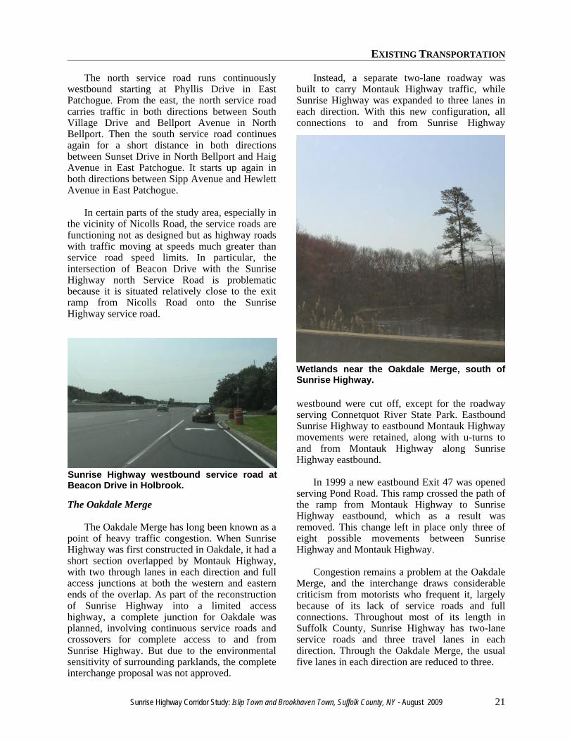
Sunrise Highway westbound service road atBeacon Drive in Holbrook.
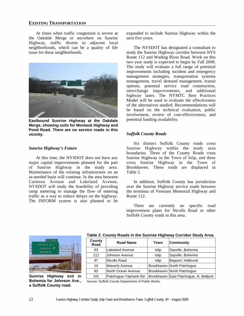
Wetlands near the Oakdale Merge, south ofSunrise Highway.
EXISTING TRANSPORTATION
22 Sunrise Highway Corridor Study: Islip Town and Brookhaven Town, Suffolk County, NY - August 2009
At times when traffic congestion is severe atthe Oakdale Merge or anywhere on SunriseHighway, traffic diverts to adjacent localneighborhoods, which can be a quality of lifeissue for these neighborhoods.
Sunrise Highway’s Future
At this time, the NYSDOT does not have anymajor capital improvements planned for the partof Sunrise Highway in the study area.Maintenance of the existing infrastructure on anas-needed basis will continue. In the area betweenCarleton Avenue and Lakeland Avenue,NYSDOT will study the feasibility of providingramp metering to manage the flow of enteringtraffic as a way to reduce delays on the highway.The INFORM system is also planned to be
expanded to include Sunrise Highway within thenext five years.
The NYSDOT has designated a consultant tostudy the Sunrise Highway corridor between NYSRoute 112 and Wading River Road. Work on thistwo year study is expected to begin by Fall 2008.The study will evaluate a full range of potentialimprovements including incident and emergencymanagement strategies, transportation systemsmanagement, travel demand management, transitoptions, potential service road construction,interchange improvements, and additionalhighway lanes. The NYMTC Best PracticesModel will be used to evaluate the effectivenessof the alternatives studied. Recommendations willbe based on the technical evaluation, publicinvolvement, review of cost-effectiveness, andpotential funding availability.
Suffolk County Roads
Six distinct Suffolk County roads crossSunrise Highway within the study areaboundaries. Three of the County Roads crossSunrise Highway in the Town of Islip, and threecross Sunrise Highway in the Town ofBrookhaven. These roads are displayed inTable 2.
In addition, Suffolk County has jurisdictionover the Sunrise Highway service roads betweenthe terminus of Veterans Memorial Highway andRoute 112.
There are currently no specific roadimprovement plans for Nicolls Road or otherSuffolk County roads in this area.
Table 2. County Roads in the Sunrise Highway Corridor Study Area.CountyRoad Road Name Town Community
93 Lakeland Avenue Islip Sayville, Bohemia112 Johnson Avenue Islip Sayville, Bohemia97 Nicolls Road Islip Bayport, Holbrook19 Waverly Avenue Brookhaven North Patchogue83 North Ocean Avenue Brookhaven North Patchogue101 Patchogue-Yaphank Rd. Brookhaven East Patchogue, N. Bellport
Source: Suffolk County Department of Public Works.
Eastbound Sunrise Highway at the OakdaleMerge, showing exits for Montauk Highway andPond Road. There are no service roads in thisvicinity.
Sunrise Highway exit inBohemia for Johnson Ave.,a Suffolk County road.
EXISTING TRANSPORTATION
Sunrise Highway Corridor Study: Islip Town and Brookhaven Town, Suffolk County, NY - August 2009 23
Bus Service
The Sunrise Highway corridor is veryautomobile oriented. Although there are manyshopping centers and higher density housingcomplexes located along the corridor, there are noSuffolk County Transit bus lines that run alongSunrise Highway in the corridor. Most of the busroutes in the area run north-south. Suffolk Transitbus route S40 runs along Montauk Highway formost of the study area. Several bus routes crossSunrise Highway in the study area, and somestops are made in the corridor, such as at St.Joseph’s College and Brookhaven Hospital inPatchogue, and the Sun Vet Mall in Holbrook.
Expanded bus service along Sunrise Highwayis hampered by the one-way nature of the serviceroads. If a bus line were to run along SunriseHighway, it would be difficult for riders needingto cross Sunrise Highway by foot to do so,because of the Highway’s wide right-of-way andlimited bridge crossings. In addition, expansion ofthe bus service system has been difficult to fund.
Rail Service
The main line of the Long Island Railroad liesapproximately two to three miles to the north ofthe Sunrise Highway Corridor Study Area. The
Long Island Railroad’s Montauk branch lies to thesouth of the study area. The Montauk branch isjust south of the study area in Great River, whereit runs just south of Montauk Highway. On theMontauk branch, the Great River railroad stationlies just outside the study area boundary on thewestern border of the study area. Similarly, theOakdale train station on the Montauk branch liesimmediately south of the study area boundary.The Sayville, Patchogue and Bellport railroadstations are one to two miles south of the SunriseHighway study area.
Airports
The vast majority of Suffolk County’sairplane passenger traffic takes place at LongIsland MacArthur Airport in Ronkonkoma,located approximately 1.5 miles north of theSunrise Highway corridor study area. MacArthurAirport is Long Island’s only airport withscheduled service and it handles more than 2million passengers annually. Southwest Airlinesrecently completed a $55 million terminal projectat MacArthur that added four new gates. Inaddition to Southwest, MacArthur Airport isserved by US Airways, and in 2008 Spirit Airlinesreturned to MacArthur Airport, providing nonstopservice to Fort Lauderdale.

EXISTING TRANSPORTATION
24 Sunrise Highway Corridor Study: Islip Town and Brookhaven Town, Suffolk County, NY - August 2009

DEMOGRAPHICS

DEMOGRAPHICS
26 Sunrise Highway Corridor Study: Islip Town and Brookhaven Town, Suffolk County, NY - August 2009
DEMOGRAPHICS
Sunrise Highway Corridor Study: Islip Town and Brookhaven Town, Suffolk County, NY - August 2009 27
DEMOGRAPHICS
Population
The communities surrounding the SunriseHighway corridor contain a sizeable, slowlygrowing population. In addition to variedcommercial and industrial development in thecommunities in the Sunrise Highway CorridorStudy Area, there are a large number of singlefamily homes and multi-unit housing complexesin these communities. These housing units arehome to tens of thousands of individuals,households, and families.
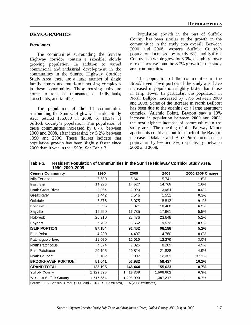
The population of the 14 communitiessurrounding the Sunrise Highway Corridor StudyArea totaled 155,000 in 2008, or 10.3% ofSuffolk County’s population. The population ofthese communities increased by 8.7% between2000 and 2008, after increasing by 5.2% between1990 and 2000. These figures indicate thatpopulation growth has been slightly faster since2000 than it was in the 1990s. See Table 3.
Population growth in the rest of SuffolkCounty has been similar to the growth in thecommunities in the study area overall. Between2000 and 2008, western Suffolk County’spopulation increased by nearly 6%, and SuffolkCounty as a whole grew by 6.3%, a slightly lowerrate of increase than the 8.7% growth in the studyarea communities.
The population of the communities in theBrookhaven Town portion of the study area haveincreased in population slightly faster than thosein Islip Town. In particular, the population inNorth Bellport increased by 37% between 2000and 2008. Some of the increase in North Bellporthas been due to the opening of a large apartmentcomplex (Atlantic Point). Bayport saw a 10%increase in population between 2000 and 2008,the next highest increase of communities in thestudy area. The opening of the Fairway Manorapartments could account for much of the Bayportincrease. Oakdale and Blue Point increased inpopulation by 9% and 8%, respectively, between2000 and 2008.
Table 3. Resident Population of Communities in the Sunrise Highway Corridor Study Area,1990, 2000, 2008
Census Community 1990 2000 2008 2000-2008 ChangeIslip Terrace 5,530 5,641 5,741 1.8%East Islip 14,325 14,527 14,765 1.6%North Great River 3,964 3,929 3,964 0.9%Great River 1,442 1,546 1,551 0.3%Oakdale 7,875 8,075 8,813 9.1%Bohemia 9,556 9,871 10,480 6.2%Sayville 16,550 16,735 17,661 5.5%Holbrook 20,210 22,476 23,648 5.2%Bayport 7,702 8,662 9,573 10.5%ISLIP PORTION 87,154 91,462 96,196 5.2%Blue Point 4,230 4,407 4,760 8.0%Patchogue village 11,060 11,919 12,279 3.0%North Patchogue 7,374 7,825 8,209 4.9%East Patchogue 20,195 20,824 21,838 4.9%North Bellport 8,182 9,007 12,351 37.1%BROOKHAVEN PORTION 51,041 53,982 59,437 10.1%GRAND TOTAL 138,195 145,444 155,633 8.7%Suffolk County 1,322,535 1,419,369 1,508,602 6.3%Western Suffolk County 1,215,384 1,293,999 1,367,217 5.7%Source: U. S. Census Bureau (1990 and 2000 U. S. Censuses), LIPA (2008 estimates)
DEMOGRAPHICS
28 Sunrise Highway Corridor Study: Islip Town and Brookhaven Town, Suffolk County, NY - August 2009
Population Density
The population density of thecommunities in the study area is slightlyhigher than the density in western SuffolkCounty overall. The study area communitiestogether have a population density of 2,659persons per square mile, slightly higher thanthe 2,422 in all of western Suffolk County.The Islip communities in the study area havea population density of 2,441 persons persquare mile, lower than the density of theBrookhaven communities in the study area(3,107 persons per square mile). See Table 4.
The lower population density in the Townof Islip is mostly due to the inclusion of largeparkland areas in two communities in thestudy area. The lowest population densitiesoccur in Great River (which includesHeckscher State Park) and Bohemia (whichincludes Connetquot River State Park). Thecommunity in the study area with the highestpopulation density is the Village ofPatchogue, with more than 5,000 persons persquare mile. Holbrook and Islip Terrace, twopredominantly residential communities, arethe next most dense communities.
Table 4. Population Density of Communities inthe Sunrise Highway Corridor StudyArea, 2008.
Census CommunityPersons Per Square
MileIslip Terrace 4,043East Islip 3,592North Great River 1,739Great River 337Oakdale 2,655Bohemia 1,200Sayville 3,194Holbrook 4,142Bayport 2,580ISLIP PORTION 2,441Blue Point 2,674Patchogue village 5,457North Patchogue 3,854East Patchogue 2,625North Bellport 2,656BROOKHAVEN PORTION 3,107GRAND TOTAL 2,659Suffolk County 1,654Western Suffolk County 2,422Town of Islip 3,168Town of Brookhaven 1,893Source: U. S. Census Bureau, LIPA
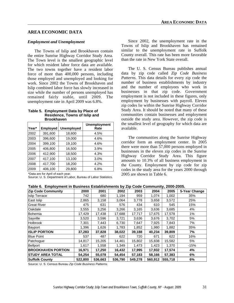
New homes in North Bellport. Since 2000, NorthBellport’s population has grown faster than the othercommunities in the study area.
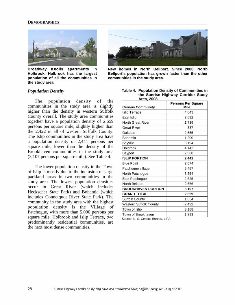
Broadway Knolls apartments inHolbrook. Holbrook has the largestpopulation of all the communities inthe study area.

AREA ECONOMIC DATA

AREA ECONOMIC DATA
30 Sunrise Highway Corridor Study: Islip Town and Brookhaven Town, Suffolk County, NY - August 2009
AREA ECONOMIC DATA
Sunrise Highway Corridor Study: Islip Town and Brookhaven Town, Suffolk County, NY - August 2009 31
AREA ECONOMIC DATA
Employment and Unemployment
The Towns of Islip and Brookhaven containthe entire Sunrise Highway Corridor Study Area.The Town level is the smallest geographic levelfor which resident labor force data are available.The two towns together have a resident laborforce of more than 400,000 persons, includingthose employed and unemployed and looking forwork. Since 2002 the Towns of Brookhaven andIslip combined labor force has slowly increased insize while the number of persons unemployed hasremained fairly stable, until 2009. Theunemployment rate in April 2009 was 6.8%.
Table 5. Employment Data by Place ofResidence, Towns of Islip andBrookhaven
Year* Employed UnemployedUnemployment
Rate2002 391,600 18,600 4.5%2003 396,600 19,000 4.6%2004 399,100 19,100 4.6%2005 406,800 16,500 3.9%2006 412,900 18,500 4.3%2007 417,100 13,100 3.0%2008 417,700 18,200 4.2%2009 406,100 29,800 6.8%*Data are for April of each year.Source: U. S. Department of Labor, Bureau of Labor Statistics.
Since 2002, the unemployment rate in theTowns of Islip and Brookhaven has remainedsimilar to the unemployment rate in SuffolkCounty overall. This rate has been more favorablethan the rate in New York State overall.
The U. S. Census Bureau publishes annualdata by zip code called Zip Code BusinessPatterns. This data details for every zip code thenumber of business establishments by industryand the number of employees who work inbusinesses in that zip code. Governmentemployment is not included in these figures, onlyemployment by businesses with payroll. Elevenzip codes lie within the Sunrise Highway CorridorStudy Area. It should be noted that many of thesecommunities contain businesses and employmentoutside the study area. However, the zip code isthe smallest level of geography for which data areavailable.
The communities along the Sunrise Highwaycorridor form an employment center. In 2005there were more than 57,000 persons employed inbusinesses in the eleven zip codes in the SunriseHighway Corridor Study Area. This figureamounts to 10.3% of all business employment inthe County. Employment by zip code for zipcodes in the study area for the years 2000 through2005 are shown in Table 6.
Table 6. Employment in Business Establishments by Zip Code Community, 2000-2005.Zip Code Community 2000 2001 2002 2003 2004 2005 5-Year ChangeIslip Terrace 742 680 1,194 959 1,074 1,002 35%East Islip 2,865 3,158 3,064 3,778 3,658 3,572 25%Great River 475 631 576 434 610 545 15%Oakdale 3,555 3,256 3,266 3,165 3,636 3,685 4%Bohemia 17,429 17,438 17,688 17,717 17,675 17,578 1%Sayville 3,520 3,596 3,721 3,636 3,676 3,702 5%Holbrook 7,301 7,443 6,730 7,647 7,925 7,843 7%Bayport 1,396 1,626 1,783 1,852 1,980 1,882 35%ISLIP PORTION 37,283 37,828 38,022 39,188 40,234 39,809 7%Blue Point 537 487 622 720 671 622 16%Patchogue 14,817 15,205 14,461 15,802 15,838 15,582 5%Bellport 1,617 1,558 1,349 1,473 1,423 1,370 -15%BROOKHAVEN PORTION 16,971 17,250 16,432 17,995 17,932 17,574 4%STUDY AREA TOTAL 54,254 55,078 54,454 57,183 58,166 57,383 6%Suffolk County 522,800 536,663 536,790 549,278 560,912 555,718 6%Source: U. S. Census Bureau Zip Code Business Patterns.
AREA ECONOMIC DATA
32 Sunrise Highway Corridor Study: Islip Town and Brookhaven Town, Suffolk County, NY - August 2009
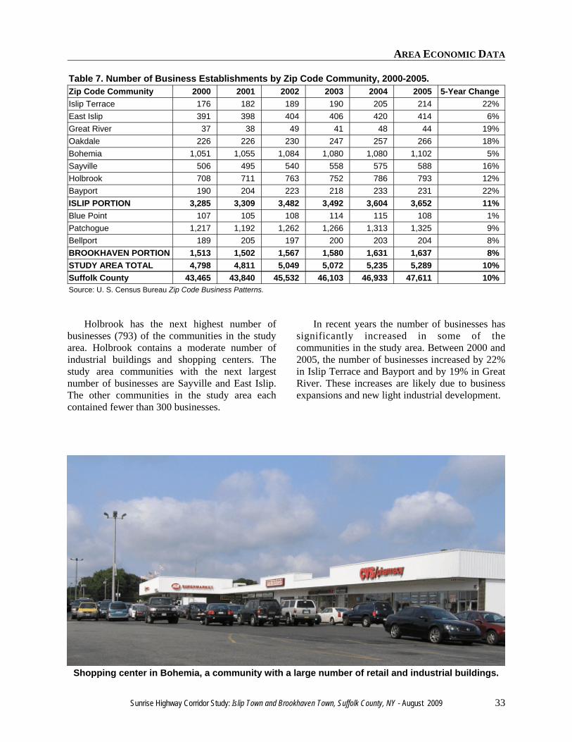
Two communities in the study area hadsignificantly higher levels of employment than theother communities: Bohemia and Patchogue.Bohemia had 17,578 employees, ranking 7th of allSuffolk County communities and Patchogue had15,582 workers, ranking 9th in the County.Bohemia contains a large number of lightindustrial buildings, especially in the area nearVeterans Memorial Highway. The Patchogue zipcode area is large; it includes the incorporatedvillage of Patchogue and the hamlets of NorthPatchogue and East Patchogue. It contains ahospital (a large employer) and a large number ofbusinesses on Sunrise Highway, MontaukHighway and State Route 112.
Holbrook has the next highest number ofemployees (7,843) of the study area communities.Holbrook contains a moderate amount ofemployment in industrial buildings and shoppingcenters. The next largest employment centers inthe study area are Sayville, Oakdale and EastIslip. The other communities in the study areaeach contained fewer than 2,000 employees.
Significant increases in employment haveoccurred in a few communities in the study area.Between 2000 and 2005, employment inbusinesses increased by 35% in Islip Terrace andBayport and by 25% in East Islip. These increasesare likely due to business expansions and newlight industrial development. Employment inBellport decreased by 15% during the period,likely due to loss of business at the two BellportOutlet shopping centers. The addition of a HomeDepot at the Bellport Outlet has since increasedemployment levels.
Business Establishments
In 2005 there were more than 5,000 businessestablishments in the eleven zip codes in theSunrise Highway Corridor Study Area. Thisfigure amounts to 11.1% of all businesses in theCounty. The number of businesses by zip code forzip codes in the study area for the years 2000through 2005 are shown See Table 7.
Once again, two communities in the studyarea had significantly larger numbersof businesses than the other communities:Bohemia and Patchogue. Patchogue had 1,325businesses and Bohemia had 1,102 businesses.Patchogue is a large zip code that includes thevillage of Patchogue, North Patchogue and EastPatchogue, and it has a large number ofbusinesses on both Sunrise Highway and MontaukHighway. Bohemia contains a large number oflight industrial buildings, especially in the areanear Veterans Memorial Highway.
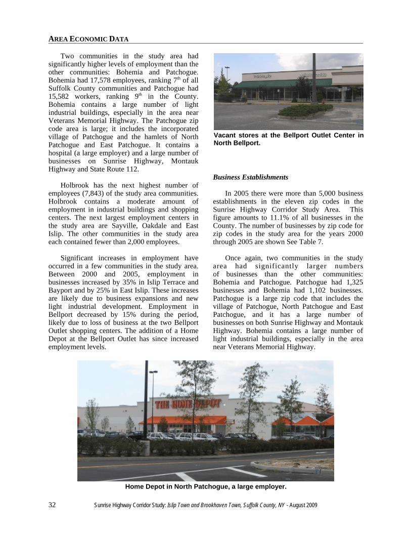
Vacant stores at the Bellport Outlet Center inNorth Bellport.
Home Depot in North Patchogue, a large employer.
AREA ECONOMIC DATA
Sunrise Highway Corridor Study: Islip Town and Brookhaven Town, Suffolk County, NY - August 2009 33
Table 7. Number of Business Establishments by Zip Code Community, 2000-2005.Zip Code Community 2000 2001 2002 2003 2004 2005 5-Year ChangeIslip Terrace 176 182 189 190 205 214 22%East Islip 391 398 404 406 420 414 6%Great River 37 38 49 41 48 44 19%Oakdale 226 226 230 247 257 266 18%Bohemia 1,051 1,055 1,084 1,080 1,080 1,102 5%Sayville 506 495 540 558 575 588 16%Holbrook 708 711 763 752 786 793 12%Bayport 190 204 223 218 233 231 22%ISLIP PORTION 3,285 3,309 3,482 3,492 3,604 3,652 11%Blue Point 107 105 108 114 115 108 1%Patchogue 1,217 1,192 1,262 1,266 1,313 1,325 9%Bellport 189 205 197 200 203 204 8%BROOKHAVEN PORTION 1,513 1,502 1,567 1,580 1,631 1,637 8%STUDY AREA TOTAL 4,798 4,811 5,049 5,072 5,235 5,289 10%Suffolk County 43,465 43,840 45,532 46,103 46,933 47,611 10%Source: U. S. Census Bureau Zip Code Business Patterns.
Holbrook has the next highest number ofbusinesses (793) of the communities in the studyarea. Holbrook contains a moderate number ofindustrial buildings and shopping centers. Thestudy area communities with the next largestnumber of businesses are Sayville and East Islip.The other communities in the study area eachcontained fewer than 300 businesses.
In recent years the number of businesses hassignificantly increased in some of thecommunities in the study area. Between 2000 and2005, the number of businesses increased by 22%in Islip Terrace and Bayport and by 19% in GreatRiver. These increases are likely due to businessexpansions and new light industrial development.
Shopping center in Bohemia, a community with a large number of retail and industrial buildings.
AREA ECONOMIC DATA
34 Sunrise Highway Corridor Study: Islip Town and Brookhaven Town, Suffolk County, NY - August 2009
Hotel Market
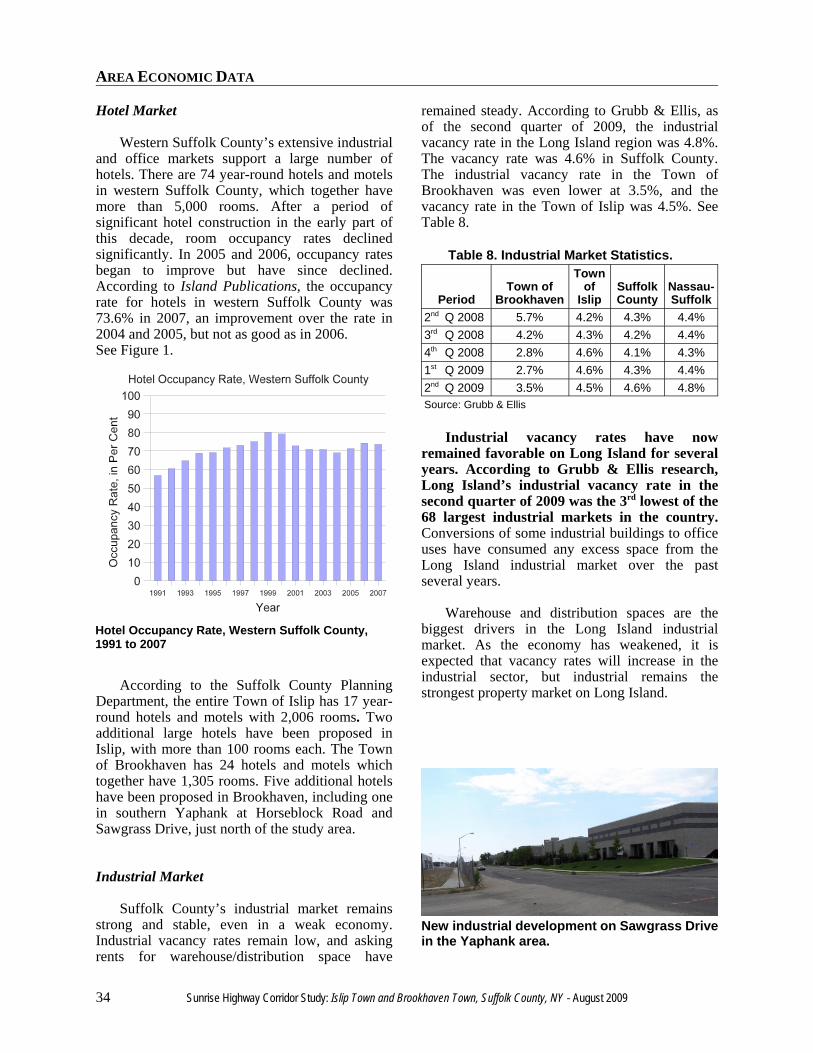
Western Suffolk County’s extensive industrialand office markets support a large number ofhotels. There are 74 year-round hotels and motelsin western Suffolk County, which together havemore than 5,000 rooms. After a period ofsignificant hotel construction in the early part ofthis decade, room occupancy rates declinedsignificantly. In 2005 and 2006, occupancy ratesbegan to improve but have since declined.According to Island Publications, the occupancyrate for hotels in western Suffolk County was73.6% in 2007, an improvement over the rate in2004 and 2005, but not as good as in 2006.See Figure 1.
According to the Suffolk County PlanningDepartment, the entire Town of Islip has 17 year-round hotels and motels with 2,006 rooms. Twoadditional large hotels have been proposed inIslip, with more than 100 rooms each. The Townof Brookhaven has 24 hotels and motels whichtogether have 1,305 rooms. Five additional hotelshave been proposed in Brookhaven, including onein southern Yaphank at Horseblock Road andSawgrass Drive, just north of the study area.
Industrial Market
Suffolk County’s industrial market remainsstrong and stable, even in a weak economy.Industrial vacancy rates remain low, and askingrents for warehouse/distribution space have
remained steady. According to Grubb & Ellis, asof the second quarter of 2009, the industrialvacancy rate in the Long Island region was 4.8%.The vacancy rate was 4.6% in Suffolk County.The industrial vacancy rate in the Town ofBrookhaven was even lower at 3.5%, and thevacancy rate in the Town of Islip was 4.5%. SeeTable 8.
Table 8. Industrial Market Statistics.
PeriodTown of
Brookhaven
Townof
IslipSuffolkCounty
Nassau-Suffolk
2nd Q 2008 5.7% 4.2% 4.3% 4.4%3rd Q 2008 4.2% 4.3% 4.2% 4.4%4th Q 2008 2.8% 4.6% 4.1% 4.3%1st Q 2009 2.7% 4.6% 4.3% 4.4%2nd Q 2009 3.5% 4.5% 4.6% 4.8%Source: Grubb & Ellis
Industrial vacancy rates have nowremained favorable on Long Island for severalyears. According to Grubb & Ellis research,Long Island’s industrial vacancy rate in thesecond quarter of 2009 was the 3rd lowest of the68 largest industrial markets in the country.Conversions of some industrial buildings to officeuses have consumed any excess space from theLong Island industrial market over the pastseveral years.
Warehouse and distribution spaces are thebiggest drivers in the Long Island industrialmarket. As the economy has weakened, it isexpected that vacancy rates will increase in theindustrial sector, but industrial remains thestrongest property market on Long Island.
Hotel Occupancy Rate, Western Suffolk County,1991 to 2007
New industrial development on Sawgrass Drivein the Yaphank area.
AREA ECONOMIC DATA
Sunrise Highway Corridor Study: Islip Town and Brookhaven Town, Suffolk County, NY - August 2009 35
Office Market
Suffolk County’s office market is relativelyhealthy. Office vacancy rates remain relativelylow, although asking rents have decreased in thepast year. According to Grubb & Ellis, as of thesecond quarter of 2009, the office vacancy rate inthe Long Island region was 9.3% and the vacancyrate was 11.4% in Suffolk County. (An officevacancy rate below 10% is considered favorable.)The office vacancy rates in the Towns ofBrookhaven and Islip were significantly higher at19.1% and 13.4%, respectively. The officemarkets in the Towns of Brookhaven and Islipusually have a higher vacancy rate than SuffolkCounty as a whole. See Table 9.
Grubb & Ellis also compiles office rental ratesby Town. According to Grubb & Ellis, officerental rates in Islip and Brookhaven Towns arelower than all the other towns in western Suffolkand Nassau Counties. Class A office rental rates inthe Town of Brookhaven averaged $20.64 persquare foot in the second quarter of 2009, 9%lower than a year ago. Office rental rates in theTown of Islip averaged $26.19 per square foot inthe second quarter of 2009, 8% lower than a yearago. the average for all of Suffolk County.Between the second quarter of 2008 and thesecond quarter of 2009, Class A office rental ratesdecreased by 6% in Suffolk County overall, to$26.85 per square foot.
Table 9. Office Market Statistics
PeriodTown of
BrookhavenTown of
Islip Suffolk CountyNassau-Suffolk U. S.
2nd Quarter ‘08 13.5% 11.6% 10.5% 9.9% 14.0% 3rd Quarter ‘08 12.9% 12.2% 10.0% 9.5% 14.3% 4th Quarter ‘08 18.1% 10.9% 10.1% 8.8% 14.8% 1st Quarter '09 17.8% 10.5% 10.1% 8.5% 15.6% 2nd Quarter '09 19.1% 13.4% 11.4% 9.3% 16.6%Source: Grubb & Ellis

AREA ECONOMIC DATA
36 Sunrise Highway Corridor Study: Islip Town and Brookhaven Town, Suffolk County, NY - August 2009

DEVELOPMENT IN THE STUDY AREA

DEVELOPMENT IN THE STUDY AREA
38 Sunrise Highway Corridor Study: Islip Town and Brookhaven Town, Suffolk County, NY - August 2009
DEVELOPMENT IN THE STUDY AREA
Sunrise Highway Corridor Study: Islip Town and Brookhaven Town, Suffolk County, NY - August 2009 39
DEVELOPMENT IN THE STUDY AREA
Hotels and Motels
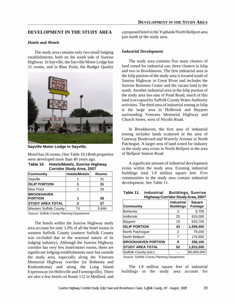
The study area contains only two small lodgingestablishments, both on the south side of SunriseHighway. In Sayville, the Sayville Motor Lodge has31 rooms, and in Blue Point, the Budget Quality
Motel has 26 rooms. (See Table 10.) Both propertieswere developed more than 40 years ago.Table 10. Hotels/Motels, Sunrise Highway
Corridor Study Area, 2007Community Hotels/Motels RoomsSayville 1 31ISLIP PORTION 1 31Blue Point 1 26BROOKHAVENPORTION 1 26STUDY AREA TOTAL 2 57Western Suffolk County 74 5,846Source: Suffolk County Planning Department
The hotels within the Sunrise Highway studyarea account for only 1.0% of all the hotel rooms inwestern Suffolk County (eastern Suffolk Countywas excluded due to the seasonal nature of itslodging industry). Although the Sunrise Highwaycorridor has very few hotel/motel rooms, there aresignificant lodging establishments near but outsidethe study area, especially along the VeteransMemorial Highway corridor (in Bohemia andRonkonkoma) and along the Long IslandExpressway (in Holtsville and Farmingville). Thereare also a few hotels on Route 112 in Medford, and
a proposed hotel in the Yaphank/North Bellport areajust north of the study area.
Industrial Development
The study area contains five main clusters ofland zoned for industrial use, three clusters in Islipand two in Brookhaven. The first industrial area inthe Islip portion of the study area is located south ofSunrise Highway in Great River and includes theSunrise Business Center and the vacant land to thesouth. Another industrial area in the Islip portion ofthe study area lies east of Pond Road; much of thisland is occupied by Suffolk County Water Authorityactivities. The third area of industrial zoning in Islipis the large area in Holbrook and Bayportsurrounding Veterans Memorial Highway andChurch Street, west of Nicolls Road.
In Brookhaven, the first area of industrialzoning includes lands scattered in the area ofGateway Boulevard and Waverly Avenue in NorthPatchogue. A larger area of land zoned for industryin the study area exists in North Bellport in the areaof Bellport Station Road.
A significant amount of industrial developmentexists within the study area. Existing industrialbuildings total 1.8 million square feet. Fivecommunities in the study area contain industrialdevelopment. See Table 11.
Table 11. Industrial Buildings, SunriseHighway Corridor Study Area, 2007
CommunityIndustrialBuildings
SquareFootage
Bohemia 3 9,700Holbrook 25 916,000Bayport 15 633,700ISLIP PORTION 43 1,559,400North Patchogue 2 79,200North Bellport 7 176,900BROOKHAVEN PORTION 9 256,100STUDY AREA TOTAL 52 1,815,500Suffolk County (est.) - 95,000,000Source: Suffolk County Planning Department
The 1.8 million square feet of industrialbuildings in the study area account for
Sayville Motor Lodge in Sayville.
DEVELOPMENT IN THE STUDY AREA
40 Sunrise Highway Corridor Study: Islip Town and Brookhaven Town, Suffolk County, NY - August 2009
Light industrial development in the SherwoodCorporate Center in Holbrook.
Sunrise Business Center in Great River.New office building on Hospital Road in EastPatchogue.
approximately 1.9% of all industrial development inSuffolk County. There is significantly moreindustrial development in the Town of Islip portionof the study area than in the Brookhaven Townportion. Currently, the largest concentration ofindustrial development in the study area is inHolbrook, where 25 industrial buildings containmore than 916,000 square feet of space. Bayport hasanother 633,700 square feet of space in 15buildings, including large buildings occupied byWenner Bread, Nature’s Bounty, and StimpsonIncorporated. North Bellport has a smallconcentration of industrial buildings on StationRoad and on Farber Drive. In the study area, theremaining industrial buildings are in NorthPatchogue and Bohemia.
Office Development
The largest concentrations of major office spacein Suffolk County are located in Melville andHauppauge. Other parts of Suffolk County alsocontain significant office space. Within the studyarea, there is a moderate amount of office space inoffice buildings and office parks. Five communitiesin the study area contain significant office buildings.Table 12 details the amount of office space withinthe study area.
Table 12. Office Buildings/ Complexes*,Sunrise Highway Corridor StudyArea, 2007
CommunityOffice
Buildings Square FootageGreat River 1 363,000Bohemia 1 26,000Holbrook 1 19,000ISLIP PORTION 3 408,000North Patchogue 1 38,000East Patchogue 2 148,000BROOKHAVENPORTION 3 186,000STUDY AREATOTAL 6 594,000Suffolk County 407 23,648,000*Non-government buildings/complexes 15,000 square feet orlarger.Source: Suffolk County Planning Department
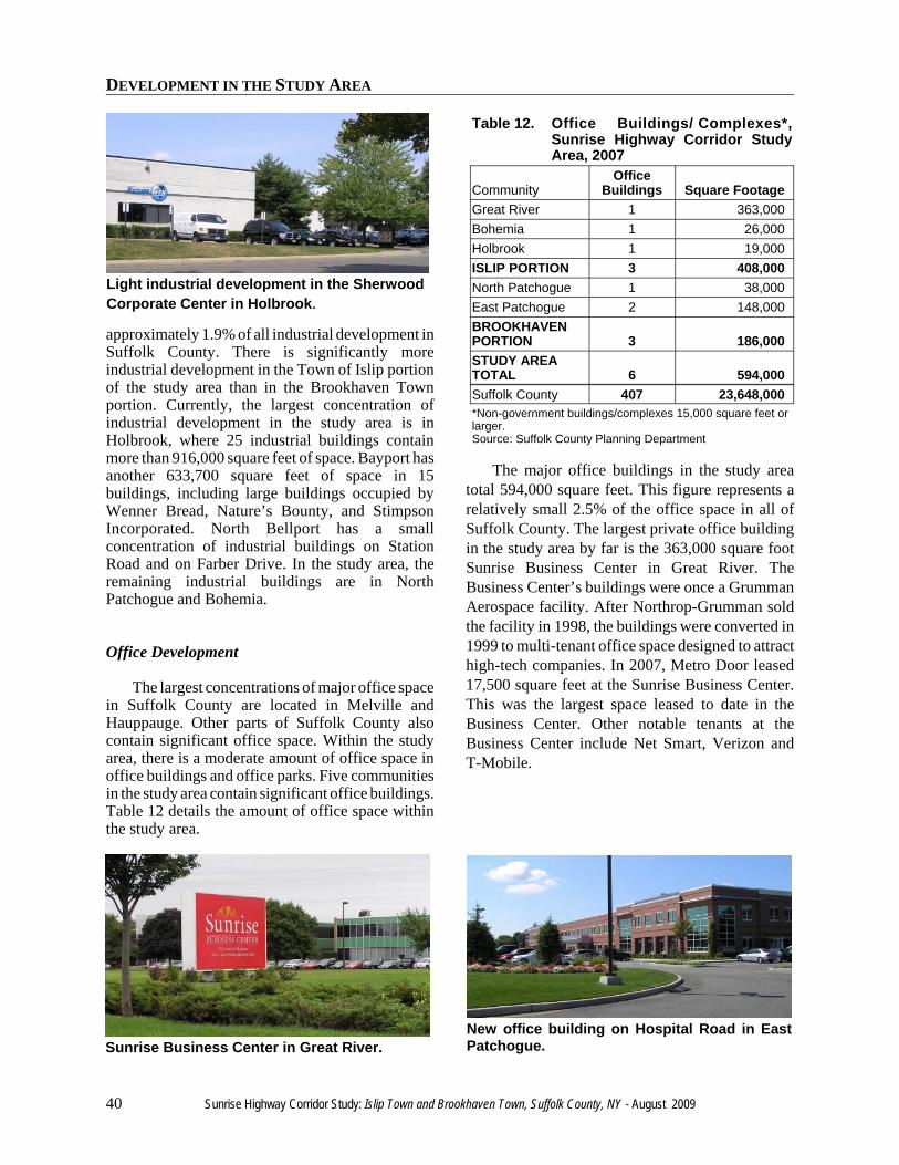
The major office buildings in the study areatotal 594,000 square feet. This figure represents arelatively small 2.5% of the office space in all ofSuffolk County. The largest private office buildingin the study area by far is the 363,000 square footSunrise Business Center in Great River. TheBusiness Center’s buildings were once a GrummanAerospace facility. After Northrop-Grumman soldthe facility in 1998, the buildings were converted in1999 to multi-tenant office space designed to attracthigh-tech companies. In 2007, Metro Door leased17,500 square feet at the Sunrise Business Center.This was the largest space leased to date in theBusiness Center. Other notable tenants at theBusiness Center include Net Smart, Verizon andT-Mobile.
DEVELOPMENT IN THE STUDY AREA
Sunrise Highway Corridor Study: Islip Town and Brookhaven Town, Suffolk County, NY - August 2009 41
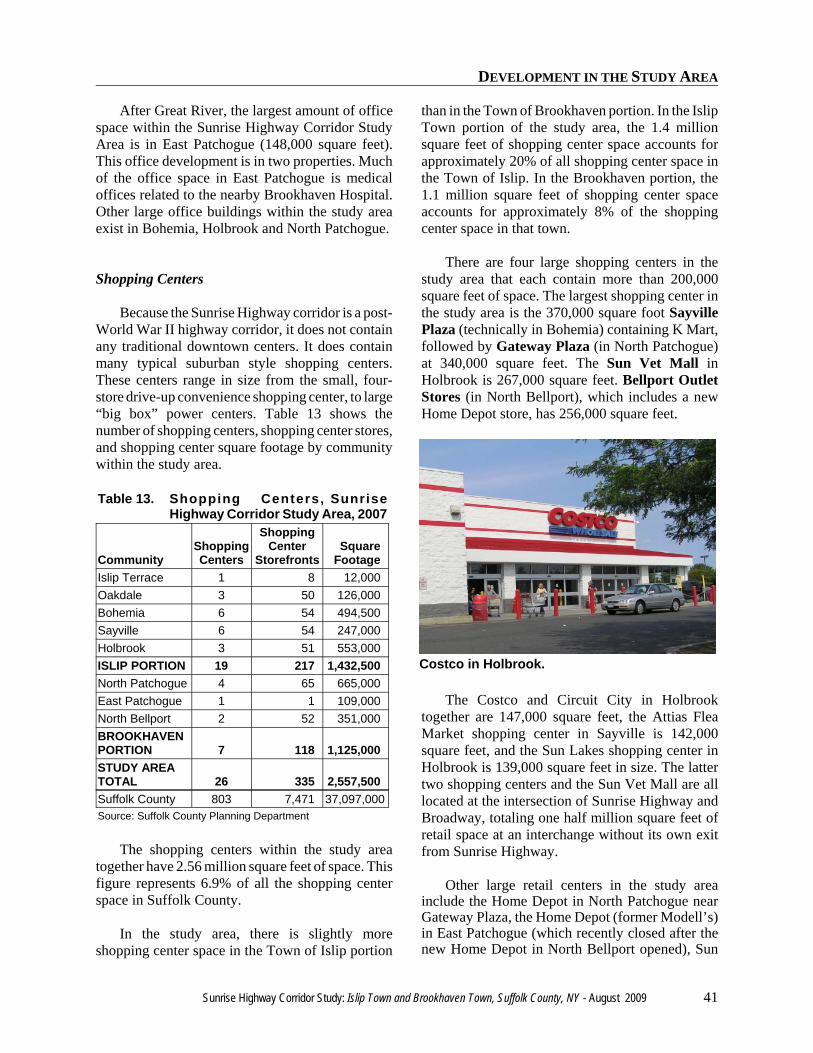
Costco in Holbrook.
After Great River, the largest amount of officespace within the Sunrise Highway Corridor StudyArea is in East Patchogue (148,000 square feet).This office development is in two properties. Muchof the office space in East Patchogue is medicaloffices related to the nearby Brookhaven Hospital.Other large office buildings within the study areaexist in Bohemia, Holbrook and North Patchogue.
Shopping Centers
Because the Sunrise Highway corridor is a post-World War II highway corridor, it does not containany traditional downtown centers. It does containmany typical suburban style shopping centers.These centers range in size from the small, four-store drive-up convenience shopping center, to large“big box” power centers. Table 13 shows thenumber of shopping centers, shopping center stores,and shopping center square footage by communitywithin the study area.
Table 13. Shopping Centers, SunriseHighway Corridor Study Area, 2007
CommunityShoppingCenters
ShoppingCenter
StorefrontsSquare
FootageIslip Terrace 1 8 12,000Oakdale 3 50 126,000Bohemia 6 54 494,500Sayville 6 54 247,000Holbrook 3 51 553,000ISLIP PORTION 19 217 1,432,500North Patchogue 4 65 665,000East Patchogue 1 1 109,000North Bellport 2 52 351,000BROOKHAVENPORTION 7 118 1,125,000STUDY AREATOTAL 26 335 2,557,500Suffolk County 803 7,471 37,097,000Source: Suffolk County Planning Department
The shopping centers within the study areatogether have 2.56 million square feet of space. Thisfigure represents 6.9% of all the shopping centerspace in Suffolk County.
In the study area, there is slightly moreshopping center space in the Town of Islip portion
than in the Town of Brookhaven portion. In the IslipTown portion of the study area, the 1.4 millionsquare feet of shopping center space accounts forapproximately 20% of all shopping center space inthe Town of Islip. In the Brookhaven portion, the1.1 million square feet of shopping center spaceaccounts for approximately 8% of the shoppingcenter space in that town.
There are four large shopping centers in thestudy area that each contain more than 200,000square feet of space. The largest shopping center inthe study area is the 370,000 square foot SayvillePlaza (technically in Bohemia) containing K Mart,followed by Gateway Plaza (in North Patchogue)at 340,000 square feet. The Sun Vet Mall inHolbrook is 267,000 square feet. Bellport OutletStores (in North Bellport), which includes a newHome Depot store, has 256,000 square feet.
The Costco and Circuit City in Holbrooktogether are 147,000 square feet, the Attias FleaMarket shopping center in Sayville is 142,000square feet, and the Sun Lakes shopping center inHolbrook is 139,000 square feet in size. The lattertwo shopping centers and the Sun Vet Mall are alllocated at the intersection of Sunrise Highway andBroadway, totaling one half million square feet ofretail space at an interchange without its own exitfrom Sunrise Highway.
Other large retail centers in the study areainclude the Home Depot in North Patchogue nearGateway Plaza, the Home Depot (former Modell’s)in East Patchogue (which recently closed after thenew Home Depot in North Bellport opened), Sun
DEVELOPMENT IN THE STUDY AREA
42 Sunrise Highway Corridor Study: Islip Town and Brookhaven Town, Suffolk County, NY - August 2009
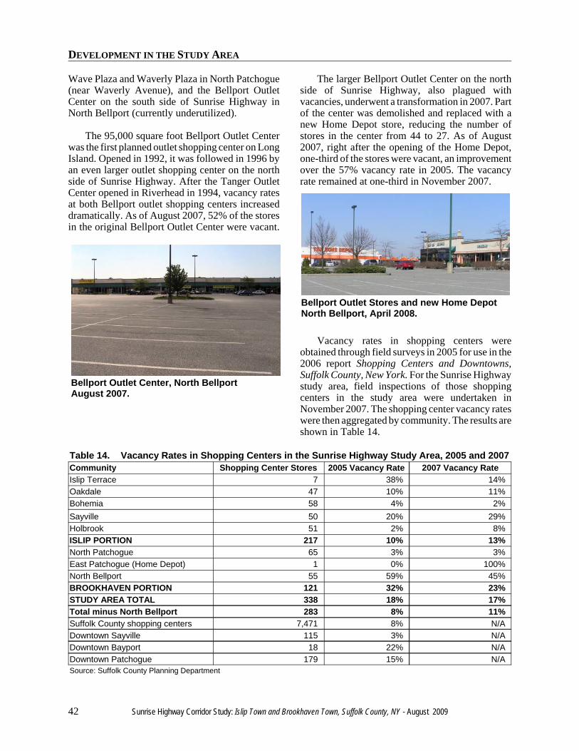
Bellport Outlet Center, North BellportAugust 2007.
Bellport Outlet Stores and new Home DepotNorth Bellport, April 2008.
Wave Plaza and Waverly Plaza in North Patchogue(near Waverly Avenue), and the Bellport OutletCenter on the south side of Sunrise Highway inNorth Bellport (currently underutilized).
The 95,000 square foot Bellport Outlet Centerwas the first planned outlet shopping center on LongIsland. Opened in 1992, it was followed in 1996 byan even larger outlet shopping center on the northside of Sunrise Highway. After the Tanger OutletCenter opened in Riverhead in 1994, vacancy ratesat both Bellport outlet shopping centers increaseddramatically. As of August 2007, 52% of the storesin the original Bellport Outlet Center were vacant.
The larger Bellport Outlet Center on the northside of Sunrise Highway, also plagued withvacancies, underwent a transformation in 2007. Partof the center was demolished and replaced with anew Home Depot store, reducing the number ofstores in the center from 44 to 27. As of August2007, right after the opening of the Home Depot,one-third of the stores were vacant, an improvementover the 57% vacancy rate in 2005. The vacancyrate remained at one-third in November 2007.
Vacancy rates in shopping centers wereobtained through field surveys in 2005 for use in the2006 report Shopping Centers and Downtowns,Suffolk County, New York. For the Sunrise Highwaystudy area, field inspections of those shoppingcenters in the study area were undertaken inNovember 2007. The shopping center vacancy rateswere then aggregated by community. The results areshown in Table 14.
Table 14. Vacancy Rates in Shopping Centers in the Sunrise Highway Study Area, 2005 and 2007Community Shopping Center Stores 2005 Vacancy Rate 2007 Vacancy RateIslip Terrace 7 38% 14%Oakdale 47 10% 11%Bohemia 58 4% 2%Sayville 50 20% 29%Holbrook 51 2% 8%ISLIP PORTION 217 10% 13%North Patchogue 65 3% 3%East Patchogue (Home Depot) 1 0% 100%North Bellport 55 59% 45%BROOKHAVEN PORTION 121 32% 23%STUDY AREA TOTAL 338 18% 17%Total minus North Bellport 283 8% 11%Suffolk County shopping centers 7,471 8% N/ADowntown Sayville 115 3% N/ADowntown Bayport 18 22% N/ADowntown Patchogue 179 15% N/ASource: Suffolk County Planning Department
DEVELOPMENT IN THE STUDY AREA
Sunrise Highway Corridor Study: Islip Town and Brookhaven Town, Suffolk County, NY - August 2009 43
The shopping center with Attais Flea Market inSayville contains several vacant stores.
New car dealer in Sayville.
Used car dealer in East Patchogue.
The overall current vacancy rate in shoppingcenters in the study area is 17%. The shoppingcenter vacancy rate is 13% in the Town of Islipportion and 23% in the Town of Brookhavenportion. Virtually all of the vacant stores in theBrookhaven portion are in North Bellport’s twooutlet centers. Without North Bellport, the vacancyrate in the study area is 11%.
The last countywide survey of vacant stores inshopping centers was performed in 2005. In thatsurvey, vacancy rates in the Sunrise Highway studyarea overall were similar to 2007. In looking moreclosely, however, there have been two trends:vacancies improved somewhat in the North Bellportshopping centers (mostly due to the northern centerdemolishing stores for one Home Depot store), andvacancies worsened somewhat in the remainder ofthe study area. Without North Bellport, theshopping center vacancy rate in the study areaincreased from 8% in 2005 (same as Suffolk Countyoverall) to 11% in 2007.
The vacancy rate in shopping centers in theSayville portion of the study area increased from20% in 2005 to 29% in 2007. The vacancy rate alsoincreased slightly in the Holbrook shopping centersin the study area, from 2% in 2005 to 8% in 2007.Together, the number of vacant shopping centerstores in Holbrook and Sayville in the study areaincreased from 12 stores to 21 stores between 2005and 2007. In the Islip Town portion of the studyarea overall, the shopping center vacancy rateincreased from 10% in 2005 to 13% in 2007.
Other Commercial Development
A large movie theater complex is located in thestudy area in Blue Point. This theater closed inautumn 2007. There are no other movie theaters in
the study area. The nearest movie theaters arelocated south of the study area in downtownSayville, and in Holtsville north of the study area.
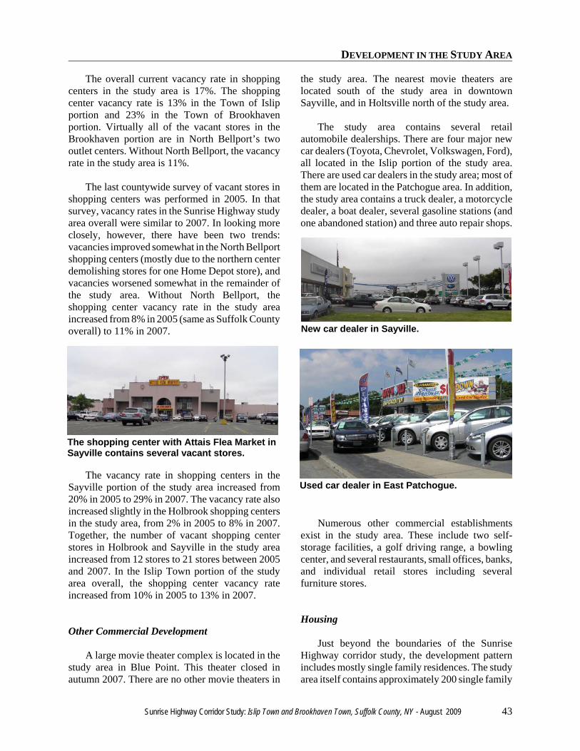
The study area contains several retailautomobile dealerships. There are four major newcar dealers (Toyota, Chevrolet, Volkswagen, Ford),all located in the Islip portion of the study area.There are used car dealers in the study area; most ofthem are located in the Patchogue area. In addition,the study area contains a truck dealer, a motorcycledealer, a boat dealer, several gasoline stations (andone abandoned station) and three auto repair shops.
Numerous other commercial establishmentsexist in the study area. These include two self-storage facilities, a golf driving range, a bowlingcenter, and several restaurants, small offices, banks,and individual retail stores including severalfurniture stores.
Housing
Just beyond the boundaries of the SunriseHighway corridor study, the development patternincludes mostly single family residences. The studyarea itself contains approximately 200 single family
DEVELOPMENT IN THE STUDY AREA
44 Sunrise Highway Corridor Study: Islip Town and Brookhaven Town, Suffolk County, NY - August 2009
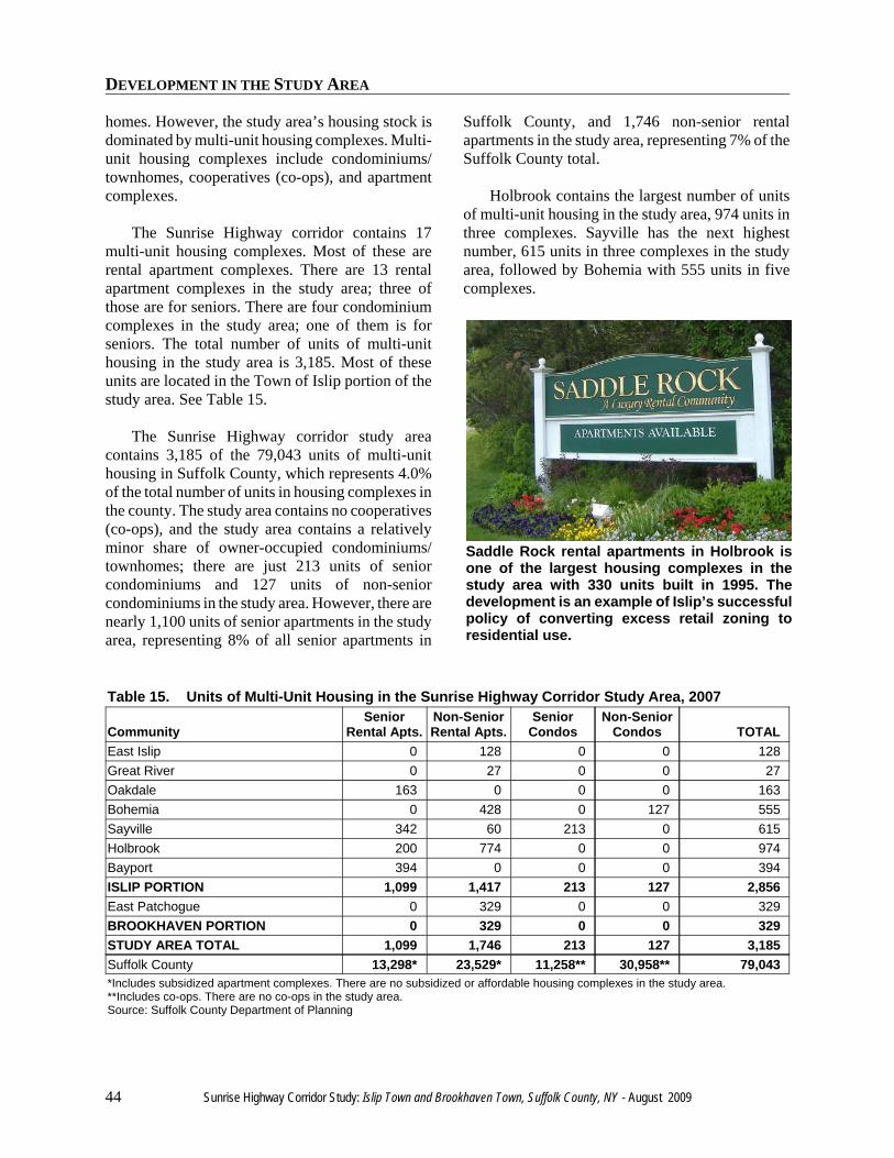
Saddle Rock rental apartments in Holbrook isone of the largest housing complexes in thestudy area with 330 units built in 1995. Thedevelopment is an example of Islip’s successfulpolicy of converting excess retail zoning toresidential use.
homes. However, the study area’s housing stock isdominated by multi-unit housing complexes. Multi-unit housing complexes include condominiums/townhomes, cooperatives (co-ops), and apartmentcomplexes.
The Sunrise Highway corridor contains 17multi-unit housing complexes. Most of these arerental apartment complexes. There are 13 rentalapartment complexes in the study area; three ofthose are for seniors. There are four condominiumcomplexes in the study area; one of them is forseniors. The total number of units of multi-unithousing in the study area is 3,185. Most of theseunits are located in the Town of Islip portion of thestudy area. See Table 15.
The Sunrise Highway corridor study areacontains 3,185 of the 79,043 units of multi-unithousing in Suffolk County, which represents 4.0%of the total number of units in housing complexes inthe county. The study area contains no cooperatives(co-ops), and the study area contains a relativelyminor share of owner-occupied condominiums/townhomes; there are just 213 units of seniorcondominiums and 127 units of non-seniorcondominiums in the study area. However, there arenearly 1,100 units of senior apartments in the studyarea, representing 8% of all senior apartments in
Suffolk County, and 1,746 non-senior rentalapartments in the study area, representing 7% of theSuffolk County total.
Holbrook contains the largest number of unitsof multi-unit housing in the study area, 974 units inthree complexes. Sayville has the next highestnumber, 615 units in three complexes in the studyarea, followed by Bohemia with 555 units in fivecomplexes.
Table 15. Units of Multi-Unit Housing in the Sunrise Highway Corridor Study Area, 2007
CommunitySenior
Rental Apts.Non-SeniorRental Apts.
SeniorCondos
Non-SeniorCondos TOTAL
East Islip 0 128 0 0 128Great River 0 27 0 0 27Oakdale 163 0 0 0 163Bohemia 0 428 0 127 555Sayville 342 60 213 0 615Holbrook 200 774 0 0 974Bayport 394 0 0 0 394ISLIP PORTION 1,099 1,417 213 127 2,856East Patchogue 0 329 0 0 329BROOKHAVEN PORTION 0 329 0 0 329STUDY AREA TOTAL 1,099 1,746 213 127 3,185Suffolk County 13,298* 23,529* 11,258** 30,958** 79,043*Includes subsidized apartment complexes. There are no subsidized or affordable housing complexes in the study area.**Includes co-ops. There are no co-ops in the study area.Source: Suffolk County Department of Planning
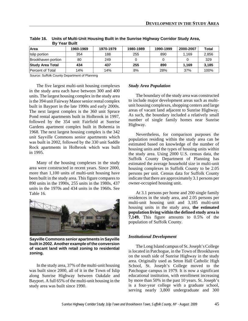
DEVELOPMENT IN THE STUDY AREA
Sunrise Highway Corridor Study: Islip Town and Brookhaven Town, Suffolk County, NY - August 2009 45
Sayville Commons senior apartments in Sayvillebuilt in 2002. Another example of the conversionof vacant land with retail zoning to residentialzoning.
Table 16. Units of Multi-Unit Housing Built in the Sunrise Highway Corridor Study Area, By Year BuiltArea 1960-1969 1970-1979 1980-1989 1990-1999 2000-2007 TotalIslip portion 354 188 255 890 1,169 2,856Brookhaven portion 80 249 0 0 0 329Study Area Total 434 437 255 890 1,169 3,185Percent of Total 14% 14% 8% 28% 37% 100%Source: Suffolk County Department of Planning
The five largest multi-unit housing complexesin the study area each have between 300 and 400units. The largest housing complex in the study areais the 394 unit Fairway Manor senior rental complexbuilt in Bayport in the late 1990s and early 2000s.The next largest complex is the 360 unit SprucePond rental apartments built in Holbrook in 1997,followed by the 354 unit Fairfield at SunriseGardens apartment complex built in Bohemia in1968. The next largest housing complex is the 342unit Sayville Commons senior apartments whichwas built in 2002, followed by the 330 unit SaddleRock apartments in Holbrook which was builtin 1995.
Many of the housing complexes in the studyarea were constructed in recent years. Since 2000,more than 1,100 units of multi-unit housing havebeen built in the study area. This figure compares to890 units in the 1990s, 255 units in the 1980s, 437units in the 1970s and 434 units in the 1960s. SeeTable 16.
In the study area, 37% of the multi-unit housingwas built since 2000, all of it in the Town of Islipalong Sunrise Highway between Oakdale andBayport. A full 65% of the multi-unit housing in thestudy area was built since 1990.
Study Area Population
The boundary of the study area was constructedto include major development areas such as multi-unit housing complexes, shopping centers and largeareas of vacant land adjacent to Sunrise Highway.As such, the boundary included a relatively smallnumber of single family homes near SunriseHighway.
Nevertheless, for comparison purposes thepopulation residing within the study area can beestimated based on knowledge of the number ofhousing units and the types of housing units withinthe study area. Using 2000 U.S. census data, theSuffolk County Department of Planning hasestimated the average household size in multi-unithousing complexes in Suffolk County to be 2.05persons per unit. Census data for Suffolk Countyindicate that there are approximately 3.1 persons perowner-occupied housing unit.
At 3.1 persons per home and 200 single familyresidences in the study area, and 2.05 persons permulti-unit housing unit and 3,185 multi-unithousing units in the study area, the estimatedpopulation living within the defined study area is7,149. This figure amounts to 0.5% of thepopulation of Suffolk County.
Institutional Development
The Long Island campus of St. Joseph’s Collegeis located in Patchogue, in the Town of Brookhavenon the south side of Sunrise Highway in the studyarea. Originally used as Seton Hall Catholic HighSchool, St. Joseph’s College moved to thePatchogue campus in 1979. It is now a significanteducational institution, with enrollment increasingby more than 50% in the past 10 years. St. Joseph’sis a four-year college with a graduate school,serving nearly 3,800 undergraduate and 300
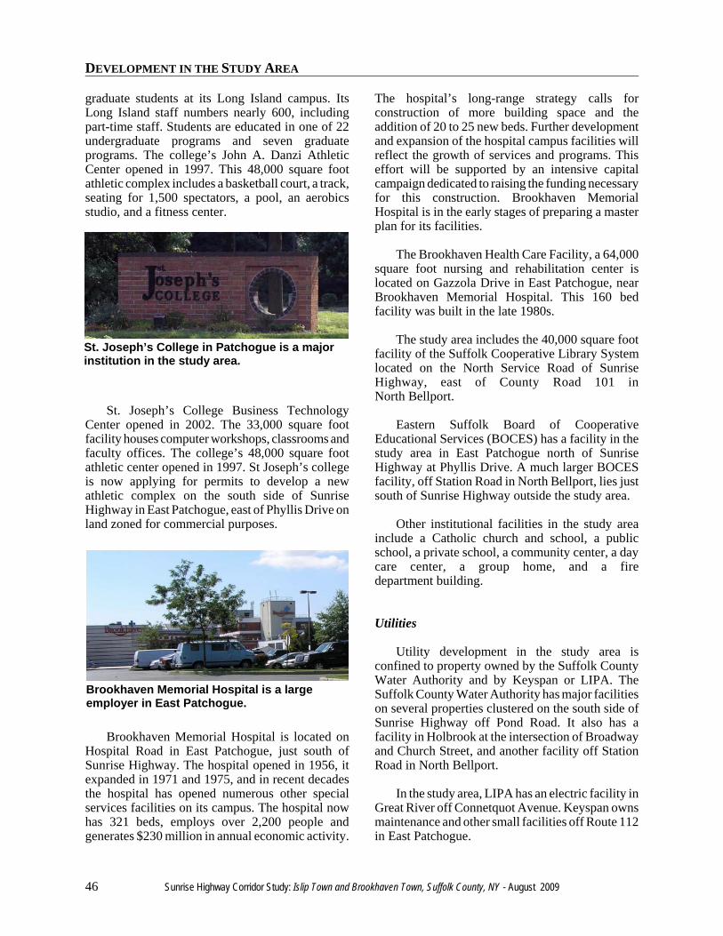
DEVELOPMENT IN THE STUDY AREA
46 Sunrise Highway Corridor Study: Islip Town and Brookhaven Town, Suffolk County, NY - August 2009
St. Joseph’s College in Patchogue is a majorinstitution in the study area.
Brookhaven Memorial Hospital is a largeemployer in East Patchogue.
graduate students at its Long Island campus. ItsLong Island staff numbers nearly 600, includingpart-time staff. Students are educated in one of 22undergraduate programs and seven graduateprograms. The college’s John A. Danzi AthleticCenter opened in 1997. This 48,000 square footathletic complex includes a basketball court, a track,seating for 1,500 spectators, a pool, an aerobicsstudio, and a fitness center.
St. Joseph’s College Business TechnologyCenter opened in 2002. The 33,000 square footfacility houses computer workshops, classrooms andfaculty offices. The college’s 48,000 square footathletic center opened in 1997. St Joseph’s collegeis now applying for permits to develop a newathletic complex on the south side of SunriseHighway in East Patchogue, east of Phyllis Drive onland zoned for commercial purposes.
Brookhaven Memorial Hospital is located onHospital Road in East Patchogue, just south ofSunrise Highway. The hospital opened in 1956, itexpanded in 1971 and 1975, and in recent decadesthe hospital has opened numerous other specialservices facilities on its campus. The hospital nowhas 321 beds, employs over 2,200 people andgenerates $230 million in annual economic activity.
The hospital’s long-range strategy calls forconstruction of more building space and theaddition of 20 to 25 new beds. Further developmentand expansion of the hospital campus facilities willreflect the growth of services and programs. Thiseffort will be supported by an intensive capitalcampaign dedicated to raising the funding necessaryfor this construction. Brookhaven MemorialHospital is in the early stages of preparing a masterplan for its facilities.
The Brookhaven Health Care Facility, a 64,000square foot nursing and rehabilitation center islocated on Gazzola Drive in East Patchogue, nearBrookhaven Memorial Hospital. This 160 bedfacility was built in the late 1980s.
The study area includes the 40,000 square footfacility of the Suffolk Cooperative Library Systemlocated on the North Service Road of SunriseHighway, east of County Road 101 inNorth Bellport.
Eastern Suffolk Board of CooperativeEducational Services (BOCES) has a facility in thestudy area in East Patchogue north of SunriseHighway at Phyllis Drive. A much larger BOCESfacility, off Station Road in North Bellport, lies justsouth of Sunrise Highway outside the study area.
Other institutional facilities in the study areainclude a Catholic church and school, a publicschool, a private school, a community center, a daycare center, a group home, and a firedepartment building.
Utilities
Utility development in the study area isconfined to property owned by the Suffolk CountyWater Authority and by Keyspan or LIPA. TheSuffolk County Water Authority has major facilitieson several properties clustered on the south side ofSunrise Highway off Pond Road. It also has afacility in Holbrook at the intersection of Broadwayand Church Street, and another facility off StationRoad in North Bellport.
In the study area, LIPA has an electric facility inGreat River off Connetquot Avenue. Keyspan ownsmaintenance and other small facilities off Route 112in East Patchogue.

LAND USE

LAND USE
48 Sunrise Highway Corridor Study: Islip Town and Brookhaven Town, Suffolk County, NY - August 2009
LAND USE
Sunrise Highway Corridor Study: Islip Town and Brookhaven Town, Suffolk County, NY - August 2009 49
LAND USE
The land use inventory conducted for theSunrise Highway corridor study area was performedin August and September 2007. The existing landuse map for the study area shows 13 categories ofland use. These land use categories are suitable forcharacterizing community layout and function,determining land available for development, andpreparing master plans.
The 13 general land use categories that are usedby the Suffolk County Planning Department forplanning purposes are:
• Low density residential (one acre or more perhousing unit)
• Medium density residential (between one andfive housing units per acre)
• High density residential (five or more housingunits per acre)
• Commercial• Industrial• Institutional• Recreation and Open space• Agriculture• Vacant• Transportation• Utilities• Waste handling and management• Surface waters
Each and every tax map parcel within the studyarea was assigned to one (and only one) of the 13general land use categories. When more than oneuse was found to occur on a single parcel, theprimary use of that parcel was determined andassigned to that parcel. Primary use is based on therelative intensity of the use in comparison with thatof the other possible uses on the parcel. Forexample, if a house in a residential district containsan accessory garage with a vehicle repair shop, theparcel may be classified as residential because theresidential use is the primary and more dominantuse of the parcel.
Several other conventions were used inassigning land uses to each parcel. Some of thoseconventions are:
• When structures on improved parcels areunoccupied, the parcels are classified accordingto the type of structure present such ascommercial, residential, etc. (not as vacant).Such a parcel is classified as vacant only if thebuilding is in such a dilapidated condition thatit is considered not reusable.
• The existing zoning designation of a parcel isnot a factor in determining the land useclassification of that parcel.
• Future or proposed uses were not considered indetermining land use, only the existing usewhen the parcel was visited.
• Each parcel owned by the Suffolk CountyWater Authority was classified as utilities,regardless of how or whether the parcel wasimproved.
• Parcels that are adjacent to commercial uses andare used as parking lots in connection withthese uses were classified as commercial.Similarly, parcels that are municipally ownedand used for parking or roadway drainage wereclassified as transportation.
• Roadways are technically transportation uses,but they are usually not tax map parcels inthemselves. Instead, most roadways show up as“holes” in the GIS coverage. These “holes”which include all road rights-of-way includingunbuilt “paper streets” are not included in thetransportation category in this study.
The study area covers 3,105 acres and contains1,118 tax map parcels. The acreage outside of roadrights-of-way was used for the analysis. The totalacreage of parcels in the study area (excluding roadrights-of-way) is 2,271 acres. Acreage figures weregenerated for each of the 13 land use categories.Table 17 displays, by Town, the number of acres inthe study area in each land use category, and thepercentage of land in each category.
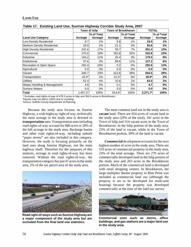
LAND USE
50 Sunrise Highway Corridor Study: Islip Town and Brookhaven Town, Suffolk County, NY - August 2009
Road right-of-ways such as Sunrise Highway area major component of the study area but areexcluded from the final land use statistics.
Commercial uses such as stores, officebuildings, and gas stations are a major land usein the study area.
Table 17. Existing Land Use, Sunrise Highway Corridor Study Area, 2007
Land Use Category
Town of Islip Town of Brookhaven TOTAL
Acreage% of Total
Acreage Acreage% of Total
Acreage Acreage% of Total
AcreageLow Density Residential 8.7 1% 9.8 1% 18.5 1%Medium Density Residential 29.5 2% 21.1 3% 50.6 2%High Density Residential 241.6 17% 59.7 7% 301.4 13%Commercial 270.0 19% 262.8 32% 532.8 23%Industrial 154.2 11% 25.4 3% 179.5 8%Institutional 37.6 3% 89.6 11% 127.2 6%Recreation & Open Space 292.4 20% 0.2 0% 292.6 13%Agricultural 0.0 0% 0.0 0% 0.0 0%Vacant 340.7 23% 313.8 39% 654.5 29%Transportation 25.4* 2% 21.5* 3% 46.9* 2%Utilities 52.4 4% 10.6 1% 63.0 3%Waste Handling & Management 4.6 0% 0.1 0% 4.7 0%Surface Waters 0.0 0% 0.0 0% 0.0 0%Total 1,457.2* 100% 814.6* 100% 2,271.7* 100%* Excludes road rights-of-way of 478.3 acres in Islip and 355.0 acres in Brookhaven.Figures may not add to 100% due to rounding.Source: Suffolk County Department of Planning
Because the study area focuses on SunriseHighway, a wide highway right-of way, technicallythe most acreage in the study area is devoted totransportation uses. Transportation uses includingroad rights-of-way account for 880 acres or 28% ofthe full acreage in the study area. Recharge basinsand other road rights-of-way, including unbuilt“paper streets” are also included in this category.However, the study is focusing primarily on theland uses along Sunrise Highway, not the mainhighway itself. Therefore for the purposes of thisanalysis, acreage in road rights-of-way has beenremoved. Without the road rights-of-way, thetransportation category has just 47 acres in the studyarea, 2% of the tax parcel area of the study area.
The most common land use in the study area isvacant land. There are 654 acres of vacant land inthe study area (29% of the total), 341 acres in theTown of Islip and 314 vacant acres in the Town ofBrookhaven. In the Islip portion of the study area,23% of the land is vacant, while in the Town ofBrookhaven portion, 39% of the land is vacant.
Commercial development accounts for the nexthighest number of acres in the study area. There are533 acres of commercial property in the study area,23% of the total acreage. There are 270 acres ofcommercially developed land in the Islip portion ofthe study area and 263 acres in the Brookhavenportion. Much of the commercial land is developedwith retail shopping centers. In Brookhaven, thelarge multiplex theater property in Blue Point wasincluded as commercial land use (although theproperty is set to be developed for multi-unithousing) because the property was developedcommercially at the time of the land use survey.
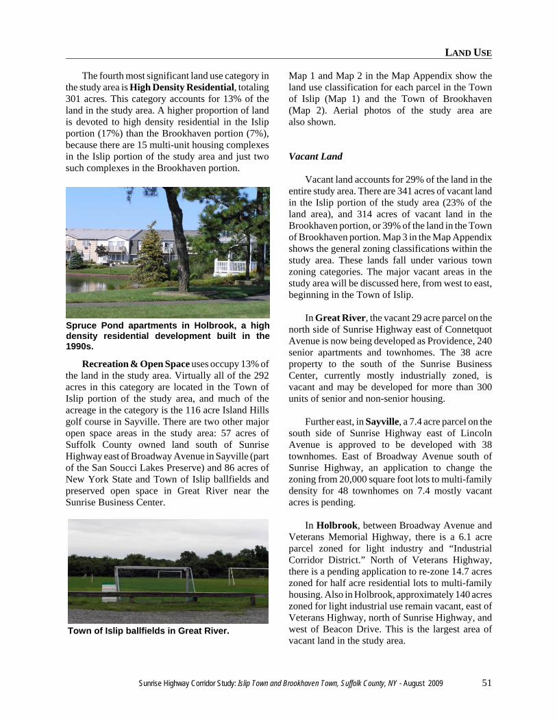
LAND USE
Sunrise Highway Corridor Study: Islip Town and Brookhaven Town, Suffolk County, NY - August 2009 51
Spruce Pond apartments in Holbrook, a highdensity residential development built in the1990s.
Town of Islip ballfields in Great River.
The fourth most significant land use category inthe study area is High Density Residential, totaling301 acres. This category accounts for 13% of theland in the study area. A higher proportion of landis devoted to high density residential in the Islipportion (17%) than the Brookhaven portion (7%),because there are 15 multi-unit housing complexesin the Islip portion of the study area and just twosuch complexes in the Brookhaven portion.
Recreation & Open Space uses occupy 13% ofthe land in the study area. Virtually all of the 292acres in this category are located in the Town ofIslip portion of the study area, and much of theacreage in the category is the 116 acre Island Hillsgolf course in Sayville. There are two other majoropen space areas in the study area: 57 acres ofSuffolk County owned land south of SunriseHighway east of Broadway Avenue in Sayville (partof the San Soucci Lakes Preserve) and 86 acres ofNew York State and Town of Islip ballfields andpreserved open space in Great River near theSunrise Business Center.
Map 1 and Map 2 in the Map Appendix show theland use classification for each parcel in the Townof Islip (Map 1) and the Town of Brookhaven(Map 2). Aerial photos of the study area arealso shown.
Vacant Land
Vacant land accounts for 29% of the land in theentire study area. There are 341 acres of vacant landin the Islip portion of the study area (23% of theland area), and 314 acres of vacant land in theBrookhaven portion, or 39% of the land in the Townof Brookhaven portion. Map 3 in the Map Appendixshows the general zoning classifications within thestudy area. These lands fall under various townzoning categories. The major vacant areas in thestudy area will be discussed here, from west to east,beginning in the Town of Islip.
In Great River, the vacant 29 acre parcel on thenorth side of Sunrise Highway east of ConnetquotAvenue is now being developed as Providence, 240senior apartments and townhomes. The 38 acreproperty to the south of the Sunrise BusinessCenter, currently mostly industrially zoned, isvacant and may be developed for more than 300units of senior and non-senior housing.
Further east, in Sayville, a 7.4 acre parcel on thesouth side of Sunrise Highway east of LincolnAvenue is approved to be developed with 38townhomes. East of Broadway Avenue south ofSunrise Highway, an application to change thezoning from 20,000 square foot lots to multi-familydensity for 48 townhomes on 7.4 mostly vacantacres is pending.
In Holbrook, between Broadway Avenue andVeterans Memorial Highway, there is a 6.1 acreparcel zoned for light industry and “IndustrialCorridor District.” North of Veterans Highway,there is a pending application to re-zone 14.7 acreszoned for half acre residential lots to multi-familyhousing. Also in Holbrook, approximately 140 acreszoned for light industrial use remain vacant, east ofVeterans Highway, north of Sunrise Highway, andwest of Beacon Drive. This is the largest area ofvacant land in the study area.
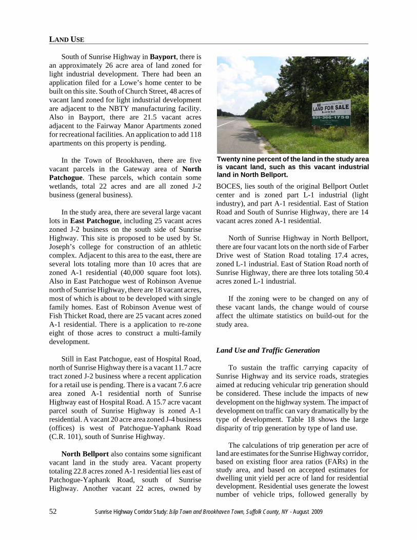
LAND USE
52 Sunrise Highway Corridor Study: Islip Town and Brookhaven Town, Suffolk County, NY - August 2009
Twenty nine percent of the land in the study areais vacant land, such as this vacant industrialland in North Bellport.
South of Sunrise Highway in Bayport, there isan approximately 26 acre area of land zoned forlight industrial development. There had been anapplication filed for a Lowe’s home center to bebuilt on this site. South of Church Street, 48 acres ofvacant land zoned for light industrial developmentare adjacent to the NBTY manufacturing facility.Also in Bayport, there are 21.5 vacant acresadjacent to the Fairway Manor Apartments zonedfor recreational facilities. An application to add 118apartments on this property is pending.
In the Town of Brookhaven, there are fivevacant parcels in the Gateway area of NorthPatchogue. These parcels, which contain somewetlands, total 22 acres and are all zoned J-2business (general business).
In the study area, there are several large vacantlots in East Patchogue, including 25 vacant acreszoned J-2 business on the south side of SunriseHighway. This site is proposed to be used by St.Joseph’s college for construction of an athleticcomplex. Adjacent to this area to the east, there areseveral lots totaling more than 10 acres that arezoned A-1 residential (40,000 square foot lots).Also in East Patchogue west of Robinson Avenuenorth of Sunrise Highway, there are 18 vacant acres,most of which is about to be developed with singlefamily homes. East of Robinson Avenue west ofFish Thicket Road, there are 25 vacant acres zonedA-1 residential. There is a application to re-zoneeight of those acres to construct a multi-familydevelopment.
Still in East Patchogue, east of Hospital Road,north of Sunrise Highway there is a vacant 11.7 acretract zoned J-2 business where a recent applicationfor a retail use is pending. There is a vacant 7.6 acrearea zoned A-1 residential north of SunriseHighway east of Hospital Road. A 15.7 acre vacantparcel south of Sunrise Highway is zoned A-1residential. A vacant 20 acre area zoned J-4 business(offices) is west of Patchogue-Yaphank Road(C.R. 101), south of Sunrise Highway.
North Bellport also contains some significantvacant land in the study area. Vacant propertytotaling 22.8 acres zoned A-1 residential lies east ofPatchogue-Yaphank Road, south of SunriseHighway. Another vacant 22 acres, owned by
BOCES, lies south of the original Bellport Outletcenter and is zoned part L-1 industrial (lightindustry), and part A-1 residential. East of StationRoad and South of Sunrise Highway, there are 14vacant acres zoned A-1 residential.
North of Sunrise Highway in North Bellport,there are four vacant lots on the north side of FarberDrive west of Station Road totaling 17.4 acres,zoned L-1 industrial. East of Station Road north ofSunrise Highway, there are three lots totaling 50.4acres zoned L-1 industrial.
If the zoning were to be changed on any ofthese vacant lands, the change would of courseaffect the ultimate statistics on build-out for thestudy area.
Land Use and Traffic Generation
To sustain the traffic carrying capacity ofSunrise Highway and its service roads, strategiesaimed at reducing vehicular trip generation shouldbe considered. These include the impacts of newdevelopment on the highway system. The impact ofdevelopment on traffic can vary dramatically by thetype of development. Table 18 shows the largedisparity of trip generation by type of land use.
The calculations of trip generation per acre ofland are estimates for the Sunrise Highway corridor,based on existing floor area ratios (FARs) in thestudy area, and based on accepted estimates fordwelling unit yield per acre of land for residentialdevelopment. Residential uses generate the lowestnumber of vehicle trips, followed generally by
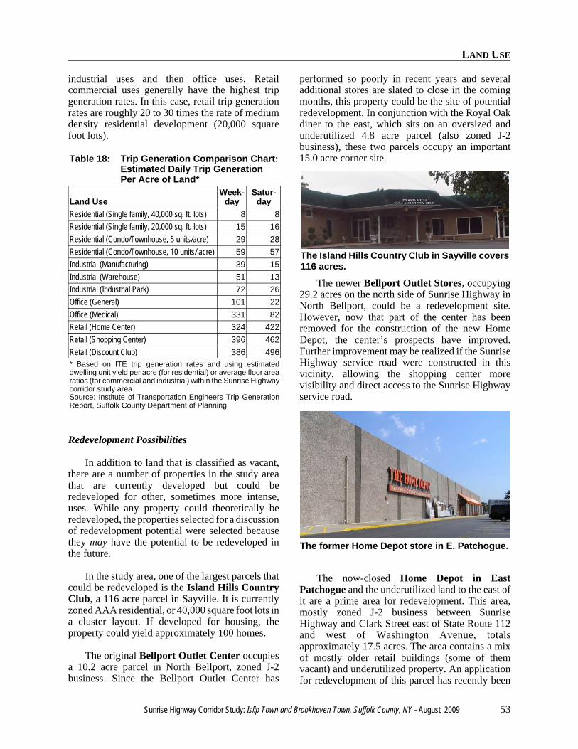
LAND USE
Sunrise Highway Corridor Study: Islip Town and Brookhaven Town, Suffolk County, NY - August 2009 53
The Island Hills Country Club in Sayville covers116 acres.
The former Home Depot store in E. Patchogue.
industrial uses and then office uses. Retailcommercial uses generally have the highest tripgeneration rates. In this case, retail trip generationrates are roughly 20 to 30 times the rate of mediumdensity residential development (20,000 squarefoot lots).
Table 18: Trip Generation Comparison Chart:Estimated Daily Trip GenerationPer Acre of Land*
Land UseWeek-
daySatur-
dayResidential (Single family, 40,000 sq. ft. lots) 8 8Residential (Single family, 20,000 sq. ft. lots) 15 16Residential (Condo/Townhouse, 5 units/acre) 29 28Residential (Condo/Townhouse, 10 units/ acre) 59 57Industrial (Manufacturing) 39 15Industrial (Warehouse) 51 13Industrial (Industrial Park) 72 26Office (General) 101 22Office (Medical) 331 82Retail (Home Center) 324 422Retail (Shopping Center) 396 462Retail (Discount Club) 386 496* Based on ITE trip generation rates and using estimateddwelling unit yield per acre (for residential) or average floor arearatios (for commercial and industrial) within the Sunrise Highwaycorridor study area.Source: Institute of Transportation Engineers Trip GenerationReport, Suffolk County Department of Planning
Redevelopment Possibilities
In addition to land that is classified as vacant,there are a number of properties in the study areathat are currently developed but could beredeveloped for other, sometimes more intense,uses. While any property could theoretically beredeveloped, the properties selected for a discussionof redevelopment potential were selected becausethey may have the potential to be redeveloped inthe future.
In the study area, one of the largest parcels thatcould be redeveloped is the Island Hills CountryClub, a 116 acre parcel in Sayville. It is currentlyzoned AAA residential, or 40,000 square foot lots ina cluster layout. If developed for housing, theproperty could yield approximately 100 homes.
The original Bellport Outlet Center occupiesa 10.2 acre parcel in North Bellport, zoned J-2business. Since the Bellport Outlet Center has
performed so poorly in recent years and severaladditional stores are slated to close in the comingmonths, this property could be the site of potentialredevelopment. In conjunction with the Royal Oakdiner to the east, which sits on an oversized andunderutilized 4.8 acre parcel (also zoned J-2business), these two parcels occupy an important15.0 acre corner site.
The newer Bellport Outlet Stores, occupying29.2 acres on the north side of Sunrise Highway inNorth Bellport, could be a redevelopment site.However, now that part of the center has beenremoved for the construction of the new HomeDepot, the center’s prospects have improved.Further improvement may be realized if the SunriseHighway service road were constructed in thisvicinity, allowing the shopping center morevisibility and direct access to the Sunrise Highwayservice road.
The now-closed Home Depot in EastPatchogue and the underutilized land to the east ofit are a prime area for redevelopment. This area,mostly zoned J-2 business between SunriseHighway and Clark Street east of State Route 112and west of Washington Avenue, totalsapproximately 17.5 acres. The area contains a mixof mostly older retail buildings (some of themvacant) and underutilized property. An applicationfor redevelopment of this parcel has recently been
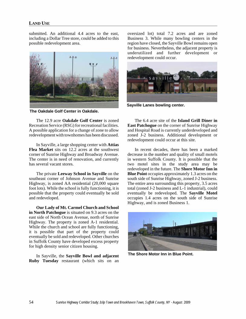
LAND USE
54 Sunrise Highway Corridor Study: Islip Town and Brookhaven Town, Suffolk County, NY - August 2009
The Oakdale Golf Center in Oakdale.Sayville Lanes bowling center.
The Shore Motor Inn in Blue Point.
submitted. An additional 4.4 acres to the east,including a Dollar Tree store, could be added to thispossible redevelopment area.
The 12.9 acre Oakdale Golf Center is zonedRecreation Service (RSG) for recreational facilities.A possible application for a change of zone to allowredevelopment with townhomes has been discussed.
In Sayville, a large shopping center with AttiasFlea Market sits on 12.2 acres at the southwestcorner of Sunrise Highway and Broadway Avenue.The center is in need of renovation, and currentlyhas several vacant stores.
The private Leeway School in Sayville on thesoutheast corner of Johnson Avenue and SunriseHighway, is zoned AA residential (20,000 squarefoot lots). While the school is fully functioning, it ispossible that the property could eventually be soldand redeveloped.
Our Lady of Mt. Carmel Church and Schoolin North Patchogue is situated on 9.3 acres on theeast side of North Ocean Avenue, north of SunriseHighway. The property is zoned A-1 residential.While the church and school are fully functioning,it is possible that part of the property couldeventually be sold and redeveloped. Other churchesin Suffolk County have developed excess propertyfor high density senior citizen housing.
In Sayville, the Sayville Bowl and adjacentRuby Tuesday restaurant (which sits on an
oversized lot) total 7.2 acres and are zonedBusiness 3. While many bowling centers in theregion have closed, the Sayville Bowl remains openfor business. Nevertheless, the adjacent property isunderutilized and further development orredevelopment could occur.
The 6.4 acre site of the Island Grill Diner inEast Patchogue on the corner of Sunrise Highwayand Hospital Road is currently underdeveloped andzoned J-2 business. Additional development orredevelopment could occur at this site.
In recent decades, there has been a markeddecrease in the number and quality of small motelsin western Suffolk County. It is possible that thetwo motel sites in the study area may beredeveloped in the future. The Shore Motor Inn inBlue Point occupies approximately 1.3 acres on thesouth side of Sunrise Highway, zoned J-2 business.The entire area surrounding this property, 3.5 acrestotal (zoned J-2 business and L-1 industrial), couldeventually be redeveloped. The Sayville Moteloccupies 1.4 acres on the south side of SunriseHighway, and is zoned Business 1.

POTENTIAL BUILD-OUT

POTENTIAL BUILD-OUT
56 Sunrise Highway Corridor Study: Islip Town and Brookhaven Town, Suffolk County, NY - August 2009
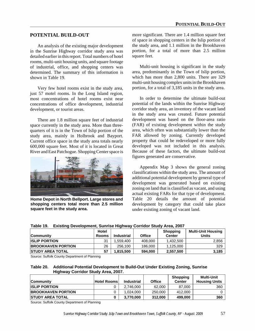
POTENTIAL BUILD-OUT
Sunrise Highway Corridor Study: Islip Town and Brookhaven Town, Suffolk County, NY - August 2009 57
Home Depot in North Bellport. Large stores andshopping centers total more than 2.5 millionsquare feet in the study area.
POTENTIAL BUILD-OUT
An analysis of the existing major developmentin the Sunrise Highway corridor study area wasdetailed earlier in this report. Total numbers of hotelrooms, multi-unit housing units, and square footageof industrial, office, and shopping centers wasdetermined. The summary of this information isshown in Table 19.
Very few hotel rooms exist in the study area,just 57 motel rooms. In the Long Island region,most concentrations of hotel rooms exist nearconcentrations of office development, industrialdevelopment, or tourist areas.
There are 1.8 million square feet of industrialspace currently in the study area. More than three-quarters of it is in the Town of Islip portion of thestudy area, mainly in Holbrook and Bayport.Current office space in the study area totals nearly600,000 square feet. Most of it is located in GreatRiver and East Patchogue. Shopping Center space is
more significant. There are 1.4 million square feetof space in shopping centers in the Islip portion ofthe study area, and 1.1 million in the Brookhavenportion, for a total of more than 2.5 millionsquare feet.
Multi-unit housing is significant in the studyarea, predominantly in the Town of Islip portion,which has more than 2,800 units. There are 329multi-unit housing complex units in the Brookhavenportion, for a total of 3,185 units in the study area.
In order to determine the ultimate build-outpotential of the lands within the Sunrise Highwaycorridor study area, an inventory of the vacant landin the study area was created. Future potentialdevelopment was based on the floor-area ratio(FAR) of existing development within the studyarea, which often was substantially lower than theFAR allowed by zoning. Currently developedproperty that could be redeveloped or more fullydeveloped was not included in this analysis.Because of these factors, the ultimate build-outfigures generated are conservative.
Appendix Map 3 shows the general zoningclassifications within the study area. The amount ofadditional potential development by general type ofdevelopment was generated based on existingzoning on land that is classified as vacant, and usingactual existing FARs for that type of development.Table 20 details the amount of potentialdevelopment by category that could take placeunder existing zoning of vacant land.
Table 19. Existing Development, Sunrise Highway Corridor Study Area, 2007
CommunityHotel
Rooms Industrial OfficeShopping
CenterMulti-Unit Housing
UnitsISLIP PORTION 31 1,559,400 408,000 1,432,500 2,856BROOKHAVEN PORTION 26 256,100 186,000 1,125,000 329STUDY AREA TOTAL 57 1,815,500 594,000 2,557,500 3,185Source: Suffolk County Department of Planning
Table 20. Additional Potential Development to Build-Out Under Existing Zoning, SunriseHighway Corridor Study Area, 2007.
Community Hotel Rooms Industrial OfficeShopping
CenterMulti-Unit
Housing UnitsISLIP PORTION 0 2,746,000 62,000 87,000 360BROOKHAVEN PORTION 0 1,024,000 250,000 412,000 0STUDY AREA TOTAL 0 3,770,000 312,000 499,000 360Source: Suffolk County Department of Planning
POTENTIAL BUILD-OUT
58 Sunrise Highway Corridor Study: Islip Town and Brookhaven Town, Suffolk County, NY - August 2009
Table 21. Major Development Proposed in the Sunrise Highway Corridor Study Area
Community Hotel Rooms Industrial Office ShoppingCenter
Multi-UnitHousing Units
ISLIP PORTION 0 0 40,000 400,000 1,028BROOKHAVEN PORTION 0 0 0 9,600 349STUDY AREA TOTAL 0 0 40,000 409,600 1,377Source: Suffolk County Department of Planning
Under existing zoning, there is a potential for anadditional 3,770,000 square feet of industrial spacein the study area. Most of this (2.7 million squarefeet) is located in the Town of Islip portion, onvacant land primarily in Holbrook, followed byBayport, and then Great River. In Brookhaven,significant additional industrial development in thestudy area could occur primarily in North Bellport.
An additional 499,000 square feet of shoppingcenter or general commercial development couldoccur in the study area under existing zoning. Mostof this potential space is located in the Brookhavenportion of the study area, in East Patchogue. Underexisting zoning, an additional 312,000 square feet ofoffice space could be constructed in the study area,most of it in the Brookhaven portion of the studyarea, in East Patchogue.
Finally, under existing zoning, an additional360 units of multi-unit housing could be built in thestudy area, and approximately 175 additional singlefamily homes could be built on vacant landcurrently zoned for single family residences in thestudy area.
There are currently approximately two dozenmajor applications or development proposalslocated in the study area. A list of these develop-ment proposals can be found in Appendix 3. Theseproposals have been aggregated in Table 21.
While there is very little hotel, office, andindustrial development currently proposed for thestudy area, there are significant shopping center andmulti-unit housing proposals, mostly in the Town ofIslip. Most of the proposed retail space is in theTown of Islip, specifically two large proposals inBayport.
There are 1,377 units of multi-unit housingcomplexes proposed within the study area which,if built, would increase the number of units by43%, to more than 4,500 units. Most of theproposed multi-unit housing complexes in thestudy area are located in the Town of Islipportion of the study area, in various locations.
When potential development based on existingzoning is combined with the development potentialof likely or pending development applications, asharper picture of potential development to build-out emerges. In this case, the development potentialunder existing zoning of property with a proposeddevelopment is removed and the actual developmentyield of the proposal is added. The results of thisanalysis are shown in Table 22. Appendix 3contains the detailed information from whichTable 22 was derived.
There is significant potential additionaldevelopment to build-out in the study area, based onexisting zoning and current proposals. There is apotential for an additional 3.1 million square feet ofindustrial space in the study area. Most of this(2.06 million square feet) is located in the Town ofIslip portion, on vacant land primarily in Holbrook,followed by Bayport. In Brookhaven, significantadditional industrial development in the study areacould occur primarily in North Bellport.
An additional 658,000 square feet of shoppingcenter or general commercial development couldoccur in the study area under existing zoning andpending applications. Most of this potential space islocated in the Islip portion of the study area, inBayport, and in East Patchogue in the Brookhavenportion of the study area.
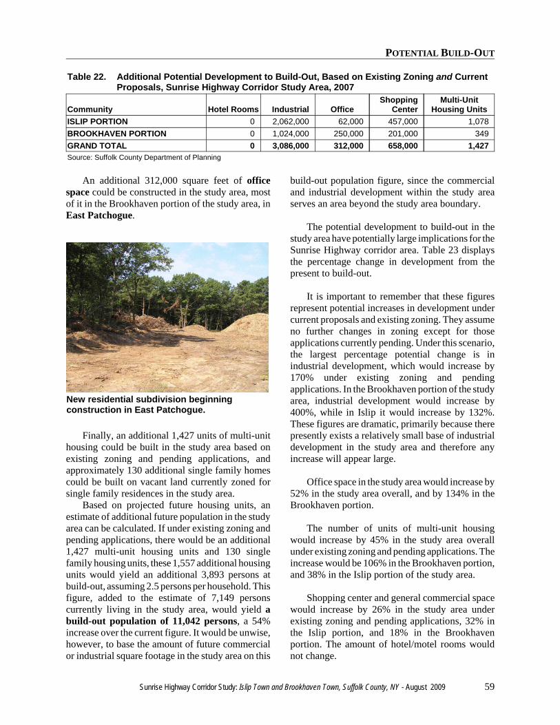
POTENTIAL BUILD-OUT
Sunrise Highway Corridor Study: Islip Town and Brookhaven Town, Suffolk County, NY - August 2009 59
New residential subdivision beginningconstruction in East Patchogue.
Table 22. Additional Potential Development to Build-Out, Based on Existing Zoning and CurrentProposals, Sunrise Highway Corridor Study Area, 2007
Community Hotel Rooms Industrial OfficeShopping
CenterMulti-Unit
Housing UnitsISLIP PORTION 0 2,062,000 62,000 457,000 1,078BROOKHAVEN PORTION 0 1,024,000 250,000 201,000 349GRAND TOTAL 0 3,086,000 312,000 658,000 1,427Source: Suffolk County Department of Planning
An additional 312,000 square feet of officespace could be constructed in the study area, mostof it in the Brookhaven portion of the study area, inEast Patchogue.
Finally, an additional 1,427 units of multi-unithousing could be built in the study area based onexisting zoning and pending applications, andapproximately 130 additional single family homescould be built on vacant land currently zoned forsingle family residences in the study area.
Based on projected future housing units, anestimate of additional future population in the studyarea can be calculated. If under existing zoning andpending applications, there would be an additional1,427 multi-unit housing units and 130 singlefamily housing units, these 1,557 additional housingunits would yield an additional 3,893 persons atbuild-out, assuming 2.5 persons per household. Thisfigure, added to the estimate of 7,149 personscurrently living in the study area, would yield abuild-out population of 11,042 persons, a 54%increase over the current figure. It would be unwise,however, to base the amount of future commercialor industrial square footage in the study area on this
build-out population figure, since the commercialand industrial development within the study areaserves an area beyond the study area boundary.
The potential development to build-out in thestudy area have potentially large implications for theSunrise Highway corridor area. Table 23 displaysthe percentage change in development from thepresent to build-out.
It is important to remember that these figuresrepresent potential increases in development undercurrent proposals and existing zoning. They assumeno further changes in zoning except for thoseapplications currently pending. Under this scenario,the largest percentage potential change is inindustrial development, which would increase by170% under existing zoning and pendingapplications. In the Brookhaven portion of the studyarea, industrial development would increase by400%, while in Islip it would increase by 132%.These figures are dramatic, primarily because therepresently exists a relatively small base of industrialdevelopment in the study area and therefore anyincrease will appear large.
Office space in the study area would increase by52% in the study area overall, and by 134% in theBrookhaven portion.
The number of units of multi-unit housingwould increase by 45% in the study area overallunder existing zoning and pending applications. Theincrease would be 106% in the Brookhaven portion,and 38% in the Islip portion of the study area.
Shopping center and general commercial spacewould increase by 26% in the study area underexisting zoning and pending applications, 32% inthe Islip portion, and 18% in the Brookhavenportion. The amount of hotel/motel rooms wouldnot change.
POTENTIAL BUILD-OUT
60 Sunrise Highway Corridor Study: Islip Town and Brookhaven Town, Suffolk County, NY - August 2009
Table 23. Percentage Change From Present to Build-Out, Based on Existing Development,Existing Zoning and Pending Applications, Sunrise Highway Corridor Study Area, 2007
Community Hotel Rooms Industrial OfficeShopping
CenterMulti-Unit
Housing UnitsISLIP PORTION 0% 132% 15% 32% 38%BROOKHAVEN PORTION 0% 400% 134% 18% 106%GRAND TOTAL 0% 170% 52% 26% 45%Source: Suffolk County Department of Planning

RECOMMENDATIONS
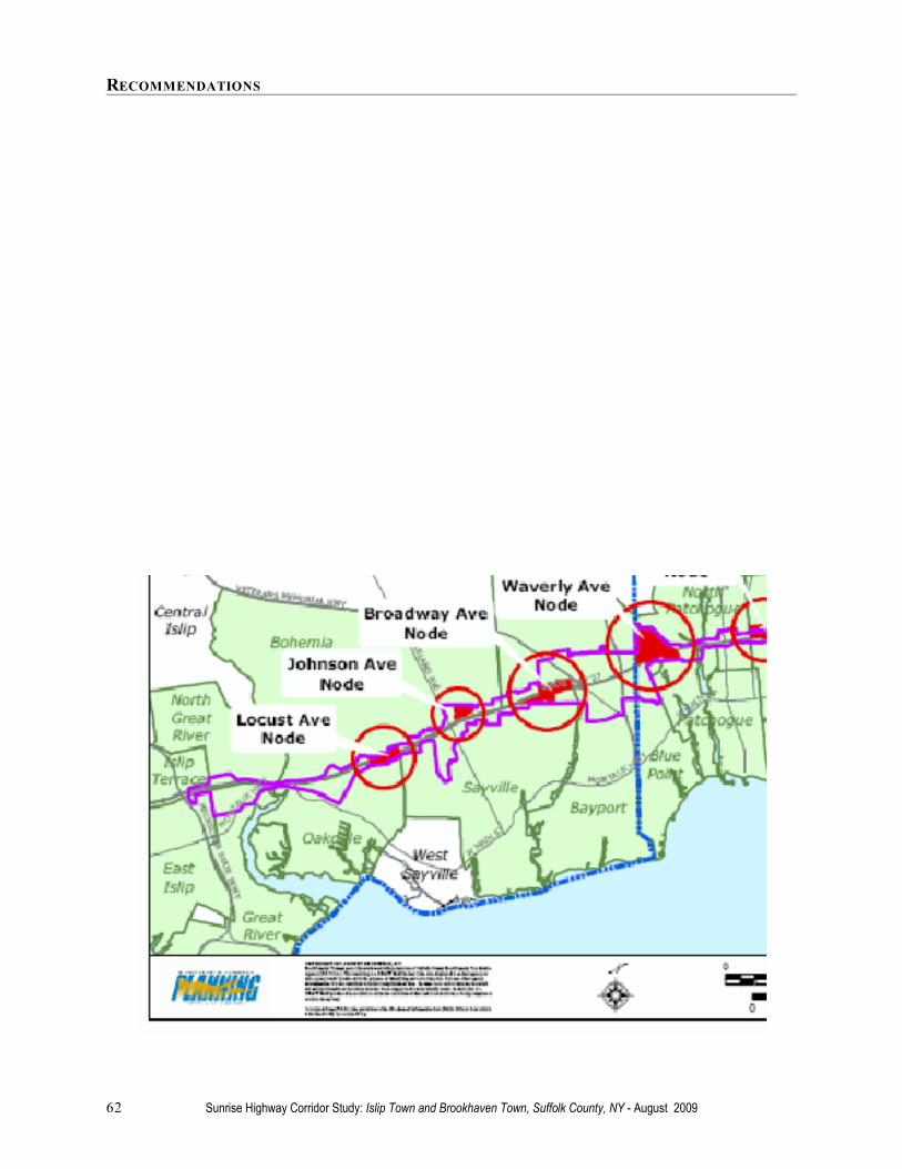
RECOMMENDATIONS
62 Sunrise Highway Corridor Study: Islip Town and Brookhaven Town, Suffolk County, NY - August 2009
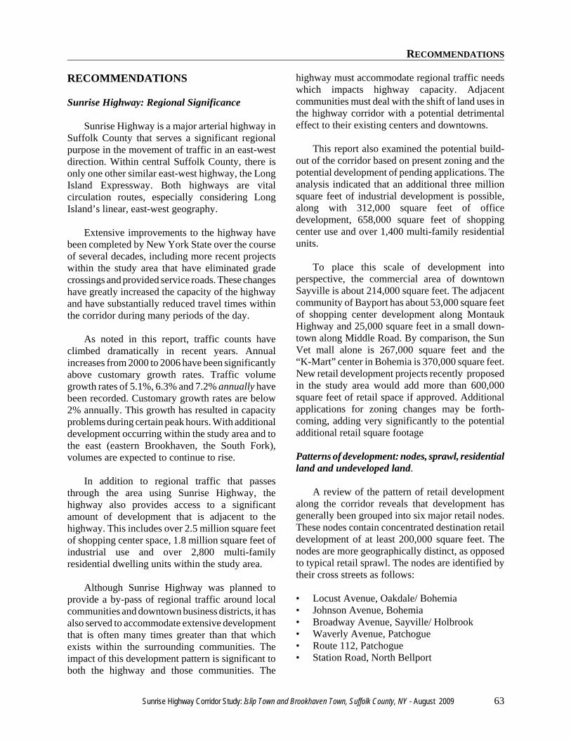
RECOMMENDATIONS
Sunrise Highway Corridor Study: Islip Town and Brookhaven Town, Suffolk County, NY - August 2009 63
RECOMMENDATIONS
Sunrise Highway: Regional Significance
Sunrise Highway is a major arterial highway inSuffolk County that serves a significant regionalpurpose in the movement of traffic in an east-westdirection. Within central Suffolk County, there isonly one other similar east-west highway, the LongIsland Expressway. Both highways are vitalcirculation routes, especially considering LongIsland’s linear, east-west geography.
Extensive improvements to the highway havebeen completed by New York State over the courseof several decades, including more recent projectswithin the study area that have eliminated gradecrossings and provided service roads. These changeshave greatly increased the capacity of the highwayand have substantially reduced travel times withinthe corridor during many periods of the day.
As noted in this report, traffic counts haveclimbed dramatically in recent years. Annualincreases from 2000 to 2006 have been significantlyabove customary growth rates. Traffic volumegrowth rates of 5.1%, 6.3% and 7.2% annually havebeen recorded. Customary growth rates are below2% annually. This growth has resulted in capacityproblems during certain peak hours. With additionaldevelopment occurring within the study area and tothe east (eastern Brookhaven, the South Fork),volumes are expected to continue to rise.
In addition to regional traffic that passesthrough the area using Sunrise Highway, thehighway also provides access to a significantamount of development that is adjacent to thehighway. This includes over 2.5 million square feetof shopping center space, 1.8 million square feet ofindustrial use and over 2,800 multi-familyresidential dwelling units within the study area.
Although Sunrise Highway was planned toprovide a by-pass of regional traffic around localcommunities and downtown business districts, it hasalso served to accommodate extensive developmentthat is often many times greater than that whichexists within the surrounding communities. Theimpact of this development pattern is significant toboth the highway and those communities. The
highway must accommodate regional traffic needswhich impacts highway capacity. Adjacentcommunities must deal with the shift of land uses inthe highway corridor with a potential detrimentaleffect to their existing centers and downtowns.
This report also examined the potential build-out of the corridor based on present zoning and thepotential development of pending applications. Theanalysis indicated that an additional three millionsquare feet of industrial development is possible,along with 312,000 square feet of officedevelopment, 658,000 square feet of shoppingcenter use and over 1,400 multi-family residentialunits.
To place this scale of development intoperspective, the commercial area of downtownSayville is about 214,000 square feet. The adjacentcommunity of Bayport has about 53,000 square feetof shopping center development along MontaukHighway and 25,000 square feet in a small down-town along Middle Road. By comparison, the SunVet mall alone is 267,000 square feet and the“K-Mart” center in Bohemia is 370,000 square feet.New retail development projects recently proposedin the study area would add more than 600,000square feet of retail space if approved. Additionalapplications for zoning changes may be forth-coming, adding very significantly to the potentialadditional retail square footage
Patterns of development: nodes, sprawl, residentialland and undeveloped land.
A review of the pattern of retail developmentalong the corridor reveals that development hasgenerally been grouped into six major retail nodes.These nodes contain concentrated destination retaildevelopment of at least 200,000 square feet. Thenodes are more geographically distinct, as opposedto typical retail sprawl. The nodes are identified bytheir cross streets as follows:
• Locust Avenue, Oakdale/ Bohemia• Johnson Avenue, Bohemia• Broadway Avenue, Sayville/ Holbrook• Waverly Avenue, Patchogue• Route 112, Patchogue• Station Road, North Bellport
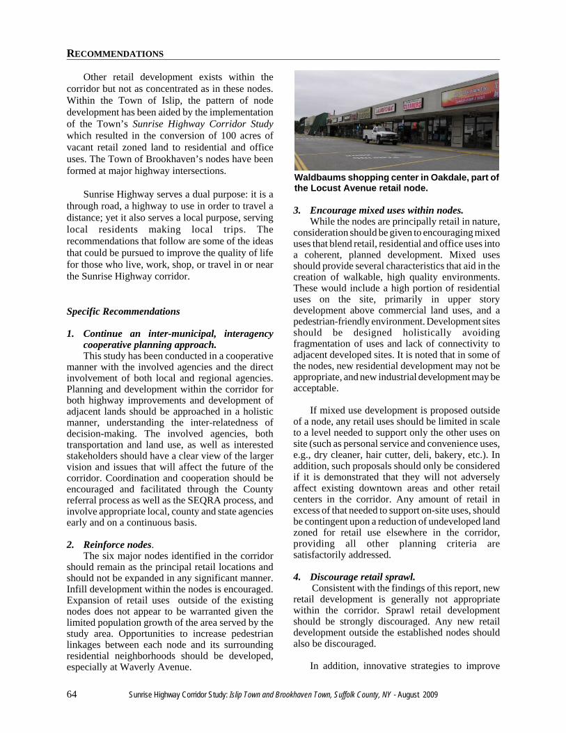
RECOMMENDATIONS
64 Sunrise Highway Corridor Study: Islip Town and Brookhaven Town, Suffolk County, NY - August 2009
Waldbaums shopping center in Oakdale, part ofthe Locust Avenue retail node.
Other retail development exists within thecorridor but not as concentrated as in these nodes.Within the Town of Islip, the pattern of nodedevelopment has been aided by the implementationof the Town’s Sunrise Highway Corridor Studywhich resulted in the conversion of 100 acres ofvacant retail zoned land to residential and officeuses. The Town of Brookhaven’s nodes have beenformed at major highway intersections.
Sunrise Highway serves a dual purpose: it is athrough road, a highway to use in order to travel adistance; yet it also serves a local purpose, servinglocal residents making local trips. Therecommendations that follow are some of the ideasthat could be pursued to improve the quality of lifefor those who live, work, shop, or travel in or nearthe Sunrise Highway corridor.
Specific Recommendations
1. Continue an inter-municipal, interagencycooperative planning approach.This study has been conducted in a cooperative
manner with the involved agencies and the directinvolvement of both local and regional agencies.Planning and development within the corridor forboth highway improvements and development ofadjacent lands should be approached in a holisticmanner, understanding the inter-relatedness ofdecision-making. The involved agencies, bothtransportation and land use, as well as interestedstakeholders should have a clear view of the largervision and issues that will affect the future of thecorridor. Coordination and cooperation should beencouraged and facilitated through the Countyreferral process as well as the SEQRA process, andinvolve appropriate local, county and state agenciesearly and on a continuous basis.
2. Reinforce nodes.The six major nodes identified in the corridor
should remain as the principal retail locations andshould not be expanded in any significant manner.Infill development within the nodes is encouraged.Expansion of retail uses outside of the existingnodes does not appear to be warranted given thelimited population growth of the area served by thestudy area. Opportunities to increase pedestrianlinkages between each node and its surroundingresidential neighborhoods should be developed,especially at Waverly Avenue.
3. Encourage mixed uses within nodes.While the nodes are principally retail in nature,
consideration should be given to encouraging mixeduses that blend retail, residential and office uses intoa coherent, planned development. Mixed usesshould provide several characteristics that aid in thecreation of walkable, high quality environments.These would include a high portion of residentialuses on the site, primarily in upper storydevelopment above commercial land uses, and apedestrian-friendly environment. Development sitesshould be designed holistically avoidingfragmentation of uses and lack of connectivity toadjacent developed sites. It is noted that in some ofthe nodes, new residential development may not beappropriate, and new industrial development may beacceptable.
If mixed use development is proposed outsideof a node, any retail uses should be limited in scaleto a level needed to support only the other uses onsite (such as personal service and convenience uses,e.g., dry cleaner, hair cutter, deli, bakery, etc.). Inaddition, such proposals should only be consideredif it is demonstrated that they will not adverselyaffect existing downtown areas and other retailcenters in the corridor. Any amount of retail inexcess of that needed to support on-site uses, shouldbe contingent upon a reduction of undeveloped landzoned for retail use elsewhere in the corridor,providing all other planning criteria aresatisfactorily addressed.
4. Discourage retail sprawl. Consistent with the findings of this report, new
retail development is generally not appropriatewithin the corridor. Sprawl retail developmentshould be strongly discouraged. Any new retaildevelopment outside the established nodes shouldalso be discouraged.
In addition, innovative strategies to improve
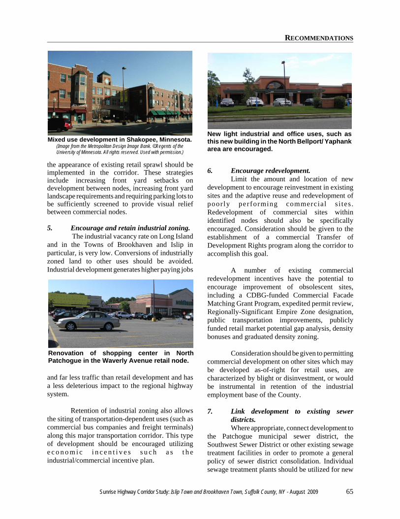
RECOMMENDATIONS
Sunrise Highway Corridor Study: Islip Town and Brookhaven Town, Suffolk County, NY - August 2009 65
Mixed use development in Shakopee, Minnesota.(Image from the Metropolitan Design Image Bank. ©Regents of theUniversity of Minnesota. All rights reserved. Used with permission.)
Renovation of shopping center in NorthPatchogue in the Waverly Avenue retail node.
New light industrial and office uses, such asthis new building in the North Bellport/ Yaphankarea are encouraged.
the appearance of existing retail sprawl should beimplemented in the corridor. These strategiesinclude increasing front yard setbacks ondevelopment between nodes, increasing front yardlandscape requirements and requiring parking lots tobe sufficiently screened to provide visual reliefbetween commercial nodes.
5. Encourage and retain industrial zoning. The industrial vacancy rate on Long Island
and in the Towns of Brookhaven and Islip inparticular, is very low. Conversions of industriallyzoned land to other uses should be avoided.Industrial development generates higher paying jobs
and far less traffic than retail development and hasa less deleterious impact to the regional highwaysystem.
Retention of industrial zoning also allowsthe siting of transportation-dependent uses (such ascommercial bus companies and freight terminals)along this major transportation corridor. This typeof development should be encouraged utilizinge c o n o m i c i n c e n t i v e s s u c h a s t h eindustrial/commercial incentive plan.
6. Encourage redevelopment.Limit the amount and location of new
development to encourage reinvestment in existingsites and the adaptive reuse and redevelopment ofpoor ly performing commercia l s i tes .Redevelopment of commercial sites withinidentified nodes should also be specificallyencouraged. Consideration should be given to theestablishment of a commercial Transfer ofDevelopment Rights program along the corridor toaccomplish this goal.
A number of existing commercialredevelopment incentives have the potential toencourage improvement of obsolescent sites,including a CDBG-funded Commercial FacadeMatching Grant Program, expedited permit review,Regionally-Significant Empire Zone designation,public transportation improvements, publiclyfunded retail market potential gap analysis, densitybonuses and graduated density zoning.
Consideration should be given to permittingcommercial development on other sites which maybe developed as-of-right for retail uses, arecharacterized by blight or disinvestment, or wouldbe instrumental in retention of the industrialemployment base of the County.
7. Link development to existing sewerdistricts.Where appropriate, connect development to
the Patchogue municipal sewer district, theSouthwest Sewer District or other existing sewagetreatment facilities in order to promote a generalpolicy of sewer district consolidation. Individualsewage treatment plants should be utilized for new
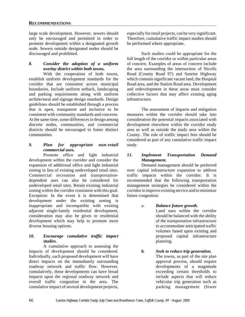
RECOMMENDATIONS
66 Sunrise Highway Corridor Study: Islip Town and Brookhaven Town, Suffolk County, NY - August 2009
large scale development. However, sewers shouldonly be encouraged and permitted in order topromote development within a designated growthnode. Sewers outside designated nodes should bediscouraged and prohibited.
8. Consider the adoption of a uniformoverlay district within both towns.With the cooperation of both towns,
establish uniform development standards for thecorridor that are consistent across municipalboundaries. Include uniform setback, landscapingand parking requirements along with uniformarchitectural and signage design standards. Designguidelines should be established through a processthat is open, transparent and inclusive to beconsistent with community standards and concerns.At the same time, some differences in design amongdiscrete nodes, communities, and commercialdistricts should be encouraged to foster distinctcommunities.
9. Plan for appropriate non-retailcommercial uses.Promote office and light industrial
development within the corridor and consider theexpansion of additional office and light industrialzoning in lieu of existing undeveloped retail sites.Commercial recreation and transportation-dependent uses can also be considered forundeveloped retail sites. Retain existing industrialzoning within the corridor consistent with this goal.Exception: In the event it is determined thatdevelopment under the existing zoning isinappropriate and incompatible with existingadjacent single-family residential development,consideration may also be given to residentialdevelopment which may help to promote morediverse housing options.
10. Encourage cumulative traffic impactstudies.A cumulative approach to assessing the
impacts of development should be considered.Individually, each proposed development will havedirect impacts on the immediately surroundingroadway network and traffic flow. However,cumulatively, these developments can have broadimpacts upon the regional roadway network andoverall traffic congestion in the area. Thecumulative impact of several development projects,
especially for retail projects, can be very significant.Therefore, cumulative traffic impact studies shouldbe performed where appropriate.
Such studies could be appropriate for thefull length of the corridor or within particular areasof concern. Examples of areas of concern includethe area surrounding the intersection of NicollsRoad (County Road 97) and Sunrise Highwaywhich contains significant vacant land, the HospitalRoad area, and the Station Road area. Developmentand redevelopment in these areas must considercollective factors that may affect existing aginginfrastructure.
The assessment of impacts and mitigationmeasures within the corridor should take intoconsideration the potential impacts associated withdevelopment elsewhere within the corridor studyarea as well as outside the study area within theCounty. The role of traffic impact fees should beconsidered as part of any cumulative traffic impactstudy.
11. Implement Transportation DemandManagement.Demand management should be preferred
over capital infrastructure expansion to addresstraffic impacts within the corridor. It isrecommended that the following transportationmanagement strategies be considered within thecorridor to improve existing service and to minimizefuture congestion:
a. Balance future growth.Land uses within the corridorshould be balanced with the abilityof the transportation infrastructureto accommodate anticipated trafficvolumes based upon existing andproposed capital infrastructureplanning.
b. Seek to reduce trip generation.The towns, as part of the site planapproval process, should requiredevelopments of a magnitudeexceeding certain thresholds toinclude aspects that will reducevehicular trip generation such asparking management (fewer
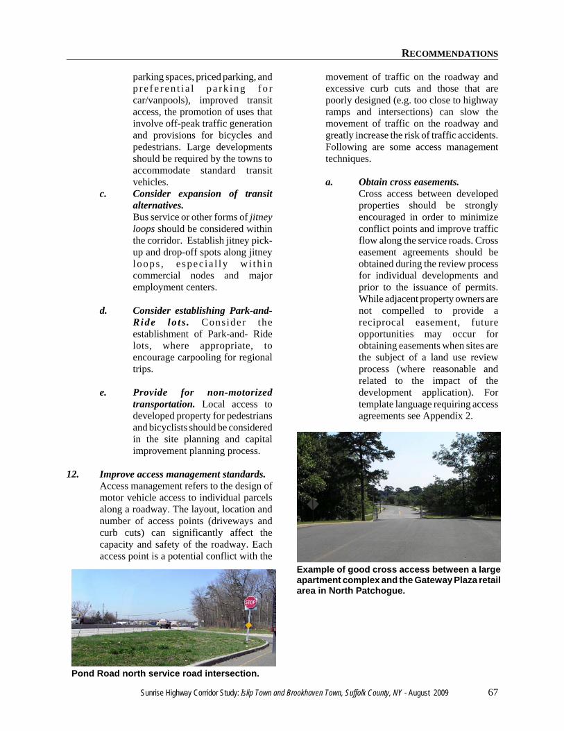
RECOMMENDATIONS
Sunrise Highway Corridor Study: Islip Town and Brookhaven Town, Suffolk County, NY - August 2009 67
Pond Road north service road intersection.
Example of good cross access between a largeapartment complex and the Gateway Plaza retailarea in North Patchogue.
parking spaces, priced parking, andp r e f e r e n t i a l p a r k i n g f o rcar/vanpools), improved transitaccess, the promotion of uses thatinvolve off-peak traffic generationand provisions for bicycles andpedestrians. Large developmentsshould be required by the towns toaccommodate standard transitvehicles.
c. Consider expansion of transitalternatives.Bus service or other forms of jitneyloops should be considered withinthe corridor. Establish jitney pick-up and drop-off spots along jitneyloops , e spec i a l ly w i th incommercial nodes and majoremployment centers.
d. Consider establishing Park-and-Ride lo ts . Consider theestablishment of Park-and- Ridelots, where appropriate, toencourage carpooling for regionaltrips.
e. Provide for non-motorizedtransportation. Local access todeveloped property for pedestriansand bicyclists should be consideredin the site planning and capitalimprovement planning process.
12. Improve access management standards.Access management refers to the design ofmotor vehicle access to individual parcelsalong a roadway. The layout, location andnumber of access points (driveways andcurb cuts) can significantly affect thecapacity and safety of the roadway. Eachaccess point is a potential conflict with the
movement of traffic on the roadway andexcessive curb cuts and those that arepoorly designed (e.g. too close to highwayramps and intersections) can slow themovement of traffic on the roadway andgreatly increase the risk of traffic accidents.Following are some access managementtechniques.
a. Obtain cross easements.Cross access between developedproperties should be stronglyencouraged in order to minimizeconflict points and improve trafficflow along the service roads. Crosseasement agreements should beobtained during the review processfor individual developments andprior to the issuance of permits.While adjacent property owners arenot compelled to provide areciprocal easement, futureopportunities may occur forobtaining easements when sites arethe subject of a land use reviewprocess (where reasonable andrelated to the impact of thedevelopment application). Fortemplate language requiring accessagreements see Appendix 2.
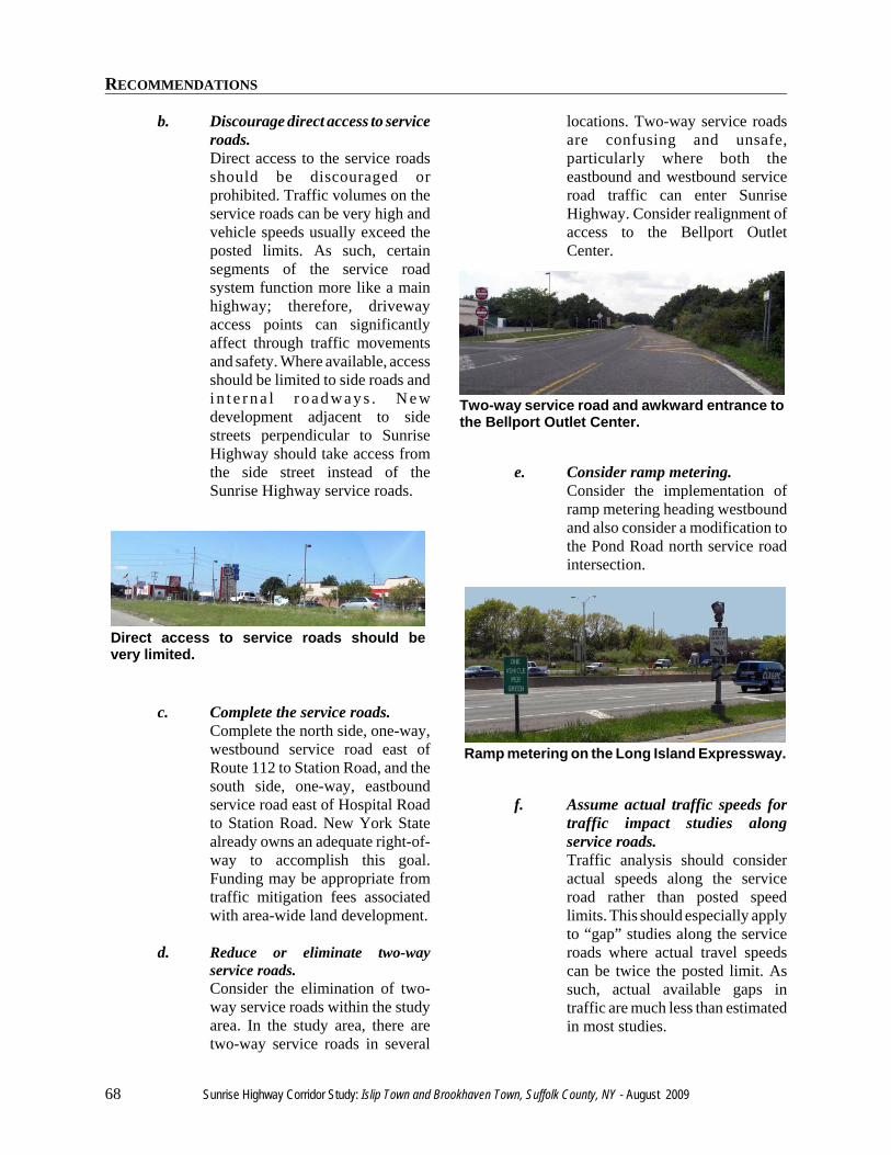
RECOMMENDATIONS
68 Sunrise Highway Corridor Study: Islip Town and Brookhaven Town, Suffolk County, NY - August 2009
Direct access to service roads should bevery limited.
Two-way service road and awkward entrance tothe Bellport Outlet Center.
Ramp metering on the Long Island Expressway.
b. Discourage direct access to serviceroads.Direct access to the service roadsshould be discouraged orprohibited. Traffic volumes on theservice roads can be very high andvehicle speeds usually exceed theposted limits. As such, certainsegments of the service roadsystem function more like a mainhighway; therefore, drivewayaccess points can significantlyaffect through traffic movementsand safety. Where available, accessshould be limited to side roads andi n t e r n a l r o ad way s . N e wdevelopment adjacent to sidestreets perpendicular to SunriseHighway should take access fromthe side street instead of theSunrise Highway service roads.
c. Complete the service roads.Complete the north side, one-way,westbound service road east ofRoute 112 to Station Road, and thesouth side, one-way, eastboundservice road east of Hospital Roadto Station Road. New York Statealready owns an adequate right-of-way to accomplish this goal.Funding may be appropriate fromtraffic mitigation fees associatedwith area-wide land development.
d. Reduce or eliminate two-wayservice roads.Consider the elimination of two-way service roads within the studyarea. In the study area, there aretwo-way service roads in several
locations. Two-way service roadsare confusing and unsafe,particularly where both theeastbound and westbound serviceroad traffic can enter SunriseHighway. Consider realignment ofaccess to the Bellport OutletCenter.
e. Consider ramp metering.Consider the implementation oframp metering heading westboundand also consider a modification tothe Pond Road north service roadintersection.
f. Assume actual traffic speeds fortraffic impact studies alongservice roads.Traffic analysis should consideractual speeds along the serviceroad rather than posted speedlimits. This should especially applyto “gap” studies along the serviceroads where actual travel speedscan be twice the posted limit. Assuch, actual available gaps intraffic are much less than estimatedin most studies.
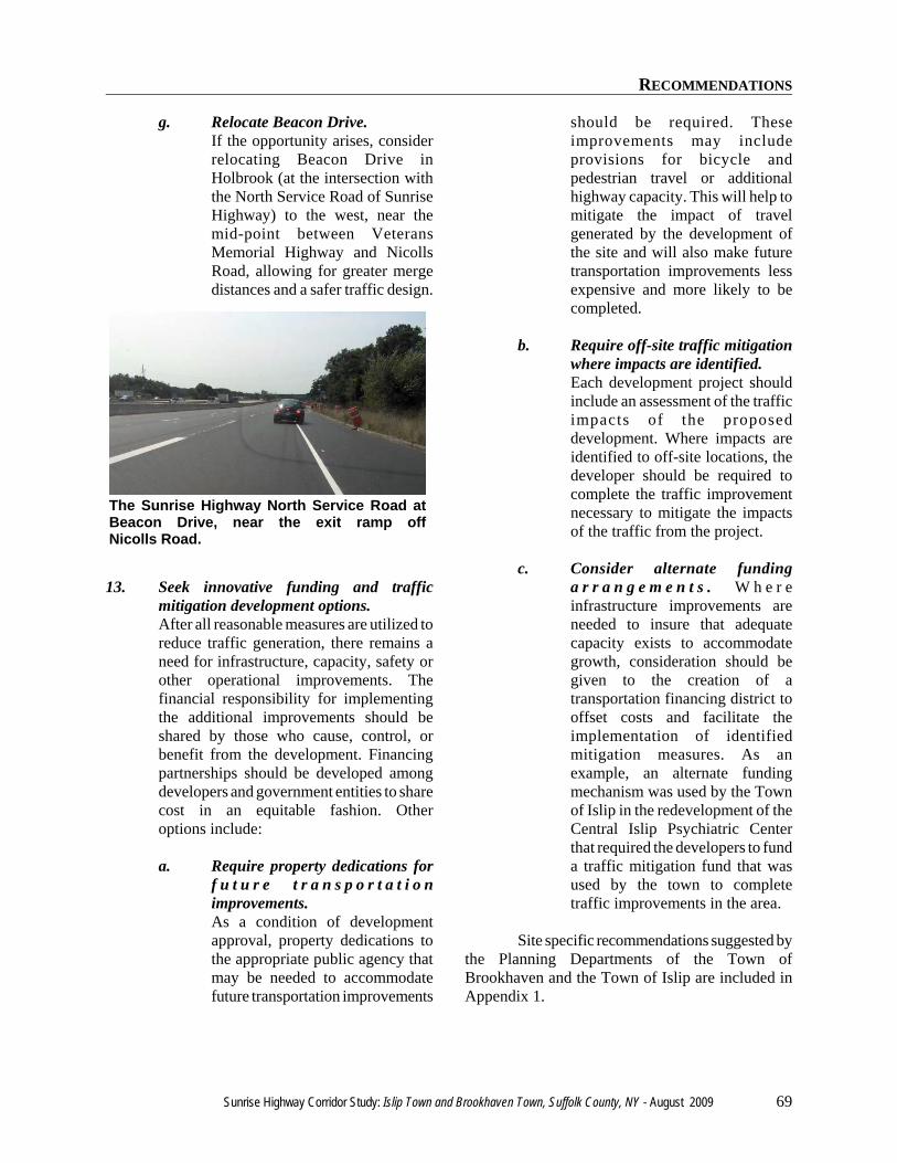
RECOMMENDATIONS
Sunrise Highway Corridor Study: Islip Town and Brookhaven Town, Suffolk County, NY - August 2009 69
The Sunrise Highway North Service Road atBeacon Drive, near the exit ramp offNicolls Road.
g. Relocate Beacon Drive.If the opportunity arises, considerrelocating Beacon Drive inHolbrook (at the intersection withthe North Service Road of SunriseHighway) to the west, near themid-point between VeteransMemorial Highway and NicollsRoad, allowing for greater mergedistances and a safer traffic design.
13. Seek innovative funding and trafficmitigation development options.After all reasonable measures are utilized toreduce traffic generation, there remains aneed for infrastructure, capacity, safety orother operational improvements. Thefinancial responsibility for implementingthe additional improvements should beshared by those who cause, control, orbenefit from the development. Financingpartnerships should be developed amongdevelopers and government entities to sharecost in an equitable fashion. Otheroptions include:
a. Require property dedications forf u t u r e t r a n s p o r t a t i o nimprovements.As a condition of developmentapproval, property dedications tothe appropriate public agency thatmay be needed to accommodatefuture transportation improvements
should be required. Theseimprovements may includeprovisions for bicycle andpedestrian travel or additionalhighway capacity. This will help tomitigate the impact of travelgenerated by the development ofthe site and will also make futuretransportation improvements lessexpensive and more likely to becompleted.
b. Require off-site traffic mitigationwhere impacts are identified.Each development project shouldinclude an assessment of the trafficimpacts of the proposeddevelopment. Where impacts areidentified to off-site locations, thedeveloper should be required tocomplete the traffic improvementnecessary to mitigate the impactsof the traffic from the project.
c. Consider alternate fundinga r r a n g e m e n t s . W h e r einfrastructure improvements areneeded to insure that adequatecapacity exists to accommodategrowth, consideration should begiven to the creation of atransportation financing district tooffset costs and facilitate theimplementation of identifiedmitigation measures. As anexample, an alternate fundingmechanism was used by the Townof Islip in the redevelopment of theCentral Islip Psychiatric Centerthat required the developers to funda traffic mitigation fund that wasused by the town to completetraffic improvements in the area.
Site specific recommendations suggested bythe Planning Departments of the Town ofBrookhaven and the Town of Islip are included inAppendix 1.

RECOMMENDATIONS
70 Sunrise Highway Corridor Study: Islip Town and Brookhaven Town, Suffolk County, NY - August 2009

Sunrise Highway Corridor Study: Islip Town and Brookhaven Town, Suffolk County, NY - August 2009 71
REFERENCES

REFERENCES
72 Sunrise Highway Corridor Study: Islip Town and Brookhaven Town, Suffolk County, NY - August 2009
REFERENCES
Sunrise Highway Corridor Study: Islip Town and Brookhaven Town, Suffolk County, NY - August 2009 73
REFERENCES
Beyard, Michael D., and Michael Pawlukiewicz. Urban Land Institute. Ten Principles For ReniventingAmerica’s Suburban Strips. Washington, DC, 2001.
Brookhaven Memorial Hospital. 2006. Reflections, 50 Years of Caring Close to Home. CommunityReport. Patchogue, NY.
Brookhaven Memorial Hospital. Website. About Us, Chairman’s Message.http://www.brookhavenhospital.org/aboutus/chairmanmessage.html
CB Richard Ellis. Market Reports. http://www.cbre.com/USA/Research/Market+Reports/
Grubb & Ellis. Market Research Reports. http://www.grubb-ellis.com/research/reports.aspx
Institute of Transportation Engineers. 1997. Trip Generation, 6th Edition. Washington, DC.
Long Island Power Authority. 2006. 2006 Long Island Population Survey.http://www.lipower.org/pdfs/company/pubs/popsurvey/popsurvey06.pdf, Uniondale, NY.
Long Island Regional Planning Board. 1978. 208: L.I. Comprehensive Waste Treatment ManagementPlan. Hauppauge, NY
Mason-Draffen, Carrie. “Former Northrop Site Sells For $20M.” Newsday, September 26, 2006.
Moore, Elizabeth. “Outlet Mall Turning To Ghost Town” Newsday, December 20,2007.
New York State Department of Transportation. 2007. Traffic Volume Report.https://www.nysdot.gov/portal/page/portal/divisions/engineering/applications/traffic-data-viewer
St. Joseph’s College. Website. Long Island Campus Facilities, History of St. Joseph’s College. http://www.sjcny.edu
Suffolk County Department of Planning. 2000. Village of Lindenhurst Downtown Business DistrictAnalysis. Hauppauge, NY.
Suffolk County Department of Planning. 2004. 2001 Existing Land Use Inventory, Long Island SoundStudy, Suffolk County North Shore Watershed Management Program. Hauppauge, NY.
Suffolk County Department of Planning. 2006. Shopping Centers and Downtowns, Suffolk County, NewYork. Hauppauge, NY.
Suffolk County Department of Planning. 2006. Inventory of Multi-Unit Housing Complexes. Inventory ofMajor Office Buildings, Inventory of Hotels, Inventory of Shopping Centers. Hauppauge, NY.
Town of Islip. 1986. Town of Islip Comprehensive Plan. Update: Sunrise Highway Corridor Study. Islip,NY.
U. S. Department of Commerce. Bureau of the Census. 1990 U. S. Census of Population and Housing,2000 U. S. Census of Population and Housing. http://www.census.gov
REFERENCES
74 Sunrise Highway Corridor Study: Islip Town and Brookhaven Town, Suffolk County, NY - August 2009
U. S. Department of Commerce. Bureau of the Census. County Business Patterns, Zip Code BusinessPatterns (2000-2005). http://censtats.census.gov/cbpnaic/cbpnaic.shtml
U. S. Department of Labor. Bureau of Labor Statistics. Local Area Unemployment Statistics.http://www.bls.gov/lau/home.htm
University of Minnesota. Metropolitan Design Center. Metropolitan Design Center Image Bank.Accession #: dc021047. Downloaded 05-05-08. http://www.designcenter.umn.edu
Wagner, Daniel. “Commercial Real Estate: Developer Making Plans For Brookhaven Site.” Newsday.December 4, 2007.
www.empirestateroads.com “Interchange of the Week, Monday 26 January 2004. NY 27 & NY 27A,Oakdale.” www.empirestateroads.com/week/week76.html
www.nycroads.com “Sunrise Highway, Historic Overview.” http://www.nycroads.com/roads/sunrise
www.ratetheroads.com/NY/NY-27_sunrise “Sunrise Highway.”

APPENDIX

APPENDIX
76 Sunrise Highway Corridor Study: Islip Town and Brookhaven Town, Suffolk County, NY - August 2009
APPENDIX
Sunrise Highway Corridor Study: Islip Town and Brookhaven Town, Suffolk County, NY - August 2009 77
Appendix 1: Site SpecificRecommendations Suggested by the TownPlanning Departments
Town of Islip Sites
The Town of Islip’s general policy regarding newdevelopment or redevelopment is to avoid retailoutside existing commercial nodes. Industrialzoning is to be maintained as recommended by theTown’s Overall Economic Development Plan,unless:
a) other, equally valid land uses areproposed such as diversifiedhousing including affordable units,or
b) the public would be better servedby retail development thatultimately retains jobs, reducesambient traffic levels, or removesblight.
The following list includes sites of pendingapplications or potential development orredevelopment:
Oakdale Golf Center0500-302.00-02.00-003.000 Recommendation: Recreational uses are preferred.Recent suggested uses include assisted living anddiversified housing. While these can be successfuluses, the density and design would need to beappropriate to equal the benefits of RSG zoning orrecreational uses.
Vacant land at Oakdale Bohemia Road0500-302-01.00-005.000, 006.000,009.001 and 010.000 Recommendation: Retain existing GeneralService D (GSD) and residential zoning consistentwith the first plan. All of the southern parcels arezoned residential. Only lot 10 is zoned GSD.
Island Hills Country Club0500-280.00-01.00-015.001Recommendation: Retain existing Residence AAAzoning. Consideration should also be given to thedesignation of a recreational zoning district in orderto protect this valuable recreational use and preservethis existing oasis of open space. Retain golf courseor if an application is received, allow as-of-right
development or similar FARS and density andrequire cluster subdivision which preserves golfcourse or any other open space on site. TDRs shouldbe considered if on-site yield is incompatible withgolf course. Actual yield would be about 107 unitsif developed under the existing Residence AAADistrict.
Leeway School0500-258.00-01.00-009.000Recommendation: Retain existing Residence AADistrict zoning. The school is low intensity.
Sayville Motel0500-259.00-01.00-001.000Recommendation: Consideration should be given tonon-retail commercial development such as GeneralService D (GSD) District. While this parcel lies onthe western extent of the Broadway node, thecurrent use is legal nonconforming. Retention andupgrading of the existing use is appropriate. Non-retail commercial development should beencouraged for this parcel if redeveloped.
Sayville Bowl /Ruby Tuesdays0500-237.00-02.00-015.001, 015.002Recommendation: Retain existing commercialzoning designation within this established com-mercial node.
Attias Flea Market0500-238.00-02.00-001.000Recommendation: Retain existing commercialzoning within this established commercial node.Redevelop as-of-right (potential department store).Note: The retail node stops at Broadway Avenue.
Fusco property0500-238.00-02.00-002.000, 003.001,003.002, 004.000Recommendation: Retain existing residentialzoning. The site is surrounded by Suffolk CountyParks. On this basis, consistent with the town’soriginal Sunrise Highway Corridor Study, the site isrecommended for lower density residential. TheResidential AA zoning allows development as acluster subdivision.
APPENDIX
78 Sunrise Highway Corridor Study: Islip Town and Brookhaven Town, Suffolk County, NY - August 2009
Serota site0500-218.00-01.00-manyAn application to rezone this site to permit retail andresidential use, in addition to Industrial zoning, hasbeen made to the Town of Islip.
The final scope for the Draft Environmental ImpactStatement for this proposal was adopted by the IslipTown Board on March 16, 2010. The DEIS willidentify all significant issues including trafficvolume and safety, especially the existing locationof Beacon Drive; the impact of development onestablished retail centers; socioeconomic impacts;consistency with previous studies of SunriseHighway Corridor; maximizing buffer and openspace; and impacts on stormwater run-off andgroundwater.
Lowe’s site0500-239.00-03.00-manyRecommendation: Retain existing Industrial 1District zoning. The Town’s original SunriseHighway Corridor Study recommendations arevalid. Retail and Industrial Business District Zoning(which could allow big box retail) should beprohibited.
Wenner Bread site0500-239-4-6.16, 6.19, etc.Recommendation: Development should beencouraged which results in industrial job retentionand the removal of existing blighted conditions.Industry, office, recreation, and other uses permittedin the Industrial 1 (IN1) and Industrial Business(IBD) District should be encouraged. Vehiclemovements on Sunrise Highway, especially forvehicles exiting the site, should be minimizedthough the use of Sylvan Avenue and Church Street.Any new development proposed on the subjectparcel should function as large bulk/industrial usesnot multi-unit shopping centers. Ancillary useswhich support these primary bulk/industrial usesmay be acceptable if proper site design and on-sitecirculation are achieved.
NBTY vacant land0500-261.00-01.00-028.012Recommendation: Retain existing light industrialzoning. Cartwright Loop should be completed.
Astro/Farkas0500-211.00-01.00-005.006 and 005.007Recommendation: Northern parcel: Keep industrial; allowredevelopment. Southern parcel: Re-zone toPlanned Development District and allow areasonable amount of residential units inconformance with diversified housing policy, and asa more compatible land use if: a) traffic impacts canbe properly mitigated and b)some portion of theproperty is donated for community ball fields (withaccompanying parking).
APPENDIX
Sunrise Highway Corridor Study: Islip Town and Brookhaven Town, Suffolk County, NY - August 2009 79
Town of Brookhaven Sites
All proposed developments east of Route 112 andthose yet conceived within the study corridor willrequire transportation mitigation that considersSunrise Service Road construction. Suchconstruction should connect existing sections asapplicable, and incorporate one-way operationconsistent with the existing service roads tothe west.
All proposed developments east of Route 112 andthose yet conceived within the study corridor willrequire transportation mitigation along crossroadsthat include consideration for bridge widenings atHospital Road and Station Road. Theseimprovements will further require intersectionimprovements at the crossroads with the SunriseNorth and South Service Roads.
Existing Industrial zoning should be retained tosupport job creation associated with transportation-dependent uses.
In conformance with the intent of Town Code, frontyard landscaping shall be increased, wherepracticable.
The following list includes sites of pendingapplications or potential development orredevelopment:
Waverly Avenue area:
While mixed use development is encouraged in thisnode, mixing residential uses should not beencouraged here because of conflicts with noisefrom the arterial highway.
North of Sunrise Highway (from the Town lineeast to Waverly Avenue). Parcels: 0200-973.00-01.00-007.028, 007.011, 007.031Recommendation: Retain existing zoning andencourage light industrial zoning proximate to a
commercial node.
North of Sunrise Highway (from the Town lineeast to Waverly Avenue). Parcels: 0200-951.00-04.00-033.002, 033.003, 033.004Recommendation: Retain existing zoning butcontrol permitted uses that are incompatiblecontiguous to wetlands. Encourages offices,recreational uses, and light industrial zoning.
North of Sunrise Highway (east of WaverlyAvenue, west of North Ocean Avenue)Recommendation: Rezone vacant J-2 Businessparcels to a residential category that is sensitive tocontiguous wetlands, as recommended in priorstream corridor rezoning efforts.
South of Sunrise Highway (from the Town lineeast to Waverly Avenue). Parcels: 0200-975.20-02.00-021.003, 022.001Recommendation: Rezone vacant J-2 Businessparcels to L-1 Industrial to encourage transportationdependent uses such as landscape nurseries,equipment dealerships, motor vehicle shops, etc.Consideration should also be given to the gradualamortization of poorly situated commercial uses inorder to promote reinvestment in existingdowntowns and commercial nodes.
Our Lady of Mt. Carmel0200-953.00-04.00-002.000Recommendation: Retain existing residentialzoning. In addition, the NY Telephone/Verizonbuilding property immediately to the north butoutside the study area (0200-953.00-04.00-001.000)should be rezoned to J-4 Business in conformancewith the existing use to all office use only.
Route 112 area:
Route 112 is dominated by a pattern of stripcommercial zoning that is reflective of the zoningpatterns of the past, common to many Long Island
APPENDIX
80 Sunrise Highway Corridor Study: Islip Town and Brookhaven Town, Suffolk County, NY - August 2009
suburban communities. While mixed usedevelopment is encouraged in this node, mixingresidential uses should not be encouraged herebecause of conflicts with noise from the arterialhighway. Mixing industrial campus typedevelopment with existing regional retail will betterserve the infrastructure and tax base.
Northeast of Sunrise Highway: The northeastcorner of Route 112 and the westbound service roadis dominated by the closed Home Depot store, alongwith a variety of strip commercial uses extendingeast to Phyllis Drive. Recommendation: Eliminatethe existing J-2 Business zones on the North ServiceRoad east of Route 112 and west of Phyllis Drive,in favor of J-4 Business or L-1 Industrial zoning toallow for office and transportation-dependent usesas an alternative to the existing strip commercialpattern. However, the existing Chck E Cheese site(0200-954.00-05.00-009.001) should be rezoned toCR (Commercial Recreation) in conformance withthe existing uses. It is also recommended that thePark and Ride immediately east of the Home Depotbuilding be retained during the redevelopment ofthis property.
Southeast of Sunrise Highway: The area southeastof the intersection of Route 112 and the eastboundservice road consists of three commercial usesincluding a restaurant and car dealership.Recommendation: The Town may wish to considera less intensive non-retail commercial use at thislocation.
BOCES offices0200-955.00-02.00-035.003Recommendation: The BOCES facility located onthe North Service Road east of Phyllis Drive shouldbe rezoned from J-2 Business District to J-4Business District to accommodate the school officeuse and future professional and business office uses.
\
Reckson Site area0200-973.40-04.00-001.000, 003.000Recommendation: These two parcels are proposedfor development of a college level recreationalcomplex associated with St. Joseph’s College. Achange of zone to L-1 Industrial and A-1Residential has been approved. The Town hasreceived an application to consider a change of zonefrom A-1 Residential to J-2 Business for theadjacent former model dwelling site, for a proposalto develop an animal hospital. However, it isrecommended that the remaining properties in thisarea east of Physllis Drive, west of Hewlett Avenuebe rezoned for residential development consistentwith surrounding land uses or an L-1 Industrial zonewhich would permit Veterinarian, but not futureretail uses.
Hospital Road area: The Hospital Road area is dominated byBrookhaven Memorial Hospital and associatedoffice development. It is recommended that zoningbe used to enhance the predominant land use patterncentered around the hospital and medical offices.The medical and office development surroundingthe hospital can further be supported with thedevelopment of workforce housing using transferreddevelopment rights from more environmentallysensitive properties.
Recommendations:The southwest corner of Hospital Road and thesouth service road is zoned J-2 Business District andis currently improved with a restaurant (diner). It isrecommended that the existing zoning be retained inorder to allow for the retention and possibleexpansion of this service- oriented use. In thealternative, the expansion of this site for additionaloffice space should also be considered.
The southeast corner of Hospital Road and thesouth service road is dominated by the hospital witha small site improved with a gas station. It isrecommended that the existing zoning bemaintained at these two locations as well as thesurrounding office development to the east along
APPENDIX
Sunrise Highway Corridor Study: Islip Town and Brookhaven Town, Suffolk County, NY - August 2009 81
County Road 101. It is also recommended that thevacant property to the east and northeast of thehospital (0200-957.00-01.00-001.000 and 002.000)be rezoned to J-4 Business District in order to allowfor the future expansion of the hospital and officedevelopment.
The northeast corner of Hospital Road and thenorth service road consists of a now vacant formergas station. This area also has a large vacant tractzoned J-2 Business District. It is recommended thatthe J-2 Business District zoning be reduced to allowlimited neighborhood business uses to serve theexisting multi-family and office developments withservices and convenience retail. The remaininglands in this area should be rezoned to J-4 BusinessDistrict in order to allow for the future expansion ofthis office node surrounding the hospital.Consideration should also be given to thedevelopment of a Planned Development District(PDD) in order to allow for the development of amixed-use office/residential development.Significant additional retail development at thislocation, outside of an established retail node, isunwarranted and would serve to exacerbate existingand future traffic impacts in the vicinity of HospitalRoad.
The northwest corner of Hospital Road and thenorth service road consists of vacant land zonedresidential. Residential uses at this location shouldbe supported.
County Road 101 area:
There are dozens of residentially zoned contiguousvacant parcels located along the north and southservice roads east and west of C. R. 101. TheSuffolk Cooperative Library System occupies theparcel northeast of C. R. 101.Recommendation: Zoning should remainresidential.
Station Road area:
Development within the Station Road area is a mixof industrial and retail uses. The Town ofBrookhaven’s Empire zone extends to SunriseHighway at Station Road. The industrialdevelopment in the Station Road area is situated inproximity to the Town’s recycling facility, landfill,and compost facility. There is an opportunity toidentify this area of the corridor as a niche forcompanies developing cleaner and “greener”technology.
While mixed use development is encouraged in thisnode, residential uses should not be encouraged inthe Station Road area north of Sunrise Highwaybecause of conflicts with industrial uses and noisefrom the arterial highway. Mixing industrial campustype development with existing regional retail andcommercial uses will better serve the infrastructureand tax base.
Recommendations: North of Sunrise Highway: All industrial zonedland should be retained for tax base and economicdevelopment purposes. A local visioning plan hasrecommended that a large-scale retail store be builtat the northeast corner of Station Road and SunriseHighway, but additional retail uses should beconfined to existing retail locations along SunriseHighway. Limiting additional retail construction inthe Station Road node will help foster retaildevelopment within the envisioned North Bellportdowntown on Montauk Highway, and will help tolimit commercial sprawl along Sunrise highway. Inaddition, workers associated with existing andfuture office and industrial uses will patronizeexisting and future retail development within NorthBellport, helping to strengthen the retail market inthis area.
South of Sunrise Highway: It is recommended thata 22 acre parcel (0200-929.00-02.00-009.002) split-zoned L-1 Industrial and A-1 Residential locatedsouth of the Bellport Outlet Center be rezoned to allresidential use; the development of industrial uses inthis location would adversely impact surroundingsingle-family residential development. This
APPENDIX
82 Sunrise Highway Corridor Study: Islip Town and Brookhaven Town, Suffolk County, NY - August 2009
industrially zoned parcel is a leftover portion of alarger tract of industrial land that has since beenrezoned to residential and retail. The industrialzoning in this limited location is inappropriate andshould be eliminated, as it is incompatible withsurrounding residential development. The southeastcorner of Sunrise Highway and Station Road (0200-929.00-03.00-031.001) is zoned A-1 Residential.This area was recommended for CommercialRecreation use by the recent SustainableCommunity Plan for Greater Bellport. Residentialor Commercial Recreation uses would beappropriate at this location.
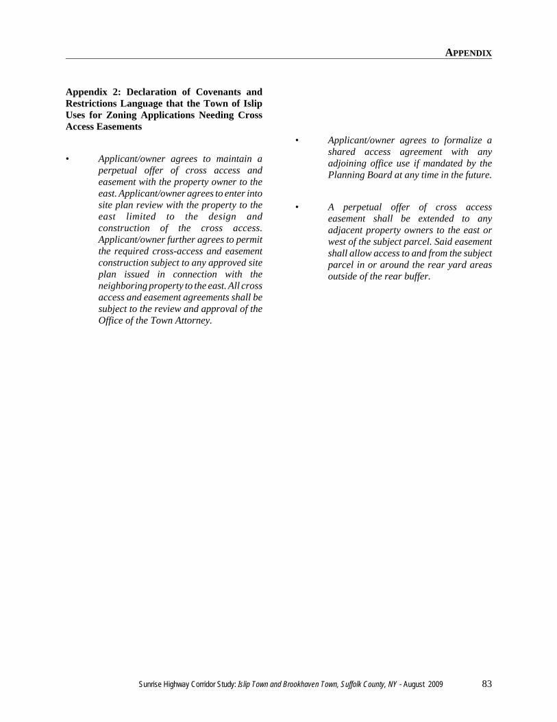
APPENDIX
Sunrise Highway Corridor Study: Islip Town and Brookhaven Town, Suffolk County, NY - August 2009 83
Appendix 2: Declaration of Covenants andRestrictions Language that the Town of IslipUses for Zoning Applications Needing CrossAccess Easements
• Applicant/owner agrees to maintain aperpetual offer of cross access andeasement with the property owner to theeast. Applicant/owner agrees to enter intosite plan review with the property to theeast limited to the design andconstruction of the cross access.Applicant/owner further agrees to permitthe required cross-access and easementconstruction subject to any approved siteplan issued in connection with theneighboring property to the east. All crossaccess and easement agreements shall besubject to the review and approval of theOffice of the Town Attorney.
• Applicant/owner agrees to formalize ashared access agreement with anyadjoining office use if mandated by thePlanning Board at any time in the future.
• A perpetual offer of cross accesseasement shall be extended to anyadjacent property owners to the east orwest of the subject parcel. Said easementshall allow access to and from the subjectparcel in or around the rear yard areasoutside of the rear buffer.

APPENDIX
84 Sunrise Highway Corridor Study: Islip Town and Brookhaven Town, Suffolk County, NY - August 2009
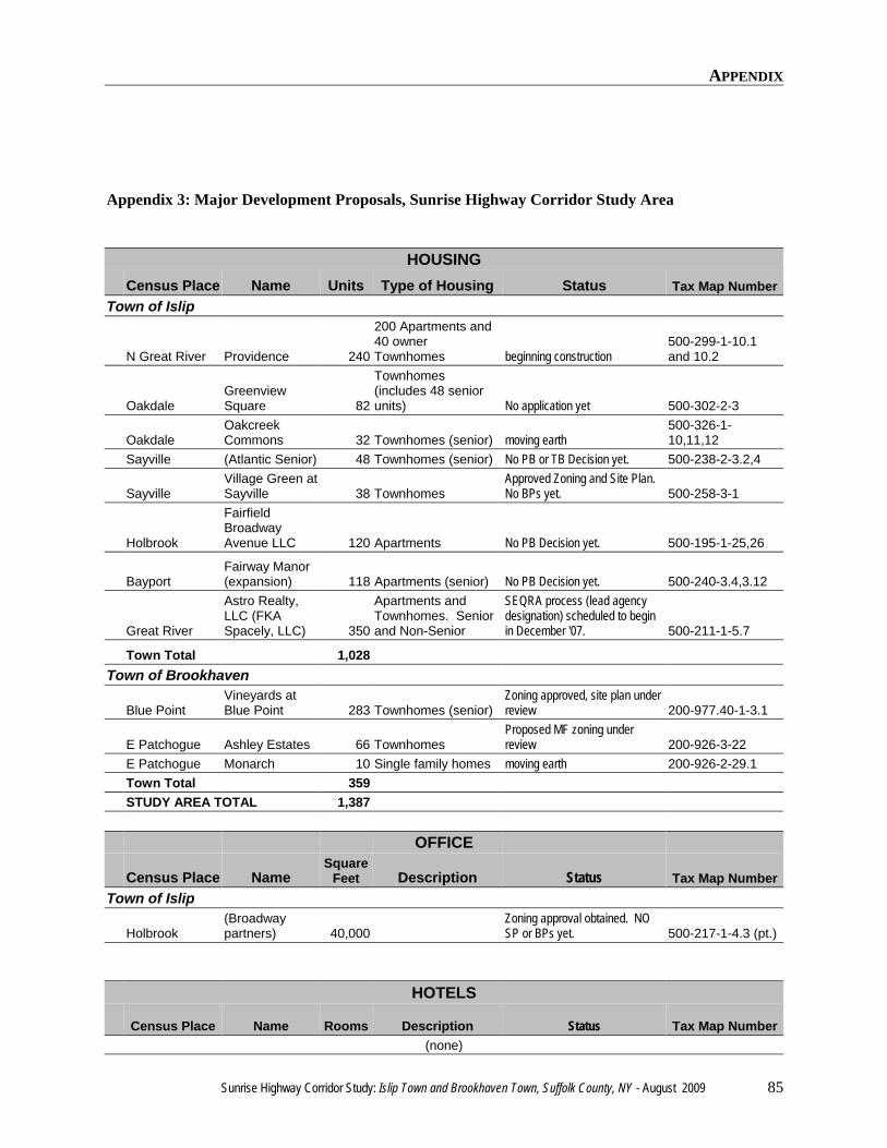
APPENDIX
Sunrise Highway Corridor Study: Islip Town and Brookhaven Town, Suffolk County, NY - August 2009 85
Appendix 3: Major Development Proposals, Sunrise Highway Corridor Study Area
HOUSINGCensus Place Name Units Type of Housing Status Tax Map Number
Town of Islip
N Great River Providence 240
200 Apartments and40 ownerTownhomes beginning construction
500-299-1-10.1and 10.2
OakdaleGreenviewSquare 82
Townhomes(includes 48 seniorunits) No application yet 500-302-2-3
OakdaleOakcreekCommons 32 Townhomes (senior) moving earth
500-326-1-10,11,12
Sayville (Atlantic Senior) 48 Townhomes (senior) No PB or TB Decision yet. 500-238-2-3.2,4
SayvilleVillage Green atSayville 38 Townhomes
Approved Zoning and Site Plan. No BPs yet. 500-258-3-1
Holbrook
FairfieldBroadwayAvenue LLC 120 Apartments No PB Decision yet. 500-195-1-25,26
BayportFairway Manor(expansion) 118 Apartments (senior) No PB Decision yet. 500-240-3.4,3.12
Great River
Astro Realty,LLC (FKASpacely, LLC) 350
Apartments andTownhomes. Seniorand Non-Senior
SEQRA process (lead agencydesignation) scheduled to beginin December '07. 500-211-1-5.7
Town Total 1,028Town of Brookhaven
Blue PointVineyards atBlue Point 283 Townhomes (senior)
Zoning approved, site plan underreview 200-977.40-1-3.1
E Patchogue Ashley Estates 66 TownhomesProposed MF zoning underreview 200-926-3-22
E Patchogue Monarch 10 Single family homes moving earth 200-926-2-29.1Town Total 359STUDY AREA TOTAL 1,387
OFFICE
Census Place NameSquare
Feet Description Status Tax Map NumberTown of Islip
Holbrook(Broadwaypartners) 40,000
Zoning approval obtained. NOSP or BPs yet. 500-217-1-4.3 (pt.)
HOTELS
Census Place Name Rooms Description Status Tax Map Number(none)
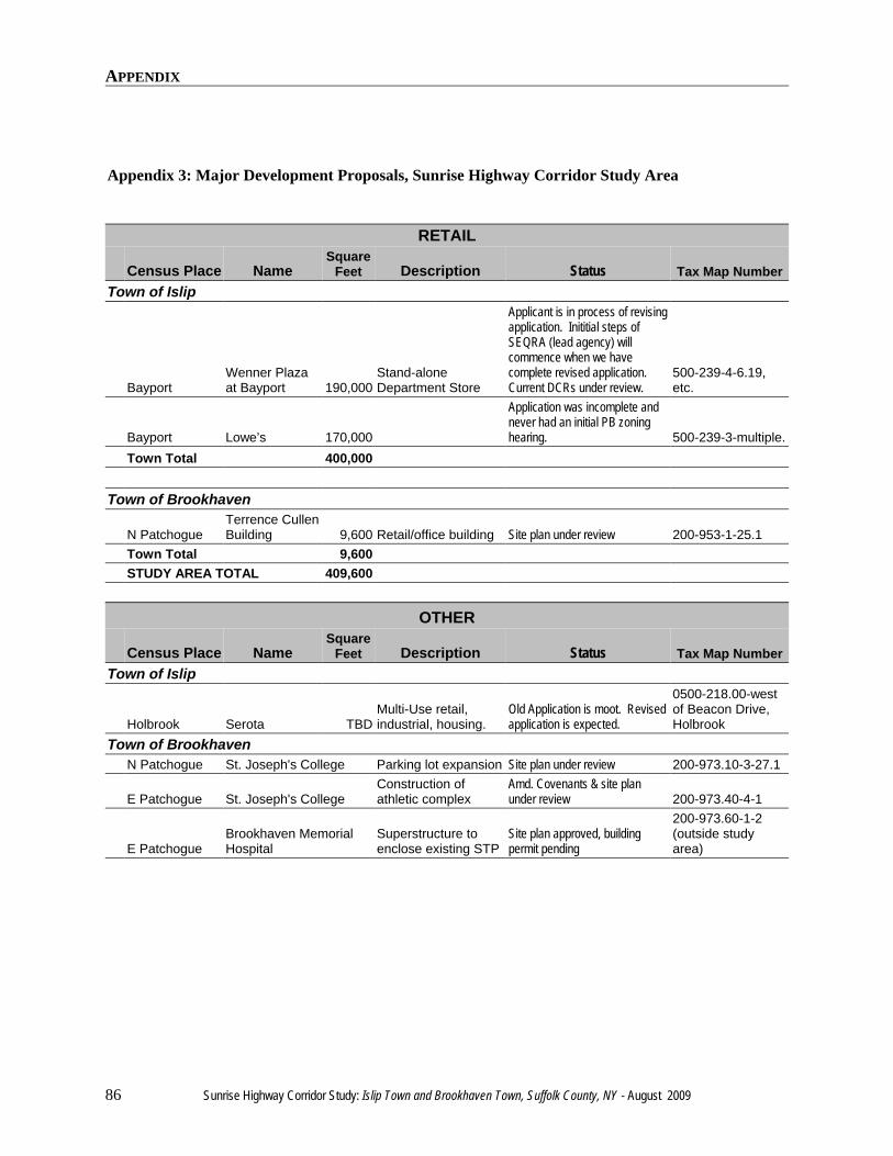
APPENDIX
Appendix 3: Major Development Proposals, Sunrise Highway Corridor Study Area
86 Sunrise Highway Corridor Study: Islip Town and Brookhaven Town, Suffolk County, NY - August 2009
RETAIL
Census Place NameSquare
Feet Description Status Tax Map NumberTown of Islip
BayportWenner Plazaat Bayport 190,000
Stand-aloneDepartment Store
Applicant is in process of revisingapplication. Inititial steps ofSEQRA (lead agency) willcommence when we havecomplete revised application.Current DCRs under review.
500-239-4-6.19,etc.
Bayport Lowe’s 170,000
Application was incomplete andnever had an initial PB zoninghearing. 500-239-3-multiple.
Town Total 400,000
Town of Brookhaven
N PatchogueTerrence CullenBuilding 9,600 Retail/office building Site plan under review 200-953-1-25.1
Town Total 9,600STUDY AREA TOTAL 409,600
OTHER
Census Place NameSquare
Feet Description Status Tax Map NumberTown of Islip
Holbrook Serota TBDMulti-Use retail,industrial, housing.
Old Application is moot. Revisedapplication is expected.
0500-218.00-westof Beacon Drive,Holbrook
Town of BrookhavenN Patchogue St. Joseph's College Parking lot expansion Site plan under review 200-973.10-3-27.1
E Patchogue St. Joseph's CollegeConstruction ofathletic complex
Amd. Covenants & site planunder review 200-973.40-4-1
E PatchogueBrookhaven MemorialHospital
Superstructure toenclose existing STP
Site plan approved, buildingpermit pending
200-973.60-1-2(outside studyarea)

MAP APPENDIX

MAP APPENDIX
88 Sunrise Highway Corridor Study: Islip Town and Brookhaven Town, Suffolk County, NY - August 2009
MAP APPENDIX
Sunrise Highway Corridor Study: Islip Town and Brookhaven Town, Suffolk County, NY - August 2009 89
Map 1: Sunrise Highway Corridor Study Area, Town of Islip Portion - Suffolk County Land Use by Tax MapParcel and Aerial Photo & Points of Interest
Map 2: Sunrise Highway Corridor Study Area, Town of Brookhaven Portion - Suffolk County Land Use byTax Map Parcel and Aerial Photo & Points of Interest
Map 3: Sunrise Highway Corridor Study Area, Town of Islip Portion - Generalized Zoning Categories andSunrise Highway Corridor Study Area, Town of Brookhaven Portion - Generalized Zoning Categories
Map 4: Sunrise Highway Corridor Study, Patterns of Development, Towns of Islip and Brookhaven, SuffolkCounty, New York.

MAP APPENDIX
90 Sunrise Highway Corridor Study: Islip Town and Brookhaven Town, Suffolk County, NY - August 2009
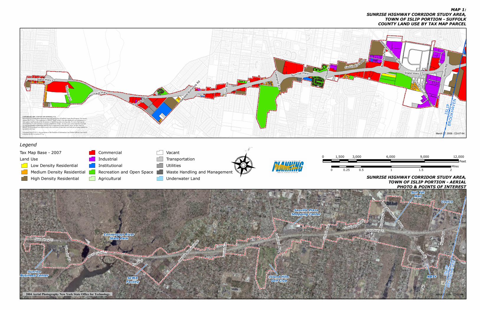
Veterans Memorial HwyState Hwy 27
Sunrise Hwy
Nicoll
s Rd
Montauk Hwy
Broa
dway
Ave
P ond Rd
Wheeler Rd
Lakeland Ave
Linco
ln Av
e Saddle Rock Rd
Locu
st Av
e
Oakdale
Bohem
ia Rd
Church St
State Hwy 27
Veterans Memorial Hwy
State Hwy 27
Nicoll
s Rd
Montauk Hwy
Broa
dway
Ave
P o nd Rd
Whee ler Rd
Lakeland Ave
Linco
ln Av
e Saddle Rock Rd
Locu
st Av
e
Oakdale
Bohem
ia Rd
Church St
State Hwy 27
N
COPYRIGHT 2007, COUNTY OF SUFFOLK, N.Y. Real Property Taxmap parcel linework used with permission of Suffolk County Real Property Tax Service Agency (R.P.T.S.A.). This rendering is a DRAFT MAP in that 1) the data displayed is an interagency or intra agency work* produced for the purpose of identifying and correcting data. It is not a final agency determination. It is not statistical or factual compilation of data. In some cases correct data has been left out and questionable or inaccurate data has been exaggerated to help identify errors. In short, this is a DRAFT MAP produced in an effort to aid in the correction of data and is not held out as being complete or accurate in any way. *excerpted from (F.O.I.L.) the provisions of the Freedom of Information Law [Public Officers Law Article 6 Section 84-90] by section 87.2.g
2004 Aerial Photography New York State Office for Technology.
ISLI
PBR
OOKH
AVEN
ISLI
PBR
OOKH
AVEN
MAP 1:SUNRISE HIGHWAY CORRIDOR STUDY AREA,
TOWN OF ISLIP PORTION - SUFFOLKCOUNTY LAND USE BY TAX MAP PARCEL
SUNRISE HIGHWAY CORRIDOR STUDY AREA,TOWN OF ISLIP PORTION - AERIAL
PHOTO & POINTS OF INTEREST
March 27, 2008 - CD-07-94
March 7, 2008 - CD-07-94
SunriseBusiness Center
Connetquot RiverState Park
SCWAFacility
Island HillsGolf Club
Sayville PlazaShopping Center
Sun VetMall
NBTY
LegendTax Map Base - 2007Land Use
Low Density ResidentialMedium Density ResidentialHigh Density Residential
CommercialIndustrialInstitutionalRecreation and Open SpaceAgricultural
VacantTransportationUtilitiesWaste Handling and ManagementUnderwater Land
0 3,000 6,000 9,000 12,0001,500Feet
0 0.5 1 1.5 20.25Miles
Costco
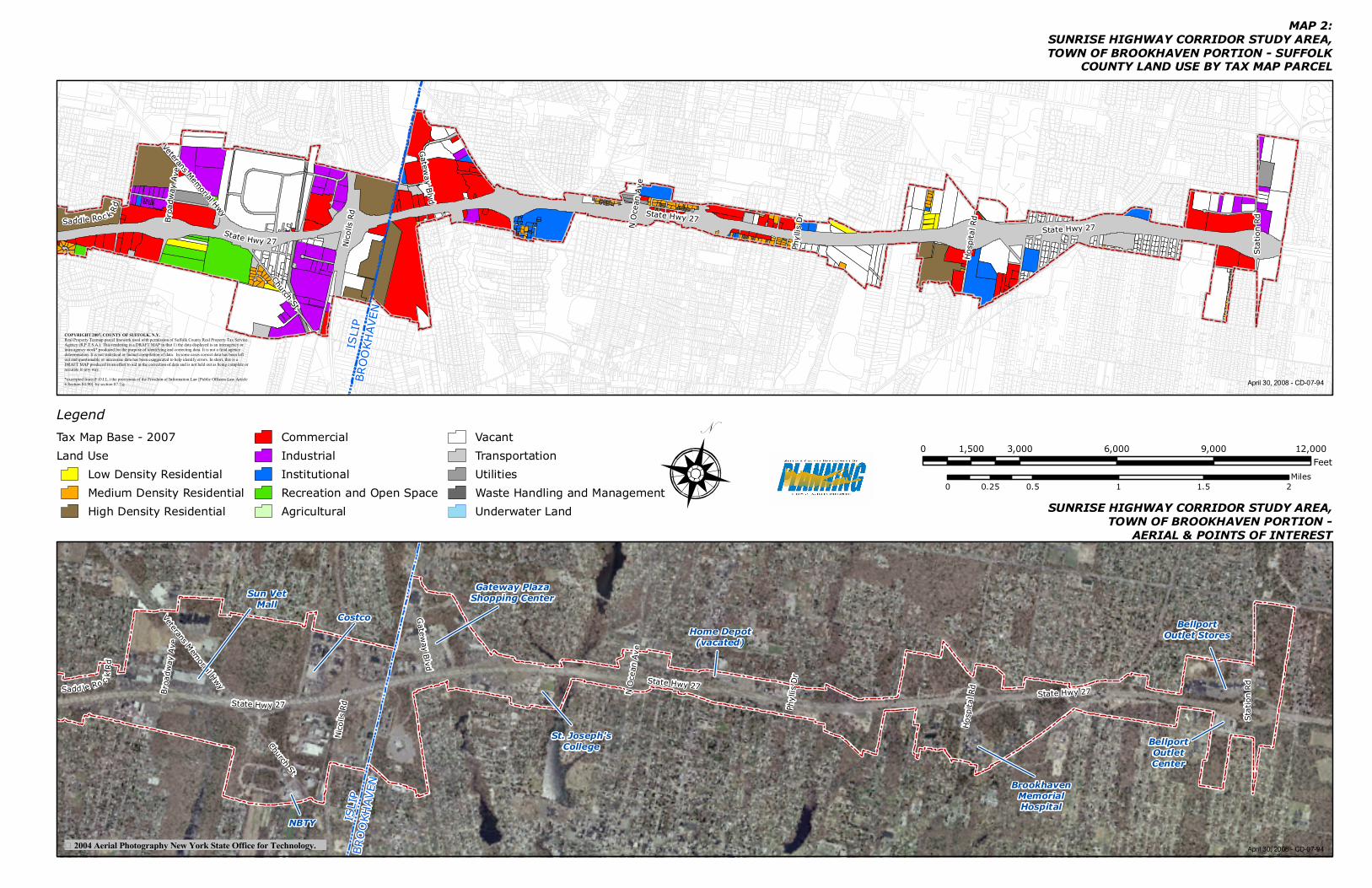
Veterans Memorial Hwy
Broa
dway
Ave
State Hwy 27
Saddle Roc k Rd
State Hwy 27
Hosp
ital R
d
Stat
ion R
d
Gat eway B lvd
N Oc
ean A
ve
Phyll
is Dr
State Hwy 27
Church St
Nicoll
s Rd
Veterans Memorial Hwy
Broa
dway
Ave
State Hwy 27Sadd le Ro c k R
d
Church St
Nicoll
s Rd
State Hwy 27
Hosp
ital R
d
Stat
ion R
d
Ga teway B lvd
N Oc
ean A
ve
Phyll
is Dr
State Hwy 27
MAP 2:SUNRISE HIGHWAY CORRIDOR STUDY AREA,TOWN OF BROOKHAVEN PORTION - SUFFOLK
COUNTY LAND USE BY TAX MAP PARCEL
SUNRISE HIGHWAY CORRIDOR STUDY AREA,TOWN OF BROOKHAVEN PORTION -
AERIAL & POINTS OF INTEREST
N
ISLIP
BROO
KHAV
ENIS
LIPBR
OOKH
AVEN
LegendTax Map Base - 2007Land Use
Low Density ResidentialMedium Density ResidentialHigh Density Residential
CommercialIndustrialInstitutionalRecreation and Open SpaceAgricultural
VacantTransportationUtilitiesWaste Handling and ManagementUnderwater Land
0 3,000 6,000 9,000 12,0001,500Feet
0 0.5 1 1.5 20.25Miles
April 30, 2008 - CD-07-94
April 30, 2008 - CD-07-94
2004 Aerial Photography New York State Office for Technology.
COPYRIGHT 2007, COUNTY OF SUFFOLK, N.Y. Real Property Taxmap parcel linework used with permission of Suffolk County Real Property Tax Service Agency (R.P.T.S.A.). This rendering is a DRAFT MAP in that 1) the data displayed is an interagency or intra agency work* produced for the purpose of identifying and correcting data. It is not a final agency determination. It is not statistical or factual compilation of data. In some cases correct data has been left out and questionable or inaccurate data has been exaggerated to help identify errors. In short, this is a DRAFT MAP produced in an effort to aid in the correction of data and is not held out as being complete or accurate in any way. *excerpted from (F.O.I.L.) the provisions of the Freedom of Information Law [Public Officers Law Article 6 Section 84-90] by section 87.2.g
NBTY
Sun VetMall
Costco
Gateway PlazaShopping Center
St. Joseph'sCollege
Home Depot(vacated)
BrookhavenMemorialHospital
BellportOutletCenter
BellportOutlet Stores
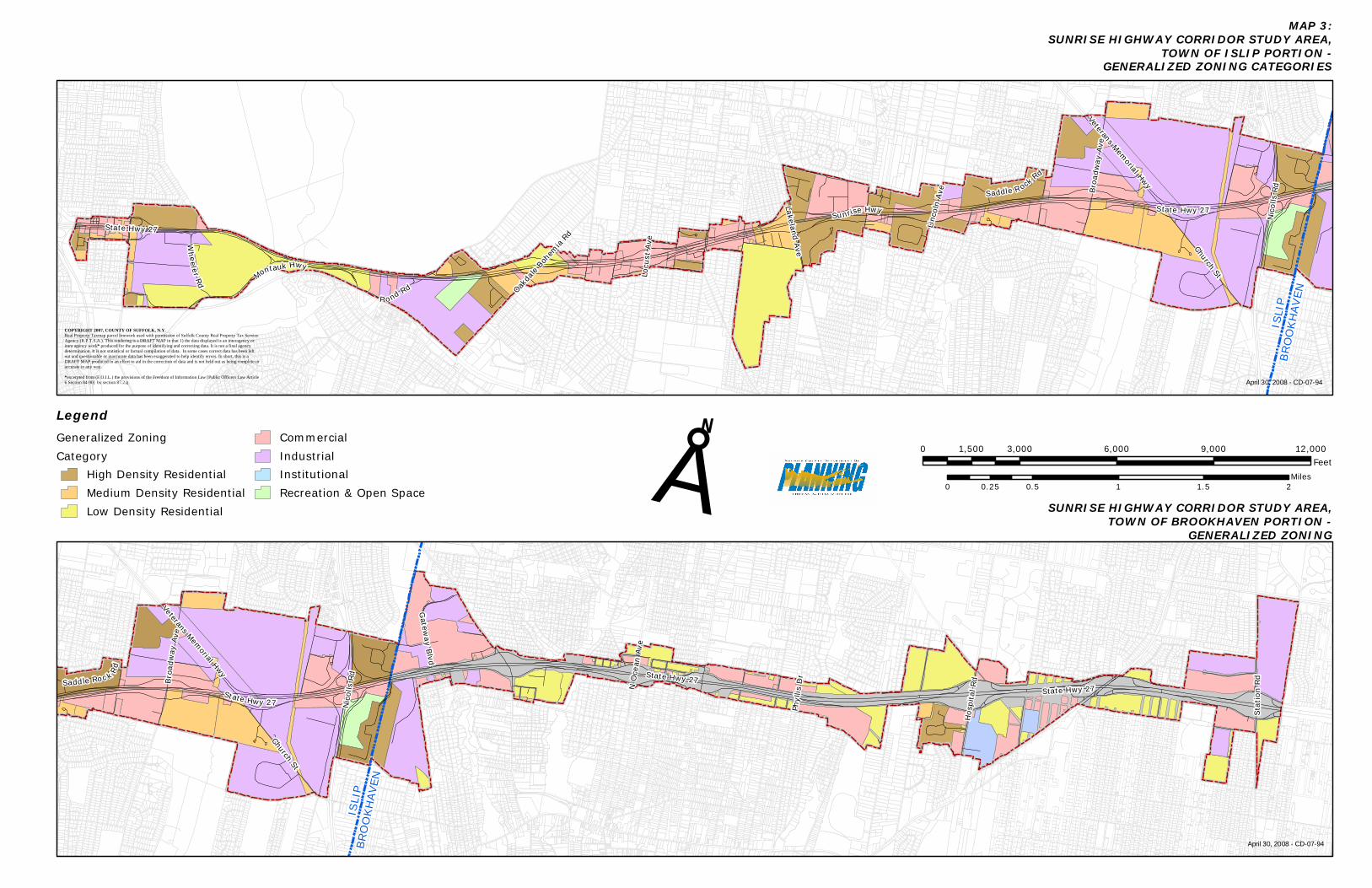
Veterans Memorial Hwy
Broa
dway
Ave
State Hwy 27
Saddle Roc k Rd
State Hwy 27
Hosp
ital R
d
Stat
ion R
d
Gat eway B lvd
N Oc
ean
Ave
Phyll
is Dr
State Hwy 27
Church St
Nicoll
s Rd
Veterans Memorial HwyState Hwy 27
Sunrise Hwy
Nicoll
s Rd
Montauk Hwy
Broa
dway
Ave
P ond Rd
Wheeler Rd
Lakeland Ave
Linco
ln Av
e Saddle Rock Rd
Locu
st Av
e
Oakdale
Bohem
ia Rd
Church St
State Hwy 27
N
ISLI
PBR
OOKH
AVEN
MAP 3:SUNRISE HIGHWAY CORRIDOR STUDY AREA,
TOWN OF ISLIP PORTION -GENERALIZED ZONING CATEGORIES
SUNRISE HIGHWAY CORRIDOR STUDY AREA,TOWN OF BROOKHAVEN PORTION -
GENERALIZED ZONING
April 30, 2008 - CD-07-94
0 3,000 6,000 9,000 12,0001,500Feet
0 0.5 1 1.5 20.25MilesÅ
LegendGeneralized ZoningCategory
High Density ResidentialMedium Density ResidentialLow Density Residential
CommercialIndustrialInstitutionalRecreation & Open Space
ISLIP
BROO
KHAV
EN
April 30, 2008 - CD-07-94
COPYRIGHT 2007, COUNTY OF SUFFOLK, N.Y. Real Property Taxmap parcel linework used with permission of Suffolk County Real Property Tax Service Agency (R.P.T.S.A.). This rendering is a DRAFT MAP in that 1) the data displayed is an interagency or intra agency work* produced for the purpose of identifying and correcting data. It is not a final agency determination. It is not statistical or factual compilation of data. In some cases correct data has been left out and questionable or inaccurate data has been exaggerated to help identify errors. In short, this is a DRAFT MAP produced in an effort to aid in the correction of data and is not held out as being complete or accurate in any way. *excerpted from (F.O.I.L.) the provisions of the Freedom of Information Law [Public Officers Law Article 6 Section 84-90] by section 87.2.g
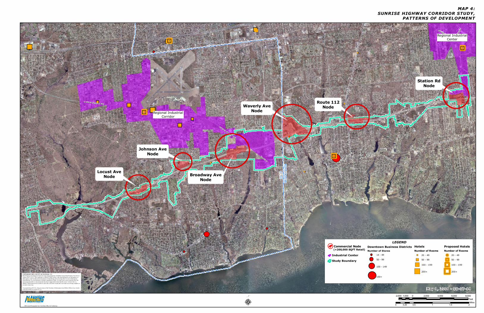
I 495
NICO
LLS
RD
LAKELAND AVE
N OCEAN AVE
VETERANS MEMORIAL HWY
S COUNTRY RD
ROUT
E 112
MONTAUK HWY
E MAIN ST
PATC
HOGU
E YAP
HANK
RD
HORSEBLOCK RD
MAIN ST
N MAIN ST
S OCEAN AVE
OCEAN AVE
HECK SCHER STATE PKWY
CHURCH ST
W MAIN ST
SUNRISE HWY
MEDF
ORD
AVE
VETERANS HWYCO
UNTY
ROAD
101
ROUTE 112
W MAIN ST
NICO
LLS
RD
HECKSCHER STATE PKWY
I 495
VETERANS MEMORIAL HWY
E MAIN ST
HECK
SCHE
R STATE PKWY
SUNRISE HWY
ROUTE 112
MONTAUK HWY MONTAUK HWY
HECKSCHER STATE PKWY
STATE HWY 27
ROUTE 112MEDFORD AVE
MAP 4:SUNRISE HIGHWAY CORRIDOR STUDY,
PATTERNS OF DEVELOPMENT
2,000 0 2,000 4,000 6,000 8,0001,000Feet
May 8, 2008 - CD-07-94
0 0.5 1 1.5 20.25Miles
2004 Aerial Photography New York State Office for Technology.
ISLI
PBR
OOKH
AVEN
Downtown Business DistrictsNumber of Stores
14 - 4950 - 99
100 - 149
150+
Industrial CenterStudy Boundary
Regional IndustrialCorridor
Regional IndustrialCenter
HotelsNumber of Rooms
20 - 4950 - 99100 - 199
200+
Proposed HotelsNumber of Rooms
20 - 4950 - 99100 - 199
200+
LEGEND
Locust AveNode
Johnson AveNode
Broadway AveNode
Waverly AveNode
Route 112Node
Station RdNode
Commercial Node(+200,000 SQFT Retail)
N
COPYRIGHT 2007, COUNTY OF SUFFOLK, N.Y. Real Property Taxmap parcel linework used with permission of Suffolk County Real Property Tax Service Agency (R.P.T.S.A.). This rendering is a DRAFT MAP in that 1) the data displayed is an interagency or intra agency work* produced for the purpose of identifying and correcting data. It is not a final agency determination. It is not statistical or factual compilation of data. In some cases correct data has been left out and questionable or inaccurate data has been exaggerated to help identify errors. In short, this is a DRAFT MAP produced in an effort to aid in the correction of data and is not held out as being complete or accurate in any way. *excerpted from (F.O.I.L.) the provisions of the Freedom of Information Law [Public Officers Law Article 6 Section 84-90] by section 87.2.g
Suffolk County Department of Planning
Thomas A. Isles, AICP
DIRECTOR
Daniel J. Gulizio, AICP DEPUTY DIRECTOR
ADMINISTRATION
Lynne Chieffo Chrissy Einemann
ENVIRONMENTAL ANALYSIS
DeWitt Davies, Ph.D. Lauretta Fischer Michael Mulé
Susan Filipowich Barbara DelGiudice
ZONING AND SUBDIVISION REVIEW Andrew Freleng, AICP
Theodore Klein John Corral
Dorothy Sonnichsen
COUNCIL ON ENVIRONMENTAL QUALITY James Bagg
Christine DeSalvo
PLANNING AND RESEARCH Peter Lambert
Jessica Kalmbacher Andrew Amakawa
Karen Timlin
CARTOGRAPHY AND GIS Carl Lind
Kate Oheim Thomas Frisenda
Vincent Leogrande
LONG ISLAND REGIONAL PLANNING BOARD Seth Forman, Ph.D., AICP