Embed Size (px)
Citation preview
Highway 99 Corridor Local Area Plan
Table of Contents Page i
Table of Contents Page
PART I: BACKGROUND ........................................................1
1. Regional Context ...................................................................................... 1
2. The Plan Area............................................................................................ 1
3. Economic Development Context ............................................................. 3
4. Opportunities And Constraints................................................................ 4
4.1 Opportunities ......................................................................................................4
4.2 Constraints..........................................................................................................5
5. The Planning Process .............................................................................. 6
PART II: PLANNING GOALS AND OBJECTIVES.................8
1. Purpose ..................................................................................................... 8
2. Planning Objectives ................................................................................. 8
PART III: THE LAND USE PLAN AND POLICIES...............10
1. Introduction............................................................................................. 10
2. Land Use Designations .......................................................................... 12
2.1 Commercial .......................................................................................................12
2.2 Business Park ...................................................................................................12
2.3 Commercial/Business Park..............................................................................12
2.4 Business Park/Light Industrial ........................................................................12
3. The Land Use Plan.................................................................................. 13
3.1 28 Avenue Business Park/Light Industrial Area ............................................15
3.2 24 Avenue Commercial Node ..........................................................................15
3.3 16 Avenue Commercial/Business Park Node.................................................17
3.4 Central Business Park/Light Industrial and Business Park Area .................18
3.5 8 Avenue Gateway Commercial/Business Park Area ....................................19
4. Land Use Statistics................................................................................. 20
Highway 99 Corridor Local Area Plan
Table of Contents Page ii
5. Pedestrian And Bicycle Circulation ...................................................... 21
PART IV: ENVIRONMENTAL PRESERVATION..................24
1. Introduction............................................................................................. 24
2. Habitat Management Principles............................................................. 24
3. Habitat Management Plan ...................................................................... 25
3.1 Fish Habitat .......................................................................................................25
3.2 Wildlife Habitat..................................................................................................25
4. Environmental Preservation Areas ....................................................... 28
PART V: DESIGN GUIDELINES ..........................................30
1. Area Character Guidelines..................................................................... 30
PART VI: PLAN IMPLEMENTATION ...................................32
1. Amenity Contributions ........................................................................... 32
1.1 Fire and Police Protection................................................................................32
1.2 Summary of Funding Arrangements...............................................................33
2. Official Community Plan Amendments ................................................. 33
3. Development Permit Area Guidelines ................................................... 33
PART VII: HIGHWAY 99 CORRIDOR SERVICING.............34
1. Servicing ................................................................................................. 34
PART VIII: APPENDICES........................................................I Appendix "A" - Highway 99 Corridor Design Guidelines................................. i Appendix "B" - Highway 99 Corridor – Financing of Servicing................... xvi
Highway 99 Corridor Local Area Plan
Part I - Background Page 1
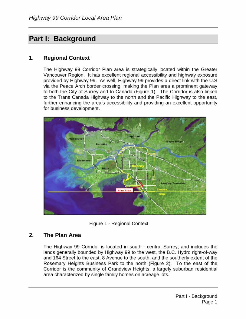
Part I: Background 1. Regional Context
The Highway 99 Corridor Plan area is strategically located within the Greater Vancouver Region. It has excellent regional accessibility and highway exposure provided by Highway 99. As well, Highway 99 provides a direct link with the U.S via the Peace Arch border crossing, making the Plan area a prominent gateway to both the City of Surrey and to Canada (Figure 1). The Corridor is also linked to the Trans Canada Highway to the north and the Pacific Highway to the east, further enhancing the area’s accessibility and providing an excellent opportunity for business development.
Figure 1 - Regional Context
2. The Plan Area
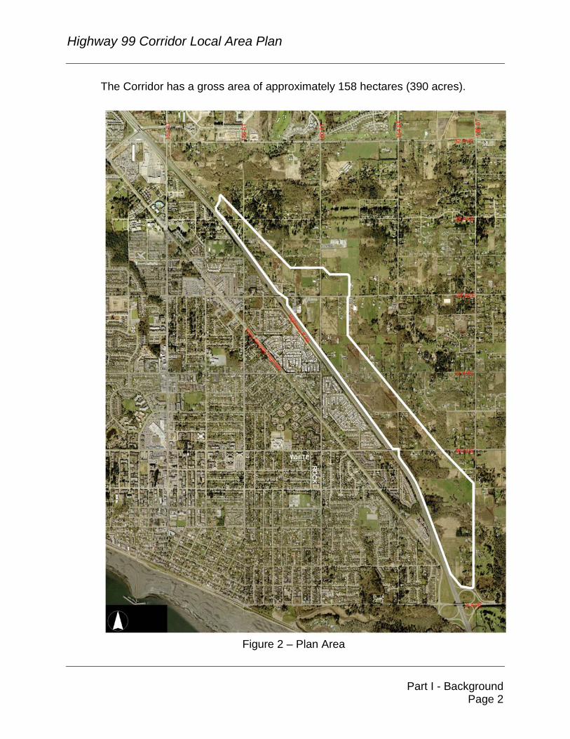
The Highway 99 Corridor is located in south - central Surrey, and includes the lands generally bounded by Highway 99 to the west, the B.C. Hydro right-of-way and 164 Street to the east, 8 Avenue to the south, and the southerly extent of the Rosemary Heights Business Park to the north (Figure 2). To the east of the Corridor is the community of Grandview Heights, a largely suburban residential area characterized by single family homes on acreage lots.
Highway 99 Corridor Local Area Plan
Part I - Background Page 2
The Corridor has a gross area of approximately 158 hectares (390 acres).
Figure 2 – Plan Area
Highway 99 Corridor Local Area Plan
Part I - Background Page 3
3. Economic Development Context
The City of Surrey Official Community Plan (the "OCP") has a strong business development focus, and includes policies to create a vibrant and sustainable local economy. Balancing jobs and resident workers, and achieving a strong and balanced fiscal base are key policy targets identified in the OCP. To achieve these policy targets, the OCP contains strategies to ensure the availability of an adequate land supply to facilitate long term economic growth. More specifically, the OCP includes the following policies and location guidelines: 1. Balance jobs and resident workers by increasing the ratio of jobs per
resident in the work force from 0.55, to one job per resident worker by 2021;
2. Achieve a strong and balanced fiscal base by achieving a tax base
revenue ratio of 60% residential to 40% business. The current ratio is 70% residential to 30% business;
3. Ensure an adequate land supply to facilitate long term economic growth;
and 4. Facilitate the location of new business parks in appropriate and strategic
locations within the City based on the following guidelines:
− Direct access to a designated truck route, a Provincial Highway or an Arterial Road. Primary traffic access roads to/from the site not to penetrate or create nuisance for adjacent residential land uses;
− Located within an existing or potential servicing catchment area(s) that will allow comprehensive, timely and cost-effective infrastructure and utility servicing including water, sewer, drainage, flood control, natural gas and hydro electricity;
− Adequate interface with adjacent land uses, to minimize traffic and other nuisance impacts on adjacent properties and to protect environmentally sensitive areas; and
− Site topography and soils conducive to large floor-plate buildings. In view of this policy framework, the Highway 99 Corridor has been identified as an attractive location for business development uses.
Highway 99 Corridor Local Area Plan
Part I - Background Page 4
The Corridor has an area of approximately 158 hectares (390 acres) of land. If it is developed to its full potential with a mix of industrial and commercial uses, it will generate approximately $300 to $350 million in new business property assessments, new property tax revenues of approximately $3 million to $3.5 million per year, and will be home to over 6,000 new jobs.
4. Opportunities And Constraints 4.1 Opportunities
The Highway 99 Corridor offers many opportunities for business development. It is a relatively self-contained area defined by strong edges with Highway 99 to the west; generally the B.C. Hydro right-of-way to the east; 8 Avenue to the south; and the Rosemary Heights Business Park to the north.
The area has excellent regional accessibility and highway exposure provided by Highway 99. This location, adjacent to a Provincial highway, provides good opportunities for commercial, retail, office, light industrial and related business development. In addition to regional accessibility provided by Highway 99, this area is well served by a number of east-west arterial linkages including 24 Avenue, 16 Avenue, and 8 Avenue. The proximity and direct linkage of the Corridor to the Canada/U.S. border to the south also adds to the attractiveness of this area for business development and employment uses.
The plan area contains large tracts of land with relatively level ground, especially between 16 Avenue and 24 Avenue. These conditions will serve to facilitate development that requires a sizeable land area and buildings with large floor plates.
There are a number of existing natural amenities in the area, including Fergus Creek and its tributaries located south of 16 Avenue. Opportunities exist to preserve and enhance both the creek and the riparian setback areas of the creek, and to maintain and enhance the biodiversity of this area.
While the Corridor is currently unserviced with respect to municipal sanitary sewer and water, there is an opportunity to provide and upgrade infrastructure, services and amenities through the development of the area.
Highway 99 Corridor Local Area Plan
Part I - Background Page 5
4.2 Constraints
The Plan Area also has a number of constraints that were taken into consideration in preparing the plan.
Servicing: As noted, the Corridor requires the installation of servicing infrastructure. As well, the major east-west roads will require upgrading to accommodate the additional demands of development in the Corridor. Such transportation improvements are currently not within the City’s 10 Year Servicing Plan.
Interfaces: The transition and interface between new business development uses within the Corridor and the established suburban residential uses and hobby farms in the area to the east must be appropriately addressed to minimize conflicts between land uses. Hydro Right-of-Way: The B.C. Hydro right-of-way, which runs diagonally along the easterly edge of the Plan Area, presents a major limitation to development with respect to land use, setback requirements and height restrictions. Watercourses: As well, there are fish-bearing watercourses requiring protection under the Fish Protection Act. While the Hydro right-of-way and watercourses may impact development potential, they provide opportunities to integrate natural corridors, provide buffering, and provide for the retention and enhancement of Fergus Creek through a Wildlife Management Plan. Existing Businesses: A further consideration in the preparation of the land use plan for the Corridor is the location and size of competing, existing commercial and office park development within the larger South Surrey area, and the potential impacts of new commercial development on these existing businesses. The plan should act to balance new development with the continuing health of existing businesses in the broader community.
Highway 99 Corridor Local Area Plan
Part I - Background Page 6
5. The Planning Process Council authorized the preparation of a local area plan for the Corridor and approved the Terms of Reference for the preparation of such a Plan in January of 2002. An inter-agency working group was established and provided technical input into the plan preparation. The participating agencies included: ��B.C. Hydro ��Land Reserve Commission ��Ministry of Transportation ��RCMP ��Surrey School District ��Surrey Parks, Recreation and Culture Department ��Surrey Engineering Department ��Surrey Economic Development Office ��Surrey Planning & Development Department
The provincial Ministry of Water, Land & Air Protection and the federal Department of Fisheries and Oceans declined to participate at this stage, due to resource limitations. Three land use plan options were presented to the public at an Open House held on May 2, 2002. A preferred land use plan option was developed based on public input related to these options. The preferred land use plan option was presented to the public at an Open House held on April 24, 2003. Further modifications were made to the preferred option, based on community input received at and following the April 24 Open House, as well as further community input garnered through a series of small group stakeholder meetings held during the month of September, 2003, and a community workshop held on October 7, 2003. Two additional open houses were held in November 2003 to present to the public a final draft Land Use Plan. In summary, the planning process involved a number of steps with formal and informal opportunities for the public to participate in the process. These steps were: 1. Council approved Terms of Reference (January, 2002); 2. Inter-agency working group formed to provide input and advice throughout
the planning process (February, 2002); 3. Public Open House on Issues and Concerns (March, 2002); 4. Public Open House to present three land use plan options (May, 2002);
Highway 99 Corridor Local Area Plan
Part I - Background Page 7
5. Issue analysis and plan preparation (June, 2002 – March, 2003); 6. Public Open House to present Preferred Land Use Option (April, 2003); 7. Community Association/stakeholder group meetings (September, 2003); 8. Community workshop (October, 2003); 9. Public Open House to present final draft Land Use Plan, servicing and
financing strategies (November, 2003); 10. Council approval of Stage 1 land use plan (December, 2003); 11. Finalization of land use plan, design guidelines, servicing and financing
(January/February, 2004); and 12. Council approval of final and complete (Stage 1 and Stage 2)
Neighbourhood Concept Plan (February, 2004).
Highway 99 Corridor Local Area Plan
Part II - Planning Goals and Objectives Page 8
PART II: PLANNING GOALS AND OBJECTIVES 1. Purpose
The Local Area Plan for the Highway 99 Corridor sets out a policy framework for land use and density, a transportation network and an environmental management plan, as well as requirements for servicing, amenities and financing.
2. Planning Objectives The objectives of the Highway 99 Corridor Local Area Plan process as developed with public input and endorsed by Council are as follows: 1. To develop and formulate land use, economic and other development
policies, with a business development focus, to guide development proposals for the Highway 99 Corridor;
2. To protect, preserve and enhance significant habitat values (both fish and
wildlife) and other natural features within the Corridor and, where possible, to integrate such features into the planning and design of new development;
3. To employ sustainable development principles in the planning and design
of new development; 4. To achieve new development with a high quality of urban design,
architecture and landscaping; 5. To ensure that the development of the Corridor does not significantly
compromise the viability of other existing and planned businesses in the larger South Surrey area;
6. To ensure that the lands within the Corridor are planned to have an
appropriate land use interface and transition with adjacent lands; 7. To prepare a parallel servicing strategy that provides for the location,
staging and standards of services, including sanitary sewer, water, drainage, roads and other utilities and methods of implementation by rezoning, subdivision, or other mechanisms;
Highway 99 Corridor Local Area Plan
Part II - Planning Goals and Objectives Page 9
8. To provide a road network to effectively handle the new traffic generated by development, that does not mix new traffic from the Plan Area with the existing residential road network; and
9. To undertake a financial analysis that will demonstrate adequate funding
for the implementation of the servicing and transportation plan.
Highway 99 Corridor Local Area Plan
Part III - The Land Use Plan and Policies Page 10
PART III: THE LAND USE PLAN AND POLICIES 1. Introduction
The Land Use Plan for the Highway 99 Corridor supports Council’s business development objectives and policies and accommodates a variety of Commercial, Business Park and high-end Light Impact Industrial uses. The Highway 99 Corridor is expected to generate approximately 6,000 new jobs once it is built-out to its full potential with a mix of industrial and commercial development. The Land Use Plan for the Highway 99 Corridor is illustrated in Figure 3.

Highway 99 Corridor Local Area Plan
Part III - The Land Use Plan and Policies Page 11
Figure 3 – Land Use Plan
Highway 99 Corridor Local Area Plan
Part III - The Land Use Plan and Policies Page 12
2. Land Use Designations Developable land within the Corridor is classified into four land use categories, as described in the following sections: 2.1 Commercial
The Commercial designation provides for a variety of commercial land uses including large format retail, restaurants including drive-thru’s, service commercial and other retail uses. The Commercial designation also allows for office uses. Commercial uses may be contained in a multi-tenant complex or in a freestanding building occupied by a single tenant.
2.2 Business Park
The Business Park designation provides for business parks consisting of office uses and service uses as well as warehouse and distribution uses that are comprehensively designed with extensive landscaping and high quality urban design. Business park development may include multi-tenant complexes or freestanding single tenant buildings established in an attractive, clean and quiet campus setting. No outside storage is permitted.
2.3 Commercial/Business Park The Commercial/Business Park designation provides for a combination of commercial and business park uses including retail, office and warehouse/distribution uses with no outside storage.
2.4 Business Park/Light Industrial
The Business Park/Light Industrial designation provides opportunities for a variety of business park and "high end" light impact industrial uses including office and service uses, and wholesale, warehousing and light manufacturing uses that are completely enclosed within a building. Outdoor storage and display is not allowed under this designation. Both single tenant and multi-tenant buildings could be located on these lands.
Highway 99 Corridor Local Area Plan
Part III - The Land Use Plan and Policies Page 13
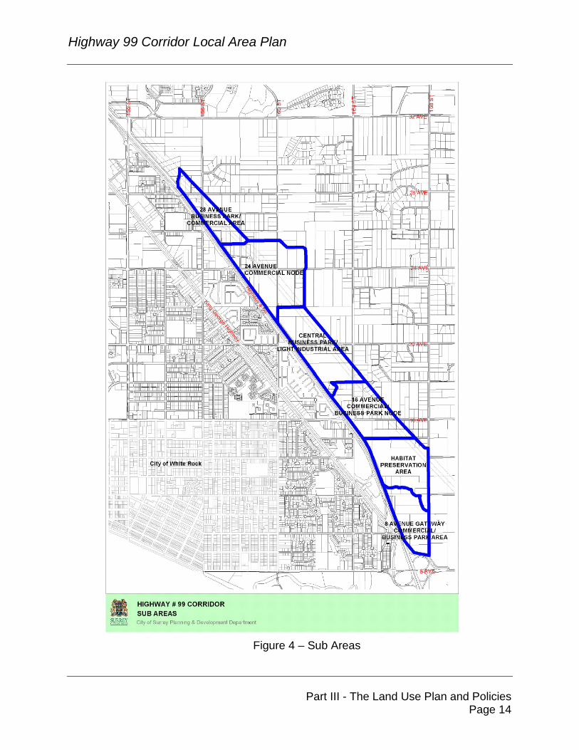
3. The Land Use Plan The Land Use Plan is divided into a number of sub-areas as illustrated in Figure 4. Each of these sub-areas supports different types of land uses, as described in the following sections:
Highway 99 Corridor Local Area Plan
Part III - The Land Use Plan and Policies Page 14
Figure 4 – Sub Areas
Highway 99 Corridor Local Area Plan
Part III - The Land Use Plan and Policies Page 15
3.1 28 Avenue Business Park/Light Industrial Area
The 28 Avenue Business Park/Light Industrial Area is located in the northerly part of the Highway 99 Corridor. This area is bounded by the Rosemary Heights Business Park and by 28 Avenue to the north, and by 26 Avenue to the south. Comprising approximately 22 acres of land, it is presently characterized by rural acreages of varying condition.
This area shares many of the characteristics of the properties located in the south part of the Rosemary Heights Business Park, including narrow frontages along Highway 99 and the encumbrances posed by the B.C. Hydro right-of-way to the east. The land use plan proposes a continuation of the business park and clean light impact industrial uses of the Rosemary Heights Business Park in this area.
Policy Highlights
1. Business Park and “high-end” Light Impact Industrial uses may be developed in this area.
2. All Business Park and Light Impact Industrial development will be of
a high environmental and architectural quality.
3. No outdoor storage of any kind will be allowed in this area. 3.2 24 Avenue Commercial Node
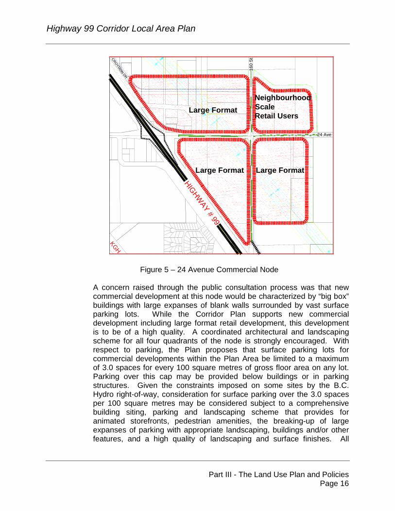
The Land Use Plan proposes a major commercial node at 24 Avenue and 160 Street. Comprising approximately 34.5 hectares (85 acres) of land, the northwest, southwest and southeast quadrants of this node are proposed for a variety of retail commercial uses including large format retail development. As a gateway to the Grandview Heights residential area to the east, careful attention must be given to the planning and design of new development within these quadrants.
The northeast quadrant of this node is envisioned for retail uses that can provide an appropriate transition between the potential large format retail uses in the other three quadrants and the existing and future residential uses to the east and north of this node. Large format retail uses in the form of single user “big box” buildings will not be permitted within this quadrant. This quadrant is focused on providing a neighbourhood scale of retail uses for the residential areas to the east (Figure 5).
Highway 99 Corridor Local Area Plan
Part III - The Land Use Plan and Policies Page 16
NeighbourhoodScaleRetail Users
Large Format Large Format
Large Format
CROYDON DR
160
St
24 Ave
HIGHWAY # 99
KGH
Figure 5 – 24 Avenue Commercial Node
A concern raised through the public consultation process was that new commercial development at this node would be characterized by “big box” buildings with large expanses of blank walls surrounded by vast surface parking lots. While the Corridor Plan supports new commercial development including large format retail development, this development is to be of a high quality. A coordinated architectural and landscaping scheme for all four quadrants of the node is strongly encouraged. With respect to parking, the Plan proposes that surface parking lots for commercial developments within the Plan Area be limited to a maximum of 3.0 spaces for every 100 square metres of gross floor area on any lot. Parking over this cap may be provided below buildings or in parking structures. Given the constraints imposed on some sites by the B.C. Hydro right-of-way, consideration for surface parking over the 3.0 spaces per 100 square metres may be considered subject to a comprehensive building siting, parking and landscaping scheme that provides for animated storefronts, pedestrian amenities, the breaking-up of large expanses of parking with appropriate landscaping, buildings and/or other features, and a high quality of landscaping and surface finishes. All
Highway 99 Corridor Local Area Plan
Part III - The Land Use Plan and Policies Page 17
development will be subject to the design guidelines set out in this Plan and will be subject to a Development Permit process as provided in the Official Community Plan.
Policy Highlights 1. Single tenant large format retail uses in large floor plate buildings
may be developed in this commercial node except in the quadrant located to the north of 24 Avenue east of 160 Street.
2. Retail uses in the north-east quadrant shall be of a neighbourhood-
scale, and provide an appropriate transition between the possible large format retail uses in the other three quadrants and the residential area to the east of the Corridor. Special care and attention must be given to the planning and design of commercial development within this quadrant so that this transition is effective.
3. Appropriate site planning, architectural and landscape treatment
must be provided along the east edge of this commercial node to provide an acceptable buffer and interface to the residential area to the east.
4. Surface parking for commercial development in this area is to be
limited to 3.0 spaces per 100 square metres of gross floor area except on sites that are significantly encumbered with the Hydro right-of-way where some relaxation may be considered depending on the degree to which the site is encumbered. Additional parking beyond the 3.0 stalls per 100 sq. m. is permitted provided that it is contained below a building or in a parking structure(s). Where, due to the encumbrance of the Hydro right-of-way, a larger amount of surface parking is considered, its visual impact must be mitigated through creative site planning, design and landscaping, including comprehensive building siting, parking and landscaping scheme that provides for animated storefronts, pedestrian amenities, the breaking-up of large expanses of parking with landscaped areas, buildings, and/or other features, and a high quality of landscaping and surface finishes.
3.3 16 Avenue Commercial/Business Park Node
A commercial node, which combines commercial and business park uses, is proposed at 16 Avenue, which provides a direct link to the established
Highway 99 Corridor Local Area Plan
Part III - The Land Use Plan and Policies Page 18
White Rock/South Surrey residential areas to the west. This node includes approximately 13 ha (32 acres) of land. Smaller scale commercial development in the form of either freestanding buildings occupied by a single tenant or in multi-tenant commercial retail units are proposed for this location. Unlike the 24 Avenue commercial node, single tenant retailers in freestanding buildings in excess of 20,000 to 25,000 square feet are not envisioned in this area.
Policy Highlights 1. Retail commercial and office uses both in freestanding buildings
occupied by a single tenant or multi-tenant commercial retail buildings may be developed in this area. Typically, the maximum size of a single tenant in a freestanding building should not exceed 1850 to 2325 square metres (20,000 to 25,000 square feet) in gross floor area.
2. Surface parking for commercial development in this area is to be
limited to 3.0 spaces per 100 square metres of gross floor area except on sites that are significantly encumbered with the Hydro right-of-way where some relaxation may be considered depending on the degree to which the site is encumbered. Additional parking beyond the 3.0 stalls per 100 sq. m. is permitted provided that it is contained below a building or in a parking structure(s). Where, due to the encumbrance of the Hydro right-of-way, a larger amount of surface parking is considered, its visual impact must be mitigated through creative site planning, design and landscaping, including comprehensive building siting, parking and landscaping scheme that provides for animated storefronts, pedestrian amenities, the breaking-up of large expanses of parking with landscaped areas, buildings, and/or other features, and a high quality of landscaping and surface finishes.
3. All development shall be of high environmental and architectural
quality. 3.4 Central Business Park/Light Industrial and Business Park Area
The area between the commercial nodes at 16 Avenue and 24 Avenue is proposed for a combination of Business Park/Light Industrial (+/- 23 hectares or 56 acres) and Business Park uses (+/- 8 hectares or 20 acres). The Plan illustrates a precinct of business park and light industrial uses anchored at the north and south ends by the two commercial nodes.
Highway 99 Corridor Local Area Plan
Part III - The Land Use Plan and Policies Page 19
A north-south spine road, the extension of Croydon Drive south to approximately 18 Avenue paralleling Highway 99, is proposed to provide access to this area. To ensure high quality development, all light impact industrial uses within this precinct must be within an enclosed building. Outdoor storage of any goods, materials or supplies will be prohibited. Policy Highlights 1. All business park and light impact industrial development will be of
a high environmental and architectural quality. 2. No outdoor storage of any kind will be allowed in this area.
3.5 8 Avenue Gateway Commercial/Business Park Area
The area between 8 Avenue and the southerly limit of the Fergus Creek habitat preservation area is proposed for a combination of Business Park (+/- 8 hectares or 20 acres) and Business Park/Commercial uses (+/- 8.5 hectares or 21 acres). This area is an important gateway location into Surrey and Canada and as such, a high quality of urban design, architecture and landscaping is especially important at this location. Tourist commercial uses such as hotels, which take advantage of this gateway location, are allowed. Policy Highlights 1. Tourist commercial uses such as a high-end hotel with conference
facilities are encouraged at this location. 2. Development at this gateway to Surrey and Canada is to be of a
high quality of urban design, architecture and landscaping.
Highway 99 Corridor Local Area Plan
Part III - The Land Use Plan and Policies Page 20
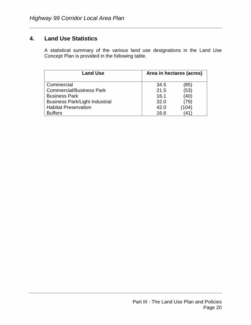
4. Land Use Statistics A statistical summary of the various land use designations in the Land Use Concept Plan is provided in the following table.
Land Use Area in hectares (acres)
Commercial 34.5 (85) Commercial/Business Park 21.5 (53) Business Park 16.1 (40) Business Park/Light Industrial 32.0 (79) Habitat Preservation 42.0 (104) Buffers 16.6 (41)
Highway 99 Corridor Local Area Plan
Part III - The Land Use Plan and Policies Page 21
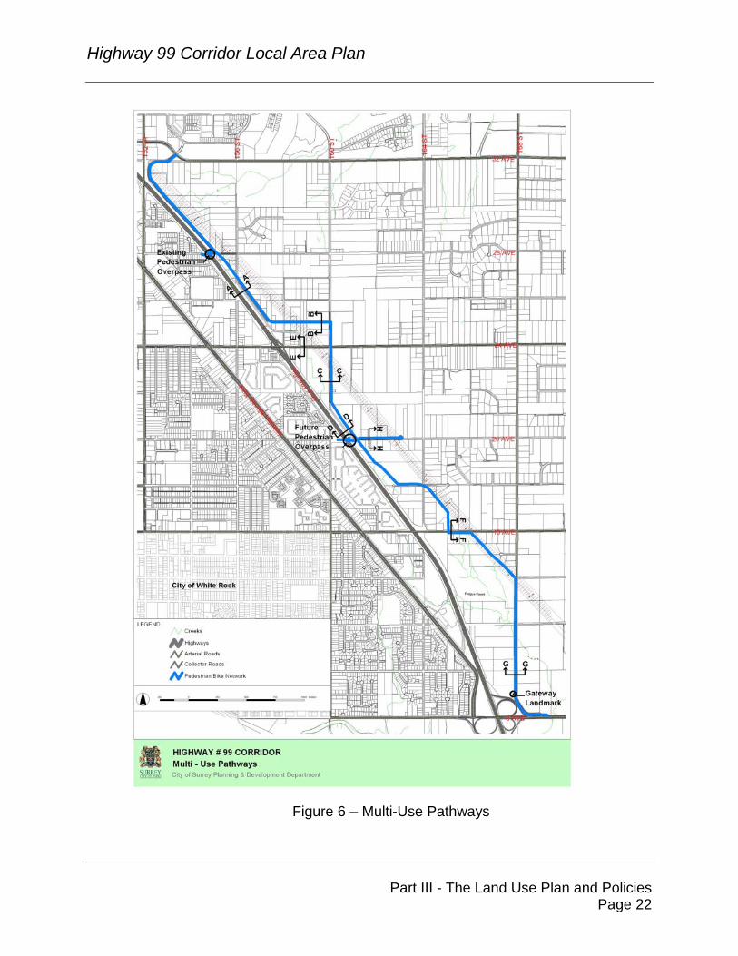
5. Pedestrian And Bicycle Circulation
The Highway 99 Corridor Plan provides for a pedestrian and bicycle route in the form of a multi-use pathway. This pathway is intended to link the Plan Area with the Rosemary Heights Business Park to the north and 8 Avenue to the south (Figure 6) and is part of the larger “Pioneer Greenway”. A multi-use pathway (or corridor) refers to a travel corridor for multiple users such as pedestrians, cyclists, wheelchair users, joggers and roller-bladers. The multi-use pathway through the Corridor Plan Area is proposed to connect to the pathway (i.e., already partially constructed) in the Rosemary Heights Business Park to the north. From the Rosemary Heights Business Park, the pathway runs south along the east side of Croydon Drive to the northerly extent of the 24 Avenue commercial node. The pathway extends along the north side of this road east to 160 Street then continues south along the east side of 160 Street to meet Croydon Drive at approximately 22 Avenue. From this location, the pathway runs parallel with Highway 99 generally along the east side of Croydon Drive to 18 Avenue. The pathway then extends east along the north side of 18 Avenue to the B.C. Hydro right-of-way where it turns south running parallel with the Hydro right-of-way and intersects with 16 Avenue at approximately 165 Street. From this location, the pathway is proposed to run east along the south side of 16 Avenue to the B.C. Hydro right-of-way and diagonally to 168 Street. At this point, the pathway continues south along the west side of 168 Street to 8 Avenue. Cross-sections for different sections of this multi-use pathway are illustrated in the Design Guidelines for the Plan Area, attached as Appendix "A" to this Plan document.
Highway 99 Corridor Local Area Plan
Part III - The Land Use Plan and Policies Page 22
Figure 6 – Multi-Use Pathways
Highway 99 Corridor Local Area Plan
Part III - The Land Use Plan and Policies Page 23
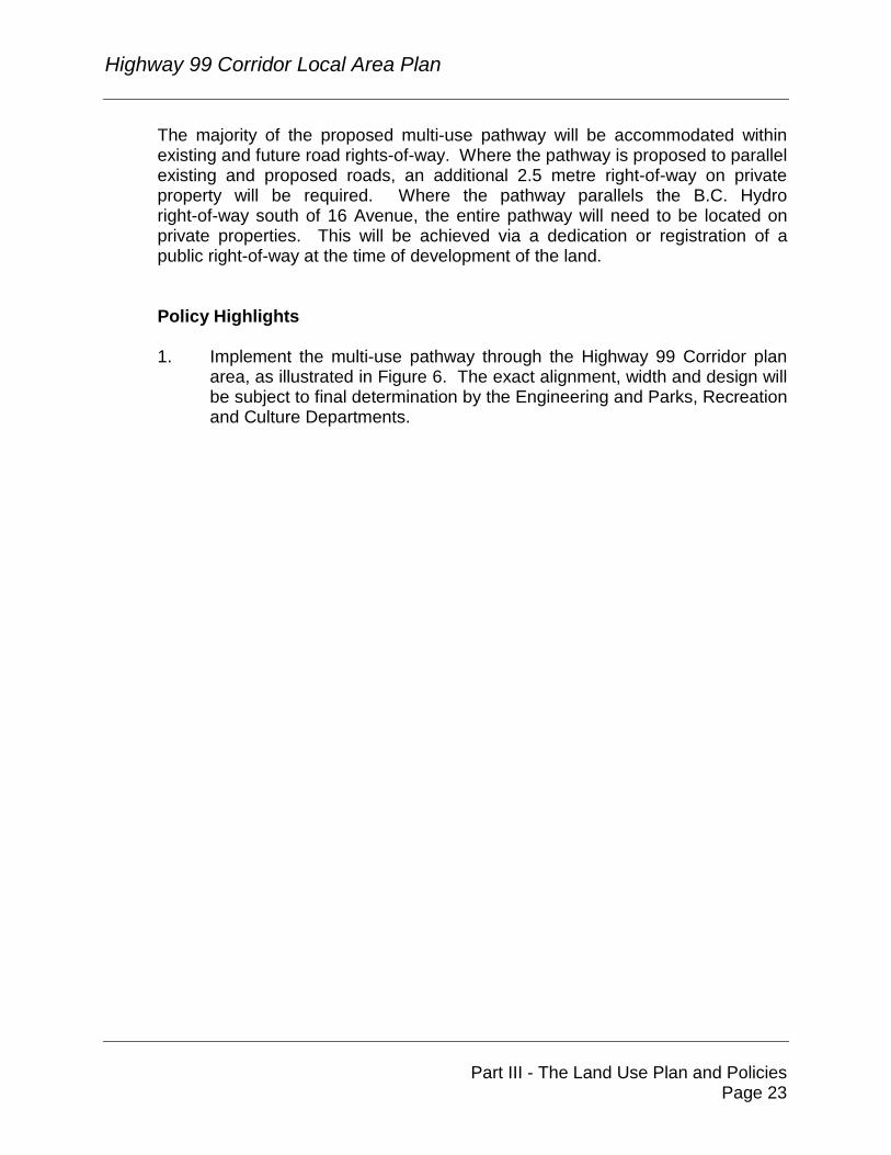
The majority of the proposed multi-use pathway will be accommodated within existing and future road rights-of-way. Where the pathway is proposed to parallel existing and proposed roads, an additional 2.5 metre right-of-way on private property will be required. Where the pathway parallels the B.C. Hydro right-of-way south of 16 Avenue, the entire pathway will need to be located on private properties. This will be achieved via a dedication or registration of a public right-of-way at the time of development of the land. Policy Highlights 1. Implement the multi-use pathway through the Highway 99 Corridor plan
area, as illustrated in Figure 6. The exact alignment, width and design will be subject to final determination by the Engineering and Parks, Recreation and Culture Departments.
Highway 99 Corridor Local Area Plan
Part IV - Environmental Preservation Page 24
PART IV: ENVIRONMENTAL PRESERVATION 1. Introduction
The Highway 99 Corridor Plan area contains numerous watercourses. Development proposals will subject to setback and possibly, enhancement requirements. ECL, Envirowest Consultants Limited was retained by the City of Surrey to assess and provide recommendations with respect to these watercourses and other habitat features located within the Corridor plan area. Meetings with the Department of Fisheries and Oceans Canada (DFO) and local environmental groups have indicated that there would be great benefit in consolidating most of the enhancement efforts related to watercourses and their associated riparian setback areas into one comprehensive area within the Corridor. A key component in implementing this consolidation strategy is to allow the development of lower value habitat while preserving and enhancing higher value areas. This approach equates to developers mitigating the impacts of development on a particular site by creating, protecting and/or enhancing environmental features on another site. This concept has been applied quite frequently throughout the Lower Mainland including other areas of Surrey.
2. Habitat Management Principles
A series of general habitat management principles have been developed for the Highway 99 Corridor, as presented below:
• adhere to the guiding principles of the City of Surrey’s Official Community Plan with respect to the protection of natural areas;
• adhere to the habitat management policies of DFO and, in particular, address DFO’s guiding principle of “No Net Loss of Habitat Productivity” and other requirements of the Federal Fisheries Act;
• acknowledge and address the confirmed or potential occurrence of wildlife in accordance with the Federal Species at Risk Act;
• ensure that wildlife, in particular birds, are considered with respect to non-disturbance periods, as required in accordance with both the Provincial Wildlife Act and the Federal Migratory Bird Act;
• develop a habitat management plan that maximizes habitat diversity within areas to be protected as wildlife habitat;
• consider linkages with habitat features beyond the boundaries of the Highway 99 Corridor; and
Highway 99 Corridor Local Area Plan
Part IV - Environmental Preservation Page 25
• consider high value fish habitat as a key component of the habitat management strategy.
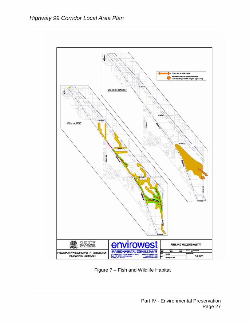
3. Habitat Management Plan The Highway 99 Corridor includes a variety of habitat features that support resident and migratory populations of fish and wildlife (Figure 7). The Plan Area includes over 40 hectares (100 acres) of high value habitat area that will be preserved, enhanced and protected. High quality fish habitat forms the foundation of the habitat protection plan and is supplemented by a mix of upland habitat types that will maintain representation by all wildlife groups currently found in this area. A synopsis of the basic elements of the habitat management plan is presented in the following sections: 3.1 Fish Habitat
The most significant fish habitat feature within the Corridor is Fergus Creek. The main stem sections of Fergus Creek and several other tributary sections have been designated as Class A habitat in accordance with the City of Surrey’s watercourse classification system. These watercourses are inhabited by fish species such as Coho salmon and cutthroat trout. Class A habitats must be protected by a minimum setback area of 30 metres from commercial and industrial developments, in accordance with DFO guidelines. A network of Class B watercourses also drains the Highway 99 corridor. Fish do not inhabit these watercourses; however, the Class B watercourses do contribute ecologically to the Class A watercourses located downstream. In the past, DFO has not objected to the principle of developers eliminating Class B habitats on the condition that approved replacement habitat is provided within the same area. Through the planning process for the Highway 99 Corridor, DFO has indicated that it could apply the same principle to the Corridor provided the majority of the enhancement efforts occur within the Corridor area and the replacement habitat is of similar or increased functional value.
3.2 Wildlife Habitat
The Highway 99 Corridor contains six general habitat types that include mature riparian forest, mature deciduous forest, alder pole/sapling forest, field, rural/suburban developed, and golf course. These habitats reflect
Highway 99 Corridor Local Area Plan
Part IV - Environmental Preservation Page 26
varying degrees of development encroachment but to some degree each supports wildlife communities. A broad range of wildlife species, including small and large mammals, reptiles, amphibians, raptors and songbirds, currently utilizes the Corridor area. Primary objectives of the habitat management strategy are to preserve representative habitat types and wildlife species currently utilizing the Corridor area, and in particular, to preserve habitat for the Pacific water shrew, a threatened species listed in Schedule (1) of the Species At Risk Act (SARA).
Highway 99 Corridor Local Area Plan
Part IV - Environmental Preservation Page 27
Figure 7 – Fish and Wildlife Habitat
Highway 99 Corridor Local Area Plan
Part IV - Environmental Preservation Page 28
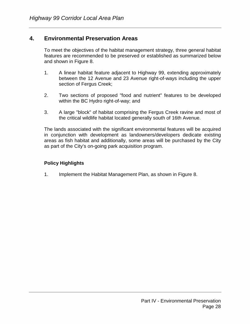
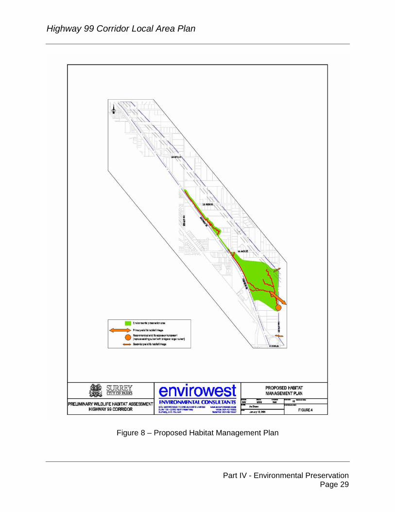
4. Environmental Preservation Areas To meet the objectives of the habitat management strategy, three general habitat features are recommended to be preserved or established as summarized below and shown in Figure 8. 1. A linear habitat feature adjacent to Highway 99, extending approximately
between the 12 Avenue and 23 Avenue right-of-ways including the upper section of Fergus Creek;
2. Two sections of proposed "food and nutrient" features to be developed
within the BC Hydro right-of-way; and 3. A large "block" of habitat comprising the Fergus Creek ravine and most of
the critical wildlife habitat located generally south of 16th Avenue. The lands associated with the significant environmental features will be acquired in conjunction with development as landowners/developers dedicate existing areas as fish habitat and additionally, some areas will be purchased by the City as part of the City’s on-going park acquisition program. Policy Highlights 1. Implement the Habitat Management Plan, as shown in Figure 8.
Highway 99 Corridor Local Area Plan
Part IV - Environmental Preservation Page 29
Figure 8 – Proposed Habitat Management Plan
Highway 99 Corridor Local Area Plan
Part V - Design Guidelines Page 30
PART V: DESIGN GUIDELINES 1. Area Character Guidelines
Detailed urban design guidelines have been prepared for the Highway 99 Corridor. The primary intent of the guidelines is to provide guidance for the development of the public realm as well for development proposals on private property to achieve specific urban design objectives for the Corridor. These guidelines are detailed in Appendix "A". They are intended to supplement the Development Permit Guidelines contained in the Surrey Official Community Plan. The guidelines are based on the following urban design objectives:
• To promote a high quality of urban design, architecture and landscaping, with special attention to development along Highway 99, and arterial and collector roads.
• To facilitate coordinated development, including the coordination of
architectural expression, landscaping and site features on neighbouring sites, and along public streets.
• To integrate urban design and environmental protection by protecting and
preserving important elements of the natural environment.
• To retain/provide a green corridor or buffer along Highway 99.
• To encourage development which incorporates sustainability principles of land development, site planning and building design, and to encourage the implementation of LEED (Leadership in Energy and Environmental Design) standards, where possible.
• To encourage unique design at visually prominent locations, including the
commercial nodes at 24 Avenue, 16 Avenue and 8 Avenue.
• To enhance the interface of the private developments and buildings with public streets, with particular attention to the pedestrian environment.
• To provide an appropriate and attractive interface between the Highway
99 Corridor and non-commercial/industrial uses to the east.
• To use CPTED (Crime Prevention Through Environmental Design) principles to achieve safe, attractive and pedestrian friendly urban spaces.
Highway 99 Corridor Local Area Plan
Part V - Design Guidelines Page 31
The guidelines provide general direction for the street character and form and character of developments, including guidelines on building siting and design, parking areas, signage, landscaping, interface conditions, and loading and service areas. Separate specific guidelines have been prepared for the 24 Avenue commercial node.
Highway 99 Corridor Local Area Plan
Part VI - Plan Implementation Page 32
PART VI: PLAN IMPLEMENTATION 1. Amenity Contributions
In accordance with City policy, to address the policing and fire protection needs of the proposed new development in the Highway 99 Corridor, all development proposals at the time of rezoning or building permit issuance will be required to make a monetary contribution toward the provision of new police and fire protection services. The monetary contributions toward police and fire will offset the capital costs of providing these services to the new development and are applied on a standardized basis in all of Surrey's new neighbourhoods and plan areas. The costs are divided by the anticipated acreages in the case of non-residential development to ensure an equitable contribution arrangement. Business, industrial and commercial developments are exempt from contributing toward park/pathway development and library services as they are expected to have less impact on these services. 1.1 Fire and Police Protection
Existing fire and police protections facilities will need to be upgraded as new development takes place within the Highway 99 Corridor. A study of fire protection requirements in Surrey's new areas has established that a contribution of $963.57 per acre of non-residential development (in 2004 dollars) will cover the capital costs for fire protection. Similarly, a contribution of $223.02 per acre of non-residential development will cover the capital costs for police protection. This will result in a total capital contribution from the Highway 99 Corridor of approximately $247,637 and $57,316 towards fire and police protection, respectively.
Highway 99 Corridor Local Area Plan
Part VI - Plan Implementation Page 33
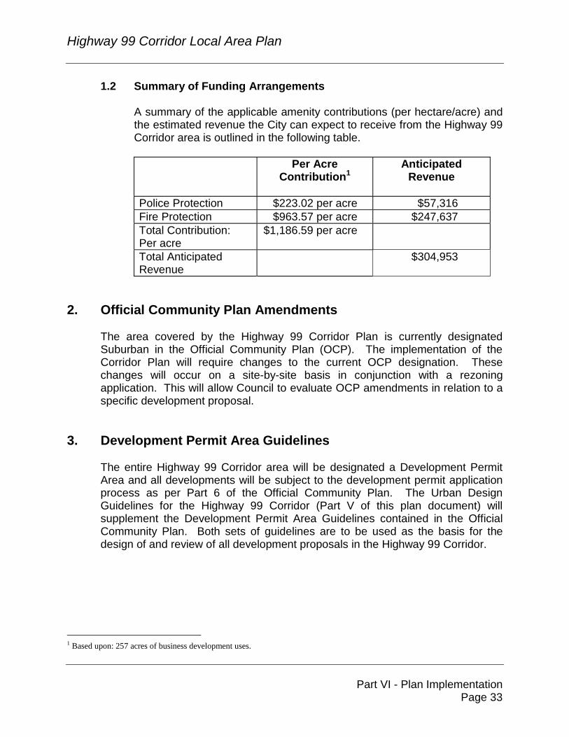
1.2 Summary of Funding Arrangements
A summary of the applicable amenity contributions (per hectare/acre) and the estimated revenue the City can expect to receive from the Highway 99 Corridor area is outlined in the following table.
Per Acre Contribution1
Anticipated Revenue
Police Protection $223.02 per acre $57,316 Fire Protection $963.57 per acre $247,637 Total Contribution: Per acre
$1,186.59 per acre
Total Anticipated Revenue
$304,953
2. Official Community Plan Amendments
The area covered by the Highway 99 Corridor Plan is currently designated Suburban in the Official Community Plan (OCP). The implementation of the Corridor Plan will require changes to the current OCP designation. These changes will occur on a site-by-site basis in conjunction with a rezoning application. This will allow Council to evaluate OCP amendments in relation to a specific development proposal.
3. Development Permit Area Guidelines
The entire Highway 99 Corridor area will be designated a Development Permit Area and all developments will be subject to the development permit application process as per Part 6 of the Official Community Plan. The Urban Design Guidelines for the Highway 99 Corridor (Part V of this plan document) will supplement the Development Permit Area Guidelines contained in the Official Community Plan. Both sets of guidelines are to be used as the basis for the design of and review of all development proposals in the Highway 99 Corridor.
1 Based upon: 257 acres of business development uses.
Highway 99 Corridor Local Area Plan
Part VII - Highway 99 Corridor
Master Servicing Plan Page 34
PART VII: HIGHWAY 99 CORRIDOR SERVICING 1. Servicing
The Highway 99 Corridor servicing and financial strategy, as contained in Corporate Report No. R027 – Highway 99 Corridor – Financing of Servicing, dated February 9, 2004 has been approved by Council. A copy of the Corporate Report is attached as Appendix "B". Background information and further details on the servicing concepts are available in the Grandview Heights Highway 99 Corridor Study prepared by New East Consulting Services Ltd, which is available at the Engineering Department.
Highway 99 Corridor Local Area Plan
Part VIII - Appendices
Page i
PART VIII: APPENDICES Appendix "A" - Highway 99 Corridor Design Guidelines 1. Introduction
The design guidelines for the Highway 99 Corridor apply to all new developments within the Highway 99 Corridor Plan Area, and provide guidance for the development of the public realm as well as for the design of development proposals on private property. These guidelines supplement the Development Permit Area Guidelines contained in Surrey’s Official Community Plan.
A Development Permit will be required for each proposed development within the Plan Area. All development proposals will be reviewed to ensure compliance with these guidelines. The guidelines promote the coordination and compatibility of scale, massing and materials among the buildings and other features on a particular development site as well as on adjacent sites.
A comprehensive design scheme including site planning, architecture and landscaping shall be prepared for each development. The design scheme shall take into consideration specific site conditions and its context. New development should integrate the functional requirements of the project with site features, taking into consideration surrounding developed and undeveloped sites.
2. Urban Design Objectives
These Design Guidelines are intended to ensure that development within the Highway 99 Corridor Plan Area is enhanced through careful planning and design based on the following objectives:
��To promote a high quality of urban design, architecture and landscaping,
with special attention to development along Highway 99, and arterial and collector roads.
��To facilitate coordinated development, including the coordination of
architectural expression, landscaping and site features on neighbouring sites, and along public roads.
��To integrate urban design and environmental protection by protecting and
preserving important elements of the natural environment. ��To retain/provide a green corridor or buffer along Highway 99.
Highway 99 Corridor Local Area Plan
Part VIII - Appendices
Page ii
��To encourage development which incorporates sustainability principles
related to land development, site planning and building design, and to encourage the implementation of LEEDS (Leadership in Energy and Environmental Design) standards, where possible.
��To encourage unique design at visually prominent locations, including the
commercial nodes at 24 Avenue, 16 Avenue and 8 Avenue. ��To enhance the interface of the private developments and buildings with
public streets, with particular attention to the pedestrian environment. ��To provide an appropriate and attractive interface between the Highway
99 Corridor and non-commercial/industrial uses to the east. ��To use CPTED (Crime Prevention Through Environmental Design)
principles to achieve safe, attractive and pedestrian friendly urban spaces. 3. Guidelines for Public Streets, Streetscapes, and Gateways
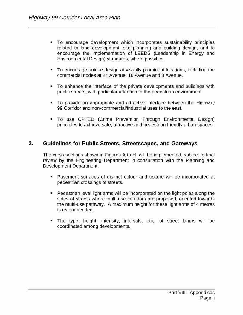
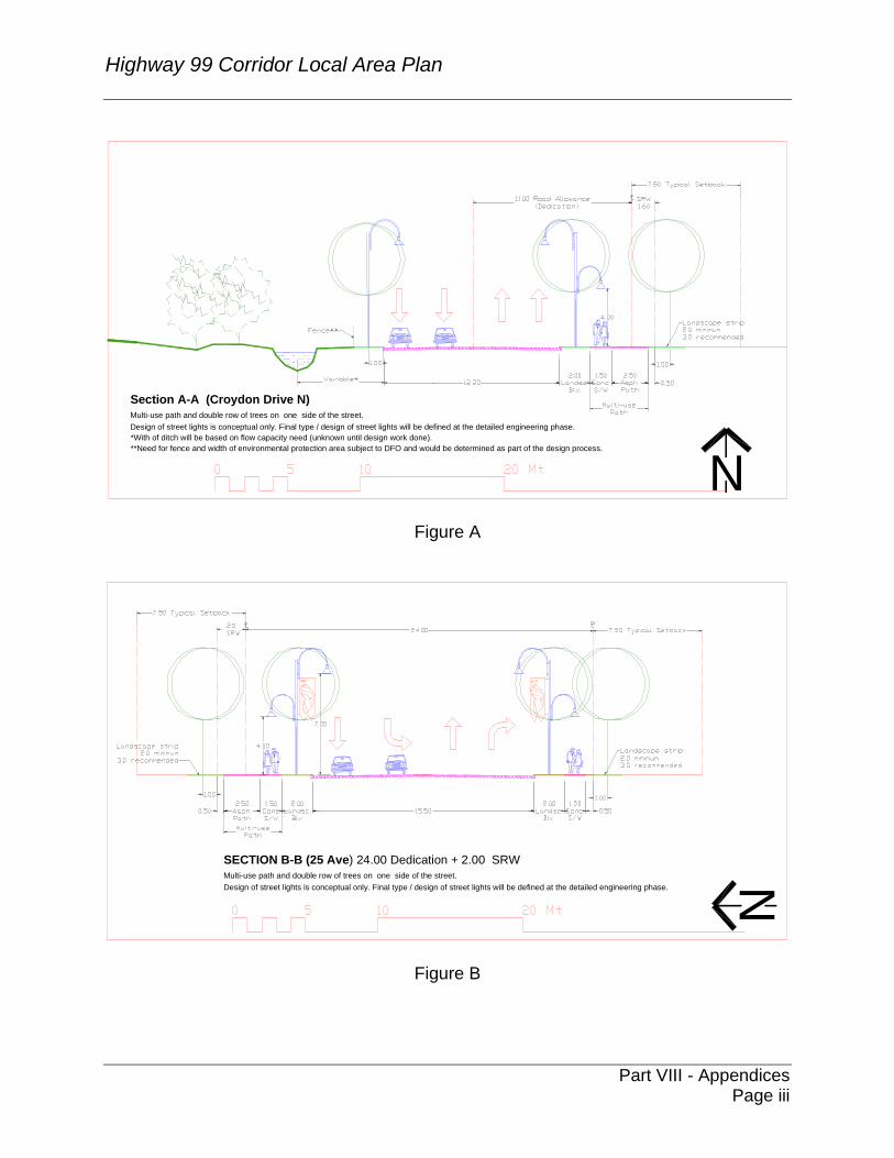
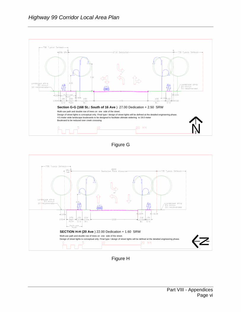
The cross sections shown in Figures A to H will be implemented, subject to final review by the Engineering Department in consultation with the Planning and Development Department.
��Pavement surfaces of distinct colour and texture will be incorporated at pedestrian crossings of streets.
��Pedestrian level light arms will be incorporated on the light poles along the
sides of streets where multi-use corridors are proposed, oriented towards the multi-use pathway. A maximum height for these light arms of 4 metres is recommended.
��The type, height, intensity, intervals, etc., of street lamps will be
coordinated among developments.
Highway 99 Corridor Local Area Plan
Part VIII - Appendices
Page iii
Section A-A (Croydon Drive N)Multi-use path and double row of trees on one side of the street. Design of street lights is conceptual only. Final type / design of street lights will be defined at the detailed engineering phase. *With of ditch will be based on flow capacity need (unknown until design work done).**Need for fence and width of environmental protection area subject to DFO and would be determined as part of the design process.
N
Figure A
SECTION B-B (25 Ave) 24.00 Dedication + 2.00 SRWMulti-use path and double row of trees on one side of the street. Design of street lights is conceptual only. Final type / design of street lights will be defined at the detailed engineering phase. N
Figure B
Highway 99 Corridor Local Area Plan
Part VIII - Appendices
Page iv
NSECTION C-C (160 St South of 25 Ave ) 27.00 Dedication + 2.50 SRWMulti-use path and double row of trees on one side of the street. Design of street lights is conceptual only. Final type / design of street lights will be defined at the detailed engineering phase.*** Landscape median design as directed by Park Recreation and Culture.
Figure C
Section D-D (Croydon from 160 - 163 )Multi-use path and double row of trees on one side of the street. Design of street lights is conceptual only. Final type / design of street lights will be defined at the detailed engineering phase.*** Landscape median design as directed by Park Recreation and Culture.
N
Figure D

Highway 99 Corridor Local Area Plan
Part VIII - Appendices
Page v
Section E-E (24 Avenue: Hwy 99 to East Limit Commercial) 34.00 Dedication Design of street lights is conceptual only. Final type / design of street lights will be defined at the detailed engineering phase.*** Landscape median design as directed by Park Recreation and Culture.
N
Figure E
Section F-F (16 Avenue: * East of 160 St) 27.00 Dedication + 2.50 SRWMulti-use path and double row of trees on one side of the street. Design of street lights is conceptual only. Final type / design of street lights will be defined at the detailed engineering phase.***Landscape median design as directed by Park Recreation and Culture. N
Figure F
Highway 99 Corridor Local Area Plan
Part VIII - Appendices
Page vi
Section G-G (168 St.: South of 16 Ave ) 27.00 Dedication + 2.50 SRWMulti-use path and double row of trees on one side of the street. Design of street lights is conceptual only. Final type / design of street lights will be defined at the detailed engineering phase.4.5 meter wide landscape boulevards to be designed to facilitate ultimate widening to 19.0 meter Boulevard to be reduced over creek crosssing
N
Figure G
SECTION H-H (20 Ave ) 22.00 Dedication + 1.60 SRWMulti-use path and double row of trees on one side of the street. Design of street lights is conceptual only. Final type / design of street lights will be defined at the detailed engineering phase. N
Figure H
Highway 99 Corridor Local Area Plan
Part VIII - Appendices
Page vii
��Street trees on boulevards will be spaced at a maximum of 10 metres on centre. Tree selection and spacing is subject to final determination by the Park Recreation and Culture Department.
��To achieve a canopy effect over public sidewalks, a row of alternating
trees should be provided on private sites to complement street trees on boulevards.
��Landscaping along property lines should be integrated with the
landscaping of adjacent development to provide streetscape/landscape continuity.
��Screening must be provided for all mechanical and electrical equipment,
garbage collection areas, and loading areas that are visible from streets.
��Fences will not generally be permitted along property lines that abut streets. Any fence at the front of a lot should be set back the same distance as the principal building, with substantial landscaping provided on the street side of the fence.
��Gateway features are encouraged at strategic locations incorporating
unique lighting, landscaped medians, and high quality soft and hard landscaping. The commercial nodes, as entrances to Grandview Heights, require high standards of architectural and landscape design.
��The southern entrance to the Corridor in the vicinity of Highway 99 and 8th
Avenue requires a high standard of street appearance incorporating distinct hard and soft landscaping features and unique building design.
4. Landscaping
��As a key gateway to Surrey, the Corridor should present a green edge along Highway 99. All new development should retain and enhance the landscaped image along this major route.
��Substantial and high quality landscaping will be used to define the edges
of parking areas along public streets. Raised planters, berms, decorative low fences, and continuous landscaping are encouraged. A combination of trees and shrubs should be provided along the street.
��Coordinated landscape treatment is encouraged to enhance the
architecture of buildings and to provide a transition between uses, and between the private and public realms.
Highway 99 Corridor Local Area Plan
Part VIII - Appendices
Page viii
��Attention should be given to retaining significant trees and incorporating them into the new landscaping. Stands of mature trees, particularly at the perimeter of sites, should be incorporated into the landscape design to provide visual interest and protect environmental values.
��High canopy trees are recommended along street frontages for security
reasons. Some coniferous and specimen trees should be provided as an accent.
��All landscape islands within a site are to be defined by raised curbs.
��Specially illuminated and landscaped identification signs, ponds,
fountains, decorative pavers and enhanced landscaped islands are encouraged within individual developments.
��Proper screening, including architecturally coordinated fencing and
landscaping where appropriate, will be required for all mechanical and electrical equipment, garbage collection areas, large paved parking areas, blank walls, and loading areas that may be visible from public streets.
5. Form and Character of Buildings
��Building facades that are visible from public streets are to be of high quality, attractive materials with generous amount of glass.
��Buildings, outdoor spaces and landscaping are to be located and
designed to maximize opportunities for informal surveillance.
��Strong architectural edges should be created along arterial and collector roads by locating at least one side of a principal building at the minimum required front and /or flanking yard setback, and glazing is to be included as a major component of facades facing public streets.
��Principal buildings should anchor corners on a corner site and be
designed with due consideration to the visual prominence of these buildings as landmarks.
��If it is not practical to locate the principal building at the corner, a building
is still encouraged to anchor the corner, designed to be pedestrian accessible from both abutting streets, and to provide a visual landmark.
��Blank walls facing streets are discouraged. Where they are unavoidable,
a combination of spandrel glass and high quality landscaping will be encouraged to mitigate the visual impact.
Highway 99 Corridor Local Area Plan
Part VIII - Appendices
Page ix
��Scale, building mass, architectural character, rooflines, materials and
colour schemes are to be coordinated among buildings to create compatibility between adjacent developments.
��Garbage container enclosures will have gates and should be of the same
materials and finish as the rest of the buildings. Such enclosures shall be screened by landscaping and located out of direct view from the street.
6. Parking Areas
��Surface parking for commercial development in the Highway 99 Corridor
Plan area is to be limited to 3.0 spaces per 100 square metres of gross floor area except on sites that are significantly encumbered with the B.C. Hydro right-of-way, where some relaxation may be considered depending on the degree to which the site is encumbered. Additional parking beyond the 3.0 spaces per 100 square metres is permitted provided that it is contained below a building or in a parking structure(s). Where due to the encumbrance of the B.C. Hydro right-of-way a larger amount of surface parking is considered, its visual impact must be mitigated through creative site planning, parking and landscaping schemes that provide for animated building storefronts, pedestrian amenities, the breaking-up of large expanses of parking with landscaped areas, buildings, and/or other features, and a high quality of landscaping and surface materials.
��On-site walkways should be linked to public sidewalks by well-defined
paths to minimize conflict with vehicular traffic.
��Large parking areas are to be divided into smaller areas separated by landscaping on islands or medians.
��One landscaped island, planted with trees, should be provided for every
six parking stalls in a row. Islands at the end of double-parking rows should be planted with at least two shade trees. Islands at the end of single parking rows should be planted with at least one shade tree.
��A landscaped median planted with trees is recommended between long
rows of parking spaces.
��Parking should be located in the side and rear yards, and is discouraged within the front yard setback. Any parking in a front yard must be screened from the street by high quality landscaping.
Highway 99 Corridor Local Area Plan
Part VIII - Appendices
Page x
��For parking areas located in the vicinity of upland residential developments, outdoor lighting fixtures are to be designed so as to shield glare on a adjacent sites and direct the glow downwards.
��A lighting plan of the outdoor areas, height of the lighting poles and
proposed types of lighting fixtures will be required as a part of the Development Permit drawings. Lighting should be directed toward the interior of the site and away from adjacent streets and properties.
7. Signage
��Signage on any site will be designed to relate to the architectural character and overall design of the buildings on the same site.
��The maximum height of any freestanding sign shall not exceed
2.5 metres.
��Single and double pole pylon signs and “flat” freestanding signs are not permitted.
��Three dimensional “monument” type freestanding signs, designed to
become architectural features or landmarks, are encouraged.
��Main entry signs or major area identification signs should be of high quality, durable materials, and coordinated with the architecture of buildings.
��Fascia signs facing the street shall be integrated and/or coordinated with
the architecture of the buildings.
��Architecturally integrated exterior lighting and directional signs are encouraged to improve way finding and security within development sites.
8. Interface Conditions
��Where buffer is to be used as the interface between the Highway 99
Corridor and neighbouring uses to the east, it is to consist of a combination of high quality landscaped berms, plant materials and fencing to provide visual and noise protection. Buffers must respect B.C. Hydro landscaping guidelines within the Hydro right-of-way, where required.
Highway 99 Corridor Local Area Plan
Part VIII - Appendices
Page xi
��Where landscape buffers provide an interface between different land uses, the landscaping should be provided on a berm with a minimum height of 1.5 metres and consist of a combination of native evergreen trees, deciduous trees and shrubs. All the trees should be closely spaced and should be of a type and size to allow rapid growth.
��Buffering along public streets is intended to enhance the driving and
pedestrian experience but not completely screen the development. It should consist of a combination of native evergreen and deciduous trees, shrubs and groundcovers, with planting arranged in clusters. The spacing between the clusters should not exceed 6 meters+/- .
��No fence higher than 1.8 metres should be located adjacent to a
residential area. Any fence higher than 1.8 metres, if provided, should be located at the inside edge of the landscaped buffer.
9. Additional Guidelines for Commercial Nodes
9.1 Site Design and Buildings
��Commercial areas should be designed to cater to pedestrians by
creating a pleasant outdoor environment.
��A high standard of architectural and landscape design should be incorporated, similar to that defined by the “Surrey Street Beautification Strategy”.
��Small-scale buildings and retail storefronts should be located along
street edges and in other locations throughout the development to soften the massing of large format retail stores and to encourage pedestrian activity. Active interior spaces such as offices, lunchrooms, customer service areas, cafeterias, etc. should be located along the exterior face of buildings, visible from the street.
��Buildings should be sited to maximize the length of façade along
the street.
��Buildings should be located close to the street frontage, at the minimum setback from property lines to create a strong architectural edge.
��The massing, setbacks, and orientation of buildings should
reinforce a pedestrian environment.
Highway 99 Corridor Local Area Plan
Part VIII - Appendices
Page xii
��Shops windows, awnings, outdoor sitting areas and signage should be designed to add life to the streets and encourage pedestrian activity.
��Cafes and restaurant patios are encouraged where the context is
appropriate.
��Sidewalks adjacent to retail uses should be provided with rain protection.
��Corner sites at 24 Avenue and 160 Street, not encumbered by B.C.
Hydro right-of-way, are to be anchored with buildings. These anchor buildings should provide a visual landmark and be designed to be visually attractive and to be pedestrian accessible from both abutting streets. The use of glazing and /or windows towards the streets is necessary. Landscape design should incorporate special pavement to differentiate pedestrian areas.
��Where it is not possible to locate buildings at this intersection due
to the B.C. Hydro right-of-way, this corner shall be developed as an “entry-feature plaza” using a combination of hard and soft landscaping, benches, flag poles, banners, visual art, tree grates, ornamental trees, architectural elements and structures, subject to Hydro approval.
��Sidewalk paving materials should be extended to the face of corner
buildings to accentuate pedestrian character at these locations.
��All commercial buildings should have at least one façade with extensive glazing oriented towards a public street.
��Buildings should be sited to minimize the amount of on-site parking
between the building and the street, and to maximize opportunities for landscaping in the setback area exposed to public view.
��Commercial building facades along public streets should
incorporate frequent entries, small shops, and canopies for weather protection, architecturally integrated into the building.
��Loading, service, garbage and recyclable material areas should be
located behind buildings or on the sides of a building if the side is not visible from the street. Overhead service doors should not face the streets and should be integrated into the overall building design.
Highway 99 Corridor Local Area Plan
Part VIII - Appendices
Page xiii
9.2 Parking and Landscaping ��Surface parking for commercial development in the Highway 99
Corridor Plan area is to be limited to 3.0 spaces per 100 square metres of gross floor area except on sites that are significantly encumbered with the B.C. Hydro right-of-way, where some relaxation may be considered depending on the degree to which the site is encumbered. Additional parking beyond the 3.0 spaces per 100 square metres is permitted provided that it is contained below a building or in a parking structure(s). Where due to the encumbrance of the B.C. Hydro right-of-way a larger amount of surface parking is considered, its visual impact must be mitigated through creative site planning, parking and landscaping schemes that provide for animated building storefronts, pedestrian amenities, the breaking-up of large expanses of parking with landscaped areas, buildings, and/or other features, and a high quality of landscaping and surface materials.
��Parking should be safe and easily accessible and not dominate the
development of a site.
��Pedestrian pathways through parking areas should be carefully defined, paying particular attention to pedestrian crossings at vehicle aisles to allow for safe crossing.
��Building exposure should be maximized and parking areas minimized
along 24 Avenue, 16 Avenue, and 160 Street. Parking areas should be located behind buildings and be screened from direct view from the street.
��Where parking areas are exposed to public streets, they shall be
screened using landscaping, colonnades, trellises, pergolas, low transparent fences, low masonry or concrete walls.
��A 3.0 metre wide, high quality landscape buffer shall be provided
where parking areas are located along public streets.
��Shrubs in combination with high canopy trees should be provided along street frontages to complement the boulevard trees. These trees should not be less than 8cm caliper planted at 8.0 metres on center and located within the property line.
��Parking lots shall be designed to facilitate pedestrian access from the
public roads to the building entrances.
Highway 99 Corridor Local Area Plan
Part VIII - Appendices
Page xiv
��The maximum height of outdoor light poles should not exceed 7.5 metres, with a height of 4 metres recommended for the light poles along pedestrian routes through parking areas.
��Areas of distinctively coloured and/or textured paving materials should
be incorporated in the parking areas. Concrete bands and pavers of contrasting colour should be used to break up areas of asphalt.
��Sidewalks should be clearly identified across the entry points to the
site.
��Outdoor amenity landscaped areas for the enjoyment of employees and the public-at-large should be considered and include amenities such as benches, public art, shelter from sun or rain, and space for outdoor recreation.
10. Guidelines for Sustainable Development
��New development is encouraged to incorporate principles of sustainable development in the site planning and building design.
��New development should be designed to preserve, integrate and enhance
where possible, important elements of the natural environment such as, existing watercourses, creeks, riparian setback areas and wildlife habitat.
��Special attention should be given in the site planning and landscaping to
the outer edges of riparian setbacks areas, using architectural and landscape design techniques that minimize the impact of future developments abutting creek preservation areas.
��New development is encouraged to use LEED (Leadership in Energy and
Environmental Design) or similar standards in the following areas:
��Sustainable Sites: Minimize disruption to the topography and significant natural characteristics of the site. Minimize storm water run-off by increasing green space and areas planted with shrubs; ground cover and trees, and reducing paved impermeable areas.
��Water Efficiency: Design landscaping to reduce water consumption
and minimize site irrigation. Maximize the quantity of native species including planting material that is drought resistant and trees that provide shade. Incorporate means of maximizing water efficiency within buildings.
Highway 99 Corridor Local Area Plan
Part VIII - Appendices
Page xv
��Energy: Design buildings to reduce energy consumption by maximizing southern exposure. Provide shading devices to minimize penetration of the interior by the high summer sun. Consider alternative and renewable energy production systems such as geothermal heat pumps, solar heating, biomass and winds.
��Materials and Resources: In building construction and outdoor
paved areas, consider the use of renewable and/or recycled construction materials such as structural components manufactured from wood chips, plywood waste paving blocks made from recycled or discarded tires, and recycled asphalt. Use products from within the region.
��Indoor Environmental Quality: Orient buildings to maximize daylight
penetration and natural ventilation into working areas. Maximize windows on the exterior walls; incorporate skylights, interior courtyards or terrace the buildings for daylight penetration into the interior, etc.
11. Crime Prevention and Safety
��The City of Surrey is committed to creating a high quality urban
environment. Implementing “Crime Prevention Through Environmental Design”(CPTED) principles and strategies at the concept and design stage have proven to be a very effective and proactive means to prevent crime. CPTED aims to minimize opportunities for crime by designing the physical environment to reduce opportunities for crime, the fear of crime, and nuisance behavior such as loitering, littering, and vandalism.
��All new development within Highway 99 Corridor will be required to
incorporate CPTED measures as is contained the policies of the Surrey Official Community Plan.
��CPTED principles should be considered at the site planning stage to
coordinate and maintain continuity of buffering, landscaped strips, sidewalks and multi-use pathways from one development site to another.
Highway 99 Corridor Local Area Plan
Part VIII - Appendices
Page xvi
Appendix "B" - Highway 99 Corridor – Financing of Servicing
Corporate NO: R027
Report COUNCIL DATE: February 9/04
REGULAR COUNCIL
TO: Mayor & Council DATE: February 6, 2004
FROM: General Manager, Engineering FILE: 6520-20 (Hwy 99 Corridor)
6520-20 (GH) 3150-00
SUBJECT: Highway 99 Corridor – Financing of Servicing
RECOMMENDATIONS 1. That the proposed scope of engineering services as summarized in Section 4 of this
report form the basis for the development of the Corridor. 2. That the trunk utility services, and new or upgraded arterial and major collector
roads necessary for the development of the Highway 99 Corridor Land Use Plan, be funded through an area specific development cost charge (DCC).
3. That staff be authorized to take the necessary steps to implement the required
amendment to the DCC By-law. 1.0 INTENT
The purpose of this report is to: 1. Provide Council with an overview of the engineering servicing and financial strategy
for the Highway 99 Corridor Land Use Plan (Corridor). 2. Seek Council support for an area specific DCC.
Highway 99 Corridor Local Area Plan
Part VIII - Appendices
Page xvii
2.0 BACKGROUND
The Proposed Land Use Concept Plan for the Highway 99 Corridor study area was presented and approved by council on December 8, 2003. This report outlines the engineering servicing concepts and financial strategies to achieve this servicing plus acquire lands for environmental preservation.
3.0 CONTEXT OF SERVICING
As part of the overall evaluation of the viability of developing this Corridor, the feasibility and costs for the provision of municipal infrastructure to support the proposed land uses were reviewed. One of the key components of this area’s servicing strategy is its integration with adjacent lands. The Highway 99 Corridor study area is marked by a number of servicing constraints resulting from topography and the long, narrow shape of the plan area. All services proposed fit within a broader context at a neighbourhood level, as well as at a regional level. This broader context provides both constraints and opportunities for the servicing of the Corridor. The constraints are related to existing infrastructure that must be used to service the Corridor area while the opportunities reflect the concept that new servicing can be constructed as part of development of the Corridor to help facilitate the long term servicing plans for adjacent area . Lands to the east of the subject Corridor will soon be the subject of an extensive land use planning exercise as part of the Grandview Heights General Land Use Plan. Final details of servicing within the Corridor will need to reflect the ultimate land uses proposed within the broader Grandview Heights General Land Use Plan. The engineering services discussed in the report relate to major community infrastructure. Only those works, which are trunk or major facilities and normally funded through the City’s Development Cost Charge (DCC) programs, are included in the area specific DCC. Interim servicing and local site servicing requirements of individual developments were not analyzed.
4.0 CONCEPTUAL SCOPE OF SERVICING As outlined above, the topography and geographic extent of the Corridor dictate the servicing strategy for the area. A more detailed description of the servicing issues is provided in Appendix A but summarized here for reference.
Highway 99 Corridor Local Area Plan
Part VIII - Appendices
Page xviii
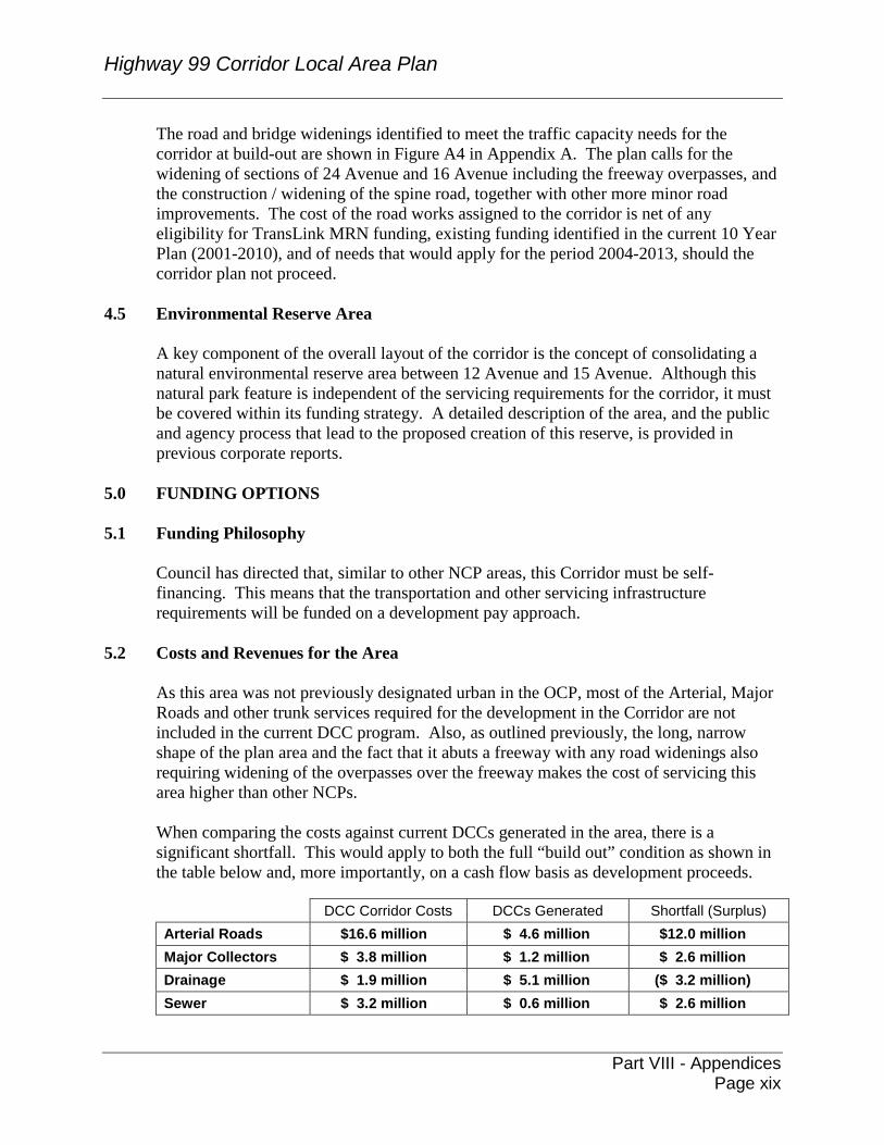
4.1 Drainage The Corridor falls within two distinct watersheds: Morgan (or Titman) Creek for areas north of 24 Avenue; and Fergus Creek which flows into the Campbell River for areas south of 24 Avenue. The area is currently serviced by ditches, culverts, minor storm sewers and an extensive network of natural watercourses. A number of existing drainage studies, as well as more recent environmental reviews of the project area, have lead to the proposed servicing strategy for the site which is aimed at attenuating the post-development flows to ensure protection of valuable aquatic habitat within and downstream of the corridor area. The plan includes a number of ponds, piped and ditched diversions and where possible, low impact development strategies. Natural watercourses are integrated into the plan as these continue to convey drainage flows and provide aquatic habitat as well as green space for the neighbourhood. (Please see Figure A1 - Appendix A.)
4.2 Water With respect to potable water, the existing reservoir at 24 Avenue has sufficient capacity to supply water for the Corridor. The future pump station needed for the overall Grandview Heights area can be upsized to service the corridor. Some areas will be serviced directly from the pump station while others will be connected to existing infrastructure at King George Highway. The grid system within the Corridor will be looped to ensure the necessary fire flows. (Please see Figure A2 - Appendix A.)
4.3 Sewer As with drainage servicing, sanitary servicing is driven by the topography of the site and is limited by existing conveyance capacities. Generally, areas north of 24 Avenue will be serviced by gravity sewer to the north and areas south of 24 Avenue will flow by gravity to the south. Sanitary pump capacity at the Semiahmoo Pump Station will be provided to service the corridor area on an interim basis until the ultimate Grandview Heights South Pump Station is constructed in the vicinity of 168 Street and 12 Avenue. A detailed description of the sewer servicing strategy and issues related to interim pump capacity is provided in Appendix A. It should be noted that all interim sewer facilities will be the responsibility of the various proponents and are not included in the corridor infrastructure costs or part of the area specific DCC charge. (Please see Figure A3 - Appendix A.)
4.4 Roads A number of the key transportation issues were dealt with in the December 8, 2003, Report to Council. These issues included the deferring of a new interchange on Highway 99 as the traffic analysis found it was not necessary for the development of the corridor alone. However, on and off ramps may be added at either 24 Avenue or 16 Avenue in the future.
Highway 99 Corridor Local Area Plan
Part VIII - Appendices
Page xix
The road and bridge widenings identified to meet the traffic capacity needs for the corridor at build-out are shown in Figure A4 in Appendix A. The plan calls for the widening of sections of 24 Avenue and 16 Avenue including the freeway overpasses, and the construction / widening of the spine road, together with other more minor road improvements. The cost of the road works assigned to the corridor is net of any eligibility for TransLink MRN funding, existing funding identified in the current 10 Year Plan (2001-2010), and of needs that would apply for the period 2004-2013, should the corridor plan not proceed.
4.5 Environmental Reserve Area A key component of the overall layout of the corridor is the concept of consolidating a natural environmental reserve area between 12 Avenue and 15 Avenue. Although this natural park feature is independent of the servicing requirements for the corridor, it must be covered within its funding strategy. A detailed description of the area, and the public and agency process that lead to the proposed creation of this reserve, is provided in previous corporate reports.
5.0 FUNDING OPTIONS 5.1 Funding Philosophy
Council has directed that, similar to other NCP areas, this Corridor must be self-financing. This means that the transportation and other servicing infrastructure requirements will be funded on a development pay approach.
5.2 Costs and Revenues for the Area
As this area was not previously designated urban in the OCP, most of the Arterial, Major Roads and other trunk services required for the development in the Corridor are not included in the current DCC program. Also, as outlined previously, the long, narrow shape of the plan area and the fact that it abuts a freeway with any road widenings also requiring widening of the overpasses over the freeway makes the cost of servicing this area higher than other NCPs. When comparing the costs against current DCCs generated in the area, there is a significant shortfall. This would apply to both the full “build out” condition as shown in the table below and, more importantly, on a cash flow basis as development proceeds.
DCC Corridor Costs DCCs Generated Shortfall (Surplus) Arterial Roads $16.6 million $ 4.6 million $12.0 million Major Collectors $ 3.8 million $ 1.2 million $ 2.6 million Drainage $ 1.9 million $ 5.1 million ($ 3.2 million) Sewer $ 3.2 million $ 0.6 million $ 2.6 million
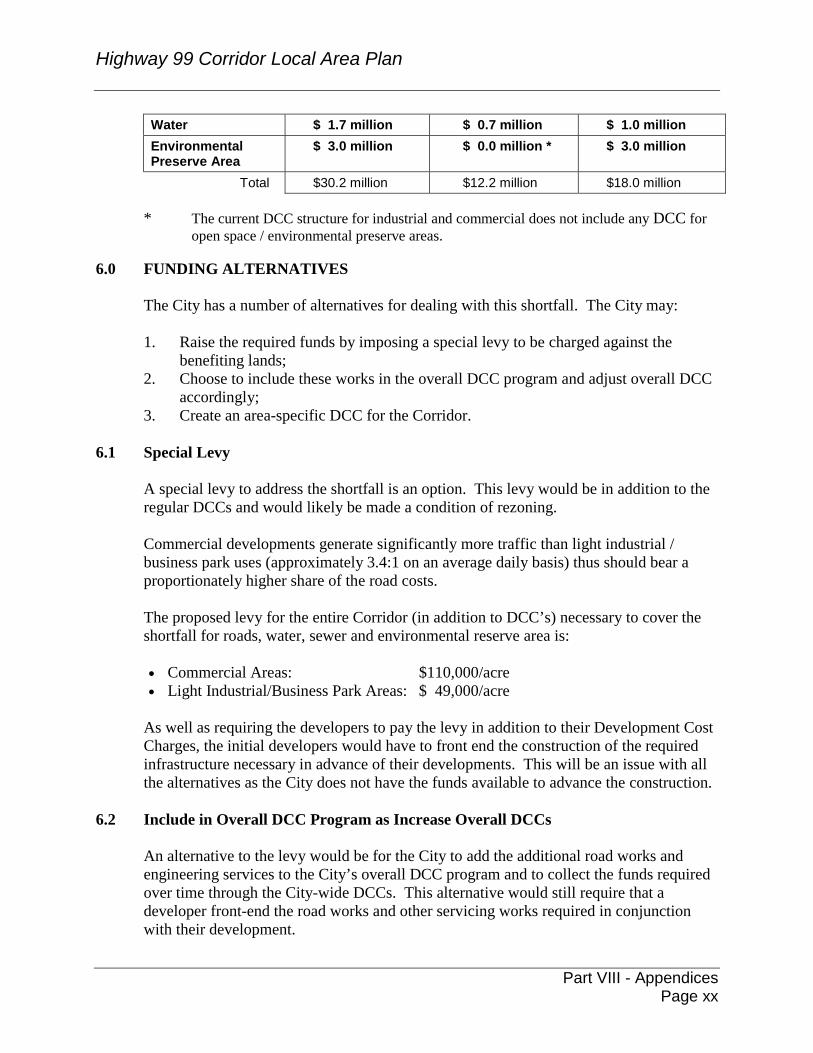
Highway 99 Corridor Local Area Plan
Part VIII - Appendices
Page xx
Water $ 1.7 million $ 0.7 million $ 1.0 million Environmental Preserve Area
$ 3.0 million $ 0.0 million * $ 3.0 million
Total $30.2 million $12.2 million $18.0 million
* The current DCC structure for industrial and commercial does not include any DCC for open space / environmental preserve areas.
6.0 FUNDING ALTERNATIVES
The City has a number of alternatives for dealing with this shortfall. The City may: 1. Raise the required funds by imposing a special levy to be charged against the
benefiting lands; 2. Choose to include these works in the overall DCC program and adjust overall DCC
accordingly; 3. Create an area-specific DCC for the Corridor.
6.1 Special Levy
A special levy to address the shortfall is an option. This levy would be in addition to the regular DCCs and would likely be made a condition of rezoning. Commercial developments generate significantly more traffic than light industrial / business park uses (approximately 3.4:1 on an average daily basis) thus should bear a proportionately higher share of the road costs. The proposed levy for the entire Corridor (in addition to DCC’s) necessary to cover the shortfall for roads, water, sewer and environmental reserve area is: • Commercial Areas: $110,000/acre • Light Industrial/Business Park Areas: $ 49,000/acre
As well as requiring the developers to pay the levy in addition to their Development Cost Charges, the initial developers would have to front end the construction of the required infrastructure necessary in advance of their developments. This will be an issue with all the alternatives as the City does not have the funds available to advance the construction.
6.2 Include in Overall DCC Program as Increase Overall DCCs
An alternative to the levy would be for the City to add the additional road works and engineering services to the City’s overall DCC program and to collect the funds required over time through the City-wide DCCs. This alternative would still require that a developer front-end the road works and other servicing works required in conjunction with their development.
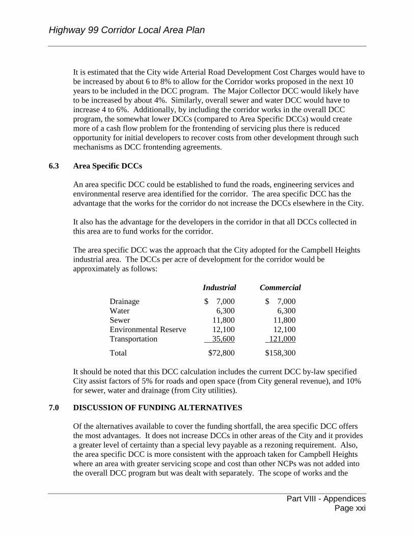
Highway 99 Corridor Local Area Plan
Part VIII - Appendices
Page xxi
It is estimated that the City wide Arterial Road Development Cost Charges would have to be increased by about 6 to 8% to allow for the Corridor works proposed in the next 10 years to be included in the DCC program. The Major Collector DCC would likely have to be increased by about 4%. Similarly, overall sewer and water DCC would have to increase 4 to 6%. Additionally, by including the corridor works in the overall DCC program, the somewhat lower DCCs (compared to Area Specific DCCs) would create more of a cash flow problem for the frontending of servicing plus there is reduced opportunity for initial developers to recover costs from other development through such mechanisms as DCC frontending agreements.
6.3 Area Specific DCCs
An area specific DCC could be established to fund the roads, engineering services and environmental reserve area identified for the corridor. The area specific DCC has the advantage that the works for the corridor do not increase the DCCs elsewhere in the City. It also has the advantage for the developers in the corridor in that all DCCs collected in this area are to fund works for the corridor. The area specific DCC was the approach that the City adopted for the Campbell Heights industrial area. The DCCs per acre of development for the corridor would be approximately as follows:
Industrial Commercial
Drainage $ 7,000 $ 7,000 Water 6,300 6,300 Sewer 11,800 11,800 Environmental Reserve 12,100 12,100 Transportation 35,600 121,000
Total $72,800 $158,300
It should be noted that this DCC calculation includes the current DCC by-law specified City assist factors of 5% for roads and open space (from City general revenue), and 10% for sewer, water and drainage (from City utilities).
7.0 DISCUSSION OF FUNDING ALTERNATIVES
Of the alternatives available to cover the funding shortfall, the area specific DCC offers the most advantages. It does not increase DCCs in other areas of the City and it provides a greater level of certainty than a special levy payable as a rezoning requirement. Also, the area specific DCC is more consistent with the approach taken for Campbell Heights where an area with greater servicing scope and cost than other NCPs was not added into the overall DCC program but was dealt with separately. The scope of works and the
Highway 99 Corridor Local Area Plan
Part VIII - Appendices
Page xxii
resulting DCC rates have been discussed with the key development proponents in the corridor, and they have a good understanding and appreciation of the costs and servicing needs involved. Initially, it was envisaged that the commercial per acre DCC would be around $171,000 an acre. The key proponents raised concerns at this per acre rate. Further detail review of servicing components and a more detailed calculation of the DCCs resulted in a reduced per acre commercial DCC of $158,000.
8.0 CONCLUSION
The servicing needs for the corridor have been summarized in this report and outlined in Appendix A. The servicing study shows that with current City-wide DCC rates, there is a considerable shortfall in funding available for servicing. To overcome this shortfall, the best funding alternative is an area specific DCC. Council’s authority is requested to proceed with the necessary steps, including Provincial approval, to amend the current DCC By-law to include an area specific DCC for the Highway 99 Corridor. Approval of the financing strategy is a necessary precursor to bringing the final NCP document for Council approval which is expected to occur in two weeks.
Original signed by Paul Ham, P.Eng. General Manager, Engineering PH/RD/brb Attachment g:\wp-docs\2004\utilities\drainage & env\01191133rd.doc BRB 2/24/04 9:31 AM
Highway 99 Corridor Local Area Plan
Part VIII - Appendices
Page xxiii
APPENDIX A
Summary of Servicing Plan for the Highway 99 Corridor
Drainage/Stormwater Management
The project area lies within two very distinct watersheds. Areas north of 24 Avenue drain to Titman (aka Morgan) Creek which is tributary to the Old Logging Ditch system within the Nicomekl Watershed. Areas south of 24 Avenue drain to Fergus Creek which is tributary to the Little Campbell River. Currently drainage servicing is provided by a system of man made ditches and culverts as well as many natural water courses. Environmental aspects of the watercourse network were provided to council in the December 8, 2003 Planning Report.
The Stormwater Management Plan for the study area is aimed at providing drainage servicing to the City of Surrey standard while ensuring protection of the natural aquatic habitat features in and about the plan area. Although the drainage plan is presented for the Highway 99 Corridor area it must be considered in a more regional context of drainage through this area. This regional context is known as a watershed based drainage planning approached.
The Morgan Creek/Old Logging Ditch systems have been the subject of numerous drainage and planning studies and the plan proposed for Corridor area is consistent with the studies. Currently a detention pond at the north end of the Corridor with a network of surface drainage features are being proposed for the area falling within the Morgan Creek/Old Logging Ditch portion of the project.
In order to address concerns raised in previous reports and through the planning consultative process a number of key strategies are proposed for the Fergus Creek portion of the plan area. A system of creek and pipe diversions will provide increased conveyance capacity for the area without compromising the integrity of Fergus Creek. A substantial diversion running along King George Highway from 14 Avenue to the Campbell River is proposed to deal with increased flows originating from areas of Sunnyside that have already been developed. Base flows to Fergus Creek will be maintained at the diversion point in an effort to maintain pre-development hydrologic regimes. The commercial node at 24 Avenue will be expected to provide detention in order to limit peak flows to creek reaches upstream of the diversion point. Open swales located through the BC Hydro right-of-way is proposed to help maintain the integrity of the Fergus Creek headwaters.
Drainage originating from areas outside of the Corridor area north east of the BC Hydro ROW will be conveyed through the site in ditches and pipes. The Drainage plan that will be
Highway 99 Corridor Local Area Plan
Part VIII - Appendices
Page xxiv
completed as part of the Grandview Heights General Land Use Plan will account for this situation.
Hydrogeological reports of the area indicate that there is limited opportunity for groundwater exfiltration best management practices through the corridor. The soil deposits through the area have low infiltration capacities and would not be conducive to infiltration trenches and swales. Nonetheless, it is expected that impacts normally associated development will be mitigated through on site bioretention, surface drainage treatment and other low impact development measures throughout the plan area.
The proposed stormwater control plan for the Corridor area is provided as Figure A.1
attached. Estimated DCC eligible costs are summarized in Table A1. Sanitary Sewer
Currently, septic fields service existing dwellings and there are no sewers in the corridor
area. The topography of the land dictates that gravity sewers run either north or south from the study area’s height of land around 24 Avenue. Ultimately, sewers running north will tie into the future North Grandview Gravity Interceptor that will run from approximately 172 Street to Highway 99 along 28 Avenue. This future interceptor will also be able to service the broader Grandview Heights area. Areas to the south of 24 Avenue will ultimately be serviced by gravity sewers to a future pump station (Grandview Heights South PS) anticipated the vicinity of 168 Street south of 12 Avenue. A force main will run from the pump station north to 24 Avenue at which point a gravity sewer will tie into the North Grandview Gravity Interceptor described above. Such a system could also potentially service the broader Grandview Heights area. The sanitary sewer servicing plan is shown on Figure A2.
It is anticipated that lands within the Corridor will develop prior to the availability of the
future North Grandview Gravity Interceptor and Grandview Heights South PS. As such, the following interim sanitary sewer servicing strategy is proposed for the corridor area.
As described above, two sewer systems – one running north, the other running south –
will be required to service the area. A gravity sanitary sewer system is proposed to serve the Corridor from approximately 24 Avenue southwards to about 16 Avenue, at which point a new gravity sewer can be constructed to cross Highway 99 and tie into an existing trunk at King George Highway. For the area south of 16 Avenue to Fergus Creek at about 12 Avenue, a new lift station will be required to pump the sewage back to the 16 Avenue crossing. Areas south of 12 Avenue will be serviced by another interim pump station directing sewerage to the existing system on 8 Avenue. All of the above-mentioned systems will lead to the existing Semiahmoo Pump Station. This pump station has sufficient capacity to convey the anticipated load from the corridor on an interim basis only. It is anticipated the full capacity of the Semiahmoo pump station will be required to accommodate its own existing catchment as redevelopment progresses. At that point in time, we expect both the North Grandview Gravity Interceptor and
Highway 99 Corridor Local Area Plan
Part VIII - Appendices
Page xxv
the Grandview Heights South PS will be in operation and sanitary sewers from the Corridor will be directed to those systems.
Currently only 40 l/s of pumping capacity has been put aside at the Semiahmoo pump
station to service the Highway 99 Corridor on an interim basis. This pumping capacity will be allocated on a first come first serve basis. When the pumping capacity reaches capacity, no further development will be able to discharge to the Semiahmoo pump station. This capacity constraint means that only one section of the corridor can be connected to the Semiahmoo pump station; either the area from 16 Avenue to 24 Avenue or the area from 8 Avenue to 16 Avenue.
Areas to the north of 24 Avenue can discharge by gravity northward to cross Highway 99
at 28 Avenue into the existing system or potentially north to the Morgan Creek pump station. Again, this is an interim system and the sewerage from the corridor will ultimately be directed to the North Grandview Gravity Interceptor.
It should be noted that other than a few trunk sewers that will be used under the ultimate
servicing scenario the interim systems described above are the responsibility of the developers. It is anticipated that although the interim plans described above are feasible that other interim plans may be proposed by individual developers. These will be evaluated to ensure the interim strategies will not compromise the overall servicing strategy for the area.
Financial details are provided in Table A2.
Water
The existing reservoir at 24 Avenue has sufficient capacity to supply water for the Corridor. A new pump station at this reservoir will also be needed for the overall Grandview Heights area; consequently, a proportion of the cost of this new pump station has been assigned to the corridor. Areas above the 75 metre contour will be serviced from the pump station directly and the remaining areas will be serviced via the existing 450mm trunk water main along King George Highway with two new grid mains crossing Highway 99. The grid system within the Corridor will be looped to ensure the necessary fire flows.
The water servicing plan is shown on Figure A3 attached and the financial details are
provided in Table A3.
Transportation Based on a detailed traffic analysis, the Major Road requirements to service build-out of
the Corridor were determined and are illustrated in Figure A4. Additional auxiliary lanes may be required for specific intersections and road segments relating to specific individual developments. These will be determined through future Traffic Impact Studies for development applications.
Highway 99 Corridor Local Area Plan
Part VIII - Appendices
Page xxvi
The key improvements are widening of 24 Avenue from King George Highway to 164 Street and 16 Avenue from King George Highway to 168 Street to four through lanes plus a median/left turn lane. This work includes new bridges across Highway 99 at 24 Avenue and at 16 Avenue. In addition, an extended, realigned and widened Croydon Drive is required to function as a spine road for the Corridor. The cross-section along this road varies between two and four lanes plus a left turn lane. The servicing costs are provided in Table A4. The other key aspect of the road requirements is timing of the road improvements. In
order to maintain functionality on the arterial roads with the addition of the significant traffic volumes associated with large scale commercial development within the Corridor, some of the roads will need to be upgraded prior to opening of the commercial areas. This issue is addressed in more detail in the Financing Section. Development Phasing
Development phasing will be developer driven and will be subject to completion of downstream infrastructure requirements. CONCLUSION
The Highway 99 Corridor Plan area can be serviced on an interim and under ultimate conditions with the financial strategies described in this report. Interim works are not, however, included in the DCC program, and have to be funded directly by developers. g:\wp-docs\2004\utilities\drainage & env\01191133rd.doc BRB 2/24/04 9:31 AM
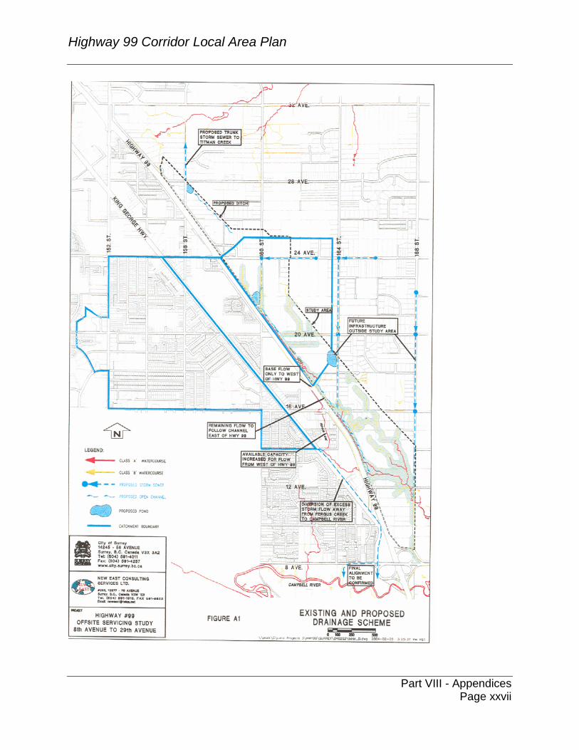
Highway 99 Corridor Local Area Plan
Part VIII - Appendices
Page xxvii
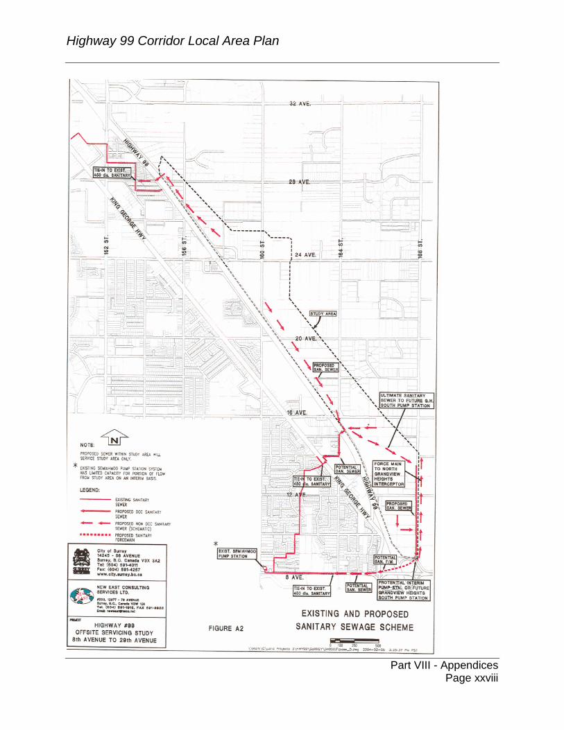
Highway 99 Corridor Local Area Plan
Part VIII - Appendices
Page xxviii
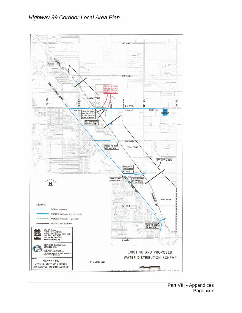
Highway 99 Corridor Local Area Plan
Part VIII - Appendices
Page xxix
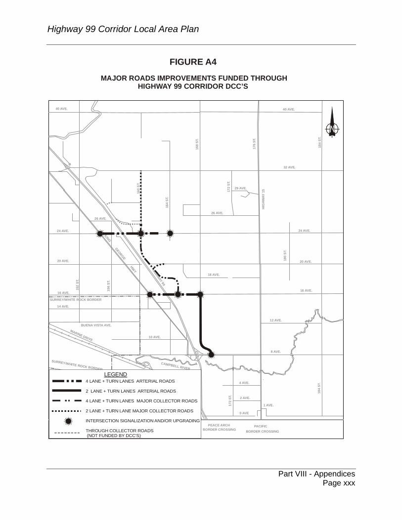
Highway 99 Corridor Local Area Plan
Part VIII - Appendices
Page xxx
2 AVE.
12 AVE.
18 AVE.
26 AVE.
29 AVE.
KING GEORGE HWY
BORDER CROSSING BORDER CROSSING
PEACE ARCH PACIFIC
BUENA VISTA AVE.MARINE DRIVE
10 AVE.
16 AVE.
SURREY/WHITE ROCK BORDER
SURREY/WHITE ROCK BORDER
20 AVE.
152
ST.
156
ST.
14 AVE.
24 AVE.
160
ST.
164
ST.
26 AVE.
172
ST.
0 AVE
8 AVE.
4 AVE.
1 AVE.
184
ST.
16 AVE.
20 AVE.180
ST.
24 AVE.17
2 ST
.
HIG
HWAY
15
HIGHWAY 99
32 AVE.
40 AVE.
168
ST.
176
ST.
40 AVE.
184
ST.
CAMPBELL RIVER
FIGURE A4MAJOR ROADS IMPROVEMENTS FUNDED THROUGH
HIGHWAY 99 CORRIDOR DCC’S
LEGEND
4 LANE + TURN LANES ARTERIAL ROADS
INTERSECTION SIGNALIZATION AND/OR UPGRADING
2 LANE + TURN LANES ARTERIAL ROADS
4 LANE + TURN LANES MAJOR COLLECTOR ROADS
2 LANE + TURN LANE MAJOR COLLECTOR ROADS
THROUGH COLLECTOR ROADS (NOT FUNDED BY DCC’S)
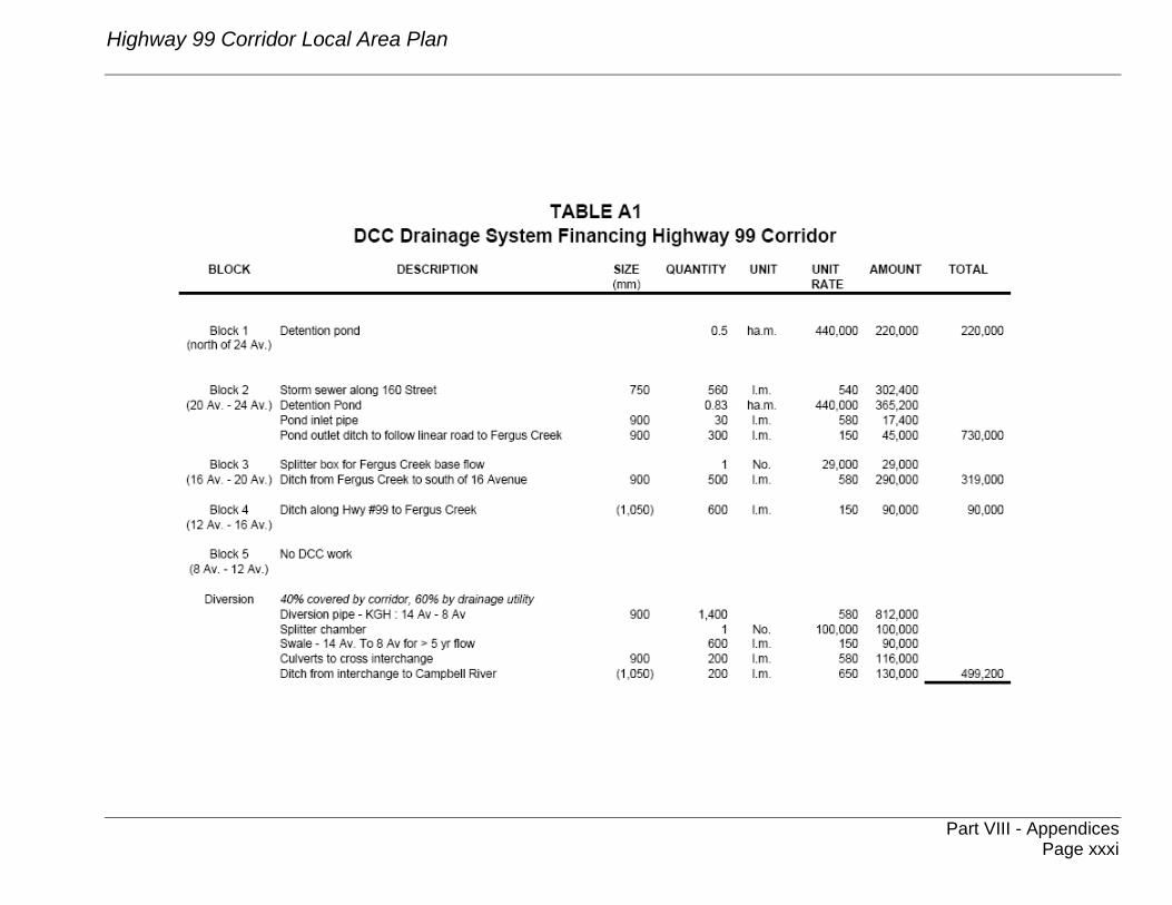
Highway 99 Corridor Local Area Plan
Part VIII - Appendices
Page xxxi
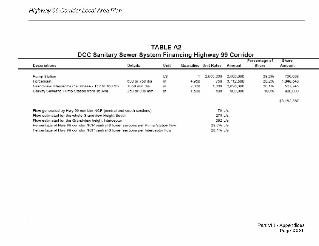
Highway 99 Corridor Local Area Plan
Part VIII - Appendices
Page XXXII
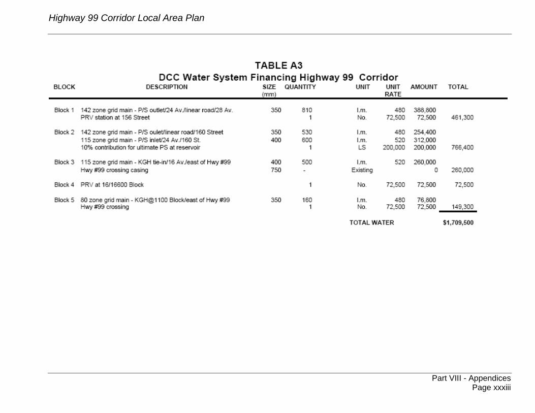
Highway 99 Corridor Local Area Plan
Part VIII - Appendices
Page xxxiii

Highway 99 Corridor Local Area Plan
v:\wp-docs\planning\lo gterm\highway 99 corridor lap.doc
Part VIII - Appendices
Page xxxiv
nSAW 2/24/04 9:31 AM