Embed Size (px)
Citation preview
16 January 201903/19LNM:
13Coast Guard DistrictPage 1 of 14
U.S. Departmentof Homeland Security
United StatesCoast Guard
LOCAL NOTICE TO MARINERS
ISSUED BY: COMMANDER, THIRTEENTH COAST GUARD DISTRICT (dpw)915 Second Avenue, 35th Floor, Rm 3510, Seattle, Washington 98174-1067
Telephone: (206) 220-7280Email: [email protected]
https://www.pacificarea.uscg.mil/Our-Organization/District-13/District-Staff/-dpw/https://www.navcen.uscg.gov/?pageName=lnmDistrict®ion=13
COMDTPUB P16502.6, Light List Volume VI, 2019 Edition, and Coast Pilot Volume 7, 2019 Edition.Coast Pilots, along with corrections, are available at: www.nauticalcharts.noaa.gov/publications/coast-pilot/index.html. Print on Demand (POD)
copies are available for purchase at: www.nauticalcharts.noaa.gov/publications/print-agents.html#coast-pilot.
UNITED STATES COAST GUARD NAVIGATION INFORMATION SERVICE (NIS)The United States Coast Guard Navigation Information Service (NIS), operated by the USCG Navigation Center, is staffed 24 hours a day, 7 days a week. The NIS provides information on the current operational status, effective policies, and general information for GPS and DGPS. The NIS also
disseminates Safety Broadcasts / Broadcast Notice to Mariners (BNM), Local Notice to Mariners (LNM), and the latest Notice Advisory to Navstar Users (NANU). NANU notices can also be obtained via e-mail subscription through the USCG Navigation Center website:
https://www.navcen.uscg.gov/?pageName=GPS.In addition, the NIS investigates all reports of degradation or loss of GPS or DGPS service. Mariners are encouraged to report all degradation of
radio navigation services to the NIS via any of the following: Phone: (703) 313-5900 or Email: [email protected], or on the World Wide Web: https://www.navcen.uscg.gov
BROADCAST NOTICE TO MARINERSUrgent marine navigational and weather information is broadcast over VHF channel 22A (157.1 MHZ). Broadcasts are first announced over the
distress, safety and calling channel 16 before they are made. All ships in U.S. waters over 20 meters in length are required to monitor VHF channel 16, and must have radios capable of tuning to the VHF simplex channel 22A.
This section contains a range of all the significant Broadcast Notice to Mariners (BNM's) on the date of this edition.
Originating Unit Beginning BNM Ending BNM CGD THIRTEEN D13-0027-19 D13-0056-19
ABBREVIATIONS
District: 13 Week: 03/19
A through H
ADRIFT - Buoy AdriftAICW - Atlantic Intracoastal WaterwayAl - AlternatingB - BuoyBKW - Breakwaterbl - BlastBNM - Broadcast Notice to Marinerbu - BlueC - CanadianCHAN - ChannelCGD - Coast Guard DistrictC/O - Cut OffCONT - ContourCRK - CreekCONST - ConstructionDAYMK/Daymk - DaymarkDBN/Dbn - DaybeaconDBD/DAYBD - DayboardDEFAC - DefacedDEST - DestroyedDISCON - DiscontinuedDMGD/DAMGD - Damagedec - eclipse
I through O
I - InterruptedICW - Intracoastal WaterwayIMCH - Improper CharacteristicINL - InletINOP - Not OperatingINT - IntensityISL - IsletIso - IsophasekHz - KilohertzLAT - LatitudeLB - Lighted BuoyLBB - Lighted Bell BuoyLHB - Lighted Horn BuoyLGB - Lighted Gong BuoyLONG - LongitudeLNM - Local Notice to MarinersLT - LightLT CONT - Light ContinuousLTR - LetterLWB - Lighted Whistle BuoyLWP - Left Watching ProperlyMHz - Megahertz MISS/MSNG - Missing
P through Z
PRIV - Private AidQ - QuickR - Red RACON - Radar Transponder BeaconRa ref - Radar reflectorRBN - Radio BeaconREBUILT - Aid RebuiltRECOVERED - Aid RecoveredRED - Red BuoyREFL - ReflectiveRRL - Range Rear LightRELIGHTED - Aid RelitRELOC - RelocatedRESET ON STATION - Aid Reset on StationRFL - Range Front LightRIV - RiverRRASS - Remote Radio Activated Sound Signals - secondsSEC - SectionSHL - Shoalingsi - silentSIG - SignalSND - Sound
16 January 201903/19LNM:
13Coast Guard DistrictPage 2 of 14
AtoN - Aids to Navigation NAVCEN – U.S. Coast Guard Navigation Center S-AIS – Synthetic AISCOTP – Captain of the Port NM - Nautical Miles VTS - Vessel Traffic ServiceCPA - Closest Point of Approach ODOT – Oregon Department of Transportation WSDOT- Washington State Department of TransportationLLNR - Light List Number RM - River Mile Marker TSS - Traffic Separation Scheme
SECTION I - SPECIAL NOTICESThis section contains information of special concern to the Mariner.
OREGON - WASHINGTON - 2019 Light List now available
WASHINGTON – PACIFIC OCEAN – CAPE FLATTERY TO CAPE JOHNSON- Underwater Operations
WASHINGTON - GRAYS HARBOR AND WESTHAVEN - Wishkah Street Bridge Repairs
WASHINGTON – STRAIT OF JUAN DE FUCA TO STRAIT OF GEORGIA – DECEPTION PASS – Bridge Inspection (revised from LNM02/19)
The USCG Navigation Center has published the 2019 edition of Light List Volume VI, which includes all of Oregon, Washington and Idaho. Mariners can view and download the new edition at the following link: https://www.navcen.uscg.gov/pdf/lightlists/LightList_V6_2019.pdf
The Cable Ship DECISIVE will be conducting underwater operations approximately 10 to 20 miles off the coast of Washington between Cape Flattery and Cape Johnson from 15 Jan 2019 through 30 Jan 2019. The vessel will be restricted in her ability to maneuver while conducting these operations. The coordinates of the cable operation area are as follows: 48-19-15.6N 125-01-22.2W, 48-04-12.0N 124-57-27.0W, 47-51-30.6N 125-22-42.6W, 48-06-16.2N 125-30-03.6W. Mariners are advised to transit the area with caution and may contact the vessel via VHF Ch. 16 & 13 as well as via satellite phone at 206-274-8941.
WSDOT will be conducting emergency repairs to the Wishkah Street Bridge (LLNR 16072.3) over the Wishkah River (RM 0.4) from 22 Jan 2019 to 25 Jan 2019. During these necessary repairs, the bridge will not be able to open for marine traffic. For more information contact WSDOT Doug Krikava at (360) 470-9605 or email [email protected]
WSDOT will be performing a regular scheduled biennial inspection of the Deception Pass Bridge on SR 20 over Deception Pass between the hoursof 0800 to 1400 from 11 to 15 Feb 2019. WSDOT will be using two under-bridge inspection trucks (UBITs) occupying portions of the SR 20 roadway to complete the inspection. UBITs will maintain a minimum of approximately 120 ft. of vertical clearance and have flashing amber strobelights mounted to the bucket undersides to improve visibility. For more information, contact Steve Dobron at (360) 930-9116 or email [email protected].
WASHINGTON – Canadian Coast Guard Notice to Shipping (NOTSHIP) service changeOn 07 Jan 2019, the Canadian Coast Guard’s Marine Communications and Traffic Services (MCTS) Western Region transitioned from the existing Notice to Shipping (NOTSHIP) service to a new Navigational Warning service (NAVWARN) for the publication of maritime information important to navigation in Canadian waters. This new service will use a publically accessible internet application that will provide the ability for users to create account profiles specific to geographic areas of interest and receive notification when new NAVWARNs are created that fit that profile. Interested mariners can visit http://nis.ccg-gcc.gc.ca/public/rest/messages/en/search to subscribe to notifications and, after 07 Jan, view NAVWARN notices.
LNM:
LNM:
LNM:
LNM:
LNM:
03/19
03/19
03/19
03/19
01/19
Additional Abbreviations Specific to this LNM Edition:
EST - Established Aidev - everyEVAL - EvaluationEXT - ExtinguishedF - Fixedfl - flashFl - FlashingG - Green GIWW - Gulf Intracoastal WaterwayHAZ - Hazard to NavigationHBR - HarborHOR - Horizontal ClearanceHT - Height
Mo - Morse Code MRASS - Marine Radio Activated Sound SignalMSLD - MisleadingN/C - Not ChartedNGA - National Geospatial-Intelligence AgencyNO/NUM - NumberNOS - National Ocean ServiceNW - Notice WriterOBSCU - ObscuredOBST - ObstructionOBSTR - ObstructionOc - OccultingODAS - Anchored Oceanographic Data Buoy
SPM - Single Point Mooring BuoySS - Sound SignalSTA - StationSTRUCT - StructureSt M - Statute MileTEMP - Temporary Aid ChangeTMK - TopmarkTRLB - Temporarily Replaced by Lighted BuoyTRLT - Temporarily Replaced by LightTRUB - Temporarily Replaced by Unlighted BuoyUSACE - Army Corps of EngineersW - WhiteY - Yellow
18460
18502
18427 18429
Chart
Chart
Charts:
16 January 201903/19LNM:
13Coast Guard DistrictPage 3 of 14
WASHINGTON - PUGET SOUND - ELLIOTT BAY – Crane removal operations at Terminals 18 and 46
WASHINGTON – PUGET SOUND – LAKE WASHINGTON SHIP CANAL – Hiram M. Chittenden Large Lock closure in January
Pacific Pile & Marine is removing 03 container cranes from Terminal 18 and 01 from Terminal 46 in Elliott Bay. Operations are expected to continue until approximately 20 Feb 2019. Operations will be conducted during daylight hours from 0600 to 1800, Monday through Friday. Therewill one large derrick crane (100’ x 400’), one deck barge (100’ x 400’) as well as a tug. Work parties will answer hails as “PPM” or “Pacific Pile andMarine” on VHF-FM channel 17. All work will be conducted inside the dock line, however the crane and barge will stand off up to 235’ during someloading operations. It is requested that all vessels transiting the vicinity operate with minimum wake. For additional information contact Dirk deGroot of Pacific Pile & Marine at (206) 455-5244 or email [email protected]
USACE will close the Hiram M. Chittenden Locks large chamber to all vessel traffic from 0700 to 1700 on 24 and 25 Jan 2019 to complete work onthe emergency closure system, or ECS. The large chamber closed 12-14 December for this work but the contractor could not finish the necessary work during that outage. The work includes replacing a wire rope, reconditioning a portion of the ECS and testing the system. The small lock will continue operations during the closures. For more information, contact the Seattle District Public Affairs Office: Bill Dowell at (206) 764-3464 or email [email protected]
LNM:
LNM:
01/19
01/19
DISCREPANCIES (FEDERAL AIDS)
SECTION II - DISCREPANCIESThis section lists all reported and corrected discrepancies related to Aids to Navigation in this edition. A discrepancy is a change in the status of
an aid to navigation that differs from what is published or charted.
LNM EndLLNR Aid Name Status Chart No. BNM Ref. LNM StNOAA Environmental Lighted Buoy 46015Yaquina Bay Approach Lighted Whistle Buoy YStrait of Juan De Fuca Traffic Separation Lane Lighted Whistle Buoy JStrait of Juan De Fuca Traffic Separation Lane Lighted Whistle Buoy JDuntze Rock Lighted Bell Buoy 2
NOAA Environmental Lighted Buoy 46002DART Tsunami Warning Lighted Buoy 46407DART Tsunami Warning Lighted Buoy 46404DART Tsunami Warning Lighted Buoy 46452Coos Bay Range A Rear Light
Siuslaw River Channel Light 14 Yaquina Bay Approach Lighted Whistle Buoy YDepoe Bay Entrance Lighted Bell Buoy 2
Depoe Bay Regulated Navigation Area Warning SignTillamook Bay Entrance Lighted Bell Buoy1 Garibaldi Channel Light 11
Clatsop Spit Lighted Whistle Buoy 8Astoria Range Lighted Buoy 42
Martin Island Dike Light 63
Cook Point Range Front LightLower Monumental Light 16
Lower Monumental Light 18
ADRIFT
MISSING
LT EXT
RAC INOP
LT EXT
MISSING
MISSING
MISSING
ADRIFT
LT IMCH/DAYMK DMGD/STRUCT DMGDSTRUCT DESTMISSING
SINKING
LT EXT
LT EXT
STRUCT DEST
LT EXTOFF STA
STRUCT DMGD
LT EXTLT EXT
LT EXT
52/18
51/18
49/18
48/18
52/18
20/17
04/18
05/18
49/18
51/18
37/1851/18
01/19
22/18
01/19
40/18
03/1936/18
24/18
03/1902/19
02/19
18580
18581
18460
18460
18485
18007
18007
18007
18003
18587
1858318581
18561
18561
18558
18558
1852118521
18524
1853218546
18546
590
645
755
755
765
765.1
765.2
765.4
765.45
8820
95209575
9785
9805
9815
9846
993510150
10975
1188013555
13565
1080-18
1035-18
0998-18
0995-18
1078-18
0407-17
0159-18
0082-18
1009-18
1050-18
0764-181035-18
1091-18
0443-18
1087-18
0849-180055-190748-18
0511-180054-190013-19
0014-19
18450
18447
Chart
Chart
16 January 201903/19LNM:
13Coast Guard DistrictPage 4 of 14
DISCREPANCIES (FEDERAL AIDS) CORRECTED
DISCREPANCIES (PRIVATE AIDS)
DISCREPANCIES (PRIVATE AIDS) CORRECTED
LNM End
LNM End
LNM End
LLNR
LLNR
LLNR
Aid Name
Aid Name
Aid Name
Status
Status
Status
Chart No.
Chart No.
Chart No.
BNM Ref.
BNM Ref.
BNM Ref.
LNM St
LNM St
LNM St
Little Goose Reservoir Light 16
Little Goose Reservoir Light 21 Lower Granite Reservoir Light 16
Baker Bay West Channel Daybeacon 7
Oswego Rock DaybeaconWillapa Bay Entrance Light 13
Grays Harbor South Reach Lighted GongBuoy 21 Quillayute River Entrance Light 2A
Quillayute River Direction LightStrait of Juan De Fuca Traffic Separation Lane Lighted Whistle Buoy JStrait of Juan De Fuca Traffic Separation Lane Lighted Whistle Buoy JDuntze Rock Lighted Bell Buoy 2
Arachne Reef Light
Umpqua River Channel Range Front LightAstoria Lower Range Rear Light
Skamokawa Range Front LightLady Island Range Front Light
Grays Harbor North Channel Range F Front LightOak Harbor Buoy 7
Blakely Island Shoal Lighted Isolated Danger Buoy DSFisherman Bay Sector Light
Scripps Institute Wave Recorder LightedBuoy 46229/139Heceta Head LighthouseScripps Institute Wave Recorder LightedBuoy 46229/139Golden Gardens Boat Ramp Pier Light
Quilcene Bay Fish Pen Lights (2)
Quilcene Bay Mussel Raft Light BQuilcene Bay Mussel Raft Light C
Quilcene Bay Mussel Raft Light D
Quilcene Bay Mussel Raft Light EQuilcene Bay Mussel Raft Light F
Padilla Bay Research Lighted Buoy
Georgia Pacific Outfall Lighted BuoyBirch Bay Mooring Basin Daybeacon3
LT EXT
LT EXTLT EXT
STRUCT DEST
STRUCT DESTSTRUCT DEST
OFF STA
LT EXT
LT IMCHLT EXT
RAC INOP
LT EXT
LT EXT
WATCHING PROPERLY
WATCHING PROPERLY
WATCHING PROPERLYWATCHING PROPERLY
WATCHING PROPERLY
WATCHING PROPERLY
WATCHING PROPERLY
WATCHING PROPERLY
ADRIFT
LT EXTADRIFT
LT EXT
LT IMCH
LT IMCHLT IMCH
LT IMCH
LT IMCHLT IMCH
MISSING
MISSINGMISSING
02/19
02/1902/19
35/17
20/1738/16
02/19
01/19
50/1849/18
48/18
52/18
01/19
03/19
03/19
02/1903/19
02/19
03/19
03/19
49/18
51/18
51/1851/18
50/18
50/18
50/1850/18
50/18
50/1850/18
45/18
44/1803/19
03/19
03/19
03/1903/19
03/19
03/19
03/19
03/19
18547
1854718548
18521
1852818504
18502
18480
1848018460
18460
18485
18432
18584
18521
1852318531
18502
18428
18430
18430
18580
1858018580
18446
18458
1845818458
18458
1845818458
18424
1842418421
13770
1379513980
14435
1504015210
15655
16086
1609016135
16135
16150
19785
9265
10110
1035511490
15785
18695
19430
19560
613
6358728
16775
17897
17899.217899.3
17899.4
17899.517899.6
19023
1923019913
None
0011-19
0012-190015-19
0739-17
0394-170839-16
0018-19
1088-18
1023-180998-18
0995-18
1078-18
0001-19
None
None
0024-19None
0017-19
None
None
1011-18
1062-18
1058-181062-18
1014-18
1029-181030-18
1031-18
1032-18
1033-181034-18
0932-18
0926-180030-19
PLATFORM DISCREPANCIES
Name Status Position BNM Ref. LNM St LNM End
16 January 201903/19LNM:
13Coast Guard DistrictPage 5 of 14
SECTION III - TEMPORARY CHANGES and TEMPORARY CHANGES CORRECTEDThis section contains temporary changes and corrections to Aids to Navigation for this edition. When charted aids are temporarily relocated for dredging, testing, evaluation, or marking an obstruction, a temporary correction shall be listed in Section IV giving the
new position.
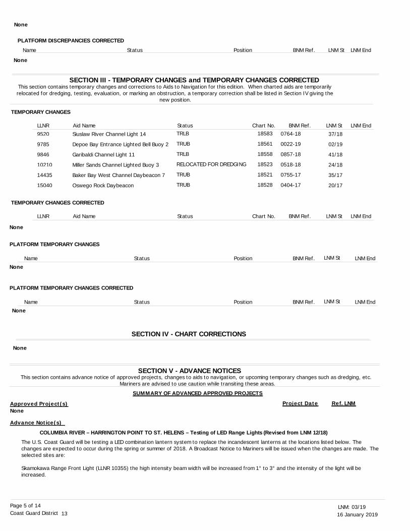
TEMPORARY CHANGES
TEMPORARY CHANGES CORRECTED
LNM End
LNM End
LLNR
LLNR
Aid Name
Aid Name
Status
Status
Chart No.
Chart No.
BNM Ref.
BNM Ref.
LNM St
LNM St
SECTION V - ADVANCE NOTICESThis section contains advance notice of approved projects, changes to aids to navigation, or upcoming temporary changes such as dredging, etc.
Mariners are advised to use caution while transiting these areas.
SUMMARY OF ADVANCED APPROVED PROJECTS
Approved Project(s) Project Date Ref. LNM
COLUMBIA RIVER – HARRINGTON POINT TO ST. HELENS – Testing of LED Range Lights (Revised from LNM 12/18)
The U.S. Coast Guard will be testing a LED combination lantern system to replace the incandescent lanterns at the locations listed below. The changes are expected to occur during the spring or summer of 2018. A Broadcast Notice to Mariners will be issued when the changes are made. Theselected sites are:
Skamokawa Range Front Light (LLNR 10355) the high intensity beam width will be increased from 1° to 3° and the intensity of the light will be increased.
Siuslaw River Channel Light 14
Depoe Bay Entrance Lighted Bell Buoy 2
Garibaldi Channel Light 11
Miller Sands Channel Lighted Buoy 3
Baker Bay West Channel Daybeacon 7
Oswego Rock Daybeacon
TRLB
TRUB
TRLB
RELOCATED FOR DREDGING
TRUB
TRUB
37/18
02/19
41/18
24/18
35/17
20/17
18583
18561
18558
18523
18521
18528
9520
9785
9846
10210
14435
15040
None
SECTION IV - CHART CORRECTIONS
None
0764-18
0022-19
0857-18
0518-18
0755-17
0404-17
PLATFORM DISCREPANCIES CORRECTED
Name Status Position BNM Ref. LNM St LNM End
None
None
PLATFORM TEMPORARY CHANGES
PLATFORM TEMPORARY CHANGES CORRECTED
Name
Name
Status
Status
Position
Position
BNM Ref.
BNM Ref.
LNM St
LNM St
LNM End
LNM End
None
None
None
Advance Notice(s)
16 January 201903/19LNM:
13Coast Guard DistrictPage 6 of 14
COLUMBIA RIVER – BONNEVILLE TO THE DALLES – CASCAPE RAPIDS – Change to the light color for Cascade Rapids Lower Range
COLUMBIA RIVER – VANCOUVER TO THE DALLES – Testing of LED Front Range Lights at selected locations (Revised from LNM 24/18)
WASHINGTON – STRAIT OF JUAN DE FUCA TO STRAIT OF GEORGIA – SWINOMISH CHANNEL SOUTH ENTRANCE – Changes in aids to navigation
Skamokawa Range Rear Light (LLNR 10360) the overall intensity of the range light will be increased.
Driscoll Range Front Light (LLNR 10465) the high intensity beam width will be increased from 1° to 3° and the intensity of the light will be increased.
Driscoll Range Rear Light (LLNR 10470) the overall intensity of the range light has been increased.
Stella Range Front Light (LLNR 10660) the high intensity beam width will be increased from 1° to 3° and the intensity of the light will be increased.
Stella Range Rear Light (LLNR 10665) the overall intensity of the range light will be increased.
Mariners are encouraged to share comments on the performance and operation of these lights as aids to navigation. All comments should be sent tothe email address [email protected]. Any discrepancy for these or other Aids to Navigation should continue to be reported to US Coast Guard Sector Columbia River.
The U.S. Coast Guard will be changing the lighting color for Cascade Rapids Lower Range Front Light 8 (LLNR 11795) and Cascade Rapids Lower Range Rear Light (LLNR 11800) from white to red during the winter of 2018-2019. Currently the Range Front Light 8 is displaying a quick flashing white light (QW) and the Range Rear Light is displaying an isophase white light (Iso W 6s). To conform to the International Association for Lighthouse Authorities (IALA) standards, starboard aids to navigation when lighted will be red in color. The Range Front Light 8 will change to a quick flashing red light (QR) and the Range Rear Light will change to a isophase red light (Iso R 6s). Daymarks for both lights will remain the same and the intensity of both lights will be matched to those currently displayed.
The U.S. Coast Guard is testing LED Lantern systems to replace the incandescent lanterns at range sites on the Columbia River, between Vancouver, WA and Hood River, OR. The changes are expected to occur during the winter of 2018, before the nesting season. A Broadcast Notice to Mariners will be issued as the changes are made. The selected sites are:
Airport Bar Range Front Light (LLNR 11307) the high intensity beam has been removed and the intensity of the light has been increased.Airport Bar Range Rear Light (LLNR 11308) the intensity of the light has been increased.
Government Island Range Front Light (LLNR 11465) the high intensity beam has been removed and the intensity of the light will be increased.Government Island Range Rear Light (LLNR 11470) remains unchanged.
Washougal Lower Range Front Light (LLNR 11530) the high intensity beam has been removed and the intensity of the light has been increased.Washougal Lower Range Rear Light (LLNR 11535) the intensity of the light has been increased.
Little White Salmon Upper Range Front Light 30 (LLNR 11895) the high intensity beam has been removed and the intensity of the light increased.Little White Salmon Upper Range Rear Light (LLNR 11900) the intensity of the light will be increased.
Hood River Range Front Light (LLNR 11915) the high intensity beam width will be increased from 1° to 3° and the intensity of the light will be increased.Hood River Range Rear Light (LLNR 11920) the intensity of the light will be increased.
Mariners are encouraged to share comments on the performance and operation of these lights as aids to navigation. All comments should be sent tothe email address [email protected]. Any discrepancy for these or other Aids to Navigation should continue to be reported to US Coast Guard Sector Columbia River.
During the winter of 2018, the U.S. Coast Guard is making the following changes in aids to navigation that mark Swinomish Channel South Entrance:
Swinomish Channel South Entrance Buoy 1 (LLNR 18785) is being replaced by Swinomish Channel South Entrance Light 1 (LLNR 18795) in approximate position. The light will have a green light flashing every 2.5 seconds (Fl G 2.5s) with a nominal range of 4 NM, and display green squaredaymarks.
Swinomish Channel South Entrance Buoy 6 (LLNR 18803) is being replaced by Swinomish Channel South Daybeacon 6 (LLNR 18805) in approximate position. The daybeacon will display red triangular daymarks.
Swinomish Channel South Entrance Buoy 8 (LLNR 18805) is being replaced by Swinomish Channel South Daybeacon 8 (LLNR 18807) in approximate position. The daybeacon will display red triangular daymarks.
Swinomish Channel South Entrance Buoy 12 (LLNR 18810) is being replaced by Swinomish Channel South Daybeacon 12 (LLNR 18812) in approximate position. The daybeacon will display red triangular daymarks.
LNM:
LNM:
LNM:
50/18
50/18
51/18
Charts:
Charts:
Charts:
18523 18524
18531 18532
18531 18532
16 January 201903/19LNM:
13Coast Guard DistrictPage 7 of 14
Swinomish Channel South Entrance Buoy 15 (LLNR 18828) is being replaced by Swinomish Channel South Daybeacon 15 (LLNR 18820) in approximate position. The daybeacon will display green square daymarks.
In addition to these changes, the Light List numbers for the southern entrance aids to navigation are incorrectly placed in the Light List and the following changes will be made to be compatible with their geographic location:
18820 Swinomish Channel South Entrance Range Front Light (change LLNR to 18785)18825 Swinomish Channel South Entrance Range Rear Light (change LLNR to 18790)18785 Swinomish Channel South Entrance Buoy 1 (change LLNR to 18795)18790 Swinomish Channel South Entrance Lighted Buoy 2 (change LLNR to 18797)18795 Swinomish Channel South Entrance Buoy 4 (change LLNR to 18800)18800 Swinomish Channel South Entrance Buoy 5 (change LLNR to 18802)18803 Swinomish Channel South Entrance Buoy 6 (change LLNR to 18805)18805 Swinomish Channel South Entrance Buoy 8 (change LLNR to 18807)18815 Swinomish Channel South Entrance Light 11 (change LLNR to 18810)18810 Swinomish Channel South Entrance Buoy 12 (change LLNR to 18812)18826 Swinomish Channel South Daybeacon 13 (change LLNR to 18815)18817 Swinomish Channel South Entrance Daybeacon 14 (LLNR will stay 18817)18828 Swinomish Channel South Entrance Buoy 15 (change LLNR to 18820)18829 Swinomish Channel South Entrance Daybeacon 16 (change LLNR to 18825)
Mariners are encouraged to share comments on the performance and operation of these aids to navigations and comments should be sent to the email address [email protected]. Any discrepancy for these or other Aids to Navigation should continue to be reported to US Coast Guard Sector Puget Sound.
LNM: 39/18
SECTION VI - PROPOSED CHANGESPeriodically, the Coast Guard evaluates its system of aids to navigation to determine whether the conditions for which the aids to navigation were
established have changed. When changes occur, the feasibility of improving, relocating, replacing, or discontinuing aids are considered. This section contains notice(s) of non-approved, proposed projects open for comment. SPECIAL NOTE: Mariners are requested to respond in writing to the District
office unless otherwise noted (see banner page for address).
PROPOSED WATERWAY PROJECTS OPEN FOR PUBLIC COMMENT
Proposed Project(s) Closing Docket No. Ref. LNM
OREGON – UMPQUA RIVER – Barretts Range Front and Rear Light arc of visibility change
COLUMBIA RIVER – VANCOUVER TO BONNEVILLE – REED ISLAND CHANNEL – Changing Reed Island Buoy 61 to Lighted Buoy 61
WASHINGTON – STRAIT OF JUAN DE FUCA TO STRAIT OF GEORGIA – ROSARIO STRAIT – Change to the light characteristic of Belle Rock Sector Light
The U.S. Coast Guard is proposing to change the arc of visibility characteristics for Barretts Range Front Light and Barretts Range Rear Light to facilitate the installation of LED lanterns as listed below:
Barretts Range Front Light (LLNR 9305) remove the high intensity beam and increase the intensity of the current light. The light will remain an all-around white light.
Barretts Range Rear Light (LLNR 9310) remove the high intensity beam and install a lantern with a 3° beam (1.5° either side of the range centerline). The intensity of the 3° beam will be increased from the current light.
Mariners are encouraged to share comments on this proposed change and the performance and operation of these lights as aids to navigation. All comments should be sent to the email address [email protected]. Any discrepancy for these or other Aids to Navigation should continue to be reported to US Coast Guard Sector North Bend.
proposing to change Reed Island Buoy 61 (LLNR 11580) to Reed Island Lighted Buoy 61, displaying a green light flashing every 2.5 seconds (Fl G2.5s) with a nominal range of 4 NM. This lighted buoy will mark the southeastern corner of the shoal in approximately 20 feet of water at Columbia River Datum (CRD)
Mariners are encouraged to share comments on this proposed change. All comments should be sent to the email address [email protected]. Any discrepancy for these or other Aids to Navigation should continue to be reported to US Coast Guard Sector Columbia River.
The U.S. Coast Guard is proposing to change the red high intensity beam on Belle Rock Sector Light (LLNR 19395) from a 1.5° beam to a 3° beam. This change will facilitate the installation of a LED lantern, and increase the intensity of both the red and white light characteristic from the
LNM:
LNM:
50/18
50/18
Chart 18427
Chart
Chart
18584
18531
None
Proposed Change Notice(s)
16 January 201903/19LNM:
13Coast Guard DistrictPage 8 of 14
current light.
Mariners are encouraged to share comments on this proposed change and the performance and operation of these lights as aids to navigation. All comments should be sent to the email address [email protected]. Any discrepancy for these or other Aids to Navigation should continue to be reported to US Coast Guard Sector Puget Sound.
LNM: 50/18
SECTION VII - GENERALThis section contains information of general concern to the Mariners. Mariners are advised to use caution while transiting these areas.
The summary of Bridge Lighting Discrepancies and Corrections is listed as Enclosure (1) of this Local Notice to Mariners.
The summary of Dredging Operations is listed as Enclosure (2) of this Local Notice to Mariners.
The summary of Marine Events is listed as Enclosure (3) of this Local Notice to Mariners.
The Oregon International Port of Coos Bay will continue their maintenance on the Coos Bay Rail Road Bridge at Coos Bay River Mile 9.0. Phase 2 of the project includes removing damaged structural members from the bridge and is planned from 28 Nov 1018 to 11 Jan 2019. Work will be conducted from two work barges located along the north or south side of the bridge center fender pier and will horizontally restrict the navigation channel by approximately 60’ to 100’ on that side of the bridge. During working hours, there will be a safety vessel operated by Pacific Charters Services onscene and monitoring VHF-FM channels 18 and 7A. Planned workhours will be Monday through Friday from 0700 to 1730 each day. Mariners are advised to use caution while transiting the area. For additional information, contact Thomas Durand, Port of Coos Bay, at (541) 294-7426 or email [email protected].
The US Coast Guard has approved a Temporary Final Rule (TFR) for the Isthmus Slough Bridge (LLNR 9087) near Coos Bay, OR. The new rule will allow the Oregon Department of Transportation to temporarily operate and open one half of the span, single leaf, for vessel traffic on signal if at least 24 hours notice is given, and reduce the vertical clearance with a work platform from 28 feet to 18 feet from 0600 on 26 Feb 18 through 1800 on 31 Jul 19. The TFR will be up loaded to the Federal Register, and may be read at: https://www.federalregister.gov/. To view the rule, type in the search box, uscg-2017-0868. For more info on the work or operation of the bridge, contact Sam Dunnavant at (541) 957-3519.
The Coast Guard has published a Notice of Proposed Rulemaking (NPRM) in the Federal Register that governs the Youngs Bay Bridge (LLNR 14573), the Old Youngs Bay Bridge (LLNR 14582) and the Lewis and Clark River Highway Bridge (LLNR 14607) in Astoria, Oregon. This NPRM proposes a rule change to the operating schedule, and is open for comments until 18 Jan 2019. The NPRM may be reviewed at http://www.regulations.gov and use USCG-2018-0131 to search for the docket. The three subject bridges operate in accordance with 33 CFR 117.899. This proposed rule will allow the three subject bridges to open from Friday at 1700 to Monday at 0700 if at least a two-hour notice is given by telephone to the draw tender at the Lewis and Clark River Bridge. The Youngs Bay Bridge provides 39 feet of vertical clearance in the closed-to-navigation position above high water; the Old Youngs Bay Bridges provides 24 feet of vertical clearance in the closed-to-navigation position above high water; the Lewis and Clark Bridge provides 25 feet of vertical clearance in the closed-to-navigation position above high water. Vessels able to pass through the bridges in the closed-to-navigation position may do so at any time. At all other times, the three subject bridges shall operate per 33 CFR § 117.899. Please submit comments to the Federal Register at http://www.regulations.gov and reference USCG-2018-0131 by 18 Jan 2019. For more information, contact Danny McReynolds at (206) 220-7234.
The Coast Guard has approved a temporary test deviation that governs the Youngs Bay Bridge (LLNR 14573), the Old Youngs Bay Bridge (LLNR 14582) and the Lewis and Clark River Highway Bridge (LLNR 14607) in Astoria. This deviation period will be from 0700 on 22 Sep 18 to 0700 on 19 Mar 19. This bridge deviation allows ODOT to remove the bridge tender during weekend hours. The three subject drawbridges are authorized to open with at least a two-hour notice due to infrequent weekend opening requests. The deviation authorizes ODOT's bridge operator to open the subject bridges within two hours after receiving a request for an opening by telephone from 1700 on Friday to 0700 on Monday, including all Federal holidays. At all other times, the bridges shall operate per 33 CFR 117.899. For more info, contact Dan McFadden at (503) 440-0949.
LNM:
LNM:
LNM:
LNM:
LNM:
LNM:
LNM:
03/19
03/19
03/19
48/18
02/18
51/18
39/18
SUMMARY OF BRIDGE LIGHTING DISCREPANCIES AND CORRECTIONS
SUMMARY OF DREDGING OPERATIONS
SUMMARY OF MARINE EVENTS
OREGON – COOS BAY – Coos Bay Rail Road Bridge maintenance (Revised from LNM 46/18)
OREGON - COOS BAY – Isthmus Slough Bridge Notice
COLUMBIA RIVER - PACIFIC OCEAN TO HARRINGTON POINT - YOUNGS BAY – Youngs Bay Bridges notice
COLUMBIA RIVER - PACIFIC OCEAN TO HARRINGTON POINT - Youngs Bay bridges notice (Revised from LNM 34/18)
Charts: 18421 18429
Chart
Chart
Chart
Chart
18587
18587
18521
18521
16 January 201903/19LNM:
13Coast Guard DistrictPage 9 of 14
The Coast Guard has issued a temporary deviation from the operating schedule that governs the Spokane Street Bridge (LLNR 16870.1) across the Duwamish Waterway, mile 0.3, in Seattle, WA. The deviation is necessary to accommodate highway traffic during the closure of the Alaskan Way Viaduct and prior to opening the SR-99 Tunnel. The deviation authorizes the subject bridge to not open to marine vessels, except the draw shall open any time for vessels of 5000 or more gross tons, a vessel towing a vessel of 5000 or more gross tons, and a vessel proceeding to pick up for towing a vessel of 5000 gross tons or greater on the Duwamish Waterway, from 0001 on 11 Jan 2019 to 2359 on 09 Feb 2019. The hours to not open the subject bridge to marine vessels are from 0700 to 1000 and from 1400 to 1700 seven days per week. The deviation is necessary to accommodate highway traffic during the closure of the Alaskan Way Viaduct and prior to opening the SR-99 Tunnel. The bridge will not be required to open, if needed, for vessels engaged in emergency response operations during this closure period if roadway vehicles are on the bridges. In accordance with 33 CFR 117.35(e), the drawbridge must return to its regular operating schedule immediately at the end of the designated time period. For additional information contact Mary Brown, Seattle DOT, at 206-386-4208.
The Coast Guard has issued a temporary deviation from the operating schedule that governs three Seattle Department of Transportation bridges: the Ballard Bridge (LLNR 18180), mile 1.1, the Fremont Bridge (LLNR 18182), mile 2.6, and the University Bridge (LLNR 18235), mile 4.3, all crossing the Lake Washington Ship Canal in Seattle, WA. The deviation is necessary to accommodate highway traffic during the closure of the Alaskan Way Viaduct and prior to opening the SR-99 Tunnel. This deviation authorizes the three subject bridges to not open to marine vessels, less than 1000 tons, unless the vessel has in tow a vessel of 1000 or more gross tons, from 0001 on 11 Jan 2019 to 2359 on 09 Feb 2019. The hours to not open the three subject bridges to marine vessels are from 0700 to 1000 and from 1530 to 1900 seven days per week. Vessels which do not require bridge openings may continue to transit beneath these bridges during the closure periods. The lift spans will not be required to open, if needed, for vessels engaged in emergency response operations during this closure period if roadway vehicles are on the bridges. In accordance with 33 CFR 117.35(e), the drawbridges must return to their regular operating schedule immediately at the end of the designated timeperiod. For additional information contact Mary Brown, Seattle DOT, at 206-386-4208.
Washington State Department of Transportation will be conducting painting and preservation operations on the George Washington Memorial Street Bridge (Aurora Avenue Bridge) (LLNR 18184). The work will be conducted from 01 Apr 18 through 31 Oct 20. Hours of work will be from 0700 to 1900, Monday through Saturday. The subject bridge provides 135 feet of vertical clearance will be reduced to 125 feet for containment. The containment will be marked with flashing yellow lights and signage. Half of the 150 feet of horizontal clearance will have containment. Mariners may transit under the bridge at any time, and are advised to use caution while transiting the area. For additional information, contact Nick Hadsell, PM, at (330) 402-3232 or [email protected].
Kiewit-Hoffman will be performing seismic upgrades to the existing approach piers for the Interstate 90 (I-90) Highway Bridge (LLNR 18389 and 18398). The west navigation channel and east navigation channels for the I-90 Floating Bridge will have marine activities, including the moving of barges, but will stay open to mariners. At this time an aerial platform will also be working from the existing bridge structure above. The platform willnot restrict the minimum vertical clearances published for the east and west navigation channels. Mariners are advised to use caution while transiting near barges within the Sound Transit E130 project area. These vessels are currently moored to columns and may present hazards. Workzones around the construction barges will be marked with steady white lights on the corners. Mariners should maintain a safe distance and minimizewake around all floating barges and other construction vessels. The eastern navigation channel will be open and will not change vertical or horizontal clearances. Two temporary mooring buoys marked with white lights flashing every 4 seconds (Fl W 4s) have been relocated near the bridge for the mooring of the barges. The positions are: Mooring Buoy (Northwest side of I-90 Floating Bridge) 47-35-32.040N, 122-16-49.740W Mooring Buoy (Northeast side of I-90 Floating Bridge) 47-35-31.860N, 122-15-37.680WMariners should not deviate from these established paths through navigations channels when open to vessel traffic. Construction and operations at this site are expected to continue through 2020. For additional information contact Matt Larson at (425) 318-5296 or email [email protected].
The City of Renton is constructing new pedestrian bridges along the Gene Coulon Memorial Beach Park in the south part of Lake Washington. A series of bridges will be built within the park on the water’s edge. Work vessels may be present at the worksite. Mariners are requested to avoid entering the construction area. The construction is planned to be completed on or near 19 Jan 2019. For more information, contact Nicole Foster at (206) 624-1387, or email [email protected].
The Coast Guard has approved a Final Rule in the Federal Register that governs the BNSF RR Bridge 38.3 (LLNR 18594.6) across Ebey Slough (Snohomish River), mile 1.5 at Marysville, Washington. BNSF Bridge 38.3 operates in accordance with 33 CFR 117.1059 (g), and the change will be effective from 0001 on 19 Jan 2019. The rule change authorizes BNSF to operate without a bridge operator attending the bridge until an opening request has been received. The revised rule states: 33§117.1059; Snohomish River, Steamboat Slough, and Ebey Slough; Marysville, WA: (g) The draw of the Burlington Northern Santa Fe Railroad Bridge across Ebey Slough, mile 1.5, near Marysville, WA, shall open on signal if atleast four hours notice is given. The opening signal is one prolonged blast followed by one short blast. During freshets, a draw tender shall be in constant attendance, and the draw shall open on signal when so ordered by the District Commander. BNSF RR Bridge 38.3 provides 5 feet of vertical clearance in the closed-to-navigation position above high water, and at the lowest tides, up to 16 feet of vertical clearance may be
LNM:
LNM:
LNM:
LNM:
LNM:
49/18
49/18
26/18
22/18
47/18
WASHINGTON – PUGET SOUND – SEATTLE TO BREMERTON – DUWAMISH WATERWAY – Bridge deviation notice
WASHINGTON – LAKE WASHINGTON SHIP CANAL – Bridge deviation notice
WASHINGTON – LAKE WASHINGTON SHIP CANAL - George Washington Memorial Bridge Notice (Revised from LNM 01/18)
WASHINGTON – LAKE WASHINGTON SHIP CANAL – LAKE WASHINGTON - Interstate 90 Highway Bridge (West Channel) construction (Revised from LNM 15/18)
WASHINGTON – LAKE WASHINGTON SHIP CANAL – LAKE WASHINGTON – Bridge construction
WASHINGTON – PUGET SOUND – EVERETT HARBOR – SNOHOMISH RIVER – Ebey Slough Bridge notice
Chart
Chart
Chart
Chart
Chart
18450
18447
18447
18447
18447

16 January 201903/19LNM:
13Coast Guard DistrictPage 10 of 14
available. Vessels able to pass through the bridge in the closed-to-navigation position may do so at any time. For more information, contact Danny McReynolds at (206) 220-7234.
The Idaho Transportation Department will be conducting repair work to the Walters Ferry Bridge, at Snake River mile 442.9, from approximately 04Sep 18 until 30 Apr 19. The Walters Ferry Bridge is approximately 15 miles south of Nampa, ID, on SH-45. The working hours will be Monday through Saturday, 0700 to 1900. The repair work will be above and below the waterline; mariners watch for diver flags to warn of divers in the water. Work barges will be anchored at the bridge, and lighted per Coast Guard regulations. Turbidity curtains will be submerged around the workarea and marked with lighted buoys. Mariners are requested to remain at least 100 feet away from the marked work area and proceed with minimum wake. For additional information, contact Styles Salek at (208) 559-1275 or [email protected].
The Coast Guard District has received two applications from BNSF Railway Co. (BNSF) requesting approval of location and plans for two new bridges over navigable waterways of the United States, near Sandpoint, Idaho, one across Lake Pend Oreille at 48-15-01.0N 116-32-14.9W and the other across Sand Creek at 48-16-19.5N 116-32-38.9W. At this time, the Coast Guard has published two public notices (PN), 05-18 and 06-18, soliciting comments from mariners exclusively related to navigation issues concerning these proposed bridges. The public is highly encouraged to carefully review these notices, attached plans, and diagrams and then provide comments with regard to the proposed bridges’ abilities to meet the reasonable needs of navigation. When the Coast Guard has completed the draft environmental document related to these proposed bridges, they will publish a subsequent PN and a Federal Register notice announcing the document and its availability. PN 05-18 and 06-18 solicit comment and are available at https://www.navcen.uscg.gov/D13BN. Comments are requested by 17 Jan 2019, and should be addressed to the Bridge Administrator, Steve Fischer, at (206) 220-7282 or email [email protected].
Idaho Transportation Department is conducting repair work to the I-90 Blue Creek Highway Bay Bridge across Lake Coeur D’Alene from Jun 18 through Aug 19. These dates are weather pending. The subject bridge is located at 47-37-38.5N, 116-40-37.3W. This project is in three phases as shown in enclosure (5) of Local Notice to Mariners 28/18. The enclosure shows work zones for mariners to remain clear, and the section of the bridge open for passage during each phase. The work will include heavy construction with fall hazards in the closure areas, and painting and preservation. Hours will be 0700 to 1730, seven days a week for most above water work and all underwater work, with 0700 to 1930 above water a few times per week. The vertical clearance for the navigable section will be 24 feet, and the horizontal clearance will be a minimum of 120 feet. The construction zone will be marked with orange buoys and lighted regulatory no wake buoys. Orange caution signs will be installed from the bridge marking the navigable section. Mariners may transit under the bridge span with no active working, but at minimum safe speed. The point of contact for the construction company is Skip Delwisch at (208) 600-2595.
The USACE Portland and Walla Walla Districts will implement the winter seasonal lockage schedule, from 15 Sep 2018 to 14 May 2019, for thepassage of recreational craft through the Columbia and Snake River navigation locks. Winter recreational vessel lockage will be made during daylight hours only, on request at each lock – vessels should contact the lock operator via VHF-FM channel 14 or commercial telephone, and shouldmake their request at least 30 minutes in advance. Lock Name Location Phone Number Radio Call SignBonneville Lock Columbia River Mile 145.5 (541) 374-8323 WUJ 33The Dalles Lock Columbia River Mile 191.5 (541) 298-4007 WUJ 34John Day Lock Columbia River Mile 215.6 (541) 298-9712 WUJ 35McNary Lock Columbia River Mile 292 (541) 922-2231 WUJ 41Ice Harbor Lock Snake River Mile 9.7 (509) 543-3253 x231 WUJ 42Lower Monumental Lock Snake River Mile 41.6 (509) 282-7231 WUJ 43Little Goose Lock Snake River Mile 70.3 (509) 399-2233 x231 WUJ 44Lower Granite Lock Snake River Mile 107.5 (509) 843-1493 x231 WUJ 45Commercial vessels continue to have lockage precedence over recreational vessels. At the discretion of the lock operator, recreational vessels may be allowed to lock through with commercial vessels. All vessel owner/operators lock through at their own risk. All persons in the vessel must be wearing a personal flotation device (PFD) during lockage. Follow the directions of the lock operator when using locks or operating in the vicinity of the locks. The lock operator has final authority on the suitability of a craft for lockage. Please refer to USACE Safe Lockage Policy for Recreational Craft on the Columbia and Snake Rivers, published separately, for safety requirements. For safety and additional information on navigation lock operations and schedules visit http://www.nww.usace.army.mil/Missions/Navigation.aspx. or call the USACE Walla Walla Operations Division at (509) 527-7112.
The USACE Portland and Walla Walla Districts have scheduled the annual navigation lock maintenance closure for March 2019. During this time, the Locks and Dams on the Columbia and Snake Rivers have scheduled routine inspections and maintenance, as well as some non-routine work. Allseven (7) of the navigation locks will close at 0600 on Saturday 02 Mar 2019. Bonneville, The Dalles, John Day, McNary, Ice Harbor, and Little Goose will reopen at 2359 on Sunday 17 Mar 2019, while Lower Monumental and Lower Granite will reopen at 2359 on Sunday 24 Mar 2019. Columbia River navigation lock maintenance closures are: Bonneville (RM 145) – 0600 on 02 Mar 2019 to 2359 on 17 Mar 2019The Dalles (RM 191) – 0600 on 02 Mar 2019 to 2359 on 17 Mar 2019
LNM:
LNM:
LNM:
LNM:
LNM:
51/18
34/18
51/18
25/18
38/18
WASHINGTON – PUGET SOUND – EVERETT HARBOR – SNOHOMISH RIVER – Ebey Slough Bridge notice
SNAKE RIVER –Walters Ferry Highway Bridge repair work notice (Revised from LNM 33/18)
IDAHO – LAKE POND OREILLE – Proposed Bridge Public Notice for navigation information
IDAHO - LAKE COEUR D'ALENE – I-90 Blue Creek Bay Highway Bridge Notice
COLUMBIA AND SNAKE RIVERS – Winter seasonal recreational vessel lockage
COLUMBIA AND SNAKE RIVERS – 2019 Annual Lock closures for maintenance
Chart
Chart
Charts:
18444
18554
18532 18533 18535 18539 18541 18545 18546 18547
16 January 201903/19LNM:
13Coast Guard DistrictPage 11 of 14
John Day (RM 216) – 0600 on 02 Mar 2019 to 2359 on 17 Mar 2019McNary (RM 292) – 0600 on 02 Mar 2019 to 2359 on 17 Mar 2019Snake River navigation lock maintenance closures are:Ice Harbor (RM 9.7) – 0600 on 02 Mar 2019 to 2359 on 17 Mar 2019Lower Monumental (RM 41.6) – 0600 on 02 Mar 2019 to 2359 on 24 Mar 2019Little Goose (RM 70.3) – 0600 on 02 Mar 2019 to 2359 on 17 Mar 2019Lower Granite (RM 107.3) – 0600 on 02 Mar 2019 to 2359 on 24 Mar 2019For additional information regarding Bonneville, The Dalles and John Day lock maintenance closures, contact Portland District, Operations Division at (503) 808-4341. For additional information regarding McNary, Ice Harbor, Lower Monumental, Little Goose and Lower Granite lock maintenance closures, contact Walla Walla District, Operations Division, at (509) 527-7112.
The use of the floating guide wall at Ice Harbor Navigation Lock (Snake River RM 9.7) is restricted due to a failure of the brackets that hold the bumpers in the correct position. Mariners are requested to avoid pushing on, bumping into or tying up to the guide wall until repairs are made. Therepairs require divers and a one-day lock closure, which is scheduled for the next in-water work period in February of 2019. For more information, contact the Ice Harbor Chief Operator at (509) 543-3231. Call Sign WUJ42 Ice Harbor.
USACE Seattle District has released a projected schedule for extended maintenance outages of the large lock chamber at the Hiram M. Chittenden Locks in Ballard. In 2019,USACE will commence the first of five extended 45-day closures to replace the valve gates, which are original equipment that must be replaced to keep the 101-year-old Chittenden Locks safe and operational for years to come. The projected 45-day closure dates are:2019: 12 Oct – 30 Nov2020: 12 Feb – 02 Apr 12 Oct – 30 Nov2021: 12 Feb – 02 Apr 09 Nov – 24 NovFor more information, contact the Seattle District Public Affairs Office, Bill Dowell at (206) 764-3464 or email [email protected].
National Renewable Energy Lab has a marker float located at 43-35.18N 124-17.39W, approximately 6 nm south of the entrance of Umpqua River. This float is marking an anchor that will be recovered as soon as possible, and no later than 30 Jun 2019. The float is composed of two salmon-colored cylindrical inflatable buoys attached to 5/8-inch 12-strand orange spectra line. For additional information, please contact Levi Kilcher at (303) 384-7192 or email [email protected].
The Portland Winter Light Festival will be placing an underwater art display in the shape of a school of salmon approximately 20 feet off the east bank of the Willamette River directly south of the Marquam Bridge in Portland, OR from 05 Feb 19 through 11 Feb 19. The display will be comprisedof a 100' long polyester line with floats at each end, running parallel to the shore. There will be 15-20 salmon, formed of soft materials and lit with LEDs, attached to the line directly under the surface of the water. Mariners are requested to use caution when transiting the area. For additional information, contact Jean Margaret at (503) 753-7725 or [email protected].
Scheduled repairs of the North Jetty have commenced and will continue through 2020. Current repairs are being conducted via the land access, but at a future date barges and in water equipment will be used to conduct repairs. This notice will be updated once in water work is scheduled. For additional information on this project contact Sherri Brenner at (503) 550-6743 and email [email protected] or the Project Superintendent Aaron Anderson at (503) 791- 2161 and email [email protected] jetties at the Columbia River Entrance have suffered severe deterioration and may no longer be correctly represented upon the nautical charts of the area. Mariners should use caution when transiting in the vicinity of the jetties and the river entrance. Repairs of the South jetty are scheduled to be conducted from 2019 through 2023. More information may be found at the USACE Portland District web site: http://www.nwp.usace.army.mil/jetties/.
Advanced American Construction (AAC) will be conducting marine construction in the Columbia River at Wauna (RM 42). Operations include dock demolition, pile driving, and dock construction. Onsite work is expected to occur from 01 Nov 2018 to 28 Feb 2019. AAC’s Derrick Barges DB 4100 and DB Millennium, tug Lindy Marie, and work barges will be on station from 01 Nov 2018 to 28 Feb 2019. AAC will be monitoring VHF-FM channel 16 during the working hours of 0700 through 1700, Monday through Friday. The floating equipment will remain on-station during non-working hours and will be illuminated at night by fixed white lights on all corners. Mariners are asked to transit the area with extreme caution and minimize
LNM:
LNM:
LNM:
LNM:
LNM:
LNM:
47/18
33/18
47/18
49/18
51/18
13/18
COLUMBIA AND SNAKE RIVERS – 2019 Annual Lock closures for maintenance
SNAKE RIVER – LAKE SACAJAWEA – ICE HARBOR DAM – Extension of floating guide wall restrictions at Ice Harbor Navigation Lock (Revised from LNM 28/18)
WASHINGTON – PUGET SOUND – LAKE WASHINGTON SHIP CANAL – Future schedule for Hiram M. Chittenden Large Lock maintenance closures
OREGON – CAPE BLANCO TO YAQUINA HEAD – Marker float and anchor
WILLAMETTE RIVER - PORT OF PORTLAND - Portland Winter Light Festival underwater display
COLUMBIA RIVER – PACIFIC OCEAN TO HARRINGTON POINT - Mouth of the Columbia River Jetty System Major RehabilitationProject (Revised from LNM 31/17)
COLUMBIA RIVER – HARRINGTON POINT TO CRIMS ISLAND – Dock construction
Chart
Chart
Chart
Chart
Chart
Charts: 18532 18533 18535 18539 18541 18545 18546 18547
18545
18447
18580
18526
18521
16 January 201903/19LNM:
13Coast Guard DistrictPage 12 of 14
wake. Please contact Jason Sweet at (503) 849-1883 [email protected] with questions.
Advanced American Construction (AAC) will be conducting bridge construction in the Columbia River at the mouth of Wind River (RM 155). Operations include pile driving and drilled shaft work. Onsite work is expected to occur from 01 Nov 2018 to 28 Feb 2019. AAC’s Derrick Barge DB 4000 and tug Ruth will be on station and monitoring VHF-FM channel 16 during the working hours of 0700 through 1700, Monday through Saturday. The floating equipment will remain on-station during non-working hours and will be illuminated at night by fixed white lights on all corners. Mariners are asked to transit the area with extreme caution and minimize wake. Please contact Kyle Izatt at (503) 849-3336 [email protected] or Todd High at (503) 572-0101 [email protected] with questions.
NOAA Northwest Fisheries Science Center (NMFS) will be deploying subsurface acoustic recorder moorings along the Washington Coast on 15 Oct 18. The moorings will have a subsurface float and cabling up to 125 meters from the ocean floor but may be as little as 20 meters below the surface in some locations. The moorings are expected to remain on site through 01 Oct 19. The moorings are located at: Location Area Name Latitude - Longitude Columbia River North 46-19-37N 124-11-54W Westport 46-57-51N 124-18-09W LaPush 47-52-50N 124-40-53W Cape Flattery Offshore 48-10-33N 125-37-08W Western Strait of Juan de Fuca 48-29-30N 124-47-00WMariners should avoid trailing any gear or equipment to prevent entanglement when transiting in the vicinity. For additional information contact Brad Hanson at (206) 860-3220 or email at [email protected].
The Pacific Northwest National Laboratory (PNNL) will be deploying and retrieving submerged scientific equipment in the entrance channel to Sequim Bay, Washington from 07 Jan 2019 through 31 Mar 2019. The submerged equipment be located in various locations between approximate positions 48-04-54.51N 123-02-32.50W and 48-04-42.74N 123-02-34.80W, and will have cables running on the seafloor to PNNL’s pier located on the west side of the channel, opposite Travis Spit. There will be no surface marker buoys on the equipment, but the equipment extends more than 5 feet above the seafloor, leaving at least 23 feet of water over the equipment at all times. Several research vessels will be involved in the operations, and may be hailed on VHF-FM channel 16, including the Strait Science, Desdemona, and R/V Jack Robertson. Mariners will not be restricted from using the channel, but should anticipate the research and support vessels may have decreased maneuverability during operations. Additionally, when diving operations are conducted, vessels supporting divers will fly the blue and white Alpha flag as well as the red and white Diver Down flag and other vessels should keep well clear at a slow speed. A Sécurité message will announce the start and end of the deployment and retrieval periods, expected to take place during slack tides approximately 8 to 10 times total during project time period. For additional information, contact PNNL Marine Sciences Laboratory, Susan Southard, at (360) 681-3615 (office) or (360) 460-1999 (cell) or email [email protected].
Pacific Pile and Marine, LP is conducting pier demolition and construction operations at Piers 62 and 63 in Elliott Bay, WA from 15 Jan 18 through January of 2020. The hours of operations will be 0700 to 1700, Monday through Friday though some work may be continued through the weekends. The construction and crane barge Web and various other barges will be onscene at all times, lighted at night, and will monitor VHF-FM channels 13, 16 & 69. Construction equipment may be moored in the vicinity of Pier 62 and may restrict sections of the waterway. For additional information, contact Karl Benjamin at (206) 331-3873 or at email [email protected].
Washington State Ferries is conducting demolition and construction operations at the Colman Docks, scheduled to be completed in the summer of 2022. Operations will be conducted from 0700 to 1700, Monday through Friday. Mariners should be aware of marine construction equipment moored around the Colman Dock and regular tows up and down the Duwamish River in support of the operation. Equipment may obstruct small sections of the waterway adjacent to Colman Dock. Water quality monitoring will be taking place during construction operations. Please direct any inquiries to WSF Communications at (206) 402-8070 or email [email protected].
Stellar J and Bergerson Construction is conducting repair work operations under Terminal 46 in Elliott Bay until approximately 30 Jan 20. Operationswill be conducted during daylight hours to coincide with tidal changes, Monday through Friday. There will be up to five work skiffs, two working floats as well as a scaffolding system under the dock. Work parties will answer hails as Stellar J or Bergerson Construction on VHF-FM channel 17. All work will be conducted inside the dock line, and it is requested that all vessels transiting the vicinity operate with minimum wake. For additional information contact Mike Klassen of Stellar J Corporation at (360) 518-2544 or email [email protected].
LNM:
LNM:
LNM:
LNM:
LNM:
LNM:
LNM:
43/18
43/18
42/18
51/18
02/18
27/17
23/18
COLUMBIA RIVER – HARRINGTON POINT TO CRIMS ISLAND – Dock construction
COLUMBIA RIVER – BONNEVILLE TO THE DALLES – Wind River Railroad Bridge construction
WASHINGTON COAST – COLUMBIA RIVER TO THE STRAIT OF JUAN DE FUCA – Deployment of sub-surface acoustic recorder moorings
WASHINGTON – APPROACHES TO ADMIRALTY INLET - Sequim Bay scientific sensor deployment
WASHINGTON - PUGET SOUND – ELLIOT BAY – Construction at Piers 62 and 63
WASHINGTON – SEATTLE TO BREMERTON – ELLIOTT BAY - Colman Dock construction
WASHINGTON – PUGET SOUND – ELLIOTT BAY – Construction under Terminal 46
WASHINGTON – PUGET SOUND – GPS testing
Chart
Chart
Chart
Chart
Chart
Chart
Charts:
18523
18532
18480 18500
18471
18450
18450
18449
16 January 201903/19LNM:
13Coast Guard DistrictPage 13 of 14
US Strategic Command has proposed GPS testing encompassing the majority of the Puget Sound area. The center point of the test will be at position 47-01-47.437N, 122-32-57.893W, near Fort Lewis, WA, with a radius of 52 NM. The GPS navigation signal may be unreliable due to testing on GPS frequencies used by shipboard navigation and handheld systems. Systems that rely on GPS, such as e-911, AIS and DSC, may be affected. The testing frequencies will be GPS L1 and L2. Testing dates and times are as listed below, using Pacific Standard Time as local time: 26 Feb 2019: 0700 – 1900 27 Feb 2019: 0700 – 1900 28 Feb 2019: 0700 – 1900 For additional information or to express concerns, contact the Coast Guard Navigation Center at (703) 313-5900 or at https://www.navcen.uscg.gov/?pageName=dgpsSiteInfo¤tOutages.
Advanced American Construction (ACC) is conducting dredging, capping, demolition, pile driving, float replacement at the Port of Everett Central Marina from 06 Nov 2018 through Jun 2019. Working vessels include the Lummi Island, Everett, Valor, and the floating cranes Guardian and Snohomish. Vessels can be contacted on VHF-FM 13 and 14. Mariners are requested to make passing arrangements, transit with caution and minimize wake. For additional information, contact Vernon Uy at email [email protected]
Advanced American Construction is conducting repair work operations under South Terminal Wharf at the Port of Everett in Port Gardner Bay until approximately January 2020. Operations will be conducted during day and nighttime hours to coincide with tidal changes, Monday through Saturday. There will be up two work skiffs, several working floats as well as a scaffolding system under the wharf. Work parties will answer hails asAdvanced American Construction on VHF 63 and 64. All work will be conducted inside the wharf line, and it is requested that all vessels transiting the vicinity operate with minimum wake. For additional information, contact Steve Hager, Port of Everett, at (425) 388-0633 or email [email protected].
Pacific Pile & Marine will be conducting dredging operations at the La Conner Marina basins commencing 06 Sep 18 continuing through 15 Feb 19. Operations will be conducted 0600 to 1700, Monday through Friday. Dredge sediment disposals will take place at the Rosario Strait Disposal Site 24 hours per day from 06 Sep 18 through 15 Feb 19. The dredge barge Flexi, Judge Dredge, and tugboat Sonja H. will be monitoring VHF-FM channels 18 and 19. Mariners are requested to use caution and reduce wake when transiting the area. For additional information, contact Pacific Pile & Marine at (206) 947-0188.
Harbor Offshore Inc. is installing and recovering submarine cables in the San Juan Channel between Pear Point on San Juan Island and Fisherman’sBay on Lopez Island, within the charted cable areas. Operations are expected to continue through 13 Aug 19. The hours of operations are 24 hours a day, 7 days a week. The Cable Lay Barge HOI-1, the tugs Westrac, Flyer and Reliable and the work boat Bobbie T may be contacted on VHF-FM channels 13, 16 and 68. An anchor system will be placed in approximate position 48-31-02.58N 122-58-46.73W off of Pear Point. Marinersare requested to contact one of the vessels listed above before transiting in the vicinity. For additional information contact Mr. Cliff Center at (206) 949-7133 or Mr. Lester Garrett at (206) 391-4077.
Two Canadian subsurface research buoys have been placed in Canadian waters in Haro Pass and Boundary Pass at approximate positions: 48-41-07.32N 123-16-26.10W 48- 30-23.68N 123-12-37.92W The buoys are set to float approximately eight meters above the seabed and are expected to be in place until further notice. For additional information contact Mr. Sean Dyble of the Canadian Hydrographic Services Office Esquimalt at (250) 363-4929 or email [email protected].
LNM:
LNM:
LNM:
LNM:
LNM:
LNM:
50/18
45/18
51/18
34/18
34/17
11/17
SECTION VIII - LIGHT LIST CORRECTIONSAn Asterisk *, indicates the column in which a correction has been made to new information
ENCLOSURESEnclosure 1
OREGON - WASHINGTON - IDAHO - MONTANA - Summary of Bridge Lighting Discrepancies and Corrections
(1)No.
(2)Name and Location
(3)Position
(4)Characteristic
(5)Height
(6)Range
(7)Structure
(8)Remarks
WASHINGTON – PUGET SOUND – GPS testing
WASHINGTON – PUGET SOUND NORTHERN PART – EVERETT HARBOR – Pier construction
WASHINGTON - PUGET SOUND - APPROACHES TO EVERETT - Port of Everett's South Terminal Wharf Construction
WASHINGTON – STRAIT OF JUAN DE FUCA TO STRAIT OF GEORGIA - SWINOMISH CHANNEL – La Conner Marina basins dredging
WASHINGTON – STRAIT OF JUAN DE FUCA TO STRAIT OF GEORGIA – SAN JUAN CHANNEL – Submarine cable operations (Revised from 30/17)
STRAIT OF JUAN DE FUCA TO STRAIT OF GEORGIA – HARO STRAIT AND BOUNDARY PASS - Placement of underwater equipment (Revised from LNM 08/16)
None
Chart
Chart
Chart
Charts:
Charts:
Charts:
18440
18443 18444
18443 18444
18421 18427
18434
18421

16 January 201903/19LNM:
13Coast Guard DistrictPage 14 of 14
Enclosure 2
Enclosure 3
OREGON - WASHINGTON - COLUMBIA RIVER - Summary of Dredging Operations
OREGON - WASHINGTON - COLUMBIA RIVER - Summary of Marine Events
03/19
03/19
03/19
LNM:
LNM:
LNM:
If you have any questions, comments, or need additional information concerning this or other LNMs (e.g. additions, deletions, corrections) contactthe address or phone number on the front page.
CDR Brendan J. HarrisChief, Waterways Management Branch
Thirteenth Coast Guard District
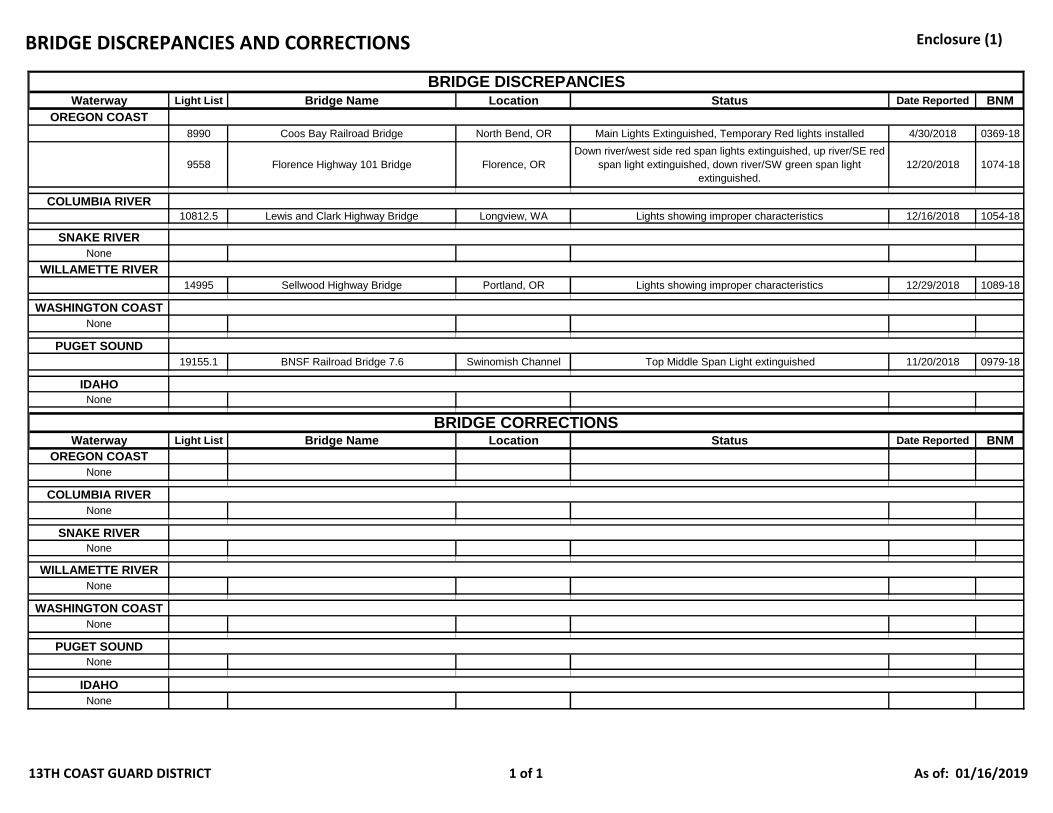
BRIDGE DISCREPANCIES AND CORRECTIONS Enclosure (1)
Waterway Light List Bridge Name Location Status Date Reported BNM
OREGON COAST
8990 Coos Bay Railroad Bridge North Bend, OR Main Lights Extinguished, Temporary Red lights installed 4/30/2018 0369-18
9558 Florence Highway 101 Bridge Florence, OR
Down river/west side red span lights extinguished, up river/SE red
span light extinguished, down river/SW green span light
extinguished.
12/20/2018 1074-18
COLUMBIA RIVER
10812.5 Lewis and Clark Highway Bridge Longview, WA Lights showing improper characteristics 12/16/2018 1054-18
SNAKE RIVER
None
WILLAMETTE RIVER
14995 Sellwood Highway Bridge Portland, OR Lights showing improper characteristics 12/29/2018 1089-18
WASHINGTON COAST
None
PUGET SOUND
19155.1 BNSF Railroad Bridge 7.6 Swinomish Channel Top Middle Span Light extinguished 11/20/2018 0979-18
IDAHO
None
Waterway Light List Bridge Name Location Status Date Reported BNM
OREGON COAST
None
COLUMBIA RIVER
None
SNAKE RIVER
None
WILLAMETTE RIVER
None
WASHINGTON COAST
None
PUGET SOUND
None
IDAHO
None
BRIDGE CORRECTIONS
BRIDGE DISCREPANCIES
13TH COAST GUARD DISTRICT 1 of 1 As of: 01/16/2019
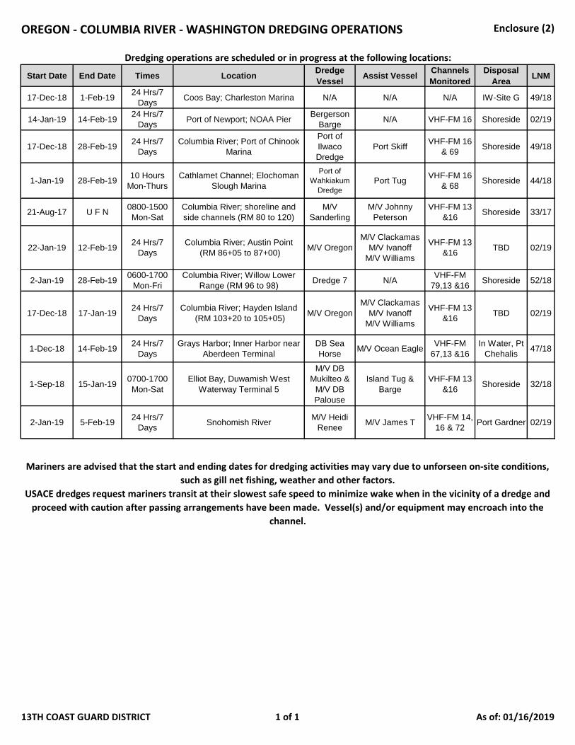
OREGON - COLUMBIA RIVER - WASHINGTON DREDGING OPERATIONS Enclosure (2)
Start Date End Date Times LocationDredge
VesselAssist Vessel
Channels
Monitored
Disposal
AreaLNM
17-Dec-18 1-Feb-1924 Hrs/7
DaysCoos Bay; Charleston Marina N/A N/A N/A IW-Site G 49/18
14-Jan-19 14-Feb-1924 Hrs/7
DaysPort of Newport; NOAA Pier
Bergerson
BargeN/A VHF-FM 16 Shoreside 02/19
17-Dec-18 28-Feb-1924 Hrs/7
Days
Columbia River; Port of Chinook
Marina
Port of
Ilwaco
Dredge
Port SkiffVHF-FM 16
& 69Shoreside 49/18
1-Jan-19 28-Feb-1910 Hours
Mon-Thurs
Cathlamet Channel; Elochoman
Slough Marina
Port of
Wahkiakum
Dredge
Port TugVHF-FM 16
& 68Shoreside 44/18
21-Aug-17 U F N0800-1500
Mon-Sat
Columbia River; shoreline and
side channels (RM 80 to 120)
M/V
Sanderling
M/V Johnny
Peterson
VHF-FM 13
&16Shoreside 33/17
22-Jan-19 12-Feb-1924 Hrs/7
Days
Columbia River; Austin Point
(RM 86+05 to 87+00)M/V Oregon
M/V Clackamas
M/V Ivanoff
M/V Williams
VHF-FM 13
&16TBD 02/19
2-Jan-19 28-Feb-190600-1700
Mon-Fri
Columbia River; Willow Lower
Range (RM 96 to 98)Dredge 7 N/A
VHF-FM
79,13 &16Shoreside 52/18
17-Dec-18 17-Jan-1924 Hrs/7
Days
Columbia River; Hayden Island
(RM 103+20 to 105+05)M/V Oregon
M/V Clackamas
M/V Ivanoff
M/V Williams
VHF-FM 13
&16TBD 02/19
1-Dec-18 14-Feb-1924 Hrs/7
Days
Grays Harbor; Inner Harbor near
Aberdeen Terminal
DB Sea
HorseM/V Ocean Eagle
VHF-FM
67,13 &16
In Water, Pt
Chehalis47/18
1-Sep-18 15-Jan-190700-1700
Mon-Sat
Elliot Bay, Duwamish West
Waterway Terminal 5
M/V DB
Mukilteo &
M/V DB
Palouse
Island Tug &
Barge
VHF-FM 13
&16Shoreside 32/18
2-Jan-19 5-Feb-1924 Hrs/7
DaysSnohomish River
M/V Heidi
ReneeM/V James T
VHF-FM 14,
16 & 72Port Gardner 02/19
Dredging operations are scheduled or in progress at the following locations:
USACE dredges request mariners transit at their slowest safe speed to minimize wake when in the vicinity of a dredge and
proceed with caution after passing arrangements have been made. Vessel(s) and/or equipment may encroach into the
channel.
Mariners are advised that the start and ending dates for dredging activities may vary due to unforseen on-site conditions,
such as gill net fishing, weather and other factors.
13TH COAST GUARD DISTRICT 1 of 1 As of: 01/16/2019
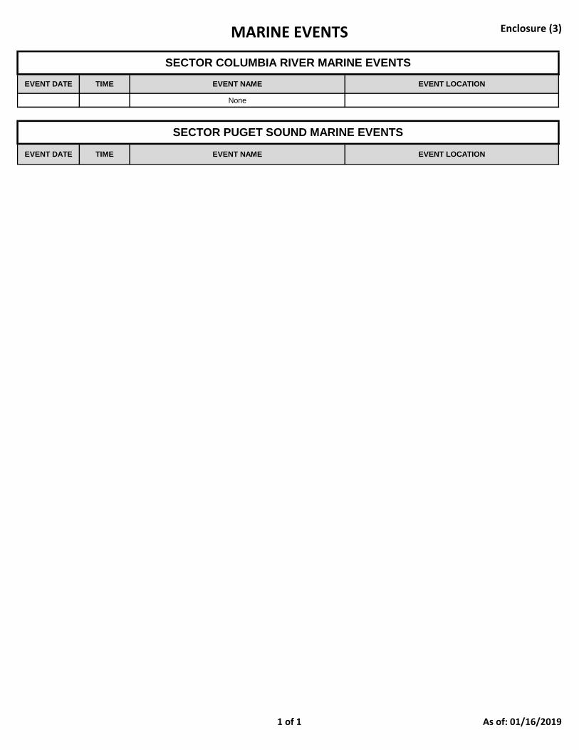
MARINE EVENTS Enclosure (3)
EVENT DATE TIME EVENT NAME EVENT LOCATION
None
EVENT DATE TIME EVENT NAME EVENT LOCATION
SECTOR COLUMBIA RIVER MARINE EVENTS
SECTOR PUGET SOUND MARINE EVENTS
1 of 1 As of: 01/16/2019