Embed Size (px)
Citation preview
15 April 202015/20LNM:
9Coast Guard DistrictPage 1 of 18
U.S. Departmentof Homeland Security
United StatesCoast Guard
LOCAL NOTICE TO MARINERS
Issued by: Commander (dpw)Ninth Coast Guard District1240 East Ninth Street,
Cleveland, OH 44199-2060Telephone: (216) 902-6069
Direct questions about this LNM to the above address.
All distances in this publication are STATUTE MILES unless otherwise noted.
*District Nine Internet Address* https://www.atlanticarea.uscg.mil/Our-Organization/District-9/*District Nine Local Notice to Mariners email Address* [email protected]
** Navigation Information Service watchstander, 24 hours a day at (703) 313-5900 ** **Internet Address** https://www.navcen.uscg.gov/Light List Reference: Commandant Publication P16502.7, VOL VII, 2019 Edition
Coast Pilot Reference: 2020 U.S. Coast Pilot 6 Great Lakes 50th EditionCoast Pilots, along with corrections are available at: https://nauticalcharts.noaa.gov/publications/coast-pilot/index.html
The Local Notice to Mariners is available on the Internet at https://www.navcen.uscg.gov/-pageName=lnmMain You will also have links to other government agencies- web pages including the US Army Corps of Engineers and the National Ocean Service.
REPORT DISCREPANCIES IN AIDS TO NAVIGATION TO THE NEAREST COAST GUARD UNIT
The Ninth District and all Sector offices for their areas of responsibility issue a BROADCAST NOTICE TO MARINERS. The following Broadcast Notice to Mariners have been incorporated into this week's Local Notice to Mariners:
Sector Buffalo, NY - B011-20 through B013-20Ninth District - C030-20 through C031-20
Sector Detroit, MI - D010-20 through D015-20Sector Lake Michigan, WI - M061-20 through M063-20Sector Sault Ste Marie, MI - S041-20 through S044-20
The United States Coast Guard Navigation Information Service (NIS), operated by the USCG Navigation Center, is staffed 24 hours a day, 7 days aweek. The NIS provides information on the current operational status, effective policies, and general information for GPS and DGPS. The
NIS also disseminates Safety Broadcasts (BNM), Local Notice to Mariners (LNM), and the latest Notice Advisory to Navstar Users (NANU). NANUnotices can be obtained via email subscription through the USCG Navigation Center website: https://cgls.uscg.mil/mailman/listinfo/nanu . In addition,
the NIS investigates all reports of degradation or loss of GPS, DGPS or AIS service. Users are encouraged to report all degradation or loss ofradio navigation services to the NIS via any of the following: Phone: (703) 313-5900, mail to: [email protected], or on the internet
at: https://www.navcen.uscg.gov
ABBREVIATIONS
District: 9 Week: 15/20
A through H
ADRIFT - Buoy AdriftAICW - Atlantic Intracoastal WaterwayAl - AlternatingB - BuoyBKW - Breakwaterbl - BlastBNM - Broadcast Notice to Marinerbu - BlueC - CanadianCHAN - ChannelCGD - Coast Guard DistrictC/O - Cut OffCONT - ContourCRK - CreekCONST - ConstructionDAYMK/Daymk - DaymarkDBN/Dbn - DaybeaconDBD/DAYBD - DayboardDEFAC - DefacedDEST - Destroyed
I through O
I - InterruptedICW - Intracoastal WaterwayIMCH - Improper CharacteristicINL - InletINOP - Not OperatingINT - IntensityISL - IsletIso - IsophasekHz - KilohertzLAT - LatitudeLB - Lighted BuoyLBB - Lighted Bell BuoyLHB - Lighted Horn BuoyLGB - Lighted Gong BuoyLONG - LongitudeLNM - Local Notice to MarinersLT - LightLT CONT - Light ContinuousLTR - LetterLWB - Lighted Whistle Buoy
P through Z
PRIV - Private AidQ - QuickR - Red RACON - Radar Transponder BeaconRa ref - Radar reflectorRBN - Radio BeaconREBUILT - Aid RebuiltRECOVERED - Aid RecoveredRED - Red BuoyREFL - ReflectiveRRL - Range Rear LightRELIGHTED - Aid RelitRELOC - RelocatedRESET ON STATION - Aid Reset on StationRFL - Range Front LightRIV - RiverRRASS - Remote Radio Activated Sound Signals - secondsSEC - SectionSHL - Shoaling
15 April 202015/20LNM:
9Coast Guard DistrictPage 2 of 18
LIB - Lighted Ice Buoy
SECTION I - SPECIAL NOTICESThis section contains information of special concern to the Mariner.
CAUTION TO BE USED IN RELIANCE UPON AIDS TO NAVIGATION
IMPORTANT SAFETY NOTICE ABOUT THE RELIABLE OPERATION OF ECDIS
NATIONAL GEOSPATIAL-INTELLIGENCE AGENCY POSTS USCG LIGHT LISTS TO NGA MARINE SAFETY INFORMATION WEBSITE
The aids to navigation depicted on charts comprise a system of fixed and floating aids to navigation with varying degrees of reliability. Prudent mariners will not rely solely on any single aid to navigation, particularly a floating aid to navigation. With respect to buoys, the buoy symbol is usedto indicate the approximate position of the buoy body and the sinker which secures the buoy to the seabed. The approximate position is used because of the practical limitations in positioning and maintaining buoys and their sinkers in precise geographical locations. These limitations include, but are not limited to, inherent imprecision in position fixing methods, prevailing atmospheric and sea conditions, slope of and the material making up the seabed, the fact that buoys are moored to sinkers by varying length of chain, and the fact that the buoy body and/or sinker positions are not under continuous surveillance, but are normally checked only during periodic maintenance visits which often occur more than a year apart. Due to the forces of nature, the position of the buoy body can be expected to shift inside and outside the charted symbol. The mariner is also cautioned that buoys may be extinguished or sound signals may not function as the result of ice, running ice, or other natural causes, collisions, or other accidents. For the foregoing reasons, a prudent mariner must not rely completely upon the position or operation of floating aids to navigation, but will also utilize bearings from fixed objects and aids to navigation on shore. Further, a vessel attempting to pass close aboard always risks collision with a yawing buoy or with the obstruction that the buoy marks.
Following an announcement by the International Maritime Organization (IMO) concerning potential display anomalies in some ECDIS systems, theInternational Hydrographic Organization (IHO) issued an ENC Data Presentation and Performance Check in October 2011. This check is intended to assist mariners and to help determine the extent of the anomalies. IHO has received reports from mariners confirming that a number of ECDIS fail to display some significant underwater features in the "Standard" display mode. For all significant objects to be visible to the mariner, these ECDIS must be operated in "Full display" or "All display" mode until a software upgrade is made available from the manufacturer. Mariners are strongly encouraged to use the IHO ENC Data Presentation and Performance Check issued through ENC service providers and also available directly from the IHO website (www.iho.int) to check the operation of their ECDIS and to determine whether their system is affected. IHO Circular Letter 33/2012 is available on the Coast Guard’s Navigation Center website (https://www.navcen.uscg.gov) under the heading News and Notices.
Effective immediately with NGA NtM 16/2020 (18 APR 2020), NGA will now be posting fully corrected versions of the USCG Light List (LL) to their Maritime Safety Information (MSI) webpage and will suspend issuing corrections to the USCG LL within the NGA NtM. The USCG NAVCEN provides PDF and XML versions of their weekly corrected Light List publications available at https://www.navcen.uscg.gov/?pageName=lightListWeeklyUpdates. USCG NVIC 01-16 allows for publications to be kept in electronic format as long as the publication updates are reasonably available. To align with the NVIC, NGA will match the USCG format and will start posting the fully corrected USCG Light List PDFs on their website at https://msi.nga.mil/Publications/USCGLL. This will allow the mariner to download a corrected version of the USCG Light List instead of applying notice corrections to the baseline PDFs. Effective immediately, NGA will stop incorporating individual USCG Light List corrections in their weekly Notice to Mariners. Additionally, the “SEARCH ONLINE DATABASE” query function on NGA’s MSI webpage will no longer be maintained. Until it can be removed from the MSI webpage,mariners are directed to only use the updated USCG LL PDFs for all light information. The specific USCG Light List corrections can continue to be viewed in each USCG Local Notice to Mariner by District at: https://www.navcen.uscg.gov/?pageName=lnmMain. Please contact the Maritime Safety Office or the Maritime Light Team at [email protected] with any questions.
LNM:
LNM:
06/14
12/12
Additional Abbreviations Specific to this LNM Edition:
DISCON - DiscontinuedDMGD/DAMGD - Damagedec - eclipseEST - Established Aidev - everyEVAL - EvaluationEXT - ExtinguishedF - Fixedfl - flashFl - FlashingG - Green GIWW - Gulf Intracoastal WaterwayHAZ - Hazard to NavigationHBR - HarborHOR - Horizontal ClearanceHT - Height
LWP - Left Watching ProperlyMHz - Megahertz MISS/MSNG - MissingMo - Morse Code MRASS - Marine Radio Activated Sound SignalMSLD - MisleadingN/C - Not ChartedNGA - National Geospatial-Intelligence AgencyNO/NUM - NumberNOS - National Ocean ServiceNW - Notice WriterOBSCU - ObscuredOBST - ObstructionOBSTR - ObstructionOc - OccultingODAS - Anchored Oceanographic Data Buoy
si - silentSIG - SignalSND - SoundSPM - Single Point Mooring BuoySS - Sound SignalSTA - StationSTRUCT - StructureSt M - Statute MileTEMP - Temporary Aid ChangeTMK - TopmarkTRLB - Temporarily Replaced by Lighted BuoyTRLT - Temporarily Replaced by LightTRUB - Temporarily Replaced by Unlighted BuoyUSACE - Army Corps of EngineersW - WhiteY - Yellow
15 April 202015/20LNM:
9Coast Guard DistrictPage 3 of 18
NGA HydroLant/HydroPacMSIB
NOAA formerly announced in the Federal Register (Docket #2019-24807)
RANGE STRUCTURES
USACE NOTICE TO NAVIGATION INTERESTS
GREAT LAKES - Great Lakes Water Levels
On 22 April 2020 any shipboard Inmarsat-C mobile satellite terminal, including those used in the Global Maritime Distress and Safety System (GMDSS), and still commissioned using the Federal Communications Commission (FCC) as an Accounting Authority will be barred. Affected terminals will still be capable of transmitting distress alerts, receiving distress-priority messages from RCCs and receiving SafetyNET maritime safety information broadcasts. However, all other functions including Long Range Identification and Tracking (LRIT), piracy alerting and messaging will be disabled on that date. After 22 April, affected terminals can be identified by sending a standard C mail (e-mail) from the ship earth station and confirming its delivery.
Further information is available by FCC Public Notice DA 19-315 and recommended action is provided in FCC Accounting Authority Transition Frequently Asked Questions. Ships carrying affected GMDSS satellite terminals will be non-complaint with US and SOLAS GMDSS regulations.
On November 15, 2019, NOAA formerly announced in the Federal Register (Docket #2019-24807) that they would begin a 5-year process of discontinuing their traditional paper, or raster, charts by 2025. NOAA intends to gradually ‘sunset’ raster chart products and is introducing an option to create custom ENC data based charts that can be printed as a paper copy locally or commercially, via one of their certified third party printers. More detailed information regarding this transition is available from https://nauticalcharts.noaa.gov/publications/docs/raster-sunset.pdf . Comments/questions on the Federal Register Notice and the NOAA Custom Chart application should be submitted at https://www.nauticalcharts.noaa.gov/customer-service/assist/ . Other concerns may be directed to your local NOAA Navigation Manager, https://nauticalcharts.noaa.gov/customer-service/regional-managers/index.html. In order to identify and overcome the regulatory challenges associated with this transition including but not limited to updating commercial vessel carriage requirements and maritime safety information processes, NOAA will continue to work directly with its Agency charting partners. A prototype version of the NOAA Custom Chart Tool is available at https://devgis.charttools.noaa.gov/pod/ .
The U.S. Coast Guard has become aware that Coast Guard information used to depict a rangeline on NOAA Electronic Navigational Charts (ENC) may not be of sufficient accuracy to accurately portray the rangeline on the ENC. Mariners are cautioned that the position of a rangeline as shown on an ENC may not reflect its true position.
Current Federal Channel conditions, shoaling, and the most recent channel surveys are available at the following Army Corps of Engineers web sites:
Buffalo: http://www.lrb.usace.army.mil/Detroit: http://www.lre.usace.army.mil/Chicago: http://www.lrc.usace.army.mil/Rock Island: http://www.mvr.usace.army.mil/
The expected water levels on the Great Lakes for Apr 17, 2020. Connecting Channels and the St. Lawrence River, given in inches above (+) or below (-) Low Water Datum (LWD). LWD is a plane of reference used on a navigation chart. It is also known as chart datum.
Great Lakes: Lake Ontario +47 Lake Erie +63, Lake St. Clair +60, Lake Michigan-Huron +51, Lake Superior +16. St Lawrence River: Above Long Sault Dam +62, Above Iroquois Dam +53, Ogdensburg +48, Alexandria Bay +47. Head of River at Cape Vincent +47. Detroit River: Lake Erie at Pelee Passage +63 Mouth of River at Gibraltar +63, Fort Wayne +65. Head of River above Belle Isle +61. St. Clair River: Mouth of River at St. Clair Flats +60, Algonac +59, St. Clair +58, Blue Water Bridge +57, Head of River at Fort Gratiot +53, Lake Huron Approach Channel +51. St. Marys River: Mouth of River at Detour +51, West and Middle Neebish +46, Head of Little Rapids +45, U.S. Slip +43, Above Locks +20, Head of River at Point Iroquois +16.
Available water depth is determined for a location by adding (if +) or subtracting (if -) the amount from the above to the water depth shown on National Oceanic and Atmospheric Administration (NOAA) navigational charts. Caution: Depths so determined are representative of a still water
LNM:
LNM:
LNM:
LNM:
LNM:
15/20
15/20
04/20
04/11
28/12
15 April 202015/20LNM:
9Coast Guard DistrictPage 4 of 18
ST. MARYS RIVER SYSTEM - DE TOUR PASSAGE TO WHITEFISH BAY - Charts 14882,14883,14884
GREAT LAKES - Great Lakes NOAA Weather Buoys
LAKE ERIE - BUFFALO HARBOR - Chart 14833
SAGINAW BAY - MI - Saginaw, MI - Chart 14863
STRAITS OF MACKINAC - DE TOUR TO WAUGOSHANCE POINT - Chart
LAKE MICHIGAN - MANITOWOC AND SHEBOYGAN - Chart 14922
LAKE MICHIGAN - RACINE HARBOR - Chart 14925
ST. MARYS RIVER - DETOUR PASSAGE TO MUNUSCONG LAKE - Chart 14882
surface elevation, disturbed by neither wind nor other causes. Depth, however, may be reduced or increased as much as several feet for short periods of time due to these disturbances, or when sections of channels develop shoals. Vessel masters should refer to the Local Notice to Mariners for extent of shoaling and scattered bedrock projections in all channels. For further information direct inquiries to: Department of the Army, Detroit District Corps of Engineers P. O. Box 1027, Detroit, MI 48231, (313) 226-6443. Additional information can be found on the U.S. ArmyCorps of Engineers Information Center website at
http://www.lre.usace.army.Mil/Missions/GreatLakesInformation/GreatLakesWaterLevels/WaterLevelForecast/ConnectingChannelsForecast.asp.
Due to unusually high water levels, SOO Traffic requests all mariners transiting the ST. Marys River System to monitor their speed and corresponding wake to protect the shoreline.
NOAA Weather buoys throughout the Great Lakes will not be set on station as advertised in the Volume VII Great Lakes Light List. The National Data Buoy Center has postponed servicing of these buoy until further notice.
North Entrance Light "7" (LLNR 2720) The light has been temporarily discontinued due to construction on the breakwater. A temporary light without day marks and lowered focal plane has been established in position 42-52'50.220"N / 078-53'45.474"W. The characteristic is FL G 2.5s. Another lantern was mounted on the Northwest end of the breakwater in position 42-53'04.590"N / 078-54'05.880"W. The characteristic of this light is QW. There are "DANGER" day marks located on each side of the breakwater where it is washed out and submerged.
Unmarked submerged vessel. A 18' vessel is submerged at 43-44.310N 083-48.420W in approximately 11' of water. The vessel is not in the navigational channel. Mariners are advised to transit the area with caution.
North Graham Shoal Lighted Bell Buoy "3" (LLNR 12605) The unlighted can winter mark will not be set. The buoys position is enhanced with Virtual AIS Port Hand Mark.
Manitowoc South Breakwater Light "3" (LLNR 20855) The light tower has been destroyed by weather and is missing from its assigned position on the breakwater. The remains of the structure have been located and removed from the southern edge of the channel. An AIS ATON has been established to mark the Light List assigned position of Manitowoc South Breakwater Light "3" (LLNR 20855). AIS ATON TYPE: SyntheticeATON Type: Beacon PorteATON Name LT 3MMSI: 993682614
Racine Reef Light (LLNR 20480) the light tower and supporting foundation has become unstable. Mariners should stay more than 300 feet from the structure.Racine Reef Lighted Buoy 18 (LLNR 20483) has been established in position 42-43-40.338N / 087-44-01.614W to mark the damaged light structure. The buoy is red in color and has a light characteristic of Fl R 2.5s with a range of 5 statute miles. The buoy will be removed and winter marked with an unlighted nun buoy from December 1 to April 21.
The following aids are being broadcast as AIS ATON:
Lime Island Coal Dock Passage Light (LLNR 12930) Physical Lime Island Traffic Buoy (LLNR 12915) SyntheticPipe Island Shoal Lighted Buoy "1" (LLNR 12865) SyntheticHay Point Reef Lighted Buoy "18A" (LLNR 12955) SyntheticPoint Aux Frenes Lighted Buoy "22" (LLNR 12980) Synthetic
LNM:
LNM:
LNM:
LNM:
LNM:
LNM:
LNM:
LNM:
15/20
14/20
13/20
51/19
48/19
51/19
05/19
42/17
15 April 202015/20LNM:
9Coast Guard DistrictPage 5 of 18
ST. MARYS RIVER - MUNUSCONG LAKE TO SAULT STE. MARIE - Chart 14883
LAKE SUPERIOR - REDRIDGE TO SAXON HARBOR - Chart 14965
The following aids are being broadcast as AIS ATON:
Middle Neebish Light "62" (LLNR 13375) PhysicalMunuscong Lake Junction (LLNR 13030) PhysicalMunuscong Channel Lighted Buoy "9" (LLNR 13070) SyntheticMunuscong Channel Lighted Buoy "21" (LLNR 13125) SyntheticMunuscong Channel Lighted Buoy "29" (LLNR 13217) SyntheticMunuscong Channel Lighted Buoy "35" (LLNR 13245) SyntheticMoon Island Lighted Buoy "13" (LLNR 13695) SyntheticSailors Encampment Lighted Buoy "21" (LLNR 13125) SyntheticMiddle Neebish Lighted Buoy "43" (LLNR 13285) SyntheticMiddle Neebish Lighted Buoy "59" (LLNR 13345) SyntheticLake Nicolet Lighted Buoy "89" (LLNR 14030) SyntheticLake Nicolet Lighted Buoy "65" (LLNR 13390) Synthetic
Ontonagon Harbor East Breakwater Light (LLNR 15220) A Virtual AIS ATON has been established to mark the end of the Ontonagon Harbor East Breakwater. Position 46-52-47.040N / 089-19-47.786W. The physical lighted structure was damaged by ice and is missing.
LNM:
LNM:
LNM:
35/19
35/19
19/19
DISCREPANCIES (FEDERAL AIDS)
SECTION II - DISCREPANCIESThis section lists all reported and corrected discrepancies related to Aids to Navigation in this edition. A discrepancy is a change in the status of
an aid to navigation that differs from what is published or charted.
LNM EndLLNR Aid Name Status Chart No. BNM Ref. LNM StSt. Lawrence Seaway Light 186
St. Lawrence Seaway Lighted Buoy 233St. Lawrence Seaway Lighted Buoy 235Rochester Harbor Light
Crib Reef Buoy 7
Erie Proving Ground Buoy K
Erie Proving Ground Buoy L
Maumee Bay Lighted Buoy 45
Maumee River Turning Basin Buoy 58Russell Island Lighted Buoy 29
Saginaw Bay Channel Buoy 8
Drummond Island Shoal Buoy 8
Watson Reefs Buoy 9
Lime Island Lighted Buoy 15
Winter Point Range Front Light
Big Point Lighted Buoy 7
Cedar Point Lighted Buoy 23
Driftwood Point Light
Portage Lake South Pierhead Light
Ludington North Breakwater Light
Muskegon South Breakwater Light
LT EXT
LT EXT
LT EXT
NIGHT LT BURNING DAY
MISSING
MISSING
MISSING
OFF STA
OFF STA
LT EXT
MISSING
MISSING
SINKING
MISSING
LT EXT
OFF STA
OFF STA
LT EXT
LT EXT
LT EXT
LT EXT
14/20
15/20
15/20
14/20
15/20
15/20
15/20
15/20
15/20
15/20
14/20
37/19
08/20
11/20
13/20
12/20
12/20
37/19
51/19
07/20
13/20
14815
14830
14830
14830
14847
14847
14853
14867
14882
14882
14882
14887
14884
14884
14939
14937
14934
1320
1615
1630
2320
5545
5825
5830
6280
6345
9710
10615
12845
12855
12920
13015
14265
14410
16963
18420
18530
18705
15 April 202015/20LNM:
9Coast Guard DistrictPage 6 of 18
DISCREPANCIES (FEDERAL AIDS) CORRECTED
DISCREPANCIES (PRIVATE AIDS)
DISCREPANCIES (PRIVATE AIDS) CORRECTED
SECTION III - TEMPORARY CHANGES and TEMPORARY CHANGES CORRECTEDThis section contains temporary changes and corrections to Aids to Navigation for this edition. When charted aids are temporarily relocated for dredging, testing, evaluation, or marking an obstruction, a temporary correction shall be listed in Section IV giving the
new position.
TEMPORARY CHANGES
LNM EndLLNR Aid Name Status Chart No. BNM Ref. LNM St
LNM End
LNM End
LNM End
LLNR
LLNR
LLNR
Aid Name
Aid Name
Aid Name
Status
Status
Status
Chart No.
Chart No.
Chart No.
BNM Ref.
BNM Ref.
BNM Ref.
LNM St
LNM St
LNM St
St. Joseph South Pierhead Light
St. Joseph River Buoy 3
Indiana Harbor East Breakwater Light
Calumet Harbor Breakwater South End LightManitowoc Breakwater Light
Lansing Shoals Light
Eagle Bluff Light
Lake St. Clair Buoy 15
Little Rapids Channel Buoy 6
Pointe Aux Pins Channel Lighted Buoy 9
Recors Point Dock Lower Light
Recors Point Dock Upper Light
Two Harbors Light
LT EXT
OFF STA
LT EXT
LT EXT
REDUCED INT
LT EXT
REDUCED INT
WATCHING PROPERLY
RESET ON STATION
WATCHING PROPERLY
LT EXT
LT EXT
LT EXT
01/20
15/20
05/20
05/20
25/19
15/20
29/18
13/20
15/20
15/20
30/19
30/19
51/19
15/20
15/20
15/20
14930
14930
14929
14926
14922
14911
14909
14853
14883
14884
14853
14853
14966
19525
19530
19675
19800
20860
21535
21825
8485
14080
14337
9840
9850
16500
Oswego Harbor West Channel Light 2
NOAA Lighted Weather Buoy 45012
Buffalo Harbor North Entrance Light 7
NOAA Lighted Weather Buoy 45005
NOAA Lighted Weather Buoy 45008
NOAA Lighted Weather Buoy 45003
Crooked Lake Daybeacon 81
Lime Island Traffic Lighted Buoy LI
Ontonagon Harbor East Breakwater Light
Duluth Harbor Basin Traffic Lighted Buoy
TRLB
DISCONTINUED
DISCONTINUED
DISCONTINUED
DISCONTINUED
DISCONTINUED
TRUB
DISCONTINUED
DISCONTINUED
DISCONTINUED
17/19
13/20
33/19
13/20
13/20
13/20
28/19
13/20
11/18
09/20
14813
14800
14833
14844
14860
14864
14886
14882
14965
14975
2105
2655
2720
5555
10010
11510
12140
12915
15220
15870
None
PLATFORM DISCREPANCIES
PLATFORM DISCREPANCIES CORRECTED
Name
Name
Status
Status
Position
Position
BNM Ref.
BNM Ref.
LNM St
LNM St
LNM End
LNM End
None
None
15 April 202015/20LNM:
9Coast Guard DistrictPage 7 of 18
TEMPORARY CHANGES CORRECTED
LNM EndLLNR Aid Name Status Chart No. BNM Ref. LNM St
14881
14976
36th Ed.
19th Ed.
01-NOV-19
01-FEB-16
48/19
26/19
Detour Passage to Waugoshance Pt.;Hammond Bay Harbor;Mackinac Island;Cheboygan;Mackinaw City;St. lgnace
Isle Royale
ChartTitle:
ChartTitle:
NAD 83
NAD 83
Last LNM:
Last LNM:
15/20
15/20
CHART DETOUR PASSAGE TO WAUGOSHANCE POINT. Page/Side: N/A
Main Panel 1334 LAKE HURON STRAITS OF MACKINAC DE TOUR PASS TO WAUGOSHANCE PT - -. Page/Side: -
ADD
ADD
ADD
ADD
East Enbridge Pipe 2
West Enbridge Pipe 3
West Enbridge Pipe 4
East Enbridge Pipe 1
CGD09
CGD09
CGD09
CGD09
at 45-49-22.620N
at 45-48-12.600N
at 45-48-17.496N
at 45-49-26.940N
084-45-25.650W
084-45-52.553W
084-46-18.163W
084-45-52.247W
NOAA Lighted Weather Buoy 45006
NOAA Lighted Weather Buoy 45001
NOAA Lighted Weather Buoy 45002
North Manitou Shoal Light
Racine Reef Light
NOAA Lighted Weather Buoy 45007
Manitowoc South Breakwater Light 3
DISCONTINUED
DISCONTINUED
DISCONTINUED
Reduced Intensity
DISCONTINUED
DISCONTINUED
DISCONTINUED
13/20
13/20
13/20
51/17
42/17
13/20
02/20
14967
14961
14912
14912
14925
14901
14922
16540
16880
18310
18340
20480
20595
20855
None
This section contains corrections to federally and privately maintained Aids to Navigation, as well as NOS corrections. This section contains corrective actions affecting chart(s). Corrections appear numerically by chart number, and pertain to that chart only. It is up to the mariner to decide which chart(s) are to be corrected. The following example explains individual elements of a typical chart correction.
Chart Chart Edition Last Local Notice Horizontal Source of Current LocalNumber Edition Date to Mariners Datum Reference Correction Notice to Mariners l . l . l . . . l . . . l . . . l . . l12327 91st Ed. 19-APR-97 Last LNM: 26/97 NAD 83 27/97Chart Title: NY-NJ-NEW YORK HARBOR - RARITAN RIVER Main Panel 2245 NEW YORK HARBOR CGD01(Temp) ADD NATIONAL DOCK CHANNEL BUOY 3 at 40-41-09.001N 074-02-48.001W . . l . Green can l . . . . . . l . Corrective Object of Corrective Position Action Action
(Temp) indicates that the chart correction action is temporary in nature. Courses and bearings are given in degrees clockwise from 000 true. Bearings of light sectors are toward the light from seaward. The nominal range of lights is expressed in nautical miles (NM) unless otherwise noted.
PLATFORM TEMPORARY CHANGES
PLATFORM TEMPORARY CHANGES CORRECTED
Name
Name
Status
Status
Position
Position
BNM Ref.
BNM Ref.
LNM St
LNM St
LNM End
LNM End
None
None
SECTION IV - CHART CORRECTIONS
15 April 202015/20LNM:
9Coast Guard DistrictPage 8 of 18
SECTION V - ADVANCE NOTICESThis section contains advance notice of approved projects, changes to aids to navigation, or upcoming temporary changes such as dredging, etc.
Mariners are advised to use caution while transiting these areas.
SUMMARY OF ADVANCED APPROVED PROJECTS
Approved Project(s) Project Date Ref. LNM
DETROIT RIVER - POWDER HOUSE ISLAND CHANNEL - CHART 14848
DETROIT RIVER - HICKORY ISLAND CHANNEL - CHART 14848
STRAITS OF MACKINAC - DE TOUR PASSAGE TO WAUGOSHANCE POINT - Chart 14881
STRAITS OF MACKINAC - DE TOUR PASSAGE TO WAUGOSHANCE POINT - CHART 14881
LAKE HURON - SAGINAW BAY - CHART 14867
LAKE HURON - PORT HURON TO PTE AUX BARQUES - CHART 14862
LAKE MICHIGAN - WAUGOSHANCE POINT TO SEUL CHOIX POINT - Chart
Permanently discontinue the aid to navigation:
Powder House Island Junction Buoy (LLNR 7620) Powder House Island Channel Buoy "1" (LLNR 7630)Powder House Island Channel Buoy "2" (LLNR 7635) Powder House Island Channel Buoy "4" (LLNR 7640) Powder House Island Channel Buoy "6" (LLNR 7645)
Hickory Island Channel Shoal Buoy (LLNR 7625) Change from a preferred channel red and green buoy to a lateral port hand green can buoy "17".
Change the following fog signal operation to user activated on the following lights. The fog signal would be energized when the mariner keys the microphone five times in VHF-FM radio channel 83A five times.
Poe Reef Light (LLNR 11750)Fourteen Foot Shoal Light (LLNR 11765)
Discontinue the physical aid to navigation and replace it with VAIS (Virtual AIS) on the following aids:
Mackinac Bridge Lighted Bell Buoy "1" (LLNR 12625)Mackinac Bridge Lighted Gong Buoy "2" (LLNR 12630)Mackinac Bridge Lighted Bell Buoy "3" (LLNR 12645)Mackinac Bridge Lighted Gong Buoy "4" (LLNR 12650)
Saginaw Bay Channel Lighted Buoy "2" (LLNR 10575) Change the operation of the lighted buoy from a seasonal lighted buoy replaced by a nun wintermark to a year round lighted buoy.
Lake Huron Cut Lighted Buoy "1" (LLNR 10035) Change the operation of the buoy to a year round lighted buoy. The aid position will continue to be enhanced by Synthetic AIS ATON.
Lake Huron Cut Lighted Buoy "11" (LLNR 10085) Change the operation of the buoy to a year round lighted buoy. The aid position will continue to be enhanced by Synthetic AIS ATON.
Lake Huron Cut Lighted Buoy "12" (LLNR 10090) Change the operation of the lighted buoy from a seasonal lighted buoy replaced by a nun winter mark to a year round lighted buoy. The aid position will continue to be enhanced by Synthetic AIS ATON.
Change the following fog signal operation to user activated on the following lights. The fog signal would be energized when the mariner keys the microphone five times in VHF-FM radio channel 83A five times.
LNM:
LNM:
LNM:
LNM:
LNM:
LNM:
07/20
07/20
20/19
08/20
08/20
05/20
CHART ISLE ROYALE. Page/Side: N/A
RELOCATE Siskiwit Bay Passage Buoy 3CGD09from 47-54-03.807N 088-53-17.120W
Relocate to 47-54-06.453N 088-53-18.297W
None
Advance Notice(s)
15 April 202015/20LNM:
9Coast Guard DistrictPage 9 of 18
LAKE MICHIGAN - WAUGOSHANCE POINT TO CHOIX POINT - Chart 14911
LAKE MICHIGAN - PLATTE BAY TO LELAND - Chart 14912
LAKE MICHIGAN - STURGEON BAY AND CANAL - Chart 14919
LAKE MICHIGAN - MANITOWOC AND SHEBOYGAN - Chart 14922
LAKE MICHIGAN - STONY LAKE TO POINT BETSIE - Chart 14907
LAKE MICHIGAN - PORT WASHINGTON TO WAUKEGAN - Chart 14904
LAKE MICHIGAN - RACINE HARBOR - CHART 14925
LAKE MICHIGAN - UPPER GREEN BAY - Chart 14909
LAKE MICHIGAN - LOWER GREEN BAY - Chart 14909
White Shoal Light (LLNR 17750)Grays Reef Light (LLNR 17775)Lansing Shoal Light (21535)
Grays Reef Light (LLNR 17775) Permanently discontinue the RACON Morse code "G". Establish Synthetic AIS ATON on the position of the aid.
North Manitou Shoal Light (LLNR 18340) Permanently discontinue the RACON morse code characteristic "N". Establish a Synthetic AIS ATON on the position of the aid.
Sturgeon Bay Ship Channel Buoy "31" (LLNR 21210) change the unlighted buoy to a seasonal lighted buoy maintained from April 21 to November 21. The buoy will have a characteristic of Fl G 2.5s with a range of 4 statute miles. The buoy will be winter marked with a green can.
Manitowoc Buoy "9" (LLNR 20876) Permanently discontinue the buoy.
Point Betsie Light (LLNR 18370) Reduce the range of the light from 19 statute miles to 16 statute miles.
Wind Point Light (LLNR 20605) Reduce the range of the light from 21 statute miles to 16 statute miles.
Racine Reef Light (LLNR 20480) The light structure has been damaged and is unsafe to service. The advertised light and horn advertised in the Light List are not operating. The abandon structure will be marked with a white Isolated Danger Light Fl W (2)5s. The range of the light will be 5 statute miles.
Porte Des Morts Entrance Lighted Bell Buoy (LLNR 21300) Discontinue the physical aid to navigation and replace it with VAIS (Virtual Aid to Navigation).
Sherwood Point Traffic Lighted Buoy (LLNR 22000) Discontinue the physical aid to navigation and replace it with VAIS (Virtual Aid to Navigation).
LNM:
LNM:
LNM:
LNM:
LNM:
LNM:
LNM:
LNM:
LNM:
LNM:
20/19
08/20
20/19
02/20
08/20
41/19
41/19
10/20
08/20
08/20
15 April 202015/20LNM:
9Coast Guard DistrictPage 10 of 18
ST. MARY'S RIVER - DE TOUR PASSAGE TO MUNUSCONG LAKE - Chart 14882
ST. MARYS RIVER -MUNUSCONG LAKE TO SAULT STE. MARIE - Chart 14833 - Munuscong
LAKE SUPERIOR - DULUTH - SUPERIOR HARBOR - Chart 14975
LAKE SUPERIOR - GRAND MARAIS TO BIG BAY POINT - Chart 14963
LAKE SUPERIOR - APOSTLE ISLANDS - Chart 14973
LAKE SUPERIOR - BIG BAY POINT TO REDRIDGE - CHART 14964
Drummond Island Shoal Buoy "8" (LLNR 12845) Permanently discontinue the buoy.
West Neebish Channel (Downbound) Light "26" (LLNR 13625) Relocate to position 46-15.9135N / 084-11.3678W West Neebish Channel (Downbound) Light "25" (LLNR 13630) Relocate to position 46-15.8830 / 084-11.4533W
Duluth Harbor South Breakwater Outer Light (LLNR 15845) change the fog signal operation to a user activated system. The mariner can energize the fog signal by keying the microphone five times on VHF-FM channel 83A.
Big Bay Point Light (LLNR 14705) Change the operation of the light from a Federal Aid to Navigation to a Privately owner operated light. Change thecharacteristic from Fl W 6s and 12 statute mile range to Fl W 5s with a 20 statute mile range.
Gull Island Light (LLNR 15260) Reduce the range of the light from 7 statute miles to 6 statute miles. Lower the focal plane of the light from 56 feet to 12 feet.
Manitou Island Light (LLNR 15170) permanently reduce the range of the light from 12 statute miles to 10 statute miles
LNM:
LNM:
LNM:
LNM:
LNM:
LNM:
08/20
42/19
29/17
23/19
22/19
22/19
SECTION VI - PROPOSED CHANGESPeriodically, the Coast Guard evaluates its system of aids to navigation to determine whether the conditions for which the aids to navigation were
established have changed. When changes occur, the feasibility of improving, relocating, replacing, or discontinuing aids are considered. This section contains notice(s) of non-approved, proposed projects open for comment. SPECIAL NOTE: Mariners are requested to respond in writing to the District
office unless otherwise noted (see banner page for address).
PROPOSED WATERWAY PROJECTS OPEN FOR PUBLIC COMMENT
Proposed Project(s) Closing Docket No. Ref. LNM
LAKE HURON - HARRISVILLE TO FORTY MILE POINT - CHART 14864
LAKE HURON - SAGINAW BAY - CHART 14863
LAKE HURON – SAGINAW BAY CHANNEL – CHART 14867 (Part I)
Thunder Bay Traffic Lighted Buoy "TB" (LLNR 11355) Discontinue the physical aid to navigation and replace it with VAIS (Virtual Aid to Navigation).
Charity Island Shoal Lighted Bell Buoy "1" (LLNR 10530) Permanently discontinue the physical buoy. The aid position will continue to be enhancedby electronic AIS ATON.
The following changes are being proposed for Saginaw Bay Channel Aids to Navigation. In summary between Saginaw Bay Channel Light “1” and “12” the unlighted buoy gates will be eliminated. The lighted buoy gates will repositioned from their current distance of 2 miles to 1.7 miles and the range of the light will be increased from 4 statute miles to 5 statute miles.
The aids will be renumbered as described below.
From Light “12” to Lighted Buoy “28” the physical unlighted buoy gates will be eliminated and replaced with VAIS. The aids will be renumbered as described below.
Saginaw Bay Channel Buoy “3” (LLNR 10590) move the buoy to approximant position 43-46-52.020N / 083-44-23.280W. Change the buoy from an unlighted buoy to a seasonal lighted buoy maintained from April 21 to December 1 replaced by a can winter mark. The light characteristic will be Fl G 4s with a nominal range of 5 statute miles.
Saginaw Bay Channel Buoy “4” (LLNR 10595) move the buoy to approximant position 43-46-53.763N / 083-44-27.273W gated with Lighted Buoy “3”. Change the buoy from an unlighted buoy to a seasonal lighted buoy maintained from April 21 to December 1 replaced by a nun winter mark. The light characteristic will be Fl R 4s with a nominal range of 5 statute miles.
LNM:
LNM:
07/20
06/20
None
Proposed Change Notice(s)
15 April 202015/20LNM:
9Coast Guard DistrictPage 11 of 18
LAKE HURON – SAGINAW BAY CHANNEL – CHART 14867 (Part II)
LAKE MICHICAN - STRAITS OF MACKINAW - Chart 14881
LAKE HURON - HARRISVILLE TO FORTY MILE POINT - Chart 14864
STRAITS OF MACKINAC - DE TOUR PASSAGE TO WAUGOSHANCE POINT - Chart 14881
LAKE MICHIGAN - ALGOMA TO SHEBOYGAN - Chart 14903
LAKE MICHIGAN - ST. JOSEPH TO BENTON HARBOR - CHART 14930
ST. MARY'S RIVER - DETOUR PASSAGE TO MUNUSCONG LAKE - CHART 14882
MUNUSCONG LAKE TO SAULT STE. MARIE - CHART 14883
Saginaw Bay Channel Lighted Buoy “5” (LLNR 10600) move the buoy to approximant position 43-45-22.814 / 083-45-38.213W. The buoy will be seasonal maintained from April 21 to December 1 replaced by a can winter mark. The characteristic will remain Fl G 4s with a nominal range of 5 statute miles.
Saginaw Bay Channel Lighted Buoy “6” (LLNR 10605) move the buoy to approximate position 43-45-24.338N / 083-45-42.298W gated with Lighted Buoy “5”. The buoy will be seasonal maintained from April 21 to December 1 replaced by a nun winter mark. The characteristic will remain Fl R 4s with a nominal range of 5 statute miles.
Saginaw Bay Channel Buoy “7” (LLNR 10610) move the buoy to approximant position 43-43-54.183N / 083-46-51.978W gated with Light “8” (same position as lighted buoy “11” LLNR 10640). Change the buoy from an unlighted buoy to a seasonal lighted buoy maintained from April 21 toDecember 1 replaced by a can winter mark. The light characteristic will be Fl G 2.5s with a nominal range of 5 statute miles.
Saginaw Bay Channel Buoy “8” (LLNR 10615) permanently discontinue the aid.Saginaw Bay Channel Lighted Buoy “9” (LLNR 10620) permanently discontinue the aid. Saginaw Bay Channel Lighted Buoy “10” (LLNR 10625) permanently discontinue the aid.Saginaw Bay Channel Lighted Buoy “11” (LLNR 10640) permanently discontinue the aid and replace it with new Lighted Buoy “7” (LLNR 10610)Saginaw Bay Channel Light “12” (LLNR 10644) Change the name of the light to Saginaw Bay Channel Light “8” (LLNR 10644.) The characteristic will remain Fl G 2.5s with a nominal range of 6 statute miles.
Saginaw Bay Channel Buoy “13” (LLNR 10650) permanently discontinue the physical aid and replace it with VAIS Port Hand Mark “9”.Saginaw Bay Channel Buoy “14” (LLNR 10655) permanently discontinue the physical aid and replace it with VAIS Starboard Hand Mark “10”.Saginaw Bay Channel Lighted Buoy “15” (LLNR 10660) Change the name of the aid to Saginaw Bay Channel Lighted Buoy “11”.Saginaw Bay Channel Lighted Buoy “16” (LLNR 10665) Change the name of the aid to Saginaw Bay Channel Lighted Buoy “12”. Saginaw Bay Channel Buoy “17” (LLNR 10670) permanently discontinue the physical aid and replace it with VAIS Port Hand Mark “13”. Saginaw Bay Channel Buoy “18” (LLNR 10675) permanently discontinue the physical aid and replace it with VAIS Starboard Hand Mark “14”.Saginaw Bay Channel Lighted Buoy “19” (LLNR 10680) Change the name of the aid to Saginaw Bay Channel Lighted Buoy “15”. Saginaw Bay Channel Lighted Buoy “20” (LLNR 10685) Change the name of the aid to Saginaw Bay Channel Lighted Buoy “16”. Saginaw Bay Channel Lighted Buoy “21” (LLNR 10710) Change the name of the aid to Saginaw Bay Channel Lighted Buoy “17”. Saginaw Bay Channel Lighted Buoy”22” (LLNR 10715) Change the name of the aid to Saginaw Bay Channel Lighted Buoy “18”.Saginaw Bay Channel Lighted Buoy “23” (LLNR 10720) Change the name of the aid to Saginaw Bay Channel Lighted Buoy “19”.Saginaw Bay Channel Lighted Buoy “24” (LLNR 10725) Change the name of the aid to Saginaw Bay Channel Lighted Buoy “20”.Saginaw Bay Channel Lighted Buoy “25” (LLNR 10735) Change the name of the aid to Saginaw Bay Channel Lighted Buoy “21”.Saginaw Bay Channel Light “26” (LLNR 10730) Change the name of the aid to Saginaw Bay Channel Light “22”. Saginaw Bay Channel Lighted Buoy “28” (LLNR 10740) Change the name of the aid to Saginaw Bay Channel Lighted Buoy “24”.
Enbridge Energy, Limited Partnership anticipate to activate Private Aid -AIS (Automatic Identification System) signal in the vicinity of Straits of Mackinaw. AIS signal will transmitting under VAIS assigned name: Enbridge Pipeline E/W . Anticipate AIS radio frequency - dual channel transmit and receive signals frequency as follows: 161.975 and 162.025 MHz.
AIS positions are located as follows: East Enbridge Pipe 1 VAIS - Lat: 45° 49' 26.940" N and Long: 084° 45' 52.247" W, East Enbridge Pipe 2 VAIS - Lat: 45° 49' 26.620" N and Long: 084° 45' 25.650" W, East Enbridge Pipe 3 VAIS - Lat: 45° 48' 12.600" N and Long: 084° 45' 52.553" W and East Enbridge Pipe 4 VAIS - Lat: 45° 48' 17.496" N and Long: 084° 46' 18.163" W. Position will mark the pipeline as indicated.
Presque Isle Light (LLNR 11550) Reduce the range of the light from 22 statute miles to 16 statute miles.
Cheboygan Traffic Lighted Buoy (LLNR 12180) Discontinue the physical aid to navigation and replace it with VAIS (Virtual Aid to Navigation).
Rawley Point Light (LLNR 20935) Reduce the range of the light from 21 statute miles to 16 statute miles.
St. Joseph South PHD Light (LLNR 19525) Permanently reduce the range if the light from 7 statute miles to 5 statute miles.
Detour Tour Passage Buoy "3" (LLNR 12820) Change the operation of the buoy to a seasonal lighted buoy FL G 2.5s with a 4 statute mile range. The lighted buoy will be replaced by a can from December 1 to May 1.
West Neebish Channel (Downbound) Buoy "35" (LLNR 13580) Change the operation of the buoy to a seasonal lighted buoy Q G with a 4 statute
LNM:
LNM:
LNM:
LNM:
LNM:
LNM:
LNM:
LNM:
08/20
08/20
04/20
41/19
07/20
41/19
11/20
06/20
15 April 202015/20LNM:
9Coast Guard DistrictPage 12 of 18
LAKE SUPERIOR - KEWEENAW WATERWAY - CHART 14972
LAKE SUPERIOR - DULUTH / SUPERIOR HARBOR - CHART 14975
For any comments or questions on these proposed changes please contact:
mile range. The lighted buoy will be replaced by a can from December 1 to April 21. Lake Nicolet Buoy "86" (LLNR 13995) Change the operation of the buoy to a seasonal lighted buoy Q R with a 4 statute mile range. The lighted buoy will be replaced by a nun from November 21 to April 14.
Change the seasonal decommissioning date for the following buoys from November 14 to October 14:
Torch Lake Southwest Arm Wreck Buoy "2" (LLNR 14962)
Keweenaw Waterway Buoy "24" (LLNR 14875)Keweenaw Waterway Buoy "30A" (LLNR 14937) Keweenaw Waterway Lighted Buoy "33" (LLNR 14950) Keweenaw Waterway Buoy "34" (LLNR 14955) Keweenaw Waterway Buoy "40" (LLNR 14985) Keweenaw Waterway Buoy "44" (LLNR 15000) Keweenaw Waterway Buoy "46" (LLNR 15005) Keweenaw Waterway Buoy "52" (LLNR 15035) Keweenaw Waterway Buoy "54" (LLNR 15050) Keweenaw Waterway Buoy "56" (LLNR 15060) Keweenaw Waterway Buoy "57" (LLNR 15065) Keweenaw Waterway Buoy "59" (LLNR 15070) Keweenaw Waterway Buoy "60" (LLNR 15075) Keweenaw Waterway Buoy "63" (LLNR 15090)
Change the seasonal decommissioning date for the following buoys from December 1 to November 14:
Duluth Harbor Basin Traffic Lighted Buoy LNNR 15870)
Allouez Bay Lighted Buoy (LLNR 15640)
St. Louis Upper Channel Lighted Buoy "4" (LLNR 16180)
Minnesota Channel (Eastern Section) Lighted Buoy "6" (LLNR 16205)Minnesota Channel (Eastern Section) Lighted Buoy "7" (LLNR 16210)Minnesota Channel (Eastern Section) Lighted Buoy "9" (LLNR 16220)Minnesota Channel (Eastern Section) Lighted Buoy "10" (LLNR 16225)Minnesota Channel (Eastern Section) Lighted Buoy "14" (LLNR 16235)Minnesota Channel (Eastern Section) Lighted Buoy "15" (LLNR 16240)Minnesota Channel (Eastern Section) Lighted Buoy "19" (LLNR 16250)
Mr. Doug Sharp of the Ninth District Aids to Navigation office at (216) 902-6070.
LNM:
LNM:
LNM:
LNM:
06/20
07/20
07/20
30/13
SECTION VII - GENERALThis section contains information of general concern to the Mariners. Mariners are advised to use caution while transiting these areas.
The U. S. Coast Guard is conducting a Waterway Analysis and Management System Study of the following waterways during 2020. The study focuses on the Aids to Navigation within the waterway, waterborne commerce, marine casualty information, emergency response plans, routine and emergency communication capabilities, and future development projects. Coast Guard units will conduct research of each waterway in the study and require waterway user feedback. If you have recommended changes to the waterway please email: [email protected] or complete the survey attached to this local notice to mariner. Your comments are very important and will be forwarded to the appropriate unit conducting the study.
Straits of Mackinaw Eastern Section (LLNR 11720 – LLNR 11775) (LLNR 12175 – LLNR 12215) (LLNR 12535 – LLN 12650)
Burns Harbor (LLNR 19575 – LLNR 19625)
Milwaukee Harbor (LLNR 20635 – LLNR 20765)
Portage Lake (LLNR 18370 – LLNR 18445)
Waterways Analysis and Management System Study - 2020
15 April 202015/20LNM:
9Coast Guard DistrictPage 13 of 18
Manistee Harbor (LLNR 18450 – LLNR 18520)
Ludington Harbor (LLNR 18525 – LLNR 18645)
Chicago / Calumet Harbors (LLNR 19630 – LLNR 20300)
Alpena (LLNR 11345 – LLNR 11715)
Sandusky River (LLNR 5035 – LLNR 5515)
Au Gres (LLNR 11140 – LLNR 11235)
Tawas Bay (LLNR 11240 – LLNR 11330)
Rochester Harbor (LLNR 2280 – LLNR 2395)
Youngstown Harbor (LLNR 2400 – LLNR 2655)
Sackets Harbor (LLNR 1755 – LLNR 2024.9)
St. Mary’s River (LLNR 12765 – LLNR 13755)
Lake Nicolet / Bayfield Channel (LLNR 13955 – LLNR 14192)
Marine events such as races, parades, regattas, and fireworks displays are frequently held in the Great Lakes region. Advance information on specific events is contained in enclosure (2) of this publication. The public is reminded to listen to the local broadcast notice to mariners for the mostup-to-date information on a marine event. Mariners are advised that some events may require temporary aids to navigation that are not displayed on a chart or in the Light List, and that they should exercise additional caution while operating in the vicinity of a scheduled marine event.
From April 1 through September 25, 2020 shore based man lifts will be working under the E-202, Gaines Basin Rd Bridge at Mile 294.86 and the E-212, Marshall Rd Bridge at Mile 305.63, both over the Erie Canal. Spotters will warn of approaching vessels and will move the man lifts to allow vessels to pass.
From July 9 through November 20, 2020, the E-174 Union Street Bridge at Mile 271.28 and the E-128 Main Street (SR 250) Bridge at Mile 246.67, both over the Erie Canal, part of the New York Canal System will be locked in the open to navigation position and moveable platforms that hang approximately 3 feet below low steel will be installed under the bridge in one half of the channel. The normal working hours will be 0700 to 1700, Monday through Friday; however, actual work hours may change during the project due to weather.
From July 9 through November 20, 2020 moveable platforms will be installed under the E174 Union Street Bridge at mile 271.28 and the E128 Main Street Bridge at Mile 246.67, both over the Erie Canal. The platforms will extend approximately 6 feet below low steel.
From November 18, 2019 to May 17, 2020, contractors will perform rehabilitation work on the E208 Bates Road Bridge located at Mile 302.64 over the Erie Canal near Medina, New York. Scaffolding will be installed that hands approximately four feet below low steel.
From November 12, 2019 to May 11, 2020, contractors will perform rehabilitation work on the E189 Telegraph Road Bridge located at Mile 285.00 over the Erie Canal near Holley, New York. Scaffolding will be installed that hands approximately four feet below low steel.
From 0730 to 1245 on September 20, 2020 the O’Rourke Bridge at Mile 1.25 over the Genesee River will be secured to masted navigation in conjunction with the Rochester Marathon. Vessels able to pass under the bridge without an opening may do so at any time.
From July 10, 2016 through June 5, 2020 scaffolding that extends approximately 6 feet below low steel will be installed under the Peace Bridge at Mile 1.5 over the Black Rock Canal. Scaffolding will be installed under other parts of the bridge above low steel.
LNM:
LNM:
LNM:
LNM:
LNM:
LNM:
LNM:
LNM:
LNM:
09/20
24/13
07/20
20/19
24/19
47/19
47/19
06/20
04/20
Waterways Analysis and Management System Study - 2020
GREAT LAKES - Marine Events
NEW YORK STATE CANAL SYSTEM – NY - Erie Canal – Chart 14786 – Bridge Maintenance
NEW YORK STATE CANAL SYSTEM – NY - Erie Canal – Chart 14786 – Bridge Maintenance
NEW YORK STATE CANAL SYSTEM – NY - Erie Canal – Chart 14786 – Bridge Maintenance
NEW YORK STATE CANAL SYSTEM – NY – Erie Canal – Chart 14786 – Bridge Maintenance
NEW YORK STATE CANAL SYSTEM – NY – Erie Canal – Chart 14786 – Bridge Maintenance
LAKE ONTARIO – NY – Rochester Harbor – Chart 14815 – Bridge Discrepancy
LAKE ERIE – NY – Buffalo Harbor – Chart 14833 – Bridge Maintenance
LAKE ERIE – NY – Buffalo Harbor – Chart 14833 – Bridge Maintenance

15 April 202015/20LNM:
9Coast Guard DistrictPage 14 of 18
from January 1, 2021 through April 16, 2021 the draw of the Ohio Street Bridge at Mile 2.10 over the Buffalo River will be secured to masted navigation 53 feet lower than fully open to allow workers access for rehabilitation.
From January 9 through May 4, 2020 between the hours of 0700 and 1700, Monday through Friday a 141 foot by 54 foot barge, or smaller, will be working under the Hope Memorial Bridge at Mile 3.14 over the Cuyahoga River. The barge will move to accommodate river traffic if a 1-hour advance notice is provided on VHF-FM Marine Channel 16 or by calling 330-419-3722.
From April 1 through April 30, the Erie Avenue Bridge at Mile 0.6 over the Black River will require a 4-hour advance notice for openings. Mariners should provide advance notice directly to the drawtender on VHF-FM Marine Radio Channel 16 or by calling: 440-244-2137.
Between the hours of 0750 to 0900 on May 23, 2020 the Craig Memorial Bridge at Mile 3.30, over the Maumee River, will be secured to masted navigation in conjunction with the River Run event. Vessels able to pass under the bridge without an opening may do so at any time.
From August 1 through March 31, 2020 the Erie Avenue Bridge at Mile 0.6 over the Black River will require a 12-hour advance notice for openings. Mariners should provide advance notice directly to the drawtender on VHF-FM Marine Radio Channel 16 or by calling: 440-244-2137.
From July 15 through April 30, 2020 spider scaffolding will be installed over the north pass through, not part of the navigation span of the State Route 2 at Mile 7.7 over the Sandusky Bay. Steady burning yellow lights will mark the scaffolding.
From April 15 through June 15, 2020 scaffolding that hangs approximately 5 feet below low steel will be installed under the U.S. side of the Blue Water Bridge at Mile 39.1 over the St. Clair River. Steady burning yellow lights will mark the bottom and four-corners of the scaffolding. The bridge navigation lights will remain unaffected.
From April 24 through April 26, 2020, between the hours of 0800 and 1700 daily, divers will be inspecting the Independence Bridge at Mile 3.68 and the Liberty Street Bridge at Mile 4.99, both over the Saginaw River. A dive boat will monitor VHF-FM Marine Channel 16 and move the divers to allow vessels to pass.
The Coast Guard is extending the winter operations schedule for the State Street Bridge (U.S. Route 23) at Mile 0.92 over the Cheboygan River, part of the Michigan Inland Route, until April 13, 2020 due to ice in the river. The bridge will open with an 8-hour advanced notice by calling 231-420-1156.
The Coast Guard has received a report that the dolphins near the location of the former Polk Street Bridge at Mile 2.16 over the South Branch of the Chicago River and the former Erie Street Bridge at Mile 2.21 over the North Branch of the Chicago River are a hazard to navigation.
From April 13 through May 3, 2020 between the hours of 0700 to 1600 Monday through Saturday a 100 foot by 40 foot Barge will be working under the Randolph Street Bridge at Mile 1.73 (CORPS MILE 325.4), over the South Branch of the Chicago River. The barge will monitor VHF-FM Marine Channel 16 and will move if a 1-hour advance notice is provided.
The Coast Guard has received a report of an underwater obstruction near the position of the former Canal Street Bridge at Mile 1.88 over the Indiana Harbor Canal.
On May 2, 2020, between the hours of 1000 and 1600 the Twin Cities Bicentennial Bridge at Mile 1.30 over the Saint Joseph River will be secured to masted navigation in conjunction with the Twin Cities Floral Parade. Vessels able to pass under the bridge without an opening may do so at any time.
LNM:
LNM:
LNM:
LNM:
LNM:
LNM:
LNM:
LNM:
LNM:
LNM:
LNM:
LNM:
LNM:
51/19
02/20
13/20
10/20
06/20
46/19
10/19
11/20
13/20
21/16
14/20
01/14
08/20
LAKE ERIE – NY – Buffalo Harbor – Chart 14833 – Bridge Maintenance
LAKE ERIE – OH – Cleveland Harbor – Chart 14839 – Bridge Maintenance
LAKE ERIE – OH – Lorain Harbor – Chart 14841 – Bridge Schedule
LAKE ERIE – OH – Toledo Harbor– Chart 14847 – Bridge Special Event
LAKE ERIE – OH – Lorain Harbor – Chart 14841 – Bridge Maintenance
LAKE ERIE – OH – Sandusky Bay – Chart 14845 – Bridge Maintenance
ST. CLAIR RIVER – MI – St. Clair Middle Ground – Chart 14852 – Bridge Maintenance
LAKE HURON – MI - Saginaw River – Chart 14867
LAKE HURON – MI – Cheboygan Harbor Inland Route – Chart 14886 – Bridge Winter Schedule
LAKE MICHIGAN – IL – Chicago River – Chart 14927 – Bridge Discrepancy
LAKE MICHIGAN – IL – Chicago River – Chart 14972 – Bridge Maintenance
LAKE MICHIGAN – IN – Indiana Harbor, Chart 14929 – Bridge Underwater Hazard
LAKE MICHIGAN – MI – St Joseph River– Chart 14930 – Bridge Special Event
LAKE MICHIGAN – IL – Indiana Harbor Canal – Chart 14927 – Bridge Maintenance
15 April 202015/20LNM:
9Coast Guard DistrictPage 15 of 18
From February 3 through April 30, 2020, Monday through Saturday, 0700 to 1900, a 120 foot by 110 foot barge will be constructing the Cline Avenue Bridge at Mile 1.61 over the Indiana Harbor Canal. The barge will monitor VHF-FM Marine Channel 16 and will move if a 1-hour advance notice is provided on VHF-FM marine Channel 16.
From March 3 through July 31, 2020, between the hours of 0700 and 1530 Monday through Friday a 120 by 35 foot barge will be working under theSouth Loomis Street Bridge at Mile 5.29 (CORPS MILE 321.9) over the South Branch of the Chicago River. The barge will move if a 2-hour advance notice of arrival is provided directly to the barge on VHF-FM Marine Channel 16 or by calling: 312-747-2470.
From March 16, 2020 through April 20, 2020, between the hours of 0700 and 1530 Monday through Friday. An 80 by 20 foot barge will be working under the Van Buren Street Bridge at Mile 2.26 (CORPS MILE 324.9) over the South Branch of the Chicago River. The barge will move if a 2-hour advance notice of arrival is provided directly to the barge on VHF-FM Marine Channel 16 or by calling: 312-747-2470.
This notice is to advise mariners of a partially submerged obstruction off the left descending bank of the North Branch of the Chicago River located at MM 327.5
From November 14, 2019 through April 1, 2020, daily, the Indianapolis Boulevard Bridge at Mile 2.59 over the Indiana Harbor Canal will require a 12-hour advance notice for openings. Mariners should provide advance notice by calling: 219-851-1141, 219-851-3944, 219-851-3110, 219-214-8905, 219-344-0871.
From April 24 through May 15, 2020, between the hours of 0700 and 1530 Monday through Friday a 100 foot by 35 foot barge will be working at the State Street Bridge at Mile 1.05 (CORPS MILE 326.1) over the Main Branch of the Chicago River. The barge will move if a 30-minute advance notice is provided directly to the barge on VHF-FM Marine Channel 16.
From April 17 through April 24, 2020, between the hours of 0700 and 1530 Monday through Friday a 100 foot by 35 foot barge will be working at the Michigan Avenue Bridge at Mile 0.85 (CORPS MILE 326.3) over the Main Branch of the Chicago River. The barge will move if a 30-minute advance notice is provided directly to the barge on VHF-FM Marine Channel 16.
From February 4 through May 23, 2020, scaffolding will be installed under one leaf of the Monroe Street Bridge at Mile 1.99 (CORPS MILE 325.2) over the South Branch of the Chicago River that hangs approximately 1 foot below low steel. Monday through Saturday between the hours of 0700and 1730 a 40 foot by 40 foot barge will be working under the bridge. The barge will move with a 30-minute advance notice provided directly to thebarge on VHF-FM Marine Channel 16.
From May 25 through August 14, 2020, scaffolding will be installed under one leaf of the Randolph Street Bridge at Mile 1.73 (CORPS MILE 325.4) over the South Branch of the Chicago River that hangs approximately 1 foot below low steel. Monday through Saturday between the hours of 0700and 1730 a 40 foot by 40 foot barge will be working under the bridge. The barge will move with a 30-minute advance notice provided directly to thebarge on VHF-FM Marine Channel 16.
From July 6 through August 24, 2020, scaffolding will be installed under the South Pulaski Bridge at Mile 8.9 (CORPS MILE 318.4) over the Chicago Sanitary and Ship Canal that hangs approximately 2 feet below low steel.
From March 19 through June 15, 2020, between the hours of 0700 and 1900, Monday through Saturday, a 100-foot by 80-foot barge will be constructing the new Northern Illinois Toll Highway/ I-295 Bridges at Mile 18.1 (CORPS MILE 309.1) over the Chicago Sanitary and Ship Canal. Vessel are required to provide at least a 3-hour advance notice before passing under the bridge while steel sections are being lifted over the waterway. Mariners may provide advance notice on VHF-Marine Channel 16 or by calling: 708-879-0961. The contractor will update the voice mail message to include any non-work days due to foul weather and will accept 3-hour advance notice by voicemail. No vessel should pass under the bridge while steel is suspended over the waterway.
From March 16 through April 1, 2020, between the hours of 2100 and 0600 each day, a 120-foot by 30-foot barge will be working under the Dearborn Street Bridge at Mile 1.13 (CORPS MILE 326.1) over the Main Branch of the Chicago River. The barge will move if a 1-hour advance notice
LNM:
LNM:
LNM:
LNM:
LNM:
LNM:
LNM:
LNM:
LNM:
LNM:
LNM:
06/20
15/20
07/20
19/19
47/19
15/20
15/20
06/20
06/20
06/20
15/20
LAKE MICHIGAN – IL – Indiana Harbor Canal – Chart 14927 – Bridge Maintenance
LAKE MICHIGAN – IL – Chicago River – Chart 14872 – Bridge Maintenance
LAKE MICHIGAN – IL – Chicago River – Chart 14872 – Bridge Maintenance
North Branch of the Chicago River
LAKE MICHIGAN – IN – Indiana Harbor Canal – Chart 14927 – Bridge Winter Hours
LAKE MICHIGAN – IL – Chicago River – Chart 14972 – Bridge Maintenance
LAKE MICHIGAN – IL – Chicago River – Chart 14972 – Bridge Maintenance
LAKE MICHIGAN – IL – Chicago River – Chart 14927 – Bridge Maintenance
LAKE MICHIGAN – IL – Chicago River – Chart 14927 – Bridge Maintenance
LAKE MICHIGAN – IL – Chicago Sanitary and Ship Canal – Chart 14927 – Bridge Maintenance
LAKE MICHIGAN – IL – Chicago Sanitary and Ship Canal – Chart 14972 – Bridge Construction
LAKE MICHIGAN – IL – Chicago River– Chart 14927 – Bridge Maintenance
15 April 202015/20LNM:
9Coast Guard DistrictPage 16 of 18
is provided directly to the barge on VHF-FM Marine Channel 16.
From January 2 through April 1, 2020 one leaf of the La Salle Street Bridge at Mile Bridge at Mile 1.29 (CORPS MILE 325.9) over the Main Channel of the Chicago River. Scaffolding will be installed under the secured leaf that extends approximately 3 feet below low steel. Under the operational leafthere will be a small temporary platform. Both the scaffolding and temporary platform will have steady burning yellow light on the bottom and four-corners. A 120 foot by 30 foot barge will be working at the bridge. The barge will monitor VHF-FM Marine Channel 16 and with a 30-minute advance notice will move to accommodate vessels.
From January 15 through October 16, 2020 one leaf of the Lake Street Bridge at Mile 1.64 (CORPS MILE 325.5) over the South Branch of the Chicago River will be secured to masted navigation.
From March 24 through April 12, 2020, one leaf of the North Plankinton Avenue Bridge at Mile 1.08 over the Menomonee River will be secured to masted navigation. Between the hours of 0700 and 1630, a 44-foot by 12-foot barge will be working under the secured leaf. The barge will move isa 2-hour advance notice is provided directly to the drawtender.
On March 7, 2020, we posted a Test Deviation in the Federal Register 85 FR 13517. From midnight on April 15 to midnight on November 1, 2020, the Coast Guard is seeking comments during a test schedule for the bridges crossing the Milwaukee Harbor waterways. If you have questions on this proposed rule, call or e-mail Mr. Lee D. Soule, Bridge Management Specialist, Ninth Coast Guard District; telephone 216-902-6085, e-mail [email protected]. You may submit comments identified by docket number USCG-2019-0824 using Federal eRulemaking Portal at https://www.regulations.gov. For your convenience, a copy of the test deviation has been attached to this LNM.
From April 14 through June 23, 2020 one leaf of the North Plankinton Avenue Bridge at Mile 1.08 over the Menomonee River will be secured to masted navigation. A 46-foot by 64-foot barge will be working under the bridge. The barge will move if a 2-hour advance notice is provided on VHF-FM Marine Radio Channel 16.
On May 31, 2020 from 0700 to 1130 the Broadway Avenue Bridge at Mile 0.79 over the Milwaukee River and the Kinnickinnic Avenue Bridge at Mile 1.63 over the Kinnickinnic River will be secured to recreational masted navigation, except at the discretion of the police department, in conjunction with the UPAF Ride for the Arts. Vessels able to pass under the bridge without an opening may do so at any time.
From 2130 on June 24 through 0100 on June 25, 2020 all bridges from Mile 0.79 to Mile 1.46 over the Milwaukee river will be secured to recreationalmasted navigation, except at the discretion of the police department, in conjunction with the Big Bang Fireworks. Vessels able to pass under the bridges without an opening may do so at any time. A rain date of June 25th is authorized if needed.
From 2130 on July 3 through 0100 on July 4, 2020 all bridges from Mile 0.79 to Mile 1.46 over the Milwaukee river will be secured to recreational masted navigation, except at the discretion of the police department, in conjunction with the American Family Insurance Fireworks. Vessels able to pass under the bridges without an opening may do so at any time. A rain date of July 4th is authorized if needed.
From July 17 through July 19, 2019 from 2200 to Midnight, The Broadway Avenue Bridge at Mile 0.79 and the Water Street Bridge at Mile 0.94, over the Milwaukee River will be secured to recreational masted navigation, except at the discretion of the police department, in conjunction with the Festa Italiana event. Vessels able to pass under the bridges without an opening may do so at any time.
From June 24 through July 5, 2020 from 2300 to 0100, daily, except Wednesday, all bridges from Mile 0.79 to Mile 1.46 over the Milwaukee River will be secured to recreational masted navigation, except at the discretion of the police department, in conjunction with the Summerfest event. Vessels able to pass under the bridges without an opening may do so at any time.
All movable bridges in Milwaukee Harbor will require a 12-hour advance notice for openings from November 2, 2019 through April 15, 2020. To provide notice to vehicle bridges call the lead draw tender on VHF-FM Channel 16 or 414-286-2575 and for rail bridges call 414-389-3772 or 414-
LNM:
LNM:
LNM:
LNM:
LNM:
LNM:
LNM:
LNM:
LNM:
LNM:
LNM:
10/20
51/19
15/20
09/20
10/20
10/20
12/20
12/20
12/20
12/20
12/20
LAKE MICHIGAN – IL – Chicago River– Chart 14927 – Bridge Maintenance
LAKE MICHIGAN – IL – Chicago River – Chart 14927 – Bridge Maintenance
LAKE MICHIGAN – IL – Chicago River – Chart 14972 – Bridge Maintenance
LAKE MICHIGAN – WI – Milwaukee Harbor– Chart 14924 – Bridge Maintenance
LAKE MICHIGAN – WI – Milwaukee Harbor– Chart 14924 – Bridge Test Schedule
LAKE MICHIGAN – WI – Milwaukee Harbor– Chart 14924 – Bridge Maintenance
LAKE MICHIGAN – MI – Milwaukee Harbor – Chart 14924 – Bridge Special Event
LAKE MICHIGAN – MI – Milwaukee Harbor – Chart 14924 – Bridge Special Event
LAKE MICHIGAN – MI – Milwaukee Harbor – Chart 14924 – Bridge Special Event
LAKE MICHIGAN – MI – Milwaukee Harbor – Chart 14924 – Bridge Special Event
LAKE MICHIGAN – MI – Milwaukee Harbor – Chart 14924 – Bridge Special Event
LAKE MICHIGAN – WI – Milwaukee Harbor – Chart 14924 – Bridge Winter Hours
15 April 202015/20LNM:
9Coast Guard DistrictPage 17 of 18
278-1385.
From 0500 to 1400 on May 17, 2020 the Tillman Memorial Bridge at Mile 2.27 over the Fox River will be secured to masted navigation in conjunction with the Cellcom Marathon. Vessels able to pass under the bridge without an opening may do so at any time.
From 1400 to 2300 on July 4, 2020 the Main Street Bridge at Mile 1.58 and the Walnut Street Bridge at Mile 1.81, both over the Fox River will be secured to masted navigation in conjunction with the City of Green Bay 4th of July celebration.
The Coast Guard is modifying the operating schedule that governs the Main Street Bridge, mile 1.58, the Walnut Street Bridge, mile 1.81, and the Tilleman Memorial Bridge, mile 2.27, all over the Fox River at Green Bay, WI to allow them to operate remotely. To view documents available in thedocket, go to http://www.regulations.gov. Type USCG-2019-0178 in the “SEARCH” box and click "SEARCH." A copy of the Final Rule is included as anattachment.
From February 20 through April 8, 2020 the Congress Avenue Bridge at Mile 58.01 over the Fox River will be secured to masted navigation and scaffolding that hangs approximately 2 feet below low steel will be installed under the bridge.
On April 26, 202 between the hours of 0645 and 1100 the Wisconsin Street Bridge at Mile 56.72 and the Main Street Bridge at Mile 55.97 over the Fox River, at Oshkosh, will be secured, to masted navigation in conjunction with the Oshkosh Marathon. Vessels able to pass under the bridges without an opening may do so at any time.
On August 23, 202 the Racine Street Bridge at Mile 37.91, between the hours of 0700 and 1000, and the Main Street Bridge at Mile 55.97, betweenthe hours of 0630 and 0930, will be secured to masted navigation, in conjunction with the Run the Lake Event. Vessels able to pass under the bridges without an opening may do so at any time.
From approximately mid-April to the end of August 2020, there will be work performed on the dam crossing the Fox River in De Pere, WI at position 44o 26.88’N, 088o 03.84’W. During this timeframe, barges will be moved back and forth between the Claude Allouez Bridge (Main Avenue) and the dam. Mariners are advised to transit this area caution.
From May 1 through September 1, 2020 platforms that extends 6 feet out towards the river will be installed on the abutments, under the WisconsinAvenue Bridge at Mile 23.78 over the Fox River, at Kaukauna, WI.
From approximately mid-April to the end of December 2020, there will be work performed on the south pier of the Sheboygan Harbor in Sheboygan,WI. During this timeframe, barges and construction equipment will be present as part of a large pier rehabilitation project. Mariners are advised to transit this area caution.
There will be a sediment sampling project taking place in the Manitowoc River in Manitowoc, WI from April 2 - 24, 2020. During this project there willbe a barge and work boats collecting sediment samples from the river between coordinates 44.094972o N, 087.665904o W and 44.099947o N, 087.662918o W. Mariners are advised to transit this area with caution.
From 1900 on July 4 to 0100 on July 5, 2020 the Duluth Ship Canal Bridge at mile 0.24 over the Duluth Ship Canal and from 2000 and 2330 on July 4,the Minnesota Slip Bridge at the entrance to Minnesota Slip will be secured to masted navigation in conjunction with the City of Duluth firework display. Vessels able to pass under the bridges without an opening may do so at any time. A rain date on July 5 may be authorized by separate notice.
From April 10th through November 27th, 2020 eight 80 foot x 80 foot barges will be working in the river in addition to a 100’ x 60’ causeway extending from the U.S. Shoreline to accommodate building the new International Bridge across the Rainy River between Baudette, Minnesota, andRainy River, Ontario, Canada at Mile 14.1 over the Rainy River at Baudette, MN. A 200 foot wide channel will be available for vessels to pass
LNM:
LNM:
LNM:
LNM:
LNM:
LNM:
LNM:
LNM:
LNM:
LNM:
LNM:
LNM:
46/19
05/20
06/20
06/20
06/20
09/20
09/20
13/20
14/20
13/20
13/20
08/20
LAKE MICHIGAN – WI – Milwaukee Harbor – Chart 14924 – Bridge Winter Hours
LAKE MICHIGAN – WI – Green Bay – Chart 14918 – Bridge Special Event
LAKE MICHIGAN – WI – Green Bay – Chart 14918 – Bridge Special Event
LAKE MICHIGAN – WI – Green Bay – Chart 14918 – Bridge Regulation
LAKE MICHIGAN – WI – Upper Fox River – Chart 14916 – Bridge Maintenance
LAKE MICHIGAN – WI – Upper Fox River– Chart 14916 – Bridge Special Event
LAKE MICHIGAN – WI – Upper Fox River– Chart 14916 – Bridge Special Event
LAKE MICHIGAN-WI-Fox River-Chart 14916-Dam Maintenance
LAKE MICHIGAN – WI – Fox River – Chart 14916 – Bridge Maintenance
LAKE MICHIGAN-WI-Sheboygan Harbor-Chart 14922-Pier Maintenance
LAKE MICHIGAN-WI-Manitowoc River-Chart 14922
LAKE SUPERIOR – MN – Duluth – Superior Harbors – Chart 14975 – Bridge Special Event
LAKE OF THE WOODS – MN – Rainy River – Chart 14999 – Bridge Construction
15 April 202015/20LNM:
9Coast Guard DistrictPage 18 of 18
through the construction area.LNM: 11/19
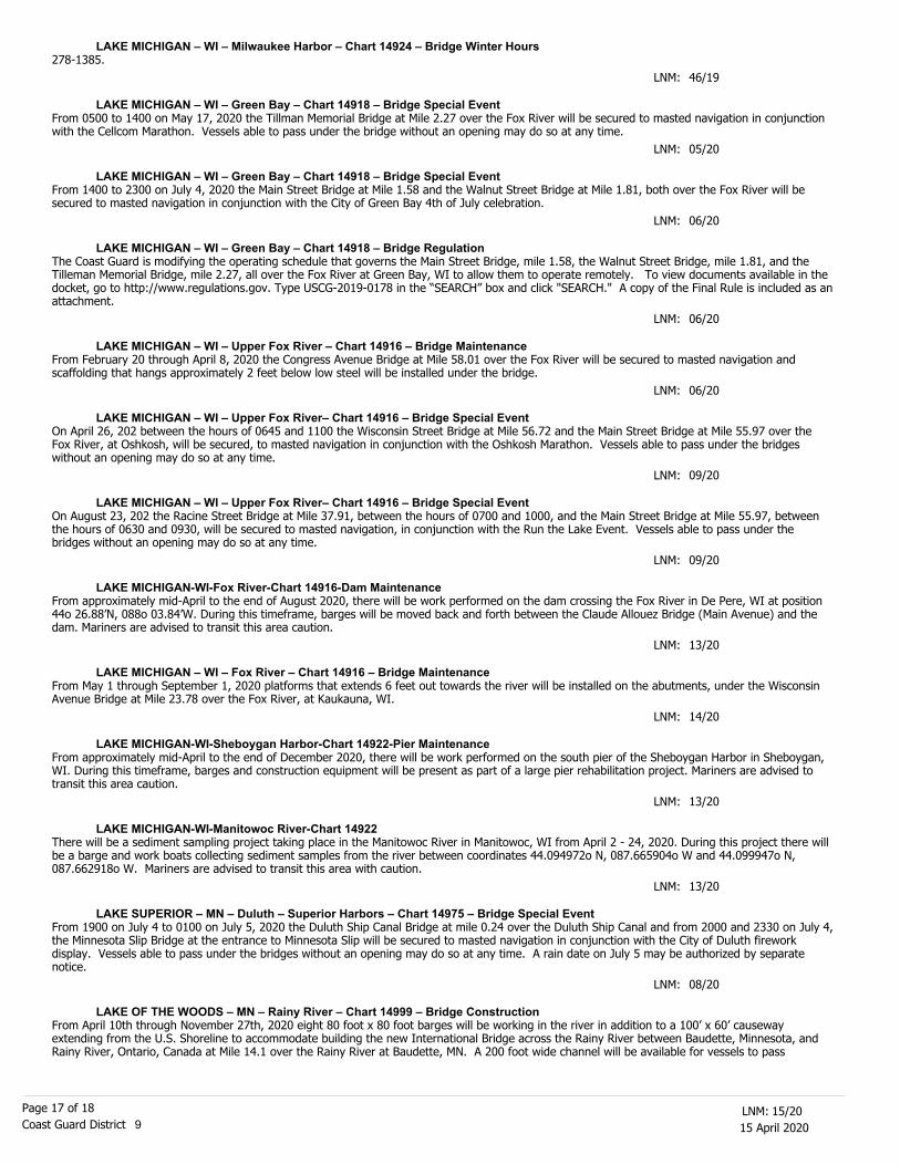
SECTION VIII - LIGHT LIST CORRECTIONSAn Asterisk *, indicates the column in which a correction has been made to new information
D. L. Cottrell, RDMLU. S. Coast Guard
Commander, Ninth Coast Guard District
(1)No.
(2)Name and Location
(3)Position
(4)Characteristic
(5)Height
(6)Range
(7)Structure
(8)Remarks
LAKE OF THE WOODS – MN – Rainy River – Chart 14999 – Bridge Construction
12647
12647.1
12648
12648.1
16695
16700
17919
East Enbridge Pipe 1
East Enbridge Pipe 2
West Enbridge Pipe 3
West Enbridge Pipe 4
Siskiwit Bay Passage Lighted Buoy 2
Siskiwit Bay Passage Buoy 3
NORTH POINT BUOY 13
45-49-26.940N
45-49-22.620N
45-48-12.600N
45-48-17.496N
47-53-52.419N
47-54-06.453N
45-20-45.126N
084-45-52.247W
084-45-25.650W
084-45-52.553W
084-46-18.163W
088-53-06.282W
088-53-18.297W
085-15-26.572W
Green can.
Green.
Fl R 2.5s
Q G
*
*
*
*
*
*
*
*
*
*
*
*
*
*
*
*
*
*
*
*
*
*
*
*
*
*
*
*
*
*
*
*
*
*
*
*
*
VAISPrivate Aid.
VAISPrivate Aid.
VAISPrivate Aid.
VAISPrivate Aid.
Maintained from Apr. 14 to Nov. 14.
15/20
15/20
15/20
15/20
15/20
15/20
15/20
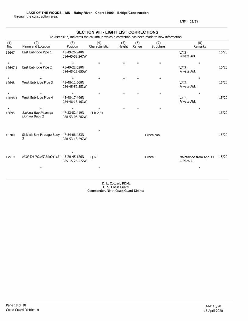
SUMMARY OF DREDGING/CONSTRUCTION OPERATIONS IN EFFECT
SECTOR BUFFALO
The LNM column is where the entry originally appeared. The dates listed are tentative
LOCATION LNM SUBJECT HOURS/DAYS FROM-TO POC Tel #
NEW YORK STATE BARGE CANAL
LAKE ONTARIO
LAKE ERIE
Cleveland, OH 08/20 Construction 0700-1700 3 Mar - 1 May 7 Days Randy Radel 216-210-1430
Rocky River, OH 13/20 Dredging 0700-1900 31 Mar - 20 May 7 Days Wayne Moon 419-276-1475
DREDGING
LNM 11/20
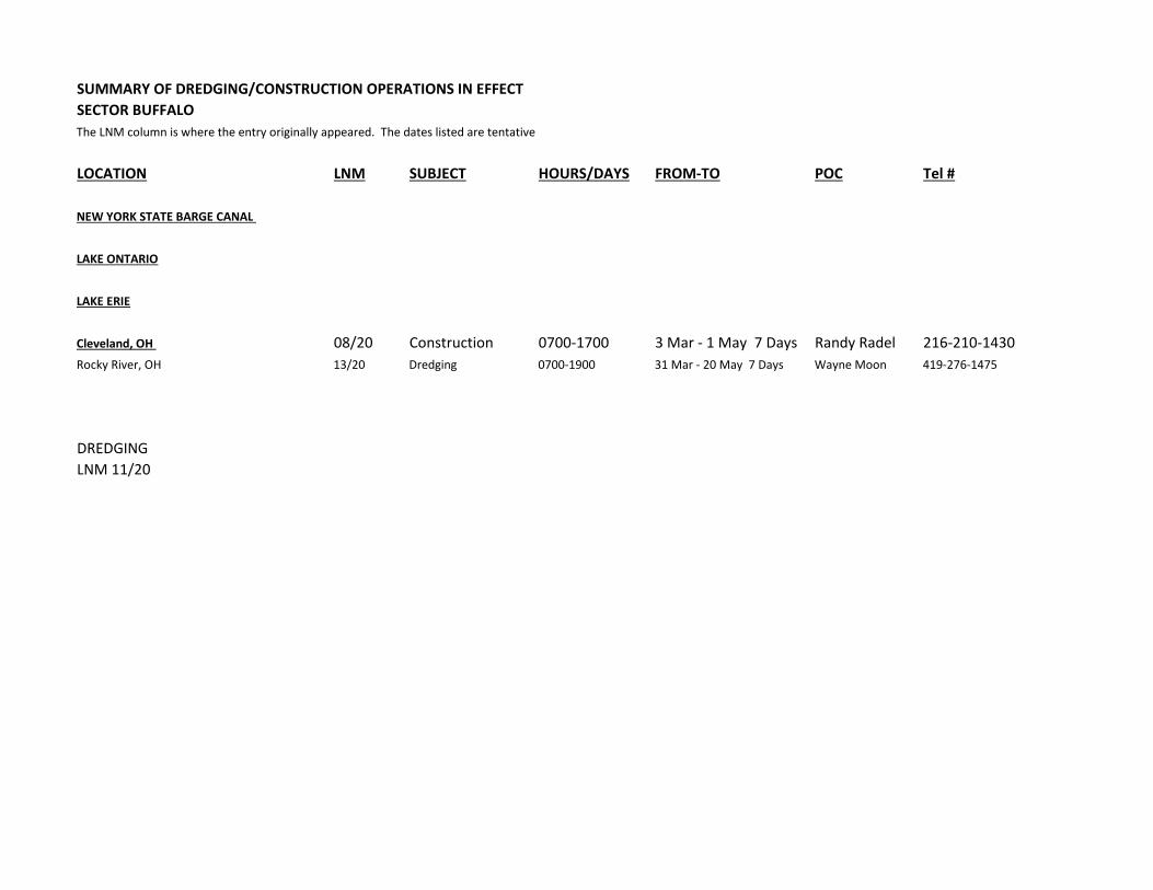
SUMMARY OF DREDGING/CONSTRUCTION OPERATIONS IN EFFECTSECTOR DETROITThe LNM column is where the entry originally appeared. The dates listed are tentative
LOCATION LNM SUBJECT HOURS/DAYS FROM-TO POC Tel #
LAKE ERIE
DETROIT RIVER
Pointe Mouille 11/20 Dredging 24 hrs 7 days 1 Apr- 31 May Ralph Farver 231-420-4352
LAKE ST. CLAIR
Lake Huron
STRAITS OF MACKINAC
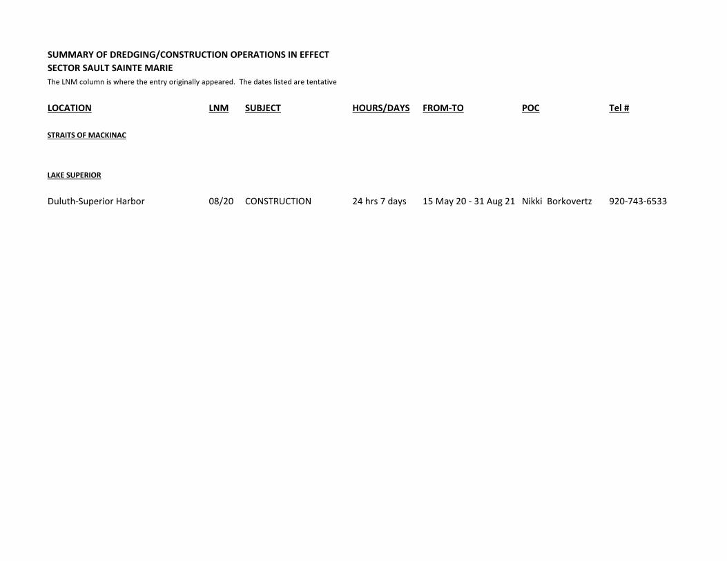
SUMMARY OF DREDGING/CONSTRUCTION OPERATIONS IN EFFECTSECTOR SAULT SAINTE MARIEThe LNM column is where the entry originally appeared. The dates listed are tentative
LOCATION LNM SUBJECT HOURS/DAYS FROM-TO POC Tel #
STRAITS OF MACKINAC
LAKE SUPERIOR
Duluth-Superior Harbor 08/20 CONSTRUCTION 24 hrs 7 days 15 May 20 - 31 Aug 21 Nikki Borkovertz 920-743-6533
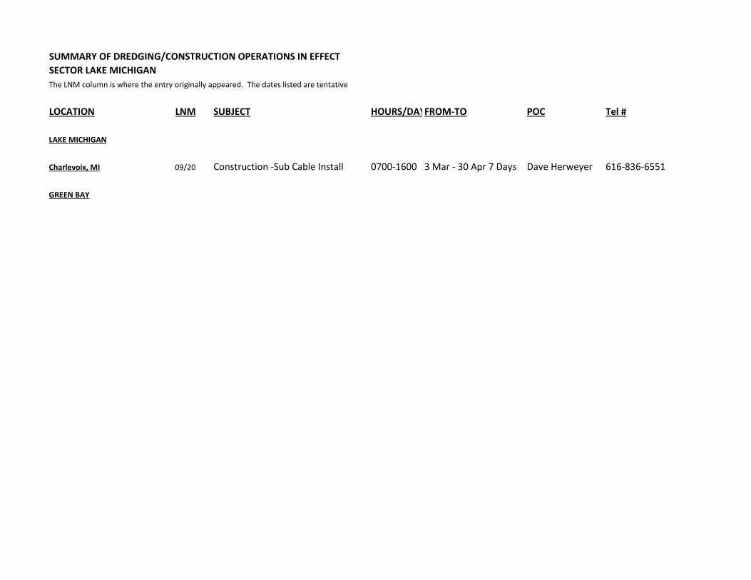
SUMMARY OF DREDGING/CONSTRUCTION OPERATIONS IN EFFECTSECTOR LAKE MICHIGANThe LNM column is where the entry originally appeared. The dates listed are tentative
LOCATION LNM SUBJECT HOURS/DAYFROM-TO POC Tel #
LAKE MICHIGAN
Charlevoix, MI 09/20 Construction -Sub Cable Install 0700-1600 3 Mar - 30 Apr 7 Days Dave Herweyer 616-836-6551
GREEN BAY
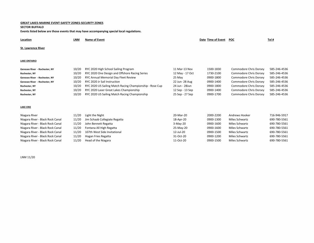
GREAT LAKES-MARINE EVENT-SAFETY ZONES-SECURITY ZONESSECTOR BUFFALOEvents listed below are those events that may have accompanying special local regulations.
Location LNM Name of Event Date Time of Event POC Tel #
St. Lawrence River
LAKE ONTARIO
Genesee River - Rochester, NY 10/20 RYC 2020 High School Sailing Program 11 Mar-13 Nov 1500-1830 Commodore Chris Dorsey 585-246-4536Rochester, NY 10/20 RYC 2020 One Design and Offshore Racing Series 12 May - 17 Oct 1730-2100 Commodore Chris Dorsey 585-246-4536Genesee River - Rochester, NY 10/20 RYC Annual Memorial Day Fleet Review 25 May 0900-1800 Commodore Chris Dorsey 585-246-4536Genesee River - Rochester, NY 10/20 RYC 2020 Jr Sail Instruction 22 Jun- 28 Aug 0900-1400 Commodore Chris Dorsey 585-246-4536Rochester, NY 10/20 RYC 2020 US Sailing Match Racing Championship - Rose Cup 24 Jun - 28Jun 0900-1800 Commodore Chris Dorsey 585-246-4536Rochester, NY 10/20 RYC 2020 Laser Great Lakes Championship 12 Sep - 13 Sep 0900-1400 Commodore Chris Dorsey 585-246-4536Rochester, NY 10/20 RYC 2020 US Sailing Match Racing Championship 25 Sep - 27 Sep 0900-1700 Commodore Chris Dorsey 585-246-4536
LAKE ERIE
Niagara River 11/20 Light the Night 20-Mar-20 2000-2200 Andrews Hooker 716-946-5917Niagara River - Black Rock Canal 11/20 Jim Schaab Collegiate Regatta 18-Apr-20 0900-1300 Miles Schwartz 690-780-5561Niagara River - Black Rock Canal 11/20 John Bennett Regatta 3-May-20 0900-1600 Miles Schwartz 690-780-5561Niagara River - Black Rock Canal 11/20 Fontana All High Regatta 25-May-20 0900-1600 Miles Schwartz 690-780-5561Niagara River - Black Rock Canal 11/20 107th West Side Invitational 12-Jul-20 0900-1500 Miles Schwartz 690-780-5561Niagara River - Black Rock Canal 11/20 Hogan Fries Regatta 31-Oct-20 0900-1200 Miles Schwartz 690-780-5561Niagara River - Black Rock Canal 11/20 Head of the Niagara 11-Oct-20 0900-1500 Miles Schwartz 690-780-5561
LNM 11/20
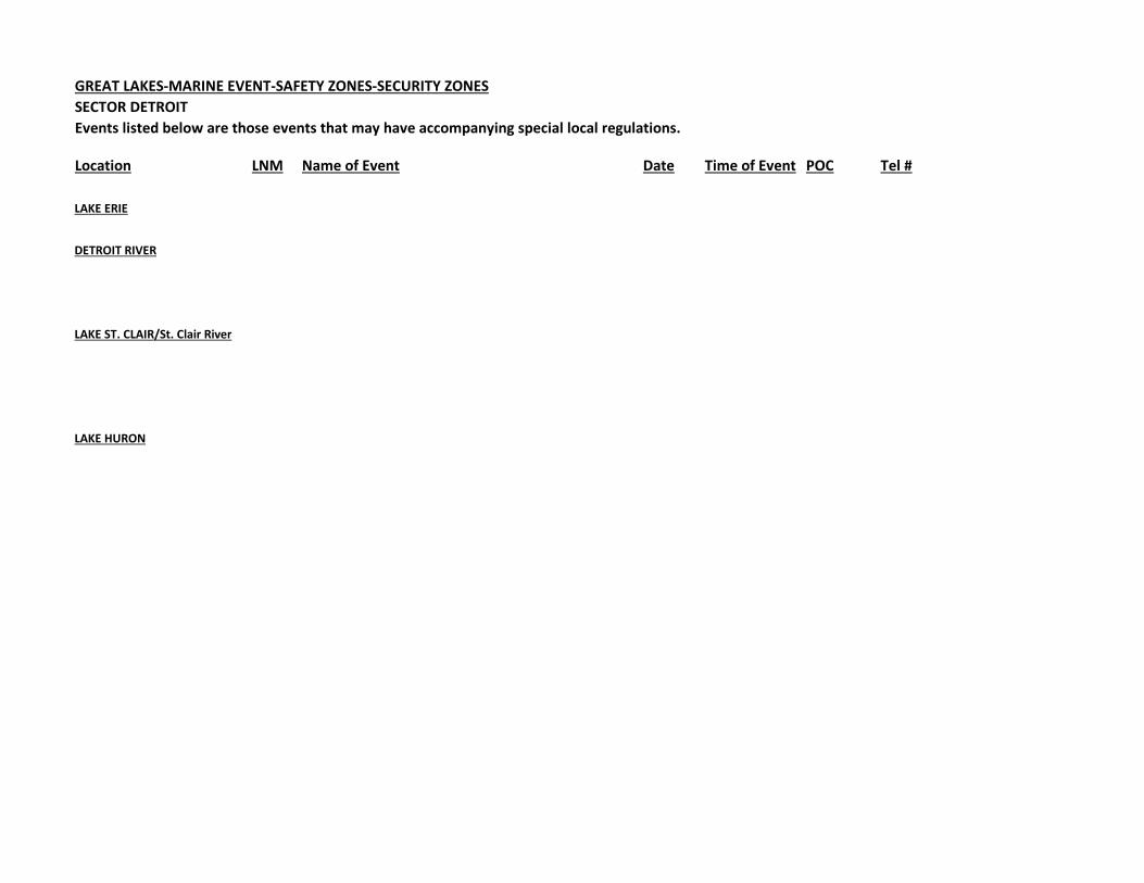
GREAT LAKES-MARINE EVENT-SAFETY ZONES-SECURITY ZONESSECTOR DETROITEvents listed below are those events that may have accompanying special local regulations.
Location LNM Name of Event Date Time of Event POC Tel #
LAKE ERIE
DETROIT RIVER
LAKE ST. CLAIR/St. Clair River
LAKE HURON
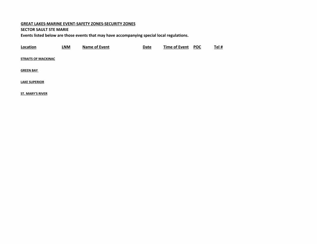
GREAT LAKES-MARINE EVENT-SAFETY ZONES-SECURITY ZONESSECTOR SAULT STE MARIEEvents listed below are those events that may have accompanying special local regulations.
Location LNM Name of Event Date Time of Event POC Tel #
STRAITS OF MACKINAC
GREEN BAY
LAKE SUPERIOR
ST. MARY'S RIVER
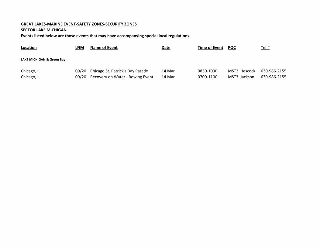
GREAT LAKES-MARINE EVENT-SAFETY ZONES-SECURITY ZONESSECTOR LAKE MICHIGANEvents listed below are those events that may have accompanying special local regulations.
Location LNM Name of Event Date Time of Event POC Tel #
LAKE MICHIGAN & Green Bay
Chicago, IL 09/20 Chicago St. Patrick's Day Parade 14 Mar 0830-1030 MST2 Hescock 630-986-2155Chicago, IL 09/20 Recovery on Water - Rowing Event 14 Mar 0700-1100 MST3 Jackson 630-986-2155

NOTICE TO MARINERS
Issued By:
CENTER FOR OPERATIONAL OCEANOGRAPHIC PRODUCTS & SERVICES
1305 East-West Highway, N/OPS3
Silver Spring, MD 20910-3281 301-713-2815
[email protected] <https://tidesandcurrents.noaa.gov>
NOAA is Discontinuing the Printed Tide Tables and Tidal Current Tables After 2020.
NOAA is ending the production of the printed Tide Tables and Tidal Current Tables publications. The 2020 Tide Tables and Tidal Current Tables, released for distribution and available as PDF files from https://tidesandcurrents.noaa.gov/historic_tide_tables.html, are the final printed editions. NOAA is discontinuing the production of these annual publications due to: (a) recent changes by the U.S. Coast Guard in the interpretation of the requirements for predictions, no longer requiring these publications in paper format and (b) the availability of online and electronic services providing tide and tidal current predictions which meet the U.S. Coast Guard requirements for navigation, and support other activities along the U.S. coast. Tide and Tidal Current predictions are available through NOAA’s Center for Operational Oceanographic Products and Services (CO-OPS) online services:
• NOAA Tide Predictions: https://tidesandcurrents.noaa.gov/tide_predictions.html • NOAA Current Predictions: https://tidesandcurrents.noaa.gov/noaacurrents/Regions
These online services provide predictions which equal or exceed the accuracy and availability of the predictions at domestic locations provided through printed publications, and provide additional capabilities allowing the predictions to better meet a variety of user needs. These online services provide predictions for the U.S. coasts. International predictions will not be available from the online services. Predictions for countries outside the U.S. may be obtained through the Oceanographic / Hydrographic agency in that country. Contact NOAA’s Center for Operational Oceanographic Products and Services (CO-OPS) with questions or for further information. E-mail: [email protected] Phone: 301-713-2815
Issued: March 16, 2020
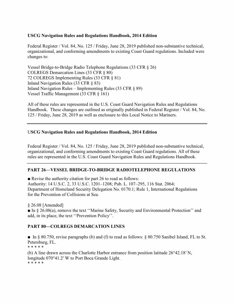
USCG Navigation Rules and Regulations Handbook, 2014 Edition Federal Register / Vol. 84, No. 125 / Friday, June 28, 2019 published non-substantive technical, organizational, and conforming amendments to existing Coast Guard regulations. Included were changes to: Vessel Bridge-to-Bridge Radio Telephone Regulations (33 CFR § 26) COLREGS Demarcation Lines (33 CFR § 80) 72 COLREGS Implementing Rules (33 CFR § 81) Inland Navigation Rules (33 CFR § 83) Inland Navigation Rules – Implementing Rules (33 CFR § 89) Vessel Traffic Management (33 CFR § 161) All of these rules are represented in the U.S. Coast Guard Navigation Rules and Regulations Handbook. These changes are outlined as originally published in Federal Register / Vol. 84, No. 125 / Friday, June 28, 2019 as well as enclosure to this Local Notice to Mariners. USCG Navigation Rules and Regulations Handbook, 2014 Edition
Federal Register / Vol. 84, No. 125 / Friday, June 28, 2019 published non-substantive technical, organizational, and conforming amendments to existing Coast Guard regulations. All of these rules are represented in the U.S. Coast Guard Navigation Rules and Regulations Handbook. PART 26—VESSEL BRIDGE-TO-BRIDGE RADIOTELEPHONE REGULATIONS ■ Revise the authority citation for part 26 to read as follows: Authority: 14 U.S.C. 2, 33 U.S.C. 1201–1208; Pub. L. 107–295, 116 Stat. 2064; Department of Homeland Security Delegation No. 0170.1; Rule 1, International Regulations for the Prevention of Collisions at Sea. § 26.08 [Amended] ■ In § 26.08(a), remove the text ‘‘Marine Safety, Security and Environmental Protection’’ and add, in its place, the text ‘‘Prevention Policy’’. PART 80—COLREGS DEMARCATION LINES ■ In § 80.750, revise paragraphs (b) and (f) to read as follows: § 80.750 Sanibel Island, FL to St. Petersburg, FL. * * * * * (b) A line drawn across the Charlotte Harbor entrance from position latitude 26°42.18′ N, longitude 070°41.2′ W to Port Boca Grande Light. * * * * *
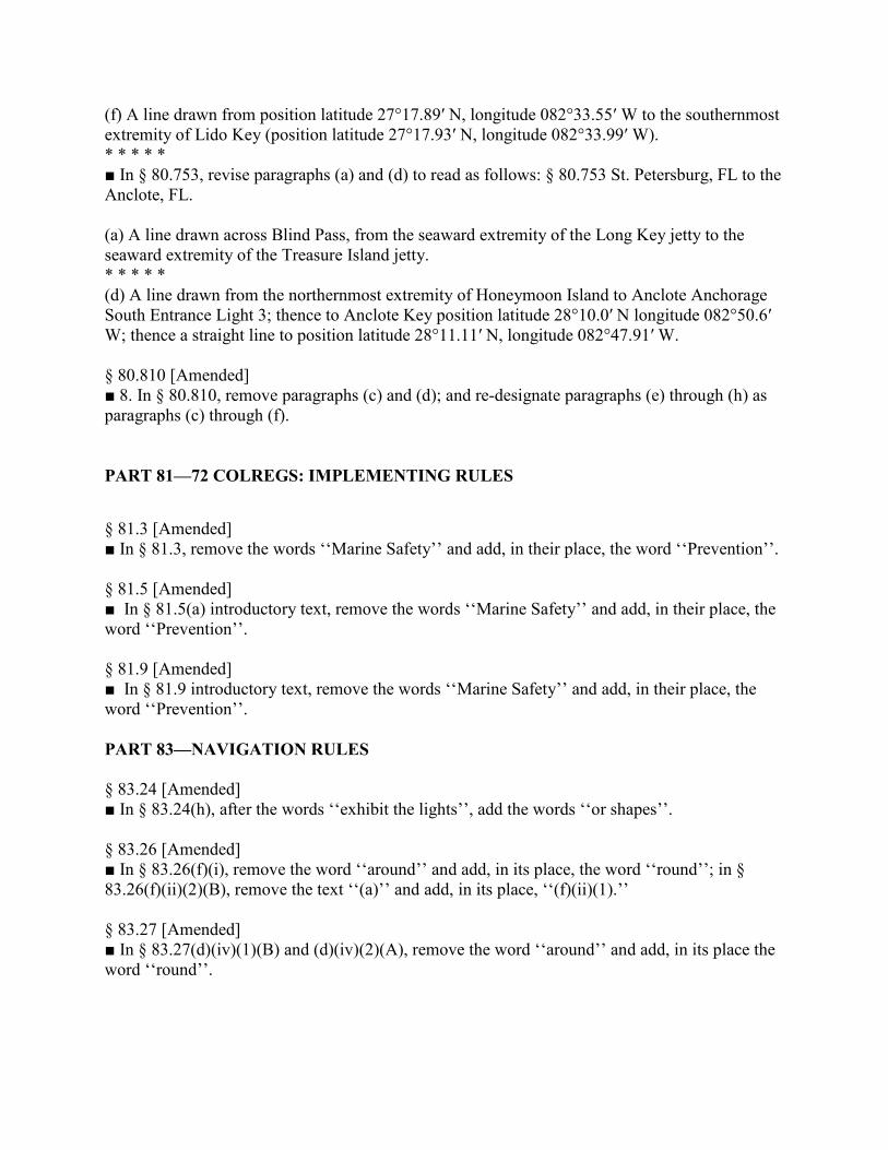
(f) A line drawn from position latitude 27°17.89′ N, longitude 082°33.55′ W to the southernmost extremity of Lido Key (position latitude 27°17.93′ N, longitude 082°33.99′ W). * * * * * ■ In § 80.753, revise paragraphs (a) and (d) to read as follows: § 80.753 St. Petersburg, FL to the Anclote, FL. (a) A line drawn across Blind Pass, from the seaward extremity of the Long Key jetty to the seaward extremity of the Treasure Island jetty. * * * * * (d) A line drawn from the northernmost extremity of Honeymoon Island to Anclote Anchorage South Entrance Light 3; thence to Anclote Key position latitude 28°10.0′ N longitude 082°50.6′ W; thence a straight line to position latitude 28°11.11′ N, longitude 082°47.91′ W. § 80.810 [Amended] ■ 8. In § 80.810, remove paragraphs (c) and (d); and re-designate paragraphs (e) through (h) as paragraphs (c) through (f). PART 81—72 COLREGS: IMPLEMENTING RULES
§ 81.3 [Amended] ■ In § 81.3, remove the words ‘‘Marine Safety’’ and add, in their place, the word ‘‘Prevention’’. § 81.5 [Amended] ■ In § 81.5(a) introductory text, remove the words ‘‘Marine Safety’’ and add, in their place, the word ‘‘Prevention’’. § 81.9 [Amended] ■ In § 81.9 introductory text, remove the words ‘‘Marine Safety’’ and add, in their place, the word ‘‘Prevention’’. PART 83—NAVIGATION RULES § 83.24 [Amended] ■ In § 83.24(h), after the words ‘‘exhibit the lights’’, add the words ‘‘or shapes’’. § 83.26 [Amended] ■ In § 83.26(f)(i), remove the word ‘‘around’’ and add, in its place, the word ‘‘round’’; in § 83.26(f)(ii)(2)(B), remove the text ‘‘(a)’’ and add, in its place, ‘‘(f)(ii)(1).’’ § 83.27 [Amended] ■ In § 83.27(d)(iv)(1)(B) and (d)(iv)(2)(A), remove the word ‘‘around’’ and add, in its place the word ‘‘round’’.
PART 89—INLAND NAVIGATION RULES: IMPLEMENTING RULES § 89.3 [Amended] ■ In § 89.3, remove the words ‘‘Marine Safety’’ and add, in their place, the word ‘‘Prevention’’. § 89.5 [Amended] ■ In § 89.5(a) introductory text, remove the words ‘‘Marine Safety’’ and add, in their place, the word ‘‘Prevention’’. § 89.9 [Amended] ■ In § 89.9 introductory text, remove the words ‘‘Marine Safety’’ and add, in their place, the word ‘‘Prevention’’. § 89.27 [Amended] ■ In the section heading to § 89.27 and paragraphs (a) and (b), remove the text ‘‘24(i)’’ and add, in its place, the text ‘‘24(j)’’. PART 161—VESSEL TRAFFIC MANAGEMENT § 161.2 [Amended] ■ Amend § 161.2 as follows: a. Remove the word ‘‘sector’’ wherever it appears, and add, in its place, the word ‘‘zone’’; b. Add definitions in alphabetical order for ‘‘Center’’ and ‘‘Published’’; c. In the definition of ‘‘Vessel Traffic Service Area or VTS Area’’, remove the word ‘‘sectors’’ and add, in its place, the word ‘‘zones’’; and d. In the introductory text of the definition of ‘‘VTS User’’, remove the word ‘‘area’’ and add, in its place, the word ‘‘Area’’. § 161.2 [Amended] ■ Amend § 161.2 Definitions - with additions to read as follows: * * * * * Center means a Vessel Traffic Center or Vessel Movement Center. * * * * * Published means available in a widely-distributed and publicly available medium (e.g., VTS User’s Manual, ferry schedule, Notice to Mariners). * * * * * Under VTS User Re-designate (a) – (b) as (1) – (2); add (3) Equipped with a required Coast Guard type-approved Automatic Identification System (AIS). § 161.4 Requirement to Carry the Rules. [Amended] ■ Re-designate the note at the end of the section as Note 1 to § 161.4 and revise it to read as follows: * * * * * Note 1 to § 161.4: These rules are contained in the applicable U.S. Coast Pilot, the VTS User’s Manual which may be obtained by contacting the appropriate VTS or downloaded from the Coast Guard Navigation Center website (https://www.navcen.uscg.gov).
§ 161.5 [Amended] ■ In § 161.5(b), remove the text ‘‘VTS Director’’ and add, in its place, the text ‘‘VTC’’. § 161.12 [Amended] ■ Amend § 161.12 in Table 1 to § 161.12(c) as follows: a. In entry (10)(ii) – Seattle Traffic, in the ‘‘Monitoring area’’ column, remove the words ‘‘Strait of Juan de Fuca’’ and add, in their place, the words ‘‘Salish Sea’’; b. In entry (12) – St. Marys River, remove the text ‘‘Mary’s’’ wherever it appears and add, in its place, the text ‘‘Marys’’; and c. In Note 6, remove the word ‘‘sector’’ and add, in its place, the word ‘‘zone’’. § 161.17 [Removed and Reserved] ■ Remove and reserve § 161.17. PART 161—VESSEL TRAFFIC MANAGEMENT (continued) § 161.55 [Amended] ■ Amend § 161.55 by revising paragraph (c)(3) to read as follows: § 161.55 Vessel Traffic Service Puget Sound and the Cooperative Vessel Traffic Service for the Juan de Fuca Region. * * * * * (c) * * * (3) A vessel of less than 100 meters in length is exempt from the provisions set forth in § 161.13(b)(3) of this part. * * * * * § 161.70 [Amended] ■ In entry 4 to the Table to § 161.70(d) and entry 3 to the Table to § 161.70(f), remove the word ‘‘Sector’’ and add, in its place, the word ‘‘Zone’’. Questions may be directed to the Office of Navigation Systems at [email protected] .
Waterway Analysis and Management System Survey Name of Waterway: _________________________________________ User Information ___Commercial User ___Recreational User Number of years in the maritime industry or number of years using this waterway: ____________________________________________________ Number of transits in the waterway per year: ________________________ Number of night transits of waterway: _____________________________ Seasonal Dates: Start: ______________End:____________________ Name of Vessel: ________________________________________________ Vessel Description: _____________________________________________ Length: ___________Beam:__________Draft:_________Gross Tons: _____ Net Tons: _________Bridge Height of Eye: ___________________________ Cargo Carried: _________________________________________________ Navigational tools used: (ECDIS/ECPINS, GPS, DGPS,VISUAL, RADAR)_____________________________________________________________________________________________________________________________________________________________________________________________________________________________________________ What area do you believe is the most dangerous or difficult to navigate:_____________________________________________________________________________________________________________________________________________________________________________________________________________________________________________ Are the floating aids to navigation (lighted and unlighted buoys) adequate for this waterway: _______________________________________________
_______________________________________________________________________________________________________________________________________________________________________________________ Are the fixed aids to navigation (lights, ranges, lighthouses, daybeacons) adequate for this waterway: _______________________________________ _______________________________________________________________________________________________________________________________________________________________________________________ Are the year round and lighted ice buoys adequate: ____________________ _______________________________________________________________________________________________________________________________________________________________________________________ Are there buoys that you feel should be changed to fixed aids to navigation? ____________________________________________________________________________________________________________________________________________________________________________________________________________________________________________________ Are there any buoys that could be eliminated from this waterway: ________ _______________________________________________________________________________________________________________________________________________________________________________________ Are there any buoys with sound signals that the bell or gong could be removed: ______________________________________________________ __________________________________________________________________________________________________________________________ Are there any areas that require additional aids to navigation in this waterway: _______________________________________________________________________________________________________________________________________________________________________________ Do the nautical charts, Coast Pilot, and Light List meet your needs for this waterway:__________________________________________________________________________________________________________________
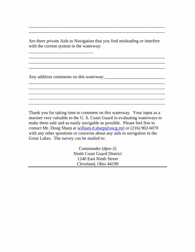
__________________________________________________________________________________________________________________________ Are there private Aids to Navigation that you find misleading or interfere with the current system in the waterway: _____________________________ _______________________________________________________________________________________________________________________________________________________________________________________ Any addition comments on this waterway:___________________________ _________________________________________________________________________________________________________________________________________________________________________________________________________________________________________________________________________________________________________________ Thank you for taking time to comment on this waterway. Your input as a mariner very valuable to the U. S. Coast Guard in evaluating waterways to make them safe and as easily navigable as possible. Please feel free to contact Mr. Doug Sharp at [email protected] or (216) 902-6070 with any other questions or concerns about any aids to navigation in the Great Lakes. The survey can be mailed to:
Commander (dpw-2) Ninth Coast Guard District
1240 East Ninth Street Cleveland, Ohio 44199
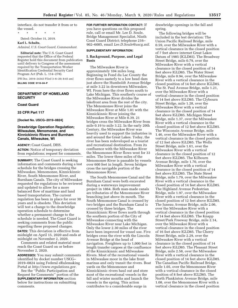
13517 Federal Register / Vol. 85, No. 46 / Monday, March 9, 2020 / Rules and Regulations
interface, do not transfer it from or to the vessel. * * * * *
Dated: October 31, 2019. Karl L. Schultz, Admiral, U.S. Coast Guard, Commandant.
Editorial note: The U.S. Coast Guard requested that the Office of the Federal Register hold this document from publication until delivery to Congress of the assessment required by the Transportation Worker Identification Credential Security Card Program Act (Pub. L. 114–278).
[FR Doc. 2019–24343 Filed 3–6–20; 8:45 am]
BILLING CODE 9110–04–P
DEPARTMENT OF HOMELAND SECURITY
Coast Guard
33 CFR Part 117
[Docket No. USCG–2019–0824]
Drawbridge Operation Regulation; Milwaukee, Menomonee, and Kinnickinnic Rivers and Burnham Canals, Milwaukee, WI
AGENCY: Coast Guard, DHS. ACTION: Notice of temporary deviation from regulations; request for comments.
SUMMARY: The Coast Guard is seeking information and comments during a test schedule for the bridges crossing the Milwaukee, Menomonee, Kinnickinnic River, South Menomonee River, and Burnham Canals. The city of Milwaukee requested the regulations to be reviewed and updated to allow for a more balanced flow of maritime and land based transportation. The current regulation has been in place for over 30 years and is obsolete. This deviation will test a change to the drawbridge operation schedule to determine whether a permanent change to the schedule is needed. The Coast Guard is seeking comments from the public regarding these proposed changes. DATES: This deviation is effective from midnight on April 15, 2020 and ends at midnight on November 2, 2020.
Comments and related material must reach the Coast Guard on or before November 2, 2020. ADDRESSES: You may submit comments identified by docket number USCG– 2019–0824 using Federal eRulemaking Portal at http://www.regulations.gov.
See the ‘‘Public Participation and Request for Comments’’ portion of the SUPPLEMENTARY INFORMATION section below for instructions on submitting comments.
FOR FURTHER INFORMATION CONTACT: If you have questions on this proposed rule, call or email Mr. Lee D. Soule, Bridge Management Specialist, Ninth Coast Guard District; telephone 216– 902–6085, email [email protected].
SUPPLEMENTARY INFORMATION:
I. Background, Purpose, and Legal Basis
The Milwaukee River is approximately 104 miles long. Beginning in Fond du Lac County the river flows easterly to a low head dam just above the Humboldt Avenue Bridge at mile 3.22 in downtown Milwaukee, WI. From here the river flows south to Lake Michigan. This southerly course of the Milwaukee River divides the lakefront area from the rest of the city. The Menomonee River joins the Milwaukee River at Mile 1.01 with the Kinnickinnic River joining the Milwaukee River at Mile 0.39. 21 bridges cross the Milwaukee River from mile 0.19 to mile 3.22. In the early 20th Century, the Milwaukee River was heavily used to support the industries in and around the Great Lakes. Today, the river has been redeveloped as a tourist and recreational destination. From its confluence with the Milwaukee River the Menomonee River flows west for 33 miles. The lower three miles of the Menomonee River is passable by vessels over 600 feet in length. Seven bridges cross the navigable portion of the Menomonee River.
The South Menomonee Canal and the Burnham Canal were both excavated during a waterways improvement project in 1864. Both man-made canals are tributaries of the Menomonee River branching just above its mouth. The South Menomonee Canal is crossed by two bridges and the Burnham Canal is crossed by three bridges. The Kinnickinnic River flows north through the southern portion of the City of Milwaukee connecting with the Milwaukee River near Lake Michigan. Only the lower 2.30 miles of the river have been improved for vessel use. Five bridges cross the river with the Lincoln Avenue Bridge at the head of navigation. Freighters up to 1,000 feet in length transfer cargoes at the confluence of the Kinnickinnic and Milwaukee Rivers. Most of the recreational vessels in Milwaukee moor in the lake front marinas and only transit the rivers. Boat yards on the Menomonee and Kinnickinnic rivers haul out and store most of the recreational vessels in the fall and winter months and launch the vessels in the spring. This action contributes to a considerable surge in
drawbridge openings in the fall and spring.
The following bridges will be included in the test deviation: The Union Pacific Railroad Bridge, mile 0.59, over the Milwaukee River with a vertical clearance in the closed position of 7 feet above internet Great Lakes Datum of 1985 (IGLD85). The Broadway Street Bridge, mile 0.79, over the Milwaukee River with a vertical clearance in the closed position of 14 feet above IGLD85. The Water Street Bridge, mile 0.94, over the Milwaukee River with a vertical clearance in the closed position of 14 feet above IGLD85. The St. Paul Avenue Bridge, mile 1.21, over the Milwaukee River with a vertical clearance in the closed position of 14 feet above IGLD85. The Clybourn Street Bridge, mile 1.28, over the Milwaukee River with a vertical clearance in the closed position of 14 feet above IGLD85. Michigan Street Bridge, mile 1.37, over the Milwaukee River with a vertical clearance in the closed position of 12 feet above IGLD85. The Wisconsin Avenue Bridge, mile 1.46, over the Milwaukee River with a vertical clearance in the closed position of 12 feet above IGLD85. The Wells Street Bridge, mile 1.61, over the Milwaukee River with a vertical clearance in the closed position of 12 feet above IGLD85. The Kilbourn Avenue Bridge, mile 1.70, over the Milwaukee River with a vertical clearance in the closed position of 14 feet above IGLD85. The State Street Bridge, mile 1.79, over the Milwaukee River with a vertical clearance in the closed position of 14 feet above IGLD85. The Highland Avenue Pedestrian Bridge, mile 1.97, over the Milwaukee River with a vertical clearance in the closed position of 12 feet above IGLD85. The Juneau Avenue Bridge, mile 2.06, over the Milwaukee River with a vertical clearance in the closed position of 14 feet above IGLD85. The Knapp Street/Park Freeway Bridge, mile 2.14, over the Milwaukee River with a vertical clearance in the closed position of 16 feet above IGLD85. The Cherry Street Bridge, mile 2.29, over the Milwaukee River with a vertical clearance in the closed position of 14 feet above IGLD85. The Pleasant Street Bridge, mile 2.58, over the Milwaukee River with a vertical clearance in the closed position of 14 feet above IGLD85. The Canadian Pacific Railroad Bridge, mile 1.05, over the Menomonee River with a vertical clearance in the closed position of 8 feet above IGLD85. The North Plankinton Avenue Bridge, mile 1.08, over the Menomonee River with a vertical clearance in the closed position
VerDate Sep<11>2014 16:34 Mar 06, 2020 Jkt 250001 PO 00000 Frm 00043 Fmt 4700 Sfmt 4700 E:\FR\FM\09MRR1.SGM 09MRR1jbel
l on
DS
KJL
SW
7X2P
RO
D w
ith R
ULE
S
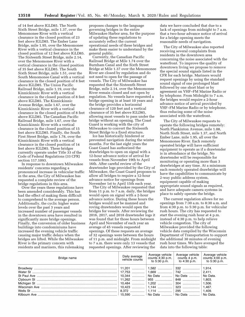
13518 Federal Register / Vol. 85, No. 46 / Monday, March 9, 2020 / Rules and Regulations
of 14 feet above IGLD85. The North Sixth Street Bridge, mile 1.37, over the Menomonee River with a vertical clearance in the closed position of 23 feet above IGLD85. The Ember Lane Bridge, mile 1.95, over the Menomonee River with a vertical clearance in the closed position of 12 feet above IGLD85. The Sixteenth Street Bridge, mile 2.14, over the Menomonee River with a vertical clearance in the closed position of 35 feet above IGLD85. The South Sixth Street Bridge, mile 1.51, over the South Menomonee Canal with a vertical clearance in the closed position of 8 feet above IGLD85. The Union Pacific Railroad Bridge, mile 1.19, over the Kinnickinnic River with a vertical clearance in the closed position of 8 feet above IGLD85. The Kinnickinnic Avenue Bridge, mile 1.67, over the Kinnickinnic River with a vertical clearance in the closed position of 8 feet above IGLD85. The Canadian Pacific Railroad Bridge, mile 1.67, over the Kinnickinnic River with a vertical clearance in the closed position of 15 feet above IGLD85. Finally, the South First Street Bridge, mile 1.78, over the Kinnickinnic River with a vertical clearance in the closed position of 14 feet above IGLD85. These bridges currently operate under Title 33 of the Code of Federal Regulations (33 CFR) section 117.1093.
In response to downtown Milwaukee residents’ concerns regarding a pronounced increase in vehicular traffic in the area, the City of Milwaukee has requested a complete review of the bridge regulations in this area.
Over the years these regulations have been amended considerably. This has had the effect of making them difficult to comprehend to the average person. Additionally, the cyclic higher water levels over the past 3 years and increased number of passenger vessels in the downtown area have resulted in significantly more bridge openings. Finally, the conversion of older business buildings into condominiums have increased the evening vehicle traffic causing major traffic delays when the bridges are lifted. While the Milwaukee River is the primary concern with residents and mariners, this rulemaking
proposes changes to the language governing bridges in the entire Milwaukee Harbor area, for the purpose of updating these regulations to accurately reflect the current operational needs of these bridges and make them easier to understand by the general public.
Currently, the Canadian Pacific Railroad Bridge at Mile 1.74 over the Burnham Canal and the Sixth Street Bridge at Mile 1.37 over the Menomonee River are closed by regulation and do not need to open for the passage of vessels. The City of Milwaukee has requested that the Sixteenth Street Bridge, mile 2.14, over the Menomonee River remain closed and not open by regulation. No vessels have requested a bridge opening in at least 10 years and the bridge provides a horizontal clearance of 120 feet and a vertical clearance of 35 feet above IGLD85, allowing most vessels to pass under the bridge without an opening. The Coast Guard is working with the city of Milwaukee to convert the Sixteenth Street Bridge to a fixed structure.
Ice has historically hindered or prevented navigation during the winter months. For the last eight years the Coast Guard has authorized the drawbridges to open on signal with a 12-hour advance notice of arrival for vessels from November 19th to April 16th. After careful review of the drawtender logs provided by the City of Milwaukee, the Coast Guard proposes to allow all bridges to require a 12-hour advance notice for openings from November 1st to April 15th each year.
The City of Milwaukee requested that from 11 p.m. to 7 a.m. daily, the bridges would open on signal with a 2-hour advance notice. During these hours the bridges would not be manned and roving drawtenders would open the bridges for vessels. After reviewing the 2016, 2017, and 2018 drawtender logs it was found that for those hours between April and November of each year an average of 45 vessels requested openings. Of these requests an average of 32 openings were between the hours of 11 p.m. and midnight. From midnight to 7 a.m. there were only 13 vessels that requested openings. After reviewing the
data we have concluded that due to a lack of openings from midnight to 7 a.m. that a two-hour advance notice of arrival for a bridge opening meets the reasonable needs of navigation.
The City of Milwaukee also reported receiving several complaints from residents in the downtown area concerning the noise associated with the waterfront. To improve the quality of downtown living we propose to remove the special sound signals listed in the CFR for each bridge. Mariners would request openings by using the standard sound signal of one prolonged blast followed by one short blast or by agreement on VHF–FM Marine Radio or by telephone. From Midnight to 7 a.m. the bridges would require a 2-hour advance notice of arrival provided by VHF–FM Marine Radio or by telephone, thus reducing some of the noise associated with the waterfront.
The City of Milwaukee requests to operate the following bridges remotely: North Plankinton Avenue, mile 1.08, North Sixth Street, mile 1.37, and North Ember Lane, mile 1.95, all over the Menomonee River. Each remotely operated bridge will have sufficient equipment to operate as if a drawtender is in attendance at the bridge. No drawtender will be responsible for monitoring or operating more than 3 drawbridges at any time. At a minimum each remotely operated drawbridge will have the capabilities to communicate by 2-way public address system, equipment capable of making appropriate sound signals as required, and have adequate camera systems in place to safely operate the bridge.
The current regulation allows for no openings from 7:30 a.m. to 8:30 a.m. and from 4:30 p.m. to 5:30 p.m. for vehicular rush hours. The city has requested to start the evening rush hour at 4 p.m. instead of 4:30 p.m. to help relieve vehicle congestion. The city of Milwaukee provided the following vehicle data compiled by the Wisconsin Department of Transportation to support the additional 30 minutes of evening rush hour times. We have averaged the data into the following table:
Bridge name Daily average vehicle counts
Average vehicle counts 4:30 p.m.
to 5:30 p.m.
Average vehicle counts 4 p.m. to 4:30 p.m.
Average vehicle counts 4:00 p.m.
to 5:30 p.m.
Broadway ............................................................................................. 11,201 .............. 1,582 ................ 332 ................... 1,914. Water St ............................................................................................... 17,753 .............. 1,669 ................ 742 ................... 2,411. St Paul Ave .......................................................................................... 10,344 .............. No Data ............ No Data ............ No Data. Clybourn St .......................................................................................... 11,262 .............. 955 ................... 848 ................... 1,803. Michigan St .......................................................................................... 10,484 .............. 1,202 ................ 304 ................... 1,506. Wisconsin Ave ..................................................................................... 10,423 .............. 1,144 ................ 323 ................... 1,467. Wells St ................................................................................................ 8,372 ................ 1,114 ................ 295 ................... 1,409. Kilbourn Ave ......................................................................................... 15,590 .............. No Data ............ No Data ............ No Data.
VerDate Sep<11>2014 16:34 Mar 06, 2020 Jkt 250001 PO 00000 Frm 00044 Fmt 4700 Sfmt 4700 E:\FR\FM\09MRR1.SGM 09MRR1jbel
l on
DS
KJL
SW
7X2P
RO
D w
ith R
ULE
S
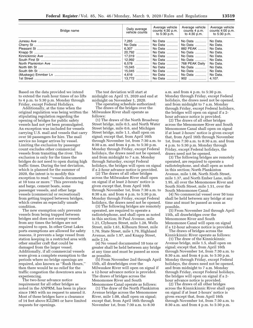
13519 Federal Register / Vol. 85, No. 46 / Monday, March 9, 2020 / Rules and Regulations
Bridge name Daily average vehicle counts
Average vehicle counts 4:30 p.m.
to 5:30 p.m.
Average vehicle counts 4 p.m. to 4:30 p.m.
Average vehicle counts 4:00 p.m.
to 5:30 p.m.
Juneau Ave .......................................................................................... 7,265 ................ No Data ............ No Data ............ No Data. Cherry St .............................................................................................. No Data ............ No Data ............ No Data ............ No Data. Pleasant St ........................................................................................... 6,307 ................ No Data ............ 882 PEAK ......... No Data. Knapp St .............................................................................................. 20,792 .............. No Data ............ No Data ............ No Data. Kinnickinnic Ave ................................................................................... 17,019 .............. No Data ............ No Data ............ No Data. South First St ....................................................................................... 12,992 .............. No Data ............ No Data ............ No Data. North Plankinton Ave ........................................................................... 6,578 ................ No Data ............ 768 PEAK Daily No Data. North 6th St .......................................................................................... 15,045 .............. No Data ............ No Data ............ No Data. South 6th St ......................................................................................... 15,045 .............. No Data ............ No Data ............ No Data. (Muskego) Emmber Ln ........................................................................ 4,616 ................ No Data ............ No Data ............ No Data. 1st Street .............................................................................................. 13,772 .............. No Data ............ 902 ................... 4,107.
Based on the data provided we intend to extend the rush hour times of no lifts to 4 p.m. to 5:30 p.m. Monday through Friday, except Federal Holidays.
Additionally, at the time when the original regulation was being written the stipulating regulation regarding the opening of bridges for public safety vessels had not yet been promulgated. An exception was included for vessels carrying U.S. mail and vessels that carry over 50 passengers for hire. The mail service no longer arrives by vessel. Limiting the exclusion by passenger count excludes other commercial vessels from transiting the river. This exclusion is only for the times the bridges do not need to open during high traffic times. During the test deviation, which is planned for the summer of 2020, the intent is to modify this exception to read: ‘‘vessels documented at 10 tons or more.’’ This prevents tug and barge, cement boats, some passenger vessels, and other large vessels (commercial or recreational) from getting trapped between bridges, which creates an especially unsafe condition.
The new exemption only prevents vessels from being trapped between bridges and does not exempt vessels from any times the bridges are not required to open. In other Great Lakes ports exemptions are allowed for safety reasons, it prevents a large vessel from station keeping in a restricted area with other smaller craft that could be damaged from the larger vessel. Additionally, if all commercial vessels were given a complete exemption to the periods where no bridge openings are required, also known as ‘‘Rush Hours,’’ then there would be no relief for the traffic congestion the downtown area is experiencing.
The two-hour advance notice requirement for all other bridges as noted in the ANPRM, has been in place since 1965 with no request to amend it. Most of these bridges have a clearance of 14 feet above IGLD85 or have limited requests for openings.
The test deviation will start at midnight on April 15, 2020 and end at midnight on November 1, 2020.
The operating schedule authorized: The draws of the bridges over the
Milwaukee River shall operate as follows:
(1) The draws of the North Broadway Street bridge, mile 0.5, and North Water Street bridge, mile 0.6, and Michigan Street bridge, mile 1.1, shall open on signal; except that, from April 16th through November 1st, from 7:30 a.m. to 8:30 a.m. and from 4 p.m. to 5:30 p.m. Monday through Friday, except Federal holidays, the draws need not be opened, and from midnight to 7 a.m. Monday through Saturday, except Federal holidays, the bridges will open on signal if a 2-hour advance notice is provided.
(2) The draws of all other bridges across the Milwaukee River shall open on signal if at least 2-hours’ notice is given except that, from April 16th through November 1st, from 7:30 a.m. to 8:30 a.m. and from 4 p.m. to 5:30 p.m. Monday through Friday, except Federal holidays, the draws need not be opened.
(3) The following bridges are remotely operated, are required to operate a radiotelephone, and shall open as noted in this section; St Paul Avenue, mile 1.21, Clybourn Street, mile 1.28, Wells Street, mile 1.61, Kilbourn Street, mile 1.70, State Street, mile 1.79, Highland Avenue, mile 1.97, and Knapp Street, mile 2.14.
(4) No vessel documented 10 tons or greater shall be held between any bridge at any time and must be passed as soon as possible.
(5) From November 2nd through April 15th, all drawbridges over the Milwaukee River will open on signal if a 12-hour advance notice is provided. The draws of bridges across the Menomonee River and South Menomonee Canal operate as follows:
(1) The draw of the North Plankinton Avenue bridge across the Menomonee River, mile 1.08, shall open on signal; except that, from April 16th through November 1st, from 7:30 a.m. to 8:30
a.m. and from 4 p.m. to 5:30 p.m. Monday through Friday, except Federal holidays, the draws need not be opened, and from midnight to 7 a.m. Monday through Friday, except Federal holidays, the bridges will open on signal if a 2- hour advance notice is provided.
(2) The draws of all other bridges across the Menomonee River and South Menomonee Canal shall open on signal if at least 2-hours’ notice is given except that, from April 16th through November 1st, from 7:30 a.m. to 8:30 a.m. and from 4 p.m. to 5:30 p.m. Monday through Friday, except Federal holidays, the draws need not be opened.
(3) The following bridges are remotely operated, are required to operate a radiotelephone, and shall open as noted in this section; North Plankinton Avenue, mile 1.08, North Sixth Street, mile 1.37, and North Ember Lane, mile 1.95, all over the Menomonee River and South Sixth Street, mile 1.51, over the South Menomonee Canal.
(4) No commercial vessel over 50 tons shall be held between any bridge at any time and must be passed as soon as possible.
(5) From November 2nd through April 15th, all drawbridges over the Menomonee River and South Menomonee Canal will open on signal if a 12-hour advance notice is provided.
The draws of bridges across the Kinnickinnic River operate as follows:
(1) The draw of the Kinnickinnic Avenue bridge, mile 1.5, shall open on signal; except that, from April 16th through November 1st, from 7:30 a.m. to 8:30 a.m. and from 4 p.m. to 5:30 p.m. Monday through Friday, except Federal holidays, the draws need not be opened, and from midnight to 7 a.m. Monday through Friday, except Federal holidays, the bridges will open on signal if a 2- hour advance notice is provided.
(2) The draws of all other bridges across the Kinnickinnic River shall open on signal if at least 2-hours’ notice is given except that, from April 16th through November 1st, from 7:30 a.m. to 8:30 a.m. and from 4 p.m. to 5:30 p.m.
VerDate Sep<11>2014 16:34 Mar 06, 2020 Jkt 250001 PO 00000 Frm 00045 Fmt 4700 Sfmt 4700 E:\FR\FM\09MRR1.SGM 09MRR1jbel
l on
DS
KJL
SW
7X2P
RO
D w
ith R
ULE
S
13520 Federal Register / Vol. 85, No. 46 / Monday, March 9, 2020 / Rules and Regulations
Monday through Friday, except Federal holidays, the draws need not be opened.
(3) The following bridges are remotely operated, are required to operate a radiotelephone, and shall open as noted in this section; The South First Street Bridge, mile 1.78.
(4) No commercial vessel over 50 tons shall be held between any bridge at any time and must be passed as soon as possible.
(5) From November 2nd through April 15th, all drawbridges over the Kinnickinnic River will open on signal if a 12-hour advance notice is provided.
The Canadian Pacific Railroad Bridge at Mile 1.74 over the Burnham Canal, and the Sixteenth Street Bridge, mile 2.14, over the Menomonee River are closed by regulation and do not need to open for the passage of vessels.
During non-special event weekdays the owners of all affected bridges will provide records showing the dates and times of bridge openings and the type of vessels the bridge opened for. The city of Milwaukee will also provide information on the vehicle congestion caused or improved by the temporary deviation by providing the number of vehicles waiting for the bridge to close after a vessel passes.
Because we took into consideration the comments from the ANPRM, vehicle counts, and past three years of vehicle counts, we believe the test deviation will have a limited impact on vessels.
The city of Milwaukee held public discussions about the potential rule change through public works meetings conducted throughout the summer of 2018. Prior to asking for our review, this office reached out to several commercial vessels which operate on the affected waterways prior to the release of the ANPRM. These actions were aimed at developing a test deviation that took all pertinent comments and concerns under consideration.
Vessels that can safely pass under the bridge without an opening may do so at any time. The Coast Guard will also inform the users of the waterways of the change in operating schedule for the bridges through our Local and Broadcast Notices to Mariners.
In accordance with 33 CFR 117.35(e), the drawbridge must return to its regular operating schedule immediately at the end of the effective period of this temporary deviation. This deviation from the operating regulations is authorized under 33 CFR 117.35.
II. Public Participation and Request for Comments
We view public participation as essential to effective rulemaking, and will consider all comments and material
received during the comment period. Your comment can help shape the outcome of this rulemaking. Should you submit a comment, please include the docket number for this rulemaking, indicate the specific section of this document to which each comment applies, and provide a reason for each suggestion or recommendation.
We encourage you to submit comments through the Federal eRulemaking Portal at http://www.regulations.gov. If your material cannot be submitted using http://www.regulations.gov, contact the person in the FOR FURTHER INFORMATION CONTACT section of this document for alternate instructions.
We accept anonymous comments. All comments received will be posted without change to http://www.regulations.gov and will include any personal information you have provided. Documents mentioned in this NPRM as being available in this docket and all public comments, will be in our online docket at http://www.regulations.gov, and can be viewed by following that website’s instructions. Additionally, if you go to the online docket and sign up for email alerts, you will be notified when comments are posted or a final rule is published.
Dated: February 25, 2020. D. L. Cottrell, Rear Admiral, U.S. Coast Guard, Commander, Ninth Coast Guard District. [FR Doc. 2020–04659 Filed 3–6–20; 8:45 am]
BILLING CODE 9110–04–P
DEPARTMENT OF HOMELAND SECURITY
Coast Guard
33 CFR Part 165
[Docket No. USCG–2020–0105]
Safety Zone; New Orleans, LA
AGENCY: Coast Guard, DHS. ACTION: Notice of enforcement of regulation.
SUMMARY: The Coast Guard will enforce a temporary safety zone between mile marker (MM) 95.7 and MM 96.7 above Head of Passes, Lower Mississippi River, LA. This action is necessary to provide for the safety of life on these navigable waters near New Orleans, LA, during a fireworks display on March 18, 2020. During the enforcement periods, the operator of any vessel in the regulated area must comply with directions from the Patrol Commander or any Official Patrol displaying a Coast Guard ensign.
DATES: The regulations in 33 CFR 165.845 will be enforced from 9 p.m. to 10 p.m. on March 18, 2020. FOR FURTHER INFORMATION CONTACT: If you have questions about this notice of enforcement, call or email Lieutenant Commander Corinne Plummer, Sector New Orleans, U.S. Coast Guard; telephone 504–365–2375, email [email protected]. SUPPLEMENTARY INFORMATION: The Coast Guard will enforce the safety zone located in 33 CFR 165.845 for the River Center Fireworks Display event. The regulations will be enforced from 9:00 p.m. through 10:00 p.m. on March 18, 2020. This action is being taken to provide for the safety of life on navigable waterways during this event, which will be located between MM 95.7 and MM 96.7 above Head of Passes, Lower Mississippi River, LA. During the enforcement periods, if you are the operator of a vessel in the regulated area you must comply with directions from the Patrol Commander or any Official Patrol displaying a Coast Guard Ensign.
In addition to this notice of enforcement in the Federal Register, the Coast Guard plans to provide notification of this enforcement period via a Marine Safety Information Bulletin and Broadcast Notice to Mariners.
Dated: March 2, 2020. K.M. Luttrell, Captain, U.S. Coast Guard, Captain of the Port Sector New Orleans. [FR Doc. 2020–04664 Filed 3–6–20; 8:45 am]
BILLING CODE 9110–04–P
DEPARTMENT OF HOMELAND SECURITY
Coast Guard
33 CFR 165
[Docket Number USCG–2016–1067]
RIN 1625–AA00
Safety Zone; Hurricanes, Tropical Storms and Other Disasters in South Florida
AGENCY: Coast Guard, DHS. ACTION: Final rule.
SUMMARY: The Coast Guard will establish a safety zone that would restrict certain vessels from entering or transiting through certain navigable waters in the Miami River and Ports of Miami, Everglades, Palm Beach and Fort Pierce during periods of reduced or restricted visibility due to tropical storm force winds (39–73 mph/34–63 knots), hurricanes and/or other disasters. This action is necessary for the safety of life
VerDate Sep<11>2014 16:34 Mar 06, 2020 Jkt 250001 PO 00000 Frm 00046 Fmt 4700 Sfmt 4700 E:\FR\FM\09MRR1.SGM 09MRR1jbel
l on
DS
KJL
SW
7X2P
RO
D w
ith R
ULE
S
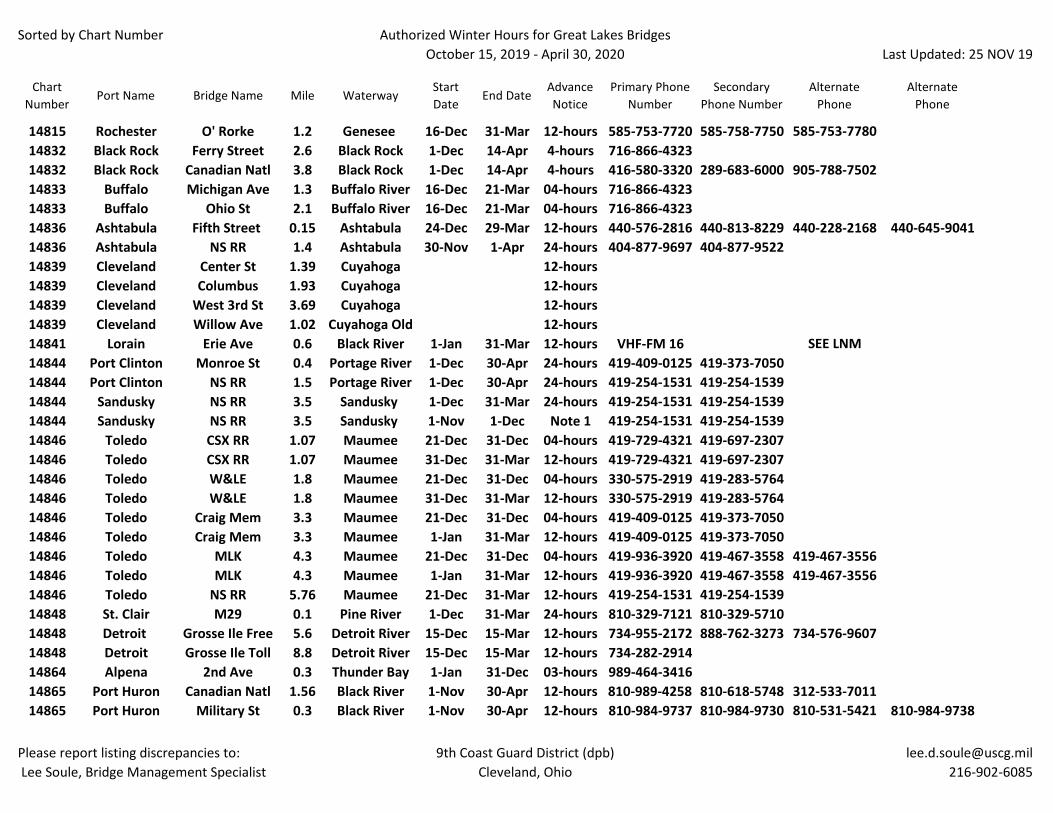
Sorted by Chart Number Authorized Winter Hours for Great Lakes BridgesOctober 15, 2019 - April 30, 2020
Last Updated: 25 NOV 19
Please report listing discrepancies to: Lee Soule, Bridge Management Specialist
9th Coast Guard District (dpb)Cleveland, Ohio
Chart Number
Port Name Bridge Name Mile WaterwayStart Date
End DateAdvance Notice
Primary Phone Number
Secondary Phone Number
Alternate Phone
Alternate Phone
14815 Rochester O' Rorke 1.2 Genesee 16-Dec 31-Mar 12-hours 585-753-7720 585-758-7750 585-753-778014832 Black Rock Ferry Street 2.6 Black Rock 1-Dec 14-Apr 4-hours 716-866-432314832 Black Rock Canadian Natl 3.8 Black Rock 1-Dec 14-Apr 4-hours 416-580-3320 289-683-6000 905-788-750214833 Buffalo Michigan Ave 1.3 Buffalo River 16-Dec 21-Mar 04-hours 716-866-432314833 Buffalo Ohio St 2.1 Buffalo River 16-Dec 21-Mar 04-hours 716-866-432314836 Ashtabula Fifth Street 0.15 Ashtabula 24-Dec 29-Mar 12-hours 440-576-2816 440-813-8229 440-228-2168 440-645-904114836 Ashtabula NS RR 1.4 Ashtabula 30-Nov 1-Apr 24-hours 404-877-9697 404-877-952214839 Cleveland Center St 1.39 Cuyahoga 12-hours14839 Cleveland Columbus 1.93 Cuyahoga 12-hours14839 Cleveland West 3rd St 3.69 Cuyahoga 12-hours14839 Cleveland Willow Ave 1.02 Cuyahoga Old 12-hours14841 Lorain Erie Ave 0.6 Black River 1-Jan 31-Mar 12-hours VHF-FM 16 SEE LNM14844 Port Clinton Monroe St 0.4 Portage River 1-Dec 30-Apr 24-hours 419-409-0125 419-373-705014844 Port Clinton NS RR 1.5 Portage River 1-Dec 30-Apr 24-hours 419-254-1531 419-254-153914844 Sandusky NS RR 3.5 Sandusky 1-Dec 31-Mar 24-hours 419-254-1531 419-254-153914844 Sandusky NS RR 3.5 Sandusky 1-Nov 1-Dec Note 1 419-254-1531 419-254-153914846 Toledo CSX RR 1.07 Maumee 21-Dec 31-Dec 04-hours 419-729-4321 419-697-230714846 Toledo CSX RR 1.07 Maumee 31-Dec 31-Mar 12-hours 419-729-4321 419-697-230714846 Toledo W&LE 1.8 Maumee 21-Dec 31-Dec 04-hours 330-575-2919 419-283-576414846 Toledo W&LE 1.8 Maumee 31-Dec 31-Mar 12-hours 330-575-2919 419-283-576414846 Toledo Craig Mem 3.3 Maumee 21-Dec 31-Dec 04-hours 419-409-0125 419-373-705014846 Toledo Craig Mem 3.3 Maumee 1-Jan 31-Mar 12-hours 419-409-0125 419-373-705014846 Toledo MLK 4.3 Maumee 21-Dec 31-Dec 04-hours 419-936-3920 419-467-3558 419-467-355614846 Toledo MLK 4.3 Maumee 1-Jan 31-Mar 12-hours 419-936-3920 419-467-3558 419-467-355614846 Toledo NS RR 5.76 Maumee 21-Dec 31-Mar 12-hours 419-254-1531 419-254-153914848 St. Clair M29 0.1 Pine River 1-Dec 31-Mar 24-hours 810-329-7121 810-329-571014848 Detroit Grosse Ile Free 5.6 Detroit River 15-Dec 15-Mar 12-hours 734-955-2172 888-762-3273 734-576-960714848 Detroit Grosse Ile Toll 8.8 Detroit River 15-Dec 15-Mar 12-hours 734-282-291414864 Alpena 2nd Ave 0.3 Thunder Bay 1-Jan 31-Dec 03-hours 989-464-341614865 Port Huron Canadian Natl 1.56 Black River 1-Nov 30-Apr 12-hours 810-989-4258 810-618-5748 312-533-701114865 Port Huron Military St 0.3 Black River 1-Nov 30-Apr 12-hours 810-984-9737 810-984-9730 810-531-5421 810-984-9738
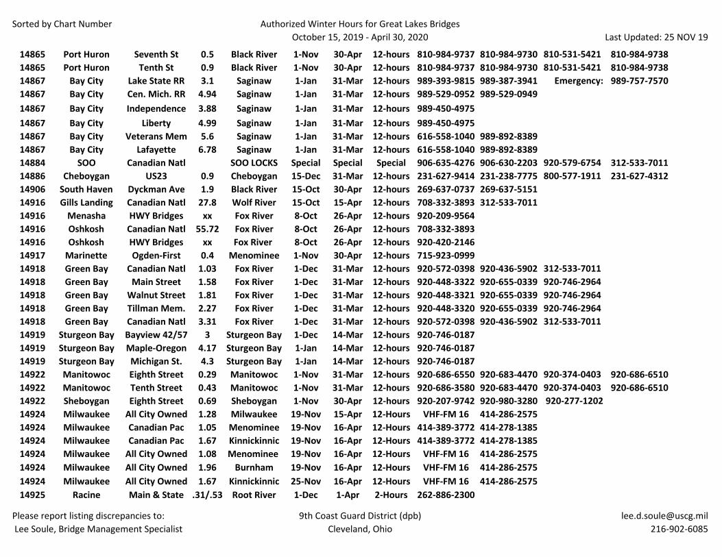
Sorted by Chart Number Authorized Winter Hours for Great Lakes BridgesOctober 15, 2019 - April 30, 2020
Last Updated: 25 NOV 19
Please report listing discrepancies to: Lee Soule, Bridge Management Specialist
9th Coast Guard District (dpb)Cleveland, Ohio
14865 Port Huron Seventh St 0.5 Black River 1-Nov 30-Apr 12-hours 810-984-9737 810-984-9730 810-531-5421 810-984-973814865 Port Huron Tenth St 0.9 Black River 1-Nov 30-Apr 12-hours 810-984-9737 810-984-9730 810-531-5421 810-984-973814867 Bay City Lake State RR 3.1 Saginaw 1-Jan 31-Mar 12-hours 989-393-9815 989-387-3941 Emergency: 989-757-757014867 Bay City Cen. Mich. RR 4.94 Saginaw 1-Jan 31-Mar 12-hours 989-529-0952 989-529-094914867 Bay City Independence 3.88 Saginaw 1-Jan 31-Mar 12-hours 989-450-497514867 Bay City Liberty 4.99 Saginaw 1-Jan 31-Mar 12-hours 989-450-497514867 Bay City Veterans Mem 5.6 Saginaw 1-Jan 31-Mar 12-hours 616-558-1040 989-892-838914867 Bay City Lafayette 6.78 Saginaw 1-Jan 31-Mar 12-hours 616-558-1040 989-892-838914884 SOO Canadian Natl SOO LOCKS Special Special Special 906-635-4276 906-630-2203 920-579-6754 312-533-701114886 Cheboygan US23 0.9 Cheboygan 15-Dec 31-Mar 12-hours 231-627-9414 231-238-7775 800-577-1911 231-627-431214906 South Haven Dyckman Ave 1.9 Black River 15-Oct 30-Apr 12-hours 269-637-0737 269-637-515114916 Gills Landing Canadian Natl 27.8 Wolf River 15-Oct 15-Apr 12-hours 708-332-3893 312-533-701114916 Menasha HWY Bridges xx Fox River 8-Oct 26-Apr 12-hours 920-209-956414916 Oshkosh Canadian Natl 55.72 Fox River 8-Oct 26-Apr 12-hours 708-332-389314916 Oshkosh HWY Bridges xx Fox River 8-Oct 26-Apr 12-hours 920-420-214614917 Marinette Ogden-First 0.4 Menominee 1-Nov 30-Apr 12-hours 715-923-099914918 Green Bay Canadian Natl 1.03 Fox River 1-Dec 31-Mar 12-hours 920-572-0398 920-436-5902 312-533-701114918 Green Bay Main Street 1.58 Fox River 1-Dec 31-Mar 12-hours 920-448-3322 920-655-0339 920-746-296414918 Green Bay Walnut Street 1.81 Fox River 1-Dec 31-Mar 12-hours 920-448-3321 920-655-0339 920-746-296414918 Green Bay Tillman Mem. 2.27 Fox River 1-Dec 31-Mar 12-hours 920-448-3320 920-655-0339 920-746-296414918 Green Bay Canadian Natl 3.31 Fox River 1-Dec 31-Mar 12-hours 920-572-0398 920-436-5902 312-533-701114919 Sturgeon Bay Bayview 42/57 3 Sturgeon Bay 1-Dec 14-Mar 12-hours 920-746-018714919 Sturgeon Bay Maple-Oregon 4.17 Sturgeon Bay 1-Jan 14-Mar 12-hours 920-746-018714919 Sturgeon Bay Michigan St. 4.3 Sturgeon Bay 1-Jan 14-Mar 12-hours 920-746-018714922 Manitowoc Eighth Street 0.29 Manitowoc 1-Nov 31-Mar 12-hours 920-686-6550 920-683-4470 920-374-0403 920-686-651014922 Manitowoc Tenth Street 0.43 Manitowoc 1-Nov 31-Mar 12-hours 920-686-3580 920-683-4470 920-374-0403 920-686-651014922 Sheboygan Eighth Street 0.69 Sheboygan 1-Nov 30-Apr 12-hours 920-207-9742 920-980-3280 920-277-120214924 Milwaukee All City Owned 1.28 Milwaukee 19-Nov 15-Apr 12-Hours VHF-FM 16 414-286-257514924 Milwaukee Canadian Pac 1.05 Menominee 19-Nov 16-Apr 12-Hours 414-389-3772 414-278-138514924 Milwaukee Canadian Pac 1.67 Kinnickinnic 19-Nov 16-Apr 12-Hours 414-389-3772 414-278-138514924 Milwaukee All City Owned 1.08 Menominee 19-Nov 16-Apr 12-Hours VHF-FM 16 414-286-257514924 Milwaukee All City Owned 1.96 Burnham 19-Nov 16-Apr 12-Hours VHF-FM 16 414-286-257514924 Milwaukee All City Owned 1.67 Kinnickinnic 25-Nov 16-Apr 12-Hours VHF-FM 16 414-286-257514925 Racine Main & State .31/.53 Root River 1-Dec 1-Apr 2-Hours 262-886-2300
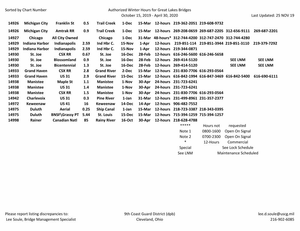
Sorted by Chart Number Authorized Winter Hours for Great Lakes BridgesOctober 15, 2019 - April 30, 2020
Last Updated: 25 NOV 19
Please report listing discrepancies to: Lee Soule, Bridge Management Specialist
9th Coast Guard District (dpb)Cleveland, Ohio
14926 Michigan City Franklin St 0.5 Trail Creek 1-Dec 15-Mar 12-hours 219-362-2051 219-608-9732
14926 Michigan City Amtrak RR 0.9 Trail Creek 1-Dec 15-Mar 12-hours 269-208-0659 269-687-2205 312-656-9111 269-687-2201
14927 Chicago All City Owned Chicago 1-Dec 31-Mar 48-hours* 312-744-4200 312-747-2470 312-744-428014929 Indiana Harbor Indianapolis 2.59 Ind Hbr C. 15-Nov 1-Apr 12-hours 219-851-114 219-851-3944 219-851-3110 219-379-7292 14929 Indiana Harbor Indianapolis 2.59 Ind Hbr C. 15-Nov 1-Apr 12-hours 219-344-087114930 St. Joe CSX RR 0.67 St. Joe 16-Dec 28-Feb 12-hours 616-246-5600 616-246-565814930 St. Joe Blossomland 0.9 St. Joe 16-Dec 28-Feb 12-hours 269-414-5120 SEE LNM SEE LNM14930 St. Joe Bicentennial 1.3 St. Joe 16-Dec 28-Feb 12-hours 269-414-5120 SEE LNM SEE LNM14933 Grand Haven CSX RR 2.8 Grand River 2-Dec 15-Mar 12-hours 231-830-7706 616-293-056414933 Grand Haven US 31 2.9 Grand River 15-Dec 15-Mar 12-hours 616-842-1994 616-847-3469 616-842-5400 616-690-611114938 Manistee Maple St 1.1 Manistee 1-Nov 30-Apr 24-hours 231-723-624114938 Manistee US 31 1.4 Manistee 1-Nov 30-Apr 24-hours 231-723-624114938 Manistee CSX RR 1.5 Manistee 1-Nov 30-Apr 24-hours 231-830-7706 616-293-056414942 Charlevoix US 31 0.3 Pine River 1-Jan 31-Mar 12-hours 231-499-8961 231-357-237714972 Keweenaw US 41 16 Keweenaw 14-Dec 14-Apr 12-hours 906-482-755214975 Duluth Aerial 0.25 Ship Canal 1-Jan 15-Mar 12-hours 218-723-3387 218-343-039514975 Duluth BNSF\Grassy PT 5.44 St. Louis 15-Dec 15-Mar 12-hours 715-394-1259 715-394-125714998 Rainer Canadian Natl 85 Rainy River 16-Oct 30-Apr 12-hours 218-628-4788
***** Hours not requested Note 1 0800-1600 Open On SignalNote 2 0700-2300 Open On Signal
* 12-Hours CommercialSpecial See Lock Schedule
See LNM Maintenance Scheduled
6806 Federal Register / Vol. 85, No. 25 / Thursday, February 6, 2020 / Rules and Regulations
Authority: 46 U.S.C. 70034, 70051; 33 CFR 1.05–1, 6.04–1, 6.04–6, and 160.5; Department of Homeland Security Delegation No. 0170.1.
§ 165.501 [Amended]
■ 6. In § 165.501(b), remove the words ‘‘Hampton Roads’’ wherever they appear and add in their place the word ‘‘Virginia’’.
§ 165.503 [Amended]
■ 7. In § 165.503: ■ a. In paragraph (a) amend the definition of ‘‘Designated Representative’’ by removing the words ‘‘Hampton Roads,’’; and ■ b. Amend paragraphs (b) and (c) by removing the words ‘‘Hampton Roads’’ and adding their place ‘‘Virginia.’’
§ 165.504 [Amended]
■ 8. In § 165.504(c)(1)(vii)(A), remove the words ‘‘Hampton Roads,’’.
§ 165.506 [Amended]
■ 9. In § 165.506, remove the words ‘‘Hampton Roads’’ wherever they appear and add in their place the word ‘‘Virginia’’.
§ 165.518 [Amended]
■ 10. In § 165.518(c)(7), remove the words ‘‘Hampton Roads’’ wherever they appear and add in their place the word ‘‘Virginia’’.
§ 165.550 [Amended]
■ 11. In § 165.550 (a)(3) and (d)(2)(iii), remove the words ‘‘Hampton Roads’’ wherever they appear and add in their place the word ‘‘Virginia’’.
Dated: January 30, 2020. K.M. Carroll, Captain, U.S. Coast Guard, Sector Commander. [FR Doc. 2020–02214 Filed 2–5–20; 8:45 am]
BILLING CODE 9110–04–P
DEPARTMENT OF HOMELAND SECURITY
Coast Guard
33 CFR Part 117
[Docket No. USCG–2019–0178]
RIN 1625–AA09
Drawbridge Operation Regulation; Fox River, Green Bay, WI
AGENCY: Coast Guard, DHS. ACTION: Final rule.
SUMMARY: The Coast Guard is modifying the operating schedule that governs the Main Street Bridge, mile 1.58, the
Walnut Street Bridge, mile 1.81, and the Tilleman Memorial Bridge, mile 2.27, all over the Fox River at Green Bay, WI to allow them to operate remotely.
DATES: This rule is effective March 9, 2020.
ADDRESSES: To view documents mentioned in this preamble as being available in the docket, go to http://www.regulations.gov. Type USCG– 2019–0178 in the ‘‘SEARCH’’ box and click ‘‘SEARCH.’’ Click on Open Docket Folder on the line associated with this rulemaking.
FOR FURTHER INFORMATION CONTACT: If you have questions on this rule, call or email: Mr. Lee D. Soule, Bridge Management Specialist, Ninth Coast Guard District; telephone 216–902– 6085, email [email protected].
SUPPLEMENTARY INFORMATION:
I. Table of Abbreviations
CFR Code of Federal Regulations DHS Department of Homeland Security FR Federal Register HDCCTV High Definition Closed Circuit
Television IGLD85 International Great Lakes Datum of
1985 IRCCTV Infrared Closed Circuit Television LWD Low Water Datum based on IGLD 85 NPRM Notice of Proposed Rulemaking
(Advance, Supplemental) OMB Office of Management and Budget PLC Programmable Logic Control § Section U.S.C. United States Code WI–FI Wireless Fidelity WISDOT Wisconsin Department of
Transportation
II. Background Information and Regulatory History
On April 29, 2019, we published a notice of proposed rulemaking entitled: Drawbridge Operation Regulation; Fox River, Green Bay, WI in the Federal Register (84 FR 17979). We received five comments on this rule.
III. Legal Authority and Need for Rule
The Coast Guard is issuing this rule under authority 33 U.S.C. 499.
There are three bascule bridges operated by WISDOT and the City of Green Bay: Main Street Bridge, mile 1.58, provides 120 feet horizontal and 12 feet vertical clearance in the closed position; the Walnut Street Bridge, mile 1.81, provides 124 feet horizontal and 11 feet vertical clearance in the closed position; and the Tilleman Memorial Bridge, mile 2.27, provides 124 feet horizontal and 32 feet vertical clearance in the closed position.
IV. Discussion of Comments, Changes and the Final Rule
The Coast Guard provided a 180 day comment period and received five comments. During the comment period the bridges were managed by WISDOT with city of Green Bay personnel operating the three bridges. As of December 1, 2019 Brown County began operating the bridges with personnel from the snow plow division. This prevented snow plow drivers from being laid off in the summer and drawtenders from being laid off in the winter. The current drawtenders lost their jobs unless they could obtain a commercial driver’s license to operate a snow plow in the winter. We believe this may have influenced some of the comments we received; however, below we address each comment provided:
The first comment: ‘‘The Main Street Bridge was renamed the Ray Nitschke Memorial Bridge in 1998’’. We reached out to the State of Wisconsin and the City of Green Bay and asked them to send us a letter requesting the name change to be made and they have declined to do so.
The second comment addressed several factors: ‘‘As long as vehicles are still crashing through the gates there should be a live presence, i.e., a Bridge Tender, on every bridge that is being operated.’’ We asked WISDOT for the last three years of vehicle incidents. There were zero incidents in 2017, two in 2018, and two in 2019. All three years indicated live drawtenders manning the bridges. We do not have any data from other remotely operated bridges to support the claim that remote bridges have a higher incidents of vehicles hitting barriers during the opening cycle of the bridge or that responses to vehicles hitting the barriers have been lessened. ‘‘Instead of the risk and cost of an experimental wireless remote operation, just establish a call-in period. By making Tilleman bridge a 4 hour call-in, 24–7, and by making Walnut and Nitschke bridges a 4 hour call-in from 11 p.m. to 7 a.m., you could reduce the number of Bridge Tenders to 6 (half of what they have now). You would still have a live Bridge Tender on each bridge when they require an opening.’’ This suggested schedule would place an additional burden on the mariners. The wireless equipment is not experimental. It is a commercial grade wireless system developed for city wide municipal use with a 20 mile range.
The third comment: ‘‘As a tour boat company we feel it is in the best interest of auto, pedestrian and boat traffic to keep bridgetenders at Main Street
VerDate Sep<11>2014 19:34 Feb 05, 2020 Jkt 250001 PO 00000 Frm 00074 Fmt 4700 Sfmt 4700 E:\FR\FM\06FER1.SGM 06FER1lotte
r on
DS
KB
CF
DH
B2P
RO
D w
ith R
ULE
S
6807 Federal Register / Vol. 85, No. 25 / Thursday, February 6, 2020 / Rules and Regulations
Bridge, Walnut Street Bridge and the Tilleman Memorial Bridge. We have seen firsthand the need for a bridgetender to keep a pedestrian from walking over the bridge as it was going up. In addition, a recent incident in Menasha with a bicyclist attempting to cross the open doors made national news (as it was videotaped). This may save money, but it won’t offer the safety required at these drawbridges.’’ The bridgetenders rely on physical barriers along with visual and audible alarms to keep pedestrians from accessing the bridge span while in motion. These same devices will be employed during remote operations. The bicyclist incident occurred in Menasha, WI at a bridge with a drawtender in attendance and the bicyclist was arrested for intoxication. This was an isolated incident. The remotely operated bridges will have enough cameras to monitor every pedestrian, and vehicular approach.
The fourth comment provided copies of the Remote Bridge Study provided in 2009 with additional notes concerning upgrades made up until 2019. This study provided the basis on why remote operations were not authorized prior to 2019 by the U.S. Coast Guard. The older analog camera systems and basic bridge controls were not adequate to perform as if a drawtender was on the bridge. The equipment that has been installed on the bridges has been represented by WISDOT to be state of the art and ready to meet the challenges of these bridges. WISDOT does intend to have additional drawtenders available during special events and heavy pedestrian and vehicle attendance at the bridges. The wireless equipment has a 20 mile range and is a capable unit designed for city service and not a wireless service a person may have in their home. Even with a large freighter between the wireless units the units continue to communicate to each other. We do not intend to diminish this comment but the materials provided have been vetted through various meetings and the equipment currently on the bridge meets the same benchmarks as defined by the Coast Guard on other successful remotely operated bridges in the Great Lakes.
The fifth comment: ‘‘Having operated the Green Bay bridges remotely through the summer, I believe the Ray Nitschke Memorial Bridge (Main Street) is not ready for Full Remote Operation (no Bridge Tender on the remotely operated bridge). The equipment and programming are still being troubleshot and the camera placements were influenced by convenience (existing poles) instead of desired results.
My major concern about going Full Remote is the recent decision by WISDOT to replace the current Green Bay City Bridge Tenders with Brown County Snow Plow Operators. The plan calls for no overlap. Therefore, 100 years of Bridge Tender experience will be replaced with 45 minutes if a lift needs to be done on any of the three bridges in Green Bay at midnight on December 1, 2019. Making such a drastic personnel change this far into the process and on the tail end of the NPRM is irresponsible with respect to the public and maritime safety, and shows a certain disregard towards the Coast Guards approval process. The four senior City Bridge Tenders were moved to Walnut Street Bridge in March, 2019 to facilitate and prepare for future Full Remote Operations. The Tilleman Memorial and Ray Nitschke Memorial bridges have been operated remotely through the summer without major incidents. There were a couple of gate crashes but that is a normal, infrequent occurrence. Now, new operators, who have been trained in Sturgeon Bay and not Green Bay, will be responsible for all openings as of midnight on December 1, 2019. As a current City Bridge Tender and a retired Coast Guard Officer, I strongly recommend that Full Remote Operations be delayed at least one more summer so these new operators can gain some experience. Openings on a foggy morning, a dark rainy night, or a crowded Farmers Market evening are all situations the new operators should not be required or allowed to do alone for the first time.’’ This was a serious concern and WISDOT requested we allow the bridges to operate remotely with tenders present to allow the drawtenders adequate time to learn how to operate the new system. This delayed the remote operations until the end of 2019. WISDOT intends to continue training the new drawtenders through the winter of 2019–2020 and they remain confident the drawtenders will be ready for the 2020 navigation season. Because WISDOT has done an excellent job at the three remotely operated bridges in Sturgeon Bay, WI, we do not see any reasons to delay another year.
IV. Discussion of Final Rule The bridges will continue to operate
as they have been except this rule will allow them to be operated remotely.
V. Regulatory Analyses We developed this rule after
considering numerous statutes and Executive Orders related to rulemaking. Below we summarize our analyses based on a number of these statutes and
Executive Orders, and we discuss First Amendment rights of protesters.
A. Regulatory Planning and Review Executive Orders 12866 and 13563
direct agencies to assess the costs and benefits of available regulatory alternatives and, if regulation is necessary, to select regulatory approaches that maximize net benefits. Executive Order 13771 directs agencies to control regulatory costs through a budgeting process. This rule has not been designated a ‘‘significant regulatory action,’’ under Executive Order 12866. Accordingly, it has not been reviewed by the Office of Management and Budget (OMB) and pursuant to OMB guidance it is exempt from the requirements of Executive Order 13771.
This rule allows the drawtender to operate the bridge remotely and will not affect the schedule of the bridge and therefore is not a significant regulatory action.
B. Impact on Small Entities The Regulatory Flexibility Act of 1980
(RFA), 5 U.S.C. 601–612, as amended, requires federal agencies to consider the potential impact of regulations on small entities during rulemaking. The term ‘‘small entities’’ comprises small businesses, not-for-profit organizations that are independently owned and operated and are not dominant in their fields, and governmental jurisdictions with populations of less than 50,000. The Coast Guard did not receive any comments from the Small Business Administration on this rule. The Coast Guard certifies under 5 U.S.C. 605(b) that this rule will not have a significant economic impact on a substantial number of small entities.
‘‘While some owners or operators of vessels intending to transit the bridge may be small entities, for the reasons stated in section IV.A above this final rule would not have a significant economic impact on any vessel owner or operator.
Under section 213(a) of the Small Business Regulatory Enforcement Fairness Act of 1996 (Pub. L. 104–121), we want to assist small entities in understanding this rule. If the rule would affect your small business, organization, or governmental jurisdiction and you have questions concerning its provisions or options for compliance, please contact the person listed in the FOR FURTHER INFORMATION CONTACT, above.
Small businesses may send comments on the actions of Federal employees who enforce, or otherwise determine compliance with, Federal regulations to
VerDate Sep<11>2014 19:34 Feb 05, 2020 Jkt 250001 PO 00000 Frm 00075 Fmt 4700 Sfmt 4700 E:\FR\FM\06FER1.SGM 06FER1lotte
r on
DS
KB
CF
DH
B2P
RO
D w
ith R
ULE
S
6808 Federal Register / Vol. 85, No. 25 / Thursday, February 6, 2020 / Rules and Regulations
the Small Business and Agriculture Regulatory Enforcement Ombudsman and the Regional Small Business Regulatory Fairness Boards. The Ombudsman evaluates these actions annually and rates each agency’s responsiveness to small business. If you wish to comment on actions by employees of the Coast Guard, call 1– 888–REG–FAIR (1–888–734–3247). The Coast Guard will not retaliate against small entities that question or complain about this rule or any policy or action of the Coast Guard.
C. Collection of Information
This rule calls for no new collection of information under the Paperwork Reduction Act of 1995 (44 U.S.C. 3501– 3520).
D. Federalism and Indian Tribal Government
A rule has implications for federalism under Executive Order 13132, Federalism, if it has a substantial direct effect on the States, on the relationship between the national government and the States, or on the distribution of power and responsibilities among the various levels of government. We have analyzed this rule under that Order and have determined that it is consistent with the fundamental federalism principles and preemption requirements described in Executive Order 13132.
Also, this rule does not have tribal implications under Executive Order 13175, Consultation and Coordination with Indian Tribal Governments, because it does not have a substantial direct effect on one or more Indian tribes, on the relationship between the Federal Government and Indian tribes, or on the distribution of power and responsibilities between the Federal Government and Indian tribes.
We did not receive any comments from Indian Tribes.
E. Unfunded Mandates Reform Act
The Unfunded Mandates Reform Act of 1995 (2 U.S.C. 1531–1538) requires Federal agencies to assess the effects of their discretionary regulatory actions. In particular, the Act addresses actions that may result in the expenditure by a State, local, or tribal government, in the aggregate, or by the private sector of $100,000,000 (adjusted for inflation) or more in any one year. Though this rule will not result in such an expenditure, we do discuss the effects of this rule elsewhere in this preamble.
F. Environment
We have analyzed this rule under Department of Homeland Security Management Directive 023–01, U.S.
Coast Guard Environmental Planning Policy COMDTINST 5090.1 (series) and U.S. Coast Guard Environmental Planning Implementation Procedures (series) which guide the Coast Guard in complying with the National Environmental Policy Act of 1969 (NEPA) (42 U.S.C. 4321–4370f). We have made a determination that this action is one of a category of actions that do not individually or cumulatively have a significant effect on the human environment. This rule promulgates the operating regulations or procedures for drawbridges. This action is categorically excluded from further review, under paragraph L49, of Chapter 3, Table 3–1 of the U.S. Coast Guard Environmental Planning Implementation Procedures.
Neither a Record of Environmental Consideration nor a Memorandum for the Record are required for this rule.
G. Protest Activities
The Coast Guard respects the First Amendment rights of protesters. Protesters are asked to contact the person listed in the FOR FURTHER INFORMATION CONTACT section to coordinate protest activities so that your message can be received without jeopardizing the safety or security of people, places, or vessels.
List of Subjects in 33 CFR Part 117 Bridges.
For the reasons discussed in the preamble, the Coast Guard amends 33 CFR part 117 as follows:
PART 117—DRAWBRIDGE OPERATION REGULATIONS
■ 1. The authority citation for part 117 continues to read as follows:
Authority: 33 U.S.C. 499; 33 CFR 1.05–1; Department of Homeland Security Delegation No. 0170.1.
■ 2. Amend § 117.1087 by adding paragraph (a)(4) to read as follows:
§ 117.1087 Fox River.
(a) * * * (4) The Main Street Bridge, mile 1.58,
the Walnut Street Bridge, mile 1.81, and the Tilleman Memorial Bridge, mile 2.27, are operated remotely. * * * * *
Dated: January 24, 2020.
D.L. Cottrell, Rear Admiral, U.S. Coast Guard Commander, Ninth Coast Guard District. [FR Doc. 2020–01767 Filed 2–5–20; 8:45 am]
BILLING CODE 9110–04–P
ENVIRONMENTAL PROTECTION AGENCY
40 CFR Part 52
[EPA–R04–OAR–2019–0014; FRL–10004– 68–Region 4]
Air Plan Approval; AL and SC: Infrastructure Requirements for the 2015 8-Hour Ozone National Ambient Air Quality Standard
AGENCY: Environmental Protection Agency (EPA). ACTION: Final rule.
SUMMARY: The Environmental Protection Agency (EPA) is approving portions of the Alabama and South Carolina State Implementation Plan (SIP) submissions provided on August 20, 2018, and September 7, 2018, respectively, for inclusion into their respective SIPs. These approvals pertain to the infrastructure requirements of the Clean Air Act (CAA or Act) for the 2015 8- hour ozone national ambient air quality standard (NAAQS). Whenever EPA promulgates a new or revised NAAQS, the CAA requires that each state adopt and submit a SIP for the implementation, maintenance and enforcement of each NAAQS promulgated by EPA. Alabama and South Carolina certified that their SIPs contain provisions that ensure the 2015 8-hour ozone NAAQS is implemented, enforced, and maintained in their State. EPA has determined that Alabama and South Carolina infrastructure SIP submissions satisfy certain required infrastructure elements for the 2015 8- hour ozone NAAQS. DATES: This rule will be effective March 9, 2020. ADDRESSES: EPA has established a docket for this action under Docket Identification No. EPA–R04–OAR– 2019–0014. All documents in the docket are listed on the www.regulations.gov website. Although listed in the index, some information is not publicly available, i.e., Confidential Business Information or other information whose disclosure is restricted by statute. Certain other material, such as copyrighted material, is not placed on the internet and will be publicly available only in hard copy form. Publicly available docket materials are available either electronically through www.regulations.gov or in hard copy at the Air Regulatory Management Section, Air Planning and Implementation Branch, Air and Radiation Division, U.S. Environmental Protection Agency, Region 4, 61 Forsyth Street SW, Atlanta, Georgia 30303–8960. EPA requests that if at all possible, you contact the person
VerDate Sep<11>2014 19:34 Feb 05, 2020 Jkt 250001 PO 00000 Frm 00076 Fmt 4700 Sfmt 4700 E:\FR\FM\06FER1.SGM 06FER1lotte
r on
DS
KB
CF
DH
B2P
RO
D w
ith R
ULE
S