Embed Size (px)
Citation preview

25 April 201817/18LNM:
8Coast Guard District GULFPage 1 of 41
U.S. Departmentof Homeland Security
United StatesCoast Guard
LOCAL NOTICE TO MARINERS
8TH DISTRICT LOCAL NOTICE TO MARINERSGULF OF MEXICO
Econfina River, FL to the Rio Grande, TXLIGHT LIST VOLUME IVNOTICE NUMBER 17/18
April 25, 2018
References: COMDTPUB P16502.4, Vol. IV, 2018 Edition and Coast Pilot 5. Both publications, along with corrections, are available for download at: https://nauticalcharts.noaa.gov/publications/coast-pilot/index.html .https://www.navcen.uscg.gov/pdf/lightLists/LightList_V4_2018.pdf .
COAST GUARD DISTRICT 8, WATERWAYS, (504) 671-2327, 7:00 a.m. until 3:30 p.m. (CST)NIS WATCHSTANDER PHONE (703) 313-5900 24-HOURS A DAY
INTERNET ADDRESS HTTPS://www.navcen.uscg.govCOMMENTS REGARDING SECTION VI - PROPOSED CHANGES MAY ALSO BE EMAILED TO: [email protected]
GULF OF MEXICO LNM VIA INTERNET https://www.navcen.uscg.gov/?pageName=lnmDistrict®ion=8&ext=g
BROADCAST NOTICE TO MARINERS COVERED IN THIS EDITION
ORIGINATING UNIT BEGINNING BNMS ENDING BNMS
CCGD8 BNM 0019 - 18 (D8) BNM 0021 - 18 (D8) SECTOR MOBILE (MO) BNM 0201 - 18 (MO) THROUGH BNM 0220 - 18 (MO) SECTOR NEW ORLEANS (NO) BNM 0268 - 18 (NO) BNM 0289 - 18 (NO) SECTOR HOUSTON-GALVESTON (GA) BNM 0243 - 18 (GA) BNM 0269 - 18 (GA) SECTOR CORPUS CHRISTI (CC) BNM 0152 - 18 (CC) BNM 0158 - 18 (CC)
ABBREVIATIONS
District 8 GULF Week: 17/18
A through H
ADRIFT - Buoy AdriftAICW - Atlantic Intracoastal WaterwayAl - AlternatingB - BuoyBKW - Breakwaterbl - BlastBNM - Broadcast Notice to Marinerbu - BlueC - CanadianCHAN - ChannelCGD - Coast Guard DistrictC/O - Cut OffCONT - ContourCRK - CreekCONST - ConstructionDAYMK/Daymk - DaymarkDBN/Dbn - DaybeaconDBD/DAYBD - DayboardDEFAC - DefacedDEST - DestroyedDISCON - DiscontinuedDMGD/DAMGD - Damagedec - eclipseEST - Established Aidev - everyEVAL - EvaluationEXT - Extinguished
I through O
I - InterruptedICW - Intracoastal WaterwayIMCH - Improper CharacteristicINL - InletINOP - Not OperatingINT - IntensityISL - IsletIso - IsophasekHz - KilohertzLAT - LatitudeLB - Lighted BuoyLBB - Lighted Bell BuoyLHB - Lighted Horn BuoyLGB - Lighted Gong BuoyLONG - LongitudeLNM - Local Notice to MarinersLT - LightLT CONT - Light ContinuousLTR - LetterLWB - Lighted Whistle BuoyLWP - Left Watching ProperlyMHz - Megahertz MISS/MSNG - MissingMo - Morse Code MRASS - Marine Radio Activated Sound SignalMSLD - MisleadingN/C - Not Charted
P through Z
PRIV - Private AidQ - QuickR - Red RACON - Radar Transponder BeaconRa ref - Radar reflectorRBN - Radio BeaconREBUILT - Aid RebuiltRECOVERED - Aid RecoveredRED - Red BuoyREFL - ReflectiveRRL - Range Rear LightRELIGHTED - Aid RelitRELOC - RelocatedRESET ON STATION - Aid Reset on StationRFL - Range Front LightRIV - RiverRRASS - Remote Radio Activated Sound Signals - secondsSEC - SectionSHL - Shoalingsi - silentSIG - SignalSND - SoundSPM - Single Point Mooring BuoySS - Sound SignalSTA - StationSTRUCT - Structure
25 April 201817/18LNM:
8Coast Guard District GULFPage 2 of 41
AHOP Above Head of PassesBHOP Below Head of PassesHSC Houston Ship ChannelMRGO Mississippi River - Gulf OutletHWY HighwayIHNC Inner Harbor Navigation CanalF/V Fishing VesselAP Assigned PositionCPA Closest Point of ApproachCOTP Captain of The PortSOLAS Safety of Life at Sea
SECTION I - SPECIAL NOTICESThis section contains information of special concern to the Mariner.
NOTICE OF PLATFORMS, DRILL RIGS AND ATTENDANT VESSELS
DEPARTMENT OF HOMELAND SECURITY SUSPICIOUS ACTIVITY
GPS TESTING - Greenville, Texas
LA - MISSISSIPPI RIVER - BATON ROUGE TO VENICE - High River Stages
The drill rigs and vessels that have been temporarily established will display lights and sound signals, according to size or class, during periods of darkness and reduced visibility. Numerous large anchor buoys which may be lighted displaying a white 4-seconds characteristic light and unlighted buoy may be established up to 2,000 or more yards from the vessel or rig site. Mariners should avoid passing close aboard the rigs or vessels. Offshore structures that have been established will display lights and a fog signal sounding 1 blast (2-sec. blast) every 20-seconds. Mooring buoys (white with blue band) may be located within 500 yards of the structure for mooring attendant vessels and/or barges. Mariners should avoid passing close aboard structures.
The Department of Homeland Security (DHS) encourages the maritime public to report information concerning suspicious activity to the local Federal Bureau of Investigation Joint Terrorism Task Force (JTTF) Office, http://www.fbi.gov/about-us/investigate/terrorism/terrorism_jttfs, or to other appropriate authorities. The U.S. Coast Guard reminds the maritime industry that they may also report information concerning suspicious activity to the www.AmericasWaterwayWatch.org, the National Response Center (NRC) 1-800-424-8802 or 1-877-24WATCH.
Continuing until April 30, 2018 and again from May 13-26, 2018, GPS testing will be conducted in the vicinity of Greenville, Texas. Systems that rely on GPS, such as E-911, AIS and DSC, may be affected at an approximate test center of 33-03-53.8N 096-03-18.5W, with a possible impact radius of 190 nautical miles from the center point. More information is available at the U.S. Coast Guard Navigation Center Website, https://www.navcen.uscg.gov . During these periods, GPS users are encouraged to report any GPS outages that they may experience to the Navigation Information Service (NIS) by calling (703) 313-5900 or by using the NAVCEN Website to submit a GPS problem report.
During present high river stages, revetments and levees south of Baton Rouge, Louisiana, are subject to damage from wave wash resulting from vessels traveling at excessive speeds, and also from contact with barges and vessels moored along the riverbank.Mariners are advised to exercise extreme caution when navigating in the section of the river between Baton Rouge and Head of Passes, proceed at slowest safe speed, and steer a course as far away as possible from the levees and revetments to avoid damage by suction and wave wash.Mariners are also advised to exercise extreme caution when navigating or mooring their vessels in the forebays of Algiers, Harvey, Inner HarborNavigation Canal, Port Allen and Old River Locks to prevent vessels and tows from coming in contact with the controlling levee line in those areas.Mariners and fleet operators are advised to secure their vessels and barges in such a manner as to ensure that there will be no contact with the levees or revetments and the barges are no closer than 180 feet to the centerline of the levee. Vessel owners or other persons responsible for any vessel or barges making contact with the levees and revetments in any way may be charged as provided for in Section 7 of the River and
LNM:
LNM:
LNM:
DPW/PRIV AIDS
DPW
17-18
Additional Abbreviations Specific to this LNM Edition:
F - Fixedfl - flashFl - FlashingG - Green GIWW - Gulf Intracoastal WaterwayHAZ - Hazard to NavigationHBR - HarborHOR - Horizontal ClearanceHT - Height
NGA - National Geospatial-Intelligence AgencyNO/NUM - NumberNOS - National Ocean ServiceNW - Notice WriterOBSCU - ObscuredOBST - ObstructionOBSTR - ObstructionOc - OccultingODAS - Anchored Oceanographic Data Buoy
St M - Statute MileTEMP - Temporary Aid ChangeTMK - TopmarkTRLB - Temporarily Replaced by Lighted BuoyTRLT - Temporarily Replaced by LightTRUB - Temporarily Replaced by Unlighted BuoyUSACE - Army Corps of EngineersW - WhiteY - Yellow

25 April 201817/18LNM:
8Coast Guard District GULFPage 3 of 41
NOAA - Oceanographic Instrumentation Deployment Operations
Harbor Act of August 8, 1917, and Title 33 of the United States Code, Sections 408 and 412.
Attached as an enclosure to this LNM are NOAA oceanographic instrumentation establishments in the waters of Texas in the vicinity of Port Mansfield and Laguna Madre.
LNM:
LNM:
10-18
17-18
DISCREPANCIES (FEDERAL AIDS)
SECTION II - DISCREPANCIESThis section lists all reported and corrected discrepancies related to Aids to Navigation in this edition. A discrepancy is a change in the status of
an aid to navigation that differs from what is published or charted.
LNM EndLLNR Aid Name Status Chart No. BNM Ref. LNM StSt Marks Light
Colorado River East Jetty Entrance Obstruction LightNOAA Lighted Data Buoy 42003 (ODAS)St Marks Light
Ochlockonee Bay Entrance Light OB
Apalachee Bay Light 2Carrabelle Channel Buoy 7
Carrabelle Channel Lighted Buoy 12
Carrabelle River Daybeacon 3
Apalachicola Bay Wreck LightSt Joseph Bay Entrance A Range Front LightChoctawhatchee Bay Entrance Daybeacon 15Pensacola Bay Navy Range Rear Light
Bayou Chico Daybeacon 13
Escambia Bay Daybeacon 21Bayou St John Daybeacon 4
Mobile Channel Light 30
Mobile Channel Light 34Mobile Channel Light 38
Mobile Channel Light 39
Mobile Channel Light 43Mobile Channel Light 44
Mobile Channel Light 51
Theodore Ship Channel Light 1Theodore Ship Channel Buoy 1A
Mobile Channel Lighted Buoy 55
Mobile Channel Light 60Mobile Channel Light 67Mobile Channel Light 69Mobile Channel Light 70Mobile Channel Light 76
Arlington Channel Lighted Buoy 1
Mobile Channel Light 78MOBILE TURNING BASIN LIGHT A
Twelve Mile Island Light
LT EXT
STRUCT DEST
ADRIFTLT EXT
STRUCT DEST/TRLB
STRUCT DEST/TRLBHAZ NAV/BUOY DMGD/DAYMK MISSINGHAZ NAV/SINKING/BUOY DMGD/TRLBSTRUCT DEST/TRUB
STRUCT DESTSTRUCT DMGD/TRLB
STRUCT DEST/TRUB
LT EXT/STRUCT DMGD
STRUCT DEST/TRUB
STRUCT DEST/TRUBSTRUCT DEST/TRUB
TRLB/STRUCT DEST
STRUCT DEST/TRLBSTRUCT DEST/TRLB
STRUCT DEST/TRLB
STRUCT DEST/TRLBSTRUCT DEST/TRLB
OFF STA/STRUCT DEST/TRLB
STRUCT DEST/TRLBOFF STA
TRLB
STRUCT DEST/TRLBSTRUCT DEST/TRLBSTRUCT DMGDSTRUCT DEST/TRLBSTRUCT DEST/TRLB
OFF STA/TRLB
DAYMK MISSINGSTRUCT DEST
STRUCT DEST/TRLB
22/16
11/18
20/1722/16
37/16
37/1616/17
01/18
45/17
39/1747/13
41/17
50/13
45/17
06/1841/17
38/15
30/1615/17
03/18
04/1817/17
46/13
10/1810/18
03/18
06/1717/1817/1841/1741/17
15/18
41/1733/17
46/17
11406
11319
1100611406
11405
1140511404
11404
11404
1140211393
11385
11384
11378
1137811378
11378
1137711377
11377
1138011380
11380
1137611376
11380
1137611376113761137611376
11376
1137611376
11376
10
1377
14601490
2290
23002535
2550
2605
28503025
4680
4855
5340
58305955
6300
63206335
6340
64456450
6520
65356540
6550
65706595660566106660
6680
66856697
6725
0448-16 MO0070-18 CC
0028-17 D8
0448-16 MO
0775-16 MO0774-16 MO
0203-18 MO
0084-18 MO
0899-17 MO
0667-17 MO0931-13 MO
0709-17 MO
1028-16 MO
0056-18 MO0750-17 MO
0322-17 MO0641-17 MO
0026-18 MO
0090-18 MO
0105-18 MO
0168-18 MO0154-18 MO
0027-18 MO
0212-18 MO0213-18 MO0758-17 MO0152-18 MO
0214-18 MO
0715-17 MO0584-47 MO
0924-17 MO

25 April 201817/18LNM:
8Coast Guard District GULFPage 4 of 41
Mullet Point Light 2
Dauphin Island Channel Daybeacon 5Dauphin Island Channel Daybeacon 7
Theodore Ship Channel Outer Range Rear LightTheodore Ship Channel Light 1
Theodore Ship Channel Light 3Theodore Ship Channel Light 6
Theodore Ship Channel Light 11
Theodore Ship Channel Light 13Dog River Channel Light 8
Arlington Channel Lighted Buoy 1
Arlington Channel Light 5Bayou La Batre Light 5Bayou La Batre Buoy 14
Bayou La Batre Light 19Bayou La Batre Daybeacon 20
Bayou La Batre Light 22
Bayou La Batre Daybeacon 23Horn Island Pass Lighted Buoy 2
Horn Island Pass Lighted Buoy 9
Pascagoula Channel D Range Rear LightPascagoula Channel Lighted Buoy 31
Pascagoula Channel Light 39
Pascagoula Channel Light 50Pascagoula River Daybeacon 6
Bayou Casotte Channel Light 6
Bayou Casotte Channel Light 7Biloxi East Channel Daybeacon 1
Biloxi East Channel Daybeacon 16
Biloxi East Channel Light 26Ott Bayou Channel Daybeacon 1
Big Lake Junction Daybeacon
Gulfport Middle Reach Channel Inbound Range Rear Passing LightGulfport Obstruction LightGulfport Ship Channel Light 41Gulfport Ship Channel Light 44
Bayou Portage Channel Daybeacon 4Bayou Portage Channel Buoy 14
Bayou Caddy Daybeacon 2
Pearl River Daybeacon 33Tchefuncte River Daybeacon 8
Mississippi River - Gulf Outlet Daybeacon68Bayou Terre Aux Boeufs Daybeacon 3
Baptiste Collette Bayou Daybeacon 11South Pass Light 3B
South Pass Danger Light A
South Pass Danger Light BSouthwest Pass Light 21
The Jump Wharf Lights (3)
Sixty Mile Point Lighted Buoy ASix Mile Point Light 102
Mississippi River Wreck Lighted Buoy WR4Gramercy Bridge Approach Buoy 1
STRUCT DMGD
STRUCT DEST/TRUBSTRUCT DEST/TRUB
DAYMK MISSING
STRUCT DEST/TRLB
STRUCT DEST/TRLBSTRUCT DEST/TRLB
STRUCT DEST/TRLB
STRUCT DEST/TRLBSTRUCT DEST/TRLB
OFF STA/TRLB
STRUCT DEST/TRLBSTRUCT DESTMISSING/TRUB
STRUCT DEST/TRLBSTRUCT DEST/TRUB
STRUCT DEST/TRLB
STRUCT DEST/TRUBLT EXT
OFF STA
DAYMK DMGDOFF STA
STRUCT DEST/TRLB
STRUCT DEST/TRLBSTRUCT DEST/TRUB
STRUCT DEST/TRLB
STRUCT DEST/TRLBDAYMK MISSING
STRUCT DEST
STRUCT DMGDSTRUCT DEST/TRUB
STRUCT DEST/TRLB
STRUCT DEST
DAYMK DMGDSTRUCT DESTSTRUCT DEST/TRLB
STRUCT DESTMISSING
STRUCT DEST
STRUCT DEST/TRUBSTRUCT DEST/TRUB
STRUCT DEST/TRUB
STRUCT DEST/TRUB
STRUCT DEST/TRUBSTRUCT DEST
STRUCT DEST
STRUCT DESTSTRUCT DEST/REDUCED INT/TRLB
STRUCT DEST
MISSINGLT EXT/STRUCT DMGD
LT EXT
OFF STA
43/17
16/1816/18
41/17
10/18
47/1737/16
06/18
41/1734/17
15/18
06/1817/1828/17
10/1810/18
16/18
05/1804/18
51/17
41/1703/18
08/18
49/1648/17
52/17
52/1710/18
16/18
12/1810/18
10/18
14/18
11/1817/1809/18
14/1804/18
08/18
10/1841/17
28/17
28/17
12/1835/17
35/17
41/1710/18
14/17
15/1807/18
14/18
13/18
11377
1137811378
11376
11376
1137611376
11380
1137611376
11376
113761137411374
1137411374
11374
1137411373
11375
1137511375
11375
1137511374
11375
1137511372
11372
1137211372
11372
11372
113721137211372
1137211372
11367
1136711369
11364
11364
1135311361
11361
1136111361
11353
1136411368
11370
11370
6970
71757185
7340
7350
73607370
7395
74057485
7540
757076657705
77307735
7745
77507860
7910
79708040
8120
82108305
8455
84708695
8770
88059130
9380
9685
978598209835
1022010250
10395
1060011345
11720
12360
1243512591
12592
1259312875
13090
1325013945
14160
14555
0858-17 MO
0220-18 MO0219-18 MO
0767-17 MO
0168-18 MO
0933-17 MO0742-16 MO
0054-18 MO
0058-18 MO0594-17 MO
0214-18 MO
0069-18 MO0208-18 MO
0201-18 MO
0044-18 MO0033-18 MO
0998-17 MO
0030-18 MO
0082-18 MO
0794-17 MO0988-17 MO
1020-17 MO
1021-17 MO0120-18 MO
0200-18 MO
0149-18 MO0119-18 MO
0118-18 MO
0169-18 MO
0204-18 MO0106-18 MO
0175-18 MO0038-18 MO
0086-18 MO
0117-18 MO0884-17 NO
0551-17 NO
0550-17 NO
0204-18 NO0737-17 NO
0738-17 NO
0291-18 NO
0201-17 NO
0250-18 NO0160-18 NO
0230-18 NO
0219-18 NO

25 April 201817/18LNM:
8Coast Guard District GULFPage 5 of 41
Sunshine Bridge Approach Buoy 1
Sunshine Bridge Approach Buoy ASmoke Bend Range Front Light
Evan Hall Light 177
Arlington Range Front LightArlington Range Rear Light
Baton Rouge Bridge Baton Rouge Pier North V-AISTiger Pass Light 6
Barataria Pass Buoy 4Barataria Pass Lighted Buoy 6
Barataria Pass Buoy 7
Barataria Waterway Daybeacon 3Atchafalaya River Junction Light CAtchafalaya River Light 13
Atchafalaya River Daybeacon 31Southwest Pass - Vermilion Bay Channel Light 34Mermentau River Daybeacon 2
Calcasieu Channel East Jetty Light 42
Calcasieu Channel Light 50
Calcasieu Channel Light 91Port Arthur Canal Light 40
Sabine-Neches Canal Light 52
Sabine-Neches Canal K Range Front Passing LightSabine River Daybeacon 4Sabine River Light 5
Sabine River Daybeacon 13A
Sabine River Daybeacon 25Sabine River Daybeacon 29
Houston Ship Channel Light 34
Houston Ship Channel Light 58Houston Ship Channel Light 59
Houston Ship Channel Light 70
Houston Ship Channel Light 75Bayport Ship Channel Outer Range RearLightBayport Ship Channel Junction Light B
Bayport Ship Channel Light 3
Houston Ship Channel Light 81Houston Ship Channel Light 89
Houston Ship Channel Light 100Upper Red Light Bend Outbound Range Front LightHouston Ship Channel Light 113BUpper Peggy's Lake Outbound Range Rear LightHouston Ship Channel Light 118
Houston Ship Channel Light 126AHouston Ship Channel Light 127
Houston Ship Channel Light 160
Texas City Channel Light 9Texas City Channel Light 14
Dickinson Bayou Channel Light 14
Clear Creek Channel Light 2Clear Creek Channel Light 16
MISSING
ADRIFTSTRUCT DMGD
STRUCT DEST
LT IMCH/TRLTLT IMCH/TRLT
AIS INOP
TRLB/STRUCT DEST
TRUBMISSING/TRLB
TRLB
STRUCT DEST/TRUBSTRUCT DESTSTRUCT DEST/TRLB
STRUCT DESTSTRUCT DEST/TRLB
STRUCT DEST
OFF STA/STRUCT DEST/HAZ NAV/TRLBSTRUCT DEST
STRUCT DEST/TRLBSTRUCT DEST/TRLB
STRUCT DEST/TRLB
STRUCT DEST
STRUCT DEST/TRUBSTRUCT DEST/TRLB
STRUCT DEST/TRUB
STRUCT DEST/TRLBSTRUCT DEST/TRUB
STRUCT DEST/TRLB
STRUCT DEST/TRLBSTRUCT DEST/TRLB
STRUCT DEST/TRLB
OFF STA/STRUCT DEST/TRLBLT EXT/STRUCT DMGD
STRUCT DEST/TRLB
STRUCT DEST
STRUCT DEST/TRLBSTRUCT DEST/TRLB
STRUCT DESTSTRUCT DEST
STRUCT DEST/TRLBLT EXT
STRUCT DEST/TRLB
STRUCT DEST/TRLBSTRUCT DEST/TRLB
STRUCT DEST/TRLB
STRUCT DEST/TRLBSTRUCT DEST/TRLB
STRUCT DEST/TRLB
LT EXT/STRUCT DMGDDAYMK MISSING
50/16
12/1815/18
13/18
32/1542/15
10/18
08/14
13/1726/17
26/17
16/1817/1816/18
17/1810/18
09/18
29/14
44/17
10/1805/18
06/18
14/18
10/1810/18
12/18
10/1810/18
38/17
13/1815/18
16/18
05/1808/18
48/17
07/18
14/1814/18
17/1812/18
15/1817/18
13/18
14/1816/18
47/17
16/1815/18
15/18
17/1817/18
11370
1137011370
11370
1137011370
11370
11361
1136511365
11365
113651135111351
1135111349
11348
11347
11339
1134811342
11331
11343
1133111343
11331
1133111331
11324
1132711327
11327
1132711327
11327
11327
1132711328
1132811329
1132911329
11329
1132911329
11329
1132411324
11327
1132711326
14835
1484014955
14965
1530015305
15429
15455
1582015830
15835
161251896319035.01
19125.0120230
20995
21405
21430
2177522780
22900
22960
2311023115
23150
2322523250
24020
2424024245
24330
2438524440
24455
24475
2452524565
2481525240
2537025415
25425
2552025695
25815
2608526130
26270
2636526430
0970-16 NO
0201-18 NO0244-18 NO
0209-18 NO
0065-18 NO0066-18 NO
0156-18 NO
0154-14 NO
0677-17 NO0678-17 NO
0501-17 NO
0260-18 NO0282-18 NO0264-18 NO
0283-18 NO
0127-18 GA
0676-17 GA
0140-18 GA0053-18 GA
0268-18 GA
0201-18 GA
0136-18 GA0133-18 GA
0176-18 GA
0130-18 GA0137-18 GA
0067-18 GA
0192-18 GA0228-18 GA
0240-18 GA
0189-18 GA0196-18 GA
0785-17 GA
0079-18 GA
0213-18 GA0251-18 GA
0271-18 GA0175-18 GA
0225-18 GA0269-18 GA
0184-18 GA
0212-18 GA0244-18 GA
0777-17 GA
0246-18 GA0238-18 GA
0256-18 GA0266-18 GA
25 April 201817/18LNM:
8Coast Guard District GULFPage 6 of 41
Colorado River East Jetty Entrance Obstruction LightMatagorda Ship Channel B Range Rear LightMATAGORDA SHIP CHANNEL LIGHT 21
Matagorda Ship Channel Light 41Matagorda Ship Channel Light 43
Matagorda Ship Channel Light 65Port Lavaca Channel Light 5Port Lavaca Harbor of Refuge Daybeacon 10Lavaca Bay Channel Daybeacon 22
Lavaca River Daybeacon 3
Port Aransas Harbor Light 3Port Aransas Harbor Daybeacon 4
Corpus Christi Bay Alternate Route Light4Tule Lake Channel E Range Front Light
Tule Lake Channel F Range Front LightTule Lake Channel F Range Rear Light
La Quinta Channel Inner Range Rear LightLa Quinta Channel Light 18
La Quinta Channel Light ARincon Canal Daybeacon 9
Port Mansfield Channel Daybeacon 17
Port Mansfield Channel Daybeacon 21Port Mansfield Channel Daybeacon 25
Brazos Santiago Entrance Range Front LightBrownsville Channel Light 37St. George Sound Light 6
Apalachicola River Entrance Range Front LightApalachicola River Entrance Range RearLightApalachicola River Light 2
Apalachicola River Daybeacon 6Jackson River Light 9
West Bay Light 1
Choctawhatchee Bay Light 1Choctawhatchee Bay Daybeacon 36
Joes Bayou Entrance Channel Daybeacon 4Garnier Bayou Entrance Daybeacon 4
Santa Rosa Sound Daybeacon 4Santa Rosa Sound Daybeacon 16
Santa Rosa Sound Light 21
Santa Rosa Sound Daybeacon 26Santa Rosa Sound Daybeacon 41
Santa Rosa Sound Daybeacon 73Santa Rosa Sound Light 75Santa Rosa Sound Daybeacon 85
Santa Rosa Sound Daybeacon 89A
Santa Rosa Sound Daybeacon 93Santa Rosa Sound Light 102
Santa Rosa Sound Daybeacon 104
Santa Rosa Sound Daybeacon 127Santa Rosa Sound Light 129
STRUCT DEST
STRUCT DEST
STRUCT DEST/TRLB
STRUCT DEST/TRLBSTRUCT DEST/TRLB
LT EXTSTRUCT DESTSTRUCT DEST/TRUB
DAYMK IMCH
DAYMK IMCH
LT EXT/DAYMK MISSINGSTRUCT DEST/TRUB
STRUCT DEST/TRLB
STRUCT DMGD
LT IMCHLT IMCH
LT EXT
STRUCT DEST/TRLB
STRUCT DESTMISSING/STRUCT DEST/TRUB
TRUB/STRUCT DEST
STRUCT DEST/TRUBSTRUCT DEST/TRUB
STRUCT DMGD
STRUCT DEST/TRLBSTRUCT DEST/TRLB
STRUCT DEST
LT EXT/DAYMK DMGD
STRUCT DEST/TRLB
STRUCT DEST/TRUBLT EXT/TRLB
STRUCT DMGD/TRLB
STRUCT DEST/TRLBSTRUCT DEST/TRUB
OFF STA/STRUCT DEST/TRUB
DAYMK MISSING
STRUCT DEST/TRUBSTRUCT DEST/HAZ NAV/TRUB
STRUCT DEST/TRLB
STRUCT DEST/TRUBDAYMK MISSING
DAYMK MISSINGSTRUCT DEST/TRLBSTRUCT DEST/TRUB
DAYMK MISSING
STRUCT DEST/TRUBSTRUCT DEST/TRLB
STRUCT DEST/TRUB
STRUCT DEST/TRUBSTRUCT DEST/TRLB
11/18
36/17
12/18
14/1814/18
17/1817/1811/14
11/14
11/14
36/1736/17
39/17
36/17
12/1812/18
08/17
36/17
36/1719/17
17/14
40/1530/16
17/18
12/1837/17
04/18
36/14
47/17
43/1712/16
42/17
45/1711/18
01/18
41/17
44/1707/18
50/17
15/1803/17
17/1803/1841/17
30/17
05/1814/18
14/18
14/1805/18
11319
11319
11319
1131711317
113171131711317
11317
11317
1130911309
11308
11311
1131111311
11309
11309
1130911311
11306
1130611306
11302
1130211404
11401
11401
11402
1140211402
11390
1138511385
11385
11385
1138511385
11385
1138511385
113851138511385
11385
1138511385
11385
1138511385
27047
27180
27212
2730527315
274752771527815
27900
27910
2832028325
28747.4
28875
2888528890
28975
29085
2910029135
29355
2937529395
29465
2991530035
30400
30405
30410
3043030535
31225
3140531550
32110
32125
3222032255
32275
3229532355
325353255032610
32635
3266532695
32705
3279032795
0070-18 CC
0090-18 CC
0130-18 CC0131-18 CC
0158-18 CC0157-18 CC0033-18 CC
0205-14 CC
0206-14 CC
0100-18 CC
0083-18 CC
0062-17 CC
0488-17 CC0234-17 CC
0304-14 CC
0529-15 CC
0119-18 CC0647-17 MO
0034-18 MO
0737-14 MO
0936-17 MO
0862-17 MO0869-17 MO
0846-17 MO
0900-17 MO0125-18 MO
0140-18 MO
0706-17 MO
0892-17 MO0078-18 MO
0995-17 MO
0183-18 MO0026-17 MO
0215-18 MO0024-18 MO0993-17 MO
0525-17 MO
0051-18 MO0176-18 MO
0179-18 MO
0180-18 MO
25 April 201817/18LNM:
8Coast Guard District GULFPage 7 of 41
Pensacola Bay Navy Range Rear Light
Pensacola-Mobile Shoal Buoy 5APensacola-Mobile Buoy 8
Pensacola-Mobile Light 10
Pensacola-Mobile Light 18Pensacola-Mobile Light 25
Pensacola-Mobile Daybeacon 29
Pensacola-Mobile Daybeacon 81Pensacola-Mobile Light 94
Pensacola-Mobile Buoy 106
Pensacola-Mobile Light 111Pensacola-Mobile Daybeacon 112
Pensacola-Mobile Daybeacon 127
Pensacola-Mobile Daybeacon 129Pensacola-Mobile Daybeacon 145
Pass Aux Herons Light 2
Pass Aux Herons Buoy 14Pass Aux Herons D Range Rear Light
Pass Aux Herons Daybeacon 36Pass Aux Herons Daybeacon 37Pass Aux Herons Daybeacon 38Bayou La Batre Light 5Belle Fontaine Light 6
Ship Island Light 2Ship Island Light 4
Gulfport Ship Channel Light 41Gulfport Ship Channel Light 44Cat Island Light 2
Marianne Channel Buoy 17
Marianne Channel Buoy 18Marianne Channel Buoy 19
Marianne Channel Buoy 21
Marianne Channel Buoy 23Marianne Channel Buoy 25
Lake Borgne Daybeacon 12
Lake Borgne Daybeacon 14Lake Borgne Light 19
Lake Borgne Daybeacon 20
Morgan City-Port Allen Alternate Route Daybeacon 12Little Wax Bayou Light 2VERMILLION RIVER ENTRANCE LIGHT 1
Calcasieu Channel Light 91
Sabine River Daybeacon 13ASabine River Light 5
Sabine River Daybeacon 4
Sabine-Neches Canal K Range Front Passing LightSabine-Neches Canal Light 52East Bay Bayou Buoy 2
ROLLOVER BAY LIGHT 9
ROLLOVER BAY LIGHT 10Rollover Bay Buoy 12
Bolivar Peninsula Light 14
Bolivar Peninsula Lighted Buoy 19Galveston-Freeport Light 6
LT EXT/STRUCT DMGD
OFF STAOFF STA
STRUCT DEST/LT EXT/TRLB
STRUCT DEST/TRLBSTRUCT DEST
STRUCT DEST/TRUB
STRUCT DEST/TRUBSTRUCT DEST/TRLB
OFF STA
STRUCT DEST/TRLBSTRUCT DEST/TRUB
STRUCT DEST/TRUB
STRUCT DEST/TRUBSTRUCT DEST/TRUB
STRUCT DEST/TRLB
TRUBDAYMK MISSING
STRUCT DESTSTRUCT DESTSTRUCT DESTSTRUCT DESTSTRUCT DEST
STRUCT DEST/TRLBSTRUCT DMGD/TRLB
STRUCT DESTSTRUCT DEST/TRLBSTRUCT DEST
TRUB
TRUBMISSING/TRUB
TRUB
TRUBTRUB
STRUCT DEST/TRUB
STRUCT DEST/TRUBSTRUCT DEST/TRLB
STRUCT DEST/TRUB
STRUCT DEST/TRUB
STRUCT DEST/TRLBSTRUCT DEST/TRLB
STRUCT DEST/TRLB
STRUCT DEST/TRUBSTRUCT DEST/TRLB
STRUCT DEST/TRUB
STRUCT DEST
STRUCT DEST/TRLBOFF STA
STRUCT DEST/TRLB
STRUCT DEST/TRLBOFF STA
STRUCT DMGD
OFF STASTRUCT DEST/TRLB
50/13
06/1806/18
41/17
03/1815/18
14/18
07/1808/18
14/18
11/1811/18
11/18
05/1845/17
12/18
03/1841/17
17/1817/1817/1817/1816/18
11/1814/18
17/1809/1808/18
07/15
29/1703/18
03/18
03/1803/18
16/18
16/1816/18
16/18
14/18
16/1815/18
10/18
12/1810/18
10/18
14/18
06/1815/18
04/18
05/1810/18
14/18
17/1814/18
11384
1138411383
11378
1137811378
11378
1137811378
11378
1137811378
11378
1137811378
11378
1137811377
1137411374113741137411374
1137211372
113721137211372
11372
1137211372
11372
1137211372
11367
1136711367
11367
11355
1135511350
11348
1133111343
11331
11343
1133111331
11331
1133111331
11324
1132411324
33065
3311533132
33190
3326533305
33320
3365033715
33775
3380033805
33875
3388033920
33965
3403534225
3427034275342853431534360
3437034375
343853439034400
34455
3446034465
34475
3448534495
34650
3465534675
34680
35120
3520035274
35410
3548035505
35520
35660
3572035775
35855.01
35860.0135870
35915
3594036125
1028-16 MO
0059-18 MO0063-18 MO
0753-17 MO
0017-18 MO0190-18 MO
0174-18 MO
0085-18 MO0087-18 MO
0171-18 MO
0127-18 MO0126-18 MO
0128-18 MO
0050-18 MO0902-17 MO
0142-18 MO
0028-18 MO0814-17 MO
0216-18 MO0217-18 MO0218-18 MO0208-18 MO0199-18 MO
0172-18 MO
0204-18 MO0106-18 MO
0051-17 MO0097-18 MO
0095-18 MO
0020-18 MO0021-18 MO
0096-18 MO
0256-18 NO0258-18 NO
0257-18 NO
0255-18 NO0227-18 NO
0268-18 NO
0246-18 NO
0140-18 GA0176-18 GA
0133-18 GA
0136-18 GA0201-18 GA
0268-18 GA
0227-18 GA
0042-18 GA0193-18 GA
0147-18 GA
0203-18 GA0250-18 GA0216-18 GA

25 April 201817/18LNM:
8Coast Guard District GULFPage 8 of 41
Galveston-Freeport Light 9
Galveston-Freeport Buoy 23Galveston-Freeport Light 39
Galveston-Freeport Light 50
Galveston-Freeport G Range Rear LightChocolate Bayou Channel Outer Range Front LightChocolate Bay Buoy 11
Matagorda Bay Light 11
Matagorda Bay - Alternate Route Light 6Matagorda Bay - Alternate Route Daybeacon 8AMatagorda Bay - Alternate Route Light 10Matagorda Bay - Alternate Route Buoy 11MATAGORDA BAY - ALTERNATE ROUTE LIGHT 13Matagorda Bay - Alternate Route Buoy 17Matagorda Bay - Alternate Route Buoy 20Halfmoon Reef Light
Palacios Channel Daybeacon 28
Port O' Connor Landcut Daybeacon 6AVictoria Channel Buoy 8
Victoria Channel Light 16
Victoria Channel Daybeacon 27Victoria Channel Light 30
Victoria Channel Light 38
Victoria Channel Light 43Victoria Channel Light 55
Seadrift South Entrance Channel Daybeacon 1SSeadrift Channel Buoy 4
Copano Bay Approach Light 1Copano Bay Approach Light 2
Copano Bay Approach Light 3
Rockport Channel Daybeacon 5Aransas-Corpus Christi Bay Cutoff Channel Light 5Aransas-Corpus Christi Bay Cutoff Channel Buoy 9Aransas-Corpus Christi Bay Cutoff Channel Buoy 27Aransas Bay Alternate Route Danger Buoy BCorpus Christi Baffin Bay Daybeacon 77
Land Cut-Arroyo Colorado Daybeacon 74Land Cut-Arroyo Colorado Daybeacon 96Land Cut-Arroyo Colorado Daybeacon 97Land Cut-Arroyo Colorado Daybeacon 109Harlingen-Port Isabel Daybeacon 8Harlingen-Port Isabel Daybeacon 58
Harlingen-Port Isabel Daybeacon 62
Brownsville Channel Light 37Sim'S Bayou Security Zone Marker
STRUCT DEST/TRLB
OFF STASTRUCT DEST/TRLB
STRUCT DEST/TRLB
LT EXT/STRUCT DMGDSTRUCT DMGD
MISSING
STRUCT DEST/TRLB
STRUCT DEST/TRLBSTRUCT DEST/TRUB
STRUCT DEST/TRLB
OFF STA
MISSING/STRUCT DEST/TRLB
OFF STA
OFF STA
STRUCT DEST/REDUCED INT/TRLB
STRUCT DEST/TRUB
STRUCT DMGDOFF STA
STRUCT DEST/TRLB
STRUCT DEST/TRLBSTRUCT DEST/TRLB
STRUCT DEST/TRLB
STRUCT DEST/TRLBSTRUCT DEST/TRLB
STRUCT DEST/TRUB
OFF STA
STRUCT DESTSTRUCT DEST
STRUCT DEST/TRLB
STRUCT DESTSTRUCT DEST/TRLB
OFF STA
OFF STA
MISSING
STRUCT DEST/TRUB
STRUCT DEST/TRUB
MISSING/STRUCT DEST/TRLB
STRUCT DMGD/TRUB
STRUCT DMGD
STRUCT DEST/TRUBSTRUCT DMGD
STRUCT DMGD
STRUCT DEST/TRLBMISSING
15/18
17/1814/18
14/18
10/1804/18
14/18
43/17
15/1813/18
13/18
16/18
43/17
16/18
16/18
40/17
31/17
34/1736/17
36/17
06/1845/17
36/17
03/1805/18
05/18
38/17
36/1736/17
36/17
12/1812/18
36/17
06/18
36/17
14/18
09/18
20/17
11/18
35/17
14/1835/17
35/17
12/1802/16
11324
1132411324
11322
1132211322
11322
11319
1131911319
11319
11319
11319
11319
11319
11319
11317
1131511315
11315
1131511315
11315
1131511315
11315
11315
1131411314
11314
1131411314
11314
11309
11312
11308
11306
11306
11302
11302
1130311302
11302
11302
36150
3629536565.01
36640.01
3682537120
37290
37445
3758037600
37610
37615
37625
37650
37660
37670
37755
3802538100
38135
3817538185
38210
3823038270
38285
38300
3877038775
38780
3899539090
39110
39230
39705
40620.01
41890
41995
42000.01
42060.01
4239542700
42725
43035
0252-18 GA0217-18 GA
0218-18 GA
0143-18 GA0036-18 GA
0222-18 GA
0422-17 CC
0145-18 CC0118-18 CC
0133-18 CC
0153-18 CC
0073-18 CC
0150-18 CC
0154-18 CC
0394-17 CC
0317-17 CC0351-17 CC
0088-18 CC
0021-18 CC
0054-18 CC
0043-18 CC
0379-17 CC
0076-18 CC
0101-18 CC
0047-18 CC
0150-18 CC
0069-18 CC
0093-18 CC
0095-18 CC
0135-18 CC
0119-18 CC

25 April 201817/18LNM:
8Coast Guard District GULFPage 9 of 41
DISCREPANCIES (FEDERAL AIDS) CORRECTED
LNM EndLLNR Aid Name Status Chart No. BNM Ref. LNM StSabine Bank Channel Lighted Buoy SBPensacola Coast Guard Jetty Light 2
Mobile Channel D Range Front Light
Fly Creek Buoy 7Gulfport Middle Reach Inbound Range Rear LightSouth Pass Lighted Buoy 3
Lake Boudreaux Buoy 13
Lake Boudreaux Lighted Buoy 15Calcasieu Channel Light 47
Sabine Bank Channel Lighted Buoy SB
Sabine-Neches Canal Light 62Sabine-Neches Canal K Range Front LightSabine-Neches Canal Light 66
Galveston North Jetty Light 6A
Houston Ship Channel Light 36Houston Ship Channel Light 37
Houston Ship Channel Light 64
Bayport Ship Channel Light 5Houston Ship Channel Light 87
Houston Ship Channel Light 92
Cedar Bayou Channel Daybeacon 10Cedar Bayou Channel Light 14
Cedar Bayou Channel Daybeacon 18
Cedar Bayou Channel Daybeacon 20Cedar Bayou Channel Daybeacon 22
Cedar Bayou Channel Light 30
Cedar Bayou Channel Light 31Cedar Bayou Channel Daybeacon 40
Cedar Bayou Channel Daybeacon 42
Houston Ship Channel Light 105Fidelity Island Daybeacon 2
Clear Creek Channel Light 4
Clear Creek Channel Light 6Clear Creek Channel Light 8
Apalachicola Bay Buoy 48
Apalachicola River Entrance Buoy 15Apalachicola River Entrance Buoy 21
Pensacola-Mobile Buoy 3
Pensacola-Mobile Buoy 4Pensacola-Mobile Buoy 6
Sabine-Neches Canal Light 66
Sabine-Neches Canal K Range Front LightSabine-Neches Canal Light 62Galveston-Freeport Buoy 27
Offatts Bayou Entrance Channel Daybeacon 3Offatts Bayou Entrance Channel Daybeacon 4Galveston-Freeport Buoy 32
Galveston-Freeport E Range Front LightLand Cut-Arroyo Colorado Daybeacon 89
RELIGHTEDRELIGHTED
WATCHING PROPERLY
WATCHING PROPERLYWATCHING PROPERLY
RELIGHTED
WATCHING PROPERLY
WATCHING PROPERLYWATCHING PROPERLY
RELIGHTED
REBUILT/REMAINSREBUILT/REMAINS
REBUILT/REMAINS
RELIGHTED
REBUILT/REMAINSREBUILT/REMAINS
REBUILT/REMAINS
REBUILT/RECOVEREDREBUILT/REMAINS
REBUILT/REMAINS
REBUILT/REMAINSREBUILT/RECOVERED
REBUILT/REMAINS
REBUILT/REMAINSREBUILT/REMAINS
REBUILT/REMAINS
REBUILT/REMAINSWATCHING PROPERLY
REBUILT/REMAINS
REBUILT/REMAINSWATCHING PROPERLY
WATCHING PROPERLY
WATCHING PROPERLYWATCHING PROPERLY
WATCHING PROPERLY
RESET ON STATIONRESET ON STATION
RESET ON STATION
RESET ON STATIONRESET ON STATION
REBUILT/REMAINS
REBUILT/REMAINS
REBUILT/REMAINSWATCHING PROPERLY
WATCHING PROPERLY
WATCHING PROPERLY
WATCHING PROPERLY
REBUILT/RECOVEREDWATCHING PROPERLY
17/1817/18
17/18
45/1715/18
12/18
17/18
17/1817/18
17/18
16/1814/18
17/18
13/18
10/1810/18
15/18
17/1813/18
14/18
14/1807/18
07/18
12/1817/18
12/18
12/1817/18
10/18
13/1812/18
17/18
17/1817/18
17/18
17/1817/18
17/18
17/1817/18
17/18
14/18
16/1817/18
17/18
17/18
17/18
51/1713/18
17/1817/18
17/18
17/1817/18
17/18
17/18
17/1817/18
17/18
17/1817/18
17/18
17/18
17/1817/18
17/18
17/1817/18
17/18
17/1817/18
17/18
17/1817/18
17/18
17/1817/18
17/18
17/1817/18
17/18
17/1817/18
17/18
17/1817/18
17/18
17/1817/18
17/18
17/18
17/1817/18
17/18
17/18
17/18
17/1817/18
1133211384
11377
1137611372
11361
11352
1135211347
11332
1133111343
11331
11324
1132411324
11327
1132711328
11328
1132811328
11328
1132811328
11328
1132811328
11328
1132811325
11327
1132711327
11404
1140211402
11384
1137811378
11331
11343
1133111324
11324
11324
11324
1132411302
10854865
6495
70709680
12580
17515
1752021410
22300
2294022955
23000
23725
2404024045
24300
2448524555
24600
2463524645
24655
2466024665
24705
2471024740
24745
2521025840
26375
2638526395
30210
3035030380
33100
3310533120
35625
35655
3568036325
36350
36352
36530
3658541955.01

25 April 201817/18LNM:
8Coast Guard District GULFPage 10 of 41
DISCREPANCIES (PRIVATE AIDS)
LNM EndLLNR Aid Name Status Chart No. BNM Ref. LNM St
Arroyo Colorado Cutoff Channel Junction Buoy NHarlingen-Port Isabel Light 23
Energy XXI-102-10 (Lighted Horn Buoy)
Fr-La-27 Lighted Tension Buoy ELoop Anchorage Lighted Buoy L-B
Walter-114-10 Lighted Buoy
McMoran-999-11 (Lighted Buoy)Energy Xxi-112-3
Texas A & M Lighted Oceanographic Buoy JFR-TX-58 Special Lighted Buoy
Shell Point Channel Daybeacon 1Port St Joe Marina Entrance Light 2
Port St Joe Marina Entrance Light 1
Gulf Power Electrical Tower Danger Lights(2)Gulf Power Electrical Tower Danger Lights (2)Bayou Texar Daybeacon 3ABayou Texar Daybeacon 15A
Spoil Bank Light 1
Mississippi Gulf Fish Reef Light APascagoula River Obstruction Lighted Buoy 2Pascagoula River Obstruction Lighted Buoy 4Mississippi Gulf Fish Reef Light B
Graveline Bayou Channel Daybeacon 7
Graveline Bayou Channel Daybeacon 9Graveline Bayou Channel Daybeacon 12
Deer Island Breakwater Southeast Danger LightDeer Island Breakwater Danger Light
Deer Island Breakwater Danger LightDeer Island Breakwater Danger Light
Deer Island Breakwater Danger Light
Deer Island Breakwater Danger LightDeer Island Breakwater Danger Light
Deer Island Breakwater Danger Light
Deer Island Breakwater Danger LightDeer Island Breakwater Northwest Danger LightDavis Bayou Channel Light 2
Davis Bayou Channel Daybeacon 24
Point Cadet Marina Breakwater Light 1Point Cadet Marina Breakwater Daybeacon 2Point Cadet Marina Breakwater Light 3
Point Cadet Marina Breakwater Daybeacon 4Point Cadet Marina Breakwater Light 5
Point Cadet Marina Breakwater Daybeacon 6Old Fort Bayou Channel Daybeacon 9Mississippi Gulf Fishing Reef Light B
RESET ON STATION
WATCHING PROPERLY
SS INOP
OFF STAMISSING
OFF STA
OFF STASS INOP
OFF STA
OFF STA
DAYMK MISSINGDAYMK DMGD
DAYMK DMGD
LT EXT
LT EXT
STRUCT DESTDAYMK DMGD
LT EXT
STRUCT DESTMISSING
OFF STA/LT EXT
MISSING
STRUCT DMGD
STRUCT DMGDSTRUCT DMGD
MISSING
MISSING
MISSINGMISSING
MISSING
MISSINGMISSING
MISSING
MISSINGMISSING
LT EXT/STRUCT DMGD
OFF STA
LT EXTSTRUCT DMGD
LT EXT/STRUCT DMGD
STRUCT DMGD
STRUCT DMGD
STRUCT DMGD
STRUCT DESTSTRUCT DEST
17/18
15/18
13/17
09/1546/17
03/18
21/1516/18
01/17
13/18
22/1722/15
22/15
50/17
50/17
13/1711/17
39/17
15/1819/17
19/17
33/14
48/16
48/1648/16
03/18
03/18
03/1803/18
03/18
03/1803/18
03/18
03/1803/18
07/16
14/15
44/1744/17
44/17
44/17
44/17
44/17
15/1715/18
17/18
17/18
11303
11303
11361
1135811359
1116
111611339
11356
11301
1140511393
11393
11391
11391
1138311383
11373
1137411375
11375
11374
11374
1137411374
11372
11372
1137211372
11372
1137211372
11372
1137211372
11372
11372
1137211372
11372
11372
11372
11372
1137211372
42195
42490
370
500565
805
988995
1440
1445
18403170
3175
3495
3500
51055165
8170
82408245
8250
8560
8578.06
8578.088578.12
8639
8640
86458650
8655
86608665
8670
86758677
8830.01
8830.19
90659070
9075
9080
9085
9090
9160.129480
0186-17
0167-15 NO0976-17 NO
0399-150242-18 GA
0525-16 CC
0115-18CC
0354-17 MO0392-15 MO
0391-15 MO
0194-17 MO
0291-17 MO
0532-17 MO
0037-18 MO
0131-16 MO
225-15 NO0038-18 MO
0039-18 MO
0040-18 MO
0041-18 MO
0042-18 MO0043-18 MO
0213-17 MO

25 April 201817/18LNM:
8Coast Guard District GULFPage 11 of 41
Mississippi Gulf Fishing Reef Light C
Eden Isles Channel Daybeacon 1Eden Isles Channel Daybeacon 2
FR-LA-71-A
FR-LA-71-BFR-LA-71-C
FR-LA-71-D
FR-LA-70-AFR-LA-70-B
FR-LA-70-C
FR-LA-70-DSouth Shore Harbor Marina Light 10
South Shore Harbor Marina Light 13
New Canal LightMississippi River - Gulf Outlet Pipeline Light 27 (C-1)Mississippi River - Gulf Outlet Pipeline Light 28 (C-2)Chevron Pier Light
Pilottown Terminal Wing Dam Light
Empire Water Intake Lights (2)Entergy Louisiana Submerged Cable Lights (2)Shell Intake Dolphin Lights (3)
New Orleans Water Discharge Dolphin Lights (4)Lasalle Landing Barge Dock Lights (2)
Entergy Waterford Lights (3)Bayou Lafourche Intake Light
Olin Dock Lights (3)
Formosa Plastics Lower Dock Lights (2)Meyers Canal Light 1
Superior Canal Entrance Light 2
Short Cut Canal Light 1Short Cut Canal Light 2
Short Cut Canal Light 3
Lake De Cade Light 2Lake De Cade Light 28
East Atchafalaya Bay Channel Daybeacon 16East Atchafalaya Bay Channel Daybeacon 24East Atchafalaya Bay Channel Daybeacon 26East Atchafalaya Bay Channel Daybeacon 28East Atchafalaya Bay Channel Daybeacon 52East Atchafalaya Bay Channel Daybeacon 54East Atchafalaya Bay Channel Daybeacon 66E Cote Blan Bay Canal Entrance Light 1Mound Point Light 1
Roundlake Canal Barracade Light 1
Roundlake Canal Barracade Light 2Cameron LNG Daybeacon B
Texas Water Board Research Light Tower ANavy Pier 10 Lights (2)
MISSING
MISSINGSTRUCT DEST
MISSING
MISSINGMISSING
MISSING
MISSINGMISSING
MISSING
MISSINGSTRUCT DEST
STRUCT DEST
LT EXTSTRUCT DEST
STRUCT DEST/HAZ NAV
STRUCT DEST
STRUCT DEST
STRUCT DESTLT EXT
LT IMCH
LT EXT
STRUCT DMGD
HAZ NAV/LT EXT/STRUCT DMGDSTRUCT DEST
LT EXT
LT EXTSTRUCT DEST
STRUCT DEST
LT EXTLT EXT
LT EXT
OFF STA/LT EXT/DAYMK MISSINGLT EXT
MISSING
MISSING
MISSING
MISSING
MISSING
MISSING
MISSING//STRUCT DMGD
LT EXTOFF STA
MISSING
MISSINGSTRUCT DMGD
LT EXT
LT EXT
33/14
06/1748/16
23/16
23/1623/16
23/16
23/1623/16
23/16
23/1601/18
01/18
41/1138/16
38/16
14/17
14/17
14/1749/13
02/14
40/17
12/14
44/1428/16
46/17
30/1703/15
15/18
11/1811/18
11/18
50/1515/17
35/14
03/15
35/14
35/14
35/14
35/14
35/14
46/1622/14
18/13
18/1311/14
49/12
44/17
11372
1136911369
11369
1136911369
11369
1136911369
11369
1136911367
11367
1136911363
11363
11361
11361
1136411364
11364
11367
11370
1137011370
11370
11364
11365
1135511355
11355
1135211352
11351
11351
11351
11351
11351
11351
11351
1135111349
11348
1134811339
11342
11331
9485
1096010965
10977
10977.0110977.02
10977.03
1098010985
10990
1099511155
11165
1118011705
11710
12845
13015
1321513505
13680
13700
14105
1436014950
15100
1542015730
16835
1791117911.01
17911.02
1824018245
18390
18410
18415
18420
18475
18480
18505
1983520065
20730
2073521710
22770
23275
0933-16 NO
0506-16 NO
0507-16 NO0508-16 NO
0509-16 NO
0510-16 NO0511-16 NO
0512-16 NO
0513-16 NO0001-18 NO
0002-18 NO
0768-16 NO
0769-16 NO
0203-17 NO
0205-17 NO
0206-17 NO1376-13 NO
0603-16 NO
0091-17 D8
0599-17 NO
0245-18 NO
0167-18 NO0168-18 NO
0169-18 NO
0245-17 NO
0055-15 NO
0056-15 NO
0460-14 NO
0203-14 GA
0753-17 GA

25 April 201817/18LNM:
8Coast Guard District GULFPage 12 of 41
Orange County Pier Light 6
Orange County Pier Light 3Orange County Pier Light 2
Gulf States Erosion Barrier Lights (2)
Baytown Goose Creek Channel Daybeacon 6San Jacinto Bay Barge Channel Daybeacon 2San Jacinto Bay Barge Channel Daybeacon 3San Jacinto Bay Barge Channel Daybeacon 4San Jacinto Bay Barge Channel Daybeacon 5San Jacinto Bay Barge Channel Daybeacon 6San Jacinto Bay Barge Channel Daybeacon 8San Jacinto Bay Barge Channel Daybeacon 10San Jacinto Bay Barge Channel Daybeacon 17San Jacinto Bay Barge Channel Daybeacon 20San Jacinto Bay Barge Channel Daybeacon 21San Jacinto Bay Barge Channel Daybeacon 22Watergate Marina Channel Light 2
Watergate Marina Channel Light 11
Watergate Marina Channel Light 13Watergate Marina Channel Range Front LightWatergate Marina Channel Range Rear LightMarina Del Sol Channel Buoy 2
Marina Del Sol Channel Daybeacon 4
Marina Del Sol Channel Daybeacon 5Marina Del Sol Channel Light 11
Marina Del Sol Channel Light 12
Ideal Channel Daybeacon 1Ideal Channel Light 2
Ideal Channel Light 5
Ideal Channel Daybeacon 6Ideal Channel Daybeacon 7
Ideal Channel Daybeacon 8
Ideal Channel Daybeacon 10Clear Lake Wharf Light #2
Point Comfort Turning Basin South ShoalRange Rear Light Point Comfort Inner Channel Light 4
Chocolate Bay Channel Buoy 1Chocolate Bay Channel Buoy 3
Chocolate Bay Channel Buoy 5
Chocolate Bay Channel Buoy 7Mustang Beach Channel Daybeacon 11
Mustang Beach Channel Daybeacon 19
Mustang Beach Channel Daybeacon 38South Padre Island Channel Daybeacon 9South Padre Island Channel Daybeacon 15
LT EXT
LT EXTLT EXT
LT EXT
STRUCT DMGD
STRUCT DEST
STRUCT DEST
STRUCT DEST
STRUCT DEST
STRUCT DEST
STRUCT DEST
STRUCT DEST
STRUCT DEST
MISSING
STRUCT DEST
STRUCT DEST/DAYMK IMCH
LT IMCH
DAYMK IMCH
STRUCT DESTSTRUCT DEST
STRUCT DEST
MISSING
MISSING
MISSINGMISSING
MISSING
LT EXTMISSING
MISSING
MISSINGMISSING
MISSING
MISSINGLT EXT
LT EXT
LT EXT
MISSINGMISSING
MISSING
MISSINGSTRUCT DMGD
OFF STA
STRUCT DESTMISSING
STRUCT DEST
18/13
43/1744/17
11/18
48/15
49/16
14/16
49/16
52/15
49/16
49/16
49/16
28/16
11/16
03/16
19/15
23/12
23/12
23/1223/12
23/12
40/15
40/15
40/1540/15
40/15
40/1540/15
40/15
40/1540/15
40/15
40/1529/14
11/17
31/10
11/1411/14
37/10
11/1445/11
18/13
42/1601/13
45/10
11331
1133111331
11343
11328
11329
11328
11329
11329
11329
11329
11309
11326
11326
11326
11326
11326
1132611326
11326
1132611326
11326
1132611326
11326
1132611326
11317
11317
1131711317
11317
1131711308
11308
1130811302
11302
23280
2328523290
23545
24905
25107
25110
25115
25120
25125
25130
25135
25158
25165
25168
25170
26530
26580
2658526590
26595
26670
26680
2668526715
26720
2679026795
26810
2681526820
26825
2683026855
27645
27665
2782027825
27830
2783528460
28495
2859529635
29655
0756-17 GA
0755-17 GA0754-17 GA
0098-15
0766-15 GA
0709-16 GA
0228-16 GA
0710-16 GA
0043-16 GA
0711-16 GA
0719-16 GA
0712-16 GA
0410-16 GA
0189-16 GA
0044-16 GA
0326-15 GA
0465-12 GA
0467-12 GA
0468-12 GA0469-12 GA
0470-12 GA
0093-17 CC
0193-14 CC
0194-14CC
0195-14 CC
0302-13CC
0439-16 CC
25 April 201817/18LNM:
8Coast Guard District GULFPage 13 of 41
DISCREPANCIES (PRIVATE AIDS) CORRECTED
LNM EndLLNR Aid Name Status Chart No. BNM Ref. LNM St
South Padre Island Channel Daybeacon 23Gulf Power Electrical Tower Danger Lights(2)Gulf Power Electrical Tower Danger Lights (2)Hogtown Bayou Daybeacon 1
Hogtown Bayou Daybeacon 2Hogtown Bayou Daybeacon 3
Hogtown Bayou Daybeacon 4
Hogtown Bayou Daybeacon 5Indian Bayou Daybeacon 6
Indian Bayou Daybeacon 11
Fort Walton Lodge & Yacht Basin Daybeacon 2Little Sabine Bay Daybeacon 2Sherman Cove Marina Daybeacon 6
Grand Lagoon Boat Basin Channel Daybeacon 3Bay La Launch Channel Daybeacon 5
Saunders Yachtworks Basin Light 2Dauphin Bay Daybeacon 1
Pier 77 Channel Buoy 3
Pier 77 Channel Buoy 4Pier 77 Channel Buoy 7
Pier 77 Channel Buoy 9
Pier 77 Channel Buoy 10Pier 77 Channel Buoy 12
Pier 77 Channel Buoy 13
Pier 77 Channel Buoy 14Harborwalk Entrance East Buoy 4
Harborwalk Entrance West Buoy 1
Harborwalk Entrance West Buoy 2Brazoria Wildlife Refuge Wave Barrier LightAransas-Corpus Christi Bay Cutoff Channel Pipeline Light APadre Isles North Channel Daybeacon 18
Baytown Bend Tower Obstruction Light C
MISSING
LT EXT
LT EXT
STRUCT DEST
STRUCT DESTSTRUCT DEST
STRUCT DEST
DAYMK MISSINGDAYMK DMGD
STRUCT DMGD
STRUCT DMGD
DAYMK MISSINGDAYMK MISSING/STRUCT DMGD
STRUCT DEST
STRUCT DEST
STRUCT DESTSTRUCT DMGD
MISSING
MISSINGMISSING
MISSING
MISSINGMISSING
MISSING
OFF STAOFF STA
MISSING
MISSINGLT EXT
STRUCT DEST/LT EXT
DAYMK DMGD
WATCHING PROPERLY
01/13
50/17
50/17
31/14
13/1513/15
13/15
51/1314/12
33/17
16/18
29/1602/13
15/16
16/11
24/1734/16
38/14
38/1438/14
38/14
38/1438/14
38/14
46/1334/13
08/18
08/1817/13
40/17
27/10
11/15 18/18
11302
11391
11391
11388
1138811388
11388
1138811385
11385
11385
1137811383
11378
11378
1137811378
11324
1132411324
11324
1132411324
11324
1132411322
11322
1132211322
11314
11308
11328
29695
31060
31065
31685
3169031695
31700
3170531970
31995
32265
3298533160
33210
33610
3372834135
36215
3622036225
36230
3623536240
36245
3625036715
36775
3678037375
39280
40065
25310
0204-15 MO
0205-15 MO0206-15 MO
0207-15 MO
0192-18 MO
0633-16 MO1002-12
0539-11 NO0382-17 MO
0723-16 MO
0860-13 GA
0104-18 GA
0105-18 GA0321-13 GA
PLATFORM DISCREPANCIES
LT EXTSS INOPLT EXT/SS INOPLT EXTSS INOPSS INOPSS INOPLT EXT/SS INOPSS INOPLT EXT
30-12-20.864N29-20-50.775N29-24-00.439N29-09-50.256N29-33-16.211N29-46-06.900N29-35-17.000N29-09-51.000N29-15-37.747N29-15-10.117N
088-03-41.846W088-06-47.910W088-36-33.646W088-39-55.422W088-41-13.611W088-42-31.600W088-42-39.000W088-44-46.000W088-44-50.190W088-45-26.961W
0894-11 MO
085-15
0263-17
0269-18
114-18
0132-09 MO
0774-11 NO
0182-15
NO 0106-18
1002-17 NO
Name Status Position BNM Ref.
39/11
05/15
18/17
16/18
08/18
09/09
23/11
09/15
08/18
48/17
LNM St LNM End
Mobil-228-5Merit-105-12Petro Ventures-100-3Fieldwood-107-5Energy Xxi-102-11Maritech-115-1Mobil-194-4Gom Shelf-300-4Cantium-114-06Cantium-114-05

25 April 201817/18LNM:
8Coast Guard District GULFPage 14 of 41
LT EXT/SS INOPLT EXT/SS INOPSS INOPLT EXTLT EXT/SS INOPSS INOPSS INOPSS INOPLT EXT/SS INOPLT EXTLT EXT/SS INOPLT EXTSS INOPSS INOPSS INOPSS INOPLT EXTSS INOPSS INOPLT EXTLT EXTLT EXTSS INOPSS INOPLT EXTLT EXTLT EXTLT EXT/SS INOPLT EXTLT EXT/SS INOPLT EXT/SS INOPLT EXT/SS INOPLT EXT/SS INOPLT EXT/SS INOPLT EXTLT EXTLT EXTLT EXT/SS INOPLT EXTSS INOPLT EXTSS INOPLT EXTSTRUCT DEST/HAZ NAV/LT EXTSTRUCT DEST/HAZ NAV/LT EXTLT EXTHAZ NAV/LT EXTLT EXTLT EXT/SS INOPLT EXTSS INOPLT EXT
29-15-47.527N29-49-22.000N29-15-44.730N29-06-55.000N29-17-01.086N29-15-52.970N29-15-26.096N29-15-38.850N29-19-33.840N29-21-10.592N29-15-59.000N29-12-41.000N29-22-02.000N29-23-37.052N29-18-45.000N29-18-24.470N29-17-54.374N29-19-03.659N29-18-38.000N30-00-23.000N29-23-48.800N30-02-04.981N28-58-42.410N29-24-56.888N30-03-36.865N29-24-38.000N29-23-50.000N29-31-10.000N29-28-00.000N29-00-12.000N28-58-29.000N28-59-10.000N28-59-46.000N28-59-35.000N28-48-06.000N29-04-19.200N29-04-02.890N28-53-58.000N28-53-57.549N28-49-19.710N28-54-39.000N28-53-31.200N29-14-09.000N28-54-54.000N28-54-23.000N28-54-58.000N29-07-26.000N28-55-05.000N28-54-32.660N29-08-58.000N28-59-57.700N29-34-39.800N
088-45-33.249W088-45-48.000W088-46-03.480W088-46-05.000W088-46-15.272W088-46-19.529W088-46-22.762W088-46-28.390W088-52-37.390W088-53-07.382W088-54-29.000W088-57-01.000W088-59-35.000W089-00-36.902W089-03-07.600W089-03-24.761W089-03-32.051W089-03-36.883W089-03-55.000W089-05-10.000W089-06-25.500W089-06-39.903W089-07-42.480W089-09-58.327W089-10-15.441W089-11-58.000W089-13-39.000W089-13-43.000W089-14-57.000W089-15-28.000W089-15-30.000W089-15-41.000W089-15-58.000W089-17-43.000W089-18-00.000W089-19-57.000W089-20-57.160W089-22-05.000W089-22-05.219W089-23-41.850W089-24-02.000W089-25-16.700W089-25-36.000W089-26-43.000W089-27-02.000W089-27-08.000W089-27-10.000W089-27-11.000W089-27-26.200W089-29-02.000W089-29-21.100W089-29-44.700W
NO 1016-17
0415-08
0974-17 NO
0987-17 NO
0635-17 NO
0989-17 NO
NO 1102-17
NO 0132-18
1097-17
0997-17NO
0565-17 NO
0932-12 NO
0108-15 NO
1821-09 NO
NO 0127-18
0578-11 NO
0291-14NO
0098-09 NO
0724-04 NO
0405-16 NO
1545-10 NO
0061-18 NO
0343-13 NO
0284-18 NO0639-15 NO
0158-11 NO
1305-02 NO
0200-01 NO
0719-98 NO
0853-97 NO
49/17
06/08
47/17
39/08
47/17
31/17
47/17
01/18
42/17
09/18
04/18
34/16
52/17
48/17
28/17
23/12
05/15
51/09
39/16
07/11
09/18
07/11
17/11
14/14
07/11
04/09
25/04
19/16
48/10
44/08
44/08
44/08
44/08
44/08
06/18
14/13
39/04
17/1833/15
13/18
50/12
06/11
38/02
08/15
07/01
08/15
31/98
08/15
31/11
35/97
37/08
37/08
Mcmoran-117-2Bt Operating-101-2Mcmoran-117-5Walter-105-10Cantium-114-03Mcmoran-117-3Cantium-114-04Mcmoran-117-6Energy Xxi-102-5 (Racon)EnVen-106-2Energy Xxi-102-6Mariner-118-1Cantium-110-01Cantium-101-09Medco Energi-103-20Medco Energi-103-05Medco Energi-103-15Medco Energi-103-18Medco Energi-103-09Eb04-17812-1(Pxp)Cantium-109-01Eb04-17388-1(Pxp)Ocean Energy-102-335Century-109-4Eb04-17387-1(Pxp)Amerada Hess-114-10Devon-111-3Century Exploration-100-8Amerada Hess-103-1Energy Partners-102-34Energy Partners-102-191Energy Partners-102-130Energy Partners-102-20Energy Partners-102-121Gom Shelf- 600-2Panaco-101-39Panaco-101-41Fieldwood-106-8
Llog-114-1 Lighted BuoyEnergy XXI-108-19En Dev Corp-103-4XTO Offshore-100-1Ed19-Bld-183S. Parish-102-9S. Parish-102-7S. Parish-102-12Signal-100-0S. Parish-102-11IG Petroleum-100-1Davis Fuels-101-2Noble Energy-109-1Eb01-195qq-96

25 April 201817/18LNM:
8Coast Guard District GULFPage 15 of 41
LT EXTLT EXTLT EXT/STRUCT DMGDSS INOPLT EXT/SS INOPSS INOPLT EXT/SS INOPLT EXTSS INOPLT EXT/SS INOPLT EXTLT EXTSS INOPLT EXTSS INOPLT EXTLT EXTLT EXT/SS INOPLT EXTLT EXT/SS INOPLT EXTLT EXT/SS INOPSS INOPLT EXT/SS INOPLT EXTLT EXT/SS INOPLT EXT/SS INOPLT EXT/SS INOPLT EXT/SS INOPLT EXTLT EXTSS INOPLT EXTSS INOPLT EXTRAC INOPSS INOPLT EXTSS INOPLT EXTLT EXTLT EXTLT EXTLT EXTLT EXTLT EXT/SS INOPLT EXT/SS INOPLT EXTLT EXTLT EXTLT EXTSS INOP
29-11-15.434N29-34-04.200N29-25-41.000N29-11-35.000N29-11-02.000N29-11-02.000N29-10-53.100N29-18-30.000N29-10-30.300N29-08-23.570N29-06-25.000N29-00-26.060N28-52-49.690N30-05-38.766N29-00-38.506N29-08-48.000N29-07-42.739N29-07-06.466N30-06-42.000N29-05-35.000N28-57-51.000N28-49-01.949N28-54-21.000N28-57-07.714N28-57-52.000N29-07-39.218N28-45-46.749N29-10-45.800N29-10-48.342N30-13-34.000N30-13-35.000N28-46-11.659N28-02-05.310N28-43-12.000N28-55-58.000N27-11-43.641N28-56-42.000N29-43-06.000N28-15-33.300N29-05-59.133N29-03-53.096N29-01-17.493N29-06-04.229N29-05-59.663N29-06-12.932N29-05-20.339N29-04-18.430N29-04-19.221N29-03-55.369N29-03-05.418N29-03-06.411N29-05-19.399N
089-30-33.004W089-30-37.500W089-30-49.000W089-31-14.000W089-31-22.000W089-31-22.000W089-32-02.200W089-32-30.000W089-33-06.200W089-34-44.890W089-37-54.000W089-38-08.436W089-39-47.290W089-39-50.070W089-40-28.535W089-41-25.000W089-41-25.032W089-41-37.867W089-44-11.000W089-45-30.000W089-47-02.000W089-47-54.534W089-49-14.000W089-49-22.886W089-50-08.000W089-50-08.079W089-51-57.565W089-53-16.500W089-53-43.381W089-57-23.000W089-57-23.000W089-58-19.931W090-01-21.980W090-01-24.000W090-01-34.000W090-01-37.150W090-01-51.000W090-03-06.000W090-03-39.100W090-07-17.788W090-07-47.161W090-08-15.079W090-08-51.195W090-08-58.564W090-09-13.073W090-09-28.040W090-09-38.970W090-10-04.434W090-10-18.173W090-10-21.224W090-10-22.655W090-10-28.582W
0245-12 NO
1474-08 NO
NO 0930-17
0277-18 NO1021-01 NO
1829-08 NOLA
1468-01 NO
0553-04 NO
0644-17 NO
0080-17
0791-07
1464-11
0377-03 D8
0377-03 D8
0273-14 NO
1488-12
1286-07
0224-17
1109-15 NO
0252-18 NO
0221-02 D8
0058-18 NO
0064-18 NO
NO 1066-17
1025-17 NO
1024-17 NO
1023-17 NO
NO 0011-18
NO 1111-17
1106-17 NO
NO 1112-17
NO 1112-17
NO 1112-17
NO 0012-18
38/08
37/08
09/12
29/16
38/08
29/16
38/08
37/08
05/16
37/08
04/16
17/15
44/17
07/11
17/1832/01
03/18
44/08
50/01
41/14
19/04
51/15
31/17
31/17
24/07
37/11
11/06
47/08
47/08
33/03
33/03
13/14
37/12
45/17
15/17
52/15
16/18
22/02
06/17
06/18
06/18
51/17
50/17
50/17
50/17
02/18
01/18
01/18
01/18
01/18
01/18
02/18
MCMORAN-136-2Eb26-195qq-49Eb21-195 Qq-312 (Merit Energy)Denbury-200-7Denbury-200-17Denbury-200-17Denbury-200-12Ea06-5710108-39-RiserMcmoran-136-3Energy Partners-112-8Nexen-103-3Capco-100-1Fieldwood-115-6Eb12-17656-2 (Pxp)Tana-106-6
Maritech-107-10Black Elk-116-1Black Elk-116-2Ec6-3327-Prod PlfmApache-125-14BP Exploration-112-24Anglo Suisse-100-1BP Exploration-112-28Gom Shelf-110-5BP Exploration-112-17Northstar-121-1Ocean Energy-112-1El Paso-180-5El Paso-180-4Ec5-6750-2Ec5-6750-2 PlfmRooster-107-1Agip-300-1(Tlp-Seastar)Beryl-103-1BP Exploration-102-7BP Exploration-110-3 (Atlantis)BP Exploration-102-26Ea44-5310175-Riser PlfmAnkor Energy-100-7Cantium-102-04Cantium-117-15Cantium-106-04Cantium-116-21Cantium-116-20Cantium-116-23Cantium-116-02Cantium-118-02Cantium-118-06Cantium-118-12Cantium-118-03Cantium-118-05Cantium-116-03

25 April 201817/18LNM:
8Coast Guard District GULFPage 16 of 41
LT EXTLT EXTLT EXT/SS INOPLT EXTLT EXTLT EXTLT EXTLT EXTLT EXTLT EXTLT EXTLT EXT/SS INOPLT EXTSS INOPLT EXTSS INOPLT EXTLT EXT/SS INOPLT EXTLT EXTLT EXT/SS INOPSS INOPOFF STA/HAZ NAV/LT EXT/SS INSS INOPSS INOPLT EXT/SS INOPSS INOPSS INOPSS INOPLT EXTLT EXT/FS INOPLT EXT/FS INOPLT EXT/SS INOPSS INOPLT EXTLT EXTLT EXTSS INOPLT EXTLT EXTLT EXTLT EXT/SS INOPSS INOPSS INOPLT EXT/SS INOPLT EXTFS INOPHAZ NAVMISSING/HAZ NAVLT IMCH/SS INOPLT EXT/SS INOPSS INOP
29-03-58.500N29-03-32.864N28-09-41.090430-04-31.000N28-47-43.000N28-30-24.000N28-41-21.105N28-26-01.208N28-42-10.427N28-34-49.000N28-47-56.000N28-35-50.800N28-37-50.842N28-32-26.000N29-06-45.000N28-26-45.000N28-55-57.240N28-50-00.000N29-07-42.000N28-56-27.600N28-53-30.810N28-49-32.030N28-30-24.800N28-26-57.399N28-58-36.000N28-59-01.000N28-58-53.000N28-58-33.671N28-58-21.000N28-58-56.000N28-50-13.000N28-50-10.000N28-40-11.000N28-49-41.000N28-48-36.000N28-57-21.000N28-58-19.000N28-42-36.176N28-03-59.513N28-43-35.540N28-02-03.083N28-22-10.840828-28-12.890N28-17-57.534N28-16-28.876N28-51-34.000N28-59-24.178N28-19-53.000N28-41-08.000N28-58-57.853N28-32-39.426N28-42-28.713N
090-12-57.600W090-13-34.244W090-13-39.450W090-13-48.000W090-13-49.000W090-17-07.000W090-19-55.900W090-20-48.955W090-22-28.852W090-23-33.000W090-24-52.000W090-24-57.500W090-25-04.048W090-26-08.000W090-26-54.000W090-27-53.000W090-28-55.000W090-29-58.000W090-30-52.000W090-31-59.800W090-37-05.733W090-37-14.710W090-40-46.360W090-41-06.836W090-49-36.000W090-50-00.000W090-50-11.000W090-50-15.489W090-50-16.000W090-50-24.000W090-50-31.000W090-50-51.000W090-52-37.000W090-54-07.000W090-55-02.000W090-57-11.000W090-57-49.000W090-58-54.622W090-59-40.655W091-01-17.605W091-01-46.881W091-05-13.664W091-05-14.404W091-05-15.278W091-05-33.791W091-07-52.000W091-11-20.838W091-12-18.000W091-12-23.000W091-13-08.200W091-14-01.151W091-14-08.779W
1036-17
NO 0229-18
0307-01 D8
1499-12 NO
0404-15 NO
D8-0106-15
0023-18 NO
1380-00 NO
NO 0118-18
1797-07
1499-12
0472-02 D8
1258-01 NO
0440-14 NO
0502-02 D8
0750-14 NOLA
0265-14 NO
NO 0145-18
274-16
273-17
1029-15 NO
0275-17
0276-17
0862-03 NO
0862-03 NO
0982-12 NO
0754-09 NO
0081-16 no
650-17 NO
1627-11 NO
0960-04 NO
399-17 NO
0131-16 NO
0595-17 NO
0590-17 NO
0158-04 D8
0246-08
0851-17
50/17
07/11
14/18
42/01
37/12
21/15
33/15
03/18
50/00
34/16
03/18
09/18
50/07
37/12
46/02
14/15
39/01
22/14
46/02
33/14
41/08
44/15
39/08
13/14
10/18
19/17
19/17
49/15
19/17
19/17
28/03
28/03
38/08
37/12
24/12
25/17
23/09
04/16
31/17
39/11
33/04
38/08
24/17
07/16
30/17
30/17
14/04
30/06
39/08
39/17
04/15
26/16
Shoreline-100-4Louisiana Orphan Wellsite C #151642Fieldwood-101-2Ec5-7325-1 & 1DTrunkline-103-4Transco-101-6Walter-116-10Fieldwood-101-10Century Offshore-102-1Arena Offshore-106-5Energy Xxi-100-75Mcmoran-118-3Remington-400-1Trunkline-103-2Ee27-188-76 Walkway Lt (Texaco)Black Elk-100-8Bois-103-6Trunkline-103-3Ee21-1247-13Walter-102-1Energy Partners-109-2Talos-101-16Noble Energy-106-6Probe-102-2Newfield-103-19McMoran-145-5McMoran-145-3Newfield-103-27Newfield-103-22McMoran-145-4Comstock Offshore-100-56Comstock Offshore-100-62Odeco-166-15Comstock Offshore-100-36Comstock Offshore-100-6Northstar-122-6Northstar-122-9Tana-103-5Bennu-100-1Capco-102-1Bennu-100-2Sandridge-101-2Ankor Energy-100-4Monforte-101-1Monforte-101-2Energy XXI-109-09McMoran-145-7Maritech-105-2Century-106-7Mcmoran-145-1Northstar-122-1Century Exploration-102-1

25 April 201817/18LNM:
8Coast Guard District GULFPage 17 of 41
SS INOPLT EXTSS INOPLT EXT/SS INOPSS INOPSS INOPSS INOPSS INOPSS INOPLT EXTLT EXTSS INOPLT EXTSS INOPLT EXT/SS INOPSS INOPSS INOPSS INOPLT EXTLT EXT/SS INOPSS INOPHAZ NAV/LT EXT/SS INOPSS INOPLT EXTLT EXTMISSING/HAZ NAVLT EXT/SS INOPSS INOPLT EXTMISSING/HAZ NAVSS INOPLT EXT/SS INOPSS INOPSS INOPLT EXTSS INOPSS INOPLT EXT/SS INOPHAZ NAV/LT EXT/SS INOPLT EXTHAZ NAV/LT EXT/SS INOPSS INOPSS INOPSS INOPHAZ NAV/LT EXT/SS INOPOFF STA/HAZ NAV/LT EXT/SS INSS INOPLT EXT/SS INOPSS INOPSS INOPSS INOPLT EXT
28-39-01.173N28-45-38.373N28-56-00.264N29-14-39.824N28-15-19.040N28-18-30.294N28-59-56.421N28-44-26.242228-58-59.912N29-07-23.661N28-11-17.000N28-44-28.827N28-27-32.670N28-59-12.336N28-58-57.597N28-58-31.897N29-11-36.320N28-18-14.000N28-28-50.969N28-20-40.400N29-13-24.927N28-57-58.000N28-24-54.576N29-17-54.540N28-22-00.000N27-59-34.916N29-03-23.904N29-02-34.846N29-04-10.480N28-19-58.000N28-48-07.113N29-18-00.785N29-17-51.271N28-16-11.500N28-15-22.000N28-46-39.614N28-46-58.037N28-15-12.000N28-22-42.664N28-34-21.523N28-25-21.418N28-51-55.000N28-35-41.272N28-51-38.000N29-14-19.197N28-44-31.000N28-46-12.241N28-52-01.000N28-14-54.000N28-51-05.035N28-52-39.000N29-40-25.000N
091-20-10.391W091-20-51.000W091-21-36.211W091-23-12.601W091-26-01.295W091-26-37.902W091-26-42.932W091-26-58.592W091-27-00.727W091-27-13.574W091-27-34.000W091-27-52.606W091-27-53.380W091-27-53.441W091-28-45.922W091-29-04.966W091-31-33.893W091-31-59.000W091-33-27.130W091-34-26.300W091-34-48.359W091-36-47.000W091-36-47.275W091-37-38.130W091-37-48.000W091-39-38.476W091-41-53.272W091-41-57.715W091-42-04.121W091-42-28.000W091-43-03.151W091-43-03.184W091-43-43.650W091-43-50.600W091-44-24.000W091-44-26.583W091-44-38.083W091-45-06.000W091-45-59.424W091-46-08.077W091-49-44.818W091-51-46.000W091-52-11.218W091-52-46.000W091-52-52.665W091-53-25.000W091-53-25.605W091-53-52.000W091-53-57.000W091-54-45.168W091-54-55.000W091-54-59.000W
0574-17 NO
0235-15 NO
0227-17
0096-09 NO
0718-14 NO
826-17 NO
0078-18 NO
0753-09 NO
0060-18 NO
837-17 NO
720-17 NO
0937-17 NO
0613-17 NO
321-17
0664-17 NO
1492-08 NO
0412-16 NO
0022-09 NO
0245-08
NO 0916-17
722-17 NO
0124-16 NO
1680-08 NO
1681-08 NO
725-17 NO
1349-08 NO
1037-17 NO
0650-12 NO
1699-11 NO
0377-15 NO
0042-18 NO
0046-15
0046-15
0726-03 NO
29/17
12/15
15/17
09/18
03/09
32/14
38/17
42/17
06/18
23/09
06/18
38/17
50/16
34/17
44/17
30/17
20/17
52/08
32/17
40/08
07/17
40/08
37/08
19/16
01/09
39/08
11/18
43/17
11/18
39/08
34/17
41/16
07/16
40/08
40/08
12/17
34/17
34/08
38/08
50/17
39/08
23/15
05/18
17/12
41/11
39/08
05/18
19/15
03/18
03/16
03/16
25/03
Fieldwood-103-54Apache-102-29Whitney-101-04Arena Offshore-105-32Arena Offshore-105-60Ridgelake-104-1Fieldwood-103-86Fieldwood-103-9Fieldwood-103-47Gryphon-103-1Energy XXI-101-12Fieldwood-103-16Nexen-100-9Fieldwood-103-45Fieldwood-103-43Fieldwood-103-24CONTANGO-200-6Devon-112-16Houston-103-1Nexen-100-15Fieldwood-103-67Mobil-134-1Apache-160-1Juniper-100-1Bt Operating-102-1Walter-114-3Fieldwood-103-36Energy Xxi-101-7Fieldwood-103-34Mariner-111-10Fieldwood-103-30Rooster-106-1Rooster-106-3Arena Offshore-105-36Arena Offshore-105-37Fieldwood-103-68Fieldwood-103-73Arena Offshore-105-35 (B-DRL)Merit-102-1Fieldwood-103-90Sterling-102-1Black Elk-109-1Energy Xxi-108-13Devon-115-5Merit-110-2Devon-115-9Fieldwood-105-27Devon-115-3Newfield-116-4Nippon-103-10Devon-115-1WA28-334-Tank Batt 1 (Hilcorp Energy)

25 April 201817/18LNM:
8Coast Guard District GULFPage 18 of 41
LT EXTLT EXTLT EXTSS INOPLT EXTLT EXTSS INOPSS INOPSS INOPLT EXT/SS INOPLT EXTSS INOPLT EXTSS INOPSS INOPLT EXT/SS INOPLT EXTLT EXTLT EXTLT EXT/SS INOPSS INOPLT EXTLT EXTSS INOPMISSING/HAZ NAVSS INOPLT EXT/SS INOPLT EXTHAZ NAV/LT EXT/SS INOPHAZ NAV/LT EXT/SS INOPHAZ NAV/LT EXT/SS INOPLT EXTLT EXT/SS INOPLT EXT/SS INOPHAZ NAV/LT EXT/DAYMK IMCH/SLT EXT/SS INOPSS INOPSS INOPSTRUCT DESTSS INOPLT EXT/SS INOPSS INOPLT EXTLT EXT/SS INOPLT EXT/SS INOPSS INOPSTRUCT DMGDHAZ NAV/LT EXT/SS INOPLT EXTSS INOPLT EXT/SS INOPLT EXT
29-40-15.000N29-40-11.000N29-40-30.000N28-38-39.083N28-39-38.000N28-40-17.381N28-40-17.381N28-48-46.494N28-57-32.000N29-19-55.000N29-22-03.000N29-22-03.000N29-25-43.745N29-20-39.530N29-20-07.000N28-48-16.772N28-18-37.328N28-50-49.000N29-26-50.000N28-48-33.000N28-34-28.467N28-18-18.111N29-05-38.000N28-42-15.000N28-30-18.000N28-30-37.326N28-58-19.000N29-19-52.385N28-41-28.000N28-41-24.430N28-42-05.327N29-31-34.802N29-19-43.036N28-13-04.000N28-18-15.000N28-13-05.724N28-07-40.133N28-24-53.222N28-02-25.750N28-29-24.234N29-07-14.000N29-05-13.746N29-05-12.106N29-05-42.445N29-05-02.626N29-04-46.547N29-04-46.547N28-04-22.000N29-28-11.914N29-20-24.511N28-17-55.000N28-48-49.100N
091-55-20.000W091-56-12.000W091-56-17.000W091-56-53.419W091-57-21.000W091-58-09.176W091-58-09.176W091-58-32.945W091-58-47.000W091-59-12.000W092-00-42.000W092-00-42.000W092-02-12.016W092-03-13.686W092-04-12.000W092-04-18.491W092-05-45.863W092-10-02.000W092-11-37.000W092-12-49.000W092-13-07.891W092-13-48.500W092-18-40.000W092-18-56.000W092-20-44.000W092-21-28.998W092-24-08.000W092-24-24.675W092-24-40.000W092-24-51.050W092-25-46.581W092-25-50.812W092-25-55.319W092-25-56.000W092-26-28.000W092-26-49.700W092-28-01.263W092-29-20.250W092-29-22.548W092-29-46.616W092-30-09.000W092-30-18.758W092-31-01.729W092-31-01.789W092-31-33.072W092-31-43.585W092-31-43.585W092-32-47.000W092-32-59.921W092-33-49.943W092-34-45.000W092-35-06.000W
1941-12
1110-12 NO
0011-12 NO
0092-16
NO 1114-17
0940-17 NO
1933-12 NO
NO 0199-18
NO 0161-18
NO 0261-18
0620-17 NO
NO 0925-17
0238-15 GA
647-17 NO
0335-03 D8
NO 0910-17
0227-15 NO
1254-12 NO
0539-16 NO
0243-08
0436-15 NO
1115-14 NO
0794-15 NO
1301-13 NO
0257-17
0366-15 NO
0143-16 no
0170-16
0429-15
47/12
28/12
02/12
07/17
01/18
39/17
45/17
23/17
47/12
12/18
10/18
16/18
15/17
30/17
44/17
15/15
31/17
30/03
42/17
06/17
12/15
14/18
31/12
28/17
39/08
23/15
41/08
06/14
40/08
38/08
38/08
40/15
40/08
42/08
39/08
40/08
46/13
17/17
50/09
22/09
49/16
01/17
42/16
19/15
07/16
10/16
41/16
38/08
22/15
08/18
40/08
39/00
Wa28-334-B28 (Hilcorp Energy)WA28-334-B109 (Hilcorp Energy)WA28-334-B93 (Hilcorp Energy)Fieldwood-105-25Energy XXI-108-14Energy XXI-108-48Energy XXI-108-48Fieldwood-105-21Mariner-115-9Cox-109-42Cox-109-33Cox-109-33Mcmoran-114-51Mcmoran-114-8Elf Aquitaine-106-2Northstar-123-1Fieldwood-105-12Taylor Energy-103-8Energy XXI-113-9Murphy-105-16Coastal-105-3Fieldwood-108-21Conquest-104-1Newfield-105-10Stone Energy 101-5Basin-107-3Maritech-101-13Nexen-102-11Samson Contour-101-1Samson Contour-101-4Samson Contour-101-3Maritech-101-4Nexen-102-12Nexen-102-2Millennium-103-1Nexen-102-33Beryl-107-1Tana-109-3Merit-112-1Palm Energy-104-1Black Elk-101-5Black Elk-101-6Black Elk-101-2Black Elk-101-4Black Elk-101-1Black Elk-101-3Black Elk-101-3Marathon-114-1Probe-103-1Fieldwood-108-7Nexen-102-1Energy Resource-103-4

25 April 201817/18LNM:
8Coast Guard District GULFPage 19 of 41
MISSING/HAZ NAVMISSING/HAZ NAVMISSING/HAZ NAVLT EXT/SS INOPSS INOPSS INOPMISSING/HAZ NAVLT EXTLT EXT/SS INOPLT EXTSS INOPLT EXTSS INOPLT EXT/SS INOPSS INOPHAZ NAV/LT EXT/SS INOP/STRULT EXTSS INOPLT EXTLT EXTSS INOPLT EXT/SS INOPSS INOPLT EXT/SS INOPSS INOPSS INOPLT EXT/SS INOPSS INOPLT EXTSS INOPLT EXT/SS INOPLT EXTSS INOPSS INOPSS INOPSS INOPSS INOPLT EXT/SS INOPLT EXT/SS INOPSS INOPSS INOPSS INOPSS INOPSS INOPLT EXT/SS INOPLT EXTLT EXTLT EXTSS INOPSS INOPSS INOPLT EXT/SS INOP
28-45-47.925N28-27-01.314N29-02-52.791N28-24-38.937N29-29-36.656N28-40-11.000N28-10-44.741N29-20-48.464N28-55-37.000N28-56-21.000N29-31-54.000N29-35-17.534N29-30-29.380N29-15-22.380N28-09-50.659N28-37-31.000N28-12-30.000N29-26-49.423N29-26-26.906N28-18-14.928N29-16-47.200N28-10-22.430N29-39-34.035N29-41-07.000N29-37-35.162N29-19-04.000N29-20-17.000N29-39-07.369N29-25-43.000N28-30-32.600N29-25-18.656N29-25-52.688N29-24-12.540N29-23-58.460N28-35-48.000N28-32-56.780N28-28-39.658N29-23-47.000N29-23-46.135N29-30-16.419N29-29-47.486N29-30-18.835N29-30-01.126N28-54-31.000N29-12-17.830N28-04-16.066N28-41-18.727N28-15-30.552N29-37-17.005N29-24-26.000N29-24-27.982N27-51-35.495N
092-35-07.532W092-35-26.776W092-36-55.710W092-36-56.185W092-38-23.287W092-40-30.000W092-41-45.558W092-42-56.802W092-44-16.000W092-44-47.000W092-45-42.000W092-46-56.031W092-48-12.590W092-51-17.230W092-51-44.845W092-53-30.000W092-57-07.000W092-58-16.246W092-58-46.060W092-59-29.425W092-59-44.600W092-59-56.699W093-00-13.395W093-00-55.000W093-02-04.901W093-02-05.000W093-04-23.000W093-07-18.652W093-09-21.974W093-09-32.700W093-09-54.270W093-09-59.188W093-10-09.797W093-10-40.780W093-10-43.000W093-11-36.390W093-12-26.095W093-15-03.000W093-15-03.301W093-16-37.600W093-16-52.316W093-17-41.323W093-17-44.347W093-18-06.000W093-19-12.590W093-21-41.189W093-22-07.173W093-22-15.729W093-22-57.258W093-23-18.000W093-24-53.178W093-25-05.305W
3908
0243-08
0441-15 GA
0351-13 GA
0246-08
0855-13GA
1128-09 GA
0192-13 GA
0019-11 LA
0198-13 GA
1656-10 NO
0050-14 GA
0772-17 GA
0723-12
0052-14 GA
0354-13 GA
0367-15 GA
0266-14 GA
0240-09
0362-10
0296-14 GA
0297-14 GA
554-17 GA
555-17 GA
0163-18 GA
0728-17 GA
0368-17 GA
0239-18 GA
0016-14 D8
39/08
39/08
39/08
43/10
26/15
18/13
39/08
46/13
51/09
02/17
10/13
07/11
11/13
52/10
12/18
03/14
46/17
11/16
34/12
49/08
03/14
46/17
38/15
11/18
01/18
18/13
21/15
13/18
14/18
15/14
14/18
14/18
11/09
16/10
16/14
16/14
22/09
35/17
35/17
43/17
11/18
11/18
11/18
15/16
11/18
43/17
22/17
51/16
16/18
17/1817/1804/14
Newfield-105-15King Ranch-103-2Aquilla-108-1Gomex-100-1PROBE-100-1Coastal-104-1Maritech-111-3East Cameron Partners-100-2Houston-102-2Merit-108-2Merit-108-1Louisiana Orphan Wellsite A #156996Houston-102-6Merit-110-1Fieldwood-100-13Con Energy-101-1Medco Energi-104-09Stone Energy-106-1Helis-121-3Hec-101-2Hec-102-7Merit-107-1Virgin-100-2Fieldwood-100-16Fieldwood-109-26Diamond Shamroc-104-3Black Elk-102-16Fieldwood-109-4Fieldwood-109-33Tarpon-100-10Fieldwood-109-12Fieldwood-109-10Houston-110-3Houston-110-4Petsec-101-2ATP-100-18Pisces-106-2Conn Energy- 200-1Conn Energy-200-2Fieldwood-109-34Fieldwood-109-27Fieldwood-109-31Fieldwood-109-30Century Offshore-101-2Tarpon-100-8W & T Offshore-104-4Monforte-100-2Peregrine-105-1EnVen-100-2Linder-105-1
Linder-105-2
ATP-100-13

25 April 201817/18LNM:
8Coast Guard District GULFPage 20 of 41
LT EXTSS INOPSS INOPLT EXTLT EXTLT EXTLT EXTLT EXTSS INOPLT EXTSS INOPLT EXTSS INOPLT EXTSS INOPSS INOPSS INOPLT EXT/SS INOPMISSINGSS INOPSS INOPSS INOPSS INOPLT EXT/SS INOPLT EXT/SS INOPSS INOPLT EXT/SS INOPHAZ NAV/LT EXT/SS INOPLT EXTLT EXTLT EXTSS INOPLT EXT/SS INOPLT EXTSS INOPSS INOPLT EXT/SS INOPLT EXTLT EXTLT EXTSS INOPSS INOPLT EXTLT EXT/SS INOPLT EXTSS INOPLT EXTSS INOPSS INOPLT EXT/SS INOPLT EXT/SS INOPSS INOP
29-33-34.926N29-25-56.000N29-25-54.972N28-26-12.091N29-22-03.889N28-14-31.286N29-11-41.249N29-39-39.366N29-37-28.117N29-29-50.773N29-16-18.267N29-26-18.077N29-24-18.963N28-13-42.000N28-13-42.000N28-24-17.472N28-21-21.535N27-54-12.276N28-15-08.900N27-52-00.098N29-30-38.300N29-11-44.193N28-00-22.939N27-58-35.000N29-08-00.000N28-15-18.367N29-09-34.403N29-26-09.000N29-16-03.000N29-05-36.952829-14-16.000N28-02-56.550N29-13-31.606N28-53-36.975N28-43-10.338N28-57-52.900N28-34-36.219N28-35-32.000N28-44-47.000N28-15-22.872N28-18-53.000N28-23-47.950828-24-50.796N28-23-09.000N28-22-45.000N27-38-17.880N27-36-27.000N27-36-27.000N28-06-07.711N28-06-06.394N28-13-53.000N28-07-04.936N
093-25-27.778W093-25-58.000W093-26-09.843W093-26-45.035W093-31-40.029W093-33-25.823W093-33-44.686W093-34-00.582W093-45-02.213W093-46-51.409W093-47-04.779W093-47-18.002W093-51-00.752W093-56-13.000W093-56-13.000W093-56-28.961W093-57-18.336W093-57-32.144W093-57-53.794W093-59-28.006W094-01-08.900W094-02-14.997W094-06-08.506W094-08-38.000W094-11-46.000W094-12-31.784W094-15-24.738W094-18-15.000W094-20-24.000W094-23-08.718W094-25-21.000W094-26-18.070W094-34-42.063W094-42-15.296W094-50-13.235W094-54-31.400W094-58-36.125W095-11-09.000W095-25-13.000W095-33-54.313W095-37-14.000W095-51-42.862W096-02-48.082W096-05-12.000W096-09-54.000W096-14-05.170W096-15-13.000W096-15-13.000W096-22-11.521W096-22-51.838W096-23-24.000W096-23-28.244W
0811-17 GA
1122-09 GA
0645-13 GA
0767-11 GA
0450-10 GA
0912-09
0059-14
0123-18 GA
0460-15 GA
0273-16 GA
0265-18 GA
0538-11 GA
0685-17 GA
1078-11 GA
0058-12 GA
0019-15
0773-17 GA
0880-09 GA
1162-04 GA
0785-15 GA
0514-15
0397-17 GA
0065-15
0059-15 GA
0470-17 GA
0632-15cc
49/17
50/09
34/13
34/11
14/18
33/17
20/10
40/09
14/18
06/18
32/17
28/17
04/14
09/18
26/14
28/15
17/16
49/17
46/15
17/1817/1814/18
15/18
23/11
17/1841/17
47/11
04/12
02/15
05/18
46/17
38/09
04/18
30/04
49/15
31/15
19/17
24/17
05/15
04/15
28/17
10/18
21/09
43/17
21/09
16/18
51/15
33/17
14/18
43/17
35/12
34/17
Castex-101-1Mobil-225-39El Paso-103-28Beryl-108-2Fieldwood-109-15Fieldwood-111-20Mariner-104-17Northstar-107-5Energy XXI-112-7Fieldwood-121-1Fieldwood-111-23Dominion-108-2Atp-106-4Union-198-3Union-198-3Northstar-108-3Northstar-108-4Fieldwood-111-14Walter-112-9 Lighted BuoyFieldwood-111-18
W & T Offshore-105-1
Energy Xxi-106-8Fieldwood-111-31Stone Energy-125-1Mariner-105-27
McMoran-170-2Virgin-100-1Union-196-1Devon-200-4Fieldwood-111-5Transco-109-1Newfield-109-2Fieldwood-123-2Blue Dolphin-101-10Black Elk-104-1Hec-125-3Black Elk-108-1Seagull-101-3Kirby-104-3ATP-102-3Transco-116-1Fieldwood-110-2Black Elk-105-5Fieldwood-120-11American Coastal-102-5Apache-110-7Apache-110-8Apache-110-8Fieldwood-120-8Fieldwood-120-7Buttes-101-2Fieldwood-120-9

25 April 201817/18LNM:
8Coast Guard District GULFPage 21 of 41
SECTION III - TEMPORARY CHANGES and TEMPORARY CHANGES CORRECTEDThis section contains temporary changes and corrections to Aids to Navigation for this edition. When charted aids are temporarily relocated for dredging, testing, evaluation, or marking an obstruction, a temporary correction shall be listed in Section IV giving the
new position.
TEMPORARY CHANGES
LNM EndLLNR Aid Name Status Chart No. BNM Ref. LNM St
St Joseph Bay Light & Entrance A Range Rear Light
ST GEORGE ISLAND LIGHTED BUOY 3
ST GEORGE ISLAND LIGHTED BUOY 4
St Joseph Bay Entrance A Range Front Light
St Joseph Bay Light & Entrance A Range Rear Light
St Joseph Bay Entrance Range D Rear Light
Choctawhatchee Bay Entrance Buoy 10
Bayou La Batre Daybeacon 25
Horn Island Pass Lighted Buoy 16
Horn Island Pass Lighted Buoy 18
Ott Bayou Channel Daybeacon 3
Back Bay of Biloxi Daybeacon 3
Biloxi River Daybeacon 1
Big Lake Junction Daybeacon
Big Lake Daybeacon 28
Arlington Range Front Light
Arlington Range Rear Light
Atchafalaya Channel Daybeacon 57
Calcasieu Channel Light 50
Bayport Ship Channel Light 3
DISCONTINUED
RELOCATED DUE TO SHOALING
RELOCATED DUE TO SHOALING
DISCONTINUED
DISCONTINUED
DISCONTINUED
DISCONTINUED
TRLT
DISCONTINUED FOR DREDGING
DISCONTINUED FOR DREDGING
DISCONTINUED FOR DREDGING
TRLT
TRLT
TRLT
TRLT
TRLT
TRLT
TRLT
DISCONTINUED
DISCONTINUED FOR DREDGING
15/09
40/17
40/17
24/08
15/09
44/15
05/18
33/17
03/18
03/18
41/17
13/17
13/17
13/17
13/17
06/18
06/18
51/17
39/15
07/18
11393
11404
11404
11393
11393
11393
11385
11374
11375
11375
11372
11372
11372
11372
11372
11370
11370
11351
11339
11327
95
2840
2845
3025
3030
3105
4580
7760
7940
7950
9135
9265
9375
9380
9390
15300
15305
18856
21430
24475
0685-17 MO
0685-17 MO
0870-15 MO
0585-17 MO
0015-18 MO
0016-18 MO
0065-18 NO
0066-18 NO
1050-17 NO
0650-15 GA
0079-18 GA
PLATFORM DISCREPANCIES CORRECTED
LT EXT/SS INOPLT EXTLT EXTLT EXTLT EXTLT EXT
WATCHING PROPERLYWATCHING PROPERLYWATCHING PROPERLYWATCHING PROPERLYWATCHING PROPERLYWATCHING PROPERLY
27-57-26.074N27-42-33.360N27-39-18.000N27-38-57.000N27-46-10.910N27-46-05.590N
29-01-46.000N29-03-01.692N29-10-27.847N28-15-53.618N28-15-19.946N28-26-38.314N
096-33-33.213W097-06-16.020W097-07-39.000W097-07-42.000W097-17-41.960W097-20-55.010W
088-56-34.000W089-50-27.042W091-31-57.396W092-12-33.901W092-30-56.213W092-52-43.191W
0221-10CC
0221-10CC
Name Status Position BNM Ref.
30/17
39/17
19/10
19/10
39/17
39/17
11/18
17/18
13/18
06/18
01/18
15/18
17/18
17/18
17/18
17/18
17/18
17/18
LNM St LNM End
Fieldwood-120-10White Marlin-100-6Reynolds-102-3Reynolds-102-4WF03-33100-48-3 (WHITE MARLIN)WF03-32973-71-1 (WHITE MARLIN)
Fieldwood-106-4Energy Xxi-107-23Fieldwood-103-79Fieldwood-108-12Fieldwood-108-1Fieldwood-100-3

25 April 201817/18LNM:
8Coast Guard District GULFPage 22 of 41
TEMPORARY CHANGES CORRECTED
LNM EndLLNR Aid Name Status Chart No. BNM Ref. LNM St
1115
1116
A
A
44th Ed.
80th Ed.
01-OCT-10
01-JUL-17
16/18
16/18
Cape St. George to Mississippi Passes (Oil and Gas Leasing Areas)
Mississippi River to Galveston (Oil and Gas Leasing Areas)
ChartTitle:
ChartTitle:
NAD 83
NAD 83
Last LNM:
Last LNM:
17/18
17/18
Main Panel 2995 LEASE BLOCK FOR CAPE ST. GEORGE TO MISSISSIPPI PASSES. Page/Side: N/A
Main Panel 2996 LEASE BLOCK FOR MISSISSIPPI RIVER TO GALVESTON - -. Page/Side: -
ADD
ADD
Platform (Shell-200-17 (Appomattox))
Submarine Pipeline A PT 1 OF 3; Chart No. 1: L40.1 (NOS NW-27878)
CGD08
NOS
CGD08
28-34-25.470N
29-53-00.830N
087-56-03.110W
088-28-07.360W
Bayport Ship Channel Light 5
La Quinta Channel Inner Range Front Light
La Quinta Channel Light A
Bolivar Peninsula Light 14
Sim'S Bayou Security Zone Marker
Sabine-Neches Canal K Range Front Light
Sabine-Neches Canal K Range Front Light
RELOCATED FOR DREDGING
TRLT
DISCONTINUED FOR DREDGING
DISCONTINUED FOR DREDGING
DISCONTINUED
Reestablished
Reestablished
17/18
11/18
06/16
15/18
34/16
14/18
14/18
17/18
17/18
11327
11309
11309
11324
11343
11343
24485
28970
29100
35915
22955
35655
This section contains corrections to federally and privately maintained Aids to Navigation, as well as NOS corrections. This section contains corrective actions affecting chart(s). Corrections appear numerically by chart number, and pertain to that chart only. It is up to the mariner to decide which chart(s) are to be corrected. The following example explains individual elements of a typical chart correction.
Chart Chart Edition Last Local Notice Horizontal Source of Current LocalNumber Edition Date to Mariners Datum Reference Correction Notice to Mariners l . l . l . . . l . . . l . . . l . . l12327 91st Ed. 19-APR-97 Last LNM: 26/97 NAD 83 27/97Chart Title: NY-NJ-NEW YORK HARBOR - RARITAN RIVER Main Panel 2245 NEW YORK HARBOR CGD01(Temp) ADD NATIONAL DOCK CHANNEL BUOY 3 at 40-41-09.001N 074-02-48.001W . . l . Green can l . . . . . . l . Corrective Object of Corrective Position Action Action
(Temp) indicates that the chart correction action is temporary in nature. Courses and bearings are given in degrees clockwise from 000 true. Bearings of light sectors are toward the light from seaward. The nominal range of lights is expressed in nautical miles (NM) unless otherwise noted.
0270-18 GA
0044-16 CC
0476-16 GA
PLATFORM TEMPORARY CHANGES
PLATFORM TEMPORARY CHANGES CORRECTED
Name
Name
Status
Status
Position
Position
BNM Ref.
BNM Ref.
LNM St
LNM St
LNM End
LNM End
None
None
SECTION IV - CHART CORRECTIONS

25 April 201817/18LNM:
8Coast Guard District GULFPage 23 of 41
11006
11322
11326
34th Ed.
33rd Ed.
40th Ed.
01-AUG-13
01-MAY-12
01-NOV-16
15/18
12/18
16/18
Gulf Coast - Key West to Mississippi River
Intracoastal Waterway Galveston Bay to Cedar Lakes
Galveston Bay
ChartTitle:
ChartTitle:
ChartTitle:
NAD 83
NAD 83
NAD 83
Last LNM:
Last LNM:
Last LNM:
17/18
17/18
17/18
Main Panel 44 KEY WEST TO THE MISSISSIPPI RIVER. Page/Side: N/A
Extension 100 GALVESTON BAY TO CEDAR LAKES SIDE B EXTENSION. Page/Side: B
Main Panel 99 GALVESTON BAY TO CEDAR LAKES SIDE B. Page/Side: B
Inset 91 GALVESTON BAY SIDE A INSET 1. Page/Side: _01
DELETE
DELETE
DELETE
DELETE
ADD
ADD
ADD
ADD
ADD
ADD
ADD
ADD
ADD
ADD
ADD
ADD
ADD
ADD
ADD
ADD
ADD
ADD
ADD
Garden Banks Lighted Buoy "E", FLY4s, Y (Priv Maint)
Garden Banks Lighted Buoy "S", FLY4s, Y (Priv Maint)
Garden Banks Lighted Buoy "W", FLY4s, Y (Priv Maint)
Shell-260-1 Temporary Lighted Buoy, FL2.5s, WOR (Priv Maint)
Platform (Shell-200-17 (Appomattox))
Pipeline Area C PT 1 OF 4; Pipeline Area, Chart No. 1: L40.2 (NOS NW-27909)
Pipeline Area C PT 2 OF 4; Pipeline Area, Chart No. 1: L40.2 (NOS NW-27909)
Pipeline Area C PT 3 OF 4; Pipeline Area, Chart No. 1: L40.2 (NOS NW-27909)
Pipeline Area C PT 4 OF 4; Pipeline Area, Chart No. 1: L40.2 (NOS NW-27909)
Pipeline Area B PT 1 OF 4; Pipeline Area, Chart No. 1: L40.2 (NOS NW-27909)
Pipeline Area B PT 2 OF 4; Pipeline Area, Chart No. 1: L40.2 (NOS NW-27909)
Pipeline Area B PT 3 OF 4; Pipeline Area, Chart No. 1: L40.2 (NOS NW-27909)
Pipeline Area B PT 4 OF 4; Pipeline Area, Chart No. 1: L40.2 (NOS NW-27909)
Pipeline Area D PT 01 OF 10; Chart No. 1: L40.2 (NOS NW-27857)
Pipeline Area D PT 02 OF 10; Chart No. 1: L40.2 (NOS NW-27857)
Pipeline Area D PT 03 OF 10; Chart No. 1: L40.2 (NOS NW-27857)
Pipeline Area D PT 04 OF 10; Chart No. 1: L40.2 (NOS NW-27857)
Pipeline Area D PT 05 OF 10; Chart No. 1: L40.2 (NOS NW-27857)
Pipeline Area D PT 06 OF 10; Chart No. 1: L40.2 (NOS NW-27857)
Pipeline Area D PT 07 OF 10; Chart No. 1: L40.2 (NOS NW-27857)
Pipeline Area D PT 08 OF 10; Chart No. 1: L40.2 (NOS NW-27857)
Pipeline Area D PT 09 OF 10; Chart No. 1: L40.2 (NOS NW-27857)
Pipeline Area D PT 10 OF 10; Chart No. 1: L40.2 (NOS NW-27857)
CGD08
CGD08
CGD08
CGD08
NOS
NOS
NOS
NOS
NOS
NOS
NOS
NOS
NOS
NOS
NOS
NOS
NOS
NOS
NOS
NOS
NOS
NOS
27-54-34.260N
28-09-55.080N
27-52-35.100N
28-09-40.720N
28-34-25.470N
28-56-42.170N
28-56-43.850N
28-56-33.450N
28-56-35.340N
28-56-42.170N
28-56-43.850N
28-56-33.450N
28-56-35.340N
29-41-04.950N
29-41-04.650N
29-41-09.490N
29-41-25.780N
29-41-55.390N
29-40-55.030N
29-40-54.740N
29-40-59.720N
29-41-17.450N
29-41-46.130N
093-35-50.400W
094-17-46.080W
093-48-52.380W
090-42-58.330W
087-56-03.110W
095-33-12.440W
095-33-08.890W
095-33-07.060W
095-33-03.200W
095-33-12.440W
095-33-08.890W
095-33-07.060W
095-33-03.200W
095-00-36.660W
094-59-58.550W
094-59-27.130W
094-58-38.630W
094-58-11.620W
095-00-32.460W
094-59-57.710W
094-59-25.430W
094-58-31.840W
094-58-05.560W
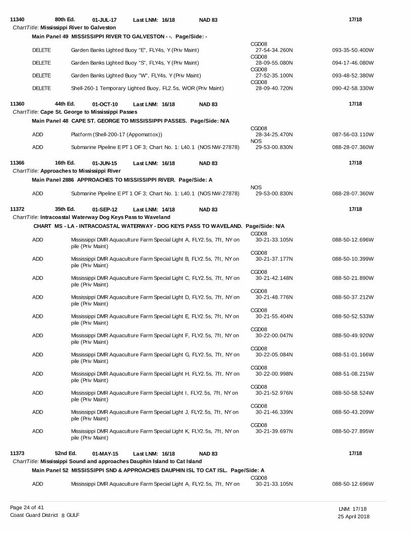
25 April 201817/18LNM:
8Coast Guard District GULFPage 24 of 41
11340
11360
11366
11372
11373
80th Ed.
44th Ed.
16th Ed.
35th Ed.
52nd Ed.
01-JUL-17
01-OCT-10
01-JUN-15
01-SEP-12
01-MAY-15
16/18
16/18
16/18
14/18
16/18
Mississippi River to Galveston
Cape St. George to Mississippi Passes
Approaches to Mississippi River
Intracoastal Waterway Dog Keys Pass to Waveland
Mississippi Sound and approaches Dauphin Island to Cat Island
ChartTitle:
ChartTitle:
ChartTitle:
ChartTitle:
ChartTitle:
NAD 83
NAD 83
NAD 83
NAD 83
NAD 83
Last LNM:
Last LNM:
Last LNM:
Last LNM:
Last LNM:
17/18
17/18
17/18
17/18
17/18
Main Panel 49 MISSISSIPPI RIVER TO GALVESTON - -. Page/Side: -
Main Panel 48 CAPE ST. GEORGE TO MISSISSIPPI PASSES. Page/Side: N/A
Main Panel 2886 APPROACHES TO MISSISSIPPI RIVER. Page/Side: A
CHART MS - LA - INTRACOASTAL WATERWAY - DOG KEYS PASS TO WAVELAND. Page/Side: N/A
Main Panel 52 MISSISSIPPI SND & APPROACHES DAUPHIN ISL TO CAT ISL. Page/Side: A
DELETE
DELETE
DELETE
DELETE
ADD
ADD
ADD
ADD
ADD
ADD
ADD
ADD
ADD
ADD
ADD
ADD
ADD
ADD
ADD
Garden Banks Lighted Buoy "E", FLY4s, Y (Priv Maint)
Garden Banks Lighted Buoy "S", FLY4s, Y (Priv Maint)
Garden Banks Lighted Buoy "W", FLY4s, Y (Priv Maint)
Shell-260-1 Temporary Lighted Buoy, FL2.5s, WOR (Priv Maint)
Platform (Shell-200-17 (Appomattox))
Submarine Pipeline E PT 1 OF 3; Chart No. 1: L40.1 (NOS NW-27878)
Submarine Pipeline E PT 1 OF 3; Chart No. 1: L40.1 (NOS NW-27878)
Mississippi DMR Aquaculture Farm Special Light A, FLY2.5s, 7ft, NY on pile (Priv Maint)
Mississippi DMR Aquaculture Farm Special Light B, FLY2.5s, 7ft, NY on pile (Priv Maint)
Mississippi DMR Aquaculture Farm Special Light C, FLY2.5s, 7ft, NY on pile (Priv Maint)
Mississippi DMR Aquaculture Farm Special Light D, FLY2.5s, 7ft, NY on pile (Priv Maint)
Mississippi DMR Aquaculture Farm Special Light E, FLY2.5s, 7ft, NY on pile (Priv Maint)
Mississippi DMR Aquaculture Farm Special Light F, FLY2.5s, 7ft, NY on pile (Priv Maint)
Mississippi DMR Aquaculture Farm Special Light G, FLY2.5s, 7ft, NY on pile (Priv Maint)
Mississippi DMR Aquaculture Farm Special Light H, FLY2.5s, 7ft, NY on pile (Priv Maint)
Mississippi DMR Aquaculture Farm Special Light I, FLY2.5s, 7ft, NY on pile (Priv Maint)
Mississippi DMR Aquaculture Farm Special Light J, FLY2.5s, 7ft, NY on pile (Priv Maint)
Mississippi DMR Aquaculture Farm Special Light K, FLY2.5s, 7ft, NY on pile (Priv Maint)
Mississippi DMR Aquaculture Farm Special Light A, FLY2.5s, 7ft, NY on
CGD08
CGD08
CGD08
CGD08
CGD08
NOS
NOS
CGD08
CGD08
CGD08
CGD08
CGD08
CGD08
CGD08
CGD08
CGD08
CGD08
CGD08
CGD08
27-54-34.260N
28-09-55.080N
27-52-35.100N
28-09-40.720N
28-34-25.470N
29-53-00.830N
29-53-00.830N
30-21-33.105N
30-21-37.177N
30-21-42.148N
30-21-48.776N
30-21-55.404N
30-22-00.047N
30-22-05.084N
30-22-00.998N
30-21-52.976N
30-21-46.339N
30-21-39.697N
30-21-33.105N
093-35-50.400W
094-17-46.080W
093-48-52.380W
090-42-58.330W
087-56-03.110W
088-28-07.360W
088-28-07.360W
088-50-12.696W
088-50-10.399W
088-50-21.890W
088-50-37.212W
088-50-52.533W
088-50-49.920W
088-51-01.166W
088-51-08.215W
088-50-58.524W
088-50-43.209W
088-50-27.895W
088-50-12.696W
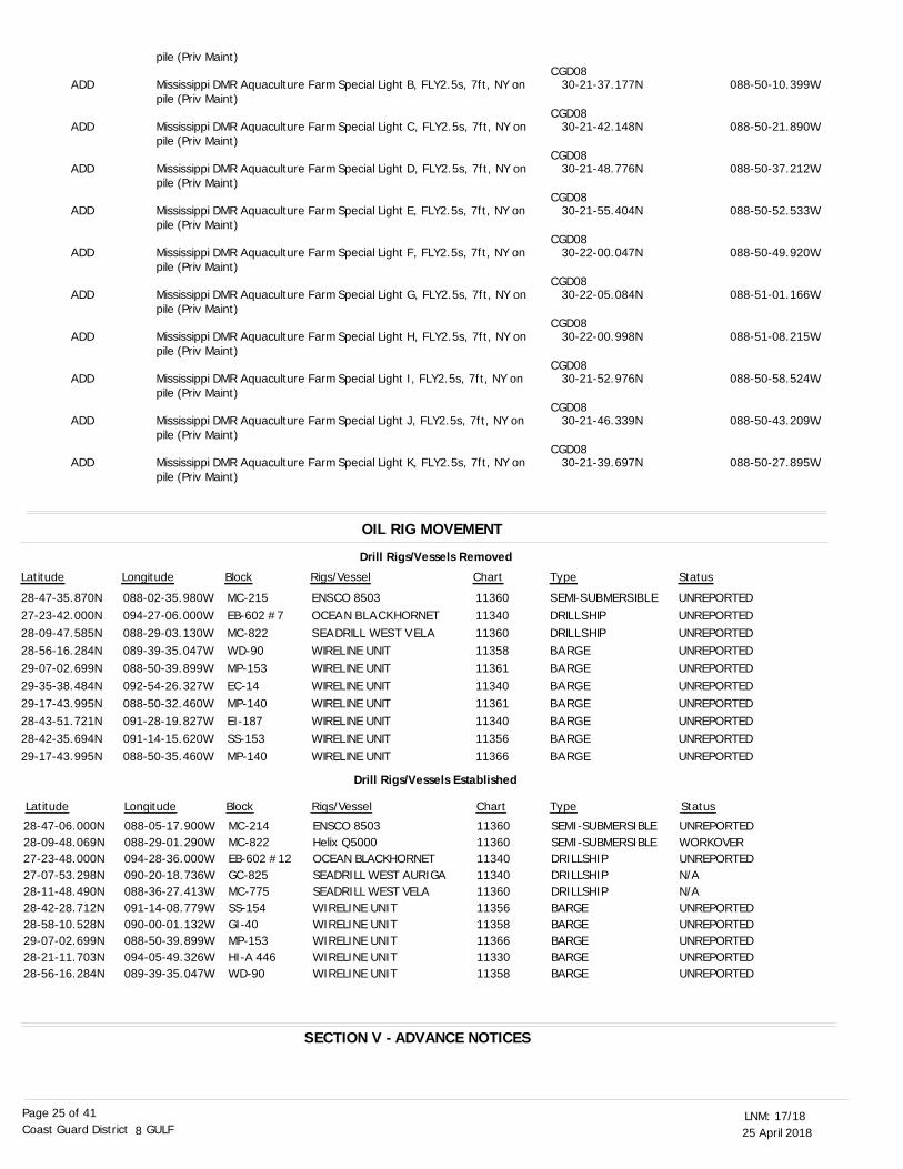
25 April 201817/18LNM:
8Coast Guard District GULFPage 25 of 41
OIL RIG MOVEMENT
SECTION V - ADVANCE NOTICES
Drill Rigs/Vessels Removed
Latitude Longitude Block Rigs/Vessel Type Status
28-47-35.870N27-23-42.000N28-09-47.585N28-56-16.284N29-07-02.699N29-35-38.484N29-17-43.995N28-43-51.721N28-42-35.694N29-17-43.995N
088-02-35.980W094-27-06.000W088-29-03.130W089-39-35.047W088-50-39.899W092-54-26.327W088-50-32.460W091-28-19.827W091-14-15.620W088-50-35.460W
MC-215EB-602 #7MC-822WD-90MP-153EC-14MP-140EI-187SS-153MP-140
ENSCO 8503OCEAN BLACKHORNETSEADRILL WEST VELAWIRELINE UNITWIRELINE UNITWIRELINE UNITWIRELINE UNITWIRELINE UNITWIRELINE UNITWIRELINE UNIT
11360113401136011358113611134011361113401135611366
SEMI-SUBMERSIBLEDRILLSHIPDRILLSHIPBARGEBARGEBARGEBARGEBARGEBARGEBARGE
UNREPORTEDUNREPORTEDUNREPORTEDUNREPORTEDUNREPORTEDUNREPORTEDUNREPORTEDUNREPORTEDUNREPORTEDUNREPORTED
Latitude Longitude Block Rigs/Vessel Type Status
28-47-06.000N28-09-48.069N27-23-48.000N27-07-53.298N28-11-48.490N28-42-28.712N28-58-10.528N29-07-02.699N28-21-11.703N28-56-16.284N
088-05-17.900W088-29-01.290W094-28-36.000W090-20-18.736W088-36-27.413W091-14-08.779W090-00-01.132W088-50-39.899W094-05-49.326W089-39-35.047W
MC-214MC-822EB-602 #12GC-825MC-775SS-154GI-40MP-153HI-A 446WD-90
ENSCO 8503Helix Q5000OCEAN BLACKHORNETSEADRILL WEST AURIGASEADRILL WEST VELAWIRELINE UNITWIRELINE UNITWIRELINE UNITWIRELINE UNITWIRELINE UNIT
11360113601134011340113601135611358113661133011358
SEMI-SUBMERSIBLESEMI-SUBMERSIBLEDRILLSHIPDRILLSHIPDRILLSHIPBARGEBARGEBARGEBARGEBARGE
UNREPORTEDWORKOVERUNREPORTEDN/AN/AUNREPORTEDUNREPORTEDUNREPORTEDUNREPORTEDUNREPORTED
Chart
Chart
Drill Rigs/Vessels Established
ADD
ADD
ADD
ADD
ADD
ADD
ADD
ADD
ADD
ADD
pile (Priv Maint)
Mississippi DMR Aquaculture Farm Special Light B, FLY2.5s, 7ft, NY on pile (Priv Maint)
Mississippi DMR Aquaculture Farm Special Light C, FLY2.5s, 7ft, NY on pile (Priv Maint)
Mississippi DMR Aquaculture Farm Special Light D, FLY2.5s, 7ft, NY on pile (Priv Maint)
Mississippi DMR Aquaculture Farm Special Light E, FLY2.5s, 7ft, NY on pile (Priv Maint)
Mississippi DMR Aquaculture Farm Special Light F, FLY2.5s, 7ft, NY on pile (Priv Maint)
Mississippi DMR Aquaculture Farm Special Light G, FLY2.5s, 7ft, NY on pile (Priv Maint)
Mississippi DMR Aquaculture Farm Special Light H, FLY2.5s, 7ft, NY on pile (Priv Maint)
Mississippi DMR Aquaculture Farm Special Light I, FLY2.5s, 7ft, NY on pile (Priv Maint)
Mississippi DMR Aquaculture Farm Special Light J, FLY2.5s, 7ft, NY on pile (Priv Maint)
Mississippi DMR Aquaculture Farm Special Light K, FLY2.5s, 7ft, NY on pile (Priv Maint)
CGD08
CGD08
CGD08
CGD08
CGD08
CGD08
CGD08
CGD08
CGD08
CGD08
30-21-37.177N
30-21-42.148N
30-21-48.776N
30-21-55.404N
30-22-00.047N
30-22-05.084N
30-22-00.998N
30-21-52.976N
30-21-46.339N
30-21-39.697N
088-50-10.399W
088-50-21.890W
088-50-37.212W
088-50-52.533W
088-50-49.920W
088-51-01.166W
088-51-08.215W
088-50-58.524W
088-50-43.209W
088-50-27.895W

25 April 201817/18LNM:
8Coast Guard District GULFPage 26 of 41
This section contains advance notice of approved projects, changes to aids to navigation, or upcoming temporary changes such as dredging, etc. Mariners are advised to use caution while transiting these areas.
SUMMARY OF ADVANCED APPROVED PROJECTS
Approved Project(s) Project Date Ref. LNM
TX – COPRUS CHRISTI BAY – LA QUINTA CHANNEL
TX – GALVESTON to RIO GRANDE
LA – MISSISSIPPI RIVER – VENICE to NEW ORLEANS
LA – POINT AU FER to MARSH ISLAND – ATCHAFALAYA CHANNEL
TX – UPPER GALVESTON BAY – HOUSTON SHIP CHANNEL – BAYPORT SHIP CHANNEL
In order to mark the centerline of the La Quinta Channel extension thefollowing aids to navigation will be established between May 2018 andOctober 2018:Establish La Quinta Channel A Outer Range Front Light (LLNR-29076) inposition 27-52-26.553N/097-14-56.319W, showing Q G Day/Night and KRW onskeleton tower.Establish La Quinta Channel A Outer Range Front Passing Light (LLNR-29076.01) in position 27-52-26.553N/097-14-56.319W, on same structure asthe La Quinta Channel A Outer Range Front Light, showing Fl W 4sEstablish La Quinta Channel A Outer Range Rear Light (LLNR-29077) inposition 27-52-20.098N/097-14-24.959W, showing Iso G 6s Day/Night and KRWon skeleton tower.Establish La Quinta Channel A Outer Precision Directional Light (LLNR-29078) in position 27-52-20.098N/097-14-24.959W, showing Fl G from 101.9to 102.2, F G from 102.2 to 102.6, alternating GW from 102.6 to 102.9, F W(on channel line) from 102.9 to 103.1, alternating RW from 103.1 to103.5, F R from 103.5 to 103.9, Fl R from 103.9 to 104.2. The PDL will bewaterway user activated via a Marine Radio Activated Light System (MRALS).Establish La Quinta Channel A Inner Range Front Light (LLNR-29101.25) inposition 27-52-53.103N/097-17-05.427W, showing Q G Day/Night and KRW onskeleton tower.Establish La Quinta Channel A Inner Range Rear Light (LLNR-29101.26) inposition 27-52-56.969N/097-17-24.241W, showing Iso G 6s Day/Night and KRWon skeleton tower.Establish La Quinta Channel A Inner Precision Directional Light (LLNR-29101.28) in position 27-52-56.969N/097-17-24.241W, on same structure asthe La Quinta Channel A Inner Range Rear Light, showing Fl R from 281.9 to282.3, F R from 282.3 to 282.6, alternating RW from 282.6 to 282.9, F W (on channel line) from 282.9 to 283.1, alternating GW from 283.1 to 283.5, F G from 283.5 to 283.8, Fl G from 283.8 to 284.2. The PDL will be waterway user activated via a Marine Radio Activated Light System (MRALS).More specific construction dates will be published as soon as they areavailable.
The following change will be made after the week of May 15, 2018.In order to facilitate Pilot boardings and allow additional time for the ship and crews to prepare for entering the Brownsville Ship Channel.Relocate Brazos Santiago Entrance Lighted Buoy BS (LLNR-1450) in approximateposition 26-03-55.982N/097-06-34.990W, 1.5NM east to approximate position26-03-56.460N/097-04-56.320W.
The following change will be made after the week of May 22, 2018.Discontinue Mississippi River - Gulf Outlet Daybeacon 68 (LLNR-11720) in approximate position 29-42-25.506N/089-25-40.908W.Discontinue Bayou Terre Aux Boeufs Daybeacon 3 (LLNR-12360) in approximate position 29-37-07.446N/089-29-14.842W.
The following change will be made after the week of May 22, 2018.Change and relocate Atchafalaya Channel Daybeacon 57 (LLNR-18856) in approximate position 29-27-49.223N/091-17-03.556W to Atchafalaya Channel Light 57 (LLNR-18856) in approximate position 29-27-50.063N/091-16-57.004W showing FL G 4s, 17ft Focal Height, 4NM, Nominal Range.
LNM:
LNM:
LNM:
LNM:
07/18
12/18
13/18
13/18
Chart
Chart
Charts:
Charts:
11309
11301 11302
11364
11351 11354
None
Advance Notice(s)

25 April 201817/18LNM:
8Coast Guard District GULFPage 27 of 41
TX – CLEAR LAKES to ESPIRITU SANTO BAY – MATAGORDA BAY
TX – LAGUNA MADRE – PORT MANSFIELD CHANNEL
The following changes will be made after the week of May 22, 2018.Due to dredging in the Bayport Ship Channel, the Inner Range Front Light and Inner Range Rear Light no longer mark the centerline of the channel. Additionally the Inner Range Rear Light is now obscured by new fuel tank construction. Discontinue Bayport Ship Channel Inner Range Front Light (LLNR-24465) in approximate position 29-36-47.054N/095-01-41.940W.Discontinue Bayport Ship Channel Inner Rear Range (LLNR-24470) in approximate position 29-36-46.544N/095-02-11.216W.
The following change will be made after the week of June 5, 2018.In order to provide a more efficient and effective Aid to Navigation the Coast Guard shall rebuild the currently destroyed Halfmoon Reef Light. Change Halfmoon Reef Light (LLNR-37670) in approximate position 28-32-20.672N/096-15-30.867W, Fl W 4s, 30ft Focal Height, 5NM Nominal Range, NR on skeleton tower on piles, Ra ref, to Halfmoon Reef Light (LLNR-37670) in approximate position 28-32-20.672N/096-15-30.867W, FL W4s, 17ft Focal Height, 5NM Nominal Range, NR on Dolphin, Ra ref.
The following changes will be made after the week of June 5, 2018.Due to shoaling and shallow water in Port Mansfield Channel, the Coast Guard in order to more effectively mark shallow water in vicinity of Daybeacons 17, 21 and 25 shall replace those daybeacons with buoys. The mariner shall see no reduction in either daymark visual range, or radar range. Change Port Mansfield Channel Daybeacon 17 (LLNR-29355) in approximate position 26-33-38.303N/097-20-42.944W to Port Mansfield Buoy 17 (LLNR-29355) in position 26-33-38.303N/097-20-42.944W, green can.Change Port Mansfield Channel Daybeacon 21 (LLNR-29375) in approximate position 26-33-35.963N/097-22-10.086W to Port Mansfield Buoy 21 (LLNR-29375) in approximate position 26-33-35.963N/097-22-10.086W, green can.Change Port Mansfield Channel Daybeacon 25 (LLNR-29395) in approximate position 26-33-32.541N/097-23-39.528W to Port Mansfield Buoy 25 (LLNR-29395) in approximate position 26-33-32.541N/097-23-39.528W, green can.
LNM:
LNM:
LNM:
13/18
15/18
15/18
SECTION VI - PROPOSED CHANGESPeriodically, the Coast Guard evaluates its system of aids to navigation to determine whether the conditions for which the aids to navigation were
established have changed. When changes occur, the feasibility of improving, relocating, replacing, or discontinuing aids are considered. This section contains notice(s) of non-approved, proposed projects open for comment. SPECIAL NOTE: Mariners are requested to respond in writing to the District
office unless otherwise noted (see banner page for address).
PROPOSED WATERWAY PROJECTS OPEN FOR PUBLIC COMMENT
Proposed Project(s) Closing Docket No. Ref. LNM
FL – ST. MARKS RIVER AND APPROACHES – ST. MARKS RIVER
TX – ELLENDER TO GALVESTON BAY – PORT ARTHUR-GALVESTON – BOLIVAR PENNISULA
TX – MATAGORDA BAY – LAVACA BAY – PORT LAVACA HARBOR OF REFUGE
Due to shoaling and shallow water depths, the Coast Guard is reducing the size of the buoy hullsmarking the channel. This change shall enable smaller Coast Guard vessels to respond quickerto any buoy discrepancies and better maintain this channel. The mariner will notice a slight difference in nominal visual range and radar range of the buoy.Reduce ST. Marks River Buoy 8 (LLNR-1550) on scene hull size in approximate position30-04-06.207N/084-11-22.607W.Comments to be taken until May 16, 2018.
Due to a history of Bolivar Peninsula Buoys 19 and 20 frequently being knocked off station the Coast Guard proposes the following changes in order to improve the visibility of Aids to Navigation in the Port Bolivar Channel.Relocate and change Bolivar Peninsula Lighted Buoy 20 (LLNR-35945) in approximate position 29-22-19.793N/094-47-09.542W to Bolivar Peninsula Light 20 (LLNR-35945) in position 29-22-21.149N/094-47-10.758W, showing Q R, 17ft Focal Height, 4NM Nominal Range, TR-TY on a pile, Ra ref.Change Bolivar Peninsula Lighted Buoy 19 (LLNR-35940) in approximate position 29-22-10.778N/094-47-08.755W to Bolivar Peninsula Light 19 (LLNR-35940),in position 29-22-10.778N/094-47-08.755W, showing Q G, 17ft Focal Height, 4NM Nominal Range, SG-SY on a pile, Ra ref. Comments to be received by May 22, 2018, please email comments regarding this proposal to: [email protected].
Due to shoaling and shallow water depths at the entrance to Port Lavaca Harbor of Refuge, the Coast Guard is unable to service Daybeacon 10.The Coast Guard proposes the following change.Change Port Lavaca Harbor of Refuge Daybeacon 10 (LLNR-27815) in approximate position 28-35-33.923N/096-36-46.506W to Port Lavaca Harbor of Refuge Buoy 10 (LLNR-27815) in approximate position 28-35-33.923N/096-36-46.506W, showing a red nun. Comments to be received
LNM:
LNM:
12/18
13/18
Chart
Charts:
Charts:
11326 11327
11316 11317 11319
11306
Chart
Charts:
11406
11324 11326 11331
None
Proposed Change Notice(s)

25 April 201817/18LNM:
8Coast Guard District GULFPage 28 of 41
TX – HOUSTON SHIP CHANNEL
TX – CORPUS CHRISTI BAY – PORT ISABEL CORPUS CHRISTI BAFFIN BAY
TX – LAGUNA MADRE – LAND CUT-ARROYO COLORADO
by May 29, 2018, please email comments regarding this proposal to: [email protected]
Due to Upper Red Light Bend Outbound Range Front Light experiencing numerous knockdowns from marine traffic allisions, the Coast Guard proposes moving the Range Rear Light to Spillman Island and moving the Range Front Light to the position currently assigned to the Range RearLight.Relocate Upper Red Light Bend Outbound Range Front Light (LLNR-25240) in approximate position 29-42-18.858N/095-01-15.980W, to approximate position 29-42-12.372N/095-01-15.999W.Relocate Upper Red Light Bend Outbound Range Rear Light (LLNR-25245) in approximate position29-42-12.372N/095-01-15.999W, to approximate position 29-42-05.194N/095-01-16.032W.Comments to be received by May 29, 2018, please email comments regarding this proposal to: [email protected]
Due to shoaling between Corpus Christi Baffin Bay Daybeacon 6 (LLNR-39760) and Corpus Christi Baffin Bay Buoy 10 (LLNR-39770) the Coast Guard is proposing the following Aid to Navigation Change.Establish Corpus Christi Baffin Bay Lighted Buoy 8 (LLNR-39768) in approximate position 27-40-46.103N/097-13-36.979W showing Q R, 3NM Nominal Range, red. Comments will be taken until June 5, 2018, please email comments regarding this proposal to: [email protected]
Due to a history of Land Cut-Arroyo Colorado Daybeacon 96 (LLNR-41995) frequently being knocked down and the temporary buoy going missing, the Coast Guard proposes the following change.Discontinue Land Cut-Arroyo Colorado Daybeacon 96 (LLNR-41995) in approximate position 26-29-21.096N/097-22-59.862W. Comments will be taken until June 12, 2018. Please email comments regarding this proposal to: [email protected] .
LNM:
LNM:
LNM:
LNM:
14/18
14/18
15/18
16/18
SECTION VII - GENERALThis section contains information of general concern to the Mariners. Mariners are advised to use caution while transiting these areas.
Continuing until April 28, 2018, the U.S. Air Force and U.S. Navy will conduct test operations in the Gulf of Mexico in the vicinity of Panama City Pass, Florida. No vessels will be allowed within 10 nautical miles of approximate position 29-38-25.0N 085-40-48.0W During military operations, the U.S. Navy Vessels TYSON B and PSC5, will be on-scene and will monitor VHF-FM Channel 16 or 82A. Mariners may contact U.S. Coast Guard Sector Mobile at (251) 441-5976, for additional information.
A fireworks display will be conducted on April 28, 2018, from 10:45 p.m. until 11:00 p.m. The fireworks will be launched from the end of a pier located at approximate position 30-11-11.6N 085-50-02.0W. All mariners are requested to remain a minimum of 600 feet from the fireworks due to hazards associated with fireworks. For up-to-date information, mariners can contact the U.S. Coast Guard Sector Mobile, at (251) 441-5976.
Commencing May 13, 2018 and continuing until approximately January 1, 2019, the U.S. Navy will be conducting inert underwater mine and Airborne Mine Neutralization System (AMNS) destructor testing in the Gulf of Mexico, in an area approximately 39 nautical miles southwest of the Panama City Pass. The inert mine destructors are silver and orange, 3 feet long, 6 inches in diameter and weighs approximately 2 pounds in water, while weighing 35 pounds in air. Inert mine bottom shapes and inert mine destructors will be deployed, operated and tested in the below test areas during this period. AMNS testing will consist of surface ship operations to include the following: R/V SEWEE or R/V STARFLEET PATRIOT and Project Support Crafts (PSC) 02, 03, 05 or PSC 11; however, additional R/Vs may be added in the future. It is requested that all vessels maintain a one nautical mile CPA of all vessels while operations are in progress. All U.S. Navy / U.S. Navy contracted AMNS support vessels will monitor VHF-FM Channel 16. For up-to-date information, mariners can contact Mr. Robertson, at (850) 230-7698 or via e-mail at [email protected] . The corners of the test areas are as follows: Test Area Tango:29-56-25.20N 085-54-36.00W,29-58-55.20N 085-54-36.00W,29-58-55.20N 085-51-42.60W and29-56-25.20N 085-51-42.60W.
Test Area Harp 8:29-45-25.20N 086-21-49.80W,29-47-01.20N 086-21-49.80W,29-47-01.20N 086-19-52.80W and
LNM:
LNM:
17-18
15-18
FL - GULF OF MEXICO - PANAMA CITY BEACH - Naval Operations
FL - GULF OF MEXICO - PANAMA CITY BEACH - Fireworks Display
FL - GULF OF MEXICO-- U.S. Navy Testing
Chart
Chart
Charts:
Charts:
11317
11329
11308 11309
11303 11306
Charts:
Charts:
1115A 11360
11389 11390

25 April 201817/18LNM:
8Coast Guard District GULFPage 29 of 41
29-45-25.20N 086-19-52.80W.
The U.S. Navy will be conducting tow body test operations in the Gulf of Mexico, navigation chart; U.S. Gulf Of Mexico Cape St. George to Mississippi Passes chart number 11362, Panama City Operations Area; W-151A, W-151B, 6D, 6C and 7B, continuing through June 30, 2018. The test area is defined by the following approximate positions:29-45-13.9N 086-06-08.3W,29-23-01.0N 086-11-48.1W,29-22-31.7N 086-27-38.5W and29-38-46.2N 086-27-50.0W.The U.S. Navy will be towing the submerged towed body behind the tow platform at various cable scopes that could reach up to 1,600 feet. The vessel will display the appropriate day shapes per the International Regulations for Prevention of Collisions at Sea, 1972 (72 COLREGS) while the tow body operations are being conducted. The main surface craft supporting these test/operations and serving as the tow platform is the M/V PATRIOT. It is requested that all vessels maintain a one nautical mile CPA of the M/V PATRIOT while operations are in progress. All U.S. Navy support craft will monitor VHF-FM Channel 16
Personal Watercraft Races Pro Watercross will be conducting the Pro Watercross Tour in Panama City Beach, Florida, on May 5 and 6, 2018, from 6:30 a.m. until 6:00 p.m., each day. The event will take place in the Gulf of Mexico in front of the Edgewater Beach and Golf Resort, Panama City Beach, Florida. Mariners are urged to remain a minimum of 100 yards from the marked race course, due to hazards associated with personal watercrafts. For up-to-date information, mariners can contact the U.S. Coast Guard at (251) 441-5976.
Based on a 10-day forecast for releases from Jim Woodruff Lock and Dam and subsequent forecast stage at Blountstown gauge, we are supporting a 7-foot navigation channel through April 25, 2018. The Blountstown gauge is currently 7.4 feet and forecast to remain the same during this forecast period.Mariners anticipating using the system are encouraged to monitor the flow and water levels at the following website: http://water.sam.usace.army.mil/ .To schedule lockage, mariners can contact (229) 723-3482. Anyone anticipating a barge shipment on the system is encouraged to contact Carl Dyess, at (251) 690-2570.
The Portofino Island Resort will be conducting a fireworks display on April 28, 2018, from 8:30 p.m. until 9:00 p.m. The fireworks will be launched from a barge on Santa Rosa Sound at approximate position 30-20-56.4N 087-04-59.0W, Pensacola Beach, FL. All mariners are requested to remain a minimum of 210 feet from the fireworks barge due to hazards associated with fireworks. For further information, mariners can contact U.S. Coast Guard Sector Mobile, at (251) 441-5976.
Continuing until approximately April 30, 2018, the Dredge KELLY L will be conducting dredging operations to remove shoaling in an area between GIWW, mile 179.0, EHL and GIWW, mile 180.0, EHL. Dredge material will be disposed into an upland disposal area located just south of the channel utilizing floating and submerged pipelines. All vessels will be lighted in accordance to U.S. Coast Guard Safety Regulations. The Dredge KELLY L will be monitoring VHF-FM Channel 13 or 16. Mariners are urged to exercise caution when transiting the area.
Rehabilitation work will continue until July 4, 2018, on the U.S. Hwy. 90 (SR 10) bridge crossing White Bayou (aka Saultsman Cove). Work consist of surface preparation of the existing piles at bents 6, 9, 10, 12, 13 and 14, moving in an east to west direction. The work is to integral pile jackets and cathodic protection systems during daylight hours only. There will be no changes to the horizontal or vertical clearances. They will be utilizing pontoon boats 22 to 24 feet in length and 8 to10 feet wide. Equipment will be removed from the waterway at night. Equipment should be properly lighted according to the “Inland Navigation Rules of 1980”. Radio equipment will be monitored and a contact number at the job site is (256) 810-7676. Mariners should use caution when transiting the bridge.
In order to accommodate dredging operations, the U.S. Coast Guard has temporarily established Synthetic AIS aids to navigation in the entrance to Pensacola Bay for the following aids:Pensacola Bay Entrance Buoy 10 (LLNR-4810) in approximate position 30-19-15.748N 087-18-24.237W.Pensacola Bay Entrance Lighted Buoy 11 (LLNR-4815) in approximate position 30-19-16.220N 087-18-34.102W.Pensacola Bay Lighted Buoy 15 (LLNR-4840) in approximate position 30-20-15.224N 087-18-07.464W.The U.S. Coast Guard has temporarily discontinued the following physical aids to navigation and replaced them with virtual AIS aids to navigation:Pensacola Bay Entrance Lighted Buoy 12 (LLNR-4820) in approximate position 30-19-41.907N 087-18-27.003W.Pensacola Bay Lighted Buoy 14 (LLNR-4835) in approximate position 30-19-56.278N 087-18-19.191W.
LNM:
LNM:
LNM:
LNM:
LNM:
LNM:
LNM:
17-18
13-18
17-18
17-18
15-18
16-18
17-18
FL - GULF OF MEXICO-- U.S. Navy Testing
FL - GULF OF MEXICO - U.S. Navy Testing
FL - GULF OF MEXICO - Personal Watercraft Races
FL - APALACHICOLA-CHATTAHOOCHEE-FLINT RIVER BASIN - Channel Conditions - UPDATE
FL - SANTA ROSA SOUND - Fireworks Display
FL - GIWW - SANTA ROSA SOUND - Dredge Operation
FL - WHITE RIVER - Bridge RIP-RAP Rehabilitation - UPDATE
FL - GULF OF MEXICO - PENSACOLA BAY - Synthetic AIS Temporary Establishment
Chart
Chart
Charts:
Charts:
Charts:
Charts:
Charts:
1115A 11360
1115A 11360
1115A 11360
11401
11385
11378 11383
11378 11382 11385

25 April 201817/18LNM:
8Coast Guard District GULFPage 30 of 41
Mariners are advised to exercise caution while transiting the area.
Commencing approximately April 28, 2018 and continuing until approximately May 20, 2018, the Hopper Dredge COLUMBIA will be conducting dredging operations in the vicinity of Pensacola Bay, FL. Work will be conducted 24-hours a day, 7-days a week. The Hopper Dredge COLUMBIA will be monitoring VHF-FM Channel 13, 16 or 69. Mariners are urged to exercise caution when transiting the area.
Continuing until approximately December 31, 2020, construction of the new Pensacola Bay Bridge will be taking place on Pensacola Bay, Florida. The COTP Mobile under the Ports and Waterways Safety Act has established a temporary Safety Zone within 500 yards of current bridge construction. This Safety Zone restricts vessel speed to an idle speed for all vessels within the zone. Mariners are urged to transit the area with extreme caution. For up-to-date information, mariners can contact the COTP, U.S. Coast Guard Sector Mobile, at (251) 441-5976.
The Pensacola Triathlon will be held April 29, 2018, from 5:00 a.m. to 9:00 a.m. The COTP Mobile under the authority of the Ports And WaterwaysSafety Act has established a special local regulation for this event. No vessel may transit within a 300 yard radius from position 30-24-16.4N 087-12-55.2W, in Pensacola, FL., during the Pensacola triathlon without prior approval. The event will held in the Pensacola bay near the Palafox pier marina. For up-to-date information, mariners can contact the U.S. Coast Guard Sector Mobile, at (251) 441-5976.
There will be a fireworks display from the Grand Hotel in Point Clear, AL., on April 27, 2018, from 9:00 p.m. until 9:30 p.m. The fireworks will be launched from a barge at approximate position 30-28-53.46N 087-56-06.74W. All mariners are requested to use caution while transiting the area. For additional information, mariners can contact the U.S. Coast Guard Sector Mobile, at (251) 441-5976.
Draft restrictions have be.en implemented due to shoaling in the Mobile River to a maximum draft of 38 feet from north of the grain elevator at Alabama State Port Authority to the Three Mile Creek Turning Basin and in the Theodore Ship Channel to a maximum draft of 36 feet.Continuing until approximately April 26, 2018, the Hopper Dredge COLUMBIA, will be dredging the Mobile River shoal. The dredge will be disposing material into the Ocean Dredge Material Disposal Site (ODMDS) south of Dauphin Island. The Hopper Dredge COLUMBIA will monitor VHF-FM Channel 13 or 16. Mariners are urged to transit the area at their slowest safe speed to minimize wake and proceed with caution after passing arrangements have been made. For up-to-date information, mariners can contact the USACE, Irvington Site Office at (251) 957-6019.Please refer to the Harbor Master Notices 03-18 and 04-18, attached to this LNM.
The Fairhope Yacht Club will be conducting the annual Dauphin Island Race in Mobile Bay. This event is published in 33 Code of Federal Regulations part 100.801 (Table 7 #97, Mobile #10) as a special local regulation and will take place on April 28, 2018, from 8:00 a.m. until 5:00 p.m. The regulated area for this event is Mobile Bay, from the Middle Bay Light to Mobile Channel Light 37 (LLNR-6330). Vessels desiring to transitthe regulated area may do so only with prior approval of the Patrol Commander and when so directed by that officer and will be operated at a no wake speed in a manner which will not endanger participants in the event or any other craft. The Patrol Commander may be contacted on VHF-FMChannel 16, call sign “PATCOM”. For up-to-date information, mariners can contact the U.S. Coast Guard Sector Mobile, at (251) 441-5976.
The swim portion of the Capital of Dreams Triathlon competition will be conducted in the Alabama River, Montgomery, AL, on May 5, 2018, from 6:00 a.m. until 9:00 a.m. Mariners are urged to use extreme caution while transiting the Alabama River between Mile 287.0 and Mile 289.0. For up-to-date information, mariners can contact the U.S. Coast Guard Sector Mobile, at (251) 441-5976.
Saint Margaret’s Church will be conducting its annual Blessing of the Fleet in Bayou La Batre, Alabama. This event is published in 33 Code of Federal Regulations part 100.801 (Table 1 Mobile #11) as a special local regulation for May 6, 2018, from noon until 3:00 p.m. The regulated areafor this event is all of Bayou La Batre from Saint Margaret’s Church near the 188 Drawbridge to the mouth of Bayou La Batre. Entry into, transiting or anchoring in this area is prohibited to all vessels not registered with the sponsor as participants or not part of the regatta patrol. Vessels desiring to transit the regulated area may do so only with prior approval of the Patrol Commander and when so directed by that officer andwill be operated at a no wake speed in a manner which will not endanger participants in the event or any other craft. The Patrol Commander can be contacted on VHF-FM Channel 16, Call Sign “PATCOM”. For up-to-date information, mariners can contact the U.S. Coast Guard Sector Mobile Waterways Management Branch, at (251) 441-5976.
LNM:
LNM:
LNM:
LNM:
LNM:
LNM:
LNM:
LNM:
LNM:
17-18
17-18
07-18
15-18
15-18
15-18
14-18
17-18
17-18
FL - GULF OF MEXICO - PENSACOLA BAY - Synthetic AIS Temporary Establishment
FL - GULF OF MEXICO - PENSACOLA BAY - Dredge Operation
FL - PENSACOLA BAY - Bridge Construction of New Bridge
FL - PENSACOLA BAY - Marine Event
AL - MOBILE BAY - Fireworks Display
AL - MOBILE HARBOR - Draft Restrictions - Shoaling - Dredge Operation
AL - MOBILE BAY - Sail Boat Race
AL - ALABAMA RIVER - Triathlon
AL - BAYOU LA BATRE - Regatta
AL - BLACK WARRIOR RIVER - Lock Closure
Chart
Chart
Chart
Chart
Chart
Chart
Charts:
Charts:
Charts:
411 11378 11382 11385
411 11378 11382 11385
11382 11383
11382
11376
11376
11376
11376
11374

25 April 201817/18LNM:
8Coast Guard District GULFPage 31 of 41
The Holt Lock, in the vicinity of mile 347.0, will be closed commencing approximately 7:00 a.m., July 10, 2018 and continuing until approximately 7:00 p.m., August 8, 2018. The closure is to replace the lower miter gates and related components. For up-to-date information, mariners can contact Anthony Perkins or Danny Hensley at the BWT/Alabama-Coosa Project Management Office (CESAM-OP-BA), at (205) 752-3571.
The Bankhead Lock, in the vicinity of mile 366.0, will be closed commencing approximately 7:00 a.m., July 11, 2018 and continuing until approximately 7:00 p.m., August 7, 2018. The closure is to replace sections of hydraulic pipes for the lock operating machinery and related components. For up-to-date information, mariners can contact Anthony Perkins or Danny Hensley at the BWT/Alabama-Coosa Project Management Office (CESAM-OP-BA), at (205) 752-3571.
Continuing until approximatley April 30, 2018, the Dredge E STROUD will be dredging in Bayou Casotte near the Chevron facility. The dredging material will be disposed of using submerged and floating pipeline. The dredge plant will be monitoring VHF-FM Channel 13 or 16. Mariners are requested to exercise extreme caution and reduce speed in the vicinity of the area. For up-to-date information, mariners can contact U.S. Coast Guard Sector Mobile, at (251) 441-5976.
The Naval Research Laboratory deployed BOPPERS (Bio-Optical Physical Pop-Up Environmental Reconnaissance System) in approximate position 30-12-22.0N 088-47-07.W, in approximately 10 meters of water. The system consisted of a 2.2 meter in diameter weighted-trawl resistant dome that houses various instruments and a 0.3 meter in diameter gray profiling unit that is winched back and forth to the surface at set times and takesoptical and hydrographic measurements of the water column. Upon recovery of the system this morning, on April 17, 2018, the profiling unit was missing. Approximately three weeks ago, the Naval Research Laboratory deployed a line mooring at 30-16-00.8N 088-47-11.1W, near the western end of Horn Island in approximately 6 meters of water. The system consisted of a surface hazard buoy (white and orange, 6-feet long, with a flashing light on the top). The buoy was attached by a cable line to an anchor resting on the sea floor, with hydrographic and optical instruments attachedalong the cable. Upon attempted recovery of the system on April 17, 2018, the surface buoy, cable, and attached instruments were missing. Mariners are urged to keep a sharp lookout and report any sightings to U.S. Naval Research Laboratory, at (228) 688-5587.
Attached as an enclosure to this LNM, notification from Great Lakes Dredge and Dock of Barrier Island restoration operations.
Breakwater construction operations are being conducted from Heron Bay to Bayou Bolan in Mississippi Sound. The project consists of constructing a stone breakwater to a +2.0 feet elevation, from Heron Bay to Bayou Bolan. Mariners are advised that several spud barges with equipment as well as barges transporting stone to and from the site will be in the area. Tow boats will be manned 24 hours per day and will include the M/V JAY GENE. Fleeting will occur along the project and the mouth of the Pearl River. Anticipated completion of this project is November 30, 2018. For up-to-date information, mariners can contact U.S. Coast Guard Sector Mobile, at (251) 441-5976.
Continuing until approximately June 30, 2018, EPIC Offshore will be conducting pipeline installation operations in Main Pass Area, Block 261 to MainPass Block 226, in approximate position 29-20-49.817N 088-06-46.770W. Work will be performed 24-hours a day, 7-days week. The M/V EPIC EXPLORER, AHT CROSBY RAM and MSV MR TREY will be monitoring VHF-FM Channel 07, 16 or 18. Mariners are urged to transit with caution. For up-to-date information, mariners can contact (281) 709-2366 ext 101. All vessels must notify the facility, MP 261A platform, of their intended approach route due to anchor positions and diving operations in the area. A 4-point anchor spread installed to position the vessel is required and all vessels are requested to stand clear a radius of 1.5-miles from facility, MP 261A platform.
Great Lakes Dredge and Dock has deployed a wave buoy until approximately July 31, 2018, in approximate position 28-54-19.4N 090-55-28.8W, to monitor wave height conditions for the Coastal Restoration project. The buoy emits a group amber flashing light pattern of 5 every 20 seconds. Great Lakes Dredge and Dock Company is continuing its work on the State of Louisiana, Coastal Protection and Restoration Authority (CPRA) in accordance with the Plans and Permits issued by CPRA. For updated information regarding the wave buoy, mariners can contact Tug KJ LEBEOUF or Dredge ALASKA via VHF-FM Channel 13 or 16.
Continuing until approximately July 2018, Great Lakes Dredge & Dock Company will be conducting dredging operations from the Ship Shoal Block 88Borrow Area located approximately 8.2 nautical miles south southwest of Whiskey Island. Material dredged will be hydraulically placed via submerged pipeline onto the center of Whiskey Island. The 30 inch diameter submerged steel pipeline will be placed directly on top of the existing natural sea floor within the permitted conveyance corridor. The hydraulic cutter suction Dredge ALASKA will be operating within the Ship Shoal
LNM:
LNM:
LNM:
LNM:
LNM:
LNM:
LNM:
LNM:
08-18
08-18
13-18
17-18
15-18
14-18
19-17
15-18
AL - BLACK WARRIOR RIVER - Lock Closure
AL - BLACK WARRIOR RIVER - Lock Closure
MS - PASCAGOULA HARBOR - Dredge Operation
MS - HORN ISLAND - SHIP ISLAND - Naval Research Instrument Deployment - UPDATE
MS - MISSISSIPPI SOUND - BILOXI BAY - Dredge Operation/Pipe Staging/Barrier Island Restoration Operation
MS - MISSISSIPPI SOUND - WAVELAND - Breakwater Construction Project
LA - GULF OF MEXICO - Pipeline Installation Operation
LA - GULF OF MEXICO - SHIP SHOAL BLOCK 88 - WHISKEY ISLAND - Dredge Operation - Coastal Restoration
LA - GULF OF MEXICO - SHIP SHOAL BLOCK 88 - WHISKEY ISLAND - Dredge Operation - Coastal Restoration
Charts:
Charts:
Charts:
Charts:
Charts:
Charts:
11373 11375
11372 11373 11374
11372 11373
11367 11372
1116A 11340
1116A 11340 11352

25 April 201817/18LNM:
8Coast Guard District GULFPage 32 of 41
Block 88 Borrow Area along with Tender Tugs and Anchor Barges. Approximately 3,000 feet of float hose will be trailing the Dredge ALASKA withinthe Borrow Area. Three Hydraulic Boosters, the ERIN, JESSIE and TEXAS JUNIOR, will be anchored at various points within the permitted submerged pipeline conveyance corridor to aid in pumping the dredge material from the Borrow Area to Whiskey Island. Work will be performed 24-hours a day, 7-days a week. The Dredge ALASKA and support vessels will be monitoring VHF-FM Channel 13 or 16. All vessels will display appropriate lighting and day markers as required by U.S. Coast Guard Regulations. All floating pipeline (Float Hose) and marker/anchor buoys will be highly visible and marked with yellow flashing lights. The submerged pipeline will be marked with regularly spaced orange Norwegian type buoyswith Solas retro-reflective tape at a maximum spacing of 500 feet as well as yellow can buoys with yellow flashing lights at a maximum spacing of 2,500 feet apart. The Project is comprised of offshore borrow areas and the existing barrier island of Whiskey Island, in approximate positions:Ship Shoal Block 88 Borrow Area Corner Locations (Dredge ALASKA Operating Area):NW Corner 28-55-32.9147N 090-55-29.6222WSW Corner 28-54-17.9753N 090-55-29.9257WSE Corner 28-54-17.7698N 090-54-25.8002WNE Corner 28-55-32.7089N 090-54-25.3758W.Submerged Pipeline Conveyance Corridor (Hydraulic Booster Operating Area):Whiskey Island End 29-02-08.4618N 090-50-02.8422W29-02-08.9199N 090-50-14.1443W29-00-14.5152N 090-49-53.4315W29-00-17.1615N 090-50-04.6641W28-57-16.3312N 090-51-50.8470W28-57-22.8550N 090-51-59.5848W28-57-03.4986N 090-52-26.9686W28-56-56.4657N 090-52-18.9516W28-56-47.6539N 090-52-41.3682W28-56-40.6212N 090-52-33.3512W28-56-26.9696N 090-53-18.6321W28-56-18.5712N 090-53-12.5472W28-55-33.2572N 090-54-34.5653WShip Shoal Block 88 End 28-55-29.9143N 090-54-21.3357W.Whiskey Island Fill Area:NW Corner 29-03-54.5091N 090-52-26.1586WNE Corner 29-03-53.4075N 090-47-38.4407WSE Corner 29-02-23.0886N 090-47-38.9245WSW Corner 29-02-24.1899N 090-52-26.5707WWhiskey Island Waterside Staging Area:NW Corner 29-03-23.7713N 090-49-49.8442WNE Corner 29-03-23.8838N 090-50-12.5522WSE Corner 29-03-16.1126N 090-49-49.9049WSW Corner 29-03-16.0438N 090-50-12.6023WHouma Navigation Channel Staging Area:NW Corner 29-14-27.4306N 090-40-38.2248WNE Corner 29-14-28.9511N 090-40-33.6142WSE Corner 29-14-09.0411N 090-40-19.3350WSW Corner 29-14-07.3240N 090-40-20.7217WCocodrie Staging Area 1:NW Corner 29-14-46.4106N 090-40-31.5366WNE Corner 29-14-49.9697N 090-40-13.0789WSE Corner 29-14-48.8964N 090-40-12.8683WSW Corner 29-14-45.4018N 090-40-29.9377WCocodrie Staging Area 2:NW Corner 29-14-52.8083N 090-39-59.3434WNE Corner 29-14-52.5912N 090-39-57.9400WSE Corner 29-14-48.7320N 090-39-58.3936WSW Corner 29-14-49.0105N 090-40-00.0705W. All mariners are requested to transit these areas with extreme caution. Trawling and dragging operations should not be conducted in the vicinity of the Ship Shoal Block 88 Borrow Area, the permitted Submerged Pipeline Conveyance Corridor,the Whiskey Island fill area or the Whiskey Island staging area.
A 350-foot derrick barge TOPS DB1 has reportedly sunk in the Gulf of Mexico in approximate position 29-18-30.0N 093-14-24.0W, in the vicinity of West Cameron Block 198A. The derrick barge will be marked along the perimeters of the barge with lighted danger buoys, white with orange stripe, white flashing 2.5 seconds in the following approximate positions:29-18-32.604N 093-14-40.186W,29-18-26.296N 093-14-30.788W,29-18-38.876N 093-14-34.705W and29-18-32.568N 093-14-25.308W.Mariners are urged to use caution in this area.
LNM:
LNM:
46-17
44-17
LA - GULF OF MEXICO - SHIP SHOAL BLOCK 88 - WHISKEY ISLAND - Dredge Operation - Coastal Restoration
LA - GULF OF MEXICO - Wreck
LA - SOUTHWEST PASS - MISSISSIPPI RIVER - Dredge Operation
Charts:
Charts:
1116A 11340 11352
1116A 11330 11340

25 April 201817/18LNM:
8Coast Guard District GULFPage 33 of 41
Continuing until approximately June 30, 2018, the Hopper Dredge NEWPORT will be working in Southwest Pass from Head of Passes (Mile 0.0) to approximately Mile 22.0, BHOP, and in the Mississippi River from Head of Passes to approximately Mile 11.0, AHOP. Dredging will be performed 24-hours a day, 7-days a week. The Hopper Dredge NEWPORT will be monitoring VHF-FM Channel 16 or 67. Mariners are urged to transit at theirslowest safe speed to minimize wake and proceed with caution after passing arrangements have been made. For up-to-date information, marinerscan contact Michelle Kornick, at (504) 862-1842 or Heather Jennings, at (504) 862-1253.
Continuing until approximately June 30, 2018, the Hopper Dredge BAYPORT will be working in Southwest Pass from Head of Passes (Mile 0.0) to approximately Mile 22.0, BHOP, and in the Mississippi River from Head of Passes to approximately Mile 11.0, AHOP. Dredging will be performed 24-hours a day, 7-days a week. The Hopper Dredge BAYPORT will be monitoring VHF-FM Channel 16 or 67. Mariners are urged to transit at their slowest safe speed to minimize wake and proceed with caution after passing arrangements have been made. For up-to-date information, marinerscan contact Michelle Kornick, at (504) 862-1842 or Heather Jennings, at (504) 862-1253.
Continuing until approximately July 31, 2018, the Cutterhead Dredge ROBERT M. WHITE will be working in Southwest Pass from Head of Passes (Mile 0.0) to approximately Mile 22.0, BHOP, and in the Mississippi River from Head of Passes to approximately Mile 11.0, AHOP. The dredged material will be deposited through a combination of floating and submerged pipelines into designated placement areas. Dredging will be performed 24-hours a day, 7-days a week. The Cutterhead Dredge ROBERT M. WHITE will be monitoring VHF-FM Channel 16 or 67. Mariners are urged to transit at their slowest safe speed to minimize wake and proceed with caution after passing arrangements have been made. For up-to-date information, mariners can contact Michelle Kornick, at (504) 862-1842 or Heather Jennings, at (504) 862-1253.
Continuing until approximately May 31, 2018, the U.S. Government Contract Hopper Dredge GLENN EDWARDS will be dredging in Southwest Pass from Head of Passes (Mile 0.0) to the Lower Jetty Bar Channel and the Mississippi River from Head of Passes to Mile 11.0, AHOP. Dredging will be performed 24-hours a day, 7-days a week. The Dredge GLENN EDWARDS will be monitoring VHF-FM Channel 16 or 67. Mariners are urged to transit at their slowest safe speed to minimize wake and proceed with caution after passing arrangements have been made. For up-to-date information, mariners can contact Michelle Kornick, at (504) 862-1842 or Heather Jennings, at (504) 862-1253.
Continuing until approximately May 31, 2018, the Hopper Dredge WHEELER will be working in Southwest Pass from Head of Passes (Mile 0.0) to the Lower Jetty Bar Channel and the Mississippi River from Head of Passes to Mile 11.0, AHOP. Dredging will be performed 24-hours a day, 7-days a week. The Hopper Dredge WHEELER will be monitoring VHF-FM Channel 16 or 67. Mariners are urged to transit at their slowest safe speedto minimize wake and proceed with caution after passing arrangements have been made. For up-to-date information, mariners can contact Michelle Kornick, at (504) 862-1842 or Heather Jennings, at (504) 862-1253.
Continuing until September 30, 2018, Crosby Dredging LLC., will be conducting dredging operations along the western edge of Rigolets Pass. Dredge CROSBY DREDGER and tender M/V CAPT WEBSTER will be working 24-hours a day, 7-days a week. Dredge CROSBY DREDGER and tenderM/V CAPT WEBSTER will be monitoring VHF-FM Channel 69. Mariners are urged to use caution when transiting within the area. The point of contact, Hud Lee or Michael Orgeron can be contacted, at (985) 677-6100 or (504) 638-0040, for additional information
The Norfolk Southern Railroad bascule span bridge (Seabrook Railroad Bridge) across the Inner Harbor Navigation Canal, mile 4.5, at New Orleans,Orleans Parish, Louisiana, will be performing track work (replacement of ties and rails) placing the bridge in a closed-to-navigation position on the following dates: Monday through Thursday on April 30, 2018 until May 3, 2018, May 7-10, 2018 and May 14-17, 2018, from at 8:00 a.m. until 2:00 p.m., each day. In the down position, the vertical clearance is one foot above Mean High Water with elevation 5 feet. Mariners should plan the alternate route through Chef Pass or the Rigolets. The 24-hour contact number, is (540) 577-9480 or (601) 323-9398.
The St. Claude Avenue (SR 39) bascule span bridge across the Inner Harbor Navigation Canal, GIWW, 6.2, EHL, mile 0.50, at New Orleans, Orleans Parish, Louisiana, will be performing mechanical and structural repairs. The bridge will remain in the open-to-navigation position for approximately 10 consecutive days (240-hours) Thursday, May 10, 2018 through May 19, 2018. Crews will be working 24-hours a day. For up-to-date information, mariners can (251) 709-2511.
Continuing until approximately August 31, 2018, Cutterhead Dredge G.D. MORGAN and attendant plant will be conducting dredging operations between Mississippi River approximate Mile 6.0, AHOP, and Southwest Pass approximate Mile 19.5, BHOP. Dredged material will be transported tothe bank using a combination of floating and submerged pipeline to placement sites as directed by the USACE. Work will be conducted 24-hours a
LNM:
LNM:
LNM:
LNM:
LNM:
LNM:
LNM:
LNM:
11-18
11-18
11-18
16-18
12-18
10-18
13-18
13-18
LA - SOUTHWEST PASS - MISSISSIPPI RIVER - Dredge Operation
LA - SOUTHWEST PASS - MISSISSIPPI RIVER - Dredge Operation
LA - SOUTHWEST PASS - MISSISSIPPI RIVER - Dredge Operation
LA - SOUTHWEST PASS - MISSISSIPPI RIVER - Dredge Operation
LA - SOUTHWEST PASS - MISSISSIPPI RIVER - Dredge Operation
LA - RIGOLETS PASS - Dredging Operation
LA - NEW ORLEANS HARBOR - INNER HARBOR NAVIGATION CANAL - Bridge Repair
LA - GIWW - NEW ORLEANS HARBOR - INNER HARBOR NAVIGATION CANAL - Bridge Repairs
LA - MISSISSIPPI RIVER - Dredge Operation
Chart
Chart
Chart
Chart
Chart
Charts:
Charts:
Charts:
11361
11361
11361
11361
11361
11367 11369 11371
11368 11369 11370
11368 11369 11370
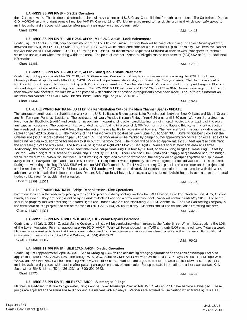
25 April 201817/18LNM:
8Coast Guard District GULFPage 34 of 41
day, 7-days a week. The dredge and attendant plant will have all required U.S. Coast Guard lighting for night operations. The Cutterhead DredgeG.D. MORGAN and attendant plant will monitor VHF-FM Channel 16 or 67. Mariners are urged to transit the area at their slowest safe speed to minimize wake and proceed with caution after passing arrangements have been made.
Continuing until April 28, 2018, ship dock maintenance on the Chevron Empire Terminal Dock will be conducted along the Lower Mississippi River, between Mile 25.0, AHOP, LDB, to Mile 26.0, AHOP, LDB. Work will be conducted from 6:00 a.m. until 8:00 p.m., each day. Mariners can contact the worksite via VHF-FM Channel 10 or 16, for sailing instructions. All mariners are requested to transit at their slowest safe speed to minimize wake and use caution when transiting within the area. The point of contact, Kenneth Pellegrin can be contacted at (504) 952-8802, for additional information.
Continuing until approximately May 30, 2018, a U.S. Government Contractor will be placing subaqueous stone along the RDB of the Lower Mississippi River at approximate Mile 25.2, AHOP. Work will be performed during daylight hours only, 7-days a week. The plant consists of a trackhoe barge with an anchor system set up with 2 anchors riverward and 2 anchors landward. Various material and support barges will be on-site and staged outside of the navigation channel. The M/V PINE BLUFF will monitor VHF-FM Channel 67 or 88A. Mariners are urged to transit at their slowest safe speed to minimize wake and proceed with caution after passing arrangements have been made. For up-to-date information, mariners can contact the USACE New Orleans District, John Page, at (337) 291-3015.
The contractor continues the rehabilitation work on the U.S. 11 Bascule Bridge across Lake Pontchartrain between New Orleans and Slidell, Orleansand St. Tammany Parishes, Louisiana. The contractor will work Monday through Friday, from 6:30 a.m. until 5:30 p.m. Work on the project has begun on the Slidell side (north) and consist of inspections, measuring of cracks, sand blasting, grinding, spall repairs and wrapping of the piers and caps as necessary. The contractor has extended the scaffolding to a total of 2,400 feet north of the Bascule Bridge, as this entire section has a reduced vertical clearance of 8 feet, thus eliminating the availability by recreational boaters. The new scaffolding set-up, including moving cables to Span 423 to Span 403. The majority of the time workers are located between Span 465 to Span 398. Some work is being done on the Orleans side (south shore) between Span 8 to Span 15. The work area will be marked by danger buoys approximately 50 feet on either side of thebridge marking an exclusion zone for vessels to stay out of the work zone. The buoys will be spaced approximately 200 feet apart and will mark the entire length of the work area. The buoys will be lighted at night with Fl W 2.5 sec. lights. Mariners should avoid this area at all times. Additionally, the contractor has added an additional crane barge measuring 150 feet by 50 feet, to the existing barges (1 measuring 30 feet by 120 feet, with a height of 25 feet and 1 measuring 30 feet by 110 feet). There are also 2 flex floats and 1 supply barge located near the bridge within the work zone. When the contractor is not working at night and over the weekends, the barges will be grouped together and spud down away from the navigation span and near the work area. This equipment will be lighted by fixed white lights on each outward corner as required. During the work day, the Tug JO ANN SIMS will monitor VHF-FM Channel 16. The L&A Contracting Company is the contractor on the project and can be reached at (601) 270-7704, 24-hours a day. This project will take approximately 48 months to complete. In conjunction with this work, additional work beneath the bridge on the New Orleans Side (south) will have divers placing wraps during daylight hours, issued in a separate LocalNotice to Mariners, for additional information.
Divers are located in the waterway placing wraps on the piers and doing spalling work on the US 11 Bridge, Lake Pontchartrain, mile 4.75, Orleans Parish, Louisiana. They are being assisted by an Anders Jackup Boat and a crew work dive boat. Work will continue until May 2019. The boats should be properly marked according to “Inland Lights and Shapes Rule 27” and monitoring VHF-FM Channel 16. The L&A Contracting Company is the contractor on the project and can be reached at (601) 270-7704, 24-hours a day. Mariners should use caution when transiting this area.
Continuing until July 1, 2018, Coastal Marine Contractors Inc., will be conducting wharf repairs at the Alabo Street Wharf, located along the LDB of the Lower Mississippi River at approximate Mile 92.0, AHOP. Work will be conducted from 7:00 a.m. until 5:00 p.m., each day, 7-days a week. Mariners are requested to transit at their slowest safe speed to minimize wake and use caution when transiting within the area. For additional information, mariners can contact David Williams, at (504) 453-2752.
Continuing until approximately April 30, 2018, Wood Dredging LLC., will be conducting dredging operations on the Lower Mississippi River, at approximate Mile 107.0, AHOP, LDB. The Dredge W.B. WOOD and M/V MR. KELLY will work 24-hours a day, 7-days a week. The Dredge W.B. WOOD and M/V MR. KELLY will be monitoring VHF-FM Channel 67 or 71. Mariners are urged to transit the area at their slowest safe speed to minimize wake and proceed with caution after passing arrangements have been made. For up-to-date information, mariners can contact Kelly Sauerwin or Billy Smith, at (504) 436-1234 or (800) 891-9663.
Mariners are advised that due to high water, pilings on the Lower Mississippi River at Mile 157.7, AHOP, RDB, have become submerged. These pilings are adjacent to the Plains Phase 8 dock and are marked with a padeye. Mariners are advised to use caution when transiting this area.
LNM:
LNM:
LNM:
LNM:
LNM:
LNM:
LNM:
14-18
17-18
16-18
17-18
49-17
05-18
15-18
LA - MISSISSIPPI RIVER - Dredge Operation
LA - MISSISSIPPI RIVER - MILE 25.0, AHOP - MILE 26.0, AHOP - Dock Maintenance
LA - MISSISSIPPI RIVER - MILE 25.2, AHOP - Subaqueous Stone Placement
LA - LAKE PONTCHARTRAIN - US 11 Bridge Rehabilitation Outside the Main Channel Spans - UPDATE
LA - LAKE PONTCHARTRAIN - Bridge Rehabilitation - Dive Operations
LA - MISSISSIPPI RIVER MILE 92.0. AHOP, LDB - Wharf Repair Operations
LA - MISSISSIPPI RIVER - MILE 107.0, AHOP - Dredge Operation
LA - MISSISSIPPI RIVER, MILE 157.7, AHOP - Submerged Pilings
Chart
Chart
Chart
Chart
Charts:
Charts:
Charts:
11361
11361
11364
11369 11371
11369 11371
11364 11367
11370
25 April 201817/18LNM:
8Coast Guard District GULFPage 35 of 41
Louisiana Department of Transportation and Development replacement bridge project work continues on State Highway 45, Goose Bayou Bridge across Des Oies Bayou, mile 0.1, at Lafitte, Louisiana. The schedule of work is from 6:30 a.m. to 5:00 p.m., Monday through Friday. The equipment being used is crane barge measuring 20 feet by 54 feet and the material barge 20 feet by 30 feet. The pile driving has begun on the northeast side of the existing bridge. Periodically, the channel will have restrictions and there may be delays. The project manager assigned to the project can be contacted at (225) 615-5028. The tug assisting will be monitoring VHF-FM Channel 16 or 13. Mariners should use caution while transiting the waterway.
Continuing until approximately November 1, 2018, the Weeks Marine Inc., Clamshell Dredge DEL RIO will conduct dredging operations between theGrand Bayou and Cut Off Canals, within the following approximate positions:29-25-19.50N 090-26-48.82W and 29-29-20.00N 090-25-37.00W (West Bank) and 29-30-17.12N 090-25-04.20W and 29-31-01.00N 090-24-42.30W (East Bank). Work will be conducted 24-hours a day, 7-days a week. The Dredge DEL RIO will monitor VHF-FM Channel 16 or 67. Mariners are urged to transit the area at their slowest safe speed to minimize their wake and proceed with caution after passing arrangements have been made. For up-to-date information, mariners can contact Miguel Cruz, at (985) 875-2564 or email [email protected].
Continuing until approximately July 23, 2018, Magnolia Dredge & Dock, LLC., will be conducting dredging operations in the Port Fourchon area. Thecontractors floating plant will consist of the Dredge GRAND CHENIER and support vessels. Work will be conducted 24-hours a day, 7 days a week. Dredge Equipment will be in the area along with a floating and submerged pipeline. The dredge area is bounded by the following approximate positions:NW 29-08-29.90N 090-11-56.10W,NE 29-08-31.03N 090-11-51.16W,SW 29-18-12.24N 090-11-49.09W,SE .29-08-11.26N 090-11-46.14W.Dredged material will be transported via floating and submerged dredge pipeline. The floating pipeline will be marked every 60 feet with an orangelighted buoy displaying a flashing yellow light. The submerged pipeline will be marked with lighted buoys displaying 2 red lights, spaced 3 feet aparton either side of the submerged weighted pipeline crossing located 100 feet to either side of the line. The location of the submerged pipeline is between approximate positions 29-08-36.63N 090-11-55.09W and 29-08-37.43N 090-11-51.85W. The Dredge GRAND CHENIER and support vessels will monitor VHF-FM Channel 13 or 68. Mariners are requested to avoid this dredging operation area, if possible.
The State Highway 3090 (A O Rappelet Road) Bridge crossing Chevron Oil Company Canal, mile 0.05 at Port Fourchon in Lafourche Parish, Louisiana has been closed and work has begun to remove the bridge. Removal will start on the south side by picking up sections and placing them on barges. Work is scheduled Monday through Friday, from 6:00 a.m. until 6:00 p.m., each day. Contactor information is Todd Water Dock, Timmy Dubois, at (985) 475-5000. Removal will take approximately 60 days. Mariners should try to seek an alternate route.
A partially submerged vessel has been reported off the Atchafalaya Channel in approximate position 29-20-31.8N 091-24-10.9W. The partially submerged vessel is reportedly not marked. Mariners are urged to use extreme caution in this area.
A report has been received of 6 Temporary Lighted Red Buoys and 6 Temporary Lighted Green Buoys marking a temporary channel to navigate the Falgout Canal in approximate position 29-24-56.6N 090-47-25.5W. For up to date information, mariners can contact Sealevel Construction, Inc., at (504) 343-7928, Attn: Justin Lane or mariners can contact the COTP MSU Houma, at (985) 850-6491, Attn: MSTC Justin Helton. Mariners should exercise extreme caution when navigating in or near this location.
Effective immediately, Bayou Boeuf Lock is closed for navigation passage, and will remain closed as long as the head differential remains above 1.5feet due to high river conditions. The bypass route around the lock using Bayou Chene is available for passage. This closure will remain in place until river conditions allow for the resumption of open-pass operation. There is currently no predicted date for resumption of open-pass operation. The points of contact with the New Orleans USACE are Tim Connell, at (504) 862-2360 and Anh Nguyen, at (504) 862-2153.
Commencing approximately April 27, 2018 and continuing until approximately October 15, 2018, Weeks Marine Inc., Cutterhead Dredge BORINQUEN and attendant plant will be operating in the vicinity of Lost Lake, Terrebone Parish, Louisiana. Dredge material will be transported through a combination of floating and submerged pipeline to placement site. Dredge and pipeline will have all required U.S. Coast Guard lighting
LNM:
LNM:
LNM:
LNM:
LNM:
LNM:
LNM:
LNM:
10-18
09-18
38-17
17-18
09-18
17-18
15-18
10-18
LA - MISSISSIPPI RIVER, MILE 157.7, AHOP - Submerged Pilings
LA - DES OIES BAYOU - Replacement Bridge Project
LA - LITTLE LAKE - GRAND BAYOU - CUTOFF CANAL - Dredge Operation
LA - PORT FOURCHON - Dredge Operation
LA - CHEVRON OILCOMPANY CANAL - Lafourche Parish - Mile 0.05 - Bridge Removal
LA - ATCHAFALAYA BAY - Wreck
LA - FALGOUT CANAL - Temporary Navigation Channel Buoys
LA - GIWW - BAYOU BOEUF LOCK - Gate Repair Operations
LA - LOST LAKE - Marsh Creation and Hydrologic Restoration Project
Chart
Chart
Chart
Charts:
Charts:
Charts:
Charts:
Charts:
11370
11353 11364 11365
11358 11365
11346 11365
11346 11355 11365
11351 11352 11354
11352
11355

25 April 201817/18LNM:
8Coast Guard District GULFPage 36 of 41
for night operations. The work perimeter for the project will be the area bound by the following approximate positions:29-22-50.16N 090-57-36.44W,29-22-50.16N 091-07-25.17W,29-18-50.98N 091-07-25.17W and29-18-50.98N 090-57-36.44W.Borrow Area 1 and Pipeline Corridor will be bound by the following approximate positions:29-20-49.97N 091-02-28.73W,29-20-32.86N 091-01-05.17W,29-19-54.02N 091-02-43.44W and29-19-26.32N 091-01-43.45W.Location for Weeks’s dredge pipe crossing over existing 22 inch and 16 inch Shell pipeline:Position for pipeline crossing over the 22 inch Shell pipeline:29-21-17.77N 091-00-19.69W.Position for pipeline crossing over the 16 inch Shell pipeline:29-21-17.40N 091-00-19.22W.Work will be conducted 24-hours a day, 7-days a week. The dredge and tugs will monitor VHF-FM Channel 13 or 16. Mariners are urged to use extreme caution and transit the area at their slowest safe speed to minimize wake and proceed with caution after passing arrangements have been made.
Continuing until approximately July 18, 2018, Castex Energy, Inc., will be installing a 10-inch flowline in the vicinity of King Lake, beginning in approximate position 29-17-47-54N 091-00-10.96W and ending in approximate position 29-16-55.32N 091-08-25.25W. Work will be conducted from 6:00 a.m. until 6:00 p.m., 7-days a week. M/V CHELSEA A, 2 crew boats, 1 crane barge, 1 deck barge, Tug MISS AUDREY and Spud Barge-PEPPY will be on scene and monitoring VHF-FM Channel 1. Mariners are urged to transit the area at their slowest safe speed to minimize wake and proceed with caution after passing arrangements have been made.
The Atchafalaya River I-10 Bridge on the Atchafalaya River, near mile 59.8, will have a reduced vertical clearance by 5 feet, from April 4, 2018 until approximately August 7, 2018. During this time the bridge will undergo maintenance and painting with a safety boat located in the vicinity. All vessels are advised to use caution while transiting the area. For additional information, mariners can contact David Beale, at (228) 323-2655 orMSU Baton Rouge, at (225) 298-5400.
Continuing until approximately May 31, 2018, mariners are required to enter and exit the Old River Lock on the south wall due to a large steel “I” beam extending into the lock chamber approximately 2.5 feet. Mariners are advised to proceed through the lock at their slowest safe speed. For up-to-date information, the lockmaster, Morris Oubre, can be reached at (225) 492-3333. The point of contact for the New Orleans District is Russell Beauvais, at (225) 492-2169.
Continuing through May 31, 2018, mariners will be subject to intermittent delays to navigation (up to 12-hours) at Old River Lock. The closures willoccur during daylight hours, between 7:00 a.m. and 5:00 p.m. The delays will be due to necessary work required to remove and repair a broken tainter valve. The work will be performed by Lock Personnel and a U.S. Government Maintenance Unit. Mariners can view the U.S. Army Corps of Engineers' New Orleans District's Navigation Bulletins at: http://www.mvn.usace.army.mil/Missions/Navigation/Navigation-Bulletins/ .Additionally, mariners can view the Notices To Navigation Interests (NTNI) website, which contains navigation notices and policies issued by U.S. Army Corps of Engineers Districts at: http://corpslocks.usace.army.mil/lpwb/f?p=150:1:0 .The Lockmaster, Morris J. Oubre, can be reached at (225) 492-3333, for up to date information. The point of contact for the New Orleans District is Russell Beauvais, at (225) 492-2169.
Attached as an enclosure to this LNM, Channel conditions, Navigation Bulletin 18-59, high river stages and picket boat duties that include the Old River Auxiliary Structure at Mile 311.0, AHOP, the Low Sill Control Structures at Mile 314.5, AHOP and the privately owned Sidney A. Murray Jr. Hydroelectric Plant at Mile 316.5, AHOP.
Continuing until approximately May 15, 2018, the U.S. Government Contract Cutterhead Dredge GAZAP will be working at Bayou Sorrel Lock. The dredging operations will be performed in the GIWW Morgan City-Port Allen Alternate Route, from the lock southward approximately 3 miles, including the flared connection between the Alternate Route and east access channel. The dredge will work 24-hours a day, 7-days a week, and the dredged material will be deposited through a floating pipeline to confined disposal areas on the west side of the navigable Channel. The dredge will be monitoring VHF-FM Channel 13. Mariners are urged to transit at their slowest safe speed to minimize wake after passing arrangements have been made, and when navigating in the vicinity of the dredging operations. The point of contact with the USACE, New Orleans District is Victor Landry, at (504) 862-2407.
LNM:
LNM:
LNM:
LNM:
LNM:
LNM:
15-18
17-18
13-18
10-18
10-18
15-18
LA - LOST LAKE - Marsh Creation and Hydrologic Restoration Project
LA - KING LAKE - Flowline Installation
LA - ATCHAFALAYA RIVER - Bridge Maintenance
LA - OLD RIVER LOCK - Condition
LA - OLD RIVER LOCK - Condition
LA - OLD RIVER AUXILIARY CONTROL STRUCTURE - Channel Condition/Picket Boat Duties
LA - GIWW - MORGAN CITY-PORT ALLEN ALTERNATE ROUTE - Dredge Operation
Chart
Chart
Chart
Chart
Chart
Charts:
11352
11352 11356
11354
11354
11354
11354

25 April 201817/18LNM:
8Coast Guard District GULFPage 37 of 41
Jefferson Island Storage & Hub, LLC., (JISH), will be performing Cement Bond Log testing on 2 wells in Lake Peigneur, centered in approximate position 29-59-04.80N 091-58-53.40W. Use of a workover rig to perform the workovers will require placement of two 200-foot by 80-foot by 4-foot thick rock foundation pads on non-vegetated waterbottoms for support of a barge-mounted rig at each well. Work on Well No. 002, serial number (SN) 972518 will commence approximately April 2018 and continue until approximately September 2018. Work will be conducted during daylight hours, equipment and standby tug will remain on site 24-hours a day, during each operation. The work area will be surrounded by hard boom which will have flashing navigation lights at each corner. In addition the workover rig will have a flashing light at the top of its 126-foot tall mast. Vessels involved in the workover include: Tug SALLY B, M/V BARBRA ANN, M/V MISS MALLORY, M/V AVA RENEE and 4-barges including the key-way barge supporting the workover rig. On site vessels will monitor VHF-FM Channel 10 or 13. Mariners are urged to use caution when transiting this area.
Continuing until further notice, Magnolia Dredge and Dock, LLC., will begin excavation, place fill and install and maintain structures to implement the Bayou D'Inde Channel and adjacent water bottoms sediment remediation project in Westlake, LA. A dredge, support vessels and marked pipeline will be in the waterway continuously with daylight only operations. The dredge will monitor VHF-FM Channel 16. Mariners are urged to transit the area at their slowest safe speed to minimize wake and proceed with caution after passing arrangements have been made.
Continuing until approximately June 10, 2018, the Hopper Dredge STUYVESANT will be dredging in the Calcasieu River Bar Channel from mile -1.5 to mile -19.0. Dredging will be performed 24-hours a day, 7-days a week, and will give way to passing navigation. The support vessel M/V BAY RUNNER will also be on site. The Hopper Dredge STUYVESANT will be monitoring VHF-FM Channel 13 or 16. Mariners are urged to transit the area at their slowest safe speed to minimize wake and proceed with caution after passing arrangements have been made. For up-to-date information, mariners can contact Tracy Falk, at (504) 862-2971.
Continuing until approximately December 2018, APOLLO Environmental Strategies will be dredging on the far east side of Calcasieu Lake. The Dredge SANDRA G will conduct dredging operations bound by the following approximate positions:29-52-25.202N 093-15-45.964W,29-52-27.198N 093-14-52.659W,29-51-42.294N 093-15-05.809W and29-51-40.871N 093-15-42.304W.The dredge discharge pipeline will run east into Grand Bayou marsh. The Dredge SANDRA G will monitor VHF-FM Channel 13 and 16. Mariners are urged to use caution when transiting the area.
Continuing until approximately August 15, 2018, the U.S. Government Contract Cutterhead Dredges DREDGE 32 and MIKE HOOKS will be conducting dredging operations in the Calcasieu River, from approximate mile 15.0, to mile 36.0, including the A4 Turning Basin. Dredging will be performed 24-hours a day, 7-days a week and will give way to passing navigation. The Cutterhead Dredges DREDGE 32 and MIKE HOOKS will be monitoring VHF-FM Channel 13 or 16. There are numerous work and support vessels associated with this dredging operation, which includes various work barges. Mariners are urged to transit the area at their slowest safe speed to minimize wake and proceed with caution after passing arrangements have been made. For up-to-date information, mariners can contact Tracy Falk, at (504) 862-2971.
Continuing until approximately June 20, 2018, from 6:00 a.m. until 7:00 p.m., 7-days a week, contractors will be driving pilings along the shoreline of Axiall's A dock and conducting heavy lift operations, north of IH-210 bridge, on the west bank, in approximate position 30-12-52.30N 093-16-57.89W, in the Calcasieu River, Lake Charles, LA. The contractors will be monitoring VHF-FM Channel 16. For further information, mariners can contact M and C Oilfield Inc., at (337) 905-1170. Mariners are urged to transit the area at their slowest safe speed to minimize wake and proceed with caution after passing arrangements have been made.
Continuing until further notice, mariners are advised not to tie off to, nor allow their vessels to rest against the south chamber wall at Calcasieu Lock due to the wall being unstable, and vessels tying to it or exerting force on it could cause the chamber wall to fail.Mariners are advised that beginning on or about May 1, 2018 and continuing until approximately December 1, 2019, a U.S. Government contractorwill begin demolition of the south chamber guidewall and construction of a new guidewall at Calcasieu Lock. The lock will be closed to navigation, Monday through Friday, from 7:00 a.m. until 5:00 p.m., each day. For up-to-date information, mariners can contact Lockmaster, Kevin Galley, at (337) 477-1482 or USACE New Orleans, Victor Landry, at (504) 862-2407.
Special Local Regulations will be in effect on the Neches River on May 4-6, 2018, during the annual Port Neches RIVERFEST Festival that includes
LNM:
LNM:
LNM:
LNM:
LNM:
LNM:
LNM:
LNM:
09-18
20-17
03-18
16-18
49-17
52-17
30-17
15-18
LA - GIWW - MORGAN CITY-PORT ALLEN ALTERNATE ROUTE - Dredge Operation
LA - LAKE PEIGNEUR - Cavern Well Testing
LA - BAYOU D’INDE - Dredge Operation
LA - CALCASIEU RIVER - Dredge Operation
LA - CALCASIEU LAKE - Dredge Operation
LA - CALCASIEU RIVER - Dredge Operation
LA - CALCASIEU RIVER - Pile Driving Operations
LA - GIWW - CALCASIEU LOCK - Lock Guidewall Repair
Chart
Chart
Chart
Chart
Chart
Charts:
Charts:
Charts:
11352 11354
11345
11347
11339 11347
11341 11347
11347
11339
11339
25 April 201817/18LNM:
8Coast Guard District GULFPage 38 of 41
boat races and a fireworks display. Special Local Regulations will be enforced from 3:00 p.m. until 6:00 p.m., on May 4, 2018, from 8:00 a.m. until9:30 p.m., on May 5, 2018 and from 8:00 a.m. until 6:00 p.m., on May 6, 2018. All vessel traffic will be allowed to transit through the area during non-enforcement times and shallow-draft traffic will also be permitted during scheduled pauses. Pauses will be broadcast on VHF-FM Channel 13 or 65A, by VTS Port Arthur as they occur. For up-to-date information, mariners can contact VTS Port Arthur on VHF-FM Channel 13, 16 or 65A or at (409) 719-5070.
Continuing until approximately May 31, 2018, Weeks Marine Inc., Hydraulic Dredge CAPTAIN FRANK and attendant plant will be operating in the vicinity of the Houston Ship Channel between Houston Ship Channel Light 74 (LLNR-24380) and Houston Ship Channel Light 84 (LLNR-24540) and the Bayport Flare.Bayport Flare work limits will be bound by the following approximate positions:29-37-15.96N 094-57-33.55W,29-36-23.50N 094-57-14.11W,29-36-22.53N 094-58-18.57W and29-37-13.35N 094-58-22.40W.Equipment Staging Area will be bound by the following approximate positions:29-38-04.85N 094-57-13.11W,29-37-42.72N 094-57-06.59W,29-37-25.15N 094-57-25.96W and29-38-00.90N 094-57-37.79W.Dredge pipeline will be placed outside of the Channel, on the east side of the Houston Ship Channel, approximately between Houston Ship ChannelLight 76 (LLNR-24390) to Houston Ship Channel Light 102 (LLNR-25085). Weeks 3301 Booster - Location #1, West of Bayport Ship Channel Light 4 (LLNR-24480), bound by the following approximate positions:29-36-54.10N 094-57-52.19W,29-36-58.45N 094-57-52.31W,29-36-58.60N 094-58-05.55W and29-36-54.15N 094-58-05.31W.Weeks 3301 Booster - Location #2, North of Houston Ship Channel Light 78 (LLNR-24520), bound by the following approximate positions:29-37-15.83N 094-57-24.54W,29-37-30.25N 094-57-30.10W,29-37-32.15N 094-57-20.90W and29-37-17.81N 094-57-15.43W.Pipeline and tugs will have all required U.S. Coast Guard lighting for night operations. Tugs and crew boats will be monitoring VHF-FM Channel 11, 13 or 72. Mariners are urged to transit the area at their slowest safe speed to minimize wake and proceed with caution after passing arrangements have been made.
Continuing until approximately May 31, 2018, the Dredge LINDA LAQUAY will be conducting dredging operations in the vicinity of Houston Ship Channel Light 115 (LLNR-25385) and Houston Ship Channel Light 109 (LLNR-25250). The dredge will have approximately 20,000 feet of submerged pipeline running on the green side of the channel in the vicinity of Houston Ship Channel Light 119 (LLNR-25435) into Peggy’s Lake Placement Area. Contractor’s related floating plant includes 2 anchor barges, 3 tugboats, a supply barge and a fuel barge. Dredging will be performed 24-hours a day. The Dredge LINDA LAQUAY will be monitoring VHF-FM Channel 03 or 13. The Dredge LINDA LAQUAY can also be contacted, at (361) 487-6470. Mariners are urged to transit the area at their slowest safe speed to minimize wake and proceed with caution after passing arrangements have been made.
Shoaling has been reported along the GIWW, between Land Cut-Arroyo Colorado Light 88 (LLNR-41950) in approximate position 26-30-45.478N 097-23-37.404W to Land Cut-Arroyo Colorado Daybeacon 98 (LLNR-42015) in approximate position 26-28-36.178N 097-22-38.999W, where depths of 0 to 3 feet have been observed through soundings along the red side of the channel extending 10 to 15 yards toward centerline of the waterway, where shoaling is located. Shoaling is reportedly not marked. Mariners are urged to exercise caution when transiting within the area. For up-to-date information, mariners can contact U.S. Coast Guard Sector Corpus Christi, at (361) 939-0450 or via VHF-FM Channel 16.
The U.S. Coast Guard has discontinued the Q green night optic and installed a temporary Precision Directional Light (PDL) on La Quinta Channel Inner Range Front Light (LLNR- 28970). The PDL is user activated by keying the mic on VHF-FM Channel 83A, five times. Once activated it will remain on for 30 minutes. The PDL will operate with a Iso 6 second rhythm displaying a center white sector from 156.6 degrees true to 157.1 degrees true, a green sector from 157.1 degrees true to 157.6 degrees true and a red sector from 156.6 degrees true to 157.1 degrees true. The PDL is not effective seaward of La Quinta Channel Light 11 (LLNR-29050) and La Quinta Channel Light 12 (LLNR-29055).
Continuing until approximately May 31, 2018, Weeks Marine Inc., Clamshell Dredge J.C. DEVILLE will be operating in the vicinity of Tule Lake Channel, Corpus Christi, TX. The work perimeter will be the area bound by the following approximate positions:27-49-12.9N 097-27-08.0W,
LNM:
LNM:
LNM:
LNM:
LNM:
16-18
16-18
09-18
16-18
11-18
TX - NECHES RIVER - River Fest Boat Races/Fireworks Display
TX - BAYPORT FLARE - HOUSTON SHIP CHANNEL - Dredge Operation
TX - HOUSTON SHIP CHANNEL - BAYTOWN - Dredge Operation
TX - GIWW - LAND CUT-ARROYO COLORADO - Shoaling
TX - CORPUS CHRISTI BAY - LA QUINTA CHANNEL - Temporary Precision Directional Light
TX - CORPUS CHRISTI HARBOR - TULE LAKE CHANNEL - Dredge Operation
Chart
Chart
Charts:
Charts:
Charts:
11343
11326 11327
11326 11328 11329
11303
11309 11311

25 April 201817/18LNM:
8Coast Guard District GULFPage 39 of 41
27-49-09.6N 097-27-16.6W,27-49-05.7N 097-27-03.4W and27-49-02.0N 097-27-13.6W.Once underway, operations will continue 24-hours a day, 7-days a week. The Clamshell Dredge J.C. DEVILLE will be monitoring VHF-FM Channel 16. Mariners are urged to transit the area at their slowest safe speed to minimize wake and proceed with caution after passing arrangements have been made.
Continuing until approximately June 8, 2018, Weeks Marine Inc., Crane Barge 752 will be operating in the vicinity of Tule Lake Lift Bridge, Corpus Christi, TX. The work perimeter will be the area bound by the following approximate positions:27-49-12.87N 097-27-07.99W,27-49-08.85N 097-27-17.97W,27-49-07.59N 097-27-17.27W and27-49-11.61N 097-27-07.36W.Demolition operations will continue Monday through Saturday, from 6:30 a.m. until 5:30 p.m. Crane Barge 752 will be monitoring VHF-FM Channel 12 or 16. Mariners are urged to transit the area at their slowest safe speed to minimize wake and proceed with caution after passing arrangements have been made.
On April 29, 2018, from 8:00 a.m. until 10:45 a.m., the South Padre Island Open Water Festival, a 5K open water swim, will be held in the vicinity of Pier 19 Boat Dock, south of the Queen Isabella Causeway. The swim route will begin in approximate position 26-04-44.219N 097-10-14.285W, proceed to approximate position 29-04-34.770N 097-10-34.049W and return to origin. The route will be marked with buoys. Approximately 150 participants are expected. Approximately 3 safety boats and multiple kayaks will be on station for this event. During this event, fishing and recreational vessels will not be permitted near the marked swim course. Mariners are urged to exercise caution in the area during the event period.
Continuing until March 31, 2019, the International Shipbreaking Limited, LLC., Brownsville will be dismantling and disposing of 2 U.S. Navy aircraft carriers in Brownsville, TX. The west boundary will be in approximate position 25-57-50.8N 097-21-50.0W and the east boundary will be in approximate position 25-57-57.8N 097-21-27.0W. All commercial vessels, tour vessels, and pleasure/fishing craft are required to remain within the channel while passing the International Shipbreaking facilities. There will be overhead industrial work in progress which can pose a hazard to vessels in the vicinity of the facility. For additional information mariners can contact Omar Valdez, Facility Security Officer, ISL, at (956) 371-6228,email at [email protected]., or Dan Richardson, U.S. Navy On-Site Representative (OSR), at (207) 751-2906, email [email protected].
LNM:
LNM:
LNM:
LNM:
07-18
18-17
15-18
07-18
SECTION VIII - LIGHT LIST CORRECTIONSAn Asterisk *, indicates the column in which a correction has been made to new information
(1)No.
(2)Name and Location
(3)Position
(4)Characteristic
(5)Height
(6)Range
(7)Structure
(8)Remarks
TX - CORPUS CHRISTI HARBOR - TULE LAKE CHANNEL - Dredge Operation
TX - CORPUS CHRISTI HARBOR - TULE LAKE CHANNEL - Crane Operations
TX - SOUTH PADRE ISLAND - Marine Event
TX - BROWNSVILLE SHIP CHANNEL - Dismantle and Disposal of Navy Aircraft Carriers
1110
1115
1120
2475
8678
Garden Banks Lighted BuoyE
Garden Banks Lighted BuoyW
Garden Banks Lighted BuoyS
Florida State University Lighted Danger Buoy
MISSISSIPPI DMR AQUACULTURE FARM SPECIAL LIGHT A
29-54-48.480N
30-21-33.105N
084-30-41.580W
088-50-12.696W
Marks concrete seawater intake boxes.
Marks perimeter of aquaculture farm.
Fl W 2.5s
Fl Y 2.5s*
*
*
*
*
*
*
*
*
*
*
*
*
*
*
*
Remove from list.
*Remove from list.
*Remove from list.
*Private aid.
Private aid.
17/18
17/18
17/18
17/18
17/18
Chart
Chart
Chart
Charts:
11311
11311
11301 11302
11302

25 April 201817/18LNM:
8Coast Guard District GULFPage 40 of 41
ENCLOSURESNOAA OCEANOGRAPHIC INSTRUMENTATION DEPLOYMENT OPERATIONS
Harbor Master Notice 03-18 and 04-18
Notice to Navigation 84510
Notice to Navigation Bulletin 18-59
NOAA establishments of oceanographic instrumentation in the waters of Texas in the vicinity of Port Mansfield and Laguna Madre.
Draft restrictions due to shoaling.
Mississippi Sound, Biloxi Bay, Dredge Operation/Pipe Staging/Barrier Island Restoration Project.
Mississippi River Old River Control Structures Project.
17-18
15-18
15-18
15-18
LNM:
LNM:
LNM:
LNM:
(1)No.
(2)Name and Location
(3)Position
(4)Characteristic
(5)Height
(6)Range
(7)Structure
(8)Remarks
SECTION VIII - LIGHT LIST CORRECTIONS (Continued)
8678.01
8678.02
8678.03
8678.04
8678.05
8678.06
8678.07
8678.08
8678.09
MISSISSIPPI DMR AQUACULTURE FARM SPECIAL LIGHT B
MISSISSIPPI DMR AQUACULTURE FARM SPECIAL LIGHT C
MISSISSIPPI DMR AQUACULTURE FARM SPECIAL LIGHT D
MISSISSIPPI DMR AQUACULTURE FARM SPECIAL LIGHT F
MISSISSIPPI DMR AQUACULTURE FARM SPECIAL LIGHT G
MISSISSIPPI DMR AQUACULTURE FARM SPECIAL LIGHT H
MISSISSIPPI DMR AQUACULTURE FARM SPECIAL LIGHT I
MISSISSIPPI DMR AQUACULTURE FARM SPECIAL LIGHT J
MISSISSIPPI DMR AQUACULTURE FARM SPECIAL LIGHT K
30-21-37.177N
30-21-42.148N
30-21-48.776N
30-22-00.047N
30-22-05.084N
30-22-00.998N
30-21-52.976N
30-21-46.339N
30-21-39.697N
088-50-10.399W
088-50-21.890W
088-50-37.212W
088-50-49.920W
088-51-01.166W
088-51-08.215W
088-50-58.524W
088-50-43.209W
088-50-27.895W
Marks perimeter of aquaculture farm.
Marks perimeter of aquaculture farm.
Marks perimeter of aquaculture farm.
Marks perimeter of aquaculture farm.
Marks perimeter of aquaculture farm.
Marks perimeter of aquaculture farm.
Marks perimeter of aquaculture farm.
Marks perimeter of aquaculture farm.
Marks perimeter of aquaculture farm.
Fl Y 2.5s
Fl Y 2.5s
Fl Y 2.5s
Fl Y 2.5s
Fl Y 2.5s
Fl Y 2.5s
Fl Y 2.5s
Fl Y 2.5s
*
*
*
*
*
*
*
*
*
*
*
*
*
*
*
*
*
*
*
*
*
*
*
*
*
*
*
*
*
*
*
*
*
*
*
*
*
*
*
*
*
*
*
*
*
*
*
*
*
*
*
*
*
*
*
*
*
*
*
*
*
*
*
*
*
*
*
*
*
*
*
*
Private aid.
Private aid.
Private aid.
Private aid.
Private aid.
Private aid.
Private aid.
Private aid.
Private aid.
11376
11372 11373
11354
17/18
17/18
17/18
17/18
17/18
17/18
17/18
17/18
17/18
Chart
Chart
Charts:

25 April 201817/18LNM:
8Coast Guard District GULFPage 41 of 41
Commander, Eighth Coast Guard DistrictHale Boggs Federal Building, Room 1230
500 Poydras StreetNew Orleans, LA 70130-3310
Telephone (504) 671-2327(Business Hours 7:00 a.m. - 3:30 p.m. Monday - Friday)
(Nights, Weekends, Holidays) (504) 589-6225RADM Thomas
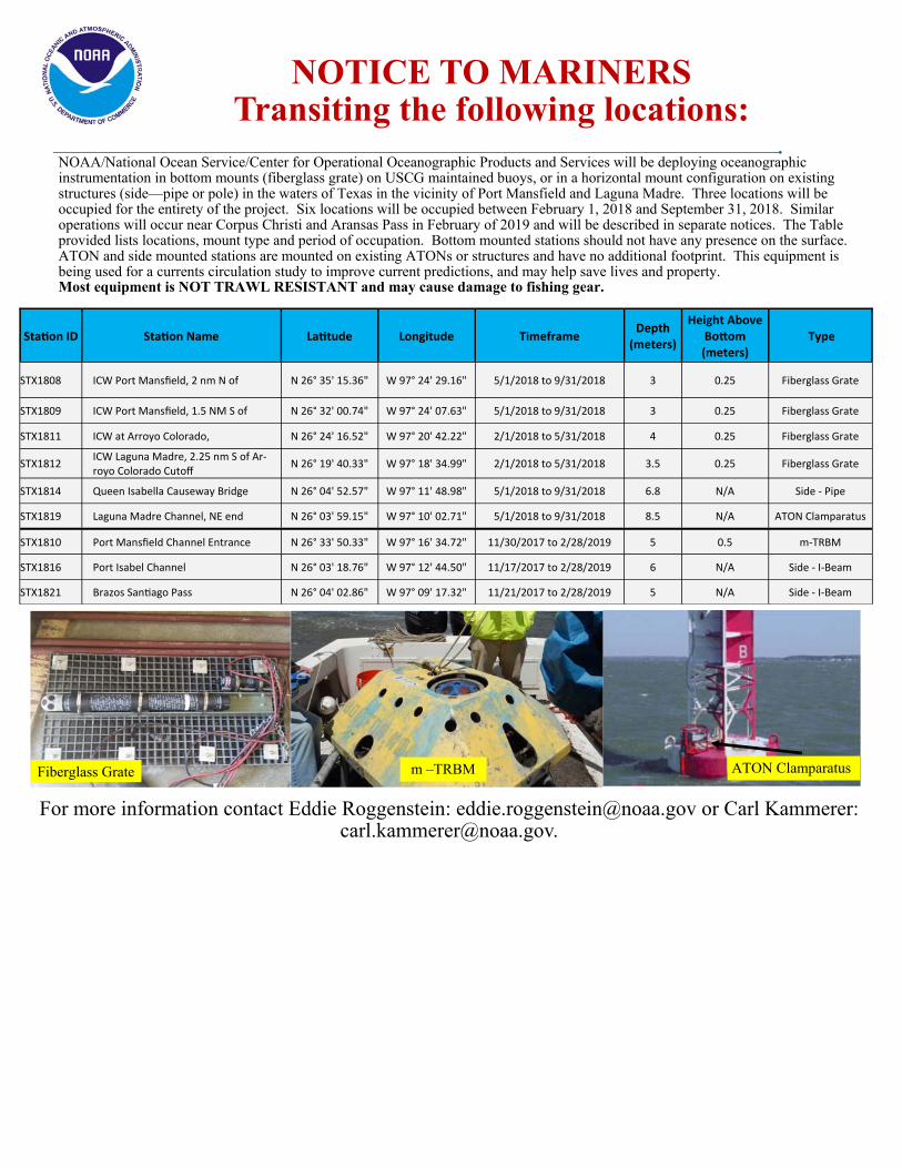
NOTICE TO MARINERS Transiting the following locations:
NOAA/National Ocean Service/Center for Operational Oceanographic Products and Services will be deploying oceanographic instrumentation in bottom mounts (fiberglass grate) on USCG maintained buoys, or in a horizontal mount configuration on existing structures (side—pipe or pole) in the waters of Texas in the vicinity of Port Mansfield and Laguna Madre. Three locations will be occupied for the entirety of the project. Six locations will be occupied between February 1, 2018 and September 31, 2018. Similar operations will occur near Corpus Christi and Aransas Pass in February of 2019 and will be described in separate notices. The Table provided lists locations, mount type and period of occupation. Bottom mounted stations should not have any presence on the surface. ATON and side mounted stations are mounted on existing ATONs or structures and have no additional footprint. This equipment is being used for a currents circulation study to improve current predictions, and may help save lives and property. Most equipment is NOT TRAWL RESISTANT and may cause damage to fishing gear.
For more information contact Eddie Roggenstein: [email protected] or Carl Kammerer: [email protected].
Sta on ID Sta on Name La tude Longitude Timeframe Depth
(meters)
Height Above Bo om (meters)
Type
STX1808 ICW Port Mansfield, 2 nm N of N 26° 35' 15.36" W 97° 24' 29.16" 5/1/2018 to 9/31/2018 3 0.25 Fiberglass Grate
STX1809 ICW Port Mansfield, 1.5 NM S of N 26° 32' 00.74" W 97° 24' 07.63" 5/1/2018 to 9/31/2018 3 0.25 Fiberglass Grate
STX1811 ICW at Arroyo Colorado, N 26° 24' 16.52" W 97° 20' 42.22" 2/1/2018 to 5/31/2018 4 0.25 Fiberglass Grate
STX1812 ICW Laguna Madre, 2.25 nm S of Ar-royo Colorado Cutoff
N 26° 19' 40.33" W 97° 18' 34.99" 2/1/2018 to 5/31/2018 3.5 0.25 Fiberglass Grate
STX1814 Queen Isabella Causeway Bridge N 26° 04' 52.57" W 97° 11' 48.98" 5/1/2018 to 9/31/2018 6.8 N/A Side - Pipe
STX1819 Laguna Madre Channel, NE end N 26° 03' 59.15" W 97° 10' 02.71" 5/1/2018 to 9/31/2018 8.5 N/A ATON Clamparatus
STX1810 Port Mansfield Channel Entrance N 26° 33' 50.33" W 97° 16' 34.72" 11/30/2017 to 2/28/2019 5 0.5 m-TRBM
STX1816 Port Isabel Channel N 26° 03' 18.76" W 97° 12' 44.50" 11/17/2017 to 2/28/2019 6 N/A Side - I-Beam
STX1821 Brazos San ago Pass N 26° 04' 02.86" W 97° 09' 17.32" 11/21/2017 to 2/28/2019 5 N/A Side - I-Beam
Fiberglass Grate m –TRBM ATON Clamparatus


Great Lakes Dredge & Dock Co. 2122 York Road Oak Brook, IL. 60523 April 9, 2018 James Alter Eighth Coast Guard District Mobile Sector 1500 5th St, Brookley Complex Mobile, AL 33615 Attn: Notice to Mariners MsCIP Comprehensive Barrier Island Restoration Plan Ship Island Phase 1 Ship Island Harrison County, Mississippi Owner Contract No. W91278-14-8-0007 GL #84510 To Whom It May Concern: Great Lakes Dredge and Dock has been contracted by The USACOE Mobile District in connection with the above referenced contract. We hereby notify and request that an issue of “Notice to Mariners” be published alerting to those using the locations identified below. Please be advised, buoys marking these locations should NOT be used for navigational purposes. Boaters should try to maintain a safe distance form these buoys. Operations: The locations between Ship Islands West and East and in Biloxi Bay will be occupied as a staging area for pipeline for future use while conducting island restoration operations on Ship Island; in addition, submerged pipeline will start to be laid near Ship Islands West and East in preparation for island restoration operations; additional equipment includes but is not limited to anchors barges, dredge tenders and floating pipeline. The location between the Biloxi Bay ship channel and Deer Island will see occasional traffic with pipeline of lengths up to 3000’; in addition, pipeline preparations may be conducted with additional equipment outside the safety fairway toward Deer Island. All manned vessels will monitor VHF Channels 3, 5, and 16.
Be aware of pipeline in the area of:
1) Between Ship Islands West and East:
North Limit Lat. 30 13.852’N Lon. 088 54.574’W East Limit Lat. 30 13.716’N Lon. 088 54.461’W West Limit Lat. 30 13.595’N Lon. 088 55.189’W South Limit Lat. 30 13.412’N Lon. 088 55.106’W

2) Biloxi Bay Immediately South of Railroad Bridge
North Limit Lat. 30 24.4523’N Lon. 088 51.1523’W East Limit Lat. 30 24.3993’N Lon. 088 51.1175’W West Limit Lat. 30 24.3575’N Lon. 088 51.3778’W South Limit Lat. 30 24.3046’N Lon. 088 51.3456’W
3) Between Biloxi Bay Ship Channel and Deer Island:
North Limit Lat. 30 23.37751’N Lon. 088 49.48400’W East Limit Lat. 30 22.19127’N Lon. 088 47.99643’W West Limit Lat. 30 22.70566’N Lon. 088 50.49420’W NW Limit Lat. 30 23.00752’N Lon. 088 50.39627’W South Limit Lat. 30 21.85299’N Lon. 088 48.85458’W
Be aware of the Booster Wadmalaw in the area of: Northwest Limit Lat. 30 12.169’N Lon. 088 51.870’ W Northeast Limit Lat. 30 12.075’ N Lon. 088 51.719’ W Southeast Limit Lat. 30 12.181’ N Lon. 088 51.634’ W Southwest Limit Lat. 30 12.075’ N Lon. 088 51.793’ W
Be aware of anchors for the Booster Wadmalaw: Northwest Anchor Lat. 30 12.205’ N Lon. 088 51.889’ W Northeast Anchor Lat. 30 12.322’ N Lon. 088 51.790’ W Southeast Anchor Lat. 30 12.092’ N Lon. 088 51.659’ W Southwest Anchor Lat. 30 12.055’ N Lon. 088 51.719’ W
Be aware of floating/surfaced pipeline in the area of: Northwest Limit Lat. 30 13.567’ N Lon. 088 51.452’ W Northeast Limit Lat. 30 14.031’ N Lon. 088 53.684’ W Southeast Limit Lat. 30 11.769’ N Lon. 088 50.648’ W Southwest Limit Lat. 30 11.208’ N Lon. 088 51.452’ W
Be aware of floating/surfaced pipeline in the area of: Northwest Limit Lat. 30 13.528’ N Lon. 088 54.634’ W Northeast Limit Lat. 30 14.031’ N Lon. 088 53.684’ W Southeast Limit Lat. 30 10.130’ N Lon. 088 52.065’ W Southwest Limit Lat. 30 09.657’ N Lon. 088 53.030’ W

Duration: Beginning July 28, 2017 through September 25, 2018 If there are any questions or concerns please contact the following personnel: Keith Pearse – Site Manager: 904-616-7290 Jeremy Remme – Site Manager: 630-207-3282 Brian Puckett – Site Manager: 630-300-4029 Sincerely, Michael J Tolivar Great Lakes Dredge & Dock Co. Quality Control Manager
Michael J Tolivar

CEMVN-OD-T
DEPARTMENT OF THE ARMY Corps of Engineers , New Orleans District
7 400 Leake Avenue New Or leans , Louisiana 70118
NAVIGATION BULLETIN NO . 18 - 59
MISSISSIPPI RIVER
9 April 2018
OLD RIVER CONTROL STRUCTURES PROJECT (UPDATE)
Reference Navigation Bulletin No . 18- 33 , dated 2 March 2018 , stating that coITUTiencing on 8 March 2018 and continuing until further notice , the U. S . Government M/V WILLIAM JAMES will be performing pi c ket boat d uties at the inf low channels of the Lo w Sil l and Auxiliary Control Structures .
EFFECTIVE IMMEDIATELY , THE M/V WILLIAM JAMES IS NO LONGER PERFORMING PICKET BOAT DUTIES AT THE INFLOW CHANNELS OF THE LOW SILL AND AUXILIARY CONTROL STRUCTURES . THE M/V FRED LEE STILL REMAINS ON-SITE PERFORMING PICKET BOAT DUTIES AND CAN BE REACHED ON VHF MARINE CHANNELS 13 AND 16.
During normal operation of these structures , a drawdown occurs at the entrances to the inflow channels . The drawdown becomes severe when t he structures operate during high river stages . The inf low channel of each of the structures is marked with a flashing amber light that is located o n t he south bank of t he entrance .
The in f low channels of thes e structure s are NOT navigable channels and are restricted from recreational purposes due to the hazardous conditions . When in the vicinity of these structures , tows and other vessels should navigate between the red nun buoys and green can buoys t ha t mark t he navigation channel o f t he river . Th is is advi sed in order to avoid effects of crosscurrents caused by the drawdown .
Vessels in distress that are drawn into the inf low channel of any of the structures or within the restricted mooring zone (see 33 CFR Ch . 1 , part 162 . 80 , 01 July 2005 Edition) in the Mississippi River (between mi le 311 . 0 and 340 . 0 Above Head of Passes) s hould contact the M/V FRED LEE or any of the foll owing by marine radio or a ny other emergency means . The structures that are staffed 24 hours each day can be reached as follows :
• Old River Complex - VHF Channel 1 6 (Marine Radio) I (225) 492 -2159 or (225) 492-2690 ( Phone)
• Sidney A. Murray , Jr . Hydroelectric Plant - VHF Channel 16 (Marine Radi o) I (225) 492-2153 ext . 207 (Phone)
• Old River Lock - VHF Channel 14 (Marine Radio) I (225 ) 492 -3333 or (22 5 ) 492-2301 (Phone) .
The point of contact with the New Orleans District is Russe ll Beauvais at (225 ) 492- 2169 {Wo rk ) or (225) 202 - 3851 (Cell ) .
The following are information resources that are currently available and displa y in chart fo rmat the location of t he hazardous conditions at the Old River Control Structures and the Sidney A. Murray , Jr . Hydroelectric Plant :
• Map No s . 66 and 67 (internet edition ) of the 2015 Missi ssippi River Navigation Charts clearly depict the inflow channels of the above structure s ; the webs ite address is :
htt : //www . mvn . usace . arm . mil/Missi on s/En i n eeri n /Geos atia l Section MRNB 2015/
• The hard copy o f the 2015 Mississippi River Flood Control and Navigation Maps .
• CD- ROMs of the updated Map Chart Nos . 66 and 67 of the 2015 Mississippi River Navigati o n Cha rts .
• Chart No . 1 of the 20 1 6 Atchafalaya River Chart Books {hard copy) and Geographic Information Systems {GIS ) publication CDROMs .
• Chart No . 1 {internet edition) of the 2016 Atchafalaya River Navigation Charts ; the website address is : http : //www . mv n . u sace . army . mil/Missions/Engi neer ing/Geospatial - Section/ARNS 2016 /
STEVEN G. PATORNO Chief, Technical Support Branch Ope r ations Division