Embed Size (px)
Citation preview

11 December 201950/19LNM:
8Coast Guard District GULFPage 1 of 43
U.S. Departmentof Homeland Security
United StatesCoast Guard
LOCAL NOTICE TO MARINERS
8TH DISTRICT LOCAL NOTICE TO MARINERSGULF OF MEXICO
Econfina River, FL to the Rio Grande, TXLIGHT LIST VOLUME IVNOTICE NUMBER 50/19
December 11, 2019
References: COMDTPUB P16502.4, Vol. IV, 2019 Edition and Coast Pilot 5.Both publications, along with corrections, are available for download at:
https://nauticalcharts.noaa.gov/publications/coast-pilot/index.html https://www.navcen.uscg.gov/pdf/lightLists/LightList_V4_2019.pdf
COAST GUARD DISTRICT 8, WATERWAYS, (504) 671-2327, 7:00 a.m. until 3:30 p.m. (CST)NIS WATCHSTANDER PHONE (703) 313-5900 24-HOURS A DAY
INTERNET ADDRESS HTTPS://www.navcen.uscg.govCOMMENTS REGARDING SECTION VI - PROPOSED CHANGES MAY ALSO BE EMAILED TO: [email protected]
GULF OF MEXICO LNM VIA INTERNET https://www.navcen.uscg.gov/?pageName=lnmDistrict®ion=8&ext=g
BROADCAST NOTICE TO MARINERS COVERED IN THIS EDITION
ORIGINATING UNIT BEGINNING BNMS ENDING BNMS
CCGD8 BNM 0085 - 19 (D8) BNM 0086 - 19 (D8) SECTOR MOBILE (MO) BNM 0746 - 19 (MO) THROUGH BNM 0757 - 19 (MO) SECTOR NEW ORLEANS (NO) BNM 0788 - 19 (NO) BNM 0804 - 19 (NO) SECTOR HOUSTON-GALVESTON (GA) BNM 0760 - 19 (GA) BNM 0783 - 19 (GA) SECTOR CORPUS CHRISTI (CC) BNM 0478 - 19 (CC) BNM 0489 - 19 (CC)
ABBREVIATIONS
District 8 GULF Week: 50/19
A through H
ADRIFT - Buoy AdriftAICW - Atlantic Intracoastal WaterwayAl - AlternatingB - BuoyBKW - Breakwaterbl - BlastBNM - Broadcast Notice to Marinerbu - BlueC - CanadianCHAN - ChannelCGD - Coast Guard DistrictC/O - Cut OffCONT - ContourCRK - CreekCONST - ConstructionDAYMK/Daymk - DaymarkDBN/Dbn - DaybeaconDBD/DAYBD - DayboardDEFAC - DefacedDEST - DestroyedDISCON - DiscontinuedDMGD/DAMGD - Damagedec - eclipseEST - Established Aidev - everyEVAL - Evaluation
I through O
I - InterruptedICW - Intracoastal WaterwayIMCH - Improper CharacteristicINL - InletINOP - Not OperatingINT - IntensityISL - IsletIso - IsophasekHz - KilohertzLAT - LatitudeLB - Lighted BuoyLBB - Lighted Bell BuoyLHB - Lighted Horn BuoyLGB - Lighted Gong BuoyLONG - LongitudeLNM - Local Notice to MarinersLT - LightLT CONT - Light ContinuousLTR - LetterLWB - Lighted Whistle BuoyLWP - Left Watching ProperlyMHz - Megahertz MISS/MSNG - MissingMo - Morse Code MRASS - Marine Radio Activated Sound SignalMSLD - Misleading
P through Z
PRIV - Private AidQ - QuickR - Red RACON - Radar Transponder BeaconRa ref - Radar reflectorRBN - Radio BeaconREBUILT - Aid RebuiltRECOVERED - Aid RecoveredRED - Red BuoyREFL - ReflectiveRRL - Range Rear LightRELIGHTED - Aid RelitRELOC - RelocatedRESET ON STATION - Aid Reset on StationRFL - Range Front LightRIV - RiverRRASS - Remote Radio Activated Sound Signals - secondsSEC - SectionSHL - Shoalingsi - silentSIG - SignalSND - SoundSPM - Single Point Mooring BuoySS - Sound SignalSTA - Station

11 December 201950/19LNM:
8Coast Guard District GULFPage 2 of 43
AHOP Above Head of PassesBHOP Below Head of PassesHSC Houston Ship ChannelMRGO Mississippi River - Gulf OutletHWY HighwayIHNC Inner Harbor Navigation CanalF/V Fishing VesselAP Assigned PositionCPA Closest Point of ApproachCOTP Captain of The PortSOLAS Safety of Life at SeaI.A.W. In Accordance WithM/V Motor VesselS/V Sailing VesselMPH Miles Per Hour
SECTION I - SPECIAL NOTICESThis section contains information of special concern to the Mariner.
NOTICE OF PLATFORMS, DRILL RIGS AND ATTENDANT VESSELS
DEPARTMENT OF HOMELAND SECURITY SUSPICIOUS ACTIVITY
GPS TESTING
LA - MISSISSIPPI RIVER - Old River Lock
The drill rigs and vessels that have been temporarily established will display lights and sound signals, according to size or class, during periods of darkness and reduced visibility. Numerous large anchor buoys which may be lighted displaying a white 4-seconds characteristic light and unlighted buoy may be established up to 2,000 or more yards from the vessel or rig site. Mariners should avoid passing close aboard the rigs or vessels. Offshore structures that have been established will display lights and a fog signal sounding 1 blast (2-sec. blast) every 20-seconds. Mooring buoys (white with blue band) may be located within 500 yards of the structure for mooring attendant vessels and/or barges. Mariners should avoid passing close aboard structures.
The Department of Homeland Security (DHS) encourages the maritime public to report information concerning suspicious activity to the local Federal Bureau of Investigation Joint Terrorism Task Force (JTTF) Office, http://www.fbi.gov/about-us/investigate/terrorism/terrorism_jttfs, or to other appropriate authorities. The U.S. Coast Guard reminds the maritime industry that they may also report information concerning suspicious activity to the www.AmericasWaterwayWatch.org, the National Response Center (NRC) 1-800-424-8802 or 1-877-24WATCH.
At times, throughout our area or responsibility, multiple U.S. Government Agencies conduct GPS testing. These tests vary in duration, affected range from the test site and potential impact to the maritime user as they may affect systems that rely on GPS such as E-911, AIS and DSC. More information is available at the U.S. Coast Guard Navigation Center Website, https://www.navcen.uscg.gov. During these periods, GPS users are encouraged to report any GPS outages that they may experience, to the Navigation Information Service (NIS) by calling (703) 313-5900 or by using the NAVCEN Website to submit a GPS problem report.
Continuing until approximately January 31, 2020, due to repairs on the Lock Emergency Bulkhead Lowering Carriage, and the procedures contained in this bulletin, tows entering the Lock are urged to use extreme caution while approaching and entering the lock chamber. While approaching the Lock, the following are required for passage:1. Tows are to enter the Lock at DEAD SLOW speed.2. All tows are restricted to no longer than 1,100 feet in length.3. All tows will line up along the floating guidewall before proceeding.
LNM:
LNM:
LNM:
DPW/PRIV AIDS
DPW
07-19
Additional Abbreviations Specific to this LNM Edition:
EXT - ExtinguishedF - Fixedfl - flashFl - FlashingG - Green GIWW - Gulf Intracoastal WaterwayHAZ - Hazard to NavigationHBR - HarborHOR - Horizontal ClearanceHT - Height
N/C - Not ChartedNGA - National Geospatial-Intelligence AgencyNO/NUM - NumberNOS - National Ocean ServiceNW - Notice WriterOBSCU - ObscuredOBST - ObstructionOBSTR - ObstructionOc - OccultingODAS - Anchored Oceanographic Data Buoy
STRUCT - StructureSt M - Statute MileTEMP - Temporary Aid ChangeTMK - TopmarkTRLB - Temporarily Replaced by Lighted BuoyTRLT - Temporarily Replaced by LightTRUB - Temporarily Replaced by Unlighted BuoyUSACE - Army Corps of EngineersW - WhiteY - Yellow
11 December 201950/19LNM:
8Coast Guard District GULFPage 3 of 43
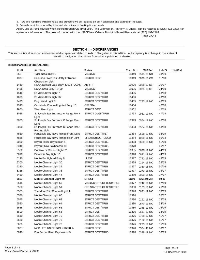
4. Two line-handlers with life vests and bumpers will be required on both approach and exiting of the Lock.5. Vessels must be moored by bow and stern lines to floating timberheads.Again, use extreme caution when locking through Old River Lock. The Lockmaster, Anthony T. Lindsly, can be reached at (225) 492-3333, for up-to-date information. The point of contact with the USACE New Orleans District is Russell Beauvais, at (225) 492-2169.
LNM: 48-19
DISCREPANCIES (FEDERAL AIDS)
SECTION II - DISCREPANCIESThis section lists all reported and corrected discrepancies related to Aids to Navigation in this edition. A discrepancy is a change in the status of
an aid to navigation that differs from what is published or charted.
LNM EndLLNR Aid Name Status Chart No. BNM Ref. LNM StTiger Shoal Buoy 2
Colorado River East Jetty Entrance Obstruction LightNOAA Lighted Data Buoy 42003 (ODAS)NOAA Data Buoy 42409
St Marks River Light 7
St Marks River Light 37Dog Island Light 8
Carrabelle Channel Lighted Buoy 10
West Pass LightSt Joseph Bay Entrance A Range Front LightSt Joseph Bay Entrance C Range Rear LightSt Joseph Bay Entrance C Range Rear Passing LightPensacola Bay Navy Range Front Light
Pensacola Bay Navy Range Rear LightBayou Texar Daybeacon 4
Bayou Chico Daybeacon 13
Blackwater Channel Light 21Escambia Bay Light 18
Mobile Bar Lighted Buoy 9
Mobile Channel Light 30Mobile Channel Light 34
Mobile Channel Light 38
Mobile Channel Light 44
Mobile Channel Light 49Mobile Channel Light 50
Mobile Channel Light 51
Theodore Ship Channel Light 1Mobile Channel Light 60
Mobile Channel Light 63
Mobile Channel Light 64Mobile Channel Light 65
Mobile Channel Light 66
Mobile Channel Light 70Mobile Channel Light 76
Mobile Channel Light 78
MOBILE TURNING BASIN LIGHT ABon Secour River Daybeacon 9
MISSING
STRUCT DEST
ADRIFTMISSING
STRUCT DEST/TRLB
STRUCT DEST/TRLBSTRUCT DEST/TRLB
OFF STA
STRUCT DESTSTRUCT DMGD/TRLB
STRUCT DEST/TRLB
STRUCT DEST/TRLB
STRUCT DEST/TRLT
LT EXT/STRUCT DMGDSTRUCT DEST/TRUB
STRUCT DEST/TRUB
STRUCT DEST/TRLBSTRUCT DEST/TRLB
LT EXT
STRUCT DEST/TRLBSTRUCT DEST/TRLB
STRUCT DEST/TRLB
STRUCT DEST/TRLB
LT EXTMISSING/STRUCT DEST/TRLB
OFF STA/STRUCT DEST/TRLB
STRUCT DEST/TRLBSTRUCT DEST/TRLB
STRUCT DEST/TRLB
STRUCT DEST/TRLBSTRUCT DEST/TRLB
STRUCT DEST
STRUCT DEST/TRLBSTRUCT DEST/TRLB
STRUCT DEST/TRLB
STRUCT DESTSTRUCT DEST/TRUB
33/19
11/18
20/1724/19
43/18
43/1848/19
42/18
42/1847/13
40/18
43/18
03/19
50/1341/19
45/17
44/1944/19
48/19
38/1530/16
15/17
17/17
50/1947/19
46/13
39/1906/17
13/19
34/1916/19
38/19
41/1741/17
15/19
33/1718/19
11349
11319
1100611006
11406
1140611405
11404
1140211393
11393
11393
11384
1138411383
11378
1138511378
11377
1137811377
11377
11380
1137611377
11380
1137611376
11380
1138011380
11376
1137611376
11376
1137611378
855
1377
14601468
1540
16952495
2545
29503025
3085
3090
4850
48555080
5340
55305810
6140
63006320
6335
6450
65106515
6520
65356570
6575
65806585
6590
66106660
6685
66976840
0515-19 NO0070-18 CC
0028-17 D8
0035-19 D8
0733-19 MO
0931-13 MO
0564-19 MO
0564-19 MO
0698-19 MO
1028-16 MO0650-19 MO
0696-19 MO0691-19 MO
0741-19 MO
0114-19 MO0369-18 MO
0370-18 MO
0090-18 MO0750-19 MO0742-19 MO
0105-18 MO0631-19 MO
0191-19 MO0570-19 MO
0345-19 MO
0611-19 MO0758-17 MO
0152-18 MO
0233-19 MO0584-47 MO
0328-19 MO

11 December 201950/19LNM:
8Coast Guard District GULFPage 4 of 43
South Fork Channel Daybeacon SF
Fly Creek Daybeacon 6Theodore Ship Channel Light 1
Theodore Ship Channel Light 3
Bayou La Batre Buoy 17Bayou La Batre Daybeacon 20
Bayou La Batre Daybeacon 21
Bayou Coden Daybeacon 3Pascagoula Channel D Range Rear Light
Pascagoula Channel C Range Front Light
Pascagoula Channel C Range Rear LightBayou Casotte Channel Light 8
Bayou Casotte Channel B Range Rear LightBiloxi East Channel Daybeacon 1Biloxi East Channel Daybeacon 11Biloxi East Channel Light 29
Big Lake Daybeacon 29
Big Lake Daybeacon 32Gulfport Obstruction Light
Gulfport Ship Channel Light 44
Gulfport Ship Channel Light 62Gulfport Small Boat Harbor Light 5
The Rigolets Light 4
Mississippi River - Gulf Outlet Light 101Mississippi River - Gulf Outlet Light 106
Bayou Terre Aux Boeufs Daybeacon 2
BAPTISTE COLLETTE BAYOU ENTRANCE LIGHTBaptiste Collette Bayou Light 1Baptiste Collette Bayou Light 3
Baptiste Collette Bayou Light 5
South Pass Light 4South Pass Light 3B
South Pass Danger Light A
South Pass Light 15Southwest Pass Leading Light
Southwest Pass Light 7Southwest Pass Head East Range Rear LightPilottown A West Range Rear LightPilottown Anchorage Lower Daybeacon 1.5Davant Anchorage Lower Daybeacon 52.8Hale Boggs Luling Bridge ApproachBuoy CGramercy Bridge Approach Buoy 3
Gramercy Bridge Approach Buoy 5Sunshine Bridge Approach Buoy 1
Sunshine Bridge Approach Buoy A
Sunshine Bridge Approach Buoy BSunshine Bridge Approach Buoy C
Eighty One Mile Point Light 180Arlington Range Front Light
Arlington Range Rear Light
STRUCT DEST/TRUB
STRUCT DEST/TRUBSTRUCT DEST/TRLB
MISSING/STRUCT DEST/TRLB
TRLBSTRUCT DEST/TRUB
STRUCT DEST/TRUB
STRUCT DEST/TRUBDAYMK MISSING
LT EXT
LT EXTSTRUCT DEST/TRLB
REDUCED INT
DAYMK MISSINGSTRUCT DEST/TRUBSTRUCT DEST/TRLB
STRUCT DEST/TRUB
STRUCT DEST/TRUBDAYMK DMGD
STRUCT DEST/TRLB
STRUCT DEST/TRLBSTRUCT DEST/TRLB
STRUCT DEST/TRLB
STRUCT DEST/TRLBSTRUCT DEST/TRLB
STRUCT DEST/TRUB
STRUCT DEST/TRLB
STRUCT DEST/TRLBSTRUCT DEST/TRLB
STRUCT DEST/TRLB
STRUCT DEST/TRLBSTRUCT DEST/TRLB
STRUCT DEST/TRLB
STRUCT DESTSTRUCT DEST/TRLB
STRUCT DEST/TRLBDAYMK DMGD
DAYMK DMGDSTRUCT DEST
DAYMK DMGD
OFF STA
MISSING
MISSINGMISSING
MISSING
MISSINGMISSING
STRUCT DESTSTRUCT DEST/LT IMCH/REDUCED INT/TRLTSTRUCT DEST/LT IMCH/REDUCED INT/TRLT
16/19
21/1939/19
39/19
28/1940/19
45/19
40/1941/17
14/19
14/1944/19
27/19
50/1940/1939/19
41/19
41/1911/18
46/19
47/1948/19
44/19
50/1834/19
45/19
24/19
24/1924/19
24/19
42/1844/18
44/18
43/1920/19
50/1929/19
47/1915/19
38/19
50/19
29/19
29/1950/16
29/19
29/1903/19
50/1932/15
42/15
11378
1137611376
11376
1137411374
11374
1137411375
11375
1137311375
11375
113721137211372
11372
1137211372
11372
1137211372
11367
1136411364
11364
11353
1135311353
11353
1136111361
11361
1136111361
1136111361
1136111361
11364
11370
11370
1137011370
11370
1137011370
1137011370
11370
6855
70657350
7360
77207735
7740
77857970
8110
81158475
8515
869587508815
9395
94059785
9835
99409990
10850
1174511770
12355
12380
1238512395
12405
1259012591
12592
1266512725
1279012930
1298512990
13360
14250
14560
1456514835
14840
1484514850
1497515300
15305
0287-19 MO
0706-19 MO0631-19 MO
0752-19 MO
0614-19 MO
0701-19 MO
0615-19 MO0516-18 MO
0710-19 MO
0711-19 MO0688-19 MO
0442-19 MO
0748-19 MO0640-19 MO0633-19 MO
0660-19 MO
0661-19 MO
0714-19 MO
0723-19 MO0732-19 MO
0707-19 NO
0872-18 NO0526-19 NO
0725-19 NO
0339-19 NO
0340-19 NO0341-19 NO
0342-19 NO
0688-19 NO0762-18 NO
0766-19 NO
0687-19 NO0262-19 NO
0803-19 NO0042-19 D8
0746-19 NO0191-19 NO
0605-19 NO
0792-19 NO
0794-19 D8
0042-19 D80970-16 NO
0042-19 D8
0042-19 D80027-19 NO
0799-19 NO0870-18 NO
0066-18 NO
11 December 201950/19LNM:
8Coast Guard District GULFPage 5 of 43
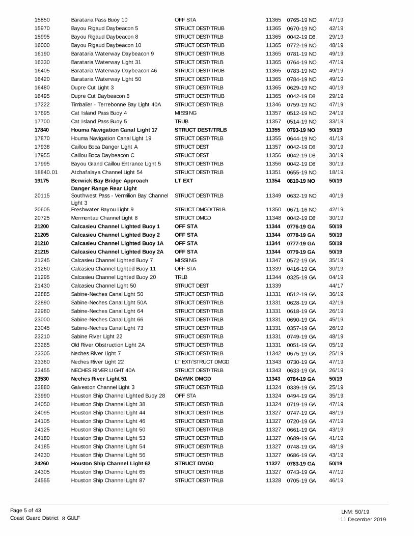
Barataria Pass Buoy 10
Bayou Rigaud Daybeacon 5Bayou Rigaud Daybeacon 8
Bayou Rigaud Daybeacon 10
Barataria Waterway Daybeacon 9Barataria Waterway Light 31
Barataria Waterway Daybeacon 46
Barataria Waterway Light 50Dupre Cut Light 3
Dupre Cut Daybeacon 6
Timbalier - Terrebonne Bay Light 40ACat Island Pass Buoy 4
Cat Island Pass Buoy 5
Houma Navigation Canal Light 17Houma Navigation Canal Light 19
Caillou Boca Danger Light A
Caillou Boca Daybeacon CBayou Grand Caillou Entrance Light 5
Atchafalaya Channel Light 54
Berwick Bay Bridge Approach Danger Range Rear LightSouthwest Pass - Vermilion Bay Channel Light 3Freshwater Bayou Light 9Mermentau Channel Light 8
Calcasieu Channel Lighted Buoy 1Calcasieu Channel Lighted Buoy 2Calcasieu Channel Lighted Buoy 1ACalcasieu Channel Lighted Buoy 2ACalcasieu Channel Lighted Buoy 7Calcasieu Channel Lighted Buoy 11
Calcasieu Channel Lighted Buoy 20
Calcasieu Channel Light 50Sabine-Neches Canal Light 50
Sabine-Neches Canal Light 50A
Sabine-Neches Canal Light 64Sabine-Neches Canal Light 66
Sabine-Neches Canal Light 73
Sabine River Light 22Old River Obstruction Light 2A
Neches River Light 7
Neches River Light 22NECHES RIVER LIGHT 40A
Neches River Light 51Galveston Channel Light 3Houston Ship Channel Lighted Buoy 28
Houston Ship Channel Light 38
Houston Ship Channel Light 44Houston Ship Channel Light 46
Houston Ship Channel Light 50
Houston Ship Channel Light 53Houston Ship Channel Light 54
Houston Ship Channel Light 56
Houston Ship Channel Light 62Houston Ship Channel Light 65
Houston Ship Channel Light 87
OFF STA
STRUCT DEST/TRUBSTRUCT DEST/TRLB
STRUCT DEST/TRUB
STRUCT DEST/TRUBSTRUCT DEST/TRLB
STRUCT DEST/TRUB
STRUCT DEST/TRLBSTRUCT DEST/TRLB
STRUCT DEST/TRUB
STRUCT DEST/TRLBMISSING
TRUB
STRUCT DEST/TRLBSTRUCT DEST/TRLB
STRUCT DEST
STRUCT DESTSTRUCT DEST/TRLB
STRUCT DEST/TRLB
LT EXT
STRUCT DEST/TRLB
STRUCT DMGD/TRLBSTRUCT DMGD
OFF STAOFF STAOFF STAOFF STAMISSINGOFF STA
TRLB
STRUCT DESTSTRUCT DEST/TRLB
STRUCT DEST/TRLB
STRUCT DEST/TRLBSTRUCT DEST/TRLB
STRUCT DEST/TRLB
STRUCT DEST/TRLBSTRUCT DEST/TRLB
STRUCT DEST/TRLB
LT EXT/STRUCT DMGDSTRUCT DEST/TRLB
DAYMK DMGDSTRUCT DEST/TRLBOFF STA
STRUCT DEST/TRLB
STRUCT DEST/TRLBSTRUCT DEST/TRLB
STRUCT DEST/TRLB
STRUCT DEST/TRLBSTRUCT DEST/TRLB
STRUCT DEST/TRLB
STRUCT DMGDSTRUCT DEST/TRLB
STRUCT DEST/TRLB
47/19
42/1929/19
48/19
49/1947/19
49/19
49/1940/19
29/19
47/1924/19
33/19
50/1941/19
30/19
30/1930/19
18/19
50/19
40/19
42/1930/19
50/1950/1950/1950/1935/1930/19
04/19
44/1736/19
42/19
26/1945/19
26/19
48/1905/19
25/19
47/1926/19
50/1925/1935/19
47/19
48/1947/19
43/19
41/1948/19
43/19
50/1947/19
46/19
11365
1136511365
11365
1136511365
11365
1136511365
11365
1134611357
11357
1135511355
11357
1135611356
11351
11354
11349
1135011348
113441134411344113441134711339
11344
1133911331
11331
1133111331
11331
1133111331
11342
1134311343
113431132411324
11324
1132711327
11327
1132711327
11327
1132711327
11328
15850
1597015995
16000
1619016330
16405
1642016480
16495
1722217695
17700
1784017870
17938
1795517995
18840.01
19175
20115
2060520725
212002120521210212152124521260
21295
2143022885
22890
2298023000
23045
2321023265
23305
2336023455
235302388023990
24050
2409524105
24125
2418024185
24230
2426024305
24555
0765-19 NO
0670-19 NO0042-19 D8
0772-19 NO
0781-19 NO0764-19 NO
0783-19 NO
0784-19 NO0629-19 NO
0042-19 D8
0759-19 NO0512-19 NO
0514-19 NO
0793-19 NO0644-19 NO
0042-19 D8
0042-19 D80042-19 D8
0655-19 NO
0810-19 NO
0632-19 NO
0671-16 NO
0042-19 D8
0776-19 GA0778-19 GA0777-19 GA0779-19 GA0572-19 GA
0416-19 GA
0325-19 GA
0512-19 GA
0628-19 GA0618-19 GA
0690-19 GA
0357-19 GA0749-19 GA
0051-19 GA
0675-19 GA
0730-19 GA0633-19 GA
0784-19 GA0339-19 GA0494-19 GA
0719-19 GA
0747-19 GA0720-19 GA
0661-19 GA
0689-19 GA0748-19 GA
0686-19 GA
0783-19 GA0743-19 GA
0705-19 GA

11 December 201950/19LNM:
8Coast Guard District GULFPage 6 of 43
Houston Ship Channel Light 89
Houston Ship Channel Light 90AHouston Ship Channel Light 92
Cedar Bayou Channel Daybeacon 6
Cedar Bayou Channel Light 14Cedar Bayou Channel Daybeacon 16
Cedar Bayou Channel Daybeacon 22
Cedar Bayou Channel Light 23Cedar Bayou Channel Daybeacon 24
Cedar Bayou Channel Daybeacon 25
Cedar Bayou Channel Daybeacon 26Cedar Bayou Channel Daybeacon 27
Cedar Bayou Channel Daybeacon 28
Cedar Bayou Channel Daybeacon 29Cedar Bayou Channel Light 30
Cedar Bayou Channel Light 31
Cedar Bayou Channel Daybeacon 33Cedar Bayou Channel Light 37
Houston Ship Channel Light 100
Lower Red Light Bend Outbound Range Front LightHouston Ship Channel Light 101Houston Ship Channel Light 103
Houston Ship Channel Light 105
Houston Ship Channel Light 106Lower Peggy'S Lake Inbound Range Rear LightHouston Ship Channel Light 113BGreens Bayou Security Zone Marker
Houston Ship Channel Light 160Double Bayou Channel Daybeacon 10
Double Bayou Channel Daybeacon 11
Double Bayou Channel Light 12Anahuac Channel Daybeacon 16
Texas City Cut B Outer Range Front LightDickinson Bayou Channel Daybeacon 2Clear Creek Channel Daybeacon 5
Clear Creek Channel Daybeacon 7
Clear Creek Channel Light 8Freeport Harbor Outbound Range Front LightFreeport Harbor Outbound Range Rear LightColorado River East Jetty Entrance Obstruction LightMatagorda Ship Channel Lighted Buoy 13Matagorda Ship Channel Light 25
Matagorda Ship Channel Light 34
Matagorda Ship Channel Light 35Matagorda Ship Channel Light 39
Matagorda Ship Channel Light 40
Matagorda Ship Channel Light 41Matagorda Ship Channel Light 44
Matagorda Ship Channel Light 47
Matagorda Ship Channel Light 48Matagorda Ship Channel Light 52
STRUCT DEST/TRLB
STRUCT DEST/TRLBSTRUCT DEST/TRLB
STRUCT DEST/TRUB
STRUCT DESTSTRUCT DEST/TRUB
STRUCT DEST/TRUB
STRUCT DEST/TRLBSTRUCT DEST/TRUB
STRUCT DEST
STRUCT DEST/TRUBMISSING/STRUCT DEST/TRUB
STRUCT DEST
STRUCT DEST/TRUBSTRUCT DEST/TRLB
STRUCT DEST/TRLB
STRUCT DEST/TRUBSTRUCT DEST/TRLB
STRUCT DEST/TRLB
STRUCT DEST
STRUCT DEST/TRLBSTRUCT DEST/TRLB
STRUCT DEST/TRLB
STRUCT DEST/TRLBREDUCED INT
STRUCT DESTSTRUCT DEST
STRUCT DEST/TRLBSTRUCT DEST/TRUB
STRUCT DEST/TRUB
STRUCT DEST/TRLBDAYMK MISSING
LT EXT
STRUCT DEST/TRUBSTRUCT DMGD/TRUB
STRUCT DEST/TRUB
STRUCT DEST/TRLBMSLD SIG
MSLD SIG
STRUCT DEST
OFF STA
STRUCT DEST/TRLB
LT EXT
LT EXTSTRUCT DEST/TRLB
DAYMK DMGD
STRUCT DEST/TRLBLT EXT
STRUCT DEST/TRLB
DAYMK MISSINGLT EXT
41/19
44/1947/19
33/19
47/1927/19
41/19
30/1827/19
47/19
46/1912/19
44/19
40/1941/19
40/19
40/1907/19
46/19
26/19
39/1945/19
39/19
43/1950/19
50/1934/18
23/1917/19
17/19
17/1925/19
50/19
35/1932/19
44/19
38/1939/18
39/18
11/18
32/19
49/19
43/19
43/1944/19
44/19
46/1945/19
44/19
39/1943/19
11328
1132811328
11328
1132811328
11328
1132811328
11328
1132811328
11328
1132811328
11328
1132811328
11328
11329
1132811328
11328
1132811329
1132911325
1132911326
11326
1132611326
11324
1132711327
11327
1132711322
11322
11319
11319
11319
11317
1131711317
11317
1131711317
11317
1131711317
24565
2458024600
24625
2464524650
24665
2467024675
24680
2468524690
24695
2470024705
24710
2471524725
24815
25070
2508025100
25210
2521525325
2537025812
2581525890
25900
2590525960
26095
2622526380
26390
2639527005
27010
27047
27185
27225
27270
2727527295
27300
2730527320
27355
2736027380
0619-19 GA
0680-19 GA0712-19 GA
0615-19 GA
0722-19 GA0383-19 GA
0721-19 GA
0542-18 GA0382-19 GA
0723-19 GA
0724-19 GA0725-19 GA
0726-19 GA
0614-19 GA0727-19 GA
0729-19 GA
0613-19 GA0077-19 GA
0710-19 GA
0362-19 GA
0651-19 GA0688-19 GA
0556-19 GA
0654-19 GA0781-19 GA
0780-19 GA0536-18 GA0421-19 GA
0216-19 GA
0217-19 GA0218-19 GA
0329-19 GA
0785-19 GA
0499-19 GA0455-19 GA
0669-19 GA
0574-19 GA0604-18 GA
0605-18 GA
0070-18 CC
0454-19 GA
0476-19 CC
0415-19 CC0416-19 CC
0429-19 CC
0432-19 CC0463-19 CC
0452-19 CC
0413-19 CC0386-19 CC
0417-19 CC

11 December 201950/19LNM:
8Coast Guard District GULFPage 7 of 43
Matagorda Ship Channel Light 56
Matagorda Ship Channel Light 58Matagorda Ship Channel Light 60
Matagorda Ship Channel Light 70
Matagorda Ship Channel Light 78Port Lavaca Channel Light 5
Port Lavaca Harbor of Refuge Daybeacon 4Lavaca Bay Channel Daybeacon 22
Lavaca River Daybeacon 3Aransas Pass Light 11
Aransas Channel Light 10
Aransas Channel Daybeacon 22Aransas Channel Light 23Port Aransas Harbor Light 3
Port Aransas Harbor Daybeacon 4Corpus Christi Channel Light 20
Tule Lake Channel E Range Front Light
Port Mansfield Channel Daybeacon 33Brazos Santiago Entrance Channel Lighted Buoy 3Laguna Madre Channel Light 21
Harlingen-Port Isabel Light 90
Brownsville Channel Light 34Brownsville Channel D Range Rear Light
Joes Bayou Entrance Channel Light 2
Santa Rosa Sound Light 142Pensacola Bay Navy Range Front Light
Pensacola Bay Navy Range Rear Light
Pensacola-Mobile Lighted Buoy 2Pensacola-Mobile Light 16
Pensacola-Mobile Light 57
Pensacola-Mobile Light 100Pass Aux Herons Daybeacon 3
Pass Aux Herons Buoy 9
Pass Aux Herons Buoy 14Bayou Aloe Light 5
Pass Aux Herons Buoy 22
Pass Aux Herons Buoy 25Pass Aux Herons Buoy 27
Pass Aux Herons Lighted Buoy 28
Pass Aux Herons Light 41Round Island South Channel Light 3
Belle Fontaine Light 6
Gulfport Ship Channel Light 44
Marianne Channel Buoy 16Marianne Channel Buoy 17
Marianne Channel Buoy 18
Marianne Channel Buoy 19Marianne Channel Buoy 20
Marianne Channel Buoy 21
Marianne Channel Buoy 23Berwick Bay Bridge Approach Danger Range Rear LightSabine River Light 22
Sabine-Neches Canal Light 73
DAYMK DMGD
DAYMK DMGDDAYMK DMGD
STRUCT DEST/TRLB
DAYMK DMGDSTRUCT DEST/TRLB
STRUCT DEST/TRUB
DAYMK IMCH
DAYMK IMCHSTRUCT DEST/TRLB
STRUCT DEST/TRLB
STRUCT DMGDSTRUCT DMGDSTRUCT DEST/TRLB
OFF STA/STRUCT DEST/TRUBSTRUCT DEST/TRLB
STRUCT DMGD
STRUCT DEST/TRUBOFF STA
STRUCT DMGD/TRLB
STRUCT DEST/TRLB
STRUCT DEST/TRLBDAYMK DMGD
LT IMCH
STRUCT DEST/TRLBSTRUCT DEST/TRLT
LT EXT/STRUCT DMGD
TRLBSTRUCT DEST/TRLB
STRUCT DEST/TRLB
STRUCT DMGDSTRUCT DEST/TRUB
TRUB
TRUBSTRUCT DEST
TRUB
OFF STA/TRUBTRUB
TRLB
STRUCT DEST/TRLBSTRUCT DEST/TRLB
STRUCT DEST/TRLB
STRUCT DEST/TRLB
TRUBTRUB
TRUB
TRUBTRUB
TRUB
TRUBLT EXT
STRUCT DEST/TRLB
STRUCT DEST/TRLB
44/19
45/1945/19
41/19
43/1917/18
38/18
11/14
11/1447/19
19/19
50/1950/1940/19
36/1748/19
36/17
20/1945/19
28/19
44/19
22/1944/19
44/18
48/1903/19
50/13
29/1943/19
48/19
44/1945/19
39/19
39/1949/19
39/19
33/1833/19
42/19
43/1945/19
40/19
46/19
50/1807/15
29/17
03/1820/18
03/18
03/1850/19
48/19
26/19
11317
1131711317
11317
1131711317
11317
11317
1131711309
11309
113091130911309
1130911308
11311
1130611302
11302
11302
1130211302
11385
1137811384
11384
1138411378
11378
1137811378
11378
1137811377
11377
1137411378
11378
1137411375
11374
11372
1137211372
11372
1137211372
11372
1137211354
11331
11331
27410
2744027450
27535
2758527715
27800
27900
2791028205
28245
282852829028320
2832528615
28875
2944529475
29585
29830
2989029955
32105
3304033060
33065
3309533250
33505
3374033985
34010
3403534105
34175
3419534205
34210
3430034345
34360
34390
3445034455
34460
3446534470
34475
3448535185
35430
35580
0431-19 CC
0454-19 CC0450-19 CC
0403-19 CC
0414-19 CC0159-18 CC
0483-18 CC
0205-14 CC
0206-14 CC0465-19 CC
0173-19 CC
0482-19 CC0483-19 CC0394-19 CC
0382-18 CC0468-19 CC
0186-19 CC0440-19 CC
0297-19 CC
0433-19 CC
0206-19 CC0428-19 CC
0657-18 MO
0734-19 MO0698-19 MO
1028-16 MO
0670-19 MO0677-19 MO
0738-19 MO
0690-19 MO0703-19 MO
0612-19 MO
0623-19 MO0746-19 MO
0704-19 MO
0754-19 MO0556-19 MO
0705-19 MO
0676-19 MO0709-19 MO
0642-19 MO
0714-19 MO
0042-19 D8
0748-18 MO0095-18 MO
0263-18 MO
0020-18 MO0726-19 MO
0810-19 NO
0749-19 GA
0357-19 GA

11 December 201950/19LNM:
8Coast Guard District GULFPage 8 of 43
Sabine-Neches Canal Light 66
Sabine-Neches Canal Light 64Sabine-Neches Canal Light 50A
Sabine-Neches Canal Light 50
ROLLOVER BAY LIGHT 10Rollover Bay Lighted Buoy 12Bolivar Peninsula Daybeacon 2
Bolivar Peninsula Light 19
Bolivar Peninsula Light 20Bolivar Point Light 21
Galveston Channel Light 3
Galveston-Freeport Light 2Galveston-Freeport Light 50
Galveston-Freeport Light 63
Galveston-Freeport G Range Rear LightWest Bay (Texas) Buoy 4
West Bay (Texas) Buoy 7West Bay (Texas) Buoy 10West Bay (Texas) Buoy 13Chocolate Bayou Channel Outer Range Front LightOyster Lake Daybeacon 1
Oyster Lake Daybeacon 5Brazos River Crossing Light 2
Brazos River Crossing Light 4
Matagorda Bay Light 2Matagorda Bay Light 32
Matagorda Bay Light 36
Matagorda Bay Daybeacon 38Matagorda Bay - Alternate Route Light 6
Matagorda Bay Light 44
Palacios Channel Daybeacon 6Palacios Channel Light 13
Palacios Channel Daybeacon 16
Palacios Channel Daybeacon 28Palacios Channel Light 30
Palacios Channel Light 32
Palacios Channel Light 34Port O'Connor Channel Light 8
Port O' Connor Landcut Daybeacon 6A
Port O' Connor Landcut Daybeacon 15Victoria East Entrance Channel Junction Buoy AVictoria Channel Light 22
San Antonio Bay Light 2
San Antonio Bay Light 5San Antonio Bay Daybeacon 9
San Antonio Bay Light 11
San Antonio Bay Daybeacon 13San Antonio Bay Light 19
San Antonio Bay Daybeacon 21
Aransas Bay Light 9Copano Bay Approach Light 3
Aransas Bay Daybeacon 22Aransas Bay Daybeacon 23Aransas Bay Daybeacon 26
STRUCT DEST/TRLB
STRUCT DEST/TRLBSTRUCT DEST/TRLB
STRUCT DEST/TRLB
STRUCT DESTSTRUCT DESTSTRUCT DEST/TRUB
OFF STA/STRUCT DEST/BUOY DMGD/TRLBOFF STA/STRUCT DEST/TRLBSTRUCT DEST/TRLB
STRUCT DEST/TRLB
DAYMK DMGDSTRUCT DEST/TRLB
STRUCT DEST/TRLB
LT EXT/STRUCT DMGDOFF STA
MISSINGMISSINGMISSINGSTRUCT DMGD
STRUCT DMGD
STRUCT DESTSTRUCT DEST
STRUCT DEST
STRUCT DESTSTRUCT DEST
STRUCT DEST
STRUCT DESTSTRUCT DMGD
MISSING/STRUCT DEST/TRLB
STRUCT DEST/TRUBSTRUCT DEST
STRUCT DEST
STRUCT DEST/TRUBLT EXT
STRUCT DEST/TRLB
STRUCT DEST/TRLBSTRUCT DEST/TRLB
STRUCT DMGD
STRUCT DEST/TRUBMISSING
STRUCT DEST/TRLB
STRUCT DEST/TRLB
STRUCT DEST/TRLBSTRUCT DEST/TRUB
STRUCT DEST/TRLB
STRUCT DEST/TRUBOFF STA/STRUCT DEST/TRLB
STRUCT DEST/TRUB
STRUCT DEST/TRLBSTRUCT DEST/TRLB
STRUCT DESTSTRUCT DESTSTRUCT DEST/TRUB
45/19
26/1942/19
36/19
50/1950/1933/19
09/19
08/1928/19
25/19
50/1927/19
17/19
10/1844/19
50/1950/1950/1904/18
46/19
41/1934/19
33/19
40/1941/19
41/19
41/1935/19
35/19
31/1834/19
34/19
25/1934/19
25/19
25/1937/19
34/17
47/1946/19
32/19
32/19
20/1912/19
12/19
12/1924/19
24/19
40/1936/17
50/1950/1940/19
11331
1133111331
11331
113311133111324
11324
1132411324
11324
1132411322
11322
1132211322
11322113221132211322
11322
1132211322
11322
1131911319
11319
1131911319
11319
1131911317
11317
1131711317
11317
1131711319
11315
1131511315
11315
11315
1131511315
11315
1131511315
11315
1131411314
113141131411314
35625
3565035730
35735
35860.013587035880
35940
3594536050
36075
3610536640.01
36815.01
3682536930
36945369603697537120
37350
3737037395
37400
3740537550
37565
3757037580
37595
3769537715
37725
3775537760
37765
3777037890
38025
3806038065
38160
38360
3838538400.01
38410
38425.0138470
38485.01
3870038780
38865.0138870.0138890.01
0690-19 GA
0618-19 GA0628-19 GA
0512-19 GA
0765-19 GA0766-19 GA0474-19 GA
0761-19 GA
0782-19 GA0392-19 GA
0339-19 GA
0772-19 GA0683-19 GA
0388-19 GA
0850-18 GA0682-19 GA
0775-19 GA0773-19 GA0774-19 GA0036-18 GA
0704-19 GA
0622-19 GA0479-19 GA
0480-19 GA
0397-19 CC0398-19 CC
0399-19 CC
0400-19 CC0350-19 CC
0402-19 CC
0340-18 CC0344-19 CC
0345-19 CC
0262-19 CC0346-19 CC
0254-19 CC
0252-19 CC0371-19 CC
0351-17 CC
0467-19 CC0458-19 CC
0325-19 CC
0330-19 CC
0241-19 CC0113-19 CC
0114-19 CC
0115-19 CC0461-19 CC
0388-19 CC0489-18 CC
0484-19 CC0485-19 CC0392-19 CC

11 December 201950/19LNM:
8Coast Guard District GULFPage 9 of 43
DISCREPANCIES (FEDERAL AIDS) CORRECTED
LNM EndLLNR Aid Name Status Chart No. BNM Ref. LNM St
Aransas-Corpus Christi Bay Cutoff Channel Light 5Aransas Channel Light 23Corpus Christi Bay Daybeacon 45Corpus Christi Bay Daybeacon 50
Corpus Christi Bay Daybeacon 52
Aransas Bay Alternate Route Daybeacon 35Aransas Bay Alternate Route Daybeacon 52Corpus Christi Baffin Bay Daybeacon 44Corpus Christi Baffin Bay Daybeacon 53
Corpus Christi Baffin Bay Daybeacon 130Baffin Bay Land Cut Daybeacon 4
Baffin Bay Land Cut Daybeacon 12Baffin Bay Land Cut Daybeacon 24
Land Cut-Arroyo Colorado Daybeacon 27Land Cut-Arroyo Colorado Light 29
Land Cut-Arroyo Colorado Daybeacon 41Land Cut-Arroyo Colorado Daybeacon 52Land Cut-Arroyo Colorado Daybeacon 91Land Cut-Arroyo Colorado Daybeacon 93Land Cut-Arroyo Colorado Daybeacon 103Land Cut-Arroyo Colorado Light 104
Land Cut-Arroyo Colorado Daybeacon 106Land Cut-Arroyo Colorado Daybeacon 121Land Cut-Arroyo Colorado Daybeacon 129Land Cut-Arroyo Colorado Daybeacon 131Land Cut-Arroyo Colorado Light 136
Arroyo Colorado Cutoff Channel Daybeacon 14AHarlingen-Port Isabel Daybeacon 25
Harlingen-Port Isabel Light 41Harlingen-Port Isabel Daybeacon 50
Harlingen-Port Isabel Daybeacon 58
Harlingen-Port Isabel Daybeacon 59Harlingen-Port Isabel Daybeacon 63
Harlingen-Port Isabel Light 85
Harlingen-Port Isabel Light 90Brownsville Channel Light 34
Brownsville Channel D Range Rear Light
Gulfport Middle Reach Inbound Range Rear LightGulfport Ship Channel Light 46
South Pass Daybeacon 5West Point Light 7
STRUCT DEST/TRLB
STRUCT DMGDSTRUCT DEST/TRUBSTRUCT DEST/TRUB
STRUCT DMGD
STRUCT DEST/TRUB
STRUCT DEST/TRUB
STRUCT DEST/TRUBSTRUCT DEST/TRUB
STRUCT DEST/TRUB
STRUCT DEST/TRUB
STRUCT DMGDSTRUCT DEST/TRUB
STRUCT DEST/TRUB
STRUCT DEST/TRLB
STRUCT DEST/TRUB
STRUCT DMGD/TRUB
STRUCT DEST/TRUB
STRUCT DEST/TRUB
STRUCT DEST/TRUB
STRUCT DEST/TRLB
STRUCT DMGD/TRUB
STRUCT DEST/TRUB
STRUCT DEST/TRUB
STRUCT DEST/TRUB
STRUCT DEST/TRLB
STRUCT DEST/TRUB
DAYMK MISSING/STRUCT DMGD/TRUBSTRUCT DEST/TRLBSTRUCT DEST/TRUB
STRUCT DEST/TRUB
STRUCT DEST/TRUBSTRUCT DEST/TRUB
STRUCT DEST/TRLB
STRUCT DEST/TRLBSTRUCT DEST/TRLB
DAYMK DMGD
RELIGHTED
RELIGHTED
WATCHING PROPERLYRELIGHTED
46/19
50/1951/1826/19
26/19
40/19
43/19
40/1940/19
34/19
13/19
16/1913/19
16/19
20/19
11/19
11/19
41/19
20/19
26/19
26/19
32/19
35/19
38/19
26/19
33/19
08/19
26/19
33/1944/19
12/19
11/1919/19
48/19
44/1922/19
44/19
48/19
50/19
48/1949/19
50/19
50/19
50/1950/19
11314
113091130811308
11312
11314
11309
1130811308
11308
11308
1130811306
11303
11306
11303
11306
11306
11302
11303
11303
11303
11302
11302
11303
11303
11303
11303
1130311302
11302
1130211302
11302
1130211302
11302
11372
11372
1136111361
39090
392253939539410
39420
39470.01
39625.01
4012040470.01
40985.01
41165
4121541290
41500.01
41520
41615.01
41695
41970
41980.01
42030
42035
42055
42115.01
42155.01
42165
42185
42285
42500.01
4259542650
42700
42705.0142730.01
42905
4294043010
43100
9680
9845
1259513050
0462-19 CC
0483-19 CC
0286-19 CC
0272-19 CC
0393-19 CC
0420-19 CC
0390-19 CC0389-19 CC
0351-19 CC
0149-19 CC
0163-19 CC
0180-19 CC0100-19 CC
0099-19 CC
0403-19 CC
0187-19 CC
0265-19 CC
0264-19 CC
0326-19 CC
0353-19 CC
0376-19 CC
0263-19 CC
0339-19 CC0074-19 CC
0267-19 CC
0336-19 CC
0437-19 CC
0266-19 CC0091-19 CC
0177-19 CC
0471-19 CC0433-19 CC
0206-19 CC
0428-19 CC

11 December 201950/19LNM:
8Coast Guard District GULFPage 10 of 43
Belle Chasse Anchorage Lower Daybeacon 73.1College Point Light 156
Tiger Pass Buoy 46Belle Pass Entrance Lighted Buoy 1
Mermentau River Crossing Buoy 4
Mermentau River Crossing Buoy 5Mermentau River Crossing Light 7
Mermentau River Daybeacon 5
Calcasieu Channel Lighted Buoy 22Calcasieu Channel Lighted Buoy 24
Monkey Island Daybeacon 2
Calcasieu Channel Light 63Calcasieu Channel Light 71
Calcasieu Channel Light 75
Calcasieu Channel Light 91Coon Island Channel Light 4
Calcasieu River Light 126
Sabine Bank Channel Lighted Buoy 34Upper Red Light Bend Outbound Range Front LightDickinson Bayou Channel Daybeacon 5
Dickinson Bayou Channel Daybeacon 8
Dickinson Bayou Channel Buoy 11Dickinson Bayou Channel Buoy 13
Dickinson Bayou Channel Daybeacon 21
Dickinson Bayou Channel Buoy 23Clear Creek Channel Light 2
Clear Creek Channel Light 4
La Quinta Channel Light 15Apalachicola River Entrance Range Front LightApalachicola River Entrance Range RearLightShoal Point Bayou Channel Light 1
Choctawhatchee Bay Light 1
Santa Rosa Sound Buoy 61Santa Rosa Sound Buoy 63
Santa Rosa Sound Buoy 65
Pensacola-Mobile Shoal Buoy 5ABayou Perot Entrance Crossing Daybeacon 2Bayou Perot Entrance Crossing Daybeacon 4Wax Outlet West Approach Daybeacon WMermentau River Crossing Buoy 4
Mermentau River Crossing Buoy 5
Mermentau River Crossing Light 7Gibbstown Daybeacon 4
Calcasieu Channel Light 91
Galveston-Freeport Buoy 46West Bay (Texas) Buoy 6
Chocolate Bayou Channel Buoy 31
Chocolate Bayou Channel Buoy 32Aransas Bay Buoy 4
Aransas Bay Buoy 8
REBUILT/REMAINS
REBUILT/REMAINS
RESET ON STATIONRESET ON STATION
WATCHING PROPERLY
RESET ON STATIONREBUILT/REMAINS
REBUILT/RECOVERED
WATCHING PROPERLYWATCHING PROPERLY
REBUILT/RECOVERED
REBUILT/REMAINSREBUILT/REMAINS
REBUILT/REMAINS
REBUILT/REMAINSREBUILT/RECOVERED
REBUILT/RECOVERED
WATCHING PROPERLYREBUILT/RECOVERED
WATCHING PROPERLY
WATCHING PROPERLY
RESET ON STATIONWATCHING PROPERLY
WATCHING PROPERLY
WATCHING PROPERLYRELIGHTED
RELIGHTED
WATCHING PROPERLYREBUILT/REMAINS
REBUILT/RECOVERED
REBUILT/REMAINS
REBUILT/REMAINS
RESET ON STATIONWATCHING PROPERLY
RESET ON STATION
WATCHING PROPERLYREBUILT/REMAINS
REBUILT/REMAINS
REBUILT/REMAINS
WATCHING PROPERLY
RESET ON STATION
REBUILT/REMAINSWATCHING PROPERLY
REBUILT/REMAINS
RESET ON STATIONWATCHING PROPERLY
WATCHING PROPERLY
WATCHING PROPERLYWATCHING PROPERLY
WATCHING PROPERLY
29/19
50/19
49/1939/19
50/19
50/1950/19
50/19
24/1947/19
39/19
38/1943/19
48/19
31/1938/19
50/19
44/1942/19
49/19
49/19
49/1949/19
42/19
49/1950/19
50/19
50/1904/18
36/14
47/19
48/19
50/1950/19
50/19
50/1929/19
29/19
31/19
50/19
50/19
50/1950/19
31/19
45/1950/19
46/19
46/1950/19
50/19
50/19
50/19
50/1950/19
50/19
50/1950/19
50/19
50/1950/19
50/19
50/1950/19
50/19
50/1950/19
50/19
50/1950/19
50/19
50/19
50/1950/19
50/19
50/1950/19
50/19
50/1950/19
50/19
50/19
50/19
50/1950/19
50/19
50/1950/19
50/19
50/19
50/19
50/19
50/1950/19
50/19
50/1950/19
50/19
50/1950/19
50/19
11364
11370
1136111365
11348
1134811348
11348
1134711339
11347
1134711347
11347
1134811347
11347
1134211328
11327
11327
1132711327
11327
1132711327
11327
1130911401
11401
11391
11385
1138511385
11385
1138411367
11367
11352
11348
11348
1134811348
11348
1132411322
11322
1132211314
11314
13585
14675
1565216975
20965
2097020980
21005
2130021310
21425
2157521625
21645
2177522055
22250
2243525240
26240
26250
2626026265
26290
2630026365
26375
2907530400
30405
30970
31405
3246532475
32485
3311534965
34970
35225
35310
35315
3532535340
35410
3662036940
37220
3722538665
38690

11 December 201950/19LNM:
8Coast Guard District GULFPage 11 of 43
DISCREPANCIES (PRIVATE AIDS)
LNM EndLLNR Aid Name Status Chart No. BNM Ref. LNM StMobil-194-6 Lighted Horn BuoyEnergy XXI-102-10 (Lighted Horn Buoy)
Walter Lighted Danger Buoy South
McMoran-999-11 (Lighted Buoy)Energy Xxi-112-3
Oryx-110-3 Lighted Buoy
Exxon-HI-176-B RACONTexas A & M Lighted Oceanographic Buoy JFR-TX-58 Special Lighted Buoy
Shell Point Marina Light 2
Shell Point Channel Daybeacon 1Shell Point Channel Daybeacon 2
Shell Point Channel Daybeacon 3
Shell Point Channel Daybeacon 4Shell Point Channel Daybeacon 5
Shell Point Channel Daybeacon 7
Shell Point Channel Daybeacon 9Shell Point Channel Daybeacon 10
Shell Point Channel Daybeacon 11
Shell Point Channel Daybeacon 12Shell Point Channel Daybeacon 13
Shell Point Channel Daybeacon 15
Shell Point Channel Daybeacon 16Junction Channel Daybeacon 3
Junction Channel Daybeacon 5
Port St Joe Marina Entrance Light 2Port St Joe Marina Entrance Light 1
Gulf Power Electrical Tower Danger Lights(2)Gulf Power Electrical Tower Danger Lights (2)West Grand Lagoon Channel Daybeacon14Bayou Texar Daybeacon 3A
Bayou Texar Daybeacon 9ABayou Texar Daybeacon 15A
NEON Special Lighted Scientific Monitoring Buoy ASpoil Bank Light 1
Mississippi Gulf Fish Reef Light APascagoula River Obstruction Lighted Buoy 2Pascagoula River Obstruction Lighted Buoy 4Mississippi Gulf Fish Reef Light B
Graveline Bayou Channel Daybeacon 7Graveline Bayou Channel Daybeacon 9
Graveline Bayou Channel Daybeacon 12
Deer Island Breakwater Southeast Danger LightDeer Island Breakwater Danger LightDeer Island Breakwater Danger Light
Deer Island Breakwater Danger Light
Deer Island Breakwater Danger LightDeer Island Breakwater Danger Light
MISSINGSTRUCT DEST
OFF STA
OFF STALT EXT
MISSING
LT EXTOFF STA
OFF STA
LT EXT
DAYMK MISSINGDAYMK MISSING
DAYMK DMGD
DAYMK MISSINGDAYMK DMGD
DAYMK DMGD
DAYMK DMGDDAYMK DMGD
DAYMK MISSING
MISSINGMISSING
MISSING
DAYMK DMGDMISSING
MISSING
DAYMK DMGDDAYMK DMGD
LT EXT
LT EXT
MISSING
STRUCT DEST
STRUCT DESTDAYMK DMGD
OFF STA
LT EXT
STRUCT DESTMISSING
OFF STA/LT EXT
MISSING
STRUCT DMGDSTRUCT DMGD
STRUCT DMGD
MISSING
MISSINGMISSING
MISSING
MISSINGMISSING
51/1823/19
03/18
21/1514/19
10/19
08/1901/17
13/18
26/19
22/1726/19
26/19
26/1926/19
26/19
26/1926/19
26/19
26/1926/19
26/19
26/1926/19
26/19
22/1522/15
50/17
50/17
41/18
13/17
19/1811/17
47/19
39/17
15/1819/17
19/17
33/14
48/1648/16
48/16
03/18
03/1803/18
03/18
03/1803/18
1136311361
1116
111611339
11330
1132311356
11301
11405
1140511405
11405
1140511405
11405
1140511405
11405
1140511405
11405
1140511405
11405
1139311393
11391
11391
11391
11383
1138311383
11376
11373
1137411375
11375
11374
1137411374
11374
11372
1137211372
11372
1137211372
350370
805
988995
1055
11951440
1445
1835
18401845
1850
18551860
1870
18801885
1890
18951900
1910
19151930
1940
31703175
3495
3500
4445
5105
51355165
6801.01
8170
82408245
8250
8560
8578.068578.08
8578.12
8639
86408645
8650
86558660
0399-15
0097-19 GA
0525-16 CC
0115-18CC
0354-17 MO
0392-15 MO0391-15 MO
625-18 MO
0194-17 MO0254-18 MO
0291-17 MO
0532-17 MO
0037-18 MO

11 December 201950/19LNM:
8Coast Guard District GULFPage 12 of 43
Deer Island Breakwater Danger Light
Deer Island Breakwater Danger LightDeer Island Breakwater Danger Light
Deer Island Breakwater Northwest Danger LightDavis Bayou Channel Daybeacon 1
Davis Bayou Channel Light 2Davis Bayou Channel Daybeacon 24
Point Cadet Marina Breakwater Light 1
Point Cadet Marina Breakwater Daybeacon 2Point Cadet Marina Breakwater Light 3Point Cadet Marina Breakwater Daybeacon 4Point Cadet Marina Breakwater Light 5
Point Cadet Marina Breakwater Daybeacon 6Old Fort Bayou Channel Daybeacon 8
Old Fort Bayou Channel Daybeacon 7Old Fort Bayou Channel Daybeacon 9
Mississippi Gulf Fishing Reef Light B
Mississippi Gulf Fishing Reef Light CEden Isles Channel Daybeacon 1
Eden Isles Channel Daybeacon 2
FR-LA-71-AFR-LA-71-B
FR-LA-71-C
FR-LA-71-DFR-LA-70-A
FR-LA-70-B
FR-LA-70-CFR-LA-70-D
New Canal Light
Koch Gateway Pipeline Light L1Koch Gateway Pipeline Light M1
Mississippi River - Gulf Outlet Pipeline Light 27 (C-1)Mississippi River - Gulf Outlet Pipeline Light 27 (C-1)Mississippi River - Gulf Outlet Pipeline Light 28 (C-2)Chevron Pier Light
Pilottown Terminal Wing Dam LightEmpire Water Intake Lights (2)
Entergy Louisiana Submerged Cable Lights (2)Shell Intake Dolphin Lights (3)
New Orleans Water Discharge Dolphin Lights (4)New Orleans Steamboat Co. Dock LightLasalle Landing Barge Dock Lights (2)
Entergy Waterford Lights (3)
Impala Warehousing Lighted Mooring Buoy AImpala Warehousing Lighted Mooring Buoy BOlin Dock Lights (3)
Placid Mooring Facility Lights (5)
Formosa Plastics Lower Dock Lights (2)
MISSING
MISSINGMISSING
MISSING
STRUCT DEST/DAYMK MISSING
LT EXT/STRUCT DMGDOFF STA
OFF STA
OFF STA
LT EXT/STRUCT DMGDOFF STA
OFF STA
OFF STA
STRUCT DEST
OFF STASTRUCT DEST
STRUCT DEST
MISSINGMISSING
STRUCT DEST
MISSINGMISSING
MISSING
MISSINGMISSING
MISSING
MISSINGMISSING
LT EXT
LT EXTLT EXT
MISSING
STRUCT DEST
STRUCT DEST/HAZ NAV
STRUCT DEST
STRUCT DESTSTRUCT DEST
LT EXT
LT IMCH
LT EXT
LT EXTSTRUCT DMGD
HAZ NAV/LT EXT/STRUCT DMGD
LT EXT
LT EXT
LT EXT
LT EXT
LT EXT
03/18
03/1803/18
03/18
32/19
07/1614/15
50/18
50/18
44/1750/18
50/18
50/18
45/19
28/1815/17
15/18
33/1406/17
48/16
23/1623/16
23/16
23/1623/16
23/16
23/1623/16
41/11
41/1930/19
52/18
38/16
38/16
14/17
14/1714/17
49/13
02/14
40/17
05/1912/14
44/14
10/19
10/19
46/17
33/18
30/17
11372
1137211372
11372
11372
1137211372
11372
11372
1137211372
11372
11372
11372
1137211372
11372
1137211369
11369
1136911369
11369
1136911369
11369
1136911369
11369
11369
11363
11363
11363
11361
1136111364
11364
11364
11367
1136811370
11370
11369
11370
11370
8665
86708675
8677
8830
8830.018830.19
9065
9070
90759080
9085
9090
9160.06
9160.089160.12
9480
948510960
10965
1097710977.01
10977.02
10977.0310980
10985
1099010995
11180
1152011530
11705
11705
11710
12845
1301513215
13505
13680
13700
1396514105
14360
14870
14875
15100
15400
15420
0131-16 MO225-15 NO
0040-18 MO
400-18 MO0213-17 MO
0933-16 NO
0506-16 NO0507-16 NO
0508-16 NO
0509-16 NO0510-16 NO
0511-16 NO
0512-16 NO0513-16 NO
0529-19 NO
0905-18 NO
0768-16 NO
0769-16 NO
0203-17 NO0205-17 NO
0206-17 NO
1376-13 NO
NO 047-19
122-19 NO
122-19 NO
0091-17 D8
0599-17 NO

11 December 201950/19LNM:
8Coast Guard District GULFPage 13 of 43
Great Lakes Dredge & Dock Lighted Danger Buoys (4)Meyers Canal Light 1
Superior Canal Entrance Light 2Short Cut Canal Light 1
Short Cut Canal Light 2
Short Cut Canal Light 3Lake De Cade Light 2
Lake De Cade Light 28
East Atchafalaya Bay Channel Daybeacon 16East Atchafalaya Bay Channel Daybeacon 24East Atchafalaya Bay Channel Daybeacon 26East Atchafalaya Bay Channel Daybeacon 28East Atchafalaya Bay Channel Daybeacon 52East Atchafalaya Bay Channel Daybeacon 54East Atchafalaya Bay Channel Daybeacon 66Conrad Drydock Lights
Atchafalaya Bay Light 12
E Cote Blan Bay Canal Entrance Light 1Mound Point Light 1
Boston Bayou Channel Entrance Light 1
Cameron LNG Daybeacon B
Texas Water Board Research Light Tower AGolden Pass LNG Berthing Lighted Entrance Buoy ANavy Pier 10 Lights (2)
Orange County Pier Light 6
Orange County Pier Light 3Orange County Pier Light 2
Baytown Marina Channel Daybeacon 1
Baytown Goose Creek Channel Daybeacon 6San Jacinto Bay Barge Channel Daybeacon 1San Jacinto Bay Barge Channel Daybeacon 2San Jacinto Bay Barge Channel Daybeacon 3San Jacinto Bay Barge Channel Daybeacon 16San Jacinto Bay Barge Channel Daybeacon 17San Jacinto Bay Barge Channel Daybeacon 18San Jacinto Bay Barge Channel Daybeacon 19San Jacinto Bay Barge Channel Daybeacon 20San Jacinto Bay Barge Channel Daybeacon 21San Jacinto Bay Barge Channel Daybeacon 25R & H Inc. Outfall Lighted Buoy
Watergate Marina Channel Light 2
Watergate Marina Channel Light 11
MISSING
STRUCT DEST
STRUCT DESTLT EXT
LT EXT
LT EXTOFF STA/LT EXT/DAYMK MISSING
LT EXT
MISSING
MISSING
MISSING
MISSING
MISSING
MISSING
MISSING//STRUCT DMGD
STRUCT DEST/LT EXT
LT EXT
LT EXTOFF STA
REDUCED INT
STRUCT DMGD
LT EXT
LT EXT
LT EXT
LT EXT
LT EXTLT EXT
STRUCT DEST
STRUCT DMGD
STRUCT DEST
MISSING/STRUCT DEST
STRUCT DEST
DAYMK MISSING
STRUCT DEST
STRUCT DEST
STRUCT DEST
STRUCT DEST
STRUCT DEST
STRUCT DEST
LT EXT
LT IMCH
DAYMK IMCH
37/18
03/15
15/1811/18
11/18
11/1850/15
15/17
35/14
03/15
35/14
35/14
35/14
35/14
35/14
16/19
43/19
46/1622/14
08/19
11/14
49/12
21/19
44/17
18/13
43/1744/17
28/18
48/15
43/19
42/19
43/19
43/19
49/19
43/19
43/19
43/19
43/19
43/19
25/19
23/12
23/12
11358
11364
1136511355
11355
1135511352
11352
11351
11351
11351
11351
11351
11351
11351
11355
11351
1135111349
11350
11339
11342
11342
11331
11331
1133111331
11328
11328
11328
11329
11328
11326
11329
11326
11329
11329
11325
11326
11326
15728.11
15730
1683517911
17911.01
17911.0218240
18245
18390
18410
18415
18420
18475
18480
18505
19180
19515
1983520065
20560
21710
22770
22795
23275
23280
2328523290
24820
24905
25105
25107
25110
25155
25158
25160
25162
25165
25168
25185
25770
26530
26580
NO 0631-18
0245-18 NO0167-18 NO
0168-18 NO
0169-18 NO
0245-17 NO
0055-15 NO
0056-15 NO
0460-14 NO
0084-19 GA
0203-14 GA
0753-17 GA
0756-17 GA
0755-17 GA0754-17 GA
0433-18 GA
0766-15 GA
0334-19 GA
0465-12 GA
0467-12 GA

11 December 201950/19LNM:
8Coast Guard District GULFPage 14 of 43
Watergate Marina Channel Light 13
Watergate Marina Channel Range Front LightWatergate Marina Channel Range Rear LightIdeal Channel Daybeacon 1Ideal Channel Light 2
Ideal Channel Light 5
Ideal Channel Daybeacon 6Ideal Channel Daybeacon 7
Ideal Channel Daybeacon 8
Ideal Channel Daybeacon 10Clear Lake Wharf Light #2
Point Comfort Inner Channel Light 4
Chocolate Bay Channel Buoy 1Chocolate Bay Channel Buoy 3
Chocolate Bay Channel Buoy 5
Chocolate Bay Channel Buoy 7Espiritu Santo Bay - Barroom Bay Navigation Daybeacon 40Mustang Beach Channel Daybeacon 11
Mustang Beach Channel Daybeacon 19
Mustang Beach Channel Daybeacon 38Plains Corpus Christi Directional Sector Light AUniversity Beach Danger Daybeacon C
South Padre Island Channel Daybeacon 9South Padre Island Channel Daybeacon 15South Padre Island Channel Daybeacon 23Gulf Power Electrical Tower Danger Lights(2)Gulf Power Electrical Tower Danger Lights (2)Hogtown Bayou Daybeacon 1Hogtown Bayou Daybeacon 2
Hogtown Bayou Daybeacon 3
Hogtown Bayou Daybeacon 4
Hogtown Bayou Daybeacon 5Indian Bayou Daybeacon 6
Indian Bayou Daybeacon 11
Fort Walton Lodge & Yacht Basin Daybeacon 2Little Sabine Bay Daybeacon 2
Sherman Cove Marina Daybeacon 6
Grand Lagoon Boat Basin Channel Daybeacon 3Bay La Launch Channel Daybeacon 5Conrad Drydock Lights
Conrad Drydock Light
Pier 77 Channel Buoy 3Pier 77 Channel Buoy 4
Pier 77 Channel Buoy 7
Pier 77 Channel Buoy 9Pier 77 Channel Buoy 10
Pier 77 Channel Buoy 12
Pier 77 Channel Buoy 13Pier 77 Channel Buoy 14
STRUCT DEST
STRUCT DEST
STRUCT DEST
LT EXTMISSING
MISSING
MISSINGMISSING
MISSING
MISSINGLT EXT
LT EXT
MISSINGMISSING
MISSING
MISSINGSTRUCT DMGD
STRUCT DMGD
OFF STA
STRUCT DESTLT EXT
DAYMK DMGD
MISSING
STRUCT DEST
MISSING
LT EXT
LT EXT
STRUCT DESTSTRUCT DEST
STRUCT DEST
STRUCT DEST
DAYMK MISSINGDAYMK DMGD
STRUCT DMGD
STRUCT DMGD
DAYMK MISSING
DAYMK MISSING/STRUCT DMGD
STRUCT DEST
STRUCT DESTSTRUCT DEST/LT EXT
STRUCT DEST/LT EXT
MISSINGMISSING
MISSING
MISSINGMISSING
MISSING
MISSINGOFF STA
23/12
23/12
23/12
40/1540/15
40/15
40/1540/15
40/15
40/1529/14
31/10
11/1411/14
37/10
11/1435/18
45/11
18/13
42/1629/19
50/18
01/13
45/10
01/13
50/17
50/17
31/1413/15
13/15
13/15
51/1314/12
33/17
16/18
29/16
02/13
15/16
16/1116/19
16/19
38/1438/14
38/14
38/1438/14
38/14
38/1446/13
11326
1132611326
11326
1132611326
11326
1132611326
11317
1131711317
11317
1131711319
11308
11308
1130811311
11309
11302
11302
11302
11391
11391
1138811388
11388
11388
1138811385
11385
11385
11378
11383
11378
1137811355
11352
1132411324
11324
1132411324
11324
1132411324
26585
26590
26595
2679026795
26810
2681526820
26825
2683026855
27665
2782027825
27830
2783528090
28460
28495
2859528872
29190
29635
29655
29695
31060
31065
3168531690
31695
31700
3170531970
31995
32265
32985
33160
33210
3361035155
35160
3621536220
36225
3623036235
36240
3624536250
0468-12 GA
0469-12 GA
0470-12 GA
0193-14 CC0194-14CC
0195-14 CC
0302-13CC
0439-16 CC0304-19 CC
0246-18 CC
0204-15 MO0205-15 MO
0206-15 MO
0207-15 MO
0192-18 MO
0633-16 MO
1002-12
0539-11 NO
0860-13 GA

11 December 201950/19LNM:
8Coast Guard District GULFPage 15 of 43
DISCREPANCIES (PRIVATE AIDS) CORRECTED
LNM EndLLNR Aid Name Status Chart No. BNM Ref. LNM St
Harborwalk Entrance East Buoy 4
Harborwalk Entrance West Buoy 1Harborwalk Entrance West Buoy 2
Brazoria Wildlife Refuge Wave Barrier LightAransas-Corpus Christi Bay Cutoff Channel Pipeline Light APackery Channel Daybeacon 12
Packery Channel Daybeacon 13Packery Channel Daybeacon 17
Packery Channel Daybeacon 25
Padre Isles North Channel Daybeacon 16Padre Isles North Channel Daybeacon 16Queen Isabella Causeway North East Danger Lights (4)Queen Isabella Causeway North West Danger Lights (5)Queen Isabella Causeway South West Danger Lights (5)Queen Isabella Causeway South East Danger Lights(4)Anadarko Temporary Lighted Danger Buoy
OFF STA
MISSINGMISSING
LT EXT
STRUCT DEST/LT EXT
DAYMK MISSING/STRUCT DMGD
DAYMK MISSING/STRUCT DMGDDAYMK MISSING/STRUCT DMGD
DAYMK MISSING/STRUCT DMGD
MISSING
MISSING
LT EXT
LT EXT
LT EXT
LT EXT
MISSING
34/13
08/1808/18
17/13
40/17
41/18
41/1841/18
41/18
37/08
39/18
14/19
14/19
14/19
14/19
40/18
11322
1132211322
11322
11314
11308
1130811308
11308
11308
11308
11302
11302
11302
11302
11353
36715
3677536780
37375
39280
39910
3991539935
39975
40060
40060
42860
42865
42870
42875
None
0104-18 GA0105-18 GA
0321-13 GA
0522-18 CC
0523-18 CC0524-18 CC
0525-18 CC
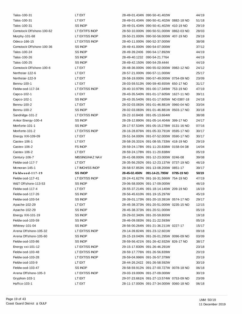
PLATFORM DISCREPANCIES
LT EXTLT EXT/SS INOPSS INOPLT EXT/SS INOPLT EXT/SS INOPLT EXTLT EXTSS INOPSS INOPLT EXT/SS INOPSS INOPLT EXTLT EXTLT EXT/SS INOPLT EXTLT EXT/SS INOPSS INOPLT EXTLT EXT/SS INOPSS INOPSS INOPLT EXT/SS INOPLT EXTLT EXT/SS INOP
30-12-20.864N29-38-11.354N29-20-50.775N29-24-00.439N29-23-53.567N29-22-46.164N29-09-50.256N29-33-16.211N29-35-17.000N29-09-51.156N29-15-37.747N29-16-07.138N29-15-10.117N29-15-47.527N29-15-59.650N29-49-22.000N29-15-44.730N29-06-55.000N29-17-01.086N29-15-52.970N29-15-26.096N29-19-33.840N29-21-10.592N29-15-59.000N
088-03-41.846W088-05-31.592W088-06-47.910W088-36-33.646W088-37-40.811W088-37-56.467W088-39-55.422W088-41-13.611W088-42-39.000W088-44-46.075W088-44-50.190W088-45-21.444W088-45-26.961W088-45-33.249W088-45-38.410W088-45-48.000W088-46-03.480W088-46-05.000W088-46-15.272W088-46-19.529W088-46-22.762W088-52-37.390W088-53-07.382W088-54-29.000W
0894-11 MO
326-19 MO
085-15
0263-17
0621-18 NO
0269-18
114-18
0774-11 NO
0182-15
NO 0106-18
277-19 NO
1002-17 NO
NO 1016-17
0800-18 NO
0415-08
0974-17 NO
0987-17 NO
0635-17 NO
0989-17 NO
NO 0132-18
Name Status Position BNM Ref.
39/11
18/19
05/15
18/17
36/18
10/19
16/18
08/18
23/11
09/15
08/18
22/19
48/17
49/17
47/18
06/08
47/17
39/08
47/17
31/17
47/17
42/17
09/18
04/18
LNM St LNM End
Mobil-228-5Fieldwood-114-4Merit-105-12Petro Ventures-100-3Petro Ventures-100-2Petro Ventures-100-4Fieldwood-107-5Energy Xxi-102-11Mobil-194-4Gom Shelf-300-4Cantium-114-06Mcmoran-117-4Cantium-114-05Mcmoran-117-2Mcmoran-117-7Bt Operating-101-2Mcmoran-117-5Walter-105-10Cantium-114-03Mcmoran-117-3Cantium-114-04Energy Xxi-102-5 (Racon)EnVen-106-2Energy Xxi-102-6

11 December 201950/19LNM:
8Coast Guard District GULFPage 16 of 43
LT EXTLT EXTLT EXTLT EXTLT EXTSS INOPSS INOPSS INOPLT EXTSS INOPSS INOPSS INOPSS INOPLT EXTSS INOPLT EXTLT EXTLT EXTSS INOPSS INOPLT EXTLT EXTLT EXT/SS INOPLT EXTLT EXT/SS INOPLT EXT/SS INOPLT EXT/SS INOPLT EXT/SS INOPLT EXT/SS INOPLT EXTLT EXTLT EXTSS INOPLT EXTSS INOPLT EXTSTRUCT DEST/HAZ NAV/LT EXTSTRUCT DEST/HAZ NAV/LT EXTLT EXTHAZ NAV/LT EXTLT EXTLT EXT/SS INOPLT EXTLT EXTSS INOPLT EXTLT EXTLT EXT/STRUCT DMGDSS INOPLT EXT/SS INOPSS INOPLT EXT/SS INOP
29-25-36.300N29-12-41.000N29-23-33.983N29-21-04.233N29-24-34.048N29-22-53.220N29-22-02.000N29-24-21.007N29-22-22.187N29-22-22.187N29-23-37.052N29-25-04.228N29-18-24.470N29-17-54.374N29-24-47.162N30-00-23.000N29-23-48.800N30-02-04.981N28-58-42.410N29-24-56.888N30-03-36.865N29-24-38.000N29-31-10.000N29-28-00.000N29-00-12.000N28-58-29.000N28-59-10.000N28-59-46.000N28-59-35.000N29-04-19.200N29-04-02.890N28-53-57.549N28-49-19.710N28-54-39.000N28-53-31.200N29-14-09.000N28-54-54.000N28-54-23.000N28-54-58.000N29-07-26.000N28-55-05.000N28-54-32.660N29-08-58.000N29-34-39.800N28-57-24.893N29-11-15.434N29-34-04.200N29-25-41.000N29-11-35.000N29-11-02.000N29-11-02.000N29-10-53.100N
088-55-15.363W088-57-01.000W088-57-55.992W088-58-55.688W088-58-56.348W088-59-15.852W088-59-35.000W088-59-39.611W089-00-27.992W089-00-27.992W089-00-36.902W089-03-13.668W089-03-24.761W089-03-32.051W089-04-19.615W089-05-10.000W089-06-25.500W089-06-39.903W089-07-42.480W089-09-58.327W089-10-15.441W089-11-58.000W089-13-43.000W089-14-57.000W089-15-28.000W089-15-30.000W089-15-41.000W089-15-58.000W089-17-43.000W089-19-57.000W089-20-57.160W089-22-05.219W089-23-41.850W089-24-02.000W089-25-16.700W089-25-36.000W089-26-43.000W089-27-02.000W089-27-08.000W089-27-10.000W089-27-11.000W089-27-26.200W089-29-02.000W089-29-44.700W089-30-25.099W089-30-33.004W089-30-37.500W089-30-49.000W089-31-14.000W089-31-22.000W089-31-22.000W089-32-02.200W
NO 0354-18
259-19 NO
1097-17
396-19 NO
0570-18 NO
0997-17NO
0932-12 NO
0108-15 NO
NO 0127-18
0578-11 NO
0291-14NO
0098-09 NO
0405-16 NO
1545-10 NO
0343-13 NO
0639-15 NO
0158-11 NO
1305-02 NO
0200-01 NO
0719-98 NO
0853-97 NO
375-19 NO
0245-12 NO
29/19
34/16
29/19
29/19
22/18
20/19
52/17
29/19
33/18
29/19
48/17
29/19
23/12
05/15
29/19
07/11
09/18
07/11
17/11
14/14
07/11
04/09
19/16
48/10
44/08
44/08
44/08
44/08
44/08
14/13
39/04
33/15
13/18
50/12
06/11
38/02
08/15
07/01
08/15
31/98
08/15
31/11
35/97
37/08
27/19
38/08
37/08
09/12
29/16
38/08
29/16
38/08
Cantium-100-02Mariner-118-1Cantium-100-05Cantium-110-02Cantium-101-11Cantium-101-07Cantium-110-01Cantium-101-05Cantium-101-13Cantium-101-13Cantium-101-09Cantium-115-06Medco Energi-103-05Medco Energi-103-15Cantium-115-01Eb04-17812-1(Pxp)Cantium-109-01Eb04-17388-1(Pxp)Ocean Energy-102-335Century-109-4Eb04-17387-1(Pxp)Amerada Hess-114-10Century Exploration-100-8Amerada Hess-103-1Energy Partners-102-34Energy Partners-102-191Energy Partners-102-130Energy Partners-102-20Energy Partners-102-121Panaco-101-39Panaco-101-41Llog-114-1 Lighted BuoyEnergy XXI-108-19En Dev Corp-103-4XTO Offshore-100-1Ed19-Bld-183S. Parish-102-9S. Parish-102-7S. Parish-102-12Signal-100-0S. Parish-102-11IG Petroleum-100-1Davis Fuels-101-2Eb01-195qq-96Fieldwood-115-16MCMORAN-136-2Eb26-195qq-49Eb21-195 Qq-312 (Merit Energy)Denbury-200-7Denbury-200-17Denbury-200-17Denbury-200-12

11 December 201950/19LNM:
8Coast Guard District GULFPage 17 of 43
LT EXTSS INOPSS INOPLT EXTSS INOPSS INOPLT EXTLT EXTLT EXTLT EXT/SS INOPLT EXT/SS INOPLT EXTLT EXT/SS INOPLT EXT/SS INOPSS INOPLT EXTLT EXT/SS INOPLT EXTSS INOPLT EXTLT EXT/SS INOPLT EXT/SS INOPLT EXT/SS INOPLT EXT/SS INOPLT EXTSS INOPLT EXTLT EXTSS INOPLT EXTRAC INOPLT EXTLT EXT/SS INOPSS INOPSS INOPLT EXTLT EXTLT EXTLT EXTLT EXTLT EXTSS INOPLT EXTLT EXT/SS INOPLT EXTSS INOPLT EXT/SS INOPLT EXTSS INOPLT EXT/SS INOPLT EXT/SS INOPSS INOP
29-18-30.000N29-10-30.300N29-07-52.129N29-06-25.000N28-52-49.690N28-57-35.130N30-05-38.766N29-00-38.467N29-07-42.739N29-07-06.466N28-56-39.000N30-06-42.000N29-05-35.000N29-09-42.600N28-39-09.000N28-58-13.548N28-49-01.949N28-58-10.664N28-54-21.000N28-57-52.000N28-45-46.749N29-10-45.800N29-10-48.342N29-10-02.300N28-59-55.525N28-55-19.296N30-13-34.000N30-13-35.000N28-46-11.659N28-02-05.310N27-11-43.641N29-43-06.000N28-56-42.000N28-15-33.300N28-31-32.858N29-05-57.710N29-05-59.133N29-03-53.096N29-01-17.493N29-04-22.850N29-06-08.691N29-06-21.850N29-01-51.217N29-06-04.229N29-05-59.663N29-05-59.663N29-05-53.528N29-06-12.932N29-02-38.022N29-05-20.339N29-04-18.430N29-05-43.531N
089-32-30.000W089-33-06.200W089-34-44.475W089-37-54.000W089-39-47.290W089-39-47.640W089-39-50.070W089-40-28.603W089-41-25.032W089-41-37.867W089-42-40.000W089-44-11.000W089-45-30.000W089-46-27.036W089-47-11.000W089-47-52.871W089-47-54.534W089-49-10.369W089-49-14.000W089-50-08.000W089-51-57.565W089-53-16.500W089-53-43.381W089-54-05.200W089-56-15.899W089-56-22.254W089-57-23.000W089-57-23.000W089-58-19.931W090-01-21.980W090-01-37.150W090-03-06.000W090-03-13.000W090-03-39.100W090-05-52.512W090-06-32.548W090-07-17.788W090-07-47.161W090-08-15.079W090-08-16.084W090-08-30.210W090-08-35.796W090-08-40.497W090-08-51.195W090-08-58.564W090-08-58.564W090-09-08.747W090-09-13.073W090-09-18.965W090-09-28.040W090-09-38.970W090-09-50.461W
NO 0930-17
0575-18 NO
911-18 NO
1829-08 NOLA
412-19 NO
1468-01 NO
269-19 NO
058-19 NO
415-19 NO
0644-17 NO
0791-07
420-19 NO
NO 0703-18
293-19 NO
0377-03 D8
0377-03 D8
0273-14 NO
1488-12
1109-15 NO
0221-02 D8
376-19 NO
212-19 NO
NO 0686-18
0058-18 NO
0064-18 NO
NO 1066-17
0023-19 NO
0771-19 NO
NO 0912-18
NO 0374-18
1024-17 NO
NO 0373-18
1023-17 NO
183-19 NO
NO 0011-18
NO 1111-17
NO 0375-18
37/08
05/16
24/18
04/16
44/17
34/18
07/11
05/19
03/18
44/08
29/19
50/01
41/14
21/19
28/18
06/19
51/15
29/19
31/17
24/07
11/06
47/08
47/08
29/19
40/18
23/19
33/03
33/03
13/14
37/12
52/15
22/02
27/19
06/17
16/19
40/18
06/18
06/18
51/17
45/18
05/19
48/19
06/19
23/18
50/17
44/19
23/18
50/17
15/19
02/18
01/18
23/18
Ea06-5710108-39-RiserMcmoran-136-3Energy XXI-107-29Nexen-103-3Fieldwood-115-6Fieldwood-115-2Eb12-17656-2 (Pxp)Basin-104-3(Buoy Waiver)Black Elk-116-1Black Elk-116-2Energy Xxi-107-24Ec6-3327-Prod PlfmApache-125-14Mariner-117-2Energy Xxi-110-2Gom Shelf-110-3Anglo Suisse-100-1Gom Shelf-110-2BP Exploration-112-28BP Exploration-112-17Ocean Energy-112-1El Paso-180-5El Paso-180-4Energy Xxi-111-4Gom Shelf-800-8Fieldwood-104-8Ec5-6750-2Ec5-6750-2 PlfmRooster-107-1Agip-300-1(Tlp-Seastar)BP Exploration-110-3 (Atlantis)Ea44-5310175-Riser PlfmBP Exploration-102-27Ankor Energy-100-7Fieldwood-104-7Cantium-102-03Cantium-102-04Cantium-117-15Cantium-106-04Cantium-117-09Cantium-116-08Cantium-116-25Cantium-117-14Cantium-116-21Cantium-116-20Cantium-116-20Cantium-116-24Cantium-116-23Cantium-117-11Cantium-116-02Cantium-118-02Cantium-116-07

11 December 201950/19LNM:
8Coast Guard District GULFPage 18 of 43
LT EXTLT EXT/SS INOPSS INOPLT EXTLT EXTLT EXTSS INOPSS INOPLT EXTLT EXTLT EXTSS INOPLT EXTLT EXTLT EXTLT EXT/SS INOPLT EXTSS INOPLT EXTLT EXTLT EXTLT EXTLT EXTLT EXTLT EXTSS INOPLT EXTSS INOPLT EXTLT EXT/SS INOPLT EXTLT EXT/SS INOPSS INOPSS INOPOFF STA/HAZ NAV/LT EXT/SS INSS INOPLT EXTLT EXTSS INOPLT EXT/SS INOPSS INOPLT EXT/SS INOPSS INOPLT EXT/SS INOPSS INOPSS INOPSS INOPLT EXTSS INOPLT EXTLT EXT/FS INOPLT EXT/SS INOP
29-04-19.221N29-03-25.793N29-04-56.285N29-03-55.369N29-03-05.418N29-03-06.411N29-04-17.927N29-05-19.399N28-47-36.000N29-03-58.500N29-03-32.864N28-09-41.090N30-04-31.000N28-47-43.000N28-32-40.000N28-37-01.861N28-30-24.000N28-29-42.976N28-41-21.105N28-42-10.427N28-27-13.407N28-34-49.000N28-47-56.000N28-37-50.842N28-32-26.000N28-32-26.000N29-06-45.000N28-26-45.000N28-55-57.240N28-50-00.000N29-07-42.000N28-53-30.810N28-49-32.030N28-58-05.422828-30-24.800N28-26-57.399N28-56-27.736228-56-52.734628-56-19.690828-56-52.506N28-53-33.308828-52-24.146228-58-36.000N28-59-01.000N28-58-53.000N28-58-33.671N28-58-21.000N28-49-28.106N28-49-28.106N28-58-56.000N28-50-13.000N28-50-08.7828
090-10-04.434W090-10-05.790W090-10-09.357W090-10-18.173W090-10-21.224W090-10-22.655W090-10-25.261W090-10-28.582W090-12-09.000W090-12-57.600W090-13-34.244W090-13-39.450W090-13-48.000W090-13-49.000W090-14-01.000W090-14-57.702W090-17-07.000W090-17-56.891W090-19-55.900W090-22-28.852W090-23-00.289W090-23-33.000W090-24-52.000W090-25-04.048W090-26-08.000W090-26-08.000W090-26-54.000W090-27-53.000W090-28-55.000W090-29-58.000W090-30-52.000W090-37-05.733W090-37-14.710W090-39-32.5578090-40-46.360W090-41-06.836W090-43-13.7748090-43-24.6282090-44-33.5544090-46-29.862W090-47-44.5123090-49-30.0885090-49-36.000W090-50-00.000W090-50-11.000W090-50-15.489W090-50-16.000W090-50-21.728W090-50-21.728W090-50-24.000W090-50-31.000W090-50-31.8696
1106-17 NO
414-19 NO
NO 0380-18
NO 1112-17
NO 1112-17
NO 1112-17
0547-18 NO
NO 0012-18
0356-19 NO
1036-17
0512-18 NO
0307-01 D8
1499-12 NO
404-19 NO
0404-15 NO
0671-18 NO
D8-0106-15
1380-00 NO
0800-19 NO
1797-07
0299-19 NO
1499-12
0472-02 D8
1258-01 NO
0440-14 NO
0502-02 D8
NO 0688-18
0265-14 NO
0821-18 NO
NO 0705-18
0904-18 NO
239-19 NO
857-18 NO
NO 0145-18
274-16
273-17
1029-15 NO
0275-17
409-19 NO
186-19 NO
0276-17
0862-03 NO
408-19 NO
01/18
29/19
24/18
01/18
01/18
01/18
32/18
02/18
25/19
50/17
07/11
30/18
42/01
37/12
25/18
29/19
21/15
39/18
33/15
50/00
50/1934/16
03/18
50/07
23/19
37/12
46/02
14/15
39/01
22/14
46/02
41/08
44/15
40/18
39/08
13/14
47/18
41/18
52/18
18/19
49/18
44/19
10/18
19/17
19/17
49/15
19/17
29/19
15/19
19/17
28/03
29/19
Cantium-118-06Cantium-118-10Cantium-118-23Cantium-118-12Cantium-118-03Cantium-118-05Cantium-118-11Cantium-116-03Talos-102-12Shoreline-100-4Louisiana Orphan Wellsite C #151642Fieldwood-101-2Ec5-7325-1 & 1DTrunkline-103-4Offshore Energy-107-3Arena Offshore-106-18Transco-101-6Energy Xxi-100-80Walter-116-10Century Offshore-102-1Fieldwood-101-12
Arena Offshore-106-5Energy Xxi-100-75Remington-400-1Trunkline-103-2Trunkline-103-2Ee27-188-76 Walkway Lt (Texaco)Black Elk-100-8Bois-103-6Trunkline-103-3Ee21-1247-13Energy Partners-109-2Talos-101-16Fieldwood-102-2Noble Energy-106-6Probe-102-2Fieldwood-102-6Fieldwood-102-16Fieldwood-102-5Fieldwood-117-17Talos-100-37Talos-100-45Newfield-103-19McMoran-145-5McMoran-145-3Newfield-103-27Newfield-103-22Talos-100-46Talos-100-46McMoran-145-4Comstock Offshore-100-56Talos-100-30
11 December 201950/19LNM:
8Coast Guard District GULFPage 19 of 43
LT EXTLT EXTSS INOPLT EXT/FS INOPLT EXT/SS INOPLT EXT/SS INOPSS INOPSS INOPSS INOPSS INOPLT EXTLT EXTLT EXTLT EXTLT EXT/SS INOPLT EXTSS INOPLT EXTSS INOPLT EXT/SS INOPSS INOPSS INOPLT EXT/SS INOPLT EXTLT EXTFS INOPLT EXTMISSING/HAZ NAVLT EXTLT IMCH/SS INOPSS INOPLT EXT/SS INOPSS INOPLT EXTSS INOPSS INOPLT EXTSS INOPSS INOPSS INOPSS INOPLT EXT/SS INOPSS INOPSS INOPLT EXT/SS INOPLT EXT/SS INOPLT EXT/SS INOPLT EXTSS INOPLT EXT/SS INOPLT EXTLT EXT
28-49-01.434N28-49-01.434N28-49-01.434N28-50-10.000N28-50-21.000N28-40-11.000N28-49-41.000N28-49-39.240628-49-40.123228-49-42.150N28-48-36.000N28-57-21.000N28-58-19.000N28-03-59.513N28-40-10.979N28-43-35.540N28-43-35.540N28-02-03.083N28-02-03.083N28-22-10.840828-28-12.890N28-17-57.534N28-16-28.876N28-51-34.000N28-58-26.331N28-59-24.178N28-59-24.178N28-41-08.000N28-35-56.292N28-58-57.853N28-45-02.450N28-24-41.627N29-06-58.000N28-55-37.214N28-56-45.610N28-39-01.173N28-45-38.373N28-45-38.373N28-29-02.340N28-46-09.083N28-56-00.264N29-14-39.824N28-15-19.040N28-59-56.421N29-15-17.830N28-59-17.776N28-59-04.996N28-44-26.242228-58-59.912N29-03-19.000N29-07-23.661N28-11-17.000N
090-50-41.402W090-50-41.402W090-50-41.402W090-50-51.000W090-50-56.000W090-52-37.000W090-54-07.000W090-54-17.892W090-54-21.7764090-54-29.4444090-55-02.000W090-57-11.000W090-57-49.000W090-59-40.655W091-00-17.349W091-01-17.605W091-01-17.605W091-01-46.881W091-01-46.881W091-05-13.664W091-05-14.404W091-05-15.278W091-05-33.791W091-07-52.000W091-08-55.733W091-11-20.838W091-11-20.838W091-12-23.000W091-12-23.137W091-13-08.200W091-14-21.795W091-16-31.566W091-17-09.000W091-18-14.140W091-19-15.297W091-20-10.391W091-20-51.000W091-20-51.000W091-20-59.800W091-21-22.593W091-21-36.211W091-23-12.601W091-26-01.295W091-26-42.932W091-26-46.291W091-26-56.839W091-26-57.379W091-26-58.592W091-27-00.727W091-27-09.000W091-27-13.574W091-27-34.000W
0882-18 NO
410-19 NO
0862-03 NO
407-19 NO
0982-12 NO
0754-09 NO
650-17 NO
753-19 NO
1627-11 NO
NO 0387-18
0960-04 NO
0503-17 NO
399-17 NO
0131-16 NO
0595-17 NO
0590-17 NO
418-19 NO
0158-04 D8
0246-08
0737-19 NO
0851-17
0795-19 NO754-19 NO
209-19 NO
0574-17 NO
0235-15 NO
0227-17
0096-09 NO
826-17 NO
0078-18 NO
0753-09 NO
0060-18 NO
44/19
51/18
29/19
28/03
29/19
38/08
37/12
44/19
44/19
44/19
24/12
25/17
23/09
31/17
47/19
39/11
24/18
33/04
30/18
38/08
24/17
07/16
30/17
30/17
29/19
14/04
05/19
39/08
46/19
39/17
50/1947/19
46/19
16/19
45/19
29/17
12/15
05/19
19/18
05/19
15/17
09/18
03/09
38/17
23/18
20/19
20/19
30/19
06/18
30/19
23/09
06/18
Talos-100-31Talos-100-31Talos-100-31Comstock Offshore-100-62Murphy-101-68Odeco-166-15Comstock Offshore-100-36Talos-100-24Talos-100-26Talos-100-25Comstock Offshore-100-6Northstar-122-6Northstar-122-9Bennu-100-1Fieldwood-117-34Capco-102-1Capco-102-1Bennu-100-2Bennu-100-2Sandridge-101-2Ankor Energy-100-4Monforte-101-1Monforte-101-2Energy XXI-109-09Castex-106-1Castex-106-2Castex-106-2Century-106-7Fieldwood-117-7Mcmoran-145-1Fieldwood-117-19
Fieldwood-117-41W&T Offshore-113-53Fieldwood-117-4Fieldwood-117-26Fieldwood-103-54Apache-102-29Apache-102-29Energy XXI-101-19Fieldwood-103-59Whitney-101-04Arena Offshore-105-32Arena Offshore-105-60Fieldwood-103-86Energy xxi-101-12Fieldwood-103-48Fieldwood-103-28Fieldwood-103-9Fieldwood-103-47Arena Offshore-105-3Gryphon-103-1Huffco-103-1
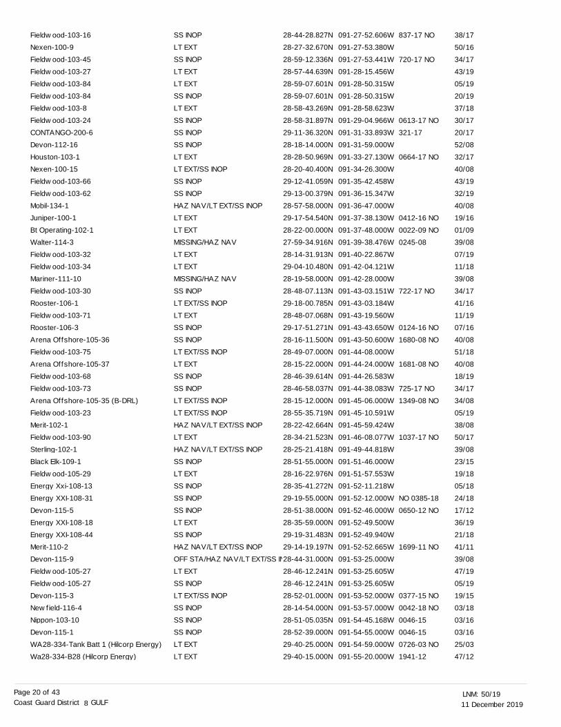
11 December 201950/19LNM:
8Coast Guard District GULFPage 20 of 43
SS INOPLT EXTSS INOPLT EXTLT EXTSS INOPLT EXTSS INOPSS INOPSS INOPLT EXTLT EXT/SS INOPSS INOPSS INOPHAZ NAV/LT EXT/SS INOPLT EXTLT EXTMISSING/HAZ NAVLT EXTLT EXTMISSING/HAZ NAVSS INOPLT EXT/SS INOPLT EXTSS INOPSS INOPLT EXT/SS INOPLT EXTSS INOPSS INOPLT EXT/SS INOPLT EXT/SS INOPHAZ NAV/LT EXT/SS INOPLT EXTHAZ NAV/LT EXT/SS INOPSS INOPLT EXTSS INOPSS INOPSS INOPLT EXTSS INOPHAZ NAV/LT EXT/SS INOPOFF STA/HAZ NAV/LT EXT/SS INLT EXTSS INOPLT EXT/SS INOPSS INOPSS INOPSS INOPLT EXTLT EXT
28-44-28.827N28-27-32.670N28-59-12.336N28-57-44.639N28-59-07.601N28-59-07.601N28-58-43.269N28-58-31.897N29-11-36.320N28-18-14.000N28-28-50.969N28-20-40.400N29-12-41.059N29-13-00.379N28-57-58.000N29-17-54.540N28-22-00.000N27-59-34.916N28-14-31.913N29-04-10.480N28-19-58.000N28-48-07.113N29-18-00.785N28-48-07.068N29-17-51.271N28-16-11.500N28-49-07.000N28-15-22.000N28-46-39.614N28-46-58.037N28-15-12.000N28-55-35.719N28-22-42.664N28-34-21.523N28-25-21.418N28-51-55.000N28-16-22.976N28-35-41.272N29-19-55.000N28-51-38.000N28-35-59.000N29-19-31.483N29-14-19.197N28-44-31.000N28-46-12.241N28-46-12.241N28-52-01.000N28-14-54.000N28-51-05.035N28-52-39.000N29-40-25.000N29-40-15.000N
091-27-52.606W091-27-53.380W091-27-53.441W091-28-15.456W091-28-50.315W091-28-50.315W091-28-58.623W091-29-04.966W091-31-33.893W091-31-59.000W091-33-27.130W091-34-26.300W091-35-42.458W091-36-15.347W091-36-47.000W091-37-38.130W091-37-48.000W091-39-38.476W091-40-22.867W091-42-04.121W091-42-28.000W091-43-03.151W091-43-03.184W091-43-19.560W091-43-43.650W091-43-50.600W091-44-08.000W091-44-24.000W091-44-26.583W091-44-38.083W091-45-06.000W091-45-10.591W091-45-59.424W091-46-08.077W091-49-44.818W091-51-46.000W091-51-57.553W091-52-11.218W091-52-12.000W091-52-46.000W091-52-49.500W091-52-49.940W091-52-52.665W091-53-25.000W091-53-25.605W091-53-25.605W091-53-52.000W091-53-57.000W091-54-45.168W091-54-55.000W091-54-59.000W091-55-20.000W
837-17 NO
720-17 NO
0613-17 NO
321-17
0664-17 NO
0412-16 NO
0022-09 NO
0245-08
722-17 NO
0124-16 NO
1680-08 NO
1681-08 NO
725-17 NO
1349-08 NO
1037-17 NO
NO 0385-18
0650-12 NO
1699-11 NO
0377-15 NO
0042-18 NO
0046-15
0046-15
0726-03 NO
1941-12
38/17
50/16
34/17
43/19
05/19
20/19
37/18
30/17
20/17
52/08
32/17
40/08
43/19
32/19
40/08
19/16
01/09
39/08
07/19
11/18
39/08
34/17
41/16
11/19
07/16
40/08
51/18
40/08
18/19
34/17
34/08
05/19
38/08
50/17
39/08
23/15
19/18
05/18
24/18
17/12
36/19
21/18
41/11
39/08
47/19
05/19
19/15
03/18
03/16
03/16
25/03
47/12
Fieldwood-103-16Nexen-100-9Fieldwood-103-45Fieldwood-103-27Fieldwood-103-84Fieldwood-103-84Fieldwood-103-8Fieldwood-103-24CONTANGO-200-6Devon-112-16Houston-103-1Nexen-100-15Fieldwood-103-66Fieldwood-103-62Mobil-134-1Juniper-100-1Bt Operating-102-1Walter-114-3Fieldwood-103-32Fieldwood-103-34Mariner-111-10Fieldwood-103-30Rooster-106-1Fieldwood-103-71Rooster-106-3Arena Offshore-105-36Fieldwood-103-75Arena Offshore-105-37Fieldwood-103-68Fieldwood-103-73Arena Offshore-105-35 (B-DRL)Fieldwood-103-23Merit-102-1Fieldwood-103-90Sterling-102-1Black Elk-109-1Fieldwood-105-29Energy Xxi-108-13Energy XXI-108-31Devon-115-5Energy XXI-108-18Energy XXI-108-44Merit-110-2Devon-115-9Fieldwood-105-27Fieldwood-105-27Devon-115-3Newfield-116-4Nippon-103-10Devon-115-1WA28-334-Tank Batt 1 (Hilcorp Energy)Wa28-334-B28 (Hilcorp Energy)
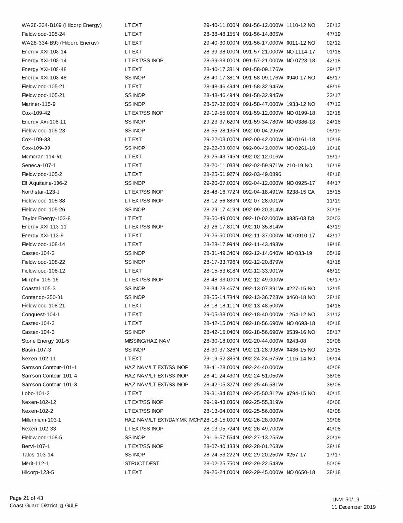
11 December 201950/19LNM:
8Coast Guard District GULFPage 21 of 43
LT EXTLT EXTLT EXTLT EXTLT EXT/SS INOPLT EXTSS INOPLT EXTSS INOPSS INOPLT EXT/SS INOPSS INOPSS INOPLT EXTSS INOPLT EXTLT EXTLT EXTSS INOPLT EXT/SS INOPLT EXT/SS INOPSS INOPLT EXTLT EXT/SS INOPLT EXTLT EXTSS INOPSS INOPLT EXTLT EXT/SS INOPSS INOPSS INOPLT EXTLT EXTLT EXTSS INOPMISSING/HAZ NAVSS INOPLT EXTHAZ NAV/LT EXT/SS INOPHAZ NAV/LT EXT/SS INOPHAZ NAV/LT EXT/SS INOPLT EXTLT EXT/SS INOPLT EXT/SS INOPHAZ NAV/LT EXT/DAYMK IMCH/SLT EXT/SS INOPSS INOPLT EXT/SS INOPSS INOPSTRUCT DESTLT EXT
29-40-11.000N28-38-48.155N29-40-30.000N28-39-38.000N28-39-38.000N28-40-17.381N28-40-17.381N28-48-46.494N28-48-46.494N28-57-32.000N29-19-55.000N29-23-37.620N28-55-28.135N29-22-03.000N29-22-03.000N29-25-43.745N28-20-11.033N28-25-51.927N29-20-07.000N28-48-16.772N28-12-56.883N28-29-17.419N28-50-49.000N29-26-17.801N29-26-50.000N28-28-17.994N28-31-49.340N28-17-33.796N28-15-53.618N28-48-33.000N28-34-28.467N28-55-14.784N28-18-18.111N29-05-38.000N28-42-15.040N28-42-15.040N28-30-18.000N28-30-37.326N29-19-52.385N28-41-28.000N28-41-24.430N28-42-05.327N29-31-34.802N29-19-43.036N28-13-04.000N28-18-15.000N28-13-05.724N29-16-57.554N28-07-40.133N28-24-53.222N28-02-25.750N29-26-24.000N
091-56-12.000W091-56-14.805W091-56-17.000W091-57-21.000W091-57-21.000W091-58-09.176W091-58-09.176W091-58-32.945W091-58-32.945W091-58-47.000W091-59-12.000W091-59-34.780W092-00-04.295W092-00-42.000W092-00-42.000W092-02-12.016W092-02-59.971W092-03-49.0896092-04-12.000W092-04-18.491W092-07-28.001W092-09-20.314W092-10-02.000W092-10-35.814W092-11-37.000W092-11-43.493W092-12-14.640W092-12-20.879W092-12-33.901W092-12-49.000W092-13-07.891W092-13-36.728W092-13-48.500W092-18-40.000W092-18-56.690W092-18-56.690W092-20-44.000W092-21-28.998W092-24-24.675W092-24-40.000W092-24-51.050W092-25-46.581W092-25-50.812W092-25-55.319W092-25-56.000W092-26-28.000W092-26-49.700W092-27-13.255W092-28-01.263W092-29-20.250W092-29-22.548W092-29-45.000W
1110-12 NO
0011-12 NO
NO 1114-17
NO 0723-18
0940-17 NO
1933-12 NO
NO 0199-18
NO 0386-18
NO 0161-18
NO 0261-18
210-19 NO
NO 0925-17
0238-15 GA
0335-03 D8
NO 0910-17
NO 033-19
0227-15 NO
0460-18 NO
1254-12 NO
NO 0693-18
0539-16 NO
0243-08
0436-15 NO
1115-14 NO
0794-15 NO
0257-17
NO 0650-18
28/12
47/19
02/12
01/18
42/18
39/17
45/17
48/19
23/17
47/12
12/18
24/18
05/19
10/18
16/18
15/17
16/19
48/18
44/17
15/15
11/19
30/19
30/03
43/19
42/17
19/18
05/19
41/18
46/19
06/17
12/15
28/18
14/18
31/12
40/18
28/17
39/08
23/15
06/14
40/08
38/08
38/08
40/15
40/08
42/08
39/08
40/08
20/19
38/18
17/17
50/09
38/18
WA28-334-B109 (Hilcorp Energy)Fieldwood-105-24WA28-334-B93 (Hilcorp Energy)Energy XXI-108-14Energy XXI-108-14Energy XXI-108-48Energy XXI-108-48Fieldwood-105-21Fieldwood-105-21Mariner-115-9Cox-109-42Energy Xxi-108-11Fieldwood-105-23Cox-109-33Cox-109-33Mcmoran-114-51Seneca-107-1Fieldwood-105-2Elf Aquitaine-106-2Northstar-123-1Fieldwood-105-38Fieldwood-105-26Taylor Energy-103-8Energy XXI-113-11Energy XXI-113-9Fieldwood-108-14Castex-104-2Fieldwood-108-22Fieldwood-108-12Murphy-105-16Coastal-105-3Contango-250-01Fieldwood-108-21Conquest-104-1Castex-104-3Castex-104-3Stone Energy 101-5Basin-107-3Nexen-102-11Samson Contour-101-1Samson Contour-101-4Samson Contour-101-3Lobo-101-2Nexen-102-12Nexen-102-2Millennium-103-1Nexen-102-33Fieldwood-108-5Beryl-107-1Talos-103-14Merit-112-1Hilcorp-123-5

11 December 201950/19LNM:
8Coast Guard District GULFPage 22 of 43
SS INOPLT EXT/SS INOPLT EXTSS INOPLT EXTLT EXT/SS INOPSS INOPLT EXT/SS INOPSS INOPSTRUCT DMGDHAZ NAV/LT EXT/SS INOPLT EXTLT EXT/SS INOPLT EXTMISSING/HAZ NAVMISSING/HAZ NAVMISSING/HAZ NAVLT EXT/SS INOPSS INOPSS INOPMISSING/HAZ NAVLT EXTLT EXT/SS INOPLT EXTSS INOPLT EXTSS INOPLT EXT/SS INOPLT EXTHAZ NAV/LT EXT/SS INOP/STRULT EXT/SS INOPLT EXTLT EXTLT EXTLT EXTSS INOPLT EXT/SS INOPSS INOPLT EXT/SS INOPSS INOPSS INOPLT EXT/SS INOPSS INOPSS INOPLT EXTLT EXTLT EXTLT EXT/SS INOPSS INOPSS INOPLT EXT/SS INOPSS INOP
28-29-24.234N29-07-14.000N29-25-33.434N29-05-13.746N29-05-12.106N29-05-42.445N28-54-34.805N29-05-02.626N29-04-46.547N29-04-46.547N28-04-22.000N29-28-11.914N28-17-55.000N28-48-49.100N28-45-47.925N28-27-01.314N29-02-52.791N28-24-38.937N29-29-36.656N28-40-11.000N28-10-44.741N29-20-48.464N28-55-37.000N28-56-21.000N29-31-54.000N29-35-17.534N29-30-29.380N29-15-22.380N28-25-44.065N28-37-31.000N28-28-18.865N28-27-07.401N28-08-44.000N29-26-26.906N28-18-14.928N29-16-47.200N28-10-22.430N29-39-34.035N29-41-02.000N29-41-01.000N29-40-53.000N29-41-07.000N29-37-35.162N29-19-04.000N29-40-05.603N28-28-02.168N28-28-02.168N29-20-17.000N29-39-07.369N29-38-56.026N29-38-46.686N29-33-32.972N
092-29-46.616W092-30-09.000W092-30-09.220W092-30-18.758W092-31-01.729W092-31-01.789W092-31-17.887W092-31-33.072W092-31-43.585W092-31-43.585W092-32-47.000W092-32-59.921W092-34-45.000W092-35-06.000W092-35-07.532W092-35-26.776W092-36-55.710W092-36-56.185W092-38-23.287W092-40-30.000W092-41-45.558W092-42-56.802W092-44-16.000W092-44-47.000W092-45-42.000W092-46-56.031W092-48-12.590W092-51-17.230W092-52-41.375W092-53-30.000W092-54-53.213W092-55-30.370W092-58-46.000W092-58-46.060W092-59-29.425W092-59-44.600W092-59-56.699W093-00-13.395W093-00-26.000W093-00-43.000W093-00-55.000W093-00-55.000W093-02-04.901W093-02-05.000W093-02-58.030W093-03-12.859W093-03-12.859W093-04-23.000W093-07-18.652W093-07-52.355W093-08-31.355W093-08-44.376W
0366-15 NO
0567-18 NO
0143-16 no
0170-16
0429-15
3908
0243-08
0441-15 GA
0351-13 GA
0246-08
0855-13GA
1128-09 GA
0192-13 GA
0019-11 LA
0198-13 GA
1656-10 NO
0050-14 GA
0723-12
0052-14 GA
0354-13 GA
0367-15 GA
22/09
49/16
43/18
01/17
42/16
19/15
33/18
07/16
10/16
41/16
38/08
22/15
40/08
39/00
39/08
39/08
39/08
43/10
26/15
18/13
39/08
46/13
51/09
02/17
10/13
07/11
11/13
52/10
45/19
03/14
27/18
47/18
44/19
34/12
49/08
03/14
46/17
38/15
11/19
05/19
24/19
11/18
01/18
18/13
13/19
25/19
49/19
21/15
05/19
27/19
25/18
12/19
Palm Energy-104-1Black Elk-101-5Energy XXI-113-13Black Elk-101-6Black Elk-101-2Black Elk-101-4Energy Xxi-113-15Black Elk-101-1Black Elk-101-3Black Elk-101-3Marathon-114-1Probe-103-1Nexen-102-1Energy Resource-103-4Newfield-105-15King Ranch-103-2Aquilla-108-1Gomex-100-1PROBE-100-1Coastal-104-1Maritech-111-3East Cameron Partners-100-2Houston-102-2Merit-108-2Merit-108-1Louisiana Orphan Wellsite A #156996Houston-102-6Merit-110-1Fieldwood-100-11Con Energy-101-1Fieldwood-100-10Fieldwood-100-2Energy Xxi-104-1Helis-121-3Hec-101-2Hec-102-7Merit-107-1Virgin-100-2Fieldwood-100-14Fieldwood-100-17Fieldwood-100-15Fieldwood-100-16Fieldwood-109-26Diamond Shamroc-104-3Fieldwood-109-24Fieldwood-109-23Fieldwood-109-23Black Elk-102-16Fieldwood-109-4Fieldwood-109-6Fieldwood-109-5Fieldwood-109-45
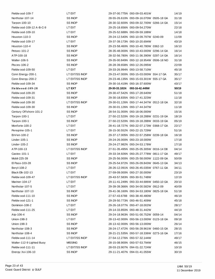
11 December 201950/19LNM:
8Coast Guard District GULFPage 23 of 43
LT EXTSS INOPSS INOPLT EXTLT EXTSS INOPLT EXTSS INOPSS INOPSS INOPSS INOPSS INOPLT EXTLT EXT/SS INOPLT EXT/SS INOPSS INOPLT EXTSS INOPSS INOPLT EXT/SS INOPSS INOPSS INOPLT EXTSS INOPLT EXTLT EXTSS INOPSS INOPSS INOPLT EXT/SS INOPLT EXTSS INOPSS INOPLT EXTLT EXTLT EXT/SS INOPLT EXTLT EXTSS INOPSS INOPSS INOPLT EXTLT EXTSS INOPLT EXTSS INOPSS INOPSS INOPLT EXT/SS INOPMISSINGLT EXT/SS INOPSS INOP
29-37-00.775N28-55-26.610N28-30-32.600N29-25-18.656N29-25-52.688N29-24-12.540N29-37-39.173N29-23-58.460N28-35-48.000N28-32-56.780N29-35-00.849N28-28-39.658N29-33-26.994N29-23-47.000N29-23-46.135N29-30-16.419N29-30-33.181N29-30-47.542N29-30-18.835N29-30-01.126N29-30-01.126N28-54-31.000N27-50-22.520N27-50-22.520N28-41-18.727N28-15-30.552N29-37-17.005N29-24-26.000N29-24-27.982N27-51-35.495N29-33-34.926N29-25-56.000N29-25-54.972N28-26-12.091N27-59-09.000N29-43-57.583N29-11-41.249N29-39-39.366N29-41-36.160N27-57-43.678829-29-50.773N29-26-18.077N29-14-33.850N29-24-18.963N28-13-42.000N28-13-42.000N28-24-17.472N28-21-21.535N27-54-12.276N28-15-08.900N28-03-23.907N29-11-21.407N
093-09-03.401W093-09-16.070W093-09-32.700W093-09-54.270W093-09-59.188W093-10-09.797W093-10-20.694W093-10-40.780W093-10-43.000W093-11-36.390W093-12-18.954W093-12-26.095W093-13-58.710W093-15-03.000W093-15-03.301W093-16-37.600W093-16-42.449W093-17-28.640W093-17-41.323W093-17-44.347W093-17-44.347W093-18-06.000W093-19-18.288W093-19-18.288W093-22-07.173W093-22-15.729W093-22-57.258W093-23-18.000W093-24-53.178W093-25-05.305W093-25-27.778W093-25-58.000W093-26-09.843W093-26-45.035W093-27-30.000W093-30-51.748W093-33-44.686W093-34-00.582W093-34-53.180W093-38-40.480W093-46-51.409W093-47-18.002W093-48-31.442W093-51-00.752W093-56-13.000W093-56-13.000W093-56-28.961W093-57-18.336W093-57-32.144W093-57-53.794W094-01-22.724W094-01-41.055W
0505-18 GA
0266-14 GA
0240-09
0362-10
0296-14 GA
0297-14 GA
0506-18 NO
554-17 GA
555-17 GA
0512-18 GA
0231-19 GA
0033-19 GA
0368-17 GA
0239-18 GA
0016-14 D8
0811-17 GA
1122-09 GA
0645-13 GA
0767-11 GA
0450-10 GA
0912-09
0825-18 GA
0059-14
0123-18 GA
0460-15 GA
0273-16 GA
14/19
31/18
15/14
22/18
14/18
11/09
43/19
16/10
16/14
16/14
31/18
22/09
45/18
35/17
35/17
43/17
50/1951/18
11/18
32/18
11/18
15/16
18/19
05/19
22/17
51/16
16/18
17/18
17/18
04/14
49/17
50/09
34/13
34/11
23/19
12/19
20/10
40/09
51/18
46/19
45/18
28/17
44/19
04/14
09/18
26/14
28/15
17/16
49/17
46/15
10/19
30/19
Fieldwood-109-7Northstar-107-14Tarpon-100-10Fieldwood-109-12 A-B-C-9Fieldwood-109-10Houston-110-3Fieldwood-109-17Houston-110-4Petsec-101-2ATP-100-18Walter-106-5Pisces-106-2Fieldwood-109-50Conn Energy-200-1Conn Energy-200-2Fieldwood-109-34Fieldwood-109-28
Fieldwood-109-20Fieldwood-109-31Fieldwood-109-30Fieldwood-109-30Century Offshore-101-2Tarpon-100-1Tarpon-100-1Monforte-100-2Peregrine-105-1EnVen-100-2Linder-105-1Linder-105-2ATP-100-13Castex-101-1Mobil-225-39El Paso-103-28Beryl-108-2Black Elk-102-13Fieldwood-109-47Mariner-104-17Northstar-107-5Northstar-107-13Fieldwood-111-10Fieldwood-121-1Dominion-108-2Fieldwood-111-25Atp-106-4Union-198-3Union-198-3Northstar-108-3Northstar-108-4Fieldwood-111-14Walter-112-9 Lighted BuoyFieldwood-111-11Energy Xxi-106-10
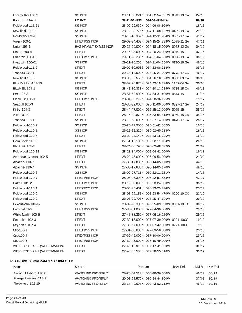
11 December 201950/19LNM:
8Coast Guard District GULFPage 24 of 43
PLATFORM DISCREPANCIES CORRECTED
SS INOPLT EXTSS INOPSS INOPSS INOPLT EXT/SS INOPHAZ NAV/LT EXT/SS INOPLT EXTLT EXT/SS INOPSS INOPLT EXTLT EXTSS INOPLT EXTSS INOPSS INOPLT EXT/SS INOPLT EXTLT EXTLT EXTSS INOPSS INOPSS INOPLT EXTSS INOPLT EXTSS INOPLT EXTLT EXTSS INOPSS INOPLT EXT/SS INOPLT EXT/SS INOPLT EXT/SS INOPSS INOPLT EXTSS INOPLT EXT/SS INOPLT EXTLT EXTLT EXTLT EXT/SS INOPLT EXT/SS INOPLT EXT/SS INOPLT EXTLT EXT
WATCHING PROPERLYWATCHING PROPERLY
WATCHING PROPERLY
29-11-03.224N28-21-10.483N28-00-22.939N28-13-38.775N28-15-18.367N29-09-34.403N29-26-09.000N29-16-03.000N29-11-28.280N29-11-28.280N29-05-36.952829-14-16.000N28-02-56.550N28-53-36.975N28-43-10.338N28-57-52.900N28-34-36.219N28-35-32.000N28-44-47.000N28-15-22.872N28-18-53.000N28-23-47.950828-23-33.320428-23-25.148N27-51-16.186N28-24-50.796N28-23-34.000N28-22-45.000N27-38-17.880N27-38-17.880N28-06-07.711N28-06-06.394N28-13-53.000N28-05-23.461N28-05-22.156N28-06-23.705N28-02-28.300N27-36-01.000N27-42-33.360N27-39-18.000N27-38-57.000N27-31-00.000N27-30-48.000N27-30-48.000N27-46-10.910N27-46-05.590N
29-28-34.519N29-08-23.570N
28-57-43.095N
094-02-54.021W094-05-48.544W094-06-08.506W094-11-08.122W094-12-31.784W094-15-24.738W094-18-15.000W094-20-24.000W094-21-04.530W094-21-04.530W094-23-08.718W094-25-21.000W094-26-18.070W094-42-15.296W094-50-13.235W094-54-31.400W094-58-36.125W095-11-09.000W095-25-13.000W095-33-54.313W095-37-14.000W095-51-42.862W095-52-45.613W095-53-15.025W096-02-11.104W096-02-48.082W096-04-42.000W096-09-54.000W096-14-05.170W096-14-05.170W096-22-11.521W096-22-51.838W096-23-24.000W096-23-29.994W096-23-54.470W096-25-47.686W096-35-09.850W097-04-39.000W097-06-16.020W097-07-39.000W097-07-42.000W097-09-50.000W097-10-06.000W097-10-49.000W097-17-41.960W097-20-55.010W
088-40-36.380W089-34-44.890W090-43-02.712W
0313-19 GA
0409-19 GA
0685-17 GA
1078-11 GA
0058-12 GA
0019-15
0098-19 GA
0770-18 GA
0773-17 GA
0880-09 GA
1162-04 GA
0785-15 GA
0514-15
0397-17 GA
0065-15
0059-15 GA
0470-17 GA
0220-19 CC
0061-19 CC
0221-10CC
0221-10CC
Name Status Position BNM Ref.
24/19
50/1915/18
29/19
41/17
47/11
04/12
02/15
08/19
49/18
05/18
46/17
38/09
30/04
49/15
31/15
19/17
24/17
05/15
04/15
28/17
10/18
29/19
15/19
28/19
21/09
19/18
21/09
44/18
49/18
14/18
43/17
35/12
25/19
23/19
29/18
08/19
25/18
39/17
19/10
19/10
25/18
25/18
25/18
39/17
39/17
48/19
37/08
45/19
50/19
50/19
50/19
LNM St LNM End
Energy Xxi-106-9Bandon-100-1
Fieldwood-111-31Newfield-109-9McMoran-170-2Virgin-100-1Union-196-1Devon-200-4Hoactzin-100-01Hoactzin-100-01Fieldwood-111-5Transco-109-1Newfield-109-2Blue Dolphin-101-10Black Elk-104-1Hec-125-3Black Elk-108-1Seagull-101-3Kirby-104-3ATP-102-3Transco-116-1Fieldwood-110-2Fieldwood-110-1Fieldwood-110-4Gom Shelf-100-2Black Elk-105-5Fieldwood-120-12American Coastal-102-5Apache-110-7Apache-110-7Fieldwood-120-8Fieldwood-120-7Buttes-101-2Fieldwood-120-1Fieldwood-120-2Fieldwood-120-3ExxonMobil-100-02Inexco-101-3White Marlin-100-6Reynolds-102-3Reynolds-102-4Ctx-100-1Ctx-100-4Ctx-100-3WF03-33100-48-3 (WHITE MARLIN)WF03-32973-71-1 (WHITE MARLIN)
Arena Offshore-116-6Energy Partners-112-8Fieldwood-102-19

11 December 201950/19LNM:
8Coast Guard District GULFPage 25 of 43
SECTION III - TEMPORARY CHANGES and TEMPORARY CHANGES CORRECTEDThis section contains temporary changes and corrections to Aids to Navigation for this edition. When charted aids are temporarily relocated for dredging, testing, evaluation, or marking an obstruction, a temporary correction shall be listed in Section IV giving the
new position.
TEMPORARY CHANGES
LNM EndLLNR Aid Name Status Chart No. BNM Ref. LNM St
St Joseph Bay Light & Entrance A Range Rear Light
St Marks River Obstruction Light
ST GEORGE ISLAND LIGHTED BUOY 3
ST GEORGE ISLAND LIGHTED BUOY 4
ST GEORGE ISLAND LIGHTED BUOY 6
St Joseph Bay Entrance A Range Front Light
St Joseph Bay Light & Entrance A Range Rear Light
St Joseph Bay Entrance Range D Rear Light
Choctawhatchee Bay Entrance Buoy 10
Pensacola Bay Navy Range Front Light
Mullet Point Light 2
Bayou La Batre Daybeacon 25
Horn Island Pass Lighted Buoy 16
Horn Island Pass Lighted Buoy 18
Tangipahoa River Light 8
Bayou Terre Aux Boeufs Daybeacon 2
South Pass Light 15
Arlington Range Front Light
Arlington Range Rear Light
Calcasieu Channel Light 50
Oyster Bayou Weir Light 4
Port Arthur Canal D Range Front Light
Port Arthur Canal D Range Rear Light
Galveston Bay Entrance Channel Lighted Buoy 9
Galveston Bay Entrance Channel Lighted Buoy 16
DISCONTINUED
DISCONTINUED
RELOCATED DUE TO SHOALING
RELOCATED DUE TO SHOALING
RELOCATED DUE TO SHOALING
DISCONTINUED
DISCONTINUED
DISCONTINUED
DISCONTINUED
TRLT
TRLT
TRLT
DISCONTINUED FOR DREDGING
DISCONTINUED FOR DREDGING
RELOCATED
DISCONTINUED
DISCONTINUED FOR DREDGING
TRLT
TRLT
DISCONTINUED
DISCONTINUED FOR DREDGING
TRLT
TRLT
RELOCATED FOR DREDGING
RELOCATED FOR DREDGING
15/09
39/19
40/17
40/17
48/18
24/08
15/09
44/15
05/18
05/19
33/18
33/17
18/19
18/19
40/18
48/19
43/19
06/18
06/18
39/15
38/19
44/18
44/18
36/19
37/19
11393
11406
11404
11404
11404
11393
11393
11393
11385
11384
11377
11374
11375
11375
11369
11364
11361
11370
11370
11339
11339
11342
11342
11324
11324
95
1485
2840
2845
2846
3025
3030
3105
4580
4850
6970
7760
7940
7950
11570
12355
12665
15300
15305
21430
21475
22785
22790
23770
23820
0638-19 MO
0715-18 MO
0715-18 MO
0715-18 MO
0870-15 MO
0585-17 MO
0336-19 MO
0337-19 MO
0065-18 NO
0066-18 NO
0650-15 GA
0548-19 GA
0705-18 GA
0706-18 GA
0522-19 GA
0529-19 GA
WATCHING PROPERLYWATCHING PROPERLYWATCHING PROPERLYWATCHING PROPERLYWATCHING PROPERLYWATCHING PROPERLYWATCHING PROPERLY
29-13-24.927N28-30-50.216N28-18-37.328N28-16-25.996228-45-55.890N29-36-20.000N27-57-43.6788
091-34-48.359W092-02-08.861W092-05-45.863W092-06-14.727W092-21-37.919W092-54-06.000W093-38-40.480W
07/17
49/19
11/19
19/19
47/18
29/19
47/19
50/19
50/19
50/19
50/19
50/19
50/19
50/19
Fieldwood-103-67Cox-109-1Fieldwood-105-12Fieldwood-105-6Fieldwood-108-8Fieldwood-100-1Fieldwood-111-10
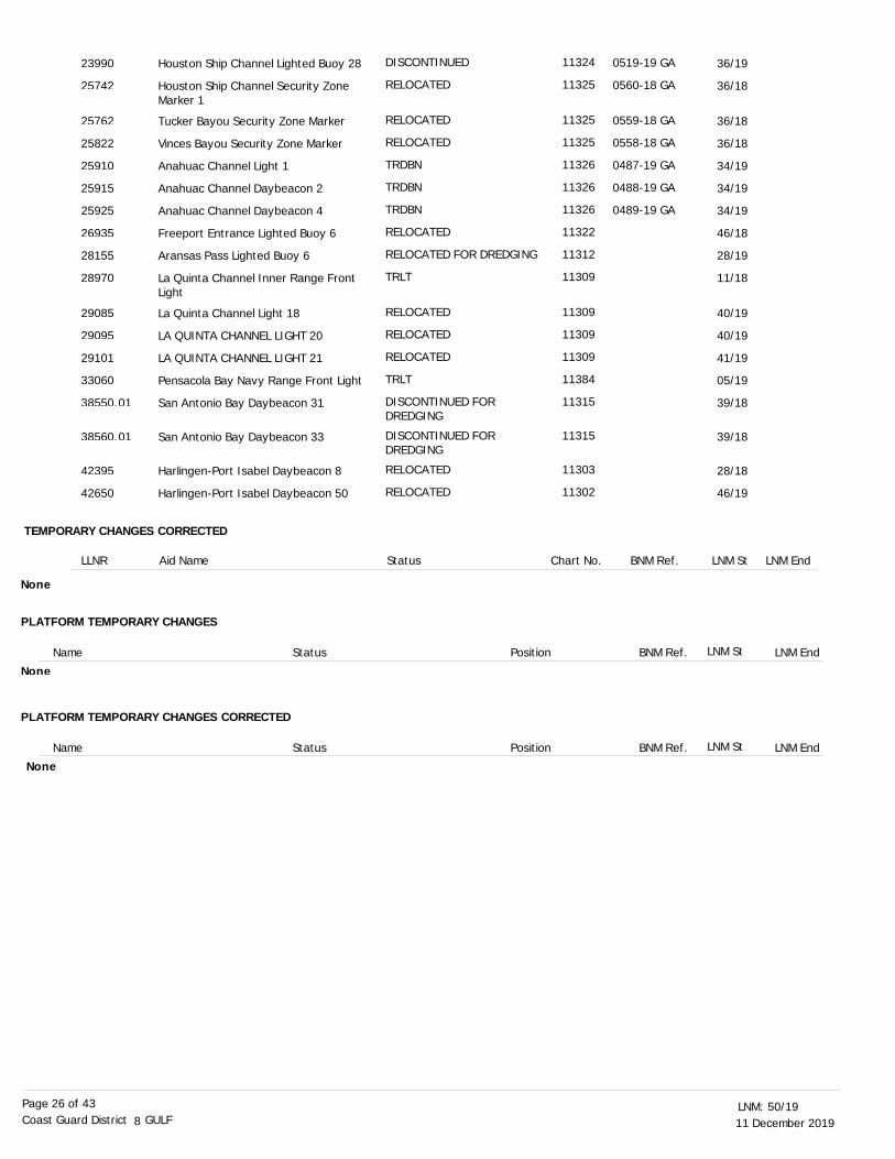
11 December 201950/19LNM:
8Coast Guard District GULFPage 26 of 43
TEMPORARY CHANGES CORRECTED
LNM EndLLNR Aid Name Status Chart No. BNM Ref. LNM St
Houston Ship Channel Lighted Buoy 28
Houston Ship Channel Security Zone Marker 1
Tucker Bayou Security Zone Marker
Vinces Bayou Security Zone Marker
Anahuac Channel Light 1
Anahuac Channel Daybeacon 2
Anahuac Channel Daybeacon 4
Freeport Entrance Lighted Buoy 6
Aransas Pass Lighted Buoy 6
La Quinta Channel Inner Range Front Light
La Quinta Channel Light 18
LA QUINTA CHANNEL LIGHT 20
LA QUINTA CHANNEL LIGHT 21
Pensacola Bay Navy Range Front Light
San Antonio Bay Daybeacon 31
San Antonio Bay Daybeacon 33
Harlingen-Port Isabel Daybeacon 8
Harlingen-Port Isabel Daybeacon 50
DISCONTINUED
RELOCATED
RELOCATED
RELOCATED
TRDBN
TRDBN
TRDBN
RELOCATED
RELOCATED FOR DREDGING
TRLT
RELOCATED
RELOCATED
RELOCATED
TRLT
DISCONTINUED FOR DREDGING
DISCONTINUED FOR DREDGING
RELOCATED
RELOCATED
36/19
36/18
36/18
36/18
34/19
34/19
34/19
46/18
28/19
11/18
40/19
40/19
41/19
05/19
39/18
39/18
28/18
46/19
11324
11325
11325
11325
11326
11326
11326
11322
11312
11309
11309
11309
11309
11384
11315
11315
11303
11302
23990
25742
25762
25822
25910
25915
25925
26935
28155
28970
29085
29095
29101
33060
38550.01
38560.01
42395
42650
None
0519-19 GA
0560-18 GA
0559-18 GA
0558-18 GA
0487-19 GA
0488-19 GA
0489-19 GA
PLATFORM TEMPORARY CHANGES
PLATFORM TEMPORARY CHANGES CORRECTED
Name
Name
Status
Status
Position
Position
BNM Ref.
BNM Ref.
LNM St
LNM St
LNM End
LNM End
None
None

11 December 201950/19LNM:
8Coast Guard District GULFPage 27 of 43
11360
11364
11365
44th Ed.
46th Ed.
25th Ed.
01-OCT-10
01-APR-18
01-NOV-18
41/19
48/19
37/19
Cape St. George to Mississippi Passes
Mississippi River-Venice to New Orleans
Barataria and Bayou Lafourche Waterways Intracoastal Waterway to Gulf of Mexico
ChartTitle:
ChartTitle:
ChartTitle:
NAD 83
NAD 83
NAD 83
Last LNM:
Last LNM:
Last LNM:
50/19
50/19
50/19
Main Panel 48 CAPE ST. GEORGE TO MISSISSIPPI PASSES. Page/Side: N/A
Main Panel 56 MISSISSIPPI RIVER VENICE TO NEW ORLEANS - -. Page/Side: -
Main Panel 183 BARATARIA & BAYOU LAFOURCHE WATERWAYS - -. Page/Side: -
ADD
ADD
ADD
ADD
ADD
ADD
ADD
ADD
ADD
ADD
ADD
ADD
ADD
ADD
RELOCATE
RELOCATE
Submarine Pipeline O PT 1 OF 3; Chart No. 1: L40.1 (NOS NW-30865)
Submarine Pipeline O PT 2 OF 3; Chart No. 1: L40.1 (NOS NW-30865)
Submarine Pipeline O PT 3 OF 3; Chart No. 1: L40.1 (NOS NW-30865)
Submarine Pipeline P PT 1 OF 3; Chart No. 1: L40.1 (NOS NW-30865)
Submarine Pipeline P PT 2 OF 3; Chart No. 1: L40.1 (NOS NW-30865)
Submarine Pipeline P PT 3 OF 3; Chart No. 1: L40.1 (NOS NW-30865)
Submarine Pipeline Q PT 1 OF 4; Chart No. 1: L40.1 (NOS NW-30865)
Submarine Pipeline Q PT 2 OF 4; Chart No. 1: L40.1 (NOS NW-30865)
Submarine Pipeline Q PT 3 OF 4; Chart No. 1: L40.1 (NOS NW-30865)
Submarine Pipeline Q PT 4 OF 4; Chart No. 1: L40.1 (NOS NW-30865)
Submarine Pipeline R PT 1 OF 4; Chart No. 1: L40.1 (NOS NW-30865)
Submarine Pipeline R PT 2 OF 4; Chart No. 1: L40.1 (NOS NW-30865)
Submarine Pipeline R PT 3 OF 4; Chart No. 1: L40.1 (NOS NW-30865)
Submarine Pipeline R PT 4 OF 4; Chart No. 1: L40.1 (NOS NW-30865)
Belle Chasse Anchorage Lower Daybeacon 73.1
Bayou Perot Entrance Crossing Daybeacon 4
NOS
NOS
NOS
NOS
NOS
NOS
NOS
NOS
NOS
NOS
NOS
NOS
NOS
NOS
CGD08
CGD08
28-34-24.700N
28-34-37.290N
28-35-55.060N
28-44-48.210N
28-44-42.750N
28-44-38.550N
28-34-25.070N
28-35-10.310N
28-35-34.720N
28-36-34.710N
28-44-37.620N
28-44-22.830N
28-44-13.110N
28-44-10.780N
from 29-49-12.058N
from 29-40-53.591N
087-56-04.130W
087-58-15.190W
088-01-06.330W
088-17-25.440W
088-17-25.580W
088-17-20.080W
087-56-04.120W
087-58-10.420W
087-58-32.350W
087-58-48.670W
088-17-19.440W
088-17-09.300W
088-16-53.520W
088-16-47.510W
090-00-19.509W
090-11-36.054W
to 29-49-12.054N
to 29-40-53.534N
090-00-21.858W
090-11-35.833W
This section contains corrections to federally and privately maintained Aids to Navigation, as well as NOS corrections. This section contains corrective actions affecting chart(s). Corrections appear numerically by chart number, and pertain to that chart only. It is up to the mariner to decide which chart(s) are to be corrected. The following example explains individual elements of a typical chart correction.
Chart Chart Edition Last Local Notice Horizontal Source of Current LocalNumber Edition Date to Mariners Datum Reference Correction Notice to Mariners l . l . l . . . l . . . l . . . l . . l12327 91st Ed. 19-APR-97 Last LNM: 26/97 NAD 83 27/97Chart Title: NY-NJ-NEW YORK HARBOR - RARITAN RIVER Main Panel 2245 NEW YORK HARBOR CGD01(Temp) ADD NATIONAL DOCK CHANNEL BUOY 3 at 40-41-09.001N 074-02-48.001W . . l . Green can l . . . . . . l . Corrective Object of Corrective Position Action Action
(Temp) indicates that the chart correction action is temporary in nature. Courses and bearings are given in degrees clockwise from 000 true. Bearings of light sectors are toward the light from seaward. The nominal range of lights is expressed in nautical miles (NM) unless otherwise noted.
SECTION IV - CHART CORRECTIONS

11 December 201950/19LNM:
8Coast Guard District GULFPage 28 of 43
OIL RIG MOVEMENT
SECTION V - ADVANCE NOTICESThis section contains advance notice of approved projects, changes to aids to navigation, or upcoming temporary changes such as dredging, etc.
Mariners are advised to use caution while transiting these areas.
SUMMARY OF ADVANCED APPROVED PROJECTS
Approved Project(s) Project Date Ref. LNM
TX – CORPUS CHRISTI BAY – La Quinta Channel
TX – GALVESTON BAY – Trinity Bay – Anahuac Channel
In order to provide a more efficient and effective Aid to Navigation signal, the Coast Guard will be making the following changes after January 7, 2020:Establish La Quinta Channel Daybeacon 15A (LLNR-29079) in approximate position 27-52-16.698N/097-14-58.626W showing SG on pile, Ra Ref.Establish La Quinta Channel Daybeacon 16 (LLNR-29079.01) in approximate position 27-52-17.753N/097-14-51.163W showing TR on pile, Ra Ref.Relocate La Quinta Channel Light 18 (LLNR-29085) in approximate position 27-52-33.064N/097-15-12.234W to approximate position 27-52-29.928N/097-15-05.406W. Establish La Quinta Channel Daybeacon 19A (LLNR-29091) in approximate position 27-52-26.202N/097-15-45.840W showing SG on pile, Ra Ref. Establish La Quinta Channel Daybeacon 19B (LLNR-29092) in approximate position 27-52-27.545N/097-15-55.399W showing SG on pile, Ra Ref. Relocate La Quinta Channel Light 20 (LLNR-29095) in approximate position 27-52-36.615N/097-15-27.944W to approximate position 27-52-34.428N/097-15-23.508W.Relocate La Quinta Channel Light 21 (LLNR-29101) in approximate position 27-52-38.406N/097-16-08.401W to approximate position 27-52-37.626N/097-16-03.414W.
Due to continuous shoaling in Anahuac Channel, between Anahuac Channel Light 1 (LLNR-25910) and Anahuac Channel Daybeacon 16 (LLNR-
LNM: 46/19
Drill Rigs/Vessels Removed
Latitude Longitude Block Rigs/Vessel Type Status
Latitude Longitude Block Rigs/Vessel Type Status
27-19-35.609N27-19-15.769N28-14-46.669N28-35-48.670N28-57-50.881N28-57-50.881N
090-08-42.516W090-32-07.279W088-55-39.921W087-40-49.637W089-47-02.122W089-47-02.122W
GC-653GC-645MC-725DC-357WD-71WD-71
DEEPWATER INVICTUSHOLSTEIN SPAR RIGHelix Q5000SEADRILL WEST VELAWIRELINE UNITWIRELINE UNIT 49979
113401134011360113401134011340
DRILLSHIPJACKUPSEMI-SUBMERSIBLEDRILLSHIPBARGEBARGE
UNREPORTEDUNREPORTEDWORKOVERNEW WELLWORKOVERUNREPORTED
Chart
Chart
Drill Rigs/Vessels Established
11367
11370
39th Ed.
29th Ed.
01-NOV-18
01-SEP-13
47/19
48/19
Intracoastal Waterway Waveland to Catahoula Bay
Mississippi River-New Orleans to Baton Rouge
ChartTitle:
ChartTitle:
NAD 83
NAD 83
Last LNM:
Last LNM:
50/19
50/19
Main Panel 26 WAVELAND TO CATAHOULA BAY - -. Page/Side: -
CHART LA - MISSISSIPPI RIVER - NEW ORLEANS TO BATON ROUGE. Page/Side: N/A
Extension 6 MISSISSIPPI RIVER REMY TO BRINGIER POINT. Page/Side: A
(Temp)
(Temp)
RELOCATE
ADD
ADD
RELOCATE
Bayou Perot Entrance Crossing Daybeacon 4
Bo-Mac Temporary Downstream Piling Light, FL2.5s, 7ft on pile (Priv Maint)
Bo-Mac Temporary Upstream Piling Light, FL2.5s, 7ft on pile (Priv Maint)
College Point Light 156
CGD08
CGD08
CGD08
CGD08
from 29-40-53.591N
29-59-31.000N
29-59-34.000N
from 29-59-07.236N
090-11-36.054W
090-50-00.000W
090-50-02.000W
090-49-13.483W
to 29-40-53.534N
to 29-59-08.550N
090-11-35.833W
090-49-13.374W
None
Chart 11309
None
Advance Notice(s)

11 December 201950/19LNM:
8Coast Guard District GULFPage 29 of 43
TX – GALVESTON BAY ENTRANCE – Houston Ship Channel
MS – PASCAGOULA HARBOR – Pascagoula Channel
AL – MOBILE BAY – Mobile Channel
AL – DAUPHIN ISLAND TO DOG KEY PASS – Bayou La Batre
FL – WEST BAY TO SANTA ROSA SOUND – Blackwater Channel
FL – SANTA ROSA SOUND TO DAUPHIN ISLAND – Pensacola-Mobile
25960), the Coast Guard will be making the following changes after January 7, 2020:Change Anahuac Channel Light 1 (LLNR-25910) in approximate position 29-41-58.301N/094-44-09.132W to Anahuac Channel Daybeacon A (LLNR-25910) showing NB on pile, Ra Ref.Change Anahauc Channel Daybeacon 2 (LLNR-25915) in approximate position 29-42-21.680N/094-43-49.745W to Anahuac Channel Daybeacon B (LLNR-25915) showing NB on pile, Ra Ref.Change Anahauc Channel Daybeacon 4 (LLNR-25925) in approximate position 29-43-10.806N/094-43-12.709W to Anahuac Channel Daybeacon C (LLNR-25925) showing NB on pile, Ra Ref.Change Anahauc Channel Daybeacon 5 (LLNR-25940) in approximate position 29-44-21.420N/094-42-25.620W to Anahuac Channel Daybeacon D (LLNR-25940) showing NB on pile, Ra Ref.Change Anahauc Channel Daybeacon 7 (LLNR-25945) in approximate position 29-44-51.203N/094-42-04.907W to Anahuac Channel Daybeacon E (LLNR-25945) showing NB on pile, Ra Ref.Change Anahauc Channel Daybeacon 9 (LLNR-25950) in approximate position 29-45-11.902N/094-41-49.307W to Anahuac Channel Daybeacon F (LLNR-25950) showing NB on pile, Ra Ref.Change Anahauc Channel Daybeacon 11 (LLNR-25955) in approximate position 29-45-18.802N/094-41-42.706W to Anahuac Channel Daybeacon G (LLNR-25955) showing NB on pile, Ra Ref.Change Anahauc Channel Daybeacon 16 (LLNR-25960) in approximate position 29-45-54.801N/094-41-11.206W to Anahuac Channel Daybeacon H (LLNR-25960) showing NB on pile, Ra Ref.
Due to a history of Houston Ship Channel Lighted Buoy 28 (LLNR-23990) frequently being struck and pulled off station to the middle of the channel causing a hazard to deep draft traffic, the Coast Guard will be making the following change after January 21, 2020:Discontinue Houston Ship Channel Lighted Buoy 28 (LLNR-23990) in approximate position 29-22-45.951N/094-48-21.796W.
Increasing water depths along the Pascagoula Channel have limited the Coast Guard’s ability to rebuild fixed structures. In order to improve response times to Aids to Navigation discrepancies, the Coast Guard will be making the following change after January 21, 2020:Change Pascagoula Channel Light 52 (LLNR-8225) in approximate position 30-20-37.454N/088-33-57.388W to Pascagoula Channel Lighted Buoy 52 (LLNR-8225), showing Q R, 3NM nominal range, Red.
Increasing water depths along the Mobile Ship Channel have limited the Coast Guard’s ability to rebuild fixed structures. In order to improve response times to Aids to Navigation discrepancies, the Coast Guard will be making the following change after January 21, 2020:Change Mobile Channel Light 32 (LLNR-6310) in approximate position 30-19-19.671N/088-01-39.141W to Mobile Channel Lighted Buoy 32 (LLNR-6310), showing Oc R 4s, 4NM nominal range, Red.
The Coast Guard will be making the following change after January 21, 2020:Change Bayou La Batre Daybeacon 25 (LLNR-7760) in approximate position 30-23-00.130N/088-16-17.687W to Bayou La Batre Light 25 (LLNR-7760), showing Fl G 2.5s, 3NM nominal range.
The Coast Guard will be making the following changes after February 4, 2020: Change Blackwater Channel Daybeacon 37 (LLNR-5595) in approximate position 30-35-33.109N/087-00-54.847W to Blackwater Channel Light 37 (LLNR-5595), showing Fl G 4s, 3NM nominal range, SG on pile, Ra Ref.Change Blackwater Channel Daybeacon 41 (LLNR-5610) in approximate position 30-36-08.761N/087-01-25.118W to Blackwater Channel Light 41 (LLNR-5595), showing Fl G 4s, 3NM nominal range, SG on pile, Ra Ref.
The Coast Guard will be making the following change after February 4, 2020: Change Pensacola-Mobile Buoy 3 (LLNR-33100) in approximate position 30-20-04.101N/087-18-47.590W to Pensacola-Mobile Lighted Buoy 3 (LLNR-33100), showing Fl G 2.5s, 3NM nominal range , Green with yellow square.
LNM:
LNM:
LNM:
LNM:
LNM:
LNM:
LNM:
46/19
48/19
48/19
48/19
48/19
50/19
50/19
SECTION VI - PROPOSED CHANGESPeriodically, the Coast Guard evaluates its system of aids to navigation to determine whether the conditions for which the aids to navigation were
established have changed. When changes occur, the feasibility of improving, relocating, replacing, or discontinuing aids are considered. This section contains notice(s) of non-approved, proposed projects open for comment. SPECIAL NOTE: Mariners are requested to respond in writing to the District
office unless otherwise noted (see banner page for address).
Chart
Chart
Chart
Chart
Chart
Chart
Chart
11326
11324
11375
11376
11376
11385
11378
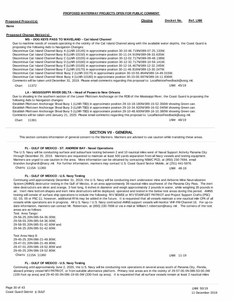
11 December 201950/19LNM:
8Coast Guard District GULFPage 30 of 43
PROPOSED WATERWAY PROJECTS OPEN FOR PUBLIC COMMENT
Proposed Project(s) Closing Docket No. Ref. LNM
MS – DOG KEYS PASS TO WAVELAND – Cat Island Channel
LA – MISSISSIPPI RIVER DELTA – Head of Passes to New Orleans
Due to maritime needs of vessels operating in the vicinity of the Cat Island Channel along with the available water depths, the Coast Guard is proposing the following Aids to Navigation Changes:Discontinue Cat Island Channel Buoy A (LLNR-10145) in approximate position 30-10-46.719N/089-07-25.133W.Discontinue Cat Island Channel Buoy B (LLNR-10150) in approximate position 30-11-24.919N/089-08-33.635W.Discontinue Cat Island Channel Buoy C (LLNR-10155) in approximate position 30-12-02.717N/089-09-48.138W. Discontinue Cat Island Channel Buoy D (LLNR-10160) in approximate position 30-12-32.717N/089-10-59.141W. Discontinue Cat Island Channel Buoy E (LLNR-10165) in approximate position 30-12-16.467N/089-12-32.245W.Discontinue Cat Island Channel Buoy F (LLNR-10170) in approximate position 30-11-46.816N/089-13-30.247W.Discontinue Cat Island Channel West Buoy 2 (LLNR-10175) in approximate position 30-10-55.864N/089-14-49.015W.Discontinue Cat Island Channel West Buoy 4 (LLNR-10180) in approximate position 30-10-00.697N/089-16-11.836W.Comments will be taken until December 31, 2019. Please email comments regarding this proposal to: [email protected].
Due to shoaling in the southern section of the Lower Pilottown Anchorage on the RDB of the Mississippi River, the Coast Guard is proposing the following Aids to Navigation changes:Establish Pilottown Anchorage Shoal Buoy 1 (LLNR-TBD) in approximate position 29-10-18-180N/089-15-52.356W showing Green can. Establish Pilottown Anchorage Shoal Buoy 3 (LLNR-TBD) in approximate position 29-10-34.920N/089-16-02.040W showing Green can.Establish Pilottown Anchorage Shoal Buoy 5 (LLNR-TBD) in approximate position 29-10-48.600N/089-16-10.380W showing Green can.Comments will be taken until January 21, 2020. Please email comments regarding this proposal to: [email protected].
LNM:
LNM:
45/19
48/19
SECTION VII - GENERALThis section contains information of general concern to the Mariners. Mariners are advised to use caution while transiting these areas.
The U.S. Navy will be conducting surface and subsurface testing between 2 and 10 nautical miles west of Naval Support Activity Panama City through December 20, 2019. Mariners are requested to maintain at least 500 yards separation from all Navy vessels and testing equipment. Mariners are urged to use caution in the area. More information can be obtained by contacting NSWC PCD, at (850) 230-7694, email [email protected]. For further information, mariners may contact U.S. Coast Guard Sector Mobile, at (251) 441-5976.
Continuing until approximately December 31, 2019, the U.S. Navy will be conducting inert underwater mine and Airborne Mine Neutralization System (AMNS) destructor testing in the Gulf of Mexico, in an area approximately 39 nautical miles southwest of the Panama City Pass. The inert mine destructors are silver and orange, 3 feet long, 6 inches in diameter and weigh approximately 2 pounds in water, while weighing 35 pounds in air. Inert mine bottom shapes and inert mine destructors will be deployed, operated and tested in the below test areas during this period. AMNS testing will consist of surface ship operations to include the following: R/V SEWEE or R/V STARFLEET PATRIOT and Project Support Crafts (PSC) 02, 03, 05 or PSC 11; however, additional R/Vs may be added in the future. It is requested that all vessels maintain a one nautical mile CPA of all vessels while operations are in progress. All U.S. Navy / U.S. Navy contracted AMNS support vessels will monitor VHF-FM Channel 16. For up-to-date information, mariners can contact Mr. Robertson, at (850) 230-7698 or via e-mail at [email protected] . The corners of the test areas are as follows: Test Area Tango:29-56-25.20N 085-54-36.00W,29-58-55.20N 085-54-36.00W,29-58-55.20N 085-51-42.60W and29-56-25.20N 085-51-42.60W.
Test Area Harp 8:29-45-25.20N 086-21-49.80W,29-47-01.20N 086-21-49.80W,29-47-01.20N 086-19-52.80W and29-45-25.20N 086-19-52.80W.
Continuing until approximately June 2, 2020, the U.S. Navy will be conducting test operations in several areas south of Panama City, Florida, aboard primary vessel M/V PATRIOT, or from suitable alternative platform. Primary test areas are in the vicinity of 29-57-00.0N 086-53-00.0W (100-foot op area) and 29-40-00.0N 086-19-00.0W (330-foot op area). It is requested that all surface vessels remain at least 2 nautical miles
LNM:
LNM:
48-19
11-19
FL - GULF OF MEXICO - ST. ANDREW BAY - Naval Operations
FL - GULF OF MEXICO - U.S. Navy Testing
FL - GULF OF MEXICO - U.S. Navy Testing
Chart
Chart
11372
11361
Charts:
Charts:
1115A 11360
1115A 11360
None
Proposed Change Notice(s)

11 December 201950/19LNM:
8Coast Guard District GULFPage 31 of 43
from test vessels working in these areas as they are likely to be under restricted maneuverability towing conditions during test events. There are also items on the sea floor and in the water column in these general areas. Any items moored close enough to the surface to be a hazard to navigation will be lighted, buoyed, and/or guarded while deployed for short durations during the test period. M/V PATRIOT will be on station in these areas during test events scheduled at a frequency of approximately 3-5 days per week. Concerned traffic should contact the U.S. Navy Support Vessel on VHF-FM Channel 16, heed all instructions given, and stay a minimum of 2 nautical miles from vessels on station in any of these operational areas. Additionally, it is requested that all trawler operations within 2 nautical miles of the op area positions given be avoided at all times as U.S. Navy equipment has been deployed in these areas and will remain in these areas through the duration of the test event.
Continuing until approximately December 22, 2019, the U.S. Navy will be conducting test operations in an area generally located approximately 15 nautical miles west of Destin Pass, FL. The test area will include items on the ocean floor and/or moored near to the waters surface that are obstructions to navigation, extending from the beach out to approximate depth of 40 feet. These items will be guarded and/or buoyed while deployed for the duration of the test period. Additionally, helicopter operations will be conducted in the test area. The support/guard vessels include M/V TYSON B., which will be on station in the testing area during the test events. Mariners should contact these support vessels via VHF-FM Channel 16, heed instructions given and stay a minimum of 1 nautical mile from the test vessels on station. U.S. Navy equipment has been deployed in the test area and will remain through the duration of the tests.Test area bound by the following approximate positions;North East corner: 30-23-12.0N 086-47-38.0W,North West corner: 30-23-01.0N 086-49-40.0W.,South West corner: 30-21-44.0N 086-49-28.0W andSouth East corner: 30-21-57.0N 086-47-18.0W.
A vessel has been reported sunk off of Alligator Point, FL., in approximate position 29-50-09.8N 084-22-24.1W. The vessel is reportedly not marked. Mariners are requested to transit the area with caution.
Continuing until approximately December 31, 2019, the U.S. Navy will be conducting underwater testing in the Gulf of Mexico, in an area approximately 1 nautical mile west of the Panama City Pass, bound by the following approximate positions:The corners of the test area are:30-08-58.76N 085-47-04.61W,30-08-58.76N 085-47-44.21W,30-09-17.97N 085-47-51.64W and30-09-17.97N 085-47-04.61W. Testing will consist of surface ship operations to include the following; Project Support Crafts (PSC) 08, and 05; additional R/V's may be added in the future. Mariners are requested to maintain a 1,000 yard closest point of approach (CPA) of all vessels while operations are in progress. All U.S. Navy/U.S. Navy contracted support vessels will monitor VHF-FM Channel 16. For additional information, mariners can contact Mr. Crowley, at (850) 819-0444 or via e-mail at [email protected].
Due to low water on the Apalachicola River and past storm damage, the U.S. Coast Guard has been unable to regularly service aids to navigation below the Jim Woodruff Lock and Dam. U.S. Coast Guard ANT Eufaula anticipates returning to area once weather and river conditions allow. Mariners are urged to exercise extreme caution when transiting these waterways as the aids to navigation may not be reliable.
Continuing until approximately January 2, 2020, Carter’s Construction Services, Inc., subcontractor Quality First Marine will be conducting dredging operations of the GIWW in East Bay and Lake Wimico. The first assignment, East Bay, is located between GIWW, Mile 309.0, EHL, to Mile 312.0, EHL. The dredged material will be placed into an upland disposal site located at GIWW, Mile 316.0, EHL, Overstreet. The Lake Wimico dredging assignment is located between GIWW, Mile 336.5, EHL, to Mile 339.0, EHL. The dredged material will be placed into an upland disposal site located at GIWW, Mile 328.0, EHL, Gulf County Canal. The contractor’s floating plant will include barge mounted excavators, scows and tugs to remove the shoaled material, transport and dispose into approved upland sites. The floating plant will monitor VHF-FM Channel 13 or 16. Mariners are urged to exercise caution when transiting the area. For up-to-date information, mariners can contact USACE, Panama City Site Office, at (850) 784-9780.
A 30-foot white cabin cruiser has been reported partially submerged with 4-5 feet of vessel above the waterline, in approximate position 30-26-38.4N 086-15-16.2W, in vicinity of Four Mile Point, in Choctawhatchee Bay. The vessel is reportedly not marked. Mariners are urged to transit the area with caution.
The SR 397 (John Sims Parkway), across Toms Bayou, Mile 0.50, at Valparaiso, Okaloosa County, Florida, Phase II is scheduled until November
LNM:
LNM:
LNM:
LNM:
LNM:
LNM:
LNM:
46-19
45-19
50-19
43-19
37-19
41-19
50-19
FL - GULF OF MEXICO - U.S. Navy Testing
FL - GULF OF MEXICO - DESTIN PASS - U.S. Navy Testing
FL - GULF OF MEXIC0 - Submerged Vessel
FL - GULF OF MEXICO - Navy Testing
FL - APALACHICOLA RIVER - Channel Conditions
FL - GIWW - LAKE WIMICO - EAST BAY Mile 309.0 - Mile 339.0 - Dredge Operation
FL - CHOCTAWHATCHEE BAY - FOUR MILE POINT - Partially Submerged Vessel
FL - TOMS BAYOU - Bridge Modifications and New Construction
Chart
Chart
Charts:
Charts:
Charts:
Charts:
Charts:
1115A 11360
11383 11385 11388
411 11400 11405
1115A 11360 11391 11400
11404
11385 11390 11393
11385
11 December 201950/19LNM:
8Coast Guard District GULFPage 32 of 43
2020, the demolition of the northbound bridge and replacement with a new bridge. During construction, the contractor will designate different navigational channels and updates will follow. They will utilize two 80-foot by 80-foot section crane spud barges, a 40-foot by 40-foot material spud barge, four 20-foot by 10-foot section material barges, the Tug MISS RONDA and a crew work boat. VHF-FM Channel 13 or 16, will be monitored for communications. This equipment should be lighted according to the “Inland Navigational Rules of 1980.” Mariners should avoid the area, travel through the navigation spans and urged to proceed at slowest safe speed with extreme caution. Anyone needing assistance should call the contractor at (334) 319-7006 or the FDOT at (850) 333-4389.
Shoaling has been reported in the vicinity of Choctawhatchee Bay Entrance Jetties and Choctawhatchee Bay Entrance Buoy 1 (LLNR-4540) and Choctawhatchee Bay Entrance Buoy 2 (LLNR-4545). The shoaling is reportedly not marked. All mariners are requested to transit the area with caution.
Phase II of the demolition and pile driving has commenced at the Pensacola Bay Bridge (aka 3-mile Bridge), Mile 0.0, at Gulf Breeze, Escambia County and Santa Rosa Counties, FL. The project will start on the outside of the main channel on both the Pensacola and Gulf Breeze sides. A trestle will be constructed on the southeast side of Gulf Breeze side of the bay. For additional information, mariners can the contact Daniel Mahnke, at (805) 249-8333) or Kevin Moynihan, at (407) 697-8564). Mariners are requested to transit the area with extreme caution.
A F/V has been reported partially submerged and leaning at approximately 30 degrees with 15-20 feet protruding above the waterline in approximate position 30-23-06.0N 087-12-36.0W. The F/V is reportedly not marked. Mariners are urged to avoid the area.
Continuing until approximately December 15, 2019, Dredge KELLY L., will conduct dredge operations in the Dauphin Island Village Channel. Dredging will be conducted in the southern end of the anchorage basin. Dredged material will be deposited in the adjacent open water disposal sites west of the channel. Dredge KELLY L., will monitor VHF-FM Channel 13 or 16. For up-to-date information, mariners can contact the USACE Irvington Site Office, at (251) 957-6019. Mariners are urged to exercise caution in the area.
F/V CHIEF, approximately 43 feet in length, has been reported submerged in approximate position 30-15-22.2N 088-00-33.6W, in Mobile Bay. The F/V is reportedly not marked. Mariners are urged to transit the area.
Due to severe shoaling and unknown channel depths, all mariners are advised to not rely on floating Aids to Navigation within the Alabama River. Until a 9-foot channel depth is restored and maintained, the U.S. Coast Guard will not be conducting Aids to Navigation Patrols on the Alabama River.
The Tuscaloosa Christmas Afloat nautical parade will take place on Saturday, December 14, 2019, from 4:00 p.m., until 8:00 p.m., on the Black Warrior-Tombigbee River, Mile 338.0 through Mile 342.0. In addition, there will be a fireworks display at 5:45 p.m., adjacent to the river. The U.S. Coast Guard Auxiliary will accompany the parade and will monitor VHF-FM Channel 16. Mariners are urged to use caution when transiting the area. For up-to-date information, mariners can contact Mr. Anthony Perkins, at the BW&T/Alabama-Coosa Project Management Office (CESAM-OP-BA), at (205) 752-3571.
Dredging operations have been completed in the designated borrow area(s). Demobilization will occur until approximately January 15, 2020.
Continuing until approximately October 11, 2020, Hydraulic Cutter Suction Dredge ALASKA will be conducting island restoration and dredging operations in the vicinity of Ship Island. In support of the dredging operations, auxiliary equipment that may include, but is not limited to, tugs, barges, anchor barges and derricks will arrive and stage prior to commencement. Both floating and submerged pipeline will be staged with the auxiliary equipment in preparation for this project. Temporary occupancy and storage of equipment will be in the following locations:On the southwest side of the railroad bridge in Biloxi Bay.Adjacent to the outbound side of the channel approaching Biloxi Bay, and south of the bridge(US HW 90).Adjacent to the outbound side of the channel southwest of Point Cadet.North side of Horn Island, adjacent to Dog Key Pass.
LNM:
LNM:
LNM:
LNM:
LNM:
LNM:
LNM:
LNM:
LNM:
41-18
14-19
34-19
50-19
48-19
49-19
38-19
50-19
48-19
FL - TOMS BAYOU - Bridge Modifications and New Construction
FL - WEST BAY TO SANTA ROSA SOUND - CHOCTAWHATCHEE BAY - Shoaling
FL - PENSACOLA BAY - Bridge, Mile 0.0 Demolition and Construction
FL - PENSACOLA BAY - Wreck
AL - DAUPHIN ISLAND - Dredge Operation
AL - MOBILE BAY - Wreck
AL - ALABAMA RIVER - Channel Condition
AL - BLACK WARRIOR-TOMBIGBEE WATERWAY - Marine Event
MS - MISSISSIPPI SOUND - Dredge Operation
MS - MISSISSIPPI SOUND - Barrier Island Restoration/Dredge Operation
Chart
Chart
Chart
Charts:
Charts:
Charts:
Charts:
Charts:
11385 11388
11382 11385
11382 11383
11383
11377 11378
11376
11376
11373 11374

11 December 201950/19LNM:
8Coast Guard District GULFPage 33 of 43
All equipment will be lighted and marked as per U.S. Coast Guard regulations. These markers should NOT be used for navigation, and mariners areadvised to maintain a safe distance. Operations will be performed 24-hours a day, 7-days a week. The dredge will be connected to approximately 1,700 feet of floating pipeline that will direct connect to submerged pipeline. The submerged pipeline will run from the borrow area indicated on the attached drawings to Ship Island, while also passing through a hydraulic booster. Mariners should be aware, that additional pipeline may be laid in place for future operations south of Ship Island. See attached enclosure of charts for further details. Dredge ALASKA will monitor VHF-FM Channel 13 or 16. For further information, mariners can contact Nicholas Williams, Project Manager, at (630) 247-2256, or Mario Martinez, QC Manager, at (806) 292-5637.
Continuing until approximately January 31, 2020, Mike Hooks, LLC., Pipeline Dredge MISSOURI H., will conduct dredging operations in Gulfport Harbor. Dredging will continue into the Sound Channel and Anchorage Basin. Dredged material will be disposed into existing open water sites adjacent to the channel. The dredge will utilize floating and submerged pipeline, in addition to a number of support vessels, all lighted in accordance to U.S. Coast Guard Safety Regulations. The Dredge MISSOURI H., will monitor VHF-FM Channel 13 or 16. Mariners are urged to transit the area at their slowest safe speed to minimize wake and proceed with caution after passing arrangements have been made. For up-to-date information, mariners can contact the USACE Irvington Site Office, at (251) 957-6019.
Continuing until approximately December 16, 2019, M/V SEVEN PACIFIC will be conducting pipeline operations in the vicinity of Southwest Pass Safety Fairway to the Gulf Safety Fairway in approximate position 28-01-51.594N 090-07-10.725W. Operations will be conducted 24-hours a day, 7-days a week. M/V SEVEN PACIFIC will monitor VHF-FM Channel 16. M/V SEVEN PACIFIC will be restricted in her ability to maneuver. Mariners are urged to use caution when transiting the area.
Continuing until approximately December 13, 2019, M/V SEVEN OCEANS will be conducting pipeline operations in the vicinity of Southwest Pass Safety Fairway to the Gulf Safety Fairway in approximate position 28-01-51.594N 090-07-10.725W. Operations will be conducted 24-hours a day, 7-days a week. M/V SEVEN OCEANS will monitor VHF-FM Channel 16. M/V SEVEN OCEANS will be restricted in her ability to maneuver. Mariners are urged to use caution when transiting the area.
The United States Army Corps of Engineers, has established, a waverider buoy approximately 10 nautical miles southeast of Caminada Pass, LA., in approximate position 29-05-06.0N 089-54-30.0W. The buoy is operated for the U.S. Army Corps of Engineers and partners as part of the Coastal Data Information Program (CDIP). The wave buoy is a 3-foot diameter sphere with an attached telemetry whip antenna and a night yellow color warning flashing light. The light timing sequence is a Fl 4. The buoy is painted yellow and marked "wave buoy" with the phone number(858) 534-3032.
Two unlighted oil well structures have been reported in the vicinity of East Cameron Block 4, in approximate positions: 29-40-02.24N 092-54-38.66W and 29-40-00.59N 092-55-01.80W. Mariners should exercise extreme caution and avoid navigating near these locations.
A F/V has been reported sunk in approximate position 29-17-00.0N 091-57-00.0W. The wreck is reportedly not marked. Mariners are requested to keep a sharp lookout, report any findings to the nearest U.S. Coast Guard unit and transit the area with caution.
A 30-foot green F/V has been reported stuck on a well head in approximate position 29-03-11.4N 089-15-13.8W, in the vicinity of East Bay. Mariners are urged to transit the area with caution.
Continuing until approximately December 18, 2019, the entrance to Cadro Pass, where it intersects with Dennis Pass, has been temporarily blocked because of shoaling. The perimeter of the shoaled area is bound by the following approximate positions:Point 1: 29-06-11.89N 089-12-24.21W,Point 2: 29-06-10.81N 089-12-22.92W,Point 3: 29-06-09.47N 089-12-24.12W,Point 4: 29-06-09.04N 089-12-24.36W andPoint 5: 29-06-09.12N 089-12-25.02W.The shoaling is reportedly not marked. Mariners are urged to use an alternate route until the shoaling is cleared.
LNM:
LNM:
LNM:
LNM:
LNM:
LNM:
LNM:
LNM:
LNM:
43-19
43-19
48-19
48-19
37-19
50-19
50-19
49-19
50-19
MS - MISSISSIPPI SOUND - Barrier Island Restoration/Dredge Operation
MS - GULFPORT HARBOR - Dredge Operation
LA - GULF OF MEXICO - Pipeline Operations
LA - GULF OF MEXICO - Pipeline Operations
LA - GULF OF MEXICO - Waverider Buoy
LA - GULF OF MEXICO - Unlighted Oil Well Structures
LA - GULF OF MEXICO - Wreck
LA - EAST BAY - Wreck
LA - CADRO PASS - Shoaling
Chart
Chart
Chart
Charts:
Charts:
Charts:
Charts:
Charts:
Charts:
11373 11374
11373
1116A 11340
1116A 11340
411 1116A 11340 11366
1116A 11330 11340 11344
1116A 11340 11349
11361
11361

11 December 201950/19LNM:
8Coast Guard District GULFPage 34 of 43
Continuing until approximately December 25, 2019, the Cutterhead Dredge J.S. CHATRY and attendant plant will be operating in Pass A’ Loutre at its intersection with the Mississippi River. The work perimeter (HDDA Borrow Site) will be the area bound by the following approximate positions:29-10-03.24N 089-15-32.35W,29-08-48.94N 089-15-17.11W,29-08-48.64N 089-14-20.67W,29-09-20.94N 089-14-20.92W and29-10-09.38N 089-15-13.72W.Subline corridor for Sawdust Bend Disposal Area will be bound by the following approximate positions:29-09-02.90N 089-15-07.78W,29-09-27.60N 089-14-46.89W,29-08-32.94N 089-12-45.19W,29-08-18.80N 089-13-06.58W,29-06-27.21N 089-12-36.89W and29-06-27.84N 089-12-23.14W.Subline Riser: 29-09-11.79N 089-14-40.01W,Buoy 1: 29-09-02.21N 089-14-25.60W andBuoy 2 (next to riser): 29-09-10.90N 089-14-38.42W.Dredged material will be transported through a combination of floating and submerged pipeline. Dredging will be conducted 24-hours a day, 7-days a week. The dredge and attendant plant will have all required U.S. Coast Guard lighting for night operations. The dredge and tugs will monitor VHF-FM Channel 16 or 67. Mariners are urged to use extreme caution and transit the area at their slowest safe speed to create minimum wake after passing arrangements have been made.
Continuing until approximately January 28, 2020, the U.S. Government Contract Cutterhead Dredge CROSBY DREDGER will be working in Baptiste Collette from approximately Mile 5.1, to approximately Mile 10.7. The dredge will work 24-hours a day, 7-days a week. Dredged material will be deposited through floating and submerged pipelines in Disposal Area H on the west side of the channel, and Gunn Island on the east side of the channel. The Cutterhead Dredge CROSBY DREDGER, Tug CROSBY CARRIER and Tug CAPT WEBSTER will be monitoring VHF-FM Channel 13 or 16. Mariners are urged to transit at their slowest safe speed to minimize wake and proceed with caution after passing arrangements have been made. The point of contact with the USACE New Orleans District is Raymond Newman, at (504) 862-2050.
Continuing until approximately December 20, 2019, Triton Diving Services, LLC., will be working in the vicinity of Breton Sound, removing pipeline markers in the Mississippi Gulf Outlet, in approximate position 29-31-36.497N 089-10-11.144W. Operations will be conducted 24-hours a day, 7-days a week. On-scene vessels will monitor VHF-FM Channel 16. Mariners are urged to transit the area at their slowest safe speed to minimize their wake and proceed with caution.
The CSX Railroad Drawbridge across Chef Menteur Pass, Mile 2.5, Orleans Parish, Louisiana, work will be performed on the swing function of the bridge. This involves jacking the bridge, preventing the bridge from opening for up to 5-hours. The schedule is as follows: The bridge will be closed-to-navigation from 7:00 a.m., until noon and from 1:00 p.m., until 5:00 p.m., Monday through Saturday, until December 31, 2019. During these times and dates, CSX will open the bridge to vessels if bridge operation is not hindered by construction activities. On scene vessels can be contacted via VHF-FM Channel 13. Mariners urged to proceed with caution. Rigolets Pass may be used as an alternate route.
The Old Gentilly Road and Louisville and Nashville Railroad Bridge (aka Almonaster Bridge) across the Inner Harbor Navigation Canal, Mile 2.9, in New Orleans, Orleans Parish, Louisiana, has fender damage caused by an allision. Repair dates are unknown at this time. Mariners should use extreme caution while transiting the location.
Continuing until approximately December 30, 2019, Sunland Construction Inc., will be installing piles for a gangway platform, installing mooring dolphins 1 and 4, installation of a fender bumper and installation of loading arms with piping at the Empire Dock Terminal located on the Mississippi River, near Mile 26.7, AHOP, LDB, for daylight operations. Barge 102; 45 feet by150 feet, Barge 300; 45 feet by 185 feet, deck barge; 40 feet by 120 feet, and Tug MAGGI LYNN and Tug JANE OLIVIA will be on-scene. Sunland Construction Inc., will monitor VHF-FM Channel 10, 13, 16 or 69. For up-to-date information, mariners can contact Michael W. Hall or Mike Pellegrin, at (504) 398-1861.
Continuing until approximately July 20, 2020, a U.S. Government Contractor will be placing subaqueous stone along the RDB of the Mississippi River, near Mile 41.0, AHOP. The contractor will work 7-days a week, 12-hours a day, during daylight hours. The plant will include an anchor barge with hydraulic excavator. An office barge and various material barges will be on-site, staged along the river at this location. The M/V PINE BLUFF can be contacted on VHF-FM Channel 13 or 72 or by phone, at (318) 452-5448. Mariners are urged to transit at their slowest safe speed
LNM:
LNM:
LNM:
LNM:
LNM:
LNM:
49-19
48-19
50-19
48-19
47-19
40-19
LA - MISSISSIPPI RIVER - PASS A’ LOUTRE - Dredge Operation
LA - BAPTISTE COLLETTE - Dredge Operation
LA - BRETON SOUND - Pipeline Operations
LA - CHEF MENTEUR PASS - Scheduled Swing Repairs
LA - GIWW - INNER HARBOR NAVIGATION CANAL - Fender Damage
LA - MISSISSIPPI RIVER, MILE 26.7, AHOP - Pile Driving Operation
LA - MISSISSIPPI RIVER, MILE 41.0, AHOP - Subaqueous Stone Placement
Chart
Chart
Chart
Chart
Charts:
Charts:
11361
11363
11363
11367 11369 11371
11368 11369 11370
11364
11 December 201950/19LNM:
8Coast Guard District GULFPage 35 of 43
to minimize wake and proceed with caution after passing arrangements have been made. The point of contact with the USACE New Orleans District is John Page, at (337) 291-3015.
Commencing approximately January 13, 2020 and continuing until approximately February 25, 2020, Providence Engineering & Environmental/Gulf South Pipeline Company, LP., will install sand/concrete bags to remediate exposed sections of two existing 12-inch pipelines in the Mississippi River,at Mile 49.5, AHOP, RDB, in approximate position 29-34-37.40N 089-48-26.45W, in Pointe A la Hache, Plaquemines Parish, Louisiana. Work will take place 12-hours a day, 7-days a week, but vessels and equipment will be on-scene and anchored 24-hours a day, 7-days a week and will be lighted in accordance with U.S. Coast Guard regulations. Tug BRANDY NICOLE, Tug CHERYL ANN, M/V MR. GUY, one anchor tug and various other barges will be on-scene and anchored. Four anchors will be placed in the river during construction. They will contain lighted marker buoys and all anchor cables will contain lights. Tugs and on-scene vessels will monitor VHF-FM Channel 67. Mariners are urged to use caution when transiting the area.
Weeks Marine has mobilized equipment and instaledl submerged pipeline for the Lake Pontchartrain and Vicinity Mitigation New Zydeco Ridge II, Flood Side Bottom Land Hardwood-Wet (BLHWet) and Brackish Marsh Restoration project. Continuing until approximately February 15, 2020, the Hydraulic Dredge CAPTAIN FRANK and attendant plant will be operating in the vicinity of Lake Pontchartrain, St. Tammany Parish, LA. Borrow Area and Submerged Line location will be bound by the following approximate positions:30-12-00.54N 089-46-42.80W,30-10-26.72N 089-43-57.01W,30-10-28.64N 089-48-11.30W and30-08-48.10N 089-45-25.34W.Operations will continue 24-hours a day, 7-days a week. The dredge and attendant plant will have all required U.S. Coast Guard lighting for night operations. The dredge and tugs will monitor VHF-FM Channel 13 or 16. Mariners are urged to use extreme caution and transit the area at their slowest safe speed to create minimum wake after passing arrangements have been made.
Continuing until February 1, 2020, Boh Brothers Construction Company will be performing pile driving and construction operations along Lower Mississippi River near Mile 125.0, AHOP, LDB. Boh Brothers Construction will have 2 deck barges and 1 crane barge on-scene and will monitor VHF-FM Channel 67. Work will be conducted from 6:00 a.m., until 6:00 p.m., Monday through Friday. Mariners are urged to transit at their slowest safe speed to minimize wake and to use caution when transiting within the area. For additional information, mariners can contact Paul White, at (504) 919-1022.
Continuing until approximately August 23, 2020, a new barge dock and pipe rack are being installed on the Lower Mississippi River at Mile 144.0, AHOP, LDB. Work is scheduled to take place during daylight hours only, Monday through Friday. Mariners are urged to exercise caution while transiting this area.
Continuing until approximately December 15, 2019, the U.S. Government Contract Dustpan Dredge WALLACE McGEORGE will be working at the Mississippi River Deep Draft Crossings between approximate Mile 151.0, AHOP and Mile 234.0, AHOP. The first dredging location will be at Alhambra Crossing, at approximate Mile 190.5, AHOP. The dredge will work 24-hours a day, 7-days a week, and will give way to vessels using thewaterway. The dredge can be contacted on VHF-FM Channel 16 or 67, for sailing instructions. Mariners are urged to transit at their slowest safe speed to minimize wake and proceed with caution after passing arrangements have been made. The point of contact with the USACE New OrleansDistrict is Michelle Kornick at (504) 862-1842 or Heather Jennings at (504) 862-1253.
The U.S. Government Dustpan Dredge HURLEY has completed dredging operations at the Mississippi River Deep Draft Crossings, between approximate Mile 151.0, AHOP and Mile 234.0, AHOP.
Continuing until approximately December 20, 2019, the U.S. Government Dustpan Dredge JADWIN will be working at the Mississippi River Deep Draft Crossings between approximate Mile 151.0, AHOP and Mile 234.0, AHOP. The first dredging location will be at Philadelphia Crossing, at approximate Mile 183.0, AHOP. The dredge will work 24-hours a day, 7-days a week, and will give way to vessels using the waterway. The dredge can be contacted on VHF-FM Channel 16 or 67, for sailing instructions. Mariners are urged to transit at their slowest safe speed to minimize wake and proceed with caution after passing arrangements have been made. The point of contact with the USACE New Orleans District isMichelle Kornick at (504) 862-1842 or Heather Jennings at (504) 862-1253.
LNM:
LNM:
LNM:
LNM:
LNM:
LNM:
LNM:
LNM:
47-19
50-19
41-19
33-19
35-19
44-19
50-19
38-19
LA - MISSISSIPPI RIVER, MILE 41.0, AHOP - Subaqueous Stone Placement
LA - MISSISSIPPI RIVER, MILE 49.5, AHOP - Pipeline Operations
LA - LAKE PONTCHARTRAIN - Dredge Operation
LA - MISSISSIPPI RIVER, MILE 125.0, AHOP, LDB - Pile Driving Operations
LA - MISSISSIPPI RIVER, MILE 144.0, AHOP - Barge Dock/Pipe Rack Installation
LA - MISSISSIPPI RIVER, MILE 151.0, AHOP TO MILE 234.0, AHOP - Dredge Operation
LA - MISSISSIPPI RIVER, MILE 151.0, AHOP TO MILE 234.0, AHOP - Dredge Operation - UPDATE
LA - MISSISSIPPI RIVER, MILE 151.0, AHOP TO MILE 234.0, AHOP - Dredge Operation
Chart
Chart
Chart
Chart
Chart
Chart
Chart
Charts:
11364
11364
11367 11369
11370
11370
11370
11370
11370

11 December 201950/19LNM:
8Coast Guard District GULFPage 36 of 43
BoMac Contractors, Inc., have established Temporary Piling Lights to mark the outermost upstream piling structure in approximate position: 29-59-30.41N 090-49-59.48W and the outermost downstream piling structure in approximate position 29-59-29.61N 090-49-59.16W. The Temporary Piling Lights display Fl White Lights. The Temporary Piling Lights have been temporarily established until approximately February 1, 2020, on the Lower Mississippi River at approximate Mile 157.3, AHOP, RDB. All questions shall be directed to BoMac Contractors, Inc., at (504) 681-6319 or (409) 201-1115 or for emergency actions mariners can contact U.S. Coast Guard Sector New Orleans, at (504) 365-2544. Mariners are urged to exercise extreme caution when navigating in or near this area.
Continuing until further notice, the USACE to conduct dredging and maintenance of an area to allow vessels to use existing dock facilities in the Mississippi River, RDB, near Mile 173.5, AHOP, in the vicinity of Donaldsonville, Louisiana, in Ascension Parish. The project will require the use of floating construction equipment. Mariners are urged to use caution in the area.
Continuing until approximately December 31, 2019, the Dow Chemical Company will utilize barge mounted equipment to install helical piles located on the RDB of the Mississippi River, near Mile 210.0, AHOP, in approximate position 30-18-49.66N 091-13-39.74W., in Plaquemine, Louisiana, within Iberville Parish. The barge location during installation of the piles will be located on the landside, behind the Dock 1 structure. For up-to-date information, mariners can contact Justen Roper, at (225) 353-1357.
Shoaling has been reported along the LDB, in the vicinity of Dow Chemical facilities, Lower Mississippi River, Mile 221.0, AHOP. The shoaling is reportedly not marked. Mariners are advised to proceed with caution in case of unexpected sand bars.
Continuing through approximately December 20, 2019, a U.S. Government Contractor will be placing subaqueous stone along the RDB of the Mississippi River near Mile 239.2, AHOP. The Contractor will work 7-days a week, 12-hours a day, during daylight hours and the plant will include an anchor barge with hydraulic backhoe. An office barge and various material barges will be on-site, staged along the river at this location. During night time hours, the Contractor will be staged along the right descending bank, out of the Mississippi River Channel. The M/V ALBOB can be contacted on VHF-FM Channel 13 or 72. Mariners are urged to transit at their slowest safe speed to minimize wake and proceed with caution after passing arrangements have been made. The point of contact with the USACE New Orleans District is John Page, at (337) 291-3015.
U.S. Government Contractor has completed placing subaqueous stone at approximate Mile 257.5, AHOP, RDB.
Continuing until approximately December 31, 2019, Clamshell Dredge WEEKS 262 will be operating in the vicinity of Caminada Bay, Grand Isle, LA. Work limits will be the area bound by the following approximate positions:29-14-17.38N 090-00-13.38W,29-14-34.38N 090-00-36.97W,29-12-51.81N 090-01-48.66W and29-13-07.62N 090-02-11.12W.Dredging will be conducted 24-hours a day, 7 days a week. The dredge will have all required U.S. Coast Guard lighting for night operations. The dredge and tugs will monitor VHF-FM Channel 16 or 67. Mariners are urged to use extreme caution and transit the area at their slowest safe speed to create minimum wake after passing arrangements have been made.
Shoaling has been reported in approximate position 29-14-00.0N 090-00-54.0W, approximately 600 yards southwest of Bayou Rigaud Daybeacon 18 (LLNR-16020). The shoaling is reportedly not marked. Mariners are advised to transit the area with caution.
Continuing until approximately December 20, 2019, Bayou Lafouche Freshwater District will be conducting derelict vessel and/or wreck removal operations on Bayou Lafouche between Larose and northwesterly to the Raceland Bridge. Several deck barges, a crane barge, and dive operations will be conducted at various locations in the area. Mariners are urged to transit the area with caution and at slowest safe speed.
Continuing until approximately December 19, 2019, Weeks Marine will mobilize equipment and install subline in the vicinity of Barataria Pass. Commencing approximately December 19, 2019 and continuing until approximately January 1, 2020, Weeks Marine Hydraulic Dredge E.W. ELLEFSEN and attendant plant will be operating in the Barataria Pass, from approximate position 29-15-51.95N 089-56-18.99W to 29-13-43.97N
LNM:
LNM:
LNM:
LNM:
LNM:
LNM:
LNM:
LNM:
LNM:
50-19
45-19
42-19
35-19
50-19
50-19
43-19
48-19
50-19
LA - MISSISSIPPI RIVER, MILE 157.3, AHOP - Temporary Establishment of Piling Lights
LA - MISSISSIPPI RIVER, MILE 173.5, AHOP - Dredge Operation
LA - MISSISSIPPI RIVER, MILE 210.0, AHOP, RDB - Pile Driving Operations
LA - MISSISSIPPI RIVER, MILE 221.0, AHOP, LDB - Shoaling
LA - MISSISSIPPI RIVER, MILE 239.2, AHOP - Subaqueous Stone Placement
LA - MISSISSIPPI RIVER, MILE 257.5, AHOP, RDB - Subaqueous Stone Placement - UPDATE
LA - CAMINADA BAY - Dredge Operation
LA - BAYOU RIGAUD - Shoaling
LA - BAYOU LaFOURCHE - Derelict Vessel/Wreck Removal Operations
LA - BARATARIA WATERWAY - Dredge Operation - UPDATE
Chart
Chart
Chart
Chart
Chart
Chart
Charts:
Charts:
Charts:
11370
11370
11370
11370
11370
11370
11352 11358 11365
11358 11365
11340 11352

11 December 201950/19LNM:
8Coast Guard District GULFPage 37 of 43
089-53-47.97W. Dredged material will be transported through a combination of floating and submerged pipeline to the assigned disposal area(s) along the edge of the Gulf Side Beach. Operations will be conducted 24-hours a day, 7-days a week. The dredge and attendant plant will have allrequired U.S. Coast Guard lighting for night operations. The dredge and tugs will monitor VHF-FM Channel 13 and 16. Mariners are urged to use extreme caution and transit the area at their slowest safe speed to create minimum wake after passing arrangements have been made.
Continuing until approximately May 11, 2020, the Dredge LILLIE and Dredge CLEDUS will be performing dredging operations in Turtle Bay, at approximate position 29-32-25.21N 090-08-01.63W. Work will be conducted 24-hours a day, 7-days a week. The Dredge will monitor VHF-FM Channel 10, 13 or 16. Mariners are urged to use caution when transiting the area. For up-to-date information, mariners can contact Kevin Verdin,at (985) 960-2105.
Continuing until approximately February 20, 2020, island restoration operations will be conducted in the vicinity of Queen Bess Island, in Barataria Bay, in approximate position 29-28-00.6N 090-00-25.1W. Approximately 28 temporary lighted danger buoys have reportedly been established forthe Queen Bess Island Restoration Project. Work will be performed 12-hours a day, 7-days a week, during daylight hours. There will be 1 materialhandler barge, 2 spud barges, 2 pinup barges, 4 tugs and 1 crew boat. The on-scene vessels will be monitoring VHF-FM Channel 10. Mariners areurged to transit the area with caution.
A temporary deviation for the regulation 33 CFR 117 for the operation of the GIWW, Fourth Street Harvey Canal Bascule Bridge, Mile 0.24, WHL, at Harvey, Louisiana. The deviation will allow the bridge to remain in the closed-to-navigation position from 8:00 a.m., until 11:00 a.m., on Saturday, December 14, 2019, for the Ole Man River Half Marathon. The bridge will not be able to open for emergencies and there is an alternateroute available via the GIWW (Algiers Alternate Route) to avoid unnecessary delays.
Mariners are advised that the dredging operations have been completed at 20 Grand Point and Mile 99.0, WHL. Dredge INGENUITY will continue working through January 6, 2020, at Tidewater Point, Morgan City Dock East, and Bayou Shaffer, from approximate GIWW Mile 93.0, WHL to Mile 95.5, WHL. The dredge will then begin working in Berwick Bay Harbor from approximately Mile 120.0 to Mile 121.5, of the Atchafalaya River after completing the locations listed above. The dredge will work 24-hours a day, 7-days a week. The dredged material will be discharged in the deep water of Atchafalaya River or Bayou Shaffer. Besides dredging equipment, there are numerous work and support vessels associated with this dredging operation. Dredge INGENUITY will monitor VHF-FM Channel 72. Mariners are urged to transit at their slowest safe speed to minimize wake and proceed with caution after passingarrangements have been made. The points of contact with the USACE New Orleans District concerning dredging operations in the GIWW areas are Victor Landry, at (504) 862-2407 and Robert Swayze, at (504) 862-2060. The points of contact with the USACE New Orleans District concerning dredging operations in the Atchafalaya River are Tim Connell, at (504) 862-2360 and Anh Nguyen, at (504) 862-2153.
Construction is currently taking place for the replacement bridge on the LA 323 Swing Bridge over Bayou Teche, Mile 22.3, at Oaklawn, in St. Mary Parish, Louisiana. The anticipated completion date of this project will be early summer of 2020. An on-scene vessel will monitor VHF-FM Channel 16. For additional information, mariners can contact the project contractor, at (504) 382-1970 or Michael Moran with Louisiana Department of Transporation and Development (LDOTD), at (337) 828-3700.
Continuing until approximately October 26, 2020, Bayou Boeuf Lock will be closed to navigation passage for construction of the new south side chamber guidewall from 7:00 a.m., until 7:00 p.m., during daylight hours only, Mondays through Thursdays. The Lockmaster, LaDon Champine, can be contacted at (985) 384-7626. The points of contact with the USACE New Orleans District are Tim Connell, at (504) 862-2360 and Anh Nguyen, at (504) 862-2153.
Continuing through January 31, 2020, the Terrebone Levee Conservation District is having a test pile project conducted near the Houma Navigational Canal Lock complex. There will be no impact to navigation. however, while transiting through this area there is a slow wake zone in effect.
Continuing until approximately March 1, 2020, work is being done on and near the Bayou Petit Caillou floodgate. A 50-foot wide bypass channel has been put in place at the location for vessels to transit through. If tows are wider than 50 feet and/or longer than 150 feet, they must use an alternate route.
LNM:
LNM:
LNM:
LNM:
LNM:
LNM:
LNM:
LNM:
LNM:
50-19
39-19
33-19
49-19
50-19
41-19
34-19
23-19
23-19
LA - BARATARIA WATERWAY - Dredge Operation - UPDATE
LA - TURTLE BAY - Dredge Operation
LA - BARATARIA WATERWAY - MUD LAKE - Island Restoration Project
LA - GIWW - NEW ORLEANS HARBOR - HARVEY CANAL - Bridge Waterway Closuree
LA - GIWW - ATCHAFALAYA RIVER - Dredge Operation - UPDATE
LA - TECHE BAYOU - Mile 22.3 - Bridge Construction, LA 323 Swing Bridge, Oaklawn, St. Mary Parish
LA - GIWW - BAYOU BOEUF LOCK - Guidewall Repair Operations
LA - HOUMA NAVIGATIONAL CANAL - Test Pile Project
LA - BAYOU PETIT CAILLOU - Floodgate Maintenance
Chart
Chart
Chart
Chart
Chart
Charts:
Charts:
Charts:
Charts:
11352 11365
11358 11365
11365
11367 11368 11369
11355
11355 11360
11355
11355
11352
11 December 201950/19LNM:
8Coast Guard District GULFPage 38 of 43
Continuing until approximately December 31, 2019, Frisco Construction and Magnolia Dredge and Dock, LLC., will be conducting dredge operations bound by the following approximate positions:Blue Hammock Bayou in approximate position 29-18-09.60N 091-02-22.49W,Bay Junop Well Canal in approximate position 29-15-10.89N 091-03-49.30W,Hellhole Bayou in approximate position 29-13-13.25N 091-04-45.63W andBayou Goreau in approximate position 29-12-15.35N 091-05-11.39W. Operations will be conducted during daylight hours only, 7-days a week. Names of on-scene vessels:Dredge MUSKRAT, Spud Barge FRISCO I, Spud Barge FRISCO II, Quarters Barge FRISCO III, Spud Barge FRISCO IV, Spud Barge EB&I, Tug TEEVEELAN, Tug CHRIS W., Airboat with Crane: LA 7654 FW and M/V CASSIE, M/V BUSY BEE, M/V HANNAH and M/V HAILEY. Mariners are urged to exercise caution when transiting the area. The dredge, work boats and Mud Tug will monitor VHF-FM Channel 4 or 6.
The Commander, Eighth Coast Guard District has issued a temporary deviation from the regulation in 33 CFR 117.5 governing the operation of the BNSF Railroad vertical lift span bridge across Atchafalaya River (also known as Berwick Bay) Mile 17.5 [GIWW, (Morgan City-Port Allen Alternate Route), Mile 0.3] at Morgan City, Louisiana. This temporary deviation allows the bridge to remain closed-to-navigation on Wednesday, December 11, 2019 from 8:00 a.m., until December 19, 2019, at 4:30 p.m. The schedule will allow an opening from noon until 2:30 p.m., for the passage of vessels and from 4:30 p.m., until 8:00 a.m., the bridge will be open. The purpose of the closure is to remove and install Signal Cable on the top of the truss. A tug and barge (155 feet by 55 feet) with a crane boom will be present in the waterway. Mariners are urged to schedule operations accordingly or use the Morgan City to Baton Rouge landside route as an alternative route.
Continuing through December 2020, the U.S. 90 bridge across the Atchafalaya River, Berwick Bay, Mile 17.7, Morgan City, Louisiana, is being repaired and repainted. A containment system has been placed underneath the bridge which will reduce the bridge vertical clearance by 3 feet. Mariners should contact Vessel Traffic Services Berwick Bay via VHF-FM Channel 11 or at (985) 380-5374, for updated information.
Due to construction work associated with the U.S. Highway 90 Bridge restoration, all mariners are advised that the waterway will be closed to marine traffic at Mile 117.7, on the Atchafalaya River, until December 19, 2019. Closure will be during daylight hours from 6:00 a.m., until 6:00 p.m., each day. Marine traffic is permitted during nighttime hours only. Mariners are further advised that a containment system will be placed underneath the bridge that will reduce the bridge clearance by three feet.
Continuing until further notice, the U.S. Government Contract Agitation Dredge CAPT JOHN E. GRAHAM will be working between Mile 156.0 and Mile 157.0, of the Atchafalaya River Bar Channel. The dredge will work 24-hours a day, 7-days a week. The dredge will monitor VHF-Channel 13 or 16. Mariners are urged to transit at their slowest safe speed to minimize wake and proceed with caution after passing arrangements have beenmade. The points of contact with the USACE New Orleans District are Tim Connell, at (504) 862-2360 and Anh Nguyen, at (504) 862-2153.
Continuing through December 31, 2019, mariners will be subject to delays to navigation up to 12-hours, at Old River Lock. The delays will occur during daylight hours, from 7:00 a.m., until 7:00 p.m., daily. These delays are necessary due to repairs to the Lock Emergency Bulkhead LoweringSystem. Mariners are urged to transit at their slowest safe speed to minimize wake and proceed with caution. The Lockmaster, Anthony Lindsly, can be reached at (225) 492-3333, for up-to-date information. The point of contact for the USACE New Orleans District is Russell Beauvais, at (225) 492-2169.
Continuing until approximately December 31, 2019, the Louisiana Department of Wildlife and Fisheries will conduct operations in Cypremort Point IIand Rabbit Island Artificial Reef Sites, in approximate positions 29-44-19.680N 091-52-45.840W and 29-30-34.020N 091-33-51.960W. Work will be conducted 24-hours a day. On each reef site, there will be an excavator rig and rock barges fleeted. Pilings, rock barges and equipment barges will be near each reef site or in transit to each reef site. M/V DIAMOND TENDER and M/V MR. CAGE will monitor VHF-FM Channel 9 or 13. Mariners are urged to use caution in this area.
Continuing through December 31, 2019, Leland Bowman Lock will have intermittent closures to navigation from 6:30 a.m., until 6:00 p.m., each day, due to necessary guidewall repairs being performed by a U.S. Government Maintenance Unit. For up-to-date information, the lock can be reached on VHF-FM Channel 14. The Lockmaster, Jerry Stoute, can be reached at (337) 893-6790. The point of contact with the USACE, New Orleans District is Victor Landry, at (504) 862-2407.
LNM:
LNM:
LNM:
LNM:
LNM:
LNM:
LNM:
LNM:
41-19
50-19
44-19
49-19
50-19
44-19
48-19
49-19
LA - BLUE HAMMOCK BAYOU - BAY JUNOP WELL CANAL - HELLHOLE BAYOU - BAYOU GOREAU - Dredge Operation
LA - BERWICK BAY - ATCHAFALAYA RIVER - Temporary Deviation from Drawbridge Operating Regulations - Temporary Bridge Closure
LA - ATCHAFALAYA RIVER - BERWICK BAY - Bridge Repair/Clearance Restrictions
LA - ATCHAFALAYA RIVER, MILE 117.7 - Channel Closure
LA - ATCHAFALAYA RIVER BAR CHANNEL, 156.0 TO MILE 157.0 - Dredge Operation
LA - OLD RIVER LOCK - Condition
LA - VERMILION BAY - EAST COTE BLANCHE BAY - Reef Restoration Project
LA - GIWW - LELAND BOWMAN LOCK - Lock Closure
Chart
Chart
Charts:
Charts:
Charts:
Charts:
Charts:
Charts:
11352 11356
11351 11354 11355
11352 11354 11355
11352 11354
11351 11352 11354 11355
11354
11345 11349 11351
11350

11 December 201950/19LNM:
8Coast Guard District GULFPage 39 of 43
Continuing until approximately February 6, 2020, Mike Hooks, LLC., Cutterhead Dredge 32 will be performing dredging operations from approximate Mile 12.0 to Mile 17.0, including Devil's Elbow. The dredge will work 24-hours a day, 7-days a week, and will give way to passing navigation. There is a combination of submerged pipeline and pontoon line that extends down the LDB, from the shore connection near Mile 13.5, to the dredge. There are numerous work and support vessels associated with this dredging operation, which include tender vessels M/V CAPTAIN HAYES, M/V LITTLE MIKE, M/V SAM SAM and M/V LAINE, as well as various work barges. The Dredge 32 can be contacted via VHF-FM Channel 13 or 16 or by cell phone, at (337) 244-3911. The field point of contact for Mike Hooks, Inc., is Captain Curtis Savoi, at (337) 842-8826. The alternate point of contact is David Hudson, at (337) 515-4038. The point of contact with the USACE New Orleans District is Tracy Falk, at (504) 862-2971. Mariners are urged to transit at their slowest safe speed to minimize wake and proceed with caution through this area.
Weeks Marine has mobilized equipment and installed submerged pipeline for the Venture Global Calcasieu Pass, Cameron Parish, Louisiana project. Continuing until approximately January 10, 2020, the Clamshell Dredge J.C. DEVILLE will be operating in conjunction with Hydraulic Dredge C.R. MCCASKILl at the Venture Global Project. Continuing until approximately September 30, 2020, Hydraulic Dredge C.R. MCCASKILL and attendant plant will be operating in the vicinity of Calcasieu Ship Channel just south of Monkey Island, Cameron Parish, LA.Borrow Area will be bound by the following approximate positions:29-46-36.56N 093-20-39.78W,29-46-37.86N 093-20-25.87W,29-46-04.87N 093-20-28.59W and29-46-00.19N 093-20-37.28W.Pipeline Corridor will be bound by the following approximate positions:29-47-53.58N 093-19-49.64W,29-47-33.03N 093-19-15.94W,29-46-21.46N 093-20-18.97W and29-46-35.96N 093-20-39.67W.Submerged line and Pipeline Crossing will be bound by the following approximatepositions:29-46-01.02N 093-20-35.97W,29-45-58.10N 093-20-50.18W,29-45-28.33N 093-20-49.03W and29-45-30.99N 093-20-30.93W.Disposal Area (West Beach - nearshore disposal) will be bound by the followingapproximate positions:29-45-49.95N 093-22-18.99W,29-45-42.12N 093-20-46.52W,29-44-59.74N 093-20-38.11W and29-45-08.32N 093-22-21.07W.Once underway, operations will continue on a 24-hours a day, 7-days a week basis. The dredges and attendant plant will have all required U.S. Coast Guard lighting for night operations. The dredges and tugs will monitor VHF-FM Channel 13 or 16. Mariners are urged to use extreme caution and transit the area at their slowest safe speed to create minimum wake after passing arrangements have been made.
Continuing until approximately September 30, 2020, a U.S. Government Contractor will be placing foreshore dike stone along the Right and Left Descending Banks of the Calcasieu River from approximate Mile 9.0 to Mile 20.0. The Contractor will work 7-days a week, 12-hours a day, during daylight hours. The plant will include an anchor barge with hydraulic backhoe. An office barge and various material barges will be on-site, staged along the river. The M/V DINO JOHN or Barge AB-6 can be contacted via VHF-FM Channel 72. Mariners are urged to transit at their slowest safe speed to minimize wake and proceed with caution after passing arrangements have been made. The point of contact with the USACE New OrleansDistrict is John Page, at (337) 291-3015.
Continuing until approximately December 31, 2019, Crosby Dredging, LLC., Cutterhead Dredge SUSAN CROSBY will be performing maintenance dredging operations of the Cameron LNG terminal and turning basin. The dredge will work 24-hours a day, 7-days a week, and should not impede navigation as the dredge and floating pipelines will be outside of the channel. A submerged pipeline crossing will be installed for a short period of time to reach the Cameron LNG turning basin on the east side of the channel. There are numerous work and support vessels associated with this dredging operation, which include tender vessels as well as various work barges. Dredge SUSAN CROSBY can be contacted via VHF-FM Channel 13 or 16. The field point of contact for Crosby Dredging, LLC., is Captain Dexter Bunton, at (318) 573-9099. The alternate point of contact is Dwayne Naquin, at (985) 637-3142. The point of contact at Cameron LNG is Levi Bradley, at (662) 603-8381. Mariners are urged to transit at their slowest safe speed to minimize wake and proceed with caution through this area.
Effective immediately, mariners are advised that the intermittent closures to navigation for completion of the new wall construction and armoring work has been postponed until further notice. Calcasieu Lock has resumed normal locking operations. Calcasieu Lock Lockmaster, Charles Hebert, can be reached at (337) 477-1482, for additional information. The point of contact with the USACE New Orleans District is Victor Landry, at (504) 862-2407.
LNM:
LNM:
LNM:
LNM:
LNM:
46-19
50-19
44-19
45-19
50-19
LA - CALCASIEU SHIP CHANNEL - Dredge Operation
LA - CALCASIEU SHIP CHANNEL - Dredge Operation - UPDATE
LA - CALCASIEU RIVER - Stone Placement
LA - CALCASIEU RIVER - Dredge Operation
LA - GIWW - CALCASIEU LOCK - Lock Repair - UPDATE
Chart
Chart
Chart
Chart
Charts:
11347
11347
11347
11339 11347
11339

11 December 201950/19LNM:
8Coast Guard District GULFPage 40 of 43
Continuing until approximately May 15, 2020, the Manson Construction Co., will be conducting construction of Berth 5 at the Port of Port Arthur which includes, but is not limited to: Removal of existing structures, pile driving, bulkhead installation, dive operations and other wharf construction activities in the vicinity of Sabine-Neches Ship Channel, at and near existing Berth 4, in approximate positions 29-51-27.272N 093-56-28.987W and 29-51-20.573N 093-56-35.438W. Work will be conducted from 6:00 a.m., until 6:00 p.m., 7-days a week. Equipment on-scene: Derrick Barge HAAKON, 268 feet by 68 feet and a flat barge 120 feet by 50 feet, will be monitoring VHF-FM Channel 13, 16 and 69. Passing arrangements and time to move vessels to not impede navigation: Construction operations will need a minimum 2-hour notice to insure all anchors can be moved. Mariners are urged to transit the area at their slowest safe speed to minimize wake and proceed with caution after passing arrangements have been made.
Continuing until approximately February 28, 2020, Crosby Dredging will be dredging an access channel off of the Port Arthur Ship Channel in approximate positions 29-45-42.75N 093-54-34.53W and 29-45-34.89N 093-54-12.03W. The Unloader TT-12002 approximate positions are between 29-49-01.09N 093-59-21.16W and 29-49-08.92N 093-59-21.52W. Crosby Dredge 8, Unloader TT-12002, 2 tugs (M/V MISS KAYLA and M/V CROSBY GENERAL), 2 spud barges and 3 hopper barges and one deck barge with walls will be on-scene. The dredge and Unloader TT-12002, will be set up closer to the bank line area. Traffic will not be able to pass between bank line and equipment. Operations will be conducted 24-hours a day, 7-days a week. Dredge material will be disposed of on the corner of the GIWW and Taylors Bayou in between approximate positions 29-49-01.09N 093-59-21.16W and 29-49-08.92N 093-59-21.52W. The dredge and attendant plant will monitor VHF-FM Channel 75. Mariners areurged to transit the area with caution.
Continuing until approximately May 1, 2020, Dredge WAYMON BOYD will be working a USACE project from Exxon Baytown to Morgans Point including Barbours Cut, and the Port of Houston Docks in Barbours Cut. Dredge will have combined approximately 20,000 feet of steel and plastic pipeline. Operations will be conducted 24-hours a day, 7-days a week. Two anchor barges, supply barge, three dredge tenders and a fuel barge will assist the dredge. Dredge material will be disposed of in the vicinity of the dredge placement area at Spillman Island. The dredge will monitor VHF-FM Channel 13 or 78 or at (361) 487-6467.
Continuing until approximately March 31, 2020, the Hydraulic Dredge GLENN EDWARDS and attendant plant will be dredging in the Houston Ship Channel, between Houston Ship Channel Light 78 (LLNR-24520) approximate position 29-37-12.52N 094-57-22.69W and Bayport Flare. Dredged material will be disposed of in placement area site 1. Turtle trawling may be performed in conjunction with dredging if directed by the USACE. Dredging will be performed 24-hours a day, 7-days a week. The Hydraulic Dredge GLENN EDWARDS and attendant plant will be monitoring VHF-FM Channel 13, 16 or 66. Mariners are urged to transit at their slowest safe speed to minimize wake and proceed with caution.
Continuing until approximately March 18, 2020, Manson Construction Co., will be dredging in the Freeport Harbor Entrance Channel and Jetty Channel. Dredging will be performed 24-hours a day, 7-days a week. Turtle trawling may be performed in conjunction with dredging if directed bythe USACE. The Hopper Dredge NEWPORT will be monitoring VHF-FM Channel 13, 16 and 66. Mariners are urged to transit the area at their slowest safe speed to minimize wake and proceed with caution after passing arrangements have been made.
Shoaling has been reported in Matagorda Bay, in approximate position 28-28-07.24N 096-22-34.67W. The shoaling is reportedly not marked. Mariners are urged to transit the area with caution.
The FM 106 (aka W. Colorado Avenue) Vertical Lift Bridge, Mile 22.2 at Rio Hondo, Cameron County, Texas suffered damage to the NE tower vertical beam reported on December 6, 2019. The vertical clearance of the bridge at MHW is 25.5 feet, elevation of 1.1 feet. Marine vessels thatcan clear the bridge may do so. Otherwise, the bridge is closed-to-navigation. Estimated time of repairs could take between 10-15 days. Contactnumber for TxDOT Pharr District (956) 702-6130 or (956) 702-6137.
An exposed section of 6-inch pipeline has been reported in Matagorda Bay, in approximate position 28-32-48.12N 096-28-46.56W. The exposed pipeline is reportedly not marked. Mariners are urged to use extreme caution when transiting the area.
Two barges have been reported sunk outside the channel, one on the north bank and one on the south bank, in the vicinity of GIWW, Mile 510.5, WHL, in approximate position 28-08-20.4N 096-54-30.0W. The barges are reportedly not marked. Mariners are urged to transit the area with caution.
LNM:
LNM:
LNM:
LNM:
LNM:
LNM:
LNM:
LNM:
18-18
40-19
50-19
46-19
47-19
36-19
50-19
27-19
TX - SABINE-NECHES CANAL - Construction Operations
TX - SABINE NECHES WATERWAY - TAYLORS BAYOU - Dredge Operation
TX - BAYTOWN - MORGANS POINT - Dredge Operation
TX - HOUSTON SHIP CHANNEL - Dredge Operation
TX - FREEPORT ENTRANCE CHANNEL, JETTY CHANNEL - Dredge Operation
TX - MATAGORDA BAY - Shoaling
TX - ARROYO COLORADO - Rio Hondo Mile 22.2, Bridge Damage
TX - GIWW - MATAGORDA BAY - Exposed Pipeline
TX - GIWW - CARLOS BAY - MILE 510.5 - Sunk Barge
Chart
Chart
Chart
Chart
Chart
Chart
Charts:
Charts:
11331
11342
11328
11327
11321 11322
11319
11303
11316 11319
11 December 201950/19LNM:
8Coast Guard District GULFPage 41 of 43
In order to accommodate dredging operations, the U.S. Coast Guard has temporarily established Synthetic AIS aids to navigation in the entrance to Aransas Pass for the following aids: Aransas Pass Lighted Buoy 3 (LLNR-28140) in approximate position 27-48-57.245N 097-00-29.513W, Aransas Pass Lighted Buoy 6 (LLNR-28155) in approximate position 27-49-31.128N 097-01-13.567W, Aransas Pass Lighted Buoy 7 (LLNR-28160) in approximate position 27-49-41.984N 097-01-52.658W, Aransas Pass Lighted Buoy 8 (LLNR-28165) in approximate position 27-49-52.161N 097-01-52.665W, Aransas Pass Lighted Buoy 9 (LLNR-28170) in approximate position 27-50-01.815N 097-02-28.437W, Aransas Pass Lighted Buoy 10 (LLNR-28175) in approximate position 27-50-09.412N 097-02-25.803W and Aransas Pass Light 11 (LLNR-28205) in approximate position 27-50-30.864N 097-03-23.365W.Mariners are advised to exercise caution when transiting the area.
A submerged obstruction has been reported in the vicinity of GIWW, Mile 522.0, WHL, in approximate position 28-00-35.47N 097-01-14.22W, approximately 1.47 meters from the sea floor. The submerged obstruction is reportedly not marked. Mariners are urged to transit the area with caution.
Dredge CAROLINA will be working in the Aransas Pass Sea Bar Channel portion of the Corpus Christi Ship Channel, outside of the jetties starting inthe vicinity of Aransas Pass Lighted Buoy 7 (LLNR-28160) and Aransas Pass Lighted Buoy 8 (LLNR-28165) and continuing outbound to approximateposition 27-49-47.0N 097-01-51.0W. To facilitate safe dredging in this area, the COTP established a Safety Zone for 1,000-feet around Dredge CAROLINA from 6:00 p.m., through 5:30 a.m., each day, from December 13, 2019 through December 20, 2019. Vessels shall not transit through the Safety Zone without permission from the U.S. Coast Guard, and coordination with Dredge CAROLINA, Aransas Corpus Christi Pilots and Port ofCorpus Christi Harbormaster's office. Dredge CAROLINA will monitor VHF-FM Channel 05A and 12. Concerned parties with urgent concerns can contact the U.S. Coast Guard Sector/Air Station Corpus Christi Command Center, at (361) 939-0450; or for non-urgent questions and concerns, email [email protected].
Maintenance and repairs continue on the State Highway 361, Dale Miller Bridge across the GIWW Mile 533.1, Aransas Pass, Texas. To accommodate repairs:The vertical clearance of the bridge will be reduced to 43 feet, and the horizontal clearance will be reduced to 62.5 feet, until December 31, 2019.Concerned parties with urgent concerns can contact the U.S. Coast Guard Sector/Air Station Corpus Christi Command Center at (361) 939-0450; or for non-urgent questions and concerns, email [email protected].
A submerged obstruction has been reported in the vicinity of GIWW, Mile 534.0, WHL, in approximate position 27-53-01.02N 097-08-32.87W, approximately 1.43 meters from the sea floor. The submerged obstruction is reportedly not marked. Mariners are urged to transit the area with caution.
A submerged S/V has been reported in approximate position 27-40-49.0N 097-13-40.0W, south of Corpus Christi Bay in the Laguna Madre, outside of the channel, in vicinity of GIWW, Mile 549.0, WHL. The submerged S/V is reportedly not marked. Mariners are urged to transit the areawith caution.
Continuing until approximately February 20, 2020, dredging operations will be conducted in the Corpus Christi Ship Channel, bound by the following approximate positions:27-50-44.25N 097-04-35.97W,27-50-10.32N 097-04-28.00W,27-50-20.42N 097-03-33.59W,27-49-27.05N 097-01-55.48W,27-47-24.58N 097-03-18.81W,27-45-29.21N 097-00-20.88W,27-47-11.88N 096-57-44.47W,27-47-43.22N 096-57-23.12W and27-50-57.42N 097-03-24.97W.Submerged 30-inch dredge pipeline will be placed on the seafloor along the length of the entire channel dredge area, generally outside the green or red tow of the channel. There will be at least two locations that the submerged pipeline will cross the ship channel. All submerged pipe will be used to transport the dredged material to the disposal areas. Floating pipeline, generally 2,500 feet, is also used directly behind each of the
LNM:
LNM:
LNM:
LNM:
LNM:
LNM:
LNM:
50-19
21-19
30-19
50-19
48-19
30-19
45-19
TX - GIWW - CARLOS BAY - MILE 510.5 - Sunk Barge
TX - ARANSAS PASS - Synthetic AIS Temporary Establishment
TX - ARANSAS BAY - Submerged Obstruction
TX - ARANSAS PASS - Dredge Operation/Safety Zone
TX - ARANSAS PASS - GIWW - Bridge Maintenance
TX - GIWW - CORPUS CHRISTI BAY - Submerged Obstructions
TX - GIWW - CORPUS CHRISTI BAY - Wreck
TX - CORPUS CHRISTI SHIP CHANNEL - Dredge Operation
Chart
Charts:
Charts:
Charts:
Charts:
Charts:
Charts:
11314 11315
11307 11309 11312
11314
11307 11309
11307 11312
11308 11309
11307 11308

11 December 201950/19LNM:
8Coast Guard District GULFPage 42 of 43
cutter suction dredges. Dredge ALASKA and CAROLINA will be monitoring VHF-FM Channel 12 or 16. Dredging will be performed 24-hours a day, 7-days a week. Mariners are urged to transit the area at their slowest safe speed to minimize wake and proceed after passing arrangements havebeen made.
Continuing until approximately December 16, 2019, Weeks Marine will conduct construction and dredge operations at the Gulf Coast Growth Ventures site, in vicinity of the La Quinta Channel Extension Turning Basin/San Patricio Turning Basin. Anchor lines in vicinity of the channel will be marked with buoys. Diving operations will also take place at the site. Mariners are urged to use caution when transiting the area.
The 35-foot Dredge Tender CHRISTY has been reported sunk in La Quinta Channel in approximate position 27-50-22.62N 097-13-58.80W. The dredge tender is reportedly not marked. Mariners are urged to use caution when transiting the area..
Orion Marine Construction will be conducting dredging operations continuing until approximately December 15, 2019, in the vicinity of Oil Dock 15, in approximate position 27-48-52.83N 097-24-27.36W. Operations will be conducted 24-hours a day, 7-days a week. Dredge will have approximately 12,000 feet of combined plastic and steel pipe. The dredge will be accompanied by two anchor barges, three tender boats and a supply barge. DREDGE LEONARD FISHER will monitor VHF-FM Channel 3 or 12. Mariners are urged to transit the area with caution.
Continuing until approximately December 14, 2019, Dredge JONATHON KING BOYD will be conducting dredge operations inside the north cut of theHarlingen Channel towards the GIWW, between Mile 655.0, WHL, to Mile 661.0, WHL. The related floating plant, including barges, tugs, crew boats, survey boat, skiffs and Submerged and floating pipeline will be used in and around these work areas. Dredged material will be placed in an open water placement area approximately 10,000 feet off the red (west) side of the GIWW, near Mile 661.0, WHL. Dredging will be conducted 24- hours a day, 7-days a week. Mariners are urged to give the dredge at least 60-minutes advance notice prior to passing, and proceed with caution at slowest safe speed to minimize wake after passing arrangements have been made. The dredge will monitor VGH-FM Channel 16 or 80.
Continuing until approximately March 15, 2020, Pipeline Dredge IOWA will conduct dredging operations in the Brazos Island Harbor main channel. Dredging will take place between approximate positions 26-30-57.090N 097-09-56.370W and 25-57-34.410N 097-22-40.020W. Work will be performed 24-hours a day, 7-days a week. Dredge IOWA and support vessels will operate at slow speeds and have limited maneuverability. Dredge IOWA will monitor VHF-FM Channel 13 or 16. Mariners are urged to provide a 2-hour notice prior to passing and proceed with caution whiletransiting at slowest safe speed.
Continuing until approximately January 2020, Great Lakes Dredge and Dock Co., will conduct dredging operations in the vicinity of Brazos Island Harbor Entrance and the Jetty Channel. Dredge material will be disposed of in open water at the nearshore berm BU Site 2A and 2B bound by the following approximate positions:BU-1) 26-07-20.4936N 097-09-34.9287W,BU-2) 26-07-26.8161N 097-08-39.5852W,BU-3) 26-08-18.9021N 097-08-47.3341W andBU-4) 26-08-12.1770N 097-09-42.7482W.Channel Work AreaCH-1) 26-03-52.1214N 097-09-45.3284W,CH-2) 26-03-54.7970N 097-06-38.9541W,CH-3) 26-04-02.9970N 097-06-39.0432W andCH-4) 26-04-01.3118N 097-09-45.4324W.Work is to be performed by Dredge TERRAPIN ISLAND. Work on this project will be performed 24-hours a day, 7-days a week. Dredge TERRAPINISLAND will monitor VHF-FM Channel 13 or 16. There will be a small survey vessel conducting survey operations daily and will be crossing perpendicular to channel. Mariners are urged to pass the survey vessels stern. Mariners are urged to transit the area at their slowest safe speedto minimize wake and proceed with caution after passing arrangements have been made.
LNM:
LNM:
LNM:
LNM:
LNM:
LNM:
LNM:
16-19
43-19
50-19
49-19
45-19
46-19
44-19
SECTION VIII - LIGHT LIST CORRECTIONSAn Asterisk *, indicates the column in which a correction has been made to new information
(1)No.
(2)Name and Location
(3)Position
(4)Characteristic
(5)Height
(6)Range
(7)Structure
(8)Remarks
TX - CORPUS CHRISTI SHIP CHANNEL - Dredge Operation
TX - LA QUINTA CHANNEL EXTENSION TURNING BASIN - SAN PATRICIO TURNING BASIN - Construction/Dredge Operation
TX - CORPUS CHRISTI BAY - LA QUINTA CHANNEL - Wreck
TX - CORPUS CHRISTI HARBOR - Dredge Operation
TX - GIWW - SOUTH PADRE ISLAND - Dredge Operation
TX - BRAZOS ISLAND HARBOR//ENTRANCE CHANNEL - Dredge Operation
TX - BRAZOS ISLAND HARBOR JETTY/ENTRANCE CHANNEL - Dredge Operation
Chart
Chart
Chart
Charts:
Charts:
Charts:
Charts:
11309
11309 11311
11309
11311
11301 11302
11301 11302
11301 11302

11 December 201950/19LNM:
8Coast Guard District GULFPage 43 of 43
ENCLOSURESBarrier Island Restoration/Dredge Operation
Inshore and offshore staging area. Submerged pipeline run from the borrow area to Ship Island.43-19LNM:
Commander, Eighth Coast Guard DistrictHale Boggs Federal Building, Room 1230
500 Poydras StreetNew Orleans, LA 70130-3310
Telephone (504) 671-2327(Business Hours 7:00 a.m. - 3:30 p.m. Monday - Friday)
(Nights, Weekends, Holidays) (504) 589-6225RADM Nadeau
(1)No.
(2)Name and Location
(3)Position
(4)Characteristic
(5)Height
(6)Range
(7)Structure
(8)Remarks
SECTION VIII - LIGHT LIST CORRECTIONS (Continued)
13585
14675
34970
Belle Chasse Anchorage Lower Daybeacon 73.1
COLLEGE POINT LIGHT 156
Bayou Perot Entrance Crossing Daybeacon 4
29-49-12.054N
29-59-08.550N
29-40-53.534N
090-00-21.858W
090-49-13.374W
090-11-35.833W
NY on pile.
TR pile.
TR-TY on pile.
Q R
*
*
*
*
Ra ref.
Ra ref.
50/19
50/19
50/19
4

GRAPHIC SCALE
OPERATOR / CONDITIONS
SURVEY VESSEL:
VESSEL OPERATOR:
WEATHER:
TEMPERATURE:
WIND:
SEA:
SURVEY DATE:
ENGINEER / SURVEYOR:
ELECTRONIC EQUIPMENT
TIDE GAUGE:
USCG BEACON:
POSITIONING:
SOS (AVG):
HEAVE COMP.:
FREQUENCY(s):
FATHOMETER:
SURVEY/PROJ. CONTROL POINT:
SURVEY/PROJ. BENCH MARK:
UNITS HORIZ. / VERT.:
TIDE STAFF LOCATION:
HORIZONTAL DATUM:
LOCAL GRID:
VERTICAL DATUM:
X=
Y=
Z=
Z=
Y=
X=
CONFIDENTIAL & PROPRIETARYThis document contains confidential and proprietary information of Great Lakes Dredge & DockCompany. If you have received this document in error, immediately discard or destroy it withoutcopying or distributing further.
Phone: (630) 574-3000
GREAT LAKES DREDGE AND DOCK COMPANY
CIVIL ENGINEERING / SURVEYING DIVISIONGR
E
AT
L
AK
ESD
RE
D
EG&
OD
CK
PM
OC
ANY
Fax: (630) 574-1515
FILE NAME:
GLDD JOB NO.:
CLIENT JOB NO.:
DRAWN BY:
LAST SAVED BY:
DATE:
SCALE:
N
S
EW