Embed Size (px)
Citation preview
20 March 201912/19LNM:
8Coast Guard District GULFPage 1 of 45
U.S. Departmentof Homeland Security
United StatesCoast Guard
LOCAL NOTICE TO MARINERS
8TH DISTRICT LOCAL NOTICE TO MARINERSGULF OF MEXICO
Econfina River, FL to the Rio Grande, TXLIGHT LIST VOLUME IVNOTICE NUMBER 12/19
March 20, 2019
References: COMDTPUB P16502.4, Vol. IV, 2019 Edition and Coast Pilot 5.Both publications, along with corrections, are available for download at:
https://nauticalcharts.noaa.gov/publications/coast-pilot/index.html https://www.navcen.uscg.gov/pdf/lightLists/LightList_V4_2018.pdf
COAST GUARD DISTRICT 8, WATERWAYS, (504) 671-2327, 7:00 a.m. until 3:30 p.m. (CST)NIS WATCHSTANDER PHONE (703) 313-5900 24-HOURS A DAY
INTERNET ADDRESS HTTPS://www.navcen.uscg.govCOMMENTS REGARDING SECTION VI - PROPOSED CHANGES MAY ALSO BE EMAILED TO: [email protected]
GULF OF MEXICO LNM VIA INTERNET https://www.navcen.uscg.gov/?pageName=lnmDistrict®ion=8&ext=g
BROADCAST NOTICE TO MARINERS COVERED IN THIS EDITION
ORIGINATING UNIT BEGINNING BNMS ENDING BNMS
CCGD8 BNM 0018 - 19 (D8) BNM 0022 - 19 (D8) SECTOR MOBILE (MO) BNM 0165 - 19 (MO) THROUGH BNM 0180 - 19 (MO) SECTOR NEW ORLEANS (NO) BNM 0129 - 19 (NO) BNM 0151 - 19 (NO) SECTOR HOUSTON-GALVESTON (GA) BNM 0136 - 19 (GA) BNM 0150 - 19 (GA) SECTOR CORPUS CHRISTI (CC) BNM 0103 - 19 (CC) BNM 0124 - 19 (CC)
ABBREVIATIONS
District 8 GULF Week: 12/19
A through H
ADRIFT - Buoy AdriftAICW - Atlantic Intracoastal WaterwayAl - AlternatingB - BuoyBKW - Breakwaterbl - BlastBNM - Broadcast Notice to Marinerbu - BlueC - CanadianCHAN - ChannelCGD - Coast Guard DistrictC/O - Cut OffCONT - ContourCRK - CreekCONST - ConstructionDAYMK/Daymk - DaymarkDBN/Dbn - DaybeaconDBD/DAYBD - DayboardDEFAC - DefacedDEST - DestroyedDISCON - DiscontinuedDMGD/DAMGD - Damagedec - eclipseEST - Established Aidev - everyEVAL - Evaluation
I through O
I - InterruptedICW - Intracoastal WaterwayIMCH - Improper CharacteristicINL - InletINOP - Not OperatingINT - IntensityISL - IsletIso - IsophasekHz - KilohertzLAT - LatitudeLB - Lighted BuoyLBB - Lighted Bell BuoyLHB - Lighted Horn BuoyLGB - Lighted Gong BuoyLONG - LongitudeLNM - Local Notice to MarinersLT - LightLT CONT - Light ContinuousLTR - LetterLWB - Lighted Whistle BuoyLWP - Left Watching ProperlyMHz - Megahertz MISS/MSNG - MissingMo - Morse Code MRASS - Marine Radio Activated Sound SignalMSLD - Misleading
P through Z
PRIV - Private AidQ - QuickR - Red RACON - Radar Transponder BeaconRa ref - Radar reflectorRBN - Radio BeaconREBUILT - Aid RebuiltRECOVERED - Aid RecoveredRED - Red BuoyREFL - ReflectiveRRL - Range Rear LightRELIGHTED - Aid RelitRELOC - RelocatedRESET ON STATION - Aid Reset on StationRFL - Range Front LightRIV - RiverRRASS - Remote Radio Activated Sound Signals - secondsSEC - SectionSHL - Shoalingsi - silentSIG - SignalSND - SoundSPM - Single Point Mooring BuoySS - Sound SignalSTA - Station
20 March 201912/19LNM:
8Coast Guard District GULFPage 2 of 45
AHOP Above Head of PassesBHOP Below Head of PassesHSC Houston Ship ChannelMRGO Mississippi River - Gulf OutletHWY HighwayIHNC Inner Harbor Navigation CanalF/V Fishing VesselAP Assigned PositionCPA Closest Point of ApproachCOTP Captain of The PortSOLAS Safety of Life at SeaI.A.W. In Accordance With
SECTION I - SPECIAL NOTICESThis section contains information of special concern to the Mariner.
NOTICE OF PLATFORMS, DRILL RIGS AND ATTENDANT VESSELS
DEPARTMENT OF HOMELAND SECURITY SUSPICIOUS ACTIVITY
GPS TESTING
NOAA ELECTRONIC NAVIGATIONAL CHART (ENC) FOR NAVIGATION IN U.S. WATERS
The drill rigs and vessels that have been temporarily established will display lights and sound signals, according to size or class, during periods of darkness and reduced visibility. Numerous large anchor buoys which may be lighted displaying a white 4-seconds characteristic light and unlighted buoy may be established up to 2,000 or more yards from the vessel or rig site. Mariners should avoid passing close aboard the rigs or vessels. Offshore structures that have been established will display lights and a fog signal sounding 1 blast (2-sec. blast) every 20-seconds. Mooring buoys (white with blue band) may be located within 500 yards of the structure for mooring attendant vessels and/or barges. Mariners should avoid passing close aboard structures.
The Department of Homeland Security (DHS) encourages the maritime public to report information concerning suspicious activity to the local Federal Bureau of Investigation Joint Terrorism Task Force (JTTF) Office, http://www.fbi.gov/about-us/investigate/terrorism/terrorism_jttfs, or to other appropriate authorities. The U.S. Coast Guard reminds the maritime industry that they may also report information concerning suspicious activity to the www.AmericasWaterwayWatch.org, the National Response Center (NRC) 1-800-424-8802 or 1-877-24WATCH.
At times, throughout our area or responsibility, multiple U.S. Government Agencies conduct GPS testing. These tests vary in duration, affected range from the test site and potential impact to the maritime user as they may affect systems that rely on GPS such as E-911, AIS and DSC. More information is available at the U.S. Coast Guard Navigation Center Website, https://www.navcen.uscg.gov . During these periods, GPS users are encouraged to report any GPS outages that they may experience, to the Navigation Information Service (NIS) by calling (703) 313-5900 or by using the NAVCEN Website to submit a GPS problem report.
NOAA recommends that mariners take advantage of the most recent chart updates by using the NOAA Electronic Navigational Chart (ENC) for navigation in U.S. waters. ENCs provide the most up-to-date information, whereas paper and raster nautical chart updates may be up to one month behind the corresponding ENC coverage. Over the next few years, mariners will see continued improvement in the extent and detail of ENC coverage, while there will be a reduction in RNC and paper chart coverage and service. ENCs will include routine changes between editions that are not published through notices to mariners. One significant change to the RNC and paper charts will be the removal of controlling (minimum) depth information from many maintained channels. Controlling channel depths will still be provided on ENCs. Comments or concerns can be addressed through ASSIST, NOAA’s Nautical Inquiry and Comment System. https://www.nauticalcharts.noaa.gov/customer-service/assist/.
LNM:
LNM:
LNM:
LNM:
DPW/PRIV AIDS
DPW
07-19
50-18
Additional Abbreviations Specific to this LNM Edition:
EXT - ExtinguishedF - Fixedfl - flashFl - FlashingG - Green GIWW - Gulf Intracoastal WaterwayHAZ - Hazard to NavigationHBR - HarborHOR - Horizontal ClearanceHT - Height
N/C - Not ChartedNGA - National Geospatial-Intelligence AgencyNO/NUM - NumberNOS - National Ocean ServiceNW - Notice WriterOBSCU - ObscuredOBST - ObstructionOBSTR - ObstructionOc - OccultingODAS - Anchored Oceanographic Data Buoy
STRUCT - StructureSt M - Statute MileTEMP - Temporary Aid ChangeTMK - TopmarkTRLB - Temporarily Replaced by Lighted BuoyTRLT - Temporarily Replaced by LightTRUB - Temporarily Replaced by Unlighted BuoyUSACE - Army Corps of EngineersW - WhiteY - Yellow
20 March 201912/19LNM:
8Coast Guard District GULFPage 3 of 45
LA - MISSISSIPPI RIVER - Old River Lock
FL - AL - GA - APALACHICOLA - CHATTAHOOCHEE AND FLINT (ACF) RIVER SYSTEM - WATER LEVEL INFORMATION - UPDATE
GPS OPERATIONS
Effective immediately, due to repairs on the Lock Emergency Bulkhead Lowering Carriage, tows entering the Lock are urged to use extreme caution while approaching and entering the lock chamber. While approaching the Lock, the following are required for passage:
1. Tows are to enter the Lock at DEAD SLOW speed.2. All tows are restricted to no longer than 1,100 feet in length.3. All tows will line up along the floating guidewall before proceeding.4. Two line-handlers with life vests and bumpers will be required on both approach and exiting of the Lock.5. Vessels must be moored by bow and stern lines to floating timberheads.
AGAIN, USE EXTREME CAUTION WHEN LOCKING THROUGH OLD RIVER LOCK.
The Lockmaster, Anthony T. Lindsly, can be reached at (225) 492-3333, for up-to-date information. The point of contact with the New Orleans District is Russell Beauvais, at (225) 492-2169.
Attached as an enclosure to this LNM is USACE Mobile District Navigation Bulletin 19-43, regarding water level information on multiple waterways.
Attached as an enclosure to this LNM is Navigation Information Service notification, regarding GPS Operations.
LNM:
LNM:
LNM:
35-18
12-19
12-19
DISCREPANCIES (FEDERAL AIDS)
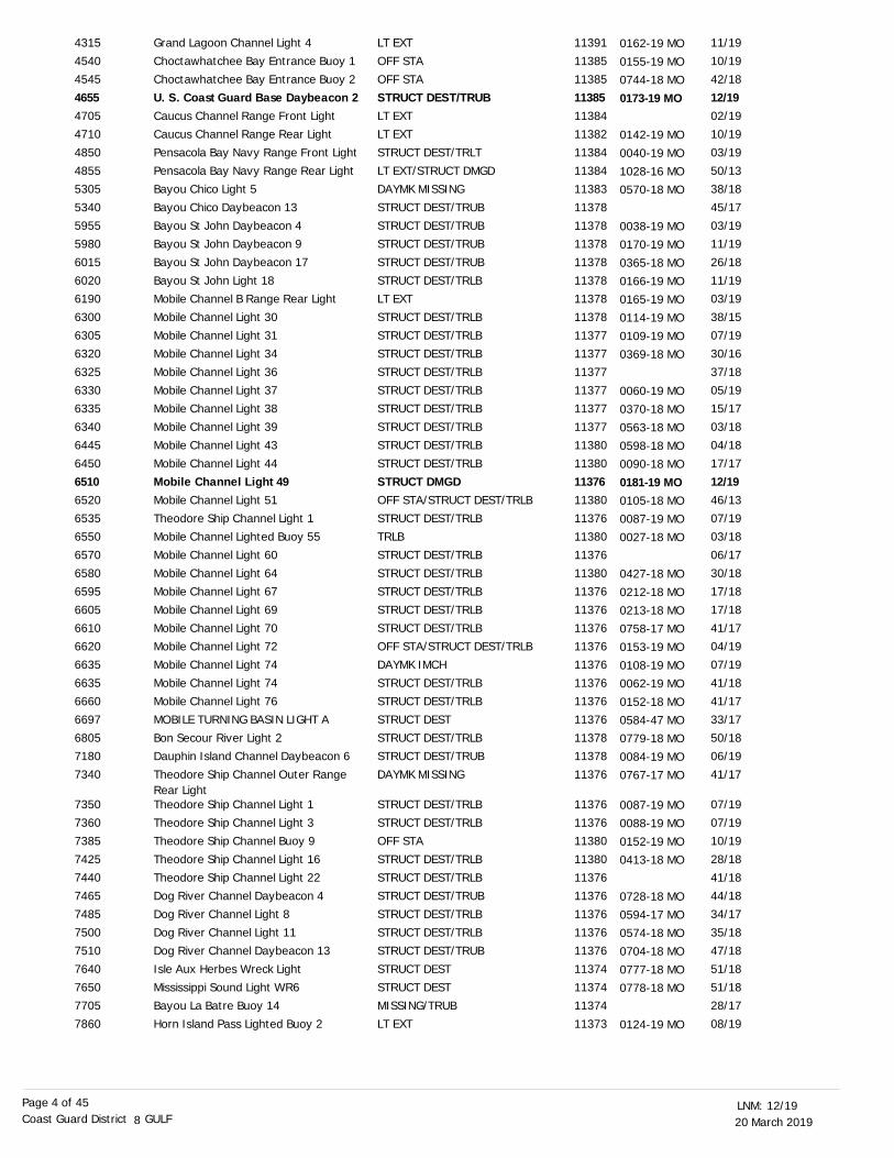
SECTION II - DISCREPANCIESThis section lists all reported and corrected discrepancies related to Aids to Navigation in this edition. A discrepancy is a change in the status of
an aid to navigation that differs from what is published or charted.
LNM EndLLNR Aid Name Status Chart No. BNM Ref. LNM StSt Marks LightColorado River East Jetty Entrance Obstruction LightNOAA Lighted Data Buoy 42003 (ODAS)
St Marks LightSt Marks River Light 7
St Marks River Light 37
Light House Point LH
Carrabelle Channel Lighted Buoy 10Carrabelle Channel Inner Leading Light
Two Mile Channel East End Daybeacon 14Two Mile Channel Junction Light TMWest Pass Light
St Joseph Bay Entrance A Range Front LightSt Joseph Bay Entrance Range B Rear LightSt Joseph Bay Entrance C Range Rear LightSt Joseph Bay Entrance C Range Rear Passing LightSt Joseph Bay Entrance Range D Rear Light Passing LightGulf County Canal Entrance Lighted Buoy 4
LT EXTSTRUCT DEST
ADRIFT
LT EXTSTRUCT DEST/TRLB
STRUCT DEST/TRLB
DAYMK MISSING
OFF STADAYMK MISSING
STRUCT DEST/TRUB
STRUCT DEST/TRLBSTRUCT DEST
STRUCT DMGD/TRLB
LT EXT/DAYMK MISSING
STRUCT DEST
STRUCT DEST
LT EXT
TRUB
22/1611/18
20/17
22/1643/18
43/18
43/18
42/1843/18
43/18
07/1942/18
47/13
42/18
40/18
43/18
43/18
42/18
1140611319
11006
1140611406
11406
11405
1140411404
11401
1140211402
11393
11393
11393
11393
11393
11393
101377
1460
14901540
1695
2305
25452560
2915
29452950
3025
3065
3085
3090
3110
3190
0448-16 MO
0070-18 CC
0028-17 D8
0448-16 MO
0714-18 MO
0106-19 MO
0931-13 MO
0622-18 MO
20 March 201912/19LNM:
8Coast Guard District GULFPage 4 of 45
Grand Lagoon Channel Light 4
Choctawhatchee Bay Entrance Buoy 1Choctawhatchee Bay Entrance Buoy 2
U. S. Coast Guard Base Daybeacon 2Caucus Channel Range Front LightCaucus Channel Range Rear Light
Pensacola Bay Navy Range Front Light
Pensacola Bay Navy Range Rear LightBayou Chico Light 5
Bayou Chico Daybeacon 13
Bayou St John Daybeacon 4Bayou St John Daybeacon 9
Bayou St John Daybeacon 17
Bayou St John Light 18Mobile Channel B Range Rear Light
Mobile Channel Light 30
Mobile Channel Light 31Mobile Channel Light 34
Mobile Channel Light 36
Mobile Channel Light 37Mobile Channel Light 38
Mobile Channel Light 39
Mobile Channel Light 43
Mobile Channel Light 44Mobile Channel Light 49Mobile Channel Light 51
Theodore Ship Channel Light 1Mobile Channel Lighted Buoy 55
Mobile Channel Light 60
Mobile Channel Light 64Mobile Channel Light 67
Mobile Channel Light 69
Mobile Channel Light 70Mobile Channel Light 72
Mobile Channel Light 74
Mobile Channel Light 74Mobile Channel Light 76
MOBILE TURNING BASIN LIGHT A
Bon Secour River Light 2Dauphin Island Channel Daybeacon 6
Theodore Ship Channel Outer Range Rear LightTheodore Ship Channel Light 1
Theodore Ship Channel Light 3Theodore Ship Channel Buoy 9
Theodore Ship Channel Light 16
Theodore Ship Channel Light 22Dog River Channel Daybeacon 4
Dog River Channel Light 8
Dog River Channel Light 11Dog River Channel Daybeacon 13
Isle Aux Herbes Wreck Light
Mississippi Sound Light WR6Bayou La Batre Buoy 14
Horn Island Pass Lighted Buoy 2
LT EXT
OFF STAOFF STA
STRUCT DEST/TRUBLT EXTLT EXT
STRUCT DEST/TRLT
LT EXT/STRUCT DMGDDAYMK MISSING
STRUCT DEST/TRUB
STRUCT DEST/TRUBSTRUCT DEST/TRUB
STRUCT DEST/TRUB
STRUCT DEST/TRLBLT EXT
STRUCT DEST/TRLB
STRUCT DEST/TRLBSTRUCT DEST/TRLB
STRUCT DEST/TRLB
STRUCT DEST/TRLBSTRUCT DEST/TRLB
STRUCT DEST/TRLB
STRUCT DEST/TRLB
STRUCT DEST/TRLBSTRUCT DMGDOFF STA/STRUCT DEST/TRLB
STRUCT DEST/TRLBTRLB
STRUCT DEST/TRLB
STRUCT DEST/TRLBSTRUCT DEST/TRLB
STRUCT DEST/TRLB
STRUCT DEST/TRLBOFF STA/STRUCT DEST/TRLB
DAYMK IMCH
STRUCT DEST/TRLBSTRUCT DEST/TRLB
STRUCT DEST
STRUCT DEST/TRLBSTRUCT DEST/TRUB
DAYMK MISSING
STRUCT DEST/TRLB
STRUCT DEST/TRLBOFF STA
STRUCT DEST/TRLB
STRUCT DEST/TRLBSTRUCT DEST/TRUB
STRUCT DEST/TRLB
STRUCT DEST/TRLBSTRUCT DEST/TRUB
STRUCT DEST
STRUCT DESTMISSING/TRUB
LT EXT
11/19
10/1942/18
12/1902/1910/19
03/19
50/1338/18
45/17
03/1911/19
26/18
11/1903/19
38/15
07/1930/16
37/18
05/1915/17
03/18
04/18
17/1712/1946/13
07/1903/18
06/17
30/1817/18
17/18
41/1704/19
07/19
41/1841/17
33/17
50/1806/19
41/17
07/19
07/1910/19
28/18
41/1844/18
34/17
35/1847/18
51/18
51/1828/17
08/19
11391
1138511385
113851138411382
11384
1138411383
11378
1137811378
11378
1137811378
11378
1137711377
11377
1137711377
11377
11380
113801137611380
1137611380
11376
1138011376
11376
1137611376
11376
1137611376
11376
1137811378
11376
11376
1137611380
11380
1137611376
11376
1137611376
11374
1137411374
11373
4315
45404545
465547054710
4850
48555305
5340
59555980
6015
60206190
6300
63056320
6325
63306335
6340
6445
645065106520
65356550
6570
65806595
6605
66106620
6635
66356660
6697
68057180
7340
7350
73607385
7425
74407465
7485
75007510
7640
76507705
7860
0162-19 MO
0155-19 MO0744-18 MO
0173-19 MO
0142-19 MO
0040-19 MO
1028-16 MO0570-18 MO
0038-19 MO0170-19 MO
0365-18 MO
0166-19 MO0165-19 MO
0114-19 MO
0109-19 MO0369-18 MO
0060-19 MO0370-18 MO
0563-18 MO
0598-18 MO0090-18 MO
0181-19 MO0105-18 MO0087-19 MO
0027-18 MO
0427-18 MO
0212-18 MO
0213-18 MO0758-17 MO
0153-19 MO
0108-19 MO0062-19 MO
0152-18 MO
0584-47 MO0779-18 MO
0084-19 MO
0767-17 MO
0087-19 MO0088-19 MO
0152-19 MO
0413-18 MO
0728-18 MO
0594-17 MO0574-18 MO
0704-18 MO
0777-18 MO0778-18 MO
0124-19 MO
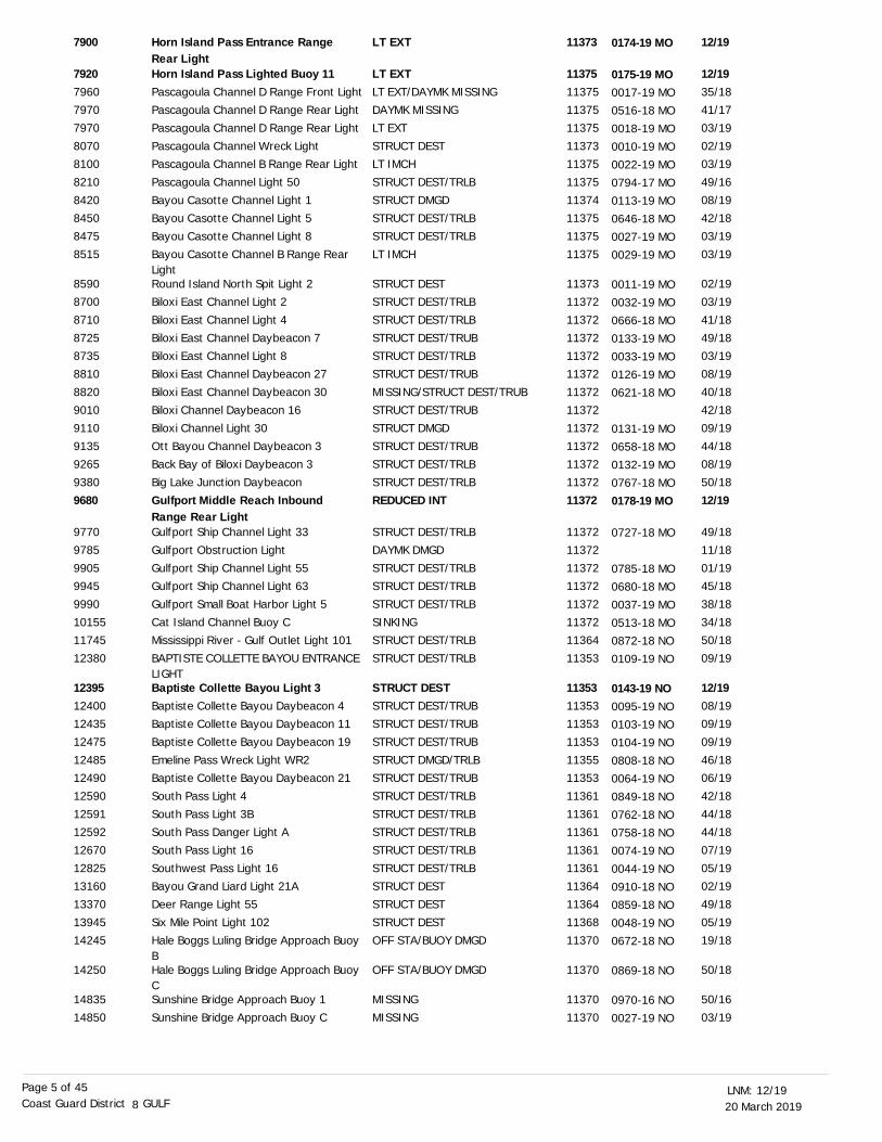
20 March 201912/19LNM:
8Coast Guard District GULFPage 5 of 45
Horn Island Pass Entrance Range Rear LightHorn Island Pass Lighted Buoy 11Pascagoula Channel D Range Front LightPascagoula Channel D Range Rear Light
Pascagoula Channel D Range Rear Light
Pascagoula Channel Wreck LightPascagoula Channel B Range Rear Light
Pascagoula Channel Light 50
Bayou Casotte Channel Light 1Bayou Casotte Channel Light 5
Bayou Casotte Channel Light 8
Bayou Casotte Channel B Range Rear LightRound Island North Spit Light 2Biloxi East Channel Light 2
Biloxi East Channel Light 4
Biloxi East Channel Daybeacon 7Biloxi East Channel Light 8
Biloxi East Channel Daybeacon 27
Biloxi East Channel Daybeacon 30Biloxi Channel Daybeacon 16
Biloxi Channel Light 30
Ott Bayou Channel Daybeacon 3Back Bay of Biloxi Daybeacon 3
Big Lake Junction Daybeacon
Gulfport Middle Reach Inbound Range Rear LightGulfport Ship Channel Light 33
Gulfport Obstruction Light
Gulfport Ship Channel Light 55Gulfport Ship Channel Light 63
Gulfport Small Boat Harbor Light 5
Cat Island Channel Buoy CMississippi River - Gulf Outlet Light 101
BAPTISTE COLLETTE BAYOU ENTRANCE LIGHTBaptiste Collette Bayou Light 3Baptiste Collette Bayou Daybeacon 4Baptiste Collette Bayou Daybeacon 11
Baptiste Collette Bayou Daybeacon 19
Emeline Pass Wreck Light WR2Baptiste Collette Bayou Daybeacon 21
South Pass Light 4
South Pass Light 3BSouth Pass Danger Light A
South Pass Light 16
Southwest Pass Light 16Bayou Grand Liard Light 21A
Deer Range Light 55
Six Mile Point Light 102Hale Boggs Luling Bridge Approach Buoy BHale Boggs Luling Bridge Approach Buoy CSunshine Bridge Approach Buoy 1
Sunshine Bridge Approach Buoy C
LT EXT
LT EXTLT EXT/DAYMK MISSINGDAYMK MISSING
LT EXT
STRUCT DESTLT IMCH
STRUCT DEST/TRLB
STRUCT DMGDSTRUCT DEST/TRLB
STRUCT DEST/TRLB
LT IMCH
STRUCT DESTSTRUCT DEST/TRLB
STRUCT DEST/TRLB
STRUCT DEST/TRUBSTRUCT DEST/TRLB
STRUCT DEST/TRUB
MISSING/STRUCT DEST/TRUBSTRUCT DEST/TRUB
STRUCT DMGD
STRUCT DEST/TRUBSTRUCT DEST/TRLB
STRUCT DEST/TRLB
REDUCED INT
STRUCT DEST/TRLB
DAYMK DMGD
STRUCT DEST/TRLBSTRUCT DEST/TRLB
STRUCT DEST/TRLB
SINKINGSTRUCT DEST/TRLB
STRUCT DEST/TRLB
STRUCT DESTSTRUCT DEST/TRUBSTRUCT DEST/TRUB
STRUCT DEST/TRUB
STRUCT DMGD/TRLBSTRUCT DEST/TRUB
STRUCT DEST/TRLB
STRUCT DEST/TRLBSTRUCT DEST/TRLB
STRUCT DEST/TRLB
STRUCT DEST/TRLBSTRUCT DEST
STRUCT DEST
STRUCT DESTOFF STA/BUOY DMGD
OFF STA/BUOY DMGD
MISSING
MISSING
12/19
12/1935/1841/17
03/19
02/1903/19
49/16
08/1942/18
03/19
03/19
02/1903/19
41/18
49/1803/19
08/19
40/1842/18
09/19
44/1808/19
50/18
12/19
49/18
11/18
01/1945/18
38/18
34/1850/18
09/19
12/1908/1909/19
09/19
46/1806/19
42/18
44/1844/18
07/19
05/1902/19
49/18
05/1919/18
50/18
50/16
03/19
11373
113751137511375
11375
1137311375
11375
1137411375
11375
11375
1137311372
11372
1137211372
11372
1137211372
11372
1137211372
11372
11372
11372
11372
1137211372
11372
1137211364
11353
113531135311353
11353
1135511353
11361
1136111361
11361
1136111364
11364
1136811370
11370
11370
11370
7900
792079607970
7970
80708100
8210
84208450
8475
8515
85908700
8710
87258735
8810
88209010
9110
91359265
9380
9680
9770
9785
99059945
9990
1015511745
12380
123951240012435
12475
1248512490
12590
1259112592
12670
1282513160
13370
1394514245
14250
14835
14850
0174-19 MO
0175-19 MO0017-19 MO
0516-18 MO
0018-19 MO0010-19 MO
0022-19 MO
0794-17 MO0113-19 MO
0646-18 MO
0027-19 MO0029-19 MO
0011-19 MO
0032-19 MO
0666-18 MO0133-19 MO
0033-19 MO
0126-19 MO0621-18 MO
0131-19 MO0658-18 MO
0132-19 MO
0767-18 MO0178-19 MO
0727-18 MO
0785-18 MO0680-18 MO
0037-19 MO
0513-18 MO0872-18 NO
0109-19 NO
0143-19 NO0095-19 NO0103-19 NO
0104-19 NO
0808-18 NO0064-19 NO
0849-18 NO
0762-18 NO0758-18 NO
0074-19 NO
0044-19 NO0910-18 NO
0859-18 NO
0048-19 NO0672-18 NO
0869-18 NO
0970-16 NO
0027-19 NO
20 March 201912/19LNM:
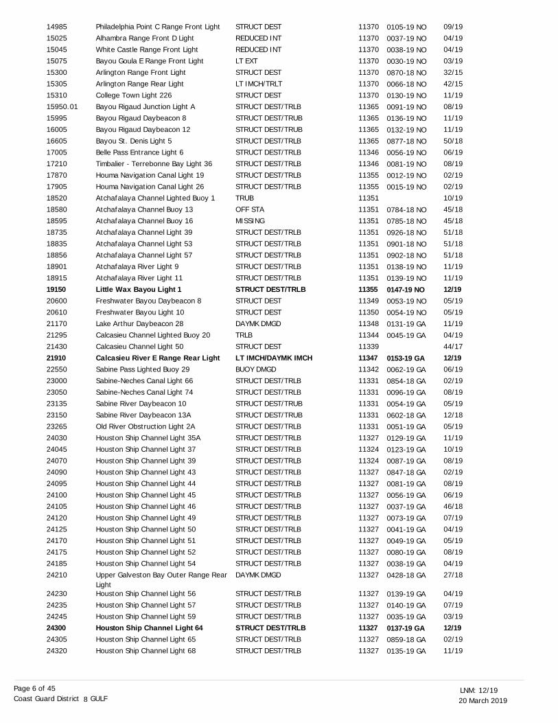
8Coast Guard District GULFPage 6 of 45
Philadelphia Point C Range Front Light
Alhambra Range Front D LightWhite Castle Range Front Light
Bayou Goula E Range Front Light
Arlington Range Front LightArlington Range Rear Light
College Town Light 226
Bayou Rigaud Junction Light ABayou Rigaud Daybeacon 8
Bayou Rigaud Daybeacon 12
Bayou St. Denis Light 5Belle Pass Entrance Light 6
Timbalier - Terrebonne Bay Light 36
Houma Navigation Canal Light 19Houma Navigation Canal Light 26
Atchafalaya Channel Lighted Buoy 1
Atchafalaya Channel Buoy 13Atchafalaya Channel Buoy 16
Atchafalaya Channel Light 39
Atchafalaya Channel Light 53Atchafalaya Channel Light 57
Atchafalaya River Light 9
Atchafalaya River Light 11
Little Wax Bayou Light 1Freshwater Bayou Daybeacon 8
Freshwater Bayou Light 10
Lake Arthur Daybeacon 28Calcasieu Channel Lighted Buoy 20
Calcasieu Channel Light 50
Calcasieu River E Range Rear LightSabine Pass Lighted Buoy 29
Sabine-Neches Canal Light 66
Sabine-Neches Canal Light 74Sabine River Daybeacon 10
Sabine River Daybeacon 13A
Old River Obstruction Light 2AHouston Ship Channel Light 35A
Houston Ship Channel Light 37
Houston Ship Channel Light 39Houston Ship Channel Light 43
Houston Ship Channel Light 44
Houston Ship Channel Light 45Houston Ship Channel Light 46
Houston Ship Channel Light 49
Houston Ship Channel Light 50Houston Ship Channel Light 51
Houston Ship Channel Light 52
Houston Ship Channel Light 54Upper Galveston Bay Outer Range Rear LightHouston Ship Channel Light 56
Houston Ship Channel Light 57
Houston Ship Channel Light 59Houston Ship Channel Light 64Houston Ship Channel Light 65
Houston Ship Channel Light 68
STRUCT DEST
REDUCED INTREDUCED INT
LT EXT
STRUCT DESTLT IMCH/TRLT
STRUCT DEST
STRUCT DEST/TRLBSTRUCT DEST/TRUB
STRUCT DEST/TRUB
STRUCT DEST/TRLBSTRUCT DEST/TRLB
STRUCT DEST/TRLB
STRUCT DEST/TRLBSTRUCT DEST/TRLB
TRUB
OFF STAMISSING
STRUCT DEST/TRLB
STRUCT DEST/TRLBSTRUCT DEST/TRLB
STRUCT DEST/TRLB
STRUCT DEST/TRLB
STRUCT DEST/TRLBSTRUCT DEST
STRUCT DEST
DAYMK DMGDTRLB
STRUCT DEST
LT IMCH/DAYMK IMCHBUOY DMGD
STRUCT DEST/TRLB
STRUCT DEST/TRLBSTRUCT DEST/TRUB
STRUCT DEST/TRUB
STRUCT DEST/TRLBSTRUCT DEST/TRLB
STRUCT DEST/TRLB
STRUCT DEST/TRLBSTRUCT DEST/TRLB
STRUCT DEST/TRLB
STRUCT DEST/TRLBSTRUCT DEST/TRLB
STRUCT DEST/TRLB
STRUCT DEST/TRLBSTRUCT DEST/TRLB
STRUCT DEST/TRLB
STRUCT DEST/TRLBDAYMK DMGD
STRUCT DEST/TRLB
STRUCT DEST/TRLB
STRUCT DEST/TRLBSTRUCT DEST/TRLBSTRUCT DEST/TRLB
STRUCT DEST/TRLB
09/19
04/1904/19
03/19
32/1542/15
11/19
08/1911/19
11/19
50/1806/19
08/19
02/1902/19
10/19
45/1845/18
51/18
51/1851/18
11/19
11/19
12/1905/19
05/19
11/1904/19
44/17
12/1906/19
02/19
08/1905/19
12/18
05/1911/19
10/19
08/1902/19
08/19
06/1946/18
07/19
04/1905/19
08/19
04/1927/18
04/19
07/19
03/1912/1902/19
11/19
11370
1137011370
11370
1137011370
11370
1136511365
11365
1136511346
11346
1135511355
11351
1135111351
11351
1135111351
11351
11351
1135511349
11350
1134811344
11339
1134711342
11331
1133111331
11331
1133111327
11324
1132411327
11327
1132711327
11327
1132711327
11327
1132711327
11327
11327
113271132711327
11327
14985
1502515045
15075
1530015305
15310
15950.0115995
16005
1660517005
17210
1787017905
18520
1858018595
18735
1883518856
18901
18915
1915020600
20610
2117021295
21430
2191022550
23000
2305023135
23150
2326524030
24045
2407024090
24095
2410024105
24120
2412524170
24175
2418524210
24230
24235
242452430024305
24320
0105-19 NO
0037-19 NO0038-19 NO
0030-19 NO
0870-18 NO0066-18 NO
0130-19 NO
0091-19 NO0136-19 NO
0132-19 NO
0877-18 NO0056-19 NO
0081-19 NO
0012-19 NO0015-19 NO
0784-18 NO0785-18 NO
0926-18 NO
0901-18 NO0902-18 NO
0138-19 NO
0139-19 NO0147-19 NO0053-19 NO
0054-19 NO0131-19 GA
0045-19 GA
0153-19 GA0062-19 GA
0854-18 GA0096-19 GA
0054-19 GA
0602-18 GA0051-19 GA
0129-19 GA
0123-19 GA0087-19 GA
0847-18 GA
0081-19 GA0056-19 GA
0037-19 GA
0073-19 GA0041-19 GA
0049-19 GA
0080-19 GA0038-19 GA
0428-18 GA
0139-19 GA
0140-19 GA0035-19 GA
0137-19 GA0859-18 GA0135-19 GA
20 March 201912/19LNM:
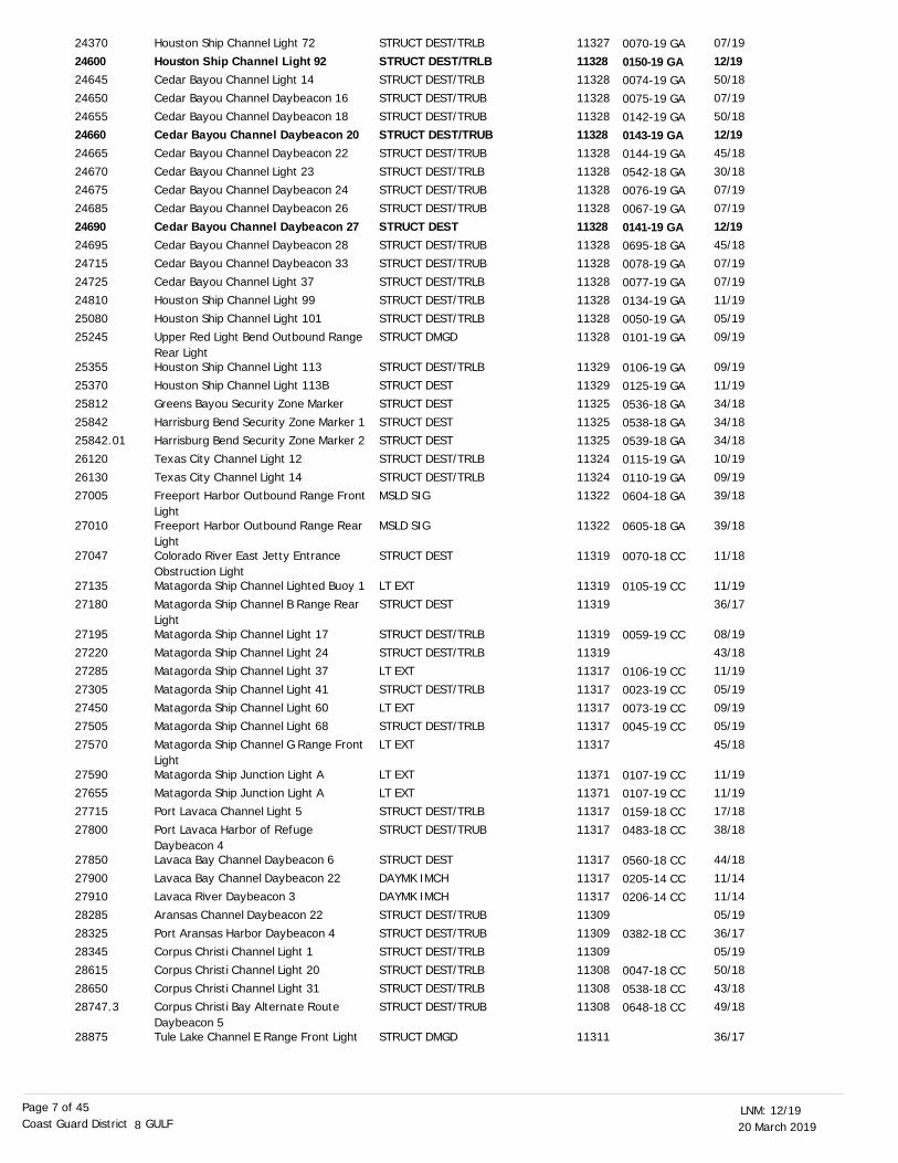
8Coast Guard District GULFPage 7 of 45
Houston Ship Channel Light 72
Houston Ship Channel Light 92Cedar Bayou Channel Light 14
Cedar Bayou Channel Daybeacon 16
Cedar Bayou Channel Daybeacon 18Cedar Bayou Channel Daybeacon 20Cedar Bayou Channel Daybeacon 22
Cedar Bayou Channel Light 23Cedar Bayou Channel Daybeacon 24
Cedar Bayou Channel Daybeacon 26
Cedar Bayou Channel Daybeacon 27Cedar Bayou Channel Daybeacon 28
Cedar Bayou Channel Daybeacon 33
Cedar Bayou Channel Light 37Houston Ship Channel Light 99
Houston Ship Channel Light 101
Upper Red Light Bend Outbound Range Rear LightHouston Ship Channel Light 113Houston Ship Channel Light 113B
Greens Bayou Security Zone Marker
Harrisburg Bend Security Zone Marker 1Harrisburg Bend Security Zone Marker 2
Texas City Channel Light 12
Texas City Channel Light 14Freeport Harbor Outbound Range Front LightFreeport Harbor Outbound Range Rear LightColorado River East Jetty Entrance Obstruction LightMatagorda Ship Channel Lighted Buoy 1
Matagorda Ship Channel B Range Rear LightMatagorda Ship Channel Light 17
Matagorda Ship Channel Light 24Matagorda Ship Channel Light 37
Matagorda Ship Channel Light 41
Matagorda Ship Channel Light 60Matagorda Ship Channel Light 68
Matagorda Ship Channel G Range Front LightMatagorda Ship Junction Light A
Matagorda Ship Junction Light APort Lavaca Channel Light 5
Port Lavaca Harbor of Refuge Daybeacon 4Lavaca Bay Channel Daybeacon 6
Lavaca Bay Channel Daybeacon 22Lavaca River Daybeacon 3
Aransas Channel Daybeacon 22
Port Aransas Harbor Daybeacon 4Corpus Christi Channel Light 1
Corpus Christi Channel Light 20
Corpus Christi Channel Light 31Corpus Christi Bay Alternate Route Daybeacon 5Tule Lake Channel E Range Front Light
STRUCT DEST/TRLB
STRUCT DEST/TRLBSTRUCT DEST/TRLB
STRUCT DEST/TRUB
STRUCT DEST/TRUBSTRUCT DEST/TRUBSTRUCT DEST/TRUB
STRUCT DEST/TRLBSTRUCT DEST/TRUB
STRUCT DEST/TRUB
STRUCT DESTSTRUCT DEST/TRUB
STRUCT DEST/TRUB
STRUCT DEST/TRLBSTRUCT DEST/TRLB
STRUCT DEST/TRLB
STRUCT DMGD
STRUCT DEST/TRLBSTRUCT DEST
STRUCT DEST
STRUCT DESTSTRUCT DEST
STRUCT DEST/TRLB
STRUCT DEST/TRLBMSLD SIG
MSLD SIG
STRUCT DEST
LT EXT
STRUCT DEST
STRUCT DEST/TRLB
STRUCT DEST/TRLBLT EXT
STRUCT DEST/TRLB
LT EXTSTRUCT DEST/TRLB
LT EXT
LT EXT
LT EXTSTRUCT DEST/TRLB
STRUCT DEST/TRUB
STRUCT DEST
DAYMK IMCHDAYMK IMCH
STRUCT DEST/TRUB
STRUCT DEST/TRUBSTRUCT DEST/TRLB
STRUCT DEST/TRLB
STRUCT DEST/TRLBSTRUCT DEST/TRUB
STRUCT DMGD
07/19
12/1950/18
07/19
50/1812/1945/18
30/1807/19
07/19
12/1945/18
07/19
07/1911/19
05/19
09/19
09/1911/19
34/18
34/1834/18
10/19
09/1939/18
39/18
11/18
11/19
36/17
08/19
43/1811/19
05/19
09/1905/19
45/18
11/19
11/1917/18
38/18
44/18
11/1411/14
05/19
36/1705/19
50/18
43/1849/18
36/17
11327
1132811328
11328
113281132811328
1132811328
11328
1132811328
11328
1132811328
11328
11328
1132911329
11325
1132511325
11324
1132411322
11322
11319
11319
11319
11319
1131911317
11317
1131711317
11317
11371
1137111317
11317
11317
1131711317
11309
1130911309
11308
1130811308
11311
24370
2460024645
24650
246552466024665
2467024675
24685
2469024695
24715
2472524810
25080
25245
2535525370
25812
2584225842.01
26120
2613027005
27010
27047
27135
27180
27195
2722027285
27305
2745027505
27570
27590
2765527715
27800
27850
2790027910
28285
2832528345
28615
2865028747.3
28875
0070-19 GA
0150-19 GA0074-19 GA
0075-19 GA
0142-19 GA0143-19 GA0144-19 GA
0542-18 GA0076-19 GA
0067-19 GA
0141-19 GA0695-18 GA
0078-19 GA
0077-19 GA0134-19 GA
0050-19 GA
0101-19 GA
0106-19 GA0125-19 GA
0536-18 GA
0538-18 GA0539-18 GA
0115-19 GA
0110-19 GA0604-18 GA
0605-18 GA
0070-18 CC
0105-19 CC
0059-19 CC
0106-19 CC
0023-19 CC
0073-19 CC0045-19 CC
0107-19 CC
0107-19 CC0159-18 CC
0483-18 CC
0560-18 CC
0205-14 CC0206-14 CC
0382-18 CC
0047-18 CC
0538-18 CC0648-18 CC
20 March 201912/19LNM:
8Coast Guard District GULFPage 8 of 45
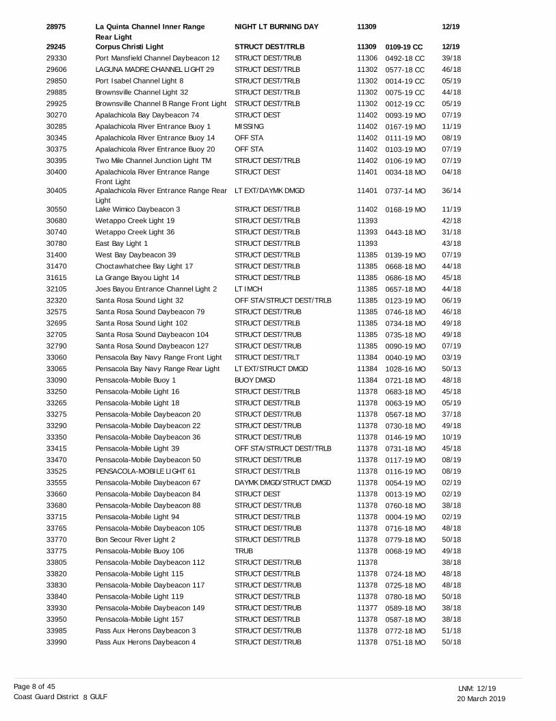
La Quinta Channel Inner Range Rear LightCorpus Christi LightPort Mansfield Channel Daybeacon 12LAGUNA MADRE CHANNEL LIGHT 29
Port Isabel Channel Light 8
Brownsville Channel Light 32Brownsville Channel B Range Front Light
Apalachicola Bay Daybeacon 74
Apalachicola River Entrance Buoy 1Apalachicola River Entrance Buoy 14
Apalachicola River Entrance Buoy 20
Two Mile Channel Junction Light TMApalachicola River Entrance Range Front LightApalachicola River Entrance Range RearLightLake Wimico Daybeacon 3
Wetappo Creek Light 19Wetappo Creek Light 36
East Bay Light 1
West Bay Daybeacon 39Choctawhatchee Bay Light 17
La Grange Bayou Light 14
Joes Bayou Entrance Channel Light 2
Santa Rosa Sound Light 32Santa Rosa Sound Daybeacon 79
Santa Rosa Sound Light 102
Santa Rosa Sound Daybeacon 104Santa Rosa Sound Daybeacon 127
Pensacola Bay Navy Range Front Light
Pensacola Bay Navy Range Rear LightPensacola-Mobile Buoy 1
Pensacola-Mobile Light 16
Pensacola-Mobile Light 18Pensacola-Mobile Daybeacon 20
Pensacola-Mobile Daybeacon 22
Pensacola-Mobile Daybeacon 36Pensacola-Mobile Light 39
Pensacola-Mobile Daybeacon 50
PENSACOLA-MOBILE LIGHT 61Pensacola-Mobile Daybeacon 67
Pensacola-Mobile Daybeacon 84
Pensacola-Mobile Daybeacon 88Pensacola-Mobile Light 94
Pensacola-Mobile Daybeacon 105
Bon Secour River Light 2Pensacola-Mobile Buoy 106
Pensacola-Mobile Daybeacon 112
Pensacola-Mobile Light 115Pensacola-Mobile Daybeacon 117
Pensacola-Mobile Light 119
Pensacola-Mobile Daybeacon 149Pensacola-Mobile Light 157
Pass Aux Herons Daybeacon 3
Pass Aux Herons Daybeacon 4
NIGHT LT BURNING DAY
STRUCT DEST/TRLBSTRUCT DEST/TRUBSTRUCT DEST/TRLB
STRUCT DEST/TRLB
STRUCT DEST/TRLBSTRUCT DEST/TRLB
STRUCT DEST
MISSINGOFF STA
OFF STA
STRUCT DEST/TRLBSTRUCT DEST
LT EXT/DAYMK DMGD
STRUCT DEST/TRLB
STRUCT DEST/TRLBSTRUCT DEST/TRLB
STRUCT DEST/TRLB
STRUCT DEST/TRLBSTRUCT DEST/TRLB
STRUCT DEST/TRLB
LT IMCH
OFF STA/STRUCT DEST/TRLBSTRUCT DEST/TRUB
STRUCT DEST/TRLB
STRUCT DEST/TRUBSTRUCT DEST/TRUB
STRUCT DEST/TRLT
LT EXT/STRUCT DMGDBUOY DMGD
STRUCT DEST/TRLB
STRUCT DEST/TRLBSTRUCT DEST/TRUB
STRUCT DEST/TRUB
STRUCT DEST/TRUBOFF STA/STRUCT DEST/TRLB
STRUCT DEST/TRUB
STRUCT DEST/TRLBDAYMK DMGD/STRUCT DMGD
STRUCT DEST
STRUCT DEST/TRUBSTRUCT DEST/TRLB
STRUCT DEST/TRUB
STRUCT DEST/TRLBTRUB
STRUCT DEST/TRUB
STRUCT DEST/TRLBSTRUCT DEST/TRUB
STRUCT DEST/TRLB
STRUCT DEST/TRUBSTRUCT DEST/TRLB
STRUCT DEST/TRUB
STRUCT DEST/TRUB
12/19
12/1939/1846/18
05/19
44/1805/19
07/19
11/1908/19
07/19
07/1904/18
36/14
11/19
42/1831/18
43/18
07/1944/18
45/18
44/18
06/1946/18
49/18
49/1807/19
03/19
50/1348/18
45/18
05/1937/18
49/18
10/1945/18
08/19
08/1902/19
02/19
38/1802/19
48/18
50/1849/18
38/18
48/1848/18
50/18
38/1838/18
51/18
50/18
11309
113091130611302
11302
1130211302
11402
1140211402
11402
1140211401
11401
11402
1139311393
11393
1138511385
11385
11385
1138511385
11385
1138511385
11384
1138411384
11378
1137811378
11378
1137811378
11378
1137811378
11378
1137811378
11378
1137811378
11378
1137811378
11378
1137711378
11378
11378
28975
292452933029606
29850
2988529925
30270
3028530345
30375
3039530400
30405
30550
3068030740
30780
3140031470
31615
32105
3232032575
32695
3270532790
33060
3306533090
33250
3326533275
33290
3335033415
33470
3352533555
33660
3368033715
33765
3377033775
33805
3382033830
33840
3393033950
33985
33990
0109-19 CC0492-18 CC
0577-18 CC
0014-19 CC0075-19 CC
0012-19 CC
0093-19 MO0167-19 MO
0111-19 MO
0103-19 MO0106-19 MO
0034-18 MO
0737-14 MO
0168-19 MO
0443-18 MO
0139-19 MO0668-18 MO
0686-18 MO
0657-18 MO0123-19 MO
0746-18 MO
0734-18 MO0735-18 MO
0090-19 MO
0040-19 MO1028-16 MO
0721-18 MO
0683-18 MO0063-19 MO
0567-18 MO
0730-18 MO0146-19 MO
0731-18 MO
0117-19 MO0116-19 MO
0054-19 MO
0013-19 MO0760-18 MO
0004-19 MO
0716-18 MO0779-18 MO
0068-19 MO
0724-18 MO
0725-18 MO
0780-18 MO
0589-18 MO0587-18 MO
0772-18 MO
0751-18 MO
20 March 201912/19LNM:
8Coast Guard District GULFPage 9 of 45
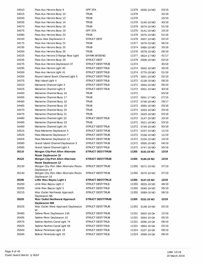
Pass Aux Herons Buoy 9
Pass Aux Herons Buoy 10Pass Aux Herons Buoy 13
Pass Aux Herons Buoy 14
Pass Aux Herons Buoy 18Pass Aux Herons Buoy 19
Pass Aux Herons Buoy 20
Bayou Aloe Daybeacon 3Pass Aux Herons Buoy 22
Pass Aux Herons Buoy 25
Pass Aux Herons Buoy 26Pass Aux Herons D Range Rear Light
Pass Aux Herons Buoy 29
Pass Aux Herons Daybeacon 37Pass Aux Herons Light 40
Pass Aux Herons Light 41
Round Island South Channel Light 5Ship Island Light 4
Marianne Channel Light 3
Marianne Channel Light 8Marianne Channel Buoy 16
Marianne Channel Buoy 17
Marianne Channel Buoy 18
Marianne Channel Buoy 19Marianne Channel Buoy 20
Marianne Channel Buoy 21
Marianne Channel Light 22Marianne Channel Buoy 23
Marianne Channel Light 24
Pass Marianne Daybeacon 5Pass Marianne Daybeacon 7
Pass Marianne Daybeacon 12
Grand Island Channel Daybeacon 3Grand Island Channel Light 5
Morgan City-Port Allen Alternate Route Daybeacon 10Morgan City-Port Allen Alternate Route Daybeacon 12Morgan City-Port Allen Alternate Route Daybeacon 14Morgan City-Port Allen Alternate Route Daybeacon 16Little Wax Bayou Light 1Little Wax Bayou Light 2
Little Wax Bayou Light 3Wax Outlet Northeast Approach Daybeacon NEWax Outlet Northwest Approach Daybeacon NWWax Outlet West Approach Daybeacon WSabine River Daybeacon 13A
Sabine River Daybeacon 10Sabine-Neches Canal Light 74
Sabine-Neches Canal Light 66
Bolivar Peninsula Light 19Bolivar Peninsula Light 20
OFF STA
TRUBTRUB
TRUB
TRUBOFF STA
TRUB
STRUCT DESTTRUB
TRUB
TRUBDAYMK MISSING
STRUCT DEST
STRUCT DEST/TRUBSTRUCT DEST/TRLB
STRUCT DEST/TRLB
STRUCT DEST/TRLBSTRUCT DEST/TRLB
STRUCT DEST/TRLB
STRUCT DEST/TRLBTRUB
TRUB
TRUB
TRUBTRUB
TRUB
STRUCT DEST/TRLBTRUB
STRUCT DEST/TRLB
STRUCT DEST/TRUBSTRUCT DEST/TRUB
STRUCT DEST/TRUB
STRUCT DEST/TRUBSTRUCT DEST/TRLB
STRUCT DEST/TRUB
STRUCT DEST/TRUB
STRUCT DEST/TRUB
STRUCT DEST/TRUB
STRUCT DEST/TRLBSTRUCT DEST/TRLB
STRUCT DEST/TRLBSTRUCT DEST/TRUB
STRUCT DEST/TRUB
STRUCT DEST/TRUB
STRUCT DEST/TRUB
STRUCT DEST/TRUBSTRUCT DEST/TRLB
STRUCT DEST/TRLB
STRUCT DEST/TRLBSTRUCT DEST/TRLB
03/19
42/1810/19
40/18
51/1810/19
51/18
02/1906/19
33/18
06/1941/17
02/19
40/1842/18
51/18
02/1909/19
05/19
40/1850/18
07/15
29/17
03/1820/18
03/18
10/1903/18
50/18
11/1911/19
10/19
04/1950/18
12/19
12/19
07/19
07/19
12/1948/18
05/1908/19
12/19
02/19
12/18
05/1908/19
02/19
09/1908/19
11378
1137811378
11378
1137811378
11378
1137811377
11374
1137811377
11378
1137411374
11374
1137511372
11372
1137211372
11372
11372
1137211372
11372
1137211372
11372
1137211372
11372
1137211372
11355
11355
11355
11355
1135511355
1135511355
11355
11352
11331
1133111331
11331
1132411324
34010
3401534030
34035
3407034075
34080
3410034175
34195
3420034225
34235
3427534295
34300
3435034375
34410
3442534450
34455
34460
3446534470
34475
3448034485
34490
3451534525
34555
3458034585
35110
35120
35130
35140
3519535200
3520535215
35220
35225
35480
3549535575
35625
3594035945
0035-19 MO
0140-19 MO
0074-19 MO0141-19 MO
0075-19 MO
0007-19 MO0076-19 MO
0480-18 MO
0078-19 MO0814-17 MO
0008-19 MO
0642-18 MO
0770-18 MO
0001-19 MO0138-19 MO
0064-19 MO
0051-19 MO
0051-17 MO
0748-18 MO0095-18 MO
0263-18 MO
0020-18 MO0147-19 MO
0021-18 MO
0749-18 MO0157-19 MO
0158-19 MO
0154-19 MO0050-19 MO
0747-18 MO
0141-19 NO
0145-19 NO
0071-19 NO
0070-19 NO
0147-19 NO0833-18 NO
0046-19 NO0089-19 NO
0151-19 NO
0148-19 NO
0602-18 GA
0054-19 GA0096-19 GA
0854-18 GA
0107-19 GA0099-19 GA
20 March 201912/19LNM:
8Coast Guard District GULFPage 10 of 45
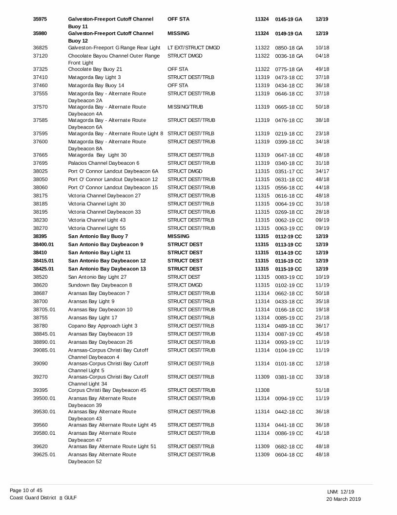
Galveston-Freeport Cutoff Channel Buoy 11Galveston-Freeport Cutoff Channel Buoy 12Galveston-Freeport G Range Rear LightChocolate Bayou Channel Outer Range Front LightChocolate Bay Buoy 21
Matagorda Bay Light 3
Matagorda Bay Buoy 14Matagorda Bay - Alternate Route Daybeacon 2AMatagorda Bay - Alternate Route Daybeacon 4AMatagorda Bay - Alternate Route Daybeacon 6AMatagorda Bay - Alternate Route Light 8
Matagorda Bay - Alternate Route Daybeacon 8AMatagorda Bay Light 30Palacios Channel Daybeacon 6
Port O' Connor Landcut Daybeacon 6A
Port O' Connor Landcut Daybeacon 12Port O' Connor Landcut Daybeacon 15
Victoria Channel Daybeacon 27
Victoria Channel Light 30Victoria Channel Daybeacon 33
Victoria Channel Light 43
Victoria Channel Light 55San Antonio Bay Buoy 7San Antonio Bay Daybeacon 9San Antonio Bay Light 11San Antonio Bay Daybeacon 12San Antonio Bay Daybeacon 13San Antonio Bay Light 27Sundown Bay Daybeacon 8
Aransas Bay Daybeacon 7
Aransas Bay Light 9
Aransas Bay Daybeacon 10Aransas Bay Light 17
Copano Bay Approach Light 3
Aransas Bay Daybeacon 19Aransas Bay Daybeacon 26
Aransas-Corpus Christi Bay Cutoff Channel Daybeacon 4Aransas-Corpus Christi Bay Cutoff Channel Light 5Aransas-Corpus Christi Bay Cutoff Channel Light 34Corpus Christi Bay Daybeacon 45Aransas Bay Alternate Route Daybeacon 39Aransas Bay Alternate Route Daybeacon 43Aransas Bay Alternate Route Light 45
Aransas Bay Alternate Route Daybeacon 47Aransas Bay Alternate Route Light 51
Aransas Bay Alternate Route Daybeacon 52
OFF STA
MISSING
LT EXT/STRUCT DMGDSTRUCT DMGD
OFF STA
STRUCT DEST/TRLB
OFF STASTRUCT DEST/TRUB
MISSING/TRUB
STRUCT DEST/TRUB
STRUCT DEST/TRLB
STRUCT DEST/TRUB
STRUCT DEST/TRLBSTRUCT DEST/TRUB
STRUCT DMGD
STRUCT DEST/TRUBSTRUCT DEST/TRUB
STRUCT DEST/TRUB
STRUCT DEST/TRLBSTRUCT DEST/TRUB
STRUCT DEST/TRLB
STRUCT DEST/TRUBMISSINGSTRUCT DESTSTRUCT DESTSTRUCT DESTSTRUCT DESTSTRUCT DESTSTRUCT DMGD
STRUCT DEST/TRUB
STRUCT DEST/TRLB
STRUCT DEST/TRUBSTRUCT DEST/TRLB
STRUCT DEST/TRLB
STRUCT DEST/TRUBSTRUCT DEST/TRUB
STRUCT DEST/TRUB
STRUCT DEST/TRLB
STRUCT DEST/TRLB
STRUCT DEST/TRUBSTRUCT DEST/TRUB
STRUCT DEST/TRUB
STRUCT DEST/TRLB
STRUCT DEST/TRUB
STRUCT DEST/TRLB
STRUCT DEST/TRUB
12/19
12/19
10/1804/18
49/18
37/18
36/1837/18
50/18
38/18
23/18
34/18
48/1831/18
34/17
48/1844/18
48/18
31/1828/18
09/19
09/1912/1912/1912/1912/1912/1910/1911/19
50/18
35/18
19/1821/18
36/17
45/1811/19
11/19
12/18
33/18
51/1811/19
36/18
36/18
41/18
48/18
48/18
11324
11324
1132211322
11322
11319
1131911319
11319
11319
11319
11319
1131911319
11315
1131511315
11315
1131511315
11315
1131511315113151131511315113151131511315
11314
11314
1131411314
11314
1131411314
11314
11314
11309
1130811314
11314
11314
11314
11309
11309
35975
35980
3682537120
37325
37410
3746037555
37570
37585
37595
37600
3766537695
38025
3805038060
38175
3818538195
38230
382703839538400.013841038415.0138425.013852038620
38687
38700
38705.0138755
38780
38845.0138890.01
39085.01
39090
39270
3939539500.01
39530.01
39560
39580.01
39620
39625.01
0145-19 GA
0149-19 GA
0850-18 GA
0036-18 GA
0775-18 GA
0473-18 CC0434-18 CC
0646-18 CC
0665-18 CC
0476-18 CC
0219-18 CC
0399-18 CC
0647-18 CC0340-18 CC
0351-17 CC
0631-18 CC0556-18 CC
0616-18 CC
0064-19 CC0269-18 CC
0062-19 CC
0063-19 CC0112-19 CC0113-19 CC0114-19 CC0116-19 CC0115-19 CC0083-19 CC0102-19 CC
0662-18 CC
0433-18 CC0166-18 CC
0085-19 CC
0489-18 CC0087-19 CC
0093-19 CC
0104-19 CC
0101-18 CC
0381-18 CC
0094-19 CC
0442-18 CC
0441-18 CC
0086-19 CC
0682-18 CC
0604-18 CC

20 March 201912/19LNM:
8Coast Guard District GULFPage 11 of 45
DISCREPANCIES (FEDERAL AIDS) CORRECTED
LNM EndLLNR Aid Name Status Chart No. BNM Ref. LNM St
Aransas Bay Alternate Route Light 53
Corpus Christi Baffin Bay Daybeacon 17Corpus Christi Baffin Bay Daybeacon 45
Corpus Christi Baffin Bay Daybeacon 52
Corpus Christi Baffin Bay Light 67Corpus Christi Baffin Bay Daybeacon 68
Corpus Christi Baffin Bay Daybeacon 76
Corpus Christi Baffin Bay Daybeacon 97Corpus Christi Baffin Bay Daybeacon 104Corpus Christi Baffin Bay Daybeacon 116Land Cut-Arroyo Colorado Light 32
Land Cut-Arroyo Colorado Daybeacon 34Land Cut-Arroyo Colorado Daybeacon 41Land Cut-Arroyo Colorado Daybeacon 52Land Cut-Arroyo Colorado Light 54
Land Cut-Arroyo Colorado Daybeacon 61Land Cut-Arroyo Colorado Daybeacon 63Land Cut-Arroyo Colorado Daybeacon 72Land Cut-Arroyo Colorado Daybeacon 73Land Cut-Arroyo Colorado Daybeacon 77LAND CUT-ARROYO COLORADO LIGHT 99Land Cut-Arroyo Colorado Daybeacon 101Land Cut-Arroyo Colorado Daybeacon 106Land Cut-Arroyo Colorado Light 136
Arroyo Colorado Cutoff Channel North Entrance Buoy 3NArroyo Colorado Cutoff Channel Daybeacon 14AHarlingen-Port Isabel Daybeacon 5Harlingen-Port Isabel Light 7
Harlingen-Port Isabel Daybeacon 8
Harlingen-Port Isabel Light 11Harlingen-Port Isabel Daybeacon 12
Harlingen-Port Isabel Light 27
Harlingen-Port Isabel Light 37Harlingen-Port Isabel Daybeacon 58Harlingen-Port Isabel Daybeacon 59
Port Isabel Small Boat Harbor Channel Buoy 5Port Isabel Small Boat Harbor Channel Lighted Buoy 10Port Isabel Channel Light 8Brownsville Channel Light 32
Brownsville Channel B Range Front Light
Mobile Channel A Range Front Light
STRUCT DEST/TRLB
STRUCT DEST/TRUBSTRUCT DEST/TRUB
STRUCT DEST/TRUB
STRUCT DEST/TRLBSTRUCT DEST/TRUB
STRUCT DEST/TRUB
STRUCT DEST/TRUBSTRUCT DEST/TRUB
STRUCT DEST/TRUB
STRUCT DEST/TRLB
DAYMK DMGD
STRUCT DEST
STRUCT DMGD
LT EXT
DAYMK MISSING/STRUCT DMGD
STRUCT DEST
STRUCT DEST/TRUB
STRUCT DEST/TRUB
STRUCT DEST
STRUCT DEST/TRLB
STRUCT DEST/TRUB
STRUCT DEST
STRUCT DEST/TRLB
MISSING
STRUCT DEST/TRUB
STRUCT DESTSTRUCT DEST/TRLB
MISSING/STRUCT DEST/TRUB
STRUCT DEST/TRLBSTRUCT DEST/TRUB
STRUCT DEST/TRLB
STRUCT DEST/TRLBSTRUCT DMGDSTRUCT DEST
MISSING
MISSING
STRUCT DEST/TRLBSTRUCT DEST/TRLB
STRUCT DEST/TRLB
RELIGHTED
35/18
44/1840/18
33/18
50/1850/18
50/18
33/1834/18
46/18
11/19
11/19
11/19
11/19
11/19
06/19
11/19
24/18
06/19
06/19
06/19
06/19
11/19
02/19
12/19
08/19
09/1947/18
49/18
44/1847/18
11/19
08/1912/1911/19
23/18
41/18
05/1944/18
05/19
11/19 12/19
11309
1130811308
11308
1130811308
11308
1130811308
11308
11306
11306
11303
11306
11306
11302
11302
11306
11302
11302
11303
11302
11303
11303
11303
11303
1130311303
11303
1130311303
11303
113031130211302
11302
11302
1130211302
11302
11377
39645
3982040130.01
40460.01
4055540560.01
40610.01
40780.0140820
40895
41550
41570
41615.01
41695
41720
41775.01
41795.01
41870
41875.01
41895.01
42010
42020.01
42055
42185
42200
42285
42380.0142390
42395
4241542420
42515
425704270042705.01
42820
42830
4294543005
43045
6080
0437-18 CC
0563-18 CC0516-18 CC
0532-18 CC
0649-18 CC0650-18 CC
0651-18 CC
0403-18 CC0414-18 CC
0603-18 CC
0092-19 CC
0101-19 CC
0100-19 CC
0099-19 CC
0098-19 CC0034-19 CC
0097-19 CC
0120-19 CC
0123-19 CC
0029-19 CC
0122-19 CC
0121-19 CC
0096-19 CC
0685-18 CC
0119-19 CC
0074-19 CC
0068-19 CC0641-18 CC
0118-19 CC
0591-18 CC0592-18 CC
0090-19 CC
0052-19 CC0117-19 CC0091-19 CC
0327-18 CC
0529-18 CC
0014-19 CC0075-19 CC
0012-19 CC
20 March 201912/19LNM:
8Coast Guard District GULFPage 12 of 45
DISCREPANCIES (PRIVATE AIDS)
LNM EndLLNR Aid Name Status Chart No. BNM Ref. LNM St
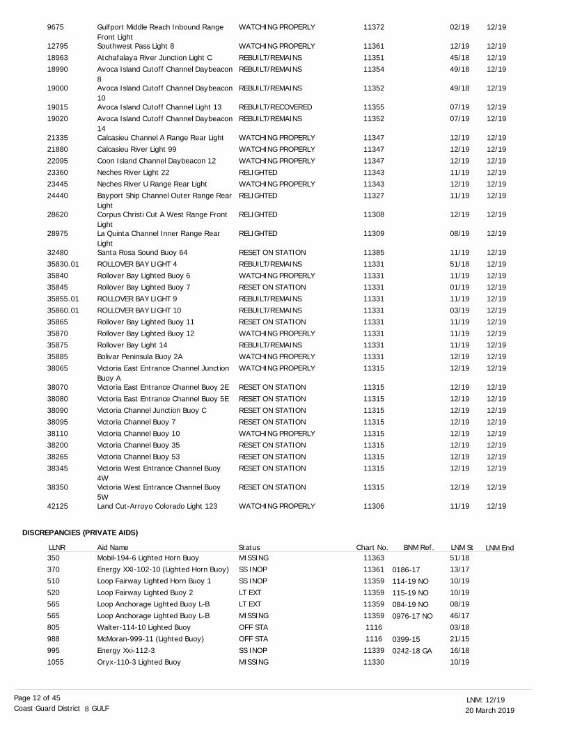
Gulfport Middle Reach Inbound Range Front LightSouthwest Pass Light 8
Atchafalaya River Junction Light CAvoca Island Cutoff Channel Daybeacon8Avoca Island Cutoff Channel Daybeacon10Avoca Island Cutoff Channel Light 13
Avoca Island Cutoff Channel Daybeacon14Calcasieu Channel A Range Rear Light
Calcasieu River Light 99Coon Island Channel Daybeacon 12
Neches River Light 22
Neches River U Range Rear LightBayport Ship Channel Outer Range RearLightCorpus Christi Cut A West Range Front LightLa Quinta Channel Inner Range Rear LightSanta Rosa Sound Buoy 64
ROLLOVER BAY LIGHT 4
Rollover Bay Lighted Buoy 6Rollover Bay Lighted Buoy 7
ROLLOVER BAY LIGHT 9
ROLLOVER BAY LIGHT 10Rollover Bay Lighted Buoy 11
Rollover Bay Lighted Buoy 12
Rollover Bay Light 14Bolivar Peninsula Buoy 2A
Victoria East Entrance Channel Junction Buoy AVictoria East Entrance Channel Buoy 2E
Victoria East Entrance Channel Buoy 5EVictoria Channel Junction Buoy C
Victoria Channel Buoy 7
Victoria Channel Buoy 10Victoria Channel Buoy 35
Victoria Channel Buoy 53
Victoria West Entrance Channel Buoy 4WVictoria West Entrance Channel Buoy 5WLand Cut-Arroyo Colorado Light 123
Mobil-194-6 Lighted Horn BuoyEnergy XXI-102-10 (Lighted Horn Buoy)
Loop Fairway Lighted Horn Buoy 1
Loop Fairway Lighted Buoy 2Loop Anchorage Lighted Buoy L-B
Loop Anchorage Lighted Buoy L-B
Walter-114-10 Lighted BuoyMcMoran-999-11 (Lighted Buoy)
Energy Xxi-112-3
Oryx-110-3 Lighted Buoy
WATCHING PROPERLY
WATCHING PROPERLY
REBUILT/REMAINSREBUILT/REMAINS
REBUILT/REMAINS
REBUILT/RECOVERED
REBUILT/REMAINS
WATCHING PROPERLY
WATCHING PROPERLYWATCHING PROPERLY
RELIGHTED
WATCHING PROPERLYRELIGHTED
RELIGHTED
RELIGHTED
RESET ON STATION
REBUILT/REMAINS
WATCHING PROPERLYRESET ON STATION
REBUILT/REMAINS
REBUILT/REMAINSRESET ON STATION
WATCHING PROPERLY
REBUILT/REMAINSWATCHING PROPERLY
WATCHING PROPERLY
RESET ON STATION
RESET ON STATIONRESET ON STATION
RESET ON STATION
WATCHING PROPERLYRESET ON STATION
RESET ON STATION
RESET ON STATION
RESET ON STATION
WATCHING PROPERLY
MISSINGSS INOP
SS INOP
LT EXTLT EXT
MISSING
OFF STAOFF STA
SS INOP
MISSING
02/19
12/19
45/1849/18
49/18
07/19
07/19
12/19
12/1912/19
11/19
12/1911/19
12/19
08/19
11/19
51/18
11/1901/19
11/19
03/1911/19
11/19
11/1912/19
12/19
12/19
12/1912/19
12/19
12/1912/19
12/19
12/19
12/19
11/19
51/1813/17
10/19
10/1908/19
46/17
03/1821/15
16/18
10/19
12/19
12/19
12/1912/19
12/19
12/19
12/19
12/19
12/1912/19
12/19
12/1912/19
12/19
12/19
12/19
12/19
12/1912/19
12/19
12/1912/19
12/19
12/1912/19
12/19
12/19
12/1912/19
12/19
12/1912/19
12/19
12/19
12/19
12/19
11372
11361
1135111354
11352
11355
11352
11347
1134711347
11343
1134311327
11308
11309
11385
11331
1133111331
11331
1133111331
11331
1133111331
11315
11315
1131511315
11315
1131511315
11315
11315
11315
11306
1136311361
11359
1135911359
11359
11161116
11339
11330
9675
12795
1896318990
19000
19015
19020
21335
2188022095
23360
2344524440
28620
28975
32480
35830.01
3584035845
35855.01
35860.0135865
35870
3587535885
38065
38070
3808038090
38095
3811038200
38265
38345
38350
42125
350370
510
520565
565
805988
995
1055
0186-17
114-19 NO115-19 NO
084-19 NO
0976-17 NO
0399-15
0242-18 GA
20 March 201912/19LNM:
8Coast Guard District GULFPage 13 of 45
Exxon-HI-176-B RACON
Texas A & M Lighted Oceanographic Buoy JFR-TX-58 Special Lighted BuoyShell Point Channel Daybeacon 1
Port St Joe Marina Entrance Light 2
Port St Joe Marina Entrance Light 1Gulf Power Electrical Tower Danger Lights(2)Gulf Power Electrical Tower Danger Lights (2)Fannin Bayou Channel Junction Daybeacon AWest Grand Lagoon Channel Daybeacon4West Grand Lagoon Channel Daybeacon14West Grand Lagoon Channel Daybeacon16Bayou Texar Daybeacon 3A
Bayou Texar Daybeacon 9A
Bayou Texar Daybeacon 15ASpoil Bank Light 1
Mississippi Gulf Fish Reef Light A
Pascagoula River Obstruction Lighted Buoy 2Pascagoula River Obstruction Lighted Buoy 4Mississippi Gulf Fish Reef Light B
Graveline Bayou Channel Daybeacon 7
Graveline Bayou Channel Daybeacon 9Graveline Bayou Channel Daybeacon 12
Deer Island Breakwater Southeast Danger LightDeer Island Breakwater Danger Light
Deer Island Breakwater Danger LightDeer Island Breakwater Danger Light
Deer Island Breakwater Danger Light
Deer Island Breakwater Danger LightDeer Island Breakwater Danger Light
Deer Island Breakwater Danger Light
Deer Island Breakwater Danger LightDeer Island Breakwater Northwest Danger LightDavis Bayou Channel Light 2
Davis Bayou Channel Daybeacon 24
Point Cadet Marina Breakwater Light 1Point Cadet Marina Breakwater Daybeacon 2Point Cadet Marina Breakwater Light 3
Point Cadet Marina Breakwater Daybeacon 4Point Cadet Marina Breakwater Light 5
Point Cadet Marina Breakwater Daybeacon 6Old Fort Bayou Channel Daybeacon 7Old Fort Bayou Channel Daybeacon 9
Mississippi Gulf Fishing Reef Light B
Mississippi Gulf Fishing Reef Light CEden Isles Channel Daybeacon 1
Eden Isles Channel Daybeacon 2
LT EXT
OFF STA
OFF STADAYMK MISSING
DAYMK DMGD
DAYMK DMGDLT EXT
LT EXT
STRUCT DEST
LT EXT
MISSING
STRUCT DEST
STRUCT DEST
STRUCT DEST
DAYMK DMGDLT EXT
STRUCT DEST
MISSING
OFF STA/LT EXT
MISSING
STRUCT DMGD
STRUCT DMGDSTRUCT DMGD
MISSING
MISSING
MISSINGMISSING
MISSING
MISSINGMISSING
MISSING
MISSINGMISSING
LT EXT/STRUCT DMGD
OFF STA
OFF STAOFF STA
LT EXT/STRUCT DMGD
OFF STA
OFF STA
OFF STA
OFF STASTRUCT DEST
STRUCT DEST
MISSINGMISSING
STRUCT DEST
08/19
01/17
13/1822/17
22/15
22/1550/17
50/17
02/19
11/19
41/18
40/18
13/17
19/18
11/1739/17
15/18
19/17
19/17
33/14
48/16
48/1648/16
03/18
03/18
03/1803/18
03/18
03/1803/18
03/18
03/1803/18
07/16
14/15
50/1850/18
44/17
50/18
50/18
50/18
28/1815/17
15/18
33/1406/17
48/16
11323
11356
1130111405
11393
1139311391
11391
11390
11391
11391
11391
11383
11383
1138311373
11374
11375
11375
11374
11374
1137411374
11372
11372
1137211372
11372
1137211372
11372
1137211372
11372
11372
1137211372
11372
11372
11372
11372
1137211372
11372
1137211369
11369
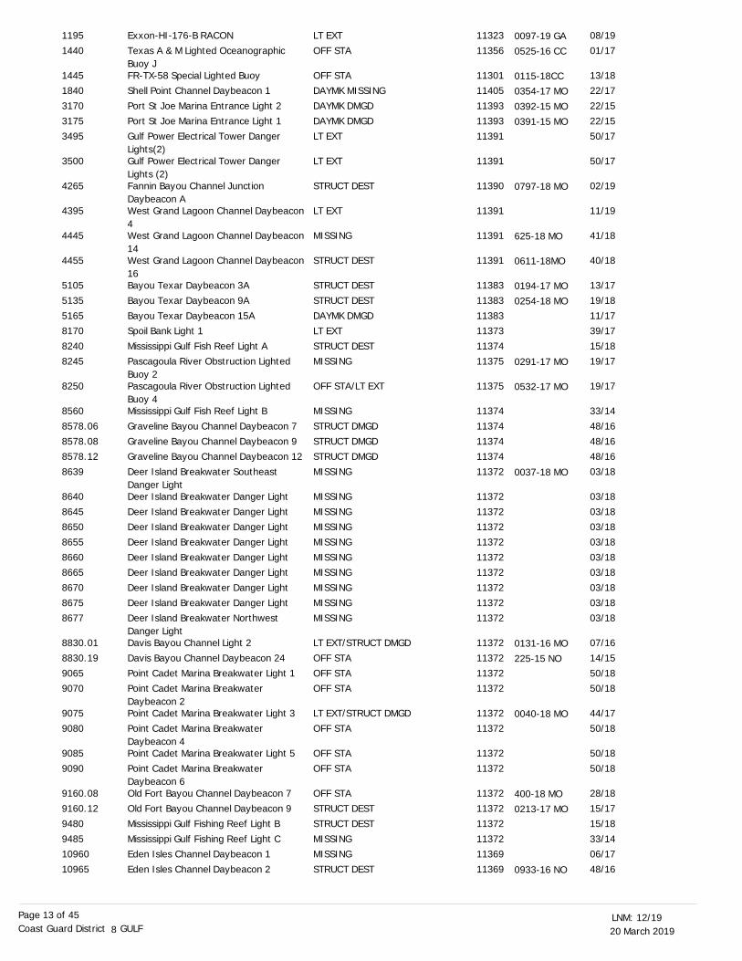
1195
1440
14451840
3170
31753495
3500
4265
4395
4445
4455
5105
5135
51658170
8240
8245
8250
8560
8578.06
8578.088578.12
8639
8640
86458650
8655
86608665
8670
86758677
8830.01
8830.19
90659070
9075
9080
9085
9090
9160.089160.12
9480
948510960
10965
0097-19 GA
0525-16 CC
0115-18CC0354-17 MO
0392-15 MO
0391-15 MO
0797-18 MO
625-18 MO
0611-18MO
0194-17 MO
0254-18 MO
0291-17 MO
0532-17 MO
0037-18 MO
0131-16 MO
225-15 NO
0040-18 MO
400-18 MO0213-17 MO
0933-16 NO
20 March 201912/19LNM:
8Coast Guard District GULFPage 14 of 45
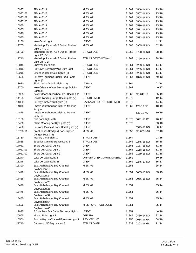
FR-LA-71-A
FR-LA-71-BFR-LA-71-C
FR-LA-71-D
FR-LA-70-AFR-LA-70-B
FR-LA-70-C
FR-LA-70-DNew Canal Light
Mississippi River - Gulf Outlet Pipeline Light 27 (C-1)Mississippi River - Gulf Outlet Pipeline Light 27 (C-1)Mississippi River - Gulf Outlet Pipeline Light 28 (C-2)Chevron Pier Light
Pilottown Terminal Wing Dam LightEmpire Water Intake Lights (2)
Entergy Louisiana Submerged Cable Lights (2)Shell Intake Dolphin Lights (3)
New Orleans Water Discharge Dolphin Lights (4)New Orleans Steamboat Co. Dock LightLasalle Landing Barge Dock Lights (2)
Entergy Waterford Lights (3)
Impala Warehousing Lighted Mooring Buoy AImpala Warehousing Lighted Mooring Buoy BOlin Dock Lights (3)Placid Mooring Facility Lights (5)
Formosa Plastics Lower Dock Lights (2)
Great Lakes Dredge & Dock Lighted Danger Buoys (4)Meyers Canal Light 1Superior Canal Entrance Light 2
Short Cut Canal Light 1
Short Cut Canal Light 2Short Cut Canal Light 3
Lake De Cade Light 2
Lake De Cade Light 28East Atchafalaya Bay Channel Daybeacon 16East Atchafalaya Bay Channel Daybeacon 24East Atchafalaya Bay Channel Daybeacon 26East Atchafalaya Bay Channel Daybeacon 28East Atchafalaya Bay Channel Daybeacon 52East Atchafalaya Bay Channel Daybeacon 54East Atchafalaya Bay Channel Daybeacon 66E Cote Blan Bay Canal Entrance Light 1
Mound Point Light 1Boston Bayou Channel Entrance Light 1
Cameron LNG Daybeacon B
MISSING
MISSINGMISSING
MISSING
MISSINGMISSING
MISSING
MISSINGLT EXT
MISSING
STRUCT DEST
STRUCT DEST/HAZ NAV
STRUCT DEST
STRUCT DESTSTRUCT DEST
LT EXT
LT IMCH
LT EXT
LT EXTSTRUCT DMGD
HAZ NAV/LT EXT/STRUCT DMGD
LT EXT
LT EXT
LT EXTLT EXT
LT EXT
MISSING
STRUCT DESTSTRUCT DEST
LT EXT
LT EXTLT EXT
OFF STA/LT EXT/DAYMK MISSING
LT EXTMISSING
MISSING
MISSING
MISSING
MISSING
MISSING
MISSING//STRUCT DMGD
LT EXT
OFF STAREDUCED INT
STRUCT DMGD
23/16
23/1623/16
23/16
23/1623/16
23/16
23/1641/11
52/18
38/16
38/16
14/17
14/1714/17
49/13
02/14
40/17
05/1912/14
44/14
10/19
10/19
46/1733/18
30/17
37/18
03/1515/18
11/18
11/1811/18
50/15
15/1735/14
03/15
35/14
35/14
35/14
35/14
35/14
46/16
22/1408/19
11/14
11369
1136911369
11369
1136911369
11369
1136911369
11363
11363
11363
11361
1136111364
11364
11364
11367
1136811370
11370
11369
1137011370
11358
1136411365
11355
1135511355
11352
1135211351
11351
11351
11351
11351
11351
11351
11351
1134911350
11339
10977
10977.0110977.02
10977.03
1098010985
10990
1099511180
11705
11705
11710
12845
1301513215
13505
13680
13700
1396514105
14360
14870
14875
1510015400
15420
15728.11
1573016835
17911
17911.0117911.02
18240
1824518390
18410
18415
18420
18475
18480
18505
19835
2006520560
21710
0506-16 NO
0507-16 NO0508-16 NO
0509-16 NO
0510-16 NO0511-16 NO
0512-16 NO
0513-16 NO
0905-18 NO
0768-16 NO
0769-16 NO
0203-17 NO
0205-17 NO0206-17 NO
1376-13 NO
NO 047-19
122-19 NO
122-19 NO
0091-17 D8
0599-17 NONO 0631-18
0245-18 NO
0167-18 NO0168-18 NO
0169-18 NO
0245-17 NO
0055-15 NO
0056-15 NO
0460-14 NO0084-19 GA
0203-14 GA
20 March 201912/19LNM:
8Coast Guard District GULFPage 15 of 45
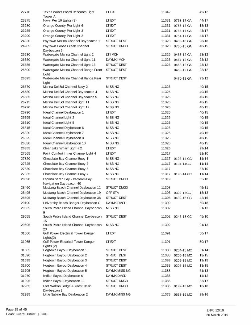
Texas Water Board Research Light Tower ANavy Pier 10 Lights (2)
Orange County Pier Light 6Orange County Pier Light 3
Orange County Pier Light 2
Baytown Marina Channel Daybeacon 1Baytown Goose Creek Channel Daybeacon 6Watergate Marina Channel Light 2
Watergate Marina Channel Light 11
Watergate Marina Channel Light 13Watergate Marina Channel Range Front LightWatergate Marina Channel Range Rear LightMarina Del Sol Channel Buoy 2
Marina Del Sol Channel Daybeacon 4
Marina Del Sol Channel Daybeacon 5Marina Del Sol Channel Light 11
Marina Del Sol Channel Light 12
Ideal Channel Daybeacon 1Ideal Channel Light 2
Ideal Channel Light 5
Ideal Channel Daybeacon 6Ideal Channel Daybeacon 7
Ideal Channel Daybeacon 8
Ideal Channel Daybeacon 10Clear Lake Wharf Light #2
Point Comfort Inner Channel Light 4
Chocolate Bay Channel Buoy 1Chocolate Bay Channel Buoy 3
Chocolate Bay Channel Buoy 5
Chocolate Bay Channel Buoy 7Espiritu Santo Bay - Barroom Bay Navigation Daybeacon 40Mustang Beach Channel Daybeacon 11
Mustang Beach Channel Daybeacon 19
Mustang Beach Channel Daybeacon 38University Beach Danger Daybeacon C
South Padre Island Channel Daybeacon 9South Padre Island Channel Daybeacon 15South Padre Island Channel Daybeacon 23Gulf Power Electrical Tower Danger Lights(2)Gulf Power Electrical Tower Danger Lights (2)Hogtown Bayou Daybeacon 1
Hogtown Bayou Daybeacon 2Hogtown Bayou Daybeacon 3
Hogtown Bayou Daybeacon 4
Hogtown Bayou Daybeacon 5Indian Bayou Daybeacon 6
Indian Bayou Daybeacon 11
Fort Walton Lodge & Yacht Basin Daybeacon 2Little Sabine Bay Daybeacon 2
LT EXT
LT EXT
LT EXTLT EXT
LT EXT
STRUCT DESTSTRUCT DMGD
LT IMCH
DAYMK IMCH
STRUCT DESTSTRUCT DEST
STRUCT DEST
MISSING
MISSING
MISSINGMISSING
MISSING
LT EXTMISSING
MISSING
MISSINGMISSING
MISSING
MISSINGLT EXT
LT EXT
MISSINGMISSING
MISSING
MISSINGSTRUCT DMGD
STRUCT DMGD
OFF STA
STRUCT DESTDAYMK DMGD
MISSING
STRUCT DEST
MISSING
LT EXT
LT EXT
STRUCT DEST
STRUCT DESTSTRUCT DEST
STRUCT DEST
DAYMK MISSINGDAYMK DMGD
STRUCT DMGD
STRUCT DMGD
DAYMK MISSING
49/12
44/17
18/1343/17
44/17
28/1848/15
23/12
23/12
23/1223/12
23/12
40/15
40/15
40/1540/15
40/15
40/1540/15
40/15
40/1540/15
40/15
40/1529/14
31/10
11/1411/14
37/10
11/1435/18
45/11
18/13
42/1650/18
01/13
45/10
01/13
50/17
50/17
31/14
13/1513/15
13/15
51/1314/12
33/17
16/18
29/16
11342
11331
1133111331
11331
1132811328
11326
11326
11326
11326
11326
1132611326
11326
1132611326
11326
1132611326
11326
1132611326
11317
1131711317
11317
1131711319
11308
11308
1130811309
11302
11302
11302
11391
11391
11388
1138811388
11388
1138811385
11385
11385
11378
22770
23275
2328023285
23290
2482024905
26530
26580
2658526590
26595
26670
26680
2668526715
26720
2679026795
26810
2681526820
26825
2683026855
27665
2782027825
27830
2783528090
28460
28495
2859529190
29635
29655
29695
31060
31065
31685
3169031695
31700
3170531970
31995
32265
32985
0753-17 GA
0756-17 GA0755-17 GA
0754-17 GA
0433-18 GA0766-15 GA
0465-12 GA
0467-12 GA
0468-12 GA0469-12 GA
0470-12 GA
0193-14 CC0194-14CC
0195-14 CC
0302-13CC
0439-16 CC
0246-18 CC
0204-15 MO0205-15 MO
0206-15 MO
0207-15 MO
0192-18 MO
0633-16 MO
20 March 201912/19LNM:
8Coast Guard District GULFPage 16 of 45
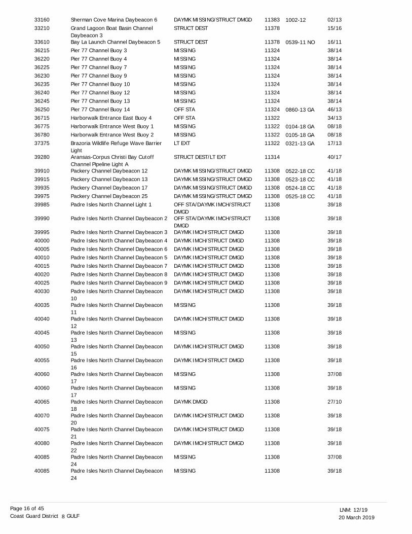
Sherman Cove Marina Daybeacon 6
Grand Lagoon Boat Basin Channel Daybeacon 3Bay La Launch Channel Daybeacon 5Pier 77 Channel Buoy 3
Pier 77 Channel Buoy 4
Pier 77 Channel Buoy 7Pier 77 Channel Buoy 9
Pier 77 Channel Buoy 10
Pier 77 Channel Buoy 12Pier 77 Channel Buoy 13
Pier 77 Channel Buoy 14
Harborwalk Entrance East Buoy 4Harborwalk Entrance West Buoy 1
Harborwalk Entrance West Buoy 2
Brazoria Wildlife Refuge Wave Barrier LightAransas-Corpus Christi Bay Cutoff Channel Pipeline Light APackery Channel Daybeacon 12Packery Channel Daybeacon 13
Packery Channel Daybeacon 17
Packery Channel Daybeacon 25Padre Isles North Channel Light 1
Padre Isles North Channel Daybeacon 2
Padre Isles North Channel Daybeacon 3
Padre Isles North Channel Daybeacon 4
Padre Isles North Channel Daybeacon 6Padre Isles North Channel Daybeacon 5
Padre Isles North Channel Daybeacon 7
Padre Isles North Channel Daybeacon 8Padre Isles North Channel Daybeacon 9
Padre Isles North Channel Daybeacon 10Padre Isles North Channel Daybeacon 11Padre Isles North Channel Daybeacon 12Padre Isles North Channel Daybeacon 13Padre Isles North Channel Daybeacon 15Padre Isles North Channel Daybeacon 16Padre Isles North Channel Daybeacon 17Padre Isles North Channel Daybeacon 17Padre Isles North Channel Daybeacon 18Padre Isles North Channel Daybeacon 20Padre Isles North Channel Daybeacon 21Padre Isles North Channel Daybeacon 22Padre Isles North Channel Daybeacon 24Padre Isles North Channel Daybeacon 24
DAYMK MISSING/STRUCT DMGD
STRUCT DEST
STRUCT DESTMISSING
MISSING
MISSINGMISSING
MISSING
MISSINGMISSING
OFF STA
OFF STAMISSING
MISSING
LT EXT
STRUCT DEST/LT EXT
DAYMK MISSING/STRUCT DMGDDAYMK MISSING/STRUCT DMGD
DAYMK MISSING/STRUCT DMGD
DAYMK MISSING/STRUCT DMGDOFF STA/DAYMK IMCH/STRUCT DMGDOFF STA/DAYMK IMCH/STRUCT DMGDDAYMK IMCH/STRUCT DMGD
DAYMK IMCH/STRUCT DMGD
DAYMK IMCH/STRUCT DMGDDAYMK IMCH/STRUCT DMGD
DAYMK IMCH/STRUCT DMGD
DAYMK IMCH/STRUCT DMGDDAYMK IMCH/STRUCT DMGD
DAYMK IMCH/STRUCT DMGD
MISSING
DAYMK IMCH/STRUCT DMGD
MISSING
DAYMK IMCH/STRUCT DMGD
DAYMK IMCH/STRUCT DMGD
MISSING
MISSING
DAYMK DMGD
DAYMK IMCH/STRUCT DMGD
DAYMK IMCH/STRUCT DMGD
DAYMK IMCH/STRUCT DMGD
MISSING
MISSING
02/13
15/16
16/1138/14
38/14
38/1438/14
38/14
38/1438/14
46/13
34/1308/18
08/18
17/13
40/17
41/1841/18
41/18
41/1839/18
39/18
39/18
39/18
39/1839/18
39/18
39/1839/18
39/18
39/18
39/18
39/18
39/18
39/18
37/08
39/18
27/10
39/18
39/18
39/18
37/08
39/18
11383
11378
1137811324
11324
1132411324
11324
1132411324
11324
1132211322
11322
11322
11314
1130811308
11308
1130811308
11308
11308
11308
1130811308
11308
1130811308
11308
11308
11308
11308
11308
11308
11308
11308
11308
11308
11308
11308
11308
11308
33160
33210
3361036215
36220
3622536230
36235
3624036245
36250
3671536775
36780
37375
39280
3991039915
39935
3997539985
39990
39995
40000
4000540010
40015
4002040025
40030
40035
40040
40045
40050
40055
40060
40060
40065
40070
40075
40080
40085
40085
1002-12
0539-11 NO
0860-13 GA
0104-18 GA
0105-18 GA
0321-13 GA
0522-18 CC0523-18 CC
0524-18 CC
0525-18 CC
20 March 201912/19LNM:
8Coast Guard District GULFPage 17 of 45
DISCREPANCIES (PRIVATE AIDS) CORRECTED
LNM EndLLNR Aid Name Status Chart No. BNM Ref. LNM St
Padre Isles South Channel Light 1
Padre Isles South Channel Daybeacon 2Padre Isles South Channel Daybeacon 3
Padre Isles South Channel Daybeacon 5
Padre Isles South Channel Daybeacon 7
Padre Isles South Channel Daybeacon 8Padre Isles South Channel Daybeacon 9
Padre Isles South Channel Daybeacon 10Padre Isles South Channel Daybeacon 11Padre Isles South Channel Daybeacon 13Padre Isles South Channel Daybeacon 14Anadarko Temporary Lighted Danger Buoy
MISSING
MISSINGDAYMK IMCH/STRUCT DMGD
DAYMK IMCH/STRUCT DMGD
OFF STA/DAYMK IMCH/STRUCT DMGDDAYMK IMCH/STRUCT DMGDDAYMK IMCH/STRUCT DMGD
DAYMK IMCH/STRUCT DMGD
DAYMK IMCH/STRUCT DMGD
DAYMK IMCH/STRUCT DMGD
DAYMK IMCH/STRUCT DMGD
MISSING
39/18
39/1839/18
39/18
39/18
39/1839/18
39/18
39/18
39/18
39/18
40/18
11308
1130811308
11308
11308
1130811308
11308
11308
11308
11308
11353
40145
4015040155
40160
40165
4017040175
40180
40185
40190
40195
None
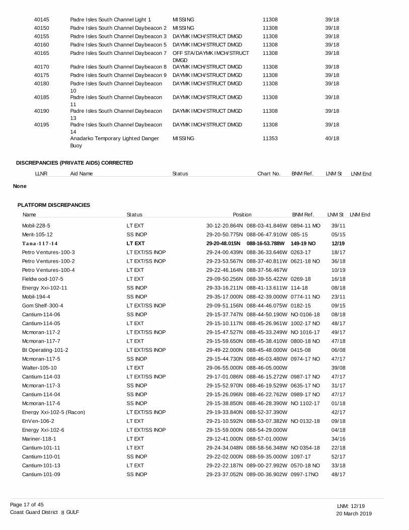
PLATFORM DISCREPANCIES
LT EXTSS INOPLT EXTLT EXT/SS INOPLT EXT/SS INOPLT EXTLT EXTSS INOPSS INOPLT EXT/SS INOPSS INOPLT EXTLT EXT/SS INOPLT EXTLT EXT/SS INOPSS INOPLT EXTLT EXT/SS INOPSS INOPSS INOPSS INOPLT EXT/SS INOPLT EXTLT EXT/SS INOP
LT EXTLT EXTSS INOPLT EXTSS INOP
30-12-20.864N29-20-50.775N29-20-48.015N29-24-00.439N29-23-53.567N29-22-46.164N29-09-50.256N29-33-16.211N29-35-17.000N29-09-51.156N29-15-37.747N29-15-10.117N29-15-47.527N29-15-59.650N29-49-22.000N29-15-44.730N29-06-55.000N29-17-01.086N29-15-52.970N29-15-26.096N29-15-38.850N29-19-33.840N29-21-10.592N29-15-59.000N
29-12-41.000N29-24-34.048N29-22-02.000N29-22-22.187N29-23-37.052N
088-03-41.846W088-06-47.910W088-16-53.788W088-36-33.646W088-37-40.811W088-37-56.467W088-39-55.422W088-41-13.611W088-42-39.000W088-44-46.075W088-44-50.190W088-45-26.961W088-45-33.249W088-45-38.410W088-45-48.000W088-46-03.480W088-46-05.000W088-46-15.272W088-46-19.529W088-46-22.762W088-46-28.390W088-52-37.390W088-53-07.382W088-54-29.000W088-57-01.000W088-58-56.348W088-59-35.000W089-00-27.992W089-00-36.902W
0894-11 MO
085-15
149-19 NO0263-17
0621-18 NO
0269-18
114-18
0774-11 NO
0182-15
NO 0106-18
1002-17 NO
NO 1016-17
0800-18 NO
0415-08
0974-17 NO
0987-17 NO
0635-17 NO
0989-17 NO
NO 1102-17
NO 0132-18
NO 0354-18
1097-17
0570-18 NO
0997-17NO
Name Status Position BNM Ref.
39/11
05/15
12/1918/17
36/18
10/19
16/18
08/18
23/11
09/15
08/18
48/17
49/17
47/18
06/08
47/17
39/08
47/17
31/17
47/17
01/18
42/17
09/18
04/18
34/16
22/18
52/17
33/18
48/17
LNM St LNM End
Mobil-228-5Merit-105-12Tana-117-14
Petro Ventures-100-3Petro Ventures-100-2Petro Ventures-100-4Fieldwood-107-5Energy Xxi-102-11Mobil-194-4Gom Shelf-300-4Cantium-114-06Cantium-114-05Mcmoran-117-2Mcmoran-117-7Bt Operating-101-2Mcmoran-117-5Walter-105-10Cantium-114-03Mcmoran-117-3Cantium-114-04Mcmoran-117-6Energy Xxi-102-5 (Racon)EnVen-106-2Energy Xxi-102-6
Mariner-118-1Cantium-101-11Cantium-110-01Cantium-101-13Cantium-101-09
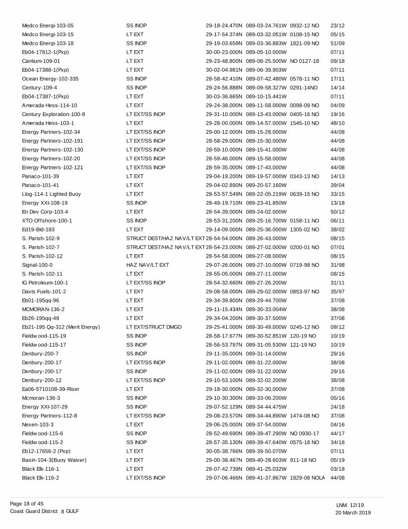
20 March 201912/19LNM:
8Coast Guard District GULFPage 18 of 45
SS INOPLT EXTSS INOPLT EXTLT EXTLT EXTSS INOPSS INOPLT EXTLT EXTLT EXT/SS INOPLT EXTLT EXT/SS INOPLT EXT/SS INOPLT EXT/SS INOPLT EXT/SS INOPLT EXT/SS INOPLT EXTLT EXTLT EXTSS INOPLT EXTSS INOPLT EXTSTRUCT DEST/HAZ NAV/LT EXTSTRUCT DEST/HAZ NAV/LT EXTLT EXTHAZ NAV/LT EXTLT EXTLT EXT/SS INOPLT EXTLT EXTLT EXTLT EXTLT EXT/STRUCT DMGDSS INOPSS INOPSS INOPLT EXT/SS INOPSS INOPLT EXT/SS INOPLT EXTSS INOPSS INOPLT EXT/SS INOPLT EXTSS INOPSS INOPLT EXTLT EXTLT EXTLT EXT/SS INOP
29-18-24.470N29-17-54.374N29-19-03.659N30-00-23.000N29-23-48.800N30-02-04.981N28-58-42.410N29-24-56.888N30-03-36.865N29-24-38.000N29-31-10.000N29-28-00.000N29-00-12.000N28-58-29.000N28-59-10.000N28-59-46.000N28-59-35.000N29-04-19.200N29-04-02.890N28-53-57.549N28-49-19.710N28-54-39.000N28-53-31.200N29-14-09.000N28-54-54.000N28-54-23.000N28-54-58.000N29-07-26.000N28-55-05.000N28-54-32.660N29-08-58.000N29-34-39.800N29-11-15.434N29-34-04.200N29-25-41.000N28-58-17.677N28-56-53.797N29-11-35.000N29-11-02.000N29-11-02.000N29-10-53.100N29-18-30.000N29-10-30.300N29-07-52.129N29-08-23.570N29-06-25.000N28-52-49.690N28-57-35.130N30-05-38.766N29-00-38.467N29-07-42.739N29-07-06.466N
089-03-24.761W089-03-32.051W089-03-36.883W089-05-10.000W089-06-25.500W089-06-39.903W089-07-42.480W089-09-58.327W089-10-15.441W089-11-58.000W089-13-43.000W089-14-57.000W089-15-28.000W089-15-30.000W089-15-41.000W089-15-58.000W089-17-43.000W089-19-57.000W089-20-57.160W089-22-05.219W089-23-41.850W089-24-02.000W089-25-16.700W089-25-36.000W089-26-43.000W089-27-02.000W089-27-08.000W089-27-10.000W089-27-11.000W089-27-26.200W089-29-02.000W089-29-44.700W089-30-33.004W089-30-37.500W089-30-49.000W089-30-52.851W089-31-05.530W089-31-14.000W089-31-22.000W089-31-22.000W089-32-02.200W089-32-30.000W089-33-06.200W089-34-44.475W089-34-44.890W089-37-54.000W089-39-47.290W089-39-47.640W089-39-50.070W089-40-28.603W089-41-25.032W089-41-37.867W
0932-12 NO
0108-15 NO
1821-09 NO
NO 0127-18
0578-11 NO
0291-14NO
0098-09 NO
0405-16 NO
1545-10 NO
0343-13 NO
0639-15 NO
0158-11 NO
1305-02 NO
0200-01 NO
0719-98 NO
0853-97 NO
0245-12 NO
120-19 NO
121-19 NO
1474-08 NO
NO 0930-17
0575-18 NO
911-18 NO
1829-08 NOLA
23/12
05/15
51/09
07/11
09/18
07/11
17/11
14/14
07/11
04/09
19/16
48/10
44/08
44/08
44/08
44/08
44/08
14/13
39/04
33/15
13/18
50/12
06/11
38/02
08/15
07/01
08/15
31/98
08/15
31/11
35/97
37/08
38/08
37/08
09/12
10/19
10/19
29/16
38/08
29/16
38/08
37/08
05/16
24/18
37/08
04/16
44/17
34/18
07/11
05/19
03/18
44/08
Medco Energi-103-05Medco Energi-103-15Medco Energi-103-18Eb04-17812-1(Pxp)Cantium-109-01Eb04-17388-1(Pxp)Ocean Energy-102-335Century-109-4Eb04-17387-1(Pxp)Amerada Hess-114-10Century Exploration-100-8Amerada Hess-103-1Energy Partners-102-34Energy Partners-102-191Energy Partners-102-130Energy Partners-102-20Energy Partners-102-121Panaco-101-39Panaco-101-41Llog-114-1 Lighted BuoyEnergy XXI-108-19En Dev Corp-103-4XTO Offshore-100-1Ed19-Bld-183S. Parish-102-9S. Parish-102-7S. Parish-102-12Signal-100-0S. Parish-102-11IG Petroleum-100-1Davis Fuels-101-2Eb01-195qq-96MCMORAN-136-2Eb26-195qq-49Eb21-195 Qq-312 (Merit Energy)Fieldwood-115-19Fieldwood-115-17Denbury-200-7Denbury-200-17Denbury-200-17Denbury-200-12Ea06-5710108-39-RiserMcmoran-136-3Energy XXI-107-29Energy Partners-112-8Nexen-103-3Fieldwood-115-6Fieldwood-115-2Eb12-17656-2 (Pxp)Basin-104-3(Buoy Waiver)Black Elk-116-1Black Elk-116-2
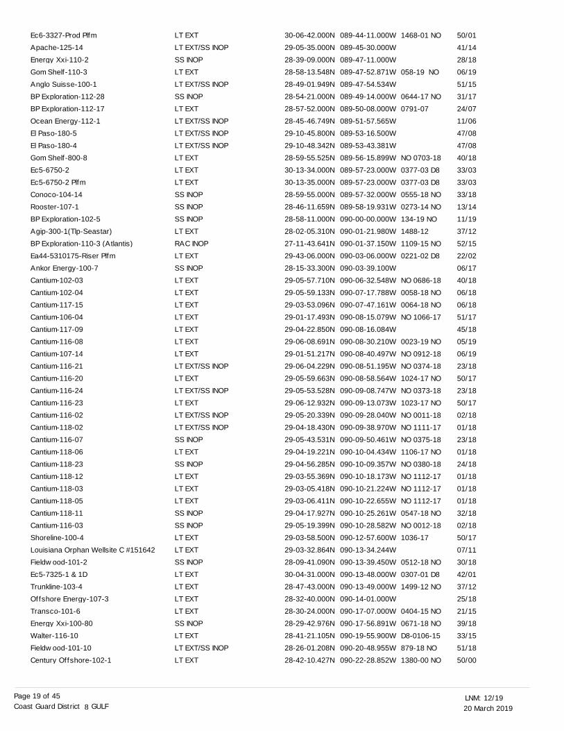
20 March 201912/19LNM:
8Coast Guard District GULFPage 19 of 45
LT EXTLT EXT/SS INOPSS INOPLT EXTLT EXT/SS INOPSS INOPLT EXTLT EXT/SS INOPLT EXT/SS INOPLT EXT/SS INOPLT EXTLT EXTLT EXTSS INOPSS INOPSS INOPLT EXTRAC INOPLT EXTSS INOPLT EXTLT EXTLT EXTLT EXTLT EXTLT EXTLT EXTLT EXT/SS INOPLT EXTLT EXT/SS INOPLT EXTLT EXT/SS INOPLT EXT/SS INOPSS INOPLT EXTSS INOPLT EXTLT EXTLT EXTSS INOPSS INOPLT EXTLT EXTSS INOPLT EXTLT EXTLT EXTLT EXTSS INOPLT EXTLT EXT/SS INOPLT EXT
30-06-42.000N29-05-35.000N28-39-09.000N28-58-13.548N28-49-01.949N28-54-21.000N28-57-52.000N28-45-46.749N29-10-45.800N29-10-48.342N28-59-55.525N30-13-34.000N30-13-35.000N28-59-55.000N28-46-11.659N28-58-11.000N28-02-05.310N27-11-43.641N29-43-06.000N28-15-33.300N29-05-57.710N29-05-59.133N29-03-53.096N29-01-17.493N29-04-22.850N29-06-08.691N29-01-51.217N29-06-04.229N29-05-59.663N29-05-53.528N29-06-12.932N29-05-20.339N29-04-18.430N29-05-43.531N29-04-19.221N29-04-56.285N29-03-55.369N29-03-05.418N29-03-06.411N29-04-17.927N29-05-19.399N29-03-58.500N29-03-32.864N28-09-41.090N30-04-31.000N28-47-43.000N28-32-40.000N28-30-24.000N28-29-42.976N28-41-21.105N28-26-01.208N28-42-10.427N
089-44-11.000W089-45-30.000W089-47-11.000W089-47-52.871W089-47-54.534W089-49-14.000W089-50-08.000W089-51-57.565W089-53-16.500W089-53-43.381W089-56-15.899W089-57-23.000W089-57-23.000W089-57-32.000W089-58-19.931W090-00-00.000W090-01-21.980W090-01-37.150W090-03-06.000W090-03-39.100W090-06-32.548W090-07-17.788W090-07-47.161W090-08-15.079W090-08-16.084W090-08-30.210W090-08-40.497W090-08-51.195W090-08-58.564W090-09-08.747W090-09-13.073W090-09-28.040W090-09-38.970W090-09-50.461W090-10-04.434W090-10-09.357W090-10-18.173W090-10-21.224W090-10-22.655W090-10-25.261W090-10-28.582W090-12-57.600W090-13-34.244W090-13-39.450W090-13-48.000W090-13-49.000W090-14-01.000W090-17-07.000W090-17-56.891W090-19-55.900W090-20-48.955W090-22-28.852W
1468-01 NO
058-19 NO
0644-17 NO
0791-07
NO 0703-18
0377-03 D8
0377-03 D8
0555-18 NO
0273-14 NO
134-19 NO
1488-12
1109-15 NO
0221-02 D8
NO 0686-18
0058-18 NO
0064-18 NO
NO 1066-17
0023-19 NO
NO 0912-18
NO 0374-18
1024-17 NO
NO 0373-18
1023-17 NO
NO 0011-18
NO 1111-17
NO 0375-18
1106-17 NO
NO 0380-18
NO 1112-17
NO 1112-17
NO 1112-17
0547-18 NO
NO 0012-18
1036-17
0512-18 NO
0307-01 D8
1499-12 NO
0404-15 NO
0671-18 NO
D8-0106-15
879-18 NO
1380-00 NO
50/01
41/14
28/18
06/19
51/15
31/17
24/07
11/06
47/08
47/08
40/18
33/03
33/03
33/18
13/14
11/19
37/12
52/15
22/02
06/17
40/18
06/18
06/18
51/17
45/18
05/19
06/19
23/18
50/17
23/18
50/17
02/18
01/18
23/18
01/18
24/18
01/18
01/18
01/18
32/18
02/18
50/17
07/11
30/18
42/01
37/12
25/18
21/15
39/18
33/15
51/18
50/00
Ec6-3327-Prod PlfmApache-125-14Energy Xxi-110-2Gom Shelf-110-3Anglo Suisse-100-1BP Exploration-112-28BP Exploration-112-17Ocean Energy-112-1El Paso-180-5El Paso-180-4Gom Shelf-800-8Ec5-6750-2Ec5-6750-2 PlfmConoco-104-14Rooster-107-1BP Exploration-102-5Agip-300-1(Tlp-Seastar)BP Exploration-110-3 (Atlantis)Ea44-5310175-Riser PlfmAnkor Energy-100-7Cantium-102-03Cantium-102-04Cantium-117-15Cantium-106-04Cantium-117-09Cantium-116-08Cantium-107-14Cantium-116-21Cantium-116-20Cantium-116-24Cantium-116-23Cantium-116-02Cantium-118-02Cantium-116-07Cantium-118-06Cantium-118-23Cantium-118-12Cantium-118-03Cantium-118-05Cantium-118-11Cantium-116-03Shoreline-100-4Louisiana Orphan Wellsite C #151642Fieldwood-101-2Ec5-7325-1 & 1DTrunkline-103-4Offshore Energy-107-3Transco-101-6Energy Xxi-100-80Walter-116-10Fieldwood-101-10Century Offshore-102-1
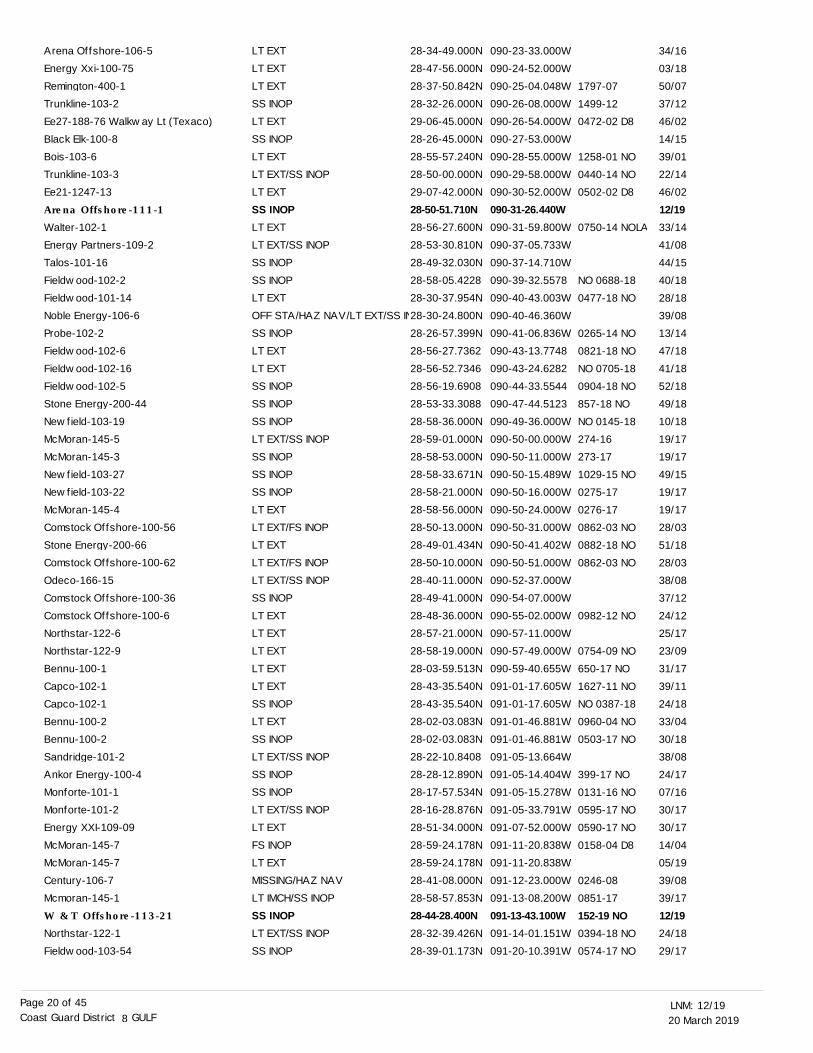
20 March 201912/19LNM:
8Coast Guard District GULFPage 20 of 45
LT EXTLT EXTLT EXTSS INOPLT EXTSS INOPLT EXTLT EXT/SS INOPLT EXTSS INOPLT EXTLT EXT/SS INOPSS INOPSS INOPLT EXTOFF STA/HAZ NAV/LT EXT/SS INSS INOPLT EXTLT EXTSS INOPSS INOPSS INOPLT EXT/SS INOPSS INOPSS INOPSS INOPLT EXTLT EXT/FS INOPLT EXTLT EXT/FS INOPLT EXT/SS INOPSS INOPLT EXTLT EXTLT EXTLT EXTLT EXTSS INOPLT EXTSS INOPLT EXT/SS INOPSS INOPSS INOPLT EXT/SS INOPLT EXTFS INOPLT EXTMISSING/HAZ NAVLT IMCH/SS INOPSS INOPLT EXT/SS INOPSS INOP
28-34-49.000N28-47-56.000N28-37-50.842N28-32-26.000N29-06-45.000N28-26-45.000N28-55-57.240N28-50-00.000N29-07-42.000N28-50-51.710N28-56-27.600N28-53-30.810N28-49-32.030N28-58-05.422828-30-37.954N28-30-24.800N28-26-57.399N28-56-27.736228-56-52.734628-56-19.690828-53-33.308828-58-36.000N28-59-01.000N28-58-53.000N28-58-33.671N28-58-21.000N28-58-56.000N28-50-13.000N28-49-01.434N28-50-10.000N28-40-11.000N28-49-41.000N28-48-36.000N28-57-21.000N28-58-19.000N28-03-59.513N28-43-35.540N28-43-35.540N28-02-03.083N28-02-03.083N28-22-10.840828-28-12.890N28-17-57.534N28-16-28.876N28-51-34.000N28-59-24.178N28-59-24.178N28-41-08.000N28-58-57.853N28-44-28.400N28-32-39.426N28-39-01.173N
090-23-33.000W090-24-52.000W090-25-04.048W090-26-08.000W090-26-54.000W090-27-53.000W090-28-55.000W090-29-58.000W090-30-52.000W090-31-26.440W090-31-59.800W090-37-05.733W090-37-14.710W090-39-32.5578090-40-43.003W090-40-46.360W090-41-06.836W090-43-13.7748090-43-24.6282090-44-33.5544090-47-44.5123090-49-36.000W090-50-00.000W090-50-11.000W090-50-15.489W090-50-16.000W090-50-24.000W090-50-31.000W090-50-41.402W090-50-51.000W090-52-37.000W090-54-07.000W090-55-02.000W090-57-11.000W090-57-49.000W090-59-40.655W091-01-17.605W091-01-17.605W091-01-46.881W091-01-46.881W091-05-13.664W091-05-14.404W091-05-15.278W091-05-33.791W091-07-52.000W091-11-20.838W091-11-20.838W091-12-23.000W091-13-08.200W091-13-43.100W091-14-01.151W091-20-10.391W
1797-07
1499-12
0472-02 D8
1258-01 NO
0440-14 NO
0502-02 D8
0750-14 NOLA
NO 0688-18
0477-18 NO
0265-14 NO
0821-18 NO
NO 0705-18
0904-18 NO
857-18 NO
NO 0145-18
274-16
273-17
1029-15 NO
0275-17
0276-17
0862-03 NO
0882-18 NO
0862-03 NO
0982-12 NO
0754-09 NO
650-17 NO
1627-11 NO
NO 0387-18
0960-04 NO
0503-17 NO
399-17 NO
0131-16 NO
0595-17 NO
0590-17 NO
0158-04 D8
0246-08
0851-17
152-19 NO0394-18 NO
0574-17 NO
34/16
03/18
50/07
37/12
46/02
14/15
39/01
22/14
46/02
12/1933/14
41/08
44/15
40/18
28/18
39/08
13/14
47/18
41/18
52/18
49/18
10/18
19/17
19/17
49/15
19/17
19/17
28/03
51/18
28/03
38/08
37/12
24/12
25/17
23/09
31/17
39/11
24/18
33/04
30/18
38/08
24/17
07/16
30/17
30/17
14/04
05/19
39/08
39/17
12/1924/18
29/17
Arena Offshore-106-5Energy Xxi-100-75Remington-400-1Trunkline-103-2Ee27-188-76 Walkway Lt (Texaco)Black Elk-100-8Bois-103-6Trunkline-103-3Ee21-1247-13Arena Offshore-111-1
Walter-102-1Energy Partners-109-2Talos-101-16Fieldwood-102-2Fieldwood-101-14Noble Energy-106-6Probe-102-2Fieldwood-102-6Fieldwood-102-16Fieldwood-102-5Stone Energy-200-44Newfield-103-19McMoran-145-5McMoran-145-3Newfield-103-27Newfield-103-22McMoran-145-4Comstock Offshore-100-56Stone Energy-200-66Comstock Offshore-100-62Odeco-166-15Comstock Offshore-100-36Comstock Offshore-100-6Northstar-122-6Northstar-122-9Bennu-100-1Capco-102-1Capco-102-1Bennu-100-2Bennu-100-2Sandridge-101-2Ankor Energy-100-4Monforte-101-1Monforte-101-2Energy XXI-109-09McMoran-145-7McMoran-145-7Century-106-7Mcmoran-145-1W & T Offshore-113-21
Northstar-122-1Fieldwood-103-54
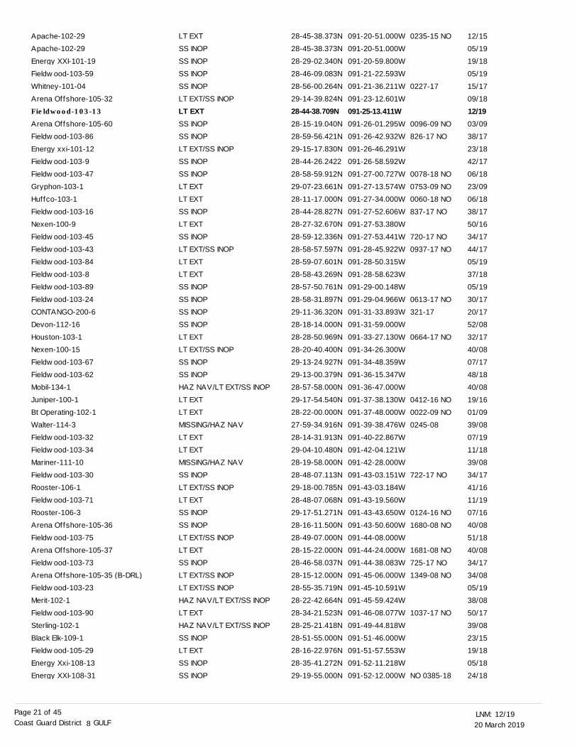
20 March 201912/19LNM:
8Coast Guard District GULFPage 21 of 45
LT EXTSS INOPSS INOPSS INOPSS INOPLT EXT/SS INOPLT EXTSS INOPSS INOPLT EXT/SS INOPSS INOPSS INOPLT EXTLT EXTSS INOPLT EXTSS INOPLT EXT/SS INOPLT EXTLT EXTSS INOPSS INOPSS INOPSS INOPLT EXTLT EXT/SS INOPSS INOPSS INOPHAZ NAV/LT EXT/SS INOPLT EXTLT EXTMISSING/HAZ NAVLT EXTLT EXTMISSING/HAZ NAVSS INOPLT EXT/SS INOPLT EXTSS INOPSS INOPLT EXT/SS INOPLT EXTSS INOPLT EXT/SS INOPLT EXT/SS INOPHAZ NAV/LT EXT/SS INOPLT EXTHAZ NAV/LT EXT/SS INOPSS INOPLT EXTSS INOPSS INOP
28-45-38.373N28-45-38.373N28-29-02.340N28-46-09.083N28-56-00.264N29-14-39.824N28-44-38.709N28-15-19.040N28-59-56.421N29-15-17.830N28-44-26.242228-58-59.912N29-07-23.661N28-11-17.000N28-44-28.827N28-27-32.670N28-59-12.336N28-58-57.597N28-59-07.601N28-58-43.269N28-57-50.761N28-58-31.897N29-11-36.320N28-18-14.000N28-28-50.969N28-20-40.400N29-13-24.927N29-13-00.379N28-57-58.000N29-17-54.540N28-22-00.000N27-59-34.916N28-14-31.913N29-04-10.480N28-19-58.000N28-48-07.113N29-18-00.785N28-48-07.068N29-17-51.271N28-16-11.500N28-49-07.000N28-15-22.000N28-46-58.037N28-15-12.000N28-55-35.719N28-22-42.664N28-34-21.523N28-25-21.418N28-51-55.000N28-16-22.976N28-35-41.272N29-19-55.000N
091-20-51.000W091-20-51.000W091-20-59.800W091-21-22.593W091-21-36.211W091-23-12.601W091-25-13.411W091-26-01.295W091-26-42.932W091-26-46.291W091-26-58.592W091-27-00.727W091-27-13.574W091-27-34.000W091-27-52.606W091-27-53.380W091-27-53.441W091-28-45.922W091-28-50.315W091-28-58.623W091-29-00.148W091-29-04.966W091-31-33.893W091-31-59.000W091-33-27.130W091-34-26.300W091-34-48.359W091-36-15.347W091-36-47.000W091-37-38.130W091-37-48.000W091-39-38.476W091-40-22.867W091-42-04.121W091-42-28.000W091-43-03.151W091-43-03.184W091-43-19.560W091-43-43.650W091-43-50.600W091-44-08.000W091-44-24.000W091-44-38.083W091-45-06.000W091-45-10.591W091-45-59.424W091-46-08.077W091-49-44.818W091-51-46.000W091-51-57.553W091-52-11.218W091-52-12.000W
0235-15 NO
0227-17
0096-09 NO
826-17 NO
0078-18 NO
0753-09 NO
0060-18 NO
837-17 NO
720-17 NO
0937-17 NO
0613-17 NO
321-17
0664-17 NO
0412-16 NO
0022-09 NO
0245-08
722-17 NO
0124-16 NO
1680-08 NO
1681-08 NO
725-17 NO
1349-08 NO
1037-17 NO
NO 0385-18
12/15
05/19
19/18
05/19
15/17
09/18
12/1903/09
38/17
23/18
42/17
06/18
23/09
06/18
38/17
50/16
34/17
44/17
05/19
37/18
05/19
30/17
20/17
52/08
32/17
40/08
07/17
48/18
40/08
19/16
01/09
39/08
07/19
11/18
39/08
34/17
41/16
11/19
07/16
40/08
51/18
40/08
34/17
34/08
05/19
38/08
50/17
39/08
23/15
19/18
05/18
24/18
Apache-102-29Apache-102-29Energy XXI-101-19Fieldwood-103-59Whitney-101-04Arena Offshore-105-32Fieldwood-103-13
Arena Offshore-105-60Fieldwood-103-86Energy xxi-101-12Fieldwood-103-9Fieldwood-103-47Gryphon-103-1Huffco-103-1Fieldwood-103-16Nexen-100-9Fieldwood-103-45Fieldwood-103-43Fieldwood-103-84Fieldwood-103-8Fieldwood-103-89Fieldwood-103-24CONTANGO-200-6Devon-112-16Houston-103-1Nexen-100-15Fieldwood-103-67Fieldwood-103-62Mobil-134-1Juniper-100-1Bt Operating-102-1Walter-114-3Fieldwood-103-32Fieldwood-103-34Mariner-111-10Fieldwood-103-30Rooster-106-1Fieldwood-103-71Rooster-106-3Arena Offshore-105-36Fieldwood-103-75Arena Offshore-105-37Fieldwood-103-73Arena Offshore-105-35 (B-DRL)Fieldwood-103-23Merit-102-1Fieldwood-103-90Sterling-102-1Black Elk-109-1Fieldwood-105-29Energy Xxi-108-13Energy XXI-108-31
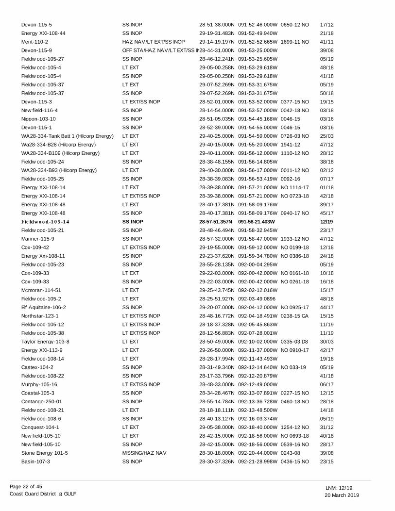
20 March 201912/19LNM:
8Coast Guard District GULFPage 22 of 45
SS INOPSS INOPHAZ NAV/LT EXT/SS INOPOFF STA/HAZ NAV/LT EXT/SS INSS INOPLT EXTSS INOPLT EXTSS INOPLT EXT/SS INOPSS INOPSS INOPSS INOPLT EXTLT EXTLT EXTSS INOPLT EXTSS INOPLT EXTLT EXT/SS INOPLT EXTSS INOPSS INOPSS INOPSS INOPLT EXT/SS INOPSS INOPSS INOPLT EXTSS INOPLT EXTLT EXTSS INOPLT EXT/SS INOPLT EXT/SS INOPLT EXT/SS INOPLT EXTLT EXTLT EXTSS INOPSS INOPLT EXT/SS INOPSS INOPSS INOPLT EXTSS INOPLT EXTLT EXTSS INOPMISSING/HAZ NAVSS INOP
28-51-38.000N29-19-31.483N29-14-19.197N28-44-31.000N28-46-12.241N29-05-00.258N29-05-00.258N29-07-52.269N29-07-52.269N28-52-01.000N28-14-54.000N28-51-05.035N28-52-39.000N29-40-25.000N29-40-15.000N29-40-11.000N28-38-48.155N29-40-30.000N28-38-39.083N28-39-38.000N28-39-38.000N28-40-17.381N28-40-17.381N28-57-51.357N28-48-46.494N28-57-32.000N29-19-55.000N29-23-37.620N28-55-28.135N29-22-03.000N29-22-03.000N29-25-43.745N28-25-51.927N29-20-07.000N28-48-16.772N28-18-37.328N28-12-56.883N28-50-49.000N29-26-50.000N28-28-17.994N28-31-49.340N28-17-33.796N28-48-33.000N28-34-28.467N28-55-14.784N28-18-18.111N28-40-13.127N29-05-38.000N28-42-15.000N28-42-15.000N28-30-18.000N28-30-37.326N
091-52-46.000W091-52-49.940W091-52-52.665W091-53-25.000W091-53-25.605W091-53-29.618W091-53-29.618W091-53-31.675W091-53-31.675W091-53-52.000W091-53-57.000W091-54-45.168W091-54-55.000W091-54-59.000W091-55-20.000W091-56-12.000W091-56-14.805W091-56-17.000W091-56-53.419W091-57-21.000W091-57-21.000W091-58-09.176W091-58-09.176W091-58-21.403W091-58-32.945W091-58-47.000W091-59-12.000W091-59-34.780W092-00-04.295W092-00-42.000W092-00-42.000W092-02-12.016W092-03-49.0896092-04-12.000W092-04-18.491W092-05-45.863W092-07-28.001W092-10-02.000W092-11-37.000W092-11-43.493W092-12-14.640W092-12-20.879W092-12-49.000W092-13-07.891W092-13-36.728W092-13-48.500W092-16-03.374W092-18-40.000W092-18-56.000W092-18-56.000W092-20-44.000W092-21-28.998W
0650-12 NO
1699-11 NO
0377-15 NO
0042-18 NO
0046-15
0046-15
0726-03 NO
1941-12
1110-12 NO
0011-12 NO
0092-16
NO 1114-17
NO 0723-18
0940-17 NO
1933-12 NO
NO 0199-18
NO 0386-18
NO 0161-18
NO 0261-18
NO 0925-17
0238-15 GA
0335-03 D8
NO 0910-17
NO 033-19
0227-15 NO
0460-18 NO
1254-12 NO
NO 0693-18
0539-16 NO
0243-08
0436-15 NO
17/12
21/18
41/11
39/08
05/19
48/18
41/18
05/19
50/18
19/15
03/18
03/16
03/16
25/03
47/12
28/12
38/18
02/12
07/17
01/18
42/18
39/17
45/17
12/1923/17
47/12
12/18
24/18
05/19
10/18
16/18
15/17
48/18
44/17
15/15
11/19
11/19
30/03
42/17
19/18
05/19
41/18
06/17
12/15
28/18
14/18
05/19
31/12
40/18
28/17
39/08
23/15
Devon-115-5Energy XXI-108-44Merit-110-2Devon-115-9Fieldwood-105-27Fieldwood-105-4Fieldwood-105-4Fieldwood-105-37Fieldwood-105-37Devon-115-3Newfield-116-4Nippon-103-10Devon-115-1WA28-334-Tank Batt 1 (Hilcorp Energy)Wa28-334-B28 (Hilcorp Energy)WA28-334-B109 (Hilcorp Energy)Fieldwood-105-24WA28-334-B93 (Hilcorp Energy)Fieldwood-105-25Energy XXI-108-14Energy XXI-108-14Energy XXI-108-48Energy XXI-108-48Fieldwood-105-14
Fieldwood-105-21Mariner-115-9Cox-109-42Energy Xxi-108-11Fieldwood-105-23Cox-109-33Cox-109-33Mcmoran-114-51Fieldwood-105-2Elf Aquitaine-106-2Northstar-123-1Fieldwood-105-12Fieldwood-105-38Taylor Energy-103-8Energy XXI-113-9Fieldwood-108-14Castex-104-2Fieldwood-108-22Murphy-105-16Coastal-105-3Contango-250-01Fieldwood-108-21Fieldwood-108-6Conquest-104-1Newfield-105-10Newfield-105-10Stone Energy 101-5Basin-107-3
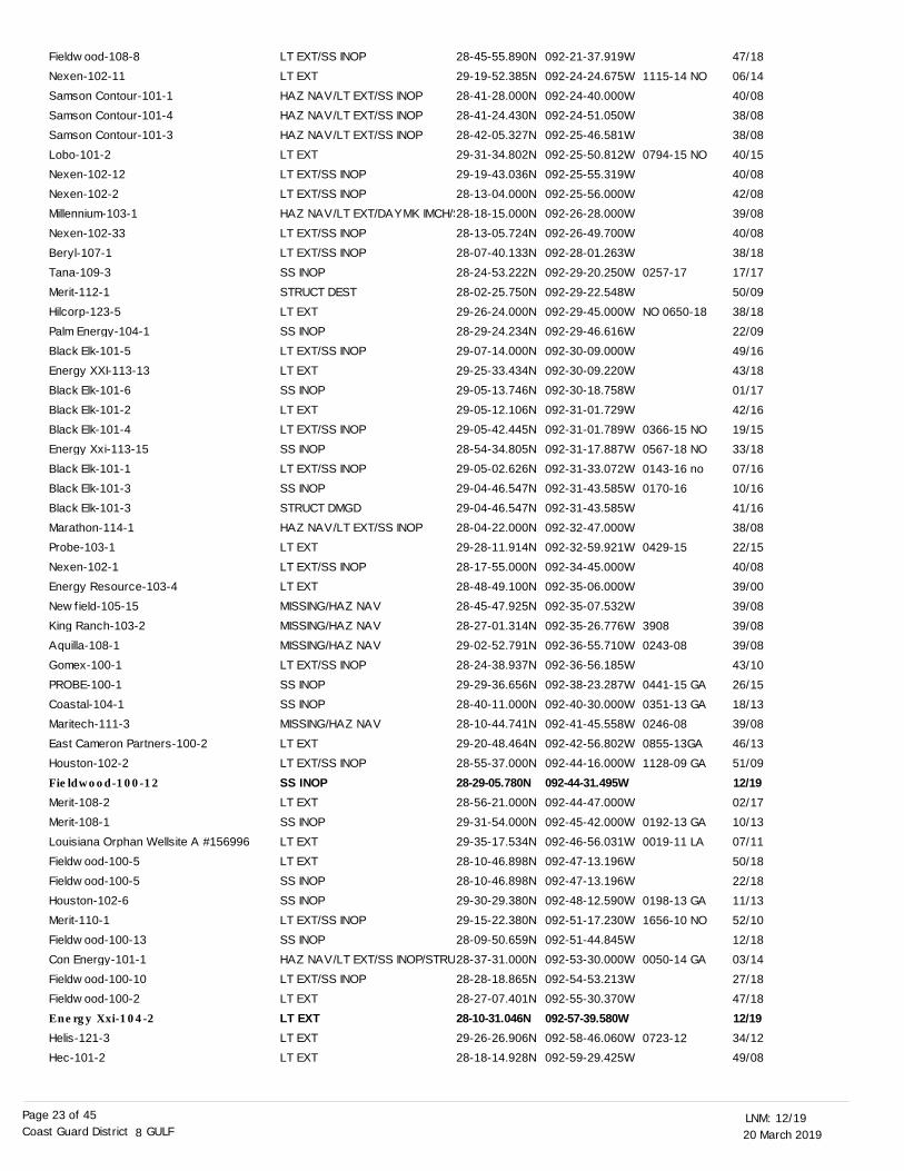
20 March 201912/19LNM:
8Coast Guard District GULFPage 23 of 45
LT EXT/SS INOPLT EXTHAZ NAV/LT EXT/SS INOPHAZ NAV/LT EXT/SS INOPHAZ NAV/LT EXT/SS INOPLT EXTLT EXT/SS INOPLT EXT/SS INOPHAZ NAV/LT EXT/DAYMK IMCH/SLT EXT/SS INOPLT EXT/SS INOPSS INOPSTRUCT DESTLT EXTSS INOPLT EXT/SS INOPLT EXTSS INOPLT EXTLT EXT/SS INOPSS INOPLT EXT/SS INOPSS INOPSTRUCT DMGDHAZ NAV/LT EXT/SS INOPLT EXTLT EXT/SS INOPLT EXTMISSING/HAZ NAVMISSING/HAZ NAVMISSING/HAZ NAVLT EXT/SS INOPSS INOPSS INOPMISSING/HAZ NAVLT EXTLT EXT/SS INOPSS INOPLT EXTSS INOPLT EXTLT EXTSS INOPSS INOPLT EXT/SS INOPSS INOPHAZ NAV/LT EXT/SS INOP/STRULT EXT/SS INOPLT EXTLT EXTLT EXTLT EXT
28-45-55.890N29-19-52.385N28-41-28.000N28-41-24.430N28-42-05.327N29-31-34.802N29-19-43.036N28-13-04.000N28-18-15.000N28-13-05.724N28-07-40.133N28-24-53.222N28-02-25.750N29-26-24.000N28-29-24.234N29-07-14.000N29-25-33.434N29-05-13.746N29-05-12.106N29-05-42.445N28-54-34.805N29-05-02.626N29-04-46.547N29-04-46.547N28-04-22.000N29-28-11.914N28-17-55.000N28-48-49.100N28-45-47.925N28-27-01.314N29-02-52.791N28-24-38.937N29-29-36.656N28-40-11.000N28-10-44.741N29-20-48.464N28-55-37.000N28-29-05.780N28-56-21.000N29-31-54.000N29-35-17.534N28-10-46.898N28-10-46.898N29-30-29.380N29-15-22.380N28-09-50.659N28-37-31.000N28-28-18.865N28-27-07.401N28-10-31.046N29-26-26.906N28-18-14.928N
092-21-37.919W092-24-24.675W092-24-40.000W092-24-51.050W092-25-46.581W092-25-50.812W092-25-55.319W092-25-56.000W092-26-28.000W092-26-49.700W092-28-01.263W092-29-20.250W092-29-22.548W092-29-45.000W092-29-46.616W092-30-09.000W092-30-09.220W092-30-18.758W092-31-01.729W092-31-01.789W092-31-17.887W092-31-33.072W092-31-43.585W092-31-43.585W092-32-47.000W092-32-59.921W092-34-45.000W092-35-06.000W092-35-07.532W092-35-26.776W092-36-55.710W092-36-56.185W092-38-23.287W092-40-30.000W092-41-45.558W092-42-56.802W092-44-16.000W092-44-31.495W092-44-47.000W092-45-42.000W092-46-56.031W092-47-13.196W092-47-13.196W092-48-12.590W092-51-17.230W092-51-44.845W092-53-30.000W092-54-53.213W092-55-30.370W092-57-39.580W092-58-46.060W092-59-29.425W
1115-14 NO
0794-15 NO
0257-17
NO 0650-18
0366-15 NO
0567-18 NO
0143-16 no
0170-16
0429-15
3908
0243-08
0441-15 GA
0351-13 GA
0246-08
0855-13GA
1128-09 GA
0192-13 GA
0019-11 LA
0198-13 GA
1656-10 NO
0050-14 GA
0723-12
47/18
06/14
40/08
38/08
38/08
40/15
40/08
42/08
39/08
40/08
38/18
17/17
50/09
38/18
22/09
49/16
43/18
01/17
42/16
19/15
33/18
07/16
10/16
41/16
38/08
22/15
40/08
39/00
39/08
39/08
39/08
43/10
26/15
18/13
39/08
46/13
51/09
12/1902/17
10/13
07/11
50/18
22/18
11/13
52/10
12/18
03/14
27/18
47/18
12/1934/12
49/08
Fieldwood-108-8Nexen-102-11Samson Contour-101-1Samson Contour-101-4Samson Contour-101-3Lobo-101-2Nexen-102-12Nexen-102-2Millennium-103-1Nexen-102-33Beryl-107-1Tana-109-3Merit-112-1Hilcorp-123-5Palm Energy-104-1Black Elk-101-5Energy XXI-113-13Black Elk-101-6Black Elk-101-2Black Elk-101-4Energy Xxi-113-15Black Elk-101-1Black Elk-101-3Black Elk-101-3Marathon-114-1Probe-103-1Nexen-102-1Energy Resource-103-4Newfield-105-15King Ranch-103-2Aquilla-108-1Gomex-100-1PROBE-100-1Coastal-104-1Maritech-111-3East Cameron Partners-100-2Houston-102-2Fieldwood-100-12
Merit-108-2Merit-108-1Louisiana Orphan Wellsite A #156996Fieldwood-100-5Fieldwood-100-5Houston-102-6Merit-110-1Fieldwood-100-13Con Energy-101-1Fieldwood-100-10Fieldwood-100-2Energy Xxi-104-2
Helis-121-3Hec-101-2
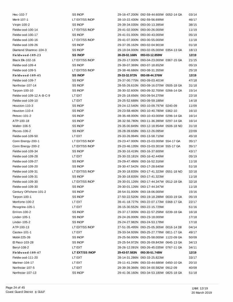
20 March 201912/19LNM:
8Coast Guard District GULFPage 24 of 45
SS INOPLT EXT/SS INOPSS INOPLT EXT/SS INOPSS INOPLT EXT/SS INOPSS INOPSS INOPSS INOPLT EXT/SS INOPSS INOPLT EXT/SS INOPSS INOPSS INOPSS INOPSS INOPLT EXTLT EXTSS INOPSS INOPSS INOPSS INOPSS INOPSS INOPLT EXTLT EXT/SS INOPLT EXT/SS INOPSS INOPLT EXTSS INOPSS INOPLT EXT/SS INOPSS INOPLT EXT/SS INOPSS INOPSS INOPSS INOPLT EXTLT EXTSS INOPSS INOPSS INOPLT EXT/SS INOPLT EXTSS INOPSS INOPLT EXTLT EXT/SS INOPLT EXTLT EXTLT EXTSS INOP
29-16-47.200N28-10-22.430N29-39-34.035N29-41-02.000N29-41-01.000N29-41-07.000N29-37-35.162N29-19-04.000N28-28-02.168N29-20-17.000N29-39-07.369N29-38-46.686N29-33-32.972N29-37-00.775N28-55-26.610N28-30-32.600N29-25-18.656N29-25-52.688N29-24-12.540N29-23-58.460N28-35-48.000N28-32-56.780N29-35-00.849N28-28-39.658N29-33-26.994N29-23-47.000N29-23-46.135N29-30-16.419N29-30-33.181N29-29-47.486N29-30-47.542N29-30-18.835N29-30-18.835N29-30-01.126N29-30-01.126N28-54-31.000N27-50-22.520N28-41-18.727N28-15-30.552N29-37-17.005N29-24-26.000N29-24-27.982N27-51-35.495N29-33-34.926N29-25-56.000N29-25-54.972N28-26-12.091N29-43-57.583N28-14-31.286N29-11-41.249N29-39-39.366N29-41-36.160N
092-59-44.600W092-59-56.699W093-00-13.395W093-00-26.000W093-00-43.000W093-00-55.000W093-02-04.901W093-02-05.000W093-03-12.859W093-04-23.000W093-07-18.652W093-08-31.355W093-08-44.376W093-09-03.401W093-09-16.070W093-09-32.700W093-09-54.270W093-09-59.188W093-10-09.797W093-10-40.780W093-10-43.000W093-11-36.390W093-12-18.954W093-12-26.095W093-13-58.710W093-15-03.000W093-15-03.301W093-16-37.600W093-16-42.449W093-16-52.316W093-17-28.640W093-17-41.323W093-17-41.323W093-17-44.347W093-17-44.347W093-18-06.000W093-19-18.288W093-22-07.173W093-22-15.729W093-22-57.258W093-23-18.000W093-24-53.178W093-25-05.305W093-25-27.778W093-25-58.000W093-26-09.843W093-26-45.035W093-30-51.748W093-33-25.823W093-33-44.686W093-34-00.582W093-34-53.180W
0052-14 GA
0354-13 GA
0367-15 GA
0505-18 GA
0266-14 GA
0240-09
0362-10
0296-14 GA
0297-14 GA
0506-18 NO
554-17 GA
555-17 GA
0551-18 NO
0512-18 GA
0033-19 GA
0368-17 GA
0239-18 GA
0016-14 D8
0811-17 GA
1122-09 GA
0645-13 GA
0767-11 GA
0450-10 GA
0912-09
0825-18 GA
03/14
46/17
38/15
11/19
05/19
11/18
01/18
18/13
12/1921/15
05/19
25/18
12/1947/18
31/18
15/14
22/18
14/18
11/09
16/10
16/14
16/14
31/18
22/09
45/18
35/17
35/17
43/17
05/19
11/18
51/18
32/18
11/18
32/18
11/18
15/16
05/19
22/17
51/16
16/18
17/18
17/18
04/14
49/17
50/09
34/13
34/11
12/1933/17
20/10
40/09
51/18
Hec-102-7Merit-107-1Virgin-100-2Fieldwood-100-14Fieldwood-100-17Fieldwood-100-16Fieldwood-109-26Diamond Shamroc-104-3Fieldwood-109-23
Black Elk-102-16Fieldwood-109-4Fieldwood-109-5Fieldwood-109-45
Fieldwood-109-7Northstar-107-14Tarpon-100-10Fieldwood-109-12 A-B-C-9Fieldwood-109-10Houston-110-3Houston-110-4Petsec-101-2ATP-100-18Walter-106-5Pisces-106-2Fieldwood-109-50Conn Energy-200-1Conn Energy-200-2Fieldwood-109-34Fieldwood-109-28Fieldwood-109-27Fieldwood-109-20Fieldwood-109-31Fieldwood-109-31Fieldwood-109-30Fieldwood-109-30Century Offshore-101-2Tarpon-100-1Monforte-100-2Peregrine-105-1EnVen-100-2Linder-105-1Linder-105-2ATP-100-13Castex-101-1Mobil-225-39El Paso-103-28Beryl-108-2Fieldwood-109-47
Fieldwood-111-20Mariner-104-17Northstar-107-5Northstar-107-13
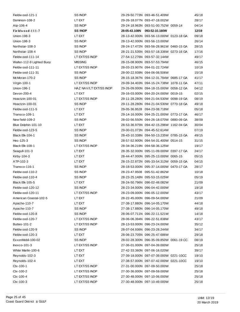
20 March 201912/19LNM:
8Coast Guard District GULFPage 25 of 45
SS INOPLT EXTSS INOPSS INOPLT EXTSS INOPSS INOPSS INOPLT EXT/SS INOPMISSINGLT EXT/SS INOPSS INOPSS INOPLT EXT/SS INOPHAZ NAV/LT EXT/SS INOPLT EXTLT EXT/SS INOPSS INOPLT EXTLT EXTSS INOPLT EXTSS INOPSS INOPSS INOPLT EXT/SS INOPLT EXTLT EXTLT EXTSS INOPSS INOPSS INOPLT EXTSS INOPLT EXT/SS INOPLT EXTLT EXTSS INOPSS INOPLT EXT/SS INOPLT EXT/SS INOPSS INOPLT EXTSS INOPLT EXT/SS INOPLT EXTLT EXTLT EXTLT EXT/SS INOPLT EXT/SS INOPLT EXT/SS INOPLT EXT/SS INOP
29-29-50.773N29-26-18.077N29-24-18.963N28-05-43.108N28-13-42.000N28-13-42.000N28-24-17.472N28-21-21.535N27-54-12.276N28-15-08.900N28-03-23.907N28-00-22.939N28-15-18.367N29-09-34.403N29-26-09.000N29-16-03.000N29-11-28.280N29-11-28.280N29-05-36.952829-14-16.000N28-02-56.550N28-53-36.975N29-00-01.073N28-43-10.338N28-57-52.900N28-34-36.219N28-35-32.000N28-44-47.000N28-15-22.872N28-18-53.000N28-23-47.950828-23-25.148N28-24-50.796N28-23-34.000N28-23-09.000N28-22-45.000N27-38-17.880N27-38-17.880N28-06-07.711N28-06-06.394N28-13-53.000N28-07-04.936N28-06-23.705N28-02-28.300N27-36-01.000N27-42-33.360N27-39-18.000N27-38-57.000N27-31-00.000N27-30-36.000N27-30-48.000N27-30-48.000N
093-46-51.409W093-47-18.002W093-51-00.752W093-52-10.160W093-56-13.000W093-56-13.000W093-56-28.961W093-57-18.336W093-57-32.144W093-57-53.794W094-01-22.724W094-06-08.506W094-12-31.784W094-15-24.738W094-18-15.000W094-20-24.000W094-21-04.530W094-21-04.530W094-23-08.718W094-25-21.000W094-26-18.070W094-42-15.296W094-45-52.614W094-50-13.235W094-54-31.400W094-58-36.125W095-11-09.000W095-25-13.000W095-33-54.313W095-37-14.000W095-51-42.862W095-53-15.025W096-02-48.082W096-04-42.000W096-05-12.000W096-09-54.000W096-14-05.170W096-14-05.170W096-22-11.521W096-22-51.838W096-23-24.000W096-23-28.244W096-25-47.686W096-35-09.850W097-04-39.000W097-06-16.020W097-07-39.000W097-07-42.000W097-09-50.000W097-09-59.000W097-10-06.000W097-10-49.000W
0059-14
0123-18 GA
0460-15 GA
0273-16 GA
0685-17 GA
1078-11 GA
0058-12 GA
0019-15
0098-19 GA
0770-18 GA
0773-17 GA
0880-09 GA
1162-04 GA
0785-15 GA
0514-15
0397-17 GA
0065-15
0059-15 GA
0470-17 GA
0061-19 CC
0221-10CC
0221-10CC
45/18
28/17
04/14
12/1909/18
26/14
28/15
17/16
49/17
46/15
10/19
15/18
41/17
47/11
04/12
02/15
08/19
49/18
05/18
46/17
38/09
30/04
07/19
49/15
31/15
19/17
24/17
05/15
04/15
28/17
10/18
05/19
21/09
19/18
43/17
21/09
44/18
49/18
14/18
43/17
35/12
34/17
29/18
08/19
25/18
39/17
19/10
19/10
25/18
25/18
25/18
25/18
Fieldwood-121-1Dominion-108-2Atp-106-4Fieldwood-111-7
Union-198-3Union-198-3Northstar-108-3Northstar-108-4Fieldwood-111-14Walter-112-9 Lighted BuoyFieldwood-111-11Fieldwood-111-31McMoran-170-2Virgin-100-1Union-196-1Devon-200-4Hoactzin-100-01Hoactzin-100-01Fieldwood-111-5Transco-109-1Newfield-109-2Blue Dolphin-101-10Fieldwood-123-5Black Elk-104-1Hec-125-3Black Elk-108-1Seagull-101-3Kirby-104-3ATP-102-3Transco-116-1Fieldwood-110-2Fieldwood-110-4Black Elk-105-5Fieldwood-120-12Fieldwood-120-11American Coastal-102-5Apache-110-7Apache-110-7Fieldwood-120-8Fieldwood-120-7Buttes-101-2Fieldwood-120-9Fieldwood-120-3ExxonMobil-100-02Inexco-101-3White Marlin-100-6Reynolds-102-3Reynolds-102-4Ctx-100-1Ctx-100-2Ctx-100-4Ctx-100-3
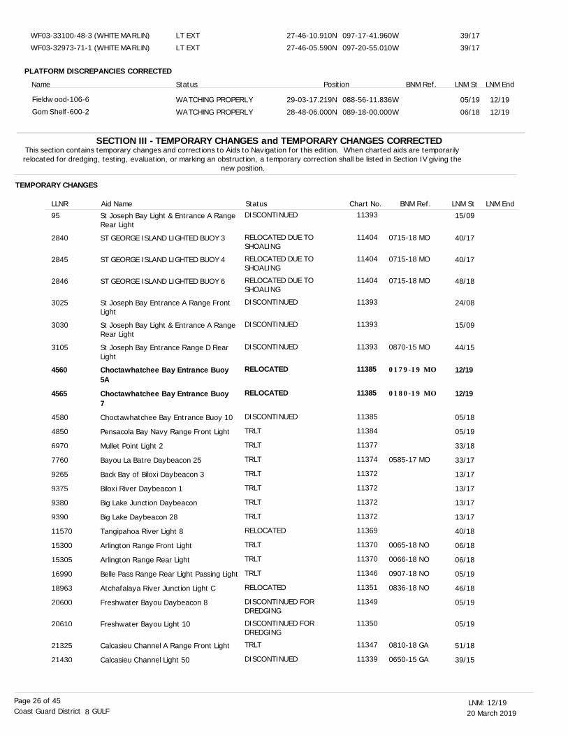
20 March 201912/19LNM:
8Coast Guard District GULFPage 26 of 45
SECTION III - TEMPORARY CHANGES and TEMPORARY CHANGES CORRECTEDThis section contains temporary changes and corrections to Aids to Navigation for this edition. When charted aids are temporarily relocated for dredging, testing, evaluation, or marking an obstruction, a temporary correction shall be listed in Section IV giving the
new position.
TEMPORARY CHANGES
LNM EndLLNR Aid Name Status Chart No. BNM Ref. LNM St
St Joseph Bay Light & Entrance A Range Rear Light
ST GEORGE ISLAND LIGHTED BUOY 3
ST GEORGE ISLAND LIGHTED BUOY 4
ST GEORGE ISLAND LIGHTED BUOY 6
St Joseph Bay Entrance A Range Front Light
St Joseph Bay Light & Entrance A Range Rear Light
St Joseph Bay Entrance Range D Rear Light
Choctawhatchee Bay Entrance Buoy 5A
Choctawhatchee Bay Entrance Buoy 7
Choctawhatchee Bay Entrance Buoy 10
Pensacola Bay Navy Range Front Light
Mullet Point Light 2
Bayou La Batre Daybeacon 25
Back Bay of Biloxi Daybeacon 3
Biloxi River Daybeacon 1
Big Lake Junction Daybeacon
Big Lake Daybeacon 28
Tangipahoa River Light 8
Arlington Range Front Light
Arlington Range Rear Light
Belle Pass Range Rear Light Passing Light
Atchafalaya River Junction Light C
Freshwater Bayou Daybeacon 8
Freshwater Bayou Light 10
Calcasieu Channel A Range Front Light
Calcasieu Channel Light 50
DISCONTINUED
RELOCATED DUE TO SHOALING
RELOCATED DUE TO SHOALING
RELOCATED DUE TO SHOALING
DISCONTINUED
DISCONTINUED
DISCONTINUED
RELOCATED
RELOCATED
DISCONTINUED
TRLT
TRLT
TRLT
TRLT
TRLT
TRLT
TRLT
RELOCATED
TRLT
TRLT
TRLT
RELOCATED
DISCONTINUED FOR DREDGING
DISCONTINUED FOR DREDGING
TRLT
DISCONTINUED
15/09
40/17
40/17
48/18
24/08
15/09
44/15
12/19
12/19
05/18
05/19
33/18
33/17
13/17
13/17
13/17
13/17
40/18
06/18
06/18
05/19
46/18
05/19
05/19
51/18
39/15
11393
11404
11404
11404
11393
11393
11393
11385
11385
11385
11384
11377
11374
11372
11372
11372
11372
11369
11370
11370
11346
11351
11349
11350
11347
11339
95
2840
2845
2846
3025
3030
3105
4560
4565
4580
4850
6970
7760
9265
9375
9380
9390
11570
15300
15305
16990
18963
20600
20610
21325
21430
0715-18 MO
0715-18 MO
0715-18 MO
0870-15 MO
0179-19 MO
0180-19 MO
0585-17 MO
0065-18 NO
0066-18 NO
0907-18 NO
0836-18 NO
0810-18 GA
0650-15 GA
PLATFORM DISCREPANCIES CORRECTED
LT EXTLT EXT
WATCHING PROPERLYWATCHING PROPERLY
27-46-10.910N27-46-05.590N
29-03-17.219N28-48-06.000N
097-17-41.960W097-20-55.010W
088-56-11.836W089-18-00.000W
Name Status Position BNM Ref.
39/17
39/17
05/19
06/18
12/19
12/19
LNM St LNM End
WF03-33100-48-3 (WHITE MARLIN)WF03-32973-71-1 (WHITE MARLIN)
Fieldwood-106-6Gom Shelf-600-2
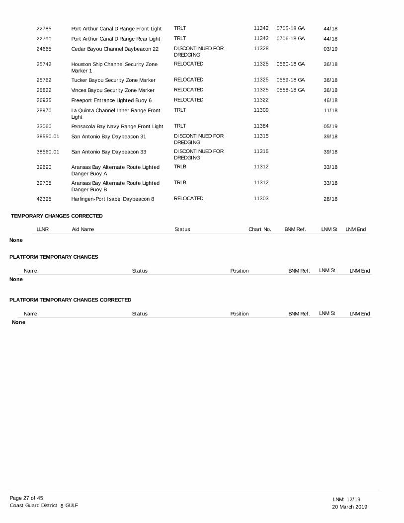
20 March 201912/19LNM:
8Coast Guard District GULFPage 27 of 45
TEMPORARY CHANGES CORRECTED
LNM EndLLNR Aid Name Status Chart No. BNM Ref. LNM St
Port Arthur Canal D Range Front Light
Port Arthur Canal D Range Rear Light
Cedar Bayou Channel Daybeacon 22
Houston Ship Channel Security Zone Marker 1
Tucker Bayou Security Zone Marker
Vinces Bayou Security Zone Marker
Freeport Entrance Lighted Buoy 6
La Quinta Channel Inner Range Front Light
Pensacola Bay Navy Range Front Light
San Antonio Bay Daybeacon 31
San Antonio Bay Daybeacon 33
Aransas Bay Alternate Route Lighted Danger Buoy A
Aransas Bay Alternate Route Lighted Danger Buoy B
Harlingen-Port Isabel Daybeacon 8
TRLT
TRLT
DISCONTINUED FOR DREDGING
RELOCATED
RELOCATED
RELOCATED
RELOCATED
TRLT
TRLT
DISCONTINUED FOR DREDGING
DISCONTINUED FOR DREDGING
TRLB
TRLB
RELOCATED
44/18
44/18
03/19
36/18
36/18
36/18
46/18
11/18
05/19
39/18
39/18
33/18
33/18
28/18
11342
11342
11328
11325
11325
11325
11322
11309
11384
11315
11315
11312
11312
11303
22785
22790
24665
25742
25762
25822
26935
28970
33060
38550.01
38560.01
39690
39705
42395
None
0705-18 GA
0706-18 GA
0560-18 GA
0559-18 GA
0558-18 GA
PLATFORM TEMPORARY CHANGES
PLATFORM TEMPORARY CHANGES CORRECTED
Name
Name
Status
Status
Position
Position
BNM Ref.
BNM Ref.
LNM St
LNM St
LNM End
LNM End
None
None
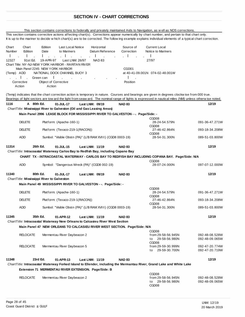
20 March 201912/19LNM:
8Coast Guard District GULFPage 28 of 45
1116
11314
11340
11345
11348
A 80th Ed.
26th Ed.
80th Ed.
35th Ed.
23rd Ed.
01-JUL-17
01-JUL-15
01-JUL-17
01-APR-12
01-APR-13
09/19
11/19
09/19
11/19
11/19
Mississippi River to Galveston (Oil and Gas Leasing Areas)
Intracoastal Waterway Carlos Bay to Redfish Bay, including Copano Bay
Mississippi River to Galveston
Intracoastal Waterway New Orleans to Calcasieu River West Section
Intracoastal Waterway Forked Island to Ellender, including the Mermantau River, Grand Lake and White Lake
ChartTitle:
ChartTitle:
ChartTitle:
ChartTitle:
ChartTitle:
NAD 83
NAD 83
NAD 83
NAD 83
NAD 83
Last LNM:
Last LNM:
Last LNM:
Last LNM:
Last LNM:
12/19
12/19
12/19
12/19
12/19
Main Panel 2996 LEASE BLOCK FOR MISSISSIPPI RIVER TO GALVESTON - -. Page/Side: -
CHART TX - INTRACOASTAL WATERWAY - CARLOS BAY TO REDFISH BAY INCLUDING COPANA BAY. Page/Side: N/A
Main Panel 49 MISSISSIPPI RIVER TO GALVESTON - -. Page/Side: -
Main Panel 47 NEW ORLEANS TO CALCASIEU RIVER WEST SECTION. Page/Side: N/A
Extension 71 MERMENTAU RIVER EXTENSION. Page/Side: B
DELETE
DELETE
ADD
ADD
DELETE
DELETE
ADD
RELOCATE
RELOCATE
RELOCATE
Platform: (Apache-160-1)
Platform: (Texaco-219-1(RACON))
Sumbol: "Visible Obstn (PA)" (L/B RAM XVIII) (CGD8 0003-19)
Symbol: "Dangerous Wreck (PA)" (CGD8 002-19)
Platform: (Apache-160-1)
Platform: (Texaco-219-1(RACON))
Sumbol: "Visible Obstn (PA)" (L/B RAM XVIII) (CGD8 0003-19)
Mermentau River Daybeacon 2
Mermentau River Daybeacon 5
Mermentau River Daybeacon 2
CGD08
CGD08
CGD08
CGD08
CGD08
CGD08
CGD08
CGD08
CGD08
CGD08
CGD08
28-24-54.579N
27-46-42.864N
28-54-31.300N
28-07-24.000N
28-24-54.579N
27-46-42.864N
28-54-31.300N
from 29-58-56.945N
from 29-59-30.999N
from 29-58-56.945N
091-36-47.271W
093-18-34.208W
089-51-03.800W
097-07-12.000W
091-36-47.271W
093-18-34.208W
089-51-03.800W
092-48-08.528W
092-47-20.774W
092-48-08.528W
to 29-58-56.980N
to 29-59-30.700N
to 29-58-56.980N
092-48-09.065W
092-47-20.719W
092-48-09.065W
This section contains corrections to federally and privately maintained Aids to Navigation, as well as NOS corrections. This section contains corrective actions affecting chart(s). Corrections appear numerically by chart number, and pertain to that chart only. It is up to the mariner to decide which chart(s) are to be corrected. The following example explains individual elements of a typical chart correction.
Chart Chart Edition Last Local Notice Horizontal Source of Current LocalNumber Edition Date to Mariners Datum Reference Correction Notice to Mariners l . l . l . . . l . . . l . . . l . . l12327 91st Ed. 19-APR-97 Last LNM: 26/97 NAD 83 27/97Chart Title: NY-NJ-NEW YORK HARBOR - RARITAN RIVER Main Panel 2245 NEW YORK HARBOR CGD01(Temp) ADD NATIONAL DOCK CHANNEL BUOY 3 at 40-41-09.001N 074-02-48.001W . . l . Green can l . . . . . . l . Corrective Object of Corrective Position Action Action
(Temp) indicates that the chart correction action is temporary in nature. Courses and bearings are given in degrees clockwise from 000 true. Bearings of light sectors are toward the light from seaward. The nominal range of lights is expressed in nautical miles (NM) unless otherwise noted.
SECTION IV - CHART CORRECTIONS
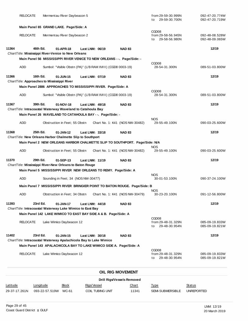
20 March 201912/19LNM:
8Coast Guard District GULFPage 29 of 45
OIL RIG MOVEMENT
Drill Rigs/Vessels Removed
Latitude Longitude Block Rigs/Vessel Type Status
29-37-17.261N 093-22-57.519W WC-61 COIL TUBING UNIT 11341 SEMI-SUBMERSIBLE UNREPORTED
Chart
11364
11366
11367
11368
11370
11393
11402
46th Ed.
16th Ed.
39th Ed.
25th Ed.
29th Ed.
23rd Ed.
23rd Ed.
01-APR-18
01-JUN-15
01-NOV-18
01-JAN-12
01-SEP-13
01-JAN-17
01-JAN-15
06/19
07/19
49/18
33/18
11/19
44/18
30/18
Mississippi River-Venice to New Orleans
Approaches to Mississippi River
Intracoastal Waterway Waveland to Catahoula Bay
New Orleans Harbor Chalmette Slip to Southport
Mississippi River-New Orleans to Baton Rouge
Intracoastal Waterway Lake Wimico to East Bay
Intracoastal Waterway Apalachicola Bay to Lake Wimico
ChartTitle:
ChartTitle:
ChartTitle:
ChartTitle:
ChartTitle:
ChartTitle:
ChartTitle:
NAD 83
NAD 83
NAD 83
NAD 83
NAD 83
NAD 83
NAD 83
Last LNM:
Last LNM:
Last LNM:
Last LNM:
Last LNM:
Last LNM:
Last LNM:
12/19
12/19
12/19
12/19
12/19
12/19
12/19
Main Panel 65 GRAND LAKE. Page/Side: A
Main Panel 56 MISSISSIPPI RIVER VENICE TO NEW ORLEANS - -. Page/Side: -
Main Panel 2886 APPROACHES TO MISSISSIPPI RIVER. Page/Side: A
Main Panel 26 WAVELAND TO CATAHOULA BAY - -. Page/Side: -
Main Panel 2 NEW ORLEANS HARBOR CHALMETTE SLIP TO SOUTHPORT. Page/Side: N/A
Main Panel 5 MISSISSIPPI RIVER NEW ORLEANS TO REMY. Page/Side: A
Main Panel 7 MISSISSIPPI RIVER BRINGIER POINT TO BATON ROUGE. Page/Side: B
Main Panel 142 LAKE WIMICO TO EAST BAY SIDE A & B. Page/Side: A
Main Panel 143 APALACHICOLA BAY TO LAKE WIMICO SIDE A. Page/Side: A
RELOCATE
RELOCATE
ADD
ADD
ADD
ADD
ADD
ADD
RELOCATE
RELOCATE
Mermentau River Daybeacon 5
Mermentau River Daybeacon 2
Sumbol: "Visible Obstn (PA)" (L/B RAM XVIII) (CGD8 0003-19)
Sumbol: "Visible Obstn (PA)" (L/B RAM XVIII) (CGD8 0003-19)
Obstruction in Feet; 55 Obstn Chart No. 1: K41 (NOS NW-30482)
Obstruction in Feet; 55 Obstn Chart No. 1: K41 (NOS NW-30482)
Sounding in Feet; 34 (NOS NW-30477)
Obstruction in Feet; 34 Obstn Chart No. 1: K41 (NOS NW-30479)
Lake Wimico Daybeacon 12
Lake Wimico Daybeacon 12
CGD08
CGD08
CGD08
NOS
NOS
NOS
NOS
CGD08
CGD08
from 29-59-30.999N
from 29-58-56.945N
28-54-31.300N
28-54-31.300N
29-55-49.100N
29-55-49.100N
30-01-53.100N
30-23-20.100N
from 29-48-31.329N
from 29-48-31.329N
092-47-20.774W
092-48-08.528W
089-51-03.800W
089-51-03.800W
090-03-25.600W
090-03-25.600W
090-37-24.100W
091-12-56.800W
085-09-19.833W
085-09-19.833W
to 29-59-30.700N
to 29-58-56.980N
to 29-48-30.954N
to 29-48-30.954N
092-47-20.719W
092-48-09.065W
085-09-19.821W
085-09-19.821W
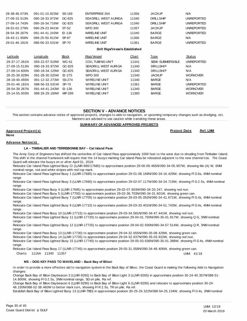
20 March 201912/19LNM:
8Coast Guard District GULFPage 30 of 45
SECTION V - ADVANCE NOTICESThis section contains advance notice of approved projects, changes to aids to navigation, or upcoming temporary changes such as dredging, etc.
Mariners are advised to use caution while transiting these areas.
SUMMARY OF ADVANCED APPROVED PROJECTS
Approved Project(s) Project Date Ref. LNM
LA – TIMBALIER AND TERREBONNE BAY – Cat Island Pass
MS – DOG KEY PASS TO WAVELAND – Back Bay of Biloxi
The Army Corp of Engineers has shifted the centerline of Cat Island Pass approximately 1000 feet to the west due to shoaling from Timbalier Island.This shift in the channel framework will require that the 14 buoys marking Cat island Pass be relocated adjacent to the new channel toe. The Coast Guard will relocate the buoys on or after April 01, 2019:Relocate Cat Island Pass Lighted Buoy CI (LLNR-680/17680) to approximate position 29-00-09.465N/090-34-05.907W, showing Mo (A) W, 6NM nominal range, red and white stripes with red top mark. Relocate Cat Island Pass Lighted Buoy 1 (LLNR-17685) to approximate position 29-01-08.169N/090-34-16.429W, showing Fl G 6s, 4NM nominal rangeRelocate Cat Island Pass Lighted Buoy 3 (LLNR-17690) to approximate position 29-02-07.117N/090-34-24.719W, showing Fl G 2.5s, 4NM nominal rangeRelocate Cat Island Pass Buoy 4 (LLNR-17695) to approximate position 29-02-07.603N/090-34-20.247, showing red nun. Relocate Cat Island Pass Buoy 5 (LLNR-17700) to approximate position 29-02-36.703N/090-34-31.601W, showing green can.Relocate Cat Island Pass Lighted Buoy 7 (LLNR-17705) to approximate position 29-03-05.052N/090-34-41.671W, showing Fl G 4s, 4NM nominal range. Relocate Cat Island Pass Lighted Buoy 9 (LLNR-17710) to approximate position 29-03-33.401N/090-34-51.743W, showing Fl G 4s, 4NM nominal range. Relocate Cat Island Pass Buoy 10 (LLNR-17715) to approximate position 29-03-34.581N/090-34-47.441W, showing red nun. Relocate Cat Island Pass Lighted Buoy 11 (LLNR-17720) to approximate position 29-04-01.750N/090-35-01.817W, showing Q G, 3NM nominal range.Relocate Cat Island Pass Lighted Buoy 12 (LLNR-17725) to approximate position 29-04-02.930N/090-34-57.514W, showing Q R, 3NM nominal range. Relocate Cat Island Pass Buoy 13 (LLNR-17730) to approximate position 29-04-32.655N/090-35-08.429W, showing green can.Relocate Cat Island Pass Buoy 14 (LLNR-17735) to approximate position 29-04-32.637N/090-35-03.910W, showing red nun. Relocate Cat Island Pass Lighted Buoy 15 (LLNR-17740) to approximate position 29-05-03.636N/090-35-01.388W, showing Fl G 4s, 4NM nominal range.Relocate Cat Island Pass Buoy 17 (LLNR-17745) to approximate position 29-05-31.058N/090-34-48.406W, showing green can.
In order to provide a more effective aid to navigation system in the Back Bay of Biloxi, the Coast Guard is making the following Aids to Navigation changes: Change Back Bay of Biloxi Daybeacon 3 (LLNR-9265) to Back Bay of Biloxi Light 3 (LLNR-9265) in approximate position 30-24-40.357N/088-51-14.800W, showing Fl G 2.5s, 3NM nominal range, SG on pile, Ra ref.Change Back Bay of Biloxi Daybeacon 6 (LLNR-9290) to Back Bay of Biloxi Light 6 (LLNR-9290) and relocate to approximate position 30-24-48.150N/088-52-38.460W to better mark turn, showing Fl R 2.5s, TR on pile, Ra ref. Establish Back Bay of Biloxi Lighted Buoy 13 (LLNR-TBD) in approximate position 30-25-29.322N/088-54-25.134W, showing Fl G 4s, 3NM nominal
LNM: 41/18
28-38-46.073N27-09-15.513N27-09-14.743N28-52-02.279N28-54-39.267N28-43-11.958N29-01-46.181N
091-01-10.823W090-18-33.972W090-18-34.716W090-29-23.941W091-44-41.243W089-25-50.812W088-56-33.531W
SS-169GC-825GC-825ST-52EI-136SP-87SP-70
ENTERPRISE 264SEADRILL WEST AURIGASEADRILL WEST AURIGAWFD 300WIRELINE UNITWIRELINE UNITWIRELINE UNIT
11356113401134011357113401136611361
JACKUPDRILLSHIPDRILLSHIPJACKUPBARGEBARGEBARGE
N/AUNREPORTEDUNREPORTEDUNREPORTEDUNREPORTEDN/AUNREPORTED
Latitude Longitude Block Rigs/Vessel Type Status
29-37-17.261N27-09-15.513N27-09-14.600N28-25-39.929N28-18-40.455N29-01-46.181N28-54-39.267N29-14-55.003N
093-22-57.519W090-18-33.972W090-18-34.129W091-28-30.525W091-12-32.273W088-56-33.531W091-44-41.243W088-26-29.169W
WC-61GC-825GC-825EI-275SS-274SP-70EI-136MP-289
COIL TUBING UNITSEADRILL WEST AURIGASEADRILL WEST AURIGAWFD 300WIRELINE UNITWIRELINE UNITWIRELINE UNITWIRELINE UNIT
1134111340113401134011340113611134011360
SEMI-SUBMERSIBLEDRILLSHIPDRILLSHIPJACKUPBARGEBARGEBARGEBARGE
UNREPORTEDN/AN/AWORKOVERN/AUNREPORTEDWORKOVERWORKOVER
Chart
Drill Rigs/Vessels Established
Charts: 1116A 11340 11357
None
Advance Notice(s)
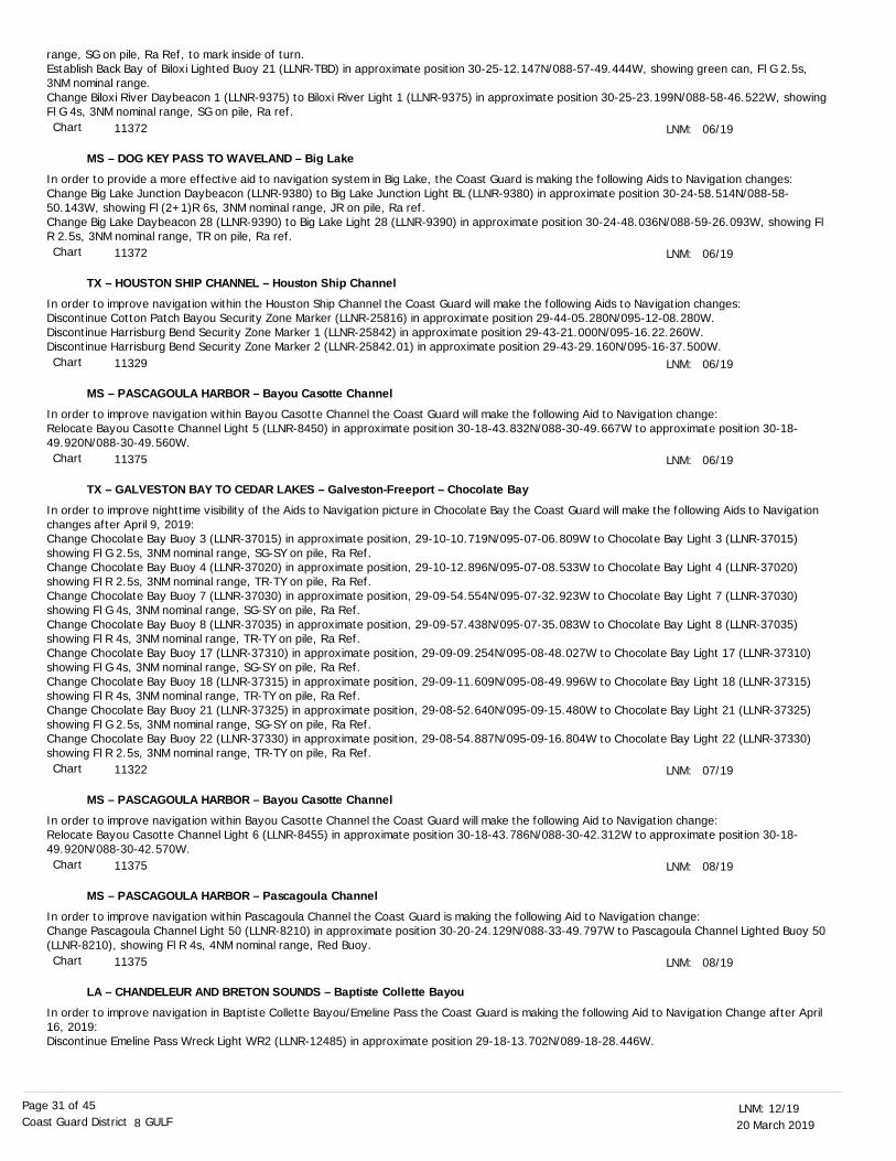
20 March 201912/19LNM:
8Coast Guard District GULFPage 31 of 45
MS – DOG KEY PASS TO WAVELAND – Big Lake
TX – HOUSTON SHIP CHANNEL – Houston Ship Channel
MS – PASCAGOULA HARBOR – Bayou Casotte Channel
TX – GALVESTON BAY TO CEDAR LAKES – Galveston-Freeport – Chocolate Bay
MS – PASCAGOULA HARBOR – Bayou Casotte Channel
MS – PASCAGOULA HARBOR – Pascagoula Channel
LA – CHANDELEUR AND BRETON SOUNDS – Baptiste Collette Bayou
range, SG on pile, Ra Ref, to mark inside of turn.Establish Back Bay of Biloxi Lighted Buoy 21 (LLNR-TBD) in approximate position 30-25-12.147N/088-57-49.444W, showing green can, Fl G 2.5s, 3NM nominal range.Change Biloxi River Daybeacon 1 (LLNR-9375) to Biloxi River Light 1 (LLNR-9375) in approximate position 30-25-23.199N/088-58-46.522W, showing Fl G 4s, 3NM nominal range, SG on pile, Ra ref.
In order to provide a more effective aid to navigation system in Big Lake, the Coast Guard is making the following Aids to Navigation changes: Change Big Lake Junction Daybeacon (LLNR-9380) to Big Lake Junction Light BL (LLNR-9380) in approximate position 30-24-58.514N/088-58-50.143W, showing Fl (2+1)R 6s, 3NM nominal range, JR on pile, Ra ref. Change Big Lake Daybeacon 28 (LLNR-9390) to Big Lake Light 28 (LLNR-9390) in approximate position 30-24-48.036N/088-59-26.093W, showing Fl R 2.5s, 3NM nominal range, TR on pile, Ra ref.
In order to improve navigation within the Houston Ship Channel the Coast Guard will make the following Aids to Navigation changes:Discontinue Cotton Patch Bayou Security Zone Marker (LLNR-25816) in approximate position 29-44-05.280N/095-12-08.280W.Discontinue Harrisburg Bend Security Zone Marker 1 (LLNR-25842) in approximate position 29-43-21.000N/095-16.22.260W.Discontinue Harrisburg Bend Security Zone Marker 2 (LLNR-25842.01) in approximate position 29-43-29.160N/095-16-37.500W.
In order to improve navigation within Bayou Casotte Channel the Coast Guard will make the following Aid to Navigation change:Relocate Bayou Casotte Channel Light 5 (LLNR-8450) in approximate position 30-18-43.832N/088-30-49.667W to approximate position 30-18-49.920N/088-30-49.560W.
In order to improve nighttime visibility of the Aids to Navigation picture in Chocolate Bay the Coast Guard will make the following Aids to Navigation changes after April 9, 2019:Change Chocolate Bay Buoy 3 (LLNR-37015) in approximate position, 29-10-10.719N/095-07-06.809W to Chocolate Bay Light 3 (LLNR-37015) showing Fl G 2.5s, 3NM nominal range, SG-SY on pile, Ra Ref.Change Chocolate Bay Buoy 4 (LLNR-37020) in approximate position, 29-10-12.896N/095-07-08.533W to Chocolate Bay Light 4 (LLNR-37020) showing Fl R 2.5s, 3NM nominal range, TR-TY on pile, Ra Ref.Change Chocolate Bay Buoy 7 (LLNR-37030) in approximate position, 29-09-54.554N/095-07-32.923W to Chocolate Bay Light 7 (LLNR-37030) showing Fl G 4s, 3NM nominal range, SG-SY on pile, Ra Ref.Change Chocolate Bay Buoy 8 (LLNR-37035) in approximate position, 29-09-57.438N/095-07-35.083W to Chocolate Bay Light 8 (LLNR-37035) showing Fl R 4s, 3NM nominal range, TR-TY on pile, Ra Ref.Change Chocolate Bay Buoy 17 (LLNR-37310) in approximate position, 29-09-09.254N/095-08-48.027W to Chocolate Bay Light 17 (LLNR-37310) showing Fl G 4s, 3NM nominal range, SG-SY on pile, Ra Ref.Change Chocolate Bay Buoy 18 (LLNR-37315) in approximate position, 29-09-11.609N/095-08-49.996W to Chocolate Bay Light 18 (LLNR-37315) showing Fl R 4s, 3NM nominal range, TR-TY on pile, Ra Ref.Change Chocolate Bay Buoy 21 (LLNR-37325) in approximate position, 29-08-52.640N/095-09-15.480W to Chocolate Bay Light 21 (LLNR-37325) showing Fl G 2.5s, 3NM nominal range, SG-SY on pile, Ra Ref.Change Chocolate Bay Buoy 22 (LLNR-37330) in approximate position, 29-08-54.887N/095-09-16.804W to Chocolate Bay Light 22 (LLNR-37330) showing Fl R 2.5s, 3NM nominal range, TR-TY on pile, Ra Ref.
In order to improve navigation within Bayou Casotte Channel the Coast Guard will make the following Aid to Navigation change:Relocate Bayou Casotte Channel Light 6 (LLNR-8455) in approximate position 30-18-43.786N/088-30-42.312W to approximate position 30-18-49.920N/088-30-42.570W.
In order to improve navigation within Pascagoula Channel the Coast Guard is making the following Aid to Navigation change:Change Pascagoula Channel Light 50 (LLNR-8210) in approximate position 30-20-24.129N/088-33-49.797W to Pascagoula Channel Lighted Buoy 50 (LLNR-8210), showing Fl R 4s, 4NM nominal range, Red Buoy.
In order to improve navigation in Baptiste Collette Bayou/Emeline Pass the Coast Guard is making the following Aid to Navigation Change after April 16, 2019:Discontinue Emeline Pass Wreck Light WR2 (LLNR-12485) in approximate position 29-18-13.702N/089-18-28.446W.
LNM:
LNM:
LNM:
LNM:
LNM:
LNM:
LNM:
06/19
06/19
06/19
06/19
07/19
08/19
08/19
Chart
Chart
Chart
Chart
Chart
Chart
Chart
11372
11372
11329
11375
11322
11375
11375
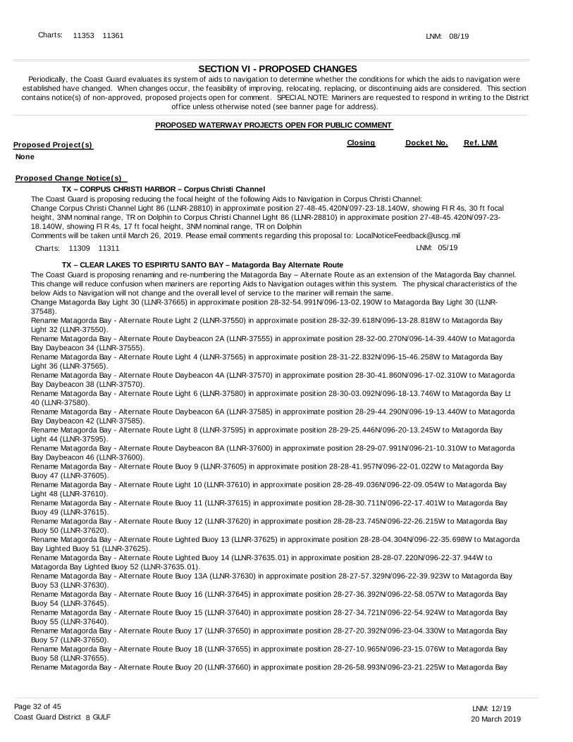
20 March 201912/19LNM:
8Coast Guard District GULFPage 32 of 45
LNM: 08/19
SECTION VI - PROPOSED CHANGESPeriodically, the Coast Guard evaluates its system of aids to navigation to determine whether the conditions for which the aids to navigation were
established have changed. When changes occur, the feasibility of improving, relocating, replacing, or discontinuing aids are considered. This section contains notice(s) of non-approved, proposed projects open for comment. SPECIAL NOTE: Mariners are requested to respond in writing to the District
office unless otherwise noted (see banner page for address).
PROPOSED WATERWAY PROJECTS OPEN FOR PUBLIC COMMENT
Proposed Project(s) Closing Docket No. Ref. LNM
TX – CORPUS CHRISTI HARBOR – Corpus Christi Channel
TX – CLEAR LAKES TO ESPIRITU SANTO BAY – Matagorda Bay Alternate Route
The Coast Guard is proposing reducing the focal height of the following Aids to Navigation in Corpus Christi Channel: Change Corpus Christi Channel Light 86 (LLNR-28810) in approximate position 27-48-45.420N/097-23-18.140W, showing Fl R 4s, 30 ft focal height, 3NM nominal range, TR on Dolphin to Corpus Christi Channel Light 86 (LLNR-28810) in approximate position 27-48-45.420N/097-23-18.140W, showing Fl R 4s, 17 ft focal height, 3NM nominal range, TR on DolphinComments will be taken until March 26, 2019. Please email comments regarding this proposal to: [email protected]
The Coast Guard is proposing renaming and re-numbering the Matagorda Bay – Alternate Route as an extension of the Matagorda Bay channel. This change will reduce confusion when mariners are reporting Aids to Navigation outages within this system. The physical characteristics of the below Aids to Navigation will not change and the overall level of service to the mariner will remain the same. Change Matagorda Bay Light 30 (LLNR-37665) in approximate position 28-32-54.991N/096-13-02.190W to Matagorda Bay Light 30 (LLNR-37548).Rename Matagorda Bay - Alternate Route Light 2 (LLNR-37550) in approximate position 28-32-39.618N/096-13-28.818W to Matagorda Bay Light 32 (LLNR-37550).Rename Matagorda Bay - Alternate Route Daybeacon 2A (LLNR-37555) in approximate position 28-32-00.270N/096-14-39.440W to Matagorda Bay Daybeacon 34 (LLNR-37555).Rename Matagorda Bay - Alternate Route Light 4 (LLNR-37565) in approximate position 28-31-22.832N/096-15-46.258W to Matagorda Bay Light 36 (LLNR-37565).Rename Matagorda Bay - Alternate Route Daybeacon 4A (LLNR-37570) in approximate position 28-30-41.860N/096-17-02.310W to Matagorda Bay Daybeacon 38 (LLNR-37570).Rename Matagorda Bay - Alternate Route Light 6 (LLNR-37580) in approximate position 28-30-03.092N/096-18-13.746W to Matagorda Bay Lt 40 (LLNR-37580).Rename Matagorda Bay - Alternate Route Daybeacon 6A (LLNR-37585) in approximate position 28-29-44.290N/096-19-13.440W to Matagorda Bay Daybeacon 42 (LLNR-37585).Rename Matagorda Bay - Alternate Route Light 8 (LLNR-37595) in approximate position 28-29-25.446N/096-20-13.245W to Matagorda Bay Light 44 (LLNR-37595).Rename Matagorda Bay - Alternate Route Daybeacon 8A (LLNR-37600) in approximate position 28-29-07.991N/096-21-10.310W to Matagorda Bay Daybeacon 46 (LLNR-37600).Rename Matagorda Bay - Alternate Route Buoy 9 (LLNR-37605) in approximate position 28-28-41.957N/096-22-01.022W to Matagorda Bay Buoy 47 (LLNR-37605).Rename Matagorda Bay - Alternate Route Light 10 (LLNR-37610) in approximate position 28-28-49.036N/096-22-09.054W to Matagorda Bay Light 48 (LLNR-37610).Rename Matagorda Bay - Alternate Route Buoy 11 (LLNR-37615) in approximate position 28-28-30.711N/096-22-17.401W to Matagorda Bay Buoy 49 (LLNR-37615).Rename Matagorda Bay - Alternate Route Buoy 12 (LLNR-37620) in approximate position 28-28-23.745N/096-22-26.215W to Matagorda Bay Buoy 50 (LLNR-37620).Rename Matagorda Bay - Alternate Route Lighted Buoy 13 (LLNR-37625) in approximate position 28-28-04.304N/096-22-35.698W to MatagordaBay Lighted Buoy 51 (LLNR-37625).Rename Matagorda Bay - Alternate Route Lighted Buoy 14 (LLNR-37635.01) in approximate position 28-28-07.220N/096-22-37.944W to Matagorda Bay Lighted Buoy 52 (LLNR-37635.01).Rename Matagorda Bay - Alternate Route Buoy 13A (LLNR-37630) in approximate position 28-27-57.329N/096-22-39.923W to Matagorda Bay Buoy 53 (LLNR-37630).Rename Matagorda Bay - Alternate Route Buoy 16 (LLNR-37645) in approximate position 28-27-36.392N/096-22-58.057W to Matagorda Bay Buoy 54 (LLNR-37645).Rename Matagorda Bay - Alternate Route Buoy 15 (LLNR-37640) in approximate position 28-27-34.721N/096-22-54.924W to Matagorda Bay Buoy 55 (LLNR-37640).Rename Matagorda Bay - Alternate Route Buoy 17 (LLNR-37650) in approximate position 28-27-20.392N/096-23-04.330W to Matagorda Bay Buoy 57 (LLNR-37650).Rename Matagorda Bay - Alternate Route Buoy 18 (LLNR-37655) in approximate position 28-27-10.965N/096-23-15.076W to Matagorda Bay Buoy 58 (LLNR-37655).Rename Matagorda Bay - Alternate Route Buoy 20 (LLNR-37660) in approximate position 28-26-58.993N/096-23-21.225W to Matagorda Bay
LNM: 05/19
Charts: 11353 11361
Charts: 11309 11311
None
Proposed Change Notice(s)
20 March 201912/19LNM:
8Coast Guard District GULFPage 33 of 45
TX – MATAGORDA BAY – Matagorda Bay
LA – MISSISSIPPI RIVER – New Orleans to Baton Rouge
AL – MOBILE BAY – Mobile Bar
TX – GALVESTON BAY ENTRANCE – Galveston Bay
Buoy 60 (LLNR-37660).Comments will be taken until April 2, 2019. Please email comments regarding this proposal to: [email protected].
The Coast Guard is proposing renaming and re-numbering the lower portion of Matagorda Bay and Port O’Connor Channels. This change will reduce confusion when mariners are reporting Aids to Navigation outages within this system. The physical characteristics of the below Aids to Navigation will not change and the overall level of service to the mariner will remain the same. Rename Matagorda Bay Buoy 111 (LLNR-37855) in approximate position 28-27-12.442N/096-22-01.925W to Port O' Connor Channel Buoy 1 (LLNR 37855).Rename Matagorda Bay Buoy 112 (LLNR-37860) in approximate position 28-27-13.887N/096-22-10.542W to Port O' Connor Channel Buoy 2 (LLNR-37860).Rename Matagorda Bay Buoy 113 (LLNR-37865) in approximate position 28-27-07.082N/096-22-17.028W to Port O' Connor Channel Buoy 3 (LLNR-37865).Rename Matagorda Bay Buoy 115 (LLNR-37880) in approximate position 28-27-01.566N/096-22-32.547W to Port O' Connor Channel Buoy 5 (LLNR-37880).Rename Matagorda Bay Buoy 117 (LLNR-37885) in approximate position 28-26-55.832N/096-22-48.192W to Port O' Connor Channel Buoy 7 (LLNR-37885).Rename Matagorda Bay Light 118 (LLNR-37890) in approximate position 28-27-01.121N/096-22-50.378W to Port O' Connor Channel Light 8 (LLNR-37890).Rename Matagorda Bay Buoy 119 (LLNR-37895) in approximate position 28-26-50.532N/096-23-03.584W to Port O' Connor Channel Buoy 9 (LLNR-37895).Rename Matagorda Bay Buoy 121 (LLNR-37900) in approximate position 28-26-41.540N/096-23-27.670W to Port O' Connor Channel Buoy 11 (LLNR-37900).Rename Port O' Connor Channel Light 1 (LLNR-37905) in approximate position 28-26-37.262N/096-23-39.037W to Port O' Connor Channel Light 13 (LLNR-37905).Rename Port O' Connor Channel Light 2 (LLNR-37910) in approximate position 28-26-44.661N/096-23-42.358W to Port O' Connor Channel Light 14 (LLNR-37910). Rename Port O' Connor Channel Buoy 4 (LLNR-37915) in approximate position 28-26-38.082N/096-23-52.094W to Port O' Connor Channel Buoy 16 (LLNR-37915).Rename Port O' Connor Channel Buoy 5 (LLNR-37920) in approximate position 28-26-31.222N/096-24-04.698W to Port O' Connor Channel Buoy 17 (LLNR-37920).Rename Port O' Connor Channel Buoy 6 (LLNR-37925) in approximate position 28-26-33.691N/096-24-05.640W to Port O' Connor Channel Buoy 18 (LLNR-37925).Comments will be taken until April 2, 2019. Please email comments regarding this proposal to: [email protected].
The Coast Guard proposes the following Aids to Navigation changes, the following physical buoys will be removed and replaced by Virtual AIS Aids. Change Huey P Long Bridge Approach Buoy C (LLNR-14045) in approximate position 29-56-33.658N/090-10-11.886W, from a Synthetic AIS Aid to a Virtual AIS Aid named Huey P Long Bridge Approach C V-AIS with assigned MMSI 993682002.Change Hale Boggs Luling Bridge Approach Buoy B (LLNR-14245) in approximate position 29-56-36.784N/090-22-32.791W, from a physical aid toa Virtual AIS Aid named Hale Boggs Luling Bridge Approach B V-AIS with MMSI to be determined.Change Gramercy Bridge Approach Buoy 3 (LLNR-14560) in approximate position 30-02-38.507N/090-40-25.727W, from a physical aid to a Virtual AIS Aid named Gramercy Bridge Approach 3 V-AIS with MMSI to be determined.Change Sunshine Bridge Approach Buoy 1 (LLNR-14835) in approximate position 30-05-46.671N/090-54-53.317W, from a Synthetic AIS Aid to a Virtual AIS Aid named Sunshine Bridge Approach 1 V-AIS with assigned MMSI 993682009.Change Sunshine Bridge Approach Buoy B (LLNR-14845) in approximate position 30-05-58.176N/090-54-46.531W, from a Synthetic AIS Aid to a Virtual AIS Aid named Sunshine Bridge Approach B V-AIS with assigned MMSI 993682011.Establish Sunshine Bridge Approach 4 V-AIS (LLNR-14846) in approximate position 30-06-00.50N/090-54-36.83W, showing as a Virtual AIS Aid with MMSI to be determined.
In order to improve the marking of the Mobile Bar Channel the Coast Guard is proposing the establishment of a new inbound range set as follows: Establish Mobile Bar Channel Range Front Light (LLNR-TBD) in approximate position 30-14-48.629N/088-01-47.948W, showing Iso W 6s day and night.Establish Mobile Bar Channel Range Rear Light (LLNR-TBD) in approximate position 30-16-00.944N/088-01-28.856W, showing Q W day and night.Establish Mobile Bar Channel Range Rear Passing Light (LLNR-TBD) in approximate position 30-16-00.944N/088-01-28.856W, showing Fl W 4s (2).Comments will be taken until April 16, 2019. Please email comments regarding this proposal to: [email protected].
In order to improve the marking of Galveston Bay Anchorage “A” the following Aids to Navigation Changes are being proposed:
LNM:
LNM:
LNM:
LNM:
06/19
06/19
09/19
08/19
Chart
Charts:
Charts:
Charts:
11316 11317 11319
11316 11317 11319
11370
11376 11377 11378
20 March 201912/19LNM:
8Coast Guard District GULFPage 34 of 45
Change Galveston Anchorage Lighted Buoy A (LLNR-23800) in approximate position 29-21-06.148N/094-42-52.099W, from a physical aid to a Virtual AIS Aid named Galveston Anchorage A V-AIS (LLNR-23800) with MMSI to be determined.Change Galveston Anchorage Lighted Buoy B (LLNR-23805) in approximate position 29-21-15.848N/094-44-27.702W, from a physical aid to a Virtual AIS Aid named Galveston Anchorage B V-AIS (LLNR-23805) with MMSI to be determined.Comments will be taken until April 23, 2019. Please email comments regarding this proposal to: [email protected].
LNM: 09/19
SECTION VII - GENERALThis section contains information of general concern to the Mariners. Mariners are advised to use caution while transiting these areas.
Commencing April 1, 2019 and continuing until approximately December 31, 2019, the U.S. Navy will be conducting inert underwater mine and Airborne Mine Neutralization System (AMNS) destructor testing in the Gulf of Mexico, in an area approximately 39 nautical miles southwest of the Panama City Pass. The inert mine destructors are silver and orange, 3 feet long, 6 inches in diameter and weigh approximately 2 pounds in water,while weighing 35 pounds in air. Inert mine bottom shapes and inert mine destructors will be deployed, operated and tested in the below test areas during this period. AMNS testing will consist of surface ship operations to include the following: R/V SEWEE or R/V STARFLEET PATRIOT and Project Support Crafts (PSC) 02, 03, 05 or PSC 11; however, additional R/Vs may be added in the future. It is requested that all vessels maintain a one nautical mile CPA of all vessels while operations are in progress. All U.S. Navy / U.S. Navy contracted AMNS support vessels will monitor VHF-FM Channel 16. For up-to-date information, mariners can contact Mr. Robertson, at (850) 230-7698 or via e-mail at [email protected] . The corners of the test areas are as follows: Test Area Tango:29-56-25.20N 085-54-36.00W,29-58-55.20N 085-54-36.00W,29-58-55.20N 085-51-42.60W and29-56-25.20N 085-51-42.60W.
Test Area Harp 8:29-45-25.20N 086-21-49.80W,29-47-01.20N 086-21-49.80W,29-47-01.20N 086-19-52.80W and29-45-25.20N 086-19-52.80W.
Continuing for approximately 2 weeks, the Dredge INGENUITY will be conducting dredging operations at GIWW mile 273.0, EHL, in West Bay. The dredged material will be disposed in open water sites, adjacent to the channel. The Dredge INGENUITY will utilize floating and submerged pipeline, in addition to a number of support vessels. All vessels will be lighted in accordance to the U.S. Coast Guard Safety Regulations. The Dredge INGENUITY will be monitoring VHF-FM Channel 13 or 16. Mariners are urged to exercise caution when transiting the area. For up-to-date information, mariners can contact USACE, Panama City Site Office, at (850) 784-9780.
The SR 397 (John Sims Parkway), across Toms Bayou, mile 0.50, at Valparaiso, Okaloosa County, Florida. Continuing until August 2019, with the removal of the southbound bridge and widening will begin in a westerly direction in Phase I. Phase II is scheduled from August 2019 until November 2020, the demolition of the northbound bridge and replacement with a new bridge. During construction, the contractor will designate different navigational channels and updates will follow. They will utilize two 80-foot by 80-foot section crane spud barges, a 40-foot by 40-foot material spud barge, four 20-foot by 10-foot section material barges, the Tug MISS RONDA and a crew work boat. VHF-FM Channel 13 or 16, will be monitored for communications. This equipment should be lighted according to the “Inland Navigational Rules of 1980.” Mariners should avoid the area, travel through the navigation spans and urged to proceed at slowest safe speed with extreme caution. Anyone needing assistance should call the contractor at (334) 319-7006 or the FDOT at (850) 333-4389.
Continuing until approximately December 31, 2020, construction of the new Pensacola Bay Bridge will be taking place on Pensacola Bay, Florida. The COTP Mobile under the Ports and Waterways Safety Act has established a temporary Safety Zone within 500 yards of current bridge construction. This Safety Zone restricts vessel speed to an idle speed for all vessels within the zone. Mariners are urged to transit the area with extreme caution. For up-to-date information, mariners can contact U.S. Coast Guard Sector Mobile, at (251) 441-5976.
Continuing until approximately June 1, 2019, the Dredge MISS RILEY and M/V MUD TUG will conduct dredging operations in Mobile Bay, in the vicinity of Goat Island, in approximate position: 30-27-12.75N 088-05-57.82W. Work will be conducted during daylight hours with occasional night shifts when neccessary, 7-days a week. The Dredge MISS RILEY and M/V MUD TUG will monitor VHF-FM Channel 14. Mariners are urged to transitthe area with caution.
LNM:
LNM:
LNM:
LNM:
11-19
12-19
41-18
07-18
FL - GULF OF MEXICO - U.S. Navy Testing
FL - GIWW MILE 273.0, EHL - Dredge Operation
FL - TOMS BAYOU - Bridge Modifications and New Construction
FL - PENSACOLA BAY - Bridge Construction of New Bridge
AL - MOBILE BAY - GOAT ISLAND - Dredge Operation
Charts: 11323 11324 11326
Charts:
Charts:
Charts:
Charts:
1115A 11360
11385 11390 11393
11385 11388
11382 11383
20 March 201912/19LNM:
8Coast Guard District GULFPage 35 of 45
Commencing on March 26, 2019 and continuing until further notice, the Dredge MISSOURI H., will be dredging the Mobile River and Mobile Upper Bay. The dredge will be disposing of material into upland disposal areas adjacent to the channel. The Dredge MISSOURI H., will monitor VHF-FM Channel 13 or 16. Mariners are urged to use caution while transiting the area. For up-to-date information, mariners can contact the USACE Irvington Site Office, at (251) 957-6019.
Shoaling has been reported on the Black Warrior River n the vicinity of Ophelia Bar, mile 329.0, LDB, restricting the channel width to approximately225 feet. The shoaling is reportedly not marked. Mariners are urged to exercise caution when transiting the area. For additional information, mariners can contact Anthony Perkins, at the BW&T/Alabama-Coosa Project Management Office (CESAM-OP-BA), at (205) 752-3571.
Attached as an enclosure to this LNM is a USACE Mobile District Navigation Bulletin 19-26, regarding a marine event on the Black Warrior River between approximate miles 341.0 and 339.0, Oliver Pool.
Holt Lock in the vicinity of mile 347.0 will be closed to all traffic, from 7:00 a.m., on March 19, 2019, until 7:00 p.m., on March 21, 2019. Maintenance crews will be repairing a major component on the lower land-side miter gate. During this time, mariners should exercise caution and expect delays. For up-to-date information, mariners can contact Anthony Perkins at the BWT/Alabama-Coosa Project Management Office (CESAM-OP-BA), at (205) 752-3571.
Due to the recent high water event, a bar has formed across the navigation channel in the vicinity of mile 357.0, lower approach to Aberdeen Lock, Columbus Lake, Stennis Pool. The navigation channel is impassable. For up-to-date information, mariners can contact Mr. Roger Wilson Jr., at the Tennessee Tombigbee Project Office, at (662) 245-5481 or (662) 574-7316.
Attached as an enclosure to this LNM is a USACE Mobile District Navigation Bulletin 19-35, regarding channel restrictions due to shoaling between approximate miles 440.3 and 326.0, Tennessee-Tombigbee Waterway.
Continuing until March 22, 2019, Mainstream Commercial divers will be conducting dive operations/inspections of bridge piers in the Pascagoula River Channels, Jackson County, MS. Work will be conducted from 6:00 a.m. until 6:00 p.m., each day. A 25-foot dive boat will be in the area and will monitor VHF-FM Channel 13 or 16 and will display a diver down flag and an alpha flag. The approximate positions of the dive operations are: 30-26-15.3N 088-36-43.1W,30-26-16.4N 088-36-18.2W,30-26-17.1N 088-34-51.0W,30-26-17.1N 088-34-30.0W and30-26-17.5N 088-33-27.0W.
Mainstream commercial divers will be performing diving operations on the U.S. HWY 90 Biloxi Bay Bridge in Jackson and Harrison County, MS., continuing until approximately March 23, 2019. The divers will be at the sites between 6:00 a.m. and 6:00 p.m., each day. The inspections will beperformed exclusively on the bridge piers. The diving platform will be a 25-foot workboat with a diver down flag and an alpha flag displayed. The dive boat will monitor VHF-FM Channel 13 and 16. Mariners are urged to use caution while transiting the area. For up-to-date information, mariners can contact the U.S. Coast Guard Sector Mobile, at (251) 441-5976.
ITV MISS ASHLEY reportedly sank on the Jourdan River in the vicinity of I-10 Bridge. The barge owner, Coastal Marine, marked the barge with 2 lighted buoys on the barge. Mariners are urged to use caution while transiting the area.
Continuing until approximately March 31, 2019, Liquid Robotics (www.liquid-robotics.com) will conduct continuous autonomous, unmanned maritimevehicle operations. The operating area will be within 20 nautical miles of the line between the following two approximate positions: 26-08-
LNM:
LNM:
LNM:
LNM:
LNM:
LNM:
LNM:
LNM:
LNM:
LNM:
07-19
12-19
07-19
10-19
11-19
10-19
11-19
10-19
11-19
11-19
AL - MOBILE BAY - GOAT ISLAND - Dredge Operation
AL - MOBILE RIVER - Dredge Operation
AL - BLACK WARRIOR RIVER - Shoaling
AL - BLACK WARRIOR RIVER - Marine Event
AL - BLACK WARRIOR RIVER - Lock Closure
AL - BLACK WARRIOR RIVER - Channel Condition
AL - TENNESSEE-TOMBIGBEE WATERWAY - Channel Conditions
MS - PASCAGOULA RIVER - Bridge Pier Inspection
MS - BILOXI BAY - Bridge Pier Inspections/Dive Operations
MS - JOURDAN RIVER - Wreck
LA/TX - GULF OF MEXICO - Wave Glider
Chart
Chart
Chart
Chart
Charts:
11376
11376
11374
11372 11373
11373
20 March 201912/19LNM:
8Coast Guard District GULFPage 36 of 45
01.1862N 094-49-51.6828W and 28-09-13.0674N 089-13-50.4300W. Operations consist of scientific ocean data collection. Wave Glider carries no fuel, lubricants, or hydrocarbons, is wave powered, remotely attended from our Wave Glider Operations Center (WGOC), moving at speeds of typically 1 knot and designed to give way or part if encountered by a vessel. It is surfboard size, yellow in color, with a contact plaque and mast extending 1 meter above the surface supporting a flag. Mariners are urged to transit the area with caution. For up-to-date information, mariners can contact Liquid Robotics Operations Center at (408) 636-4205, or by email at [email protected].
A partially submerged obstruction has been reported on March 11, 2019, at approximate position 28-54-31.8N 089-51-04.44W, in the Gulf of Mexico, West Delta Block 96. It is uncertain whether the obstruction is stationary or adrift. The partially submerged obstruction is reportedly not marked. All mariners are requested to use caution when transiting within the area and report any sightings to the nearest U.S. Coast Guard unit.
A lift boat wreck is reported in approximate position 28-54-31.3N 089-51-03.8W and is marked with 3 buoys, set in a triangular formation. Mariners are requested to transit the area with extreme caution.
Continuing until approximately May 31, 2019, the Hopper Dredge NEWPORT will be dredging in Southwest Pass from Head of Passes (Mile 0.0) to the Lower Jetty and Bar Channel and the Mississippi River from Head of Passes to Mile 11.0, AHOP. Dredging will be performed 24-hours a day, 7-days a week. The Hopper Dredge NEWPORT will be monitoring VHF-FM Channel 16 or 67. Mariners are urged to transit at their slowest safe speed to minimize wake and proceed with caution after passing arrangements have been made. For up-to-date information, mariners can contact Michelle Kornick, at (504) 862-1842 or Heather Jennings, at (504) 862-1253.
Continuing until approximately April 15, 2019, the U.S. Government Contract Cutterhead Dredge CAPTAIN FRANK will be working in Southwest Pass from Head of Passes (Mile 0.0) to approximately Mile 22.0, BHOP, and in the Mississippi River from Head of Passes to approximately Mile 11.0, AHOP. The dredged material will be deposited through a combination of floating and submerged pipelines into designated placement areas. Dredging will be performed 24-hours a day, 7-days a week. The Cutterhead Dredge CAPTAIN FRANK will monitor VHF-FM Channel 16 or 67. Mariners are urged to transit at their slowest safe speed to minimize wake and proceed with caution after passing arrangements have been made. For up-to-date information, mariners can contact Michelle Kornick, at (504) 862-1842 or Heather Jennings, at (504) 862-1253.
Continuing until approximately August 31, 2019, a U.S. Government Contractor will be repairing the jetty and foreshore dikes on the RDB and LDB of Southwest Pass from Head of Passes (Mile 0.0) to Mile 20.0, (BHOP). Work will be performed during daylight hours only, 7-days per week. The operations will include several sites working concurrently with multiple spud barges and tugboats on-site and staged outside the channel. The M/V CROSBY RAMBLER and M/V JULIE MARIE will monitor VHF-FM Channel 16 or 72. Mariners are urged to transit the area at their slowest safe speed to minimize wake and proceed with caution after passing arrangements have been made. The point of contact with the USACE New Orleans District is John Page, at (337)-291-3015.
Continuing until approximately March 31, 2019, the Hopper Dredge WHEELER will be working in Southwest Pass from Head of Passes (Mile 0.0) to approximately Mile 22.0, BHOP, and in the Mississippi River from Head of Passes to approximately Mile 11.0, AHOP. Dredging will be performed 24-hours a day, 7-days a week. The Hopper Dredge WHEELER will be monitoring VHF-FM Channel 16 or 67. Mariners are urged to transit at their slowest safe speed to minimize wake and proceed with caution after passing arrangements have been made. For up-to-date information, marinerscan contact Michelle Kornick, at (504) 862-1842 or Heather Jennings, at (504) 862-1253.
Continuing until approximately June 15, 2019, the Government Contract Hopper Dredge STUYVESANT will be working in Southwest Pass from Headof Passes (Mile 0.0) to approximately Mile 22.0, BHOP, and in the Mississippi River from Head of Passes to approximately Mile 11.0, AHOP. Dredging will be performed 24-hours a day, 7-days a week. The Hopper Dredge STUYVESANT will be monitoring VHF-FM Channel 16 or 67. Mariners are urged to transit at their slowest safe speed to minimize wake and proceed with caution after passing arrangements have been made. For up-to-date information, mariners can contact Michelle Kornick, at (504) 862-1842 or Heather Jennings, at (504) 862-1253.
Continuing until approximately March 31, 2019, the U.S. Government Contract Hopper Dredge TERRAPIN ISLAND will be dredging in Southwest Pass from Head of Passes (Mile 0.0) to the Lower Jetty Bar Channel and the Mississippi River from Head of Passes to Mile 11.0, AHOP. Dredging will be performed 24-hours a day, 7-days a week. The Hopper Dredge TERRAPIN ISLAND will monitor VHF-FM Channel 16 or 67. Mariners are urged to transit at their slowest safe speed to minimize wake and proceed with caution after passing arrangements have been made. For up-to-date information, mariners can contact Michelle Kornick, at (504) 862-1842 or Heather Jennings, at (504) 862-1253.
LNM:
LNM:
LNM:
LNM:
LNM:
LNM:
LNM:
LNM:
03-19
11-19
12-19
08-19
08-19
38-18
08-19
10-19
LA/TX - GULF OF MEXICO - Wave Glider
LA - GULF OF MEXICO - Partially Submerged Obstruction
LA - GULF OF MEXICO - Wreck - UPDATE
LA - SOUTHWEST PASS - MISSISSIPPI RIVER - Dredge Operation
LA - SOUTHWEST PASS - MISSISSIPPI RIVER - Dredge Operation
LA - SOUTHWEST PASS - MISSISSIPPI RIVER - Jetty and Foreshore Dike Repair Operations
LA - SOUTHWEST PASS - MISSISSIPPI RIVER - Dredge Operation
LA - SOUTHWEST PASS - MISSISSIPPI RIVER - Dredge Operation
LA - SOUTHWEST PASS - MISSISSIPPI RIVER - Dredge Operation
Chart
Chart
Chart
Chart
Chart
Charts:
Charts:
Charts:
411 11006
411 11340 11364 11366
11352 11358 11365 11366
11361
11361
11361
11361
11361
20 March 201912/19LNM:
8Coast Guard District GULFPage 37 of 45
Continuing until April 1, 2019, David Evans and Associates, Inc., will be conducting hydrographic survey operations under contract to the National Oceanic and Atmospheric Administration (NOAA), Office of Coast Survey. S/V BLAKE, an 82-foot aluminum-hulled catamaran and rigid hull inflatable boat SIGSBEE will be operating between Head of Passes, Mile 0.0, and Southwest Pass. S/V BLAKE and SIGSBEE will be operating during daylight hours. Approaching vessels should give a wide berth to reduce impacts to survey data quality. S/V BLAKE and SIGSBEE have AIS and canbe reached via VHF-FM Channel 13, 16 and 67.
The CSX Railroad Drawbridge across Chef Menteur Pass, mile 2.5, Orleans Parish, Louisiana, will be working on the structural steel below the track creating a partial channel obstruction from 7:00 a.m., on March 11, 2019, until 7:00 p.m., October 31, 2019. On-scene vessels will be monitoring VHF-FM Channel 13 for instructions, as the horizontal clearances will be reduced. Mariners are urged to proceed with caution. Rigolets Pass can be used as an alternate route.
Continuing until approximately March 30, 2019, Cutterhead Dredge R.S. WEEKS and attendant plant will be conducting dredging operations between Mississippi River approximate Mile 6.0, AHOP to Mile 19.5, BHOP. Dredged material will be transported through a combination of floating and submerged pipeline. Disposal material will be placed into designated placement sites along each side of the channel. Work will be conducted 24-hours a day, 7-days a week. The dredge and attendant plant will have all required U.S. Coast Guard lighting for night operations. The Cutterhead Dredge R.S. WEEKS and attendant plant will monitor VHF-FM Channel 16 or 67. Mariners are urged to transit the area at their slowestsafe speed to minimize wake and proceed with caution after passing arrangements have been made.
The M/V SEATTLE SLEW reportedly sank on the Lower Mississippi River near Mile 55.0, AHOP, approximately 120 feet from the LDB. The wreck is reportedly not marked. For more information, mariners can contact Vessel Traffic Service Lower Mississippi River via VHF-FM Channel 12 or by phone at (504) 365-2514.
A submerged obstruction has been reported on March 13, 2019, at approximate position 29-51-51.8N 089-55-40.1W, in the Mississippi River, nearMile 80.7, LDB, AHOP. The submerged obstruction is reportedly not marked. All mariners are requested to use caution when transiting within the area.
The contractor continues the rehabilitation work on the U.S. 11 Bascule Bridge across Lake Pontchartrain between New Orleans and Slidell, Orleansand St. Tammany Parishes, Louisiana. The contractor will work Monday through Friday, from 6:30 a.m. until 5:30 p.m. Work on the project consists of inspections, measuring of cracks, sand blasting, grinding, spall repairs and wrapping of the piers and caps as necessary. There is a reduction of vertical clearance of 8 feet due to the scaffolding set-up within the area south of the navigation channel. The majority of the time workers are located between Spans 403 and 381. Danger buoys are approximately 50 feet on either side of the bridge marking an exclusion zone for vessels to stay out of the work zone. The buoys should be spaced approximately 200 feet apart to mark the entire length of the work area. The buoys are lighted for nighttime visibility with Fl W 2.5 sec lights. Mariners should avoid the area and use extreme caution at all times.Cabling extends from Spans 372 to 380 and additional barges will be on site for the repairs. The barges will be accompanied by the Tug JO-ANN SIMS monitoring VHF-FM Channel 16. The barge equipment should follow the “Inland Navigation Rules of 1950.” The L&A Contracting Company is the contractor for the project and can be contacted via phone at (601) 270-7704, 24-hours a day. This project will take approximately 48 months to complete.
The U.S. 11, north & south drawbridges, Lake Pontchartrain, mile 4.75, near Slidell, LA., will be performing repair and rehabilitation work that only allows one leaf to operate in accordance with 33 CFR 117.467(a), through June 12, 2019. This will only allow for a 70-foot horizontal clearance for the duration of the partial closure. An alternate route is through the Inner Harbor Navigation Canal (IHNC). Mariners are urged to use extreme caution when transiting the area.
Continuing until approximately March 24, 2019, the M/V ASHLEIGH, ALTON J., and DONYCE S., will be conducting dredge operations on the Mississippi River at the Port of New Orleans Container Terminal, Mile 100.0, AHOP, LDB. The dredge will work 24-hours a day, 7-days a week. The M/V ASHLEIGH, ALTON J., and DONYCE S., will monitor VHF-FM Channel 13 or 16, for sailing instructions. The point of contact is Justin Tassin, at (504) 782-0995.
LNM:
LNM:
LNM:
LNM:
LNM:
LNM:
LNM:
LNM:
LNM:
08-19
07-19
11-19
08-19
12-19
12-19
50-18
09-19
09-19
LA - SOUTHWEST PASS - MISSISSIPPI RIVER - Dredge Operation
LA - SOUTHWEST PASS - MISSISSIPPI RIVER - Hyrdographic Survey
LA - CHEF MENTEUR PASS - Scheduled Maintenance Repairs
LA - MISSISSIPPI RIVER - Dredge Operation
LA - MISSISSIPPI RIVER, MILE 55.0, AHOP - Wreck
LA - MISSISSIPPI RIVER, MILE 81.8, AHOP - Submerged Obstruction
LA - LAKE PONTCHARTRAIN - US 11 Bridge Rehabilitation Outside the Main Channel Spans
LA - LAKE PONTCHARTRAIN - U.S. 11 - North & South Drawbridge Repairs
LA - MISSISSIPPI RIVER, MILE 100.0, AHOP - Dredge Operation
Chart
Chart
Chart
Chart
Chart
Charts:
Charts:
Charts:
Charts:
11361
11361
11367 11369 11371
11361
11364
11370
11369 11371
11369 11371
11367 11368
20 March 201912/19LNM:
8Coast Guard District GULFPage 38 of 45
Continuing until approximately April 30, 2019, Dredge W.B. WOOD and M/V MR. KELLY will be performing dredging operations along the Lower Mississippi River, near Mile 125.0, AHOP, RDB. The Dredge W.B. WOOD and M/V MR. KELLY will work 24-hours a day, 7-days a week. The DredgeW.B. WOOD and M/V MR. KELLY will be monitoring VHF-FM Channel 71 or 72. Mariners are urged to transit the area at their slowest safe speed tominimize wake and proceed with caution after passing arrangements have been made. For up-to-date information, mariners can contact Hunter Ham or Billy Smith, at (504) 436-1234 or (800) 891-9663.
Continuing until October 7, 2019, Boh Brothers Construction Company will be performing pile driving and construction operations along Lower Mississippi River near Mile125.0, AHOP, LDB. Boh Brothers Construction will have 2 deck barges and 1 crane barge on-scene and will monitor VHF-FM Channel 67. Work will be conducted from 6:00 a.m. until 6:00 p.m., Monday through Friday. Mariners are urged to transit at their slowest safe speed to minimize wake and to use caution when transiting within the area. For additional information, mariners can contact Paul White, at (504) 919-1022.
Continuing until further notice, the Bonnet Carré Spillway, located on the Mississippi River, in the vicinity of Mile 128.0, AHOP, LDB, 1.6 miles above Goodhope Landing, Louisiana, will be placed in operation. All vessels, particularly heavy loaded tows passing the site, are directed to steer a course sufficiently toward the opposite or RDB to avoid possible crosscurrents or drawdown resulting from water being diverted through the Spillway and flowing toward and into Lake Pontchartrain. The M/V TENNER C., will be stationed on the LDB, just north of the Spillway to monitor marine traffic via VHF Channel 16 or 67, and can also be contacted at (985) 466-0519. Should an incident occur between the Spillway and mile 140.0, AHOP, involving an adrift vessel, barge, etc., the attending vessel or any other vessel in the vicinity should immediately report the incident to the M/V TENNER C. Terminal operators and fleet owners with facilities above Bonnet Carre’ Spillway should exercise every precaution to properly secure moored or anchored vessels, especially fleets of barges, to ensure that they do not break adrift as a result of increased velocities with the opening of this structure. Vessels operating in Lake Pontchartrain in the vicinity of the discharge area are cautioned to be on the lookout for possible logs or stumps which may be deposited into the lake due to the operations and should give that area a wide berth. Additionally, in order to protect persons and vessels from potential safety hazards, all recreational vessels and personal watercraft are to remain clear of the discharge area, including areas upstream and in the vicinity of the railroad trestle and Interstate 10 Bridge.
The M/V ST. RITA reportedly sank on the Lower Mississippi River near Mile 132.6, RDB, AHOP. Salvage operations have begun on M/V ST. RITA. Operations will be conducted during daylight hours only. Vessels are urged to transit at slowest safe speed and to give a wide berth for equipmentthat will remain on-scene overnight. Operations are expected to take approximately one week. For more information, mariners can contact M/V AARON CHARLES MCKINNEY or M/V PERE C., via VHF-FM Channel 67.
Mariners are advised that due to a reportedly sunk barge on the Lower Mississippi River in the vicinity of Mile 154.0, AHOP, approximately 600 feetoff the LDB, Vessel Traffic Service Lower Mississippi River is implementing a one-way traffic measure from Mile 153.0, AHOP to Mile 155.0, AHOP. Vessels are directed to transit at their slowest safe speed and to give a wide berth in the vicinity of the sunken barge. Additionally, Belmont Anchorage (Mile-152.0, AHOP) Lower End is now available for use by a single vessel. The remainder of the anchorage remains closed, due to a sunken barge. For further information, mariners can contact Vessel Traffic Service Lower Mississippi River via VHF-FM Channel 05A or at (504) 365-2514.
Attached as an enclosure to this LNM, the COTP New Orleans has issued a High Water Safety Advisory, MSIB 025-19, for Lower Mississippi River.
There have been reports of dangerous eddies on the Lower Mississippi River, between Mile 170.0, AHOP and Mile 182.0, AHOP. Towing vessels must be able to maintain a minimum of 3 miles per hour through Mile 170.0, AHOP and Mile 182.0, AHOP. All vessels transiting the area shall avoid passing or overtaking situations at or near Philadelphia PT, 81 Mile PT, Bringier PT and PT Houmas.
M/V MICHELLE ANN reportedly sank in the Mississippi River near Mile 226.0, AHOP, in approximate position 30-23-39.1865N 091-12-56.3607W. The wreck is reportedly marked with a green buoy displaying a quick green flashing light. Vessel Traffic Service Measure has been established for one-way traffic, no meeting or overtaking, between ocean-going vessels and large tows, with more than 10 regulation size barges, until further notice, from Mile 225.0, AHOP to Mile 227.0, AHOP. The Baton Rouge General Anchorage is closed until further notice. For further information, mariners can contact Vessel Traffic Lower Mississippi River on VHF-FM Channel 12 or via phone at (504) 365-2230..
Commencing March 23, 2019 and continuing until approximately May 23, 2019, a U.S. Government Contractor will be placing subaqueous stone on
LNM:
LNM:
LNM:
LNM:
LNM:
LNM:
LNM:
LNM:
11-19
07-19
09-19
11-19
12-19
12-19
11-19
12-19
LA - MISSISSIPPI RIVER, MILE 125.0, AHOP, RDB - Dredge Operation
LA - MISSISSIPPI RIVER, MILE 125.0, AHOP, LDB - Pile Driving Operations
LA - MISSISSIPPI RIVER, MILE 128.0, AHOP, LDB - Spillway Operation
LA - MISSISSIPPI RIVER, MILE 132.0, AHOP, TO MILE 133.5, AHOP, - Wreck/VTS Measure
LA - MISSISSIPPI RIVER, MILE 153.0, AHOP TO MILE 155.0, AHOP - Sunk Barge/VTS Measure - UPDATE
LA - MISSISSIPPI RIVER, Preventing Damage to Riverbank Infrastructure
LA - MISSISSIPPI RIVER, MILE 170.0, AHOP TO MILE 182.0, AHOP - River Conditions
LA - MISSISSIPPI RIVER, MILE 225.0, AHOP TO MILE 227.0, AHOP - Wreck/VTS Measure
LA - MISSISSIPPI RIVER, MILE 231.5, AHOP - Subaqueous Stone Placement
Chart
Chart
Chart
Chart
Chart
Chart
Chart
Chart
11370
11370
11370
11370
11370
11370
11370
11370
20 March 201912/19LNM:
8Coast Guard District GULFPage 39 of 45
the RDB of the Mississippi River, at Mile 231.5, AHOP. The contractor will work 7-days a week, during daylight hours and the plant will include an anchor barge with dragline. An office barge and various material barges will be on-site, staged outside the channel. The M/V SHERYL and M/V KACIE LUHR will monitor VHF-FM Channel 13, 16 or 72. Mariners are urged to transit at their slowest safe speed to minimize wake, pass as closely and safely to the LDB as possible, and proceed with caution after passing arrangements have been made. The point of contact with the USACE New Orleans District is John Page, at (337) 291-3015.
Continuing until March 20, 2019, a U.S. Government Contractor will be placing stone along Lower Mississippi River, near Mile 257.5, AHOP, RDB, from 7:00 a.m., until sunset, including weekends. During operations, the rock barge can extend 600 feet into the river, necessitating the need forone-way traffic and intermittent delays for southbound towing vessels up to one and half hours. All towing vessels are restricted to one-way traffic from Mile 256.5, AHOP to Mile 258.5, AHOP and will need to contact the on-scene pilots stationed on the M/V MEGAN DAWN or M/V KACIE LUHR via VHF-FM Channel 13 for passing arrangements. Additionally, all southbound vessels wishing to transit the area need to contact the on-scene pilots at least 30-minutes prior to arrival to determine if a delay is necessary.
Louisiana Department of Transportation and Development replacement bridge project work continues on State Highway 45, Goose Bayou Bridge across Des Oies Bayou, Mile 0.1, at Lafitte, Louisiana. The schedule of work is from 6:30 a.m. to 5:00 p.m., Monday through Friday. The equipment being used is crane barge measuring 20 feet by 54 feet, material barge 20 feet by 30 feet. Pile driving has begun on the northwest side near the entrance to Barataria Bayou waterway for Phase II. Periodically, the channel will have restrictions and there may be delays. The project manager assigned to the project can be contacted at (504) 628-4471. The tug assisting will be monitoring VHF-FM Channel 13 or 16. There is an alternate route south of this location to enter the Pen to Bayou Dupont. Mariners should use caution while transiting the waterway.
Continuing until approximately March 31, 2019, the Weeks Marine Inc., Clamshell Dredge J.C. DEVILLE will conduct dredging operations between the Grand Bayou and Cut Off Canals, within the following approximate positions:29-25-19.50N 090-26-48.82W and 29-29-20.00N 090-25-37.00W (West Bank) and 29-30-17.12N 090-25-04.20W and 29-31-01.00N 090-24-42.30W (East Bank). Work will be conducted 24-hours a day, 7-days a week. The Dredge J.C. DEVILLE will monitor VHF-FM Channel 16 or 67. Mariners are urged to transit the area at their slowest safe speed to minimize their wake and proceed with caution after passing arrangements have been made. For up-to-date information, mariners can contact Nicholas Williams, at (985) 373-3467, [email protected] or Captain Ronald Brown, at (908) 272-4010, [email protected].
Continuing until approximately March 26, 2019, the U.S. Government Contract Cutterhead Dredge ROBERT M. WHITE will be working in Bayou Lafourche (Port Fourchon) from approximately mile 3.4 to mile -1.7. The Dredge will work 24-hours a day, 7-days a week, and will deposit materialin a designated disposal area located on the east side of the channel using floating and submerged pipelines. Besides dredging equipment, there are numerous work and support vessels associated with this dredging operation. Mariners must contact on-site Harbor Police on VHF-FM Channel 13, for passing arrangements. Once transit is authorized, mariners must travel at their slowest safe speed to minimize wake and ensure operational safety. The Dredge can be contacted on either VHF-FM Channel 13 or 16. The point of contact with the USACE New Orleans District is Raymond Newman, at (504) 862-2050.
The LA Route 1 vertical lift bridge across the GIWW mile 35.6, WHL, at West Larose, Louisiana, will not open for vessel traffic on the following times and dates: 7:00 a.m., March 22, 2019 until 7:00 a.m., March 25, 2019; 7:00 a.m., March 29, 2019 until 7:00 a.m., April 1, 2019; 7:00 a.m., April 5, 2019 until 7:00 a.m., April 8, 2019 and7:00 a.m., April 12, 2019 until 7:00 a.m., April 15, 2019. During these times and dates vessels may pass underneath the bridge if they do not need the bridge to open.
A Temporary Closure affecting T-Bois bridge across Bayou Lafourche, mile 40.4, at Larose, Lafourche Parish, Louisiana, allows the bridge to be closed to navigation from 8:00 a.m. until 8:30 a.m. and from 3:00 p.m. until 3:30 p.m., Monday through Friday, effective from March 11, 2019, until April 15, 2019. The purpose of this deviation is to allow for the smooth flow of the increased vehicle traffic at this bridge due to the temporary closure of the LA 1 Bascule bridge across the GIWW.
Continuing until approximately May 30, 2019, a U.S. Government Contractor will be placing subaqueous stone on the RDB of the Atchafalaya River, at GIWW mile 98.0, WHL. The contractor will work during daylight hours only, 7-days a week. The plant will include work barges with spudsand anchors. There will be tender and survey boats in the vicinity of the work. The M/V OSCAR WALTERS will monitor VHF-FM Channel 13 or 16, and can be contacted at (318) 452-0116. Mariners are urged to transit at their slowest safe speed to minimize wake and proceed with caution
LNM:
LNM:
LNM:
LNM:
LNM:
LNM:
LNM:
12-19
09-19
40-18
49-18
04-19
08-19
11-19
LA - MISSISSIPPI RIVER, MILE 231.5, AHOP - Subaqueous Stone Placement
LA - MISSISSIPPI RIVER, MILE 256.5, AHOP TO MILE 258.5, AHOP - Stone Placement/Tow Restrictions
LA - DES OIES BAYOU - Replacement Bridge Project
LA - LITTLE LAKE - GRAND BAYOU - CUTOFF CANAL - Dredge Operation
LA - BAYOU LAFOURCHE - Dredge Operation
LA - GIWW - WHL, West Larose - Bridge Closure
LA - BAYOU LAFOURCHE - Temporary Closure - T-Bois Bridge
LA - GIWW - ATCHAFALAYA RIVER - Subaqueous Stone
Chart
Chart
Chart
Charts:
Charts:
Charts:
Charts:
11370
11370
11353 11364 11365
11358 11365
11365 11370
11355 11365
11365
20 March 201912/19LNM:
8Coast Guard District GULFPage 40 of 45
after passing arrangements have been made. The point of contact with the USACE New Orleans District is John Page, at (337) 291-3015.
The 65-foot F/V LADY STACY has been reported sunk in Bayou Petit Caillou Waterway, in approximate position 29-26-10.89N 090-35-44.29W. The wreck is reportedly not marked. Mariners are urged to use slowest safe speed and caution when transiting this area. Mariners of larger fishing vessels are urged to use an alternate route.
The U.S. Coast Guard has received multiple reports of shoaling above, between and below the HWY 182 and HWY 90 bridges on the Morgan City, LA., side. The shoaling has been reportedly marked in the vicinity of the Rio Fuel Dock, in Morgan City by three red temporary unlit buoys in approximate position 29-41-48.00N 091-12-48.00W and by three red temporary unlit buoys near the HWY 90 bridge, Atchafalaya River, Morgan City, LA., in approximate position 29-41-52.8N 091-12-52.8W, near the LDB. Mariners are urged to use caution when transiting the bridge complex in Morgan City, LA. For additional information, mariners can contact U.S. Coast Guard Vessel Traffic Center Berwick Bay, at (985) 380-5374.
Continuing through March 29, 2019, mariners will be subject to intermittent delays to navigation (up to 12-hours) at Old River Lock. The closures will occur during daylight hours, between 7:00 a.m. and 5:00 p.m. The delays will be due to necessary work required to remove and repair a broken tainter valve. The work will be performed by Lock Personnel and a U.S. Government Maintenance Unit. The Lockmaster, Anthony T. Lindsly can be reached at (225) 492-3333, for up-to-date information. The point of contact for the New Orleans District is Russell Beauvais, at (225) 492-2169.
Continuing until approximately March 30, 2019, the U.S. Government Contract Cutterhead Dredge MIKE HOOKS will be working in Freshwater Bayou from the lock to the seabuoy (mile 1.3 to mile -4.0). A combination of submerged and floating pipeline will transport the dredged material to the Beach Nourishment Area, which is west of the channel. The dredge will work 24-hours a day, 7-days a week, and can be contacted on VHF-FM Channel 12 or 67. Mariners are urged to transit at their slowest safe speed to minimize wake and proceed with caution after passing arrangements have been made. The field point of contact for the U.S. Government Contractor, Mike Hooks, Inc., is Mr. Ricky Domingue, at (337) 802-3323. The alternate point of contact for the dredge is the Quality Control Manager, Jason Menard, at (337) 515-3658. The attendant vessels for the Dredge MIKE HOOKS are the M/V NICHOLAS, M/V PEYTON, and M/V RYAN. The point of contact with the USACE New Orleans District is Tracy Falk, at (504) 862-2971.
Continuing until approximately April 1, 2019, Great Lakes Dredge & Dock, LLC., will conduct dredge operations within Little Vermillion Bay and marsh fill operations to the adjacent marsh area that is between Freshwater Bayou and Little Vermillion Bay. Dredging in Little Vermillion Bay will bevia hydraulic cutter suction dredge. Dredge material will be transported via floating and submerged high-density polyethylene and steel dredge pipeline. Submerged pipeline will be placed west of and adjacent to the designated borrow area until it reaches the marsh. Floating pipeline will be located near the dredge within the borrow area while construction operations are underway. The pipeline will be marked in accordance with U.S. Coast Guard regulations for the safety of mariners. The submerged pipeline will be located between the following approximate positions:29-43-07.94N 092-10-33.16W and 29-44-02.12N 092-12-13.98W. Barges and floating pipeline will be marked in accordance with U.S. Coast Guard regulations for moored equipment. Operations will be conducted 24-hours a day, 7-days a week. The Dredge SANDPIPER will be monitoringVHF-FM Channel 13 or 16. Mariners are urged to use extreme caution in the areas, transit at their slowest safe speed to minimize wake, and proceed with caution after passing arrangements have been made. Floating and submerged pipeline associated with the operation(s) will be utilized. All submerged pipeline will be placed outside of the navigation channel(s). Approximately 2,500 feet of floating pipeline will be utilized directly behind the dredge. Mariners requiring full channel clearance shall make passing arrangements allowing sufficient time for operations to cease and for dredge equipment and pipeline to be relocated for safe passage. Recreational pleasure craft shall attempt to avoid the immediate area of operations and comply with posted signage/day shapes.Continuing until further notice, the Dredge CAPTAIN LEONARD and Support Tug SHAWNEE will conduct dredging operations in access channels andside cast dredged material to each side of the channels. The area of operation is bounded by the following approximate positions:29-44-29.99N 092-11-34.32W,29-43-45.20N 092-11-41.38W and29-43-11.79N 092-10-40.13W.Work will be conducted 24-hours a day, 7-days a week. The Dredge CAPTAIN LEONARD and Support Tug SHAWNEE will monitor VHF-FM Channel 13 or 16. Barge fleeting to support these operations, may occur in many different locations and may change, due to onsite conditions. Mariners are urged to exercise caution in the area.
Continuing until approximately May 31, 2019, installation of monitoring wells at approximately 25 locations in the East White Lake Oil and Gas Field,and 2 locations along south bank of Schooner Bayou (0.5 to 1.75 miles east of White Lake) and the remainder on dead end canals south of Schooner Bayou will take place. Approximate center of the work area is, 29-43-46.0N 092-22-00.0W. The contractors floating plant will consist ofa barge mounted drill rig IBR 445, Tug Boat MISS KATELYN and Crew Boat BUTTE II. The M/V MISS KATELYN and M/V BUTTE II, will be monitoring
LNM:
LNM:
LNM:
LNM:
LNM:
LNM:
47-18
08-19
08-19
43-18
05-19
40-18
LA - GIWW - ATCHAFALAYA RIVER - Subaqueous Stone
LA - BAYOU PETIT CAILLOU - Wreck
LA - ATCHAFALAYA RIVER - BERWICK BAY HARBOR - Shoaling
LA - OLD RIVER LOCK - Lock Closure
LA - FRESHWATER BAYOU - Dredge Operation
LA - FRESHWATER BAYOU - LITTLE VERMILLION BAY - Dredge Operation
LA - WHITE LAKE - Installation of Monitoring Wells
Chart
Chart
Chart
Charts:
Charts:
Charts:
11355
11352
11352 11354
11354
11349 11350
11345 11348 11349
20 March 201912/19LNM:
8Coast Guard District GULFPage 41 of 45
VHF-FM Channel 13 or 16. Project site will be active during daylight hours with barges and tug boats present 24-hours a day. Barges/tugs will have all required U.S. Coast Guard lighting for night operations.
Continuing until approximately May 1, 2019, Dutra Group, Dredge COLUMBIA is conducting dredging operations seaward from the end of the jetties to the sea buoy, inside the navigation channel. Work will be conducted 24-hours a day, 7-days a week. Dredged material will be transported to a USACE designated disposal site. No dredge pipe and/or submerged pipeline will be utilized in this operation. The Dredge COLUMBIA will monitor VHF-FM Channel 14, 16 or 67. Mariners can contact Mr. Tim Ekren, the project manager, at (415) 686-3526, for additional information. Mariners are urged to transit the area at their slowest safe speed to minimize their wake and proceed with caution after passing arrangements have been made.
Continuing until January 6, 2020, construction will be conducted on the I-210 Bridge, Calcasieu Parish, LA in approximate position 30-12-03N 093-16-48W. The I-210 Bridge will undergo demolition and replacement of roadways and rails throughout the center portion. A Safespan extending 954 feet long and 66 feet wide will be installed under the bridge to act as a debris shield to prevent materials from falling into the channel. The vertical clearance of the bridge will be reduced by 5 feet. Vessels within the area are urged to transit with caution. Deep draft vessels planning tosail under the bridge are urged to engage with the Lake Charles Pilots in a timely manner to ensure safe transit. For questions related to the construction activities, contact the LADOTD 24-hour hotline at (337) 304-6010.
Continuing until approximately September 4, 2019, Mike Hooks, LLC., Cutterhead Dredge 32 will be performing dredging operations between approximate miles 27.0 and 28.0, Clifton Ridge Terminal. The estimated time of the dredge operation at this location will last approximately 5 days. The contractors floating plant will consist of the Dredge 32, the Crane Barge CAPT. RAYFORD, 4 tender vessels M/V CAPTAIN HAYES, M/V LITTLE MIKE, M/V SAM SAM, and M/V LAINE, a derrick barge, a 108-foot crane barge and the Survey Vessel SURVEY 1. There will be a pontoon line that connects to a shore connection at approximately GB 109, leading into the Citgo Disposal Area. The Dredge 32 can be contacted via VHF-FM Channel 13 or 16 or by cell phone, at (337) 244-3911. The field point of contact for Mike Hooks, Inc., is Captain Curtis Savoi, at (337) 842-8826. The alternate point of contact is David Hudson, at (337) 515-4038. Mariners are urged to transit at their slowest safe speed to minimize wake and proceed with caution through this area.
Continuing until approximately May 1, 2019, the U.S. Government Hopper Dredge COLUMBIA will be dredging in the Calcasieu River Bar Channel from the seaward end jetties to the sea buoy, at approximate mile -1.5 to mile -19.0. Dredged material will be deposited at the designated off shore disposal site No. 2. Dredging will be performed 24-hours a day, 7-days a week, and will give way to passing navigation. The Dredge COLUMBIA will be monitoring VHF-FM Channel 14, 16 or 67. Mariners are urged to transit the area at their slowest safe speed to minimize wake and proceed with caution after passing arrangements have been made. For up-to-date information, mariners can contact Tracy Falk, at (504) 862-2971.
Continuing until approximately May 4, 2019, the Dredge LINDA LAQUAY will be conducting dredging operations at the Cameron LNG facility in the vicinity of mile 18.7, on the Calcasieu River, in approximate position 30-02-20.03N 093-20-00.63W. Work will be conducted 24-hours a day, 7-days a week. Contractor's related floating plant consists of 3 tender boats, 2 anchor barges and a supply barge in conjunction with the dredge. Dredge material will be disposed of in marsh area west of HWY 27. The Dredge LINDA LAQUAY will monitor VHF-FM Channel 03 or 13 or can be contacted via phone, at (361) 487-6470. Mariners are urged to exercise caution in the area.
Mariners are advised that continuing until December 1, 2019, a U.S. Government contractor will be conducting demolition operations on the south chamber guidewall and construction of a new guidewall at Calcasieu Lock. The demolition and construction activities will be, Monday through Thursday, from 6:30 a.m. until 6:30 p.m., each day. Mariners can also visit the Lock status update page at: HTTP://WWW.MVN.USACE.ARMY.MIL/LOCKSTATUS for daily update. For up-to-date information, mariners can contact Lockmaster, Charles Hebert, at (337) 477-1482 or USACE New Orleans, Robert Morgan, at (504) 862-2320.
Continuing until approximately May 15, 2020, the Manson Construction Co., will be conducting construction of Berth 5 at the Port of Port Arthur which includes, but is not limited to: Removal of existing structures, pile driving, bulkhead installation, dive operations and other wharf construction activities in the vicinity of Sabine-Neches Ship Channel, at and near existing Berth 4, in approximate positions 29-51-27.272N 093-56-28.987W and 29-51-20.573N 093-56-35.438W. Work will be conducted from 6:00 a.m. until 6:00 p.m., 7-days a week. Equipment on-scene: Derrick Barge HAAKON, 268 feet by 68 feet and a flat barge 120 feet by 50 feet, will be monitoring VHF-FM Channel 13, 16 and 69. Passing arrangements and time to move vessels to not impede navigation: Construction operations will need a minimum 2-hour notice to insure all anchors can be moved. Mariners are urged to transit the area at their
LNM:
LNM:
LNM:
LNM:
LNM:
LNM:
LNM:
03-19
01-19
52-18
52-18
51-18
12-19
31-18
LA - WHITE LAKE - Installation of Monitoring Wells
LA - CALCASIEU SHIP CHANNEL - Dredge Operation
LA - CALCASIEU SHIP CHANNEL - Bridge Construction
LA - CALCASIEU SHIP CHANNEL - Dredge Operation
LA - CALCASIEU RIVER BAR CHANNEL - Dredge Operation
LA - CALCASIEU RIVER - Dredge Operation
LA - GIWW - CALCASIEU LOCK - Lock Guidewall Repair
TX - SABINE NECHES CANAL - Construction Operations
Chart
Chart
Chart
Chart
Charts:
Charts:
Charts:
11345 11348 11349 11350
1116A 11340 11344 11345
11347
11347
11339 11347
11339
11339
20 March 201912/19LNM:
8Coast Guard District GULFPage 42 of 45
slowest safe speed to minimize wake and proceed with caution after passing arrangements have been made.
Shoaling has been reported in the vicinity of Trinity River between Trinity River Channel Light 1 (LLNR-24130) and Trinity River Channel Light 10 (LLNR-24165). The shoaling is reportedly not marked. Mariners are urged to use caution when transiting the area.
Shoaling has been reported in the vicinity of Anahuac Channel, between Anahuac Channel Light 1 (LLNR-25910) and Anahuac Channel Light 16 (LLNR-25960). The shoaling is reportedly not marked. Mariners are urged to use caution when transiting the area.
Continuing until approximately March 30, 2019, the Dredge 32 will be conducting dredging operations in the Texas City Main Channel, The westerlylimits of dredging will be in the vicinity of Texas City Channel Light 11 (LLNR-26125) and Texas City Channel Light 12 (LLNR-26120). The easterly limits of dreding will be passed the GIWW, in the vicinity of Texas City Channel Lighted Buoy 2 ( LLNR-26060) and Texas City Channel Lighted Buoy3 (LLNR-26065). There will be a pontoon line that connects to a shore line leading into disposal areas. The dredge will be connected to pontoon line that leads to a submerged line. Dredging will be performed 24-hours a day, 7-days a week. Dredge 32 will be supported by Crane Barge CAPT. RAYFORD, M/V LITTLE MIKE, M/V ELAINE, M/V SAM SAM and M/V CAPT. HAYES, 1 derrick barge and Survey Boat SURVEY 1. The Dredge 32 will monitor VHF-FM Channel 13 or 16 or can be contacted via phone, at (337) 244-3911. Mariners are urged to transit the area at their slowest safe speed to minimize their wake and proceed with caution, after passing arrangements have been made.
Continuing until March 31, 2019, the Clamshell Dredge WEEKS 506 and scows will be operating in the vicinity of the Bayport Flare. Dredged material will be transported from the borrow area by barges/scows and deposited in the ODMDS. Work Limits for Bayport Flare will be bound by the following approximate positions: 29-37-13.96N 094-57-32.51W,29-36-37.36N 094-57-18.61W,29-36-29.74N 094-57-59.45W and29-37-06.00N 094-58-06.65W.Work Limits for Bayport Shipping Docks will be bound by the following approximate positions:29-36-46.46N 095-00-39.60W,29-36-47.47N 094-59-44.77W,29-36-44.85N 094-59-45.09W and29-36-43.70N 095-00-39.51W.Work Limits will be bound by the following approximate positions:29-41-29.76N 094-56-50.99W,29-40-59.00N 094-59-14.00W,29-36-34.43N 094-54-56.55W and29-35-43.54N 094-57-43.84W.A staging area (between placement area 14 and 15) will be bound by the following approximate positions:29-37-59.47N 094-57-07.13W,29-37-46.82N 094-57-02.43W,29-37-22.30N 094-57-21.49W and29-38-08.56N 094-57-37.67W.Staging area for Cutterhead Dredge CAPTAIN FRANK and equipment will be bound by the following approximate positions:29-36-52.21N 095-01-06.18W,29-36-52.18N 095-00-45.44W,29-36-50.02N 095-00-45.33W and29-36-50.07N 095-01-06.00W.Once underway, operations will continue 24-hours a day, 7-days a week. The dredge and attendant plant will have all required U.S. Coast Guard lighting for night operations. The Clamshell Dredge WEEKS 506, Cutterhead Dredge CAPTAIN FRANK and tugs will monitor VHF-FM Channel 11, 13or 72. Mariners are urged to transit the area at their slowest safe speed to minimize their wake and proceed with caution after passing arrangements have been made. For up-to-date information, mariners can contact Mr. Miguel Cruz, at (985) 875-2500, [email protected].
Shoaling has been reported in the vicinity of Clear Creek Channel Daybeacon 5 (LLNR 26380). The shoaling is reportedly not marked. Mariners are urged to use caution in this area.
Continuing until approximately March 31, 2019, the Dredge JOHN C. LAQUAY will be conducting dredging operations in the Houston Ship Channel, in the vicinity of ITC Dock, 1030 Ethyl Road, Pasadena, Texas, in approximate position 29-44-28.41N 095-09-51.13W. The dredge will have
LNM:
LNM:
LNM:
LNM:
LNM:
LNM:
18-18
50-18
50-18
06-19
06-19
09-19
TX - SABINE NECHES CANAL - Construction Operations
TX - UPPER GALVESTON BAY - TRINITY RIVER - Shoaling
TX - GALVESTON BAY - ANAHUAC CHANNEL - Shoaling
TX - GIWW - TEXAS CITY MAIN CHANNEL - Dredge Operation
TX - UPPER GALVESTON BAY - Dredge Operation
TX - CLEAR CREEK CHANNEL - Shoaling
TX - HOUSTON SHIP CHANNEL - BUFFALO BAYOU - Dredge Operation
Chart
Chart
Chart
Charts:
Charts:
Charts:
11331
11326
11326 11329
11322 11323 11324
11326 11327
11326
20 March 201912/19LNM:
8Coast Guard District GULFPage 43 of 45
approx. 20,000 feet of pipe which will be sunken, all pipe will be running down the red side of the channel from Houston Ship Channel Light 144 (LLNR-25780) towards Houston Ship Channel Light 150 (LLNR-25800) and crosses the ship channel into ITC Pasadena on the Green side of the channel. There will be 3 tender boats, 1 supply barge and 2 anchor barges with the Dredge JOHN C. LAQUAY. The Dredge JOHN C. LAQUAY and tender boats will monitor VHF-FM Channel 13. Mariners are urged to transit the area at their slowest safe speed to minimize their wake and proceed with caution, after passing arrangements have been made.
The I-10 Bridge across the San Jacinto River, mile 2.50, near Channelview, Harris County, Texas, has a damaged bridge pier as the result of an allision, located behind the right descending bank on the westbound highway bridge from an allision that occurred on February 11, 2019. There is no reduction in the horizontal or vertical clearances of the bridge and the waterway is open to all traffic. On the north side of the bridge left descending bank, one dolphin was destroyed by Hurricane Harvey. Mariners should use caution while transiting the area. Estimated time of repairis unknown and updated notices will follow.
Continuing until approximately May 15, 2019, dredging and marine construction activities will take place throughout the West Fork of the San Jacinto River, commencing west of the Highway 59 Bridge over the San Jacinto River to east of the West Lake Houston Parkway Bridge over the San Jacinto River. Two hydraulic dredges will be removing sand and debris from the river on a continuous basis. Booster pump barges will be located along the length of the above referenced work area. Tug boats, crew boats, crane and excavator barges, fuel barge and other watercraft will be traversing the river continuously in support of the dredging operation. Equipment and vessels on-scene will consist of Hydraulic Dredge LP and Dredge GENERAL PERSHING, Tender Tug FARMBOY, Tug MAMBA, Crane Barge, Excavator Barge, Fuel barge, Survey Boat WINYAH BAY, 115-foot flat deck, 70-foot flat deck boat, 60-foot flat deck boat, 40-foot skip boat, booster pump barges (6). All equipment will be properly lit and marked. Each dredge will have up to 2,000 feet of floating pipeline directly behind each dredge. The hose will be marked by flashing yellow lights attached to it every 80 feet. Submerged pipeline will be placed along the north and south banks of the river and will be marked with yellow floating buoys with yellow flashing lights every 1,000 feet and orange Norwegian type buoys with reflective markings every 350 feet. Due to that shallow nature of the river, shoaling and narrow width, mariners are requested to avoid this section of the San Jacinto Riverduring the dredging period. Dredging will be performed 24-hours a day, 7-days a week. The Hydraulic Dredge LP, Dredge GENERAL PERSHING, and multiple tugs and support vessels will be monitoring VHF-FM Channel 13 or 16.
Continuing until approximately July 30, 2019, dredging operations will be conducted in the Freeport and Matagorda areas of South East Texas on the GIWW. The project will be on the GIWW in the following sections: mile 398.5, WHL to mile 401.0, WHL,mile 405.0, WHL to mile 407.0, WHL,mile 418.0, WHL to mile 421.0, WHL,mile 430.0, WHL to mile 432.0, WHL andmile 440.0 WHL. Equipment and vessels on-scene will consist of the Hydraulic Dredge GENERAL PATTON, Dredge Tenders MIDWAY and SERGEANT and a floating pipeline varying lengths from 2,000 feet to 22,000 feet. All pipeline will be properly lit/marked for navigation purposes. Multiple tugs and support vessels will be monitoring VHF-FM Channel 7 or 13. For up-to-date information, mariners can contact (504) 259-5660.
Continuing until approximately March 31, 2019, dredge operations will be conducted at the barge dock at Invista approximately 2 miles south of the Port of Victoria on the Victoria Barge Canal. The person in charge, Captain Harold will be monitoring VHF-FM Channel 16 or can be contacted via phone, at (337) 274-9065. Mariners are urged to transit the area with caution.
A submerged oyster boat has been reported in Copano Bay, in approximate position 28-07-24.0N 097-07-12.0W. The submerged wreck is reportedly not marked. Mariners should avoid this area.
Shoaling has been reported approximaately 3 nautical miles north of the John F. Kennedy Causeway. The shoaling is reportedly not marked. All mariners are urged to exercise caution while transiting this area.
Continuing until approximately April 1, 2019, crane operations will be conducted in La Quinta Channel, in the vicinity of Kiewit Offshore Services and extending approximately 257 feet into the channel with 90-foot air draft underneath the rigging. Work will be conducted 24-hours a day, 7-days a week. Mariners are urged to transit the area at their slowest safe speed to minimize wake and proceed with caution.
LNM:
LNM:
LNM:
LNM:
LNM:
LNM:
LNM:
LNM:
52-18
10-19
36-18
46-18
05-19
11-19
12-19
08-19
TX - HOUSTON SHIP CHANNEL - BUFFALO BAYOU - Dredge Operation
TX - SAN JACINTO RIVER - MILE 2.50 - I-10 Damage to Bridge Pier
TX - WEST FORK SAN JACINTO RIVER - Dredge Operation
TX - GIWW - MILE 398.5 - MILE 440.0 WHL - Dredge Operation
TX - VICTORIA BARGE CANAL - Dredge Operation
TX - COPANO BAY - Wreck
TX - CORPUS CHRISTI BAY - Shoaling
TX - CORPUS CHRISTI BAY - LA QUINTA CHANNEL - Crane Operations
TX - BROWNSVILLE SHIP CHANNEL - Dismantle and Disposal of Navy Aircraft Carriers
Chart
Chart
Chart
Chart
Charts:
Charts:
Charts:
Charts:
11325
11329
11329
11321 11322
11315
11313 11314
11308 11309
11309 11311
20 March 201912/19LNM:
8Coast Guard District GULFPage 44 of 45
Continuing until March 31, 2019, the International Shipbreaking Limited, LLC., Brownsville will be dismantling and disposing of 2 U.S. Navy aircraft carriers in Brownsville, TX. The west boundary will be in approximate position 25-57-50.8N 097-21-50.0W and the east boundary will be in approximate position 25-57-57.8N 097-21-27.0W. All commercial vessels, tour vessels, and pleasure/fishing craft are required to remain within the channel while passing the International Shipbreaking facilities. There will be overhead industrial work in progress which can pose a hazard to vessels in the vicinity of the facility. For additional information mariners can contact Omar Valdez, Facility Security Officer, ISL, at (956) 371-6228,email at [email protected]., or Dan Richardson, U.S. Navy On-Site Representative (OSR), at (207) 751-2906, email [email protected].
Continuing until approximately April 15, 2019, the Dredge WAYMON BOYD will be dredging in Brownsville Ship Channel in approximate position 26-00-40.03N 097-16-03.82W. Dredging will be performed 24-hours a day, 7-days a week. There will be approximately 20,000 feet with a combination of steel and plastic pipe. Spoil placement will be on the south side of the channel. Contractor's related floating plant consists of 3 tender boats, 2 anchor barges, one supply barge and one fuel barge in conjunction with the dredge. The Dredge WAYMON BOYD will monitor VHF-FM Channel 13 or 79. Mariners are urged to exercise caution in the area.
LNM:
LNM:
07-18
09-19
SECTION VIII - LIGHT LIST CORRECTIONSAn Asterisk *, indicates the column in which a correction has been made to new information
ENCLOSURESUSACE Mobile District Navigation Bulletin 19-43
Navigation Information Service Notification
USACE Mobile District Navigation Bulletin 19-26
USACE Mobile District Navigation Bulletin 19-35
U.S. Coast Guard Marine Safety Information Bulletin 025-19
Water level information for Apalachicola, Chattahoochee and Flint (ACF) Rivers.
GPS system rollover on April 6-7, 2019.
Marine event on the Black Warrior River.
Channel restrictions due to shoaling between approximate miles 440.3 and 326.0,Tennessee-Tombigbee Waterway.
High Water Safety Advisory for Lower Mississippi River preventing damage to riverbank infrastructure.
12-19
12-19
10-19
11-19
LNM:
LNM:
LNM:
LNM:
(1)No.
(2)Name and Location
(3)Position
(4)Characteristic
(5)Height
(6)Range
(7)Structure
(8)Remarks
TX - BROWNSVILLE SHIP CHANNEL - Dismantle and Disposal of Navy Aircraft Carriers
TX - BROWNSVILLE SHIP CHANNEL - Dredge Operations
20995
21005
30595
Mermentau River Daybeacon 2
Mermentau River Daybeacon 5
Lake Wimico Daybeacon 12
29-58-56.980N
29-59-30.700N
29-48-30.954N
092-48-09.065W
092-47-20.719W
085-09-19.821W
TR on pile.
SG on pile.
TR-TY on pile.
*
*
*
Ra ref.
12/19
12/19
12/19
Chart
Charts:
11302
11301 11302
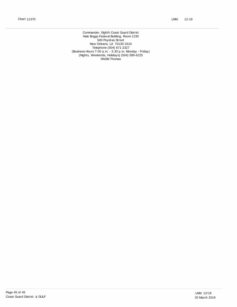
20 March 201912/19LNM:
8Coast Guard District GULFPage 45 of 45
12-19LNM:
Commander, Eighth Coast Guard DistrictHale Boggs Federal Building, Room 1230
500 Poydras StreetNew Orleans, LA 70130-3310
Telephone (504) 671-2327(Business Hours 7:00 a.m. - 3:30 p.m. Monday - Friday)
(Nights, Weekends, Holidays) (504) 589-6225RADM Thomas
11370 Chart
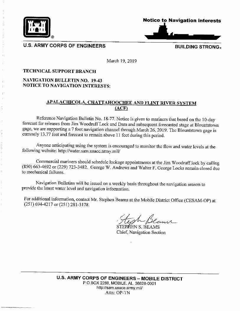
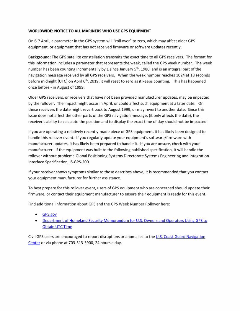
WORLDWIDE: NOTICE TO ALL MARINERS WHO USE GPS EQUIPMENT
On 6-7 April, a parameter in the GPS system will “roll over” to zero, which may affect older GPS
equipment, or equipment that has not received firmware or software updates recently.
Background: The GPS satellite constellation transmits the exact time to all GPS receivers. The format for
this information includes a parameter that represents the week, called the GPS week number. The week
number has been counting incrementally by 1 since January 5th, 1980, and is an integral part of the
navigation message received by all GPS receivers. When the week number reaches 1024 at 18 seconds
before midnight (UTC) on April 6th, 2019, it will reset to zero as it keeps counting. This has happened
once before - in August of 1999.
Older GPS receivers, or receivers that have not been provided manufacturer updates, may be impacted
by the rollover. The impact might occur in April, or could affect such equipment at a later date. On
these receivers the date might revert back to August 1999, or may revert to another date. Since this
issue does not affect the other parts of the GPS navigation message, (it only affects the date), the
receiver’s ability to calculate the position and to display the exact time of day should not be impacted.
If you are operating a relatively recently-made piece of GPS equipment, it has likely been designed to
handle this rollover event. If you regularly update your equipment’s software/firmware with
manufacturer updates, it has likely been prepared to handle it. If you are unsure, check with your
manufacturer. If the equipment was built to the following published specification, it will handle the
rollover without problem: Global Positioning Systems Directorate Systems Engineering and Integration
Interface Specification, IS-GPS-200.
If your receiver shows symptoms similar to those describes above, it is recommended that you contact
your equipment manufacturer for further assistance.
To best prepare for this rollover event, users of GPS equipment who are concerned should update their
firmware, or contact their equipment manufacturer to ensure their equipment is ready for this event.
Find additional information about GPS and the GPS Week Number Rollover here:
GPS.gov
Department of Homeland Security Memorandum for U.S. Owners and Operators Using GPS to
Obtain UTC Time
Civil GPS users are encouraged to report disruptions or anomalies to the U.S. Coast Guard Navigation
Center or via phone at 703-313-5900, 24 hours a day.
U.S. ARMY CORPS OF ENGINEERS – MOBILE DISTRICT P.O.BOX 2288, MOBILE. AL. 36628-0001
http://sam.usace.army.mil/
Attn: OP-TN
March 7, 2019
TECHNICAL SUPPORT BRANCH NAVIGATION BULLETIN NO. 19-35 NOTICE TO NAVIGATION INTERESTS:
TENNESSEE-TOMBIGBEE WATERWAY MISSISSIPPI
Notice is given to mariners, in response to the recent flood event, there are a number of areas along the waterway with channel restrictions, where the channel has shoaled to less authorized dimensions. The following areas have a restricted width 9’ depth channel:
• Divide Cut Section (Above Jamie Whitten Lock) o Mile 440.3 – 150’ width available – stay on channel center line o Mile 436.2 – 140’ width available – pin buoys in place marking channel o Mile 433.0 – 130’ width available – stay on channel center line o Mile 431.0 – 130’ width available – stay on channel center line o Mile 423.1 – 90’ width available – follow left descending bank
• Montgomery Pool o Mile 410.0 – 150’ width available – pin buoys in place marking channel
• Aberdeen Lake o Mile 362.6 – 150’ width available – USCG buoys in place marking channel
• Aliceville Lake o Mile 326.0 – 150’ width available – USCG buoys in place marking channel
In addition, Columbus Lake Mile 353.5 has a draft restriction of 7’ due to shoaling. For additional information, contact Mr. Roger Wilson, Jr. at the Tennessee-Tombigbee Project Management Office (CESAM-OP-CO) at (662) 245-5486 or (662) 574-7316. Stephen S. Beams Chief, Navigation Section
Notice to Navigation interests
BUILDING STRONG ® U.S. ARMY CORPS OF ENGINEERS