Embed Size (px)
Citation preview
Reference number/code [Sector Code]
Upper Mersey abstraction licensing strategy
A licensing strategy to manage water resources sustainably
February 2013
1
Environment Agency Upper Mersey Abstraction Licence Strategy
We are the Environment Agency. It’s our job to look after your environment and make it a better place - for you, and for future generations. Your environment is the air you breathe, the water you drink and the ground you walk on. Working with business, Government and society as a whole, we are making your environment cleaner and healthier. The Environment Agency. Out there, making your environment a better place.
Published by: Environment Agency Rio House Waterside Drive, Aztec West Almondsbury, Bristol BS32 4UD Tel: 03708 506 506 Email: [email protected] www.environment-agency.gov.uk © Environment Agency All rights reserved. This document may be reproduced with prior permission of the Environment Agency.
2
Environment Agency Upper Mersey Abstraction Licence Strategy
Foreword
Water is the most essential of our natural resources, and it is our job to ensure that we manage and use it effectively and sustainably. The latest population growth and climate change predictions show that pressure on water resources is likely to increase in the future. In light of this, we have to ensure that we continue to maintain and improve sustainable abstraction and balance the needs of society, the economy and the environment. In the Upper Mersey area water is used for industry, public water supply and agriculture as well as being an important amenity feature; so managing water wisely is essential if this resource is to remain sustainable. This licensing strategy sets out how we will manage water resources in the Upper Mersey area and provides you with information on how we will manage existing abstraction licences and water availability for further abstraction.
4
Environment Agency Upper Mersey Abstraction Licence Strategy
Contents
FOREWORD .......................................................................................................... 4
1. ABOUT THE LICENSING STRATEGY .............................................................. 6
2. UPPER MERSEY CAMS AREA ........................................................................ 8
3. WATER RESOURCE AVAILABILITY OF THE UPPER MERSEY AREA .......... 10
3.1 Resource assessment ............................................................................................................... 10
3.2 Resource availability .................................................................................................................. 10 3.2.1 Surface water ......................................................................................................................... 10 3.2.2 Groundwater ........................................................................................................................ 13
3.3 Resource reliability .................................................................................................................. 15
4. HOW WE MANAGE ABSTRACTIONS IN THE UPPER MERSEY AREA ....... 17
4.1 Water Abstraction in the Upper Mersey Area ........................................................................ 17
4.2 Principles .................................................................................................................................. 18
4.3 Abstraction restrictions ........................................................................................................... 20 4.3.1 Surface water ....................................................................................................................... 20
4.4 Opportunities for licence trading ........................................................................................... 26
4.5 New Authorisations .................................................................................................................. 27
4.6 Restoring Sustainable Abstraction (RSA) ............................................................................. 27
4.7 Heavily Modified Water Bodies ............................................................................................... 27
4.8 Habitats Directive ..................................................................................................................... 28
5. STRATEGY ACTIONS ..................................................................................... 29
GLOSSARY OF TERMS ...................................................................................... 31
ABBREVIATIONS.................................................................................................32
5
Environment Agency Upper Mersey Abstraction Licence Strategy
1. About the Licensing Strategy This Licensing Strategy sets out how water resources are managed in the Upper Mersey catchment. It provides information about where water is available for further abstraction and an indication of how reliable a new abstraction licence may be. The Upper Mersey Catchment Abstraction Management Strategy was created in February 2013 and supersedes the Tame, Goyt & Etherow (issued in March 2004) and Mersey Bollin (issued in August 2005) CAMS. How CAMS contributes to achieving environmental objectives under the (WFD) Water Framework Directive The Water Framework Directive’s main objectives are to protect and enhance the water environment and ensure the sustainable use of water resources for economic and social development. Catchment Abstraction Management Strategies (CAMS) set out how we will manage the water resources of a catchment and contribute to implementing the objectives of the WFD. CAMS contribute to the WFD by:
providing a water resource assessment of rivers, lakes, reservoirs, estuaries and groundwater referred to as water bodies under the WFD;
identifying water bodies that fail flow conditions expected to support good ecological status; preventing deterioration of water body status due to new abstractions; providing results which inform River Basin Management Plans (RBMPs).
When is an abstraction licence required? You need a licence from us if you want to abstract more than 20m3/day (4400 gallons) of water per day from a:
river or stream reservoir, lake or pond spring or an underground source
Whether or not a licence is granted depends on:
the amount of water available after the needs of the environment and existing abstractors are met
whether the justification for the abstraction is reasonable the abstractor has considered water efficiency measures
If you want to apply for an abstraction licence or make changes to a licence that you already have, please contact us: by telephone on 03708 506 506 by email at [email protected] or visit our website at www.environment-agency.gov.uk.
6
Environment Agency Upper Mersey Abstraction Licence Strategy
Sustainable abstraction This licensing strategy has been produced using evidence and information gathered during the Catchment Abstraction Management Strategy (CAMS) process. Through this process we consider the impact of abstraction at all flows. This helps to manage future abstraction more sustainably. We now assess water resources at a sub-catchment level called water bodies. This means that we can provide more detailed information on the availability of water resources in the Upper Mersey CAMS area compared to the scale used in the previous strategy. Within this strategy we also outline where we may need to reduce current rates of abstraction and our approach on time limiting licences. The background, aims and principles of CAMS, the over arching principles we use when managing abstraction licences and links with other initiatives are detailed in our document: Managing Water Abstraction. You should read Managing Water Abstraction when reading this catchment specific licensing strategy.
7
Environment Agency Upper Mersey Abstraction Licence Strategy
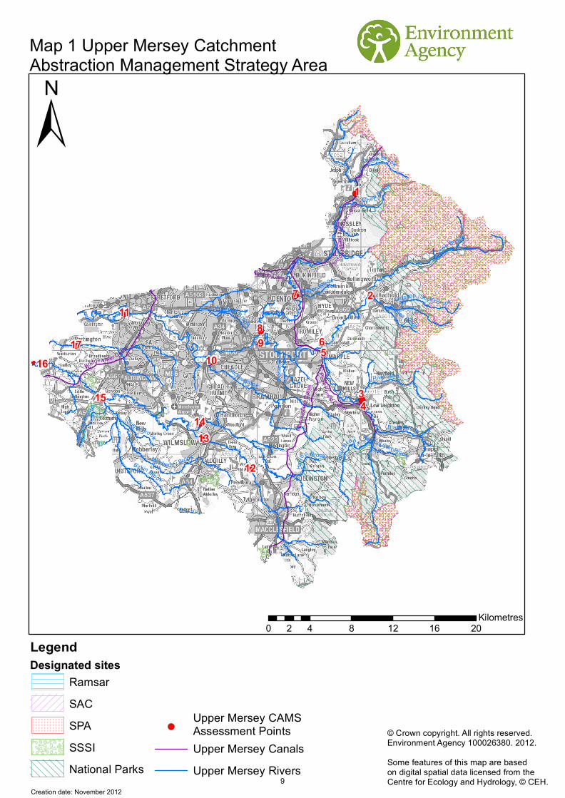
2. Upper Mersey CAMS area The Upper Mersey CAMS was formed from the merger of the Mersey Bollin and Tame Goyt Etherow CAMS. It covers a total area of approximately 1046 km2 and includes the catchments of the River Mersey (upstream of the Manchester Ship Canal), River Bollin, and River Tame, River Goyt, River Etherow and their tributaries. The River Tame catchment rises upstream of New Years Bridge reservoir at Denshaw and has a catchment area of 146 km2. From Denshaw, the river flows in a southerly direction through the towns of Delph, Uppermill, Mossley, Stalybridge, Ashton under Lyne, Denton, Hyde and ultimately joins the River Goyt at Stockport to become the River Mersey. The River Tame drains the eastern edge of the Manchester conurbation and the westerly edge of the Pennines. The River Goyt rises on Whetstone Ridge, to the south west of Buxton at an altitude of 520m AOD. The River flows to the north through Errwood and Fernilee reservoirs, before flowing through the towns of Whaley Bridge, Furness Vale, New Mills and Marple and heading west to flow towards it’s confluence with the River Tame. The River Goyt has three main tributaries. Black Brook which drains the Chapel-en-le-Frith area; the River Sett which drains the Hayfield and Kinder Scout area of the High Peak District and finally the River Etherow which drains the northern area of the High Peak District and the town of Glossop. The upper reaches of the River Etherow are dominated by five large reservoirs. The total catchment area of the River Goyt / River Etherow catchment is 365 km2.
The River Mersey sub-catchment consists of the River Mersey, down to the Manchester Ship Canal at Carrington, Sinderland Brook and their tributaries, but excluding the River Goyt, Bollin and Tame. The River Mersey originates in Stockport, where the Goyt and Tame converge at an altitude of 40m AOD. From Stockport the river flows in a westerly direction and is initially confined in a walled channel as far as Heaton Mersey, where the river begins to meander across the flood plain. The river flows past Northenden, Chorlton, Aston-on-Mersey and Flixton, before outfalling into the Manchester Ship Canal over Irlam Weir at an altitude of 12 m AOD. As the Manchester conurbation has grown, development adjacent to the river has narrowed the river corridor and much of the channel has been embanked to prevent frequent flooding to the adjoining land.
The largest tributary of the Mersey is Micker Brook, which drains South Stockport, Bramhall and Poynton, with altitudes rising to 400 m AOD. The confluence of Micker Brook with the Mersey is to the north of Cheadle. The next largest tributary of the Mersey is Chorlton Platt Gore, which drains the heavily urbanised areas of Chorlton, Fallowfield, Rusholme, Gorton and Audenshaw. Due to the demand for land in the City of Manchester, there are many culverted sections along the brook. It has its confluence with the Mersey at Sale Ees.
The River Bollin catchment consists of the River Bollin and its tributaries, Bradley Brook, Thelwall Brook, and Morris Brook. The extent of coverage is from the headwaters of each watercourse to their confluence with the Manchester Ship Canal. The River Bollin rises within Macclesfield Forest, and then flows generally westwards through Trentabank, Ridgegate and Bottoms Reservoirs towards Macclesfield. The river then flows through Prestbury and Wilmslow, where the River Dean joins it. From its confluence with the Dean, the River Bollin flows to the South of Manchester Airport, Altrincham, Dunham and Warburton to outfall into the Manchester Ship Canal. A further major tributary joins the Bollin at the M56/A556 interchange. This tributary, Birkin Brook, drains Alderley Edge and Knutsford and has many other tributaries.
The Bridgewater Canal, Macclesfield Canal and a small section of the Ashton Canal fall within the Upper Mersey CAMS area. There are a large number of water bodies, for example the Cheshire Meres, which are large reservoirs and ponds that are valuable conservation, recreation and historic resources. Rostherne Mere is an internationally important Ramsar site (Ramsar is an international designation for wetlands with particular importance for birds) and a national nature reserve.
Map 1 shows the Upper Mersey area with designated sites.
8
!(
!(
!(
!(
!(
!(
!(
!(
!(
!(
!(
!(
!(
!(
!(
!(
!(
Hud dersf
ield N
arrow
Canal
1
5
2
3
7
4
689
16
1514
1017
11
13
12
Rochdale Canal
Peak Fo rest Canal
Bridgewater Canal
Hudders
field Narrow Canal
Manch
ester S
hip Canal Ashton Canal
Leeds and Liverpool Canal
Trent and Mersey Canal
Canal
Trent
and M
ersey
Can
al
Manchester, Bolton and Bury Canal (disused)
Manchester, Bolton and Bury Canal (disused)
Manches
ter, Bolto
n and B
ury Cana
l (disus
ed)
Macc
lesfie
ld Ca
nal
Wade Bro ok
Mobberley Brook
Snape Brook
Birkin Broo k
River Set tMicker Brook
Peover Eye
River
Be
al
Diggle Brook
Astle
y Brook
Black Brook
Moston Brook
River Glaze
Sugar Brook
Rosth
erne B
rook
Wilson Brook
Glossop (Shelf) Brook
Todd
Brook
Turnlea Brook
Whittle Brook
Winc e BrookC h ew B roo
k
Heyd
en Brook
Swettenham Brook
Cl
ough B
roo
k
River Wye from Source to Monk's Dale
Fallowfield Brook
Monk's Dale Catchment (trib of R Wye)
Puddinglake Brook
Poise
Broo
k
Bag Brook
Harro
p Brook
Randall Carr Brook
Astley Brook
Map 1 Upper Mersey CatchmentAbstraction Management Strategy Area
±
0 4 8 12 16 202Kilometres
© Crown copyright. All rights reserved.Environment Agency 100026380. 2012.Some features of this map are basedon digital spatial data licensed from theCentre for Ecology and Hydrology, © CEH.
Creation date: November 2012
Legend
RamsarSACSPASSSINational Parks Upper Mersey Rivers
Designated sites
Upper Mersey Canals!(
Upper Mersey CAMS Assessment Points
9
Environment Agency Upper Mersey Abstraction Licence Strategy
3. Water resource availability of the Upper Mersey area 3.1 Resource assessment Resource assessment is at the heart of abstraction management. To manage water effectively we need to understand how much is available and where it is available, after considering the needs of the environment. We have a monitoring network to measure river flows and groundwater levels. We use this data along with our knowledge of human influences and environmental needs to establish a baseline of water availability for each water body that builds into a picture for the catchment. The main components of this assessment that help us to understand the availability of water resources are: a resource allocation for the environment defined as a proportion of natural flow, known as the
Environmental Flow Indicator (EFI);The Fully Licensed (FL) scenario - the situation if all abstraction licences were being used to full capacity;
The Recent Actual (RA) scenario – the amount of water which has actually been abstracted on average over the previous six years.
River flows change naturally throughout the year, so we want to protect flow variability in our rivers from low to high flow conditions. We use flow statistics to help to do this. Flow statistics are expressed as the percentage of time that flow is exceeded. Resource availability is calculated at four different flows, Q95 (lowest), Q70, Q50 and Q30 (highest). For example, Q95 is flow that is equalled or exceeded for 95% of the time. It’s termed a low flow because only 5% of the time is flow less than this. This information gives a realistic picture of what the current resource availability is within a given water body. Water bodies are sub-catchment surface water units or groundwater units on which we carry out assessments and map results.
3.2 Resource availability 3.2.1 Surface water If you want to abstract water, you need to know what water resources are available within a catchment and where abstraction for consumptive purposes is allowed. To show this we have developed a classification system which indicates: The relative balance between the environmental requirements for water and how much is
licensed for abstraction; Whether water is available for further abstraction; Areas where abstraction may need to be reduced. The availability of water for abstraction is determined by the relationship between the fully licensed and recent actual flows in relation to the EFI. The results mapped onto these water bodies are represented by different water resource availability colours showing the availability of water resource for further abstraction. The water resource availability colours are explained in Table 1. In addition to these water resource availability colours we’ve classified some surface water bodies as ‘high hydrological status’ which are coloured blue on the maps. In these water bodies very little actual abstraction occurs and they show virtually undisturbed, or close to natural, flow conditions. Another category of water body is Heavily Modified Water Bodies (HMWB). These can be classified for many reasons but for water resources they are classified if they may contain a modified lake and/or reservoir that influence the downstream flow regime of the river.
10
Environment Agency Upper Mersey Abstraction Licence Strategy
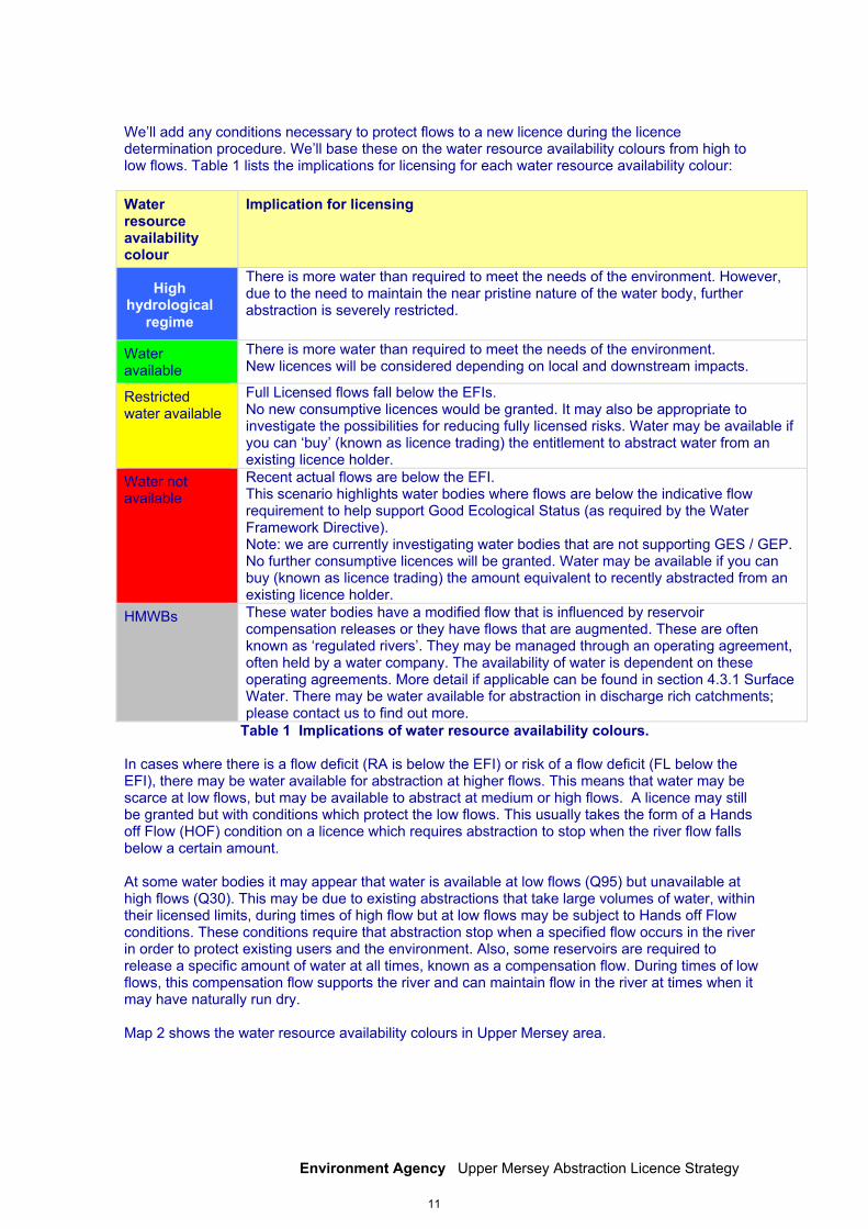
We’ll add any conditions necessary to protect flows to a new licence during the licence determination procedure. We’ll base these on the water resource availability colours from high to low flows. Table 1 lists the implications for licensing for each water resource availability colour: Water resource availability colour
Implication for licensing
There is more water than required to meet the needs of the environment. However, due to the need to maintain the near pristine nature of the water body, further abstraction is severely restricted.
Water available
There is more water than required to meet the needs of the environment. New licences will be considered depending on local and downstream impacts.
Restricted water available
Full Licensed flows fall below the EFIs. No new consumptive licences would be granted. It may also be appropriate to investigate the possibilities for reducing fully licensed risks. Water may be available if you can ‘buy’ (known as licence trading) the entitlement to abstract water from an existing licence holder.
Water not available
Recent actual flows are below the EFI. This scenario highlights water bodies where flows are below the indicative flow requirement to help support Good Ecological Status (as required by the Water Framework Directive). Note: we are currently investigating water bodies that are not supporting GES / GEP. No further consumptive licences will be granted. Water may be available if you can buy (known as licence trading) the amount equivalent to recently abstracted from an existing licence holder.
HMWBs These water bodies have a modified flow that is influenced by reservoir compensation releases or they have flows that are augmented. These are often known as ‘regulated rivers’. They may be managed through an operating agreement, often held by a water company. The availability of water is dependent on these operating agreements. More detail if applicable can be found in section 4.3.1 Surface Water. There may be water available for abstraction in discharge rich catchments; please contact us to find out more.
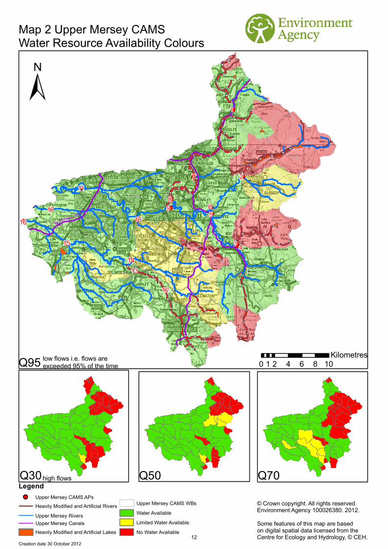
Table 1 Implications of water resource availability colours. In cases where there is a flow deficit (RA is below the EFI) or risk of a flow deficit (FL below the EFI), there may be water available for abstraction at higher flows. This means that water may be scarce at low flows, but may be available to abstract at medium or high flows. A licence may still be granted but with conditions which protect the low flows. This usually takes the form of a Hands off Flow (HOF) condition on a licence which requires abstraction to stop when the river flow falls below a certain amount. At some water bodies it may appear that water is available at low flows (Q95) but unavailable at high flows (Q30). This may be due to existing abstractions that take large volumes of water, within their licensed limits, during times of high flow but at low flows may be subject to Hands off Flow conditions. These conditions require that abstraction stop when a specified flow occurs in the river in order to protect existing users and the environment. Also, some reservoirs are required to release a specific amount of water at all times, known as a compensation flow. During times of low flows, this compensation flow supports the river and can maintain flow in the river at times when it may have naturally run dry. Map 2 shows the water resource availability colours in Upper Mersey area.
High hydrological
regime
11
!(
!(
!(
!(
!(
!(
!(
!(
!(
!(
!(
!(
!(
!(
!(
!(
!(
52
74
9
13
8
6
13
10
1112
Rochdale Canal
Bridgewater Canal
Hudders
field N
arrow Canal
Manc
heste
r S
hip Canal
Leeds and Liverpool Canal
Canal
Map 2 Upper Mersey CAMS Water Resource Availability Colours
© Crown copyright. All rights reserved.Environment Agency 100026380. 2012.Some features of this map are basedon digital spatial data licensed from theCentre for Ecology and Hydrology, © CEH.
Creation date 30 October 2012
Q30
Q95
Q70Q50
±
Legend
Heavily Modified and Artificial Rivers
Heavily Modified and Artificial Lakes
Water AvailableLimited Water AvailableNo Water Available
7
0 2 4 6 8 101Kilometres
Upper Mersey CAMS APs
Upper Mersey Rivers
Upper Mersey CAMS WBs
17
3
1
2
569
8
10
15
11
12
1314
4
16
low flows i.e. flows are exceeded 95% of the time
high flows
Upper Mersey Canals
12
Environment Agency Upper Mersey Abstraction Licence Strategy
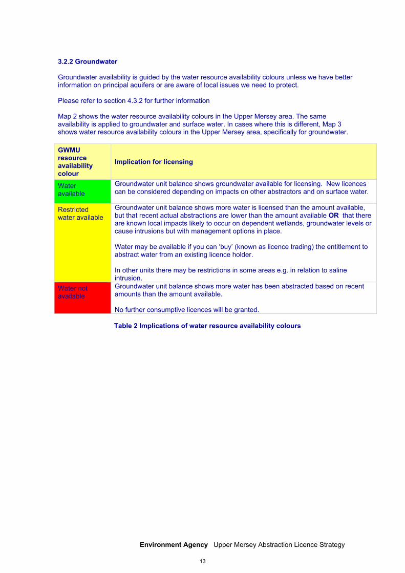
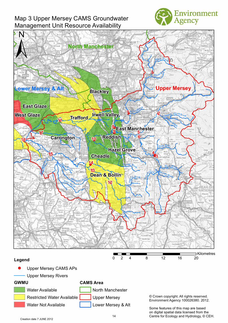
3.2.2 Groundwater Groundwater availability is guided by the water resource availability colours unless we have better information on principal aquifers or are aware of local issues we need to protect. Please refer to section 4.3.2 for further information Map 2 shows the water resource availability colours in the Upper Mersey area. The same availability is applied to groundwater and surface water. In cases where this is different, Map 3 shows water resource availability colours in the Upper Mersey area, specifically for groundwater. GWMU resource availability colour
Implication for licensing
Water available
Groundwater unit balance shows groundwater available for licensing. New licences can be considered depending on impacts on other abstractors and on surface water.
Restricted water available
Groundwater unit balance shows more water is licensed than the amount available, but that recent actual abstractions are lower than the amount available OR that there are known local impacts likely to occur on dependent wetlands, groundwater levels or cause intrusions but with management options in place. Water may be available if you can ‘buy’ (known as licence trading) the entitlement to abstract water from an existing licence holder. In other units there may be restrictions in some areas e.g. in relation to saline intrusion.
Water not available
Groundwater unit balance shows more water has been abstracted based on recent amounts than the amount available. No further consumptive licences will be granted.
Table 2 Implications of water resource availability colours
13
!(
!(
!(
!(
!(
!(
!(
!(
!(
!(
!(
!(
!(
!(
!(
!(
!(
North Manchester
Upper MerseyLower Mersey & Alt
Trafford
Dean & Bollin
Cheadle
East Glaze
Carrington
Irwell Valley
Reddish
Blackley
East Manchester
West Glaze
Hazel Grove
1
5
2
3
7
4
689
16
1514
1017
11
13
12Mobberley Brook
Birkin Broo k
River Set t
Poynton Brook
Diggle Brook
Black BrookSugar Brook
Rosth
erne B
roo
k
Wilson Brook
Glossop (Shelf) Brook
Todd
Brook
Turnlea Brook
Ch ew Brook
Harro
p Brook
Randall Carr Brook
Map 3 Upper Mersey CAMS Groundwater Management Unit Resource Availability
±
0 4 8 12 16 202Kilometres
© Crown copyright. All rights reserved.Environment Agency 100026380. 2012.Some features of this map are basedon digital spatial data licensed from theCentre for Ecology and Hydrology, © CEH.
Creation date 7 JUNE 2012
Legend!( Upper Mersey CAMS APs
Upper Mersey RiversGWMU
Water AvailableRestricted Water AvailableWater Not Available
CAMS AreaNorth ManchesterUpper MerseyLower Mersey & Alt
14

Environment Agency Upper Mersey Abstraction Licence Strategy
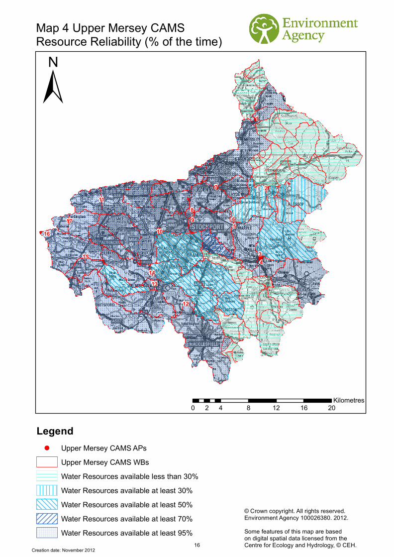
3.3 Resource reliability If you want to apply for a licence, it is worth considering that in some areas a new, consumptive abstraction may not be 100% reliable. Reliability information is based on CAMS resource availability colours and is a way of presenting the reliability of new abstractions at all flows. The availability of water for abstraction within a river varies greatly from high to low flows. By assessing the quantity of water available at different flows it is possible to see when there is a surplus or deficit of water and the associated reliability of an abstraction. This is an indication only; actual reliability of a licence will be discussed on application. Table 3 shows the resource availability colour associated with the percentage reliability of consumptive abstraction. Map 4 gives an indication of the resource reliability in Upper Mersey area expressed as percentage of time.
Resource Percentage of the time additional consumptive resource may be available
Consumptive abstraction available less than 30% of the time.
Consumptive abstraction available at least 30% of the time.
Consumptive abstraction available at least 50% of the time.
Consumptive abstraction available at least 70% of the time.
Consumptive abstraction available at least 95% of the time.
Not assessed
Table 3 Percentage reliability of consumptive abstraction
15
!(
!(
!(
!(
!(
!(
!(
!(
!(
!(
!(
!(
!(
!(
!(
!(
!(
1
5
2
3
7
4
689
16
15
14
1017
11
13
12
Map 4 Upper Mersey CAMS Resource Reliability (% of the time)
±
0 4 8 12 16 202Kilometres
© Crown copyright. All rights reserved.Environment Agency 100026380. 2012.Some features of this map are basedon digital spatial data licensed from theCentre for Ecology and Hydrology, © CEH.
Creation date: November 2012
Legend!( Upper Mersey CAMS APs
Upper Mersey CAMS WBsWater Resources available less than 30%Water Resources available at least 30%Water Resources available at least 50%Water Resources available at least 70%Water Resources available at least 95%
16
Environment Agency Upper Mersey Abstraction Licence Strategy
4. How we manage abstractions in the Upper Mersey area
4.1 Water Abstraction in the Upper Mersey Area Water is abstracted today throughout the area from both surface waters and groundwater for agriculture, spray irrigation, industry and public water supply purposes. Homes and industries within this CAMS area receive their water supply from United Utilities Water Plc. There are a number of important public water supply reservoirs in the catchment, including Ridgegate, Trentabank, Lamaload and the Audenshaw Reservoirs. There are also reservoirs within this CAMS area whose sole purpose is to provide compensation water to rivers downstream of them (including Bottoms and Teggs Nose Reservoirs, near Macclesfield). This is why on some rivers, flows are above natural levels. All of the public water supply abstractions within the area feed into the water company integrated system. This integrated system is used to supply water to 95 per cent of customers in the northwest of England. The water company source water from as far afield as Haweswater and Thirlmere Reservoirs in the Lake District and Lake Vyrnwy in mid-Wales to meet the demand for water within this system. In addition to the reservoirs mentioned above, the water company abstract from boreholes drilled into groundwater aquifers of the Mersey and Bollin catchment. These boreholes provide the water company with greater flexibility when meeting the seasonally-varying demand for water. Within the Tame/Goyt area, there is limited groundwater abstraction as yields are difficult to predict and the quality is often poor with a high iron content. However, minor aquifers are capable of supporting small-scale agricultural and domestic supplies and are used for such in areas remote from the public mains system. There are also a number of reservoirs within the CAMS area which are used to supply the canal network operated by the Canal & Rivers Trust. Sutton, Combs, Todd Brook and Diggle reservoirs are important supplies to the canal network. There are many wastewater treatment work discharges in the Upper Mersey area. These contribute to flow, and in many river sections flows are higher than they would be otherwise. Given that a significant amount of water is also imported into the catchment from the Lake District and Wales, the proportion of water supplied to the region by discharge is very significant.
17
Environment Agency Upper Mersey Abstraction Licence Strategy
4.2 Principles The document Managing Water Abstraction outlines the over-arching principles that we follow in managing our water resources. How we apply these principles in the Upper Mersey area is outlined in this section. If you want to abstract water it outlines where water is available for further abstraction and the principles we follow in assessing your application for a licence. Abstraction licence application process Anyone wanting to take more than 20m3/day (4,400 gallons) from a ‘source of supply’ (river, stream, lake, well, groundwater etc) must have an abstraction licence. The application process for abstraction is similar to the planning process in that we may require the application to be advertised and may require supporting environmental information. When considering the application we check that the quantities applied for and the purpose of the abstraction are reasonable, that there is sufficient water available to support it and that the potential impacts on the environment and other water users are acceptable. Depending on the outcome of our investigations we will issue a licence either as applied for, or with conditions that restrict the abstraction to protect the environment or other users. In certain cases we may have to refuse the application. Any applicant who is not happy with our determination (decision) has the right to appeal against it. Each application is determined on its own merits Whilst this document may say that water is available for further abstraction, this does not guarantee that all applications will be successful. We’ll determine each application upon its own merits and any local impacts. A licence does not guarantee that water is available It’s important to understand that when we issue a licence we do not guarantee the supply of water. We have to protect the environment and rights of other abstractors. To do this we may add constraints to licences. Licence holder’s needs to understand the implications of this as it affects the reliability of supply. For example, in drier years it’s more likely that conditions will come into effect and abstraction is more likely to be stopped. Abstractions are managed to protect the environment No ecological deterioration We assess the impact of new applications for water to make sure that the resultant river flows:
will maintain a good ecology or if the ecology is not good, will not deteriorate the ecology of our rivers further;
Will maintain the near pristine condition of high hydrological regime water bodies. For existing licences, where current abstraction is less than licensed i.e. more water could be legally abstracted, we may take action to limit such an increase if we think this will lead to deterioration of the ecology of water bodies. These principles apply to the water body in which the abstraction is located and also to all downstream water bodies that may be affected by any reduction in flow caused by abstraction. Doing this means that we will maintain the water body status as reported in the River Basin Management Plans (2009) and ensure compliance with the European Union Water Framework Directive. Water efficiency and demand management We need to make the best use of our existing water resources. Adopting water efficiency and demand management measures can help us achieve this goal. Water efficiency is one of the tests that will need to be satisfied before we grant a new licence or renew a time limited licence. We will promote the wise and efficient use of water and actions to limit demand (and reduce leakage) to curb the growth in abstraction and limit the impact on flows and any consequent impact on the ecology. For further details on our general approach to licensing please see the document Managing Water Abstraction.
18
Environment Agency Upper Mersey Abstraction Licence Strategy
Impoundments You normally need an impoundment licence to construct, alter, repair or remove an impoundment structure. These structures include weirs, fish passes and sluices. We will consider every case on its individual merits, and will normally only approve an application to install new structures in a watercourse if one or more of the following apply:
it is demonstrated to our satisfaction that there are over-riding social or economic reasons for the structure(s) in line with our sustainable development remit and there is no reasonable alternative;
we agree that the impacts on flood risk, ecology and morphology will not be significant or will be adequately mitigated against or compensated for;
we accept that the watercourse or floodplain has been modified or degraded, and restoration or enhancement using in-channel structures is justified and acceptable to flood risk management and ecological interests;
there are important strategic or operational reasons to monitor or regulate river levels and flows, and alternative methods are not technically or financially viable.
If we approve the application and it is appropriate to do so, we will seek mitigation or compensation to ensure environmental impacts and residual damage are minimised. If we believe it is justified, practical and economic, we may seek the removal or modification of structures that have an adverse effect on flood risk or on the ecology, morphology and visual amenity of a river. Hydropower Hydropower schemes harness the energy from flowing water to generate electricity, using a turbine or other device. Sustainable, small scale hydropower has a small but important part to play in meeting UK renewable energy targets. Water abstraction for hydropower schemes is non-consumptive, with all water used returned to the watercourse. Hands off Flows and maximum abstraction volumes are determined in line with the Environment Agency’s Hydropower Good Practice Guidelines and based on the assessment of environmental risk for each scheme. For further information please refer to our website.
19
Environment Agency Upper Mersey Abstraction Licence Strategy
4.3 Abstraction restrictions When issuing a licence we have to protect the environment and rights of other abstractors. To do this we may add conditions to licences. Time limited licences In recognition of changing pressures on water resources all new licences and variations (other than downward variations or minor variations having no environmental impact) will have a time limit imposed. This allows for the periodic review and changes to abstraction licences where circumstances have changed since the licence was granted. All new licences within a CAMS area have a Common End Date (CED) so they can be reviewed at the same time. When an application is made within six years of the CED, we will generally apply the subsequent CED to any licence granted. This is to avoid issuing shorter and shorter duration licences as the CED approaches. This means that the initial CED on a licence may be between six and 18 years duration. On replacement the normal duration will then usually be 12 years. However, where we are uncertain about the long term impacts of an abstraction we will grant a short term licence during which time potential impacts are monitored. 19% of the licences in Upper Mersey CAMS are time-limited. CEDs occur every twelve years. The next CED for Upper Mersey CAMS are:
Tame, Goyt and Etherow area: 31st March 2017 and the subsequent one is 31st March 2029
Mersey Bollin area: 31st March 2018 and the subsequent one is 31st March 2030
Additional information about the replacement of time limited licences is available in Managing Water Abstraction. Hands off flow conditions
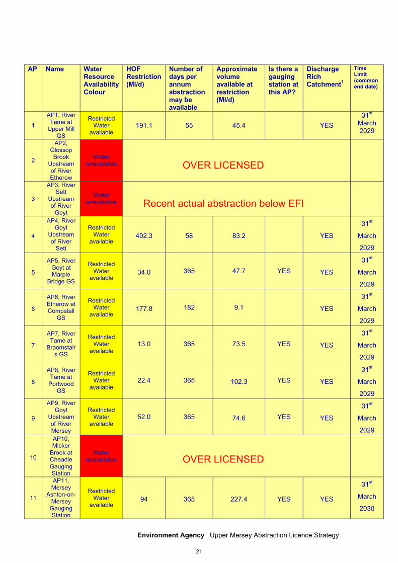
To protect the environment we may issue a licence with a condition referred to as a ‘Hands-Off Flow’ (HOF). This specifies that if the flow in the river drops below that which is required to protect the environment abstraction must stop, hence ‘Hands-Off Flow’. Please refer to table 4 for hands off flows for each assessment point. 4.3.1 Surface water We assess surface water flows at Assessment Points (APs) which are significant points on the river, often where two major rivers join or at a gauging station. Where flows fall below the EFI, new abstractions may be subject to HOFs. Table 4 gives an indication of how much water is available for further abstraction and the associated restrictions that we may apply to new and varied abstraction licences from the main river. Tributaries to the main river may be subject to different restrictions and quantities. Each HOF is linked to an AP and is dependent on the resource availability at that AP. In some cases additional restrictions may apply to licences where there is a more critical resource availability downstream to protect the ecological requirements of the river. All abstraction licence applications are subject to an assessment to take account of any local and downstream issues and may be subject to further restrictions. Reading from top to bottom in Table 4 are the APs in the Upper Mersey CAMS area. Reading across the columns you can see the potential HOF that may be applied to a licence, the number of days water may be available under this restriction and the approximate volume of water in Ml/d that may be available. In cases where there is water available at all flows we may apply a Minimum Residual Flow (MRF) to protect very low flows. We’ll decide this on a case by case basis.
20
Environment Agency Upper Mersey Abstraction Licence Strategy
AP Name
Water Resource Availability Colour
HOF Restriction (Ml/d)
Number of days per annum abstraction may be available
Approximate volume available at restriction (Ml/d)
Is there a gauging station at this AP?
Discharge Rich Catchment1
Time Limit (common end date)
1
AP1, River Tame at
Upper Mill GS
Restricted Water
available 191.1 55 45.4 YES
31st March 2029
2
AP2, Glossop Brook
Upstream of River Etherow
Water unavailable
3
AP3, River Sett
Upstream of River
Goyt
Water unavailable
4
AP4, River Goyt
Upstream of River
Sett
Restricted Water
available 402.3 58 83.2 YES
31st
March
2029
5
AP5, River Goyt at Marple
Bridge GS
Restricted Water
available 34.0 365 47.7 YES YES
31st
March
2029
6
AP6, River Etherow at Compstall
GS
Restricted Water
available 177.8 182 9.1 YES
31st
March
2029
7
AP7, River Tame at
Broomstairs GS
Restricted Water
available 13.0 365 73.5 YES YES
31st
March
2029
8
AP8, River Tame at Portwood
GS
Restricted Water
available 22.4 365 102.3 YES YES
31st
March
2029
9
AP9, River Goyt
Upstream of River Mersey
Restricted Water
available 52.0 365 74.6 YES YES
31st
March
2029
10
AP10, Micker
Brook at Cheadle Gauging Station
Water unavailable
11
AP11, Mersey
Ashton-on-Mersey Gauging Station
Restricted Water
available 94 365 227.4 YES YES
31st
March
2030
OVER LICENSED
OVER LICENSED
Recent actual abstraction below EFI
21
Environment Agency Upper Mersey Abstraction Licence Strategy
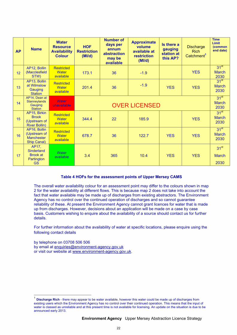
Table 4 HOFs for the assessment points of Upper Mersey CAMS The overall water availability colour for an assessment point may differ to the colours shown in map 2 for the water availability at different flows. This is because map 2 does not take into account the fact that water available may be made up of discharges from existing abstractors. The Environment Agency has no control over the continued operation of discharges and so cannot guarantee reliability of these. At present the Environment Agency cannot grant licences for water that is made up from discharges. However, decisions about an application will be made on a case by case basis. Customers wishing to enquire about the availability of a source should contact us for further details. For further information about the availability of water at specific locations, please enquire using the following contact details by telephone on 03708 506 506 by email at [email protected] or visit our website at www.environment-agency.gov.uk.
1 Discharge Rich - there may appear to be water available, however this water could be made up of discharges from existing users which the Environment Agency has no control over their continued operation. This means that the input of water is classed as unreliable and at this present time is not available for licensing. An update on the situation is due to be announced early 2013.
AP Name
Water Resource
Availability Colour
HOF Restriction
(Ml/d)
Number of days per annum
abstraction may be
available
Approximate volume
available at restriction
(Ml/d)
Is there a gauging
station at this AP?
Discharge Rich
Catchment1
Time Limit (common end date)
12 AP12, Bollin (Macclesfield
STW)
Restricted Water
available 173.1 36 -1.9 YES
31st March 2030
13
AP13, Bollin at Wilmslow
Gauging Station
Restricted Water
available 201.4 36 -1.9
YES YES 31st
March 2030
14 AP14, Dean at Stanneylands
Gauging Station
Water unavailable
31st March 2030
15
AP15, Birkin Brook
(Upstream of River Bollin)
Restricted Water
available 344.4 22 185.9 YES
31st March 2030
16
AP16, Bollin (Upstream of Manchester Ship Canal)
Restricted Water
available 678.7 36 122.7 YES YES
31st March 2030
17
AP17, Sinderland Brook at
Partington GS
Water available 3.4 365 10.4 YES YES
31st
March
2030
OVER LICENSED
22
Environment Agency Upper Mersey Abstraction Licence Strategy
The information below for each assessment point gives an indication of whether licenses will be renewed. Water Available for licensing AP17, Sinderland Brook at Partington For Assessment Point 17, Sinderland Brook at Partington, there is water available for licensing. There is 10.4 Ml/d available for unconstrained licensing. Following this further licences will be issued with hands-off flow constraints. This means that for new licences: • There is water available for unconstrained abstraction;
• We will continue licensing the available resource and then implement the Hands off Flow (HOF)
constraints
• There is a time limit of 31 March 2030
For existing licences: There is a presumption of renewal, subject to the other renewal criteria and local considerations. Renewals may be subject to minor changes including the addition of water efficiency conditions. Restricted Water Availability The following assessment points have restricted water available for licensing:
AP1, River Tame at Upper Mill gauging station AP4, River Goyt Upstream of River Sett
AP5, River Goyt at Marple Bridge gauging station
AP6, River Etherow at Compstall gauging station
AP7, River Tame at Broomstairs gauging station
AP8, River Tame at Portwood gauging station
AP9, River Goyt Upstream of River Mersey
AP11, Mersey Ashton-on-Mersey gauging station
AP12, Bollin (Macclesfield STW)
AP13, Bollin at Wilmslow gauging station
AP15, Birkin BrookAP1 (Upstream of River Bollin)
AP16, Bollin (Upstream of Manchester Ship Canal)
This means that for new licences: • No new unconstrained licences will be granted;
• Water is only available during periods of medium to high flows with HOF conditions;
• There is a time limit of 31 March 2029/30 and for existing licences:
• No impact on existing licence holders.
. 23
Environment Agency Upper Mersey Abstraction Licence Strategy
Water Unavailable for licensing The following assessment points have water unavailable for licensing:
AP2, Glossop Brook Upstream of River Etherow
AP3, River Sett Upstream of River Goyt
AP10, Micker Brook at Cheadle Gauging Station
AP14, Dean at Stanneylands Gauging Station These units are closed to new consumptive abstractions. The only way we would consider a new licence would be as a result of licence trading. Please see section 4.4 for further details. Further Information... For further information about the availability of water at specific locations, please enquire using the following contact details by telephone on 03708 506 506 by email at [email protected] or visit our website at www.environment-agency.gov.uk.
24
Environment Agency Upper Mersey Abstraction Licence Strategy
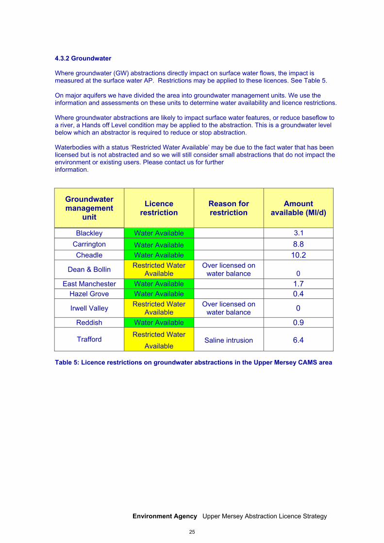
4.3.2 Groundwater Where groundwater (GW) abstractions directly impact on surface water flows, the impact is measured at the surface water AP. Restrictions may be applied to these licences. See Table 5. On major aquifers we have divided the area into groundwater management units. We use the information and assessments on these units to determine water availability and licence restrictions. Where groundwater abstractions are likely to impact surface water features, or reduce baseflow to a river, a Hands off Level condition may be applied to the abstraction. This is a groundwater level below which an abstractor is required to reduce or stop abstraction. Waterbodies with a status ‘Restricted Water Available’ may be due to the fact water that has been licensed but is not abstracted and so we will still consider small abstractions that do not impact the environment or existing users. Please contact us for further information.
Groundwater management
unit Licence
restriction Reason for restriction
Amount available (Ml/d)
Blackley Water Available 3.1 Carrington Water Available 8.8 Cheadle Water Available 10.2
Dean & Bollin Restricted Water Available
Over licensed on water balance 0
East Manchester Water Available 1.7 Hazel Grove Water Available 0.4
Irwell Valley Restricted Water Available
Over licensed on water balance 0
Reddish Water Available 0.9
Trafford Restricted Water
Available Saline intrusion 6.4
Table 5: Licence restrictions on groundwater abstractions in the Upper Mersey CAMS area
25
Environment Agency Upper Mersey Abstraction Licence Strategy
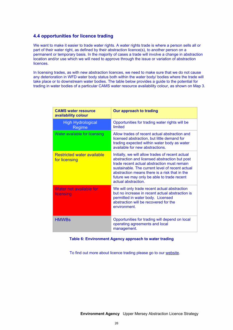
4.4 opportunities for licence trading We want to make it easier to trade water rights. A water rights trade is where a person sells all or part of their water right, as defined by their abstraction licence(s), to another person on a permanent or temporary basis. In the majority of cases a trade will involve a change in abstraction location and/or use which we will need to approve through the issue or variation of abstraction licences. In licensing trades, as with new abstraction licences, we need to make sure that we do not cause any deterioration in WFD water body status both within the water body/ bodies where the trade will take place or to downstream water bodies. The table below provides a guide to the potential for trading in water bodies of a particular CAMS water resource availability colour, as shown on Map 3.
CAMS water resource availability colour
Our approach to trading
Opportunities for trading water rights will be limited
Water available for licensing Allow trades of recent actual abstraction and licensed abstraction, but little demand for trading expected within water body as water available for new abstractions.
Restricted water available for licensing
Initially, we will allow trades of recent actual abstraction and licensed abstraction but post trade recent actual abstraction must remain sustainable. The current level of recent actual abstraction means there is a risk that in the future we may only be able to trade recent actual abstraction.
Water not available for licensing
We will only trade recent actual abstraction but no increase in recent actual abstraction is permitted in water body. Licensed abstraction will be recovered for the environment.
HMWBs Opportunities for trading will depend on local operating agreements and local management.
Table 6: Environment Agency approach to water trading
To find out more about licence trading please go to our website.
High Hydrological Regime
26
Environment Agency Upper Mersey Abstraction Licence Strategy
4.5 New Authorisations The Water Act 2003 brought all significant water abstraction under licensing control. This will result in trickle irrigation, dewatering of mines, quarries, engineering works and construction sites, abstractions related to Internal Drainage Districts, navigation abstraction and abstraction for ports and harbour authorities coming into the licensing regime. As a result we’ll be able to manage water resources more effectively by ensuring that all significant activities influencing the availability of water and its impact on the environment are undertaken in a sustainable manner. Government are still developing their policies as to how to resolve some of the issues raised during the consultation process. Government will publish their proposals before new regulations are implemented and expect to do this 3 months before commencement so that we can issue guidance to those affected by the changes. Where we have details of these abstractions we have included them in our assessments to consider how they impact on the catchment.
4.6 Restoring Sustainable Abstraction (RSA) Where water abstractions cause or potentially cause actual flows to fall short of the EFIs and result in environmental damage, we may need to change or even revoke existing abstractions in order to achieve a sustainable abstraction regime. The abstraction licences within these water bodies that cause these issues are being investigated as part of the RSA programme. Investigations into the impact caused by these licences, individually or cumulatively, will result in options being developed with licence holders on how to improve sustainability. Investigations will include a cost/benefit analysis. Information on how licences in the RSA programme are dealt with can be found in our Step by Step guide on our website. Within the current RSA programme there are no waterbodies within the Upper Mersey CAMS area. Investigation of Water Framework Directive Water bodies In addition to the RSA programme, we are investigating whether reduced water flow may be causing problems under the Water Framework Directive (WFD). About four per cent of rivers are failing to support WFD good ecological status due to pressures from over-abstraction.
4.7 Heavily Modified Water Bodies Some water bodies have been designated as artificial or heavily modified if they are substantially modified or constructed to be used for water supply, urban purposes, flood protection or navigation. Many of the headwaters of the Mersey tributaries have been impounded to create reservoirs for public water supply.
Under the River Basin Management Plan for the North West, private, public and voluntary/third sector organisations will work together to ensure that these water bodies can achieve their full environmental potential.
27
Environment Agency Upper Mersey Abstraction Licence Strategy
4.8 Habitats Directive Under the Habitats Regulations we have assessed the effects of existing abstraction licences and will assess new applications to make sure they are not impacting on internationally important nature conservation sites. These sites are known as Special Areas of Conservation (SAC’s) and Special Protection Areas (SPA’s). If you’re current licence has been reviewed under this legislation to assess its impact you will already know about the review. If we haven’t contacted you yet then your licence is either not near a SAC/SPA or isn’t having an impact on these sites. If our assessment shows that a new application could have an impact on a SAC/SPA we have to follow strict rules in setting a time limit for that licence. These are: • we may be able to grant the licence but only with a short time limit. This allows us to monitor the impact of the abstraction on a SAC/SPA and change the licence if necessary; • if we can’t determine that your application will not affect the site we have to either put conditions on the licence so that it cannot affect the site or refuse the application. If we grant the licence we may ask you to monitor its impact; • if our assessment shows that there isn’t an impact on the site we will manage the application according to the principles in this document. • When assessing new licence applications, we will consider any impacts on the Sites of Special Scientific Interest (SSSIs), Special Protection Areas (SPAs) and Ramsar sites as displayed in Map 1. These include: Rostherne Mere, a National Nature Reserve, SSI and Ramsar site situated on the northern edge of the West Midland Meres and Mosses Ramsar complex. It is the deepest mere in Cheshire and, owing to its depth, it rarely freezes over. This ensures that Rostherne Mere offers an excellent home to large numbers of wintering wildfowl. With associated reed bed, woodlands and grazing land, the reserve comprises 152 hectares. The South Pennines Moors is a Special Area of Conservation and Special Protection Area (SPA), which covers much of the headwaters of these catchments. This site consists of extensive areas of upland moorland supporting plants such as heather, cotton grass and bilberry, and provides internationally significant breeding areas for many important bird species such as golden plover, curlew, ringed ouzel, merlin and grouse. The Compstall Nature Reserve SSSI on the banks of the River Etherow contains a variety of habitats, including open water, tall fen and reed swamp, and is also of considerable ornithological interest. There are over 160 Sites of Biological Importance (SBIs) including large sites such as Lyme Park and the Peak Forest Canal which has healthy populations of rare invertebrates such as the freshwater mussel. There is a concentration of valuable SBIs associated with the river corridor and wetland habitats. These protect areas of remnant woodland, acid grassland areas, landslips and cliff sites, as well as valuable sites associated with industrial history, old mill ponds, disused railways, quarries and canals. The presence of earth cliffs, gravel shoals and boulders enhances the ecological value of the river corridor, providing habitat for a number of species, such as kingfishers and sandmartins. A number of sites also provide habitat for the threatened native crayfish. A concentration of SBIs follows the Bollin’s route through the Cheshire countryside.
28
Environment Agency Upper Mersey Abstraction Licence Strategy
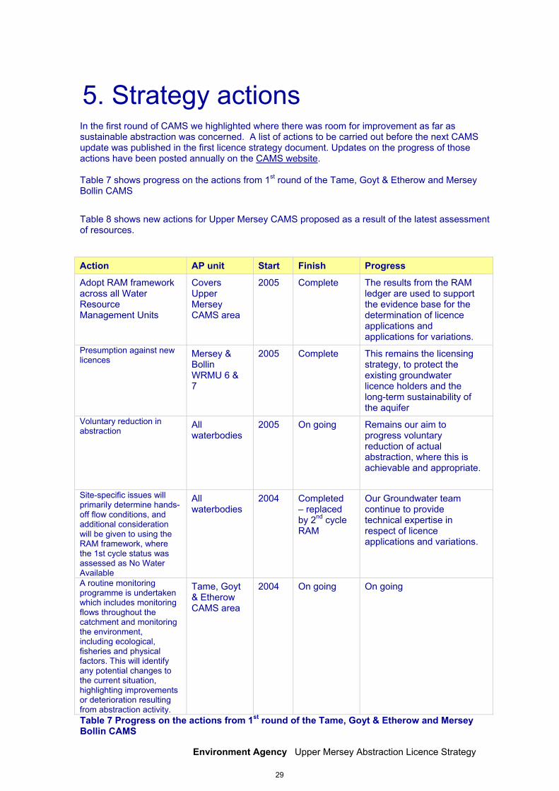
5. Strategy actions In the first round of CAMS we highlighted where there was room for improvement as far as sustainable abstraction was concerned. A list of actions to be carried out before the next CAMS update was published in the first licence strategy document. Updates on the progress of those actions have been posted annually on the CAMS website. Table 7 shows progress on the actions from 1st round of the Tame, Goyt & Etherow and Mersey Bollin CAMS
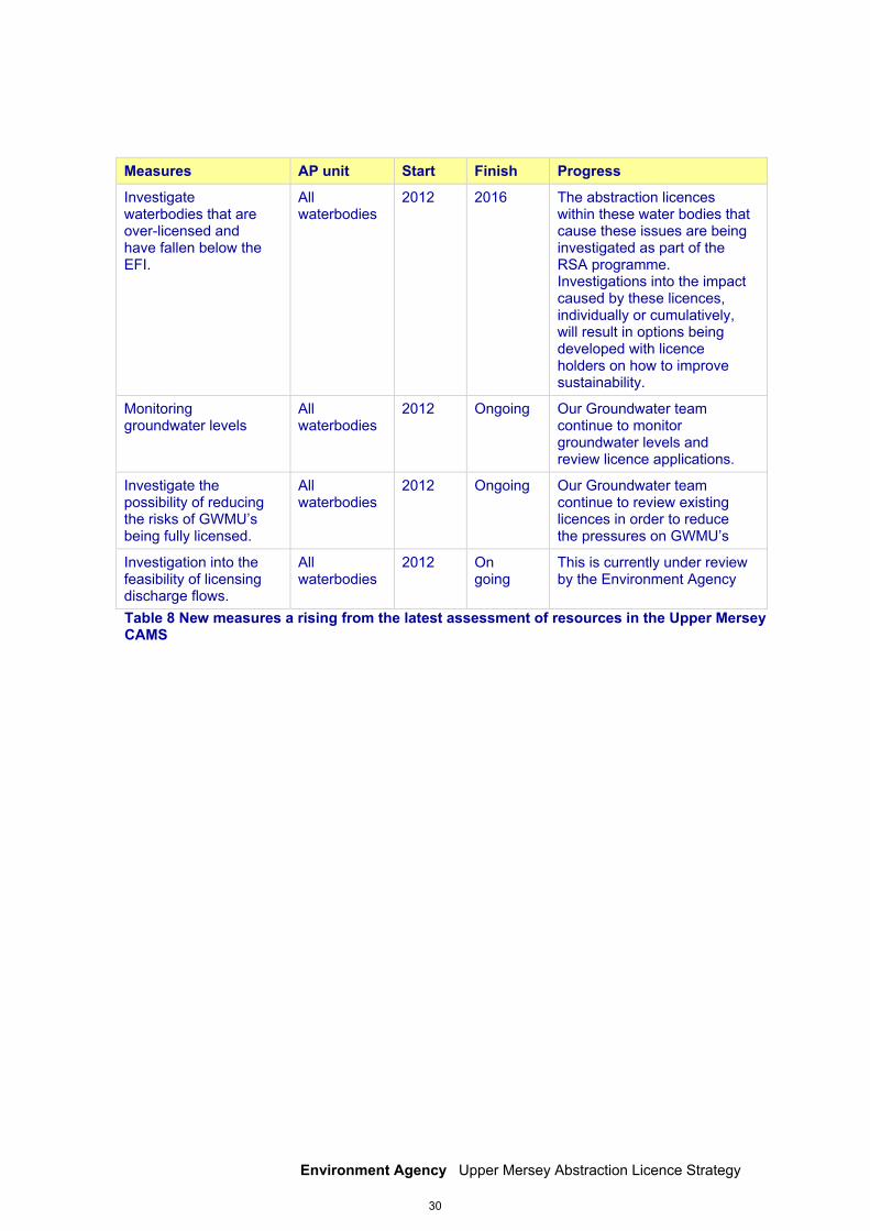
Table 8 shows new actions for Upper Mersey CAMS proposed as a result of the latest assessment of resources. Action AP unit Start Finish Progress
Adopt RAM framework across all Water Resource Management Units
Covers Upper Mersey CAMS area
2005 Complete The results from the RAM ledger are used to support the evidence base for the determination of licence applications and applications for variations.
Presumption against new licences
Mersey & Bollin WRMU 6 & 7
2005 Complete This remains the licensing strategy, to protect the existing groundwater licence holders and the long-term sustainability of the aquifer
Voluntary reduction in abstraction
All waterbodies
2005 On going Remains our aim to progress voluntary reduction of actual abstraction, where this is achievable and appropriate.
Site-specific issues will primarily determine hands-off flow conditions, and additional consideration will be given to using the RAM framework, where the 1st cycle status was assessed as No Water Available
All waterbodies
2004 Completed – replaced by 2nd cycle RAM
Our Groundwater team continue to provide technical expertise in respect of licence applications and variations.
A routine monitoring programme is undertaken which includes monitoring flows throughout the catchment and monitoring the environment, including ecological, fisheries and physical factors. This will identify any potential changes to the current situation, highlighting improvements or deterioration resulting from abstraction activity.
Tame, Goyt & Etherow CAMS area
2004 On going On going
Table 7 Progress on the actions from 1st round of the Tame, Goyt & Etherow and Mersey Bollin CAMS
29
Environment Agency Upper Mersey Abstraction Licence Strategy
Measures AP unit Start Finish Progress
Investigate waterbodies that are over-licensed and have fallen below the EFI.
All waterbodies
2012 2016 The abstraction licences within these water bodies that cause these issues are being investigated as part of the RSA programme. Investigations into the impact caused by these licences, individually or cumulatively, will result in options being developed with licence holders on how to improve sustainability.
Monitoring groundwater levels
All waterbodies
2012 Ongoing Our Groundwater team continue to monitor groundwater levels and review licence applications.
Investigate the possibility of reducing the risks of GWMU’s being fully licensed.
All waterbodies
2012 Ongoing Our Groundwater team continue to review existing licences in order to reduce the pressures on GWMU’s
Investigation into the feasibility of licensing discharge flows.
All waterbodies
2012 On going
This is currently under review by the Environment Agency
Table 8 New measures a rising from the latest assessment of resources in the Upper Mersey CAMS
30
Environment Agency Upper Mersey Abstraction Licence Strategy
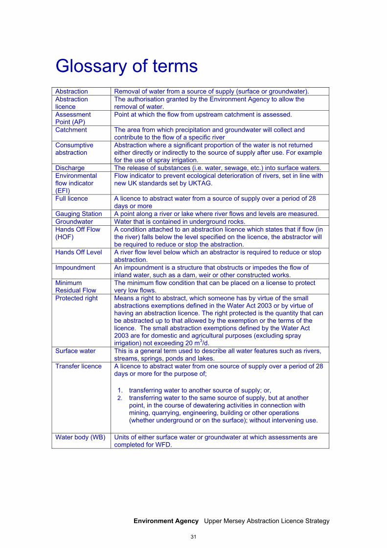
Glossary of terms Abstraction Removal of water from a source of supply (surface or groundwater). Abstraction licence
The authorisation granted by the Environment Agency to allow the removal of water.
Assessment Point (AP)
Point at which the flow from upstream catchment is assessed.
Catchment The area from which precipitation and groundwater will collect and contribute to the flow of a specific river
Consumptive abstraction
Abstraction where a significant proportion of the water is not returned either directly or indirectly to the source of supply after use. For example for the use of spray irrigation.
Discharge The release of substances (i.e. water, sewage, etc.) into surface waters. Environmental flow indicator (EFI)
Flow indicator to prevent ecological deterioration of rivers, set in line with new UK standards set by UKTAG.
Full licence A licence to abstract water from a source of supply over a period of 28 days or more
Gauging Station A point along a river or lake where river flows and levels are measured. Groundwater Water that is contained in underground rocks. Hands Off Flow (HOF)
A condition attached to an abstraction licence which states that if flow (in the river) falls below the level specified on the licence, the abstractor will be required to reduce or stop the abstraction.
Hands Off Level A river flow level below which an abstractor is required to reduce or stop abstraction.
Impoundment An impoundment is a structure that obstructs or impedes the flow of inland water, such as a dam, weir or other constructed works.
Minimum Residual Flow
The minimum flow condition that can be placed on a license to protect very low flows.
Protected right Means a right to abstract, which someone has by virtue of the small abstractions exemptions defined in the Water Act 2003 or by virtue of having an abstraction licence. The right protected is the quantity that can be abstracted up to that allowed by the exemption or the terms of the licence. The small abstraction exemptions defined by the Water Act 2003 are for domestic and agricultural purposes (excluding spray irrigation) not exceeding 20 m3/d.
Surface water This is a general term used to describe all water features such as rivers, streams, springs, ponds and lakes.
Transfer licence A licence to abstract water from one source of supply over a period of 28 days or more for the purpose of;
1. transferring water to another source of supply; or, 2. transferring water to the same source of supply, but at another
point, in the course of dewatering activities in connection with mining, quarrying, engineering, building or other operations (whether underground or on the surface); without intervening use.
Water body (WB) Units of either surface water or groundwater at which assessments are completed for WFD.
31
Environment Agency Upper Mersey Abstraction Licence Strategy
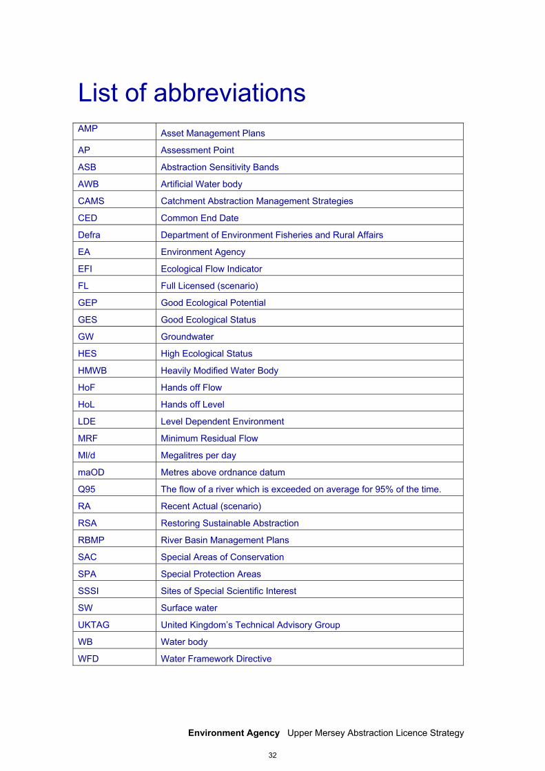
List of abbreviations
AMP Asset Management Plans
AP Assessment Point
ASB Abstraction Sensitivity Bands
AWB Artificial Water body
CAMS Catchment Abstraction Management Strategies
CED Common End Date
Defra Department of Environment Fisheries and Rural Affairs
EA Environment Agency
EFI Ecological Flow Indicator
FL Full Licensed (scenario)
GEP Good Ecological Potential
GES Good Ecological Status
GW Groundwater
HES High Ecological Status
HMWB Heavily Modified Water Body
HoF Hands off Flow
HoL Hands off Level
LDE Level Dependent Environment
MRF Minimum Residual Flow
Ml/d Megalitres per day
maOD Metres above ordnance datum
Q95 The flow of a river which is exceeded on average for 95% of the time.
RA Recent Actual (scenario)
RSA Restoring Sustainable Abstraction
RBMP River Basin Management Plans
SAC Special Areas of Conservation
SPA Special Protection Areas
SSSI Sites of Special Scientific Interest
SW Surface water
UKTAG United Kingdom’s Technical Advisory Group
WB Water body
WFD Water Framework Directive
32
Environment Agency Upper Mersey Abstraction Licence Strategy
Would you like to find out more about us,
or about your environment?
Call us on 03708 506 506* (Mon-Fri 8am-6pm) Email : [email protected] or visit our website www.environment-agency.gov.uk incident hotline 0800 80 70 60 (24 hours) floodline 0845 988 1188 *Calls to 03 numbers cost no more than a national rate call to an 01 or 02 number and must count towards any inclusive minutes in the same way as 01 and 02 calls. These rules apply to calls from any type of line including mobile, BT, other fixed line or payphone. Environment first: This publication is printed on paper made from 100 per cent previously used waste. By-products from making the pulp and paper are used for composting and fertiliser, for making cement and for generating energy. LIT 7883
33