Embed Size (px)
Citation preview
UNITED STATES DEPARTMENT OF AGRICULTURE NATURAL RESOURCES CONSERVATION SERVICE
ECOLOGICAL SITE DESCRIPTION ECOLOGICAL SITE CHARACTERISTICS
Site Type: Rangeland
Site ID: R070XC122NM
Site Name: Shallow Sandy Savannah
Precipitation or Climate Zone: 13 to 16 inches
Phase:
1

PHYSIOGRAPHIC FEATURES
Narrative:
This site occurs on nearly level to moderately sloping side slopes of foothills and on tops of hills and mesas. Typically, this site grades down from the steep slopes of physiographic breaks. Slopes range from 3 to 25 percent but are usually less than 10 percent. Direction of slope varies and is usually not significant. Elevations range from 4,500 to 7,000 feet above sea level.
Land Form: 1. Hillside 2. Hill 3. Mesa Aspect: 1. N/A 2. 3. Minimum Maximum Elevation (feet) 4,500 7,000 Slope (percent) 3 25 Water Table Depth (inches) N/A N/A Flooding: Minimum Maximum Frequency N/A N/A Duration N/A N/A Ponding: Minimum Maximum Depth (inches) N/A N/A Frequency N/A N/A Duration N/A N/A Runoff Class:
Negligible to medium.
2

CLIMATIC FEATURES
Narrative:
The climate of the area is “semi-arid continental.”
The average annual precipitation ranges from 13 to 16 inches. Variations of 5 inches, more or less, are common. Seventy-five percent of the precipitation falls from April to October. Most of the summer precipitation falls in the form of high-intensity, short-duration thunderstorms.
Distinct seasonal changes and large annual and diurnal temperature changes characterize temperatures. The average annual temperature is about 50 degrees F with extremes of -29 degrees F in the winter and 103 degrees F in the summer.
The average frost-free season is 130 to 160 days. The last killing frost falling in early May and the first killing frost in early October.
Both temperature and precipitation favor warm-season, perennial plant species. However, about 40 percent of the precipitation falls at a time favorable for cool-season plant growth. This allows the cool-season species to occupy a very important component in this plant community. Vegetation responds well to light rains due to the shallow soil depth and soil surface textures. Heavy rains produce excess runoff and can cause flash floods. Strong winds from the west and southwest blow across the area from February to June and dries the soil during a critical period for plant growth.
Climate data was obtained from http://www.wrcc.sage.dri.edu/summary/climsmnm.html web site using 50% probability for freeze-free and frost-free seasons using 28.5 degrees F and 32.5 degrees F respectively.
Minimum Maximum Frost-free period (days): 131 173 Freeze-free period (days): 155 187 Mean annual precipitation (inches): 13 16
3
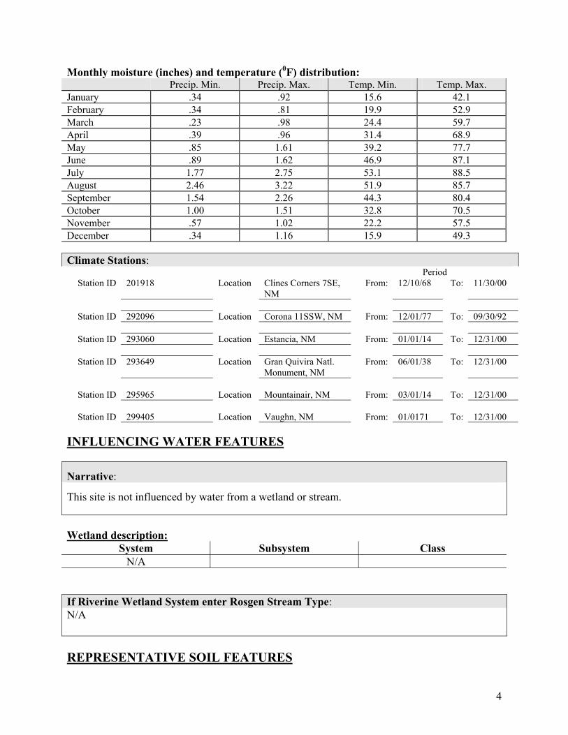
Monthly moisture (inches) and temperature (0F) distribution: Precip. Min. Precip. Max. Temp. Min. Temp. Max. January .34 .92 15.6 42.1 February .34 .81 19.9 52.9 March .23 .98 24.4 59.7 April .39 .96 31.4 68.9 May .85 1.61 39.2 77.7 June .89 1.62 46.9 87.1 July 1.77 2.75 53.1 88.5 August 2.46 3.22 51.9 85.7 September 1.54 2.26 44.3 80.4 October 1.00 1.51 32.8 70.5 November .57 1.02 22.2 57.5 December .34 1.16 15.9 49.3 Climate Stations: Period
Station ID 201918 Location Clines Corners 7SE, NM
From: 12/10/68 To: 11/30/00
Station ID 292096 Location Corona 11SSW, NM From: 12/01/77 To: 09/30/92
Station ID 293060 Location Estancia, NM From: 01/01/14 To: 12/31/00
Station ID 293649 Location Gran Quivira Natl.
Monument, NM From: 06/01/38 To: 12/31/00
Station ID 295965 Location Mountainair, NM From: 03/01/14 To: 12/31/00
Station ID 299405 Location Vaughn, NM From: 01/0171 To: 12/31/00
INFLUENCING WATER FEATURES
Narrative:
This site is not influenced by water from a wetland or stream.
Wetland description:
System Subsystem Class N/A
If Riverine Wetland System enter Rosgen Stream Type: N/A REPRESENTATIVE SOIL FEATURES
4

Narrative:
The soils of this site are well drained and shallow to very shallow over petrocalcic or sandstone. The surface texture is fine sandy loam. This extends to a depth of 12 to 20 inches. Petrocalcic is encountered at 12 to 20 inches. Permeability is rapid and water-holding capacity is medium.
Parent Material Kind: Alluvium Parent Material Origin: Mixed Surface Texture: 1. Fine sandy loam 2. 3. Surface Texture Modifier: 1. N/A 2. 3. Subsurface Texture Group: Clayey Surface Fragments <=3” (% Cover): N/A Surface Fragments >3” (% Cover):
N/A
Subsurface Fragments <=3” (%Volume): 5 to 14 Subsurface Fragments >=3” (%Volume): 2 Minimum Maximum Drainage Class: Well Well Permeability Class: Very slow Slow Depth (inches): 4 20 Electrical Conductivity (mmhos/cm): N/A N/A Sodium Absorption Ratio: N/A N/A Soil Reaction (1:1 Water): 6.6 8.4 Soil Reaction (0.1M CaCl2): N/A N/A Available Water Capacity (inches): 6 9 Calcium Carbonate Equivalent (percent): N/A N/A
5

PLANT COMMUNITIES Ecological Dynamics of the Site:
Plant Communities and Transitional Pathways (diagram)
6
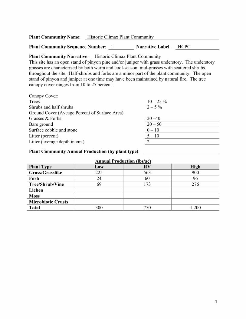
Plant Community Name: Historic Climax Plant Community
Plant Community Sequence Number: 1 Narrative Label: HCPC
Plant Community Narrative: Historic Climax Plant Community This site has an open stand of pinyon pine and/or juniper with grass understory. The understory grasses are characterized by both warm and cool-season, mid-grasses with scattered shrubs throughout the site. Half-shrubs and forbs are a minor part of the plant community. The open stand of pinyon and juniper at one time may have been maintained by natural fire. The tree canopy cover ranges from 10 to 25 percent Canopy Cover: Trees 10 – 25 % Shrubs and half shrubs 2 – 5 % Ground Cover (Aveage Percent of Surface Area). Grasses & Forbs 20 –40 Bare ground 20 – 50 Surface cobble and stone 0 – 10 Litter (percent) 5 – 10 Litter (average depth in cm.) 2
Plant Community Annual Production (by plant type):
Annual Production (lbs/ac) Plant Type Low RV High Grass/Grasslike 225 563 900 Forb 24 60 96 Tree/Shrub/Vine 69 173 276 Lichen Moss Microbiotic Crusts Total 300 750 1,200
7
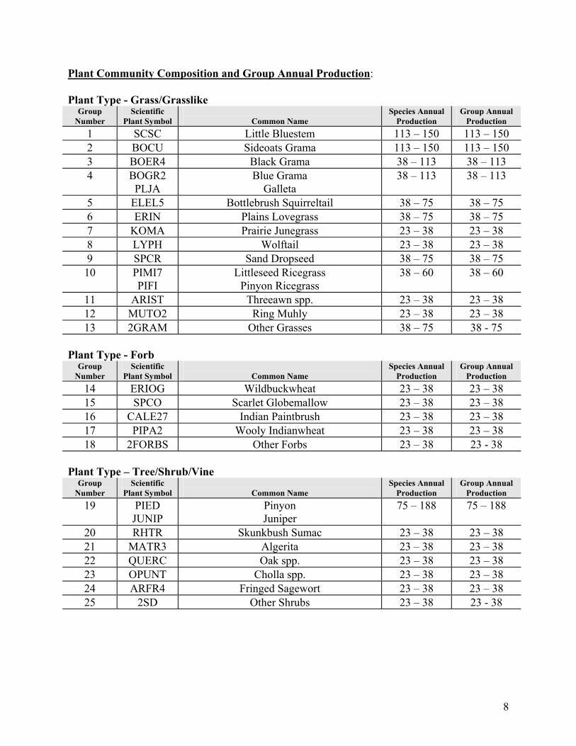
Plant Community Composition and Group Annual Production: Plant Type - Grass/Grasslike
Group Number
Scientific Plant Symbol
Common Name
Species Annual Production
Group Annual Production
1 SCSC Little Bluestem 113 – 150 113 – 150 2 BOCU Sideoats Grama 113 – 150 113 – 150 3 BOER4 Black Grama 38 – 113 38 – 113 4 BOGR2
PLJA Blue Grama
Galleta 38 – 113 38 – 113
5 ELEL5 Bottlebrush Squirreltail 38 – 75 38 – 75 6 ERIN Plains Lovegrass 38 – 75 38 – 75 7 KOMA Prairie Junegrass 23 – 38 23 – 38 8 LYPH Wolftail 23 – 38 23 – 38 9 SPCR Sand Dropseed 38 – 75 38 – 75 10 PIMI7
PIFI Littleseed Ricegrass
Pinyon Ricegrass 38 – 60 38 – 60
11 ARIST Threeawn spp. 23 – 38 23 – 38 12 MUTO2 Ring Muhly 23 – 38 23 – 38 13 2GRAM Other Grasses 38 – 75 38 - 75
Plant Type - Forb
Group Number
Scientific Plant Symbol
Common Name
Species Annual Production
Group Annual Production
14 ERIOG Wildbuckwheat 23 – 38 23 – 38 15 SPCO Scarlet Globemallow 23 – 38 23 – 38 16 CALE27 Indian Paintbrush 23 – 38 23 – 38 17 PIPA2 Wooly Indianwheat 23 – 38 23 – 38 18 2FORBS Other Forbs 23 – 38 23 - 38
Plant Type – Tree/Shrub/Vine
Group Number
Scientific Plant Symbol
Common Name
Species Annual Production
Group Annual Production
19 PIED JUNIP
Pinyon Juniper
75 – 188 75 – 188
20 RHTR Skunkbush Sumac 23 – 38 23 – 38 21 MATR3 Algerita 23 – 38 23 – 38 22 QUERC Oak spp. 23 – 38 23 – 38 23 OPUNT Cholla spp. 23 – 38 23 – 38 24 ARFR4 Fringed Sagewort 23 – 38 23 – 38 25 2SD Other Shrubs 23 – 38 23 - 38
8
Plant Type - Lichen Group
Number Scientific
Plant Symbol
Common Name Species Annual
Production Group Annual
Production
Plant Type - Moss
Group Number
Scientific Plant Symbol
Common Name
Species Annual Production
Group Annual Production
Plant Type - Microbiotic Crusts
Group Number
Scientific Plant Symbol
Common Name
Species Annual Production
Group Annual Production
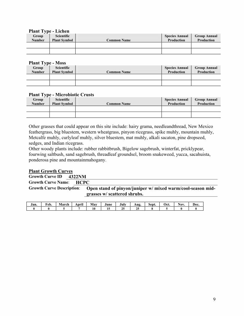
Other grasses that could appear on this site include: hairy grama, needleandthread, New Mexico feathergrass, big bluestem, western wheatgrass, pinyon ricegrass, spike muhly, mountain muhly, Metcalfe muhly, curlyleaf muhly, silver bluestem, mat muhly, alkali sacaton, pine dropseed, sedges, and Indian ricegrass. Other woody plants include: rubber rabbitbrush, Bigelow sagebrush, winterfat, pricklypear, fourwing saltbush, sand sagebrush, threadleaf groundsel, broom snakeweed, yucca, sacahuista, ponderosa pine and mountainmahogany. Plant Growth Curves Growth Curve ID 4322NM Growth Curve Name: HCPC Growth Curve Description: Open stand of pinyon/juniper w/ mixed warm/cool-season mid-
grasses w/ scattered shrubs.
Jan. Feb. March April May June July Aug. Sept. Oct. Nov. Dec. 0 0 5 7 10 15 25 25 8 5 0 0
9
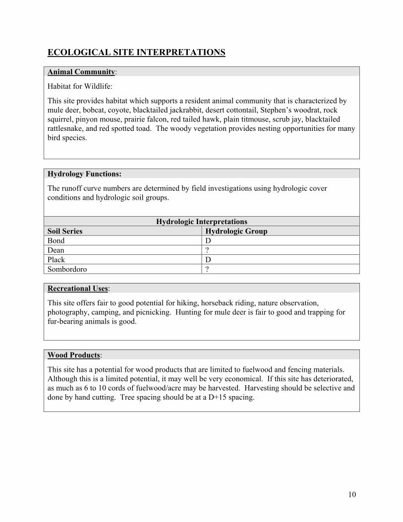
ECOLOGICAL SITE INTERPRETATIONS Animal Community:
Habitat for Wildlife:
This site provides habitat which supports a resident animal community that is characterized by mule deer, bobcat, coyote, blacktailed jackrabbit, desert cottontail, Stephen’s woodrat, rock squirrel, pinyon mouse, prairie falcon, red tailed hawk, plain titmouse, scrub jay, blacktailed rattlesnake, and red spotted toad. The woody vegetation provides nesting opportunities for many bird species.
Hydrology Functions:
The runoff curve numbers are determined by field investigations using hydrologic cover conditions and hydrologic soil groups.
Hydrologic Interpretations
Soil Series Hydrologic Group Bond D Dean ? Plack D Sombordoro ? Recreational Uses:
This site offers fair to good potential for hiking, horseback riding, nature observation, photography, camping, and picnicking. Hunting for mule deer is fair to good and trapping for fur-bearing animals is good.
Wood Products:
This site has a potential for wood products that are limited to fuelwood and fencing materials. Although this is a limited potential, it may well be very economical. If this site has deteriorated, as much as 6 to 10 cords of fuelwood/acre may be harvested. Harvesting should be selective and done by hand cutting. Tree spacing should be at a D+15 spacing.
10
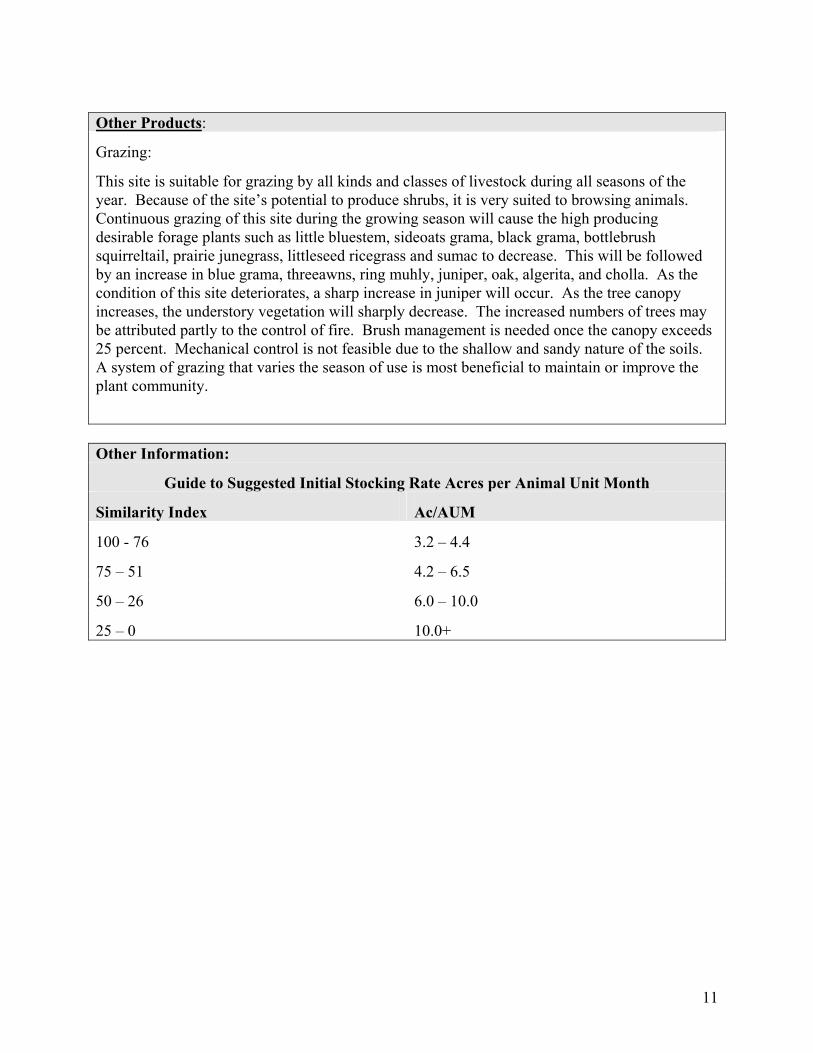
Other Products:
Grazing:
This site is suitable for grazing by all kinds and classes of livestock during all seasons of the year. Because of the site’s potential to produce shrubs, it is very suited to browsing animals. Continuous grazing of this site during the growing season will cause the high producing desirable forage plants such as little bluestem, sideoats grama, black grama, bottlebrush squirreltail, prairie junegrass, littleseed ricegrass and sumac to decrease. This will be followed by an increase in blue grama, threeawns, ring muhly, juniper, oak, algerita, and cholla. As the condition of this site deteriorates, a sharp increase in juniper will occur. As the tree canopy increases, the understory vegetation will sharply decrease. The increased numbers of trees may be attributed partly to the control of fire. Brush management is needed once the canopy exceeds 25 percent. Mechanical control is not feasible due to the shallow and sandy nature of the soils. A system of grazing that varies the season of use is most beneficial to maintain or improve the plant community.
Other Information:
Guide to Suggested Initial Stocking Rate Acres per Animal Unit Month
Similarity Index Ac/AUM
100 - 76 3.2 – 4.4
75 – 51 4.2 – 6.5
50 – 26 6.0 – 10.0
25 – 0 10.0+
11
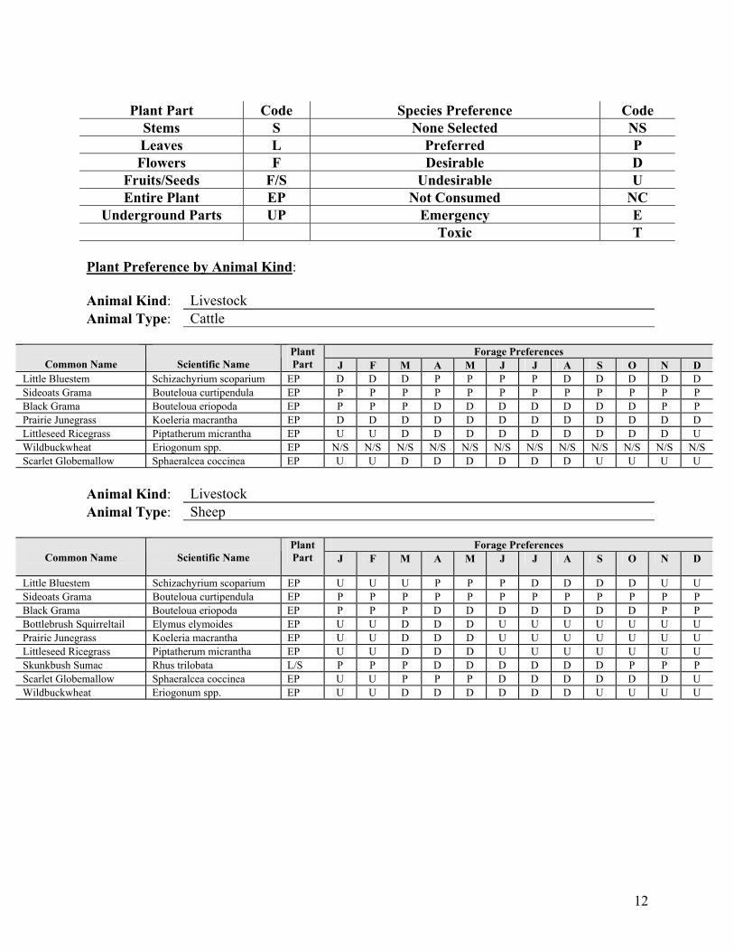
Plant Part Code Species Preference Code
Stems S None Selected NS Leaves L Preferred P Flowers F Desirable D
Fruits/Seeds F/S Undesirable U Entire Plant EP Not Consumed NC
Underground Parts UP Emergency E Toxic T
Plant Preference by Animal Kind: Animal Kind: Livestock Animal Type: Cattle
Forage Preferences Common Name
Scientific Name
Plant Part J F M A M J J A S O N D
Little Bluestem Schizachyrium scoparium EP D D D P P P P D D D D D Sideoats Grama Bouteloua curtipendula EP P P P P P P P P P P P P Black Grama Bouteloua eriopoda EP P P P D D D D D D D P P Prairie Junegrass Koeleria macrantha EP D D D D D D D D D D D D Littleseed Ricegrass Piptatherum micrantha EP U U D D D D D D D D D U Wildbuckwheat Eriogonum spp. EP N/S N/S N/S N/S N/S N/S N/S N/S N/S N/S N/S N/S Scarlet Globemallow Sphaeralcea coccinea EP U U D D D D D D U U U U
Animal Kind: Livestock Animal Type: Sheep
Forage Preferences Common Name
Scientific Name
Plant Part J F M A M J J A S O N D
Little Bluestem Schizachyrium scoparium EP U U U P P P D D D D U U Sideoats Grama Bouteloua curtipendula EP P P P P P P P P P P P P Black Grama Bouteloua eriopoda EP P P P D D D D D D D P P Bottlebrush Squirreltail Elymus elymoides EP U U D D D U U U U U U U Prairie Junegrass Koeleria macrantha EP U U D D D U U U U U U U Littleseed Ricegrass Piptatherum micrantha EP U U D D D U U U U U U U Skunkbush Sumac Rhus trilobata L/S P P P D D D D D D P P P Scarlet Globemallow Sphaeralcea coccinea EP U U P P P D D D D D D U Wildbuckwheat Eriogonum spp. EP U U D D D D D D U U U U
12

Animal Kind: Livestock Animal Type: Goats
Forage Preferences Common Name
Scientific Name
Plant Part J F M A M J J A S O N D
Bottlebrush Squirreltail Elymus elymoides EP U U D D D U U U U U U U Littleseed Ricegrass Piptatherum micrantha EP U U D D D U U U U U U U Skunkbush Sumac Rhus trilobata L/S P P P D D D D D D P P P Oak Quercus spp. L/S N/S N/S N/S N/S N/S N/S N/S N/S N/S N/S N/S N/S Wildbuckwheat Eriogonum spp. EP U U D D D D D D U U U U Wooly Indianwheat Plantago purshii EP N/S N/S N/S N/S N/S N/S N/S N/S N/S N/S N/S N/S
Animal Kind: Wildlife Animal Type: Deer
Forage Preferences Common Name
Scientific Name
Plant Part J F M A M J J A S O N D
Bottlebrush Squirreltail Elymus elymoides EP U U D D D U U U U U U U Littleseed Ricegrass Piptatherum micrantha EP U U D D D U U U U U U U Skunkbush Sumac Rhus trilobata L/S P P P D D D D D D P P P Oak Quercus spp. L/S N/S N/S N/S N/S N/S N/S N/S N/S N/S N/S N/S N/S Wildbuckwheat Eriogonum spp. EP U U D D D D D D U U U U Scarlet Globemallow Sphaeralcea coccinea EP U U P P P D D D D D D U Wooly Indianwheat Plantago purshii EP N/S N/S N/S N/S N/S N/S N/S N/S N/S N/S N/S N/S
13

14
SUPPORTING INFORMATION Associated sites:
Site Name Site ID Site Narrative
Similar sites: Site Name Site ID Site Narrative
State Correlation: This site has been correlated with the following sites: Inventory Data References:
Data Source # of Records Sample Period State County
Type Locality: State: New Mexico County: Chavez, Lincoln, San Miguel, Santa Fe, Torrance Latitude: Longitude: Township: Range: Section: Is the type locality sensitive? Yes No General Legal Description: Relationship to Other Established Classifications:
Other References: Data collection for this site was done in conjunction with the progressive soil surveys within the Pecos-Canadian Plains and Valleys 70 Major Land Resource Area of New Mexico. This site has been mapped and correlated with soils in the following soil surveys: Chaves, De Baca, Guadalupe, Lincoln, Sna Miguel, Santa Fe, Torrance. Characteristic Soils Are: Bond Plack Other Soils included are: Dean(as mapped in San Miguel County) Sombordoro(as mapped in San Miguel County) Site Description Approval: Author Date Approval Date Don Sylvester 02/02/82 Donald H. Fulton 03/03/82 Site Description Revision: Author Date Approval Date Elizabeth Wright 07/05/02 George Chavez 12/17/02