Embed Size (px)
Citation preview
Marine Monitoring
Imp
lem
en
ted
by
A. Reppucci; P.Y. Le Traon ;
Mercator Ocean
U s e o f S e a S u r f a c e T e m p e r a t u r e a n d S e a I c e o b s e r v a t i o n s f o r t h e
C o p e r n i c u s M a r i n e S e r v i c e a n d i t s a p p l i c a t i o n s
ECMWF, 23/01/2018
Marine Monitoring
•The CMEMS
•Use SST and Sea Ice observations in CMEMS
•CMEMS Requirements
•Conclusions
O u t l i n e
Marine Monitoring
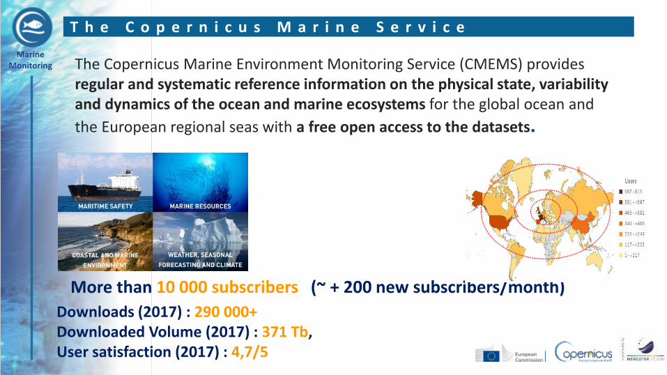
More than 10 000 subscribers (~ + 200 new subscribers/month)
Downloads (2017) : 290 000+ Downloaded Volume (2017) : 371 Tb, User satisfaction (2017) : 4,7/5
The Copernicus Marine Environment Monitoring Service (CMEMS) provides regular and systematic reference information on the physical state, variability and dynamics of the ocean and marine ecosystems for the global ocean and
the European regional seas with a free open access to the datasets.
T h e C o p e r n i c u s M a r i n e S e r v i c e
Marine Monitoring
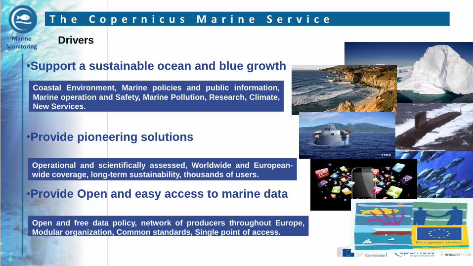
•Support a sustainable ocean and blue growth •Provide pioneering solutions •Provide Open and easy access to marine data
Coastal Environment, Marine policies and public information,
Marine operation and Safety, Marine Pollution, Research, Climate, New Services.
Operational and scientifically assessed, Worldwide and European-wide coverage, long-term sustainability, thousands of users.
Open and free data policy, network of producers throughout Europe, Modular organization, Common standards, Single point of access.
Drivers
T h e C o p e r n i c u s M a r i n e S e r v i c e
Marine Monitoring
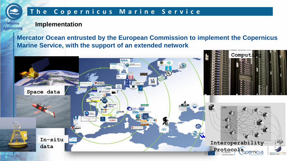
Mercator Ocean entrusted by the European Commission to implement the Copernicus
Marine Service, with the support of an extended network
Interoperability
Protocols
Space data
In-situ
data
Computing
T h e C o p e r n i c u s M a r i n e S e r v i c e
Implementation
Marine Monitoring
L3 Products
L4 Products
L1 / L2 Space data
ESA; EUMETSAT; Direct agreement with other space agencies
CMEMS Thematic Assembly Centers
CMEMS Monitoring and Forecast Centers
OC SST
SL
In Situ (INS)
Analysis and forecasts
In situ observations
SI
WIND WAVE
T h e C o p e r n i c u s M a r i n e S e r v i c e
MOB
Architecture
Marine Monitoring
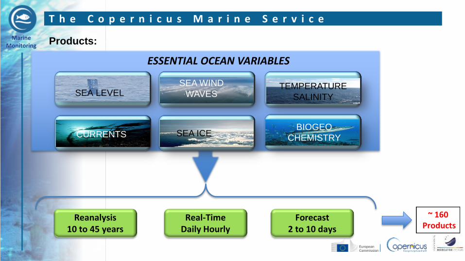
ESSENTIAL OCEAN VARIABLES
Products:
SEA LEVEL
SEA ICE BIOGEO
CHEMISTRY
SEA WIND
WAVES TEMPERATURE
SALINITY
CURRENTS
Reanalysis 10 to 45 years
Real-Time Daily Hourly
Forecast 2 to 10 days
~ 160 Products
T h e C o p e r n i c u s M a r i n e S e r v i c e
Marine Monitoring
T h e C o p e r n i c u s M a r i n e E n v i r o n m e n t M o n i t o r i n g S e r v i c e
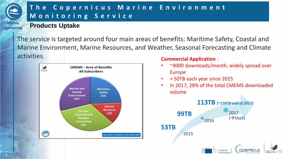
The service is targeted around four main areas of benefits: Maritime Safety, Coastal and Marine Environment, Marine Resources, and Weather, Seasonal Forecasting and Climate activities.
2015
2016
2017 (Sept)
53TB
99TB
113TB (~150TB end of 2017)
Commercial Application : • ~4000 downloads/month, widely spread over
Europe • + 50TB each year since 2015 • In 2017, 28% of the total CMEMS downloaded
volume
Products Uptake
Marine Monitoring
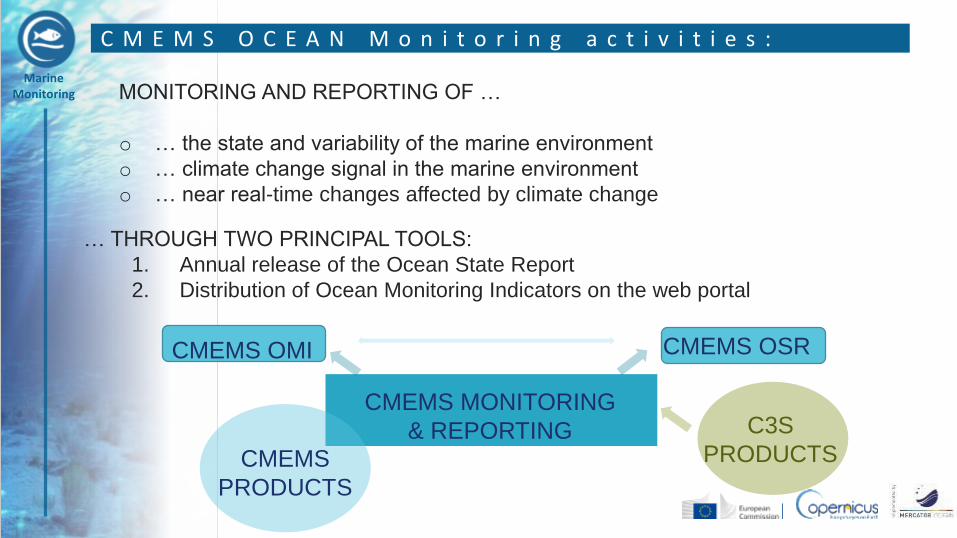
C M E M S O C E A N M o n i t o r i n g a c t i v i t i e s :
… THROUGH TWO PRINCIPAL TOOLS:
1. Annual release of the Ocean State Report
2. Distribution of Ocean Monitoring Indicators on the web portal
MONITORING AND REPORTING OF …
o … the state and variability of the marine environment
o … climate change signal in the marine environment
o … near real-time changes affected by climate change
CMEMS MONITORING
& REPORTING CMEMS
PRODUCTS
C3S
PRODUCTS
CMEMS OMI CMEMS OSR
Marine Monitoring
•The CMEMS
•Use SST and Sea Ice observations in CMEMS
•CMEMS Requirements
•Conclusions
O u t l i n e
Marine Monitoring
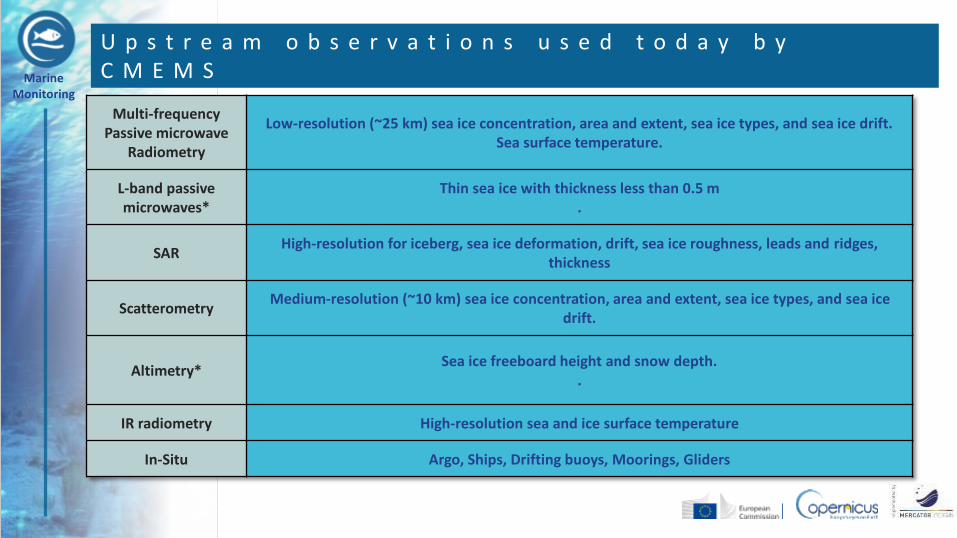
U p s t r e a m o b s e r v a t i o n s u s e d t o d a y b y C M E M S
Multi-frequency Passive microwave
Radiometry
Low-resolution (~25 km) sea ice concentration, area and extent, sea ice types, and sea ice drift. Sea surface temperature.
L-band passive microwaves*
Thin sea ice with thickness less than 0.5 m .
SAR High-resolution for iceberg, sea ice deformation, drift, sea ice roughness, leads and ridges,
thickness
Scatterometry Medium-resolution (~10 km) sea ice concentration, area and extent, sea ice types, and sea ice
drift.
Altimetry* Sea ice freeboard height and snow depth.
.
IR radiometry High-resolution sea and ice surface temperature
In-Situ Argo, Ships, Drifting buoys, Moorings, Gliders
Marine Monitoring
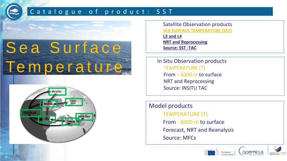
C a t a l o g u e o f p r o d u c t : S S T
S e a S u r f a c e
Te m p e r a t u r e
Model products TEMPERATURE (T)
From - 6000 m to surface
Forecast, NRT and Reanalysis
Source: MFCs
In Situ Observation products TEMPERATURE (T) From – 6000 m to surface NRT and Reprocessing Source: INSITU TAC
Satellite Observation products SEA SURFACE TEMPERATURE (SST) L3 and L4 NRT and Reprocessing Source: SST -TAC
Marine Monitoring
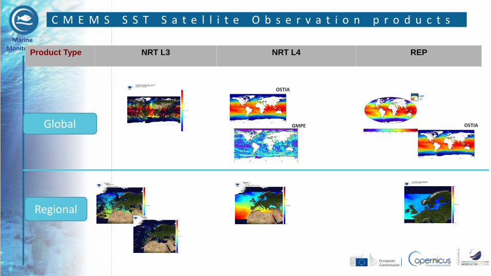
Product Type NRT L3 NRT L4 REP
C M E M S S S T S a t e l l i t e O b s e r v a t i o n p r o d u c t s
OSTIA
OSTIA
GMPE Global
Regional
Marine Monitoring
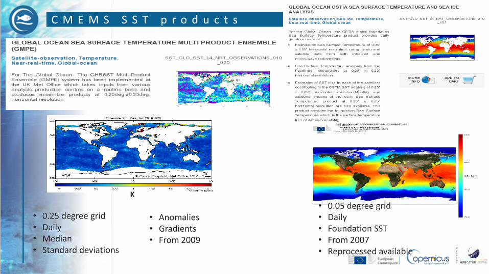
C M E M S S S T p r o d u c t s
• 0.05 degree grid • Daily • Foundation SST • From 2007 • Reprocessed available
K
• 0.25 degree grid • Daily • Median • Standard deviations
• Anomalies • Gradients • From 2009
Marine Monitoring
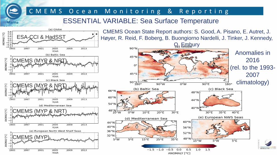
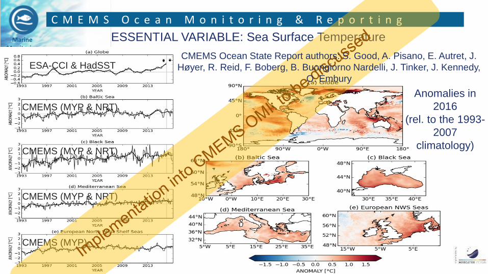
C M E M S O c e a n M o n i t o r i n g & R e p o r t i n g
ESSENTIAL VARIABLE: Sea Surface Temperature
CMEMS Ocean State Report authors: S. Good, A. Pisano, E. Autret, J.
Høyer, R. Reid, F. Boberg, B. Buongiorno Nardelli, J. Tinker, J. Kennedy,
O. Embury
ESA-CCI & HadSST
CMEMS (MYP & NRT)
CMEMS (MYP & NRT)
CMEMS (MYP & NRT)
CMEMS (MYP)
Anomalies in
2016
(rel. to the 1993-
2007
climatology)
Marine Monitoring
C M E M S O c e a n M o n i t o r i n g & R e p o r t i n g
ESSENTIAL VARIABLE: Sea Surface Temperature
ESA-CCI & HadSST
CMEMS (MYP & NRT)
CMEMS (MYP & NRT)
CMEMS (MYP & NRT)
CMEMS (MYP)
Anomalies in
2016
(rel. to the 1993-
2007
climatology)
CMEMS Ocean State Report authors: S. Good, A. Pisano, E. Autret, J.
Høyer, R. Reid, F. Boberg, B. Buongiorno Nardelli, J. Tinker, J. Kennedy,
O. Embury
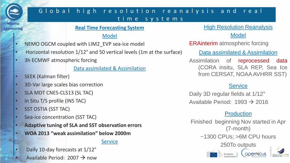
Marine Monitoring Real Time Forecasting System
Model
• NEMO OGCM coupled with LIM2_EVP sea-ice model
• Horizontal resolution 1/12° and 50 vertical levels (1m at the surface)
• 3h ECMWF atmospheric forcing
Data assimilated & Assimilation
• SEEK (Kalman filter)
• 3D-Var large scales bias correction
• SLA MDT CNES-CLS13 (SL TAC)
• In Situ T/S profile (INS TAC)
• SST OSTIA (SST TAC)
• Sea-ice concentration (SST TAC)
• Adaptive tuning of SLA and SST observation errors
• WOA 2013 “weak assimilation” below 2000m
Service
• Daily 10-day forecasts at 1/12°
• Available Period: 2007 now
G l o b a l h i g h r e s o l u t i o n r e a n a l y s i s a n d r e a l t i m e s y s t e m s
High Resolution Reanalysis
Model
ERAinterim atmospheric forcing
Data assimilated & Assimilation
Assimilation of reprocessed data
(CORA insitu, SLA REP, Sea Ice
from CERSAT, NOAA AVHRR SST)
Service
Daily 3D regular fields at 1/12°
Available Period: 1993 2016
Production
Finished beginning Nov started in Apr
(7-month)
~1300 CPUs; >6M CPU hours
250To outputs
Marine Monitoring
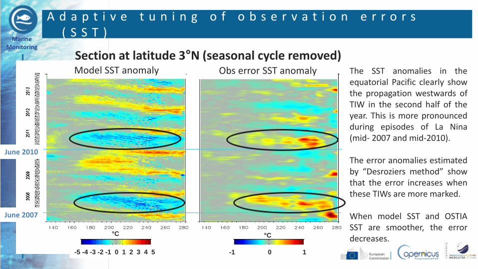
Section at latitude 3°N (seasonal cycle removed)
-5 -4 -3 -2 -1 0 1 2 3 4 5 -1 0 1
Model SST anomaly Obs error SST anomaly The SST anomalies in the equatorial Pacific clearly show the propagation westwards of TIW in the second half of the year. This is more pronounced during episodes of La Nina (mid- 2007 and mid-2010). The error anomalies estimated by “Desroziers method” show that the error increases when these TIWs are more marked. When model SST and OSTIA SST are smoother, the error decreases.
°C °C
A d a p t i v e t u n i n g o f o b s e r v a t i o n e r r o r s ( S S T )
June 2007
June 2010
Marine Monitoring
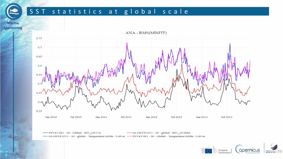
S S T s t a t i s t i c s a t g l o b a l s c a l e
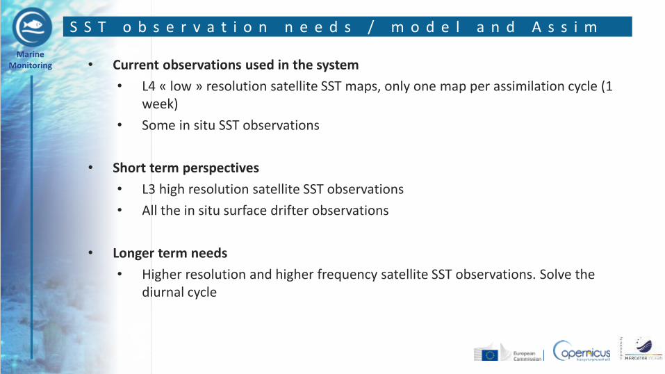
Marine Monitoring • Current observations used in the system
• L4 « low » resolution satellite SST maps, only one map per assimilation cycle (1 week)
• Some in situ SST observations
• Short term perspectives
• L3 high resolution satellite SST observations
• All the in situ surface drifter observations
• Longer term needs
• Higher resolution and higher frequency satellite SST observations. Solve the diurnal cycle
S S T o b s e r v a t i o n n e e d s / m o d e l a n d A s s i m

Marine Monitoring • Current observations used in the system
• L4 gridded SST maps
• Drifter (GOV Class 4)
• Argo surface data
• Moored data (Class 2 assessment)
• Short term perspectives
• L3 high resolution satellite SST observations + quality index
• Verification of 1-3 km CMEMS regional models
• Better definition of the time frame of the reference data
• Need to verify quality of CMEMS hourly product with relevant observation !
• Need to better characterize type of temperature value: skin, bulk, foundation
• Longer term needs
• Provide reliable (observed) values of the diurnal cycle
S S T o b s e r v a t i o n n e e d s / v a l i d a t i o n & v e r i f i c a t i o n
Marine Monitoring
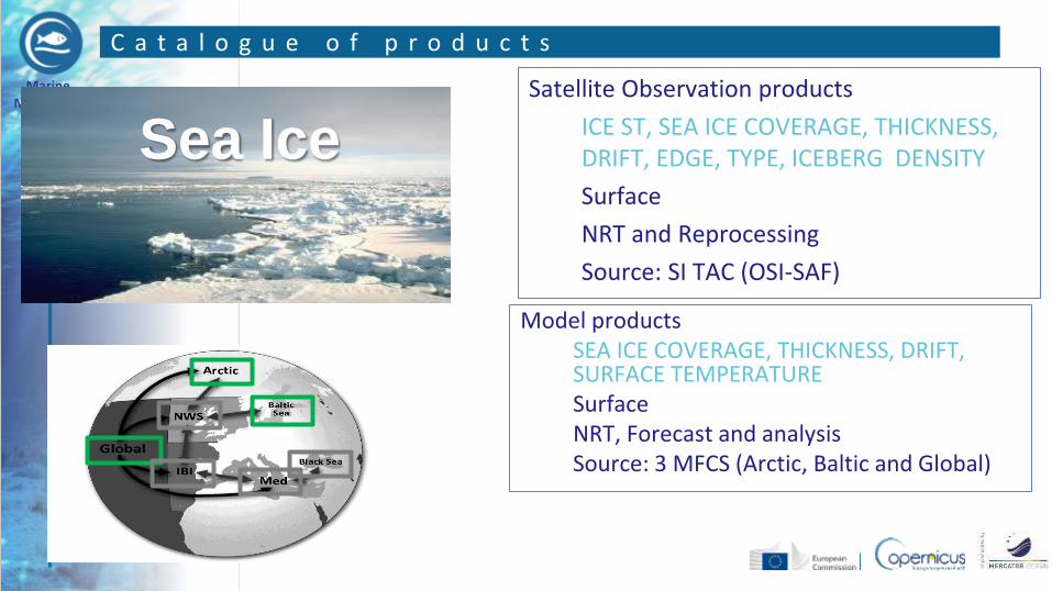
C a t a l o g u e o f p r o d u c t s
Sea Ice
Model products SEA ICE COVERAGE, THICKNESS, DRIFT, SURFACE TEMPERATURE Surface NRT, Forecast and analysis Source: 3 MFCS (Arctic, Baltic and Global)
Satellite Observation products
ICE ST, SEA ICE COVERAGE, THICKNESS, DRIFT, EDGE, TYPE, ICEBERG DENSITY
Surface
NRT and Reprocessing
Source: SI TAC (OSI-SAF)
Marine Monitoring
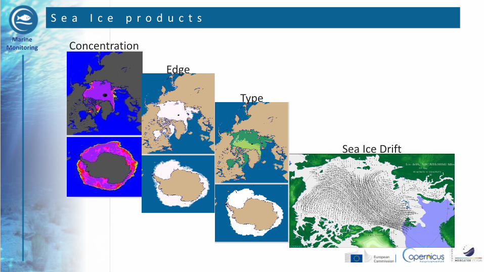
S e a I c e p r o d u c t s
Concentration
Edge
Type
Sea Ice Drift
Marine Monitoring
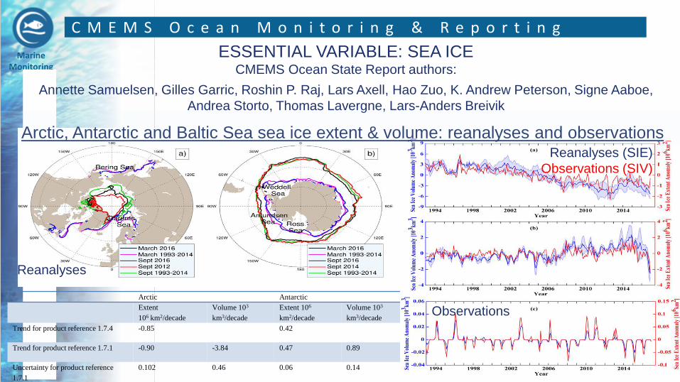
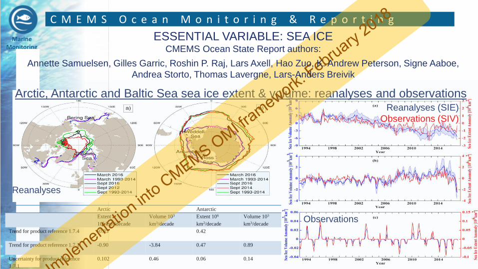
C M E M S O c e a n M o n i t o r i n g & R e p o r t i n g
ESSENTIAL VARIABLE: SEA ICE CMEMS Ocean State Report authors:
Annette Samuelsen, Gilles Garric, Roshin P. Raj, Lars Axell, Hao Zuo, K. Andrew Peterson, Signe Aaboe,
Andrea Storto, Thomas Lavergne, Lars-Anders Breivik
Arctic Antarctic
Extent
106 km2/decade
Volume 103
km3/decade
Extent 106
km2/decade
Volume 103
km3/decade
Trend for product reference 1.7.4 -0.85 0.42
Trend for product reference 1.7.1 -0.90 -3.84 0.47 0.89
Uncertainty for product reference
1.7.1
0.102 0.46 0.06 0.14
Arctic, Antarctic and Baltic Sea sea ice extent & volume: reanalyses and observations
Reanalyses
Reanalyses (SIE)
Observations (SIV)
Observations
Marine Monitoring
C M E M S O c e a n M o n i t o r i n g & R e p o r t i n g
Arctic Antarctic
Extent
106 km2/decade
Volume 103
km3/decade
Extent 106
km2/decade
Volume 103
km3/decade
Trend for product reference 1.7.4 -0.85 0.42
Trend for product reference 1.7.1 -0.90 -3.84 0.47 0.89
Uncertainty for product reference
1.7.1
0.102 0.46 0.06 0.14
Arctic, Antarctic and Baltic Sea sea ice extent & volume: reanalyses and observations
Reanalyses
Reanalyses (SIE)
Observations (SIV)
Observations
ESSENTIAL VARIABLE: SEA ICE CMEMS Ocean State Report authors:
Annette Samuelsen, Gilles Garric, Roshin P. Raj, Lars Axell, Hao Zuo, K. Andrew Peterson, Signe Aaboe,
Andrea Storto, Thomas Lavergne, Lars-Anders Breivik
Marine Monitoring
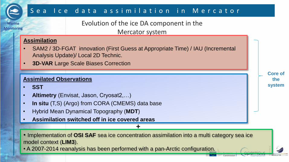
S e a I c e d a t a a s s i m i l a t i o n i n M e r c a t o r
Assimilation
• SAM2 / 3D-FGAT innovation (First Guess at Appropriate Time) / IAU (Incremental
Analysis Update)/ Local 2D Technic.
• 3D-VAR Large Scale Biases Correction
Assimilated Observations
• SST
• Altimetry (Envisat, Jason, Cryosat2,…)
• In situ (T,S) (Argo) from CORA (CMEMS) data base
• Hybrid Mean Dynamical Topography (MDT)
• Assimilation switched off in ice covered areas
• Implementation of OSI SAF sea ice concentration assimilation into a multi category sea ice
model context (LIM3).
• A 2007-2014 reanalysis has been performed with a pan-Arctic configuration.
Core of
the
system
+
Evolution of the ice DA component in the Mercator system
Marine Monitoring
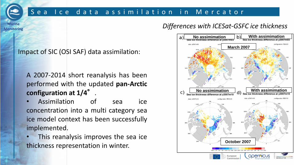
S e a I c e d a t a a s s i m i l a t i o n i n M e r c a t o r
Differences with ICESat-GSFC ice thickness
March 2007
October 2007
No assimimation
Impact of SIC (OSI SAF) data assimilation:
A 2007-2014 short reanalysis has been performed with the updated pan-Arctic configuration at 1/4°. • Assimilation of sea ice concentration into a multi category sea ice model context has been successfully implemented. • This reanalysis improves the sea ice thickness representation in winter.
With assimimation
No assimimation With assimimation
Marine Monitoring
S e a I c e o b s e r v a t i o n n e e d s / m o d e l a n d A s s i m
• Current observations used in the system
• L4 « low » resolution satellite sea ice concentration maps, only one map per
assimilation cycle (1 week)
• No in situ sea ice observations
• Short term perspectives
• Sea ice thickness from satellite observations (Cryosat SMOS)
• Longer term needs
• Higher resolution and higher frequency (sub-daily) satellite sea ice observations.
• Less uncertainties in sea ice retrievals from satellite.
Marine Monitoring
S e a I c e o b s e r v a t i o n n e e d s / v a l i d a t i o n & v e r i f i c a t i o n
• Current observations used in the system
• Sea Ice Concentration verification using satellite gridded products (AMSR2 etc…)
• Regional verification using ice charts
• Sea ice drift using SAR data
• Sea ice thickness validation using Cryosat2, SMOS data
• New approaches separating type of ice
• Derived validated quantities: sea ice edge, sea ice extent
• Short term perspectives
• Observed products for type of ice and for ice thickness
• Longer term needs
• Observed description of ice-free areas (leads, polynyas…)
Marine Monitoring
•The CMEMS
•Use SST and Sea Ice observations in CMEMS
•CMEMS Requirements
•Conclusions
O u t l i n e
Marine Monitoring
C M E M S R e q u i r e m e n t s D e f i n i t i o n
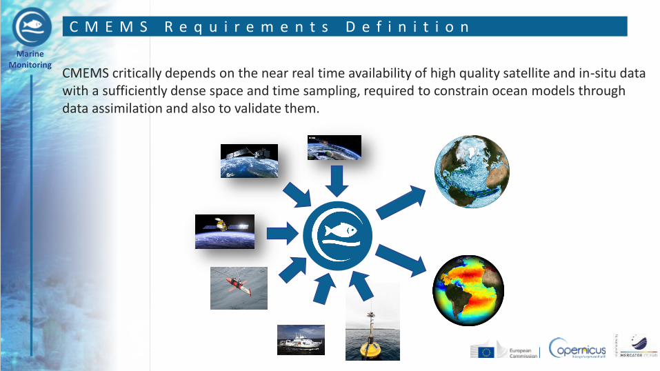
CMEMS critically depends on the near real time availability of high quality satellite and in-situ data with a sufficiently dense space and time sampling, required to constrain ocean models through data assimilation and also to validate them.
Marine Monitoring
S a t e l l i t e b a n d I n - S i t u D a t a C o o r d i n a t i o n
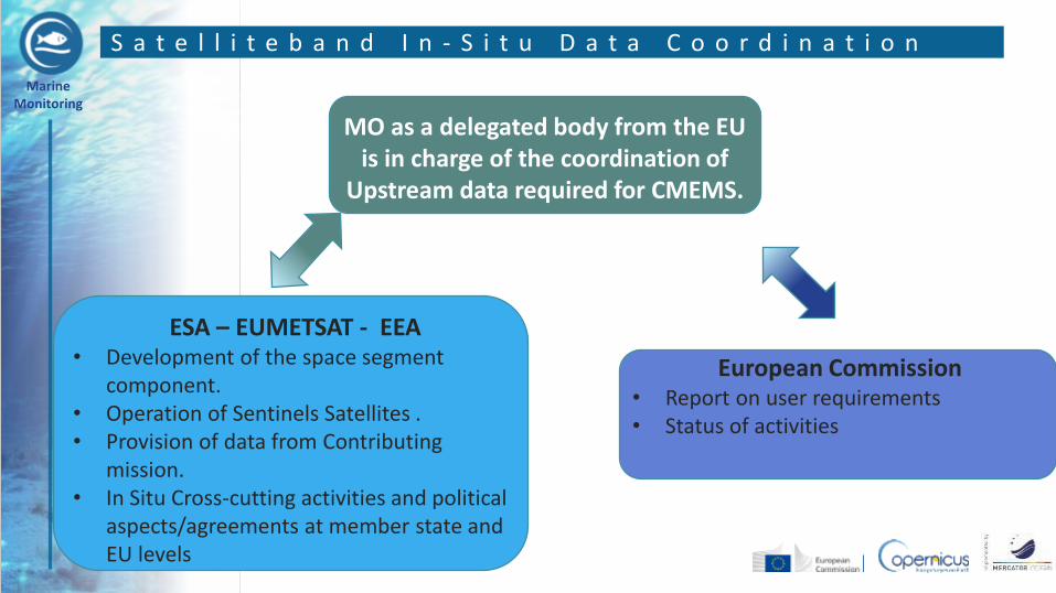
MO as a delegated body from the EU is in charge of the coordination of
Upstream data required for CMEMS.
European Commission • Report on user requirements • Status of activities
ESA – EUMETSAT - EEA • Development of the space segment
component. • Operation of Sentinels Satellites . • Provision of data from Contributing
mission. • In Situ Cross-cutting activities and political
aspects/agreements at member state and EU levels
Marine Monitoring
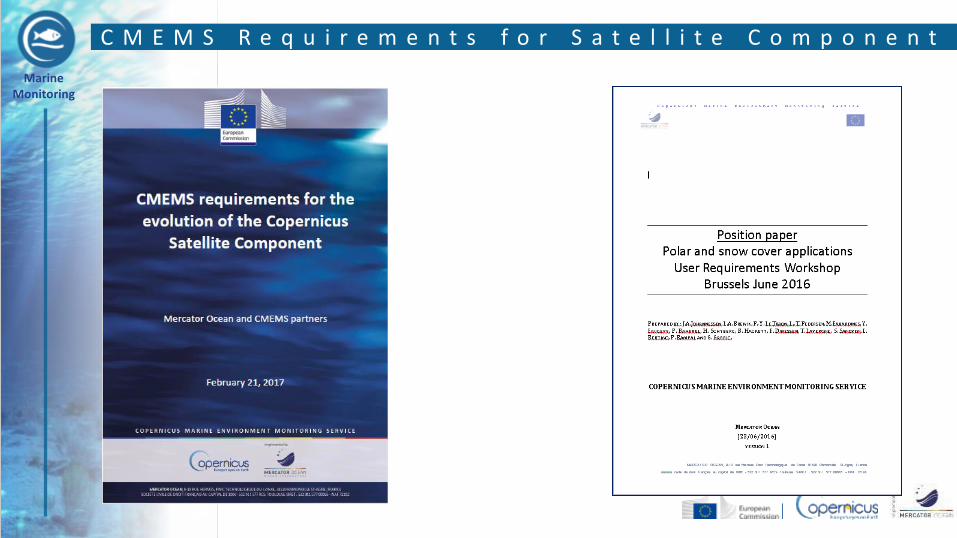
C M E M S R e q u i r e m e n t s f o r S a t e l l i t e C o m p o n e n t
Marine Monitoring
CMEMS evolution is driven by an increasing need for ocean and marine ecosystem monitoring and forecasting. • Major evolutions are required to monitor and forecast the ocean at fine scale and to
improve the monitoring of the coastal zone. • CMEMS must also improve its capacities to monitor and forecast the biogeochemical
(BGC) state of the ocean (e.g. ocean carbon uptake, acidification, de-oxygenation, eutrophication, water quality, biological productivity).
• There are also specific requirements for the monitoring of the rapidly changing polar regions.
C M E M S R e q u i r e m e n t s f o r S a t e l l i t e C o m p o n e n t
Marine Monitoring
S p e c i f i c R e q u i r e m e n t s : S S T
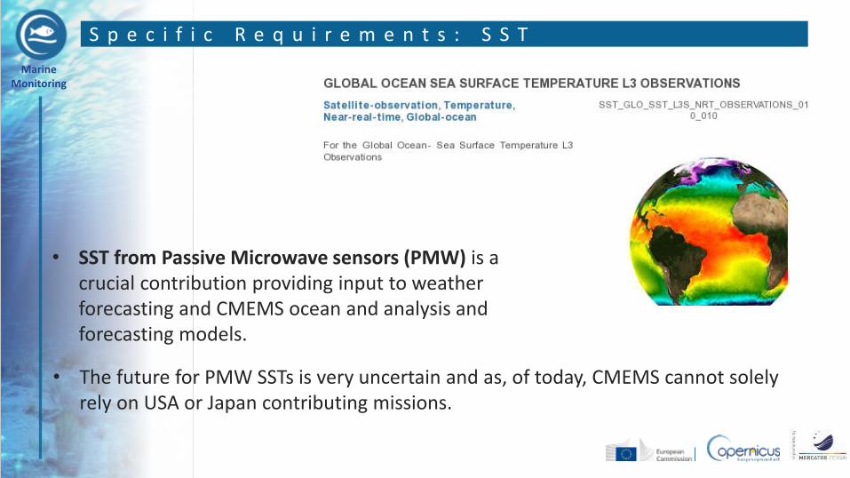
• The future for PMW SSTs is very uncertain and as, of today, CMEMS cannot solely rely on USA or Japan contributing missions.
• SST from Passive Microwave sensors (PMW) is a crucial contribution providing input to weather forecasting and CMEMS ocean and analysis and forecasting models.
Marine Monitoring
S p e c i f i c R e q u i r e m e n t s : P o l a r r e g i o n s
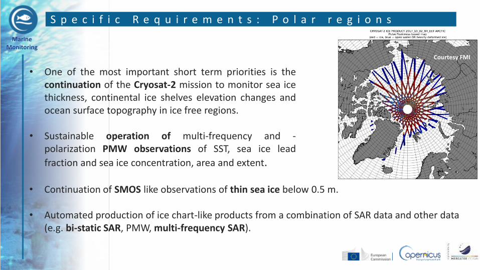
• Continuation of SMOS like observations of thin sea ice below 0.5 m.
• Automated production of ice chart-like products from a combination of SAR data and other data (e.g. bi-static SAR, PMW, multi-frequency SAR).
• One of the most important short term priorities is the continuation of the Cryosat-2 mission to monitor sea ice thickness, continental ice shelves elevation changes and ocean surface topography in ice free regions.
• Sustainable operation of multi-frequency and - polarization PMW observations of SST, sea ice lead
fraction and sea ice concentration, area and extent.
Courtesy FMI
Marine Monitoring
•The CMEMS
•Use SST and Sea Ice observations in CMEMS
•CMEMS Requirements
•Conclusions
O u t l i n e
Marine Monitoring
• CMEMS critically depends on the near real time availability of high quality satellite and in-situ SST and Sea Ice data with a sufficiently dense space and time sampling.
• These Observations are required to constrain ocean models through data assimilation and also to validate them.
• Higher resolution and higher frequency satellite SST observations are a priority for CMEMS (Solve the diurnal cycle).
• SST from Passive Microwave sensors (PMW) is a crucial contribution providing input to weather forecasting and CMEMS ocean and analysis and forecasting models.
• One of the most important short term priorities for Sea Ice monitoring is the continuation of the Cryosat-2 mission.
C o n c l u s i o n s
Marine Monitoring