Embed Size (px)
Citation preview

i
Tysons Park System Concept Plan
Endorsed by Park Authority Board October 22, 2014


THIS PAGE INTENTIONALLY LEFT BLANK


Tyso
ns
Par
k Sy
ste
m C
on
cep
t P
lan
i
ACKNOWLEDGEMENTS
FAIRFAX COUNTY PARK AUTHORITY BOARD William G. Bouie, Chairman, Hunter Mill District Kala Leggett Quintana, Secretary, At-Large Member Ken Quincy, Treasurer, Providence District Edward R. Batten, Sr., Lee District Mary D. Cortina, At-Large Member Linwood Gorham, Mount Vernon District Faisal Khan, At-Large Member Harold L. Strickland, Sully District Richard “Rip” Sullivan, Jr., Dranesville District Michael W. Thompson, Jr., Springfield District Frank S. Vajda, Mason District Anthony Vellucci, Braddock District
SENIOR STAFF Kirk W. Kincannon, Director Cindy Messinger, Deputy Director / Chief Financial Officer Sara Baldwin, Deputy Director / Chief Operating Officer David Bowden, Director, Planning & Development Division Barbara Nugent, Director, Park Services Division Cindy Walsh, Director, Resource Management Division Todd Johnson, Director, Park Operations Division Judith Pedersen, Public Information Officer
TYSONS STEERING COMMITTEE Robert Stalzer, Deputy County Executive Barbara Byron, Office of Community Revitalization Tracy Strunk, Office of Community Revitalization Fred Selden, Department of Planning & Zoning Barbara Berlin, Department of Planning & Zoning Tom Biesiadny, Department of Transportation William Marsh, Department of Public Works and Environmental Services
PROJECT TEAM Andrea L. Dorlester, Project Manager, Planning & Development Division Sandy Stallman, Manager, Park Planning Branch Gayle Hooper, Landscape Architect Catherine Lewis, Department of Planning & Zoning Suzanne Lin, Department of Planning & Zoning Brenda Cho, Department of Planning & Zoning Suzianne Zottl, Office of Community Revitalization

DRAFT
Tyso
ns
Par
k Sy
ste
m C
on
cep
t P
lan
ii
SUPPORTING STAFF Elizabeth Cronauer, Trails Coordinator Elizabeth Crowell, Manager, Cultural Resource Management & Protection Sousan Frankeberger, Events Coordinator, Park Services Division Todd Johnson, Director, Park Operations Division Charles Smith, Manager, Natural Resource Management & Protection Charlie Strunk, Bicycle Coordinator, FCDOT Vanessa Aguayo, Bicycle and Pedestrian Planner, FCDOT Karen Avvisato, Manager, Athletic Services Branch, Neighborhood & Community Services
TYSONS PARKS ADVISORY GROUP Jenifer Joy Madden, Hunter Mill District Ken Quincy, Providence District Jack Wilbern, Dranesville District Mike Champness, Athletic Council Steve McLaughlin, Athletic Council Connie Fan, Tysons Partnership Maria Hawthorne, Tysons Partnership Kristine Giangrandi, Landscape Architect Mark Gionet, Landscape Architect Trini Rodriguez, Landscape Architect David Steigler, Landscape Architect Sarah Moulton, Urban Park Planner, Washington, DC Dana Wedeles, Urban Park Planner, City of Alexandria
Cover photos from L to R: Bowling Green Park, New York, NY; Tennessee Aquarium Plaza, Chattanooga, TN; Falls Park on the Reedy River, Greenville, SC; Central Park, New York, NY NOTE: All photos herein are courtesy of the Fairfax County Park Authority, US Government, Wikimedia Commons, other non-copyrighted public domain sources, or as otherwise noted.

Tyso
ns
Par
k Sy
ste
m C
on
cep
t P
lan
iii
TABLE OF CONTENTS EXECUTIVE SUMMARY .................................................................................. vii
I – OVERVIEW ........................................................................................................ 1 A) BENEFITS OF URBAN PARKS ............................................................................... 1 B) PLAN PURPOSE .................................................................................................... 1 C) PLANNING PROCESS & PUBLIC INVOLVEMENT ................................................... 2
II – BACKGROUND ................................................................................................ 3 A) LOCATION ............................................................................................................ 3 B) PLANNING CONTEXT ........................................................................................... 3 C) GUIDING DOCUMENTS ........................................................................................ 5 D) PARK AND RECREATION NEED ............................................................................ 5 E) EXISTING CONDITIONS ........................................................................................ 8 F) ADA GUIDELINES ................................................................................................. 9
III - PARK PLACEMENT & TYPOLOGY: Balancing the Park Network ............................................................................................. 11
A) Comprehensive Plan Guidance ......................................................................... 11 B) Meeting the Need for New Parks ...................................................................... 11 C) Urban Parks Typology ....................................................................................... 12 D) Interim & Pop-up Parks ..................................................................................... 15 E) Key Challenges & Opportunities ....................................................................... 18 F) Implementation Strategy .................................................................................. 19 G) CONCEPTUAL PARK PLACEMENT & TYPOLOGY MAP ...................................... 20
IV - CONNECTIVITY: Connecting People to Parks ............................... 21 A) Comprehensive Plan Guidance ......................................................................... 21 B) Tysons Urban Design Guidelines ....................................................................... 21 C) Other Guiding Documents ................................................................................ 22 D) Meeting the Need for Park Connectivity .......................................................... 22 E) SPOTLIGHT ON: Tysons Community Circuit ....................................................... 24 F) EXAMPLE: Indianapolis Cultural Trail ................................................................ 25 G) SPOTLIGHT ON: Metro Silver Line Green Artery ................................................ 27 H) Key Challenges & Opportunities ....................................................................... 30 I) Implementation Strategy .................................................................................. 31 J) CONCEPTUAL CONNECTIVITY MAP .................................................................. 34
V - ATHLETIC FIELDS: Creating Places to Play ..................................... 35 A) Comprehensive Plan Guidance ......................................................................... 35 B) Meeting the Need for Athletic Fields ................................................................ 36 C) Improvements to Existing Parks ........................................................................ 37 D) SPOTLIGHT ON: North Central Park .................................................................. 39 E) EXAMPLES: Long Bridge Park & Boston Common ............................................. 40 F) Key Challenges & Opportunities ....................................................................... 42 G) Implementation Strategy .................................................................................. 43 H) CONCEPTUAL ATHLETIC FIELDS MAP ............................................................... 44
DRAFT
Tyso
ns
Par
k Sy
ste
m C
on
cep
t P
lan
iv
VI - RECREATIONAL FACILITIES: Providing Diverse Recreational Opportunities ................................................................. 45
A) Comprehensive Plan Guidance ....................................................................... 45 B) Meeting the Need for Small Footprint Facilities ............................................. 45 C) Key Challenges & Opportunities ..................................................................... 50 D) Implementation Strategy ................................................................................ 51 E) CONCEPTUAL RECREATIONAL FACILITIES MAP ............................................. 52
VII - CIVIC SPACES: Building Community .............................................. 53 A) Comprehensive Plan Guidance ....................................................................... 53 B) Meeting the Need for Civic Spaces, Facilities & Amenities ............................ 53 C) SPOTLIGHT ON: Signature Civic Commons ...................................................... 57 D) EXAMPLES: Citygarden & Campus Martius Parks ........................................... 58 E) Key Challenges & Opportunities ..................................................................... 60 F) Implementation Strategy ................................................................................ 61 G) CONCEPTUAL CIVIC SPACES MAP .................................................................. 62
VIII - CULTURAL RESOURCES: Preserving and Interpreting Tysons Heritage ............................................................. 63
A) Comprehensive Plan Guidance ....................................................................... 63 B) Preserving and Interpreting Cultural Resources ............................................. 63 C) Historic Resources ........................................................................................... 64 D) Archaeological Resources ............................................................................... 66 E) Interpretive Features ...................................................................................... 66 F) Key Challenges & Opportunities ..................................................................... 68 G) Implementation Strategy ................................................................................ 69 H) CONCEPTUAL CULTURAL RESOURCES MAP ................................................... 70
IX - NATURAL RESOURCES: Restoring and Enhancing Stream Valleys ........................................................................................... 71
A) Comprehensive Plan Guidance ....................................................................... 71 B) Stormwater Management .............................................................................. 72 C) Native Vegetation Enhancement .................................................................... 72 D) EXAMPLE: The Nature Conservancy Headquarters ........................................ 73 E) Tysons Stream Restoration and Enhancement ............................................... 73 F) SPOTLIGHT ON: Old Courthouse Spring Branch .............................................. 74 G) EXAMPLE: Snakeden Branch ........................................................................... 74 H) SPOTLIGHT ON: Scotts Run ............................................................................. 75 I) EXAMPLE: Falls Park on the Reedy River ........................................................ 75 J) Key Challenges & Opportunities ..................................................................... 76 K) Implementation Strategy ................................................................................ 79 L) CONCEPTUAL NATURAL RESOURCES MAP .................................................... 80
X – QUALITY URBAN PARK DESIGN .......................................................... 81
XI – TYSONS PARK SYSTEM CONCEPT PLAN MAP ............................. 82

Tyso
ns
Par
k Sy
ste
m C
on
cep
t P
lan
v
APPENDICES APPENDIX 1: REFINEMENT OF PARK SYSTEM MAP ................................................................. 85
APPENDIX 2: APPROVED URBAN PARK SPACES IN TYSONS .................................................... 93
APPENDIX 3: URBAN PARK DESIGN GUIDELINES CHECKLISTS ................................................. 95
APPENDIX 4: ATHLETIC FIELD DIMENSIONS ......................................................................... 105
LIST OF FIGURES FIGURE 1: TYSONS VICINITY MAP .............................................................................................. 4
FIGURE 2: PROJECTED 2050 PARK NEED BY DISTRICT ............................................................... 6
FIGURE 3: PROJECTED PARK NEED AND EXISTING PARK ACREAGE IN TYSONS ........................ 7
FIGURE 4: 2013 PARK AUTHORITY-OWNED LAND IN TYSONS .................................................. 8
FIGURE 5: CONCEPTUAL PARK PLACEMENT AND TYPOLOGY MAP......................................... 20
FIGURE 6 : CONCEPT FOR GREEN SPACE UNDER THE SILVER LINE ... ERROR! BOOKMARK NOT
DEFINED.
FIGURE 7 : TYSONS-WIDE CONCEPT FOR THE GREEN ARTERY .......... ERROR! BOOKMARK NOT
DEFINED.
FIGURE 8: CONCEPTUAL CONNECTIVITY MAP ........................................................................ 34
FIGURE 9: GENERAL LOCATION OF ATHLETIC FIELDS IDENTIFIED IN THE COMPREHENSIVE
PLAN ...................................................................................................................... 36
FIGURE 10: WESTGATE PARK POSSIBLE CONCEPTUAL PLAN .................................................. 37
FIGURE 11: SCHOOL & PARK SITE DEDICATION ...................................................................... 38
FIGURE 12: CONCEPTUAL ATHLETIC FIELDS MAP ................................................................... 44
FIGURE 13: PROJECTED TYPICAL PARK FACILITY NEED BY DISTRICT ....................................... 46
FIGURE 14: CONCEPTUAL RECREATIONAL FACILITIES MAP .................................................... 52
FIGURE 15: CONCEPTUAL CIVIC SPACES MAP ......................................................................... 62
FIGURE 16: CONCEPTUAL CULTURAL RESOURCES MAP ......................................................... 70
FIGURE 17: CONCEPTUAL NATURAL RESOURCES MAP ........................................................... 80
FIGURE 18: TYSONS PARK SYSTEM CONCEPT PLAN MAP ....................................................... 83
FIGURE 19 : APPROVED URBAN PARK SPACES IN TYSONS (AS OF AUGUST 2014) ................. 94

DRAFT
Tyso
ns
Par
k Sy
ste
m C
on
cep
t P
lan
vi
THIS PAGE INTENTIONALLY LEFT BLANK

Tyso
ns
Par
k Sy
ste
m C
on
cep
t P
lan
vii
Discovery Green, Houston, TX
Citygarden, St. Louis, MO
EXECUTIVE SUMMARY Great Cities have Great Parks! Major cities across the nation and world recognize the valuable benefits parks provide. In some cities, like New York, Chicago and London, parks are defining features. Parks promote increased physical activity and mental wellbeing, provide venues for community building, enhance tourism and boost the local economy, positively impact real estate values, support ecosystem functioning and biodiversity, reduce air pollutants, provide stormwater management, and contribute to cooling effects in urban areas. The list of park benefits goes on and on.
As Tysons transforms from a suburban commercial center to a major regional urban center, a connected network of urban parks will help to distinguish Tysons as a great urban area and bring benefits to the local economy and quality of life. To help ensure that happens, the Park Authority has developed a comprehensive park system concept plan for Tysons that will complement and refine the existing Tysons Urban Center Plan. The Tysons Park System Concept Plan is not a regulatory document, but rather it functions as a conceptual guide that will help to bring about future park development by the public, private and non-profit sectors to serve Tysons’ residents, employees and visitors well into the future. Through the ideas presented here, the concept plan is intended to stimulate public discussion and participation to ensure the intended individual, social and economic benefits are maximized as the future park system evolves.
The Concept Plan is organized according to several key elements of the park system, including park placement and typology, connectivity, athletic fields and other recreational facilities, civic spaces and community building features, and cultural and natural resource preservation and interpretation.
EX
EC
UT
IVE
SU
MM
AR
Y
vii

DRAFT
Tyso
ns
Par
k Sy
ste
m C
on
cep
t P
lan
viii
PARK SYSTEM ELEMENTS
PARK PLACEMENT & TYPOLOGY Place parks in the right locations. A successful Tysons park system must ensure public access to diverse park types located in the right places to meet the demands of expected population and employment growth. High quality urban parks will help to distinguish Tysons from other urban areas and make it the place to be, translating into benefits to the local economy and quality of life. Creation of new urban parks in Tysons will be achieved largely through redevelopment by the private sector. In some cases, the public and non-profit sectors may also help create new park opportunities. Interim and pop-up parks will serve an important bridging function as Tysons transforms over time. The Conceptual Park Placement & Typology Map provides guidance to help ensure the right types of parks will be built where needed.
CONNECTIVITY A well-connected park network can be enjoyed by more people. Augmenting the park network with connections between isolated park spaces, stream valleys and key points of interest will enhance the value of all parks and further distinguish Tysons from other urban areas. Opportunities are planned along the future grid of streets for cyclists and pedestrians to experience park spaces and points of interest in Tysons safely and conveniently. Identifying a recreational trail loop along a portion of the planned transportation network through special wayfinding elements will enhance connectivity across the eight districts of Tysons. The Conceptual Connectivity Map shows the “Tysons Community Circuit” trail loop as a signature park system element to tie all other elements together and elevate the park and recreation experience in Tysons.
ATHLETIC FIELDS The Tysons lifestyle will be more active with places to play. It is anticipated that Tysons residents and workers will seek an active urban lifestyle that includes organized sports play. New athletic fields in a variety of sizes and shapes, including rectangles, diamonds, overlays, rooftop and indoor facilities should be provided in or near Tysons to serve this population. The Conceptual Athletic Fields Map identifies possible locations for new athletic field development in Tysons, including those locations mentioned in the Tysons Urban Center Plan, those proffered and approved by rezoning applications, and other suggested locations. RECREATIONAL FACILITIES Park experiences should be broad and varied in a vibrant future Tysons. In addition to large athletic fields, there should be a diverse array of recreational facilities and opportunities including rooftop and indoor facilities. Examples include playgrounds, sport courts, game tables, fitness stations, running tracks, skate parks, ice skating rinks, off-leash dog areas, indoor courts and gyms, program space, and aquatic facilities. The Conceptual Recreational Facilities Map identifies possible locations where different types of facilities should be provided in Tysons, according to the projected population and employment growth in each of the eight Districts.
EX
EC
UT
IVE
SU
MM
AR
Y
viii

Tyso
ns
Par
k Sy
ste
m C
on
cep
t P
lan
ix
CIVIC SPACES Tysons can build a sense of community through a robust park system. Civic spaces that provide cultural facilities and amenities in the urban environment promote social interaction and are important to help build community and ensure vibrancy and a high quality of life. Examples include public art, interactive art and educational displays, water features, seating areas, shade structures, picnic pavilions, community garden plots (including rooftop gardens), demonstration gardens, flexible event spaces, amphitheaters and other performance spaces. Larger civic spaces, such as the Signature Civic Commons may require collaboration between the private, public and non-profit sectors. The signature parks are envisioned as long term goals and will require creativity, advocacy, philanthropy and champions for successful implementation. The Conceptual Civic Spaces Map shows the planned locations for major public gathering and event spaces.
CULTURAL RESOURCES Tysons has a rich history that should be celebrated. From country crossroads to grid of streets, Tysons exceeded the steady progression seen across Fairfax County during the twentieth century. Historic sites and interpretive features add to the richness of the culture in Tysons. Preserving and interpreting these resources will enhance park experiences and provide a link to the history of Fairfax County and the nation. Interpretive opportunities abound for known historic and archaeological resources as well as for more recent architectural and cultural influences in Tysons. Preservation and interpretation can occur through both public and private efforts. The Conceptual Cultural Resources Map shows the location of known cultural resources as well as proposed locations for interpretive features.
NATURAL RESOURCES Nature is essential to balance the health and vibrancy of Tysons. Three stream valleys and associated Chesapeake Bay Resource Protection Areas (RPAs) comprise a small, but important portion of Tysons. All three stream valleys provide opportunities for stormwater quantity and quality management, plant and wildlife habitat protection and enhancement, passive enjoyment of natural areas, volunteer resource stewardship, and interpretive and educational facilities and activities. Disturbance to these areas should be minimized and balanced with restoration efforts. In addition, where possible, existing natural areas should be expanded and native plant habitats restored to previously disturbed land. The Conceptual Natural Resources Map shows the location and extent of Tysons’ three stream valleys.
TYSONS PARK SYSTEM CONCEPT PLAN MAP The composite map on the next page pulls all of the park system elements together to create a comprehensive Tysons Park System Concept Plan. Note that the map is conceptual and actual park development may vary from that shown.
EX
EC
UT
IVE
SU
MM
AR
Y
ix

DRAFT
Tyso
ns
Par
k Sy
ste
m C
on
cep
t P
lan
x
TYSO
NS
PA
RK
SYS
TEM
CO
NC
EPT
PLA
N M
AP
EX
EC
UT
IVE
SU
MM
AR
Y
x
Tyso
ns
Par
k Sy
ste
m C
on
cep
t P
lan
1
Tysons Parks Vision
“A sustainable Tysons
with restored streams,
a green network of
public parks, open
spaces and trails, and
green buildings.”
(Tysons Urban Center
Plan, page 6)
Overview
Benefits of Urban Parks Great Cities have Great Parks! Major cities across the nation and world recognize the benefits of public spaces and the myriad valuable services parks provide. In some cities, like New York, Chicago and London, parks are defining features. Parks promote increased physical activity and provide benefits to human health and wellbeing, provide venues for community building, enhance tourism and boost the local economy, positively impact real estate values, support ecosystem functioning and species biodiversity, contribute to reduction of air pollutants, provide stormwater management, and contribute to cooling effects in urban areas. As Tysons transforms from a suburban commercial center to a major regional urban center, a connected network of urban parks will serve an essential role in making Tysons a distinctive, healthy, and thriving urban area.
Plan Purpose The Tysons Park System Concept Plan is not a regulatory document, but rather it functions as a conceptual guide that will help to bring about future park development by the public, private and non-profit sectors to serve Tysons’ residents, employees and visitors well into the future. Through the ideas presented here, the concept plan is intended to stimulate public discussion and participation to ensure the intended individual, social and economic benefits are maximized as the future park system evolves. The Tysons Urban Center Plan contains some of the most robust planning guidance related to parks in the Comprehensive Plan. The Conceptual Park Network Map included in the Comprehensive Plan gives general conceptual guidance regarding planned future park locations. Refinements are necessary, however, to ensure the right park types will be created in the right locations and the needed amenities and facilities will be provided. Building on the Conceptual Park Network Map, Tysons Urban Center Plan text and Tysons Urban Design Guidelines, this Concept Plan provides additional detail and guidance with regard to park
1

DRAFT
Tyso
ns
Par
k Sy
ste
m C
on
cep
t P
lan
2
typology, trails and connectivity, athletic fields, other recreational facilities and amenities, and resource management.
Planning Process & Public Involvement Staff Analysis – During the first half of 2012, an interagency staff team met to discuss the many needed elements of a park system plan for Tysons. Discussions were informed by rezoning applications under review and lessons learned from evaluating them. Staff also developed a refined Conceptual Park System Map that deletes some spaces unlikely to be accessible to the public and adds those spaces included in approved rezonings. Advisory Group Input – From October 2012 to February 2013, an Advisory Group of citizens and park planning and design professionals met half a dozen times to provide feedback and guidance on the refined Conceptual Park System Map and the many issues involved in implementation of a park system plan. Plan Development – During the remainder of 2013, staff developed a draft Park System Concept Plan based on the Advisory Group’s input and additional internal staff review. Public Input – Stakeholder outreach began in November 2013 and continues through the first half of 2014. The draft Concept Plan will be published via a project web page and will be presented at public workshops to collect input and comments from the general public and stakeholder groups. Further refinements to the plan will be made based on the public input received through this phase of the process. Endorsement – Following the public input and comment period, a final Tysons Park System Concept Plan will be presented to the Park Authority Board for endorsement. Subsequently, endorsement by the Planning Commission and Board of Supervisors will also be sought and the Concept Plan will be used to inform an amendment to the Comprehensive Plan.
Tyso
ns
Par
k Sy
ste
m C
on
cep
t P
lan
3
Fairfax County’s Urban Growth Center “Parks provide a sense
of place for Tysons and
individual
neighborhoods. The
successful
implementation of the
parks and open space
network and the urban
standards for parks
and recreation will be
critical for Tysons’
transformation.”
(Tysons Urban Center
Plan, page 15)
Background
Location Tysons encompasses approximately 2,100 acres (including road rights-of-way) in northeastern Fairfax County, about halfway between downtown Washington, D.C. and Dulles International Airport. It is located at the confluence of Interstate 495 (the Capital Beltway) with the Dulles Airport Access and Toll Roads, Route 7 and Route 123. Tysons is roughly triangular in shape and contains the highest natural elevations in Fairfax County. It is bounded on the southeastern side by Magarity Road and on the southwestern side generally by the limit of commercial development along Gallows and Old Courthouse Roads and the natural areas of Old Courthouse Spring Branch. The residential areas on the western side of Gosnell Road flanking Old Courthouse Road are also part of the Tysons area. The Dulles Airport Access and Toll Roads form the northern boundary of Tysons.
Planning Context Since the 1960s Tysons has served as an important commercial center for Fairfax County. In the early 1990s the area was designated as the County’s Urban Center, where more urban and pedestrian-oriented development should be focused. A key feature of the 1994 Plan for Tysons was the location of three Metrorail stations expected to serve as the catalyst to transform the area from a suburban to an urban area. In 2004 the final Environmental Impact Statement for the Silver Line of Metrorail was adopted, identifying four transit stations in Tysons. Also in that year, 20 proposals for redevelopment in Tysons were submitted under the county's Area Plan Review (APR) process. Since the Comprehensive Plan had not been revised to account for the specific locations of the four stations, the Planning Commission deferred all rail-related APR nominations to be reviewed in a Special Study of the Tysons Corner Urban Center.
From May 2005 until September 2008, a Board-established Tysons Land Use Task Force met to coordinate public outreach and develop a vision for the future of Tysons based on best practices in transit-
3

DRAFT
Tyso
ns
Par
k Sy
ste
m C
on
cep
t P
lan
4
oriented development. County staff worked with Task Force members to translate the vision into new Comprehensive Plan language, which was adopted by the Board of Supervisors in June 2010. During this same time period, an interagency group of staff from the Park Authority, Department of Planning and Zoning and Office of Community Revitalization collaborated to develop an Urban Parks Framework for Fairfax County that was incorporated into the Tysons Urban Center Plan.
The adopted Tysons Urban Center Plan is organized around eight districts, each with a mix of land uses. The transit-oriented developments (TODs) around the four Metrorail stations are planned to resemble intense and busy downtowns, with land use intensity tapering down towards the edges of Tysons. The vision of the future Tysons is one of greater density, a synergistic mix of uses, more pedestrian and transit friendly, and sustainable in design and function. Tysons will be an active 24-hour place, providing a variety of residential, office, retail, civic and entertainment uses that will attract tourists and other visitors. High quality parks and open space contribute a key role in the Tysons vision and Plan as vital placemaking and quality of life elements.
FIGURE 1: TYSONS VICINITY MAP

Tyso
ns
Par
k Sy
ste
m C
on
cep
t P
lan
5
Guiding Documents The Environmental Stewardship chapter of the Areawide Recommendations of the Tysons
Urban Center Plan provides guidance on the quantity and types of urban park spaces that should be included in a transformed Tysons. The District Recommendations section provides specific locational guidance for key urban parks in each of Tysons’ eight districts.
The adopted Urban Parks Framework (Appendix 2 of the Parks and Recreation element of the Countywide Policy Plan) established the Urban Park Typology that was subsequently incorporated into the Tysons Urban Center Plan.
The Board of Supervisors-endorsed Tysons Urban Design Guidelines augment the Urban Design recommendations contained in the adopted Comprehensive Plan for Tysons. Chapter 6 of the Urban Design Guidelines focuses on urban parks, with descriptions and photo examples of model urban parks in other urban areas.
Phase I of the Fairfax County Bicycle Master Plan includes the greater Tysons area, an approximate three mile radius surrounding Tysons. It provides detailed bicycle infrastructure recommendations (both on-street and off-street) to replace the conceptual bicycle network provided in the Comprehensive Plan.
The Tysons Metrorail Station Access Management Study (TMSAMS) recommends multi-modal transportation improvement projects to facilitate access to the four new Metrorail stations in Tysons. The TMSAMS Final Report makes recommendations on sidewalk, trail, crosswalk, and internal bus service improvements within a one-mile radius of the Metrorail stations. A three-mile radius from the rail stations was used to plan bicycle facility improvements and neighborhood bus service.
The Tysons Circulator Study proposes a three-route bus system to support Metrorail transit ridership and minimize vehicular trips to, from, and within Tysons.
Park and Recreation Need Most residents of Tysons will live in high-rise condominium or apartment buildings and may have different park and recreation needs from those who live in traditional suburban neighborhoods. Without yards, these residents will have a greater need for common open space that meets their needs for socializing, exercising, dog walking, gardening and outdoor leisure. This translates to a need for gathering spaces, off-leash dog parks, garden plots, ornamental gardens, water features, tot lots and playgrounds, skate parks, open lawns for picnicking and unstructured play, shade structures, fitness courses and trails, multi-use courts, athletic fields, amphitheaters, and space for public art. In addition, the increased employment population will require new park spaces to serve many of the same needs before and after work hours as well as during lunch and other breaks. Parks and the activity generated in them will enhance the liveliness of Tysons, increasing its economic value and attractiveness as a quality place to live, work, shop and play.
The Tysons Urban Center Plan sets forth a service level standard of 1.5 acres of parkland per 1000 residents and 1 acre per 10,000 employees. Based on the forecasted growth in Tysons
DRAFT
Tyso
ns
Par
k Sy
ste
m C
on
cep
t P
lan
6
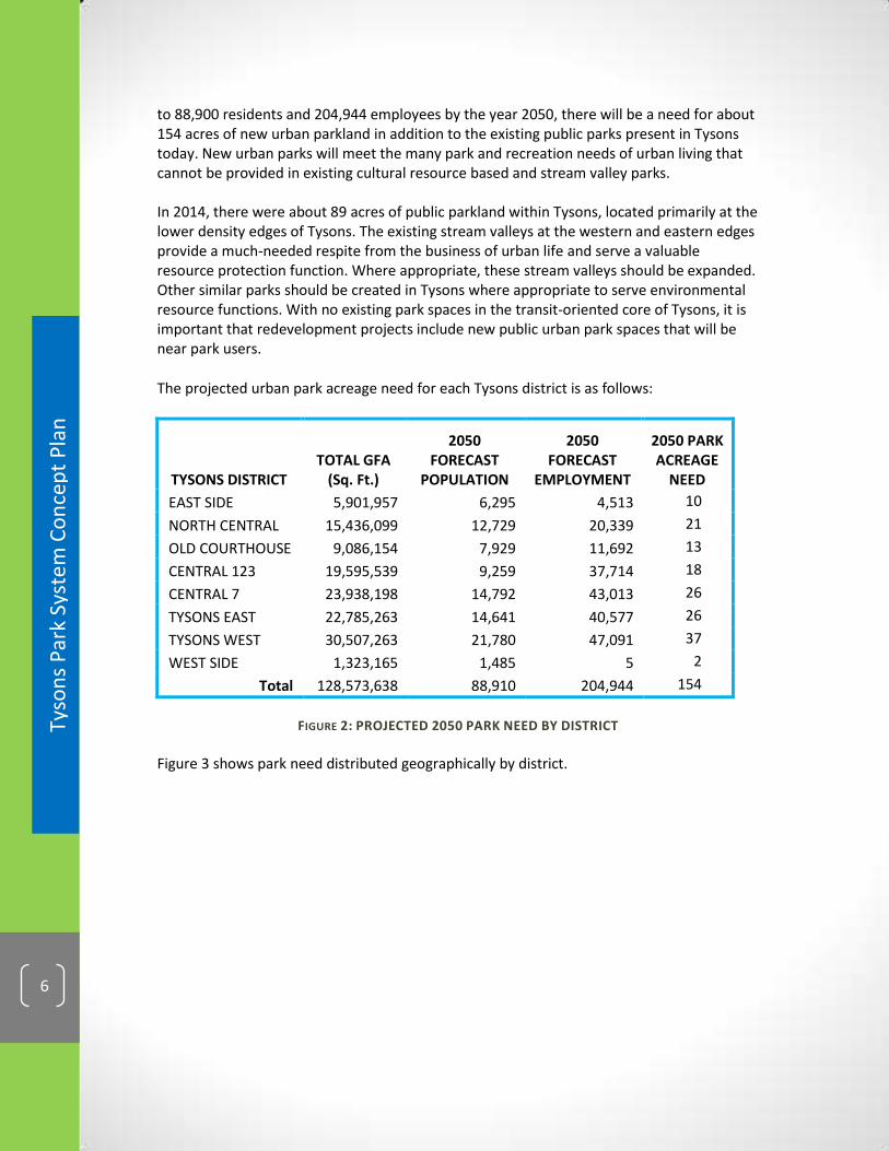
to 88,900 residents and 204,944 employees by the year 2050, there will be a need for about 154 acres of new urban parkland in addition to the existing public parks present in Tysons today. New urban parks will meet the many park and recreation needs of urban living that cannot be provided in existing cultural resource based and stream valley parks. In 2014, there were about 89 acres of public parkland within Tysons, located primarily at the lower density edges of Tysons. The existing stream valleys at the western and eastern edges provide a much-needed respite from the business of urban life and serve a valuable resource protection function. Where appropriate, these stream valleys should be expanded. Other similar parks should be created in Tysons where appropriate to serve environmental resource functions. With no existing park spaces in the transit-oriented core of Tysons, it is important that redevelopment projects include new public urban park spaces that will be near park users.
The projected urban park acreage need for each Tysons district is as follows:
TYSONS DISTRICT TOTAL GFA
(Sq. Ft.)
2050 FORECAST
POPULATION
2050 FORECAST
EMPLOYMENT
2050 PARK ACREAGE
NEED
EAST SIDE 5,901,957 6,295 4,513 10
NORTH CENTRAL 15,436,099 12,729 20,339 21
OLD COURTHOUSE 9,086,154 7,929 11,692 13
CENTRAL 123 19,595,539 9,259 37,714 18
CENTRAL 7 23,938,198 14,792 43,013 26
TYSONS EAST 22,785,263 14,641 40,577 26
TYSONS WEST 30,507,263 21,780 47,091 37
WEST SIDE 1,323,165 1,485 5 2
Total 128,573,638 88,910 204,944 154
FIGURE 2: PROJECTED 2050 PARK NEED BY DISTRICT
Figure 3 shows park need distributed geographically by district.

Tyso
ns
Par
k Sy
ste
m C
on
cep
t P
lan
7
FIG
UR
E 3
: P
RO
JEC
TE
D P
AR
K N
EE
D A
ND
EX
IST
ING
PA
RK
AC
RE
AG
E I
N T
YS
ON
S

DRAFT
Tyso
ns
Par
k Sy
ste
m C
on
cep
t P
lan
8
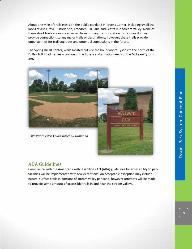
Existing Conditions In 2013, the Park Authority owned about 89 acres of parkland within the boundaries of Tysons (about five percent of the land area), located primarily at the lower density edges of Tysons. To the west of Leesburg Pike public parkland includes the Ash Grove Historic Site, Old Courthouse Spring Branch Stream Valley Park, Raglan Road Park and Freedom Hill Park. These parks serve as a buffer between the more dense development in Tysons and the low-density residential neighborhoods of Vienna. Most, but not all, of this parkland is designated for natural or cultural resource protection and trail connections. Raglan Road Park and Freedom Hill Park are planned to have some active recreation facilities. To the east of the Capital Beltway are the Scotts Run Stream Valley and Westgate Parks. Scotts Run Stream Valley provides a buffer between existing commercial and residential uses. Westgate Park is collocated with Westgate Elementary School. In 2013, there are no public parks in the core area of Tysons, in the triangle that is formed by Leesburg Pike, the Capital Beltway and the Dulles Toll Road. Westgate Park, collocated with Westgate Elementary School, provides two lighted youth diamond baseball fields, a batting cage, two lighted tennis courts, trails and a picnic shelter. A single playground and small trail loop are located at Freedom Hill Park.
FIGURE 4: 2013 PARK AUTHORITY-OWNED LAND IN TYSONS
Tyso
ns
Par
k Sy
ste
m C
on
cep
t P
lan
9
Westgate Park Youth Baseball Diamond
About one mile of trails exists on the public parkland in Tysons Corner, including small trail loops at Ash Grove Historic Site, Freedom Hill Park, and Scotts Run Stream Valley. None of these short trails are easily accessed from primary transportation routes, nor do they provide connections to any major trails or destinations; however, these trails provide opportunities for trail upgrades and potential connections in the future. The Spring Hill RECenter, while located outside the boundary of Tysons to the north of the Dulles Toll Road, serves a portion of the fitness and aquatics needs of the McLean/Tysons area.
ADA Guidelines Compliance with the Americans with Disabilities Act (ADA) guidelines for accessibility to park
facilities will be implemented with few exceptions. An acceptable exception may include
natural surface trails in portions of stream valley parkland; however attempts will be made
to provide some amount of accessible trails in and near the stream valleys.

DRAFT
Tyso
ns
Par
k Sy
ste
m C
on
cep
t P
lan
10
THIS PAGE INTENTIONALLY LEFT BLANK

Tyso
ns
Par
k Sy
ste
m C
on
cep
t P
lan
11
Urban Parks in Fairfax County “The planned
urbanization of the
County’s growth areas
requires that the
existing suburban
park system in Fairfax
County be
supplemented by
parks that are more
suitable for the
unique urban context
and provide
appropriate functions,
uses, amenities, visual
form, ownership, and
accessibility to the
variety of users typical
in an urban
environment.”
(Fairfax County Policy
Plan, Urban Parks
Framework, page 15)
PARK PLACEMENT & TYPOLOGY: Balancing the Park Network Place parks in the right locations! A successful Tysons park system must ensure public access to diverse park types located in the right places to meet the demands of expected population and employment growth. High quality urban parks will help to distinguish Tysons from other urban areas and make it the place to be, which translates into benefits to the local economy and quality of life.
Comprehensive Plan Guidance The Tysons Urban Center Plan sets forth a service level standard of 1.5 acres of parkland per 1000 residents and 1 acre per 10,000 employees. Based on the forecasted growth in Tysons to 88,900 residents and 204,944 employees by the year 2050, there will be a need for about 154 acres of new urban parkland. The “Conceptual Parks & Open Space Network Map” in the Tysons Urban Center Plan shows generally where new park spaces could be located in Tysons.
Meeting the Need for New Parks An evolving park system is reflected in the Conceptual Park Placement & Typology Map at the end of this chapter. The map builds on the “Conceptual Parks & Open Space Network Map” in the Tysons Urban Center Plan. Refinements add those new parks approved in rezoning applications and remove some spaces not likely to come about. Park spaces included in approved and pending redevelopment plans are added to the map as well as additional spaces needed to fill gaps, balance the park system, and provide for athletic facilities. The result is an updated conceptual park network map intended to be used as a guide for locating new urban parks in Tysons. New parks in
11

DRAFT
Tyso
ns
Par
k Sy
ste
m C
on
cep
t P
lan
12
Paley Park, New York, NY
Bethesda, MD
Tysons may not occur in the precise locations shown on the map. The Map seeks to distribute parks to appropriate places, but locations will be refined as Tysons redevelops. Exact locations and sizes of future parks will be determined through the redevelopment process. The Conceptual Park Placement & Typology Map further depicts planned park spaces according to the typology of the Urban Parks Framework and the locational criteria found in the Tysons Urban Design Guidelines. Five urban park types are described in these documents. Civic Plazas are identified in close proximity to Metro train stations or at major intersections. Common Green type parks are identified across Tysons in areas planned to have large residential populations. Recreation-focused parks are identified across Tysons, with the vast majority being farther than ¼ mile from Metro stations and many at the lower density edges of Tysons. Resource-based Linear Parks are located along the stream valleys. Pocket Parks are not mapped, unless already approved through a rezoning, since this park type is expected to be integrated throughout Tysons in every new development. The urban park types are described in detail below.
Urban Parks Typology
POCKET PARKS
Usually less than one acre, these urban parks are small-scale, open spaces incorporated into developments and designed for casual use by people working and living in the immediate area. A pocket park is designed as a single “room” to provide limited casual open space to enjoy individually or in social interactions. These spaces may consist of hardscape elements or lawn and landscaped areas, seating and visual amenities.
KEY FEATURES OF POCKET PARKS
Located throughout Tysons
Ideal in pedestrian activity areas
Smaller spaces
Integrated with surrounding uses
Passive activities & features
Tyso
ns
Par
k Sy
ste
m C
on
cep
t P
lan
13
Cupertino Civic Plaza, Cupertino, CA
Central Park, New York, NY
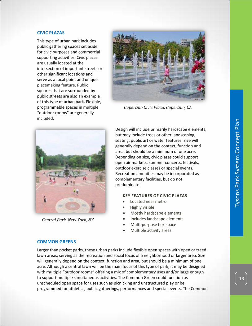
CIVIC PLAZAS
This type of urban park includes public gathering spaces set aside for civic purposes and commercial supporting activities. Civic plazas are usually located at the intersection of important streets or other significant locations and serve as a focal point and unique placemaking feature. Public squares that are surrounded by public streets are also an example of this type of urban park. Flexible, programmable spaces in multiple “outdoor rooms” are generally included.
Design will include primarily hardscape elements, but may include trees or other landscaping, seating, public art or water features. Size will generally depend on the context, function and area, but should be a minimum of one acre. Depending on size, civic plazas could support open air markets, summer concerts, festivals, outdoor exercise classes or special events. Recreation amenities may be incorporated as complementary facilities, but do not predominate.
KEY FEATURES OF CIVIC PLAZAS
Located near metro
Highly visible
Mostly hardscape elements
Includes landscape elements
Multi-purpose flex space
Multiple activity areas
COMMON GREENS
Larger than pocket parks, these urban parks include flexible open spaces with open or treed lawn areas, serving as the recreation and social focus of a neighborhood or larger area. Size will generally depend on the context, function and area, but should be a minimum of one acre. Although a central lawn will be the main focus of this type of park, it may be designed with multiple “outdoor rooms” offering a mix of complementary uses and/or large enough to support multiple simultaneous activities. The Common Green could function as unscheduled open space for uses such as picnicking and unstructured play or be programmed for athletics, public gatherings, performances and special events. The Common

DRAFT
Tyso
ns
Par
k Sy
ste
m C
on
cep
t P
lan
14
Macombs Dam Park, New York, NY
Union Square Park, New York, NY
Green may include facilities such as off-leash dog areas, community garden plots, landscaping, water features, shade structures, gathering areas, amphitheaters, space for public art, and/or hardscape areas. Recreational amenities may be incorporated as complementary facilities, but do not predominate. Examples of recreational facilities include tot lots and playgrounds, small skate parks, fitness courses and paved trails, and sport courts.
KEY FEATURES OF COMMON GREENS
Near residential uses
Open or treed lawns
Passive amenities
Active recreation
Multi-purpose flex space for events
Multiple activity areas
RECREATION-FOCUSED PARKS
Recreation needs should be addressed with the inclusion of recreation facilities in an urban park setting to serve local residents, workers and visitors. This park type is distinguished by its primary function to provide active recreation facilities for nearby residents and workers. Facilities such as athletic fields, multi-use courts and skate parks should be provided. Facilities could be scheduled or casually used. Athletic fields should have synthetic turf and lights to maximize use. Support facilities and amenities such as trails, seating, tot lots, shade structures, water features, picnic areas, restrooms, landscaping or hardscape should be provided to complement the recreational component. The size of the park should be appropriate to accommodate the recreation facilities located there.
KEY FEATURES OF RECREATION-FOCUSED PARKS
Larger in size
Multiple activity areas
Active recreation facilities dominate
Multi-sport athletic fields
Sport courts
Playgrounds

Tyso
ns
Par
k Sy
ste
m C
on
cep
t P
lan
15
Leon Creek Park, San Antonio, TX
LINEAR PARKS
Linear parks are characterized by an elongated shape and usually occur in an area between destinations or points of interest and/or along streams or power line easements and frequently double as connections. These parks can serve many different purposes including providing a variety of recreation facilities (e.g., fitness stations, dog exercise areas). Creation of continuous linear spaces for recreation provides an important amenity that can be linked with pedestrian and bicycle street elements. Linear parks can also provide opportunities for resource protection and can provide natural areas with trails and waysides for a combination of active and passive enjoyment. Linear greenways that utilize urban stream valleys for trails and trail connections are one such form of linear park.
KEY FEATURES OF LINEAR PARKS
Connectivity/Trails
Passive Enjoyment
Resource Management
Stream Restoration
Interim & Pop-up Parks Since Tysons’ redevelopment will occur over several decades and individual developments will be phased, interim and pop-up parks have an important role to play in filling the gap in park and recreation needs until the ultimate build out of Tysons is realized. A well-placed and programmed temporary park can create a sense of place, spur economic development, and make use of underutilized land until such time as more permanent parks and facilities can be built and supported by redevelopment.
INTERIM PARKS
Interim parks can be created when sites are cleared for redevelopment, but one or more land bays remain undeveloped. About half a dozen approved rezonings (as of 2013) include such interim parks. They will consist primarily of grassy lawn areas that may include landscape plantings, sidewalks, bench seating, trash cans, picnic tables, dog-waste stations, sand volley ball pits, and youth soccer fields. These interim parks will not be developed with permanent park structures (play equipment, hardscape paving, performance stages, etc.) since they will eventually be replaced by buildings and permanent urban park designs as developments are phased in.
DRAFT
Tyso
ns
Par
k Sy
ste
m C
on
cep
t P
lan
16
POP-UP PARKS
Pop-up parks can take advantage of unused surface parking lots and other vacant areas of land that do not require significant grading or construction. Temporary barriers, fences and planters can be used to define a space. Pavement paint, loose tables and chairs, lounges, shade structures and umbrellas, other outdoor furnishings, temporary lighting, and public art can help to transform an asphalt parking lot into a vibrant park space at relatively low cost. Small scale recreational uses, such as game tables, bocce courts and mini golf can be included to provide for activation of the space. Both interim and pop-up parks can include retail carts, nearby food truck parking, and space for open air markets to draw people in. These park spaces can also be programmed with events, performances, outdoor movies, and fitness classes.
EXAMPLES:
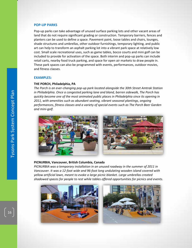
THE PORCH, Philadelphia, PA The Porch is an ever-changing pop-up park located alongside the 30th Street Amtrak Station in Philadelphia. Once a congested parking lane and bland, barren sidewalk, The Porch has quickly become one of the most animated public places in Philadelphia since its opening in 2011, with amenities such as abundant seating, vibrant seasonal plantings, ongoing performances, fitness classes and a variety of special events such as The Porch Beer Garden and mini-golf.
PICNURBIA, Vancouver, British Columbia, Canada PICNURBIA was a temporary installation in an unused roadway in the summer of 2011 in Vancouver. It was a 12-foot wide and 96-foot long undulating wooden island covered with yellow artificial lawn, meant to evoke a large picnic blanket. Large umbrellas created shadowed spaces for people to rest while tables offered opportunities for picnics and events.
Tyso
ns
Par
k Sy
ste
m C
on
cep
t P
lan
17
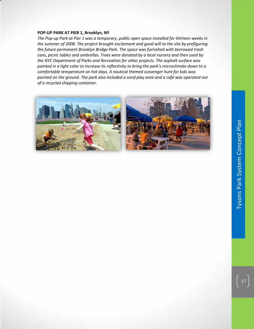
POP-UP PARK AT PIER 1, Brooklyn, NY The Pop-up Park at Pier 1 was a temporary, public open space installed for thirteen weeks in the summer of 2008. The project brought excitement and good will to the site by prefiguring the future permanent Brooklyn Bridge Park. The space was furnished with borrowed trash cans, picnic tables and umbrellas. Trees were donated by a local nursery and then used by the NYC Department of Parks and Recreation for other projects. The asphalt surface was painted in a light color to increase its reflectivity to bring the park’s microclimate down to a comfortable temperature on hot days. A nautical themed scavenger hunt for kids was painted on the ground. The park also included a sand play area and a café was operated out of a recycled shipping container.

DRAFT
Tyso
ns
Par
k Sy
ste
m C
on
cep
t P
lan
18
Key Challenges & Opportunities* Park Placement & Typology
1. Development proposals should provide sufficient park space onsite and/or quality and/or active elements.
Encourage designers and developers to think about the value of park spaces as integral to the design rather than as leftover spaces
Redesign building layout for more optimal public park provision onsite.
Consolidate land and/or collaborate with neighboring landowners to combine landholdings to provide integrated and connected urban park spaces.
Provide rooftop and/or indoor recreation spaces to augment at-grade spaces.
Where appropriate, make improvements to public spaces offsite, such as Metro station plazas, existing stream valleys and school properties to make these spaces more usable.
Provide a monetary contribution to Fairfax County for public park creation and/or improvements to serve Tysons.
Design park spaces to include a variety of amenities and facilities.
Include a variety of park types consistent with the Tysons park system map within the development.
2. Visual and physical access to parks needs to be clear and parks easy to find.
Ensure parks provided at grade are easily seen and accessed from the public realm.
Provide multiple access points from the public realm to public park spaces and especially to any rooftop park spaces.
Provide adequate wayfinding signs and features to link park spaces together and make them easy to find.
3. Streetscape and unusable areas (such as traffic islands) should not be designated as park space.
Design usable public park spaces that are easily distinguishable from the streetscape.
4. As developments will be phased in over time, urban park spaces will be provided over many years or decades.
Unused surface parking areas and vacant lots/future building sites may be ideal locations for interim parks or spaces for community events.
5. Large areas of land are needed for the big central parks (one planned in North Central and one planned for south of Route 7).
Consider potential incentives for landowners to donate land for large parks.
A land bank/funding bank for parks should be established to make it possible to dedicate space for larger parks.
* Not all listed challenges will be present in every project. Listed strategies are possible approaches that may be used but may not be appropriate in all situations.

Tyso
ns
Par
k Sy
ste
m C
on
cep
t P
lan
19
IMPLEMENTATION STRATEGY Park Placement & Typology Creation of new urban parks in Tysons will be achieved largely through redevelopment. In some cases, the public and non-profit sectors may be involved. It is important to ensure the right parks are in the right place, therefore guidance in this Plan should be utilized to help balance the provision of park types and facilities within the overall neighborhood as well as Tysons-wide. Connecting the park system and allowing for iterative opportunities as development takes place will take a unified effort of the private and public sectors. PRIVATE REDEVELOPMENT New development proposals are evaluated based upon the quantity and quality of onsite urban park spaces provided within the project as compared to the Plan guidance and in accordance with the Urban Design Guidelines. Quantitative Assessment – Urban parkland and recreation facility service level standards set forth in the Comprehensive Plan are based on population and employment. Quantifying the number of future residents and employees determines the general amount of urban park space and facilities needed.
Qualitative Evaluation – Determining the amount of urban park land is a starting point for evaluating development proposals in Tysons. The Tysons Urban Design Guidelines include a checklist of desired park elements for each of the urban park types that should be used as a guide. (A version of the checklist is also included in Appendix 2 of this document.) Qualitative evaluation of a development plan looks at the design and layout of buildings and parks, visibility and accessibility of park spaces, adjacency to active uses and key pedestrian corridors, function and programmability, quality of amenities and materials used, and inclusion of active recreation and other interactive elements that make each space a useable, programmable place.
Offsite Improvements – Improvements to publicly owned land (such as the Metro station plazas, existing stream valley parkland, and school property) may be made or funded by developers to offset a shortfall in providing new urban park spaces onsite within a development. Such investments could improve appearance, access, usability and/or function of the public space and should be coordinated with relevant agencies. PUBLIC CONTRIBUTIONS General obligation bonds and other public funding mechanisms will be necessary to achieve some elements of the park network. For example, creation of the large Central Park and/or the Signature Civic Commons may be too large a burden for individual landowners or developers. OTHER CONTRIBUTIONS Non-governmental entities such as the Tysons Partnership, charitable foundations, corporations, friends groups and individual volunteers could play an important role in supporting the realization of a robust park system over time.
The Conceptual Park Placement and Typology Map provides guidance to help ensure the right types of parks will be built where needed.

DRAFT
Tyso
ns
Par
k Sy
ste
m C
on
cep
t P
lan
20
CO
NC
EP
TU
AL
PA
RK
PL
AC
EM
EN
T A
ND
TY
PO
LO
GY
MA
P
20
FIG
UR
E 5
: C
ON
CE
PT
UA
L P
AR
K P
LAC
EM
EN
T A
ND
TY
PO
LOG
Y M
AP

Tyso
ns
Par
k Sy
ste
m C
on
cep
t P
lan
21
Parks Connectivity The vision for Tysons
calls for a “green
network,” or a
comprehensive
system of parks and
open spaces that
connects all the
districts within Tysons
through greenways.
The network will
integrate large and
small urban parks
with existing
environmentally
sensitive areas and
other built elements
to create safe
pedestrian and
bicycle-friendly
pathways throughout
all neighborhoods.
(Tysons Urban Center
Plan, page 77)
CONNECTIVITY: Connecting People to Parks A well-connected park network can be enjoyed by more people! Augmenting the park network with connections between isolated park spaces, stream valleys and key points of interest will enhance the value of all parks and further distinguish Tysons from other urban areas. Creating opportunities for cyclists and pedestrians to experience park spaces and points of interest in Tysons safely and conveniently is crucial. This can be achieved through appropriate placement of new parks and a well-planned recreational trail system that connects and extends public sidewalks, bike lanes and bicycle facilities, recognizing the importance of trails in accessing Metrorail stations. The emphasis here is on recreational use of trails.
Comprehensive Plan Guidance The “Conceptual Parks & Open Space Network Map” in the Tysons Urban Center Plan identifies several off-road trail connections, along three stream valley greenway corridors and a County-owned power line easement. These will provide key “to and through” trail connections. The Tysons Urban Center Plan also recommends a planned grid of streets that will be essential to creating a walkable community through pedestrian-friendly streetscapes and on-road bicycle lanes and facilities.
Tysons Urban Design Guidelines The Streetscape Framework chapter of the Tysons Urban Design Guidelines addresses the pedestrian network, provides recommended streetscape cross sections and presents a Pedestrian Hierarchy Plan that focuses pedestrian-oriented activity along certain corridors. The Pedestrian Hierarchy Plan is intended to connect Tysons’ neighborhoods; reinforce transit-oriented development patterns; facilitate connections to transit facilities and bus stops; support active and attractive pedestrian areas within neighborhoods; help
21

DRAFT
Tyso
ns
Par
k Sy
ste
m C
on
cep
t P
lan
22
determine locations for retail; and connect parks, libraries, schools, community centers, and other civic uses. The Pedestrian Hierarchy Plan can also help determine the best locations for new urban parks.
Other Guiding Documents Phase I of the Fairfax County Bicycle Master Plan covers the Tysons area and provides detailed bicycle infrastructure recommendations, including trail connections to neighborhoods outside of Tysons, on-road bike lanes, and other facilities to support commuter cycling. The Tysons Circulator Study proposes a three-route bus system to support Metrorail transit ridership and minimize vehicular trips to, from, and within Tysons. Consideration of planned bike and Circulator routes will better inform park and trail network locations.
Meeting the Need for Park Connectivity Planning for park connectivity in Tysons must consider the many elements of the transportation system and planned pedestrian and bicycle network. In addition, it will be important to create safe and convenient access points at the edges of Tysons that will allow pedestrians and bicyclists to enter and experience the Tysons park network from surrounding neighborhoods. A variety of non-park transportation elements will provide accessibility to and connectivity between parks. Of the various modes of transportation and connectivity in Tysons, Metrorail’s Silver Line provides connectivity on a broad scale. Circulator bus routes will provide a greater level of access to park spaces than can be provided by Metrorail as the park network evolves throughout Tysons. Sidewalks, on-road bike lanes and off-road trails along an increasingly connected grid of streets will provide the most localized level of connectivity. Three stream valleys, two with Resource Protection Area (RPA) buffers in Tysons will serve as linear recreation spaces that may include trails, trailheads, interpretive features and wayfinding signage. These trails will be popular for jogging, dog walking, biking, hiking, and general exercising, as well as providing valuable connections to the natural environment.

Tyso
ns
Par
k Sy
ste
m C
on
cep
t P
lan
23
CONNECTIVITY ELEMENTS Metro rail transit
Tysons Circulator buses
Grid of streets
Pedestrian realm of the streetscape
On-road bike lanes
Off-road trails
Bridges over streams and other physical barriers
Wayfinding signs and features
“Tysons Community Circuit”
“Silver Line Green Artery”

DRAFT
Tyso
ns
Par
k Sy
ste
m C
on
cep
t P
lan
24
SPOTLIGHT ON: Tysons Community Circuit The pedestrian realm of the planned Tysons streetscape will provide the most continuous connection to the variety of multi-modal networks envisioned for Tysons. The connectivity provided by the planned grid of streets is extensive, yet there remains a gap in the options for recreational connectivity. Although cyclists, roller bladers, and joggers are free to use the sidewalks, there is the potential for conflicts between these users and pedestrians moving at a slower, browsing pace. The planned bicycle network is extensive but focused on the cycling commuter and, therefore, not ideal for a child learning to ride a bike or a family out for a leisurely excursion. An off-road trail system along the stream valleys and power line easement will provide for some of this recreational trail need, however, with limited connectivity and limited coverage throughout Tysons. There is a need for another type of recreational trail that is more closely integrated with the places where people live and work, linking parks and points of interest, while providing the flexibility for a variety of users to share the space safely. A designated recreational trail loop will enhance connectivity among parks, civic uses and other major points of interest across Tysons. This type of urban trail should be considered a signature park system element to tie all other elements together and elevate the park and recreation experience in Tysons. This feature could be branded for easy recognition as The Tysons Community Circuit or “Circuit.” The conceptual route shown on the Conceptual Tysons Community Circuit & Connectivity Map at the end of this chapter connects the stream valleys and other off-road trail routes with the distributed network of urban parks, mainly along avenues that are planned to have on-road bike lanes. The proposed route of the Circuit runs past numerous planned park spaces as well as the two signature parks planned for Tysons. Over time, additional community facilities will likely be built along the Circuit such as a library, performing arts venues, and indoor recreation facilities. The conceptual course of the Tysons Community Circuit is laid out primarily through areas designated for Residential or Residential Mixed-Use redevelopment. Residential areas would likely contribute the greatest number of Circuit users. Over 75% of the Circuit overlaps with streets identified in the Tysons Urban Design Guidelines as the highest tier in the Pedestrian Hierarchy Plan. There is also significant overlap with all three planned Circulator bus routes, however the marked route should not conflict with bus drop-off/pickup points. In addition, on street parking should not be impacted, since the marked trail can be accommodated within the planned streetscape. The conceptual Circuit trail is about 4.5-5 miles long, which is a desirable distance for running or cycling and is similar in length to the popular trail that encircles Burke Lake in southern Fairfax County. Continuous connectivity of the Circuit depends on two new planned bridges across I-495 to close the loop; the bridge connecting Jones Branch Drive to Scotts Crossing Road (extension of Express lanes connection) and a new crossing connecting the Tysons Mall area to Old Meadow Road (limited to transit, pedestrians and bicyclists). Both of these bridges are planned transportation elements in the Comprehensive Plan. Opportunities abound for the incorporation of public art, interpretive elements, placemaking features, and cultural highlights all along the route of the Tysons Community Circuit.

Tyso
ns
Par
k Sy
ste
m C
on
cep
t P
lan
25
Indianapolis Cultural Trail Photos Courtesy of Visit Indy
EXAMPLE: Indianapolis Cultural Trail
Conceptualized in 2005, the Indianapolis Cultural Trail provides an eight mile route with 19 cultural exhibits that links five of the city’s six cultural districts. The project was undertaken with the central goal “of uniting the districts both physically and in the minds of the city’s residents.” Funded by the city, government grants, and private donations, construction started in 2007 and is on-going. The Indianapolis Cultural Trail serves as a model to consider for a recreational trail loop in Tysons. The trail is wide enough to provide two-way bike lanes but can serve for joggers, skaters or essentially anyone moving at a different pace from the sidewalk browsing speed. Unique paving and signage help identify the space and emphasize the connectivity. Key points of interest are highlighted in wayfinding signage. Locations where land could not be acquired to fully connect portions of the trail will be signed more clearly to indicate continuity of the path in the absence of physical construction.
In 2012, the City of Indianapolis published a study that demonstrates multiple benefits of the Cultural Trail on the local environment, social patterns, and economy. Primary ecological benefits are through the addition of hundreds of street trees, many in bioretention pits, and reduction of vehicular trips as a direct result of the trail and the connectivity it offers. A number of trail users were from outside city center, viewing the trail as a destination attraction. By far, though, nearby residents and workers were the predominant users of the trail, 50% stating that they used the trail several days a week and 35% stating daily use of the trail. As with land adjacent to parkland, properties adjacent to the cultural trail reflected an increase in property value. Since 2010, 23 new bars, restaurants, and shops have opened along the trail. Business owners and those focused on the economic development of Indianapolis recognize that sales increase when emphasizing a business’ location on the Indianapolis Cultural Trail.

DRAFT
Tyso
ns
Par
k Sy
ste
m C
on
cep
t P
lan
26
Recreational Trail Loop Elements and Alternatives

Tyso
ns
Par
k Sy
ste
m C
on
cep
t P
lan
27
Elevated Metrorail in the Median of Route 7
SPOTLIGHT ON: Metro Silver Line Green Artery In July 2014, Phase 1 of the Silver Line opened with four Metrorail stations in Tysons: Spring Hill, Greensboro, Tysons Corner, and McLean. The Silver Line is an aboveground extension of the regional Metrorail system that utilizes large concrete trestles and bridges 20 to 50 feet above grade. The Silver Line enters Tysons in the east along Route 123 and shifts to Route 7 at the intersection of these two main roads, where the rail line runs in the median until it exits Tysons in the west at Route 267 to continue to Reston (and eventually Dulles Airport and Loudoun County with Phase 2). The elevated Silver Line poses a unique place-making challenge as a monolithic structure dividing Tysons along major roads, with underutilized areas beneath the rail tracks and around the four stations. The resulting grade separation impacts walkability, connectivity, aesthetics, and safety. The underutilized spaces beneath the elevated line, which include some landscaped bioretention areas for stormwater management, could be enhanced to create attractive and functional spaces for people and could be connected as a Green Artery to link the four stations with a pedestrian and bicycle path weaving under and along the Silver Line. This path could serve as an organizing feature for a variety of amenities including rain gardens, public art, entertainment spaces, parks, or pop-up retail. These uses might be themed by station. In some instances the path could be elevated from the ground to avoid conflicts with motor vehicles and create interesting experiences and views. The Green Artery should also be designed to connect to other planned and existing pedestrian networks. In addition, each of the station areas should be distinct from the surrounding areas, showcasing high quality and innovative design. Key to the success of the station areas is to create safe and comfortable multi-modal connections between each TOD neighborhood and the transit function of the stations themselves. Additionally, because the Silver Line occupies space alongside and in the median of two busy arterial streets, significantly enhanced pedestrian and bicycle connections will be important at the road intersections below the stations. Station areas could be distinguished as “people places” where vehicles must slow down and defer to pedestrians and bicyclists. Design concepts that use different pavement materials, special crosswalks and signal timing, landscaping, lighting, sculpture and/or canopies along Routes 7 and 123 would cue vehicles to slow down and indicate that station areas are special places for people.
DRAFT
Tyso
ns
Par
k Sy
ste
m C
on
cep
t P
lan
28
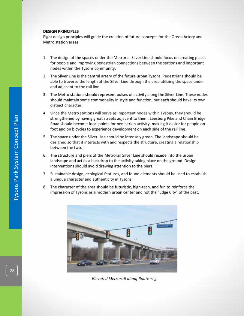
Elevated Metrorail along Route 123
DESIGN PRINCIPLES Eight design principles will guide the creation of future concepts for the Green Artery and Metro station areas:
1. The design of the spaces under the Metrorail Silver Line should focus on creating places for people and improving pedestrian connections between the stations and important nodes within the Tysons community.
2. The Silver Line is the central artery of the future urban Tysons. Pedestrians should be able to traverse the length of the Silver Line through the area utilizing the space under and adjacent to the rail line.
3. The Metro stations should represent pulses of activity along the Silver Line. These nodes should maintain some commonality in style and function, but each should have its own distinct character.
4. Since the Metro stations will serve as important nodes within Tysons, they should be strengthened by having great streets adjacent to them. Leesburg Pike and Chain Bridge Road should become focal points for pedestrian activity, making it easier for people on foot and on bicycles to experience development on each side of the rail line.
5. The space under the Silver Line should be intensely green. The landscape should be designed so that it interacts with and respects the structure, creating a relationship between the two.
6. The structure and piers of the Metrorail Silver Line should recede into the urban landscape and act as a backdrop to the activity taking place on the ground. Design interventions should avoid drawing attention to the piers.
7. Sustainable design, ecological features, and found elements should be used to establish a unique character and authenticity in Tysons.
8. The character of the area should be futuristic, high-tech, and fun to reinforce the impression of Tysons as a modern urban center and not the “Edge City” of the past.

Tyso
ns
Par
k Sy
ste
m C
on
cep
t P
lan
29
Green Artery concept sketches courtesy of Fairfax County Office of Community Revitalization
FIGURE 7: TYSONS-WIDE CONCEPT FOR THE GREEN ARTERY
FIGURE 6: CONCEPT FOR GREEN SPACE UNDER THE SILVER LINE

DRAFT
Tyso
ns
Par
k Sy
ste
m C
on
cep
t P
lan
30
Key Challenges & Opportunities* Parks Connectivity
1. Connections will be fragmented in the near term until the system is fully completed.
Integrate park trail planning efforts with bikeway and pedestrian planning efforts.
Implement planned connections and a recreational trail loop through redevelopment and transportation and public improvement projects.
Prioritize funding for connectivity projects that focus on filling in trail gaps.
Partner with private and public entities to construct trail connections.
Publicize and promote new connections as they are completed to show progress.
2. Tysons will be a 24/7 urban center, therefore off-road trail areas should be adequately lit for use at night.
Where feasible, footpath or other types of appropriate safety lighting should be provided along stream valley and other off-road trails.
Use technology solutions to address safety issues.
3. Many planned athletic fields and other park destinations are located towards the outer edges of Tysons and may have limited accessibility for pedestrians.
Recreation-focused parks may be ideal locations for Bike Share stations or circulator bus stops.
4. With 100,000 residents and 200,000 workers, the trails will get heavy use and trail maintenance must be planned and programmed.
Adopt consistent and achievable trail maintenance standards.
Gain a public funding commitment to build, renovate, and maintain trails.
Build sustainable trails to reduce maintenance requirements.
Volunteers, friends groups, corporations, or other non-governmental entities (such as the Tysons Partnership or a future Business Improvement District) could assist with maintenance and/or adopt a trail.
* Not all listed challenges will be present in every project. Listed strategies are possible approaches that may be used but may not be appropriate in all situations.

Tyso
ns
Par
k Sy
ste
m C
on
cep
t P
lan
31
IMPLEMENTATION STRATEGY Parks Connectivity Safe, convenient connections between parks, key points of interest, and the different neighborhoods of Tysons will greatly enhance quality of life. Connectivity elements will be implemented through park trail development, redevelopment projects and public transit and transportation improvements.
Tysons Community Circuit The Tysons Community Circuit trail as proposed along existing and planned roads will be a combined recreational and transportation feature that will add to the diversity of options available for moving through Tysons. Additional width in the streetscape/street section is not required to achieve the benefits of a unified Circuit trail.
The completion of the Circuit is expected to be phased as Tysons redevelops. Initially, the Circuit route could be marked with wayfinding signage and pavement markings. Promotional events and brochures, web sites and mobile apps would create awareness of the Circuit and identify key points of interest along the way. Over time, as properties along the route redevelop, the physical trail itself would be created as part of the expected complete streetscape/street section. In some areas of Tysons, where redevelopment is not expected for decades, segments of the Circuit could be implemented with public funds, grants, or through public-private partnerships.
Building on the wayfinding and branding treatments established early on, the ultimate configuration of the Circuit will be distinguished by special paving materials and marking patterns that can extend from the sidewalk across the landscape amenity panel to the curb. Additionally, unique pavement markings or asphalt colors in the on-road bike lanes along the Circuit would further distinguish the Circuit route. Some design flexibility may be needed in certain areas. For example, in places where redevelopment is unlikely to occur, regular sidewalks and on-road bike lanes could be supplemented with special pavement markings and wayfinding signage.
Complete connectivity of the Circuit depends on two new planned bridges across I-495. The bridge connecting Jones Branch Drive to Scotts Crossing Road (extension of Express lanes connection) is expected to be complete by 2020. This bridge is well into the design phase and is planned to include on-road bike lanes and 12-foot wide sidewalks. Another new crossing connecting the Tysons Mall area to Old Meadow Road (limited to transit, pedestrians and cyclists) is identified in the Comprehensive Plan to be in place by 2030. Opportunities to provide a pedestrian/bike connection only at this location through public funding prior to the implementation of the transit Circulator service should be pursued. An interim alternate route that goes over I-495 along Route 7 should be used until the second bridge crossing is built.
Maintenance standards and funding will need to be established for the unique elements (signs, special pavers, pavement markings, etc.) that will be used to brand and distinguish the Circuit from other streetscape sections in Tysons. The public, private and non-profit sectors should collaborate to ensure these standards can be achieved.
DRAFT
Tyso
ns
Par
k Sy
ste
m C
on
cep
t P
lan
32
Metro Rail Green Artery Designs for the Tysons under-rail area will require participation of several agencies, including multiple Fairfax County departments, the Washington Metropolitan Area Transit Authority, the Metropolitan Washington Airports Authority, and the Virginia Department of Transportation. To be implemented, projects may require both the public and private sectors to partner together and address hurdles such as road right-of-way requirements, property ownership, funding, construction and maintenance. Community stakeholders also should provide input on whether proposed plans align with neighborhood goals.
The Conceptual Connectivity Map shows the “Tysons Community Circuit” and Metro Rail Green Artery as major park system elements to tie all other components together.

Tyso
ns
Par
k Sy
ste
m C
on
cep
t P
lan
33
THIS PAGE INTENTIONALLY LEFT BLANK

DRAFT
Tyso
ns
Par
k Sy
ste
m C
on
cep
t P
lan
34
CO
NC
EP
TU
AL
CO
NN
EC
TIV
ITY
MA
P
FIG
UR
E 8
: C
ON
CE
PT
UA
L C
ON
NE
CT
IVIT
Y M
AP
34

Tyso
ns
Par
k Sy
ste
m C
on
cep
t P
lan
35
ATHLETIC FIELDS: Creating Places to Play The Tysons lifestyle will be more active with places to play! The increased population of residents and workers in Tysons as it develops into a new downtown will seek an active urban lifestyle that includes organized sports play. In addition, it is projected that there will be fewer children and more adults living in Tysons. New athletic fields in a variety of sizes and shapes, including rectangles, diamonds, overlays, rooftop and indoor facilities should be provided in or near Tysons to serve this population. Larger fields with multiple sport striping will accommodate a greater range of sports and age groups, however smaller fields in some locations will help to meet a portion of the need.
Comprehensive Plan Guidance Providing athletic fields in Tysons for organized sports play is an important Vision element of the Tysons Urban Center Plan, which states that 20 new athletic fields should be provided to serve Tysons by the year 2050. The recommended number of 20 new athletic fields in Tysons was arrived at through an open, collaborative process with citizens, developers, staff and decision makers, with the understanding that the mix of these fields would represent the population demographics (more adult than youth sports participants) anticipated in Tysons. Also it is understood that in order to get the most out of these facilities, fields must be designed and constructed to maximize playability (including field dimensions to accommodate multiple sports, synthetic turf, lights, and longer scheduling hours). District chapters of the Tysons Urban Center Plan identify eight possible locations for consideration for development of athletic fields. The map below shows graphically those locations that are identified by the Tysons Urban Center Plan.
Softball
Lacrosse
Soccer
35
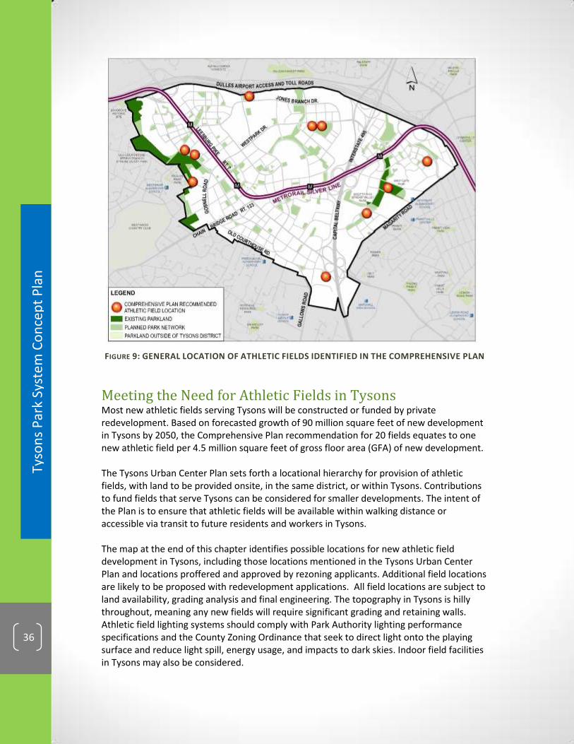
DRAFT
Tyso
ns
Par
k Sy
ste
m C
on
cep
t P
lan
36
Meeting the Need for Athletic Fields in Tysons Most new athletic fields serving Tysons will be constructed or funded by private redevelopment. Based on forecasted growth of 90 million square feet of new development in Tysons by 2050, the Comprehensive Plan recommendation for 20 fields equates to one new athletic field per 4.5 million square feet of gross floor area (GFA) of new development. The Tysons Urban Center Plan sets forth a locational hierarchy for provision of athletic fields, with land to be provided onsite, in the same district, or within Tysons. Contributions to fund fields that serve Tysons can be considered for smaller developments. The intent of the Plan is to ensure that athletic fields will be available within walking distance or accessible via transit to future residents and workers in Tysons. The map at the end of this chapter identifies possible locations for new athletic field development in Tysons, including those locations mentioned in the Tysons Urban Center Plan and locations proffered and approved by rezoning applicants. Additional field locations are likely to be proposed with redevelopment applications. All field locations are subject to land availability, grading analysis and final engineering. The topography in Tysons is hilly throughout, meaning any new fields will require significant grading and retaining walls. Athletic field lighting systems should comply with Park Authority lighting performance specifications and the County Zoning Ordinance that seek to direct light onto the playing surface and reduce light spill, energy usage, and impacts to dark skies. Indoor field facilities in Tysons may also be considered.
FIGURE 9: GENERAL LOCATION OF ATHLETIC FIELDS IDENTIFIED IN THE COMPREHENSIVE PLAN

Tyso
ns
Par
k Sy
ste
m C
on
cep
t P
lan
37
Improvements to Existing Parks Existing parks offer opportunities to add capacity for active recreation. Westgate Park, collocated with Westgate Elementary School in the Tysons East District, is developed with two lighted youth diamond baseball fields, batting cages, two lighted tennis courts, trails and a picnic shelter. A reconfiguration of athletic fields will be implemented as part of a school renovation currently underway. A redesign of the park facility layout would allow for additional athletic field capacity on the park and school properties. Funding for upgrades to Westgate Park will be provided by Tysons redevelopments that generate a smaller need for athletic fields. Prior to any significant changes to the design of the park, a Master Plan Revision will need to be completed. A possible conceptual design for Westgate Park is presented here; however, the final plan for the park will be developed with public design input that is a typical part of the park Master Plan Revision process.
FIGURE 10: WESTGATE PARK POSSIBLE CONCEPTUAL PLAN
Raglan Road Park, located on the western edge of Tysons between Leesburg Pike and the low-density residential neighborhoods of Vienna, is one of two existing parks in Tysons that is planned for recreational uses. The Comprehensive Plan states “Subject to the approval of a park master plan for Raglan Road Park, provision of athletic fields and/or other local-serving recreational uses should be considered.” The park is mostly forested upland, with a small clearing of about half an acre. Raglan Road Park is contiguous with the Old Courthouse Spring Branch Stream Valley, though the park does not have any regulatory Resource Protection Area (RPA) land on it. Prior to construction of any recreational uses at Raglan Road Park, additional land will need to be acquired to complete the park. This is due to the

DRAFT
Tyso
ns
Par
k Sy
ste
m C
on
cep
t P
lan
38
irregular shape of the park, and the land area needed to construct facilities. In addition, a park Master Plan including a conceptual development plan (CDP) will have to be developed. The park master planning and master plan revision processes both include a public participation component, providing adjacent neighbors, members of the athletic community and other stakeholders the opportunity to give input that will be considered by the Park Authority Board before approving a new park Master Plan. A proffer commitment will result in the dedication of a combined school and park site on Jones Branch Drive with one full size rectangle field and one interim small field anticipated to be completed by June 2015. Located in the North Central District of Tysons, both fields will have synthetic turf and lights. The interim field is on the site of a future elementary school that is projected to be needed no sooner than 2030, allowing for at least 15 years of use in the interim.
FIGURE 11: SCHOOL & PARK SITE DEDICATION

Tyso
ns
Par
k Sy
ste
m C
on
cep
t P
lan
39 Long Bridge Park Athletic Field
SPOTLIGHT ON: North Central Park The Tysons Urban Center Plan recommends a large 8-10 acre “Central Park” to be located in the North Central District. The setting for this park is in an area intended to have an urban residential neighborhood character and a lower overall density than that planned for the transit station areas. The plan sets forth a concept for the park as a place that provides for both active and passive recreation. Specifically, the Plan states “there should be at least two new athletic fields to serve the residents of this area.” The park could include complimentary smaller footprint active recreation uses such as sport courts, playgrounds, and a dog park. The remainder of the park should provide an opportunity for passive enjoyment of trails, open lawns, and natural landscapes that may include ponds, berms and native plantings. Passive areas could also include seating, shade umbrellas, fountains and public art. The design of future parks will be subject to a public review process. In the case of a park that is part of a rezoning process, this would include public hearings before the Planning Commission and Board of Supervisors.
EXAMPLES:
LONG BRIDGE PARK, Arlington, VA Opened to the public in 2011, Long Bridge Park in Arlington, VA consists of active and passive recreation uses on 18 acres framed by the Crystal City skyline. The park features three lighted synthetic turf athletic fields, a half-mile long esplanade, public art, a rain garden, a trellis and other public green space. In addition to sports activities, the park plays host to public gatherings including musical performances and a Fourth of July festival. Plans are underway to add an indoor fitness and aquatics facility.

DRAFT
Tyso
ns
Par
k Sy
ste
m C
on
cep
t P
lan
40
Ice Skating on the Frog Pond Boston Common Baseball Diamond
BOSTON COMMON, Boston, MA The Boston Common is an example of a large central park that incorporates both active and passive elements. The Common contains walking paths, bench seating, open green spaces, baseball diamonds, tennis courts, and the popular "Frog Pond” wading pool with sprinkler jets that becomes a skating rink in the winter.

Tyso
ns
Par
k Sy
ste
m C
on
cep
t P
lan
41
THIS PAGE INTENTIONALLY LEFT BLANK
DRAFT
Tyso
ns
Par
k Sy
ste
m C
on
cep
t P
lan
42
Key Challenges & Opportunities* Athletic Field Provision
1. Suitable locations in Tysons are needed to construct new athletic fields.
Land owners with open land (such as underutilized parking lots) or available garage rooftops could build fields and market credits, similar to wetland mitigation banking.
Seek opportunities to combine portions of redeveloping adjacent properties for athletic field locations.
Coordinate among rezoning applicants to combine field requirements at a single site.
Seek opportunities to locate fields at the less densely planned edges of Tysons.
New stand-alone parking garages are discouraged in Tysons, but consideration could be given to such structures if athletic fields are provided on garage rooftops.
Look for opportunities to provide fields using air rights over roads and other uses.
With road improvement projects, look for opportunities to reclaim cloverleaf areas and other road rights of way for athletic field use, provided safe access can be achieved. This will require coordination with VDOT, FC DOT and other stakeholders.
Consider smaller rooftop or indoor facilities on a case-by-case basis, where appropriate.
Where appropriate, explore the possibility of keeping field lights on past 11:00 p.m. to increase the hours during which fields are available for play. This will require a Zoning Ordinance Amendment.
Consider allowing athletic fields to be built adjacent to major highways, even if noise levels are higher than typically recommended for outdoor recreation areas by the Comprehensive Plan.
2. Suitable locations of appropriate shape and size in or near Tysons should be identified for construction of new diamond fields to support baseball, softball and kickball.
Convert existing youth baseball diamonds at Westgate Park to larger diamonds, using moveable bases and pitcher’s mound and various outfield lines (200’, 280’, 350’, etc.) to make the field adaptable to different ages and sports.
Explore diamond field adaptations on existing fields serving Tysons.
Upgrade existing diamond fields outside but near Tysons to increase capacity.
3. Parking will be needed to support athletic field use.
Many field users will be arriving by bike or on foot. To facilitate this, there should be adequate sidewalks, trails, bike racks and bike share stations at or near all athletic fields.
For those that will arrive by car, on street parking along roads adjacent to fields and shared parking with other uses can reduce the land area needed to develop an athletic field.
Provide sports equipment storage facilities near and integrated with athletic fields to reduce the need to transport equipment by vehicle to the fields with each use.
* Not all listed challenges will be present in every project. Listed strategies are possible approaches that may be used but may not be appropriate in all situations.

Tyso
ns
Par
k Sy
ste
m C
on
cep
t P
lan
43
IMPLEMENTATION STRATEGY Athletic Field Provision
Due to the large land area requirement for athletic fields, identifying suitable locations for them in Tysons is particularly challenging. Large open spaces do not fit the high density Transit-Oriented Design (TOD) model that includes small block sizes for better walkability, so full size fields are not likely to be located adjacent to or within ¼ mile of the four Tysons Metro rail stations. Most at-grade athletic field sites, therefore, will be located at the planned lower-density edges of Tysons. There are few publicly owned sites in Tysons where athletic fields can be built, meaning land will have to be acquired or dedicated for the great majority of new field construction. Undeveloped land in Tysons is scarce, and most privately owned sites have viable uses and businesses on them. This results in a high land cost per acre in Tysons. Redevelopment applications involving large land consolidations (i.e. greater than 10 acres) are expected to provide land onsite or nearby where athletic field facilities can be built. Redevelopment applications under 4.5 million square feet generate the need for less than a full-size athletic field. Smaller fields, rooftop facilities, and indoor facilities can meet a portion of the need, but will exclude most league sports play for other than the youngest age groups. Therefore, collaboration between landowners/developers to provide full size fields that will better meet athletic needs for a wide range of ages and sports is preferred. Another option for redevelopment proposals that generate small fractions of athletic field need (i.e. less than 1/3 field need) is to make a proportionate monetary contribution to Fairfax County. The funds would be used towards park land acquisition and facility development that serves Tysons in lieu of actual facility construction and land dedication. To ensure equity with developers that commit to dedicate land and construct fields in Tysons, the offsetting monetary contribution from smaller developments should include land and facility values. The 20 fields needed to serve Tysons comprise a mix of rectangles and diamonds to meet the various sports needs of the expected population mix. Large diamond fields have the greatest land requirement and do not fit within the urban block sizes recommended in the Tysons Urban Center Plan and on the street grid map. Because few locations in Tysons could support large diamonds, it is expected that most of the diamond field need will have to be met outside of the Tysons boundary, through upgrades to existing fields and development of new fields within the Tysons service area.
The Conceptual Athletic Fields Map identifies possible locations for new athletic field development in Tysons.

DRAFT
Tyso
ns
Par
k Sy
ste
m C
on
cep
t P
lan
44
CO
NC
EP
TU
AL
AT
HL
ET
IC F
IEL
DS
MA
P
44
FIG
UR
E 1
2:
CO
NC
EP
TU
AL
AT
HLE
TIC
FIE
LDS
MA
P

Tyso
ns
Par
k Sy
ste
m C
on
cep
t P
lan
45
Urban Recreation Needs “Residents in these
areas most likely will
have little or no
private yards due to
more dense
residential forms and
will rely on publicly
accessible open space
for leisure pursuits.”
(Fairfax County Policy
Plan, Urban Parks
Framework, page 15)
RECREATIONAL FACILITIES: Providing Diverse Recreational Opportunities Park experiences should be broad and varied in a vibrant future Tysons! In addition to athletic fields, the people living and working in Tysons will expect a diverse array of recreational facilities and opportunities including rooftop and indoor facilities. Examples include playgrounds, sport courts, game tables, fitness stations, running tracks, skate parks, ice skating rinks, off-leash dog areas, indoor courts and gyms, program space, and aquatic facilities.
Comprehensive Plan Guidance The Public Facilities section of the Tysons Urban Center Plan states that “the Countywide recreation facility service level standards in the Park and Recreation element of the Countywide Policy Plan should be applied to new development in Tysons, with adjustments made for urban demographics and use patterns.”
Meeting the Need for Recreational Facilities The variety of recreational facilities needed to serve the Tysons population differs somewhat from the types of facilities typically found in suburban Fairfax County parks because it is projected that there will be fewer children and more adults living in Tysons. Population-based service level standards estimates are used to project the number of traditional facilities (e.g. playgrounds, sport courts) needed to serve the County’s urban center. These figures are based on urban recreational facility standards derived from other urban jurisdictions, which are used as a general guide. Resulting numbers serve as benchmarks for the
45

DRAFT
Tyso
ns
Par
k Sy
ste
m C
on
cep
t P
lan
46
projected need for these facilities. For example, the projected need for sport courts is 22 total for Tysons by the year 2050. The chart below shows how the need for benchmark facilities is distributed across each of the eight districts in Tysons. Other facility types are also needed and attractive in an active urban area. Over time, the types of facilities needed and desired may change. Preferences and evolving trends will be monitored through park and recreation trends analyses, needs surveys, and countywide park and recreation needs assessments. Flexibility, adaptability, and imagination will be needed to allow for recreational facilities and activities yet to be conceived.
District 2050
POPULATION
Playgrounds Needed
(1/3,000)*
Sport Courts
Needed (1/4,000)*
Dog Parks Needed
(1/45,000)*
Skate Parks Needed
(1/57,000)*
EAST SIDE 6,295 2.1 1.6 0.1 0.1
NORTH CENTRAL 12,729 4.2 3.2 0.3 0.2
OLD COURTHOUSE 7,929 2.6 2.0 0.2 0.1
TYSONS CENTRAL 123 9,259 3.1 2.3 0.2 0.2
TYSONS CENTRAL 7 14,792 4.9 3.7 0.3 0.3
TYSONS EAST 14,641 4.9 3.7 0.3 0.3
TYSONS WEST 21,780 7.3 5.4 0.5 0.4
WEST SIDE 1,485 0.5 0.4 0.0 0.0
Total 88,910 29.6 22.2 2.0 1.6
FIGURE 13: PROJECTED TYPICAL PARK FACILITY NEED BY DISTRICT
*NOTE: Service level standards may change over time based on needs assessments
There are various categories of facilities, based on the types of recreational needs being met. These include play elements, sport courts, fitness elements, skating facilities, and pet-oriented facilities. Examples of the kinds of facilities that fall within each of these categories are provided below. Park development will not be limited to the listed facilities only, as it will be important to respond to trends and incorporate emerging uses and facilities as the need arises. The Conceptual Recreational Facilities Map at the end of this chapter shows the general (not precise) location where recreational facilities in these categories should be located in Tysons, according to the projected population and employment growth in each of the eight Districts.

Tyso
ns
Par
k Sy
ste
m C
on
cep
t P
lan
47
PLAY ELEMENTS Playgrounds
Loose-parts Play
Climbing Walls
Parkour courses
Interactive Art
Splash Pads
Putting Greens
Game Tables
Model Boat Ponds
Disc Golf
SPORT COURTS Basketball
Tennis
Volleyball
Bocce/Petanque
Pickleball
Paddle Tennis
Futsal
Handball
Open Lawns

DRAFT
Tyso
ns
Par
k Sy
ste
m C
on
cep
t P
lan
48
FITNESS ELEMENTS Adult Outdoor
Fitness Equipment
Running Tracks
Cycling Courses
Indoor Program Space
SKATING FACILITIES Skate Parks
Skate Spots
Ice Skating Rinks

Tyso
ns
Par
k Sy
ste
m C
on
cep
t P
lan
49
PET-ORIENTED FACILITIES Off-Leash Dog Parks
On-Leash Dog Walking Areas

DRAFT
Tyso
ns
Par
k Sy
ste
m C
on
cep
t P
lan
50
Key Challenges & Opportunities* Recreational Facilities 1. Future Tysons residents will have leisure and recreation interests that will evolve and
change over time.
Create spaces and facilities that can adapt with community needs and preferences over time.
As the Tysons population and workforce grow, assess local park and recreation needs and preferences on a regular basis to ensure a responsive park system.
Over time, understand barriers to park use in order to inform changes that balance the park system.
Provide a balance of facilities that are appropriate for different age groups to ensure multi-generational needs are met.
2. Sport courts can take up a large portion of the square footage of smaller urban parks.
Design sport courts to be multi-purpose to maximize opportunities in small areas.
Use rooftops as good locations for sport courts and other active recreation facilities.
* Not all listed challenges will be present in every project. Listed strategies are possible approaches that may be used but may not be appropriate in all situations.
Tyso
ns
Par
k Sy
ste
m C
on
cep
t P
lan
51
IMPLEMENTATION STRATEGY Recreational Facilities In most cases, new recreational facilities will be provided in new urban parks by private development. In some cases new facilities could be built in public parks with funding provided by Tysons redevelopment or other public funding sources. Recreational facilities will typically be found in Recreation-focused and Common Green type parks. Some of the smaller facilities could be incorporated into Pocket Parks (such as game tables and bocce courts). Recreational facilities, which are destination uses, are also ideal for rooftop park areas. Recreational facility need generated by new developments will be calculated based on the benchmark facilities of playgrounds and basketball courts. Other types of sport courts, such as bocce ball, handball, pickleball, volleyball, tennis, and half courts may be provided, however, to meet the projected court need. In addition, facilities for which adopted standards are not available, such as running tracks, game tables, and putting greens may also be provided, since they will provide outdoor recreational opportunities that are desirable in an urban area. Publicly accessible indoor facilities, such as multipurpose program areas, indoor gyms, and courts may also be provided to meet a portion of the need. Most new residential developments should provide on-leash dog walking areas. A minimum of two off-leash dog parks for all sizes of dogs should be provided in Tysons, preferably in predominantly residential neighborhoods. Smaller fenced dog exercise areas may also be provided for small breeds at other locations. A minimum of two skating facilities, for skateboarding and/or ice skating should be included in Civic Plaza type parks in Tysons. These activities provide entertainment for spectators as well as participants and will help to enliven civic spaces.
The Conceptual Recreational Facilities Map shows the general location where different types of facilities could be provided in Tysons.

DRAFT
Tyso
ns
Par
k Sy
ste
m C
on
cep
t P
lan
52
CO
NC
EP
TU
AL
RE
CR
EA
TIO
NA
L F
AC
ILIT
IES
MA
P
52
FIG
UR
E 1
4:
CO
NC
EP
TU
AL
RE
CR
EA
TIO
NA
L FA
CIL
ITIE
S M
AP
W
ITH
GEN
ERA
LIZE
D F
AC
ILIT
Y LO
CA
TIO
NS

Tyso
ns
Par
k Sy
ste
m C
on
cep
t P
lan
53
Community Building “Local parks are places
where people can
interact and build
community. Well-
designed and located
parks, park facilities
and programs support
greater social
interaction.” (Great
Parks, Great
Communities
Comprehensive Plan,
McLean District
Chapter, page 12)
CIVIC SPACES: Building Community Tysons can build a sense of community through a robust park system! Civic spaces that provide cultural facilities and amenities in the urban environment can promote social interaction and are important to help build community and ensure vibrancy and a high quality of life. Examples include public art, interactive art and educational displays, water features, seating areas, shade structures, picnic pavilions, community garden plots (including rooftop gardens), demonstration gardens, flexible event spaces, amphitheaters and other performance spaces.
Comprehensive Plan Guidance The urban parks vision for Tysons includes “large gathering places that support community events” such as in the Signature Central Park and other civic plazas “to support public, community, and cultural events, such as a farmers market, outdoor performances, art shows or weekend festivals.” In addition, the Urban Parks Framework lists typical amenities within urban parks to include “seating, tables, street furniture, public art, trails, visual elements, display space, signage, water features, casual food service, focal points, playgrounds, gazebos, lighting, bike racks, pedestrian connections, special landscaping, transit-oriented amenities, and/or security features."
Meeting the Need for Civic Spaces, Facilities & Amenities Performance and event spaces will be located primarily in Civic Plazas, but may also be found in Common Green type parks. These may include large, open and flexible use lawn areas or hardscape plazas, some with terraced or open seating and/or elevated “stage” areas. Rectangular athletic fields, depending on their location and the spectator seating that is provided, could also serve as special event spaces on occasion.
53

DRAFT
Tyso
ns
Par
k Sy
ste
m C
on
cep
t P
lan
54
Community gardens should be located near residential uses, such as in Common Green and rooftop parks. Other civic spaces, facilities and amenities will be found in all park types throughout Tysons.
EVENT SPACES Performance stage
Outdoor movie screens
Market space
Community event space
Large, flexible event spaces will provide opportunities for public performances, events and open air markets. Movie screens on the sides of buildings or near sport courts or athletic fields could provide movies in the park. To support events and performances, storage space for audio-visual and other equipment for performances and events will be needed near performance/flex spaces. Parks intended for large public gatherings should provide bathrooms, concessions, retail pavilions and/or other convenience kiosks.
FOCAL POINTS Fountains
Interactive water features
Public art
Monuments

Tyso
ns
Par
k Sy
ste
m C
on
cep
t P
lan
55
Public art creates interest, provides intellectual and creative stimulation, contributes to the appeal of urban park spaces, acts as focal points and landmarks, and fosters placemaking. Fountains and interactive water features add to the sensory experience of being in a park, appealing to the senses of sight, sound and touch. Water also can have a cooling effect on hot days. Some water elements can be designed to function as stormwater management features.
AMENITIES FOR INDIVIDUALS AND SMALL GROUPS Bench seating
Moveable tables and chairs
Shade structures & pavilions
Electronic device charging stations
Wi-Fi zones
Educational and interpretive displays
Parks of all sizes, but especially pocket parks will provide quiet spaces for passive enjoyment of the outdoors by individuals and small groups. Seating, tables, and small pavilions can support casual, informal gatherings, while larger picnic areas and shelters can support scheduled events. An outdoor reading room could be collocated with a public library or book store to provide a quiet retreat during the work day. Urban parks will have to meet the needs of changing demographics with different expectations and keep pace with new technologies such as providing Wi-Fi and solar-powered device charging stations as well as new innovations we cannot predict at this time.

DRAFT
Tyso
ns
Par
k Sy
ste
m C
on
cep
t P
lan
56
URBAN AGRICULTURE Community gardens
Community composting
Beekeeping
Gardening and other horticultural activities will help to create a sense of community and wellbeing in Tysons. Restaurant gardens could be provided on the rooftops of office buildings. Outdoor demonstration kitchens on rooftops can provide fun events after work. Community gardens could have a programmatic/educational element. Demonstration gardens with edible plants and fruit could provide an opportunity for the public to come and gather food to eat at community events or to contribute to local food banks. Urban beekeeping and bat boxes could help to support urban gardening efforts.

Tyso
ns
Par
k Sy
ste
m C
on
cep
t P
lan
57
SPOTLIGHT ON: Signature Civic Commons The Comprehensive Plan states that “the signature focal point of the Tysons Central 7 District is the civic center’s great public space, the ‘Civic Commons’ which should be about three to four acres. This public space will be a critical element for creating the area’s new identity and will provide the setting for community events and celebrations within this portion of Tysons.” Implementation of this significant park space may need to occur through a partnership between public, private and non-profit entities. The Civic Commons is meant to be designed with balanced mix of hardscape and open lawn area that enables it to be flexibly programmed for a variety of community events, open air markets and performances. This signature park should be surrounded by a mix of uses, with large commercial and civic components. Adjacent civic or cultural uses, such as a public library or performing arts center, would help to activate the park and create a synergy between indoor and outdoor civic functions. Social interaction and community building are primary purposes of the park. Taking advantage of steep grades on the southwestern side of Route 7, the Civic Commons could be built above a parking structure that may be visible above grade at only one corner of the park. Some park elements could include a defined amphitheater, open lawn area, outdoor café or space for pop-up retail with flexible seating, a water feature or splash pad, sculpture allée, shaded reading garden, and bio-retention areas with native plantings.
The primary theme in designing the park should be flexibility to allow for a wide variety of formal and informal uses of the space. The design for this future park will be subject to a public review process. If the park is associated with a rezoning process, this would include public hearings before the Planning Commission and Board of Supervisors.

DRAFT
Tyso
ns
Par
k Sy
ste
m C
on
cep
t P
lan
58
EXAMPLES:
CITYGARDEN, St. Louis, MO Funded by the Gateway Foundation, Citygarden has transformed two blocks of the grassy Gateway mall in St. Louis into a civic treasure that boasts world-class public art, lush native landscaping, beautiful lighting, interactive fountains, and a locally-sourced café with outdoor seating. Since its completion, Citygarden has drawn many people to visit downtown St. Louis and has benefitted the local economy. CAMPUS MARTIUS, Detroit, MI The result of a public/private partnership between the city of Detroit and the Detroit 300 Conservancy, the newly refurbished Campus Martius Park has become the city’s signature landmark and public events venue. A park in that location has existed since the 1800s and was always an important gathering place for the city, but development and roadway construction reduced the park’s size in the 1900s and it fell into disrepair. The new park has become a catalyst for downtown redevelopment. CITYGARDEN CAMPUS MARTIUS 2.9 acres 1.2 acres 24 sculpture installations Soldiers & Sailors Monument 3 interactive water features Central fountain and water wall 6 rain gardens 2 lawn panels Video wall 2 performance stages Meandering seat wall Seasonal ice skating rink Glass pavilion café w/seating Glass café w/indoor/outdoor seating Landscaping and hardscape areas Native trees and plants Audio tour Botanical gardens & tree canopy

Tyso
ns
Par
k Sy
ste
m C
on
cep
t P
lan
59
THIS PAGE INTENTIONALLY LEFT BLANK
DRAFT
Tyso
ns
Par
k Sy
ste
m C
on
cep
t P
lan
60
Key Challenges & Opportunities* Civic Spaces 1. A key factor for success of Tysons’ civic spaces is coordinating between public and
private entities for the programming of the spaces.
Explore options and models for successful programming of civic spaces to inform a plan for locating, sponsoring, and scheduling programs that will activate these spaces to add social, economic and healthy dimensions to Tysons.
Avoid duplication of programming through coordination efforts.
Define and celebrate the Tysons community and its various aspects, districts and assets through the use of civic spaces.
2. Major and minor civic spaces should be distributed throughout Tysons’ eight districts.
The two planned signature park locations serve different areas of Tysons and will accommodate Tysons-wide programming.
Augment major/signature civic spaces with smaller civic spaces for smaller-scale and more localized programming.
* Not all listed challenges will be present in every project. Listed strategies are possible approaches that may be used but may not be appropriate in all situations.

Tyso
ns
Par
k Sy
ste
m C
on
cep
t P
lan
61
IMPLEMENTATION STRATEGY Civic Spaces Redevelopment projects near the four Metro rail stations, where key civic plazas and outdoor performance spaces are planned to be located should integrate these plazas into their developments. Elements, such as public art, water features, shade pavilions, seating areas, wifi zones, and community gardens should be provided through redevelopment in all park types throughout Tysons and on building and garage rooftops. Public-private agreements should be established to provide for year-round programming and event opportunities. Public art, in particular, should also be integrated throughout Tysons with funding from public and private sources, grants, and through partnerships. The Fairfax Arts Council has received a Federal grant to commission public art works in Tysons and the artist selection process is underway. As Tysons grows, it is expected that such opportunities will expand as well. Development proffers alone may not be enough to fund the creation of the Signature Civic Commons Park south of Route 7 or the Signature Central Park in the North Central District. These significant park spaces may need to be realized through collaboration of the private and public sectors to plan and fund the location, complementary adjacent uses, design, construction, programming and operation of these major facilities. The signature parks are envisioned as long term goals and will require creativity, advocacy, philanthropy and champions for successful implementation.
The Conceptual Civic Spaces Map shows the planned location for major public gathering and event spaces.

DRAFT
Tyso
ns
Par
k Sy
ste
m C
on
cep
t P
lan
62
CO
NC
EP
TU
AL
CIV
IC S
PA
CE
S M
AP
62
FIG
UR
E 1
5:
CO
NC
EP
TU
AL
CIV
IC S
PA
CE
S M
AP

Tyso
ns
Par
k Sy
ste
m C
on
cep
t P
lan
63
The Value of Cultural Resources “Fairfax County
should…support and
encourage the
identification and
preservation of its
heritage resources for
the aesthetic, social
and educational
benefits of present and
future citizens.”
(Fairfax County Policy
Plan, Heritage
Resources, page 3)
CULTURAL RESOURCES: Preserving and Interpreting Tysons Heritage Tysons has a rich history that should be celebrated! From country crossroads to grid of streets, Tysons exceeded the steady progression seen across Fairfax County during the twentieth century. Tysons’ history and cultural resources remain. Historic sites and interpretive features add to the richness of the culture in Tysons. Preserving and interpreting these resources will enhance cultural experiences in Tysons and provide a link to the history of Fairfax County and the nation.
Comprehensive Plan Guidance The Tysons Urban Center Plan addresses cultural resource parks, including Ash Grove and Freedom Hill that “provide historical points of interest in small park settings.” These existing parks provide opportunities for resource preservation, restoration and interpretation that will add to the richness of the Tysons community. The Tysons Urban Center Plan also states, “Signs, kiosks and other interpretive features may be incorporated into new urban parks in Tysons to preserve and interpret the history of Tysons as it has evolved from rural crossroads to suburban office park to twenty-first century city.”
Preserving and Interpreting Cultural Resources Cultural resource preservation and interpretation in Tysons depends on the resources that are or were present. Two significant historical elements are present at existing public parks. As well, known and predicted prehistoric and historical archaeological sites have been recorded and are predicted to be present in the stream valleys in Tysons. Interpretive opportunities abound for
63

DRAFT
Tyso
ns
Par
k Sy
ste
m C
on
cep
t P
lan
64
Ash Grove House
these known resources as well as for more recent architectural and cultural influences in Tysons. Preservation and interpretation can occur through both public and private efforts.
Historic Resources Two public parks in Tysons contain significant historic resources. These are the Ash Grove House at Ashgrove Park and the earthworks at Freedom Hill Park that date to the Civil War. In addition, a historical marker on private property notes the location of the first courthouse in Fairfax County.
Ash Grove Ash Grove is one of the few standing 18th-century Virginia houses built by the Fairfax family. Three early structures are standing on the park property. In 1747, Thomas, sixth Lord Fairfax, moved from England to Virginia to manage the Northern Neck Proprietary, land he inherited from his mother Catherine Culpeper Fairfax. It included more than five million acres of land in northern Virginia. How the Fairfax family first used the land around Ash Grove is unknown, but evidence of mid-18th century occupation was discovered by archaeologists, who identified part of a foundation from a building that predates the current Ash Grove house.
The property remained in the Fairfax family until 1847. In 1850, James Sherman, a New York farmer, bought Ash Grove with 241 acres of land from Henry Fairfax’s estate. For nearly 150 years, generations of the Sherman family lived in and preserved Ash Grove. During the 20th century, in an effort to preserve Ash Grove, in perpetuity, the Sherman family transferred the house to the Park Authority at the time the Sheraton Hotel and adjacent residences were developed on the bulk of the Sherman land. The house is interpreted with historic markers and a webpage with further information is being designed. The outbuildings are being assessed to determine future treatment.
Freedom Hill Small batteries called redoubts were constructed during the Civil War as part of the outer defensive lines that encircled Washington, D.C. On New Year’s Day 1865, two 13th New York

Tyso
ns
Par
k Sy
ste
m C
on
cep
t P
lan
65
Cavalry troopers encountered a concealed force of thirty Confederates near Freedom Hill. Later that month, Federal authorities ordered the construction of this redoubt. Military dispatches and other official communications from the Freedom Hill redoubt confirm that the fort saw no significant action during its brief lifetime. A company of the 5th Pennsylvania Heavy Artillery Regiment was stationed here as part of a larger contingent assigned to protect the signal tower at the nearby Peach Grove Stockade. Freedom Hill’s fortifications also offered protection to couriers and patrols on Chain Bridge Road as they sought to elude Confederate Colonel John S. Mosby’s Rangers. The Freedom Hill redoubt was built to standard army design. It is a circular earthwork, with a diameter of approximately 65 feet. At the time of construction, the walls of the redoubt would have been approximately six feet high. Due to erosion over time, they now stand about four to five feet high. A gun platform was located in the center, the earthen walls were lined with timber, and ditches ringed the exterior. The soldiers were not shielded from the weather, nor did the earthworks protect against anything but small arms fire. The redoubt is interpreted with a Civil War Trails marker and plans call for further interpretation, and an update to the Conceptual Development Plan for the fort area.
First Courthouse of Fairfax County An historical marker, erected by the Daughters of the American Revolution commemorating the first courthouse of Fairfax County is located at the intersection of Old Courthouse Road and Chain Bridge Road in a grassy strip between Old Courthouse Road and the surface parking lot that serves the adjacent office building.

DRAFT
Tyso
ns
Par
k Sy
ste
m C
on
cep
t P
lan
66
Archaeological Resources Both Scotts Run and Old Courthouse Spring Branch stream valleys contain the archaeological remains of American Indian, colonial and nineteenth century domestic and industrial land uses.
Interpretive Features The Tysons Urban Center Plan recommends preservation and interpretation of some of the more recent architectural and cultural influences in Tysons. This includes the mid-twentieth century architecture of Charles Goodman in the Commons of McLean apartment complex and the “history of Tysons as it has evolved from rural crossroads to suburban office park to twenty-first century city.” The Commons rezoning application, approved in spring of 2013, includes commitments to interpret the architectural influences of Charles Goodman through educational signs as well as pavilions and fountains within the landscape that evoke the Goodman architectural style. Through photo imagery and educational displays new urban parks at other locations could preserve other elements of growth and change in Tysons, such as the first major indoor regional shopping mall.

Tyso
ns
Par
k Sy
ste
m C
on
cep
t P
lan
67
THIS PAGE INTENTIONALLY LEFT BLANK
DRAFT
Tyso
ns
Par
k Sy
ste
m C
on
cep
t P
lan
68
Key Challenges & Opportunities* Cultural Resources 1. Interpretive features and programs should be provided to showcase the rich cultural
history in Tysons.
Use interpretive features within existing and new urban parks to raise awareness of Tysons history.
Interpret Tysons history through park and public space programming.
Utilize high tech methods to provide information to the public about Tysons history.
2. There is a need to secure funding to preserve, maintain and interpret historic resources.
Partner with other agencies and entities to identify funding to appropriately preserve, maintain and interpret these resources. Coordinate with interested citizens and organizations.
Seek development contributions to support research, preservation and interpretation of historic and prehistoric resources in Tysons.
* Not all listed challenges will be present in every project. Listed strategies are possible approaches that may be used but may not be appropriate in all situations.

Tyso
ns
Par
k Sy
ste
m C
on
cep
t P
lan
69
IMPLEMENTATION STRATEGY Cultural Resources Interpretive opportunities abound for known historic and archaeological resources as well as for more recent architectural and cultural influences in Tysons. Preservation and interpretation of known cultural resources in Tysons can occur through both public and private efforts. Prior to any ground disturbing activities in stream valley parkland, archaeologists from the Cultural Resource Management and Protection Branch of the Park Authority should be consulted in order to assess the property for the presence of significant resources. Any development associated with Federal funding or licensing will have specific archeological requirements under Section 106 of the National Historic Preservation Act. If Section 106 applies to a development project, then any archeological work under this recommendation should also be coordinated in advance with the Virginia State Historic Preservation Officer (SHPO). Structures at Ash Grove should be assessed to determine future treatment needs. Cultural resource managers, private developers and members of the Tysons community should collaborate to identify appropriate public uses for the Ash Grove structures and grounds.
The Conceptual Cultural Resources Map shows the location of known cultural resources as well as planned locations for interpretive features.
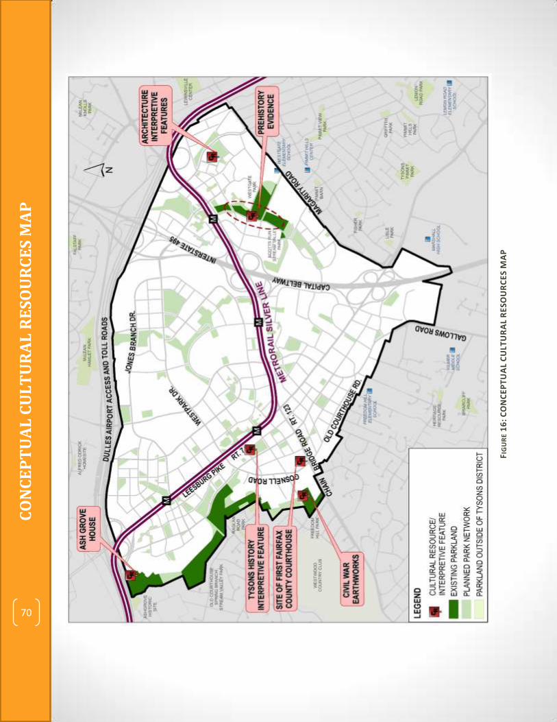
DRAFT
Tyso
ns
Par
k Sy
ste
m C
on
cep
t P
lan
70
CO
NC
EP
TU
AL
CU
LT
UR
AL
RE
SO
UR
CE
S M
AP
70
FIG
UR
E 1
6:
CO
NC
EP
TU
AL
CU
LTU
RA
L R
ESO
UR
CE
S M
AP

Tyso
ns
Par
k Sy
ste
m C
on
cep
t P
lan
71
A Valuable Resource “Stream valley parks
such as Scotts Run and
Old Courthouse Spring
Branch provide natural
buffers and potential
connectivity to and
throughout
Tysons…These stream
valley parks should not
only be protected from
development and
infrastructure impacts,
but be restored and
enhanced.” (Tysons
Urban Center Plan,
page 78)
NATURAL RESOURCES: Restoring and Enhancing Stream Valleys Nature is essential to balance the health and vibrancy of Tysons! Three stream valleys and associated Chesapeake Bay Resource Protection Areas (RPAs) comprise a small, but important portion of Tysons. The Old Courthouse Spring Branch stream valley is located at the western edge of Tysons and serves as a buffer between Tysons and existing low-density residential neighborhoods of Vienna. The Scotts Run stream valley is located in Tysons East and will serve as a central spine and focal point for new development in that area. The third stream valley, located in the North Central district, is a tributary of Scotts Runs stream. All three stream valleys provide opportunities for stormwater quantity and quality management, plant and wildlife habitat protection and enhancement, passive enjoyment of natural areas, volunteer resource stewardship, and interpretive and educational facilities and activities.
Comprehensive Plan Guidance The Tysons Urban Center Plan provides guidance on the protection, enhancement and management of natural resources in existing stream valley parks in Tysons. It also includes recommendations for improvements that will provide a variety of passive outdoor leisure experiences. In the Natural Resources Management section, the Plan states, “Environmental enhancement efforts should be encouraged and should include…restoration planting in natural areas, invasive plant control, deer management, stream restoration, and creating new natural areas (including both forested areas and meadows) where disturbed areas currently exist. These
71

DRAFT
Tyso
ns
Par
k Sy
ste
m C
on
cep
t P
lan
72
expanded natural areas could build on the stream valley parks, adding land that increases riparian buffers and enhances stream valley corridors.” In the Green Network Components section, the Plan states, “Stream valley parks such as Scotts Run and Old Courthouse Spring Branch provide natural buffers and potential connectivity to and throughout Tysons…These stream valley parks should not only be protected from development and infrastructure impacts, but be restored and enhanced…These parks will provide a variety of passive outdoor leisure experiences for residents, visitors and workers in Tysons, including outdoor exercise and enjoyment of quiet natural spaces.”
Stormwater Management Tysons drains into the Middle Potomac and Difficult Run Watersheds. During the era of rapid development of Tysons in the 1970s and 80s, protections of the Chesapeake Bay Preservation Act were not yet in place. The high percentage of impervious surface and unmanaged stormwater runoff in Tysons has served to greatly degrade the receiving streams and tributaries including the main stem of Scotts Run, the unnamed tributary of Scotts Run in the North Central District and Old Courthouse Spring Branch. The Middle Potomac Watershed Management Plan developed by the Stormwater Planning Division of the Department of Public Works and Environmental Services (DPWES) addresses Scotts Run stream as follows: “Scotts Run is actively widening along the majority of its length and the stream protection strategy composite site condition rating was ‘very poor.’ Restoring the stream and its tributaries will improve the condition of the aquatic habitat and should be carefully coordinated with the…objectives of reducing the quantity and improving the quality of runoff in order to prevent further erosion and channel widening.” The Difficult Run Watershed Management Plan notes the impact to stream water quality caused by a high percentage (43%) of impervious surface in the Old Courthouse Spring Branch sub watershed and that the Old Courthouse Spring Branch stream is actively widening in many places. The Tysons Urban Center Plan provides many recommended strategies for stormwater management and water quality improvement. In most cases, redevelopment in Tysons will result in improved conditions as the Tysons Urban Center Plan calls for onsite retention and/or reuse of the first inch of rainfall and strict limits on pollutants in stormwater runoff. Low Impact Development (LID) techniques will be implemented on rooftops, in the streetscape, and in new urban parks throughout Tysons. Stream stabilization, restoration, and enhancement are additional recommended techniques for offsetting impacts of new development. In support of Tysons’ stormwater management goals, new urban park designs should minimize the use of impervious surface and use pervious pavers where possible.
Native Vegetation Enhancement Ecological health is supported through the Tysons Urban Center Plan’s tree canopy goals, streetscape guidelines and riparian buffer expansion recommendations. Some previously disturbed areas not adjacent to stream valleys should also be restored to a natural condition

Tyso
ns
Par
k Sy
ste
m C
on
cep
t P
lan
73
The Nature Conservancy Headquarters Building & Park
with native vegetation to contribute to biodiversity and habitat value in Tysons and provide for places of respite and passive enjoyment of the outdoors. This can occur as small rain gardens in pocket parks or as meadows or groves of trees in larger common green type parks. Non-native plants and invasive species should be avoided throughout Tysons so as to protect the habitat of existing stream valleys as well as native planting areas in new parks. Using native plants in urban park landscaping can help to increase local biodiversity.
EXAMPLE:
The Nature Conservancy Headquarters, Arlington, VA The Nature Conservancy headquarters building, located in Ballston, a mixed-use TOD area of Arlington, VA was completed in 1999. The property on which the building sits features a half-acre passive park space populated entirely with native Virginia plant species.
Tysons Stream Restoration and Enhancement The Tysons Urban Center Plan explicitly states that “contributions from development in Tysons towards stream restoration and stabilization… should be encouraged as part of a comprehensive strategy to restore the water quality and ecological health of Tysons’ streams.” Rezoning applicants in Tysons with development proposals adjacent to or near streams are asked to contribute to stream bank stabilization and/or restoration, riparian buffer improvement, expansion of buffers and filling in gaps with additions of land and easements. It is anticipated that allocation of additional public sector funds may be necessary to complete all of the needed stream restoration work. Other efforts described in the Tysons Urban Center Plan, such as strict control of stormwater runoff in redeveloped areas, a 10% tree canopy goal, recommendations for deer management and invasive species control, and encouragement of native species planting in new urban parks will all contribute to improving stream conditions and protecting them from further degradation in the future.

DRAFT
Tyso
ns
Par
k Sy
ste
m C
on
cep
t P
lan
74
SPOTLIGHT ON: Old Courthouse Spring Branch The Tysons West Side District chapter of the Tysons Urban Center Plan includes text that states “The Old Courthouse Spring Branch Stream Valley Park should be developed with multi-use trail and other passive recreational facilities.” As portions of this stream are in a significantly degraded condition, they should be restored to improve its ability to accept stormwater runoff and improve the ecology of the stream valley. A central portion of the stream is highly stable due to grade control provided by an old road crossing. This reach should be protected and used as a reference reach for restoration of the degraded stream portions.
Old Courthouse Spring Branch Stream Valley
EXAMPLE:
Snakeden Branch in Reston, VA The Northern Virginia Soil and Water Conservation District and the Virginia Department of Forestry designed and implemented a project to restore the Snakeden Branch stream in Reston, VA. The banks of a 200-foot stretch of the stream were severely eroded, exposing the roots of many large trees. The stream was restored through Natural Channel Design (NCD) techniques that included raising the stream bed to reconnect higher storm flows with the floodplain. After the stream bed was reconstructed, high densities of native trees, shrubs and other herbaceous materials were planted to provide stability to the channel bed and banks and provide significant habitat benefits.
Before After

Tyso
ns
Par
k Sy
ste
m C
on
cep
t P
lan
75
SPOTLIGHT ON: Scotts Run The Tysons East District chapter of the Tysons Urban Center Plan includes text that states “Scotts Run Stream Valley Park will be expanded through the stream valley and in adjacent areas to provide better access and connectivity throughout the Tysons East District. The park will become a major linear urban park and trail system with a variety of landscapes including wooded hills, meadows and wetlands. It will provide a range of experiences, such as enjoying the outdoors and scenery, arts, performances and programs or participating in recreation. Intimate gardens with shady places of retreat could provide relief and gathering places for families, visitors and workers in Tysons.” (Page 150) Commitments obtained through the rezoning process will restore and enhance a portion of the Scotts Run Stream Valley. This will include stream bank restoration, supplemental planting, addition of trails and bridges, and provision of seating, interpretive signs, public art and other amenities. In addition, a commitment was made to dedicate to Fairfax County a half-acre portion of forested RPA adjacent to the stream valley parkland to expand the protected parkland buffer. Additional commitments to improve the Scotts Run Stream Valley are likely with future redevelopment in the area.
EXAMPLE:
Falls Park on the Reedy River, Greenville, SC Falls Park on the Reedy River is a 32-acre park adjacent to downtown Greenville, South
Carolina in the historic West End district. The park's most striking feature is a unique
pedestrian bridge that curves around a waterfall on the Reedy River. Near the bridge, the
Main Street entrance interfaces with the downtown by providing a restaurant and other
retail uses and a large bronze focal-point sculpture. There are many pedestrian pathways,
waysides and seating elements. The park also features a collection of public gardens, open
lawn areas and a wall from the original 1776 grist mill built on the site.

DRAFT
Tyso
ns
Par
k Sy
ste
m C
on
cep
t P
lan
76
Key Challenges & Opportunities* Natural Resources 1. Stabilizing, restoring, and enhancing highly impacted streams in Tysons after years of
disturbance will require collaboration between public and private entities.
Urban redevelopment adjacent to Tysons stream valleys should contribute funds towards stream restoration and enhancement. These existing parks can be integrated with new adjacent developments and make them more desirable locations.
Redevelopment projects in Tysons may make in-kind contributions or contribute funds toward stream restoration efforts. This can be credited towards onsite park needs and/or onsite stormwater retention goals.
Fairfax County, which has some dedicated funding for stormwater management, should contribute where needed to fill gaps and complete stream restoration projects started by private developers.
Support for stream restoration efforts can also happen through volunteer actions such as native vegetation planting, stream monitoring, and public education campaigns.
2. Trails in stream valleys should be developed to minimize the impacts of periodic flooding.
Stream valley trails should be constructed away from stream banks to minimize inundation frequency.
Stream valley trails should be constructed generally flush with the natural grade so they will not block flood waters from accessing the floodplain or returning to the channel as waters drop.
Stream valley trails should have a cross-slope to promote drainage of water and sediment off of trail surfaces after flood events.
3. Clearing paths through wooded stream valleys to construct trails should be done in a manner that minimizes impacts to the streams and natural resources.
Vegetative plantings should be located along the shoulders of trails to capture stormwater.
4. Stream restoration work should be accomplished in a manner that minimizes impacts to mature trees and other natural resources.
Construction access for stream restoration should follow best practices for natural channel design and stream restoration to include (but not limited to): minimizing tree removal; locating access routes along existing utility corridors (e.g., sanitary sewer easements) to the greatest extent possible; using timber mats to minimize soil disturbance and assist in restoration; washing equipment to prevent new invasions by non-native invasive plant species, and including a detailed restoration plan with multi-year warranty to install locally common native plant species, control white-tailed deer and control non-native invasive plant species.

Tyso
ns
Par
k Sy
ste
m C
on
cep
t P
lan
77
Where appropriate, access roads for stream restoration projects should be carefully
located to impact the fewest trees and then be left in place to serve as trails when
projects are completed.
5. Long-term management of natural areas in Tysons, including those that are fragmented and isolated should be provided.
New developments adjacent to stream valleys should consider dedicating land to expand the protected riparian buffers along streams.
Both the public and private sectors should support natural resource management in Tysons stream valley parks.
Support for natural resource management can also happen through volunteer actions such as invasive species removal, trash cleanup, and public education campaigns. This is an excellent opportunity to promote stewardship education.
* Not all listed challenges will be present in every project. Listed strategies are possible approaches that may be used but may not be appropriate in all situations.

DRAFT
Tyso
ns
Par
k Sy
ste
m C
on
cep
t P
lan
78
THIS PAGE INTENTIONALLY LEFT BLANK

Tyso
ns
Par
k Sy
ste
m C
on
cep
t P
lan
79
IMPLEMENTATION STRATEGY Natural Resources The remaining natural areas in Tysons are islands of native species, habitat and biodiversity that provide valuable ecosystem services. Disturbance to these areas should be minimized and balanced with restoration efforts. Natural areas should be protected and restored to minimize human impacts, reduce white-tailed deer, minimize the impact from stream scour, remove non-native invasive plant species, restore streams and foster naturally regenerating native plant communities. These restored natural areas should act not only as valuable local assets providing clean air and water and quality of life benefits, they should act as genetic reservoirs and templates for providing natural landscaping and native plant spaces throughout the Tysons area. This will further expand the ecosystem services provided by native vegetation and the quality of life benefits for residents. Some previously disturbed areas should be restored to a natural condition with native vegetation. Where possible, existing natural areas should be expanded, extended into surrounding developed landscapes, and native plant habitats restored. Land adjacent to existing stream valleys is ideal for this to expand the riparian buffers around streams. Other new parkland not adjacent to streams that is planted with native vegetation would also contribute to biodiversity and habitat value in Tysons. New developments in Tysons Corner should utilize Low Impact Development (LID) techniques in accordance with Comprehensive Plan guidance. Opportunities to provide funds or in-kind contributions toward stream restoration efforts should be sought. Fairfax County, the Tysons Partnership, homeowners’ associations, non-profit organizations, and business groups can all organize volunteer efforts to help manage Tysons natural resources. This could include native vegetation planting, stream monitoring, invasive species removal, trash cleanup and public education campaigns.
The Conceptual Natural Resources Map shows the location and extent of Tysons’ three stream valleys.

DRAFT
Tyso
ns
Par
k Sy
ste
m C
on
cep
t P
lan
80
CO
NC
EP
TU
AL
NA
TU
RA
L R
ES
OU
RC
ES
MA
P
FIG
UR
E 1
7:
CO
NC
EP
TU
AL
NA
TU
RA
L R
ES
OU
RC
ES
MA
P
80

Tyso
ns
Par
k Sy
ste
m C
on
cep
t P
lan
81
QUALITY URBAN PARK DESIGN: An Integrated Vision Park Placement and Typology, Connectivity, Athletic Fields, Recreational Facilities, Civic Spaces, and Cultural and Natural Resources have each been addressed as key components to the future park system of Tysons, defining qualities and outlining strategies for implementation. The success of the park network will hinge on quality urban design that is expressed in the appearance, arrangement and function of the various elements. An integrated vision for the Tysons park system relies on the synergy of these components as envisioned in the Comprehensive Plan. “This vision for Tysons is not just about tall buildings. It is about creating a place in which people are engaged in their surroundings and a place where people want to be.” Building on the direction of the Comprehensive Plan, the Tysons Urban Design Guidelines, endorsed by the Board of Supervisors, seek to improve Tysons by enhancing its identity, establish a sense of place, improve connectivity, promote sustainability, respect surrounding neighborhoods and create a new destination for the arts. “It is the intent of the Guidelines to encourage outstanding, creative, and innovative design for the urban form in Tysons.” The Tysons Urban Design Guidelines acknowledge the value of a cohesive park system in elevating the livability of a city. The Guidelines provide suggestions regarding park location, integration with adjacent uses, accessibility, and amenities. The Tysons Urban Design Guidelines and the Tysons Park System Concept Plan are intended to be complementary documents used to foster the development of a flourishing park network in Tysons. Both documents should be consulted in creating well designed urban park spaces that serve community leisure needs.
81

DRAFT
Tyso
ns
Par
k Sy
ste
m C
on
cep
t P
lan
82
TYSONS PARK SYSTEM CONCEPT PLAN MAP The map on the following page is a composite of the Conceptual maps provided in each of the seven preceding chapters. It displays Park Placement and Typology, the Tysons Community Circuit, Athletic Field locations, key Civic Spaces, and the location of Natural and Cultural Resources. To keep the composite map from being too cluttered small-footprint recreational facility locations were not included. It is intended that small-footprint recreational facilities will be provided in large and small parks throughout Tysons. The composite Tysons Park System Concept Plan Map is intended to be a conceptual guide and is not regulatory in nature. While some park spaces shown are already committed through rezoning actions, others remain a possibility yet to be further defined through the redevelopment process. A separate map in Appendix 2 shows those park spaces that are committed through approved rezonings.
82

Tyso
ns
Par
k Sy
ste
m C
on
cep
t P
lan
83
TY
SO
NS
PA
RK
SY
ST
EM
MA
ST
ER
PL
AN
MA
P
71
FIG
UR
E 1
8:
TY
SO
NS
PA
RK
SY
ST
EM
CO
NC
EP
T P
LAN
MA
P
TY
SO
NS
PA
RK
SY
ST
EM
CO
NC
EP
T P
LA
N M
AP
83

DRAFT
Tyso
ns
Par
k Sy
ste
m C
on
cep
t P
lan
84
THIS PAGE INTENTIONALLY LEFT BLANK

Tyso
ns
Par
k Sy
ste
m C
on
cep
t P
lan
85
APPENDIX 1: Refinement of Park System Map

DRAFT
Tyso
ns
Par
k Sy
ste
m C
on
cep
t P
lan
86
Refinement of Park System Map PARK PLACEMENT The staff team and Citizens Advisory Group made refinements to the planned park network map. The process for modifying the map is described below. 1. Existing Parkland – The Tysons Park System Map starts with park land holdings already
owned and managed by the Fairfax Park Authority. These parks protect natural and cultural resources and provide the only public athletic fields, sport courts and play equipment in Tysons today.
2. Comprehensive Plan Map – New urban park spaces as shown in the “Conceptual Parks & Open Space Network Map” in the June 2010 Comprehensive Plan are added to the map.
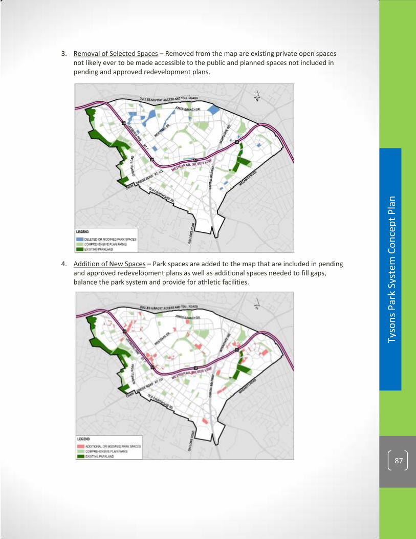
Tyso
ns
Par
k Sy
ste
m C
on
cep
t P
lan
87
3. Removal of Selected Spaces – Removed from the map are existing private open spaces not likely ever to be made accessible to the public and planned spaces not included in pending and approved redevelopment plans.
4. Addition of New Spaces – Park spaces are added to the map that are included in pending
and approved redevelopment plans as well as additional spaces needed to fill gaps, balance the park system and provide for athletic facilities.

DRAFT
Tyso
ns
Par
k Sy
ste
m C
on
cep
t P
lan
88
The result is a new, composite Park System Map intended to be used as a guide for locating new urban parks in Tysons.

Tyso
ns
Par
k Sy
ste
m C
on
cep
t P
lan
89
TYPOLOGY Applying the criteria in the Urban Parks Framework and the Tysons Urban Design Guidelines, park type classifications were assigned to each planned park on the revised park spaces map.
1. Civic Plazas are identified in close proximity to Metro train stations or at major
intersections. 2. Common Green type parks are identified across Tysons in areas planned to have large
residential populations.

DRAFT
Tyso
ns
Par
k Sy
ste
m C
on
cep
t P
lan
90
3. Recreation-focused parks are identified across Tysons, with the vast majority being farther than ¼ mile from Metro train stations and many at the lower density edges of Tysons.
4. Resource Based parks are identified where stream valleys and their associated Resource
Protection Areas (RPA) are located. Two existing parks, Freedom Hill and Ashgrove, contain significant historic resources.
5. Pocket Parks are not mapped, since this park type is expected to be integrated
throughout Tysons in every new development.

Tyso
ns
Par
k Sy
ste
m C
on
cep
t P
lan
91
6. Service area buffer maps were created using 1/8- and 1/4-mile service areas for each of the mapped park types to double-check for gaps. These distances represent about a five minute and ten minute walk, respectively.
The service area maps showed that, for the most part, planned park types are well-distributed and in the right locations.

DRAFT
Tyso
ns
Par
k Sy
ste
m C
on
cep
t P
lan
92
THIS PAGE INTENTIONALLY LEFT BLANK
Tyso
ns
Par
k Sy
ste
m C
on
cep
t P
lan
93
APPENDIX 2: Approved Urban Park Spaces in
Tysons

DRAFT
Tyso
ns
Par
k Sy
ste
m C
on
cep
t P
lan
94
FIG
UR
E 1
9 :
AP
PR
OV
ED
UR
BA
N P
AR
K S
PA
CE
S I
N T
YS
ON
S
(AS
OF
AU
GU
ST 2
01
4)

Tyso
ns
Par
k Sy
ste
m C
on
cep
t P
lan
95
APPENDIX 3: Urban Park Design Checklists

DRAFT
Tyso
ns
Par
k Sy
ste
m C
on
cep
t P
lan
96
URBAN PARK DESIGN CHECKLISTS FOR REZONING DEVELOPMENT REVIEW
These lists are to be used by staff to assist in evaluating parks under review. Each
item is not required of each park; the specific project’s circumstances will determine
the applicability of each item.
POCKET PARK EVALUATION CHECKLIST (for each proposed park space) ACHIEVED? YES/NO
Context/Location Visually accessible from the public realm Adjacent to active uses Integrated with adjacent uses (porosity) Adjacent and connected to high volumes of pedestrian traffic Located to optimize microclimate, sun and shade conditions Access Access at street level Publicly accessible ADA accessibility integrated into design Function/Purpose Passive space for individual enjoyment Space that promotes social interaction Helps to define character and identity of area Provides connectivity Meets a unique urban living need (dog park, garden plots, etc.) Provides a unique destination Provides a space to increase biodiversity in the urban landscape Provides area to integrate LID/stormwater amenities Provides planting spaces that increase tree canopy Amenities
Seating, tables, shelters
Water features
Planted areas
Lawns
Public art, interactive art
Signs, interpretive features
Playgrounds, tot lots
Café/restaurant or food service
Form/Visuals
Well-framed by buildings
Focal point(s)
Distinctive design/identity

Tyso
ns
Par
k Sy
ste
m C
on
cep
t P
lan
97
High quality materials
Sustainable materials & design
Topographic design that allows space to be usable
Programmability Amenities to support public events (power, water, lighting) Rental space for picnics, parties, events Storage space Other Commitment to ongoing maintenance Commitment to public scheduling of space

DRAFT
Tyso
ns
Par
k Sy
ste
m C
on
cep
t P
lan
98
CIVIC PLAZA EVALUATION CHECKLIST (for each proposed park space) ACHIEVED? YES/NO
Context/Location Visually accessible from the public realm Adjacent to active uses Integrated with adjacent uses (porosity) Adjacent and connected to high volumes of pedestrian traffic Located to optimize microclimate, sun and shade conditions Vehicular access restricted to edges of park
Located at major intersection or at Metro
Access Access at street level Publicly accessible ADA accessibility integrated into design Function/Purpose Passive space for individual enjoyment Space that promotes social interaction A variety of functions for users of different ages and mobility levels
Helps to define character and identity of area Provides safe and pleasant connectivity to adjacent uses Meets a unique urban living need (dog park, garden plots, etc.) Provides a unique destination Provides a space to increase biodiversity in the urban landscape Provides planting spaces that increase tree canopy Amenities Provides area to integrate LID/stormwater amenities
Seating, tables, shelters
Water features Planted areas that include perennials, annuals, trees and shrubs Lawns Public art, interactive art Signs, interpretive features/displays Playgrounds, tot lots Café/restaurant or food service (in park or adjacent to it) Community room spaces

Tyso
ns
Par
k Sy
ste
m C
on
cep
t P
lan
99
Form/Visuals Well-framed by buildings Primarily made up of hardscaped surfaces
Divided spaces or rooms that provide choices for activities and use
Focal point(s) Distinctive design/identity High quality materials Sustainable materials & design Topographic design that allows space to be usable Minimum of one acre in size; can be larger
Programmability Amenities to support public events (power, water, lighting) Rental space for picnics, parties, events Storage space Flexible program space (for farmers markets, fairs, events, shows)
Other Commitment to ongoing maintenance Commitment to public scheduling of space

DRAFT
Tyso
ns
Par
k Sy
ste
m C
on
cep
t P
lan
100
COMMON GREEN EVALUATION CHECKLIST (for each proposed park space)
ACHIEVED? YES/NO
Context/Location Visually accessible from the public realm Adjacent to active uses Integrated with adjacent uses (porosity) Adjacent and connected to high volumes of pedestrian traffic Located to optimize microclimate, sun and shade conditions Vehicular access restricted to edges of park
Access Access at street level Publicly accessible ADA accessibility integrated into design Function/Purpose Passive space for individual enjoyment Space that promotes social interaction A variety of functions for users of different ages and mobility levels
Recreational/sports facilities or flex spaces
Helps to define character and identity of area Provides safe and pleasant connectivity to adjacent uses Meets a unique urban living need (dog park, garden plots, etc.) Provides a unique destination Provides a space to increase biodiversity in the urban landscape Provides planting spaces that increase tree canopy Amenities Provides area to integrate LID/stormwater amenities
Seating, tables, shelters
Water features Planted areas that include perennials, annuals, trees and shrubs Lawns Public art, interactive art Signs, interpretive features/displays Playgrounds, tot lots Café/restaurant or food service (in park or adjacent to it) Sport courts, fitness stations, play fields
Trails
Community room spaces

Tyso
ns
Par
k Sy
ste
m C
on
cep
t P
lan
101
Form/Visuals Well-framed by buildings Divided spaces or rooms that provide choices for activities and use
Focal point(s) Distinctive design/identity High quality materials Sustainable materials & design Topographic design that allows space to be usable Minimum of one acre in size; can be larger
Programmability Amenities to support public events (power, water, lighting) Rental space for picnics, parties, events Storage space Flexible program space (for farmers markets, fairs, events, shows)
Other Commitment to ongoing maintenance Commitment to public scheduling of space

DRAFT
Tyso
ns
Par
k Sy
ste
m C
on
cep
t P
lan
102
RECREATION FOCUSED PARK EVALUATION CHECKLIST (for each proposed park space)
ACHIEVED? YES/NO
Context/Location Visually accessible from the public realm Adjacent to active uses Integrated with adjacent uses (porosity) Adjacent and connected to high volumes of pedestrian traffic Located to optimize microclimate, sun and shade conditions Vehicular access restricted to edges of park
Access Access at street level Publicly accessible ADA accessibility integrated into design Function/Purpose Space that promotes social interaction A variety of functions for users of different ages and mobility levels
Recreational/sports facilities or flex spaces
Helps to define character and identity of area Provides safe and pleasant connectivity to adjacent uses Meets a unique urban living need (dog park, garden plots, etc.) Provides a unique destination Provides a space to increase biodiversity in the urban landscape Provides planting spaces that increase tree canopy Amenities Provides area to integrate LID/stormwater amenities
Seating, tables, shelters
Water features Planted areas that include perennials, annuals, trees and shrubs Lawns Public art, interactive art Signs, interpretive features/displays Playgrounds, tot lots Café/restaurant or food service (in park or adjacent to it) Sport courts, fitness stations, lighted athletic fields
Trails
Community room spaces

Tyso
ns
Par
k Sy
ste
m C
on
cep
t P
lan
103
Form/Visuals Divided spaces or rooms that provide choices for activities and use
Focal point(s) Distinctive design/identity High quality materials Sustainable materials & design Topographic design that allows space to be usable Generally larger than 1 acre; size is a function of facilities provided
Programmability Amenities to support public events (power, water, lighting) Rental space for picnics, parties, events Storage space Flexible program space (for farmers markets, fairs, events, shows)
Other Commitment to ongoing maintenance Commitment to public scheduling of space

DRAFT
Tyso
ns
Par
k Sy
ste
m C
on
cep
t P
lan
104
THIS PAGE INTENTIONALLY LEFT BLANK

Tyso
ns
Par
k Sy
ste
m C
on
cep
t P
lan
105
APPENDIX 3: Athletic Field Dimensions

DRAFT
Tyso
ns
Par
k Sy
ste
m C
on
cep
t P
lan
106
Athletic Field Dimensions FIELD TYPE DESCRIPTION WIDTH LENGTH EQUIVALENCY SPORTS & AGES
CRICKET OVAL cricket oval 390 450 2.00 cricket (minimum acceptable size)
DIAMOND W/RECTANGLE OVERLAY
90' diamond w/rectangle overlay 391 472 1.50
adult/teen & youth baseball, adult/teen & youth softball, football, women's lacrosse, adult/teen & youth soccer, men's lacrosse, field hockey
90' DIAMOND
Diamond w/ 90' infield, 400' outfield 450 450 1.50
adult/teen & youth baseball, adult/teen & youth softball
RECTANGLE W/DIAMOND OVERLAYS*
Full size rectangle w/2 65' diamonds 355 491 1.50
youth baseball, youth softball, football, women's lacrosse, adult/teen & youth soccer, men's lacrosse, field hockey
60-65' DIAMOND
Diamond w/ 60-65' infield, 300' outfield 386 386 1.00
youth baseball, youth softball
FULL SIZE RECTANGLE w/SHORT-SIDED FIELD OVERLAY *
Full size w/3 U11 fields side-by-side 210 360 1.00
football, women's lacrosse, adult/teen soccer, men's lacrosse, field hockey, youth soccer
FULL SIZE RECTANGLE (FCPA Standard)*
Full size, no overlays 180-190 360 1.00
football, women's lacrosse, adult/teen soccer, men's lacrosse, field hockey, youth soccer
FULL RECTANGLE NO FOOTBALL*
Full size, no overlays, no end zone 180 330 1.00
adult/teen soccer, men's lacrosse, field hockey, youth soccer
U13 RECTANGLE*
US Youth Soccer up to age 13 150 300 0.75
field hockey, youth soccer, adult 5-on-5 soccer
U12 RECTANGLE*
US Youth Soccer up to age 12 135 285 0.50
youth soccer up to age 12, adult 5-on-5 soccer
U11 RECTANGLE*
US Youth Soccer up to age 11 120 210 0.50
youth soccer up to age 11, adult 5-on-5 soccer

Tyso
ns
Par
k Sy
ste
m C
on
cep
t P
lan
107
FIELD TYPE DESCRIPTION WIDTH LENGTH EQUIVALENCY SPORTS & AGES
U10 RECTANGLE*
US Youth Soccer up to age 10 120 180 0.50
youth soccer up to age 10, adult 5-on-5 soccer
U9 RECTANGLE*
US Youth Soccer up to age 9 75 120 0.33
youth soccer up to age 9, adult 5-on-5 soccer
U8 RECTANGLE*
US Youth Soccer up to age 8 45 90 0.25
youth soccer up to age 8, adult 5-on-5 soccer
U7 RECTANGLE*
US Youth Soccer up to age 7 30 60 0.25
youth soccer up to age 7
* Rectangle field dimensions do not include 15' overrun area on all sides.