Embed Size (px)
Citation preview
FAIRFAX COUNTY COMPREHENSIVE PLAN, 2011 Edition AREA II Tysons Corner Urban Center, Amended through 2-12-2013 Introduction Page 1
1: INTRODUCTION
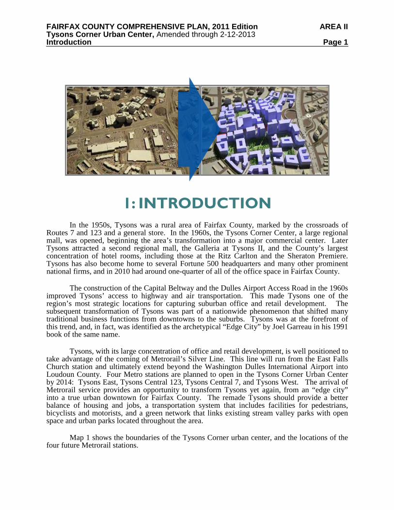
In the 1950s, Tysons was a rural area of Fairfax County, marked by the crossroads of Routes 7 and 123 and a general store. In the 1960s, the Tysons Corner Center, a large regional mall, was opened, beginning the area’s transformation into a major commercial center. Later Tysons attracted a second regional mall, the Galleria at Tysons II, and the County’s largest concentration of hotel rooms, including those at the Ritz Carlton and the Sheraton Premiere. Tysons has also become home to several Fortune 500 headquarters and many other prominent national firms, and in 2010 had around one-quarter of all of the office space in Fairfax County.
The construction of the Capital Beltway and the Dulles Airport Access Road in the 1960s improved Tysons’ access to highway and air transportation. This made Tysons one of the region’s most strategic locations for capturing suburban office and retail development. The subsequent transformation of Tysons was part of a nationwide phenomenon that shifted many traditional business functions from downtowns to the suburbs. Tysons was at the forefront of this trend, and, in fact, was identified as the archetypical “Edge City” by Joel Garreau in his 1991 book of the same name.
Tysons, with its large concentration of office and retail development, is well positioned to take advantage of the coming of Metrorail’s Silver Line. This line will run from the East Falls Church station and ultimately extend beyond the Washington Dulles International Airport into Loudoun County. Four Metro stations are planned to open in the Tysons Corner Urban Center by 2014: Tysons East, Tysons Central 123, Tysons Central 7, and Tysons West. The arrival of Metrorail service provides an opportunity to transform Tysons yet again, from an “edge city” into a true urban downtown for Fairfax County. The remade Tysons should provide a better balance of housing and jobs, a transportation system that includes facilities for pedestrians, bicyclists and motorists, and a green network that links existing stream valley parks with open space and urban parks located throughout the area.
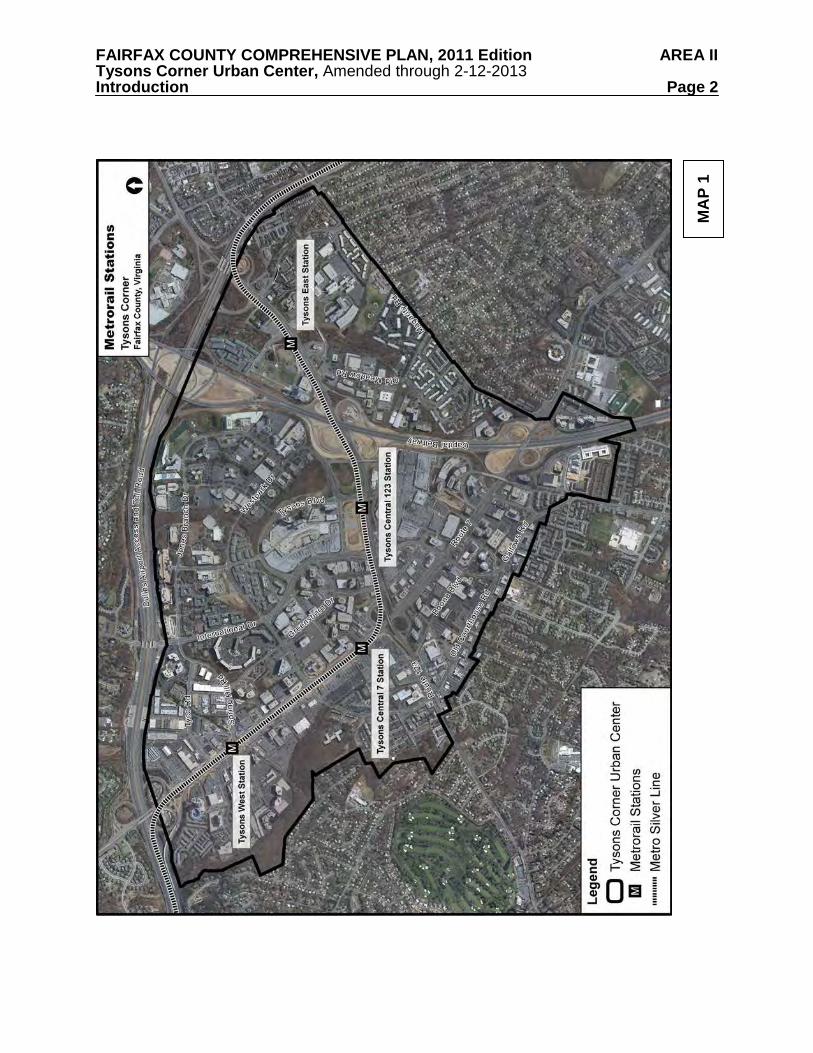
Map 1 shows the boundaries of the Tysons Corner urban center, and the locations of the four future Metrorail stations.
FAIRFAX COUNTY COMPREHENSIVE PLAN, 2011 Edition AREA II Tysons Corner Urban Center, Amended through 2-12-2013 Introduction Page 2
MA
P 1
FAIRFAX COUNTY COMPREHENSIVE PLAN, 2011 Edition AREA II Tysons Corner Urban Center, Amended through 2-12-2013 Introduction Page 3 LOCATION AND BOUNDARY
Tysons encompasses approximately 2,100 acres (including road rights-of-way) in northeastern Fairfax County, about halfway between downtown Washington, D.C. and Dulles International Airport. It is located at the confluence of the Capital Beltway/Interstate 495 (I-495) with the Dulles Airport Access Road and Dulles Toll Road (DAAR, Route 267), Leesburg Pike (Route 7) and Chain Bridge Road/Dolley Madison Boulevard (Route 123).
Tysons is roughly triangular in shape and contains the highest natural elevations in Fairfax County. It is bounded on the southeastern side by Magarity Road and on the southwestern side generally by the limit of commercial development along Gallows and Old Courthouse Roads and the natural areas of Old Courthouse Stream Branch. The residential areas on the western side of Gosnell Road flanking Old Courthouse Road are also part of the Tysons Corner area. The DAAR forms the northern boundary of Tysons.
The residential communities surrounding Tysons, which include McLean, Vienna and Falls Church, help to make Tysons a good business location. These communities provide a wide range of housing types and a relatively large supply of housing near Tysons’ employers. The communities surrounding Tysons also have many outstanding features, such as excellent public schools and one of the best educated and highly trained labor pools in the nation.
PLANNING HISTORY
As Tysons grew in the 1960s and early 1970s, its evolution as a dynamic and complex business center required re-study by County planners every few years. In August of 1975, the Board of Supervisors adopted the Area II portion of the Comprehensive Plan, which established the Tysons Corner Complex Area as “… a special study area requiring continual monitoring and restudy ….” In September of 1975, the Board commissioned a special study and created a broad-based task force with representation from large and small businesses in the area, landowners of major undeveloped tracts, and residents of the area, as well as citizen leaders from the surrounding McLean and Vienna communities. As a result of this study, a revised Comprehensive Plan was adopted in June of 1978. The detailed land use recommendations that were provided by this amendment were the primary guide for land use and zoning decisions through 1993.
After 1978, the Tysons plan was amended by means of the Area Plan Review or Out-of-Turn Plan Amendment processes. The most significant change was the addition of building height guidelines as a result of the 1984 Tysons Corner Height Study. These guidelines established maximum building heights to be considered during the zoning process, along with building mass, architectural interest and other features, in order to achieve the Plan’s urban design objectives.
Between 1989 and 1991, the County’s Comprehensive Plan underwent a major review known as the Fairfax Planning Horizons process. The first phase of Fairfax Planning Horizons resulted in the creation of the Policy Plan, which was adopted by the Board of Supervisors in August of 1990. At the same time, the Board adopted The Concept for Future Development and Land Classification System as a guide for the second phase of the Planning Horizons process, the update of the Area Plans. The Concept for Future Development designated Tysons Corner as the County’s Urban Center, and set forth a need for a Tysons Corner special study to identify
FAIRFAX COUNTY COMPREHENSIVE PLAN, 2011 Edition AREA II Tysons Corner Urban Center, Amended through 2-12-2013 Introduction Page 4 amendments to the Comprehensive Plan that would guide the area’s evolution to a more urban and pedestrian-oriented environment.
In 1990 the Board authorized a study of the Tysons Corner Urban Center and appointed a 24-member task force to work with staff on this planning effort. This task force included representatives of local businesses, developers and civic associations. The resulting Plan Amendment, as adopted by the Board in 1994, incorporated concerns of the community, applicable countywide goals, and the overall objective to develop Tysons as the “downtown” of Fairfax County. A key feature of the 1994 Plan was the location of three Metrorail stations in Tysons. These stations were expected to serve as the catalyst to transform the area from a suburban to an urban area.
Over the next ten years, county, regional, state and national officials worked to ensure that Metrorail through Tysons would become a reality. The final Environmental Impact Statement (EIS) for this project identified four transit stations in Tysons, versus the three stations in the 1994 Plan. As a result of the greater certainty of Metrorail’s alignment and station locations, in 2004 twenty proposals for redevelopment in Tysons were submitted under the county’s Area Plan Review (APR) process. Since the Comprehensive Plan had not been revised to account for the specific locations of the four stations, the Planning Commission deferred all rail-related APR nominations to be reviewed in a Special Study of the Tysons Corner Urban Center. TYSONS LAND USE TASK FORCE
In May 2005 the Board established the Tysons Land Use Task Force and described its mission to update the 1994 Plan as follows:
1. Promote more mixed use; 2. Better facilitate transit-oriented development (TOD); 3. Enhance pedestrian connections throughout Tysons; 4. Increase the residential component of the density mix; 5. Improve the functionality of Tysons; and 6. Provide for amenities and aesthetics in Tysons, such as public spaces, public art, parks,
etc. The members of the Task Force represented a wide range of community interests and perspectives. Between 2005 and 2008 the Task Force studied the issues and conditions in Tysons and looked at examples of how transit- oriented communities have been designed and implemented elsewhere in the U.S. The Task Force also formed six committees that met regularly, interacted with County staff and relevant experts, and provided detailed recommendations for Task Force review. Committee topics included transportation, affordable and workforce housing, implementation, livability and walkability, landowner coalitions, and communication.
The Board also directed the Task Force to engage in extensive public outreach to involve and incorporate the views and concerns of surrounding communities, citizen groups, smart growth advocates, businesses, employees, environmentalists and other special interests, in addition to landowners and developers. The full Task Force held over 60 public meetings in addition to the meetings of its subcommittees. Another 45 public meetings and workshops were held and attended by over 2,000 stakeholders. In addition, public input was obtained through the
FAIRFAX COUNTY COMPREHENSIVE PLAN, 2011 Edition AREA II Tysons Corner Urban Center, Amended through 2-12-2013 Introduction Page 5 County’s Tysons website. The input received from the public outreach initiatives helped to shape the Task Force’s recommendations. The recommendations and vision to transform Tysons were presented to the Board of Supervisors in September, 2008.
The Board accepted the Task Force’s Areawide Recommendations report and referred it to the Planning Commission and staff for the development of detailed Comprehensive Plan text. The Board directed that, in addition to the Task Force Recommendations, the Plan text be guided by the population and employment forecasts for Tysons developed by George Mason University’s Center for Regional Analysis, and the transportation and public facility impact studies conducted in 2008 and 2009. Utilizing these analyses, as well as a fiscal impact analysis also requested by the Board, staff worked with the Planning Commission’s Tysons Committee and the Tysons Land Use Task Force’s Draft Review Committee to formulate the Plan Amendment, ST05-CW-1CP, which was adopted by the Board of Supervisors on June 22, 2010.
FAIRFAX COUNTY COMPREHENSIVE PLAN, 2011 Edition AREA II Tysons Corner Urban Center, Amended through 2-12-2013 Vision For Tysons Page 6
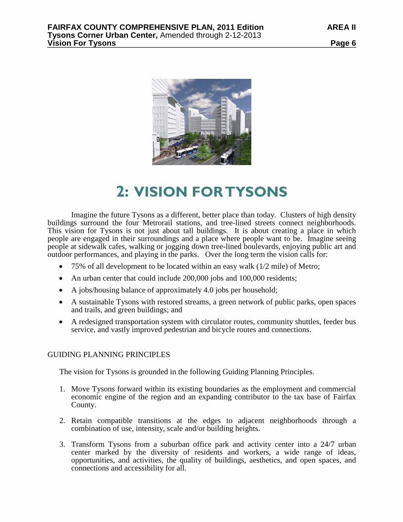
2: VISION FOR TYSONS
Imagine the future Tysons as a different, better place than today. Clusters of high density buildings surround the four Metrorail stations, and tree-lined streets connect neighborhoods. This vision for Tysons is not just about tall buildings. It is about creating a place in which people are engaged in their surroundings and a place where people want to be. Imagine seeing people at sidewalk cafes, walking or jogging down tree-lined boulevards, enjoying public art and outdoor performances, and playing in the parks. Over the long term the vision calls for:
• 75% of all development to be located within an easy walk (1/2 mile) of Metro; • An urban center that could include 200,000 jobs and 100,000 residents; • A jobs/housing balance of approximately 4.0 jobs per household; • A sustainable Tysons with restored streams, a green network of public parks, open spaces
and trails, and green buildings; and • A redesigned transportation system with circulator routes, community shuttles, feeder bus
service, and vastly improved pedestrian and bicycle routes and connections.
GUIDING PLANNING PRINCIPLES
The vision for Tysons is grounded in the following Guiding Planning Principles.
1. Move Tysons forward within its existing boundaries as the employment and commercial economic engine of the region and an expanding contributor to the tax base of Fairfax County.
2. Retain compatible transitions at the edges to adjacent neighborhoods through a combination of use, intensity, scale and/or building heights.
3. Transform Tysons from a suburban office park and activity center into a 24/7 urban
center marked by the diversity of residents and workers, a wide range of ideas, opportunities, and activities, the quality of buildings, aesthetics, and open spaces, and connections and accessibility for all.
FAIRFAX COUNTY COMPREHENSIVE PLAN, 2011 Edition AREA II Tysons Corner Urban Center, Amended through 2-12-2013 Vision For Tysons Page 7
4. Reduce the time, cost, and inconvenience of accessing and moving within Tysons by promoting a functional and accessible system of pedestrian walkways, trails, shuttles, bike routes, a grid of streets, transit connections, and standard principles of trip reduction.
5. Reduce the suburban focus on isolated buildings, surface parking and moving vehicles through Tysons to somewhere else and connect new buildings, urban parks, structured parking, and pedestrian and bicycle accommodations to form engaging streetscapes and connected neighborhoods.
6. Attract mixed use transit-oriented development and private investment to Metrorail station areas and transit connection locations throughout Tysons, including increased housing supply, choices, and price points, service opportunities, and office space.
7. Engage people, communities, institutions, and the private sector with government to include in Tysons the distinctive architecture, civic focal points, cultural and educational institutions, places of worship, medical facilities, entertainment and recreation, libraries, and public safety facilities that mark environmentally sound, safe and inclusive urban communities.
8. Respect the unique natural features and topography of Tysons in all plans, expand useable and publicly accessible open space and improve the existing natural environment.
THE FRAMEWORK TO TRANSFORM TYSONS
The guiding principles provide a framework for the future of Tysons – one that envisions a highly livable place for residents, employees and visitors. The framework includes six elements that are essential to future development. While the exact details of each element will evolve over time, none can be ignored and all must be in place and working together for the vision to be realized. The six elements of the framework are described below.
1. Creating a people-focused urban setting. The Tysons of tomorrow will be a place for people.
A people-focused urban setting will be created by providing mixed use, transit-oriented neighborhoods that promote pedestrian, bike, and transit use. The new transportation and land use concept for Tysons creates a people-focused urban setting by: • Encouraging Transit-Oriented Development (TOD) • Improving the Jobs/Housing Balance • Providing Diverse and Affordable Housing • Creating Defined Neighborhoods • Protecting the Edges • Incorporating Community Benefits • Creating Excellence in the Public Realm
2. Redesigning the transportation network with a strong focus on transit. The creation of a
multi-modal transportation system within Tysons will provide diverse and accessible transportation choices. The choices will encourage people to walk, bike or take transit to destinations within Tysons. Ultimately, Tysons could be a place where owning a car may be unnecessary and certainly not essential. The transportation network should:
FAIRFAX COUNTY COMPREHENSIVE PLAN, 2011 Edition AREA II Tysons Corner Urban Center, Amended through 2-12-2013 Vision For Tysons Page 8
• Encourage Mobility within Tysons • Establish and Construct a Grid of Streets • Create a System of Circulators • Promote Regional Connectivity
3. Placing a strong focus on the environment. The plan to transform Tysons recognizes the
long-term value and importance of protecting and enhancing the environment; this can be achieved through such goals as reducing greenhouse gas emissions, restoring streams, encouraging sustainable development, and promoting the efficient use and conservation of resources. Some key features of environmental stewardship are: • Low Impact Development Techniques to Control Stormwater • Supporting the Creation of Environmentally Sustainable Buildings • Creating a Network of Parks, Open Spaces and Trails • Conservation of Resources such as energy and water
4. Developing a vibrant civic infrastructure. The transformed Tysons will include facilities and
programs for arts and culture, recreation and education. These will be part of the essential fabric of a livable Tysons, and should be included in the initial planning for new development. Such facilities and programs should: • Build upon Educational Excellence • Provide Urban Recreation Facilities within Tysons • Meet the Community’s Needs for Cultural and Arts Facilities • Provide Public Art for Public Places
5. Enhancing Tysons as the County’s major employment center and regional economic engine.
Fairfax County is the heart of the Washington area technology sector and Tysons is its economic and employment center. Further, Tysons is one of the nation’s largest employment and retail centers. The transformed Tysons is expected to continue to generate significant increases in revenues to the county from real estate taxes, sales taxes and business licenses. The County should continue to capitalize on Tysons’ growth as a regional economic engine.
6. Creating an implementation strategy that provides the flexibility, accountability, and
resources necessary to achieve the vision, including the creation of an entity to focus on implementing the vision for Tysons. A strong implementation strategy will make the vision of a transformed Tysons a reality. The implementation strategy should specify an approach that guides and coordinates individual projects with the phasing of urban infrastructure and community benefits that are necessary to achieve the overall vision. The balancing of opportunities for development with needs for appropriate infrastructure will provide certainty for landowners as well as county residents that the vision will be implemented as desired. The implementation strategy should include: • Detailed planning that links infrastructure provision with development • Creation of an implementation entity • Establishment of a funding strategy for public infrastructure
FAIRFAX COUNTY COMPREHENSIVE PLAN, 2011 Edition AREA II Tysons Corner Urban Center, Amended through 2-12-2013 Vision For Tysons Page 9
• Revision of the regulatory framework • Formation of public-private partnerships
ACHIEVING THE VISION
The vision of the future Tysons is one of greater density, a synergistic mix of uses, more pedestrian and transit friendly, and sustainable in design and function. This new Tysons will be highly attractive with residential communities where people will want to live, raise families, and retire. Tysons will be an active 24-hour place, providing a variety of residential, office, retail, civic and entertainment uses that will attract tourists and other visitors. Pedestrian-friendly connections and frequent transit service will enable people to move easily within Tysons or to other portions of the region on Metrorail’s Silver Line. High quality parks and open space will give people a variety of places to gather and socialize.
The auto-oriented streets of Leesburg Pike (Route 7) and Chain Bridge Road/Dolley
Madison Boulevard (Route 123) will be transformed to tree-lined boulevards designed to calm traffic through the most urban parts of Tysons while still moving traffic. People will be able to walk or bike safely within Tysons to nearby businesses. Circulator routes will provide frequent transit access to almost all areas within Tysons. These elements will constitute a new and forceful example of how to realize automobile trip reduction.
Planning Horizon While the transformation of Tysons is expected to occur over a period of 40 or more years, this iteration of the Plan focuses on a 20 year period of redevelopment. This initial increment of growth should prioritize high-intensity, mixed use projects located near the Metro stations that will take full advantage of the investment in rail transit. Development occurring during this time period should also significantly advance the urban street grid, parks and open space, and public facilities that will provide a framework for growth that will occur beyond 2030. Development, infrastructure, and public facilities should be monitored regularly and subsequent planning efforts should continue to move Tysons toward the ultimate vision. Major Elements of the Plan
Redevelopment proposals will be evaluated for conformance with all of the guidance provided in the Comprehensive Plan. The following are major elements of the Plan that are necessary to achieve the vision for Tysons:
• Mix and arrangement of uses • Affordable and workforce housing • Green building expectations • Stormwater management • Consolidation performance objectives • Transportation
o Grid of streets on and off-site
FAIRFAX COUNTY COMPREHENSIVE PLAN, 2011 Edition AREA II Tysons Corner Urban Center, Amended through 2-12-2013 Vision For Tysons Page 10
o Vehicle trip reduction objectives o Parking management o Phasing to transportation improvements and programs o Traffic impact analysis evaluating three time periods: first phase, interim phase, and
Plan build-out • Urban design
o Achievement of the building, site design, and public realm design guidelines to achieve the urban aesthetic vision for Tysons
o A variety of buildings heights with the tallest buildings in the ranges specified by the building height map
o Shadow and wind studies demonstrating that the design creates an inviting environment and does not cause a canyon effect
• Urban park standards • Active recreation facilities • Public facilities • Demonstrating how other properties in the subdistrict and in the general vicinity of the
proposal can develop in conformance with the Plan DISTRICTS WITHIN TYSONS The transformed Tysons will be organized around eight districts, each with a mix of land uses. The transit-oriented developments (TODs) around the four Metrorail stations will resemble intense and busy downtowns. The four Non-TOD Districts will include lively neighborhoods leading to the edges of Tysons. Closer to the neighborhoods outside of Tysons, the pattern of development will carefully transition down to a scale and use that respects the adjacent communities. Map 2 shows the boundaries of the eight districts in Tysons. Each of the eight districts in Tysons is envisioned to have a different mix of land uses and intensities. Within these districts there will be places, to work, to live, to shop, and to play. Collectively, the districts of the transformed Tysons will work together to create an urban center or downtown for Fairfax County. All of the districts within Tysons will be equally important to its overall success. Each TOD and Non-TOD District will have a different character, as described briefly below. People who live and work in Tysons will use all of these places, and each district will be connected to the others. Boundaries between the districts will be blurred as people move seamlessly from one place to the next. The connectedness and uniqueness of each place will be mutually supportive, creating a 24-hour urban center of great vitality. TOD Districts Each of the four station areas is considered a TOD District, and is described briefly below. Tysons West: Tysons West should be a signature gateway to the urban center. Streets leading
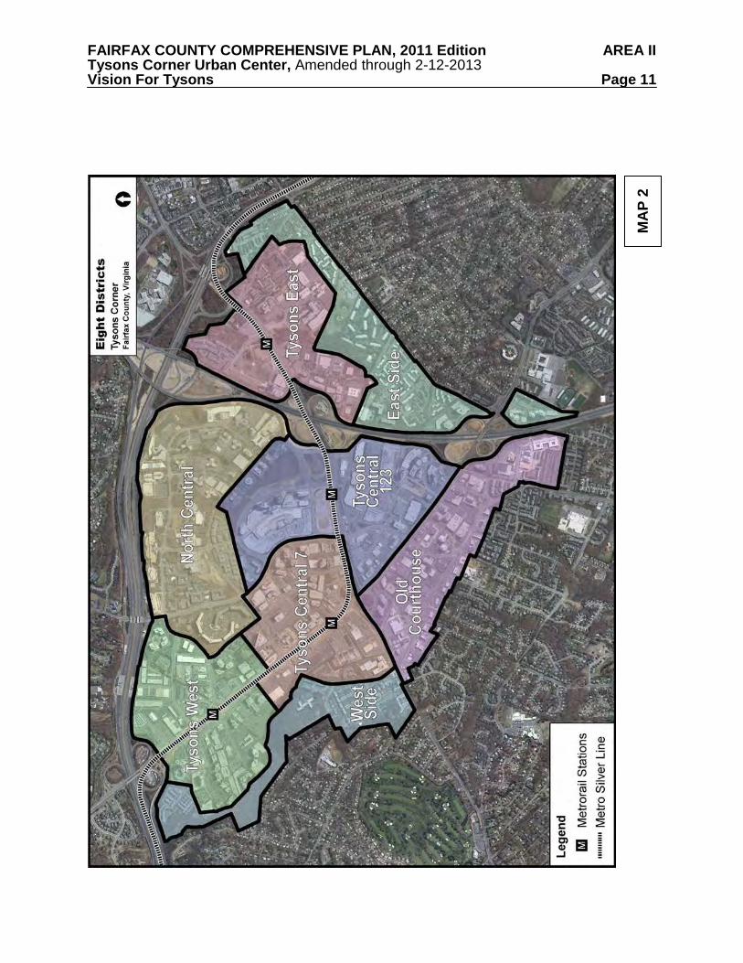
FAIRFAX COUNTY COMPREHENSIVE PLAN, 2011 Edition AREA II Tysons Corner Urban Center, Amended through 2-12-2013 Vision For Tysons Page 11
MA
P 2
FAIRFAX COUNTY COMPREHENSIVE PLAN, 2011 Edition AREA II Tysons Corner Urban Center, Amended through 2-12-2013 Vision For Tysons Page 12 to and from the Metro station are expected to redevelop with retail uses, drawing people off Metrorail and into the neighborhoods. In addition, Tysons West is an optimal location for an arts and entertainment district, including restaurants and entertainment options that stay open after the workday ends. Tysons Central 7: Tysons Central 7 District has two subdistricts, separated by Leesburg Pike. The North Subdistrict is oriented towards Greensboro Drive and is envisioned to be a vibrant 24-hour mixed use center with a high concentration of office space. The South Subdistrict is oriented towards Leesburg Pike and is envisioned as a civic center with a mix of public, residential and commercial uses. Tysons Central 123: Tysons Central 123 will remain the region’s signature shopping destination. Redevelopment is expected to add street-front, ground floor retail and entertainment, and high-rise residential buildings. In addition, high-rise hotel and conference facilities will provide services to local residents and will be a short walk from the office concentration in the Tysons Central 7 District. Tysons East: Tysons East serves as a signature gateway for those entering the urban center from the east. The defining focus of Tysons East will be Scotts Run, which is envisioned to transform into a great urban park surrounded by mixed use development, including office, residential, hotel, support retail and service uses. In addition, the area could include institutional and public uses, such as educational and recreational facilities. Non-TOD Districts The four Non-TOD Districts are generally located between TOD Districts and the edges of Tysons that are adjacent to surrounding residential communities. Each is described briefly below. West Side: The West Side District is developed with two residential neighborhoods and includes the Old Courthouse Spring Branch stream valley park as a key feature. Because of its location on the edge of the urban center, this district serves as a transition from planned high intensity mixed use in the Tysons West and Tysons Central 7 TOD Districts to the single-family neighborhoods just outside of Tysons. Old Courthouse: The Old Courthouse District will have smaller scale office buildings and residential developments than TOD Districts and will serve as a transition area between the Tysons Central 123 District and the neighboring communities. With additional infill and redevelopment, portions of this district will evolve into a neighborhood that supports an active 24-hour environment where people go to restaurants or stores after work. North Central: The land use pattern in the North Central District will allow for a transition between Tysons Central 123 and communities north of Tysons. Office uses would be mostly located adjacent to the Dulles Airport Access Road and Dulles Toll Road (DAAR, Route 267), while residential land uses could be the focus around the proposed circulator route. Future development along this route could result in vibrant, mixed use residential neighborhoods, with local-serving retail, dedicated parks and civic uses, and a pedestrian-friendly street network. East Side: The East Side District serves as a transition area between higher intensity TOD Districts and the adjacent Pimmit Hills neighborhood abutting Tysons. Portions of this district will redevelop into urban residential neighborhoods, including limited retail and office uses serving the local residential population and providing Tysons with some live-work opportunities.
FAIRFAX COUNTY COMPREHENSIVE PLAN, 2011 Edition AREA II Tysons Corner Urban Center, Amended through 2-12-2013 Implementation Page 13
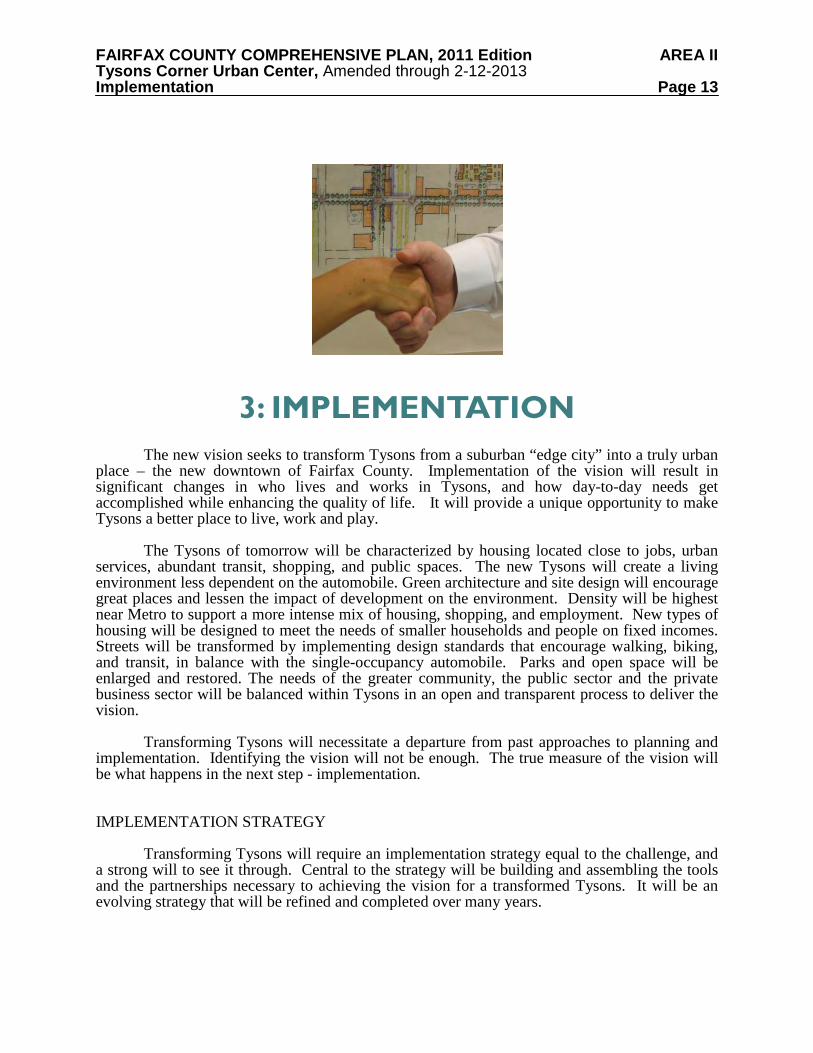
3: IMPLEMENTATION
The new vision seeks to transform Tysons from a suburban “edge city” into a truly urban place – the new downtown of Fairfax County. Implementation of the vision will result in significant changes in who lives and works in Tysons, and how day-to-day needs get accomplished while enhancing the quality of life. It will provide a unique opportunity to make Tysons a better place to live, work and play. The Tysons of tomorrow will be characterized by housing located close to jobs, urban services, abundant transit, shopping, and public spaces. The new Tysons will create a living environment less dependent on the automobile. Green architecture and site design will encourage great places and lessen the impact of development on the environment. Density will be highest near Metro to support a more intense mix of housing, shopping, and employment. New types of housing will be designed to meet the needs of smaller households and people on fixed incomes. Streets will be transformed by implementing design standards that encourage walking, biking, and transit, in balance with the single-occupancy automobile. Parks and open space will be enlarged and restored. The needs of the greater community, the public sector and the private business sector will be balanced within Tysons in an open and transparent process to deliver the vision. Transforming Tysons will necessitate a departure from past approaches to planning and implementation. Identifying the vision will not be enough. The true measure of the vision will be what happens in the next step - implementation. IMPLEMENTATION STRATEGY Transforming Tysons will require an implementation strategy equal to the challenge, and a strong will to see it through. Central to the strategy will be building and assembling the tools and the partnerships necessary to achieving the vision for a transformed Tysons. It will be an evolving strategy that will be refined and completed over many years.
FAIRFAX COUNTY COMPREHENSIVE PLAN, 2011 Edition AREA II Tysons Corner Urban Center, Amended through 2-12-2013 Implementation Page 14
Priorities and responsibilities for implementation are outlined in this chapter. Successful implementation will require: commitment to the vision and Guiding Planning Principles; committed leadership; dedicated professional staff at the County and other agencies; loyal, hard-working citizen participants; and a private sector willing to work together to seize new opportunities and utilize new development and building techniques. Implementation of the Plan will be the most complex component of Tysons’ future. The process must be transparent, intentional, and thorough. The elements of the implementation strategy include: Detailed Planning: Detailed planning is required in order to refine and update guidance for each of the eight districts; to address the alignment of the proposed grid of streets and Circulator System; to create a coordinated network of parks and open space; and to refine strategies for environmental stewardship. Implementation Entity: Implementing the vision of Tysons will be well served by a “Keeper of the Vision” that is involved in the policies, guidelines and intent of the vision at every step of implementation, and that monitors and evaluates the type and pace of development and the phasing of infrastructure to accommodate the growth within Tysons. Funding Strategies: Funding strategies (including public-private partnerships) should be identified. The feasibility of various financial tools should be assessed, and the mechanisms for financing specific portions of the plan must be identified. Regulatory Framework: Regulatory tools will be needed to implement the type and intensity of new development and to prescribe design and development standards to achieve Tysons’ overall urban design goals. Public-Private Partnerships: In addition to regulatory tools, public infrastructure improvements and public/private partnerships will be essential in implementing the Plan. Private-Private Partnerships: Cooperation among landowners will be necessary in order to obtain land for public facilities, parks and open space, the grid of streets, and future circulator rights-of-way within Tysons.
Phasing: A dynamic and evolving phasing plan tying future development to specific public improvements will be critical to ensure that transportation, other urban infrastructure and public amenities will be in place as growth occurs.
DETAILED PLANNING
District Plans
Plan guidance for each of Tysons’ eight districts addresses the mix and intensity of land uses and additional guidance for achieving the envisioned future. Over time it is anticipated that the guidance for each district will need to be refined and updated to reflect new and approved development.
FAIRFAX COUNTY COMPREHENSIVE PLAN, 2011 Edition AREA II Tysons Corner Urban Center, Amended through 2-12-2013 Implementation Page 15 Circulator Alignments
A key component of the future transportation network is a transit Circulator System, linking Metro stations and other areas of Tysons. It is anticipated that this Circulator System will be developed in phases. The first phase will be bus service provided in existing rights-of-way. This service is expected to be in place when Metrorail begins operating within Tysons. However, over the long-term this service is envisioned to evolve in to a higher level of transit service, which would operate in its own rights-of-way. To implement this system, the first step is to conduct a detailed transit circulator study. This study needs to assess:
• Connections between the circulator and the Metrorail system. This includes identifying where the connections will occur and how the two systems will be integrated at Metrorail stations and circulator stops
• Alignment of Circulator System routes, including identification of how the circulator fits in the roadway (dedicated right-of-way or mixed with traffic)
• Location of Circulator System stops throughout Tysons • Design of the circulator stops, including access and circulation plans for pedestrians,
transit, bikes, and autos, and integration with the surrounding land uses • Type of circulator mode (i.e., branded bus, streetcar, etc.) • Maintenance facility (potential locations, size, etc.) • Ridership of Circulator System and degree to which the circulator will increase Metrorail
ridership • Whether or not additional density should be planned for areas in proximity to the
circulator routes, based on resulting increases in transit capture and reductions in peak hour vehicle trips into and out of Tysons
Parks and Open Space Parks provide a sense of place for Tysons and individual neighborhoods. The successful implementation of the parks and open space network and the urban standards for parks and recreation will be critical for Tysons’ transformation. Parks should provide:
• Respite from the urban environment • A public place to play, socialize and relax • Connectivity to a network of pocket parks, public plazas and common greens
Guidance on the network of parks, open space, trails and recreational facilities is
provided in the Areawide Environmental Stewardship recommendations. This guidance will need to be periodically reviewed and refined to reflect the needs and desires of the new residents and workers in Tysons. Environmental Stewardship Strategies
The transformed Tysons should be a model of environmental sustainability. In order to make this a reality, strategies for protecting natural resources, managing stormwater, restoring streams, and minimizing greenhouse gas emissions should be updated and refined. Monitoring
FAIRFAX COUNTY COMPREHENSIVE PLAN, 2011 Edition AREA II Tysons Corner Urban Center, Amended through 2-12-2013 Implementation Page 16 programs will need to be established to document the effectiveness of these activities and determine whether these strategies need to be modified in order to achieve the outlined goals. Civic Infrastructure An urban, livable Tysons should offer opportunities to participate in the arts, culture, recreation, and the exchange of ideas. Essential civic infrastructure may include arts centers, conference or convention centers, libraries, schools, and public art. A centrally located civic center is envisioned in Tysons. This site may include a central library, possibly co-located with an arts center. There may be a need for at least two new school sites in Tysons. There is also potential for a local university to establish a presence in Tysons which may provide continuing education opportunities for residents, workers and seniors. Information and Communications Technology (ICT) Since the Tysons Corner Urban Center should include ICT infrastructure, strategies and programs will need to be developed to ensure that all residential, commercial and public use structures in the Urban Center are designed and equipped to enable such information and communications networking. IMPLEMENTATION ENTITY
In order for Tysons to reach its full potential, a “Keeper of the Vision” should be established to assist in achieving the overarching goals and objectives of the new Comprehensive Plan. The “Keeper of the Vision” should be an implementation entity, established by the Board of Supervisors and charged with working in conjunction with Fairfax County agencies, landowners, and other stakeholders. This entity should be focused on ensuring that the new Comprehensive Plan, and associated regulations and recommendations, are effective. FUNDING STRATEGIES
Existing public and private funding mechanisms will be inadequate to deliver all of the infrastructure and amenities envisioned in the Plan. New strategies will be critical to support the transformation of Tysons into a great urban place. Potential funding mechanisms may include:
• Tax Increment Financing • County, State and Federal funding • Improvement Districts • Community Development Authorities (Tysons-wide, district or subdistrict levels) • Public-private partnerships • Private-private partnerships • Pro-rata contributions by landowners • Other forms of borrowing and grants • Land exchanges • Parking fees
FAIRFAX COUNTY COMPREHENSIVE PLAN, 2011 Edition AREA II Tysons Corner Urban Center, Amended through 2-12-2013 Implementation Page 17 REGULATORY FRAMEWORK
The ability to achieve the vision will require that appropriate regulatory mechanisms be modified or created to implement the key land use and transportation elements of the vision. The Zoning Ordinance is the primary tool for implementing the planned mix of uses and intensities. To implement the vision, a new Tysons zoning district, Planned Tysons Corner Urban District (PTC), is being established. It is expected that rezoning applications in Tysons for development proposals that utilize a redevelopment option will be submitted under this district. However, modifications to proffered rezonings that were approved prior to the creation of the PTC District may be permitted under the existing zoning district if the proposed change does not increase intensity by 5% of the approved floor area, not to exceed 100,000 square feet.
In addition, other regulations and documents may need to be updated, such as the County’s capital improvement plan, the County’s transportation demand management programs and the County’s Public Facilities Manual. It may also be necessary to seek legislative authority for new financing or land development strategies.
One example of the need for consistency between the adopted vision and the implementing regulations and policies will be the road network. It will be imperative that transportation investments to be made in and around Tysons follow the lead of the Plan. VDOT needs to become a full partner in creating the kind of pedestrian environment and urban street network the Plan envisions. Street cross sections and traffic mitigation and management measures proposed on streets in Tysons should apply to all streets, including those controlled by VDOT.
Affordable/workforce housing goals are another example of how new regulations need to be in place to ensure that the Plan’s vision comes to fruition. New regulatory incentives, such as reduced fees or tax abatement, should be considered.
Revisions to regulations or programs to be considered may include: • Specific urban design guidelines to augment the guidelines contained in the Plan • Revisions to the development review process, such as providing concurrent processing of
rezonings with site plans • Transportation demand management programs • Acceptance by VDOT of new urban street sections for roadways • Evaluating and monitoring the performance of the transportation system (i.e.,
achievement of trip reduction goals) • Transfer of development rights or similar mechanism • Public Facilities Manual requirements (e.g., stormwater management) • Establishment of a tree canopy goal, based on analysis of existing tree cover
PUBLIC-PRIVATE PARTNERSHIPS
In addition to regulatory tools, public infrastructure improvements and public-private partnerships will be essential to create the synergy needed to implement the Plan. A public-private partnership involves using public funds or activities to foster private investment and
FAIRFAX COUNTY COMPREHENSIVE PLAN, 2011 Edition AREA II Tysons Corner Urban Center, Amended through 2-12-2013 Implementation Page 18 development activity that might otherwise not occur. Public infrastructure investments, such as a park or transit system, improve the development climate of an area and make it more attractive for private investment. By using public investments strategically, Fairfax County can reinforce and leverage private sector investments that achieve the vision of the Tysons Plan. PRIVATE-PRIVATE PARTNERSHIPS The transformation of Tysons will require an unprecedented level of cooperation among area landowners. The result of this cooperation is expected to be private-private partnerships that will insure that new development in Tysons includes sites for parks and open space; for needed public facilities like stormwater management, schools, fire stations, a public library, a performing arts center and a conference or convention center; for rights-of-way and connections to implement the grid of streets; and for future rights-of-way to implement the proposed Circulator System. Another byproduct of cooperation among landowners is expected to be consolidation and/or coordinated development plans. PHASING
The new Tysons will unfold incrementally over the next 40 years. The transformation of Tysons must keep pace with the necessary infrastructure and public facilities that are needed to successfully support the people who will live, work, and play in Tysons. Block-by-block redevelopment must be balanced by having requisite infrastructure in place when needed, such as the Circulator System, the new grid of streets, parks and recreational facilities, schools and fire stations. Each step of redevelopment in Tysons needs to move it in the direction of achieving the vision laid out in the Plan.
The phasing of development is essential to assure the provision of public facilities. A phased strategy to grow, monitor that growth, and adjust the implementation strategy based on experience and performance is crucial to Tysons’ success. The goal of appropriate phasing is to balance projected development with infrastructure and public facility needs over time. The Areawide Land Use, Transportation, and Public Facilities sections provide a phasing approach which will be guidance applied during the review of development applications.
FAIRFAX COUNTY COMPREHENSIVE PLAN, 2011 Edition AREA II Tysons Corner Urban Center, Amended through 2-12-2013 Areawide Recommendations Page 19
4: AREAWIDE RECOMMENDATIONS
A strategic approach is essential to create the type of vibrant, compact, mixed use centers envisioned for the transformed Tysons. This approach takes the vision and provides specific strategies so that the individual pieces work together to create a better whole. The key is to remain consistently true to the vision, rather than just building projects. The Areawide Recommendations, when implemented, will achieve the vision for the future Tysons Corner Urban Center. These recommendations present overall concepts for Tysons and provide the framework for the District Recommendations. These recommendations also provide guidance on areawide issues that may not be specifically addressed in the District Recommendations because they apply to all areas of Tysons.
All development proposals in Tysons which involve new development or redevelopment that increase intensity, increase height, or substantially change the design of a previously approved development should be in general conformance with the Areawide Recommendations as well as the District Recommendations. The Areawide Recommendations include:
• The Land Use Section, which identifies the land use pattern, mix of uses and intensities, and sets forth guidelines for phasing development with public facilities, infrastructure and amenities;
• The Transportation Section, which addresses the grid of streets, the bicycle and pedestrian network, and the proposed system of circulators;
• The Environmental Stewardship Section, which addresses the network of parks and open space, the system of stormwater management, and the requirements for green architecture;
• The Public Facilities Section, which identifies existing facilities serving the area and additional planned public facilities needed to serve future growth; and
• The Urban Design Section, which provides guidance on the pedestrian realm and on building and site design.
FAIRFAX COUNTY COMPREHENSIVE PLAN, 2011 Edition AREA II Tysons Corner Urban Center, Amended through 2-12-2013 Areawide Recommendations: Land Use Page 20
LAND USE
The land use concept creates a very different place from what exists in Tysons in 2010. It transforms Tysons into a livable place by redeveloping most areas into compact, mixed use transit-oriented developments (TODs) and neighborhoods. The following sections describe the proposed areawide land use pattern, mix of uses, intensities, and amenities proposed for the transformed Tysons. Detailed recommendations for each district and specific portions of Tysons can be found in the District Recommendations. LAND USE PATTERN
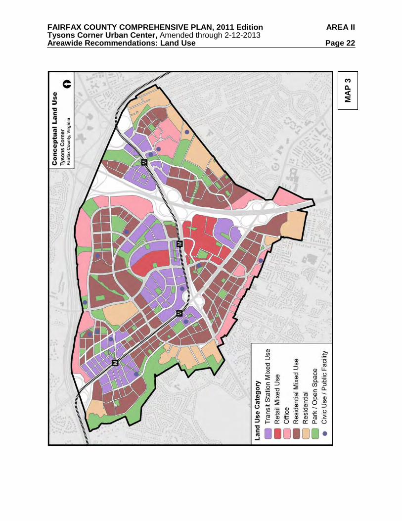
The pattern of land use in Tysons focuses growth within walking distance of Metrorail stations. Intensities will be highest in areas with the closest proximity to the stations, tapering down to transition to mid and lower density areas in the Non-TOD Districts. Most areas within Tysons will include a mix of uses, with most of the retail and office uses concentrated within 1/4 mile from the stations. The Conceptual Land Use Pattern is shown in Map 3.
The four TOD Districts, which generally encompass the areas within 1/2 mile of each Metrorail station, are planned for about 75% of all development in Tysons. The four Non-TOD Districts include some areas planned to redevelop as walkable urban neighborhoods, although at a lower intensity than the areas closer to the stations. The Non-TOD Districts also contain areas that should maintain their existing characters, uses, and intensities due to their proximity to stable residential neighborhoods outside of Tysons.
The urban grid of streets and the parks and open space network will be integrated into the land use fabric. Civic uses, public gathering places, and public facilities will be located throughout Tysons to create a full service community. MIX OF USES
Overall, the proportion of residential development within Tysons should increase as development occurs. Up to 100,000 residents are expected to live in Tysons by 2050 compared to 17,000 in 2010. The number of jobs is also expected to increase from 105,000 to as many as
FAIRFAX COUNTY COMPREHENSIVE PLAN, 2011 Edition AREA II Tysons Corner Urban Center, Amended through 2-12-2013 Areawide Recommendations: Land Use Page 21
200,000 by 2050. This iteration of the Tysons Plan focuses on a 20 year period of redevelopment while providing a framework for growth beyond the year 20301. Ultimately, the desired land use mix will provide a ratio of four jobs for every household in Tysons – a significant improvement over the 2010 ratio of approximately thirteen jobs for every household. This greater mix of uses throughout Tysons will promote walking by providing more people with the opportunity to live near their jobs and other everyday destinations.
In the future, most areas of Tysons should have a mix of land uses. This mix will include
many of the same land uses that existed in Tysons in 2010, such as residences, offices, retail stores, hotels, and public facilities. However, the land use concept promotes the redevelopment of uses such as car dealerships and strip retail centers into more efficient, higher intensity land uses. Consideration should be given to incorporating retail and service uses, car dealerships, and compatible industrial businesses into new mixed use buildings.
Providing a mix of uses, either vertically (in the same building) or horizontally (within a distance of two to three blocks), will reduce the separation among residents, workers, and services, encouraging people to walk or take transit rather than drive to fulfill many of their daily needs. People will be able to engage in routine errands, and find restaurants, entertainment, and shopping all within walking distance of their homes, offices and transit. Ground floor retail and convenience services will be essential for residential neighborhoods. Housing can also be successfully co-located with public facilities, such as schools, libraries, and fire stations. Land Use Categories and Map Most of the new office uses built in Tysons should be concentrated in mixed use developments within 1/4 mile of the Metro stations. The areas beyond 1/4 mile of the stations should be developed primarily with multifamily housing units. This pattern reflects studies of transit-oriented development which have found that people going to and from their homes will walk farther to transit than people going to and from their jobs.
The following land use categories correspond to the proposed conceptual land use pattern, shown on Map 3. These categories indicate a general proportion of uses; however, the appropriate mix will be evaluated on a case-by-case basis during the development review process. Projects that span multiple land use categories may be granted flexibility in the location of uses as long as the overall land use mix is consistent with the proportions recommended for the entire project area.
In some cases, the District Recommendations provide multiple land use options that are associated with different intensity. The conceptual land use map generally reflects the highest intensity redevelopment option. Transit Station Mixed Use: These areas are generally located near the Metro stations. They are planned for a balanced mix of retail, office, arts/civic, hotel, and residential uses. The overall percentage of office uses throughout all of the Transit Station Mixed Use areas should be approximately 65%. This target of office uses will help Tysons maintain a balance of land use and transportation over the next 20 years. Individual developments may have flexibility to build more than 65% office if other developments in the category are built or rezoned with a use mix that contains proportionately less office. The residential component should be on the order of
1 It is estimated that by the year 2030 Tysons could have approximately 167,000 jobs and 44,000 residents.
FAIRFAX COUNTY COMPREHENSIVE PLAN, 2011 Edition AREA II Tysons Corner Urban Center, Amended through 2-12-2013 Areawide Recommendations: Land Use Page 22
MA
P 3
FAIRFAX COUNTY COMPREHENSIVE PLAN, 2011 Edition AREA II Tysons Corner Urban Center, Amended through 2-12-2013 Areawide Recommendations: Land Use Page 23
20% or more of the total development. It is anticipated that the land use mix will vary by TOD District or subdistrict. Some districts or subdistricts will have a concentration of offices and other areas will have a more residential character. In all cases, synergies between complementary land uses should be pursued to promote vibrant urban communities. Retail Mixed Use: These areas are planned for regional and sub-regional retail centers that should be complemented by a mix of residential, office, hotel, and arts/civic uses. The residential component should be on the order of 20% or more. Office: These areas are planned almost exclusively for office uses. Supporting retail and service uses, such as hotels and restaurants, are also encouraged in these areas. Educational and institutional uses are encouraged, as well. Residential Mixed Use: These areas are planned for primarily residential uses with a mix of other uses, including office, hotel, arts/civic, and supporting retail and services. These complementary uses should provide for the residents’ daily needs, such as basic shopping and services, recreation, schools and community interaction. It is anticipated that the residential component should be on the order of 75% or more of the total development. Residential: These areas are planned almost exclusively for residential uses, including multifamily housing and townhouses. Supporting retail uses are allowed and should be compatible with the character of the neighborhood. Civic Use or Public Facility: These areas are planned for public uses, such as a library, school, arts center, or community center. In some instances, the uses may be in a stand-alone building. However, they may also be located within a commercial or residential building. The conceptual land use pattern identifies the planned locations for civic and public uses identified in the Public Facilities section. Some of these facilities could be located in areas planned as Retail Mixed Use, Office Mixed Use or Residential Mixed Use. Parks/Open Space: These areas are planned for passive and active park land and urban open spaces such as plazas and pocket parks. In instances when intensity credit is given for dedicating land for a park or open space, the land use mix applied to the intensity credit should be consistent with the land use category of an adjacent area. Additional guidance on parks and open space can be found in the Environmental Stewardship section. TIERED INTENSITY
A key ingredient for transforming Tysons is to strategically use intensity to maximize the benefits of Metrorail and transit and create sustainable, walkable urban environments. This is consistent with the County’s policy on transit-oriented developments. Intensity can also be an important economic tool by allowing sufficient incentive to encourage the redevelopment of auto-dependent uses, thereby strengthening Tysons’ status as Fairfax County’s Urban Center.
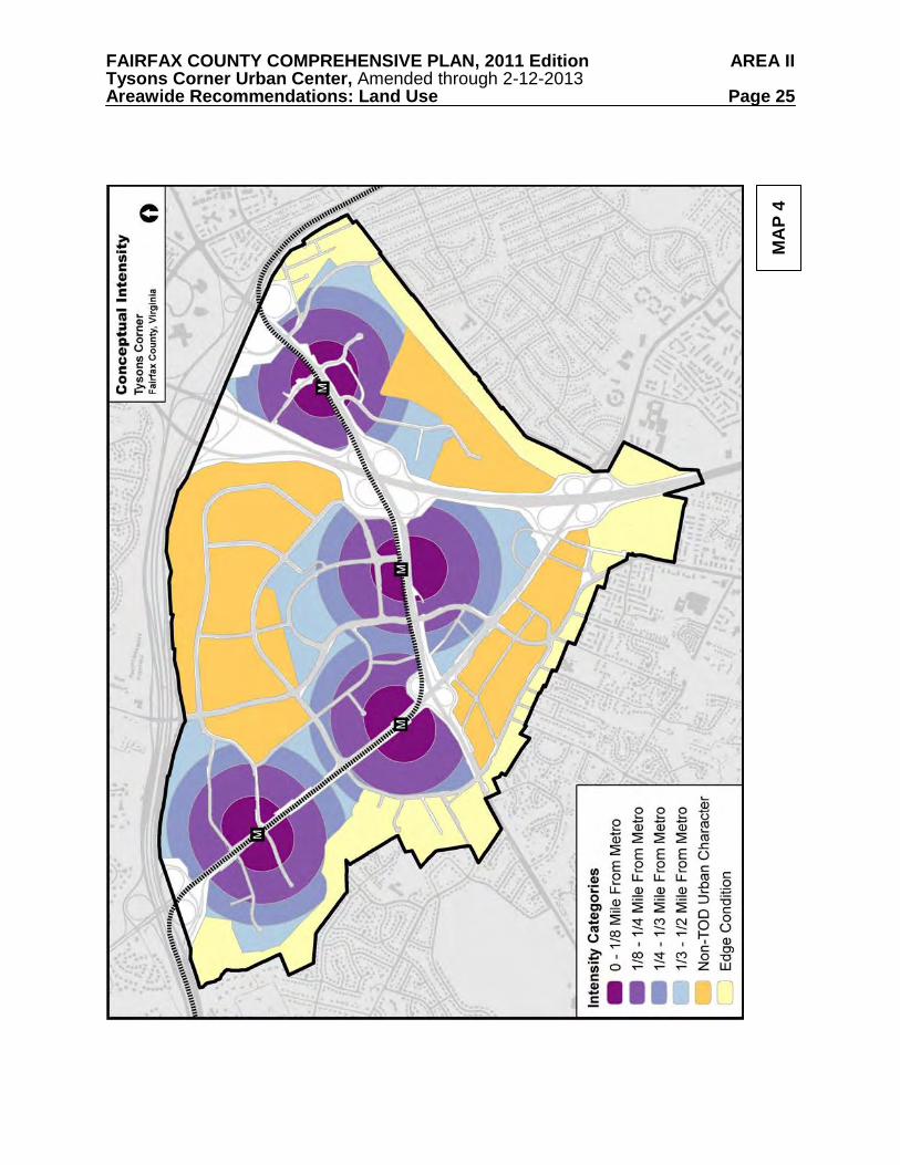
The land use concept for Tysons links intensity to transit accessibility based on how far most people are willing to walk to and from transit. Expressed as floor area ratio (FAR), the proposed levels of intensity are primarily based on distance from Metrorail stations. Development is planned to be most intense in the areas nearest the stations and least intense at the edges. Map 4 indicates conceptually where the various levels of intensity are designated in Tysons.
FAIRFAX COUNTY COMPREHENSIVE PLAN, 2011 Edition AREA II Tysons Corner Urban Center, Amended through 2-12-2013 Areawide Recommendations: Land Use Page 24
Distance from a Metro station for the purposes of calculating allowable intensity and the associated parking ratios (as described in Table 6 in the Transportation section) in the TOD Districts should be determined for each Tier by a circle centered on the primary public entrance to a station. Each Metro station in Tysons has two primary entrances, one on either side of Leesburg Pike (Route 7) or Chain Bridge Road/Dolley Madison Boulevard (Route 123). The point of measurement from an entrance should generally be the base of the escalator, as established during the initial construction of the station.
In order to achieve the recommended intensity, the walk to and from the closest station entrance to all of the buildings within a development proposal should be convenient, safe, and pleasant. As used here, convenient means direct, easy, and not overly long. Safe means protected from motorized traffic, well lit, and activated by the presence of other people. Pleasant means the walking experience is in an interesting, high quality environment.
Projects that include areas of different intensity recommendations should have an overall intensity that is based on the proportion of land area associated with each intensity recommendation. The resulting development pattern should generally conform to the goal of locating the highest intensities closest to transit. In addition, proposed intensities should be consistent with the urban scale and character that is envisioned for the area.
To encourage public-private partnerships, when building space is provided for a public facility, the floor area of the facility should not be counted toward a development’s allowable FAR.
Intensity alone will not create a livable, vibrant Tysons; a mix of land uses, public facilities, civic uses, parks, and infrastructure must also be in place. The recommended intensities are conditional and contingent upon these livability factors being provided in a manner that is phased appropriately with development. These components of a healthy community will help attract new residents to Tysons and enhance the quality of life for residents. The provision of this civic infrastructure will be the responsibility of both the private and public sectors. Specific needs for Tysons are addressed in the sections on Transportation, Environmental Stewardship, Public Facilities, and Urban Design, as well as the District Recommendations.
Rezoning applications seeking a redevelopment option will be evaluated for conformance with all of the guidance provided in the Comprehensive Plan, including the Major Elements of the Plan. These elements are listed in the Vision for Tysons section, and detailed guidance on each element are located in the Areawide Recommendations. Initial Development Level
To implement the first 20 year increment of the ultimate vision for Tysons, the total amount of office uses built and approved in the entire urban center should not exceed an initial development level of 45 million square feet. This amount is the office component of the high forecast for the year 2030 prepared for Fairfax County in 2008 by George Mason University’s Center for Regional Analysis. Office floor area that should be counted toward the initial development level includes all existing office buildings and any office development that is approved through a proffered rezoning, a special exception, or a by-right site plan. Office floor area reserved for public facility bonuses should also be counted toward the initial development level.
FAIRFAX COUNTY COMPREHENSIVE PLAN, 2011 Edition AREA II Tysons Corner Urban Center, Amended through 2-12-2013 Areawide Recommendations: Land Use Page 25
MA
P 4
FAIRFAX COUNTY COMPREHENSIVE PLAN, 2011 Edition AREA II Tysons Corner Urban Center, Amended through 2-12-2013 Areawide Recommendations: Land Use Page 26
The initial development level focuses on office uses because they represent the majority of existing uses and have high peak period vehicle trip generation characteristics. New uses other than offices that have a significant impact on peak period trips should also be managed carefully and may be counted toward the initial office development level.
To encourage new housing development in Tysons, residential uses may be rezoned at
levels above the 2030 forecast for housing. Uses such as neighborhood retail, hotels, and arts/civic space may also be rezoned at levels above the 2030 forecast if they do not have a significant impact on peak period vehicle trips.
The Land Use and Transportation sections of the Areawide Recommendations provide guidance on monitoring activities that will be necessary to track development performance. Monitoring will also be essential to future planning efforts. A particular condition to be monitored is the achievement of transportation improvements needed to mitigate the impacts of new development. If a reliable mechanism for funding these improvements needed beyond the year 2030 is established, then the initial development level of 45 million square feet of office uses may be increased through a Tysons-wide or area-specific Plan amendment.
The following criteria should be considered when determining an increase in the initial development level for office uses:
• Progress achieved toward the realization of the vision for Tysons; • Market demand for office space, as demonstrated by new building construction, vacancy
rates, and revised forecasts; • Balance between land use and transportation, including the provision of infrastructure
and achievement of vehicle trip reduction levels identified for the year 2030 and TDM performance that exceeds the targets outlined in Table 5 in the Transportation section; and
• Funding arrangements for transportation improvements and programs, so that timely completion of improvements identified for the period beyond 2030 can confidently be expected. A Tysons-wide summary of existing and approved development based on information
provided by the County should be included with all rezoning applications in Tysons. TOD District Intensity
The highest intensities in Tysons should be built in areas closest to the Metro station entrance. Intensities should decrease as the walking distance from the stations increases. This reflects evidence from other urban areas that transit ridership is correlated with walking distance to rail stations. Following this pattern, the intensity of redevelopment projects within 1/4 mile of the Metro stations should be determined through the rezoning process; in other words, no individual site within these areas should be subject to a maximum FAR.
To manage growth in Tysons effectively and encourage complete developments, a portion of the intensity proposed for a project within 1/4 mile of a Metro station may be approved through a special exception (SE). The SE will apply mostly to office uses, which have a high degree of peak period vehicle trips. In areas within 1/4 mile of the Metro stations, non-office uses that generate similar or fewer peak period trips than hotels, such as housing and neighborhood-serving retail, may be approved through a rezoning without an SE.
FAIRFAX COUNTY COMPREHENSIVE PLAN, 2011 Edition AREA II Tysons Corner Urban Center, Amended through 2-12-2013 Areawide Recommendations: Land Use Page 27
Offices and uses that generate more trips than hotels may be approved through a rezoning up to an intensity of 2.5 FAR. Intensity above 2.5 FAR for these uses may be approved with an SE that accompanies a rezoning. For example, a 6.0 FAR project that is 50% office and 50% residential could have 5.5 FAR approved by rezoning (2.5 FAR office plus 3.0 FAR residential) and an additional 0.5 FAR office approved by SE.
TOD District areas that are located more than 1/4 mile from the Metro stations are
recommended for redevelopment at 2.0 FAR and are encouraged to achieve higher intensities by utilizing bonuses for affordable and workforce housing and superlative contributions toward implementing public facilities. However, sites that are located between 1/4 and 1/3 mile from the Metro stations in TOD Districts that do not include any office space or other high trip generating uses, should be allowed intensities of 2.5 FAR, plus any bonuses achieved.
Redevelopment proposals for TOD District areas that are located more than 1/4 mile from the stations may be allowed additional intensity if they are planned for the residential mixed use category; can demonstrate a convenient, safe, and pleasant walk to a Metro station; can demonstrate that they are unable to achieve the proposed intensity through bonuses for affordable housing or public facilities; and are in close proximity to or redeveloping in coordination with an area that is located within 1/4 mile of a Metro station.
Specific guidance for each of the four TOD Districts can be found in the District Recommendations.
Guidance for Special Exception (SE) Applications
• Rezoning applications that seek additional intensity through an SE should include two development plans, one at the rezoning intensity level and one at the higher SE level.
• The floor area approved by SE will have a time limit set by the Board of Supervisors. Additional time may be granted if adequate progress is being made toward completing the project and meeting performance objectives.
• SE applications should identify how development will be phased and when the project will be completed. Applications should also demonstrate the market feasibility of the proposed phasing and completion dates as part of the justification for the additional intensity.
• Intensity associated with an SE is generally expected to be distributed among the applicable office buildings on a multi-building site, rather than in a single building. If some or all of the SE intensity that is tied to a specific building is not used when the building is constructed, this unused intensity is forfeited and cannot be transferred to other buildings on the site without a Proffered Condition Amendment (PCA) and a Special Exception Amendment (SEA).
• If bonus office floor area for superlative contributions to public facilities is achieved, the floor area of office and other high trip generating uses that may be rezoned without requiring a SE should be increased by an amount equivalent to the bonus.
• Public benefits proposed by the rezoning applicant should not be contingent on the approval of the SE.
Non-TOD District Intensity
Large portions of the Non-TOD Districts are planned for increased intensity to encourage the creation of urban residential neighborhoods. Each of these areas has a redevelopment option above the base plan identified in the District Recommendations. Some portions of Non-TOD
FAIRFAX COUNTY COMPREHENSIVE PLAN, 2011 Edition AREA II Tysons Corner Urban Center, Amended through 2-12-2013 Areawide Recommendations: Land Use Page 28
Districts, including neighborhoods at the edge of Tysons and stable residential developments like the Rotonda, are not planned for redevelopment. Specific guidance for each of the four Non-TOD Districts can be found in the District Recommendations. Circulator Intensity
A detailed study of the circulator transit system proposed in the Transportation section should be completed to determine the appropriate routes and operational characteristics. The routes and expected ridership will be used to determine the degree to which additional intensity is warranted for areas located along the circulator routes. Once the study is complete, the Comprehensive Plan should be amended to reflect its recommendations on routes and intensity. Bonus Intensity
Additional intensity in the form of bonuses is allowed to encourage the provision of affordable and workforce housing and superlative contributions toward public facilities. In cases where bonus intensity is utilized, the overall land use mix of a project should generally be consistent with the recommended land use category shown on the land use map as well as additional guidance for land use and development character set forth in the Urban Design section and the District Recommendations. More information on bonus intensity for affordable and workforce housing is provided under the Land Use Guidelines.
In addition to intensity credit given for dedicating land for parks and roads, additional floor area could be allowed in limited circumstances for the provision of major public facilities, such as a school, a conference center, or facilities associated with a large urban park. In order to achieve this additional floor area, the facility provided should significantly advance securing the necessary improvements identified in the Public Facilities section and in the District Recommendations. The extent of the public benefit being provided, which should be substantially greater than the expectations described in the “Phasing to Public Facilities” portion of the Land Use section, will be considered in determining the amount of additional floor area.
The total amount of bonus floor area for public facilities granted through the rezoning process should be no more than 2 million square feet of office uses and 10 million square feet of residential uses throughout Tysons. It is anticipated that the residential public facility bonuses will be applied in areas that are more than 1/4 mile from the Metro stations since the intensity of these uses within 1/4 mile of the stations would not be subject to a maximum FAR. The office bonuses may be achieved throughout Tysons and could be used to either increase the amount of floor area that is not subject to a special exception (SE) within 1/4 of the stations, or to increase the total amount of development permitted on a site outside of 1/4 mile of the stations.
Allocating Floor Area Between Sites
Floor area planned for a site that is being used for a public purpose may be allocated to another development site through concurrent rezoning applications. For example, if a land owner acquires a 100,000 square foot site planned at 1.5 FAR and dedicates the land for an athletic field, the land owner may utilize the resulting 150,000 square feet on another development site within Tysons through concurrent rezoning proposals considered and approved by the Board of Supervisors. Under no circumstance should floor area be moved from an area without a maximum FAR in the Plan to an area located more than 1/4 mile from a Metro station.

FAIRFAX COUNTY COMPREHENSIVE PLAN, 2011 Edition AREA II Tysons Corner Urban Center, Amended through 2-12-2013 Areawide Recommendations: Land Use Page 29
PHASING DEVELOPMENT TO TRANSPORTATION AND PUBLIC FACILITIES A longstanding planning concept in the Comprehensive Plan is linking development to the provision of the infrastructure and public facilities needed to support it. A dynamic and evolving phasing plan that links redevelopment to specific public improvements is critical to ensuring the transformation of Tysons. Growth will need to be supported by Metrorail and other transit options, an urban street grid, and additional transportation improvements that better connect Tysons internally and to the rest of the region. Similarly, redevelopment should be linked to the construction of the parks and open space network, enhanced stormwater management facilities, and other public facilities such that they are in operation when residential redevelopment in Tysons generates sufficient demand for them. Major infrastructure improvements and public facilities can take many years to design, fund, and construct. The sequencing of such improvements will require close monitoring of approved rezonings, building permits, commuting patterns, demographic trends, and population and employment growth.
The following are general strategies for phasing development plans to achieve a sustainable balance with infrastructure and public facilities throughout Tysons. Phasing to Transportation Improvements and Programs Increasing the amount of development in Tysons will require significant transportation improvements and changes in travel patterns. Planned roadway improvements, including new street connections, ramps to the Dulles Airport Access and Dulles Toll Road (DAAR, Route 267), and crossings of the Capital Beltway/Interstate 495 (I-495), are necessary to disperse vehicle traffic. Improvements to transit and to the pedestrian and bicycle networks are also needed to encourage travel by these modes. The provision of such infrastructure and the achievement of trip reduction objectives can be thought of as triggers that should occur in concert with future growth. Just as previous Plans for Tysons phased growth to the provision of Metrorail, future redevelopment proposals should be phased to planned roadway and transit improvements and the demonstrated ability to significantly reduce single-occupancy vehicle trips. Table 7 in the Transportation section of the Plan prioritizes specific improvements needed to accommodate development as Tysons grows over time. Similarly, Table 5 in the Transportation section sets vehicle trip reduction objectives that increase with each decade. All development proposals should perform a traffic impact analysis. The mitigation measures identified by this analysis should be considered along with the phasing guidance below. Initial phases of development should provide on-site improvements and the grid of streets; should significantly advance the provision of infrastructure; and should meet the applicable levels of trip reduction set forth in Table 5 in the Transportation section. Later phases should be triggered by achievement of trip reduction objectives and the provision of the infrastructure and other transportation improvements set forth in Table 7 in the Transportation section.
The necessary transportation improvements and transit operating costs will rely on both public and private sources of funding. Public sources of funding may come from state and
FAIRFAX COUNTY COMPREHENSIVE PLAN, 2011 Edition AREA II Tysons Corner Urban Center, Amended through 2-12-2013 Areawide Recommendations: Land Use Page 30
federal sources, general fund allocations, tax increment financing, and/or other sources. The private sector’s share is envisioned to be composed of on-site improvements, including the grid of streets, and contributions to the Tysons Road Fund, based on square feet or dwelling units, approved during the zoning process. However, preliminary estimates of the cost of the transportation improvements needed to accommodate 84 million square feet of development (the high forecast for the year 2030) versus anticipated revenue sources result in significant shortfalls.
As a result, it is projected that it will be necessary to augment the aforementioned funding sources with a Tysons-wide Community Development Authority (CDA) or a similar entity that can generate the necessary funds over a period of 20 years. The CDA, or similar entity, should contribute an appropriate amount to cover the shortfall and ensure the success of a funding plan for the transportation improvements and transit operating costs. Smaller CDAs or similar entities may also be able to fund the private sector’s share of one of more of the Tysons-wide improvements.
Individual rezoning cases in Tysons should only be approved if the development is being phased to one of the following transportation funding mechanisms:
• A Tysons-wide CDA or a similar mechanism that provides the private sector’s share of the Tysons-wide transportation improvements needed by 2030;
• A smaller CDA or a similar mechanism that provides a significant component of the private sector’s share of the Tysons-wide improvements needed by 2030; or
• Other binding commitments to phase development to the funding or construction of one or more of the Tysons-wide improvements needed by 2030.
Phasing to Public Facilities The Public Facilities section of the Areawide Recommendations identifies and describes the public services, parks, infrastructure, and utilities needed to serve Tysons. Providing these facilities in pace with the planned employment and residential growth will be a challenge. Securing the land area or the space for public uses within privately-owned structures is critical. Practices employed by the County in the past to provide space for public facilities in largely undeveloped suburban areas cannot be relied upon in an intensely developed area where most of the land is privately owned. In Tysons it will be critical that the land area or spaces for public uses are incorporated within private developments at no cost to the public sector.
The public facilities planned for Tysons over the next 40 years are based on the growth projections prepared by George Mason University. As the pace of growth may be faster or slower than the projections, there is a need to monitor development to determine when it is actually necessary to construct the public facilities. While facilities may actually be constructed throughout the planning horizon based upon need, it is critical that space for most, if not all, of these facilities be secured as soon as is possible. Therefore, rezoning proposals should commit to provide the necessary land and/or space to ensure that places will be available to construct facilities in concert with the pace of growth.
The land and/or building space needed for public facilities is critical to the assurance that
such facilities can be constructed. Commitments to dedicate building space or land for most, if not all, of the public facilities needed by 2050 should be provided as development approvals occur during the first 10 or 20 years of Plan implementation.
FAIRFAX COUNTY COMPREHENSIVE PLAN, 2011 Edition AREA II Tysons Corner Urban Center, Amended through 2-12-2013 Areawide Recommendations: Land Use Page 31
The levels of development set forth in the Plan are intended to enhance the ability of the private sector to provide the necessary public space for facilities. In addition, when building space is provided for a public facility, the floor area of the facility should not be counted toward a development’s allowable FAR.
In addition to facilitating public facility objectives through zoning actions, it may be necessary for landowners throughout Tysons to work collaboratively and creatively through private-private partnerships to meet public facility objectives. Detailed plans for the provision of public facilities, including parks and athletic fields, for a district or subdistrict should be in place prior to or concurrent with the first rezoning approval in that district or subdistrict. Such plans should enumerate the public facilities needed in that district, the proposed locations for the facilities, their anticipated year of construction, and the private sector’s commitments toward the provision of those facilities. The public facilities plans should be coordinated with the County and land owners within the district or subdistrict. The locations of proposed public facilities may be placed on an “official map” as described in the Transportation section.
Because developments that contain a significant land area can better facilitate the achievement of one or more public facility objectives, substantial parcel or land area consolidation for rezoning proposals is critical. However, in some instances a development with lesser acreage than the goal for consolidation may be able to provide the space for and/or construct a necessary public facility in the appropriate location, either independently or through a partnership.
Cash contributions are not the preferred method for offsetting impacts on public facilities. Especially during the early years of Plan implementation, funds would likely not be sufficient for the County to acquire developed properties for public facilities. Therefore, the preference is for land or building space dedicated for facilities. It may be preferable for a development proposal to address one or more, but not all, public facility needs in a significant way, rather than providing smaller commitments toward many facilities. Phased Site Development It is anticipated that most development projects in Tysons will be phased over time. Each phase of a development proposal seeking rezoning approval should be reviewed for conformance with the overall vision, with careful consideration given to interim conditions. Priorities that should be addressed in the earliest phases of site development plans include critical links within the street grid, parks and open space, a balanced mix of uses, pedestrian access to the Metro stations, and the integration of development with the station entrances. Developments should be phased in such a way that interim conditions are experienced by pedestrians as a complete urban environment.
Interim conditions that will enhance the urban character of Tyson are encouraged for the portions of a project that will not be built until the later phases. Examples include green space or a low intensity temporary use with an urban form. It may also be acceptable to maintain existing uses as long as they do not preclude the achievement of other priorities, such as the street grid. Additional guidance on interim conditions is in the Urban Design section. Land Use Monitoring
Monitoring the progress of the Plan toward achieving the vision for Tysons is essential. Advances in information technology have and will continue to increase the County’s capacity to maintain databases that may be shared among agencies and with the public. The data collected
FAIRFAX COUNTY COMPREHENSIVE PLAN, 2011 Edition AREA II Tysons Corner Urban Center, Amended through 2-12-2013 Areawide Recommendations: Land Use Page 32
may be useful for future planning efforts in Tysons and other activity centers in the County and the region. Information and performance data that should be monitored for Tysons include:
• Land use by floor area and number of dwelling units for built, approved, and permitted buildings (including development options and proffered development conditions, especially as they relate to phasing)
• Relationship of built and approved development projects to planned intensities • Employment, population, and demographic information, such as average residents per
dwelling unit, vacancy rates, housing tenancy (owner-occupied or rental) • Employment, population, and demographic forecasts • Average dwelling unit size • Number, location, and income mix of affordable and workforce dwelling units • Trip-making and travel behavior, including commuting patterns, transit ridership,
transportation mode splits, and vehicle and non-motorized trips generated by different land uses
• Transportation Demand Management performance, both Tysons-wide and for individual sites
• Number, location, size, and type of urban parks and open space • Progress toward environmental stewardship goals, including the condition of natural
resources • Green building performance and energy/resource conservation • Utilization and capacity of public facilities, especially public schools • Progress toward implementing the street grid and urban design goals, such as build-to
lines and streetscape improvements • Progress toward implementing facilities for pedestrians and bicycles • Number and location of parking spaces • A repository of digital 3-dimensional models of built and approved structures, to be used
in evaluating the context of development applications within their districts Additional guidance on monitoring transportation performance can be found in the
Transportation section. The Plan should be regularly monitored, and development approvals, site plans, and
occupancy permits should be continuously tracked to facilitate monitoring activities. The Comprehensive Plan for Tysons should be reviewed regularly, and the review process should consider the data collected through monitoring activities with the expected outcomes described in the Plan. Careful consideration should be given during this review process as to whether the amount and location of planned development potential should be modified. Examples of appropriate times for Plan review include when 45 million total square feet of office uses are approved through the zoning process; when 10 million square feet (of any use) zoned under this Plan are built; or as needed, based on events such as the completion of Phase 2 of the Silver Line or the implementation of other transit projects that serve Tysons.
FAIRFAX COUNTY COMPREHENSIVE PLAN, 2011 Edition AREA II Tysons Corner Urban Center, Amended through 2-12-2013 Areawide Recommendations: Land Use Page 33
LAND USE GUIDELINES
The following land use guidelines are necessary to create a people-focused urban setting. These guidelines should be considered along with the general Land Use recommendations above and the District Recommendations in evaluating development proposals in Tysons. Affordable Housing
A critical aspect of the vision is to provide housing choices and ensure that a population with a variety of income levels has the ability to live in Tysons. The Policy Plan states that affordable housing should be located close to employment opportunities and should be a vital element in high density and mixed use development projects. A specific objective in the Policy Plan is to encourage affordable and workforce housing in Tysons. Affordable housing may include Affordable Dwelling Units (ADUs) required pursuant to the Zoning Ordinance and Workforce Dwelling Units (WDUs) administered consistent with the Board’s administrative policy guidelines for such units, or other such price controlled units that the Board deems to meet the intent of these provisions.
All projects with a residential component that seek to utilize the redevelopment option in the District Recommendations should provide 20% affordable and workforce dwelling units. These projects are allowed a 20% residential floor area bonus and flexibility in how and where Workforce Dwelling Units can be provided within Tysons.
Because development proposals within 1/4 mile of the Metro stations are not subject to a maximum intensity, the FAR proposed for rezoning applications in these areas is considered to include the bonus floor area allowed for meeting the affordable and workforce housing expectations.
For Affordable Dwelling Units (ADUs), the provisions of Part 8 of Article 2 of the Fairfax County Zoning Ordinance shall apply, unless the dwelling units proposed in the development are specifically exempted from compliance with the ADU Program.
For Workforce Dwelling Units (WDUs), the following housing conditions and the guidelines in the Housing section of the Policy Plan (except as modified below) apply to any residential development built under the redevelopment option, regardless of whether or not the development elects to utilize the available bonus density.
• 20% of the residential units in new developments should be affordable to households with incomes ranging from 50 to 120 percent of AMI (Area Median Income), as set forth in Table 1. Within 1/4 mile of the Metro stations, the 20% applies to the total number of dwelling units to be constructed in the proposed development. Beyond 1/4 mile of the Metro stations, any units created with bonus floor area should be excluded from the 20% WDU calculation. In a development that is required to provide ADUs, the ADUs and ADU bonus units may be deducted from the total number of dwelling units on which the WDU calculation is based.
• If required by the Zoning Ordinance, ADUs may be counted toward the 20% affordable
housing objective identified in the previous bulleted item, above. Any such ADUs could be used to satisfy the lower income tiers identified in Table 1 for WDUs.
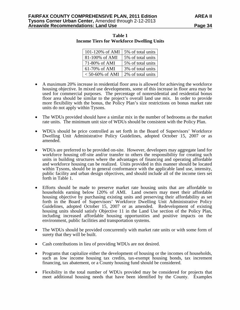
FAIRFAX COUNTY COMPREHENSIVE PLAN, 2011 Edition AREA II Tysons Corner Urban Center, Amended through 2-12-2013 Areawide Recommendations: Land Use Page 34
Table 1 Income Tiers for Workforce Dwelling Units
101-120% of AMI 5% of total units 81-100% of AMI 5% of total units 71-80% of AMI 5% of total units 61-70% of AMI 3% of total units < 50-60% of AMI 2% of total units
• A maximum 20% increase in residential floor area is allowed for achieving the workforce
housing objective. In mixed use developments, some of this increase in floor area may be used for commercial purposes. The percentage of nonresidential and residential bonus floor area should be similar to the project’s overall land use mix. In order to provide more flexibility with the bonus, the Policy Plan’s size restrictions on bonus market rate units do not apply within Tysons.
• The WDUs provided should have a similar mix in the number of bedrooms as the market
rate units. The minimum unit size of WDUs should be consistent with the Policy Plan. • WDUs should be price controlled as set forth in the Board of Supervisors’ Workforce
Dwelling Unit Administrative Policy Guidelines, adopted October 15, 2007 or as amended.
• WDUs are preferred to be provided on-site. However, developers may aggregate land for
workforce housing off-site and/or transfer to others the responsibility for creating such units in building structures where the advantages of financing and operating affordable and workforce housing can be realized. Units provided in this manner should be located within Tysons, should be in general conformance with the applicable land use, intensity, public facility and urban design objectives, and should include all of the income tiers set forth in Table 1.
• Efforts should be made to preserve market rate housing units that are affordable to
households earning below 120% of AMI. Land owners may meet their affordable housing objective by purchasing existing units and preserving their affordability as set forth in the Board of Supervisors’ Workforce Dwelling Unit Administrative Policy Guidelines, adopted October 15, 2007 or as amended. Redevelopment of existing housing units should satisfy Objective 11 in the Land Use section of the Policy Plan, including increased affordable housing opportunities and positive impacts on the environment, public facilities and transportation systems.
• The WDUs should be provided concurrently with market rate units or with some form of
surety that they will be built. • Cash contributions in lieu of providing WDUs are not desired.
• Programs that capitalize either the development of housing or the incomes of households,
such as low income housing tax credits, tax-exempt housing bonds, tax increment financing, tax abatement, or a County housing fund should be considered.
• Flexibility in the total number of WDUs provided may be considered for projects that
meet additional housing needs that have been identified by the County. Examples
FAIRFAX COUNTY COMPREHENSIVE PLAN, 2011 Edition AREA II Tysons Corner Urban Center, Amended through 2-12-2013 Areawide Recommendations: Land Use Page 35
include providing a higher proportion of units in the lowest income tiers or providing units with more bedrooms than would otherwise be expected. Such proposals should be evaluated on a case-by-case basis.
• Creative strategies for achieving housing objectives should be considered. This could include a system similar to wetlands banking in which a developer builds additional affordable and workforce dwelling units and the credit for providing the units is sold to another developer who has an obligation to provide affordable housing. Another strategy could be incorporating units into public buildings. Facilities for populations with special needs, including those who are homeless, should also be considered.
Nonresidential development throughout Tysons should contribute a minimum of $3.00
per nonresidential square foot (adjusted annually based on the Consumer Price Index) or at least 25 cents per nonresidential square foot over a period of time to be determined at the time of rezoning to a housing trust fund that will be used to create affordable and workforce housing opportunities in Tysons. Such developments may provide an equivalent contribution of land or affordable units in lieu of a cash contribution. Nonresidential contributions could also be used to fund affordable housing opportunities in Tysons through a partnership. If nonresidential floor area is achieved through a bonus for providing affordable and workforce dwelling units, the bonus floor area should not be included when calculating the contribution amount. Ground level retail located in office, hotel, and residential buildings should also not be included when calculating the contribution amount.
The provision of workforce housing should be viewed as a collective responsibility that
will directly benefit employers in Tysons. New office, retail, and hotel developments will benefit from having a range of affordable housing opportunities within a short commuting distance of the jobs in Tysons.
Green Buildings All new buildings in Tysons should receive green building certification under an established rating system such as the U.S. Green Building Council’s Leadership in Energy and Environmental Design (LEED) program. The green building rating system used should be based on individual building certification, such as LEED-NC (New Construction) or LEED-CS (Core and Shell). LEED Silver certification, or the equivalent, is the minimum expectation for nonresidential development in Tysons. Residential development should be guided by the Policy Plan objectives on Resource Conservation and Green Building Practices.
In the future, tax abatements or other cost recovery strategies may be considered as an
incentive for buildings that are certified at the LEED Gold or Platinum level, or the equivalent. At this time, tax abatements are unavailable for use.
Coordinated Development and Parcel Consolidation
Piecemeal development proposals for individual parcels could make it difficult to
implement the vision, particularly the grid of streets, parks, public facilities, and infrastructure. In order to achieve the vision, property owners in each district or subdistrict will need to have on-going coordination with each other and the County focusing on refining an area’s grid of streets as well as determining the location of open space and public facilities. Private-private partnerships or agreements will likely be needed in order to effectively address the multitude of redevelopment issues.
FAIRFAX COUNTY COMPREHENSIVE PLAN, 2011 Edition AREA II Tysons Corner Urban Center, Amended through 2-12-2013 Areawide Recommendations: Land Use Page 36
In many cases, parcel consolidation will be necessary to allow planning objectives to be achieved. Proposed parcel consolidations should demonstrate how the project will function in a well-designed, efficient manner and should be sufficient in size to provide redevelopment in several phases. Each phase should be linked to the provision of public facilities and infrastructure and demonstrate the attainment of critical plan objectives, such as achieving a functioning grid of streets, trip reductions, shared parking, green buildings, and stormwater management facilities. Through parcel consolidation, a grid of streets can be planned in a way that enhances the value of the land and provides greater connectivity and consistency with the Tysons Plan.
As an alternative to consolidation, coordinated proffered development plans (i.e., concurrent rezoning applications) that achieve the same Plan objectives as consolidation should be encouraged, if commitments can be made ensuring that both projects will function in a well-designed, efficient manner and allow development on adjacent parcels to occur in conformance with the Plan.
The desired acreage for consolidations or coordinated development plans varies due to the unique parcel configurations and planning goals of each district and subdistrict. Guidance for areas near the Metro stations is included in the District Recommendations. Where guidance on consolidation is not set forth in the District Recommendations, the extent of land area necessary will be determined on a case-by-case basis. Performance Objectives for Coordinated Development and Parcel Consolidation
In all cases, consolidations or coordinated development plans should meet the following
objectives: • Commitment to a functioning grid of streets both on-site and off-site;
o Conceptual engineering of streets that demonstrate connectivity to surrounding areas and satisfy the guidance in the Transportation section should be completed. Such engineering should be done in coordination with land owners in the surrounding area, and the proposed street alignments should be included in an official map, as described in the Transportation section.
o If an official map has already been adopted for the area, the development proposal should be in conformance with the street alignments in the map.
• Provision of parks and open space as set forth in the Environmental Stewardship section of the Areawide Recommendations, either on-site or within the subdistrict through a partnership;
• Provision of land and/or building space for public facilities as set forth in the Public Facilities section of the Areawide Recommendations;
• Conformance with the guidance in the Urban Design section and any urban design guidelines for the district or subdistrict; and
• Demonstration of how adjacent parcels could be redeveloped in a manner that is compatible with the proposal and in conformance with the Plan.
FAIRFAX COUNTY COMPREHENSIVE PLAN, 2011 Edition AREA II Tysons Corner Urban Center, Amended through 2-12-2013 Areawide Recommendations: Land Use Page 37
Existing Buildings and Services
In most instances, existing development in Tysons is not consistent with the long-term vision, which is the eventual redevelopment of these properties. However, the expansion and remodeling of existing buildings should be permitted as long as these changes do not inhibit the achievement of Plan objectives. Proposals to modify an existing use should be considered if they would result in significant public benefits that outweigh adverse effects and if such proposals do not delay or interfere with the achievement of the long term vision for Tysons. Improvements to open space, streetscapes, and streets that are identified in the Plan are encouraged, but if they are not feasible due to an existing building's location on the site, alternative improvements could be considered which may help implement the Plan's intent.
It is desirable to maintain many services, such as auto dealerships, service and repair shops, and storage facilities, even if their physical surroundings change. For example, auto showrooms and other retail and service uses could be incorporated within street-level retail spaces provided through mixed use redevelopment. There may also be ways to incorporate repair shops and storage facilities within parking structures. Residential and Other Noise-Sensitive Uses Significant highway noise impacts are likely in some parts of the Tysons Corner area due to the proximity of major roadways and interstate highways to planned future development. The Policy Plan indicates that new residential and other noise-sensitive uses should not develop in areas where current and future noise levels exceed 75 dBA DNL, which is a day-night weighted average noise level. As Tysons transforms into a more urban place, there is an increasing possibility that the land use recommendations for residential and hotel uses, and the urban design guidelines which seek to locate these uses closer to the street, may be in conflict with the current noise policy. Therefore an areawide study of noise levels along Tysons’ major transportation corridors should be undertaken. The noise study should clearly define noise contours with current noise levels and future noise levels based on a minimum 20-year traffic volume projection for the roadway and other transportation noise sources. Once noise contours are mapped and compared with planned locations for future residential and hotel development in Tysons, the implications of applying the current noise policy can be evaluated. URBAN DEVELOPMENT AREA DESIGNATION
Section 15.2-2223.1 of the Code of Virginia requires Fairfax County to designate one or more Urban Development Areas in the Comprehensive Plan. An Urban Development Area (UDA) is defined as an area designated by a locality that is (i) appropriate for higher density development due to its proximity to transportation facilities, the availability of a public or community water or sewer system, or a developed area and (ii) to the extent feasible, to be used for redevelopment or infill development. Tysons Corner is the designated Urban Development Area for Fairfax County. The Tysons Corner Urban Center boundaries found on the Comprehensive Plan Map and related Tysons Corner land use maps reflect the boundaries of the UDA. The Tysons Corner land use plan is consistent with the UDA requirements for (i) minimum densities and intensities for development, (ii) the appropriate planning horizon for Fairfax County (iii) inclusion of principles of traditional neighborhood design, and (iv) incentives for development.
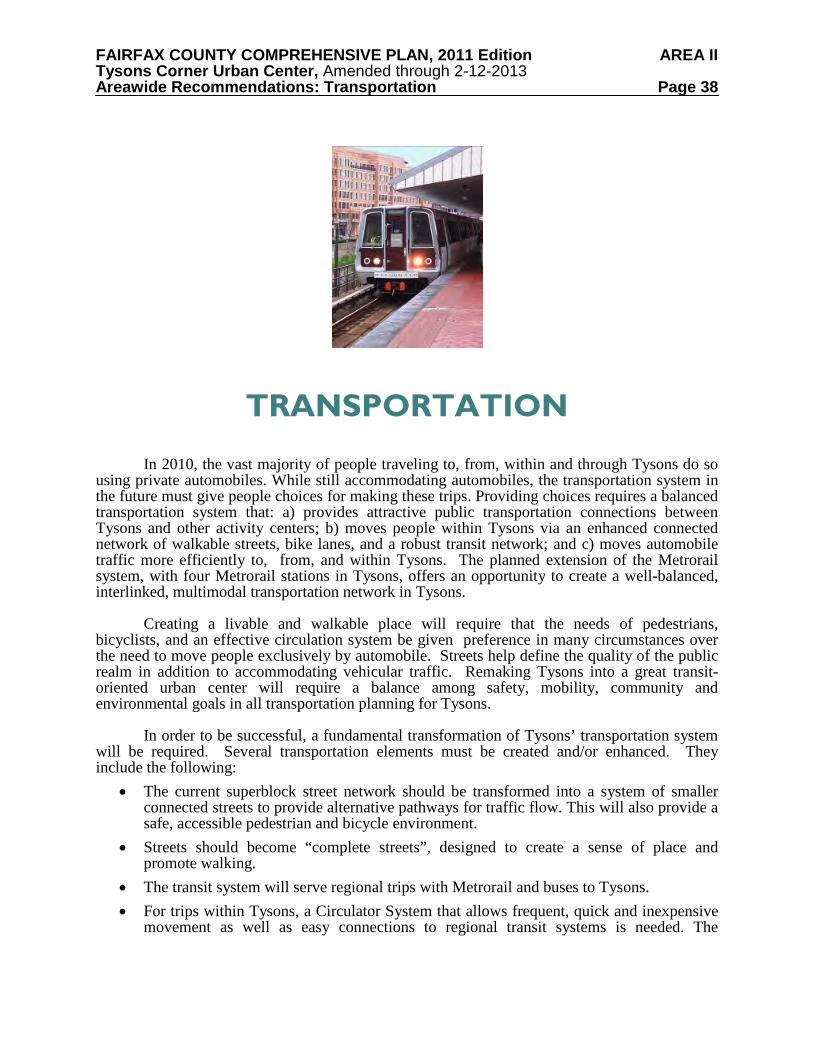
FAIRFAX COUNTY COMPREHENSIVE PLAN, 2011 Edition AREA II Tysons Corner Urban Center, Amended through 2-12-2013 Areawide Recommendations: Transportation Page 38
TRANSPORTATION
In 2010, the vast majority of people traveling to, from, within and through Tysons do so using private automobiles. While still accommodating automobiles, the transportation system in the future must give people choices for making these trips. Providing choices requires a balanced transportation system that: a) provides attractive public transportation connections between Tysons and other activity centers; b) moves people within Tysons via an enhanced connected network of walkable streets, bike lanes, and a robust transit network; and c) moves automobile traffic more efficiently to, from, and within Tysons. The planned extension of the Metrorail system, with four Metrorail stations in Tysons, offers an opportunity to create a well-balanced, interlinked, multimodal transportation network in Tysons.
Creating a livable and walkable place will require that the needs of pedestrians, bicyclists, and an effective circulation system be given preference in many circumstances over the need to move people exclusively by automobile. Streets help define the quality of the public realm in addition to accommodating vehicular traffic. Remaking Tysons into a great transit-oriented urban center will require a balance among safety, mobility, community and environmental goals in all transportation planning for Tysons.
In order to be successful, a fundamental transformation of Tysons’ transportation system will be required. Several transportation elements must be created and/or enhanced. They include the following:
• The current superblock street network should be transformed into a system of smaller connected streets to provide alternative pathways for traffic flow. This will also provide a safe, accessible pedestrian and bicycle environment.
• Streets should become “complete streets”, designed to create a sense of place and promote walking.
• The transit system will serve regional trips with Metrorail and buses to Tysons. • For trips within Tysons, a Circulator System that allows frequent, quick and inexpensive
movement as well as easy connections to regional transit systems is needed. The
FAIRFAX COUNTY COMPREHENSIVE PLAN, 2011 Edition AREA II Tysons Corner Urban Center, Amended through 2-12-2013 Areawide Recommendations: Transportation Page 39
Circulator System will initially operate on-street in mixed traffic and later on-street on its own right-of-way.
• A neighborhood feeder bus network should connect nearby communities to Tysons. • Enhancements to the automobile network, such as a grid of streets, improved I-495
crossings, additional connections to the DAAR, and state of the art traffic management systems.
Tysons Corner is located at the intersection of two major regional freeways, I-495 and the
DAAR and surrounds the intersection of two major arterials, Leesburg Pike and Chain Bridge Road. These major highways as well as other arterials have historically served the vast majority of trips to, from, and through the Tysons area. Although extensive, this highway network has become increasingly strained as the Washington, D.C. region has grown and Tysons has become one of the largest office and retail markets in the country. Although planned road improvements will reduce the increase in traffic congestion in and around Tysons, this strategy is not sustainable in the long term because of right-of-way limitations, the high cost of adding highway capacity, and limits in the accommodation of vehicle traffic in a dense urban environment such as what is planned for Tysons Corner.
In order to maintain a balance between land use and transportation, as well as create a healthier, more sustainable environment, alternatives to automobile travel, especially transit, will become increasingly important. For this reason, alternatives to automobile travel should meet increasingly higher targets over time. In order to achieve this, it is essential to successfully implement the following strategies:
• The provision of the necessary transit infrastructure and services to increase transit use over time.
• The achievement of higher vehicle trip reduction levels over time through transportation demand management programs including an increase in carpooling, telework, the application of variable working hours, and reducing the ratio of parking spaces to floor area.
The increase of residential development in Tysons over time will replace automobile trips
to and from Tysons with walking or transit trips within Tysons. A monitoring system to verify that these requirements are realized as planned is necessary and the ability to make adjustments if there are variations from the recommendations on how a balance will be maintained is critical. The successful transformation of Tysons is highly dependent on the provision of transportation infrastructure, services, and programs in a timely manner.
These programs are in turn dependent on measured development growth, an optimum mix of land use, excellent urban design, and the successful integration of development with transportation infrastructure and services. Several significant transportation analyses were done to inform the Comprehensive Plan guidance on this balance between land use and transportation. The Scenario Analysis compared the impacts of different levels of growth. This analysis was done throughout the multi-year planning process. The Beyond 2030 Sketch Planning Analysis provided the target non-SOV mode shares that would be necessary beyond 2030.
A Countywide Transportation Demand Management (TDM) study was conducted to provide the County with the information necessary to institute robust TDM programs. The findings of this study were used to establish the TDM trip reduction goals and the new parking rates for Tysons Corner. To insure that the impacts on the areas surrounding Tysons were taken
FAIRFAX COUNTY COMPREHENSIVE PLAN, 2011 Edition AREA II Tysons Corner Urban Center, Amended through 2-12-2013 Areawide Recommendations: Transportation Page 40
into consideration, a Neighborhood Traffic Impact Study was conducted. Finally, a Phasing Study provided insight into how the recommended transportation improvements should be prioritized. TRANSPORTATION INFRASTRUCTURE AND SERVICES Public Transportation In order for Tysons to develop into a great urban center, public transportation needs to serve an increasingly higher percentage of trips over time. Specific goals for the percentage of trips served by public transportation at specified development levels are listed below. These goals account for people who work in Tysons but live outside Tysons, people who live in Tysons and work elsewhere, and those who live and work within Tysons. Metrorail is the most significant public transportation improvement and is expected to carry the majority of public transportation trips in the near term. Metrorail will serve passengers travelling to Tysons from the Dulles Corridor to the west and from Arlington and the District of Columbia to the east; both directions contain significant residential centers. It will also serve residents of Tysons travelling to these areas, which are also major employment areas. While Metrorail is necessary for Tysons to develop into an urban center, it is not sufficient to support development at the Comprehensive Plan level. Other regional high quality public transportation services, such as express bus routes serving Tysons from the regional network of HOV and HOT lanes, are needed. In addition, two urban rail transit corridors, with significant residential centers, need to connect to Tysons. A system of circulators is necessary to connect other areas of Tysons to the Metrorail stations and to provide a robust internal transit system within Tysons. Finally, local bus routes will continue to serve Tysons and these routes connect nearby communities to Tysons for trips that are generally shorter than the trips served by the regional rail and bus network. All of these public transportation services are described in more detail below. Public Transportation Goals
To support the level of development in Tysons forecasted for the year 2050, it is necessary for transit to achieve a 31% mode share of all person trips to, from and within Tysons Corner during peak periods. (Mode share is defined as the percentage of person trips that use a specific mode of transportation.) As the level of development in Tysons increases, the transit mode share should increase, as shown in Table 2, so that a 31% transit mode share can be achieved by the year 2050.
To be able to achieve the increase in transit use as indicated in Table 2, the following
transit services should be provided for Tysons Corner. The projected timing of these improvements is listed in Table 7.
• The extension of Metrorail in the Dulles Corridor to Loudoun County • Express bus/BRT routes on Interstate 66 (I-66), Interstate 95 (I-95)/I-495 and Leesburg
Pike east of Tysons Corner • A Circulator System serving Tysons • Expanded local bus service
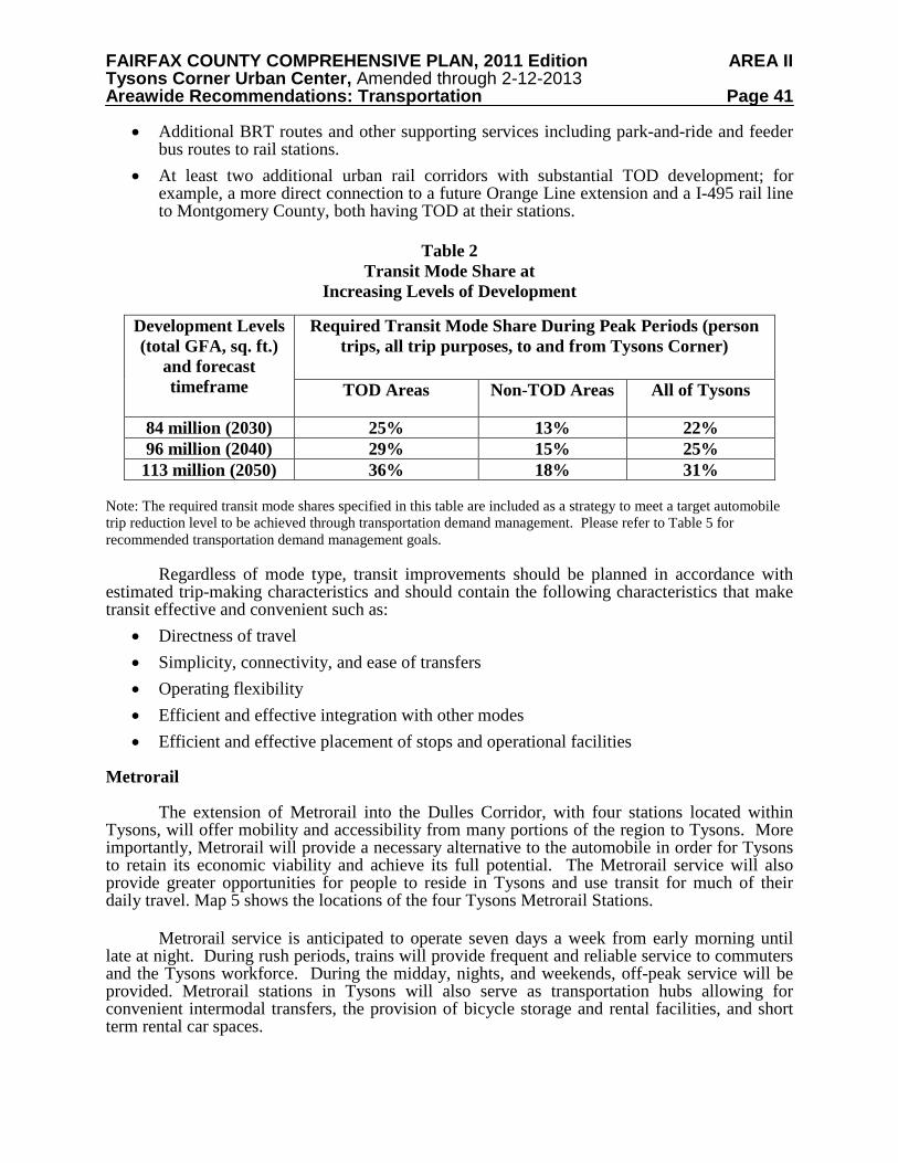
FAIRFAX COUNTY COMPREHENSIVE PLAN, 2011 Edition AREA II Tysons Corner Urban Center, Amended through 2-12-2013 Areawide Recommendations: Transportation Page 41
• Additional BRT routes and other supporting services including park-and-ride and feeder bus routes to rail stations.
• At least two additional urban rail corridors with substantial TOD development; for example, a more direct connection to a future Orange Line extension and a I-495 rail line to Montgomery County, both having TOD at their stations.
Table 2
Transit Mode Share at Increasing Levels of Development
Note: The required transit mode shares specified in this table are included as a strategy to meet a target automobile trip reduction level to be achieved through transportation demand management. Please refer to Table 5 for recommended transportation demand management goals.
Regardless of mode type, transit improvements should be planned in accordance with
estimated trip-making characteristics and should contain the following characteristics that make transit effective and convenient such as:
• Directness of travel • Simplicity, connectivity, and ease of transfers • Operating flexibility • Efficient and effective integration with other modes • Efficient and effective placement of stops and operational facilities
Metrorail
The extension of Metrorail into the Dulles Corridor, with four stations located within Tysons, will offer mobility and accessibility from many portions of the region to Tysons. More importantly, Metrorail will provide a necessary alternative to the automobile in order for Tysons to retain its economic viability and achieve its full potential. The Metrorail service will also provide greater opportunities for people to reside in Tysons and use transit for much of their daily travel. Map 5 shows the locations of the four Tysons Metrorail Stations.
Metrorail service is anticipated to operate seven days a week from early morning until
late at night. During rush periods, trains will provide frequent and reliable service to commuters and the Tysons workforce. During the midday, nights, and weekends, off-peak service will be provided. Metrorail stations in Tysons will also serve as transportation hubs allowing for convenient intermodal transfers, the provision of bicycle storage and rental facilities, and short term rental car spaces.
Development Levels (total GFA, sq. ft.)
and forecast timeframe
Required Transit Mode Share During Peak Periods (person trips, all trip purposes, to and from Tysons Corner)
TOD Areas Non-TOD Areas All of Tysons
84 million (2030) 25% 13% 22% 96 million (2040) 29% 15% 25% 113 million (2050) 36% 18% 31%
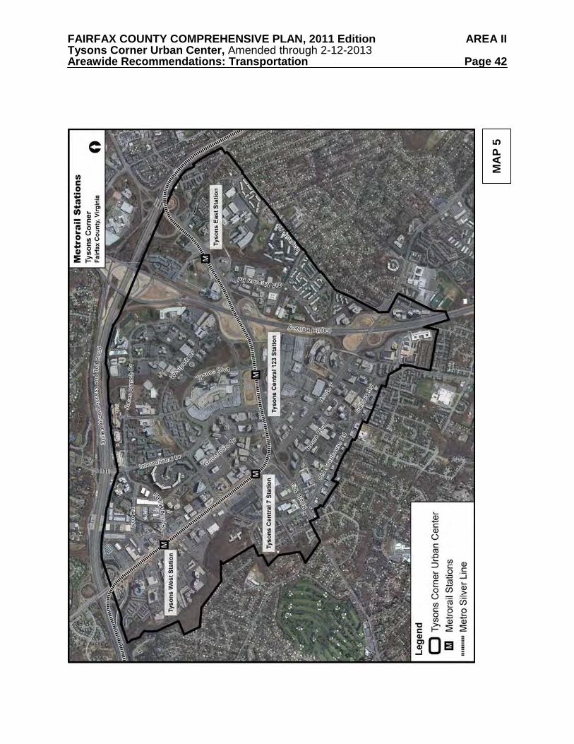
FAIRFAX COUNTY COMPREHENSIVE PLAN, 2011 Edition AREA II Tysons Corner Urban Center, Amended through 2-12-2013 Areawide Recommendations: Transportation Page 42
MA
P 5
FAIRFAX COUNTY COMPREHENSIVE PLAN, 2011 Edition AREA II Tysons Corner Urban Center, Amended through 2-12-2013 Areawide Recommendations: Transportation Page 43
Express Bus Service/Bus Rapid Transit (BRT)
Express bus service is a high-speed limited-stop service generally operating within transportation corridors oriented to a principal destination. It consists of longer trips, especially to major activity centers during peak commuting hours, and operates long distances without stopping. Bus Rapid Transit (BRT) is a limited-stop service developed in the 1990s that relies on technology to help speed up the service. It combines the quality of rail transit and the flexibility of buses. Bus Rapid Transit can operate on exclusive rights-of-way, within high-occupancy-vehicle (HOV) lanes, on expressways, or on ordinary streets.
The opening of the Beltway High Occupancy Toll (HOT) lanes with three new connections
to Tysons provides an opportunity to serve Tysons with a significant express bus network extending on the regional HOV/HOT network to destinations such as the I-95 corridor and the I-66 corridor. These corridors are identified as “Enhanced Public Transportation Corridors” in the Fairfax County Transportation Plan. This designation indicates that major public transportation facilities could be added to these corridors based on a comprehensive alternatives analysis at some point in the future.
Along with Metrorail and light rail, Bus Rapid Transit and express bus services are potential
options. Serving Tysons with robust express bus service is needed to complement Metrorail. These express buses are likely to use the Metrorail stations as terminal points and having passengers transfer there to an internal Tysons circulation system just like Metrorail passengers.
System of Circulators
In order to increase the use of Metrorail for trips to, from and within Tysons, it is essential to provide a system of transit circulators. The circulators therefore will have two main functions:
• To provide quick and convenient access for Metrorail passengers to and from locations within Tysons but beyond walking distance from the Metrorail stations
• To provide a quick and convenient way to travel within Tysons A system of circulator routes is proposed to connect most of Tysons, specifically the North Central, East Side and Old Courthouse Districts, with the four Metrorail stations and other districts in Tysons. To facilitate use of the Circulator System, it must be integrated with all other transit serving the greater Tysons area and be accessible, frequent, and convenient for users. In order to accomplish this goal, the circulators should operate in their own, dedicated right-of-way. The first phase of the Circulator System, serving the Metrorail stations immediately after opening, will be bus service operating in mixed traffic on existing rights-of-way.
Over the long term the Circulator System may evolve through several phases,
transitioning from buses operating in mixed traffic to buses operating on exclusive rights-of-way to, when feasible, a fixed guideway operating on exclusive rights-of-way. A storage and maintenance facility within Tysons will be necessary to support a fixed-guideway system. Map 6 shows a conceptual system of circulator routes that could serve Tysons once the grid and two new I-495 crossings are constructed. The ultimate alignment will likely change based upon the results of the Circulator Study and other factors, such as the availability of the necessary rights-of-way. The following objectives should guide the implementation of the Circulator System:
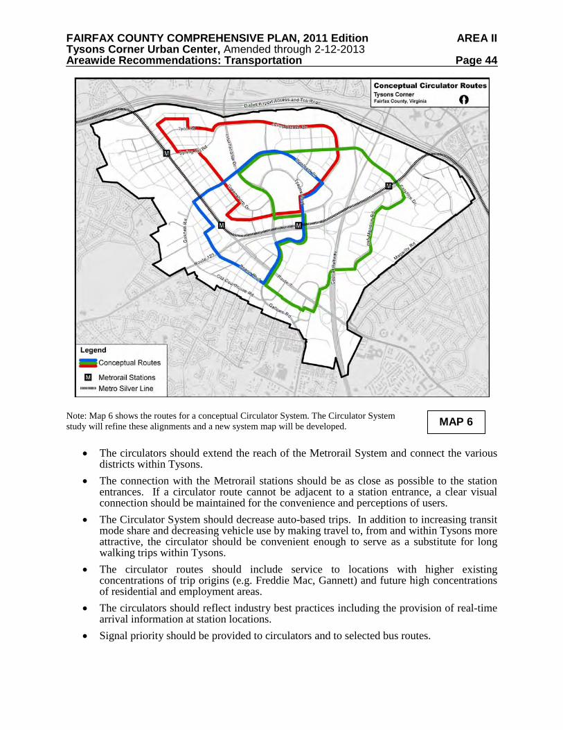
FAIRFAX COUNTY COMPREHENSIVE PLAN, 2011 Edition AREA II Tysons Corner Urban Center, Amended through 2-12-2013 Areawide Recommendations: Transportation Page 44
Note: Map 6 shows the routes for a conceptual Circulator System. The Circulator System study will refine these alignments and a new system map will be developed.
• The circulators should extend the reach of the Metrorail System and connect the various districts within Tysons.
• The connection with the Metrorail stations should be as close as possible to the station entrances. If a circulator route cannot be adjacent to a station entrance, a clear visual connection should be maintained for the convenience and perceptions of users.
• The Circulator System should decrease auto-based trips. In addition to increasing transit mode share and decreasing vehicle use by making travel to, from and within Tysons more attractive, the circulator should be convenient enough to serve as a substitute for long walking trips within Tysons.
• The circulator routes should include service to locations with higher existing concentrations of trip origins (e.g. Freddie Mac, Gannett) and future high concentrations of residential and employment areas.
• The circulators should reflect industry best practices including the provision of real-time arrival information at station locations.
• Signal priority should be provided to circulators and to selected bus routes.
MAP 6
FAIRFAX COUNTY COMPREHENSIVE PLAN, 2011 Edition AREA II Tysons Corner Urban Center, Amended through 2-12-2013 Areawide Recommendations: Transportation Page 45
• Circulator stops should be comfortable for passengers, providing protection from the weather and real-time schedule information.
• The circulators should preferably travel in both directions on each of the proposed circulator routes to maximize accessibility to the four Metrorail stations.
Local Bus Service Over one dozen bus routes currently serve the Tysons area, with about two-thirds of these routes being operated by WMATA and the others by the Fairfax Connector. These routes connect Tysons to the Metrorail system and directly to various parts of northern Virginia, including McLean, Falls Church, Vienna and Arlington. Most of the routes stop at the Tysons Corner Center and some routes provide connections to various parts of Tysons. Overall, though, these bus routes do not provide an effective circulation function within Tysons. When the Metrorail extension opens, these routes are expected to be realigned to provide better service to the new Metrorail stations, while other existing routes may be eliminated or replaced by modified routes or the extended Metrorail service. Bus service frequencies will also be modified for other routes to achieve consistency with new transit service in the corridor, to better coincide with Metrorail headways and to reduce duplication of service where it exists. Multimodal Transportation Hubs Multimodal Transportation Hubs, strategically placed close to Metrorail and circulator stations and/or other retail, employment and residential centers, are needed to allow flexibility in trip making within Tysons. These hubs should provide the following:
• Alternative modes for transit users to reach final destinations that are beyond walking distance from transit stations.
• The ability of Tysons residents and workers to travel within Tysons and beyond without the need to own or use a private vehicle.
Multimodal transportation hubs are envisioned to provide alternative modes of
transportation and transportation services including: • Transit (rail and/or bus) • Bike sharing • Car sharing • Other personal transportation devices • Taxis
Some transportation services such as bike sharing, car sharing, and other personal transportation devices can be provided by a retail service. The Road Network Overview The following principles are adapted from the document “Context Sensitive Solutions in Designing Major Urban Thoroughfares for Walkable Communities, ” published by the Institute
FAIRFAX COUNTY COMPREHENSIVE PLAN, 2011 Edition AREA II Tysons Corner Urban Center, Amended through 2-12-2013 Areawide Recommendations: Transportation Page 46
of Transportation Engineers (2008). They describe an approach to the planning and design of urban street networks that should be followed in Tysons:
• Street network planning should address mobility and access needs associated with passenger travel, goods movement, utilities placement and emergency services.
• The reservation of rights-of-way for the ultimate width of streets should be based on long term needs defined by objectives for community character and mobility.
• Street network planning should be refined and updated to define alignments and establish the role of streets as more detailed planning and development occurs.
• Street networks should provide a high level of connectivity so that drivers, pedestrians and transit users can choose the most direct routes and access urban properties. Connectivity should support the desired development patterns. Street networks should provide intermodal connectivity to easily transfer between modes.
• Street network capacity and redundancy should be provided through a dense, connected network (a grid) rather than through an emphasis on high levels of vehicle capacity on individual arterial facilities. This approach ensures that the street network can support other objectives such as pedestrian activity, multimodal safety, access to rail stations, and support for adjacent development.
Context Sensitive Solutions Context Sensitive Solutions (CSS) should be applied in the planning and design of transportation projects in and around Tysons. CSS is a process of balancing the competing needs of many stakeholders starting in the earliest stages of project development. It also includes flexibility in the application of design controls, guidelines and standards to design a facility that is safe for all users regardless of the mode of travel they choose. CSS aims to achieve the following:
• Balance safety, mobility, community and environmental goals in all projects. • Involve the public and stakeholders early and continuously throughout the planning and
project development process. • Use an interdisciplinary team tailored to project needs. • Address all modes of travel. • Apply flexibility inherent in design standards. • Incorporate aesthetics as an integral part of good design.
Grid of Streets Tysons currently consists of large superblocks with a relatively small number of streets. This places excessive reliance on the street system to move vehicle traffic, and the large block size inhibits transit use, pedestrian and bicycle movement. A grid of streets with smaller block sizes is typical in urban areas. It disperses vehicle traffic and improves mobility for pedestrians and bicyclists. A smaller block size will make a more walkable Tysons by creating convenient and short walk distances. A grid of streets concept is shown in Map 7. A perfect grid is unlikely in Tysons Corner due to the alignment of existing roads and topographical constraints. However, where possible, a grid of streets should be planned.
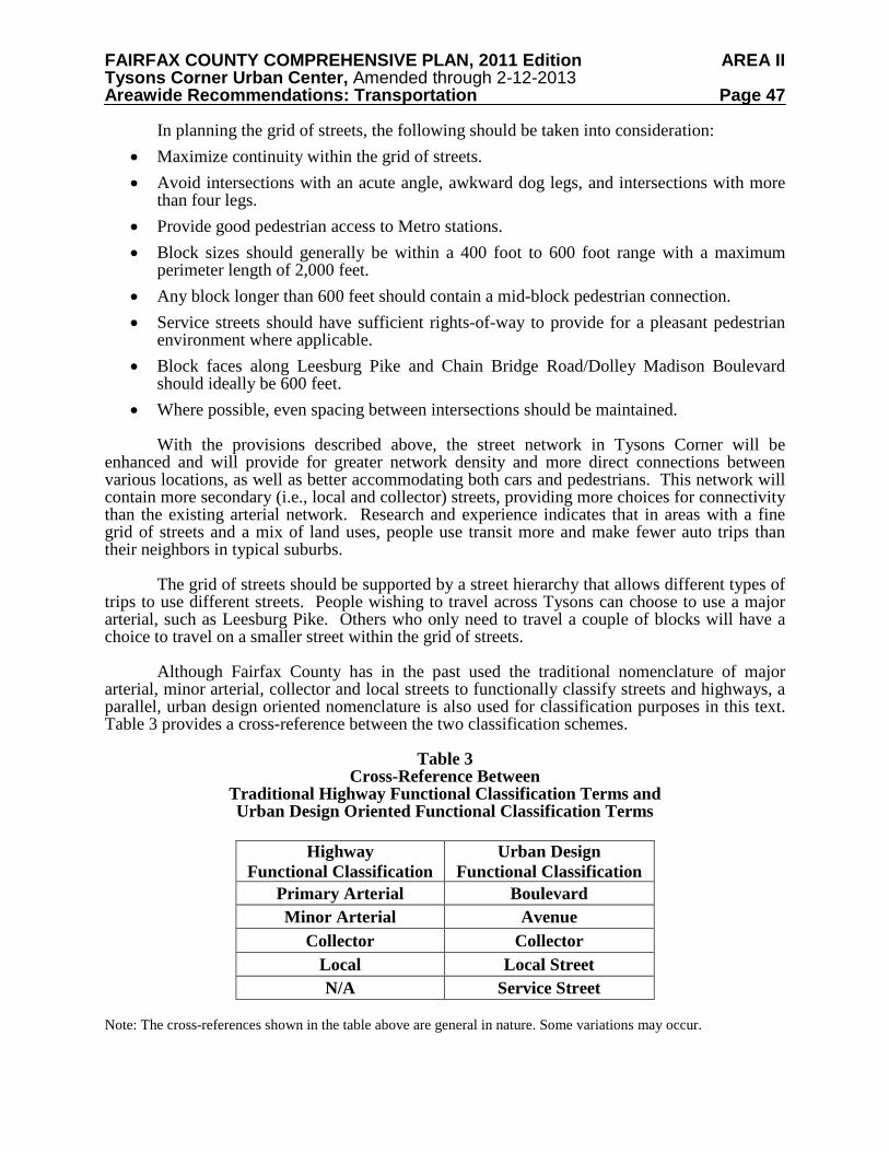
FAIRFAX COUNTY COMPREHENSIVE PLAN, 2011 Edition AREA II Tysons Corner Urban Center, Amended through 2-12-2013 Areawide Recommendations: Transportation Page 47
In planning the grid of streets, the following should be taken into consideration: • Maximize continuity within the grid of streets. • Avoid intersections with an acute angle, awkward dog legs, and intersections with more
than four legs. • Provide good pedestrian access to Metro stations. • Block sizes should generally be within a 400 foot to 600 foot range with a maximum
perimeter length of 2,000 feet. • Any block longer than 600 feet should contain a mid-block pedestrian connection. • Service streets should have sufficient rights-of-way to provide for a pleasant pedestrian
environment where applicable. • Block faces along Leesburg Pike and Chain Bridge Road/Dolley Madison Boulevard
should ideally be 600 feet. • Where possible, even spacing between intersections should be maintained.
With the provisions described above, the street network in Tysons Corner will be enhanced and will provide for greater network density and more direct connections between various locations, as well as better accommodating both cars and pedestrians. This network will contain more secondary (i.e., local and collector) streets, providing more choices for connectivity than the existing arterial network. Research and experience indicates that in areas with a fine grid of streets and a mix of land uses, people use transit more and make fewer auto trips than their neighbors in typical suburbs. The grid of streets should be supported by a street hierarchy that allows different types of trips to use different streets. People wishing to travel across Tysons can choose to use a major arterial, such as Leesburg Pike. Others who only need to travel a couple of blocks will have a choice to travel on a smaller street within the grid of streets.
Although Fairfax County has in the past used the traditional nomenclature of major arterial, minor arterial, collector and local streets to functionally classify streets and highways, a parallel, urban design oriented nomenclature is also used for classification purposes in this text. Table 3 provides a cross-reference between the two classification schemes.
Table 3 Cross-Reference Between
Traditional Highway Functional Classification Terms and Urban Design Oriented Functional Classification Terms
Highway
Functional Classification Urban Design
Functional Classification Primary Arterial Boulevard Minor Arterial Avenue
Collector Collector Local Local Street N/A Service Street
Note: The cross-references shown in the table above are general in nature. Some variations may occur.
FAIRFAX COUNTY COMPREHENSIVE PLAN, 2011 Edition AREA II Tysons Corner Urban Center, Amended through 2-12-2013 Areawide Recommendations: Transportation Page 48
Map 7 shows a functional classification of the Tysons street network, including the grid
of streets, HOT lane ramps and proposed ramps to the DAAR. The functional classification of streets in Tysons should be updated as the results of further related studies become available. Map 7 shows the conceptual grid of streets for Tysons Corner, including service streets. Future engineering analyses will result in updated versions of this map. It is expected that the design and construction of grid segments necessary to maintain acceptable traffic circulation for an individual development will be provided by that development. Official Map of Public Streets in Tysons
The proposed “Grid of Streets” is critical to the future form and function of Tysons. The implementation of this network of arterials and local streets will be extremely challenging. Engineering studies will be done to refine the conceptual grid shown above. Consideration should be given to creating and adopting an “official map” of public streets in Tysons. An official map is a description of planned public streets. This map will establish the location and character of the public street network. It should be created with input and cooperation from local landowners, the Virginia Department of Transportation, and the Fairfax County Department of Transportation, and be adopted by the County. The official map would be based on conceptual engineering sufficient to determine the center line and width of the right-of-way, in order to determine what is feasible to implement in each area. Adoption of an official map would help in the review of development applications. Street Types and Design Guidelines
Street types describe the street as an element of the comprehensive framework of Tysons. Street types respond to the needs of traffic from vehicles, bicycles and pedestrians. Street types in Tysons have been identified, with a conceptual overview of each type’s functionality, cross-section, scale, modal mix, and character provided on the following pages. The cross-section for each street type contains flexibility to be able to respond to particular needs in different locations.
Within Tysons Corner, pavement cross-sections are to be designed to fit in an urban
environment meeting the goals of Context Sensitive Solutions (CSS) while addressing safety, operations, and capacity needs. The following should be taken into consideration in the design of streets in Tysons Corner:
• Continuity of streets is desirable in order to achieve a more effective grid. • Streets in Tysons Corner will be designed as complete streets, addressing the pedestrian
experience and contributing to creating great places. By definition, complete streets are designed and operated to enable safe access and movement for pedestrians, bicyclists, motorists and transit riders of all ages and abilities. Streets in TOD areas are expected to be attractive environments for walking, commerce, and casual interaction in addition to their function of moving traffic.
• Urban design guidelines for streets, including enhanced pedestrian elements such as sidewalks buffered from traffic by street trees, and bicycle enhancements such as separate bike lanes, address the elements of a complete street. Although typical street cross sections are included below, final street designs may include some variations, such as lane width, sidewalk width, or building setback to reflect the changing context of the street as it passes through the many neighborhoods and districts within Tysons.
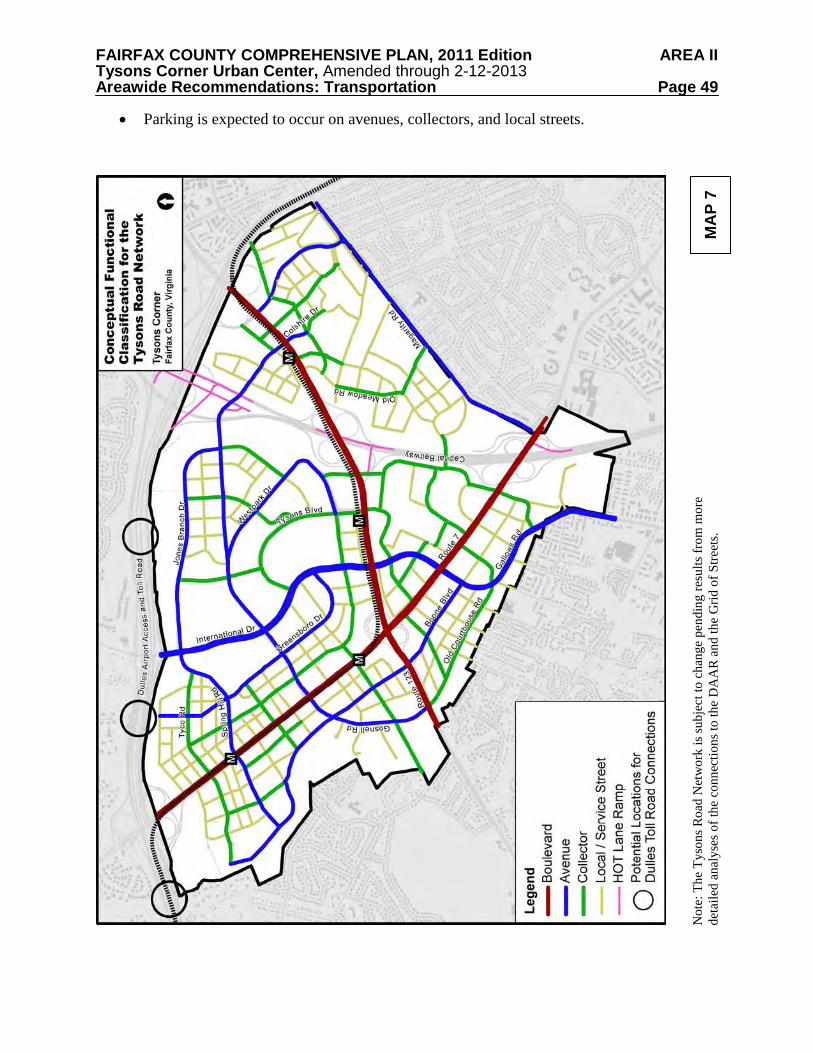
FAIRFAX COUNTY COMPREHENSIVE PLAN, 2011 Edition AREA II Tysons Corner Urban Center, Amended through 2-12-2013 Areawide Recommendations: Transportation Page 49
• Parking is expected to occur on avenues, collectors, and local streets.
Not
e: T
he T
yson
s Roa
d N
etw
ork
is su
bjec
t to
chan
ge p
endi
ng re
sults
from
mor
e de
taile
d an
alys
es o
f the
con
nect
ions
to th
e D
AA
R a
nd th
e G
rid o
f Stre
ets.
MA
P 7
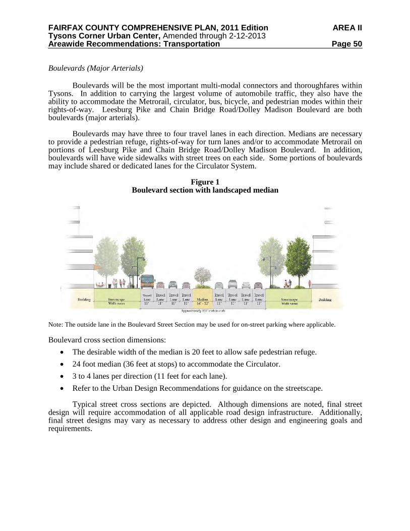
FAIRFAX COUNTY COMPREHENSIVE PLAN, 2011 Edition AREA II Tysons Corner Urban Center, Amended through 2-12-2013 Areawide Recommendations: Transportation Page 50
Boulevards (Major Arterials) Boulevards will be the most important multi-modal connectors and thoroughfares within Tysons. In addition to carrying the largest volume of automobile traffic, they also have the ability to accommodate the Metrorail, circulator, bus, bicycle, and pedestrian modes within their rights-of-way. Leesburg Pike and Chain Bridge Road/Dolley Madison Boulevard are both boulevards (major arterials). Boulevards may have three to four travel lanes in each direction. Medians are necessary to provide a pedestrian refuge, rights-of-way for turn lanes and/or to accommodate Metrorail on portions of Leesburg Pike and Chain Bridge Road/Dolley Madison Boulevard. In addition, boulevards will have wide sidewalks with street trees on each side. Some portions of boulevards may include shared or dedicated lanes for the Circulator System.
Figure 1 Boulevard section with landscaped median
Note: The outside lane in the Boulevard Street Section may be used for on-street parking where applicable. Boulevard cross section dimensions:
• The desirable width of the median is 20 feet to allow safe pedestrian refuge. • 24 foot median (36 feet at stops) to accommodate the Circulator. • 3 to 4 lanes per direction (11 feet for each lane). • Refer to the Urban Design Recommendations for guidance on the streetscape.
Typical street cross sections are depicted. Although dimensions are noted, final street design will require accommodation of all applicable road design infrastructure. Additionally, final street designs may vary as necessary to address other design and engineering goals and requirements.
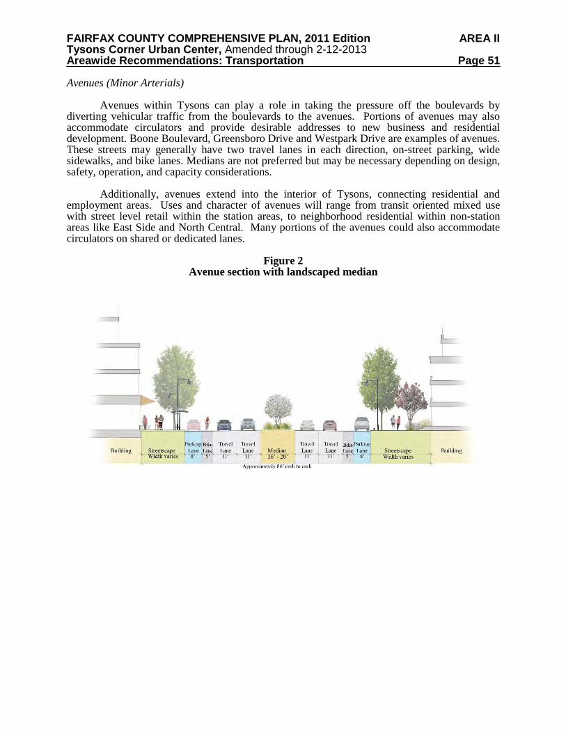
FAIRFAX COUNTY COMPREHENSIVE PLAN, 2011 Edition AREA II Tysons Corner Urban Center, Amended through 2-12-2013 Areawide Recommendations: Transportation Page 51
Avenues (Minor Arterials) Avenues within Tysons can play a role in taking the pressure off the boulevards by diverting vehicular traffic from the boulevards to the avenues. Portions of avenues may also accommodate circulators and provide desirable addresses to new business and residential development. Boone Boulevard, Greensboro Drive and Westpark Drive are examples of avenues. These streets may generally have two travel lanes in each direction, on-street parking, wide sidewalks, and bike lanes. Medians are not preferred but may be necessary depending on design, safety, operation, and capacity considerations.
Additionally, avenues extend into the interior of Tysons, connecting residential and employment areas. Uses and character of avenues will range from transit oriented mixed use with street level retail within the station areas, to neighborhood residential within non-station areas like East Side and North Central. Many portions of the avenues could also accommodate circulators on shared or dedicated lanes.
Figure 2
Avenue section with landscaped median
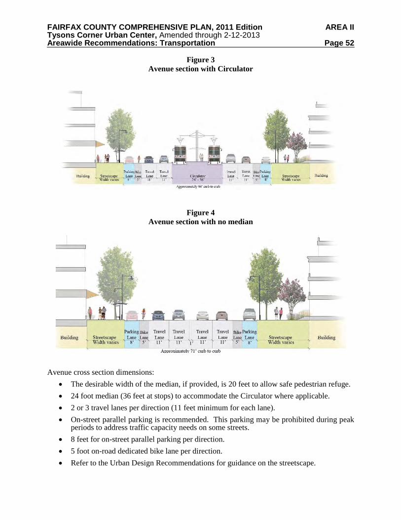
FAIRFAX COUNTY COMPREHENSIVE PLAN, 2011 Edition AREA II Tysons Corner Urban Center, Amended through 2-12-2013 Areawide Recommendations: Transportation Page 52
Figure 3 Avenue section with Circulator
Figure 4 Avenue section with no median
Avenue cross section dimensions:
• The desirable width of the median, if provided, is 20 feet to allow safe pedestrian refuge. • 24 foot median (36 feet at stops) to accommodate the Circulator where applicable. • 2 or 3 travel lanes per direction (11 feet minimum for each lane). • On-street parallel parking is recommended. This parking may be prohibited during peak
periods to address traffic capacity needs on some streets. • 8 feet for on-street parallel parking per direction. • 5 foot on-road dedicated bike lane per direction. • Refer to the Urban Design Recommendations for guidance on the streetscape.
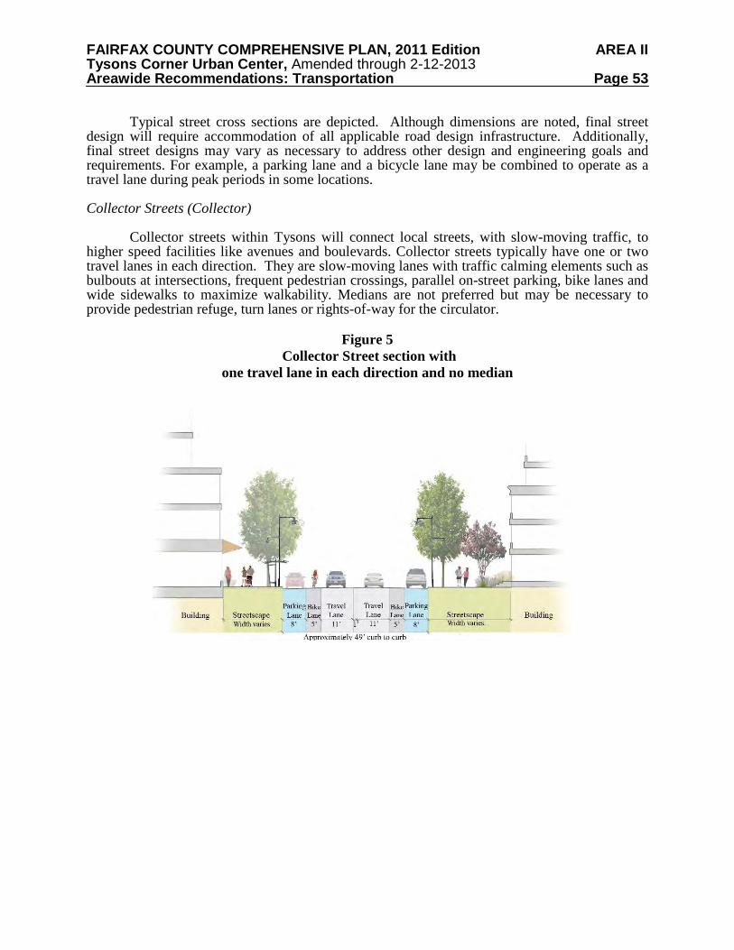
FAIRFAX COUNTY COMPREHENSIVE PLAN, 2011 Edition AREA II Tysons Corner Urban Center, Amended through 2-12-2013 Areawide Recommendations: Transportation Page 53
Typical street cross sections are depicted. Although dimensions are noted, final street design will require accommodation of all applicable road design infrastructure. Additionally, final street designs may vary as necessary to address other design and engineering goals and requirements. For example, a parking lane and a bicycle lane may be combined to operate as a travel lane during peak periods in some locations. Collector Streets (Collector) Collector streets within Tysons will connect local streets, with slow-moving traffic, to higher speed facilities like avenues and boulevards. Collector streets typically have one or two travel lanes in each direction. They are slow-moving lanes with traffic calming elements such as bulbouts at intersections, frequent pedestrian crossings, parallel on-street parking, bike lanes and wide sidewalks to maximize walkability. Medians are not preferred but may be necessary to provide pedestrian refuge, turn lanes or rights-of-way for the circulator.
Figure 5 Collector Street section with
one travel lane in each direction and no median
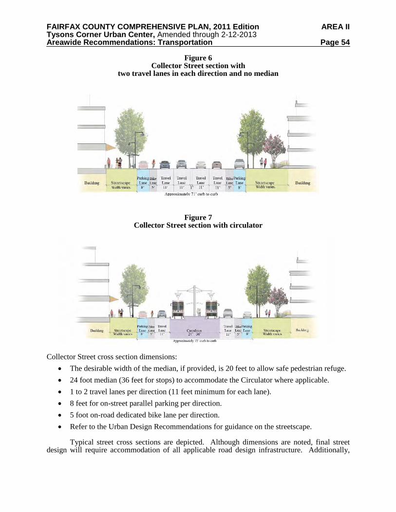
FAIRFAX COUNTY COMPREHENSIVE PLAN, 2011 Edition AREA II Tysons Corner Urban Center, Amended through 2-12-2013 Areawide Recommendations: Transportation Page 54
Figure 6 Collector Street section with
two travel lanes in each direction and no median
Figure 7
Collector Street section with circulator
Collector Street cross section dimensions:
• The desirable width of the median, if provided, is 20 feet to allow safe pedestrian refuge. • 24 foot median (36 feet for stops) to accommodate the Circulator where applicable. • 1 to 2 travel lanes per direction (11 feet minimum for each lane). • 8 feet for on-street parallel parking per direction. • 5 foot on-road dedicated bike lane per direction. • Refer to the Urban Design Recommendations for guidance on the streetscape.
Typical street cross sections are depicted. Although dimensions are noted, final street design will require accommodation of all applicable road design infrastructure. Additionally,
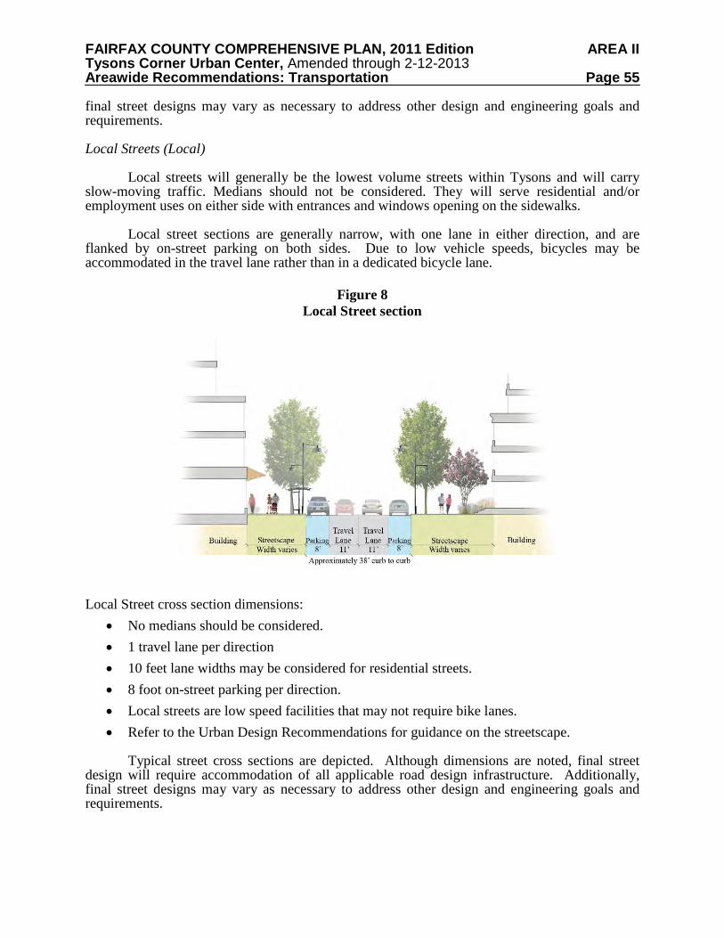
FAIRFAX COUNTY COMPREHENSIVE PLAN, 2011 Edition AREA II Tysons Corner Urban Center, Amended through 2-12-2013 Areawide Recommendations: Transportation Page 55
final street designs may vary as necessary to address other design and engineering goals and requirements. Local Streets (Local) Local streets will generally be the lowest volume streets within Tysons and will carry slow-moving traffic. Medians should not be considered. They will serve residential and/or employment uses on either side with entrances and windows opening on the sidewalks. Local street sections are generally narrow, with one lane in either direction, and are flanked by on-street parking on both sides. Due to low vehicle speeds, bicycles may be accommodated in the travel lane rather than in a dedicated bicycle lane.
Figure 8 Local Street section
Local Street cross section dimensions:
• No medians should be considered. • 1 travel lane per direction • 10 feet lane widths may be considered for residential streets. • 8 foot on-street parking per direction. • Local streets are low speed facilities that may not require bike lanes. • Refer to the Urban Design Recommendations for guidance on the streetscape.
Typical street cross sections are depicted. Although dimensions are noted, final street design will require accommodation of all applicable road design infrastructure. Additionally, final street designs may vary as necessary to address other design and engineering goals and requirements.
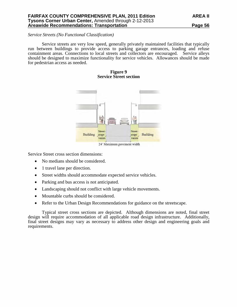
FAIRFAX COUNTY COMPREHENSIVE PLAN, 2011 Edition AREA II Tysons Corner Urban Center, Amended through 2-12-2013 Areawide Recommendations: Transportation Page 56
Service Streets (No Functional Classification) Service streets are very low speed, generally privately maintained facilities that typically run between buildings to provide access to parking garage entrances, loading and refuse containment areas. Connections to local streets and collectors are encouraged. Service alleys should be designed to maximize functionality for service vehicles. Allowances should be made for pedestrian access as needed.
Figure 9 Service Street section
Service Street cross section dimensions:
• No medians should be considered. • 1 travel lane per direction. • Street widths should accommodate expected service vehicles. • Parking and bus access is not anticipated. • Landscaping should not conflict with large vehicle movements. • Mountable curbs should be considered. • Refer to the Urban Design Recommendations for guidance on the streetscape.
Typical street cross sections are depicted. Although dimensions are noted, final street design will require accommodation of all applicable road design infrastructure. Additionally, final street designs may vary as necessary to address other design and engineering goals and requirements.
FAIRFAX COUNTY COMPREHENSIVE PLAN, 2011 Edition AREA II Tysons Corner Urban Center, Amended through 2-12-2013 Areawide Recommendations: Transportation Page 57
Highway Connections and Beltway Crossings
Physical improvements to the roadway and transportation infrastructure are necessary to achieve critical access and egress for Tysons. In addition to the grid of streets, the following improvements should be constructed.
• A new I-495 crossing connecting Jones Branch Drive to Scotts Crossing Road (extension of High Occupancy Toll connection), including pedestrian and bicycle access.
• A new I-495 crossing connecting the Tysons Corner Center area to Old Meadow Road (limited to transit, pedestrians and bicyclists).
• Ramps connecting Greensboro Drive extension to westbound DAAR. • Ramps connecting Boone Boulevard extension to westbound DAAR and eastbound
DAAR to the Boone Boulevard extension. • Ramps connecting Jones Branch Drive to westbound DAAR and eastbound DAAR to
Jones Branch Drive. • A collector-distributor road system on the DAAR between the Leesburg Pike interchange
area and the Hunter Mill interchange area. • An additional lane on the Outer Loop of I-495 between the Leesburg Pike on-ramp and I-
66. • Interchange improvements at DAAR and Leesburg Pike; and • Interchange improvements at DAAR and Spring Hill Road.
These improvements need to be designed to fit into the new Tysons, sensitive to the
context in which they will be implemented. The connections to the DAAR listed above and their exact locations are subject to more detailed analyses. A preliminary analysis found that a maximum of two additional ramps entering Tysons from the DAAR and two additional ramps exiting Tysons to the DAAR is necessary. Bicycle Network
Tysons’ existing transportation network, with its superblocks, suburban character, and auto-related land uses, makes bicycling a challenge. Despite these conditions, Tysons has significantly more bicycle trips in, around, and through than other areas of the County.
In 2006, the Board of Supervisors unanimously approved a comprehensive bicycle initiative, a program designed to encourage bicycling and make Fairfax County bicycle friendly and safe. New streets will be designed and older streets retro-fitted to better accommodate bicycles. Transit options will become bike friendly with the addition of buses equipped with bicycle racks. Ample safe, secure, and convenient bicycle parking will be installed countywide. Comprehensive wayfinding signage will provide guidance and information about destinations and paths, while a network of interconnected shared use paths, interfacing with an on-road bike network, will establish a cohesive and connected transportation environment conducive to bicycling. The Tysons Corner Urban Center plan affords an opportunity to incorporate these elements of bicycling, making Tysons Corner a bicycle friendly community.
A conceptual bicycle network is shown on Map 8. A bicycle master plan study has been
initiated for the greater Tysons area. Once completed, bicycle routes in, around, and through the urban center will be refined and Map 8 will be updated. It should be noted that bicycles facilities are shown on Leesburg Pike and Chain Bridge road/Dolley Madison Boulevard entering Tysons.
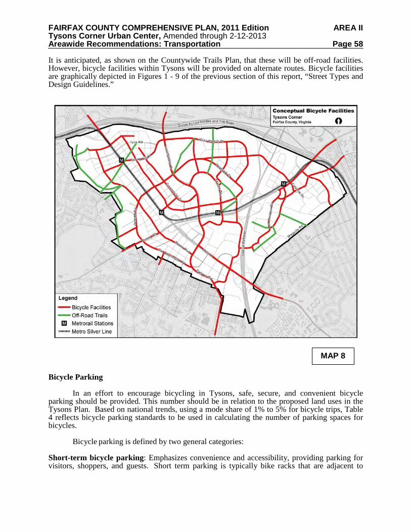
FAIRFAX COUNTY COMPREHENSIVE PLAN, 2011 Edition AREA II Tysons Corner Urban Center, Amended through 2-12-2013 Areawide Recommendations: Transportation Page 58
It is anticipated, as shown on the Countywide Trails Plan, that these will be off-road facilities. However, bicycle facilities within Tysons will be provided on alternate routes. Bicycle facilities are graphically depicted in Figures 1 - 9 of the previous section of this report, “Street Types and Design Guidelines.”
Bicycle Parking
In an effort to encourage bicycling in Tysons, safe, secure, and convenient bicycle parking should be provided. This number should be in relation to the proposed land uses in the Tysons Plan. Based on national trends, using a mode share of 1% to 5% for bicycle trips, Table 4 reflects bicycle parking standards to be used in calculating the number of parking spaces for bicycles.
Bicycle parking is defined by two general categories:
Short-term bicycle parking: Emphasizes convenience and accessibility, providing parking for visitors, shoppers, and guests. Short term parking is typically bike racks that are adjacent to
MAP 8
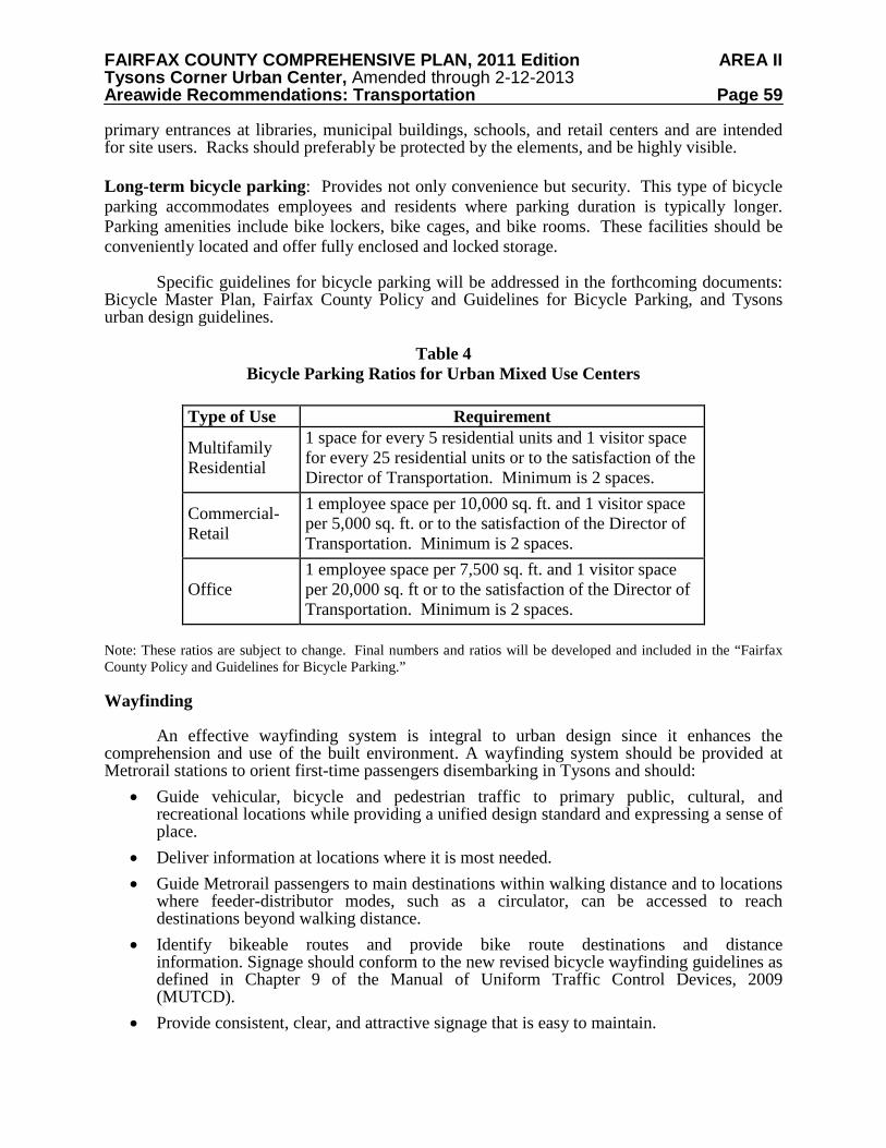
FAIRFAX COUNTY COMPREHENSIVE PLAN, 2011 Edition AREA II Tysons Corner Urban Center, Amended through 2-12-2013 Areawide Recommendations: Transportation Page 59
primary entrances at libraries, municipal buildings, schools, and retail centers and are intended for site users. Racks should preferably be protected by the elements, and be highly visible. Long-term bicycle parking: Provides not only convenience but security. This type of bicycle parking accommodates employees and residents where parking duration is typically longer. Parking amenities include bike lockers, bike cages, and bike rooms. These facilities should be conveniently located and offer fully enclosed and locked storage.
Specific guidelines for bicycle parking will be addressed in the forthcoming documents:
Bicycle Master Plan, Fairfax County Policy and Guidelines for Bicycle Parking, and Tysons urban design guidelines.
Table 4
Bicycle Parking Ratios for Urban Mixed Use Centers
Type of Use Requirement
Multifamily Residential
1 space for every 5 residential units and 1 visitor space for every 25 residential units or to the satisfaction of the Director of Transportation. Minimum is 2 spaces.
Commercial-Retail
1 employee space per 10,000 sq. ft. and 1 visitor space per 5,000 sq. ft. or to the satisfaction of the Director of Transportation. Minimum is 2 spaces.
Office 1 employee space per 7,500 sq. ft. and 1 visitor space per 20,000 sq. ft or to the satisfaction of the Director of Transportation. Minimum is 2 spaces.
Note: These ratios are subject to change. Final numbers and ratios will be developed and included in the “Fairfax County Policy and Guidelines for Bicycle Parking.” Wayfinding
An effective wayfinding system is integral to urban design since it enhances the comprehension and use of the built environment. A wayfinding system should be provided at Metrorail stations to orient first-time passengers disembarking in Tysons and should:
• Guide vehicular, bicycle and pedestrian traffic to primary public, cultural, and recreational locations while providing a unified design standard and expressing a sense of place.
• Deliver information at locations where it is most needed. • Guide Metrorail passengers to main destinations within walking distance and to locations
where feeder-distributor modes, such as a circulator, can be accessed to reach destinations beyond walking distance.
• Identify bikeable routes and provide bike route destinations and distance information. Signage should conform to the new revised bicycle wayfinding guidelines as defined in Chapter 9 of the Manual of Uniform Traffic Control Devices, 2009 (MUTCD).
• Provide consistent, clear, and attractive signage that is easy to maintain.
FAIRFAX COUNTY COMPREHENSIVE PLAN, 2011 Edition AREA II Tysons Corner Urban Center, Amended through 2-12-2013 Areawide Recommendations: Transportation Page 60
• Include stakeholder involvement in the design of the system. • Include signs that are designed to easily accommodate changes in the venues listed on the
signs. • Include real-time parking availability information.
Detailed guidelines for wayfinding signage will be addressed in the forthcoming Tysons urban design guidelines. Level of Service Impacts on Roads An overall Level of Service (LOS) ‘E’ goal is expected for the street network in Tysons Corner. At locations where a LOS E standard cannot be attained or maintained with planned development, remedies should be proposed to offset impacts using the tiered approach described below. The purpose of this tiered approach is to support implementation of the grid of streets, which is more typical of urban areas and improves mobility for pedestrians and bicyclists. In the development review process, mitigation of problem locations should follow the following sequence:
1. First, determine whether addition of capacity and/or increased operational efficiency is possible to achieve without decreasing pedestrian walkability and safety. The widening of roads by adding exclusive turn lanes and/or through lanes will in most cases not be desirable since it will increase street widths at intersections and therefore work against an attractive environment for pedestrians. In lieu of the addition of lanes, it is preferable to add links to the grid of streets where applicable and possible to promote the build out of the grid of streets and to create additional diversionary paths for vehicles, and in so doing, to decrease the traffic at problem locations in the vicinity of a proposed development.
2. Failing that, decrease future site-generated traffic by: changing the mix of land use within
the parameters of the applicable land use guidelines for Tysons (e.g., replacing office or retail uses with residential use), increasing transit use through provision of additional and improved services, and/or optimizing the application of TDM measures which might include greater transit use, walking and bicycling.
3. If the previous measures do not provide adequate improvement of LOS, a development
proposal or phase of development may need to be conditioned on completion of offsetting improvements. Financial contributions of significant value dedicated to addressing deficiencies in the Tysons area may be considered as an offsetting improvement. These contributions may not be used as a credit against other contributions toward off-site transportation improvements.
Impacts on Transit, Pedestrian, and Bicycle Facilities A high level of service should be maintained for transit users that minimizes delay, the need for transfers, and transfer delay. Where it is not possible to maintain a high level of transit service because of extraordinarily high costs, monetary contributions to a fund for the eventual improvement of transit service should be provided in lieu of the maintenance of a high quality transit service. An acceptable level of transit service nevertheless needs to be maintained.
FAIRFAX COUNTY COMPREHENSIVE PLAN, 2011 Edition AREA II Tysons Corner Urban Center, Amended through 2-12-2013 Areawide Recommendations: Transportation Page 61
A high level of service should be maintained for pedestrians and cyclists, including safety
and security, direct pathways, reasonable grades, and minimized delays at intersections. Within TOD areas, preference should be given to the maintenance of a high level of service for transit, cyclists, and pedestrians. Impact studies within TOD areas should quantify the level of service for all applicable modes (vehicular, transit, pedestrians, and cyclists) by applying up-to-date, standard techniques. TRANSPORTATION MANAGEMENT Transportation Demand Management
Transportation Demand Management (TDM) refers to a variety of strategies aimed at reducing the demand on the transportation system, particularly to reducing single occupant vehicles during peak periods, and expanding the choices available to residents, employees, shoppers and visitors. The result is more efficient use of the existing transportation system. Transportation Demand Management is a critical component of this Plan. Traffic needs to be minimized to decrease congestion within Tysons, to create livable and walkable spaces, and to minimize the effects of traffic on neighboring communities.
When the four Metrorail stations open in Tysons and denser mixed use transit-oriented development is constructed surrounding the stations, a substantial percentage of travelers are expected to commute via Metrorail without any TDM programs in place. This development pattern will also reduce the need for driving trips because jobs, housing, shopping, recreational and cultural opportunities will be close at hand and accessible by walking or a short transit ride.
A broad, systematic, and integrated program of TDM strategies throughout Tysons can further reduce peak period single occupancy vehicle trips, as well as increase the percentage of travelers using transit and non-vehicular modes of transportation. TDM programs should embrace the latest information technology techniques to encourage teleworking, provide sufficient information to enable commuters and other trip makers to choose travel modes and travel times, or decide if travel is actually necessary at that time.
A large component of TDM will be the promotion of the programs to the various stakeholders within Tysons. A Transportation Management Association should be established to coordinate TDM outreach. At a minimum, development proposals should include the following elements associated with their TDM program:
• Indicate the trip reduction goals over time (2050 and interim development levels) by using the values specified in Table 5.
• TDM implementation plans. TDM implementation plans should include at least the following: o Evaluations of potential TDM measures o Listing of TDM measures to be provided o Listing of alternate TDM measures which may be provided o Phased trip reduction goals o Implementation budgets
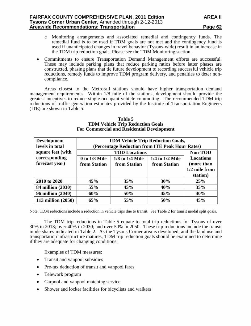
FAIRFAX COUNTY COMPREHENSIVE PLAN, 2011 Edition AREA II Tysons Corner Urban Center, Amended through 2-12-2013 Areawide Recommendations: Transportation Page 62
o Monitoring arrangements and associated remedial and contingency funds. The remedial fund is to be used if TDM goals are not met and the contingency fund is used if unanticipated changes in travel behavior (Tysons-wide) result in an increase in the TDM trip reduction goals. Please see the TDM Monitoring section.
• Commitments to ensure Transportation Demand Management efforts are successful. These may include parking plans that reduce parking ratios before latter phases are constructed, phasing plans that tie future development to recording successful vehicle trip reductions, remedy funds to improve TDM program delivery, and penalties to deter non-compliance.
Areas closest to the Metrorail stations should have higher transportation demand
management requirements. Within 1/8 mile of the stations, development should provide the greatest incentives to reduce single-occupant vehicle commuting. The recommended TDM trip reductions of traffic generation estimates provided by the Institute of Transportation Engineers (ITE) are shown in Table 5.
Table 5
TDM Vehicle Trip Reduction Goals For Commercial and Residential Development
Development levels in total square feet (with corresponding forecast year)
TDM Vehicle Trip Reduction Goals, (Percentage Reduction from ITE Peak Hour Rates)
TOD Locations Non-TOD Locations
(more than 1/2 mile from
station)
0 to 1/8 Mile from Station
1/8 to 1/4 Mile from Station
1/4 to 1/2 Mile from Station
2010 to 2020 45% 35% 30% 25% 84 million (2030) 55% 45% 40% 35% 96 million (2040) 60% 50% 45% 40% 113 million (2050) 65% 55% 50% 45%
Note: TDM reductions include a reduction in vehicle trips due to transit. See Table 2 for transit modal split goals. The TDM trip reductions in Table 5 equate to total trip reductions for Tysons of over 30% in 2013; over 40% in 2030; and over 50% in 2050. These trip reductions include the transit mode shares indicated in Table 2. As the Tysons Corner area is developed, and the land use and transportation infrastructure matures, TDM trip reduction goals should be examined to determine if they are adequate for changing conditions.
Examples of TDM measures:
• Transit and vanpool subsidies • Pre-tax deduction of transit and vanpool fares • Telework program • Carpool and vanpool matching service • Shower and locker facilities for bicyclists and walkers
FAIRFAX COUNTY COMPREHENSIVE PLAN, 2011 Edition AREA II Tysons Corner Urban Center, Amended through 2-12-2013 Areawide Recommendations: Transportation Page 63
• Secure and weatherproof bicycle parking • Carpool and vanpool preferential parking • On-site car-sharing vehicle • Employee shuttle • Guaranteed Ride Home Program • Commuter information center (bulletin board, web site, brochure table) • Employee Transportation Coordinator (ETC) • Flexible or alternative work hours • TDM education programs directed at the public and employers
TDM programs will only work where parking is not over-supplied, and will be most
effective where parking costs are charged directly to users. TDM programs must be coordinated with parking reductions and/or management programs. Parking Management
In 2009 Tysons had more land devoted to cars than to people with approximately 167,000 parking spaces covering 40 million square feet. This amount of parking far exceeds what is necessary for adequate parking. Much of this has occurred because there is no convenient internal circulation system or adequate pedestrian-friendly street and sidewalk network in Tysons. Additionally, there is limited inter-parcel access and shared-use parking. Each development provides parking for its own peak demand, an approach that often leads to excess parking supply and a wasted use of resources.
A change in philosophy of regulating parking is needed to put Tysons on the forefront of
sustainable growth. Parking in the TOD Districts should follow the experience of successful TOD areas around the country by limiting the amount of parking required near rail stations. In the Non-TOD Districts, reductions from conventional parking ratios are required to achieve Tysons-wide trip reduction goals.
For all nonresidential uses, minimum parking requirements are eliminated within 1/2 mile
of rail stations. Minimum parking requirements are reduced for all uses located outside of TOD Districts. A parking plan should be submitted along with all development applications. The parking plan should include, along with other required elements, information to demonstrate that the planned loading facilities are adequate for the planned uses. The loading plan may count new, on-street loading areas and synergies among planned uses, to limit the need for additional loading spaces.
To avoid oversupply of parking, maximum parking requirements are set for all areas.
Shared parking and the use of existing excess off-site parking are encouraged. Parking rates are indicated in Table 6.
It may be appropriate, in developments with long implementation horizons, to use more
parking than indicated in Table 6 for initial phases of development, provided that the following stipulations are adhered to:
• Existing off-site parking should be used to provide parking in excess of the parking ratios in Table 6 during initial phases of development.
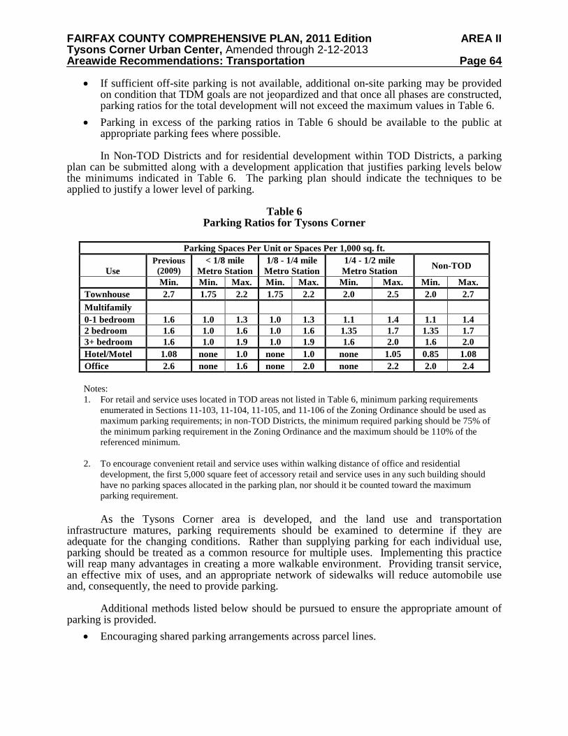
FAIRFAX COUNTY COMPREHENSIVE PLAN, 2011 Edition AREA II Tysons Corner Urban Center, Amended through 2-12-2013 Areawide Recommendations: Transportation Page 64
• If sufficient off-site parking is not available, additional on-site parking may be provided on condition that TDM goals are not jeopardized and that once all phases are constructed, parking ratios for the total development will not exceed the maximum values in Table 6.
• Parking in excess of the parking ratios in Table 6 should be available to the public at appropriate parking fees where possible. In Non-TOD Districts and for residential development within TOD Districts, a parking
plan can be submitted along with a development application that justifies parking levels below the minimums indicated in Table 6. The parking plan should indicate the techniques to be applied to justify a lower level of parking.
Table 6
Parking Ratios for Tysons Corner
Parking Spaces Per Unit or Spaces Per 1,000 sq. ft.
Use Previous
(2009) < 1/8 mile
Metro Station 1/8 - 1/4 mile
Metro Station 1/4 - 1/2 mile
Metro Station Non-TOD Min. Min. Max. Min. Max. Min. Max. Min. Max.
Townhouse 2.7 1.75 2.2 1.75 2.2 2.0 2.5 2.0 2.7 Multifamily 0-1 bedroom 1.6 1.0 1.3 1.0 1.3 1.1 1.4 1.1 1.4 2 bedroom 1.6 1.0 1.6 1.0 1.6 1.35 1.7 1.35 1.7 3+ bedroom 1.6 1.0 1.9 1.0 1.9 1.6 2.0 1.6 2.0 Hotel/Motel 1.08 none 1.0 none 1.0 none 1.05 0.85 1.08 Office 2.6 none 1.6 none 2.0 none 2.2 2.0 2.4
Notes: 1. For retail and service uses located in TOD areas not listed in Table 6, minimum parking requirements
enumerated in Sections 11-103, 11-104, 11-105, and 11-106 of the Zoning Ordinance should be used as maximum parking requirements; in non-TOD Districts, the minimum required parking should be 75% of the minimum parking requirement in the Zoning Ordinance and the maximum should be 110% of the referenced minimum.
2. To encourage convenient retail and service uses within walking distance of office and residential
development, the first 5,000 square feet of accessory retail and service uses in any such building should have no parking spaces allocated in the parking plan, nor should it be counted toward the maximum parking requirement. As the Tysons Corner area is developed, and the land use and transportation
infrastructure matures, parking requirements should be examined to determine if they are adequate for the changing conditions. Rather than supplying parking for each individual use, parking should be treated as a common resource for multiple uses. Implementing this practice will reap many advantages in creating a more walkable environment. Providing transit service, an effective mix of uses, and an appropriate network of sidewalks will reduce automobile use and, consequently, the need to provide parking.
Additional methods listed below should be pursued to ensure the appropriate amount of
parking is provided. • Encouraging shared parking arrangements across parcel lines.
FAIRFAX COUNTY COMPREHENSIVE PLAN, 2011 Edition AREA II Tysons Corner Urban Center, Amended through 2-12-2013 Areawide Recommendations: Transportation Page 65
• Creating a parking management entity to coordinate shared parking efforts, enforce parking regulations, apply parking pricing strategies where beneficial, and monitor parking demand and supply regularly.
• Securing parking management agreements such as parking pricing. • Unbundling parking from commercial and residential leases and sales. • Allowing on-street parking, and where appropriate, counting those spaces towards
parking requirements. • Implementing “Smart Parking” technology to maximize parking utilization. • Providing preferential parking for carpools, vanpools, and car-sharing vehicles. • Reductions for shared parking on mixed use sites.
Information and Communications Technology and Intelligent Transportation Systems The application of Information and Communications Technology (ICT) in Tysons Corner has the potential to decrease congestion, increase safety, make trip making more convenient, reduce emissions and improve trip-making decisions. More specifically the following are examples of goals for the application of ICT in Tysons:
• Electronic information infrastructure that works in concert with physical infrastructure to maximize the efficiency and utility of the system, encouraging modal integration and consumer choice.
• Real-time information for operators and users of the transportation system to help contain congestion and increase the effective capacity of the system while reducing the need for new construction.
• Facilities, technology and information that help reduce energy consumption and negative environmental impact. ICT can be used to not only monitor and mitigate traffic congestion, but also to enhance
emergency services in Tysons Corner. Through the use of street sensors, signal control transmitters and video surveillance cameras, real-time traffic management can take place. GPS and other technology can also help public safety personnel respond to incidents in a timely manner. As part of ICT, intelligent transportation systems (ITS) should be applied to the fullest extent possible. Main components of ITS include:
• Traffic management systems. These systems make use of information collected by traffic surveillance devices to smooth the flow of traffic along travel corridors. They also disseminate important information about travel conditions to travelers.
• Crash prevention and safety systems detect unsafe conditions and provide warnings to travelers to take action to avoid crashes.
• Roadway operations and maintenance focus on integrated management of maintenance fleets, specialized service vehicles, hazardous road conditions remediation, and work zone mobility and safety.
• Transit ITS services include surveillance and communications, such as automated vehicle location (AVL) systems, computer-aided dispatch (CAD) systems, and remote vehicle and facility surveillance cameras, which enable increases in operational efficiency, safety, and security.
FAIRFAX COUNTY COMPREHENSIVE PLAN, 2011 Edition AREA II Tysons Corner Urban Center, Amended through 2-12-2013 Areawide Recommendations: Transportation Page 66
• Emergency management applications include hazardous materials management, the deployment of emergency medical services, and large and small-scale emergency response and evacuation operations.
• Electronic payment and pricing systems employ various communication and electronic technologies to facilitate commerce between travelers and transportation agencies.
• Traveler information applications use a variety of technologies to allow users to make more informed decisions regarding trip departures, routes, and mode of travel.
New developments should contain the necessary ICT infrastructure to enhance the
following activities to the fullest extent: • Telework, teleconferencing, and related strategies to reduce vehicular trips. • Advanced traveler information to increase the efficiency and effectiveness of decisions
on when to travel, how to travel, where to travel, and whether to travel at all. Traffic Management and Maintenance
To ensure a high level of safety, to minimize breakdowns, to maintain a clean and attractive environment and to monitor systems to optimize efficiency and effectiveness, a traffic management maintenance entity should be established for Tysons Corner. Such an entity should be responsible for at least the following:
• Traffic monitoring and incident management. • Streetscape monitoring and maintenance where necessary.
MAINTAINING A BALANCE BETWEEN LAND USE AND TRANSPORTATION
In order to maintain an acceptable level of accessibility in and around Tysons Corner as development occurs over time, it is essential to keep a balance between land use and transportation. To maintain this balance, the increase in development in Tysons should be coordinated with the provision of transportation infrastructure and programs to reduce vehicular trips. Considerable analysis was conducted to determine the need for specific transportation programs and infrastructure for a specific level of development in Tysons.
From the results of this analysis, the following strategies were identified that need to be
successfully implemented to maintain a balance between land use and transportation: • The phased provision of transportation infrastructure as specified in Table 7. Major
components of transportation infrastructure are the grid of streets, new transit routes, and new connections in and out of Tysons.
• The achievement of vehicle trip reduction levels as specified in Table 5. Essential in obtaining these vehicle trip reductions are the following: o TDM programs, as specified in the TDM section of the Plan. o Achievement of transit modal split levels as specified in Table 2. o Limitations to the provision of parking as specified in Table 6. o Increasing the amount of residential development in Tysons as specified in the Land
Use section of the Plan.
FAIRFAX COUNTY COMPREHENSIVE PLAN, 2011 Edition AREA II Tysons Corner Urban Center, Amended through 2-12-2013 Areawide Recommendations: Transportation Page 67
o Excellence in urban design, successful integration with Metro stations, and the achievement of the mix of uses and the facilities which creates the largest possible internal trip capture.
• A monitoring system (see “Monitoring System” below) to verify that strategies 1 and 2 are realized as planned and apply timely adjustments if there are variations from the recommendations on how a balance will be maintained.
Considering the importance of successfully implementing these strategies, property owners should commit to the following transportation conditions:
• Achievement of transportation infrastructure and programs for various levels of development as specified in Table 7. This can be accomplished by: o Phasing development to the required transportation infrastructure and programs
and/or o Phasing development so that the required transportation infrastructure and programs
as determined at the time of zoning be fully funded with a mechanism in place to ensure construction within the required time period as specified in Table 7. Full funding can be achieved by forming and/or participating in a Community Development Authority (CDA), coincident with a zoning application that is of appropriate size and scope and commits to the provision of an acceptable level of funding to address the transportation improvement responsibilities of the CDA. The transportation improvement responsibilities for a particular CDA will consist of one or more applicable Tysons-wide projects and all applicable District projects as determined by analysis at the time of zoning. Funding responsibility should be achieved with 100% of funding provided by the CDA or provided by a combination of CDA and public funds. The applicable CDA should meet the following requirements: The required and applicable legal, financial, and administrative principles that
clearly defined the scope, functions, and goals of the CDA should be finalized and approved by the County Board of Supervisors.
A memorandum of understanding should be approved by the County Board of Supervisors and be in place at the time of the zoning application.
• A demonstrated ability to achieve vehicle trip reduction levels as specified in Table 5. Recommendations for phasing development in Tysons to transportation improvements and objectives can be found in the Land Use Recommendations.
Table 7 provides the required transportation infrastructure, programs, and services as Tysons grows over time. A number of projects, including the construction of Phase I of the Metrorail Silver Line, the construction of the HOT lanes on I-495 as well as associated ramps are scheduled to be completed by 2013 and represents a significant investment in transportation.
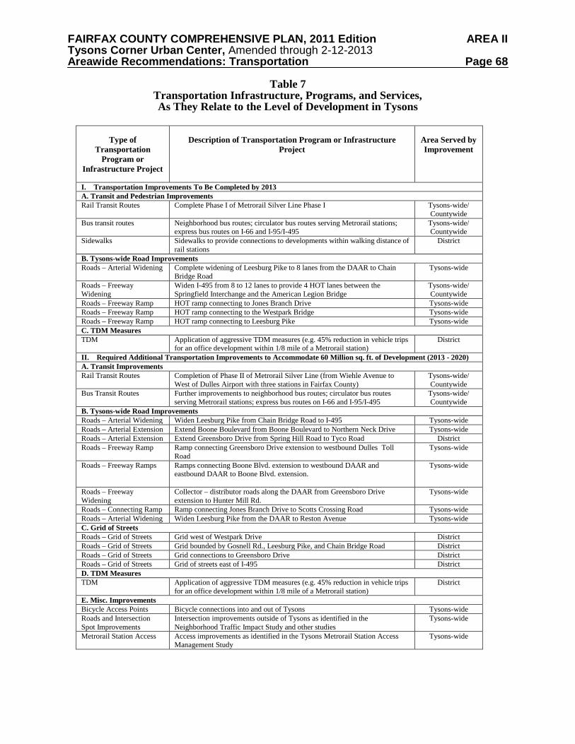
FAIRFAX COUNTY COMPREHENSIVE PLAN, 2011 Edition AREA II Tysons Corner Urban Center, Amended through 2-12-2013 Areawide Recommendations: Transportation Page 68
Table 7 Transportation Infrastructure, Programs, and Services, As They Relate to the Level of Development in Tysons
Type of Transportation
Program or Infrastructure Project
Description of Transportation Program or Infrastructure
Project
Area Served by Improvement
I. Transportation Improvements To Be Completed by 2013 A. Transit and Pedestrian Improvements Rail Transit Routes Complete Phase I of Metrorail Silver Line Phase I Tysons-wide/
Countywide Bus transit routes Neighborhood bus routes; circulator bus routes serving Metrorail stations;
express bus routes on I-66 and I-95/I-495 Tysons-wide/ Countywide
Sidewalks Sidewalks to provide connections to developments within walking distance of rail stations
District
B. Tysons-wide Road Improvements Roads – Arterial Widening Complete widening of Leesburg Pike to 8 lanes from the DAAR to Chain
Bridge Road Tysons-wide
Roads – Freeway Widening
Widen I-495 from 8 to 12 lanes to provide 4 HOT lanes between the Springfield Interchange and the American Legion Bridge
Tysons-wide/ Countywide
Roads – Freeway Ramp HOT ramp connecting to Jones Branch Drive Tysons-wide Roads – Freeway Ramp HOT ramp connecting to the Westpark Bridge Tysons-wide Roads – Freeway Ramp HOT ramp connecting to Leesburg Pike Tysons-wide C. TDM Measures TDM Application of aggressive TDM measures (e.g. 45% reduction in vehicle trips
for an office development within 1/8 mile of a Metrorail station) District
II. Required Additional Transportation Improvements to Accommodate 60 Million sq. ft. of Development (2013 - 2020) A. Transit Improvements Rail Transit Routes Completion of Phase II of Metrorail Silver Line (from Wiehle Avenue to
West of Dulles Airport with three stations in Fairfax County) Tysons-wide/ Countywide
Bus Transit Routes Further improvements to neighborhood bus routes; circulator bus routes serving Metrorail stations; express bus routes on I-66 and I-95/I-495
Tysons-wide/ Countywide
B. Tysons-wide Road Improvements Roads – Arterial Widening Widen Leesburg Pike from Chain Bridge Road to I-495 Tysons-wide Roads – Arterial Extension Extend Boone Boulevard from Boone Boulevard to Northern Neck Drive Tysons-wide Roads – Arterial Extension Extend Greensboro Drive from Spring Hill Road to Tyco Road District Roads – Freeway Ramp Ramp connecting Greensboro Drive extension to westbound Dulles Toll
Road Tysons-wide
Roads – Freeway Ramps Ramps connecting Boone Blvd. extension to westbound DAAR and eastbound DAAR to Boone Blvd. extension.
Tysons-wide
Roads – Freeway Widening
Collector – distributor roads along the DAAR from Greensboro Drive extension to Hunter Mill Rd.
Tysons-wide
Roads – Connecting Ramp Ramp connecting Jones Branch Drive to Scotts Crossing Road Tysons-wide Roads – Arterial Widening Widen Leesburg Pike from the DAAR to Reston Avenue Tysons-wide C. Grid of Streets Roads – Grid of Streets Grid west of Westpark Drive District Roads – Grid of Streets Grid bounded by Gosnell Rd., Leesburg Pike, and Chain Bridge Road District Roads – Grid of Streets Grid connections to Greensboro Drive District Roads – Grid of Streets Grid of streets east of I-495 District D. TDM Measures TDM Application of aggressive TDM measures (e.g. 45% reduction in vehicle trips
for an office development within 1/8 mile of a Metrorail station) District
E. Misc. Improvements Bicycle Access Points Bicycle connections into and out of Tysons Tysons-wide Roads and Intersection Spot Improvements
Intersection improvements outside of Tysons as identified in the Neighborhood Traffic Impact Study and other studies
Tysons-wide
Metrorail Station Access Access improvements as identified in the Tysons Metrorail Station Access Management Study
Tysons-wide
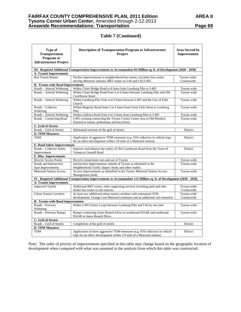
FAIRFAX COUNTY COMPREHENSIVE PLAN, 2011 Edition AREA II Tysons Corner Urban Center, Amended through 2-12-2013 Areawide Recommendations: Transportation Page 69
Table 7 (Continued)
Type of
Transportation Program or
Infrastructure Project
Description of Transportation Program or Infrastructure
Project
Area Served by Improvement
III. Required Additional Transportation Improvements to Accommodate 84 Million sq. ft. of Development (2020 - 2030) A. Transit Improvements Bus Transit Routes Further improvements to neighborhood bus routes; circulator bus routes
serving Metrorail stations; BRT routes on I-66 and I-95/I-495 Tysons-wide/ Countywide
B. Tysons-wide Road Improvements Roads – Arterial Widening Widen Chain Bridge Road to 8 lanes from Leesburg Pike to I-495 Tysons-wide Roads – Arterial Widening Widen Chain Bridge Road from 4 to 6 lanes between Leesburg Pike and Old
Courthouse Road Tysons-wide
Roads – Arterial Widening Widen Leesburg Pike from 4 to 6 lanes between I-495 and the City of Falls Church
Tysons-wide
Roads – Collector Widening
Widen Magarity Road from 2 to 4 lanes from Great Falls Street to Leesburg Pike
Tysons-wide
Roads – Arterial Widening Widen Gallows Road from 4 to 6 lanes from Leesburg Pike to I-495 Tysons-wide Roads – Connecting Road I-495 crossing connecting the Tysons Corner Center area to Old Meadow
(limited to transit, pedestrians and bicyclists) Tysons-wide
C. Grid of Streets Roads – Grid of Streets Substantial sections of the grid of streets District D. TDM Measures TDM Application of aggressive TDM measures (e.g. 55% reduction in vehicle trips
for an office development within 1/8 mile of a Metrorail station) District
E. Road Safety Improvements Roads – Collector Safety Improvement
Improve and enhance the safety of Old Courthouse Road from the Town of Vienna to Gosnell Road
District
F. Misc. Improvements Bicycle Access Points Bicycle connections into and out of Tysons Tysons-wide Roads and Intersection Spot Improvements
Intersection improvements outside of Tysons as identified in the Neighborhood Traffic Impact Study and other studies
Tysons-wide
Metrorail Station Access Access improvements as identified in the Tysons Metrorail Station Access Management Study
Tysons-wide
IV. Required Additional Transportation Improvements to Accommodate 113 Million sq. ft. of Development (2030 - 2050) A. Transit Improvements Improved Transit Additional BRT routes, other supporting services including park-and-ride,
feeder bus routes to rail stations Tysons-wide/ Countywide
Urban Transit Corridors At least two additional urban transit corridors with substantial TOD development: Orange Line Metrorail extension and an additional rail extension
Tysons-wide/ Countywide
B. Tysons-wide Road Improvements Roads – Freeway Widening
Widen I-495 (Outer Loop) between Leesburg Pike and I-66 by one lane Tysons-wide
Roads – Freeway Ramps Ramps connecting Jones Branch Drive to westbound DAAR and eastbound DAAR to Jones Branch Drive.
Tysons-wide
C. Grid of Streets Roads – Grid of Streets Completion of the grid of streets District D. TDM Measures TDM Application of more aggressive TDM measures (e.g. 65% reduction in vehicle
trips for an office development within 1/8 mile of a Metrorail station) District
Note: The order of priority of improvements specified in this table may change based on the geographic location of development when compared with what was assumed in the analysis from which this table was constructed.
FAIRFAX COUNTY COMPREHENSIVE PLAN, 2011 Edition AREA II Tysons Corner Urban Center, Amended through 2-12-2013 Areawide Recommendations: Transportation Page 70
Monitoring System
Maintaining a balance between land use and transportation is dependent on a number of factors as indicated above. The necessary transportation infrastructure, modal split levels, and vehicle trip reduction levels to maintain this balance have been determined by means of extensive analyses. Analyses are based on known conditions at the time of writing this plan text. However, these conditions include human behavior and a number of exogenous factors. These conditions might change in the future which could result in unforeseen changes in trip-making behavior.
Conditions that change the level of transportation funding could impact the ability to
provide transportation infrastructure on schedule. The provision of a livable, walkable Tysons is dependent on the provision of attractive public transportation, TDM programs, and an urban design that curbs the growth of vehicle trips. The benchmark of success in the essential strategy of maintaining a balance between land use and transportation is the number of vehicle trips entering Tysons and the associated delay due to congestion. For this reason, it is considered essential to monitor the number of vehicles entering and exiting Tysons over time and determine the associated delays due to congestion.
The monitoring system should be based on two elements: vehicle trips and delay and the provision of transportation infrastructure. Additional guidance on performance monitoring can be found in the Land Use section of the Areawide Recommendations. Vehicle Trips and Delay
The growth in vehicle trips over time will determine if there are variations from estimated
growth in vehicle trips.
Monitoring should therefore include the following: • Vehicles entering and exiting Tysons should be counted at a number of locations to
enable the accurate detection of variations from vehicle growth estimates. • Delay at a sample number of intersections and at traffic merge locations to determine if
there is a significant increase in over time. Transportation Infrastructure and Programs
The provision of transportation infrastructure and programs should follow the schedule in Table 7. It is noted that due to unforeseen circumstances, the provision of transportation infrastructure and/or programs might differ from what’s shown in Table 7. Funding and other factors that might change Table 7 should be monitored to determine any variations in the timely delivery of transportation infrastructure and programs. Analysis of Monitoring Results and Corrective Measures
The monitoring of the demand side and supply side should provide an assessment of existing conditions and an updated projection of future conditions in terms of maintaining a balance between land use and transportation. The early identification of future variations from the planned schedule provides an opportunity to react in a timely manner to allow the necessary adjustments to be made. It might be necessary to conduct an analysis of changes in travel behavior to determine cost effective measures to correct the projected imbalance between land use and transportation.
FAIRFAX COUNTY COMPREHENSIVE PLAN, 2011 Edition AREA II Tysons Corner Urban Center, Amended through 2-12-2013 Areawide Recommendations: Transportation Page 71
Possible corrective measures are: • The use of TDM Remedial and Contingency Funds to increase TDM activities. • An increase in funding sources and facility user charges. • Congestion pricing. • An amendment to the Plan to modify Plan intensities and/or mix of uses.
Funding for Transportation Improvements
The transportation improvements listed above in Table 7 require a significant capital investment as well as on-going operating investment for increased transit services. A variety of both public and private sector funding options need to be pursued to implement these improvements. A key factor in the implementation process is the ability to generate stable and ongoing sources of funding, both public and private, for these transportation improvements.
Past efforts have demonstrated that innovative public-private financing options for funding transportation improvements can be effective. The local portion of Phase I of the Dulles Metrorail Project is being funded through a tax district. Numerous small-scale improvements in Tysons Corner have been funded over the years through the Tysons Transportation Fund, a voluntary contribution for new commercial development. In 2009, the rate for this contribution was $3.87 per square foot for nonresidential development and $859 per unit for residential development adjusted annually for inflation. However, this fund does not provide a stable and ongoing source of private sector funding. Moreover, it would generate only a small percentage of the funding needed for the improvements listed in Table 7 that are required for the continued development of Tysons Corner. As part of an overall strategy for funding transportation needs, the contribution rate for the Tysons Transportation Fund should be reassessed.
A number of the necessary transportation improvements will be constructed as development occurs by the responsible developer. For instance, it is anticipated that the vast majority of the grid of streets so essential for the vision of the future Tysons Corner will be built by the private sector as development occurs.
Other innovative funding mechanisms are required to generate sufficient funds to implement the improvements in Table 7. Community Development Authorities (CDAs) are expected to play a key role in generating the dedicated and ongoing funding that will be needed. Both a Tysons-wide CDA and a number of smaller district level CDAs are anticipated to be formed and provide a critical source of funding for transportation improvements. For those improvements categorized as Tysons-wide, a combination of public funds and funds from a Tysons-wide CDA would be used. For those improvements categorized as District, a combination of public funds and funds from a smaller CDA would be used.
Overall, there is an identified need for increased funding of transportation improvements and services in order to achieve the vision for the future of Tysons Corner. Increased public sector funding from all sources and innovative private sector sources of funding, including continuation of the Tysons Transportation Fund and the formation of CDAs, are necessary.
FAIRFAX COUNTY COMPREHENSIVE PLAN, 2011 Edition AREA II Tysons Corner Urban Center, Amended through 2-12-2013 Areawide Recommendations: Environmental Stewardship Page 72
ENVIRONMENTAL STEWARDSHIP
Tysons has a unique opportunity to become a leader in environmental stewardship through the protection and improvement of both the man-made and natural environments. The plan for a future Tysons recognizes that these environments cannot be addressed in isolation or independently. More efficient land use patterns, along with a strong emphasis on multi-modal transportation systems, as identified in the vision for Tysons, are important first steps in creating a more sustainable community. In addition, the plan for a sustainable Tysons calls for enhanced stormwater management, the promotion of green buildings and low impact development techniques, and the provision of a green network of parks, open space and trails. The goals and objectives identified by this section will ensure that Tysons redevelops as a model sustainable community, creating a healthy and environmentally responsible place to live, work and play.
The vision for a sustainable Tysons recognizes an evolving approach, with a long-term goal of carbon neutrality (i.e., no net increase of greenhouse gas emissions from Tysons). With redevelopment, many steps can be taken to reduce environmental impacts and increase efficiency utilizing the practices and technologies available today. Improved air quality, energy conservation, stream restoration and protection, water conservation and reuse, green architecture, and restored and enhanced natural environments can all be achieved now.
Over the next decades, the benefits of current efforts and many others will be better
understood. At the same time, new technology may lead to improvements in water conservation and management of stormwater and wastewater. Improvements in information and communications technology could be used to monitor resource consumption and to make the transportation system operate more efficiently.
Finally, new technologies may provide opportunities for further innovations in energy
efficiency and resource conservation. With this knowledge, additional steps in building design and urban planning should be implemented to achieve the long-term goal of carbon neutrality for Tysons by 2030 in support of broader regional greenhouse gas emissions reduction goals (i.e., an 80% reduction in regional greenhouse gas emissions by 2050).
FAIRFAX COUNTY COMPREHENSIVE PLAN, 2011 Edition AREA II Tysons Corner Urban Center, Amended through 2-12-2013 Areawide Recommendations: Environmental Stewardship Page 73
MORE SUSTAINABLE THAN TYSONS TODAY
Through the application of technology, development designs and practices that will improve the protection and enhancement of environmental resources and that will improve energy and natural resource conservation and management, redevelopment efforts in Tysons can be expected to contribute to a future Tysons that will be a far more sustainable community than that which exists today. To achieve this vision, it will be necessary to implement several strategies that will reduce resource use and dependency, decrease detrimental environmental impacts, and enhance the environment. A combination of effective land use and transportation policies creates the basic foundation for the sustainable Tysons, and redevelopment efforts within Tysons will provide opportunities to build upon this foundation.
The concept of transit-oriented development or TOD is being promoted for the Tysons area. TOD is a land use pattern which emphasizes compact, dense, walkable neighborhoods focused around transit stops. National studies have shown that TOD provides increased transit ridership. TOD improves the efficiency and effectiveness of transit service investments by increasing the use of transit near stations by 20 to 40 percent, and up to five percent overall at the regional level.
TOD has also been shown to reduce rates of increase in Vehicle Miles of Travel (VMT). Nationally, vehicle travel has been increasing faster than population growth. TOD has proven to lower annual household rates of driving by 20 to 40 percent for those living, working, and/or shopping within transit station areas. Recent TOD research shows that automobile ownership in TOD areas is approximately one half the national average. By providing safe and easy pedestrian access to transit, TOD has produced lower rates of air pollution and energy consumption. TOD can also reduce rates of greenhouse gas emissions by 2.5 to 3.7 tons per year per household.
Reductions in greenhouse gas emissions from the transportation sector will be achieved by reducing vehicle miles traveled. Focusing development near Metro stations and the dedicated right of way circulator, and constructing walkable, bikeable, mixed use developments will reduce VMT. Aggressive transportation demand management programs, including parking management, are also critical to achieving VMT reduction goals.
Tysons’ redevelopment should be pursued in a manner that will reduce greenhouse gas emissions to help achieve 80% greenhouse gas reductions within the region by 2050 in accordance with the Cool Counties Climate Stabilization Initiative adopted by the Fairfax County Board of Supervisors. These reductions can only be attained through reductions in energy use and associated greenhouse gas emissions from transportation and buildings. Innovative energy efficiency and conservation strategies should be incorporated into all redevelopment projects. Toward this end, the following are but a few examples of efforts that could be considered: on-site generation of electricity, such as from solar, wind or geothermal sources (thereby reducing the need for power from the electrical grid); the use of community energy distribution systems; transit-oriented development design; the use of energy efficient heating and cooling systems; and the application of enhanced building commissioning to provide early and ongoing verification of system performance. Numerous other strategies as outlined in green building rating systems such as the U.S. Green Building Council’s Leadership in Energy and Environmental Design (LEED) program are available to support energy-efficient development and conservation.
FAIRFAX COUNTY COMPREHENSIVE PLAN, 2011 Edition AREA II Tysons Corner Urban Center, Amended through 2-12-2013 Areawide Recommendations: Environmental Stewardship Page 74
More compact development, like that proposed in the concept for Tysons, uses less
energy than low density, suburban style development. For residential housing, the energy consumption rates decrease on a per capita basis as the density increases. In addition, green building design, as encouraged through green building rating systems with third party verification such as the LEED program, reduces energy consumption and encourages innovations in water and wastewater technology. A combination of these and other strategies can have a significant impact on resource consumption for individual buildings, and can contribute to a more sustainable Tysons Corner. STORMWATER MANAGEMENT
Tysons Corner is located in the headwaters area of several of the county’s watersheds. Watershed management plans have been prepared for each of these watersheds; these plans identify a comprehensive set of projects needed to improve stream habitat conditions. These efforts are intended to be pursued independent of development proposals and are not dependent upon such proposals for implementation. However, the provision of effective stormwater management controls for new development and redevelopment projects in these watersheds is imperative to the success of watershed planning efforts. Redevelopment offers considerable opportunities to improve upon past stormwater management practices.
Receiving waters downstream of Tysons should be protected by reducing runoff from impervious surfaces within Tysons. By using a progressive approach to stormwater management, downstream stormwater problems can be mitigated and downstream restoration efforts can be facilitated. Achieving a goal of retaining on-site and/or reusing the first inch of rainfall will ensure that runoff characteristics associated with the site will mimic those of a good forest condition for a significant majority of rainfall events.
Measures to reach this goal may include application of Low Impact Development (LID) Techniques (including but not limited to rain gardens, vegetated swales, porous pavement, vegetated roofs, tree box filters, and water reuse). The incorporation of LID practices in the rights-of-way of streets will also support this goal; such efforts should be pursued where allowed. There is also a potential for the establishment of coordinated stormwater management approaches to address multiple development sites. NATURAL RESOURCES MANAGEMENT Protection, enhancement and management of natural resources in the existing stream valley parks in Tysons is critical to the long term viability of those habitats. Both Scotts Run and Old Courthouse Spring Branch and the forested floodplains that surround them have been negatively impacted by years of unchecked stormwater runoff, consumption of understory plants by deer, and encroachment by non-native invasive plant species. Without active management of the natural resources in these parks, habitat and stream quality will continue to decline. Contributions from development in Tysons towards stream restoration and stabilization in the Scotts Run, Old Courthouse Spring Branch, Rocky Run and Pimmit Run watersheds should be encouraged as part of a comprehensive strategy to restore the water quality and ecological health of Tysons’ streams. Associated improvements to the receiving streams and downstream areas could provide greater stability and water quality and improve instream habitat. Stream
FAIRFAX COUNTY COMPREHENSIVE PLAN, 2011 Edition AREA II Tysons Corner Urban Center, Amended through 2-12-2013 Areawide Recommendations: Environmental Stewardship Page 75
restoration will also enhance the stream valley parks which are key components of Tysons’ green network.
Environmental enhancement efforts should be encouraged and should include efforts such as restoration planting in natural areas, invasive plant control, deer management, stream restoration, and creating new natural areas (including both forested areas and meadows) where disturbed areas currently exist. These expanded natural areas could build on the stream valley parks, adding land that increases riparian buffers and enhances stream valley corridors. Natural areas outside of Resource Protection Areas could serve as nodes for human activity and greatly improve quality of life while relieving stress on existing riparian areas. Stream valley park expansions should not include large hardscape areas (other than trails) and resources management should drive park design. TREE CANOPY GOALS Trees provide numerous environmental and human health benefits and should be considered an essential element in the vision for a new Tysons. Environmental benefits include stormwater management, energy conservation, and mitigation of ozone and carbon in the air. When clustered together, as in a park setting, trees provide habitat areas for wildlife. From an urban design perspective, street trees enhance aesthetics, provide shade and relief from the sun and other elements, and create a sense of safety and protection from street traffic and noise. In 2009, tree canopy covered about 20% of the total land area in Tysons. Much of the tree cover in Tysons is provided in the Scotts Run and Old Courthouse Stream Valley Parks, with additional stands of trees on private land, primarily in the North Central District. Smaller and younger trees are scattered throughout Tysons as part of parking lot design and office campus open space areas. The vision for a greener Tysons calls for additions to the tree canopy through planting on existing park land, establishment of small groves of trees in new urban parks, as part of the new urban streetscape, and on some rooftops. As an interim goal, new development should be designed to provide the maximum amount of sustainable tree cover onsite, with a goal of 10% for redevelopment projects. Where developments are not able to achieve 10% tree cover onsite, contributions should be provided to the County’s tree fund to support tree planting in other suitable areas to offset the difference. Detailed analysis of existing Tysons tree cover should be conducted before setting a permanent goal. Care should be taken so that underground utilities do not conflict with street trees. Urban trees also need adequate root zones and soil volume for the best chance for long-term survival. Additional guidance on tree planting is provided in other sections of this plan including Stormwater Management, Green Buildings, Parks and Recreation, and Urban Design. INFORMATION AND COMMUNICATIONS TECHNOLOGY Information and communications technology (ICT) in Tysons will serve a variety of end users. These include building owners and operators, residents, workers at Tysons’ job centers, customers at its malls and other stores, visitors, and County first responders and environmental specialists. ICT coverage will extend from individual rooms and fixtures to buildings, groups of
FAIRFAX COUNTY COMPREHENSIVE PLAN, 2011 Edition AREA II Tysons Corner Urban Center, Amended through 2-12-2013 Areawide Recommendations: Environmental Stewardship Page 76
buildings, roads and rail, each of the eight districts, and the Tysons Corner Urban Center as a whole. The ICT infrastructure will consist of a number of computer-based networks, functioning together in an integrated hierarchy. These networks will be used to improve the efficiency and economy of building operations and of the transportation system. They will also be used to monitor the achievement of environmental goals, such as reduced levels of energy and water consumption. In order to have an ICT infrastructure in the Tysons Corner Urban Center, its components must be included in the design of buildings and roads. GREEN BUILDINGS Currently Fairfax County encourages new buildings in mixed use centers to have Leadership in Energy and Environmental Design (LEED) certification, or the equivalent. The concept of green buildings recognizes that certain design and construction practices can increase the efficiency of resource use, protect occupants’ health and productivity, and reduce waste and pollution. LEED, developed by the U.S. Green Building Council, is just one rating system used to measure a building’s effectiveness on these measures. Nonresidential development in Tysons should achieve LEED Silver certification or the equivalent, at a minimum. Residential development should be guided by the Policy Plan objectives on Resource Conservation and Green Building Practices.
Buildings are one of the largest consumers of energy in this country. According to the
U.S. Green Building Council, buildings use one-third of our total energy, two-thirds of our electricity, and one-eighth of our water. With the extensive redevelopment that will occur in Tysons, a prime opportunity exists to reduce the amount of energy consumed by the built environment through LEED certification, or its equivalent, for new construction.
A recent study conducted by the New Buildings Institute concluded that, on average, LEED certified buildings use 25 to 30 percent less energy than non-LEED certified buildings. Gold and Platinum LEED certified buildings, the highest certification that can be achieved, have an average energy savings of approximately 50 percent when compared with similar buildings without LEED certification.
In addition to green buildings, green roofs (also referred to as vegetated roofs) can enhance the natural environment within Tysons. Green roofs use the traditionally unused part of the building to grow vegetation. Public benefits of green roofs include increased stormwater retention, reduced greenhouse gas emissions, and improved air quality through filtration of airborne particles. Where green roofs are not provided, other roofing systems containing highly reflective materials may be considered, as they can reduce heat absorption and thereby conserve energy and reduce related greenhouse gas emissions. PARKS AND RECREATION
Parks, recreation and open space are essential throughout Tysons. A comprehensive park system helps to provide a high quality of life for residents by contributing economic, social and health benefits. Such amenities provide visual breaks in the urban landscape, create oases of green in an intensely urban environment, and provide places for people to enjoy passive and active leisure pursuits. Public open space is especially important for residents of higher density housing who may lack access to private yards or recreation facilities. Urban parks improve air quality, reduce stormwater runoff and impervious surfaces, improve community health, and provide opportunities to allow people a full range of leisure pursuits and to meet their neighbors
FAIRFAX COUNTY COMPREHENSIVE PLAN, 2011 Edition AREA II Tysons Corner Urban Center, Amended through 2-12-2013 Areawide Recommendations: Environmental Stewardship Page 77
in a safe environment. Parks will help provide a sense of place for Tysons and its individual neighborhoods. Existing park land is primarily resource-based and located at the transitional edges of Tysons. Only one park, Westgate Park, has significant recreation facilities. Opportunities exist to create an outstanding park system to which all contribute and from which all benefit. As a key part of the vision for Tysons, future residents, employees and visitors to Tysons should enjoy a level of park service comparable to that in exemplary U.S. cities. Outdoor recreational areas should support and foster social interaction as well as sports and recreation activities. While many Tysons developments will include urban parks as amenities, contributions of recreational facilities will also be needed to ensure a park system that serves the wider range of needs. Adopted County-wide recreation facility standards, adjusted for urban demographics and use patterns, will guide the service level enjoyed by residents, workers and visitors to Tysons who will have a full range of leisure opportunities within convenient distances. A goal of twenty new athletic fields serving Tysons should be achieved through development contributions of land and facilities. Enhancements to and redesign of nearby school and park fields to increase capacity should also be strategies for serving increased sports needs in Tysons. The provision of athletic facilities that require larger land areas within Tysons is especially important and challenging. Creative approaches to providing for sports needs in Tysons will be necessary, including integrating facilities within development areas, on rooftops, over stormwater detention facilities, in utility corridors and other alternative locations. The rooftops of parking structures and other buildings in Tysons will be considered as locations for some of the new athletic fields and courts that are needed to help meet the future demand for active recreation facilities. Through innovative design features such as lighting and synthetic turf and scheduling that provides for longer and more efficient use, field capacity can be expanded and the number of needed fields can be reduced. Overlay fields that accommodate multiple sports can reduce the amount of land needed. Adopted Countywide field standards are based on a majority of youth participants. It is anticipated that in Tysons there will be a majority of adult field users. Corporate softball, flag football, kickball, soccer and adult baseball are anticipated needs. Other field sports, such as cricket, may also emerge as a greater need over the horizon of this plan and may need to be accommodated. Parks and open space should be located to best serve the overall needs of the residents, visitors and employees in Tysons. Park land can be publicly owned, privately owned, or provided through public-private partnerships. It is also important to pursue creative solutions to providing open space and recreation facilities in Tysons. Creative urban park initiatives may include rooftop parks, unique programming areas, recreation facilities and program space provided within commercial buildings, redevelopment at nearby existing parks, and forging new park-provider partnerships. With any of these creative approaches, visual and physical accessibility to the public is essential.
The vision for Tysons calls for a “green network,” or a comprehensive system of parks and open spaces that connects all the districts within Tysons through greenways. The network will integrate large and small urban parks with existing environmentally sensitive areas and other built elements to create safe pedestrian and bicycle-friendly pathways throughout all neighborhoods. These pathways will link to transit stations, pedestrian ways, bike trails, shopping and entertainment areas, offices and residential areas. The green network should build on existing parks and the creation of new urban parks. It will include large gathering places that support community events, such as a central, signature park. The green network will have sufficient publicly accessible park acreage to be consistent with the County’s adopted urban park service level standard.
FAIRFAX COUNTY COMPREHENSIVE PLAN, 2011 Edition AREA II Tysons Corner Urban Center, Amended through 2-12-2013 Areawide Recommendations: Environmental Stewardship Page 78
Green Network Components The system of parks and open space is envisioned to build on the foundation of a large, central, “signature” park, existing parks and the creation of new urban parks. The parks and open space network concept is shown in Map 9. This map includes some existing areas associated with residential developments that are not publicly accessible. Specific guidance on parks, recreational facilities and trails is provided in the District Recommendations. The types of parks and open space recommended for Tysons include: Large Central Park: This will be the “signature” park for Tysons and should be large enough to support public, community, and cultural events, such as a farmers market, outdoor performances, art shows or weekend festivals. Ideally, this park should be co-located with other civic facilities such as museums, a performing arts center, library, or other major civic uses. Existing Stream Valley Parks: Stream valley parks such as Scotts Run and Old Courthouse Spring Branch provide natural buffers and potential connectivity to and throughout Tysons. If linked to other parks and open spaces within Tysons, they will help serve non-motorized transportation needs. These stream valley parks should not only be protected from development and infrastructure impacts, but be restored and enhanced. Redevelopment in Tysons should contribute to stream and riparian buffer restoration efforts along these stream valleys in order to strengthen Tysons’ existing natural systems and allow for resource protection and interpretation. These stream valley parks can be expanded through dedications of privately-owned portions of the stream valley and in adjacent areas to provide better connectivity. They can serve as major linear urban parks and support the planned trail system with a variety of natural landscapes. These parks will provide a variety of passive outdoor leisure experiences for residents, visitors and workers in Tysons, including outdoor exercise and enjoyment of quiet natural spaces. Trail Network: The conceptual trail network is included in Map 9. This network will be designed for frequent use through continuous lengths of outdoor trails or spaces that are a minimum of eight feet wide and may include amenities and/or design features such as trailheads, orientation features and wayfinding signage. These linear parks and trails will be popular for jogging, dog walking, biking, walking, enjoying the outdoors and general exercising. Connecting continuous linear spaces with the grid of streets in Tysons provides an important amenity that can be linked with pedestrian and bicycle street elements. The street network in Tysons will incorporate Low Impact Development in medians and rights-of-way for additional environmental benefits. In addition to being green, streets will also be “complete,” with walking and jogging trails and bicycle paths. Cultural Resource Parks: Freedom Hill Park and Ash Grove Historic Site provide historical points of interest in small park settings. Signs, kiosks and other interpretive features may be incorporated into new urban parks in Tysons to preserve and interpret the history of Tysons as it has evolved from rural crossroads to suburban office park to twenty-first century city. Multiple Urban Parks: A diversity of public spaces ranging in size, function, and character, and supporting formal and informal activities, will be located throughout Tysons. Locating parks adjacent to residential and mixed use buildings will enhance these uses by providing common outdoor spaces to users who have no private yards. Integration of parks with residential and mixed use developments will also provide “eyes” on streets and parks for a sense of public safety and activity focused on the park. All parks should be publicly accessible to residents, visitors and workers.
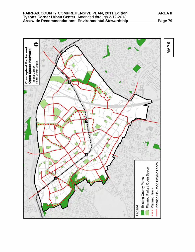
FAIRFAX COUNTY COMPREHENSIVE PLAN, 2011 Edition AREA II Tysons Corner Urban Center, Amended through 2-12-2013 Areawide Recommendations: Environmental Stewardship Page 79
MA
P 9
FAIRFAX COUNTY COMPREHENSIVE PLAN, 2011 Edition AREA II Tysons Corner Urban Center, Amended through 2-12-2013 Areawide Recommendations: Environmental Stewardship Page 80
Within urban, transit oriented development areas, a full complement of urban park types is desirable to create a robust park network and strong sense of place for Tysons. Urban park design elements may be combined in various ways to create a range of urban park types. Urban park types range from the very small “pocket park” situated as a byway on a pedestrian-oriented travel way, to large civic open spaces that encompass diverse amenities and accommodate large community gatherings, to local parks that provide opportunities for organized sports and informal play. Ideally, the park network in Tysons will include a complement of urban park types in order to serve local leisure needs; support environmental and sustainability goals; and contribute to the area’s sense of culture, liveliness and identity. Urban Park Typology An urban park typology and urban park service level standards guide the creation of urban park systems in Fairfax County. The urban parks framework for Fairfax County includes four distinct types of urban parks: pocket parks, common greens, civic plazas, and recreation-focused urban parks (see definitions below). The four urban park types span a continuum of purposes, uses, sizes and features that can flexibly accommodate a broad spectrum of recreational and leisure pursuits in Tysons. A distinction should be made between urban parks that align with the typology and urban design elements such as streetscape areas, sidewalk cafes, commercial entertainment venues, and retail browsing areas. Pocket Park
Usually less than one acre, these urban parks are small-scale open spaces incorporated into developments and designed for casual use by people working and living in the immediate area. A pocket park is designed as a single “room” to provide limited casual open space to enjoy individually or in social interactions. These spaces may consist of hardscape elements or lawn and landscaped areas, seating and visual amenities. Common Green
Larger than pocket parks, these urban parks include flexible open spaces with open lawn areas, serving as the recreation and social focus of a neighborhood or larger area. Size generally depends on the context, function and area, but should be a minimum of one acre. Although a central lawn is the main focus of this type of park, it may be designed with multiple “rooms” offering a mix of complementary uses and/or large enough to support multiple simultaneous activities. The Common Green could function as unscheduled open space for uses such as picnicking and unstructured play or be programmed for athletics, public gatherings, performances and special events. The Common Green may include facilities such as off-leash dog areas, community garden plots, landscaping, water features, shade structures, gathering areas, amphitheaters, space for public art, and/or hardscape areas. Recreational amenities may be incorporated as complementary facilities, but do not predominate. Examples of recreational facilities include tot lots and playgrounds, small skate parks, fitness courses and paved trails, and sport courts. Civic Plaza
An important feature of the park network will be a centrally located civic gathering plaza
in each district. This publicly accessible park includes public art and multiple activity areas and is large enough to support casual unprogrammed use as well as community events. This type of urban park includes public gathering spaces set aside for civic purposes and commercial supporting activities. Civic plazas are usually located at the intersection of important streets or other significant locations and serve as a focal point and unique placemaking feature. Public
FAIRFAX COUNTY COMPREHENSIVE PLAN, 2011 Edition AREA II Tysons Corner Urban Center, Amended through 2-12-2013 Areawide Recommendations: Environmental Stewardship Page 81
squares that are surrounded by public streets are also an example of this type of urban park. Flexible, programmable spaces in multiple “rooms” are generally included. Design includes primarily hardscape elements, but may include trees or other landscaping, seating, public art or water features. Size generally depends on the context, function and area, but should be a minimum of one acre. Depending on size, civic plazas could support open air markets, concerts, festivals, outdoor exercise classes or special events. Recreation amenities may be incorporated as complementary facilities, but do not predominate. Recreation-focused Urban Park
Appropriate recreation facilities will serve a variety of needs and add to the vibrancy of Tysons. In densely-populated urban areas, recreation needs should be addressed with the inclusion of recreation facilities in an urban park setting to serve local residents, visitors and workers. This park type is distinguished by its primary function to provide recreation facilities for nearby residents and workers. Facilities such as athletic fields, multi-use courts and skate parks should be provided. Facilities could be scheduled or casually used. Athletic fields which may be located on building rooftops should have synthetic turf and lighting to maximize use. Support facilities and amenities such as trails, seating, tot lots, shade structures, water features, picnic areas, restrooms, landscaping or hardscape should be provided to complement the recreational component. Parking needs should be addressed through shared parking agreements with adjacent developments. The size of the park should be appropriate to accommodate the recreation facilities and support amenities located there.
ENVIRONMENTAL STEWARDSHIP GUIDELINES
These guidelines should be considered along with the general Environmental Stewardship recommendations above, in evaluating development proposals in Tysons.
Parks and Open Space
Map 9 provides a conceptual plan for a wide-ranging and well-distributed park and open space network in Tysons. It is essential that there be a balanced park system that will support social and recreational needs. Social gathering places and pleasant outdoor spaces will comprise a greater proportion of urban parks in Tysons and can be more easily integrated within developments as an amenity. However, there should be a distinction between urban parks that provide a public benefit aligning with the typology below, and elements such as streetscape areas, sidewalk cafes, commercial entertainment venues and retail browsing areas. It will be more difficult, but no less important, to provide park land in Tysons that will support active recreation facilities such as athletic fields for use by Tysons’ residents, community leagues and corporate teams. There will be a great need for these facilities in Tysons and they should be well distributed within Tysons to serve each district.
The provision of land should be proportionate to the impact of the proposed development
on park and recreation service levels. An urban park land standard of 1.5 acres per 1,000 residents and 1 acre per 10,000 employees will be applied. For example, a new development with 330 dwelling units or 3,000,000 square feet of office space would generate a need for about 1 acre of publicly accessible urban park space.
Urban parks are typically less than five acres and often under 1/2 acre. Service areas are
generally within a 5-10 minute walking distance (or 1/4 – 1/2 mile) from nearby offices, retail
FAIRFAX COUNTY COMPREHENSIVE PLAN, 2011 Edition AREA II Tysons Corner Urban Center, Amended through 2-12-2013 Areawide Recommendations: Environmental Stewardship Page 82
and residences. Typically, on-site parking is only provided for the more intense recreation uses that are located more than 1/4 mile from transit.
In addition, recreational facility service level standards in the Park and Recreation
element of the Countywide Policy Plan should be applied to new development in Tysons, with adjustments made for urban demographics and use patterns. Using 2050 development projections, anticipated urban field use patterns, optimal athletic field design (lights and synthetic turf) and longer scheduling periods, the adjusted need for athletic fields to serve Tysons is a total of 20 fields. This adjusted need should be addressed through on-site development of needed facilities and/or through equivalent monetary or in-kind contributions to the Park Authority for facility development at nearby parks or other sites appropriate for park facilities. In general, the need for an athletic field is generated by the development of approximately 4.5 million square feet of mixed use development in Tysons. Approximately two acres of land is needed for each athletic field.
Proposed development in Tysons should be accompanied by the dedication of public or
publicly accessible parkland, and by the construction of recreational facilities, such as athletic fields. Provision of park land and facilities on-site is preferred. If on-site dedication and facility provision are not possible, an equivalent off-site dedication and facility construction within the same district should be sought as a substitution. Where it is not possible to locate facilities within the district, locations that serve Tysons may be substituted. As a last alternative, as for smaller sites, an equivalent monetary contribution to fund local public parks within Tysons may be substituted. If facilities are constructed on publicly-owned land, an offsetting contribution of park facilities, park land or cash contribution for parks equivalent to the value of the land used for construction should be provided.
Creative approaches can be used to ensure provision of recreational facilities, especially
athletic fields that meet service level standards. This may include indoor and rooftop facilities or those located above underground stormwater management facilities. Co-location with other public facilities is also appropriate.
Facilities that contribute toward meeting the parks and open space needs in Tysons may
be privately owned and privately developed. Regardless of ownership, newly created parks and open space and existing parks and open space that are redesigned in conjunction with a redevelopment project should be publicly accessible during appropriate hours and should meet or exceed the same service level standards as any publicly owned and developed parks or open spaces. The Conceptual Land Use and Parks and Open Space maps include some existing areas associated with residential developments that are not publicly accessible.
Stormwater Design
Environmentally-friendly stormwater design should be an integral design principle that should be part of the conceptual stage of site development for all redevelopment, recognizing that stormwater management measures may be phased with development. The stormwater design should first seek to minimize the effect of impervious cover, followed by the application of stormwater reuse, retention, detention, extended filtration and, where soils and infrastructure allow, infiltration to improve downstream waters. The incorporation of stormwater management strategies in parks and other open space areas within or adjacent to the Tysons Corner Urban Center may also support this approach while providing recreational amenities. Coordination of stormwater management controls among multiple development sites may also be effective in achieving stormwater management goals in an efficient manner. This could include the construction of new regional ponds or modifications to existing regional ponds.
FAIRFAX COUNTY COMPREHENSIVE PLAN, 2011 Edition AREA II Tysons Corner Urban Center, Amended through 2-12-2013 Areawide Recommendations: Environmental Stewardship Page 83
Stormwater management and water quality controls for redevelopment should be designed to return water into the ground where soils are suitable or reuse it, where allowed, to the extent practicable. Reduction of stormwater runoff volume is the single most important stormwater design objective for Tysons. Reduction could occur through techniques that use plants or soils via landscaping measures, through techniques that reuse harvested rainwater in a variety of ways, and/or through approaches that infiltrate water into the ground to replenish aquifers and provide summer base flows to local streams.
Redevelopment projects in Tysons should incorporate innovative stormwater
management measures in a manner that will, first and foremost, optimize reduction of stormwater runoff volume and control of peak flows for the remaining stormwater that cannot be completely captured on-site.
The following are recommended for applications for which a significant increase in
density/intensity is proposed (e.g., a redevelopment option is being pursued):
• Stormwater quantity and quality control measures should be provided that are substantially more extensive than minimum requirements, with the goal of reducing the total runoff volume and/or significantly delaying its entry into the stream system. The emphasis should be on Low Impact Development (LID) techniques that evapotranspire water, filter water through vegetation and/or soil, return water into the ground or reuse it.
• LID techniques of stormwater management should also be incorporated into new and
redesigned streets where allowed and practicable.
• At a minimum, the first inch of rainfall should be retained on-site through infiltration, evapotranspiration and/or reuse. If, on a given site, the retention on-site of the first inch of rainfall is demonstrated not to be fully achievable, all available measures should be implemented to the extent possible in order to support this goal and achieve partial retention of the first inch of rainfall.
• At a minimum, stormwater management measures that are sufficient to attain both the
stormwater design-quantity control and stormwater design-quality control credits2 of the
2 These credits, as set forth in LEED 2009 for New Construction and Major Renovations, are as follows: SS Credit 6.1: Stormwater Design-Quantity Control: • For sites that have greater than 50% impervious cover in the existing condition, the total volume of runoff
released from the site in the post-developed condition for the 2-year, 24-hour storm should be at least 25% less than the total volume of runoff released in the existing condition for the same storm. Furthermore, the peak runoff rate for the 2-year, 24-hour storm in the post-developed condition should be at least 25% less than the existing condition peak runoff rate for the same storm.
• For sites that have 50% or less impervious cover in the existing condition, the total volume of runoff released as well as the peak release rate for the 1- and 2-year, 24-hour storm in the post-developed condition should be equal to or less than the total runoff volume and peak release rate in the existing condition for the same storm. Alternately, a stormwater management plan that protects receiving stream channels from excessive erosion, including stream channel protection and quantity control strategies, may be pursued.
SS Credit 6.2: Stormwater Design-Quality Control: • Stormwater runoff associated with the development should be controlled such that the first one (1) inch of
rainfall is reused, infiltrated or treated in a manner through which 80% of the average annual post-development total suspended solids (TSS) are removed.
FAIRFAX COUNTY COMPREHENSIVE PLAN, 2011 Edition AREA II Tysons Corner Urban Center, Amended through 2-12-2013 Areawide Recommendations: Environmental Stewardship Page 84
most current version of the LEED-NC or LEED-CS rating system (or the equivalent of these credits) should be provided. If, on a given site, the attainment of the stormwater design LEED credits (or equivalent) is demonstrated not to be fully achievable, all available measures should be implemented to the extent possible in support of this goal.
• Equivalent approaches may incorporate coordinated stormwater management on multiple
development sites and/or off-site controls. Additional stormwater management efforts should be encouraged.
• Restoration and/or stabilization of degraded streams on development sites should be
pursued where feasible; restoration and stabilization techniques that incorporate ecologically and aesthetically beneficial, vegetated approaches are preferred. Off-site efforts to restore and/or stabilize streams in Tysons Corner should also be encouraged.
The above guidelines are intended to improve stormwater management controls
sufficiently to allow for improvements to the habitat and recreational values of streams in Tysons Corner through natural restorative processes and/or through restoration projects. Green Building Design and Energy/Resource Conservation
Existing Fairfax County policy calls for certain zoning proposals for nonresidential development and multifamily residential development of four or more stories in urban centers to incorporate green building practices sufficient to attain LEED certification or its equivalent. Nonresidential development in Tysons should go one step further and seek LEED Silver certification or equivalent as a minimum. Residential development should be guided by the Policy Plan objectives on Resource Conservation and Green Building Practices.
All redevelopment projects in Tysons should incorporate design elements and practices that will reduce the use of energy and water resources. There are numerous strategies available that are outlined in green building rating systems such as the LEED program, and strategies such as these should be pursued in support of or in addition to efforts to attain LEED Silver certification or its equivalent. The following are examples of efforts that could be pursued:
• Transit-oriented development design • Transportation demand management programs • On-site renewable energy generation, such as solar, wind and/or geothermal systems • If/when on-site renewable energy generation is not cost effective at the time of building
design, the provision of building designs that will facilitate future retrofits for on-site energy generation if/when such efforts will become cost effective
• Orientation of buildings for solar access • Energy-conscious landscape design (e.g., natural landscaping; shading) • Water-efficient landscaping • The use of energy efficient heating, ventilation and air conditioning systems • Enhanced building commissioning to provide early and ongoing verification of system
performance • The use of energy efficient lighting systems • The use of energy conserving building materials
FAIRFAX COUNTY COMPREHENSIVE PLAN, 2011 Edition AREA II Tysons Corner Urban Center, Amended through 2-12-2013 Areawide Recommendations: Environmental Stewardship Page 85
• The provision of vegetated and/or highly reflective roofs • The use of community energy distribution systems through which energy/heat generated
on one site will be shared among buildings on other nearby sites • The use of water-conserving plumbing fixtures • The use of harvested stormwater runoff for irrigation • Where consistent with building codes, the use of grey water • The use of information and communications technology to improve the efficiency and
economy of building operations. • If/when the provision of information and communications technology efforts is not cost
effective at the time of building design, the design of buildings to include conduits supporting the future installation of such measures
Setting Future Environmental Goals for Tysons
Tysons should endeavor to remain the leader in environmental stewardship. As such, the Plan should include flexibility to accommodate new strategies and technologies as they emerge, such as district energy systems, alternative energy sources, cogeneration, microgrids, district-scale environmental performance measures, innovative stormwater management and stream restoration practices, innovative green building practices and innovative approaches in the provision and design of park facilities and other open spaces. In order to encourage the use of new technologies as they become available, the Environmental Stewardship Guidelines will need to be regularly reviewed and updated.
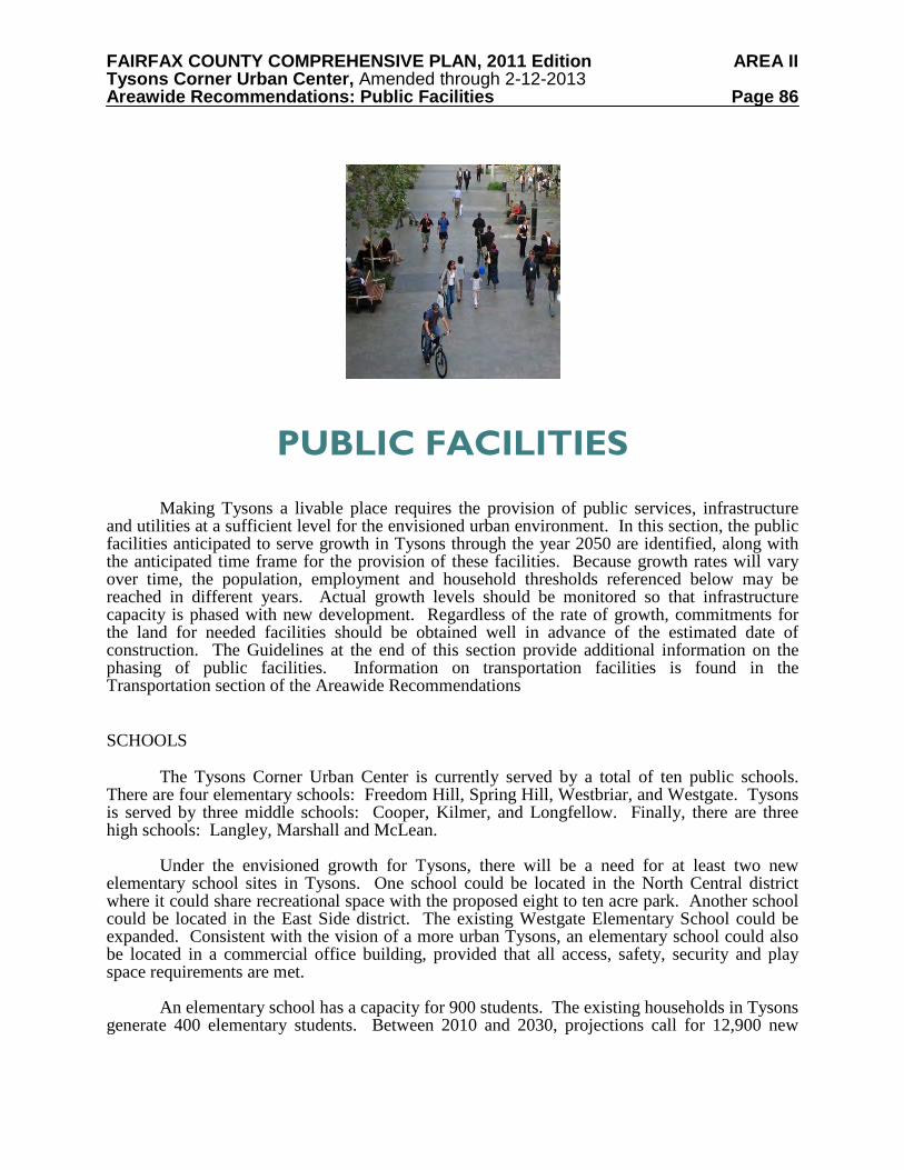
FAIRFAX COUNTY COMPREHENSIVE PLAN, 2011 Edition AREA II Tysons Corner Urban Center, Amended through 2-12-2013 Areawide Recommendations: Public Facilities Page 86
PUBLIC FACILITIES
Making Tysons a livable place requires the provision of public services, infrastructure and utilities at a sufficient level for the envisioned urban environment. In this section, the public facilities anticipated to serve growth in Tysons through the year 2050 are identified, along with the anticipated time frame for the provision of these facilities. Because growth rates will vary over time, the population, employment and household thresholds referenced below may be reached in different years. Actual growth levels should be monitored so that infrastructure capacity is phased with new development. Regardless of the rate of growth, commitments for the land for needed facilities should be obtained well in advance of the estimated date of construction. The Guidelines at the end of this section provide additional information on the phasing of public facilities. Information on transportation facilities is found in the Transportation section of the Areawide Recommendations SCHOOLS The Tysons Corner Urban Center is currently served by a total of ten public schools. There are four elementary schools: Freedom Hill, Spring Hill, Westbriar, and Westgate. Tysons is served by three middle schools: Cooper, Kilmer, and Longfellow. Finally, there are three high schools: Langley, Marshall and McLean. Under the envisioned growth for Tysons, there will be a need for at least two new elementary school sites in Tysons. One school could be located in the North Central district where it could share recreational space with the proposed eight to ten acre park. Another school could be located in the East Side district. The existing Westgate Elementary School could be expanded. Consistent with the vision of a more urban Tysons, an elementary school could also be located in a commercial office building, provided that all access, safety, security and play space requirements are met. An elementary school has a capacity for 900 students. The existing households in Tysons generate 400 elementary students. Between 2010 and 2030, projections call for 12,900 new
FAIRFAX COUNTY COMPREHENSIVE PLAN, 2011 Edition AREA II Tysons Corner Urban Center, Amended through 2-12-2013 Areawide Recommendations: Public Facilities Page 87
households in Tysons. This number of new households will generate an additional 555 elementary students, resulting in a need for the first elementary school by 2030. Between 2030 and 2050, projections call for another 20,700 new households in Tysons. This number of new households will generate an additional 890 elementary students, resulting in a need for the second elementary school by 2050. A middle school has a capacity for 1,250 students. Between 2010 and 2050 there are projected to be a total of 33,600 new households in Tysons. This number of new households will generate an additional 370 new middle school students. For purposes of long-range planning, expansion of one of the middle schools serving Tysons (Kilmer or Thoreau) is projected to be needed by the year 2050. Pimmit Hills Alternative High School may in the future be considered for use as an elementary or middle school. A secondary school may also need to be considered. A high school has a capacity for 2,000 students. Between 2010 and 2050 there are projected to be a total of 33,600 new households in Tysons. This number of new households will generate an additional 806 new high school students. For purposes of long-range planning, expansion of the existing high school serving Tysons, Marshall, is projected to be needed by the year 2040. LIBRARY Tysons is currently served by the Dolley Madison and Patrick Henry Community Libraries, and the Tysons-Pimmit Regional Library. Growth in Tysons will generate the need for a new community library when the number of residents in Tysons reaches 50,000, or between 2030 and 2040. The recommended site would be near the Tysons Central 7 Metro station, with possible co-location with a community center or a performing arts center. Another consideration would be replacement of the existing regional library, which has limited usable public space, with a new regional library in Tysons Central 7. A regional library could also be co-located with a community center or performing arts center. The current site of the Tysons-Pimmit Regional Library could be used for another public purpose. FIRE AND RESCUE Emergency services to Tysons are currently provided by Tysons Fire and Rescue Station 29 and Dunn Loring Fire and Rescue Station 13. The higher intensity of development and taller buildings at the transformed Tysons will require two new urban fire stations. These stations could be located on the first two to three floors of commercial or mixed use buildings. In order to maintain an adequate response time for emergency medical services, the first station will be needed by 2020, or when the number of residents reaches 31,400 and the number of jobs in Tysons reaches 140,300. The first station could be located in the Tysons Central 7 or Tysons Central 123 district. The second station will be needed by 2040, or when the number of residents reaches 64,000 and the number of jobs in Tysons reaches 188,600. The second fire station could be located in the Tysons East district. Because the existing Station 29 is adjacent to the Tysons West Metrorail station, it is planned for relocation to the edge of the North Tysons West Subdistrict or to co-locate with the
FAIRFAX COUNTY COMPREHENSIVE PLAN, 2011 Edition AREA II Tysons Corner Urban Center, Amended through 2-12-2013 Areawide Recommendations: Public Facilities Page 88
Spring Hill Transit Center in the North Central District. Relocation of Station 29 will take place regardless of the level of development in Tysons, and is therefore considered an existing need. POLICE Tysons is currently served by the McLean Police District. The projected workload due to growth in Tysons will exceed the capacity of the current staff by the year 2025. In order to provide a strong, visible police presence in Tysons, a satellite police station should be located near the central Metro station areas. Such a station could be co-located with the Fire and Rescue station in the Tysons Central 7 or Tysons Central 123 district, which is due for construction by the year 2020. There should also be at least one publicly accessible helipad for emergency services in Tysons. PARKS The Fairfax County Park Authority (FCPA) currently owns about 86 acres of park land within the boundaries of Tysons. An urban park standard of 1.5 acres per 1,000 residents and 1 acre per 10,000 employees should be used to determine proportionate contribution levels for urban park land. The proposed Tysons park system should include a mix of small urban pocket parks of less than one acre, one to five acre civic plazas and common greens, and two to ten acre recreation-focused urban parks. One of the civic plazas should be a centrally located signature park. The green network in Tysons will also include linear open spaces, trails, and other non-motorized linkages. In addition to land for urban parks, land for active recreation and trails will be needed to serve growth in Tysons and should be provided by new development. The Countywide recreation facility service level standards in the Park and Recreation element of the Countywide Policy Plan should be applied to new development in Tysons, with adjustments made for urban demographics and use patterns. Provision of facilities to meet these service level needs will ensure that as Tysons redevelops, publicly accessible athletic fields, tennis courts, basketball courts, fitness and program space, swimming pools, and other active recreational facilities will be provided at levels meeting the needs of future Tysons residents, employees and visitors. Using 2050 development projections, anticipated urban field patterns, optimal athletic field design (lights and synthetic turf) and longer scheduling periods, the adjusted need for athletic fields to serve Tysons is a total of 20 fields. Some of the active recreational facility needs may be accommodated by adding or upgrading facilities at existing public school sites or in nearby existing parks surrounding Tysons. However, most future active recreational facilities will need to be provided within Tysons’ redevelopments. In addition, trails should be provided in accordance with the County’s adopted Trails Plan. Trails should also connect open space to the grid of streets, in accordance with specific guidance in the District text. See the Parks and Recreation section of the Areawide Environmental Stewardship recommendations for full guidance on urban parks, trails and urban active recreational facilities. Guidance on location of specific facilities is also provided in the District text.
FAIRFAX COUNTY COMPREHENSIVE PLAN, 2011 Edition AREA II Tysons Corner Urban Center, Amended through 2-12-2013 Areawide Recommendations: Public Facilities Page 89
STORMWATER MANAGEMENT The vision for Tysons includes stormwater management practices that return water into the ground, reuse it, or delay its entry into the stream system. All redevelopment sites should be designed to ensure protection of downstream areas and prevent stream degradation. Environmentally friendly stormwater design should be included at the conceptual stage of design on all redevelopment projects. Low Impact Development (LID) techniques should be integrated into streetscapes, open space, buildings and rail. These techniques include rain gardens, vegetated swales, porous pavement, vegetated roofs, and tree box filters. LID techniques should be augmented by conventional detention practices such as ponds where needed and appropriate. Vegetated ponds can be considered both as a stormwater management technique and an aesthetic amenity. Consideration should be given to reuse of stormwater as grey water, in order to reduce consumption. See the Stormwater section of the Areawide Environmental Stewardship recommendations for full guidance on stormwater management. WASTEWATER MANAGEMENT Wastewater from Tysons Corner is treated at the Blue Plains Treatment Plant, which is owned and operated by the DC Water and Sewer Authority. In order to accommodate growth in Tysons and elsewhere in Fairfax County, the County is pursuing the purchase of additional treatment capacity at Blue Plains and at the Loudoun County Sanitation Authority. However, it is not yet known how much additional capacity could be made available to the County at this time. Most likely, the additional wastewater from Tysons will have to be diverted to other treatment plants such as the County’s Noman Cole plant or the Alexandria Sanitation Authority’s plant, in both of which there is some available capacity. Over time it is expected that the adoption of conservation measures will result in less water consumption and less wastewater production by County residents. In any case, growth in Tysons will generate the need to increase the capacities of major trunk lines, to upgrade the Difficult Run Pump Station, and to invest in other improvements to the current wastewater system. WATER The Tysons area is currently served by both the Falls Church Department of Public Utilities and Fairfax Water. Fairfax Water has a major pumping station providing for transmission through Tysons Corner as well as local distribution at their existing facilities on International Drive. Fairfax Water has identified future improvements to provide for both transmission through Tysons to eastern Fairfax County as well as for local service to Tysons itself. The timing of these improvements is subject to change based on the timing of development and opportunities for cost savings, such as constructing facilities concurrent with roadway projects. It must also be noted that the precise location of needed facilities may be modified as circumstances warrant. Expansion plans to meet local distribution needs based on current population estimates include additional storage tanks in 2030 and 2040, two additional distribution pumps in 2010 and one distribution pump in each of 2020 and 2030. A northerly 24- or 36-inch main from Spring Hill Road along Greensboro Drive and Galleria Drive to Fairfax Water’s 42-inch main along the
FAIRFAX COUNTY COMPREHENSIVE PLAN, 2011 Edition AREA II Tysons Corner Urban Center, Amended through 2-12-2013 Areawide Recommendations: Public Facilities Page 90
I-495, or the hydraulic equivalent, and a southerly 24- or 36-inch main from Fairfax Water’s 24-inch main from the Leesburg Pike/DAAR interchange to Gosnell Road and along Old Courthouse Road, or hydraulic equivalent, have been identified for installation concurrent with development. Several transmission mains through Tysons have also been identified to meet future needs. The Spring Hill Road water main will be extended to the existing Fairfax Water facilities on International Drive. Fairfax Water also plans to extend water mains from its pumping station to Magarity Road, from its treatment facilities in Dranesville to Tysons, and along Leesburg Pike from Chain Bridge Road to its existing main in Gallows Road. Construction of these facilities will enable Fairfax Water to provide full transmission capacity to serve all of Tysons. Specific details pertaining to water distribution infrastructure would be developed during the requisite site plan engineering process.
Falls Church Water recently upgraded their storage capacity at Tysons to 2.2 million gallons. Among their plans for capital improvements in Tysons are the installation of 24-inch and 16- inch water mains by the year 2020. By the year 2030 Falls Church Water plans to install another 24 inch main to serve Tysons. ELECTRIC POWER Dominion Virginia Power’s existing Tysons substation is located on Tyco Road. It will be expanded to serve approximately 400 MVA (megavolt-amperes) for normal operating conditions. By the year 2050, Dominion projects that growth in Tysons will generate demand for 738 MVA. Therefore, a second substation is planned for the year 2020, with a preferred location south of Leesburg Pike near Spring Hill Road, adjacent to Dominion’s existing high transmission line. The new facility will be a conventional walled substation and will require up to 2.5 acres of land. The new Spring Hill Substation will serve the Tysons West and Tysons Central 7 Metrorail stations, as well as development along the south side of Leesburg Pike, and Tysons Corner Center. The existing Tysons Substation will serve the Tysons Central 123 and Tysons East Metrorail stations, as well as development on the north side of Leesburg Pike, the Gannett Building and Tysons Galleria. From the second substation to the existing substation on Tyco Road, Dominion’s high voltage line should be placed underground, in order to ensure a pedestrian friendly environment. As an alternative to underground placement, the high voltage line could be relocated to an alignment away from the Metro station entrance. NATURAL GAS Washington Gas serves Tysons through a gate station in the Dranesville area. This gate station is very centrally located in the region’s system of gas pipelines, and is considered to be in a “healthy” condition. By 2050, growth in Tysons is projected to increase output in this gate station by 50%. This assumes high-rise, multifamily housing units, which consume about one-fourth as much gas as single-family units. In the unlikely event system improvements are needed as a result of growth in Tysons, any such improvements will be financed through the utility’s rate system.
FAIRFAX COUNTY COMPREHENSIVE PLAN, 2011 Edition AREA II Tysons Corner Urban Center, Amended through 2-12-2013 Areawide Recommendations: Public Facilities Page 91
TELECOMMUNICATIONS It is anticipated that telecommunications services will be able to accommodate growth in Tysons through continuous improvements in technology, funded by user fees. Tall buildings in Tysons should be designed to accommodate telecommunications antennas and equipment cabinets on rooftops. Such design should be compatible with the building’s architecture and should conceal antennas and equipment from surrounding properties and roadways by flush mounting, screening antennas, and/or concealing related equipment behind screen walls or building features. ARTS FACILITIES The Tysons area is currently served by arts facilities located nearby, such as the McLean Project for the Arts, with a small theater and nationally recognized visual arts exhibits, and Wolf Trap facilities, including the 7,000 seat Filene Center, 800-seat Children’s Theatre in the Woods, performing arts classes at the Center for Education at Wolf Trap, and performances at The Barns at Wolf Trap (388 seats). First Stage, a small professional theater company with limited visual arts exhibit space, is temporarily located on Spring Hill Road. To provide a 24-hour livable/walkable environment, an arts center should be provided in the South Tysons Central 7 Subdistrict. This center should include performance, rehearsal and exhibit space for local and visiting artists and/or a home for local theater or dance companies. At least one other neighborhood should include small theaters and/or galleries, as well as adaptable space that allows for the creation of visual art and for audiences and artists to interact. PUBLIC FACILITY GUIDELINES
These guidelines should be considered along with the general Public Facility recommendations above, in evaluating development proposals in Tysons. Phasing Public Facilities
Practices employed by the County in the past to provide space for public facilities in largely undeveloped suburban areas cannot be relied upon in an intensely developed area where most of the land is privately owned. In Tysons it will be critical that the land area or spaces for public uses are incorporated within private developments at no cost to the public sector.
While facilities may actually be constructed throughout the planning horizon based upon need, it is critical that space for most, if not all, of these facilities be secured as soon as possible. Therefore, rezoning proposals, through proffers, should commit to provide the necessary land and/or space to ensure that places will be available to construct facilities in concert with the pace of growth.
The land and/or building space needed for public facilities is critical to the assurance that such facilities can be constructed. Commitments to dedicate building space or land for most, if not all, of the public facilities needed by 2050 should be provided as development approvals occur during the first 10 or 20 years of Plan implementation.
In addition to facilitating public facility objectives through zoning actions, it may be necessary for landowners throughout Tysons to work collaboratively and creatively through
FAIRFAX COUNTY COMPREHENSIVE PLAN, 2011 Edition AREA II Tysons Corner Urban Center, Amended through 2-12-2013 Areawide Recommendations: Public Facilities Page 92
private-private partnerships to meet public facility objectives. Detailed plans for the provision of public facilities, including parks and athletic fields, for a district or subdistrict should be in place prior to or concurrent with the first rezoning approval in that district or subdistrict. Such plans should enumerate the public facilities needed in that district, the proposed locations for the facilities, their anticipated year of construction, and the private sector’s commitments toward the provision of those facilities. The public facilities plans should be coordinated with the County and land owners within the district or subdistrict. The locations of proposed public facilities may be placed on an “official map” as described in the Transportation section.
Public facility and infrastructure analyses should be performed in conjunction with any development application. The results of these analyses should identify needed improvements, the phasing of these improvements with new development, and appropriate measures to mitigate other impacts.
Also, commitments should be provided for needed improvements and for the mitigation of impacts identified in the public facility and infrastructure analyses, as well as improvements and mitigation measures identified in the Areawide recommendations.
Public facilities will be funded from a combination of public and private sources, including Community Development Authorities at the Tysons-wide, district and/or subdistrict levels. Financing strategies are discussed in the Implementation chapter of the Areawide plan text.
For development thresholds and estimated timing of needed public facilities based on the George Mason University High Forecast for growth in Tysons, refer to the table at the end of this section.
Additional discussion of phasing public facilities and infrastructure can be found in the Areawide Land Use and Transportation recommendations. Public Facilities Sustainability Goals
Reduction of the per capita consumption of water, wastewater, energy and waste materials is a guiding goal of future public utilities in Tysons. New development should reduce demands on the wastewater system through the use of water-conserving plumbing fixtures and, where consistent with building codes, the use of grey water. Additional discussion of sustainability goals is included in the Environmental Stewardship section of the Areawide Recommendations. Information and Communications Technology
All residential, commercial and public use structures in the Tysons Corner Urban Center should be designed and equipped to enable information and communications networking. Both formal and ad hoc networks for voice, video, and data will operate throughout the Urban Center, and will connect to remote points and networks. While some networks will be open access, others will be secure. The various purposes to be served by these networks will include but are not limited to:
• Business: Exchanges of information and data • Recreation, Arts and Entertainment: Virtual club meetings; netcasts of performances;
teleprograms and computer games
FAIRFAX COUNTY COMPREHENSIVE PLAN, 2011 Edition AREA II Tysons Corner Urban Center, Amended through 2-12-2013 Areawide Recommendations: Public Facilities Page 93
• Education: Formal and continuing education, originating either locally or from remote locations
• Transportation and parking management: Signal controls; surveillance video; GPS directions to reserved parking or available open access parking
• Energy management: Monitoring data on electrical consumption; exporting locally produced electricity to other buildings and/or to the electrical grid
• Resource conservation: Monitoring data on water supply and consumption • Emergency response: Notification of emergencies and provision of GPS directions to
Public Safety personnel; provision of status information during grid outages, hurricanes, or other events such as terrorist attacks.
• Library services: Provision of secure access to customer accounts, databases and other Fairfax County Public Library information.
Table 8
Timing of Public Facility Needs Based on GMU High Forecast for Growth in Tysons
Type of Facility Threshold Estimated
Year of Operation
Fire Station 29 relocation N/A 2010 - 2020 New Fire Station 31,400 residents & 140,300 jobs 2020 Satellite Police Station, possibly co-located with New Fire Station
31,400 residents & 140,300 jobs 2020
Dominion Virginia Power Substation 31,400 residents & 140,300 jobs 2020
Elementary School Building
555 new elementary students based on 12,900 new households 2030
Community Library or Regional Library (See Note 1)
50,000 residents 2030 - 2040
Performing Arts Center 50,000 residents 2030 - 2040 New Fire Station 64,000 residents & 188,600 jobs 2040 Elementary School Building
890 new elementary students based on 20,700 new households 2050
Secondary School Expansion
1,186 secondary students based on 33,600 new households 2050
Athletic Fields (See Note 2)
One field per 4.5 million square feet of mixed use development 20 fields by 2050
Notes: 1. New library may be co-located with an arts center in Tysons. 2. Needs for parks, recreational facilities and trails are discussed in the Environmental Stewardship section of
the Areawide Recommendations. 3. Transportation facilities are discussed separately in the Areawide Recommendations. 4. Land for facilities should be acquired well in advance of year of operation. Ideally, land or spaces for
public facilities should be secured by 2020 or 2030.
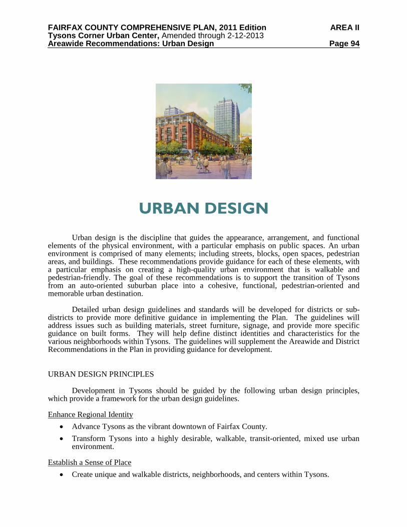
FAIRFAX COUNTY COMPREHENSIVE PLAN, 2011 Edition AREA II Tysons Corner Urban Center, Amended through 2-12-2013 Areawide Recommendations: Urban Design Page 94
URBAN DESIGN
Urban design is the discipline that guides the appearance, arrangement, and functional elements of the physical environment, with a particular emphasis on public spaces. An urban environment is comprised of many elements; including streets, blocks, open spaces, pedestrian areas, and buildings. These recommendations provide guidance for each of these elements, with a particular emphasis on creating a high-quality urban environment that is walkable and pedestrian-friendly. The goal of these recommendations is to support the transition of Tysons from an auto-oriented suburban place into a cohesive, functional, pedestrian-oriented and memorable urban destination.
Detailed urban design guidelines and standards will be developed for districts or sub-districts to provide more definitive guidance in implementing the Plan. The guidelines will address issues such as building materials, street furniture, signage, and provide more specific guidance on built forms. They will help define distinct identities and characteristics for the various neighborhoods within Tysons. The guidelines will supplement the Areawide and District Recommendations in the Plan in providing guidance for development. URBAN DESIGN PRINCIPLES
Development in Tysons should be guided by the following urban design principles,
which provide a framework for the urban design guidelines.
Enhance Regional Identity • Advance Tysons as the vibrant downtown of Fairfax County. • Transform Tysons into a highly desirable, walkable, transit-oriented, mixed use urban
environment. Establish a Sense of Place
• Create unique and walkable districts, neighborhoods, and centers within Tysons.
FAIRFAX COUNTY COMPREHENSIVE PLAN, 2011 Edition AREA II Tysons Corner Urban Center, Amended through 2-12-2013 Areawide Recommendations: Urban Design Page 95
• Encourage design elements that highlight the distinct character of each district, as well as common elements that unify Tysons as an urban center.
• Encourage each district to include tree-lined streets, a range of urban parks, and public gathering places.
Improve Connectivity
• Increase the efficiency of vehicular and pedestrian movements within Tysons through well-designed transit and a walkable grid of streets and open spaces.
• Create pedestrian and bicycle-friendly environments and connections throughout Tysons that are safe, pleasant, and convenient.
• Maximize benefits of rail in Tysons by improving connectivity to adjacent communities and to regional activity centers.
Design Sustainable Environments
• Encourage sustainable buildings, site designs, and infrastructure. • Incorporate innovative and environmentally sensitive stormwater design into all new
development and redevelopment, and restore and stabilize existing streams. Respect Surrounding Neighborhoods
• Maintain the character and livability of residential neighborhoods adjacent to and at the edges of Tysons.
• Concentrate the tallest buildings and highest land use intensities near Metro stations. • Transition building heights to be compatible with lower density neighborhoods adjacent
to and within Tysons. Create a New Destination for the Arts and Design
• Include venues for performing arts and public art in a variety of spaces throughout Tysons.
• Encourage developers to work with artists and arts organizations early in the design process to successfully integrate the arts into their projects.
• Ensure the provision of public art in Tysons by considering a dedicated funding source. • Maintain high standards for innovative architecture and design which will create a unique
identity for each district and Tysons as a whole. URBAN DESIGN RECOMMENDATIONS
The urban design recommendations expand upon these principles and provide direction
for creating urban places within Tysons. They are organized into two sections, the Pedestrian Realm Recommendations and the Building and Site Design Recommendations. Pedestrian Realm Recommendations
The pedestrian realm consists of publicly accessible places where people circulate on foot. Sidewalks connect pedestrians to their homes, places of employment, retail establishments, restaurants, parks, plazas, trails, and other public places. The pedestrian realm is the most visible
FAIRFAX COUNTY COMPREHENSIVE PLAN, 2011 Edition AREA II Tysons Corner Urban Center, Amended through 2-12-2013 Areawide Recommendations: Urban Design Page 96
space within the urban environment. It should be continuous but can vary in its character depending upon adjacent uses and the scale of the street.
The pedestrian realm also includes building facades, areas that can offer shelter from sun and rain through canopies and awnings, outdoor seating areas, commercial displays, and planted areas. Color, texture, signage, and variations in activity can provide visual interest for both pedestrians and motorists. Other elements that enhance the aesthetics and functionality of the pedestrian realm include bicycle racks, benches, bus shelters, and lighting. The design of the pedestrian realm should create a safe and high-quality pedestrian experience for all users.
The pedestrian realm also links to the larger open space network, which includes urban
parks, civic plazas and common greens. These open spaces provide a break in the dense urban fabric, allow opportunities for social interaction and help to define a district’s identity.
The design of the pedestrian realm should be integrated with and complimentary to adjacent land uses. The following recommendations address the Street Grid and Block Pattern and Streetscape Design. Street Grid and Block Pattern
The street grid will be the primary organizing element of the new urban Tysons. In contrast to the existing pattern of large, suburban blocks, new development should create smaller blocks through an interconnected system of streets. This street system will be more walkable, provide travel choices for pedestrians and motorists, and have breaks in building massing to help create a built environment that is appropriately scaled for pedestrian activity. In order to implement the grid of streets and an urban block pattern, all proposals should provide for planned road improvements that follow the grid of streets and street types contained in the Transportation section. In areas where preliminary design studies have identified the layout of new streets on an official street map, redevelopment plans should create a street and block network in accordance with the map. In cases where this is not feasible, the development team should work with staff to develop a response that achieves a level of connectivity that meets plan goals. In areas where such design studies have not been completed, the street and block network should follow the recommendations in the Transportation section and the following block size recommendations:
• Blocks should have a maximum perimeter of 2,000 feet, measured at the curb.
• Any block side longer than 600 feet should have a mid-block pedestrian connection.
• Examples include a pedestrian walkway, a service street with a sidewalk, or a publicly-accessible walkway through a building.
• The ratio of the longest side of a block to the shortest side is ideally less than 2:1 and should be no greater than 3:1.
• Due to topography and other existing conditions, some blocks may not be rectangular. Streetscape Design
Attractive streetscapes include a well-designed road edge that contributes to area identity and provides a safe, high-quality pedestrian experience. The streetscape design should vary by
FAIRFAX COUNTY COMPREHENSIVE PLAN, 2011 Edition AREA II Tysons Corner Urban Center, Amended through 2-12-2013 Areawide Recommendations: Urban Design Page 97
the type of street and the adjacent land use, and should create a unifying theme along each of the roads to visually and physically link the various districts and sub-districts of Tysons.
Elements of streetscapes include sidewalks, street furniture, streetlights, trees and other
plantings, paving, crosswalks, bus shelters, bicycle racks, public art, and seating areas. The purpose of these elements is to enhance the quality of the pedestrian environment. The integration of the Metro station entrances into the streetscape is especially important to the success of the urban environment. The public realm at the station entrances should be attractive, highly visible, and able to safely accommodate high amounts of pedestrian activity.
Below are general recommendations for all streetscapes, which are followed by design
recommendations for each individual streetscape type (Boulevards, Avenues, Collectors, and Local Streets). With the exception of International Drive, this hierarchy of streets is consistent with Map 7 and Table 3 in the Transportation section. International Drive should be considered a Boulevard streetscape type. General Streetscape Recommendations Definition of Streetscape Zones: The streetscape is composed of three zones (see illustrated streetscape cross-sections). The landscape amenity panel is located next to the curb and includes trees, lighting, bus stops, bicycle racks, parking meters, traffic signs, refuge strips, and other urban living infrastructure. The sidewalk is reserved for pedestrian movement and should not contain any street furniture. The building zone is located between the sidewalk and the building facade. The character of the building zone is determined by the adjacent land use. Underground Utilities and Stormwater Infrastructure: Utilities and stormwater infrastructure should be placed underground and should be coordinated with future roadway improvements and sidewalks to foster a pedestrian-friendly environment. Such infrastructure should be located under sidewalks, parking lanes, or the building zone; it should not be located under street trees. To achieve this goal, detailed site analysis should take place early in the development process to avoid conflicts between utilities and proposed street tree locations. New development should provide underground utility conduits or provide commitments to facilitate future improvements. Utility boxes for phone, cable, electricity, natural gas, information systems and/or other services should be located to the rear or side of the development, along service alleys, within buildings, or placed in sub-grade vaults. Street Lighting: Street lighting should maintain the overall character and quality of the area, provide adequate lighting levels that ensure public safety without creating glare or light spillage, and conform to LEED light pollution requirements and County ordinances. Light fixtures should be full cutoff and use energy-saving technology. Street lights should be located so as to not conflict with street trees at their projected maturity. Design Alternatives: Where pre-existing site constraints might limit the ability of a development to satisfy all streetscape recommendations, some limited variation may be permitted if the proposed alternative meets or exceeds the standards established by this plan. Where flexibility is granted, the streetscape should include acceptable sidewalk widths, and an acceptable amount and location of street trees.. Streetscape Dimensions: In general, areas with higher pedestrian activity, such as major retail streets and the areas surrounding Metro stations should have wider sidewalks to accommodate increased pedestrian activity. Above all, consistent dimensions within each block should be promoted to avoid shifting pedestrian features or building frontages.
FAIRFAX COUNTY COMPREHENSIVE PLAN, 2011 Edition AREA II Tysons Corner Urban Center, Amended through 2-12-2013 Areawide Recommendations: Urban Design Page 98
Public Safety: When locating street trees, other plantings, and amenities in proximity to roadways or within medians, safety and sight distance should be taken into consideration. Streetscape Maintenance: Streetscape improvements may be provided on a combination of publicly owned right-of-way and private property. When the public right-of-way is utilized to provide streetscape improvements, commitments should be made by the property owner to maintain the entire streetscape area. In addition, when the streetscape is not entirely within the right-of-way, additional right-of-way or a public access easement may need to be provided for the portion of the streetscape located on private property. Pedestrian Crossings: At pedestrian crossings, special pavement should be designed to create a well-delineated, ADA accessible and safe area for pedestrians to cross the street. Crossings at major streets should be highly visible and timed with signalized crossing systems. When medians are provided, they should be designed to create a safety island for pedestrians waiting to finish crossing the street. Median Landscape Strip: New streets in Tysons are not expected to include medians except where they would facilitate pedestrian crossings. Where medians are provided, they should be planted with attractive landscaping. Consideration should be given to the use of attractive Low Impact Development techniques for stormwater remediation in this area. On-Street Parking: Streetscapes with on-street parallel parking should have a small paved area adjacent to the curb known as a refuge strip. The refuge strip will allow passengers to exit parked cars without having to step into planted areas. Trees should be spaced appropriately to allow car doors to swing open without obstruction. Planting in the Pedestrian Realm: Street trees should be planted in an environment that promotes healthy root growth and should be spaced no more than 50 feet apart. Only those varieties that require little maintenance, are resistant to disease, and are adapted to extreme urban conditions such as pollution should be used. In addition to trees, vegetation within planting strips should include supplemental plantings, such as ornamental shrubs, ground cover, flowering plants, and grasses. Consideration should be given to the use of a broad palette of native and drought tolerant species. Supplemental plantings should occur in areas that are clear of vehicles parked on the street, and they should incorporate hardscaped pedestrian access points. Where appropriate, special pavement treatments or hardscape elements may be considered to achieve both root-friendly design and pedestrian walkability within the streetscape. Irrigation should be provided. Low Impact Development Techniques: Streetscape design should include innovative stormwater remediation design elements such as bioretention, permeable pavements, and incorporation of water collection and storage. Street Furniture and Other Elements: Street furniture selections, such as benches, water fountains, and bike racks, should be consistent within each district. This may include the model, size, and finish. Fixed elements, such as light poles and parking meters, should be aligned within the landscape amenity panel so as to minimize the disruption of pedestrian flow. Boulevard Streetscapes
The boulevard streetscape applies to Leesburg Pike, Chain Bridge Road/Dolley Madison Boulevard and International Drive. These streets will carry the largest volume of automobile
FAIRFAX COUNTY COMPREHENSIVE PLAN, 2011 Edition AREA II Tysons Corner Urban Center, Amended through 2-12-2013 Areawide Recommendations: Urban Design Page 99
traffic and will also accommodate Metrorail, buses, bicycles and pedestrians. See Figures 9a, 9b, 10a, and 10b.
The streetscape concept for boulevards features wide sidewalks, street trees evenly
spaced, and medians with plantings of flowering trees, shrubs, and flowers. Street lighting should be distinctive, and designed for both pedestrian and vehicular use. The following recommendations are provided for achieving the boulevard streetscape character: Landscape amenity panel: This zone should be a minimum of 8 feet wide; however, a 10-foot wide panel is encouraged. In addition to vegetation, this area should include amenities such as bicycle racks and bus shelters. Sidewalk: A minimum 10-foot wide sidewalk that allows for uninterrupted pedestrian movement should be provided. Building Zone: A minimum 15 foot wide multi-use zone that accommodates a second row of trees and possibly additional plantings should be provided. Major shade trees should be planted in a manner to ensure that they have building clearance at their mature size. The trees within the building zone should be planted to achieve a staggered affect with those planted in the landscape amenity panel. When ground level retail is provided in a building, a portion of the building zone should be used for retail browsing or outdoor dining. Avenue, Collector, and Local Street Streetscapes
While avenues, collectors, and local streets serve different functions from a traffic perspective, their streetscapes are similar. The character of the streetscapes should generally be determined by the pedestrian activities generated by the adjacent land uses rather than the classification of the street. See Figures 11a, 11b and 12a and 12b.
For local streets, traffic calming measures such as raised mid-block pedestrian crossings,
small traffic rotaries, and curb and sidewalk “bulb outs” at intersections may be appropriate. The following recommendations are provided for achieving the streetscape character for
avenues, collectors, and local streets: Landscape amenity panel: This zone should be a minimum of 8 feet wide along avenues and collectors and a minimum of 6 feet wide along local streets. Street trees should be evenly spaced in ordered plantings. Vegetation may also include shrubs and ground cover. Amenities such as bicycle racks and bus shelters should be provided as needed to serve the adjacent land uses. Sidewalk: Sidewalks along avenues and collectors should be a minimum of 8 feet wide. Sidewalks along local streets should be a minimum of 6 feet wide. Building Zone: This width of this zone should range from 4 to 12 feet. When ground-level retail is provided in a building, a portion of this building zone should be used for retail browsing or outdoor dining. Supplemental plantings (to include shade and flowering trees, shrubs, flowering plants, ground cover, and grasses) may be provided for buildings without retail uses.
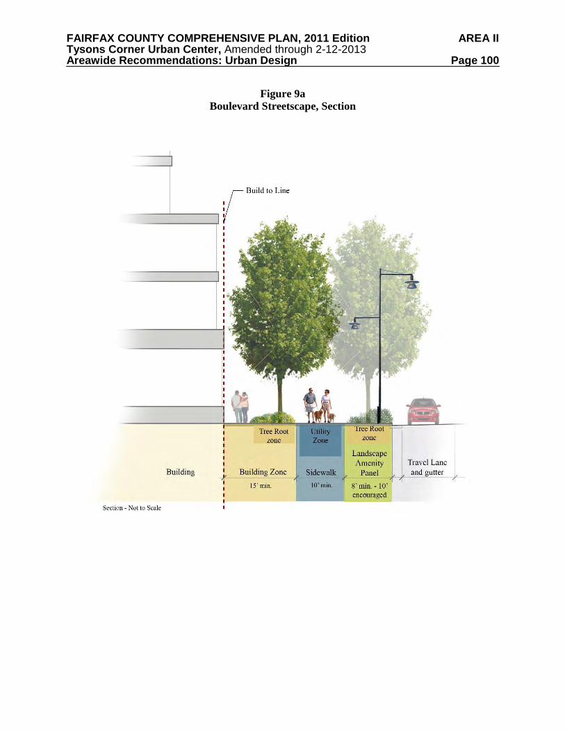
FAIRFAX COUNTY COMPREHENSIVE PLAN, 2011 Edition AREA II Tysons Corner Urban Center, Amended through 2-12-2013 Areawide Recommendations: Urban Design Page 100
Figure 9a
Boulevard Streetscape, Section
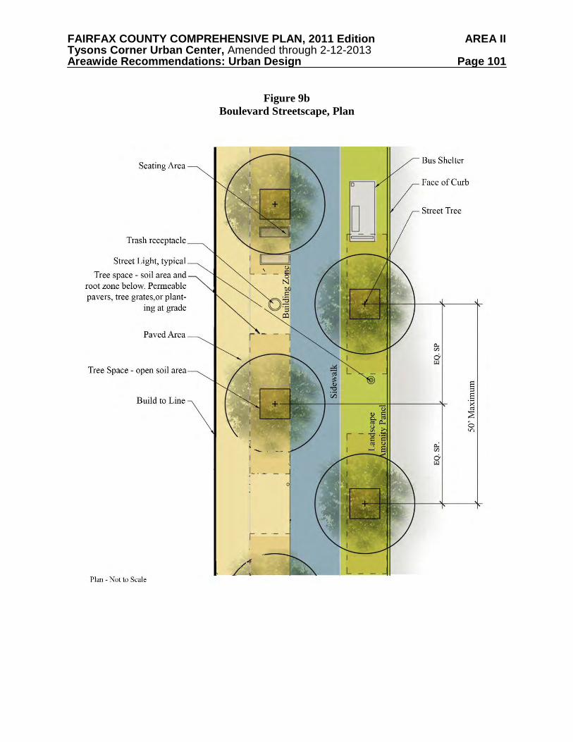
FAIRFAX COUNTY COMPREHENSIVE PLAN, 2011 Edition AREA II Tysons Corner Urban Center, Amended through 2-12-2013 Areawide Recommendations: Urban Design Page 101
Figure 9b
Boulevard Streetscape, Plan
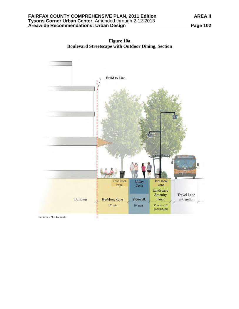
FAIRFAX COUNTY COMPREHENSIVE PLAN, 2011 Edition AREA II Tysons Corner Urban Center, Amended through 2-12-2013 Areawide Recommendations: Urban Design Page 102
Figure 10a
Boulevard Streetscape with Outdoor Dining, Section
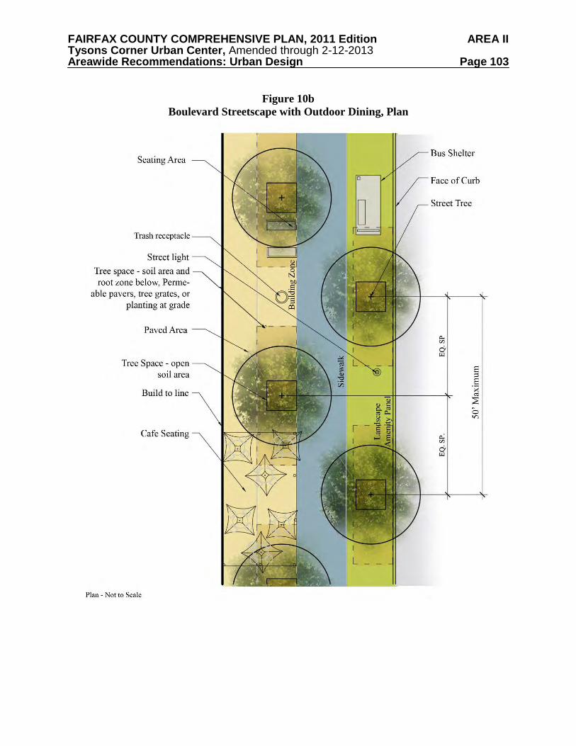
FAIRFAX COUNTY COMPREHENSIVE PLAN, 2011 Edition AREA II Tysons Corner Urban Center, Amended through 2-12-2013 Areawide Recommendations: Urban Design Page 103
Figure 10b
Boulevard Streetscape with Outdoor Dining, Plan
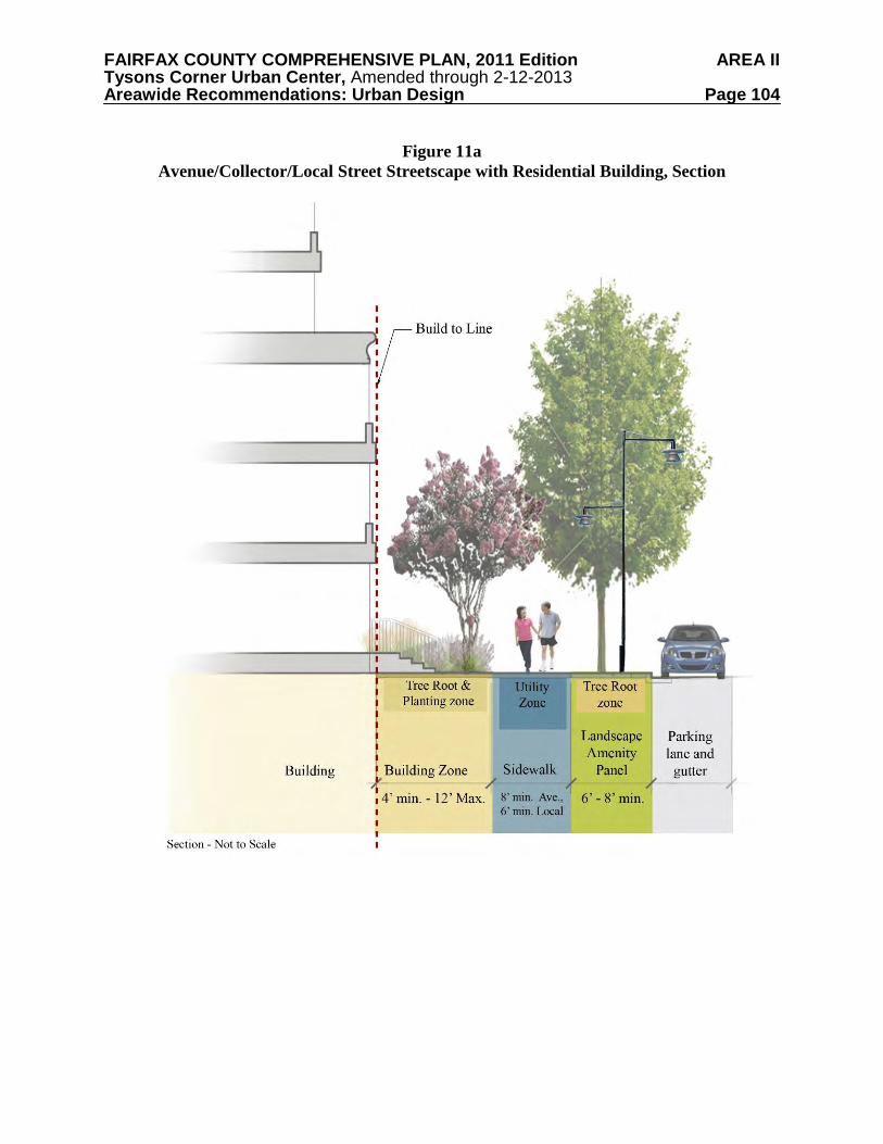
FAIRFAX COUNTY COMPREHENSIVE PLAN, 2011 Edition AREA II Tysons Corner Urban Center, Amended through 2-12-2013 Areawide Recommendations: Urban Design Page 104
Figure 11a
Avenue/Collector/Local Street Streetscape with Residential Building, Section
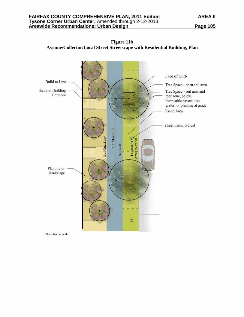
FAIRFAX COUNTY COMPREHENSIVE PLAN, 2011 Edition AREA II Tysons Corner Urban Center, Amended through 2-12-2013 Areawide Recommendations: Urban Design Page 105
Figure 11b
Avenue/Collector/Local Street Streetscape with Residential Building, Plan
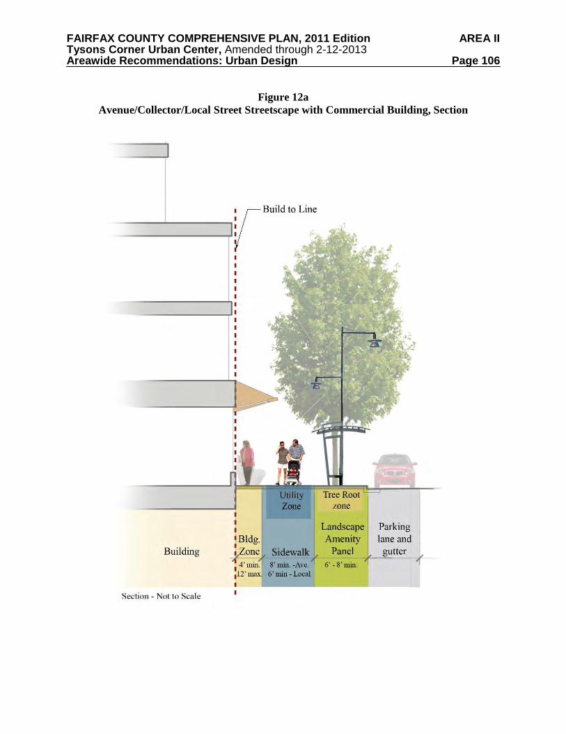
FAIRFAX COUNTY COMPREHENSIVE PLAN, 2011 Edition AREA II Tysons Corner Urban Center, Amended through 2-12-2013 Areawide Recommendations: Urban Design Page 106
Figure 12a
Avenue/Collector/Local Street Streetscape with Commercial Building, Section
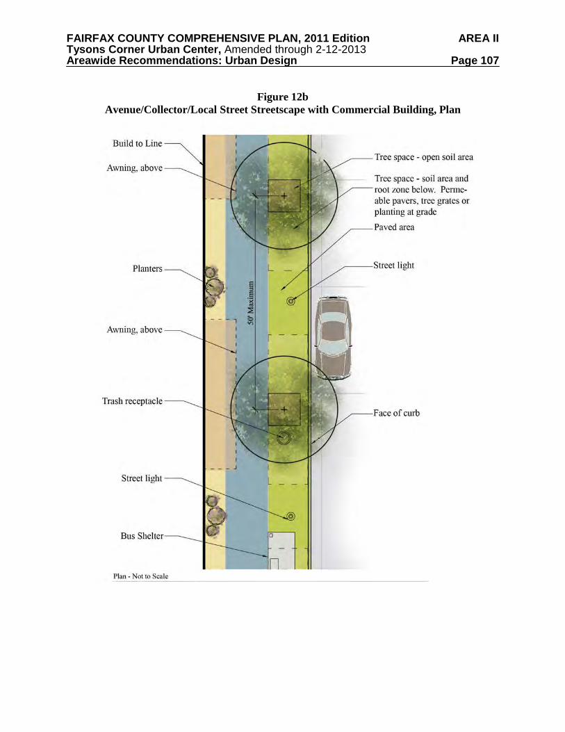
FAIRFAX COUNTY COMPREHENSIVE PLAN, 2011 Edition AREA II Tysons Corner Urban Center, Amended through 2-12-2013 Areawide Recommendations: Urban Design Page 107
Figure 12b
Avenue/Collector/Local Street Streetscape with Commercial Building, Plan
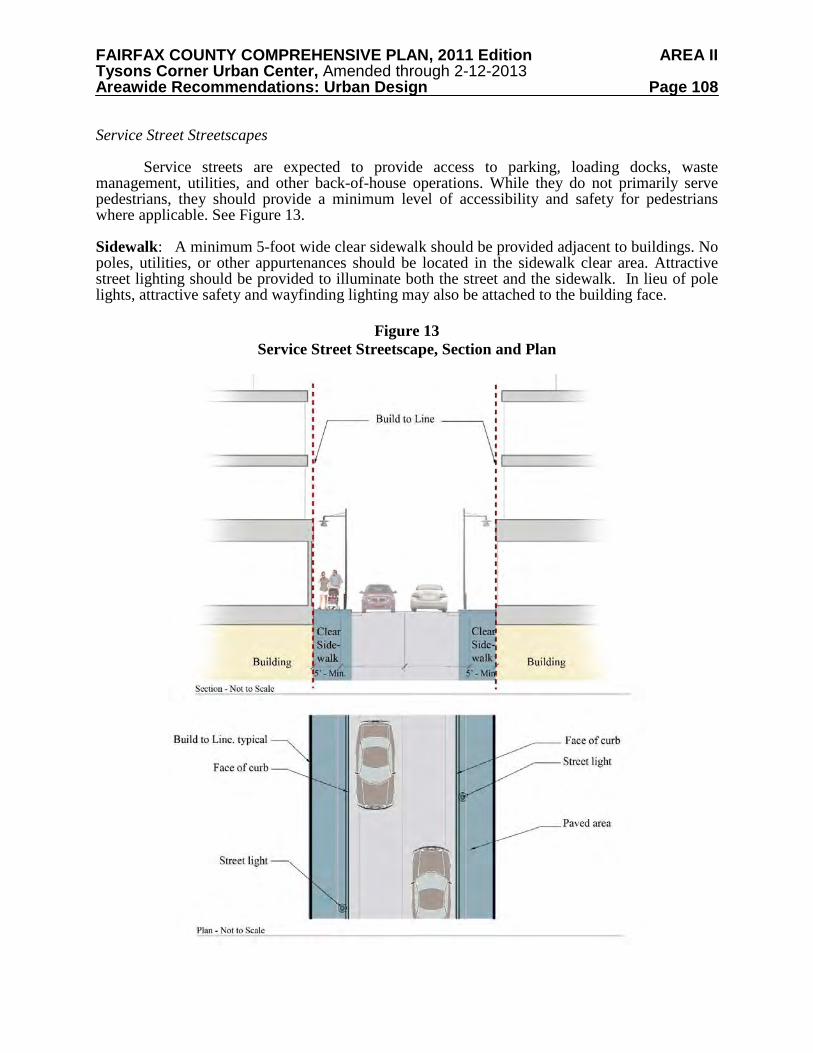
FAIRFAX COUNTY COMPREHENSIVE PLAN, 2011 Edition AREA II Tysons Corner Urban Center, Amended through 2-12-2013 Areawide Recommendations: Urban Design Page 108
Service Street Streetscapes
Service streets are expected to provide access to parking, loading docks, waste management, utilities, and other back-of-house operations. While they do not primarily serve pedestrians, they should provide a minimum level of accessibility and safety for pedestrians where applicable. See Figure 13. Sidewalk: A minimum 5-foot wide clear sidewalk should be provided adjacent to buildings. No poles, utilities, or other appurtenances should be located in the sidewalk clear area. Attractive street lighting should be provided to illuminate both the street and the sidewalk. In lieu of pole lights, attractive safety and wayfinding lighting may also be attached to the building face.
Figure 13 Service Street Streetscape, Section and Plan
FAIRFAX COUNTY COMPREHENSIVE PLAN, 2011 Edition AREA II Tysons Corner Urban Center, Amended through 2-12-2013 Areawide Recommendations: Urban Design Page 109
Building and Site Design
Building and site design must support the pedestrian realm to create a vibrant urban environment. The location of a building on a site should not create a barrier to pedestrians by interrupting the pedestrian circulation system. Typically, buildings should be located close to the sidewalk to allow for active storefronts and other uses that engage pedestrians. Non-active uses like loading docks, mechanical rooms, utility vaults, and exposed parking decks, should be oriented away from boulevards, avenues, and local streets. These uses, which detract from the pedestrian experience, should be located facing service streets or placed internally to the building envelope to minimize their negative impacts.
The scale of buildings in relationship to the street and sidewalk should also be considered. Tall, continuous buildings create canyon-like conditions which significantly detract from the pedestrian experience. Proposed developments should create building facades and frontages which are appropriate to pedestrians in scale and level of detail. In the same manner that excessive height along the sidewalk can feel uncomfortable to pedestrians, long expanses of blank walls or uniform materials can detract from the pedestrian experience and deter pedestrian movement.
If designed well, the combination of public and private spaces creates attractive and functional places to live, work, and shop. High standards for innovative architecture and landscape architecture will create a unique aesthetic and identity for the urban form within Tysons.
The following recommendations address Build-to Lines and Building Frontages; Bulk and Massing; Step-Backs; Building Articulation; Fenestration and Transparency; Parking Design; and Building Height. Build-to Lines and Building Frontages
The build-to line is a theoretical line on the ground indicating where the facades of buildings should be located. The line ensures that the ground floors of all buildings on a block are in line with each other at the edge of the streetscape. Exceptions to the build-to line may occur where plazas, pocket parks, or spaces for public art are located. The build-to line generally applies to the podium (or base) of the building structure and excludes building towers, which may be set back further to allow for light and air to reach the street. The building frontage is the portion of the building that serves to define and enclose the pedestrian realm. It aligns with the build-to line, and generally serves as a physical and visual boundary to the pedestrian realm. The building frontage typically separates exterior public space from interior semi-public or private space. The building frontage only applies to the floors of the building podium.
Proposed developments in Tysons should adhere to a consistently established build-to line for each block. The location of the build-to lines will relate to the streetscape guidance, the intensity and activity of the land uses, and the desired relationship of pedestrians to these uses. The location of the build-to line may vary depending on the character of the street and the district, and will be indicated in the specific urban design guidelines developed for each area.
FAIRFAX COUNTY COMPREHENSIVE PLAN, 2011 Edition AREA II Tysons Corner Urban Center, Amended through 2-12-2013 Areawide Recommendations: Urban Design Page 110
Existing uses and buildings that do not conform to the build-to line established by new development (especially those that are a part of phased redevelopment plans) should investigate opportunities to create visual and physical linkages to conforming new buildings that address the pedestrian realm. These buildings may use walls, landscaping, or other architectural features to align with other buildings at the build-to line. Articulation along these walls can result in sculptural elements and maintain visual interest along the sidewalk. Bulk and Massing
Redevelopment in Tysons will be urban in nature, and new buildings will generally occupy a majority of the block and be multiple stories in height. Sites should be designed with care to achieve the desired density goals, while remaining sensitive to the impact of development on the surrounding context. Guidance regarding building massing includes:
• Towers should be designed with height variations to protect access to light and views and to allow for privacy.
• Towers should be sited and spaced from one another in a manner that allows for light at the street level and minimizes long periods of shadow on the street, adjacent buildings, or public open space.
• Generally, towers should be located towards the wider rights-of-way, where the street section can absorb the additional building height better than narrower streets.
• Buildings should be at least two stories tall along the street, and should step-back above the podium as a transition to the building tower. Floor plate area reductions at the upper stories, and tower articulation should also be considered. In general, ground-floor commercial uses should be accessed directly from the adjacent
public sidewalk or building zone. Therefore, in the absence of significant existing elevation changes, storefronts should be at the same grade as the sidewalk and building zone.
Ground-floor residential uses, however, should be grade-separated from the public
sidewalk to distinguish the units and to provide some privacy. This creates the opportunity for stoops, bays, porches or entries that establish a distinct transition between private residential developments and the pedestrian realm.
If accessed directly from the public sidewalk, stairs should not impinge upon the
pedestrian realm; they should be located wholly on private property so as to not effect pedestrian movement. In lower density areas, front yards should be shallow and characterized by entry gardens and terraces that encourage a direct relationship between the building and the pedestrian realm. Step-Backs
The pedestrian experience is greatly influenced by the height of the building along the sidewalk. As a result, great care must be taken to preserve the proportion and scale of the street section so that it does not result in an overwhelming, dark, and windy pedestrian corridor. Step-backs are one tool that can be used to create an appropriate proportion of street width to building height.
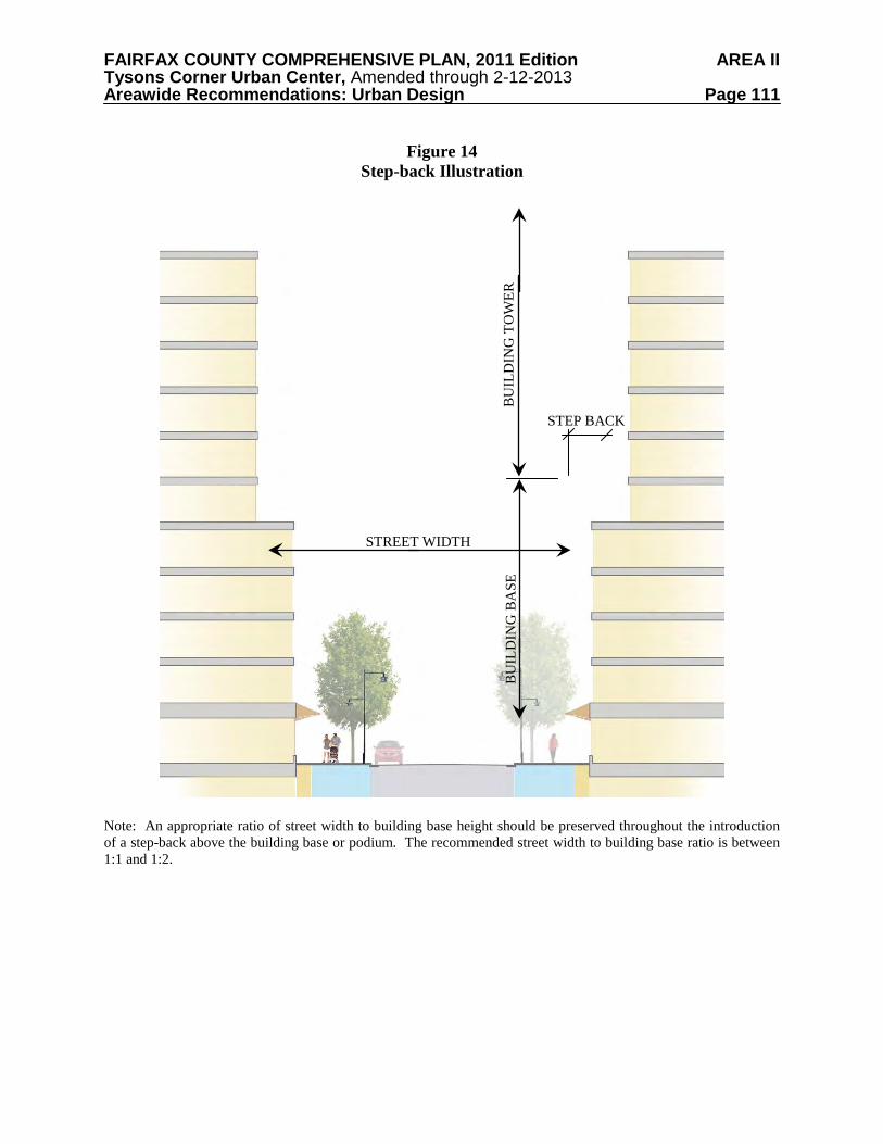
FAIRFAX COUNTY COMPREHENSIVE PLAN, 2011 Edition AREA II Tysons Corner Urban Center, Amended through 2-12-2013 Areawide Recommendations: Urban Design Page 111
Figure 14
Step-back Illustration
Note: An appropriate ratio of street width to building base height should be preserved throughout the introduction of a step-back above the building base or podium. The recommended street width to building base ratio is between 1:1 and 1:2.
STREET WIDTH
BU
ILD
ING
TO
WER
STEP BACK
BU
ILD
ING
BA
SE
FAIRFAX COUNTY COMPREHENSIVE PLAN, 2011 Edition AREA II Tysons Corner Urban Center, Amended through 2-12-2013 Areawide Recommendations: Urban Design Page 112
Step-backs result in building towers which are set back from the building frontage. As a
result, pedestrians only perceive the first few floors of the building podium, and not the full height of the tower. Step-backs can be used to reduce the impacts of shadows and increase the access of sunlight to the pedestrian realm. They can also reduce the “tunnel” effect that sometimes occurs along streets that are lined with taller buildings.
Step-backs occur above the building podium and can vary by location and context. They
can be used to add a measure of depth and complexity to the bulk of buildings. Step-backs may be necessary to ensure sunlight in certain locations, particularly as related to public open spaces. Solar shading analyses (also called sunlight or shadow studies) may be necessary to ensure that adjacent buildings will have adequate light and air.
In higher density areas, building podiums will tend to be taller, and thus, the step-back
may be located anywhere from four to eight stories above sidewalk level. In lower density areas, the step-back may occur from two to four stories above sidewalk level. Step-backs should be reviewed in proposed developments to confirm the scale and proportion of the street section and their relationship to adjacent building heights and scale. In general, the goal is to create a street width to podium height ratio anywhere from 1:1 to 1:2.
The use of the step-back technique, as illustrated in Figure 14, can help avoid the
“wedding cake” architecture which can result from excessive building setbacks. Building Articulation
In addition to building massing and setbacks, the treatment of building facades
contributes to the quality and character of the pedestrian realm. Building articulation, in the form of rhythmic bays, planar breaks, material changes, window systems, entries, balconies or stoops, can be used to break down the scale of building facades and avoid long, monotonous lengths of building elevation.
Building articulation should also include changes across the height of the building. This can include material, color, and textures which express the ground floor, building podium, and building tower. Articulation may also include cornices, different roof forms, and parapet modulation to provide visual interest.
Articulation provides the details which make buildings interesting and engaging. Further,
many articulation elements serve a dual purpose when they provide shade, demarcate entries, or act as gateway features.
Blank walls are solid walls without fenestration, entries or portals. When located at the
ground floor, they are detrimental to the pedestrian experience and may disrupt pedestrian flow. Such conditions should not be permitted on any public street-facing facade. Active uses should be provided at the ground floor as much as possible. If blank facades cannot be avoided, strategies should be employed to mitigate their impacts. These may include the provision of applied architectural elements, material changes, or other similar features to provide additional building detail and visual interest.
FAIRFAX COUNTY COMPREHENSIVE PLAN, 2011 Edition AREA II Tysons Corner Urban Center, Amended through 2-12-2013 Areawide Recommendations: Urban Design Page 113
Fenestration and Transparency
Where ground floor retail, commercial, community or other nonresidential uses occur, the facade above bulkhead and below the finished elevation of the first floor ceiling should be at least 60 percent transparent. This is measured by comparing the total glazed area for each building frontage to the total elevation area. Transparency should permit visibility from the sidewalk into a building and its active uses. Opaque, mirrored and translucent glass should be avoided and should not be considered “transparent.”
In residential buildings, the level of ground floor transparency may be lower for private
uses, such as living areas. Residential lobbies and other common spaces should exhibit higher transparency and should provide a visual connection to the pedestrian realm. To ensure adequate privacy in residential buildings, the sill of ground floor windows should be placed above the eye level of passers-by on adjacent sidewalks. This will be partially achieved through raising the finished grade of the ground floor residential units. Parking Design General Parking Design Recommendations
The following parking design recommendations are applicable to all areas of Tysons: • Parking access should always be designed in such a manner as to minimize conflicts
between vehicles and pedestrians and to take into account pedestrian safety. This may include reducing the number of parking access points and minimizing the widths of ramps and curb cuts where they intersect with the sidewalk.
• Vehicular access to parking lots and parking garages should be limited to local streets or service streets when feasible.
• Parking access should always be designed to be attractive and coordinated with the site plan and architecture.
• Certain uses, such as retail, civic or entertainment, may require highly visible parking. In these cases, the design of the parking and its access should be reflective of the activity that will occur within the building.
• Exterior and Interior parking structure lighting design should provide adequate lighting levels that ensure public safety without creating glare and light spillage into adjacent structures, roads, and the pedestrian realm. All parking lot lighting should confirm to current LEED light pollution requirements and County ordinances.
FAIRFAX COUNTY COMPREHENSIVE PLAN, 2011 Edition AREA II Tysons Corner Urban Center, Amended through 2-12-2013 Areawide Recommendations: Urban Design Page 114
Figure 15 Example of Below Ground/Podium Parking
Structured Parking
Underground parking is the least intrusive form of parking on the built environment and is the preferred method for providing parking in Tysons. Above-grade structured parking, or podium parking, may also be appropriate under some circumstances. Above-grade parking structures should be “wrapped” with active uses on all sides except along a service street. See Figure 15.
In some locations, exposed parking structures that are not wrapped with other uses may be unavoidable. In such cases, careful architectural detailing, lighting, and landscaping should be employed along the building frontage to mitigate the negative impacts of exposed parking levels. Generally, architecturally-treated garages should be designed consistent with surrounding buildings. Efforts should be taken to place these structures facing service streets. Stand-alone above-grade parking structures are discouraged. Surface Parking
Surface parking should be avoided. The exception to this guideline occurs in portions of the Non-TOD Districts near the edge of Tysons, where structured parking may not be economically feasible. Surface parking may be considered for short term parking or for passenger drop-off and pick-up areas. When provided, surface parking lots should be located to the side or rear of the primary use and should contain pedestrian connections that lead to the front door of the associated building. They should be intensively landscaped, be well-lighted, and publicly visible for greater safety. Surface parking lots should provide low walls or fences at the back of the sidewalk or parallel to the adjacent build-to line to enclose and define the pedestrian realm. They also should be designed to contribute to site stormwater management by using elements such as planter areas and permeable paving in the parking stall area.
FAIRFAX COUNTY COMPREHENSIVE PLAN, 2011 Edition AREA II Tysons Corner Urban Center, Amended through 2-12-2013 Areawide Recommendations: Urban Design Page 115
On-Street Parking On-street parking makes sidewalks safer and provides necessary and sometimes more accessible residential and retail parking. All avenues, collectors, and local streets within Tysons should provide on-street parking (see Transportation section for additional guidance). Where on-street parking is provided, curb cuts for vehicular access should be minimized in order to increase pedestrian safety and maximize the number of on-street parking spaces. Building Height
Building heights in Tysons will reflect the proposed intensity pattern. The tallest
buildings will be located within 1/8 mile of the Metro stations, with heights stepping down gradually as the distance from the stations increases. Building heights will be lowest in locations adjacent to existing single-family residential neighborhoods outside of Tysons. Careful design will protect view corridors and maintain access to sunlight at these sensitive locations. The concept for building heights in Tysons is shown in Map 10. Table 9 provides a range of maximum heights for each tier. Detailed guidance on maximum heights can be found in the District Recommendations.
The following are general recommendations regarding building height: • Maximum building height includes any above grade parking structures. • The tallest buildings of any development, particularly those that incorporate a tower
feature, should be located internal to the site and along wider streets where they will be less likely to overwhelm the pedestrian realm.
• Parcels that are split by two height designations should have the flexibility to utilize the range of heights permitted by the taller designation when development proposals provide height transitions similar to those on the Building Height Concept Map and provide a site design that is supportive of other urban design objectives.
• Building heights and massing should respond to context, intended uses, and the Plan’s vision for specific locations. Buildings may be oriented to maximize their view potential, but their location and orientation should take into consideration uses in the immediate vicinity.
• The tallest buildings (Tiers 1 and 2) should be iconic in design and serve as identifying features that contribute to the quality of the skyline. Iconic architecture can be defined as buildings that are well-crafted, unique, distinguishable within their context, and complementary to the urban fabric. Iconic architecture should also advance the overall quality of design within the district.
• Height limits do not include mechanical penthouses, architectural features, or elements affixed to buildings which are part of innovative energy technology such as wind turbines or solar panels. However, these features should not excessively increase the building height.
• Height flexibility will be provided to facilitate the provision of affordable/workforce housing, as well as public and quasi-public uses such as a conference center or arts center.
• During the development review process, solar shading analyses (also called shadow studies) for all buildings should be provided to ensure that adjacent buildings and public spaces will have adequate access to light and air.
FAIRFAX COUNTY COMPREHENSIVE PLAN, 2011 Edition AREA II Tysons Corner Urban Center, Amended through 2-12-2013 Areawide Recommendations: Urban Design Page 116
MA
P 10
FAIRFAX COUNTY COMPREHENSIVE PLAN, 2011 Edition AREA II Tysons Corner Urban Center, Amended through 2-12-2013 Areawide Recommendations: Urban Design Page 117
Table 9
Building Height Tiers
Tier Building Height Tier Building Height 1 225 to 400 ft 4 75 to 130 ft 2 175 to 225 ft 5 50 to 75 ft 3 130 to 175 ft 6 35 to 50 ft
Interim Conditions
In many cases developments will be phased over time. In addition to demonstrating how projects will ultimately adhere to the Urban Design Principles contained in the Plan, phased developments should prepare plans and supporting graphics that demonstrate how all interim conditions will meet Plan objectives, including those related to urban design. Among other design considerations, these plans should:
• Provide Pedestrian circulation that meets the connectivity goals of the Plan. • Show how any interim parking facilities will adhere to parking design goals. • Show how landscape and sustainable hardscape improvements will improve the aesthetic
character of any existing or proposed interim uses. • Show how interim stormwater facilities can be creatively incorporated into a high quality
landscape design. • Provide streetscape improvements that conform to Plan guidelines and that result in
enhanced continuity of the streetscape design. • Show how proposed public amenities such as open spaces and Urban Parks will be
integrated into the site.