Embed Size (px)
Citation preview
Plan of presentation
• TWG BU members
• General methodology
• Existing standards
• Use cases – user requirements
• Modelling approach
• Open issues
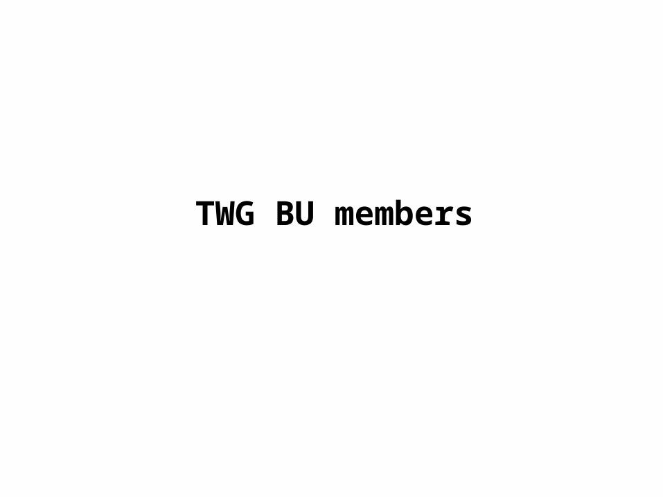
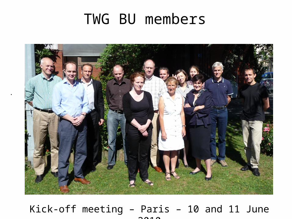
TWG BU members
TWG BU members• Barlow Simon (UK)• Bergström Eddie (Sweden)• Ferencz Zsuzsanna (Hungary)• Gröger Gerhard (Germany)• Johansson Karl-Gustav (Sweden) editor• Kooij Franck (Netherlands)• Laurent Dominique (France) facilitator• Mortier Frédéric (Belgium)• Skeljbo Karen (Denmark)• Taucer Fabio (JRC)• Velasco Amalia (Spain)• Wysocka Ewa (Poland)
• Gaffuri Julien JRC contact point
•
TWG BU members
•
Kick-off meeting – Paris – 10 and 11 June 2010
General methodology
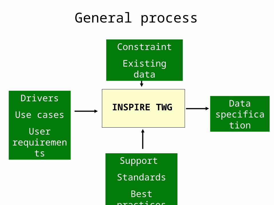
General process
INSPIRE TWGDrivers
Use cases
User requirements
Data specification
Constraint
Existing data
Support
Standards
Best practices
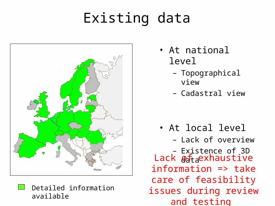
Existing data
• At national level– Topographical view– Cadastral view
• At local level– Lack of overview– Existence of 3D data
Detailed information available
Lack of exhaustive information => take care of
feasibility issues during review and testing

Existing standards
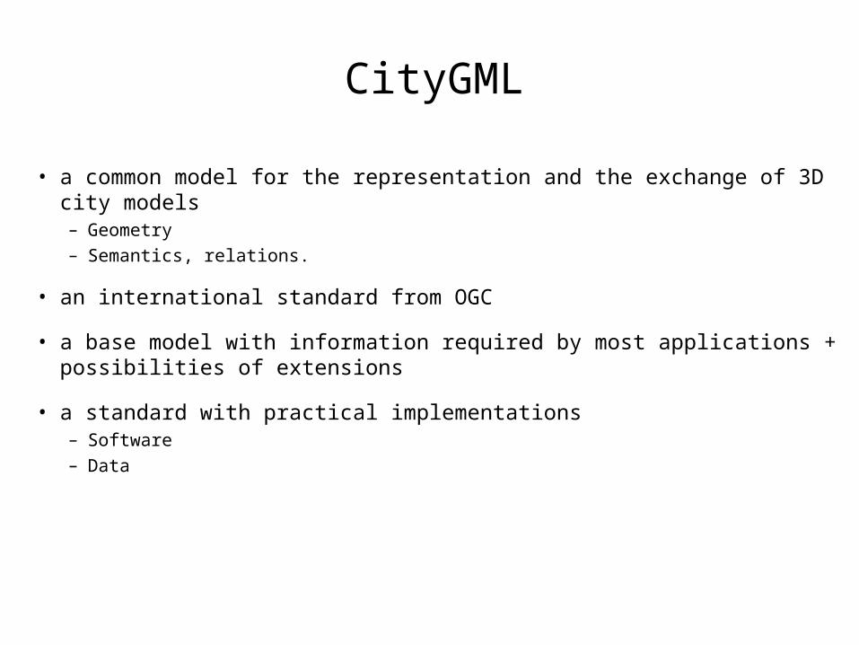
CityGML
• a common model for the representation and the exchange of 3D city models – Geometry– Semantics, relations.
• an international standard from OGC
• a base model with information required by most applications + possibilities of extensions
• a standard with practical implementations– Software– Data
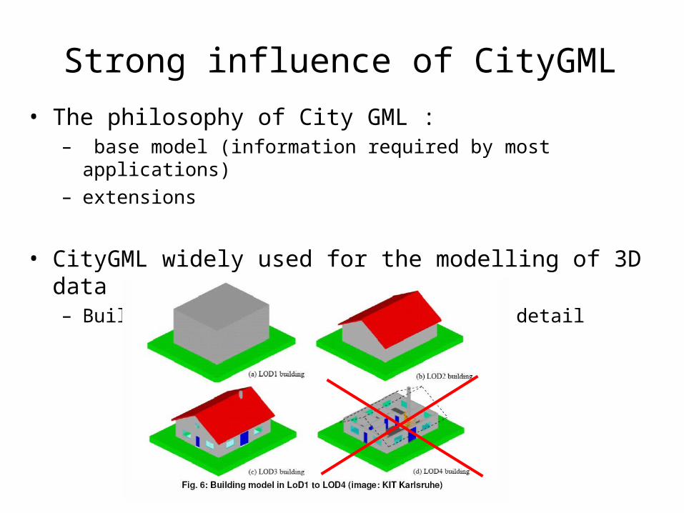
Strong influence of CityGML
• The philosophy of City GML :– base model (information required by most applications)– extensions
• CityGML widely used for the modelling of 3D data– Building model at different levels of detail
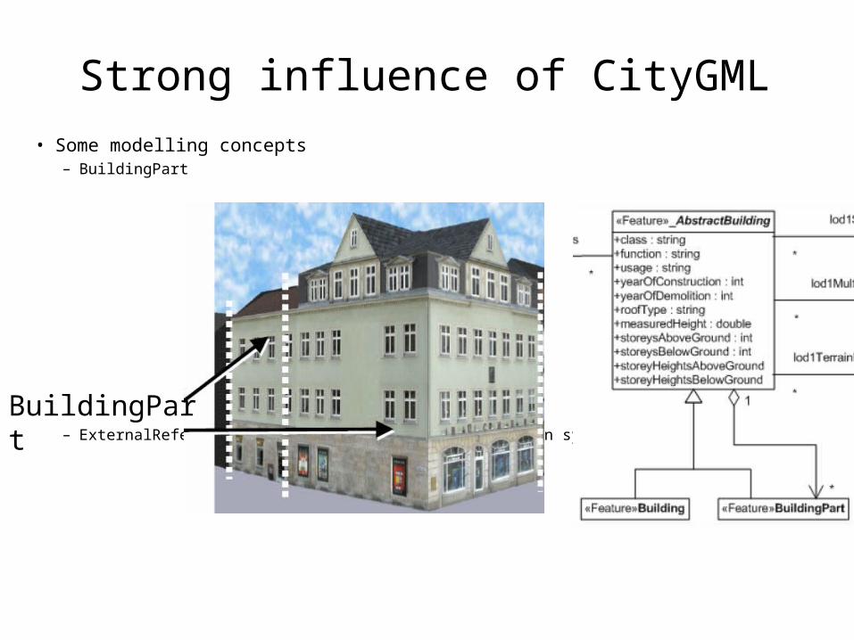
Strong influence of CityGML
• Some modelling concepts – BuildingPart
– ExternalReference : reference to another information system
BuildingPart
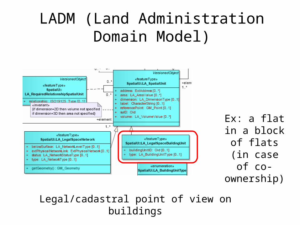
LADM (Land Administration Domain Model)
Legal/cadastral point of view on buildings
Ex: a flat in a block of flats (in case of
co-ownership)
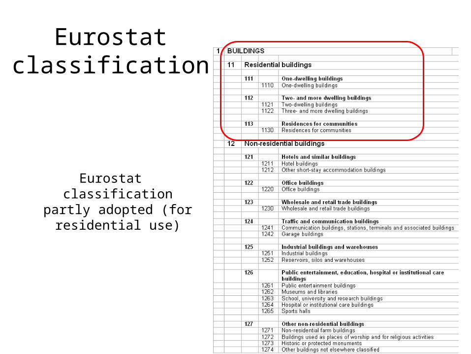
Eurostat classification
Eurostat classification partly adopted (for
residential use)

Use cases
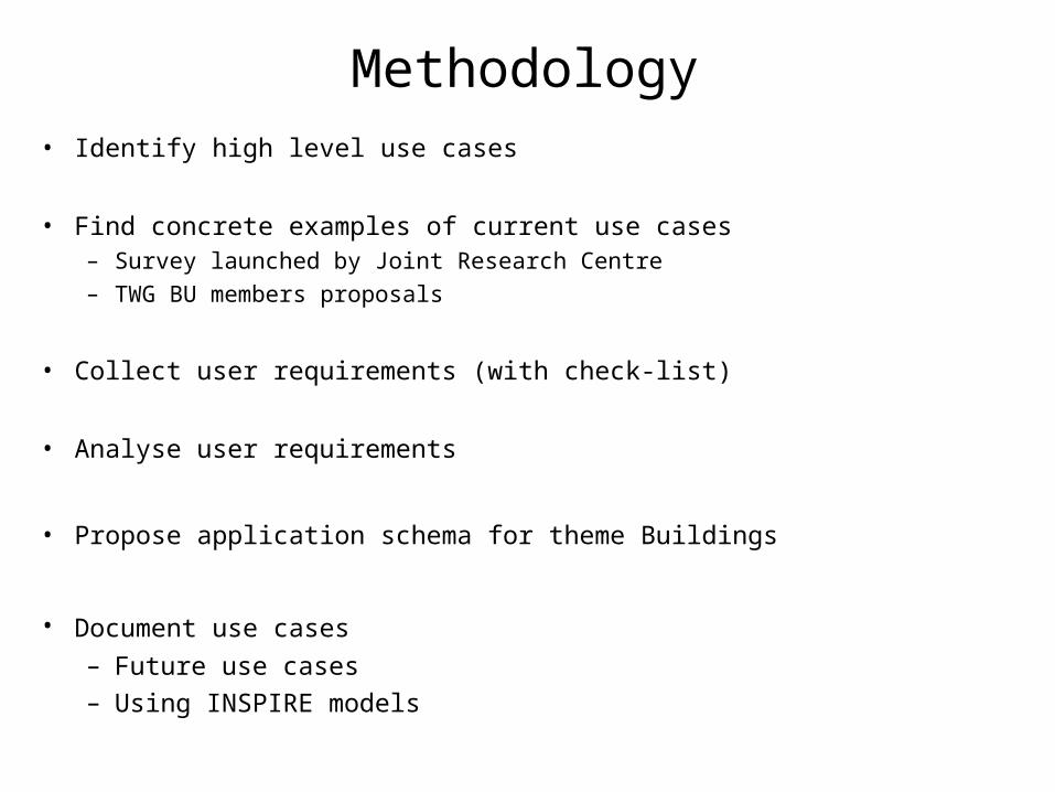
Methodology• Identify high level use cases
• Find concrete examples of current use cases – Survey launched by Joint Research Centre– TWG BU members proposals
• Collect user requirements (with check-list)
• Analyse user requirements
• Propose application schema for theme Buildings
• Document use cases – Future use cases– Using INSPIRE models
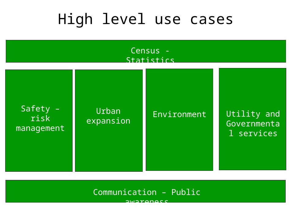
High level use cases
Safety – risk management
Urban expansion
Environment Utility and Governmental
services
Census - Statistics
Communication – Public awareness
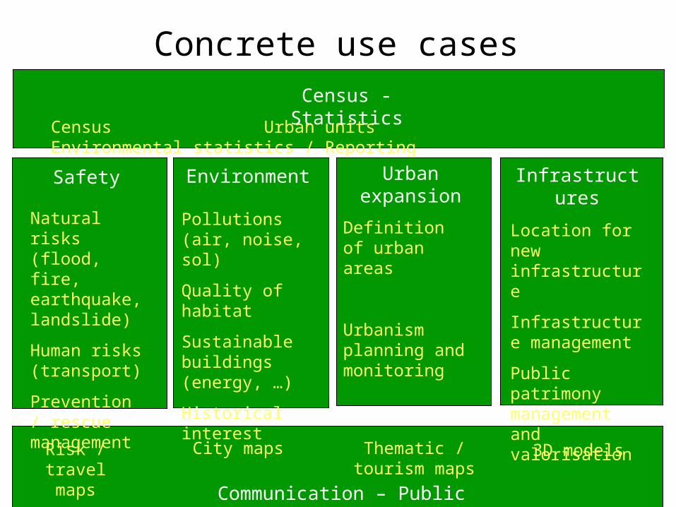
Concrete use cases
Safety Urban expansion
Environment Infrastructures
Census - Statistics
Communication – Public awareness
Natural risks (flood, fire, earthquake, landslide)
Human risks (transport)
Prevention / rescue management
Definition of urban areas
Urbanism planning and monitoring
Pollutions (air, noise, sol)
Quality of habitat
Sustainable buildings (energy, …)
Historical interest
Location for new infrastructure
Infrastructure management
Public patrimony management and valorisation
Risk / travel maps
City maps Thematic / tourism maps
3D models
Census Urban units Environmental statistics / Reporting
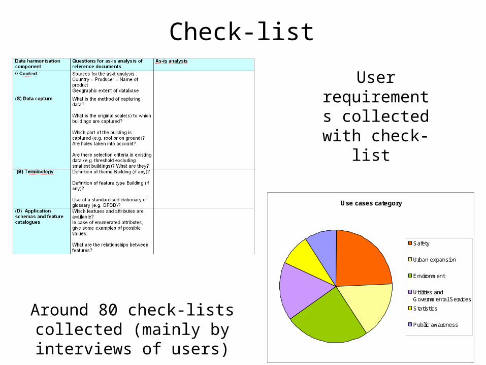
Check-list
User requirements collected with
check-list
Around 80 check-lists collected (mainly by interviews of users)
Use cases category
Safety
Urban expansion
Environment
Utilities andGovernmental Services
Statistics
Public awareness
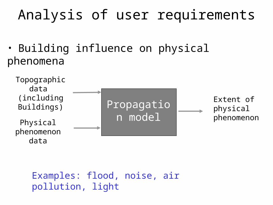
Analysis of user requirements
Propagation model
Topographic data
(including Buildings)
Physical phenomenon
data
Extent of physical phenomenon
Examples: flood, noise, air pollution, light
• Building influence on physical phenomena
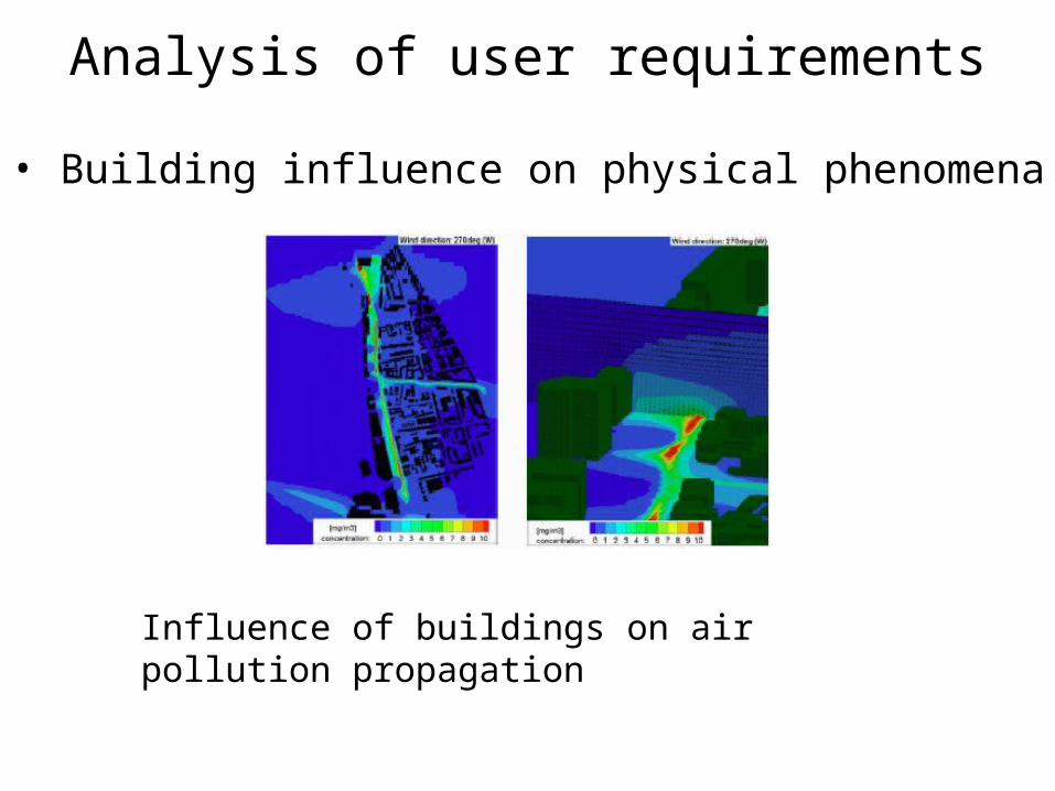
• Building influence on physical phenomena
Influence of buildings on air pollution propagation
Analysis of user requirements
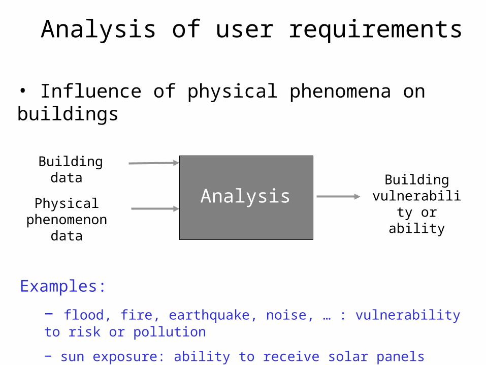
• Influence of physical phenomena on buildings
Building data
Examples:
− flood, fire, earthquake, noise, … : vulnerability to risk or pollution
− sun exposure: ability to receive solar panels
AnalysisPhysical phenomenon
data
Building vulnerability or
ability
Analysis of user requirements
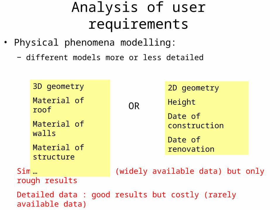
• Physical phenomena modelling:
− different models more or less detailed
Simple data: cheaper (widely available data) but only rough results
Detailed data : good results but costly (rarely available data)
3D geometry
Material of roof
Material of walls
Material of structure
…
2D geometry
Height
Date of construction
Date of renovation
OR
Analysis of user requirements
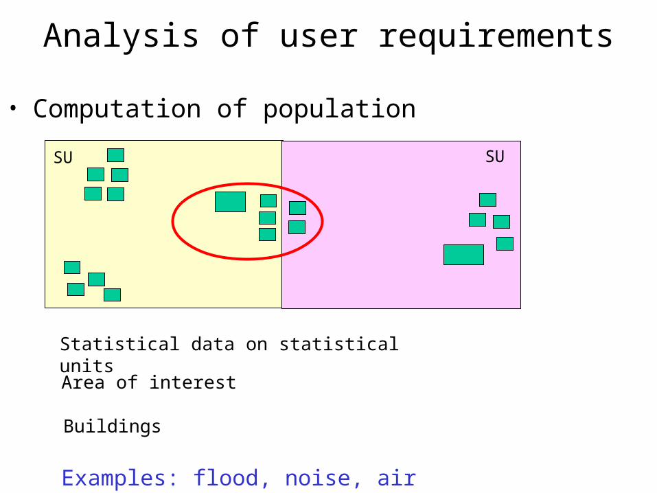
SU SU
Statistical data on statistical units
Area of interest
Buildings
Analysis of user requirements
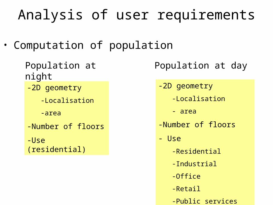
• Computation of population
Examples: flood, noise, air pollution, light, transport
Analysis of user requirements
• Computation of population
-2D geometry
-Localisation
-area
-Number of floors
-Use (residential)
-2D geometry
-Localisation
- area
-Number of floors
- Use
-Residential
-Industrial
-Office
-Retail
-Public services
Population at night Population at day
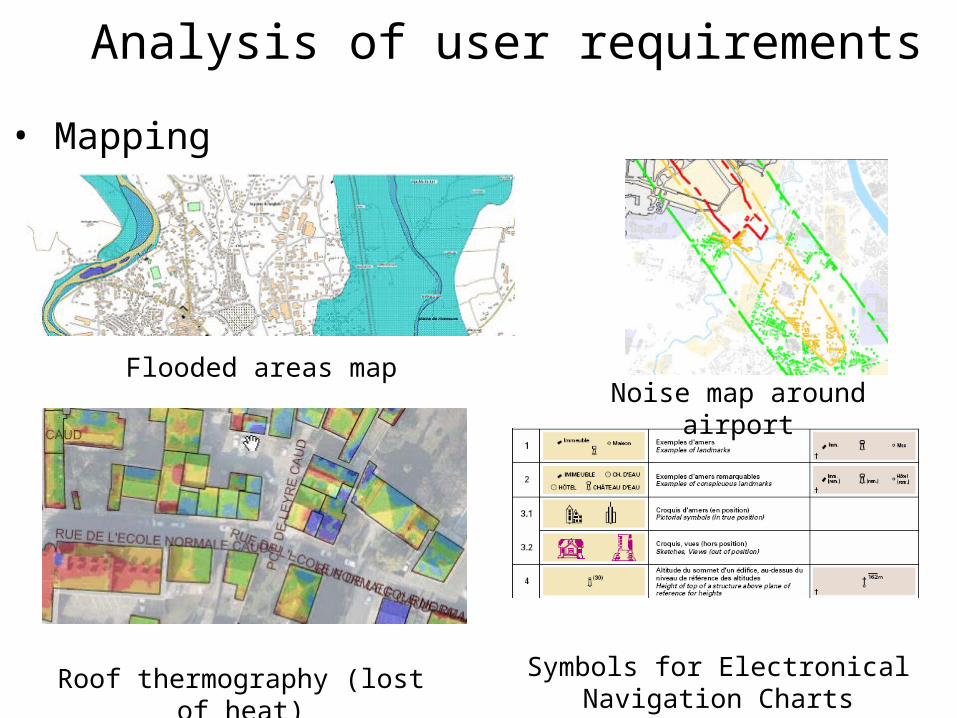
• Mapping
Flooded areas mapNoise map around airport
Roof thermography (lost of heat) Symbols for Electronical Navigation Charts
Analysis of user requirements
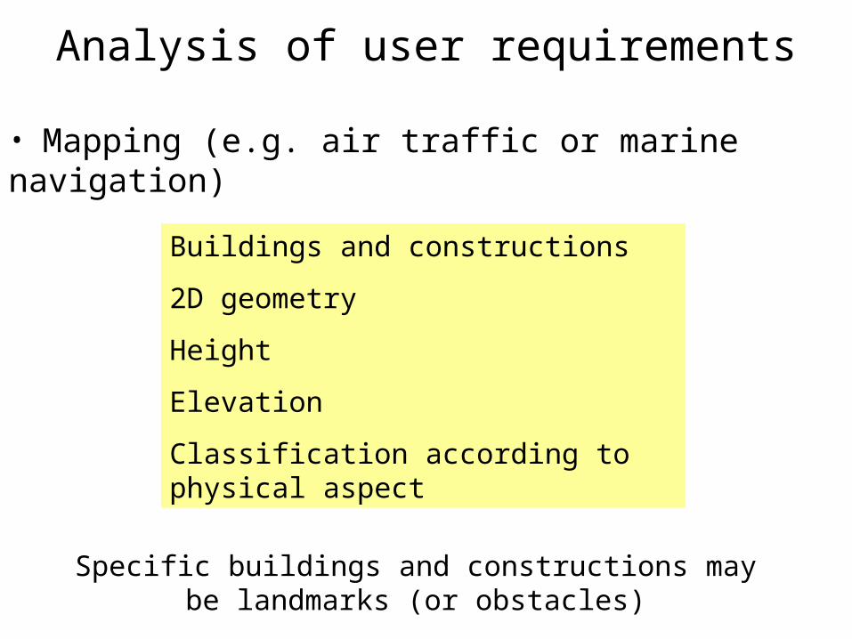
Analysis of user requirements
• Mapping (e.g. air traffic or marine navigation)
Buildings and constructions
2D geometry
Height
Elevation
Classification according to physical aspect
Specific buildings and constructions may be landmarks (or obstacles)
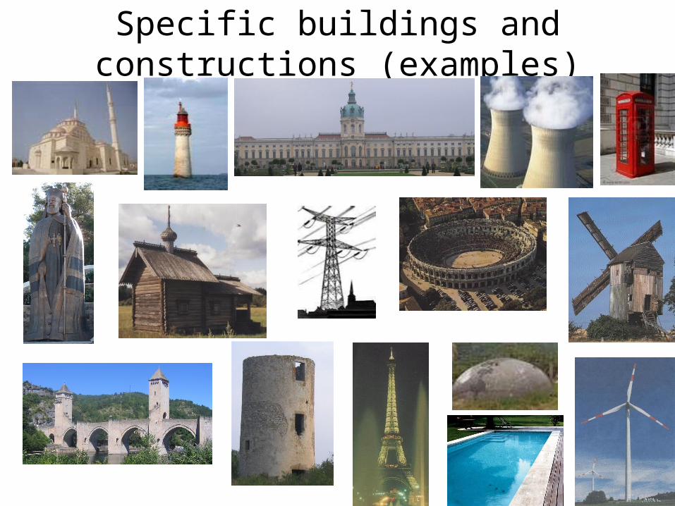
Specific buildings and constructions (examples)
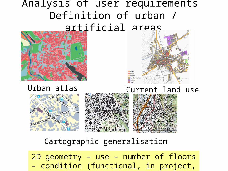
Analysis of user requirements Definition of urban / artificial areas
Urban atlas (GMES) Current land use map
Cartographic generalisation
2D geometry – use – number of floors – condition (functional, in project, ruin,…)
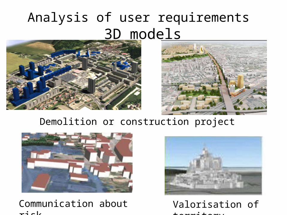
Analysis of user requirements 3D models
Demolition or construction project
Communication about risk
Valorisation of territory
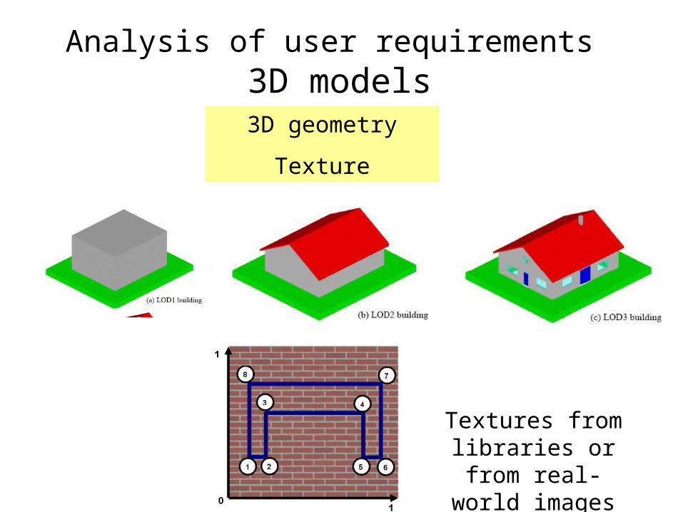
Analysis of user requirements 3D models3D geometry
Texture
Textures from libraries or from
real-world images
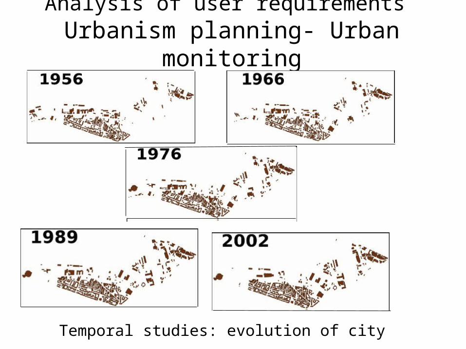
Analysis of user requirements Urbanism planning- Urban monitoring
Temporal studies: evolution of city
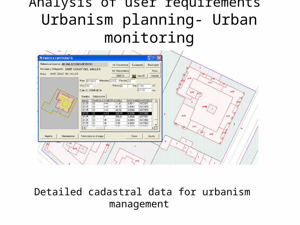
Analysis of user requirements Urbanism planning- Urban monitoring
Detailed cadastral data for urbanism management
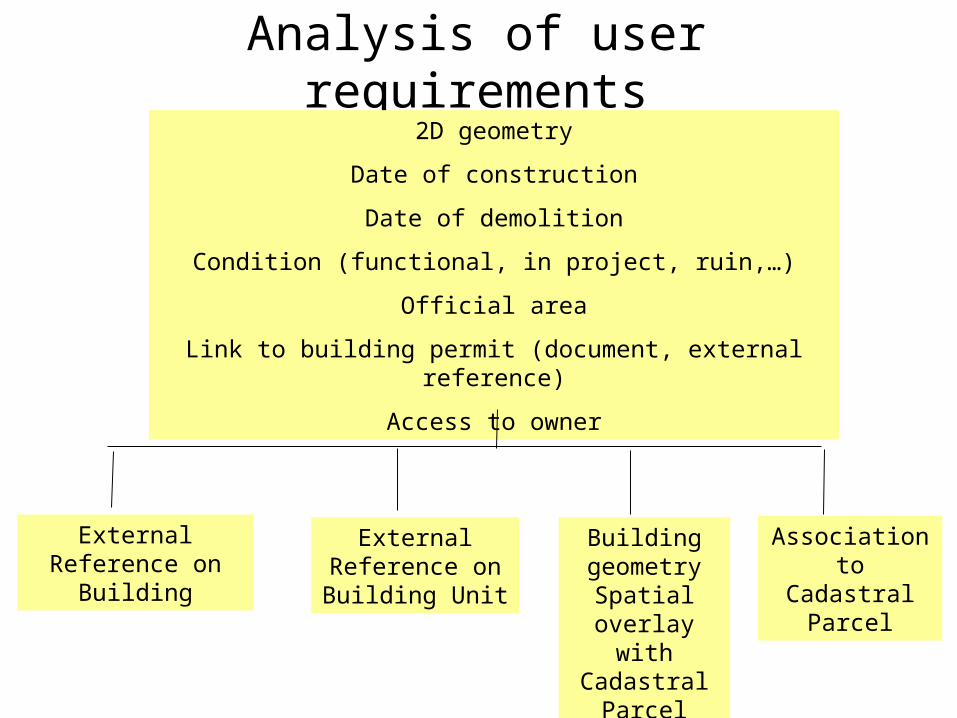
Analysis of user requirements
External Reference on Building
External Reference on Building Unit
Building geometry
Spatial overlay with Cadastral
Parcel
Association to Cadastral Parcel
2D geometry
Date of construction
Date of demolition
Condition (functional, in project, ruin,…)
Official area
Link to building permit (document, external reference)
Access to owner
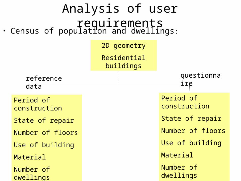
Analysis of user requirements• Census of population and dwellings:
2D geometry
Residential buildings
Period of construction
State of repair
Number of floors
Use of building
Material
Number of dwellings
Heating / toilet / water
Period of construction
State of repair
Number of floors
Use of building
Material
Number of dwellings
Heating / toilet / water
reference data questionnaire
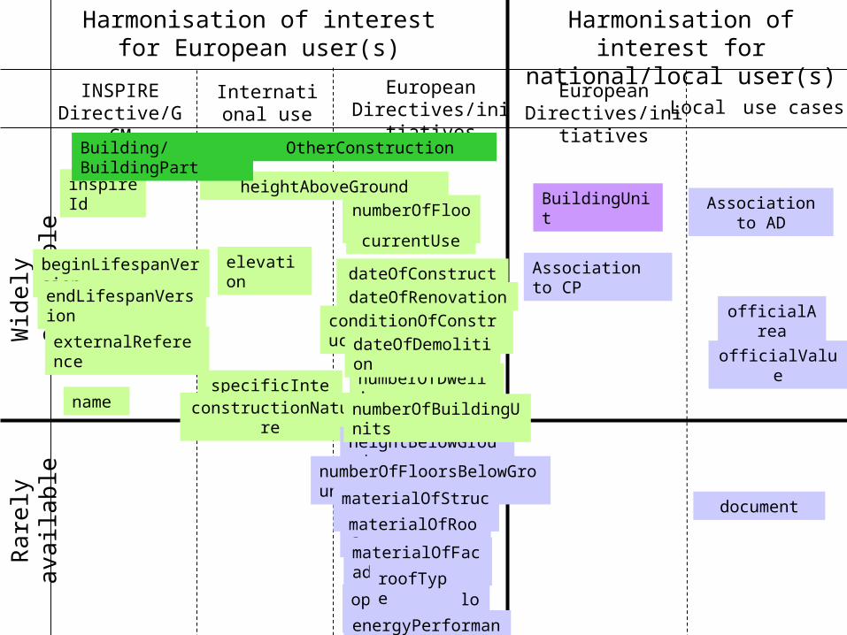
Harmonisation of interest for European user(s)
Harmonisation of interest for national/local user(s)
INSPIRE Directive/GCM
International use cases
European Directives/initiatives
European Directives/initiatives Local use cases
Wid
ely
avai
labl
eRa
rely
ava
ilabl
e
inspireId
beginLifespanVersion
endLifespanVersion
OtherConstruction
heightAboveGround
elevation
specificInterestconstructionNature
numberOfFloors
currentUse
dateOfConstruction
name
dateOfRenovation
externalReference
numberOfDwellings
Association to CP
heightBelowGround
numberOfFloorsBelowGround
materialOfStructure
materialOfRoof
materialOfFacade
openGroundFloorroofType
Association to AD
officialArea
officialValue
conditionOfConstruction
document
dateOfDemolition
energyPerformance
BuildingUnit
Building/BuildingPart
numberOfBuildingUnits
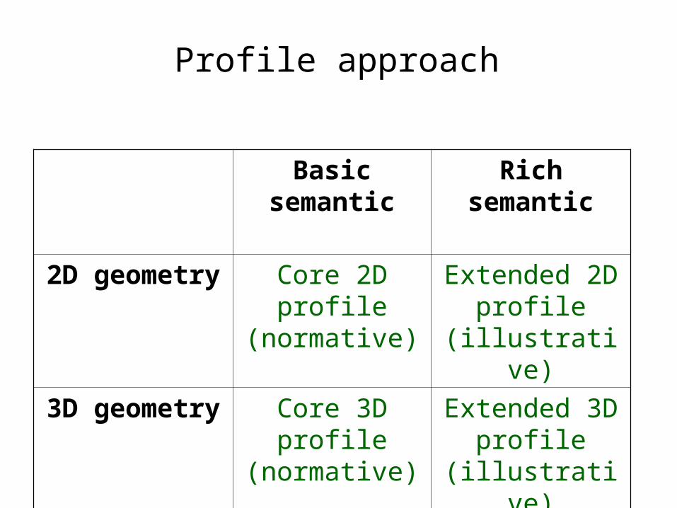
Profile approach
Basic semantic
Rich semantic
2D geometry Core 2D profile (normative)
Extended 2D profile
(illustrative)
3D geometry Core 3D profile (normative)
Extended 3D profile
(illustrative)
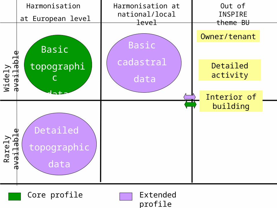
Harmonisation
at European level
Harmonisation at national/local level
Wid
ely
avai
labl
eRa
rely
ava
ilabl
eOut of INSPIRE
theme BU
Basic
topographic
data
Basic
cadastral
data
Detailed
topographic
data
Owner/tenant
Interior of building
Detailed activity
Core profile Extended profile
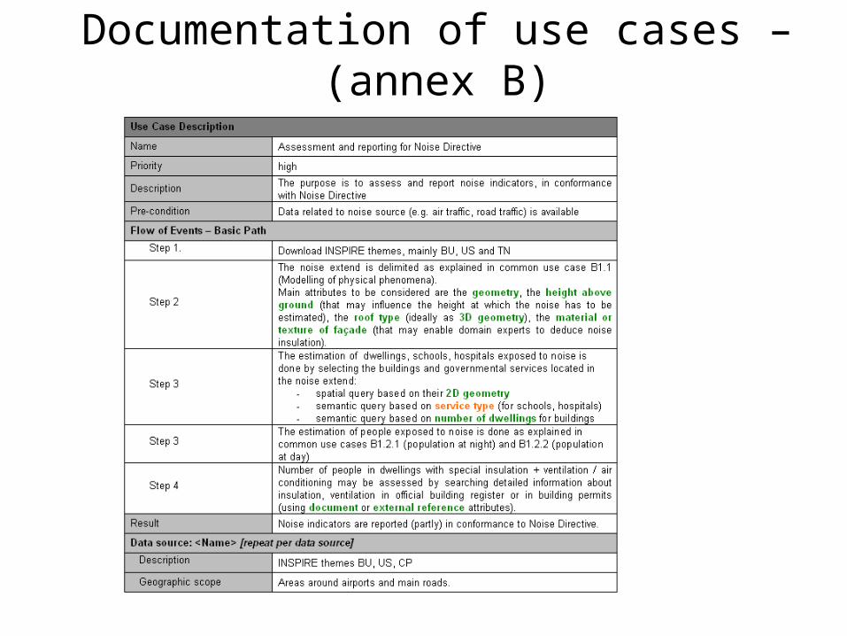
Documentation of use cases – (annex B)
Modelling approach
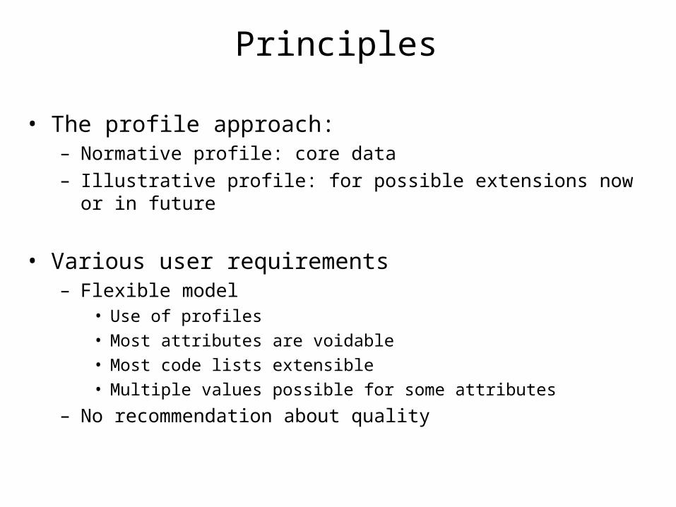
Principles
• The profile approach:– Normative profile: core data– Illustrative profile: for possible extensions now or in future
• Various user requirements – Flexible model
• Use of profiles
• Most attributes are voidable
• Most code lists extensible
• Multiple values possible for some attributes
– No recommendation about quality
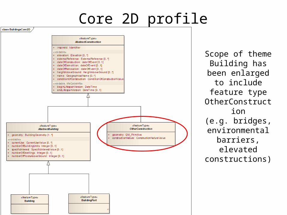
Core 2D profile
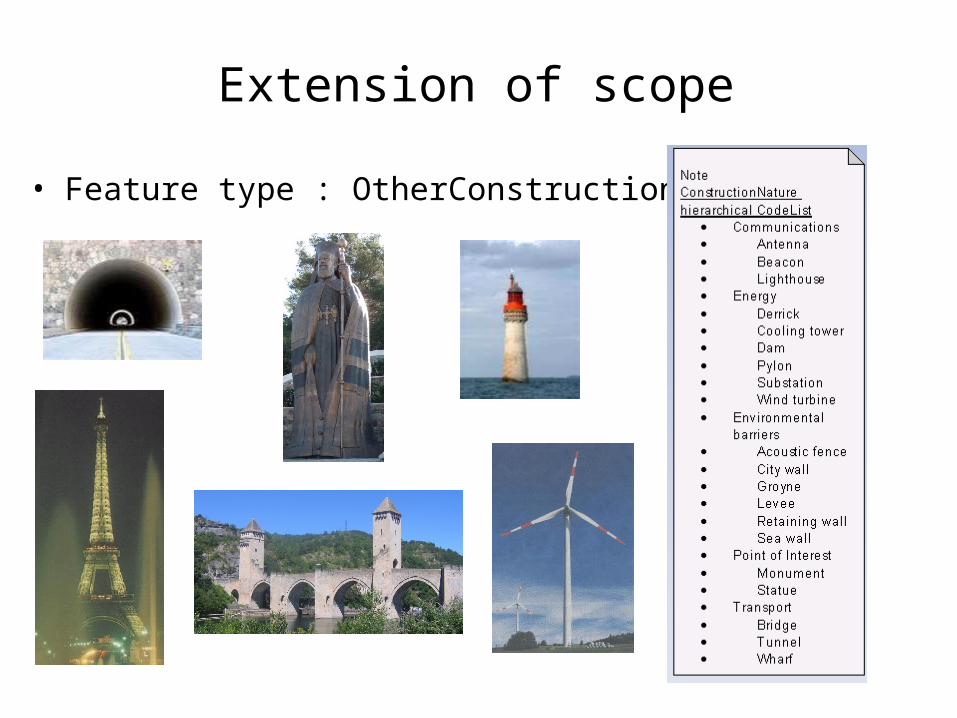
Scope of theme Building has been enlarged to include
feature type OtherConstruction
(e.g. bridges, environmental
barriers, elevated constructions)
Extension of scope
• Feature type : OtherConstruction
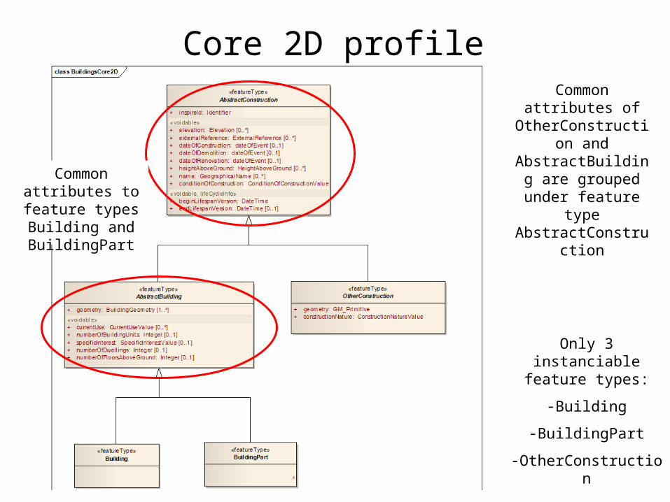
Core 2D profileCommon attributes
of OtherConstruction and AbstractBuilding are grouped under
feature type AbstractConstructionCommon
attributes to feature types Building and BuildingPart
Only 3 instanciable feature types:
-Building
-BuildingPart
-OtherConstruction
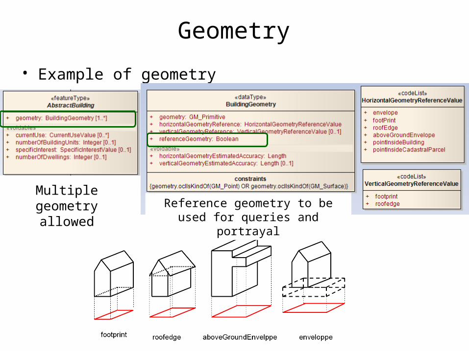
Geometry
• Example of geometry
Multiple geometry allowed Reference geometry to be used for
queries and portrayal
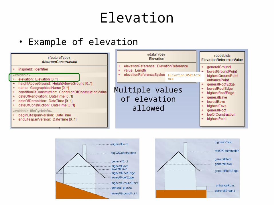
Elevation
• Example of elevation
Multiple values of elevation allowed
ElevationCRSReference
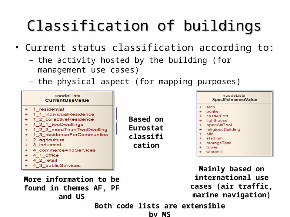
Classification of buildingsClassification of buildings• Current status classification according to:
– the activity hosted by the building (for management use cases)– the physical aspect (for mapping purposes)
Based on Eurostat
classification
More information to be found in themes AF, PF and US
Mainly based on international use cases (air traffic, marine navigation)
Both code lists are extensible by MS
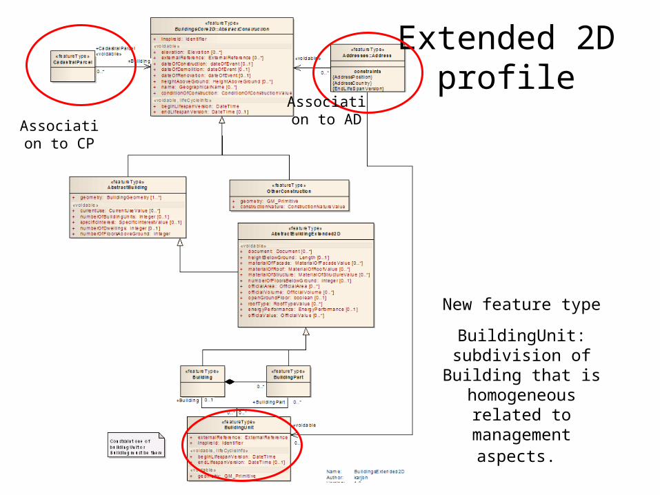
Extended 2D profile
New feature type
BuildingUnit: subdivision of Building that is homogeneous
related to management aspects.
Association to CP
Association to AD
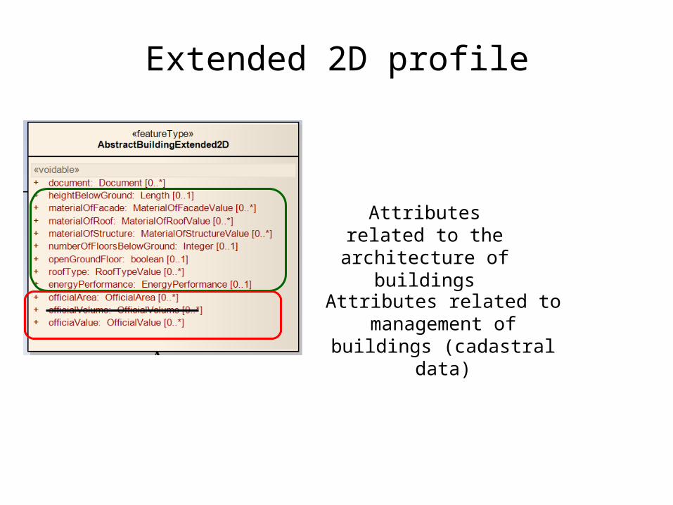
Extended 2D profile
Attributes related to the architecture of buildings
Attributes related to management of buildings
(cadastral data)
class BuildingsCore3D
«type»Geometric primitiv e::GM_Solid
+ area() : Area+ boundary() : GM_SolidBoundary+ GM_Solid(GM_SolidBoundary*) : GM_Solid+ volume() : Volume
Name: BuildingsCore3DAuthor: karjohVersion: 1.9Created: 2010-09-23 16:52:12Updated: 2011-04-28 11:51:44
«featureType»AbstractConstruction
+ horizontalGeometryEstimatedAccuracy: Length+ verticalGeometryEstimatedAccuracy: Length [0..1]
«featureType»OtherConstruction
+ constructionNature: ConstructionNatureValue
«featureType»Core2DAbstractBuilding
«voidable»+ currentUse: CurrentUseValue [0..*]+ numberOfBuildingUnits: Integer [0..1]+ numberOfFloorsAboveGround: Integer [0..1]+ specificInterest: SpecificInterestValue+ numberOfDwellings: Integer [0..1]
«featureType»BuildingsCore2D::AbstractConstruction
+ inspireId: Identifier
«voidable»+ elevation: Elevation [0..*]+ dateOfConstruction: DateTime [0..1]+ dateOfDemolition: DateTime [0..1]+ dateOfRenovation: DateTime [0..1]+ heightAboveGround: HeightAboveGround [0..*]+ name: GeographicalName [0..*]+ conditionOfConstruction: ConditionOfConstructionValue
«voidable, l ifeCycleInfo»+ beginLifespanVersion: DateTime+ endLifespanVersion: DateTime [0..1]
«featureType»Building
«featureType»BuildingPart
0..*
lod1Solid
1
0..*
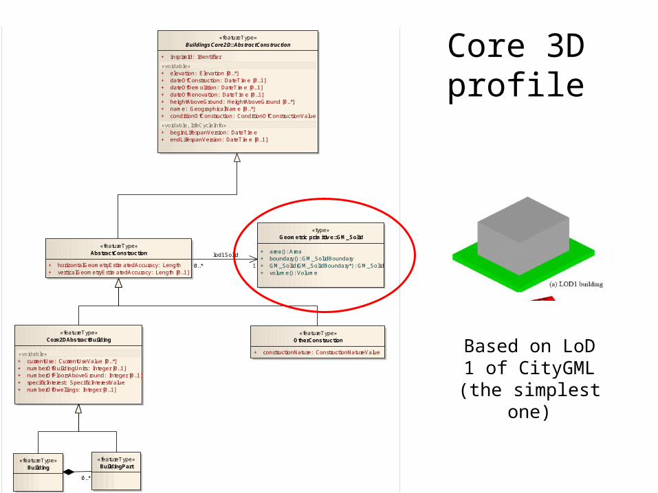
Core 3D profile
Based on LoD 1 of CityGML (the simplest one)
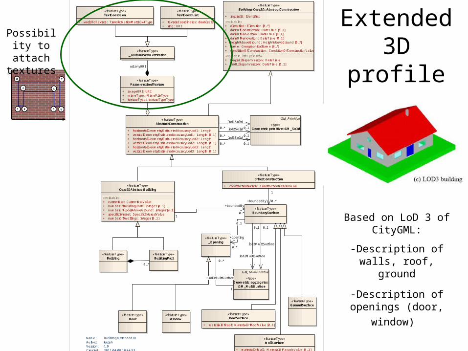
Extended 3D profile
Based on LoD 3 of CityGML:
-Description of walls, roof, ground
-Description of openings
(door, window)
class BuildingsExtended3D
«featureType»BoundarySurface
«featureType»WallSurface
+ materialOfWall: MaterialOfFacadeValue [0..1]
«featureType»RoofSurface
+ materialOfRoof: MaterialOfRoofValue [0..1]
«featureType»GroundSurface
GM_MultiPrimitive
«type»Geometric aggregates:
:GM_MultiSurface
«featureType»_Opening
«featureType»Door
«featureType»Window
GM_Primitive
«type»Geometric primitiv e::GM_Solid
«featureType»AbstractConstruction
+ horizontalGeometryEstimatedAccuracyLod1: Length+ verticalGeometryEstimatedAccuracyLod1: Length [0..1]+ horizontalGeometryEstimatedAccuracyLod2: Length+ verticalGeometryEstimatedAccuracyLod2: Length [0..1]+ horizontalGeometryEstimatedAccuracyLod3: Length+ verticalGeometryEstimatedAccuracyLod3: Length [0..1]
«featureType»OtherConstruction
+ constructionNature: ConstructionNatureValue
«featureType»BuildingsCore2D::AbstractConstruction
+ inspireId: Identifier
«voidable»+ elevation: Elevation [0..*]+ dateOfConstruction: DateTime [0..1]+ dateOfDemolition: DateTime [0..1]+ dateOfRenovation: DateTime [0..1]+ heightAboveGround: HeightAboveGround [0..*]+ name: GeographicalName [0..*]+ conditionOfConstruction: ConditionOfConstructionValue
«voidable, l ifeCycleInfo»+ beginLifespanVersion: DateTime+ endLifespanVersion: DateTime [0..1]
Name: BuildingsExtended3DAuthor: karjohVersion: 1.9Created: 2011-04-08 10:44:53Updated: 2011-04-28 11:53:26
«featureType»ParameterizedTexture
+ imageURI: URI+ mimeType: MimeFileType+ textureType: textureTypeType
«featureType»_TextureParametrization
«featureType»TextCoordGen
+ worldToTexture: TransformationMatrix3x4Type
«featureType»TextCoordList
+ textureCoordinates: doubleList+ ring: URI
«featureType»Core2DAbstractBuilding
«voidable»+ currentUse: CurrentUseValue+ numberOfBuildingUnits: Integer [0..1]+ numberOfFloorsAboveGround: Integer [0..1]+ specificInterest: SpecificInterestValue+ numberOfDwellings: Integer [0..1]
«featureType»Building
«featureType»BuildingPart
0..1
+opening
0..*
1
+boundedBy 0..*
0..*
lod3Solid
0..1
0..*
lod1Solid
0..1
0..*
lod2Solid
0..1
0..*
+lod3MultiSurface
1
0..1
lod3MultiSurface
0..1
lod2MultiSurface
1
+boundedBy
0..*
0..*
uri:anyURI
Possibility to attach textures
Main issues
• Is our model feasible?
• Is extension of scope to constructions relevant? Which benefits? Which costs?
• Should cadastral data (or part of it) be in core profile?
• Should TWG BU propose a more detailed classification of buildings?


![Twg Gc 2008 Final[1]](https://img.pdfslide.us/doc/110x75/577dacc31a28ab223f8e58c7/twg-gc-2008-final1.jpg)