Embed Size (px)
Citation preview
Tropical Cyclone Gale Wind Radii Estimates,
Forecasts and Forecast Error Estimates for
the Western North Pacific
Contributors
Buck Sampson (NRL)
Jim Goerss (SAIC)
John Knaff (NESDIS)
Brian Strahl (JTWC, presenter)
Ed Fukada (CSRA)
Kim Richardson (NRL)
Efren Serra (DeVine)
Thomas Meissner and Lucrezia Ricciardulli (REMSS)
Outline
• Motivation
• Estimating gale wind radii (R34)
– Satellite-based
– NWP models
– Mean (OBTK) and estimated error
• Forecasting R34
– NWP models and consensus (RVCN)
• Forecasting R34 errors (GPCE)
• Conclusions
• Note:R34 = gale wind radii
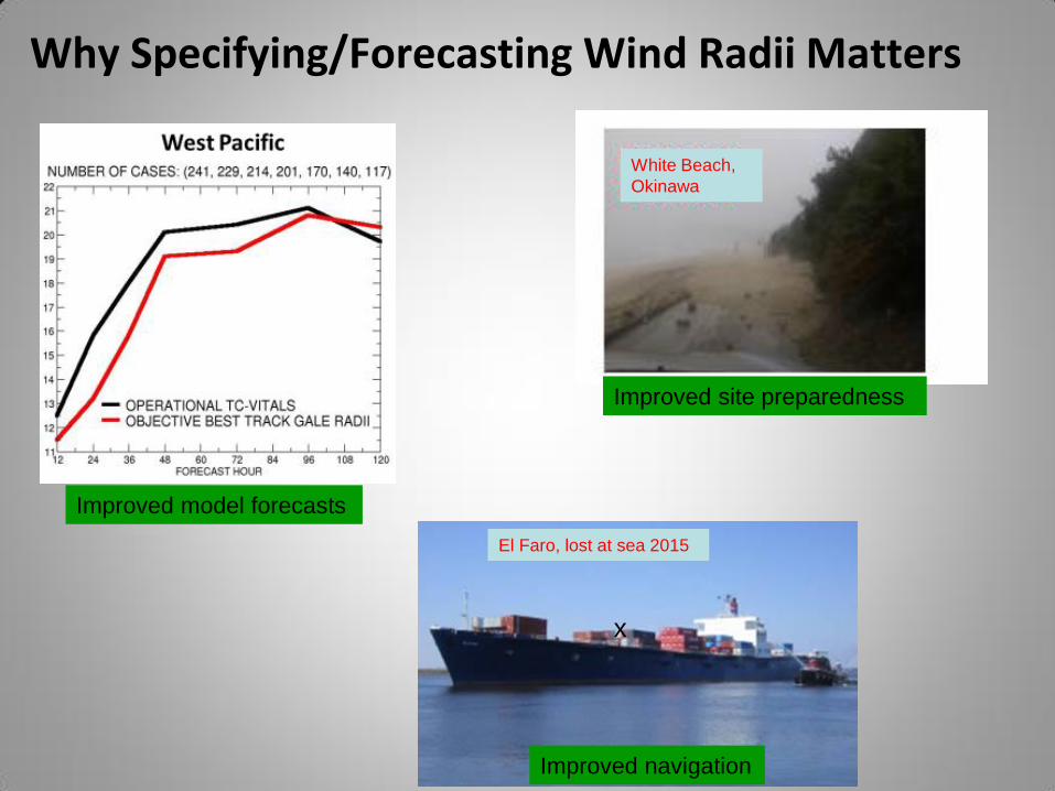
Why Specifying/Forecasting Wind Radii Matters
Improved model forecasts
Improved navigation
Improved site preparedness
x
El Faro, lost at sea 2015
White Beach,
Okinawa
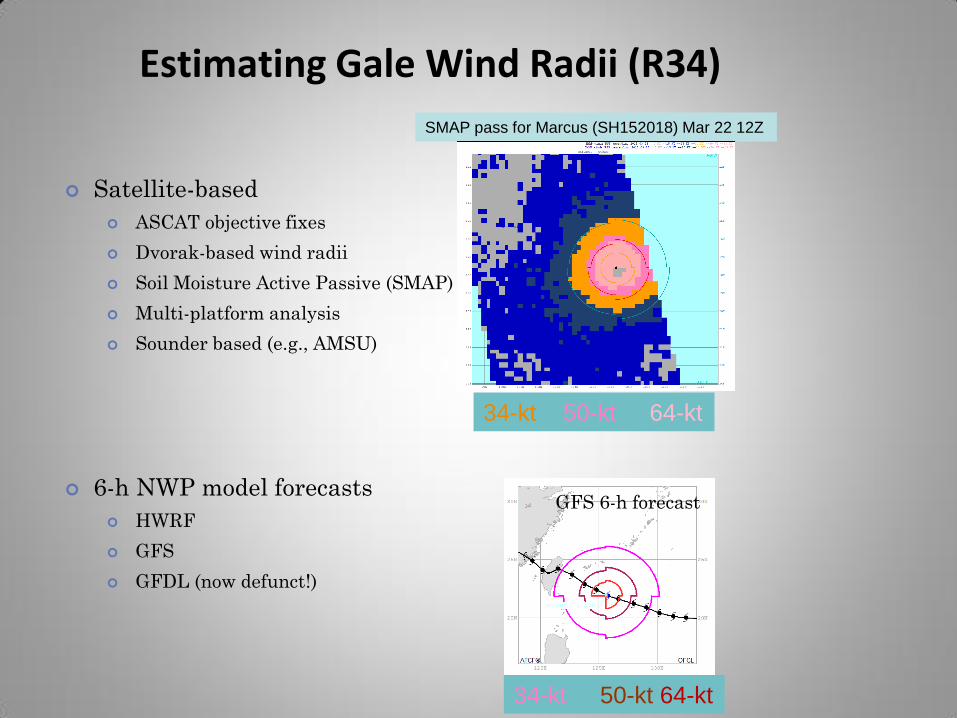
Estimating Gale Wind Radii (R34)
Satellite-based
ASCAT objective fixes
Dvorak-based wind radii
Soil Moisture Active Passive (SMAP)
Multi-platform analysis
Sounder based (e.g., AMSU)
6-h NWP model forecasts
HWRF
GFS
GFDL (now defunct!)
SMAP pass for Marcus (SH152018) Mar 22 12Z
GFS 6-h forecast
34-kt 50-kt 64-kt
34-kt 50-kt 64-kt
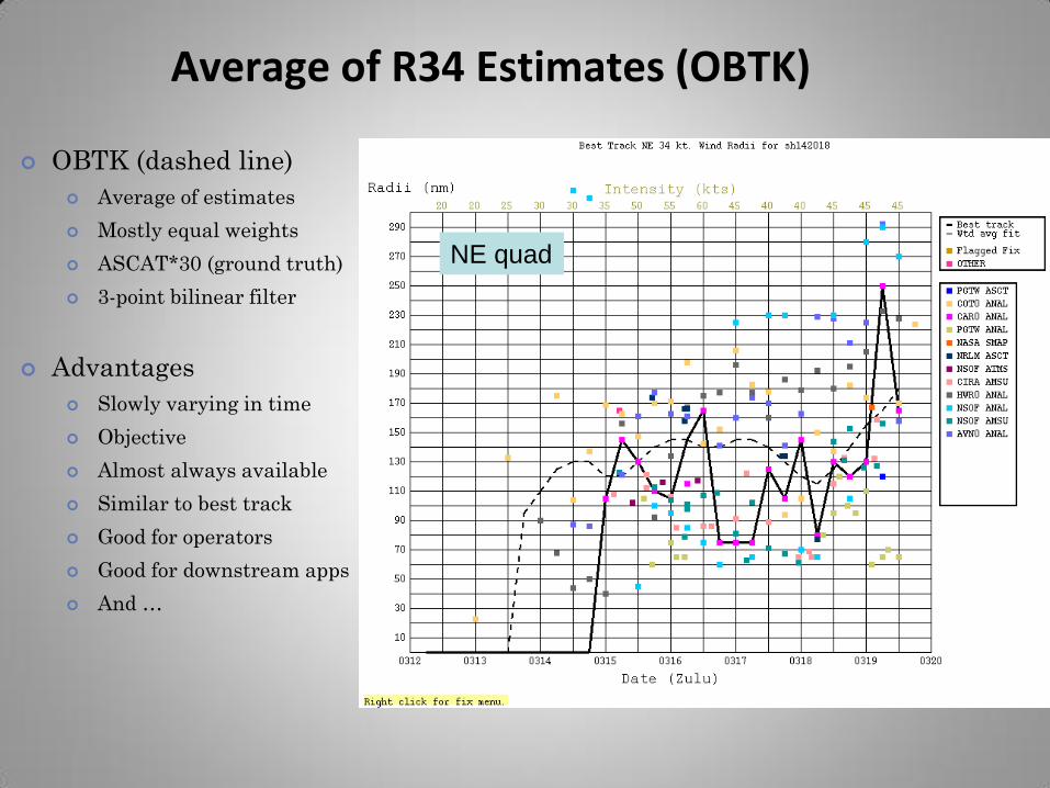
Average of R34 Estimates (OBTK)
OBTK (dashed line)
Average of estimates
Mostly equal weights
ASCAT*30 (ground truth)
3-point bilinear filter
Advantages
Slowly varying in time
Objective
Almost always available
Similar to best track
Good for operators
Good for downstream apps
And …
NE quad
-30
-20
-10
0
10
20
30
40
50
60
Me
an E
rro
r an
d b
ias
(n m
i)
(580) (129) (393) (905) (697) (884) (914) (875) (1014)
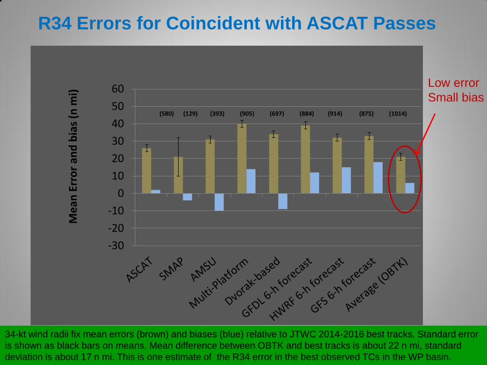
34-kt wind radii fix mean errors (brown) and biases (blue) relative to JTWC 2014-2016 best tracks. Standard error
is shown as black bars on means. Mean difference between OBTK and best tracks is about 22 n mi, standard
deviation is about 17 n mi. This is one estimate of the R34 error in the best observed TCs in the WP basin.
R34 Errors for Coincident with ASCAT Passes
Low error
Small bias
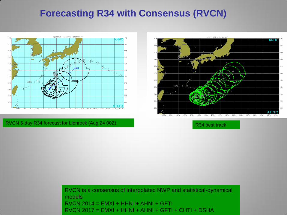
Forecasting R34 with Consensus (RVCN)
RVCN is a consensus of interpolated NWP and statistical-dynamical
models
RVCN 2014 = EMXI + HHN I+ AHNI + GFTI
RVCN 2017 = EMXI + HHNI + AHNI + GFTI + CHTI + DSHA
RVCN 5-day R34 forecast for Lionrock (Aug 24 00Z) R34 best track
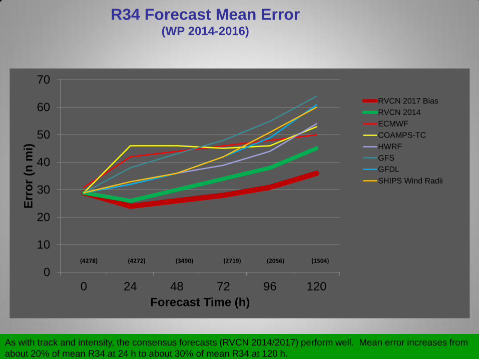
R34 Forecast Mean Error (WP 2014-2016)
0
10
20
30
40
50
60
70
0 24 48 72 96 120
Err
or
(n m
i)
Forecast Time (h)
RVCN 2017 Bias
RVCN 2014
ECMWF
COAMPS-TC
HWRF
GFS
GFDL
SHIPS Wind Radii
(4278) (4272) (3490) (2719) (2056) (1504)
As with track and intensity, the consensus forecasts (RVCN 2014/2017) perform well. Mean error increases from
about 20% of mean R34 at 24 h to about 30% of mean R34 at 120 h.

-60
-40
-20
0
20
40
60
1 2 3 4 5 6
Bia
s (
n m
i)
Forecast Time (h)
RVCN 2017 BiasRVCN2014 BiasECMWFCOAMPS-TCHWRFGFSGFDLSHIPS Wind Radii
R34 Forecast Bias (WP 2014-2016)
Biases in individual models offset each other. Not by design, but we still enjoy the benefits.
R34 Forecast Error Estimates
(GPCE)
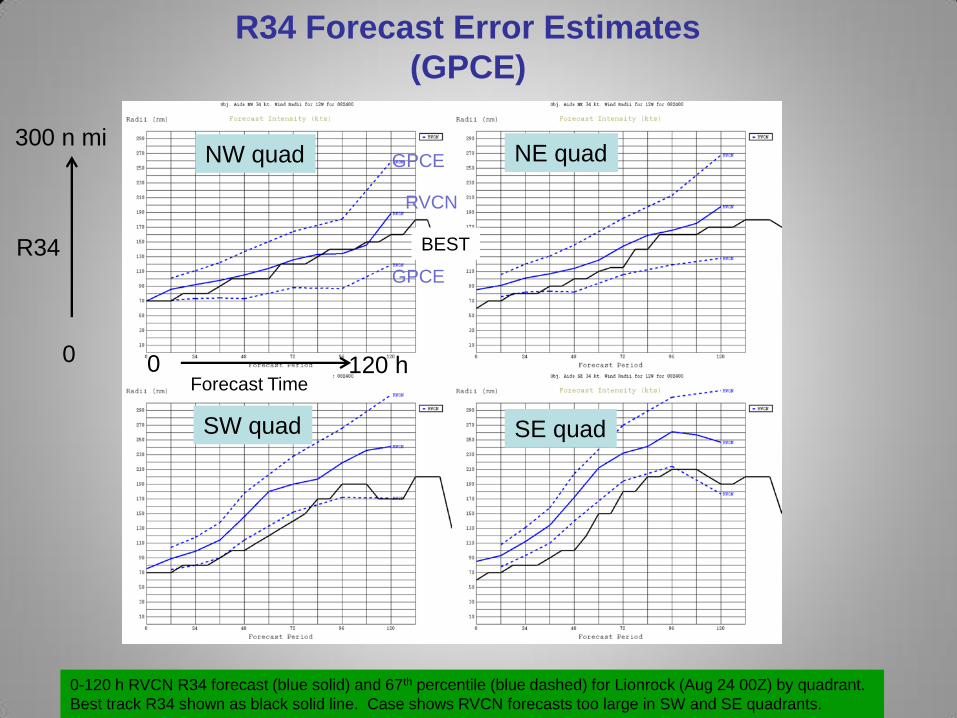
0-120 h RVCN R34 forecast (blue solid) and 67th percentile (blue dashed) for Lionrock (Aug 24 00Z) by quadrant.
Best track R34 shown as black solid line. Case shows RVCN forecasts too large in SW and SE quadrants.
NW quad
SE quad
NE quad
SW quad
0
300 n mi
120 h 0
RVCN
GPCE
GPCE
BEST R34
Forecast Time
R34 GPCE Evaluation
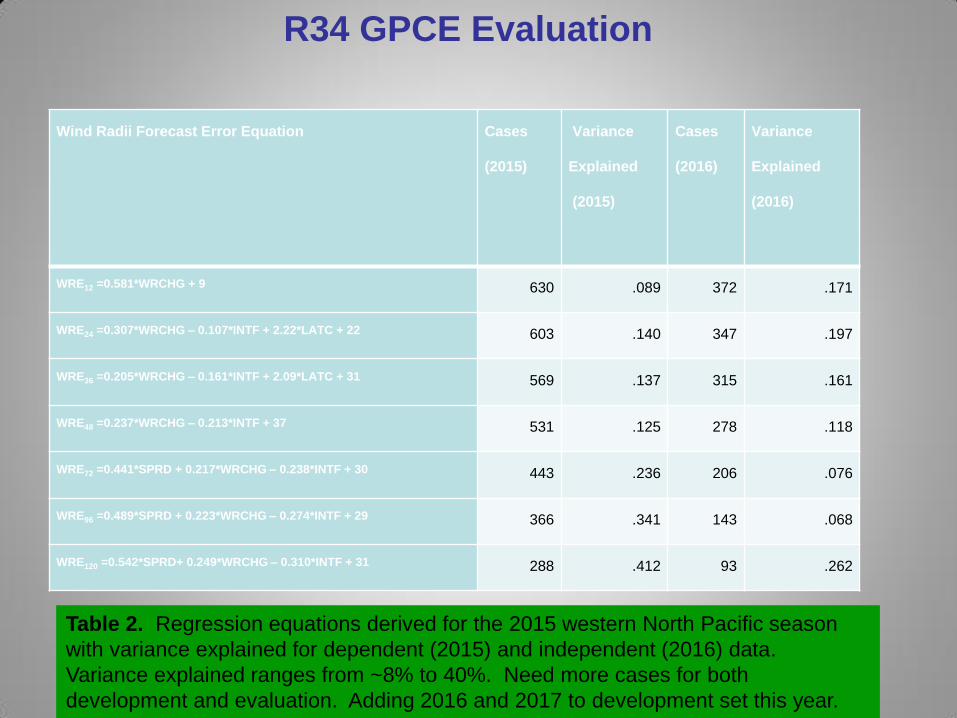
Table 2. Regression equations derived for the 2015 western North Pacific season
with variance explained for dependent (2015) and independent (2016) data.
Variance explained ranges from ~8% to 40%. Need more cases for both
development and evaluation. Adding 2016 and 2017 to development set this year.
Wind Radii Forecast Error Equation Cases
(2015)
Variance
Explained
(2015)
Cases
(2016)
Variance
Explained
(2016)
WRE12 =0.581*WRCHG + 9 630 .089 372 .171
WRE24 =0.307*WRCHG – 0.107*INTF + 2.22*LATC + 22 603 .140 347 .197
WRE36 =0.205*WRCHG – 0.161*INTF + 2.09*LATC + 31 569 .137 315 .161
WRE48 =0.237*WRCHG – 0.213*INTF + 37 531 .125 278 .118
WRE72 =0.441*SPRD + 0.217*WRCHG – 0.238*INTF + 30 443 .236 206 .076
WRE96 =0.489*SPRD + 0.223*WRCHG – 0.274*INTF + 29 366 .341 143 .068
WRE120 =0.542*SPRD+ 0.249*WRCHG – 0.310*INTF + 31 288 .412 93 .262
Summary
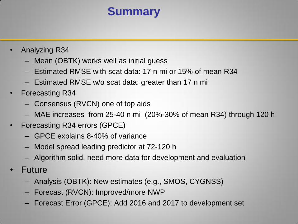
• Analyzing R34
– Mean (OBTK) works well as initial guess
– Estimated RMSE with scat data: 17 n mi or 15% of mean R34
– Estimated RMSE w/o scat data: greater than 17 n mi
• Forecasting R34
– Consensus (RVCN) one of top aids
– MAE increases from 25-40 n mi (20%-30% of mean R34) through 120 h
• Forecasting R34 errors (GPCE)
– GPCE explains 8-40% of variance
– Model spread leading predictor at 72-120 h
– Algorithm solid, need more data for development and evaluation
• Future
– Analysis (OBTK): New estimates (e.g., SMOS, CYGNSS)
– Forecast (RVCN): Improved/more NWP
– Forecast Error (GPCE): Add 2016 and 2017 to development set
• Note:R34 = gale wind radii

Extra Material
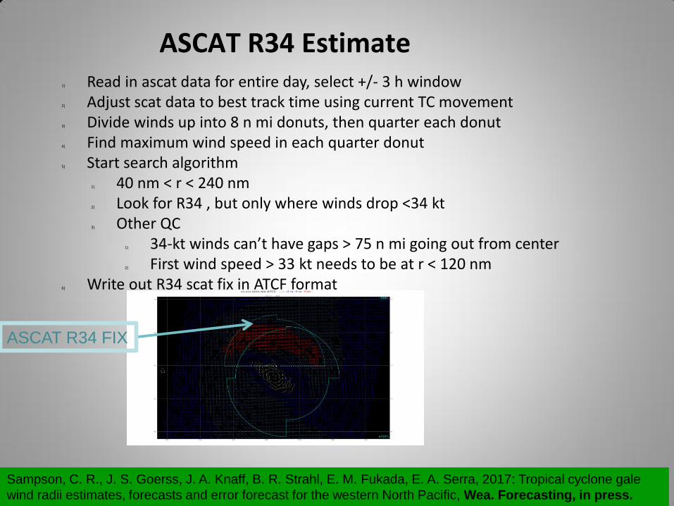
1) Read in ascat data for entire day, select +/- 3 h window 2) Adjust scat data to best track time using current TC movement 3) Divide winds up into 8 n mi donuts, then quarter each donut 4) Find maximum wind speed in each quarter donut 5) Start search algorithm
1) 40 nm < r < 240 nm 2) Look for R34 , but only where winds drop <34 kt 3) Other QC
1) 34-kt winds can’t have gaps > 75 n mi going out from center 2) First wind speed > 33 kt needs to be at r < 120 nm
6) Write out R34 scat fix in ATCF format
ASCAT R34 Estimate
ASCAT R34 FIX
Sampson, C. R., J. S. Goerss, J. A. Knaff, B. R. Strahl, E. M. Fukada, E. A. Serra, 2017: Tropical cyclone gale
wind radii estimates, forecasts and error forecast for the western North Pacific, Wea. Forecasting, in press.
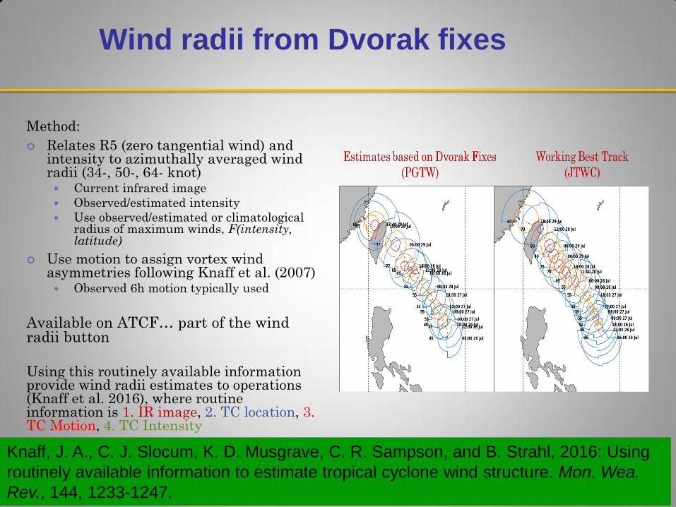
Wind radii from Dvorak fixes
Method:
Relates R5 (zero tangential wind) and intensity to azimuthally averaged wind radii (34-, 50-, 64- knot) Current infrared image
Observed/estimated intensity
Use observed/estimated or climatological radius of maximum winds, F(intensity, latitude)
Use motion to assign vortex wind asymmetries following Knaff et al. (2007) Observed 6h motion typically used
Available on ATCF… part of the wind radii button
Using this routinely available information provide wind radii estimates to operations (Knaff et al. 2016), where routine information is 1. IR image, 2. TC location, 3. TC Motion, 4. TC Intensity
Knaff, J. A., C. J. Slocum, K. D. Musgrave, C. R. Sampson, and B. Strahl, 2016: Using
routinely available information to estimate tropical cyclone wind structure. Mon. Wea.
Rev., 144, 1233-1247.
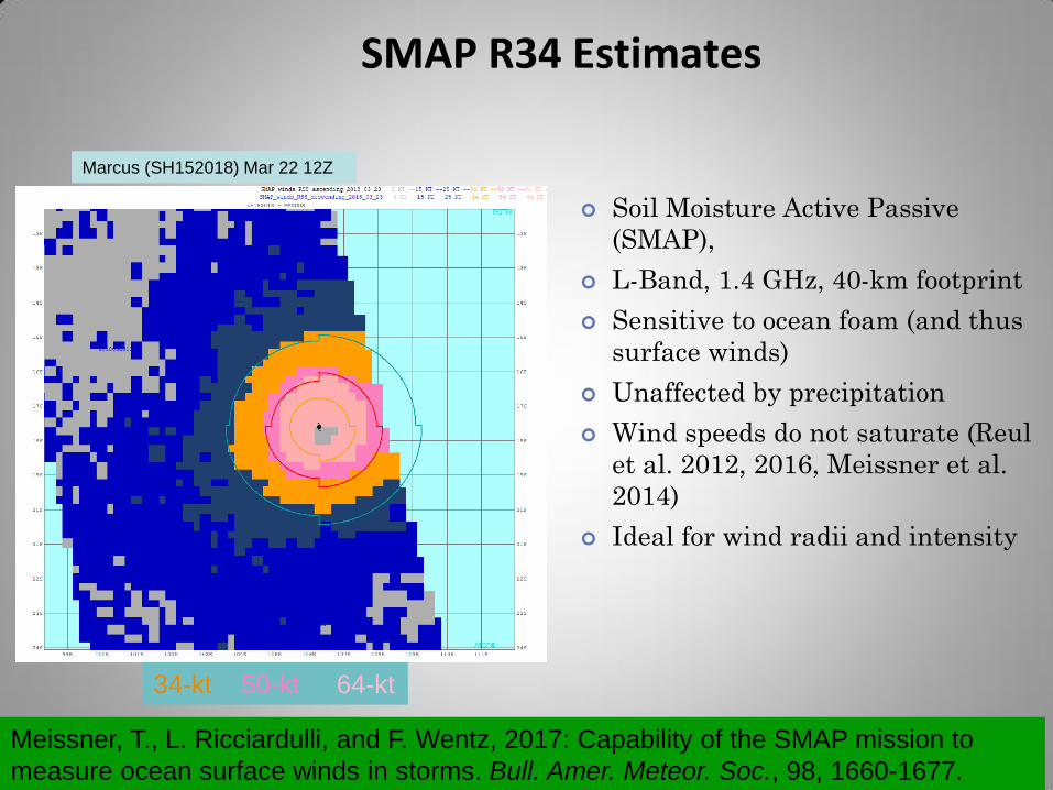
SMAP R34 Estimates
Meissner, T., L. Ricciardulli, and F. Wentz, 2017: Capability of the SMAP mission to
measure ocean surface winds in storms. Bull. Amer. Meteor. Soc., 98, 1660-1677.
Marcus (SH152018) Mar 22 12Z
Soil Moisture Active Passive
(SMAP),
L-Band, 1.4 GHz, 40-km footprint
Sensitive to ocean foam (and thus
surface winds)
Unaffected by precipitation
Wind speeds do not saturate (Reul
et al. 2012, 2016, Meissner et al.
2014)
Ideal for wind radii and intensity
34-kt 50-kt 64-kt
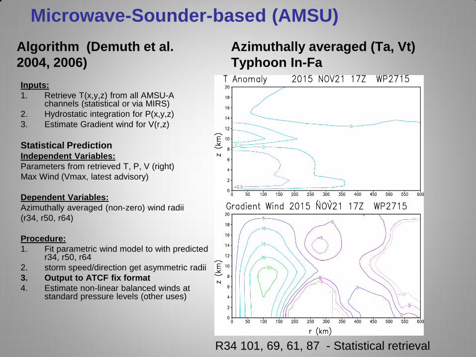
Microwave-Sounder-based (AMSU)
Inputs:
1. Retrieve T(x,y,z) from all AMSU-A channels (statistical or via MIRS)
2. Hydrostatic integration for P(x,y,z)
3. Estimate Gradient wind for V(r,z)
Statistical Prediction Independent Variables:
Parameters from retrieved T, P, V (right)
Max Wind (Vmax, latest advisory)
Dependent Variables:
Azimuthally averaged (non-zero) wind radii
(r34, r50, r64)
Procedure:
1. Fit parametric wind model to with predicted r34, r50, r64
2. storm speed/direction get asymmetric radii
3. Output to ATCF fix format
4. Estimate non-linear balanced winds at standard pressure levels (other uses)
Algorithm (Demuth et al.
2004, 2006)
Azimuthally averaged (Ta, Vt)
Typhoon In-Fa
R34 101, 69, 61, 87 - Statistical retrieval
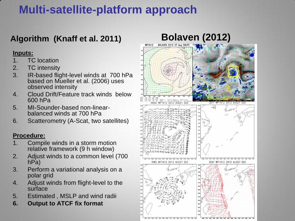
Multi-satellite-platform approach
Inputs:
1. TC location
2. TC intensity
3. IR-based flight-level winds at 700 hPa based on Mueller et al. (2006) uses observed intensity
4. Cloud Drift/Feature track winds below 600 hPa
5. MI-Sounder-based non-linear-balanced winds at 700 hPa
6. Scatterometry (A-Scat, two satellites)
Procedure:
1. Compile winds in a storm motion relative framework (9 h window)
2. Adjust winds to a common level (700 hPa)
3. Perform a variational analysis on a polar grid
4. Adjust winds from flight-level to the surface
5. Estimated , MSLP and wind radii
6. Output to ATCF fix format
Algorithm (Knaff et al. 2011) Bolaven (2012)
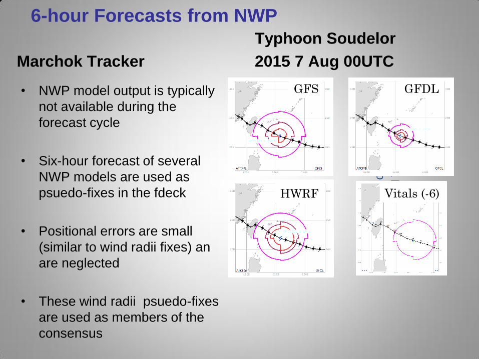
6-hour Forecasts from NWP
Marchok Tracker
• NWP model output is typically
not available during the
forecast cycle
• Six-hour forecast of several
NWP models are used as
psuedo-fixes in the fdeck
• Positional errors are small
(similar to wind radii fixes) an
are neglected
• These wind radii psuedo-fixes
are used as members of the
consensus
Typhoon Soudelor
2015 7 Aug 00UTC
2016 J
PL H
urric
ane
Work
shop
GFS GFDL
HWRF Vitals (-6)