Embed Size (px)
Citation preview
TREND OIL PRODUCTION, LLC ~a Texas Joint Venture~
1-866-871-0074
SQUYRES FT PROJECT A
215+- ACRES
LOCATION: ANGELINA COUNTY, TEXAS
3 WELL EXPLORATION AND DEVELOPMENT
PRIVATE PLACEMENT – NON SECURITY
NOTE: THIS PRIVATE PLACEMENT MEMORANDUM HAS NOT AND WILL NOT BE REGISTERED WITH
THE SECURITIES AND EXCHANGE COMMISSION OF THE UNITED STATES OF AMERICA OR ANY STATE
OR LOCAL SECURITES AGENCY. THIS MEMORANDUM IS PRIVATE FOR INDIVIDUAL OR OIL INDUSTRY
VIEWING PER REQUEST AND NOT A PUBLIC OFFERING OF ANY NATURE OR AN OFFER FOR SALE. THIS
MEMORANDUM IS NOT A DIRECT OR INDIRECT OFFER BY SOLICITATION BY TELEPHONE, FACSMILE
OR U.S. MAIL. ALL PARTIES ARE REQUIRED TO BE ACCREDITED INVESTORS TO ENTER ANY OIL AND
GAS PROGRAM ACCORDING TO ANY SEC REGULATORY AGENCY. THIS IS NOT A TRADEABLE SECURITY.
SQUYRES FT PROJECT A
QUEEN CITY FORMATION PRODUCTION ZONES
ANGELINA COUNTY, TEXAS
Location History
TOP LLC has obtained mineral leases covering 215+- acres in the Bueala field (Queen City formation) in
Angelina County, Texas. The Bueala oil/gas field is located twelve miles+- from Lufkin, Texas. Drilling and
production activity started in the 1930s and continues to this day. There are some 34 oil and gas fields
encompassing hundreds of wells within the county registered with the Texas Railroad Commission.
Cont’d.
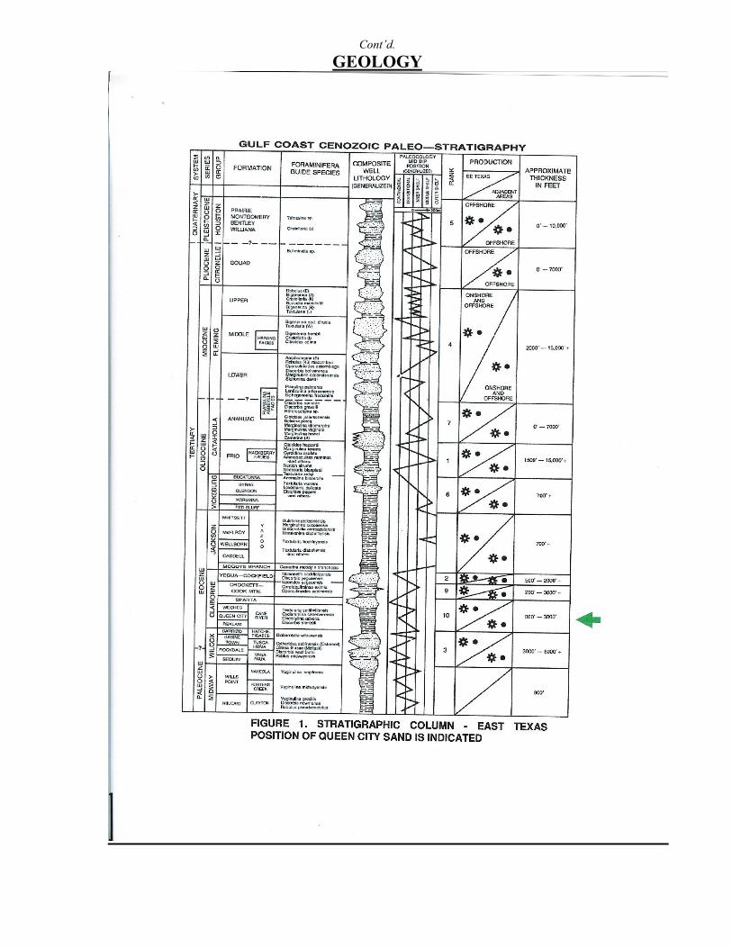
GEOLOGY
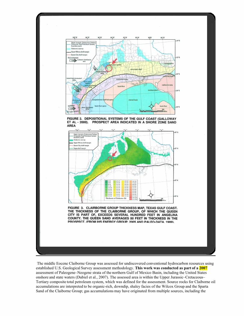
The middle Eocene Claiborne Group was assessed for undiscovered
conventional hydrocarbon resources using
established U.S. Geological Survey assessment methodology. This work was conducted as part
of a 2007
assessment of Paleogene–Neogene strata of the northern Gulf of Mexico Basin, including the United States
onshore and state waters (Dubiel et al., 2007). The assessed area is
within the Upper Jurassic–Cretaceous–
Tertiary composite total petroleum system, which was defined for the assessment.
Source rocks for Claiborne oil
accumulations are interpreted to be organic-rich, downdip, shaley facies of the Wilcox Group
and the Sparta
Sand of the Claiborne Group; gas accumulations may have originated from multiple sources, including the
Jurassic Smackover Formation and the Haynesville and Bossier shales,
the Cretaceous Eagle Ford and Pearsall
(?) formations, and the Paleogene Wilcox Group and Sparta Sand. Hydrocarbon generation
in the basin
started prior to deposition of Claiborne sediments and is currently ongoing. Primary reservoir sandstones
in the Claiborne Group include, from oldest to youngest, the Queen
City Sand, Cook Mountain
Formation, Sparta Sand, Yegua Formation, and the laterally equivalent Cockfield Formation.
A geologic model, supported by spatial analysis of petroleum geology data, including discovered reservoir
depths, thicknesses, temperatures, porosities, permeabilities, and pressures, was
used to divide the Claiborne
Group into seven assessment units (AUs) with three distinctive structural and depositional settings.
The three
structural and depositional settings are (1) stable shelf, (2) expanded fault zone, and (3) slope and basin floor;
the seven AUs are (1) lower Claiborne stable-shelf gas and oil, (2) lower Claiborne expanded fault-zone gas, (3)
lower Claiborne slope and basin-floor gas, (4) lower Claiborne Cane River, (5)
upper Claiborne stable-shelf gas
and oil, (6) upper Claiborne expanded fault-zone gas, and (7) upper Claiborne slope and basin-floor
gas. Based
on Monte Carlo simulation of justified input parameters, the total estimated mean undiscovered conventional
hydrocarbon resources in the seven AUs combined are 52 million bbl of oil,
19.145 tcf of natural gas, and 1.205
billion bbl of natural gas liquids.
Five distinct facies are recognized in the Eocene Queen City exposures between the Trinity River valley
and the Louisiana state boundary. These facies (fluvial, deltaic, tidal flat, barrier, and tidal delta) display
diagnostic suites of physical and biogenic structures. Sandstones within these facies exhibit substantial
differences in paleocurrent pattern.
Fluvial influx was mainly from the northwest, with subordinate contributions of sediment from the east. A
marginal Alluvial and upper deltaic plain was transected by fluvial channels of fluctuating bed load to
suspended load proportions and variable preservation potential. Along the northwestern embayment margin,
small, high-constructive shoal water deltas and crevasse subdeltas developed and prograded across the shallow
Reklaw shelf. Barriers may have originated as destructive components of delta abandonment or as
contemporaneous strike-fed features marginal to the main delta complex to the west. In either event, barriers are
poorly preserved, possibly because of transgressive ravinement, but more likely because they were never
developed on a major scale. Extensive backbarrier or bay-margin intertidal and subtidal flat sand shoals reflect
the interplay of tidal and wave-generated processes, leaving a characteristic record of variable physical energy
and flow patterns. Flood-tidal deltas formed at the mouths of microtidal estuaries and, like some modern
analogues, they were significantly larger than comparable mesotidal features. The inferred flood-tidal delta
deposits also exhibit features reflecting storm processes.
Regional depositional patterns were largely controlled by: 1) location of the east Texas embayment with respect
to the major deltaic depocenter, resulting in an eastward decrease in sediment supply; 2) configuration of the
broadly funnel-shaped embayment and wide shelf, which may have augmented tidal range; and3) transition
from overall progradational character, with local transgressions, to a major marine transgression that culminated
in shelf sedimentation of the overlying Weches Formation.
GEOLOGICAL SUMMARY
The Queen City Sand is part of the aforementioned Claiborne Group of formations and is present as a
reservoir for hydrocarbons. The Weches and Recklaw formations overlay and underlay the Queen City
and both help to form seals to entrap the hydrocarbons within the Queen City Sand. Both the Weches
and Recklaw have proven to be productive. Organic-rich muds serve as source rocks for hydrocarbons.
The sand trend of the Queen City is present throughout the Gulf Coast of Texas and extends into Mexico
and Louisiana. Angelina County has several Queen City fields at depths from 1400 ft to 1900 ft. These
shallow depths and favorable geology create attractive opportunities. Core data from producing Queen
City wells in the area demonstrate good reservoir characteristics such as:
Productive sandstones in the established trends range up to 50+- feet in thickness.
They are mostly of very high quality, even when (as is often the case) they are highly laminated.
Permabilities exceeding 1000 millidarcies and porosities exceeding 32% are common.
Cont’d.
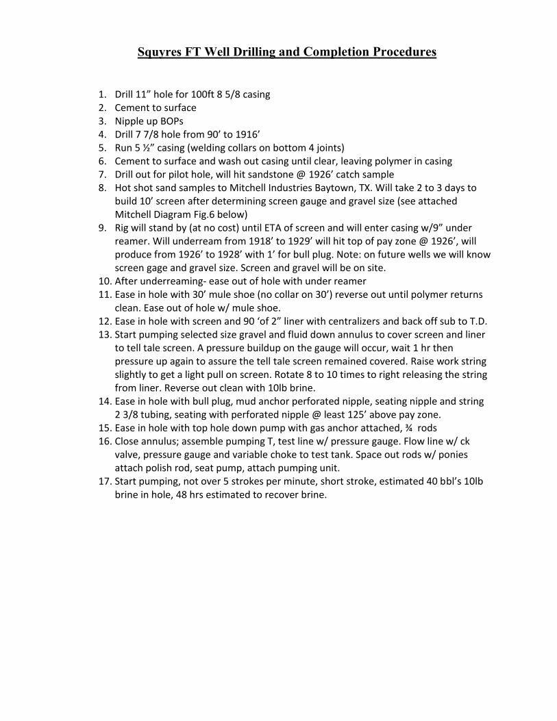
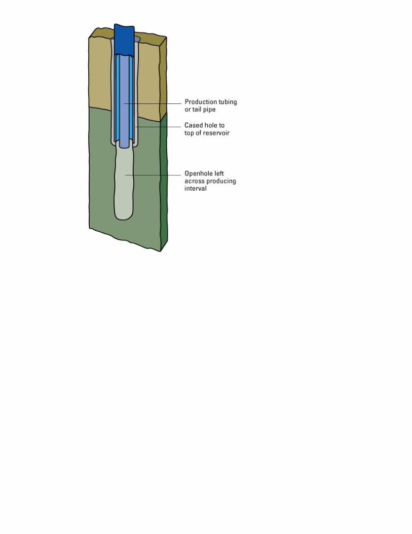
Squyres FT Well Drilling and Completion Procedures
1. Drill 11” hole for 100ft 8 5/8 casing 2. Cement to surface 3. Nipple up BOPs 4. Drill 7 7/8 hole from 90’ to 1916’ 5. Run 5 ½” casing (welding collars on bottom 4 joints) 6. Cement to surface and wash out casing until clear, leaving polymer in casing 7. Drill out for pilot hole, will hit sandstone @ 1926’ catch sample 8. Hot shot sand samples to Mitchell Industries Baytown, TX. Will take 2 to 3 days to
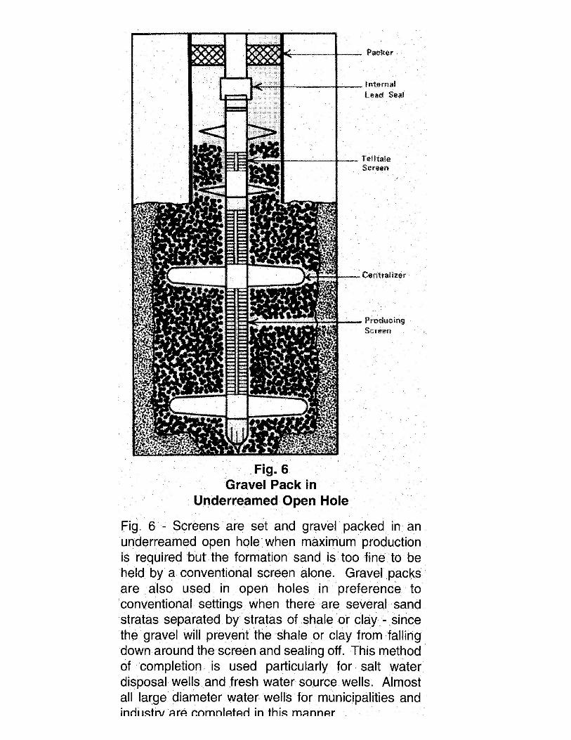
build 10’ screen after determining screen gauge and gravel size (see attached Mitchell Diagram Fig.6 below)
9. Rig will stand by (at no cost) until ETA of screen and will enter casing w/9” under reamer. Will underream from 1918’ to 1929’ will hit top of pay zone @ 1926’, will produce from 1926’ to 1928’ with 1’ for bull plug. Note: on future wells we will know screen gage and gravel size. Screen and gravel will be on site.
10. After underreaming- ease out of hole with under reamer 11. Ease in hole with 30’ mule shoe (no collar on 30’) reverse out until polymer returns
clean. Ease out of hole w/ mule shoe. 12. Ease in hole with screen and 90 ‘of 2” liner with centralizers and back off sub to T.D. 13. Start pumping selected size gravel and fluid down annulus to cover screen and liner
to tell tale screen. A pressure buildup on the gauge will occur, wait 1 hr then pressure up again to assure the tell tale screen remained covered. Raise work string slightly to get a light pull on screen. Rotate 8 to 10 times to right releasing the string from liner. Reverse out clean with 10lb brine.
14. Ease in hole with bull plug, mud anchor perforated nipple, seating nipple and string 2 3/8 tubing, seating with perforated nipple @ least 125’ above pay zone.
15. Ease in hole with top hole down pump with gas anchor attached, ¾ rods 16. Close annulus; assemble pumping T, test line w/ pressure gauge. Flow line w/ ck
valve, pressure gauge and variable choke to test tank. Space out rods w/ ponies attach polish rod, seat pump, attach pumping unit.
17. Start pumping, not over 5 strokes per minute, short stroke, estimated 40 bbl’s 10lb brine in hole, 48 hrs estimated to recover brine.
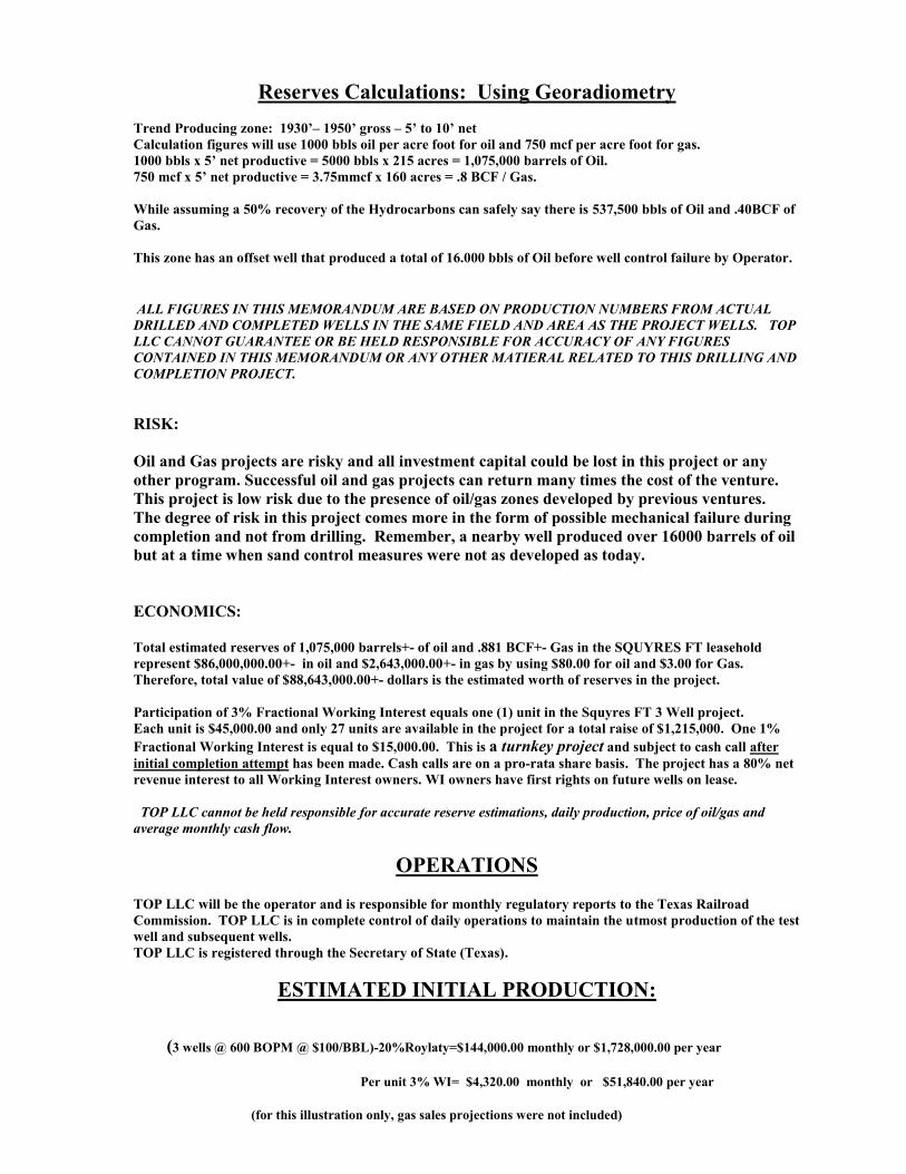
Reserves Calculations: Using Georadiometry
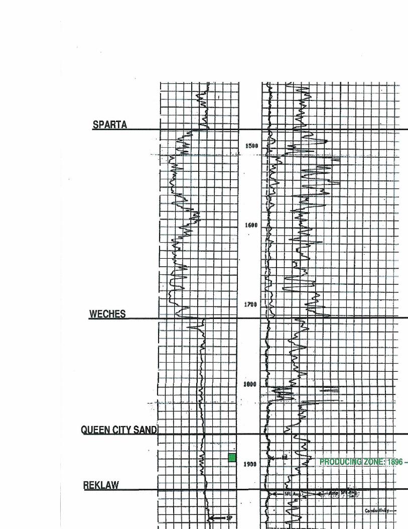
Trend Producing zone: 1930’– 1950’ gross – 5’ to 10’ net
Calculation figures will use 1000 bbls oil per acre foot for oil and 750 mcf per acre foot for gas.
1000 bbls x 5’ net productive = 5000 bbls x 215 acres = 1,075,000 barrels of Oil.
750 mcf x 5’ net productive = 3.75mmcf x 160 acres = .8 BCF / Gas.
While assuming a 50% recovery of the Hydrocarbons can safely say there is 537,500 bbls of Oil and .40BCF of
Gas.
This zone has an offset well that produced a total of 16.000 bbls of Oil before well control failure by Operator.
ALL FIGURES IN THIS MEMORANDUM ARE BASED ON PRODUCTION NUMBERS FROM ACTUAL
DRILLED AND COMPLETED WELLS IN THE SAME FIELD AND AREA AS THE PROJECT WELLS. TOP
LLC CANNOT GUARANTEE OR BE HELD RESPONSIBLE FOR ACCURACY OF ANY FIGURES
CONTAINED IN THIS MEMORANDUM OR ANY OTHER MATIERAL RELATED TO THIS DRILLING AND
COMPLETION PROJECT.
RISK:
Oil and Gas projects are risky and all investment capital could be lost in this project or any
other program. Successful oil and gas projects can return many times the cost of the venture.
This project is low risk due to the presence of oil/gas zones developed by previous ventures.
The degree of risk in this project comes more in the form of possible mechanical failure during
completion and not from drilling. Remember, a nearby well produced over 16000 barrels of oil
but at a time when sand control measures were not as developed as today.
ECONOMICS:
Total estimated reserves of 1,075,000 barrels+- of oil and .881 BCF+- Gas in the SQUYRES FT leasehold
represent $86,000,000.00+- in oil and $2,643,000.00+- in gas by using $80.00 for oil and $3.00 for Gas.
Therefore, total value of $88,643,000.00+- dollars is the estimated worth of reserves in the project.
Participation of 3% Fractional Working Interest equals one (1) unit in the Squyres FT 3 Well project.
Each unit is $45,000.00 and only 27 units are available in the project for a total raise of $1,215,000. One 1%
Fractional Working Interest is equal to $15,000.00. This is a turnkey project and subject to cash call after
initial completion attempt has been made. Cash calls are on a pro-rata share basis. The project has a 80% net
revenue interest to all Working Interest owners. WI owners have first rights on future wells on lease.
TOP LLC cannot be held responsible for accurate reserve estimations, daily production, price of oil/gas and
average monthly cash flow.
OPERATIONS TOP LLC will be the operator and is responsible for monthly regulatory reports to the Texas Railroad
Commission. TOP LLC is in complete control of daily operations to maintain the utmost production of the test
well and subsequent wells.
TOP LLC is registered through the Secretary of State (Texas).
ESTIMATED INITIAL PRODUCTION:
(3 wells @ 600 BOPM @ $100/BBL)-20%Roylaty=$144,000.00 monthly or $1,728,000.00 per year
Per unit 3% WI= $4,320.00 monthly or $51,840.00 per year
(for this illustration only, gas sales projections were not included)
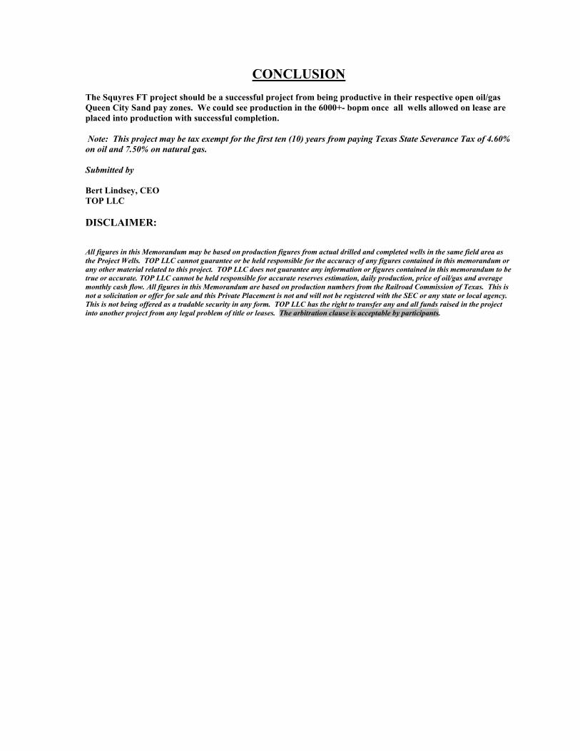
CONCLUSION
The Squyres FT project should be a successful project from being productive in their respective open oil/gas
Queen City Sand pay zones. We could see production in the 6000+- bopm once all wells allowed on lease are
placed into production with successful completion.
Note: This project may be tax exempt for the first ten (10) years from paying Texas State Severance Tax of 4.60%
on oil and 7.50% on natural gas.
Submitted by
Bert Lindsey, CEO
TOP LLC
DISCLAIMER:
All figures in this Memorandum may be based on production figures from actual drilled and completed wells in the same field area as
the Project Wells. TOP LLC cannot guarantee or be held responsible for the accuracy of any figures contained in this memorandum or
any other material related to this project. TOP LLC does not guarantee any information or figures contained in this memorandum to be
true or accurate. TOP LLC cannot be held responsible for accurate reserves estimation, daily production, price of oil/gas and average
monthly cash flow. All figures in this Memorandum are based on production numbers from the Railroad Commission of Texas. This is
not a solicitation or offer for sale and this Private Placement is not and will not be registered with the SEC or any state or local agency.
This is not being offered as a tradable security in any form. TOP LLC has the right to transfer any and all funds raised in the project
into another project from any legal problem of title or leases. The arbitration clause is acceptable by participants.