Embed Size (px)
Citation preview
RESILIENT CITY TOYAMA - 1 -
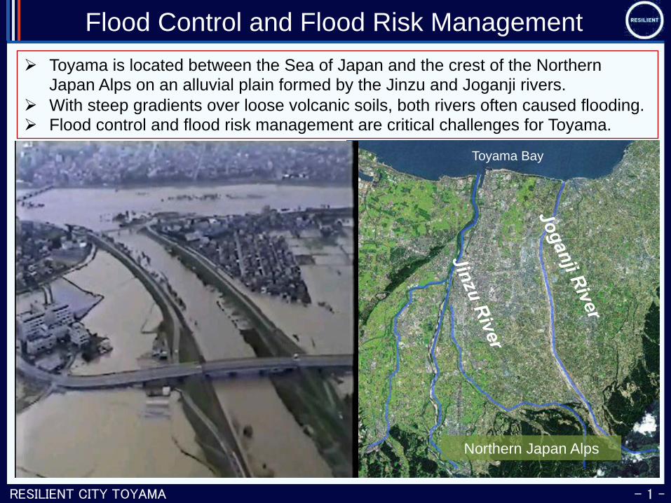
Flood Control and Flood Risk Management Ø Toyama is located between the Sea of Japan and the crest of the Northern
Japan Alps on an alluvial plain formed by the Jinzu and Joganji rivers. Ø With steep gradients over loose volcanic soils, both rivers often caused flooding. Ø Flood control and flood risk management are critical challenges for Toyama.
国土交通省富山河川 国道事務所提供
Toyama Bay
Northern Japan Alps
RESILIENT CITY TOYAMA - 2 -
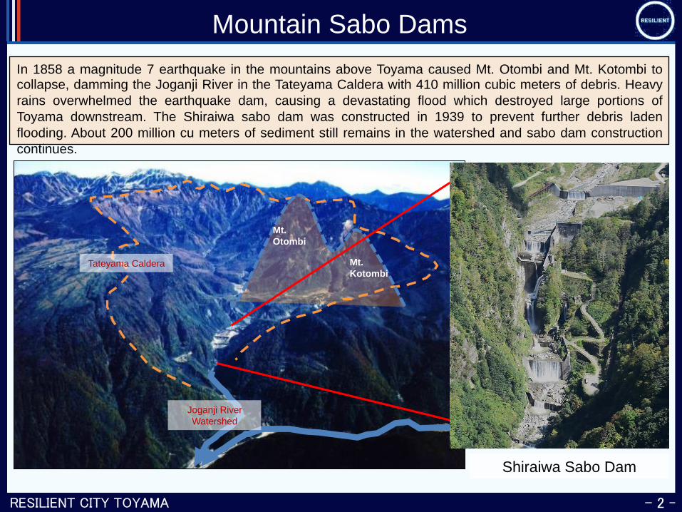
Mountain Sabo Dams In 1858 a magnitude 7 earthquake in the mountains above Toyama caused Mt. Otombi and Mt. Kotombi to collapse, damming the Joganji River in the Tateyama Caldera with 410 million cubic meters of debris. Heavy rains overwhelmed the earthquake dam, causing a devastating flood which destroyed large portions of Toyama downstream. The Shiraiwa sabo dam was constructed in 1939 to prevent further debris laden flooding. About 200 million cu meters of sediment still remains in the watershed and sabo dam construction continues.
Mt. Otombi
Mt. Kotombi
Tateyama Caldera
Shiraiwa Sabo Dam
Joganji River Watershed
RESILIENT CITY TOYAMA - 3 -
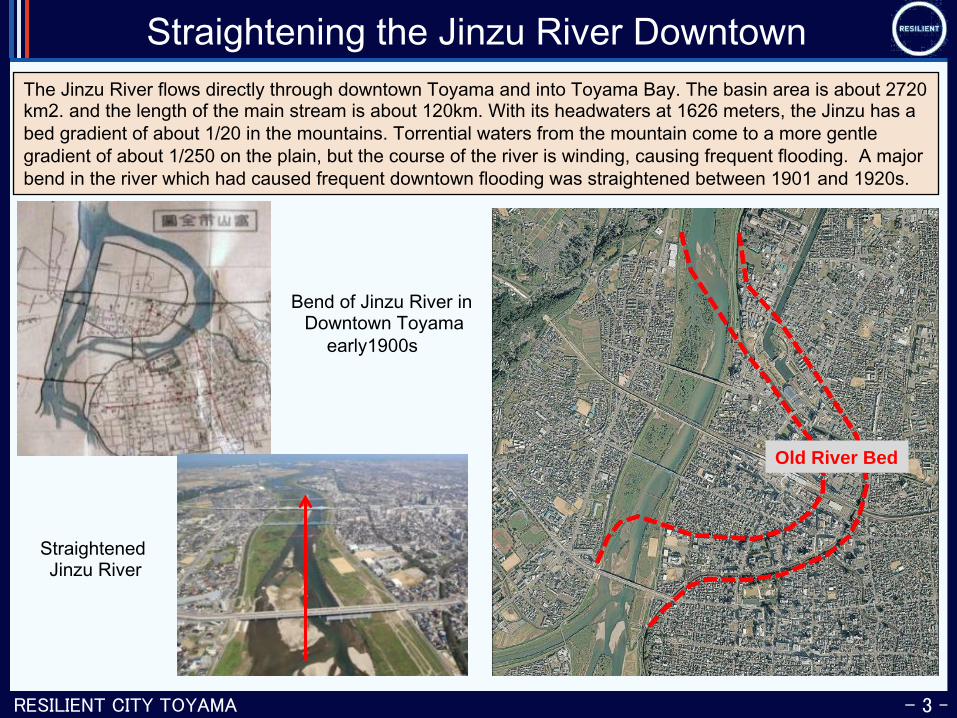
Straightening the Jinzu River Downtown The Jinzu River flows directly through downtown Toyama and into Toyama Bay. The basin area is about 2720 km2. and the length of the main stream is about 120km. With its headwaters at 1626 meters, the Jinzu has a bed gradient of about 1/20 in the mountains. Torrential waters from the mountain come to a more gentle gradient of about 1/250 on the plain, but the course of the river is winding, causing frequent flooding. A major bend in the river which had caused frequent downtown flooding was straightened between 1901 and 1920s.
Jinzu River at present
Bend of Jinzu River in Downtown Toyama
early1900s
Old River Bed
Straightened Jinzu River
RESILIENT CITY TOYAMA - 4 -
Increased Frequency of Torrential Rain
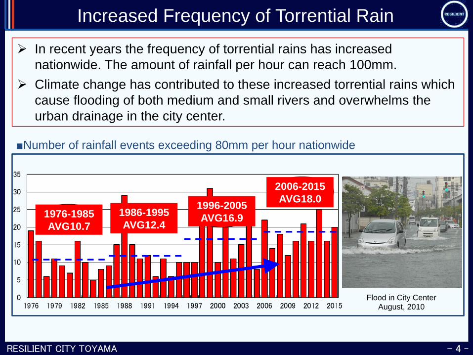
Ø In recent years the frequency of torrential rains has increased nationwide. The amount of rainfall per hour can reach 100mm.
Ø Climate change has contributed to these increased torrential rains which cause flooding of both medium and small rivers and overwhelms the urban drainage in the city center.
Flood in City Center August, 2010
1976-1985 AVG10.7
1986-1995 AVG12.4
1996-2005 AVG16.9
2006-2015 AVG18.0
■Number of rainfall events exceeding 80mm per hour nationwide
RESILIENT CITY TOYAMA - 5 -
Diversifying Rainwater Catchment Reservoirs
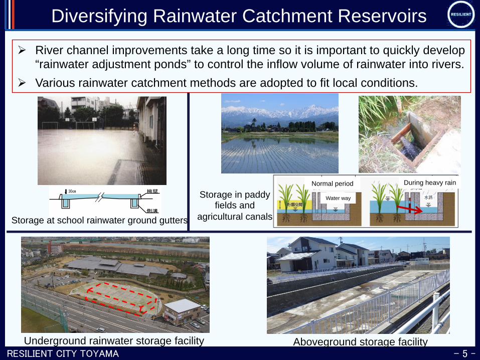
Ø River channel improvements take a long time so it is important to quickly develop “rainwater adjustment ponds” to control the inflow volume of rainwater into rivers.
Ø Various rainwater catchment methods are adopted to fit local conditions. 雨天時の貯留状況
Storage at school rainwater ground gutters
Underground rainwater storage facility Aboveground storage facility
Storage in paddy fields and
agricultural canals
Normal period During heavy rain
Water way
RESILIENT CITY TOYAMA - 6 -
Rainwater Overflow Storage Tunnel in City Center
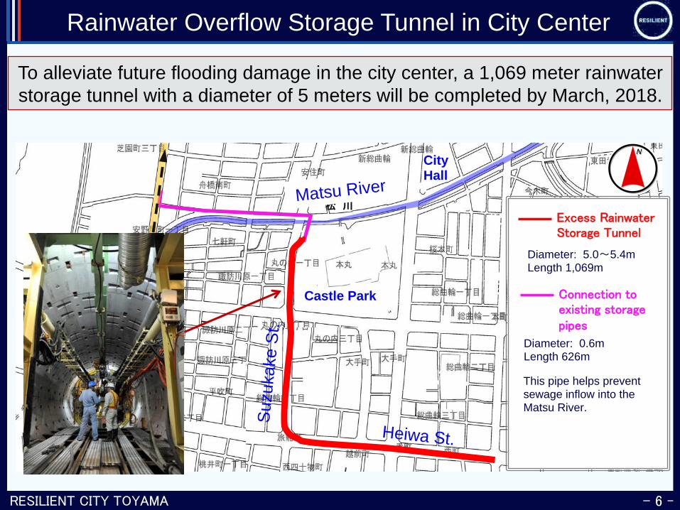
To alleviate future flooding damage in the city center, a 1,069 meter rainwater storage tunnel with a diameter of 5 meters will be completed by March, 2018.
松 川県庁
護国神社逓信病院
Heiwa St.
Suzu
kake
St.
Diameter: 5.0 5.4m Length 1,069m
Excess Rainwater Storage Tunnel
Connection to existing storage pipes
Diameter: 0.6m Length 626m
Matsu River
This pipe helps prevent sewage inflow into the Matsu River.
Castle Park
City Hall
RESILIENT CITY TOYAMA - 7 -
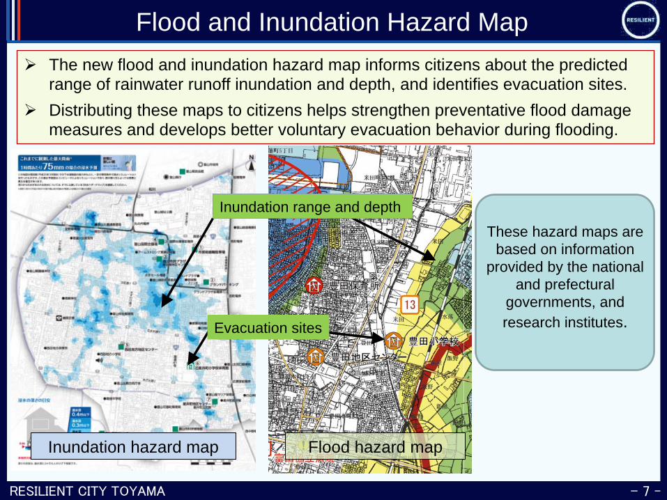
Flood and Inundation Hazard Map Ø The new flood and inundation hazard map informs citizens about the predicted
range of rainwater runoff inundation and depth, and identifies evacuation sites. Ø Distributing these maps to citizens helps strengthen preventative flood damage
measures and develops better voluntary evacuation behavior during flooding.
Inundation hazard map Flood hazard map
Inundation range and depth
These hazard maps are based on information
provided by the national and prefectural
governments, and research institutes. Evacuation sites
RESILIENT CITY TOYAMA - 8 -
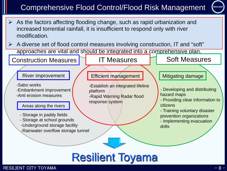
Comprehensive Flood Control/Flood Risk Management
Ø As the factors affecting flooding change, such as rapid urbanization and increased torrential rainfall, it is insufficient to respond only with river modification.
Ø A diverse set of flood control measures involving construction, IT and “soft” approaches are vital and should be integrated into a comprehensive plan.
River improvement
Areas along the rivers
Mitigating damage
-Sabo works -Embankment improvement -Anti erosion measures
- Storage in paddy fields - Storage at school grounds -Underground storage facility -Rainwater overflow storage tunnel
- Developing and distributing hazard maps - Providing clear information to citizens - Training voluntary disaster prevention organizations - Implementing evacuation drills
Construction Measures Soft Measures
Resilient Toyama
IT Measures
Efficient management
-Establish an integrated lifeline platform -Rapid Warning Radar flood response system