Embed Size (px)
Citation preview
Chapter 17 – Pg. 1
TOWN OF HARMONY
CHAPTER 17 OF THE MUNICIPAL CODE OF THE TOWN OF HARMONY, WISCONSIN
LAND DIVISION AND DEVELOPMENT
SECTION 1: AUTHORITY
This Chapter is adopted by the Town Board of the Town of Harmony pursuant to Sections 236.45, 60.22 (3), and 61.34 of the Wisconsin Statutes.
SECTION 2: TITLE AND EFFECTIVE DATE
This Chapter shall hereafter be known, cited, and referred to as the Town of Harmony Land Division and Development Ordinance and shall be effective immediately upon publication of due notice of the adoption of the Ordinance creating this Chapter.
SECTION 3: INTENT AND PURPOSE
The intent and purpose of this Chapter is to identify the process and requirements for regulation of certain land division and development activity in the Town of Harmony so as to maintain and advance the public health, safety, and general welfare of the Town and its residents.
SECTION 4: DEFINITIONS
The following terms shall, for the purpose of this Chapter, have the definition stated in this Section:
Agency – The Rock County Planning, Economic & Community Development Agency Arterial street – An arterial road or highway as defined in Chapter 1 of this Code of Ordinances
Block – A group of lots within well-defined and fixed boundaries, including but not limited to those boundaries provided by streets, public parks, cemeteries, rail lines, shorelines, or general purpose districts, and having a designation through which it may be identified
Chapter 17 – Pg. 2
Building envelope – The area of a lot in which building and accessory building sites are allowed
Certified Survey Map (“CSM”) – A Certified Survey Map as defined in Chapter 1 of this Code of Ordinances
Collector street – A collector road or highway as defined in Chapter 1 of this Code of Ordinances
Committee - The Town of Harmony Planning and Zoning Committee created under Chapter 1 of this Code of Ordinances
Conservation easement – A document, in accordance with Sec. 700.40, Wisconsin Statutes, prohibiting building and accessory building sites, and earth-disturbing activity detrimental to the intent and purpose of the document, in Environmentally Sensitive Areas (“ESA”), cultural resources, productive agricultural soils, woodlands, and/or open space
Cul-de-sac – A local street with a singular vehicular outlet containing an appropriate terminal for the safe and convenient reversal of traffic movement
Cultural resources – Any building or structure, archaeological or cultural site, or historical marker in the State of Wisconsin Historical Society’s Architecture and History Program, Archaeological Sites Inventory Program, or Historical Markers Program, or any building, structure, site, or marker so identified as a cultural resource in any Rock County cultural resources inventory, plan, or program
Environmentally Sensitive Areas (“ESA”) – (a) Floodplain – Lands identified as floodplain by the Federal Emergency
Management Agency (FEMA), as delineated in accordance with the most current FEMA floodplain maps adopted by the Rock County Board of Supervisors;
(b) Groundwater protection areas – Lands identified as groundwater protection areas, as delineated by the Agency;
(c) Hydric soils – Lands with soils identified as hydric, as delineated by the
Agency;
Chapter 17 – Pg. 3
(d) Kettles and depressional topography – Lands identified as kettles and/or depressional topography, as delineated by the Agency;
(e) Natural areas – Lands with scores of five (5) or higher, in accordance
with the Rock County Natural Areas Survey – 2011; (f) Shallow bedrock – Lands identified with bedrock within twenty (20)
inches of the surface, as delineated by the Agency; (g) Shorelands – Lands identified within seventy-five (75) feet of the
ordinary high water mark of a surface water feature, as delineated in accordance with Chapter 44 – Zoning, Code of Ordinances, Rock County;
(h) Steep slopes – Lands identified with slopes sixteen percent (16%) and
greater, as delineated by the Agency; (i) Wetland – Lands identified as wetland, as delineated by the Wisconsin
Department of Natural Resources or another qualified entity; (j) Wetland buffers – Lands identified within fifty (50) feet of wetlands, as
delineated by the Agency.
Local street – A local road or highway as defined in Chapter 1 of this Code of Ordinances
Lot - A land area created by a land division or otherwise permitted by law to be sold or used as a building site and containing adequate size and dimension to meet all Rock County, Town, State, and any other applicable standards and regulations
Major land division (Sub-division) – A land division requiring a Sub-division Plat under County ordinances, creating five (5) or more new, additional lots of any size concurrently or by successive land division within five (5) years of the recordation date of the first lot created.
Pedestrian way – A public or private right-of-way whose primary purpose is conveyance of foot traffic
Plat of Survey (“POS”) – A map of a minor land division, or identifying lands subject to an adjacent land sale or transfer, prepared by a land surveyor and submitted by an applicant in both a preliminary and final form
Chapter 17 – Pg. 4
Private onsite wastewater treatment system (“POWTS”) – A sanitary sewer treatment and disposal system consisting of a septic tank and soil absorption field, or similar improvements or infrastructure, serving a building(s) and located either on the same or a different lot than said building(s), and not owned by a governmental entity
Productive agricultural soils – Soils so identified in the Rock County Farmland Preservation Plan: 2011 Update or any similar successive Rock County plan or document
Public improvement - any structure created above or below ground, any road or any newly graded land which is proposed to be dedicated to the Town of Harmony
Street (Road) – A street as defined in Chapter 1 of this Code of Ordinances Sub-division Plat – A Subdivision Plat as defined in Chapter 1 of this Code of Ordinances
Woodlands – Lands comprising five (5) acres or more of contiguous deciduous and/or coniferous vegetation, as delineated by the Agency
SECTION 5: ADJACENT LAND SALE OR TRANSFER
(1) Applicability. This Section applies to any act or process of conveyance by a landowner of an existing parcel of land to the owner of an adjacent parcel if the land conveyed or the parcel remaining from which the conveyance is to be made is less than the minimum size for a lot established for the zoning district in which the land conveyed is located under Chapter 1 of this Code of Ordinances. Nothing in this Chapter shall be deemed to alter the minimum and maximum lot size requirements set forth in this Code of Ordinances, and no land division shall be approved hereunder which results in the creation of a lot which does not meet the minimum and maximum lot size requirements of this Code of Ordinances.
(2) Application submission requirements. No conveyance to which this Section applies shall be permitted unless the landowner submits an application for preliminary adjacent land sale or transfer to the Town Clerk, with a fee established by the Town Board by resolution, and such application is approved by the Committee.
Chapter 17 – Pg. 5
(3) Requirements for approval. Any application submitted under this
Section shall be reviewed by the Committee (or by the Agency if power hereunder is delegated to the Agency). No proposed conveyance shall be approved unless the parcel to which adjacent land is to be added is in the same zoning district as the adjacent land. No proposed conveyance shall be approved unless the parcel from which the conveyed land is taken will equal or exceed the minimum size for a lot established for the zoning district in which it is located. In order to assure that additional lots are not created by the proposed conveyance, the Board (or the Agency if power hereunder is delegated to the Agency) shall, in its discretion, require the landowner to do the landowner’s choice of one of the following as a condition for approval:
(a) Staking of the new lot line by a land surveyor, filing of a POS
and recording of a deed restriction running to the Town and permanently prohibiting the grantee and all successors in interest from conveying the conveyed land separately from the adjacent lot owned by the grantee unless the conveyance is to an adjoining landowner; or
(b) Recording of a Certified Survey Map pursuant to Wis. Stat. §
236.34 for the new combined parcel.
SECTION 6: LOT COMBINATION
(1) Applicability. This Section applies to any attempt to create a single lot from two or more existing lots. No such combined lot may be created so as to exceed the maximum lot size (if any) permitted in the zoning district in which the lot is to be located, and no such lot may be created from among parcels located in different zoning districts.
(2) Application submission requirements. No lot combination to which
this Section applies shall be permitted unless the landowner submits an application for the same to the Town Clerk, with a fee established by the Town Board by resolution, and such application is approved by the Committee.
(3) Requirements for approval. No lot combination shall be permitted
except as authorized by the Town Board after receiving a recommendation of the Committee with respect to such combination
Chapter 17 – Pg. 6
and upon determination that the combination will not be contrary to the intent of the Town’s comprehensive plan and Chapter 1 of this Code of Ordinances. No lot combination shall be permitted unless the applicant records a Certified Survey Map pursuant to Wis. Stat. § 236.34, establishing a single lot consistent with the application.
SECTION 7: PUBLIC IMPROVEMENT DESIGN, CONSTRUCTION, AND MAINTENANCE
Any public improvement in the Town shall be constructed in compliance with the following standards:
(1) Blocks. Block length shall not exceed one thousand five hundred
(1,500) feet nor be less than four hundred (400) feet, except as the Town Board deems necessary to secure the efficient use of land or desired features of street layout. Block width shall be wide enough to allow two tiers of lots of sufficient depth to provide an adequate building envelope on each lot. The Town Board (or the Agency if power hereunder is delegated to the Agency) may approve block widths consisting of a single tier of lots when said lots front a major street or when topography or size prevents two tiers. If a single tier block is approved by the Town Board (or the Agency if power hereunder is delegated to the Agency), an adequate area to screen and buffer differing land uses shall be provided and vehicular access to the lots in the tier shall not be permitted from any street abutting the side of the lot opposite the street upon which the tier faces.
A pedestrian way may be required by the Town Board (or the Agency if power hereunder is delegated to the Agency) near the center of a block, and entirely across those blocks which exceed nine hundred (900) feet in length, to connect dead-end streets or to provide access to parks, schools, shopping areas, or other similar facilities. If a pedestrian way is required, a minimum ten (10) foot right-of-way shall be set aside with an eight (8) foot pavement (or other cover type as approved by the Town Board or the Agency if power hereunder is delegated to the Agency) width, at a grade not steeper than fifteen percent (15%), unless alternative forms of adequate design are approved by the Town Board (or the Agency if power hereunder is delegated to the Agency). A note shall be placed on the Sub-division Plat stating by whom such pedestrian way shall be maintained.
Chapter 17 – Pg. 7
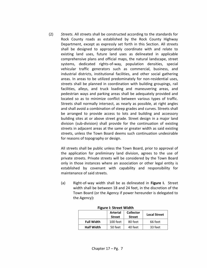
(2) Streets. All streets shall be constructed according to the standards for Rock County roads as established by the Rock County Highway Department, except as expressly set forth in this Section. All streets shall be designed to appropriately coordinate with and relate to existing land uses, future land uses as delineated in applicable comprehensive plans and official maps, the natural landscape, street systems, dedicated rights-of-way, population densities, special vehicular traffic generators such as commercial, business, and industrial districts, institutional facilities, and other social gathering areas. In areas to be utilized predominately for non-residential uses, streets shall be planned in coordination with building groupings, rail facilities, alleys, and truck loading and maneuvering areas, and pedestrian ways and parking areas shall be adequately provided and located so as to minimize conflict between various types of traffic. Streets shall normally intersect, as nearly as possible, at right angles and shall avoid a combination of steep grades and curves. Streets shall be arranged to provide access to lots and building and accessory building sites at or above street grade. Street design in a major land division (sub-division) shall provide for the continuation of existing streets in adjacent areas at the same or greater width as said existing streets, unless the Town Board deems such continuation undesirable for reasons of topography or design. All streets shall be public unless the Town Board, prior to approval of the application for preliminary land division, agrees to the use of private streets. Private streets will be considered by the Town Board only in those instances where an association or other legal entity is established by covenant with capability and responsibility for maintenance of said streets. (a) Right-of-way width shall be as delineated in Figure I. Street
width shall be between 18 and 24 feet, in the discretion of the Town Board (or the Agency if power hereunder is delegated to the Agency):
Figure I: Street Width
Arterial Street
Collector Street
Local Street
Full Width 100 feet 80 feet 66 feet
Half Width 50 feet 40 feet 33 feet
Chapter 17 – Pg. 8
(b) Street gradient shall not exceed nine percent (9%), nor eleven percent (11%), with approval of the Town Board, in areas of extreme topography. Gradient shall not exceed one point four percent (1.4%) for a minimum distance of fifty (50) feet from the intersection of street centerlines. Streets may be constructed diagonally across contours in areas of extreme topography and shall traverse the slope with minimum street grade, driveway grade, and earth movement.
(c) Cul-de-sac use shall not be encouraged, and if utilized, cul-de-sacs shall not be longer than six hundred (600) feet unless approved by the Town Board and shall terminate in a circular open space having a diameter at the outside of the right-of-way of at least one hundred forty (140) feet. Temporary cul-de-sacs may be permitted by the Town Board, to be constructed to the lot line and provided with a temporary circular or "T" shaped turn-around.
(d) Frontage or access streets shall be required in those instances
where a major land division (sub-division) abuts or contains an existing or proposed arterial street on which traffic volume and vehicular speeds warrant special safety precautions to ensure no lots front arterial streets.
(e) A street approximately parallel to a rail line, expressway,
freeway, or parkway right-of-way shall be required if the land division adjoins such facility for a significant distance, with consideration given to the distance required for approach grades to future grade separations.
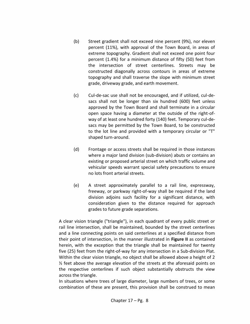
A clear vision triangle ("triangle"), in each quadrant of every public street or rail line intersection, shall be maintained, bounded by the street centerlines and a line connecting points on said centerlines at a specified distance from their point of intersection, in the manner illustrated in Figure II as contained herein, with the exception that the triangle shall be maintained for twenty five (25) feet from the right-of-way for any intersection in a Sub-division Plat. Within the clear vision triangle, no object shall be allowed above a height of 2 ½ feet above the average elevation of the streets at the aforesaid points on the respective centerlines if such object substantially obstructs the view across the triangle. In situations where trees of large diameter, large numbers of trees, or some combination of these are present, this provision shall be construed to mean
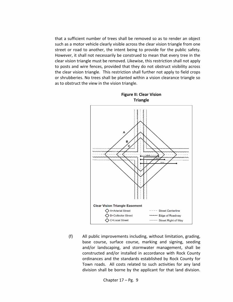
Chapter 17 – Pg. 9
that a sufficient number of trees shall be removed so as to render an object such as a motor vehicle clearly visible across the clear vision triangle from one street or road to another, the intent being to provide for the public safety. However, it shall not necessarily be construed to mean that every tree in the clear vision triangle must be removed. Likewise, this restriction shall not apply to posts and wire fences, provided that they do not obstruct visibility across the clear vision triangle. This restriction shall further not apply to field crops or shrubberies. No trees shall be planted within a vision clearance triangle so as to obstruct the view in the vision triangle.
Figure II: Clear Vision
Triangle
(f) All public improvements including, without limitation, grading, base course, surface course, marking and signing, seeding and/or landscaping, and stormwater management, shall be constructed and/or installed in accordance with Rock County ordinances and the standards established by Rock County for Town roads. All costs related to such activities for any land division shall be borne by the applicant for that land division.
Chapter 17 – Pg. 10
The applicant for any such land division shall provide a method of financing satisfactory to the Town Board (and the Agency if power hereunder is delegated to the Agency) so as to assure the construction and/or installation of all public improvements in compliance with all applicable ordinances and standards and the payment of all costs and expenses pertaining to the construction and/or installation thereof. The surface course shall be applied within twelve (12) months after the base course is constructed or at such later time as expressly approved by the Town Board (or the Agency if power hereunder is delegated to the Agency).
(g) Bridges of primary benefit to any land division applicant shall be constructed at the expense of the applicant without reimbursement from the Town. Cost sharing for construction of bridges not of primary benefit to the applicant may be fixed by agreement between the Town, other government entities and the applicant. The negotiation and execution of such special agreement shall be a condition of approval of the application for preliminary land division.
(3) Town public improvement plan. Any applicant for a land division which includes the construction of public improvements to be dedicated to the Town shall file with the Town a public improvement plan containing all of the following: (a) Elevation profiles of the centerline of all existing and proposed
streets:
(b) Elevation profile of the centerline of all existing streets that intersect with a proposed street, within six hundred (600) feet of said intersection;
(c) Approximate radii of all curves, lengths of tangents, and central
angles on all existing streets;
(d) Cross-sections of all proposed streets at one hundred (100) foot stations superimposed on existing topography (the Town Board may require cross-sections every fifty (50) feet in areas in excess of nine percent (9%) slope), and the location and cross-section of street pavements including drainageway easements, right-of-ways, and street signs;
Chapter 17 – Pg. 11
(e) Location, dimension, and invert elevations of existing and
proposed sanitary sewers, stormwater drainageways, drainage control facilities, and fire hydrants, identification of connections to any existing or proposed utility, and the location and size of all water, gas, or other underground utilities or structures;
(f) Location, dimension, and name (if applicable) of all streets and
improvements designated for public dedication, and all necessary utilities;
(g) Any other special requirements deemed necessary by the
Town Board to ensure the land division is in compliance with the Town comprehensive plan or the Rock County Comprehensive Plan.
(4) Financial guarantee. A written financial guarantee in an amount
determined by the Town Board (or the Agency if power hereunder is delegated to the Agency) to be reasonably sufficient to assure the payment of the cost of construction of all public improvements shall be provided to the Town Board by any applicant for a land division which contemplates the construction of public improvements, for all improvements not constructed at the time of approval of the final land division, complying with all conditions of approval of any application for preliminary land division and assuring the construction and performance of all necessary improvements. Said financial guarantee shall take one of the following forms and be provided in a format acceptable to the Board (and to the Agency if power hereunder is delegated to the Agency): (a) An insurance contract from a bonding agency;
(b) An irrevocable letter of credit from a recognized financial
institution;
(c) An escrow account in a recognized financial institution; The monetary amount of said guarantee shall be in an amount reasonably sufficient to assure the payment the cost of the current phase of improvement construction, in accordance with Sec. 236.13 (2) (a), Wisconsin Statutes.
Chapter 17 – Pg. 12
(5) Inspection. The Town Board (or the Agency if power hereunder is
delegated to the Agency) shall, at the developer’s expense, provide for inspection of public improvements during construction to ensure completion satisfactory to the Town Board (or to the Agency if power hereunder is delegated to the Agency).
(6) Maintenance. Any applicant for a land division contemplating public improvements shall be required to maintain all public improvements and services associated therewith ensuring the adequate performance of all said improvements until acceptance of improvements by the Town Board, including but not limited to snow removal on streets. The Town Board may, upon notice to the applicant, plow streets or effect emergency repairs and charge the cost of the same to the applicant. Utility entities and the applicant shall be responsible for accurate replacement of all lot corners and monuments destroyed while installing utilities, within a reasonable time period after installation.
(7) Timeline. For all land divisions contemplating public improvements, the public improvements shall be constructed by the applicant within twelve (12) months of of approval of the final land division. Extensions to the aforementioned timeline may be applied for by the applicant prior to expiration of said timeline and granted by the Town Board upon findings that delays are beyond the control of the applicant and that no material change in standards or conditions of the final land division has occurred or is reasonably expected to occur.
SECTION 8: ENVIRONMENTALLY SENSITIVE AREAS, CULTURAL
RESOURCES, PRODUCTIVE AGRICULTURAL SOILS, AND WOODLANDS PROTECTION AND PRESERVATION
Environmentally Sensitive Areas ("ESA"), cultural resources, productive agricultural soils and woodlands (collectively "Resources") shall be protected and preserved throughout the land division and development process, and land division and development shall not occur in a manner which significantly degrades or depletes any Resources, nor compromises their function or integrity, the Town comprehensive plan or Chapter 1 of this Code of Ordinances. Protection and preservation of Resources throughout the land division and development process shall be ensured utilizing the mechanisms identified herein.
Chapter 17 – Pg. 13
(1) Note on final land division or deed restriction. Upon creation of a lot of 35 acres or smaller, or upon application for a Zoning Permit for a building or accessory building, if the lot contains specified Resources, the Town Board may, in its discretion, require the placement of a note on the final land division CSM or Sub-division Plat, or a deed restriction, identifying specified Resources and prohibiting building and accessory building sites, and earth-disturbing activity that would significantly degrade or deplete or compromise the function or integrity of said Resources as identified therein.
(2) Conservation easement. Upon creation of a lot of 35 acres or smaller, or upon application for a Zoning Permit for a building or accessory building, if the lot contains specified Resources, the Town Board may, in its discretion, require that a conservation easement be created on the lot. Said easement may:
(a) Identify the land area subject to the easement and prohibit
building and accessory building sites, and earth-disturbing activity detrimental to the intent and purpose of the easement, in or on any specified Resources identified therein;
(b) Designate the owner of the lot subject to the easement as grantor therein and either Rock County, the Town, or some combination thereof, as grantee therein;
(c) Contain any additional information deemed appropriate by the
Town Board. SECTION 9: DELEGATION OF POWERS
The Town Board may delegate the administration and enforcement of all or portions of the provisions of this Chapter to the Rock County Planning, Economic and Community Development Agency under a Memorandum of Agreement as contemplated and permitted under Rock County Ordinances.
SECTION 10: PENALTIES
Any person convicted of a violation of this Chapter shall be subject to a fine of not less than $100 nor more than $5000, together with the costs of prosecution and the cost of remediation of any violation. The Town may obtain injunctive relief to prevent and abate further violations. Each day a violation exists or continues shall constitute a separate violation. In default of
Chapter 17 – Pg. 14
payment, the violator shall be imprisoned in the county jail until such fine and costs are paid, such imprisonment not to exceed 90 days.
SECTION 11: SEVERABILITY
Should any portion of this Chapter be declared to be unlawful or unconstitutional at any time, it shall be deemed severable from the rest of the Chapter and shall not affect the lawfulness or constitutionality of the remainder of the Chapter.