Embed Size (px)
Citation preview
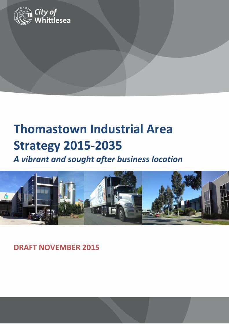
Thomastown Industrial Area Strategy 2015-2035 A vibrant and sought after business location
DRAFT NOVEMBER 2015
i Draft for Consultation
Contents
Foreword......................................................................................................................................................... ii
Section 1 – Introduction ................................................................................................................................. 1
Section 2 – Strategic context .......................................................................................................................... 2
Policy context .............................................................................................................................................. 2
Key drivers ................................................................................................................................................... 3
Strategic strengths ...................................................................................................................................... 3
Section 3 – Strategy aims and Vision .............................................................................................................. 4
Strategy aims ............................................................................................................................................... 4
Vision ........................................................................................................................................................... 4
Section 4 – Objectives and strategies ............................................................................................................. 5
Land use and development ......................................................................................................................... 5
Identity and economic development .......................................................................................................... 5
Transport, access and infrastructure .......................................................................................................... 6
Environment and sustainability .................................................................................................................. 7
Section 5 – Precinct plan and opportunity areas ............................................................................................ 8
Trawalla Avenue Precinct ............................................................................................................................ 9
Mahoneys Road Precinct .......................................................................................................................... 11
High Street West Precinct ......................................................................................................................... 13
Keon Park Station Precinct ........................................................................................................................ 15
Dalton Road Homemaker Precinct ............................................................................................................ 17
Settlement Road East Precinct .................................................................................................................. 19
Dalton Road North Precinct ...................................................................................................................... 21
McKimmies Road Precinct ........................................................................................................................ 23
Section 6 – Implementation framework ....................................................................................................... 25
Implementation plan ................................................................................................................................ 25
Delivery ..................................................................................................................................................... 30
Monitoring ................................................................................................................................................ 30
Acknowledgements ...................................................................................................................................... 31
Glossary......................................................................................................................................................... 32
ii Draft for Consultation
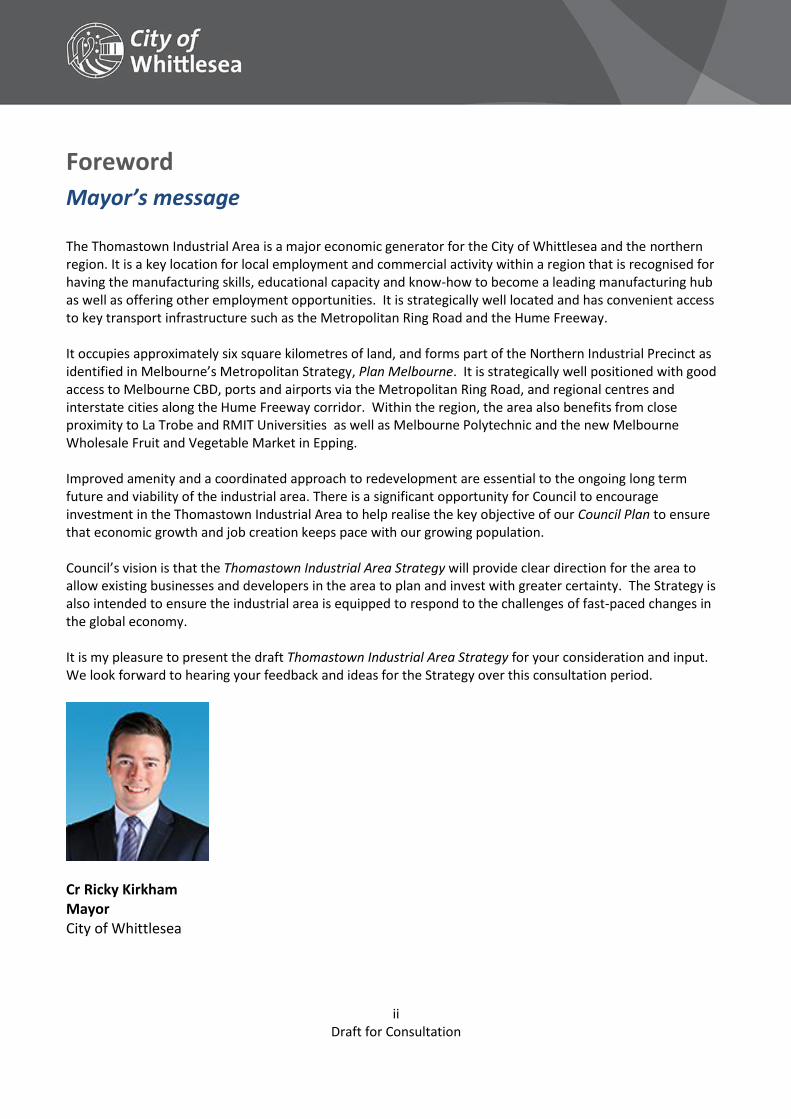
Foreword
Mayor’s message The Thomastown Industrial Area is a major economic generator for the City of Whittlesea and the northern region. It is a key location for local employment and commercial activity within a region that is recognised for having the manufacturing skills, educational capacity and know-how to become a leading manufacturing hub as well as offering other employment opportunities. It is strategically well located and has convenient access to key transport infrastructure such as the Metropolitan Ring Road and the Hume Freeway. It occupies approximately six square kilometres of land, and forms part of the Northern Industrial Precinct as identified in Melbourne’s Metropolitan Strategy, Plan Melbourne. It is strategically well positioned with good access to Melbourne CBD, ports and airports via the Metropolitan Ring Road, and regional centres and interstate cities along the Hume Freeway corridor. Within the region, the area also benefits from close proximity to La Trobe and RMIT Universities as well as Melbourne Polytechnic and the new Melbourne Wholesale Fruit and Vegetable Market in Epping. Improved amenity and a coordinated approach to redevelopment are essential to the ongoing long term future and viability of the industrial area. There is a significant opportunity for Council to encourage investment in the Thomastown Industrial Area to help realise the key objective of our Council Plan to ensure that economic growth and job creation keeps pace with our growing population. Council’s vision is that the Thomastown Industrial Area Strategy will provide clear direction for the area to allow existing businesses and developers in the area to plan and invest with greater certainty. The Strategy is also intended to ensure the industrial area is equipped to respond to the challenges of fast-paced changes in the global economy. It is my pleasure to present the draft Thomastown Industrial Area Strategy for your consideration and input. We look forward to hearing your feedback and ideas for the Strategy over this consultation period.
Cr Ricky Kirkham Mayor City of Whittlesea
1 Draft for Consultation
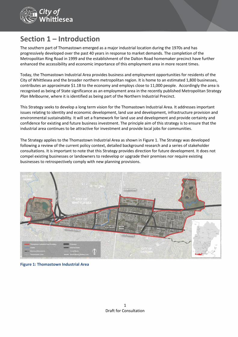
Section 1 – Introduction The southern part of Thomastown emerged as a major industrial location during the 1970s and has progressively developed over the past 40 years in response to market demands. The completion of the Metropolitan Ring Road in 1999 and the establishment of the Dalton Road homemaker precinct have further enhanced the accessibility and economic importance of this employment area in more recent times. Today, the Thomastown Industrial Area provides business and employment opportunities for residents of the City of Whittlesea and the broader northern metropolitan region. It is home to an estimated 1,800 businesses, contributes an approximate $1.1B to the economy and employs close to 11,000 people. Accordingly the area is recognised as being of State significance as an employment area in the recently published Metropolitan Strategy Plan Melbourne, where it is identified as being part of the Northern Industrial Precinct.
This Strategy seeks to develop a long term vision for the Thomastown Industrial Area. It addresses important issues relating to identity and economic development, land use and development, infrastructure provision and environmental sustainability. It will set a framework for land use and development and provide certainty and confidence for existing and future business investment. The principle aim of this strategy is to ensure that the industrial area continues to be attractive for investment and provide local jobs for communities.
The Strategy applies to the Thomastown Industrial Area as shown in Figure 1. The Strategy was developed following a review of the current policy context, detailed background research and a series of stakeholder consultations. It is important to note that this Strategy provides direction for future development. It does not compel existing businesses or landowners to redevelop or upgrade their premises nor require existing businesses to retrospectively comply with new planning provisions.
Figure 1: Thomastown Industrial Area
2 Draft for Consultation
Section 2 – Strategic context
Policy context Plan Melbourne sets out the Victorian Government’s vision for the city to 2050. It contains a number of directions relating to the delivery of investment and jobs by creating a city structure that drives productivity, supports investment through certainty and creates more jobs. The Thomastown Industrial Area is identified within the Northern Industrial Precinct which is one of the metropolitan area’s three identified State Significant Industrial Precincts. A number of potential urban renewal sites are identified in the Plan including Keon Park Station, which is within the Thomastown Industrial Area. The Whittlesea Planning Scheme guides land use and development within the municipality. There are several provisions in the scheme that are relevant to this Strategy. In addition, zones, overlays, particular and general provisions affect land use and development. The Thomastown Industrial Area is identified in the Scheme as strategically significant industrial and employment precinct in the municipality. The Whittlesea Council Plan 2013-2017 outlines a number of key initiatives and programs to make the City of Whittlesea a better place to live. A key strategic objective is Growing our Economy so there are a diverse range of local employment opportunities, under the Plan strategies encourage new business investment so local jobs are supported.
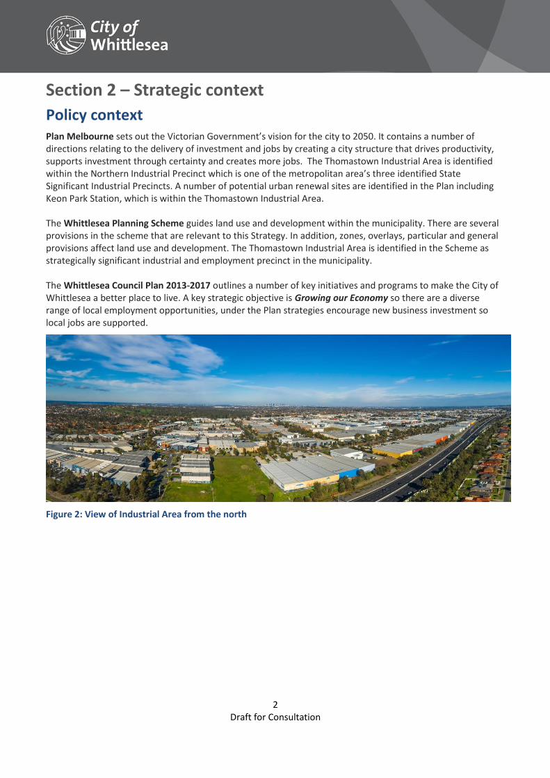
Figure 2: View of Industrial Area from the north
3 Draft for Consultation
Key drivers Despite changes, strong manufacturing sector base remains with established links to key markets. Local and stable employment opportunities. Growing awareness of the need for more diverse job opportunities and industry mix together with the
support of traditional manufacturing industries. The functional and strategic strengths of the area continue to generate new development and
investment. New and increasing demand from industry migrating from inner areas will continue. Redevelopment of recent sites and older buildings are providing opportunities for investment. 87ha of land with development potential has been identified as providing opportunities new
development and investment. Future industry investment opportunities exist in industrial services, light manufacturing and wholesaling.
Other supporting business services as well as office developments in higher amenity settings are also expected.
Strategic strengths Locational and infrastructure advantages Excellent access to the regional, metropolitan and national freeways. Access to major economic assets such as Melbourne Wholesale Fruit and Vegetable Market, Melbourne
Airport and Port of Melbourne and proximity to a range of major tertiary institutions including RMIT (Bundoora), La Trobe University and Melbourne Polytechnic.
Metropolitan passenger rail service with train stations at Keon Park and Thomastown as well as connecting bus services.
Range of uses and types of sites and built form A high proportion of functioning businesses and comparably low vacancy rate for existing buildings (5.7%)
across the wider industrial area (industrial precincts typically averages 6% to 12%). Increased global competition and industry restructuring has encouraged opportunities outside the
traditional manufacturing sector and a more diverse growth in industries has occurred. Opportunities available for a variety of businesses with a range of sites and building formats, together
with good separation from sensitive land uses via main road boundaries. Business clusters have provided agglomeration advantages for business operators. Large developers have been attracted to invest in new and higher quality industrial estates in some
locations, improving amenity and increasing business and employment activity.
Employment capacity Employment intensity varies between 21 and 42 jobs per hectare and there is the capacity to increase
employment densities through development and redevelopment of vacant or underutilised land. Situated within an area that has an established residential community with a growing catchment of
workers providing job opportunities close to where people live and provides advantages for businesses.
Environment Creek environs provide quality amenity and opportunities for improved accessibility throughout the
precinct. The creeks also provide separation from sensitive uses such as residential providing a distinct boundary
for the area.
4 Draft for Consultation
Section 3 – Strategy aims and Vision The purpose of the Thomastown Industrial Area Strategy is to support investment, improve the amenity and image of the area, provide direction in relation to the role and function of the area and outlines infrastructure needs for the area. Set out below are the principal aims of the strategy and these will define how the success of the Strategy is measured. It will set a framework for land use and development and provide certainty and confidence for existing and future business investment. The principle aim of this strategy is to ensure that the industrial area continues to be attractive for investment and provide local jobs for communities.
Strategy aims 1. To strengthen economic investment and provide a clear framework for land use and development
including the design of industrial and commercial built form.
2. To facilitate partnership opportunities and improve the image of the area to create an attractive environment for business investment and for people to access jobs.
3. To support regional transport connections and improve internal access, safety and connectivity through public transport, walking, cycling and vehicular infrastructure upgrades.
4. To improve the amenity and environmental conditions of the area through enhancements to the open space network, waterways and landscaping.
Vision
Thomastown Industrial Area is a vibrant and sought after business location. It is a thriving employment area that is an attractive place for new business and provides opportunities for growing businesses. An increased number and wide variety of job opportunities are available and accessible for local people. High quality urban design, landscaping and built form outcomes provides a quality environment. This, together with investment by private and government organisations, has also created a well-connected and safe precinct.
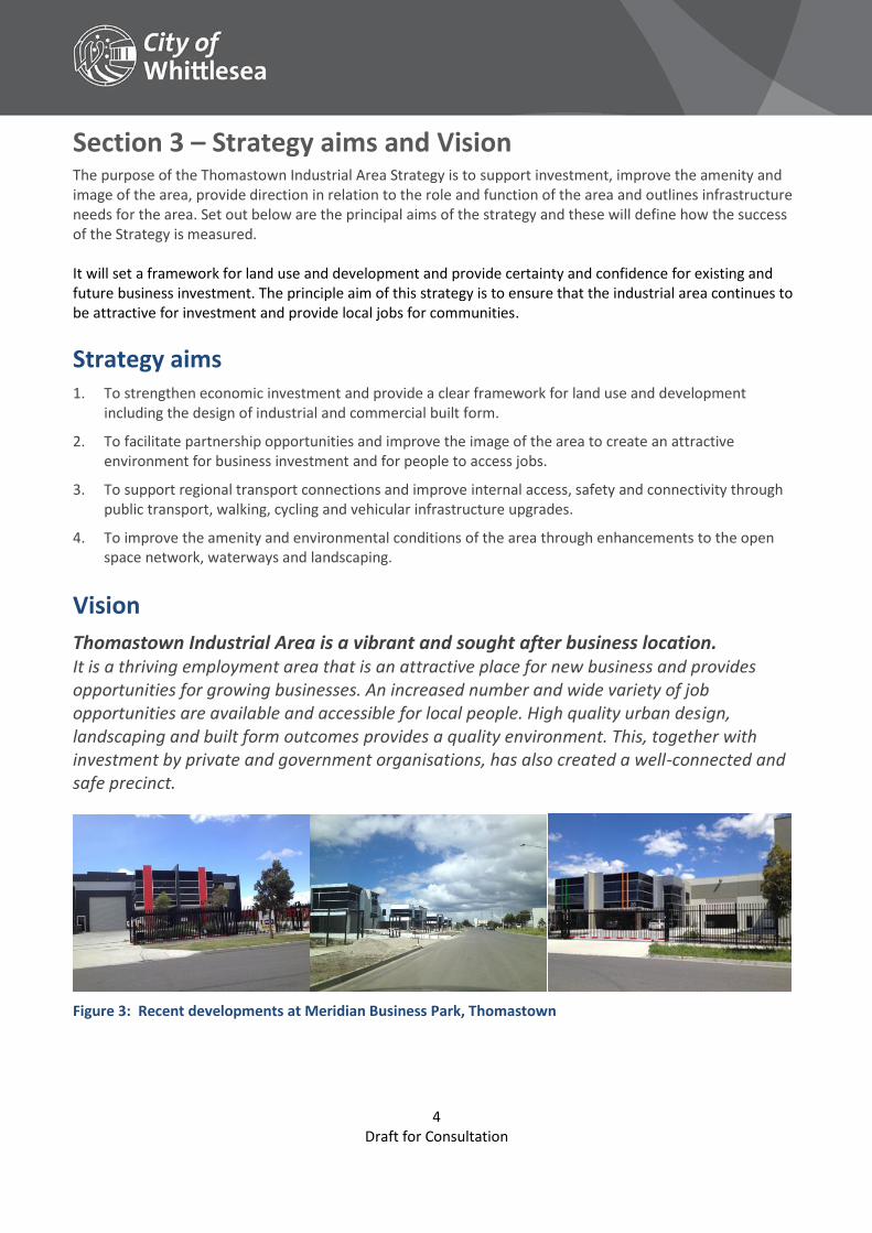
Figure 3: Recent developments at Meridian Business Park, Thomastown
5 Draft for Consultation
Section 4 – Objectives and strategies The strategy aims provide the basis for the objectives and strategies in Section 4 and inform the approach for the precincts and opportunity areas in Section 5. These together set out how the vision for the area will be achieved.
Land use and development Aim To strengthen economic investment and provide a clear framework for land use and
development including the design of industrial and commercial built form.
Objectives
Maintain and protect the industrial area’s existing and future function as an employment precinct and avoid the encroachment of sensitive uses.
Support development with increased employment densities in appropriate locations to facilitate a wider range and mix of jobs.
Improve the visual appearance through high quality developments, urban design treatments and landscaping.
Strategies
Support and encourage land uses such as general manufacturing, light industry, warehousing, storage, and modern industrial estates as well as service-based employment activities given the proximity to local population catchments.
Encourage a greater diversity of land uses around Keon Park Station, creating a business service precinct with amenities and support services for workers to complement the area’s employment function (e.g. cafés, convenience retailers and medical/childcare services).
Facilitate opportunities for local services for employees to provide places to meet or socialise and service local businesses, through a Business and Services Centre.
Require high quality site planning and design and require building design and subdivision to respond to modern needs and operational requirements of business, thereby safeguarding against obsolescence and minimising opportunities for crime (such as graffiti).
Undertake proactive compliance and education programs to ensure permit conditions are implemented and to maintain high levels of amenity to maintain an attractive investment environment.
Actions Statutory items: No’s 1.1, 1.2, 1.3
Economic development and partnerships items: No’s 2.1
Infrastructure and public realm items: No’s 3.15
Monitoring and compliance items: No’s 4.1, 4.2
Identity and economic development
Aim To facilitate partnership opportunities and improve the image of the area to create an attractive environment for business investment and for people to access jobs.
Objectives
Create an environment where the number of jobs can grow so more people have access to local job opportunities.
Build connections between businesses, government, industry bodies and tertiary institutions in order to establish partnerships, share information and facilitate business efficiencies and create opportunities for training and development to align with emerging future employment opportunities.
Create a positive impression and attractive identity for the area and entrance to the municipality through a functional public realm, streetscape improvements and gateway treatments.
6 Draft for Consultation
Identity and economic development
Strategies
Undertake regular collection of data through a Census of Land Use and Employment to understand development and market activity as well as employment trends to enable informed decisions.
Facilitate opportunities for start-up and small business to locate in the industrial area and utilise local networks and services through seeking funding opportunities for business incubator or short let start-up premises.
Strengthen and improve the profile and image of the area through enhancements to public realm including streetscape improvements.
Encourage provision of landscape enhancements or other visual amenity improvements in prominent locations such as corner sites or gateway areas.
Actions Economic development and partnerships items: No’s 2.1, 2.2, 2.3, 2.4, 2.5, 2.6
Transport, access and infrastructure Aim To support regional transport connections and improve internal access, safety and
connectivity through public transport, walking, cycling and vehicular infrastructure upgrades.
Objectives
Maintain and strengthen access and connections to existing and future major road and freight networks.
Facilitate improved connections throughout the precinct for walking and cycling and accessibility to public transport.
Maintain and improve transport, drainage and broadband infrastructure to support businesses and new development in the precinct.
Strategies Support an attractive and more connected urban environment through advocating for the removal of level crossings through grade separation.
Create improved connections throughout the area as part of local footpath network improvements, redevelopment of larger sites and by utilising utility easements.
Create improved cycle connections throughout the area in accordance with the priorities set in the Whittlesea Bicycle Strategy (2015).
Upgrade and strengthen the existing road network through road capacity and safety improvements at identified intersections and key locations.
Improve transport delivery or freight accessibility through the road network, focussing on improvements to identified critical access locations.
Support improved public transport services in Thomastown including bus services and connections particularly east-west connections.
Support businesses within the precinct to access broadband infrastructure though regular survey of business.
Minimise the adverse impact of development on existing drainage infrastructure through on site detention and through existing development contribution arrangements.
Support opportunities for stormwater harvesting as part of major developments.
Actions Statutory items: No’s 1.1, 1.2, 1.3
Infrastructure and public realm items: No’s 3.1, 3.2, 3.3, 3.4, 3.5, 3.6, 3.7, 3.7, 3.8, 3.9, 3.10, 3.11, 3.12, 3.14, 3.15
7 Draft for Consultation
Environment and sustainability Aim To improve the amenity and environmental conditions of the area through enhancements
to the open space network, waterways and landscaping.
Objectives
Encourage sustainable built form in all industrial and commercial development, practices and activities.
Improve the quality of runoff entering waterways from the area and prevent contamination by improving stormwater quality and drainage, remediating contaminated land and reducing impacts from poor business practices.
Enhance the waterways by creating usable and accessible open spaces and improving stream health and environmental values.
Strategies
Encourage all applicants for planning permits to use the Sustainable Design Assessment in the Planning Process (SDAPP) framework.
Support further sustainable development opportunities for business (including green roofs, on-site renewable energy including bulk purchase solar photovoltaic panels, and stormwater and runoff water capture and reuse).
Encourage the provision of well-located storage for equipment, stock, vehicles and waste to ensure efficient business operation and avoid contamination of sites and stormwater.
Encourage innovative water sensitive urban design to reduce and minimise local and downstream flooding and contamination impacts.
Restore and rehabilitate Edgars Creek between Mahoneys Road and the Metropolitan Ring Road to improve connectivity and create new open space.
Support the restoration and rehabilitation of Merri Creek in accordance with the Merri Creek Park Strategy.
Actions Statutory items: No’s 1.1, 1.2, 1.3
Economic development and partnerships items: No’s 2.6
Infrastructure and public realm items: No’s 3.14, 3.16, 3.1
Monitoring and compliance items: No’s 4.2
8 Draft for Consultation
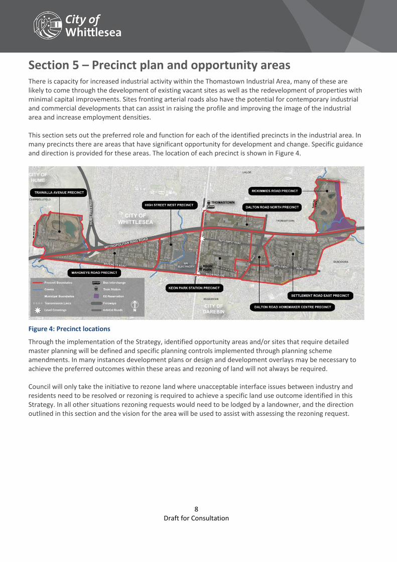
Section 5 – Precinct plan and opportunity areas There is capacity for increased industrial activity within the Thomastown Industrial Area, many of these are likely to come through the development of existing vacant sites as well as the redevelopment of properties with minimal capital improvements. Sites fronting arterial roads also have the potential for contemporary industrial and commercial developments that can assist in raising the profile and improving the image of the industrial area and increase employment densities. This section sets out the preferred role and function for each of the identified precincts in the industrial area. In many precincts there are areas that have significant opportunity for development and change. Specific guidance and direction is provided for these areas. The location of each precinct is shown in Figure 4.
Figure 4: Precinct locations
Through the implementation of the Strategy, identified opportunity areas and/or sites that require detailed master planning will be defined and specific planning controls implemented through planning scheme amendments. In many instances development plans or design and development overlays may be necessary to achieve the preferred outcomes within these areas and rezoning of land will not always be required. Council will only take the initiative to rezone land where unacceptable interface issues between industry and residents need to be resolved or rezoning is required to achieve a specific land use outcome identified in this Strategy. In all other situations rezoning requests would need to be lodged by a landowner, and the direction outlined in this section and the vision for the area will be used to assist with assessing the rezoning request.
9 Draft for Consultation
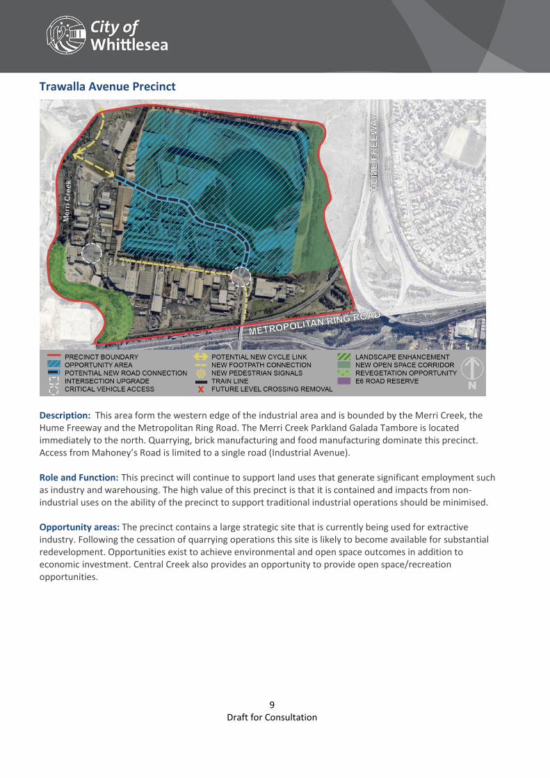
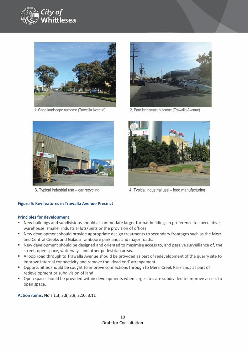
Trawalla Avenue Precinct
Description: This area form the western edge of the industrial area and is bounded by the Merri Creek, the Hume Freeway and the Metropolitan Ring Road. The Merri Creek Parkland Galada Tambore is located immediately to the north. Quarrying, brick manufacturing and food manufacturing dominate this precinct. Access from Mahoney’s Road is limited to a single road (Industrial Avenue). Role and Function: This precinct will continue to support land uses that generate significant employment such as industry and warehousing. The high value of this precinct is that it is contained and impacts from non-industrial uses on the ability of the precinct to support traditional industrial operations should be minimised. Opportunity areas: The precinct contains a large strategic site that is currently being used for extractive industry. Following the cessation of quarrying operations this site is likely to become available for substantial redevelopment. Opportunities exist to achieve environmental and open space outcomes in addition to economic investment. Central Creek also provides an opportunity to provide open space/recreation opportunities.
10 Draft for Consultation
3. Typical industrial use – car recycling 4. Typical industrial use – food manufacturing
Figure 5: Key features in Trawalla Avenue Precinct
Principles for development: New buildings and subdivisions should accommodate larger format buildings in preference to speculative
warehouse, smaller industrial lots/units or the provision of offices. New development should provide appropriate design treatments to secondary frontages such as the Merri
and Central Creeks and Galada Tamboore parklands and major roads. New development should be designed and oriented to maximise access to, and passive surveillance of, the
street, open space, waterways and other pedestrian areas. A loop road through to Trawalla Avenue should be provided as part of redevelopment of the quarry site to
improve internal connectivity and remove the ‘dead end’ arrangement. Opportunities should be sought to improve connections through to Merri Creek Parklands as part of
redevelopment or subdivision of land. Open space should be provided within developments when large sites are subdivided to improve access to
open space.
Action items: No’s 1.3, 3.8, 3.9, 3.10, 3.11
11 Draft for Consultation
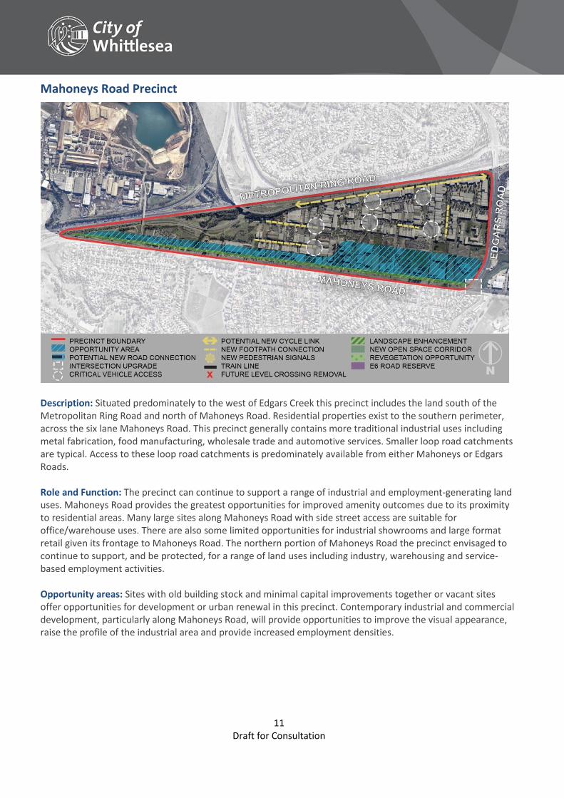
Mahoneys Road Precinct
Description: Situated predominately to the west of Edgars Creek this precinct includes the land south of the Metropolitan Ring Road and north of Mahoneys Road. Residential properties exist to the southern perimeter, across the six lane Mahoneys Road. This precinct generally contains more traditional industrial uses including metal fabrication, food manufacturing, wholesale trade and automotive services. Smaller loop road catchments are typical. Access to these loop road catchments is predominately available from either Mahoneys or Edgars Roads. Role and Function: The precinct can continue to support a range of industrial and employment-generating land uses. Mahoneys Road provides the greatest opportunities for improved amenity outcomes due to its proximity to residential areas. Many large sites along Mahoneys Road with side street access are suitable for office/warehouse uses. There are also some limited opportunities for industrial showrooms and large format retail given its frontage to Mahoneys Road. The northern portion of Mahoneys Road the precinct envisaged to continue to support, and be protected, for a range of land uses including industry, warehousing and service-based employment activities. Opportunity areas: Sites with old building stock and minimal capital improvements together or vacant sites offer opportunities for development or urban renewal in this precinct. Contemporary industrial and commercial development, particularly along Mahoneys Road, will provide opportunities to improve the visual appearance, raise the profile of the industrial area and provide increased employment densities.
12 Draft for Consultation
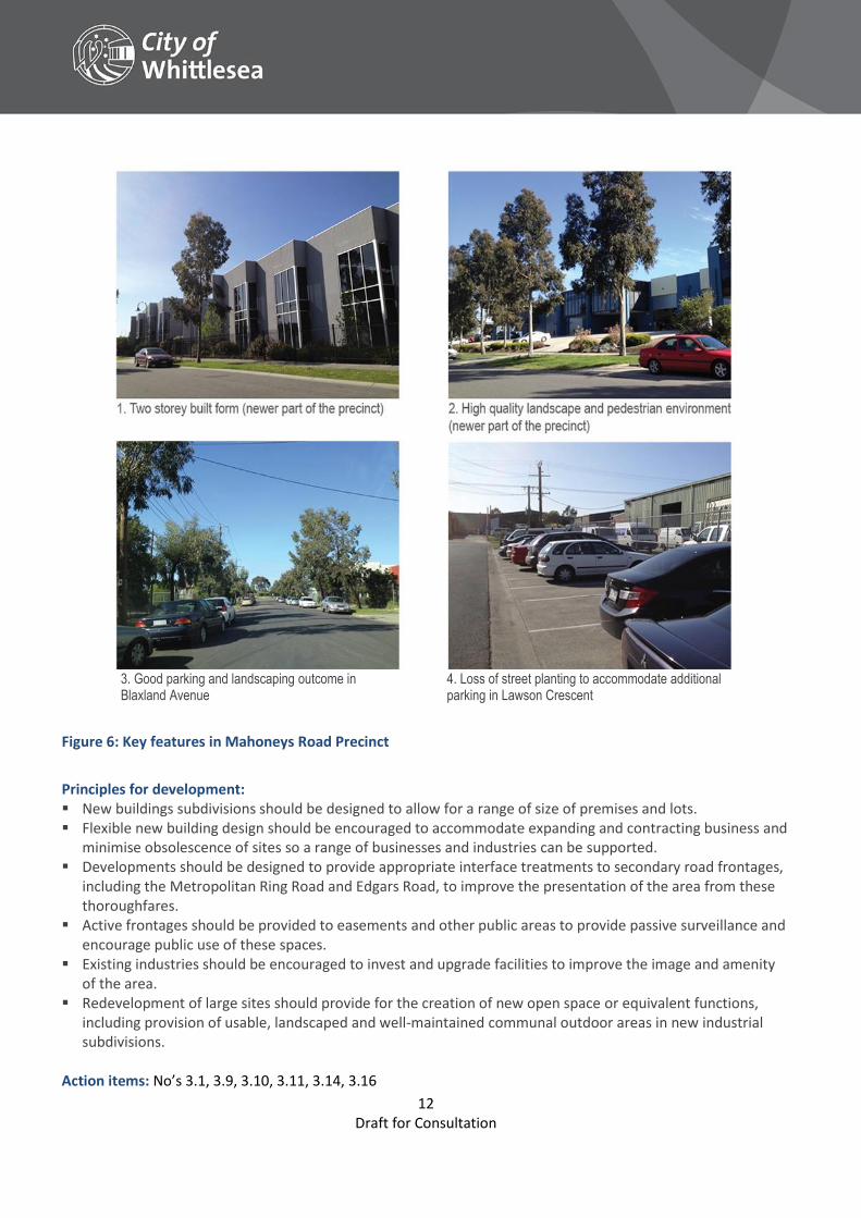
3. Good parking and landscaping outcome in Blaxland Avenue
4. Loss of street planting to accommodate additional parking in Lawson Crescent
Figure 6: Key features in Mahoneys Road Precinct
Principles for development: New buildings subdivisions should be designed to allow for a range of size of premises and lots. Flexible new building design should be encouraged to accommodate expanding and contracting business and
minimise obsolescence of sites so a range of businesses and industries can be supported. Developments should be designed to provide appropriate interface treatments to secondary road frontages,
including the Metropolitan Ring Road and Edgars Road, to improve the presentation of the area from these thoroughfares.
Active frontages should be provided to easements and other public areas to provide passive surveillance and encourage public use of these spaces.
Existing industries should be encouraged to invest and upgrade facilities to improve the image and amenity of the area.
Redevelopment of large sites should provide for the creation of new open space or equivalent functions, including provision of usable, landscaped and well-maintained communal outdoor areas in new industrial subdivisions.
Action items: No’s 3.1, 3.9, 3.10, 3.11, 3.14, 3.16
13 Draft for Consultation
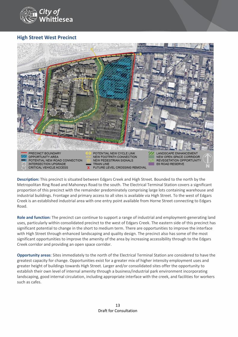
High Street West Precinct
Description: This precinct is situated between Edgars Creek and High Street. Bounded to the north by the Metropolitan Ring Road and Mahoneys Road to the south. The Electrical Terminal Station covers a significant proportion of this precinct with the remainder predominately comprising large lots containing warehouse and industrial buildings. Frontage and primary access to all sites is available via High Street. To the west of Edgars Creek is an established industrial area with one entry point available from Horne Street connecting to Edgars Road.
Role and function: The precinct can continue to support a range of industrial and employment-generating land uses, particularly within consolidated precinct to the west of Edgars Creek. The eastern side of this precinct has significant potential to change in the short to medium term. There are opportunities to improve the interface with High Street through enhanced landscaping and quality design. The precinct also has some of the most significant opportunities to improve the amenity of the area by increasing accessibility through to the Edgars Creek corridor and providing an open space corridor. Opportunity areas: Sites immediately to the north of the Electrical Terminal Station are considered to have the greatest capacity for change. Opportunities exist for a greater mix of higher intensity employment uses and greater height of buildings towards High Street. Larger and/or consolidated sites offer the opportunity to establish their own level of internal amenity through a business/industrial park environment incorporating landscaping, good internal circulation, including appropriate interface with the creek, and facilities for workers such as cafes.
14 Draft for Consultation
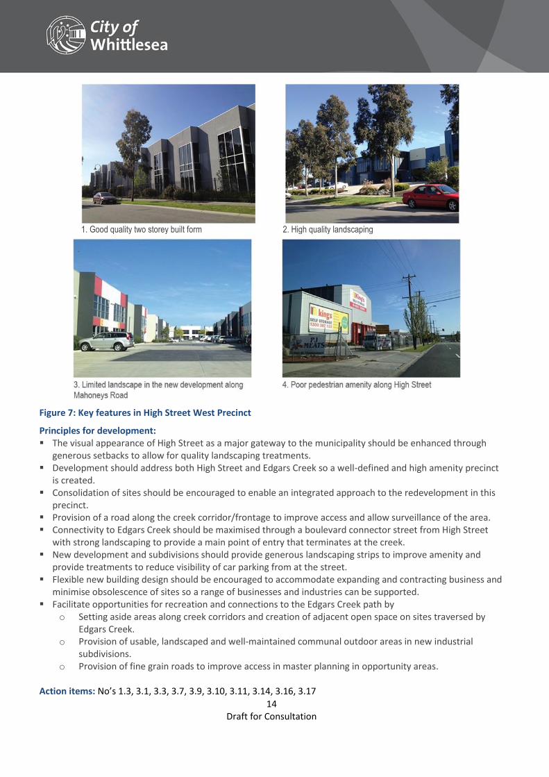
1. Good quality two storey built form 2. High quality landscaping
Figure 7: Key features in High Street West Precinct
Principles for development: The visual appearance of High Street as a major gateway to the municipality should be enhanced through
generous setbacks to allow for quality landscaping treatments. Development should address both High Street and Edgars Creek so a well-defined and high amenity precinct
is created. Consolidation of sites should be encouraged to enable an integrated approach to the redevelopment in this
precinct. Provision of a road along the creek corridor/frontage to improve access and allow surveillance of the area. Connectivity to Edgars Creek should be maximised through a boulevard connector street from High Street
with strong landscaping to provide a main point of entry that terminates at the creek. New development and subdivisions should provide generous landscaping strips to improve amenity and
provide treatments to reduce visibility of car parking from at the street. Flexible new building design should be encouraged to accommodate expanding and contracting business and
minimise obsolescence of sites so a range of businesses and industries can be supported. Facilitate opportunities for recreation and connections to the Edgars Creek path by
o Setting aside areas along creek corridors and creation of adjacent open space on sites traversed by Edgars Creek.
o Provision of usable, landscaped and well-maintained communal outdoor areas in new industrial subdivisions.
o Provision of fine grain roads to improve access in master planning in opportunity areas. Action items: No’s 1.3, 3.1, 3.3, 3.7, 3.9, 3.10, 3.11, 3.14, 3.16, 3.17
15 Draft for Consultation
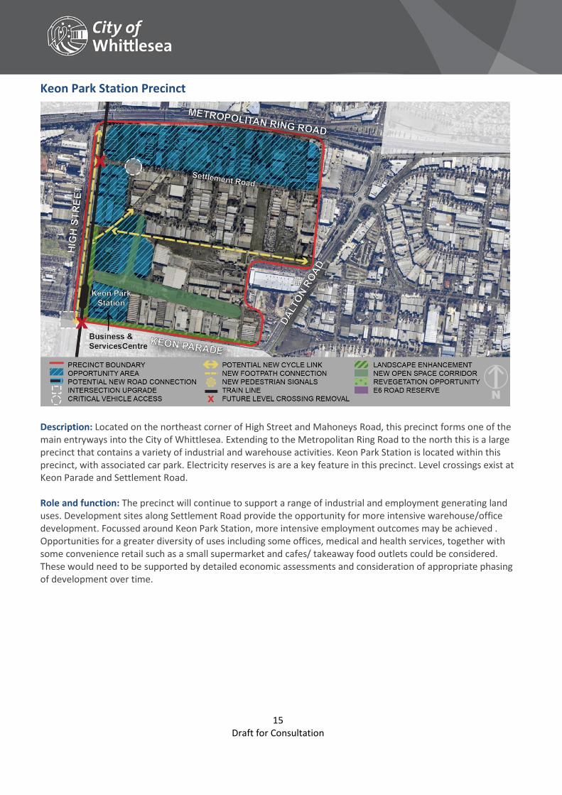
Keon Park Station Precinct
Description: Located on the northeast corner of High Street and Mahoneys Road, this precinct forms one of the main entryways into the City of Whittlesea. Extending to the Metropolitan Ring Road to the north this is a large precinct that contains a variety of industrial and warehouse activities. Keon Park Station is located within this precinct, with associated car park. Electricity reserves is are a key feature in this precinct. Level crossings exist at Keon Parade and Settlement Road. Role and function: The precinct will continue to support a range of industrial and employment generating land uses. Development sites along Settlement Road provide the opportunity for more intensive warehouse/office development. Focussed around Keon Park Station, more intensive employment outcomes may be achieved . Opportunities for a greater diversity of uses including some offices, medical and health services, together with some convenience retail such as a small supermarket and cafes/ takeaway food outlets could be considered. These would need to be supported by detailed economic assessments and consideration of appropriate phasing of development over time.
16 Draft for Consultation
Opportunity areas: Keon Park Station: The areas proximate to Keon Park Station precinct have good access to public transport. Larger sites with older building stock provide opportunities for urban renewal and increased employment densities. The removal of at grade level crossings through grade separation would significantly improve road safety and capacity issues. It would also provide improved opportunities for people to access jobs within short distance of public transport and support urban renewal in this location generating greater economic returns from investment and significantly improving the amenity and profile of the area. The establishment of a business and services centre within the area would be expected to improve the market perception of the area and provide further employment opportunities. As such, this precinct has potential to significantly change the character and visual appearance of the area. Settlement Road: More intensive industrial activities could also be supported along Settlement Road. Modern office/warehouse developments on larger sites along Settlement Road could be supported. These are likely to occur in the shorter term, particularly upon larger vacant sites. Larger sites also offer the opportunity to establish their own level of internal amenity through the development of a business/industry park environment and with high quality landscaping, good internal circulation and a cafe/take away food premises to service businesses within and adjacent to the development.
Principles for development: Ensure use and development does not compromise the operation of existing and future businesses and the
function as an industrial and employment precinct. Support a greater diversity of uses immediately adjacent to, or above, Keon Park Station and along Keon
Parade through a business and services centre that provides a range of higher skilled occupations including business services establishing within a small office suite development, and a range of health and medical services.
Developments should provide active frontages along railway line reservation, high voltage transmission line easements and open space areas.
Outlook to easements, public transport corridors and other public areas to provide passive surveillance and increase opportunities for public use of these spaces should be provided.
Redevelopment of land containing high voltage transmission line easements should provide for shared path links, open space and landscaping.
Vehicular and pedestrian entry from Temple Drive should be utilised to create improved pedestrian connectivity throughout this precinct, maximising connections to the train station.
A central public open space corridor should be encouraged as part of major redevelopments to provide amenity for workers and improve connectivity.
Developments should be designed to provide appropriate interface treatments and landscaping to secondary road frontages, including the Metropolitan Ring Road, to improve the presentation of the area from these thoroughfares.
Storage areas should be designed to minimise visual impact from the street. Flexible new building design should be encouraged to accommodate expanding and contracting business and
minimise obsolescence of sites so a range of businesses and industries can be supported. Existing industries should be encouraged to invest and upgrade facilities to improve the image and amenity
of the area.
Action items: No’s 1.3, 3.3, 3.9, 3.11, 3.12, 3.14, 3.15, 3.16
17 Draft for Consultation
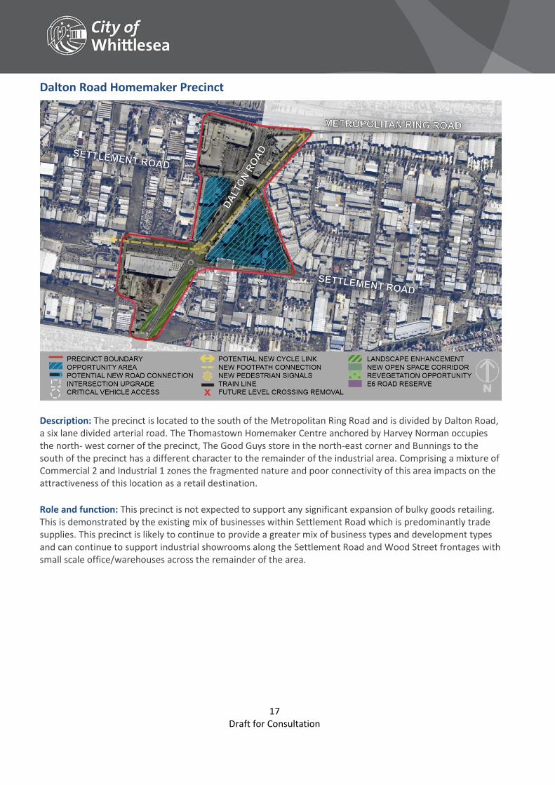
Dalton Road Homemaker Precinct
Description: The precinct is located to the south of the Metropolitan Ring Road and is divided by Dalton Road, a six lane divided arterial road. The Thomastown Homemaker Centre anchored by Harvey Norman occupies the north- west corner of the precinct, The Good Guys store in the north-east corner and Bunnings to the south of the precinct has a different character to the remainder of the industrial area. Comprising a mixture of Commercial 2 and Industrial 1 zones the fragmented nature and poor connectivity of this area impacts on the attractiveness of this location as a retail destination. Role and function: This precinct is not expected to support any significant expansion of bulky goods retailing. This is demonstrated by the existing mix of businesses within Settlement Road which is predominantly trade supplies. This precinct is likely to continue to provide a greater mix of business types and development types and can continue to support industrial showrooms along the Settlement Road and Wood Street frontages with small scale office/warehouses across the remainder of the area.
18 Draft for Consultation
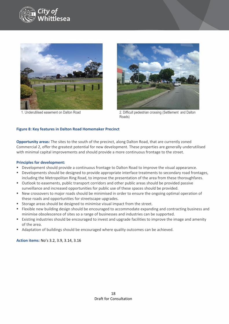
1. Underutilised easement on Dalton Road 2. Difficult pedestrian crossing (Settlement and Dalton
Roads)
Figure 8: Key features in Dalton Road Homemaker Precinct
Opportunity areas: The sites to the south of the precinct, along Dalton Road, that are currently zoned Commercial 2, offer the greatest potential for new development. These properties are generally underutilised with minimal capital improvements and should provide a more continuous frontage to the street. Principles for development: Development should provide a continuous frontage to Dalton Road to improve the visual appearance. Developments should be designed to provide appropriate interface treatments to secondary road frontages,
including the Metropolitan Ring Road, to improve the presentation of the area from these thoroughfares. Outlook to easements, public transport corridors and other public areas should be provided passive
surveillance and increased opportunities for public use of these spaces should be provided. New crossovers to major roads should be minimised in order to ensure the ongoing optimal operation of
these roads and opportunities for streetscape upgrades. Storage areas should be designed to minimise visual impact from the street. Flexible new building design should be encouraged to accommodate expanding and contracting business and
minimise obsolescence of sites so a range of businesses and industries can be supported. Existing industries should be encouraged to invest and upgrade facilities to improve the image and amenity
of the area. Adaptation of buildings should be encouraged where quality outcomes can be achieved.
Action items: No’s 3.2, 3.9, 3.14, 3.16
19 Draft for Consultation
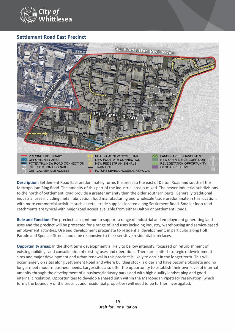
Settlement Road East Precinct
Description: Settlement Road East predominately forms the areas to the east of Dalton Road and south of the Metropolitan Ring Road. The amenity of this part of the industrial area is mixed. The newer industrial subdivisions to the north of Settlement Road provide a greater amenity than the older southern parts. Generally traditional industrial uses including metal fabrication, food manufacturing and wholesale trade predominate in this location, with more commercial activities such as retail trade supplies located along Settlement Road. Smaller loop road catchments are typical with major road access available from either Dalton or Settlement Roads. Role and Function: The precinct can continue to support a range of industrial and employment generating land uses and the precinct will be protected for a range of land uses including industry, warehousing and service-based employment activities. Use and development proximate to residential development, in particular along Holt Parade and Spencer Street should be responsive to their sensitive residential interfaces. Opportunity areas: In the short term development is likely to be low intensity, focussed on refurbishment of existing buildings and consolidation of existing uses and operations. There are limited strategic redevelopment sites and major development and urban renewal in this precinct is likely to occur in the longer term. This will occur largely on sites along Settlement Road and where building stock is older and have become obsolete and no longer meet modern business needs. Larger sites also offer the opportunity to establish their own level of internal amenity through the development of a business/industry parks and with high quality landscaping and good internal circulation. Opportunities to develop a shared path within the Maroondah Pipetrack reservation (which forms the boundary of the precinct and residential properties) will need to be further investigated.
20 Draft for Consultation
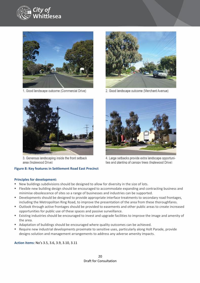
Figure 8: Key features in Settlement Road East Precinct
Principles for development: New buildings subdivisions should be designed to allow for diversity in the size of lots. Flexible new building design should be encouraged to accommodate expanding and contracting business and
minimise obsolescence of sites so a range of businesses and industries can be supported. Developments should be designed to provide appropriate interface treatments to secondary road frontages,
including the Metropolitan Ring Road, to improve the presentation of the area from these thoroughfares. Outlook through active frontages should be provided to easements and other public areas to create increased
opportunities for public use of these spaces and passive surveillance. Existing industries should be encouraged to invest and upgrade facilities to improve the image and amenity of
the area. Adaptation of buildings should be encouraged where quality outcomes can be achieved. Require new industrial developments proximate to sensitive uses, particularly along Holt Parade, provide
designs solution and management arrangements to address any adverse amenity impacts.
Action items: No’s 3.5, 3.6, 3.9, 3.10, 3.11

21 Draft for Consultation
Dalton Road North Precinct
Description: Dalton Road North forms the area to the north of the Metropolitan Ring Road, between High Street, Dalton Road and Heyington Avenue. The newly developed Meridian Business Park is situated to the west, while the older building stock to the east contains more traditional industrial activities including service industries. Smaller loop road catchments are typical, with major road access available from either Dalton or Settlement Roads. Role and Function: The precinct will continue to support a range of industrial and employment generating land uses and the precinct will be protected for a range of land uses including industry, warehousing and service-based employment activities. Use and development proximate to residential development, in particular along Holt Parade and Spencer Street should be responsive to their sensitive interfaces. Opportunity areas: In the short term development is likely to be low intensity, focussed on refurbishment of existing buildings and consolidation of existing uses and operations. Long term opportunities exist to improve the interface with residential properties to the north along the eastern end of Heyington Avenue. Connections between Dalton Road and Spencer Street to improve accessibility an safety of this intersection.
22 Draft for Consultation
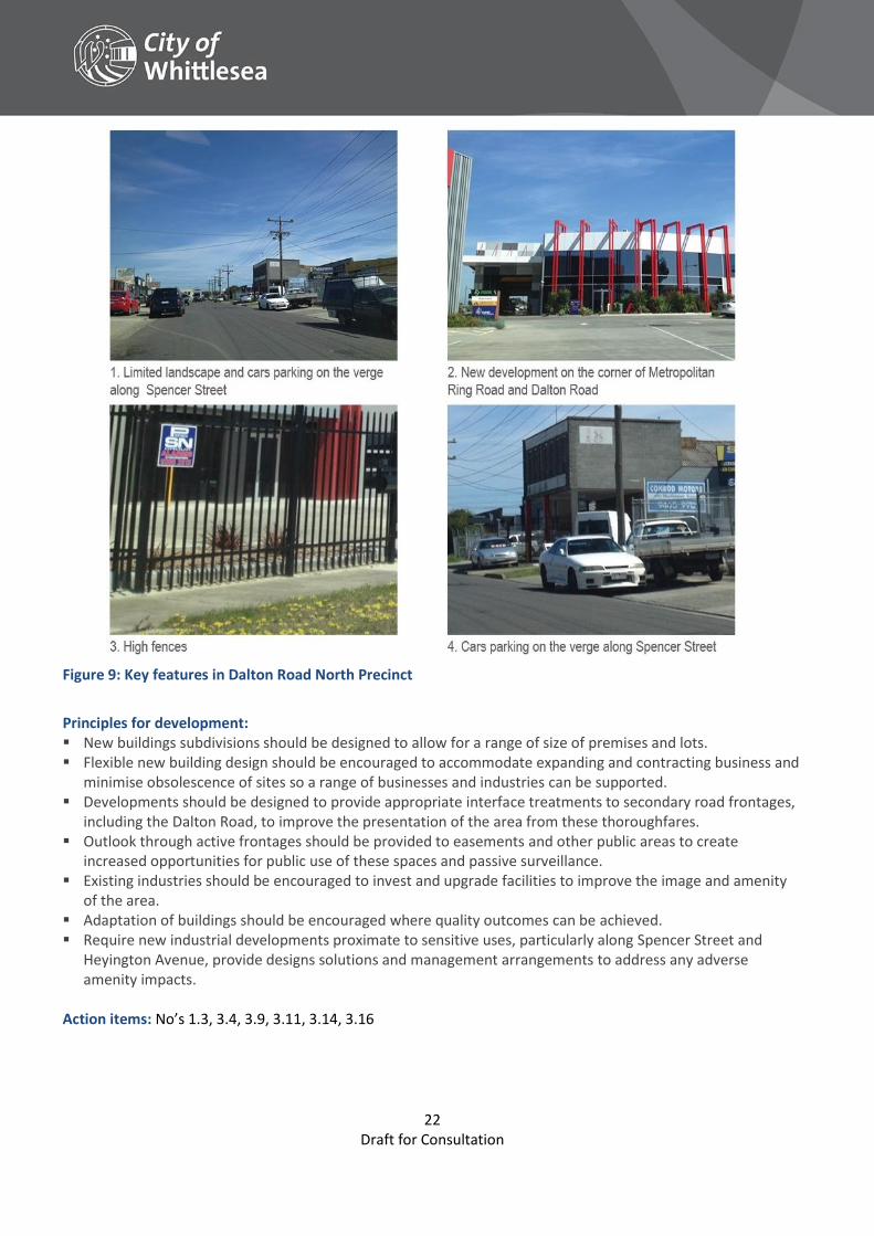
Figure 9: Key features in Dalton Road North Precinct
Principles for development: New buildings subdivisions should be designed to allow for a range of size of premises and lots. Flexible new building design should be encouraged to accommodate expanding and contracting business and
minimise obsolescence of sites so a range of businesses and industries can be supported. Developments should be designed to provide appropriate interface treatments to secondary road frontages,
including the Dalton Road, to improve the presentation of the area from these thoroughfares. Outlook through active frontages should be provided to easements and other public areas to create
increased opportunities for public use of these spaces and passive surveillance. Existing industries should be encouraged to invest and upgrade facilities to improve the image and amenity
of the area. Adaptation of buildings should be encouraged where quality outcomes can be achieved. Require new industrial developments proximate to sensitive uses, particularly along Spencer Street and
Heyington Avenue, provide designs solutions and management arrangements to address any adverse amenity impacts.
Action items: No’s 1.3, 3.4, 3.9, 3.11, 3.14, 3.16
23 Draft for Consultation
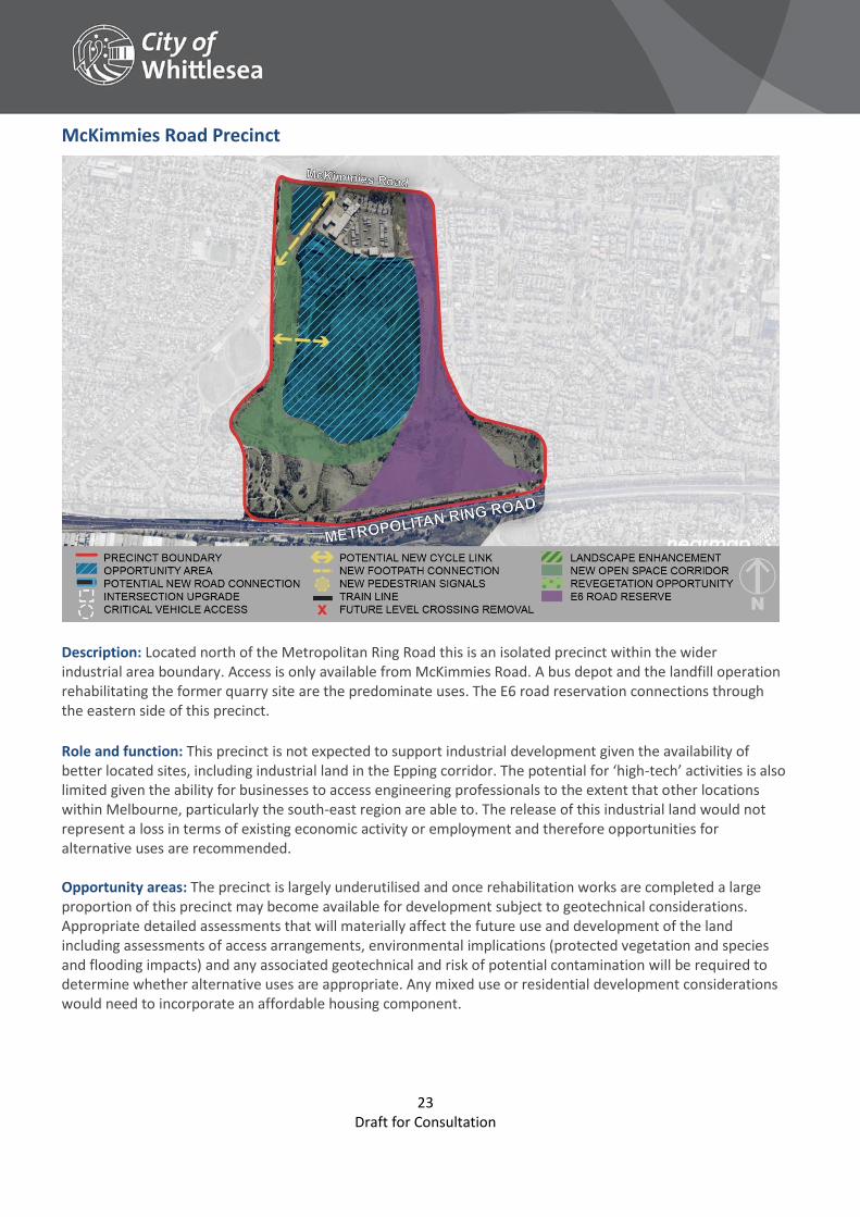
McKimmies Road Precinct
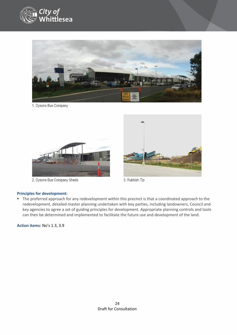
Description: Located north of the Metropolitan Ring Road this is an isolated precinct within the wider industrial area boundary. Access is only available from McKimmies Road. A bus depot and the landfill operation rehabilitating the former quarry site are the predominate uses. The E6 road reservation connections through the eastern side of this precinct. Role and function: This precinct is not expected to support industrial development given the availability of better located sites, including industrial land in the Epping corridor. The potential for ‘high-tech’ activities is also limited given the ability for businesses to access engineering professionals to the extent that other locations within Melbourne, particularly the south-east region are able to. The release of this industrial land would not represent a loss in terms of existing economic activity or employment and therefore opportunities for alternative uses are recommended. Opportunity areas: The precinct is largely underutilised and once rehabilitation works are completed a large proportion of this precinct may become available for development subject to geotechnical considerations. Appropriate detailed assessments that will materially affect the future use and development of the land including assessments of access arrangements, environmental implications (protected vegetation and species and flooding impacts) and any associated geotechnical and risk of potential contamination will be required to determine whether alternative uses are appropriate. Any mixed use or residential development considerations would need to incorporate an affordable housing component.
24 Draft for Consultation
Principles for development: The preferred approach for any redevelopment within this precinct is that a coordinated approach to the
redevelopment, detailed master planning undertaken with key parties, including landowners, Council and key agencies to agree a set of guiding principles for development. Appropriate planning controls and tools can then be determined and implemented to facilitate the future use and development of the land.
Action items: No’s 1.3, 3.9
25 Draft for Consultation
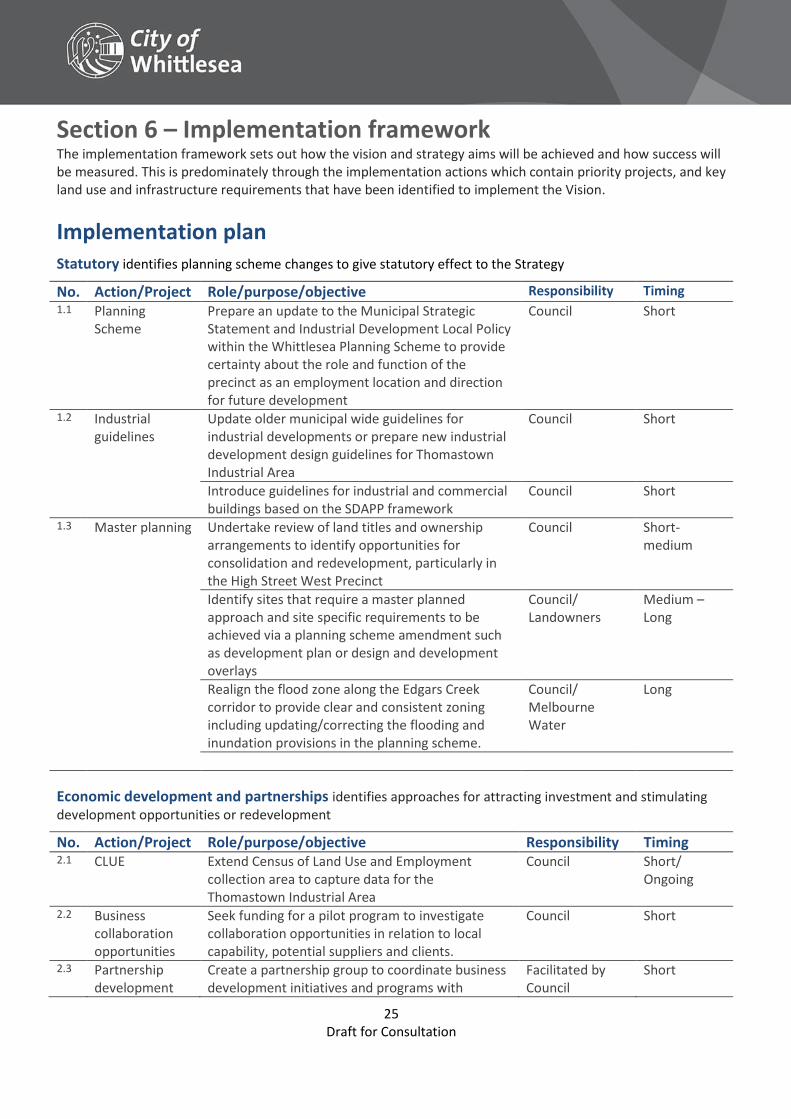
Section 6 – Implementation framework The implementation framework sets out how the vision and strategy aims will be achieved and how success will be measured. This is predominately through the implementation actions which contain priority projects, and key land use and infrastructure requirements that have been identified to implement the Vision.
Implementation plan Statutory identifies planning scheme changes to give statutory effect to the Strategy
No. Action/Project Role/purpose/objective Responsibility Timing 1.1 Planning
Scheme Prepare an update to the Municipal Strategic Statement and Industrial Development Local Policy within the Whittlesea Planning Scheme to provide certainty about the role and function of the precinct as an employment location and direction for future development
Council Short
1.2 Industrial guidelines
Update older municipal wide guidelines for industrial developments or prepare new industrial development design guidelines for Thomastown Industrial Area
Council Short
Introduce guidelines for industrial and commercial buildings based on the SDAPP framework
Council Short
1.3 Master planning
Undertake review of land titles and ownership arrangements to identify opportunities for consolidation and redevelopment, particularly in the High Street West Precinct
Council Short-medium
Identify sites that require a master planned approach and site specific requirements to be achieved via a planning scheme amendment such as development plan or design and development overlays
Council/ Landowners
Medium – Long
Realign the flood zone along the Edgars Creek corridor to provide clear and consistent zoning including updating/correcting the flooding and inundation provisions in the planning scheme.
Council/ Melbourne Water
Long
Economic development and partnerships identifies approaches for attracting investment and stimulating development opportunities or redevelopment
No. Action/Project Role/purpose/objective Responsibility Timing 2.1 CLUE Extend Census of Land Use and Employment
collection area to capture data for the Thomastown Industrial Area
Council Short/ Ongoing
2.2 Business collaboration opportunities
Seek funding for a pilot program to investigate collaboration opportunities in relation to local capability, potential suppliers and clients.
Council Short
2.3 Partnership development
Create a partnership group to coordinate business development initiatives and programs with
Facilitated by Council
Short
26 Draft for Consultation
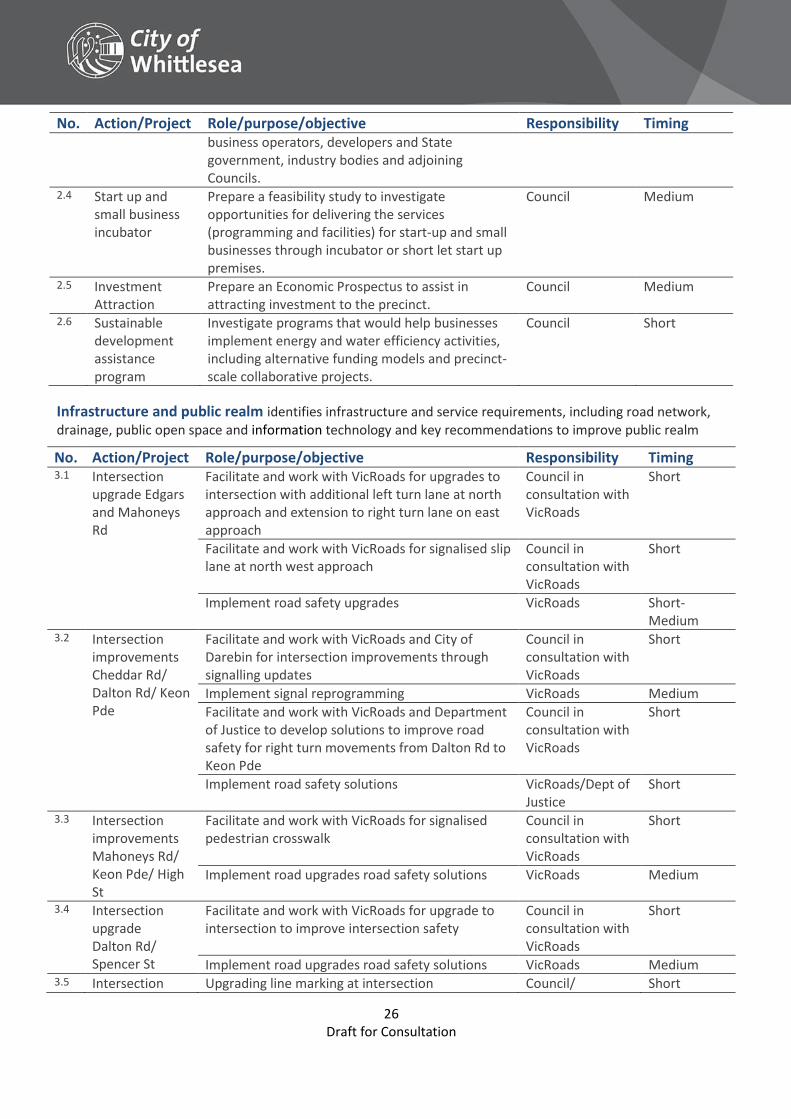
No. Action/Project Role/purpose/objective Responsibility Timing business operators, developers and State government, industry bodies and adjoining Councils.
2.4 Start up and small business incubator
Prepare a feasibility study to investigate opportunities for delivering the services (programming and facilities) for start-up and small businesses through incubator or short let start up premises.
Council Medium
2.5 Investment Attraction
Prepare an Economic Prospectus to assist in attracting investment to the precinct.
Council Medium
2.6 Sustainable development assistance program
Investigate programs that would help businesses implement energy and water efficiency activities, including alternative funding models and precinct-scale collaborative projects.
Council Short
Infrastructure and public realm identifies infrastructure and service requirements, including road network, drainage, public open space and information technology and key recommendations to improve public realm
No. Action/Project Role/purpose/objective Responsibility Timing 3.1 Intersection
upgrade Edgars and Mahoneys Rd
Facilitate and work with VicRoads for upgrades to intersection with additional left turn lane at north approach and extension to right turn lane on east approach
Council in consultation with VicRoads
Short
Facilitate and work with VicRoads for signalised slip lane at north west approach
Council in consultation with VicRoads
Short
Implement road safety upgrades VicRoads Short-Medium
3.2 Intersection improvements Cheddar Rd/ Dalton Rd/ Keon Pde
Facilitate and work with VicRoads and City of Darebin for intersection improvements through signalling updates
Council in consultation with VicRoads
Short
Implement signal reprogramming VicRoads Medium Facilitate and work with VicRoads and Department
of Justice to develop solutions to improve road safety for right turn movements from Dalton Rd to Keon Pde
Council in consultation with VicRoads
Short
Implement road safety solutions VicRoads/Dept of Justice
Short
3.3 Intersection improvements Mahoneys Rd/ Keon Pde/ High St
Facilitate and work with VicRoads for signalised pedestrian crosswalk
Council in consultation with VicRoads
Short
Implement road upgrades road safety solutions VicRoads Medium
3.4 Intersection upgrade Dalton Rd/ Spencer St
Facilitate and work with VicRoads for upgrade to intersection to improve intersection safety
Council in consultation with VicRoads
Short
Implement road upgrades road safety solutions VicRoads Medium 3.5 Intersection Upgrading line marking at intersection Council/ Short
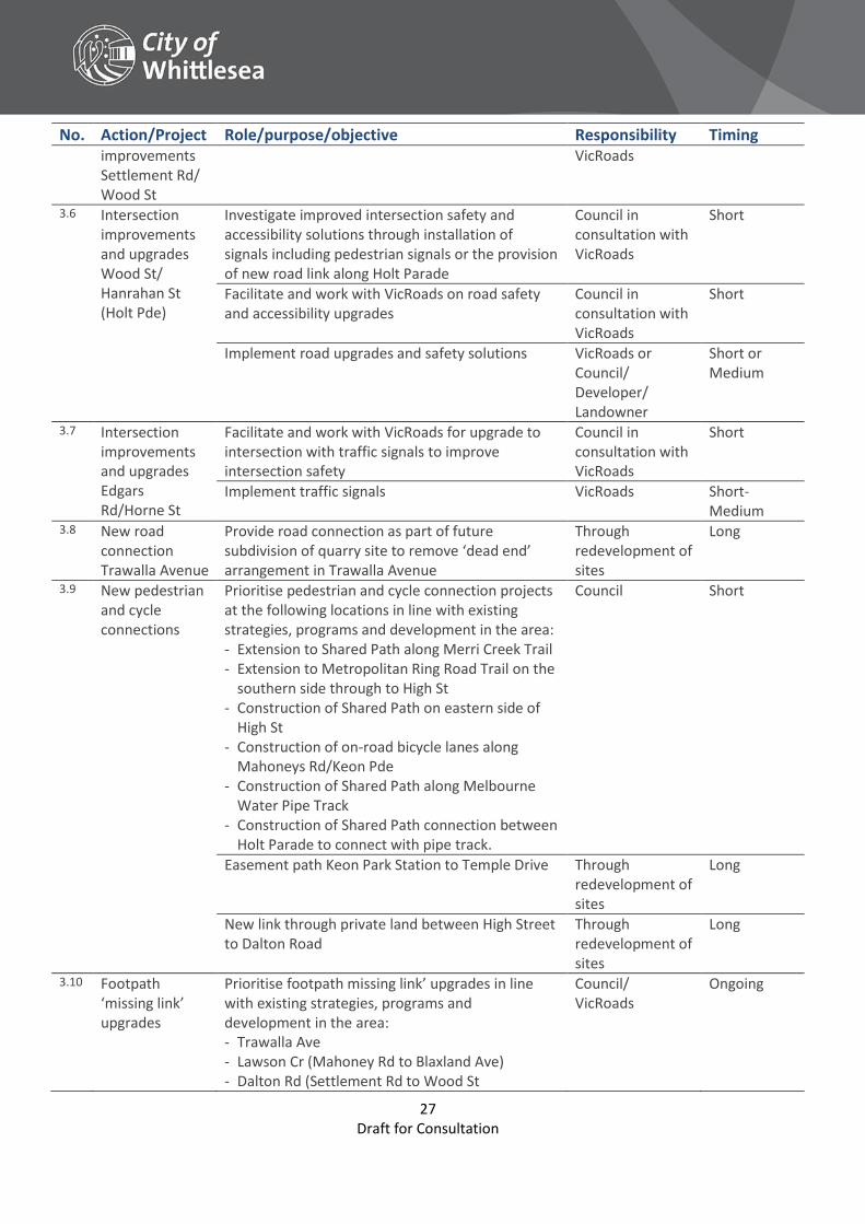
27 Draft for Consultation
No. Action/Project Role/purpose/objective Responsibility Timing improvements Settlement Rd/ Wood St
VicRoads
3.6 Intersection improvements and upgrades Wood St/ Hanrahan St (Holt Pde)
Investigate improved intersection safety and accessibility solutions through installation of signals including pedestrian signals or the provision of new road link along Holt Parade
Council in consultation with VicRoads
Short
Facilitate and work with VicRoads on road safety and accessibility upgrades
Council in consultation with VicRoads
Short
Implement road upgrades and safety solutions VicRoads or Council/ Developer/ Landowner
Short or Medium
3.7 Intersection improvements and upgrades Edgars Rd/Horne St
Facilitate and work with VicRoads for upgrade to intersection with traffic signals to improve intersection safety
Council in consultation with VicRoads
Short
Implement traffic signals VicRoads Short-Medium
3.8 New road connection Trawalla Avenue
Provide road connection as part of future subdivision of quarry site to remove ‘dead end’ arrangement in Trawalla Avenue
Through redevelopment of sites
Long
3.9 New pedestrian and cycle connections
Prioritise pedestrian and cycle connection projects at the following locations in line with existing strategies, programs and development in the area: - Extension to Shared Path along Merri Creek Trail - Extension to Metropolitan Ring Road Trail on the
southern side through to High St - Construction of Shared Path on eastern side of
High St - Construction of on-road bicycle lanes along
Mahoneys Rd/Keon Pde - Construction of Shared Path along Melbourne
Water Pipe Track - Construction of Shared Path connection between
Holt Parade to connect with pipe track.
Council Short
Easement path Keon Park Station to Temple Drive Through redevelopment of sites
Long
New link through private land between High Street to Dalton Road
Through redevelopment of sites
Long
3.10 Footpath ‘missing link’ upgrades
Prioritise footpath missing link’ upgrades in line with existing strategies, programs and development in the area: - Trawalla Ave - Lawson Cr (Mahoney Rd to Blaxland Ave) - Dalton Rd (Settlement Rd to Wood St
Council/ VicRoads
Ongoing
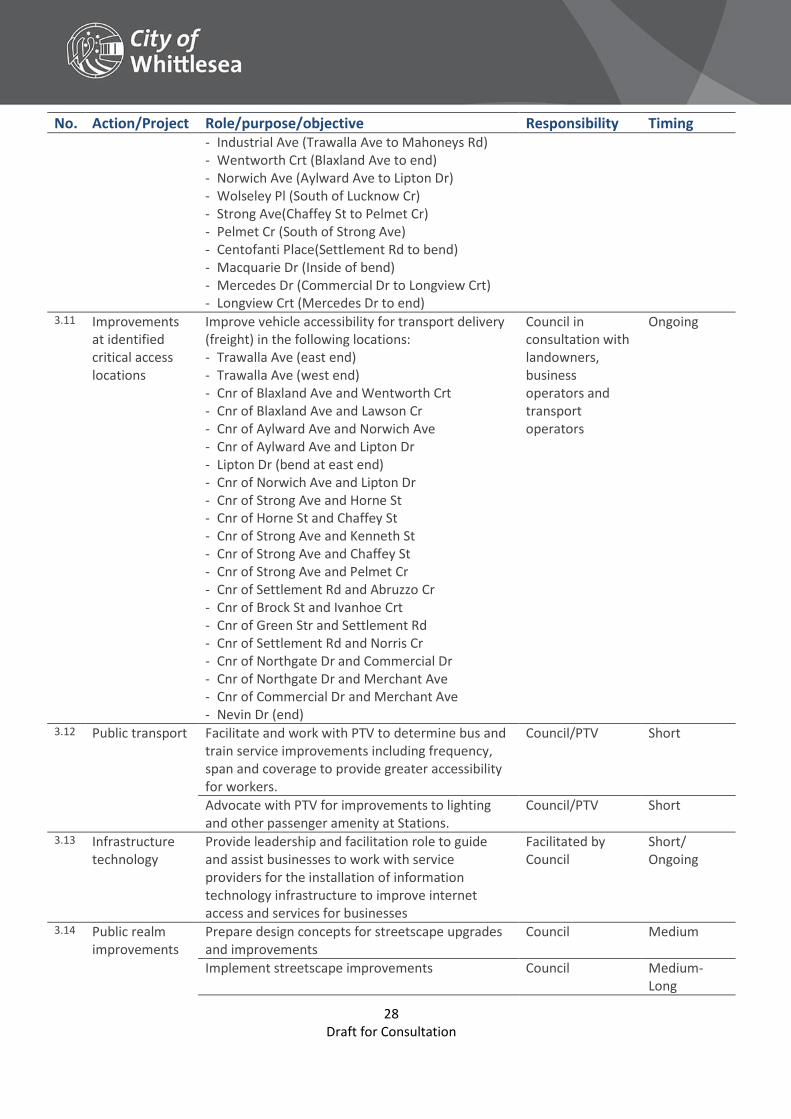
28 Draft for Consultation
No. Action/Project Role/purpose/objective Responsibility Timing - Industrial Ave (Trawalla Ave to Mahoneys Rd) - Wentworth Crt (Blaxland Ave to end) - Norwich Ave (Aylward Ave to Lipton Dr) - Wolseley Pl (South of Lucknow Cr) - Strong Ave(Chaffey St to Pelmet Cr) - Pelmet Cr (South of Strong Ave) - Centofanti Place(Settlement Rd to bend) - Macquarie Dr (Inside of bend) - Mercedes Dr (Commercial Dr to Longview Crt) - Longview Crt (Mercedes Dr to end)
3.11 Improvements at identified critical access locations
Improve vehicle accessibility for transport delivery (freight) in the following locations: - Trawalla Ave (east end) - Trawalla Ave (west end) - Cnr of Blaxland Ave and Wentworth Crt - Cnr of Blaxland Ave and Lawson Cr - Cnr of Aylward Ave and Norwich Ave - Cnr of Aylward Ave and Lipton Dr - Lipton Dr (bend at east end) - Cnr of Norwich Ave and Lipton Dr - Cnr of Strong Ave and Horne St - Cnr of Horne St and Chaffey St - Cnr of Strong Ave and Kenneth St - Cnr of Strong Ave and Chaffey St - Cnr of Strong Ave and Pelmet Cr - Cnr of Settlement Rd and Abruzzo Cr - Cnr of Brock St and Ivanhoe Crt - Cnr of Green Str and Settlement Rd - Cnr of Settlement Rd and Norris Cr - Cnr of Northgate Dr and Commercial Dr - Cnr of Northgate Dr and Merchant Ave - Cnr of Commercial Dr and Merchant Ave - Nevin Dr (end)
Council in consultation with landowners, business operators and transport operators
Ongoing
3.12 Public transport Facilitate and work with PTV to determine bus and train service improvements including frequency, span and coverage to provide greater accessibility for workers.
Council/PTV Short
Advocate with PTV for improvements to lighting and other passenger amenity at Stations.
Council/PTV Short
3.13 Infrastructure technology
Provide leadership and facilitation role to guide and assist businesses to work with service providers for the installation of information technology infrastructure to improve internet access and services for businesses
Facilitated by Council
Short/ Ongoing
3.14 Public realm improvements
Prepare design concepts for streetscape upgrades and improvements
Council Medium
Implement streetscape improvements Council Medium-Long
29 Draft for Consultation
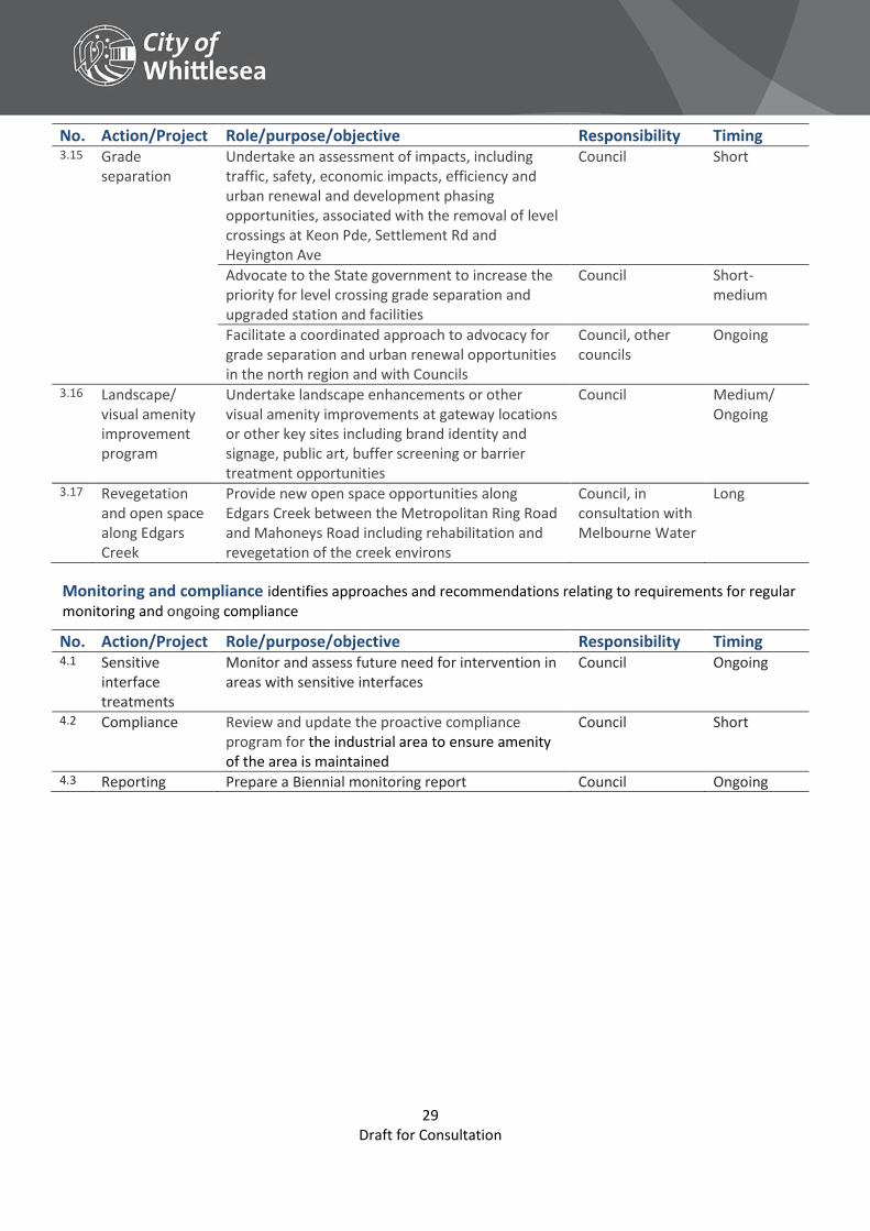
No. Action/Project Role/purpose/objective Responsibility Timing 3.15 Grade
separation Undertake an assessment of impacts, including traffic, safety, economic impacts, efficiency and urban renewal and development phasing opportunities, associated with the removal of level crossings at Keon Pde, Settlement Rd and Heyington Ave
Council Short
Advocate to the State government to increase the priority for level crossing grade separation and upgraded station and facilities
Council Short-medium
Facilitate a coordinated approach to advocacy for grade separation and urban renewal opportunities in the north region and with Councils
Council, other councils
Ongoing
3.16 Landscape/ visual amenity improvement program
Undertake landscape enhancements or other visual amenity improvements at gateway locations or other key sites including brand identity and signage, public art, buffer screening or barrier treatment opportunities
Council Medium/ Ongoing
3.17 Revegetation and open space along Edgars Creek
Provide new open space opportunities along Edgars Creek between the Metropolitan Ring Road and Mahoneys Road including rehabilitation and revegetation of the creek environs
Council, in consultation with Melbourne Water
Long
Monitoring and compliance identifies approaches and recommendations relating to requirements for regular monitoring and ongoing compliance
No. Action/Project Role/purpose/objective Responsibility Timing 4.1 Sensitive
interface treatments
Monitor and assess future need for intervention in areas with sensitive interfaces
Council Ongoing
4.2 Compliance Review and update the proactive compliance program for the industrial area to ensure amenity of the area is maintained
Council Short
4.3 Reporting Prepare a Biennial monitoring report Council Ongoing
30 Draft for Consultation
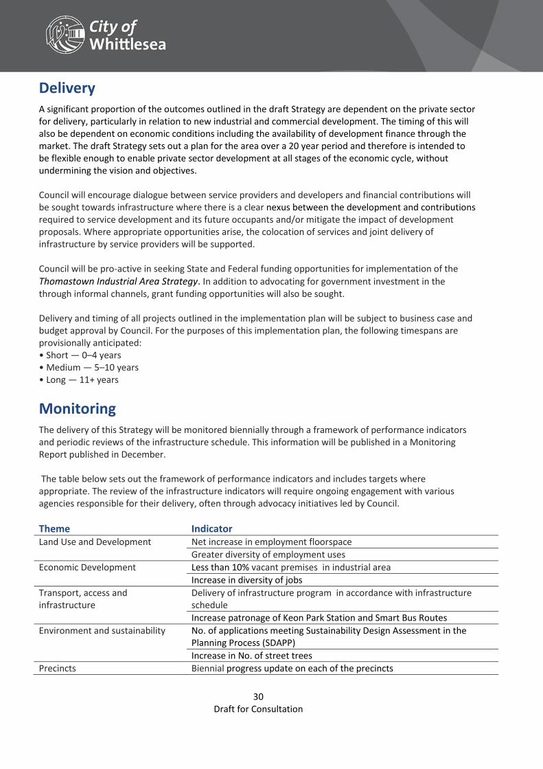
Delivery A significant proportion of the outcomes outlined in the draft Strategy are dependent on the private sector for delivery, particularly in relation to new industrial and commercial development. The timing of this will also be dependent on economic conditions including the availability of development finance through the market. The draft Strategy sets out a plan for the area over a 20 year period and therefore is intended to be flexible enough to enable private sector development at all stages of the economic cycle, without undermining the vision and objectives. Council will encourage dialogue between service providers and developers and financial contributions will be sought towards infrastructure where there is a clear nexus between the development and contributions required to service development and its future occupants and/or mitigate the impact of development proposals. Where appropriate opportunities arise, the colocation of services and joint delivery of infrastructure by service providers will be supported. Council will be pro-active in seeking State and Federal funding opportunities for implementation of the Thomastown Industrial Area Strategy. In addition to advocating for government investment in the through informal channels, grant funding opportunities will also be sought. Delivery and timing of all projects outlined in the implementation plan will be subject to business case and budget approval by Council. For the purposes of this implementation plan, the following timespans are provisionally anticipated: • Short — 0–4 years • Medium — 5–10 years • Long — 11+ years
Monitoring The delivery of this Strategy will be monitored biennially through a framework of performance indicators and periodic reviews of the infrastructure schedule. This information will be published in a Monitoring Report published in December. The table below sets out the framework of performance indicators and includes targets where appropriate. The review of the infrastructure indicators will require ongoing engagement with various agencies responsible for their delivery, often through advocacy initiatives led by Council.
Theme Indicator Land Use and Development Net increase in employment floorspace
Greater diversity of employment uses
Economic Development Less than 10% vacant premises in industrial area
Increase in diversity of jobs
Transport, access and infrastructure
Delivery of infrastructure program in accordance with infrastructure schedule
Increase patronage of Keon Park Station and Smart Bus Routes
Environment and sustainability No. of applications meeting Sustainability Design Assessment in the Planning Process (SDAPP)
Increase in No. of street trees
Precincts Biennial progress update on each of the precincts
31 Draft for Consultation
Acknowledgements The City of Whittlesea would like to thank the members of the following organisations for their participation and input into the preparation of the Draft Strategy through the Thomastown Industrial Area Advisory Group: Department of Economic Development, Jobs, Transport and Resources
Fueltreat Australia Pty Ltd
Hi Lux Technical Services Pty Ltd
Hip Pocket Work Wear and Safety Northern Pty Ltd
Hume City Council
La Trobe University
LAS Investments
MAB Corporation
Metropolitan Planning Authority
National Estate Agents
Regional Development Australia (Northern Melbourne)
Northlink
Plenty Food Group
Property Council of Australia (Victoria)
RMIT University
VicTrack
32 Draft for Consultation
Glossary Accessibility The degree to which a place, service or environment is available to as many people as possible. (Plan Melbourne)
Activity Centre Suburban centres that provide a focus for services, employment, housing, transport and social interaction.
Bulky goods/Large format retail Physically large retail establishments that are usually part of a chain and may sell general dry goods or may be limited to a particular specialty.
Business and Services Centre A small precinct with some convenience retail such as a small supermarket and cafés/food services, together with a range of supporting business services. This may include small office suite development and/or a range of health service providers and community service organisations.
CLUE Census of Land Use and Employment
Commercial Consist of offices and appropriate manufacturing and industrial and limited retail uses that do not affect the safety and amenity of adjacent, more sensitive uses.
Critical access location Area identified as have restricted manoeuvring ability for large vehicles.
Environment Physical surrounds, including land, waters, atmosphere, climate, sounds, odours, animals and plants, as well as aesthetics.
Established areas Areas of municipality including Thomastown, Lalor, Bundoora, Epping, Bundoora, Mill Park, parts of South Morang and Whittlesea Township.
Gateway Major points of passage at which the industrial area may be entered.
Grade Separation aligning a junction associated with rail level crossings to minimise traffic disruption and flow. This may also enable urban renewal opportunities and better connect communities.
Growth areas Locations on the fringe of metropolitan Melbourne designated in planning schemes for large-scale transformation, over many years, from rural to urban use.
Heavy industry Involves the manufacturing of large and heavy products, equipment and facilities.
Infrastructure Basic urban facilities and networks needed for the functioning of a local community or broader society such as drains, roads, street trees, nature strips, footpaths, telecommunications and utility facilities.
Light industry The manufacture of small or light articles and is usually less capital intensive than heavy industry.
Office Land used for administration, or clerical, technical, professional or other like business activity. No goods or materials intended for manufacture, sale, or hire can be stored on the land.
Open Space Includes land reserved for natural landscape, parklands, recreation and active sports, as well as waterways and bays.
Opportunity Areas Nominated sites or locations that offer significant opportunities for development and renewal.
Plan Melbourne The Victorian Government’s metropolitan planning strategy that will guide the city’s growth to 2050.
Precinct Areas with similar uses and similar built form that allows greater detailed planning and direction to be provided.
Private realm Land solely in private ownership.
Public realm Areas of land utilised and created for the community that is publically accessible.
Strategic Site Nominated sites that have the potential for significant major development.
Warehouse Land used to store or display goods. It may include the distribution and the wholesale selling of the goods.
Whittlesea Planning Scheme Controls land use and development within the City of Whittlesea.
Urban Renewal Opportunity An area created that truly reflects the needs and demands of businesses and provides an efficient use of land in highly accessible locations.