Embed Size (px)
Citation preview

July 2014

2
This page is intentionally blank

3
Contents1 Introduction ........................................................................................................................................................ 5
1.1 The project .................................................................................................................................................. 6
1.2 The project area .......................................................................................................................................... 7
2 Policy Context ..................................................................................................................................................... 8
2.1 State Planning Policy and Strategies ........................................................................................................... 9
2.2 Whittlesea Planning Scheme .................................................................................................................... 12
2.3 Planning Zones & Overlays ....................................................................................................................... 14
2.4 Planning Overlays ...................................................................................................................................... 15
2.5 Council plans & strategies ......................................................................................................................... 16
3 Economic Context ............................................................................................................................................. 18
3.1 Economic overview ................................................................................................................................... 19
3.2 Melbourne’s industrial land ...................................................................................................................... 21
3.3 Melbourne’s Northern Region .................................................................................................................. 23
3.4 Municipal economic context ..................................................................................................................... 25
4 Study Area Characteristics ................................................................................................................................ 28
4.1 Key features and history ........................................................................................................................... 29
4.2 Built environment characteristics ............................................................................................................. 30
4.3 Natural environment characteristics ........................................................................................................ 32
4.4 Land ownership ......................................................................................................................................... 34
5 Transport and Infrastructure ............................................................................................................................ 36
5.1 Road infrastructure ................................................................................................................................... 37
5.2 Public transport network .......................................................................................................................... 39
5.3 Pedestrian and cycle networks ................................................................................................................. 41
5.4 Traffic Accident Statistics .......................................................................................................................... 44
5.5 Utility Infrastructure ................................................................................................................................. 45
6 Environmental Conditions ................................................................................................................................ 47
6.1 Stormwater ............................................................................................................................................... 48
6.2 Site Contamination ................................................................................................................................... 49
6.3 Amenity considerations ............................................................................................................................ 50
7 Land Use Influences .......................................................................................................................................... 52
7.1 Land use planning ..................................................................................................................................... 53
7.2 Existing land use profile ............................................................................................................................ 56
8 Urban Design Review ........................................................................................................................................ 60
9 Consultation ...................................................................................................................................................... 80
9.1 Consultation stages ................................................................................................................................... 81
9.2 Community consultation – Stage 1 findings ............................................................................................. 82
10 Conclusion ..................................................................................................................................................... 86
10.1 What does this mean? .............................................................................................................................. 87
10.2 Next steps ................................................................................................................................................. 88
11 Resources ...................................................................................................................................................... 89
Appendices ................................................................................................................................................................ 90

4
Table of figuresFigure 1 Gateway to the City of Whittlesea on High Street .................................................................................. 6
Figure 2 Thomastown Industrial Area in context of the City of Whittlesea ......................................................... 7
Figure 3 Employment Areas map | Whittlesea MSS | Clause 21.10 .................................................................. 12
Figure 4 Planning Zones ...................................................................................................................................... 14
Figure 5 Planning Overlays .................................................................................................................................. 15
Figure 6 Former Fowler Pottery factory ............................................................................................................. 15
Figure 7 Population distribution [Source: Securing Victoria's Economy, 2013] .................................................. 19
Figure 8 Australian food and fibre exports by state of origin [Source: Securing Victoria's Economy, 2013] ..... 19
Figure 9 Population distribution [Source: Securing Victoria's Economy, 2013] ................................................. 20
Figure 10 New zoning of former industrial land in metropolitan Melbourne following rezoning requests [Source: UDP Report, 2013] .................................................................................................................. 21
Figure 11 State Significant Industrial Precincts and selected industrial areas (Source: UDP Report, 2013) ........ 22
Figure 12 Thomastown Industrial Area in context of the Melbourne Metropolitan Area ................................... 23
Figure 13 Thomastown Industrial Area in context of the City of Whittlesea ....................................................... 25
Figure 14 City of Whittlesea jobs by industry sector, 2011 (Source: Economy.id, derived from ABS Census of Population and Housing, 2011) ............................................................................................................. 25
Figure 15 Change in City of Whittlesea employment offer, 2006-2011 (Source: Economy.id, derived from ABS Census of Population and Housing, 2011) ............................................................................................ 25
Figure 16 Signage on SP Ausnet Electricity site .................................................................................................... 29
Figure 17 Amcor St Regis Bates............................................................................................................................. 29
Figure 18 Aerial map of industrial area and precinct locations ............................................................................ 30
Figure 19 Growling grass frog (Litoria raniformis) ................................................................................................ 32
Figure 20 Creeks and open spaces ........................................................................................................................ 33
Figure 21 Ownership profile of industrial area ..................................................................................................... 34
Figure 22 Level crossing at Keon Parade............................................................................................................... 37
Figure 23 Westbound traffic on the Metropolitan Ring Road .............................................................................. 37
Figure 24 The road network .................................................................................................................................. 38
Figure 25 Thomastown Station - Station Street forecourt ................................................................................... 39
Figure 26 Keon Park Station with SPI Ausnet site behind ..................................................................................... 39
Figure 27 Public transport coverage ..................................................................................................................... 40
Figure 28 New development with improved street interface including reduced front setback and landscaping ........................................................................................................................................... 41
Figure 29 Shared path – west side Dalton Road ................................................................................................... 42
Figure 30 Cycling network ..................................................................................................................................... 43
Figure 31 The Comdain / Envestra / APA site ....................................................................................................... 45
Figure 32 Transmission lines viewed from street ................................................................................................. 45
Figure 33 Melbourne Water drainage easement, Dalton Road ........................................................................... 45
Figure 34 Debris left by downstream flooding of Darebin Creek, June 2013 ....................................................... 48
Figure 35 Site photo from 2009 EPA monitoring: spilled engine fluids washing into stormwater drain ............. 48
Figure 36 Graffiti on building façade .................................................................................................................... 50
Figure 37 Inappropriate stockpiling of waste materials in front setback ............................................................. 50
Figure 38 Zones along Dalton Road corridor ........................................................................................................ 53
Figure 39 Vacant residential site in foreground directly adjacent to industrial premises in Longview Court ..... 54
Figure 40 Breakdown of land uses in Thomastown industrial area (Source Hill PDA, 2014) ............................... 56
Figure 41 Parking area used for storage ............................................................................................................... 82
Figure 42 Street congestion caused by truck parking ........................................................................................... 83
Figure 43 Evidence of hoon driving on Ivanhoe Court (Precinct 9) ...................................................................... 83

5
1 Introduction The Thomastown Industrial Area plays a significant role in providing jobs for the City of Whittlesea’s local community and is a key economic asset for the municipality. It is also a significant industrial precinct in Victoria and more specifically to Melbourne’s northern region. A Strategy for the area will ensure the industrial area continues to play an important role in providing jobs for the local community and to ensure that it remains competitive and attractive for future investment. It will be the mechanism to ensure that the area is strategically planned for with respect to land use, design and environmental sustainability.

6
1.1 The project The Thomastown Industrial Area is located in the southernmost part of the City of Whittlesea and is one of the largest consolidated areas of industrial zoned land in the municipality and in the wider region. The industrial area extends over 600 hectares and includes over 2,300 properties. Situated next to the Metropolitan Ring Road and the Hume Freeway, the area has easy access to the Central Business District (CBD), Melbourne Airport and the Port of Melbourne. Businesses are ideally located for local, national and international distribution networks. The area is a significant employment precinct locally and it plays a substantial role in providing business and employment opportunities for Melbourne’s northern region. The importance of the precinct as a manufacturing area and opportunities to promote greater diversity of industrial and employment uses are considered significant. The area is also recognised as being of State significance in the current State Planning Policy Framework. Why are we doing the project?
Despite its importance limited strategic work has been undertaken in relation to the industrial area
There is pressure to use parts of the land for other uses such as residential/mixed use through rezoning requests
We know employment and industry trends are changing and the planning policy framework for the area needs to reflect these changes
Parts of the precinct may encourage a negative impression and discourage investment in the area
Some streetscapes and entry treatments give a poor impression of the locality and the municipality
Figure 1 Gateway to the City of Whittlesea on High Street
Project stages
Stage 1 - Background research and review
• Understanding and assessing existing conditions, trends and policy influences
• Targeted consultation with Government, key industries and businesses
• Assembling key findings and influences • Preparation of Background Report and technical studies
Stage 2 - Issues and Opportunities
• Establishing issues and opportunities to be investigated • Preparation of Issues and Opportunities Report • Testing of key principles and directions through a range of
consultation with stakeholders • Preparation of further technical reports and studies
Stage 3 - Preparation of Strategy
• Drafting of Strategy • Adoption by Council for public exhibition of draft • Consideration of submissions • Adoption of final Strategy
Report Structure
This document provides detailed discussion and analysis of the background research and review undertaken in relation to the Thomastown Industrial Area. The evidence summarised in this report will be used to inform the content of the Thomastown Industrial Area Strategy (Strategy). This report focuses on the following subject areas: Identification of the existing and emerging policy framework which
will influence use and development within the industrial area;
Broad scale economic overview as relevant to the industrial area;
Assessment of the existing conditions of the industrial area;
Assessment of transport and other infrastructure which will influence the form and way in which the industrial area operates and is defined;
Identification of the environmental conditions and amenity which influence the form and way in which the industrial area operates and impacts the immediate and wider environmental landscape;
Assessment of land use context and implications; and
Assessment of the existing amenity, quality and functionality of the industrial area at detailed precinct level through an urban design review;
Information and input obtained through Stage 1 consultation.
A further Issues and Opportunities Report will also be prepared which should be read in conjunction with this Background Report. The Issues and Opportunities Report will explore the strengths, weaknesses, opportunities and threats of the industrial area in response to the background research and analysis undertaken. The Issues and Opportunities Report, together with the Background Report, technical studies and ongoing Stakeholder engagement will set out the basis for the strategic direction for in the draft and final Thomastown Industrial Area Strategy.

THOMASTOWN INDUSTRIAL AREA Background Report
7
1.2 The project area
Figure 2 Thomastown Industrial Area in context of the City of Whittlesea
THOMASTOWN INDUSTRIAL AREA Background Report
8
2 Policy Context There is strong recognition of the significance and importance of industrial and employment land to the economy of Melbourne in both planning and employment policy. Local planning policies also have a focus on the local economy and employment opportunities. There are also a number of other policy documents, strategies and plans that will influence use and development within the industrial area into the future. This section identifies the policy framework which supports and influences the industrial area. Appendix 3 also contains a comprehensive list of planning policies relevant to the project.
THOMASTOWN INDUSTRIAL AREA Background Report
9
2.1 State Planning Policy and Strategies
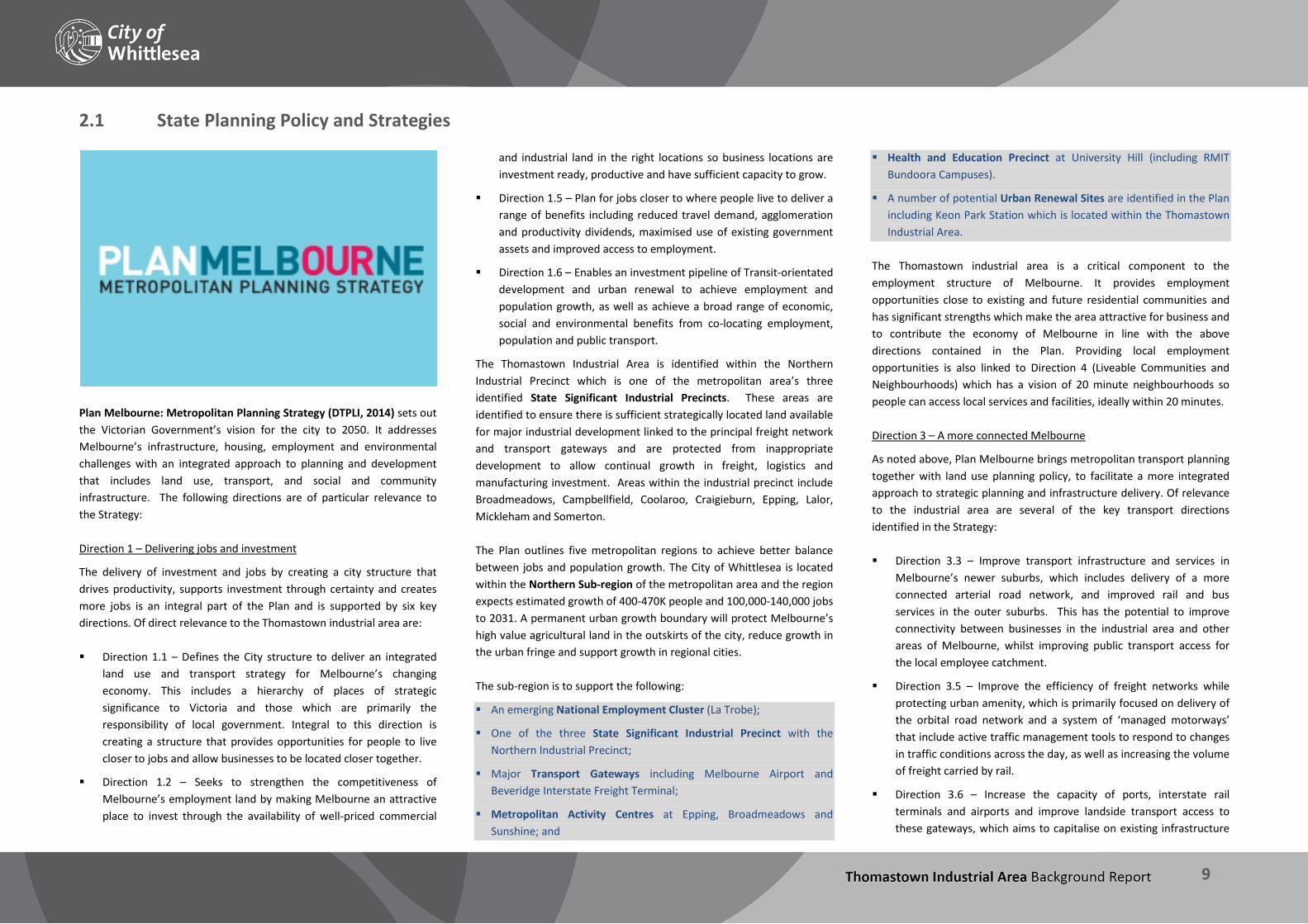
Plan Melbourne: Metropolitan Planning Strategy (DTPLI, 2014) sets out the Victorian Government’s vision for the city to 2050. It addresses Melbourne’s infrastructure, housing, employment and environmental challenges with an integrated approach to planning and development that includes land use, transport, and social and community infrastructure. The following directions are of particular relevance to the Strategy: Direction 1 – Delivering jobs and investment
The delivery of investment and jobs by creating a city structure that drives productivity, supports investment through certainty and creates more jobs is an integral part of the Plan and is supported by six key directions. Of direct relevance to the Thomastown industrial area are: Direction 1.1 – Defines the City structure to deliver an integrated
land use and transport strategy for Melbourne’s changing economy. This includes a hierarchy of places of strategic significance to Victoria and those which are primarily the responsibility of local government. Integral to this direction is creating a structure that provides opportunities for people to live closer to jobs and allow businesses to be located closer together.
Direction 1.2 – Seeks to strengthen the competitiveness of Melbourne’s employment land by making Melbourne an attractive place to invest through the availability of well-priced commercial
and industrial land in the right locations so business locations are investment ready, productive and have sufficient capacity to grow.
Direction 1.5 – Plan for jobs closer to where people live to deliver a range of benefits including reduced travel demand, agglomeration and productivity dividends, maximised use of existing government assets and improved access to employment.
Direction 1.6 – Enables an investment pipeline of Transit-orientated development and urban renewal to achieve employment and population growth, as well as achieve a broad range of economic, social and environmental benefits from co-locating employment, population and public transport.
The Thomastown Industrial Area is identified within the Northern Industrial Precinct which is one of the metropolitan area’s three identified State Significant Industrial Precincts. These areas are identified to ensure there is sufficient strategically located land available for major industrial development linked to the principal freight network and transport gateways and are protected from inappropriate development to allow continual growth in freight, logistics and manufacturing investment. Areas within the industrial precinct include Broadmeadows, Campbellfield, Coolaroo, Craigieburn, Epping, Lalor, Mickleham and Somerton. The Plan outlines five metropolitan regions to achieve better balance between jobs and population growth. The City of Whittlesea is located within the Northern Sub-region of the metropolitan area and the region expects estimated growth of 400-470K people and 100,000-140,000 jobs to 2031. A permanent urban growth boundary will protect Melbourne’s high value agricultural land in the outskirts of the city, reduce growth in the urban fringe and support growth in regional cities. The sub-region is to support the following:
An emerging National Employment Cluster (La Trobe);
One of the three State Significant Industrial Precinct with the Northern Industrial Precinct;
Major Transport Gateways including Melbourne Airport and Beveridge Interstate Freight Terminal;
Metropolitan Activity Centres at Epping, Broadmeadows and Sunshine; and
Health and Education Precinct at University Hill (including RMIT Bundoora Campuses).
A number of potential Urban Renewal Sites are identified in the Plan including Keon Park Station which is located within the Thomastown Industrial Area.
The Thomastown industrial area is a critical component to the employment structure of Melbourne. It provides employment opportunities close to existing and future residential communities and has significant strengths which make the area attractive for business and to contribute the economy of Melbourne in line with the above directions contained in the Plan. Providing local employment opportunities is also linked to Direction 4 (Liveable Communities and Neighbourhoods) which has a vision of 20 minute neighbourhoods so people can access local services and facilities, ideally within 20 minutes. Direction 3 – A more connected Melbourne
As noted above, Plan Melbourne brings metropolitan transport planning together with land use planning policy, to facilitate a more integrated approach to strategic planning and infrastructure delivery. Of relevance to the industrial area are several of the key transport directions identified in the Strategy: Direction 3.3 – Improve transport infrastructure and services in
Melbourne’s newer suburbs, which includes delivery of a more connected arterial road network, and improved rail and bus services in the outer suburbs. This has the potential to improve connectivity between businesses in the industrial area and other areas of Melbourne, whilst improving public transport access for the local employee catchment.
Direction 3.5 – Improve the efficiency of freight networks while protecting urban amenity, which is primarily focused on delivery of the orbital road network and a system of ‘managed motorways’ that include active traffic management tools to respond to changes in traffic conditions across the day, as well as increasing the volume of freight carried by rail.
Direction 3.6 – Increase the capacity of ports, interstate rail terminals and airports and improve landside transport access to these gateways, which aims to capitalise on existing infrastructure
THOMASTOWN INDUSTRIAL AREA Background Report
10
and develop new facilities to improve logistical operations, primarily on the urban fringe.
The following infrastructure projects which will have direct or indirect flow-on effects to the Thomastown Industrial Area are identified in the Plan:
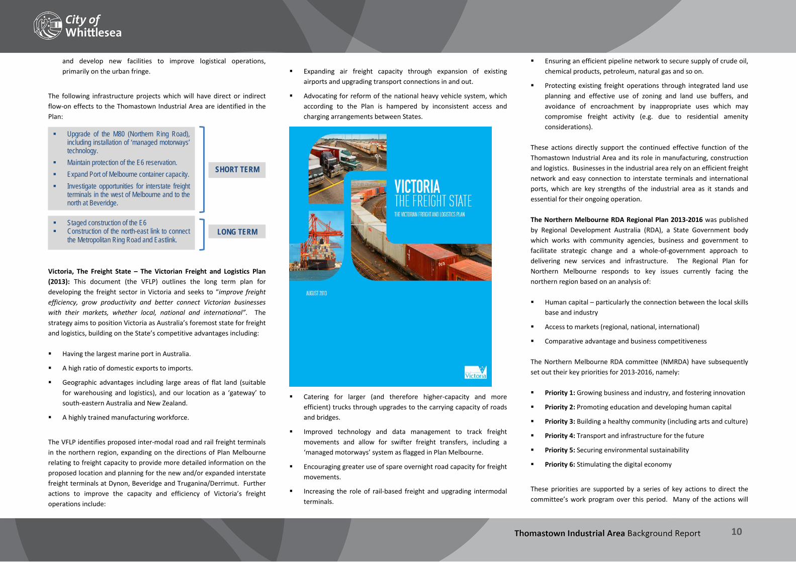
Victoria, The Freight State – The Victorian Freight and Logistics Plan (2013): This document (the VFLP) outlines the long term plan for developing the freight sector in Victoria and seeks to “improve freight efficiency, grow productivity and better connect Victorian businesses with their markets, whether local, national and international”. The strategy aims to position Victoria as Australia’s foremost state for freight and logistics, building on the State’s competitive advantages including: Having the largest marine port in Australia.
A high ratio of domestic exports to imports.
Geographic advantages including large areas of flat land (suitable for warehousing and logistics), and our location as a ‘gateway’ to south-eastern Australia and New Zealand.
A highly trained manufacturing workforce.
The VFLP identifies proposed inter-modal road and rail freight terminals in the northern region, expanding on the directions of Plan Melbourne relating to freight capacity to provide more detailed information on the proposed location and planning for the new and/or expanded interstate freight terminals at Dynon, Beveridge and Truganina/Derrimut. Further actions to improve the capacity and efficiency of Victoria’s freight operations include:
Expanding air freight capacity through expansion of existing
airports and upgrading transport connections in and out.
Advocating for reform of the national heavy vehicle system, which according to the Plan is hampered by inconsistent access and charging arrangements between States.
Catering for larger (and therefore higher-capacity and more efficient) trucks through upgrades to the carrying capacity of roads and bridges.
Improved technology and data management to track freight movements and allow for swifter freight transfers, including a ‘managed motorways’ system as flagged in Plan Melbourne.
Encouraging greater use of spare overnight road capacity for freight movements.
Increasing the role of rail-based freight and upgrading intermodal terminals.
Ensuring an efficient pipeline network to secure supply of crude oil, chemical products, petroleum, natural gas and so on.
Protecting existing freight operations through integrated land use planning and effective use of zoning and land use buffers, and avoidance of encroachment by inappropriate uses which may compromise freight activity (e.g. due to residential amenity considerations).
These actions directly support the continued effective function of the Thomastown Industrial Area and its role in manufacturing, construction and logistics. Businesses in the industrial area rely on an efficient freight network and easy connection to interstate terminals and international ports, which are key strengths of the industrial area as it stands and essential for their ongoing operation. The Northern Melbourne RDA Regional Plan 2013-2016 was published by Regional Development Australia (RDA), a State Government body which works with community agencies, business and government to facilitate strategic change and a whole-of-government approach to delivering new services and infrastructure. The Regional Plan for Northern Melbourne responds to key issues currently facing the northern region based on an analysis of: Human capital – particularly the connection between the local skills
base and industry
Access to markets (regional, national, international)
Comparative advantage and business competitiveness
The Northern Melbourne RDA committee (NMRDA) have subsequently set out their key priorities for 2013-2016, namely: Priority 1: Growing business and industry, and fostering innovation
Priority 2: Promoting education and developing human capital
Priority 3: Building a healthy community (including arts and culture)
Priority 4: Transport and infrastructure for the future
Priority 5: Securing environmental sustainability
Priority 6: Stimulating the digital economy
These priorities are supported by a series of key actions to direct the committee’s work program over this period. Many of the actions will
SHORT TERM
LONG TERM
Upgrade of the M80 (Northern Ring Road), including installation of ‘managed motorways’ technology.
Maintain protection of the E6 reservation. Expand Port of Melbourne container capacity. Investigate opportunities for interstate freight
terminals in the west of Melbourne and to the north at Beveridge.
Staged construction of the E6 Construction of the north-east link to connect
the Metropolitan Ring Road and Eastlink.
THOMASTOWN INDUSTRIAL AREA Background Report
11
have direct or indirect influence on the Thomastown industrial area, including: To undertake a series of surveys and workshops to assist local
manufacturers to diversify and innovate in order to boost local manufacturing capability and skills.
To identify strategies to improve integration and links between tertiary institutions, industry and the regional economy.
To support recommendations resulting from the Regional Manufacturing Strategy, particularly areas such as business leadership, product diversification, innovation, exports and networking
Other plans and guidelines
Ministerial Direction No. 1 – Potentially Contaminated Land (Direction No. 1) requires planning authorities when preparing planning scheme amendments, to satisfy themselves that the environmental conditions of land proposed to be used for a sensitive use are, or will be, suitable for that use. Potentially Contaminated Land Practice Note was released by the Department of Sustainability and Environment in June 2005 and provides guidance on how to identify if land is potentially contaminated; the appropriate level of assessment of contamination for a planning scheme amendment or planning permit application, and appropriate conditions on planning permits circumstances where the Environmental Audit Overlay should be applied or removed. Separation distances: The Whittlesea Planning Scheme in Clause 52.10 sets out minimum threshold distances for certain industry and warehouse uses, specifying a preferred buffer zone to sensitive uses such as dwellings, hospitals and schools. In March 2013 the EPA released a revised guideline which provides advice on recommended separation distances between industrial land uses that emit odour or dust, and sensitive land uses. This guideline replaced publication AQ 2/86, Recommended Buffer Distances for Industrial Residual Air Emissions 1990.
The Network Development Plan – Metropolitan Rail (2012) is the long term plan for the improvement of the metropolitan rail network. While it primarily focuses on improving efficiency for the commuter rail system, the Plan: Considers the needs of the rail freight network to ensure that
additional commuter services do not compromise freight movements.
Identifies opportunities to expand freight services on existing rail corridors.
Acknowledges that in the long term the growth of rail freight (in line with VFLP objectives) will require upgrade of the freight network including the construction of separate lines.
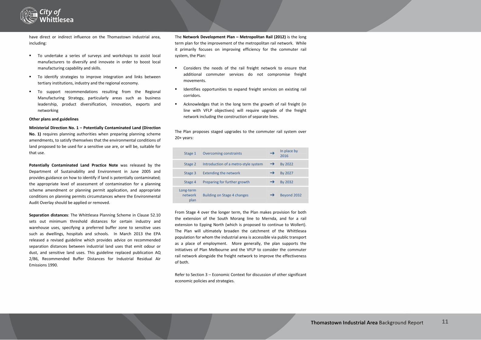
The Plan proposes staged upgrades to the commuter rail system over 20+ years:
Stage 1 Overcoming constraints In place by 2016
Stage 2 Introduction of a metro-style system By 2022
Stage 3 Extending the network By 2027
Stage 4 Preparing for further growth By 2032
Long-term network
plan Building on Stage 4 changes Beyond 2032
From Stage 4 over the longer term, the Plan makes provision for both the extension of the South Morang line to Mernda, and for a rail extension to Epping North (which is proposed to continue to Wollert). The Plan will ultimately broaden the catchment of the Whittlesea population for whom the industrial area is accessible via public transport as a place of employment. More generally, the plan supports the initiatives of Plan Melbourne and the VFLP to consider the commuter rail network alongside the freight network to improve the effectiveness of both. Refer to Section 3 – Economic Context for discussion of other significant economic policies and strategies.

THOMASTOWN INDUSTRIAL AREA Background Report
12
2.2 Whittlesea Planning Scheme State Planning Policy Framework (SPPF)
The SPPF provides a context for spatial planning and decision making by planning and responsible authorities. There is strong State Policy relating to protecting the ongoing function of industrial land and economic and employment activities more generally. The following clauses are of particular relevance to the industrial area: Clause 11.02-1: Supply of urban land seeks to ensure a sufficient supply of land is available for residential, commercial, retail, industrial, recreational, institutional and other community uses. Clause 17.02-1: Industrial land development seeks to ensure availability of land for industry. Key strategies include:
Protection and careful planning of existing industrial areas to, where possible, facilitate further industrial development.
Provision of an adequate supply of industrial land in appropriate locations.
Protection of industrial activity in industrial zones from the encroachment of unplanned commercial, residential and other sensitive uses which would adversely affect industry viability.
Avoidance of approving non-industrial land uses, which would prejudice the availability of land for future industrial requirements, in identified industrial areas.
Clause 17.02-2: Design of Industrial Development seeks to facilitate the sustainable development and operation of industry and research and development activity. Key strategies include:
Ensuring that industrial activities requiring substantial threshold distances are located in the core of industrial areas.
Encouraging activities with minimal threshold requirements to locate towards the perimeter of the industrial area.
Minimising inter-industry conflict and encourage like industries to locate within the same area.
Provision of adequate separation and buffer areas between sensitive uses and offensive or dangerous industries and quarries.
Encouragement of manufacturing and storage industries that generate significant volumes of freight to locate close to air, rail and road freight terminals
Clause 17.02-3: State significant industrial land protects industrial land of State significance and Thomastown Industrial Area as is identified in this Policy as an industrial area of State Significance. This policy protect large areas of industrial land of state significance to ensure availability of land for major industrial development, particularly for industries and storage facilities that require significant threshold distances from sensitive or incompatible uses. It also seeks to protect heavy industrial areas from inappropriate development and maintain adequate buffer distances from sensitive or incompatible uses. Local Planning Policy Framework (LPPF)
The LPPF comprises the Municipal Strategic Statement (MSS) and Council’s Local Policies.
Municipal Strategic Statement
The MSS outlines Council’s key policy objectives and strategic planning framework for land use planning in the City of Whittlesea and guides Council’s land use planning.
Clause 21.10: Economic Development recognises the greatest asset of the local economy has traditionally been a strong manufacturing base, which has focused primarily on the established industrial areas to the south of the municipality in Thomastown. The policy sets out the following focus areas to achieve additional jobs and greater diversity in employment sectors:
maximise retention of as much of the local resident industrial owner occupier market as possible in the short term;
attract the maximum number of local industries to service the growing local population;
substantially increase the range and quality of sites and the quality of services to them;
optimise the potential of appropriate home based employment; and
differentiate future large scale industrial estates based on local conditions and other comparative advantages.
Challenges highlighted in this policy include providing sustainable economic development opportunities and supporting economic activity which is responsive to the investment and employment needs of the
community, has respect for the environment and is resilient to changes in the economic climate.
Importantly, the primary objective of this policy is:
“To create a better jobs/housing balance and achieve greater diversity in employment opportunities.”
Thomastown as the municipality’s largest and most established industrial and employment area will therefore play a significant role in achieving this objective.
Figure 3 Employment Areas map | Whittlesea MSS | Clause 21.10

THOMASTOWN INDUSTRIAL AREA Background Report
13
Local Planning Policies
Local Planning Policies are tools used to implement the objectives and strategies of the Municipal Strategic Statement. Council’s Local Policies recognise the importance of industrial, and in particular manufacturing uses, to the local economy and also employment opportunities generated for the community. The policies relevant to the Thomastown Industrial Area are: Clause 22.09: Industrial Development Policy applies to all industrial areas, including the Thomastown Industrial Area, within the City of Whittlesea which are not affected by other controls such as development plans, structure plans and design guidelines. The objective of this policy is to achieve well designed, quality industrial developments that are suitably located to meet stated economic development objectives. The policy sets out a number of design requirements for industrial development relating to provision landscaping buffers, the scale and appearance of buildings, construction materials to be used, location of advertising signage, landscaping, storage of waste and fencing. The Planning Guidelines for Industrial Developments, 1997 is listed as a reference document in this policy. Clause 22.12: Signs adjoining the Metropolitan Ring Road applies to all advertising signs on land or buildings, which adjoin or have exposure to that part of the Metropolitan Ring Road. The policy considers appropriate locations for these signs and the types of design elements which should be incorporated in the signs to ensure that they enhance the visual amenity of the area.

THOMASTOWN INDUSTRIAL AREA Background Report
14
2.3 Planning Zones & Overlays
Figure 4 Planning Zones
The majority of the industrial area is an Industrial 1 Zone. The primary purpose of this zone is: To provide for manufacturing industry, the storage and distribution of goods and associated uses in a manner which does not affect the safety and amenity of local communities. This zone allows for a broad range of industrial and warehousing uses – as evidenced by the diversity of industrial activity currently operating in different parts of the industrial area, with some limited provision for bulky goods retailing and office uses. The Commercial 2 Zone is applicable to two areas which were rezoned from Business 3 Zone (Meridian Business Park) and Business 4 Zone (section along Dalton Road) through the reformed zones process on 15 July 2013. The purpose of this zone is:
To encourage commercial areas for offices, appropriate manufacturing and industries, bulky goods retailing, other retail uses, and associated business and commercial services. To ensure that uses do not affect the safety and amenity of adjacent, more sensitive uses. This zone allows for a more diverse range of commercial uses than the Industrial 1 Zone, as well as permitting light industrial activity. Other zones present in the industrial area include: The Special Use Zone (Schedule 4 – Extractive Industry), which
applies to the Boral quarry site in the west of the industrial area.
The Public Use Zone (Schedules 1 – Service and Utility, and 2 – Transport), which apply respectively to Melbourne Water pipe track land and an area of Edgars Creek west of Edgars Road, and the South Morang rail corridor.
The Urban Floodway Zone, applying to creek corridors in the central and eastern parts of the industrial area.
The Public Park and Recreation Zone, applying to a small area of land adjacent to the Merri Creek in the west of the industrial area.
Road Zone Category 1 applies to a number of major roads in the industrial area.
McKimmies Road at the northern most point of the industrial area is a Road Zone Category 2.
There are also two small areas of land designated as Residential 1 Zone in the east of the industrial area:
One is remnant land leftover from the rezoning of the future E6 freeway corridor, west of Darebin Creek, and
The other is land with a permit for warehouses that was rezoned to Residential in July 2012.

THOMASTOWN INDUSTRIAL AREA Background Report
15
2.4 Planning Overlays
Figure 5 Planning Overlays
A number of overlays affect parts of the industrial area including:
The Development Contributions Plan Overlay (Schedule 3), which applies to the majority of land in the industrial area and relates to contributions for drainage infrastructure.
The Environmental Significance Overlay (Schedule 3), which applies to land adjacent to Merri Creek
The Special Building Overlay, which applies to an area of land subject to occasional overland flooding from the drainage system.
The Land Subject to Inundation Overlay, which identifies land subject to occasional flooding from creeks.
The Design and Development Overlay (Schedule 2), which applies to the land west the Hume Freeway extension and requires appropriate noise attenuation measures to minimise the impact of traffic noise on noise sensitive activities.
The Design and Development Overlay (Schedule 11), which applies to the Meridian Business Park and land abutting the Hume Freeway.
The Development Plan Overlay (Schedule 30), which applies to the residentially zoned site discussed above at Greenhills Road.
The Public Acquisition Overlay (Schedule 2) applies to the proposed E6 extension.
Aboriginal Cultural Heritage Significance
The Aboriginal Heritage Act 2006 sets out to protect all Aboriginal places, objects, and human remains and links processes to protect these areas with the planning system. Parts of the industrial area, predominantly along the creeks, are identified as areas of cultural heritage sensitivity. Sites affected may be required to prepare a Cultural Heritage Management Plans (CHMP) for some development proposals. CHMP’s are required for certain classes of development that are located on land identified as an area of Aboriginal Cultural Heritage significance, where significant ground disturbance cannot be proven (DPCD, 2013).
Heritage Overlay (proposed)
One site in the industrial area is being considered for a Heritage Overlay as part of Whittlesea Planning Scheme Amendment C153, which implements the Whittlesea Heritage Study (2013). 11/391 Settlement Road (incorrectly identified in the Study as 390-394 Settlement Road) is the site of the former Fowler Pottery factory, one of the first manufacturing businesses in the industrial area.
Figure 6 Former Fowler Pottery factory

THOMASTOWN INDUSTRIAL AREA Background Report
16
2.5 Council plans & strategies The City of Whittlesea has a number of adopted policies which inform Council’s activities and strategic direction.
Council Plan 2013-2017 (City of Whittlesea, 2013) the Plan outlines how the Council will meet the strategic objectives of the Community Plan 2030 and outlines a number of key initiatives and programs to make the City of Whittlesea a better place to live. The Plan outlines the following vision: “Creating vibrant self-sustaining communities together”. This project has relevance to all of the Strategic Directions and many of the Strategic Objectives contained within the Community Plan. Highlighted below are key Strategic Objectives as relevant to the industrial area: Strategic Direction 3: Growing our Economy includes the following Strategic Objectives: There are a diverse range of local employment opportunities
We have strategies that encourage new business investment
Local businesses are supported
Strategic Direction 4: Places and spaces to connect people includes the following Strategic Objectives: We have open spaces that are welcoming and safe for public
gathering
Our urban design helps build connection to place and the community
Our recreation facilities and open spaces are accessible and respond to local need
Strategic Direction 6: Living sustainably includes the following Strategic Objectives: We have environmental education and conservation programs.
We are an environmentally sustainable city.
The Environmental Sustainability Strategy 2012-2022 (City of Whittlesea, 2013) outlines a 10 year framework that aims to protect the municipality’s unique natural assets and quality of life, in the face of rapid urban growth and identifies a number key objectives for the municipality, including to: protect our natural environment; adapt to climate change; save water and energy; reduce waste; and secure our food supplies. The Strategy outlines key opportunities which are of relevance to industrial areas in relation to current and future uses as well as building design.
The Housing Diversity Strategy sets out the strategic framework to assist with managing housing growth and change in the established suburbs of the municipality. A significant proportion of housing growth is also expected to be accommodated within the established areas of the municipality. The amount of residential growth seen and expected in
the City highlights the importance of providing and maintaining local employment opportunities for existing and new communities. The Stormwater Management Plan 2012-2017 (City of Whittlesea, 2012) seeks to improve the management of stormwater runoff and how it affects local waterways. A focus of this Strategy is limiting pollutants from stormwater runoff from industrial land. Key actions including educating and engaging with the community, construction industry and local businesses on the impact of stormwater run-off on the environment and implementing water-sensitive urban design in Council and private developments, such as raingardens and wetlands. The Draft Integrated Transport Strategy (City of Whittlesea, 2013) seeks to identify the present and future transport needs of the municipality and provide a set of actions and ways to improve transport infrastructure and increase access to jobs, opportunities and facilities. Council’s Advocacy Program identifies key infrastructure and service gaps in the City of Whittlesea, and lobbies the State and Federal Governments for funding and assistance to address these gaps. Key priorities are highlighted in a ‘Top 10’ list which drives the advocacy program for the year. The 2014 program includes the construction of the E6, but as an arterial road rather than a freeway as a result of traffic modelling which shows that an arterial road will be adequate to service the needs of the region. For the Thomastown Industrial area the construction of this road will provide another access point from the Metropolitan Ring Road to the wider region, and is expected to have benefits for businesses relying on road freight movements. Other advocacy items in the broader area include rail extensions to Mernda, Epping North and Wollert, the duplication of Epping Road in Epping North, the extension of Edgars Road, and the construction of an interchange at the Hume Freeway / O’Herns Road intersection. These will all contribute to improved travel times, connectivity and efficiency for businesses and employees in the industrial area. Council’s Planning Guidelines for Industrial Development (City of Whittlesea, 1997) set out objectives and design requirements to ensure that industrial developments are high quality, well designed, and suitably located.

THOMASTOWN INDUSTRIAL AREA Background Report
17
Key findings – Policy The review of the existing and emerging policy framework which will influence use and development within the industrial area highlights the following: Policy contained in the draft Plan Melbourne highlights the
economic opportunities in the northern region. The Thomastown industrial area is located on the edge of the Northern Industrial Precinct and Keon Park Station has also been identified as a potential future Urban Renewal Area. The Plan also demonstrates the strategic significance of the Thomastown Industrial Area due to its position within major existing and planned infrastructure.
The existing policy framework demonstrates that the Thomastown industrial area is strategically significant to the State, Melbourne and the northern region as an industrial and employment precinct, and represents economic development opportunities through the strong planning policy support and recognition of the importance of industrial land. Specifically the current SPPF protects the availability of industrial land in Thomastown due to its State Significance.
The LPPF, including the MSS, recognises the strong manufacturing base in Thomastown and its importance to the local economy. The need to create a diverse choice of employment sectors and additional jobs in the City is also highlighted as a priority.
The Landscape Guidelines for Industrial Development which is incorporated into the Whittlesea Planning Scheme was adopted in 1997. While these provide general guidelines for all industrial developments in the municipality the area would benefit from guidelines which more appropriately reflect current standards and can enhance the visual amenity of the Thomastown industrial area based on an assessment of the characteristics of the area and urban renewal opportunities. There is also the opportunity to explore the incorporation of improved sustainability measures as part of development including sustainable design and construction principles and water sensitive design measures.
There are no specific advertising guidelines for industrial areas and while Clause 52.06 (Particular Provisions) sets the permit requirements for signs, the only specific guidance is contained in Clause 22.12. This policy relates to signs that adjoin land or buildings which adjoin or have exposure to the Metropolitan Ring Road. Appropriate signage is also a critical aspect to ensuring the ongoing viability and vitality of business. Opportunities to provide
detailed guidelines for advertising signs (in relation to the location and level of advertising signage), particularly proximate to major roads, many of which are the municipalities gateway areas, should be considered as signs have a significant impact on the appearance of the industrial area and the City of Whittlesea more generally.
While there are a number of strategies and practice notes which will influence the use and development of the industrial area, there are no planning policies, plans or documents which provide any detailed strategic direction or guidance for the Thomastown industrial area.
The role and function of the Thomastown industrial area, how it operates within the context of Melbourne, the northern region, municipality as well as how it functions within itself has not been investigated in detail. While strategic assessments have been undertaken at a State and regional level in relation to industrial and employment land supply and opportunities, there is a lack of detailed planning policy to guide the future direction of the Thomastown industrial area in a comprehensive way.
A detailed and focused area-based policy framework is required to assist to maximise the employment generating opportunities and provide the certainty to allow ongoing investment in the area. Without area based planning policy it is likely there will be continued pressure for other uses, such as residential but also other non-industrial/employment uses, to be facilitated in parts of the industrial area. This has the potential to erode the key strengths of the area and stymie the potential for job creation and business investment/attraction.
Council also recognises the importance of understanding the changing local economy, including the influence of regional and global forces and its relationship to the social and environmental context. For this reason, Council is currently undertaking the creation and implementation of key documents, including the Economic Development Directions Report and a Retail Research Paper. These will also have direct relevance to the Thomastown Industrial Area and are expected to be published by the end of 2014.
THOMASTOWN INDUSTRIAL AREA Background Report
18
3 Economic Context The Thomastown Industrial Area plays a major role in supporting Whittlesea’s local economy and also the economy of metropolitan Melbourne. It’s important in a regional and metropolitan context which is reflected by its designation as an industrial area of State significance in the Whittlesea Planning Scheme as described earlier. This section outlines the regional, municipal and local economic context of the industrial area.
THOMASTOWN INDUSTRIAL AREA Background Report
19
3.1 Economic overview A changing industrial environment
The industrial and general economic landscape is one that is in transition; it is changing globally and this means that national, regional and local Governments and policy makers need to develop an understanding of this transforming economic environment. Economic restructuring, changes to technology, workforce trends and global integration mean that business and industry need to be dynamic and adaptable. Manufacturing specifically is also changing significantly, in part due to the Asian market, notably China and India, contributing more to global growth than advanced economies. In response, local businesses in Australia are being pushed to remain competitive in this global context. The International Economic Development Council (2010) notes: “Technology has automated traditional manufacturing, improved productivity, increased communication and enabled movement of jobs overseas.” (International Economic Development Council, Creating quality jobs: Transforming the economic development landscape, March 2010, p. 3) To respond, firms in Australia are being driven to escalate their productivity and outputs significantly, under pressure to keep wages manageable and at competitive levels while also being increasingly advanced and innovative in their respective sectors. This is true for the manufacturing and other industrial and business operators in the industrial area. Victoria’s Economy
Securing Victoria’s Economy: Planning. Building. Delivering. was published by the Victorian State Government in 2013. This report provides an overview of the Victorian economy and confirms that in terms of competitiveness, Victoria has performed solidly over the last five years. In particular, Gross State Product (GSP) increased by an average annual rate of 2.3 per cent over this period, which was broadly in line with both the Queensland and Australian growth rates (2.4 and 2.7 per cent respectively).
The report outlines the following key challenges for the Victorian economy: fragile global and national economic conditions;
the record high Australian dollar placing pressure on key sectors;
Commonwealth policies such as carbon pricing;
mounting construction costs; and
substantial cost overruns on major infrastructure projects.
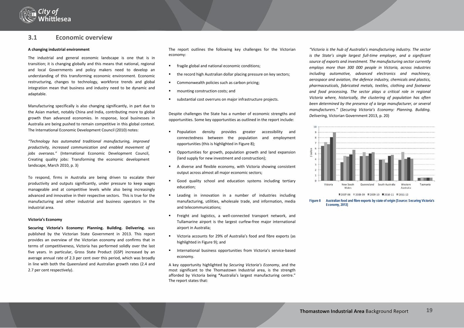
Despite challenges the State has a number of economic strengths and opportunities. Some key opportunities as outlined in the report include: Population density provides greater accessibility and
connectedness between the population and employment opportunities (this is highlighted in Figure 8);
Opportunities for growth, population growth and land expansion (land supply for new investment and construction);
A diverse and flexible economy, with Victoria showing consistent output across almost all major economic sectors;
Good quality school and education systems including tertiary education;
Leading in innovation in a number of industries including manufacturing, utilities, wholesale trade, and information, media and telecommunications;
Freight and logistics, a well-connected transport network, and Tullamarine airport is the largest curfew-free major international airport in Australia;
Victoria accounts for 29% of Australia’s food and fibre exports (as highlighted in Figure 9); and
International business opportunities from Victoria’s service-based economy.
A key opportunity highlighted by Securing Victoria’s Economy, and the most significant to the Thomastown Industrial area, is the strength afforded by Victoria being “Australia’s largest manufacturing centre.” The report states that:
“Victoria is the hub of Australia’s manufacturing industry. The sector is the State’s single largest full-time employer, and a significant source of exports and investment. The manufacturing sector currently employs more than 300 000 people in Victoria, across industries including automotive, advanced electronics and machinery, aerospace and aviation, the defence industry, chemicals and plastics, pharmaceuticals, fabricated metals, textiles, clothing and footwear and food processing. The sector plays a critical role in regional Victoria where, historically, the clustering of population has often been determined by the presence of a large manufacturer, or several manufacturers.” (Securing Victoria’s Economy: Planning. Building. Delivering, Victorian Government 2013, p. 20)
Figure 8 Australian food and fibre exports by state of origin [Source: Securing Victoria's
Economy, 2013]

THOMASTOWN INDUSTRIAL AREA Background Report
20
Figure 9 Population distribution [Source: Securing Victoria's Economy, 2013]

THOMASTOWN INDUSTRIAL AREA Background Report
21
3.2 Melbourne’s industrial land Melbourne’s largest industrial precincts
The Department of State Development, Business and Innovation (DSDBI) commissioned Deloitte Access Economics to produce a report which defined and spatially identified state significant employment precincts in metropolitan Melbourne (excluding the CBD). The State Significant Employment Precincts report (April, 2013) highlights that industrial precincts in Melbourne seize the opportunities arising from: the co-location of manufacturing, wholesaling and freight and
logistics by building relationships within the supply chain;
upstream, manufacturers in precincts with links to research institutions facilitate advances in product, technology and process; and
downstream manufacturers which are co-located with wholesalers or transport and logistics companies are able to increase efficiency and synergies in supply.
The report also advises that generally industrial businesses benefit from the knowledge, technology and skill spill-overs which arise from geographical concentration, allowing for greater innovation. With respect to manufacturing, the report confirms that this sector:
“…continues to be one of Victoria’s largest industries, accounting for over 10% of all employment across the State (2011 Census). It is “vital to the State’s economic growth and a major generator of jobs, exports and investments” (Victorian Department of Business and Innovation, 2011). It covers a large range of advanced products, from advanced electronics and machinery to pharmaceuticals, chemicals and plastics. Further, it is a source of innovation, with $1.5 billion spent annually by the sector on research and innovation in Victoria alone (op cit). “Over the next decade employment in Victoria’s manufacturing industry is projected to decline by 1.3% per annum as competition in the low value add manufacturing sector from emerging Asia and the high Australian dollar combine to put pressure on the industry as a whole (Deloitte Access Economics, 2013). However, increasing worldwide demand for technologically sophisticated devices and products, introduces opportunities for Melbourne’s high value add manufacturing sector in the future.” (p. 40)
This report identifies eight key industrial precincts as follows: Clayton
Campbellfield
Port of Melbourne
Altona/Laverton
Melbourne Airport / Keilor
Dandenong
Moorabbin/Braeside
Knoxfield
Campbellfield and Melbourne Airport / Keilor are the key industrial precincts in Melbourne’s Northern Region and the economic opportunities of these are discussed in Section 3.3. Melbourne’s industrial land supply
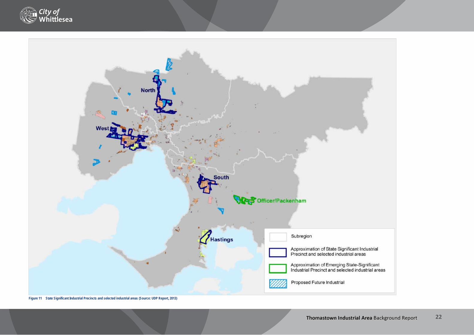
The Urban Development Program (UDP) facilitated by DTPLI provides an update on the supply of land for residential and industrial uses in metropolitan Melbourne. The most recent UDP Report, published in December 2013, provides the most up to date information on the supply and consumption of industrial land across metropolitan Melbourne, as well as indicators on the zoning changes of industrial land. The UDP Report for 2013 acknowledges that the use of industrial land is dynamic, with large developments occurring in the State Significant Industrial Precincts on the fringe of the city, redevelopment for employment uses occurring in some middle and inner suburbs, and the rezoning of land from industrial to a non-industrial zone which occurs across metropolitan Melbourne. Figure 11 on the following page shows the metropolitan context of existing and proposed future industrial land. This shows Thomastown Industrial Area located to the southernmost part of the State Significant Northern Industrial node which contains a total of 3,239 hectares of industrial land. Importantly, the UDP Report highlights that in the established parts of Melbourne there has been a decrease in the amount of zoned industrial
land. Noticeable areas highlighted were Maribyrnong and Moreland, where many manufacturing firms closed down individual locations in the 1990s and 2000s (e.g. Modern Maid, National Forge, Olympic Tyres, Tontine and Kodak) leaving a number of large sites. By contrast, the City of Whittlesea has seen a net increase in industrial zoned land since 2001 due to the increase industrial zoned land in the growth areas. As expected, the UDP Report confirms that the trend for rezoning industrial land (mostly in the inner and middle parts of Melbourne) has been to commercial uses and this has predominantly reflected the current or preferred future character and use of the locations. The proportion of industrial land rezoned to other uses is outlined in Figure 10 below.
Figure 10 New zoning of former industrial land in metropolitan Melbourne following
rezoning requests [Source: UDP Report, 2013]
THOMASTOWN INDUSTRIAL AREA Background Report
22
Figure 11 State Significant Industrial Precincts and selected industrial areas (Source: UDP Report, 2013)
THOMASTOWN INDUSTRIAL AREA Background Report
23
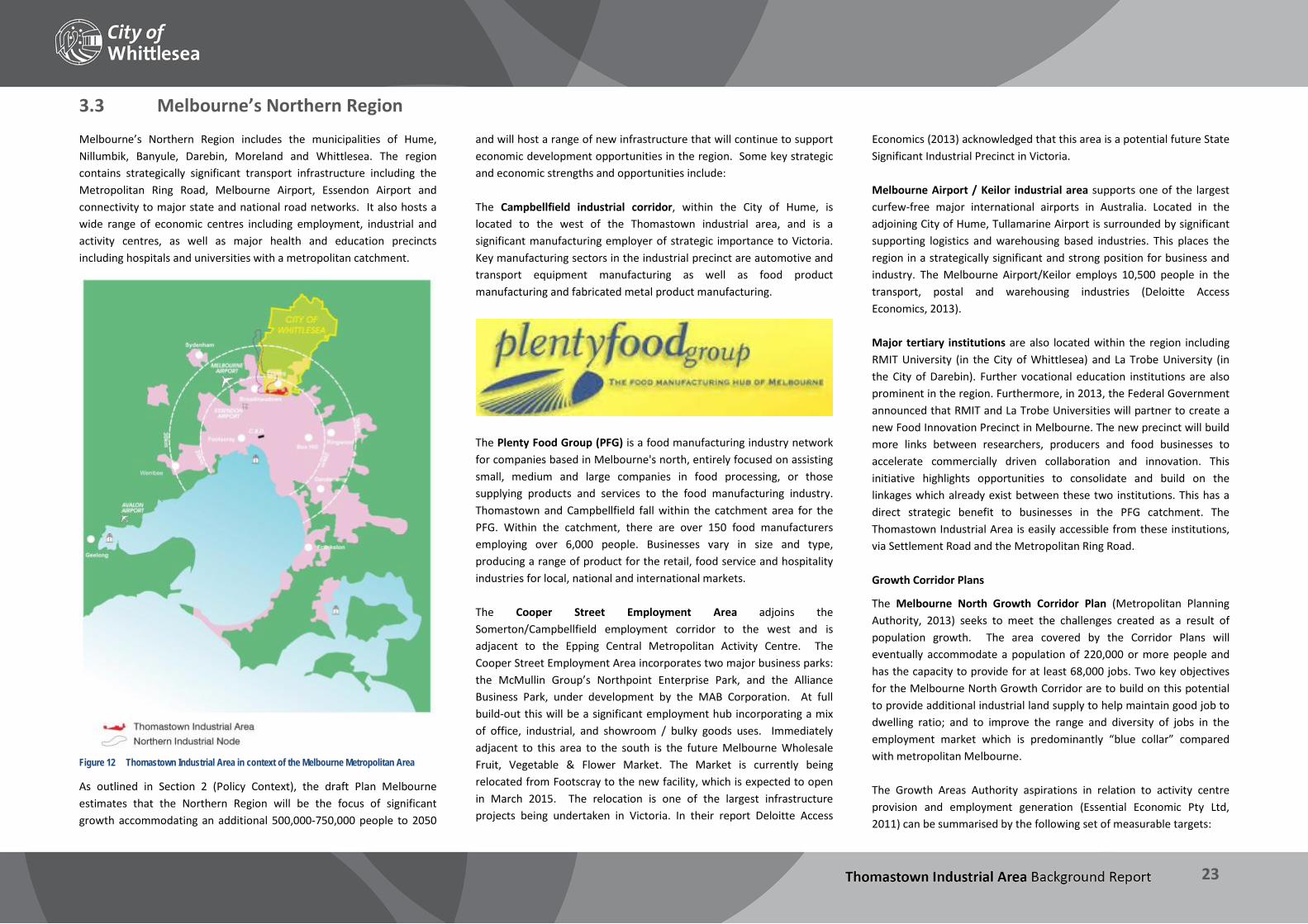
3.3 Melbourne’s Northern Region Melbourne’s Northern Region includes the municipalities of Hume, Nillumbik, Banyule, Darebin, Moreland and Whittlesea. The region contains strategically significant transport infrastructure including the Metropolitan Ring Road, Melbourne Airport, Essendon Airport and connectivity to major state and national road networks. It also hosts a wide range of economic centres including employment, industrial and activity centres, as well as major health and education precincts including hospitals and universities with a metropolitan catchment.
Figure 12 Thomastown Industrial Area in context of the Melbourne Metropolitan Area
As outlined in Section 2 (Policy Context), the draft Plan Melbourne estimates that the Northern Region will be the focus of significant growth accommodating an additional 500,000-750,000 people to 2050
and will host a range of new infrastructure that will continue to support economic development opportunities in the region. Some key strategic and economic strengths and opportunities include: The Campbellfield industrial corridor, within the City of Hume, is located to the west of the Thomastown industrial area, and is a significant manufacturing employer of strategic importance to Victoria. Key manufacturing sectors in the industrial precinct are automotive and transport equipment manufacturing as well as food product manufacturing and fabricated metal product manufacturing.
The Plenty Food Group (PFG) is a food manufacturing industry network for companies based in Melbourne's north, entirely focused on assisting small, medium and large companies in food processing, or those supplying products and services to the food manufacturing industry. Thomastown and Campbellfield fall within the catchment area for the PFG. Within the catchment, there are over 150 food manufacturers employing over 6,000 people. Businesses vary in size and type, producing a range of product for the retail, food service and hospitality industries for local, national and international markets. The Cooper Street Employment Area adjoins the Somerton/Campbellfield employment corridor to the west and is adjacent to the Epping Central Metropolitan Activity Centre. The Cooper Street Employment Area incorporates two major business parks: the McMullin Group’s Northpoint Enterprise Park, and the Alliance Business Park, under development by the MAB Corporation. At full build-out this will be a significant employment hub incorporating a mix of office, industrial, and showroom / bulky goods uses. Immediately adjacent to this area to the south is the future Melbourne Wholesale Fruit, Vegetable & Flower Market. The Market is currently being relocated from Footscray to the new facility, which is expected to open in March 2015. The relocation is one of the largest infrastructure projects being undertaken in Victoria. In their report Deloitte Access
Economics (2013) acknowledged that this area is a potential future State Significant Industrial Precinct in Victoria. Melbourne Airport / Keilor industrial area supports one of the largest curfew-free major international airports in Australia. Located in the adjoining City of Hume, Tullamarine Airport is surrounded by significant supporting logistics and warehousing based industries. This places the region in a strategically significant and strong position for business and industry. The Melbourne Airport/Keilor employs 10,500 people in the transport, postal and warehousing industries (Deloitte Access Economics, 2013). Major tertiary institutions are also located within the region including RMIT University (in the City of Whittlesea) and La Trobe University (in the City of Darebin). Further vocational education institutions are also prominent in the region. Furthermore, in 2013, the Federal Government announced that RMIT and La Trobe Universities will partner to create a new Food Innovation Precinct in Melbourne. The new precinct will build more links between researchers, producers and food businesses to accelerate commercially driven collaboration and innovation. This initiative highlights opportunities to consolidate and build on the linkages which already exist between these two institutions. This has a direct strategic benefit to businesses in the PFG catchment. The Thomastown Industrial Area is easily accessible from these institutions, via Settlement Road and the Metropolitan Ring Road. Growth Corridor Plans
The Melbourne North Growth Corridor Plan (Metropolitan Planning Authority, 2013) seeks to meet the challenges created as a result of population growth. The area covered by the Corridor Plans will eventually accommodate a population of 220,000 or more people and has the capacity to provide for at least 68,000 jobs. Two key objectives for the Melbourne North Growth Corridor are to build on this potential to provide additional industrial land supply to help maintain good job to dwelling ratio; and to improve the range and diversity of jobs in the employment market which is predominantly “blue collar” compared with metropolitan Melbourne. The Growth Areas Authority aspirations in relation to activity centre provision and employment generation (Essential Economic Pty Ltd, 2011) can be summarised by the following set of measurable targets:
THOMASTOWN INDUSTRIAL AREA Background Report
24
An overall target of one new job for each new dwelling to be created in the growth corridors
Approximately one-third of jobs to be provided at the local level
Approximately 70% of jobs to be located at the sub-regional level (within approx. 5km)
A target of 100% employment self-sufficiency at the wider regional level (i.e within approx. 10km)
A target for 80-90% of all households to be within 1km of neighbourhood-level shopping facilities that have a supermarket
A network of neighbourhood and higher-order centres planned on the basis of a square mile block.
Regional employment catchment of Thomastown Industrial Area
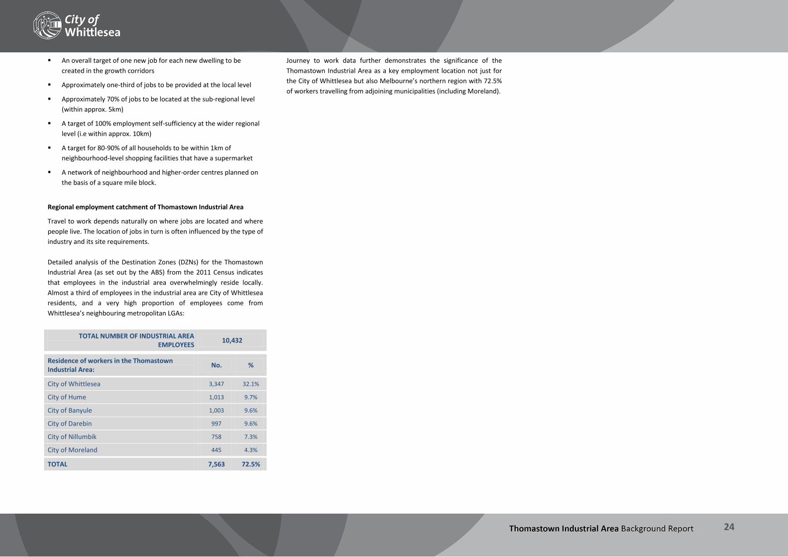
Travel to work depends naturally on where jobs are located and where people live. The location of jobs in turn is often influenced by the type of industry and its site requirements. Detailed analysis of the Destination Zones (DZNs) for the Thomastown Industrial Area (as set out by the ABS) from the 2011 Census indicates that employees in the industrial area overwhelmingly reside locally. Almost a third of employees in the industrial area are City of Whittlesea residents, and a very high proportion of employees come from Whittlesea’s neighbouring metropolitan LGAs:
TOTAL NUMBER OF INDUSTRIAL AREA EMPLOYEES 10,432
Residence of workers in the Thomastown Industrial Area: No. %
City of Whittlesea 3,347 32.1%
City of Hume 1,013 9.7%
City of Banyule 1,003 9.6%
City of Darebin 997 9.6%
City of Nillumbik 758 7.3%
City of Moreland 445 4.3%
TOTAL 7,563 72.5%
Journey to work data further demonstrates the significance of the Thomastown Industrial Area as a key employment location not just for the City of Whittlesea but also Melbourne’s northern region with 72.5% of workers travelling from adjoining municipalities (including Moreland).

THOMASTOWN INDUSTRIAL AREA Background Report
25
3.4 Municipal economic context City of Whittlesea’s Economy
The municipality comprises 487 square kilometres and contains a mix of established urban areas, newer growth areas and rural land. The City is physically and geographically diverse, characterised by a mix of urban and rural landscapes and includes significant network of employment areas and activity centres as well as farming and agricultural activities. The City does not have a significant amount of industrial and employment land in percentage terms and the Thomastown Industrial Area is the largest consolidated industrially zoned area as shown in Figure 13.
Figure 13 Thomastown Industrial Area in context of the City of Whittlesea
The City has a strong local economy as represented by the following key statistics: Estimated Gross Regional Product $4.92 billion
Percentage of Gross State Product (GSP) 1.6%
Local Businesses Registered in 2012 11,263
Estimated local jobs in municipality (2011/12) 54,281
Residents employed 82,380 Source: Economy.id, 2013 Whittlesea’s changing employment structure
Manufacturing is one of Victoria’s largest industries, and is even more dominant in the City of Whittlesea where it provides the greatest proportion of jobs located within the municipality at 18.8% (see Figure 14). As shown in Figure 15, trends over time however indicate that growth in this sector is minimal, with the strongest growth by far between 2006 and 2011 occurring in Retail Trade (+1,621 jobs), Health Care and Social Assistance (+1,447 jobs), and Construction (+1,048 jobs, reflective of Whittlesea’s status as a major growth LGA).
Figure 14 City of Whittlesea jobs by industry sector, 2011 (Source: Economy.id, derived
from ABS Census of Population and Housing, 2011)
The most significant manufacturing precinct is in Thomastown, although the growth areas, including the Cooper Street Employment Area and the
Melbourne Wholesale Market site, continue to grow and support further industrial and employment activities.
Figure 15 Change in City of Whittlesea employment offer, 2006-2011 (Source: Economy.id,
derived from ABS Census of Population and Housing, 2011)
Retail hierarchy
The municipality’s retail hierarchy corresponds to the hierarchy of activity centres, which was recently realigned under Plan Melbourne. The Epping Central Metropolitan Activity Centre (MAC) focuses around the Epping train station and to the east of the Cooper Street Employment Area, and is the City of Whittlesea’s primary retail destination. The Pacific Epping shopping centre is a regional retail attractor, and there are smaller scale shopping strips at Dalton Road and High Street. A permit is currently being sought for a Costco store on land to the south of Pacific Epping. Significant employment land also exists within the MAC. The Plenty Valley Activity Centre, for which structure planning is currently underway, is centred around McDonalds Road and includes areas of South Morang, Epping and Mill Park. It is the second most significant retail centre in the municipality, and is home to the Plenty Valley Westfield shopping centre as well as several smaller bulky goods and neighbourhood retail areas on McDonalds Road / Gorge Road and Plenty Road. The implications of the structure planning process being undertaken for these activities centres is discussed in more detail later in this section.

THOMASTOWN INDUSTRIAL AREA Background Report
26
In addition there are several neighbourhood retail centres within the City of Whittlesea, the most significant of which are:
Station Street, Lalor
High Street, Thomastown
Bundoora Square, Plenty Road, Bundoora
The Stables shopping centre, Childs Road, Mill Park
Whittlesea Township
The University Hill retail precinct, Janefield Drive, Bundoora
Industrial and employment land
Industrial and other employment generating activities are dispersed across the southern, and established, parts of the municipality. There are a number of key areas in the municipality which have been developed more recently for employment generating purposes and further areas will develop and increase in their significance as the various phases of development occurs in the identified growth areas. In addition to Thomastown Industrial Area, land for employment purposes is focussed around four major locations:
(i) Cooper Street / Epping Central (iii) Mernda/Doreen
(ii) South Morang (iv) University Hill Each of these areas will have different functions as development associated with these continues. Significant new opportunities for employment land exist to the north as the areas in the extended Urban Growth Boundary begin to develop as described in Section 2.1. The differences in the types of business and industry these area attract are further reflected in their zoning. University Hill is zoned Special Use and the Cooper Street Employment Area zoned a Comprehensive Development Zone, which allows for a variety of employment uses that generally exhibit a less traditional industrial character. Similarly, the proposed rezoning of Epping Central to the Activity Centre Zone will also result in change over time from traditional manufacturing / industrial uses to higher density commercial development. While Thomastown industrial area is the largest consolidated established industrial precinct in the City of Whittlesea there are other smaller established industrial areas within the municipality however these are limited. They generally form small isolated or standalone industrial sites which are in close proximity to sensitive land uses such as residential. These other pockets are dispersed throughout the
established residential suburbs of the municipality in locations such as Mill Park, and Lalor and make up a very small proportion of the municipalities industrial/employment land. Larger areas exist in South Morang and Mernda. These areas are generally Industrial 3 Zone or Commercial 2 Zone and provide land for businesses within the market that they service. The extent to which these industrial areas serve their purpose as functional business locations has not been fully examined and reviewed through this project. These areas are however likely to continue as secondary industrial locations providing for and attracting population serving type industrial uses such as automotive services, machinery and equipment repairs as well as an outlet for smaller scale and niche manufacturing and wholesale trade. Their potential to generate confidence for existing or prospective larger scale industrial businesses to invest is likely to be limited due to the surrounding land use context and potential conflicts with sensitive uses. They also have limitations in relation to poor access for heavy vehicles such as B-doubles and semi-trailers as well as limited capacity for future expansion. These areas could however have the capacity to provide affordable locations for small or start-up businesses. There are also some more traditional or long standing established industrial areas within the municipality which were once prime or core industrial locations that are in a period of transition. Such areas include Epping and South Morang, which currently contain employment land in Industrial and Commercial Zones, and are the focus of significant restructuring due to the development of strategic plans for these areas as activity centres. Within these areas, particularly Epping Central, there are usually a combination of prime redevelopment sites and older industrial buildings. The future use of key sites may improve the quality of the precinct through the attraction of new investment resulting in increased business diversity, or through the change in use of the site that will complement the surrounding land uses. University Hill in Bundoora is also an example of a newly developing mixed use area which contains employment generating uses. There are also examples of this restructuring throughout the Melbourne and the northern region, particularly in the municipalities of Darebin, Banyule and Moreland where the employment and land use base is in a state of transition. This is to some extent highlighted in Section 3.2 in Figure 11 which shows a trend of rezoning from industrial to mixed use, residential and commercial. Continued ‘gentrification’ of inner areas is also seeing higher land prices and structural changes in the socio-
economic composition of areas such as Brunswick, Northcote and Preston. These areas have and will continue to see changes of use from traditional industrial premises to retail and food and drink premises (i.e. cafes, bars, and niche and boutique retail stores) as well as new investment and redevelopment of sites for more intensive built form, including residential and mixed use developments. This has and will continue to see shifts of more traditional manufacturing firms further north to areas as they are displaced by these trends. Developing industrial areas
Newly developing industrial areas, largely consisting of large greenfield sites, are forming to the north of the municipality, for example at Cooper Street in Epping. Such precincts have the ability to attract multi-national and national firms contributing to a greater diversity of employment growth. New areas are also being planned for through the structure planning process in the growth areas. Development generally consists of industrial park environments with quality building design, infrastructure, landscaping and amenity. The role of these precincts is to provide locations for businesses that require new premises and the advantages of the direct access to Melbourne’s freeways. Significant new industrial areas are also planned within Hume such as Merrifield.

THOMASTOWN INDUSTRIAL AREA Background Report
27
Key findings – Economic context The review of the economic context at state, regional and local level demonstrates that: Victoria’s largest industry is manufacturing, which is also reflected
at the metropolitan and municipal scale.
Despite industry, and manufacturing in particular, being in a state of transition, Victoria is well positioned to continue to be competitive in a global, national and local context.
Melbourne has a good supply of industrial land and major industrial precincts are strategically located across greater Melbourne. While rezoning of land from industrial to non-industrial zones has occurred across metropolitan Melbourne, including in the middle and inner suburbs, there have also been large developments occurring in the State Significant Industrial Precincts on the fringe of the city.
The Thomastown Industrial Area sits within a northern regional context which is well placed to remain economically competitive with strategically located industrial and employment land (predominantly within the Northern Industrial Precinct), major retail destinations and tertiary education institutions. These are all proximate to major infrastructure such as Melbourne Airport (curfew free), the Metropolitan Ring Road and Hume Freeway.
At the local level, the City of Whittlesea is diverse in terms of its mix of urban and rural areas. The Thomastown Industrial Area is the largest area of consolidated industrially zoned land in the municipality, and sits within a hierarchy of employment land and retail centres.
Despite the decline in manufacturing jobs both nationally and locally, this sector continues to represent the most valuable employment sector and remains the largest employer in Whittlesea. Employment data suggests new sectors are growing rapidly and are likely to eventually outpace manufacturing (consistent with broader state and national trends); the implications of this for Thomastown will need to be considered.
Many of the traditional employment areas in Whittlesea found in Mill Park, South Morang and Epping are in a period of transition, further highlighting the importance of Thomastown as strategically placed and large consolidated industrial precinct.
The Thomastown Industrial Area contributes significantly to local resident employment as demonstrated by the Journey to Work data. Not only does the area provide significant local employment, almost three quarters of the people employed in the industrial area come from municipalities within the Northern Region.

THOMASTOWN INDUSTRIAL AREA Background Report
28
4 Study Area Characteristics This section describes the industrial area and its key features and characteristics of the built and natural environment.

THOMASTOWN INDUSTRIAL AREA Background Report
29
4.1 Key features and history Key features
The Thomastown Industrial Area is located approximately 15km north of the Melbourne CBD and is situated along the south western border of the municipality. The industrial area is located within the established areas of the municipality, surrounded by major roads, which provide a buffer to surrounding land uses which are primarily residential. The industrial area sits adjacent to the border of the municipality with the City of Darebin to the south, and the City of Hume to the west. The industrial area is approximately 600 hectares in area, irregular and generally linear in shape, and extends almost 7km from east to west, contained primarily between the Metropolitan Ring Road to the north and Mahoneys Road / Keon Parade to the south. The industrial area is bounded to the east by the Melbourne Water pipe track reservation (the former Maroondah Aqueduct) and to the west by the Merri Creek. While the majority of the industrial area is situated south of the Metropolitan Ring Road, three key areas are positioned to the north. These include the Trawalla Avenue precinct in the west (which includes the Boral Quarry site), Meridian Business Park and the adjoining industrial land between Dalton Road and High Street, and a former quarry site and the Dyson’s bus depot which are located in the east. Other notable features of the industrial area include: The area is well serviced by freeways and the arterial road network,
which provide ready access to key destinations including Melbourne Airport and the Port of Melbourne.
Two train stations and the bus network provide good public transport coverage, however walking and cycling are poorly connected. Section 5 contains a detailed discussion of transport infrastructure in the industrial area.
Utility infrastructure is a feature of the industrial area. Major transmission and distribution for electricity and gas networks as well as drainage assets are located throughout. Utility providers such as SP Ausnet, APA Gasnet, Melbourne Water and Yarra Valley Water have assets in the industrial area. Major utility infrastructure is also described in Section 5.
Three of the City of Whittlesea’s four major waterways pass through the industrial area. The Darebin Creek, Merri Creek and
Edgars Creek and their surrounding environs provide important and valued habitats as well as areas of open space for local residents and employees. Central Creek, a minor tributary of the Merri Creek, also runs through the area close to the Hume Freeway. Environmental conditions in the industrial area are discussed further in Section 6.
Figure 16 Signage on SP Ausnet Electricity site
A brief history
The City of Whittlesea Heritage Study (September 2013) provides a detailed overview of the themes and activities that have been significant in shaping the City of Whittlesea. The report notes that settlement of the Thomastown area dates from 1848, with land used mainly for market gardening. A township was established in the 1850s as more settlers moved to the area, however population growth was minimal until the late 1800s, occurring once the railway to Whittlesea opened in 1889. The area remained largely agricultural, characterised by dairy farming and horse racing, until the development of neighbouring Lalor in 1947, and by the 1950s Thomastown had been absorbed by Metropolitan Melbourne. The study includes specific commentary on the establishment of industrial development in the City of Whittlesea, with a focus on Thomastown which was the first industrial area in the municipality. One
of the first manufacturing industries in the area was Fowler Pottery in Settlement Road which opened in 1927. Significant development occurred in the post-war years, particularly during the 1950s and 1960s. The rapid population growth at this time provided a local workforce and many factories which had traditionally been located in Melbourne’s inner north began to relocate to Thomastown, supported by State and Commonwealth government policies which encouraged relocation of industry from the inner city to the fringe. During this time significant industries located in the precinct which are still present today, including Bostik (1958), Sutton Tools (1963), and Amcor (1968). The study also provides insight into the way the industrial area was both promoted and criticised by contemporary local media:
“The expansion of the industrial area was actively supported by promotional campaign and the publication of Northside Story, a publication that advertised the potential and successes of growth to Melbourne’s north. The May 1966 edition opens with the headline “Melbourne’s northern suburbs are answering expanding industry’s needs – first maximum site space – second, central location with minimal traffic problems”. The industrial development provided regular employment within the area, but it also changed its character. Articles in the local publication Outlook from 1972 regularly complained about the environmental problems caused by manufacturing industries, not to mention the visual pollution of the landscape that development brought with it.” (p. 42)
Figure 17 Amcor St Regis Bates

THOMASTOWN INDUSTRIAL AREA Background Report
30
4.2 Built environment characteristics
Figure 18 Aerial map of industrial area and precinct locations
In considering the overall composition of the industrial area a detailed review of the built environment and land characteristics was undertaken. This included consideration of lot sizes, subdivision pattern and access and age of building stock. These characteristics are important in understanding key challenges and weaknesses but also highlight focus areas so strengths may be retained and enhanced. Precinct analysis
This section examines the broad scale characteristics of the industrial area. Given the scale of the industrial area a more detailed review was undertaken of the above characteristics at precinct level. These areas were defined primarily by their locational characteristics in relation to major roads and infrastructure, as shown in Figure 18 above. This detailed assessment enabled a greater depth of understanding in relation to the composition of different parts of the industrial area and their characteristics. The findings of this detailed review are contained in Appendix 1 which includes a detailed description of each of the nine precincts and Appendix 2 which includes thematic maps and precinct-
specific description of lot sizes, subdivision pattern and access, and age of building stock. Subdivision pattern and access
Overwhelmingly, the subdivision pattern in the Thomastown industrial area is defined by the main arterial roads (Mahoneys Road / Keon Parade, the Metropolitan Ring Road, Edgars Road, High Street, Dalton Road and Plenty Road), interspersed by discrete enclosed precincts characterised by loop road and cul-de-sacs. This results in poor connectivity between precincts, as well as very limited connectivity within and through precincts, even in areas that have been subdivided more recently such as Precinct 9. By way of example, there is no route via local roads between Settlement Road and Keon Parade through Precinct 4, a distance of almost 800m, and the arterials providing this connection are (High Street and Dalton Road) are 1-1.3 kilometres apart. This affects vehicle movements and in particular limits the scope for alternative forms of transport such as walking and cycling. There is an opportunity for the Strategy to consider the creation of new
connections for pedestrians and cyclists, however there is the possibility that these may need to be provided along creek corridors or via the restructuring of private land. Access to the Metropolitan Ring Road from the industrial area is available via both Dalton Road and Edgars Road. The lack of an access point from High Street may pose an inconvenience for some operators, but also represents some important opportunities, including encouraging businesses without a major requirement for road-based transport connectivity to locate in this vicinity. There is also the opportunity to improve the pedestrian environment here, particularly given the location of Thomastown and Keon Park stations on High Street to either side of the industrial area. Access through parts of the industrial area is further hampered by the presence of several major utilities easements, most notably for electricity transmission lines. These are further discussed in Section 5.5.

THOMASTOWN INDUSTRIAL AREA Background Report
31
Lot size
Across the industrial area lot size composition varies significantly. The largest proportion of lots are between 1,000-5,000 square metres which comprise 30% of the total lot composition of the industrial area. Large lots of two hectares or more are limited, with a total of only 40 lots being this size. Vacant land parcels are scattered throughout the industrial area and are not concentrated to any particular location. The exception is the newly developing Meridian Business Park to the western side of Precinct 9. These are also largely concentrated in key locations, such as the two quarry sites and along High Street and to the north of Settlement Road (west). Smaller lots of less than 500 square metres are most commonly found in newer subdivisions, for example where larger sites have been developed to create numerous smaller strata-titled warehouses. The benefit of such a wide mix of lot sizes is that the area has the ability to attract a variety of businesses, although further subdivision of large lots in the future will limit this scope. Large lots provide opportunities for major space-intensive uses such as freight and logistics, large manufacturers, and utilities administration and distribution, while smaller lots can provide opportunities for start-up businesses to locate in more affordable premises, or the agglomeration of smaller businesses in specialised precincts. Lot size is not however necessarily a reliable indicator of business size, with many businesses in the industrial area occupying multiple sites to meet their operational needs. Furthermore, while site size (and floorspace) provides significant insight, the availability of ‘vertical’ space is an important additional consideration: for example, restricted roof heights may impact on the ability of a business to store goods vertically or install additional machinery such as cool rooms. This issue is common in older stock of industrial buildings which were not constructed with flat roofing (see further discussion in Section 8). Age of building stock
With the exception of the historic Fowler Pottery factory on High Street constructed in 1927, the majority of construction in the Thomastown industrial area has occurred from the 1960s through to the present, with strong growth throughout the 1970s to 2000s, peaking in the 1980s. There is also a reasonably strong correlation between age of building stock and lot size. In the 1960s the majority of construction took place on sites greater than 5,000 square metres in area, whilst in the 1970s to
2000s most development activity was occurring on sites of 500-2,000 square metres or less. Notably, almost 70% of buildings constructed in the area since 2010 have been on sites of less than 500 square metres, reflecting the speculative subdivisions discussed earlier. In the coming decades we may begin to see some demolition and redevelopment of improved sites in the industrial area as buildings begin to reach the end of their useful life. This is likely to be most notable in Precincts 2 and 4 in the first instance, where there are a high proportion of buildings constructed in the 1970s. Case studies
As part of the Urban Design Review a number of businesses currently operating in the industrial area were selected as case studies. The purpose of these case studies was to highlight and gain a detailed and in-depth understanding of the operational requirements of a range of businesses in the industrial area. The findings will also assist and inform future directions for producing high quality development guidelines for the industrial area. In undertaking detailed analysis for these case studies businesses were selected in order to get a range of business types and sizes. Case studies were undertaken of the following business types: Manufacturer (Machinery and equipment)
Wholesale distributor (food product)
Manufacturer (food product)
Service industry (automotive repair)
Bulky goods retailer (electrical and electronic goods)
The case studies assessed these businesses in terms of access and circulation, built form siting, building and landscape design, and site amenity. The detailed findings of this review are not contained in this report; however the investigations highlighted a number of findings as follows: Positives
Synergies with other businesses in the TIA
Multiple cross-overs can assist with operational efficiencies
Adequate floor to ceiling height provides greater operational flexibility
Appropriate location and screening of services improves streetscape presentation
Front setback can be effectively utilised for landscape
Minimal side and rear setbacks allow to maximise floor area
Negatives
Inadequate provision of on-site storage
Visitor and staff car parking not adequate
Older built form stock limits vertical storage capacity
Loading areas are not adequate for larger vehicles (ie. B Doubles)
The detailed findings of the Urban Design Review are contained in Section 8.
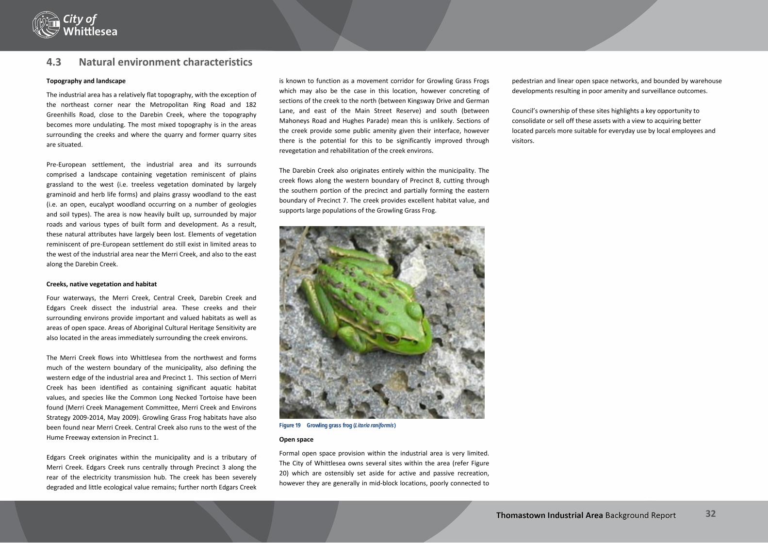
THOMASTOWN INDUSTRIAL AREA Background Report
32
4.3 Natural environment characteristics Topography and landscape
The industrial area has a relatively flat topography, with the exception of the northeast corner near the Metropolitan Ring Road and 182 Greenhills Road, close to the Darebin Creek, where the topography becomes more undulating. The most mixed topography is in the areas surrounding the creeks and where the quarry and former quarry sites are situated. Pre-European settlement, the industrial area and its surrounds comprised a landscape containing vegetation reminiscent of plains grassland to the west (i.e. treeless vegetation dominated by largely graminoid and herb life forms) and plains grassy woodland to the east (i.e. an open, eucalypt woodland occurring on a number of geologies and soil types). The area is now heavily built up, surrounded by major roads and various types of built form and development. As a result, these natural attributes have largely been lost. Elements of vegetation reminiscent of pre-European settlement do still exist in limited areas to the west of the industrial area near the Merri Creek, and also to the east along the Darebin Creek. Creeks, native vegetation and habitat
Four waterways, the Merri Creek, Central Creek, Darebin Creek and Edgars Creek dissect the industrial area. These creeks and their surrounding environs provide important and valued habitats as well as areas of open space. Areas of Aboriginal Cultural Heritage Sensitivity are also located in the areas immediately surrounding the creek environs. The Merri Creek flows into Whittlesea from the northwest and forms much of the western boundary of the municipality, also defining the western edge of the industrial area and Precinct 1. This section of Merri Creek has been identified as containing significant aquatic habitat values, and species like the Common Long Necked Tortoise have been found (Merri Creek Management Committee, Merri Creek and Environs Strategy 2009-2014, May 2009). Growling Grass Frog habitats have also been found near Merri Creek. Central Creek also runs to the west of the Hume Freeway extension in Precinct 1. Edgars Creek originates within the municipality and is a tributary of Merri Creek. Edgars Creek runs centrally through Precinct 3 along the rear of the electricity transmission hub. The creek has been severely degraded and little ecological value remains; further north Edgars Creek
is known to function as a movement corridor for Growling Grass Frogs which may also be the case in this location, however concreting of sections of the creek to the north (between Kingsway Drive and German Lane, and east of the Main Street Reserve) and south (between Mahoneys Road and Hughes Parade) mean this is unlikely. Sections of the creek provide some public amenity given their interface, however there is the potential for this to be significantly improved through revegetation and rehabilitation of the creek environs. The Darebin Creek also originates entirely within the municipality. The creek flows along the western boundary of Precinct 8, cutting through the southern portion of the precinct and partially forming the eastern boundary of Precinct 7. The creek provides excellent habitat value, and supports large populations of the Growling Grass Frog.
Figure 19 Growling grass frog (Litoria raniformis)
Open space
Formal open space provision within the industrial area is very limited. The City of Whittlesea owns several sites within the area (refer Figure 20) which are ostensibly set aside for active and passive recreation, however they are generally in mid-block locations, poorly connected to
pedestrian and linear open space networks, and bounded by warehouse developments resulting in poor amenity and surveillance outcomes. Council’s ownership of these sites highlights a key opportunity to consolidate or sell off these assets with a view to acquiring better located parcels more suitable for everyday use by local employees and visitors.

THOMASTOWN INDUSTRIAL AREA Background Report
33
Figure 20 Creeks and open spaces

THOMASTOWN INDUSTRIAL AREA Background Report
34
4.4 Land ownership
Figure 21 Ownership profile of industrial area
The vast majority of the land in the industrial is in private ownership, both in terms of the number of sites and total land area: over 80% of land parcels are privately owned. Figure 21 spatially defines the sites within the industrial area which are in private and public ownership (or owned by public or utility corporations). Of those that are in public ownership, some are landlocked and present challenges for their ongoing management. Two such examples include the Parks Victoria and Melbourne Water sites adjacent to the Merri Creek in Precinct 1. Of the properties in private ownership this is also particularly fragmented with only a small proportion of landowners owning multiple sites. Of the number of sites in private ownership, more than half of the properties in the industrial area (more than 1,100 properties) only own one site. The number of properties in the industrial area that are in the same ownership (ie. owners with more than one property) is not significant. Further analysis of land ownership breakdown also shows that there are few large consolidated areas within the industrial area in single ownership. This presents challenges to future regeneration
opportunities due to the number of land owners with which outcomes will need to be negotiated. Land audits can assist to identify underutilised parcels of public land (Commonwealth, State and Council owned) and can identify areas for development potential/focus and the opportunities for developing underutilised public land. Land audits were not undertaken as part of the review of the industrial area given there are not a significant number of sites in public ownership (Commonwealth, State and Council owned) which might form the focus for regeneration projects. Initial land audits undertaken demonstrated limited sites in public ownership, significant government owned land or assets in a strategic location such as this can sometime present as an opportunity to facilitate or stimulate urban renewal outcomes. As shown above, there are several small Council-owned sites in the industrial area. Most of these are used ostensibly as pocket parks (though they have very limited facilities and landscaping); in addition
there is a site used as a stormwater treatment wetland, and another occupied by an industrial building. While these sites are limited in size and number, further investigation is warranted to determine the feasibility of providing improved and more accessible public open space, either by enhancing existing sites, via land sales and acquisition, and / or consolidating existing sites. This investigation should not be limited to Council land and should also include the creek environs and land owned by Melbourne Water, Parks Victoria, VicRoads and other public agencies. Opportunities may exist to further consider consolidating vacant and underutilised land in private ownership to achieve improved built form and amenity outcomes and/or higher employment densities. This would require liaising with landholders to determine development intentions.

THOMASTOWN INDUSTRIAL AREA Background Report
35
Key findings – Study area characteristics The analysis of existing conditions in the Thomastown industrial area highlights the following: There is good connection afforded by the arterial roads but these
are interspersed with pockets of loop and cul-de-sac roads with poor internal and inter-precinct connectivity.
There is a wide variety of sites of different sizes within the industrial area, from very small strata-titled premises through to sites of 5,000 square metres to two-plus hectares.
Due to the size and age of the industrial area there is a similar degree of variation present in the age of building stock, dating from the 1920s through to very recent developments.
These factors, together with a site vacancy rate of around 4.5%, offer a degree of flexibility and a range of opportunities for development and redevelopment of vacant and underdeveloped sites, as well as those where the building stock has reached the end of its useful lifespan.
Significant public and utility assets exist within the precinct that offer a range of opportunities and constraints. Some offer opportunities for adaptive re-use (such as the old Maroondah Aqueduct land), whilst others detract from the area, such as the power transfer station at the corner of High Street and Mahoneys Road which is land-intensive and unattractive but unlikely to ever be relocated.
The main environmental features of the area are the creeks and their environs. The area is mostly developed and contains few remnants of indigenous vegetation or significant conservation areas. Biodiversity mapping shows significant vegetation surrounding the Darebin Creek to the northeast of the industrial area. Significant populations of the Growling Grass Frog are also found in parts of the industrial area, particularly along the Darebin Creek and close to the Merri Creek.
Opportunities for planting of native vegetation along the creeks and buffer areas should be considered including revegetation to create habitat corridors and improved pedestrian and cycling links. The preparation of master plans to allow for this will need to be considered.
Fragmented ownership presents a challenge for future regeneration opportunities due to the number of land owners with which possible outcomes will need to be negotiated.

THOMASTOWN INDUSTRIAL AREA Background Report
36
5 Transport and Infrastructure This section describes the transport network and key infrastructure throughout the industrial area. Transport infrastructure is integral to the viability of the area and can have a significant impact on the ongoing operation of businesses. Other infrastructure, including utility infrastructure such as drains and electrical lines are also prominent features and can have implications for use and development within and surrounding these areas.

THOMASTOWN INDUSTRIAL AREA Background Report
37
5.1 Road infrastructure Road network
The industrial area is well serviced by the arterial road and metropolitan freeway networks, which is key to the strategic significance of the area. Arterial road access through the precinct is provided by Edgars Road, High Street and Dalton Road running north-south, with key east-west arterial routes being Mahoneys Road / Keon Parade, Settlement Road, and Wood Street. In terms of the freeway network the Metropolitan Ring Road forms much of the northern border of the industrial area, with connections from Dalton Road and Edgars Road (though notably not from High Street). The arterial road network is interspersed with lower-scale local roads which primarily consist of loop roads and cul-de-sacs. The court bowl layout of some streets has both positive and negative impacts. Benefits include minimal through-traffic generated and therefore less conflict generated between different road users; on the other hand the existing street layout contributes to issues with on-street parking, turning and standing for large vehicles (especially trucks), as well as connectivity through the precinct particularly for pedestrians and cyclists.
Figure 22 Level crossing at Keon Parade
There are three level crossings traversing the South Morang rail line within the industrial area east of High Street: at Heyington Avenue (the main access point between High Street and the Meridian Business Park), at Settlement Road, and at Keon Parade. Consultation with businesses in the area and site visits have indicated that the level crossings create traffic congestion along High Street, Settlement Road and Keon Parade/Mahoneys Road at peak times with vehicles.
The E6 freeway is proposed to extend from the Metropolitan Ring Road to meet the future outer Metropolitan Ring Road and connect through Thomastown, Mill Park, Epping, Wollert, Woodstock, Donnybrook and Beveridge. Part of the land which is already reserved for this road is within the industrial area. A Public Acquisition Overlay is situated to the north-eastern corner of the project area between the Metropolitan Ring Road and McKimmies Road to facilitate the future construction of this road. As noted previously in Section 2.3, whilst this road is earmarked to be constructed as a freeway, the position of the City of Whittlesea is that an arterial-scale road would be sufficient to accommodate the needs of the municipality and wider region. Freight
Victorian State legislation dictates which roads can be used by B-double trucks and other heavy freight vehicles (Higher Mass Limit (HML) vehicles), and all states in Australia have similar schemes to regulate heavy vehicle traffic. This approach is designed to promote the efficiency of the freight network (by allowing vehicles to carry the maximum safe amount and minimise the number of trips required and trucks on the road), whilst ensuring that: Excessive wear and tear of road pavements is avoided,
Roads have adequate capacity to accommodate large vehicles, and
Trucks avoid low clearances and bridges with insufficient load-bearing capacity.
In Victoria, VicRoads is responsible for the regulation of B-doubles and HML vehicles, and sets out the road network that they are permitted to travel on. In the industrial area, all arterial roads are approved for these vehicles with the exception of Settlement Road between High Street and Dalton Road which is approved for HML vehicles only. Throughout the state, the vast majority of the freeway network has been adapted to accommodate the largest of these vehicles to promote increased freight efficiency (i.e. by carrying more cargo per trip). In addition, several local roads within the industrial area are approved for heavy vehicles, including Lipton Drive, Temple Drive, and Northgate Drive (see map at Figure 24 below). The location of these roads has a direct relationship to the location of companies reliant on large scale road freight to conduct their business, such as manufacturing, warehousing, and other large-scale business. As the industrial and
business sector becomes more competitive, and higher productivity and outputs from businesses are required in order to be competitive in the marketplace, access for B-double (and in the future, B-triple) vehicles will become a significant locational requirement for certain manufacturing and other industrial businesses. Connectivity
The Metropolitan Ring Road connects the industrial area with the major infrastructure, facilities and ports of the broader national and international transport network. Distances to major destinations (measured from approximately the centre of the industrial area) include: Destination Distance Approx. travel time Hume Freeway (entrance at Metropolitan Ring Road) 5km 5 minutes
Campbellfield Industrial Precinct
South – 6.5km North – 12km
8 minutes 11 minutes
Melbourne Airport, Tullamarine 19km 15 minutes
Somerton Intermodal Terminal 13km 15 minutes Melbourne CBD 16km 25 minutes Port of Melbourne 30km 25 minutes Beveridge Freight Terminal (future) 40km 30 minutes
Avalon Airport, Lara 74km 50 minutes Port of Geelong 87km 1 hour Port of Hastings (future) 88km 1 hour 15 minutes Adelaide 730km 7 hours 40 minutes Sydney (via Hume Freeway) 850km 8 hours
Figure 23 Westbound traffic on the Metropolitan Ring Road

THOMASTOWN INDUSTRIAL AREA Background Report
38
Figure 24 The road network

THOMASTOWN INDUSTRIAL AREA Background Report
39
5.2 Public transport network Public transport provision for the industrial area includes rail and both the local and orbital bus networks. Rail services
The South Morang rail line bisects the precinct along the High Street alignment. Two stations service the industrial area: Keon Park Station is located at the corner of High Street and Keon
Parade. Thomastown Station is located approximately 200 metres north of
the Heyington Avenue / High Street intersection. Service to Thomastown and Keon Park stations was improved following the completion of the South Morang Rail Extension project in early 2012. This project included the extension of the line and creation of an additional station at South Morang, redevelopment of Thomastown Station and duplication of the rail track from Keon Park onwards. This resulted in a broader public transport catchment, and increased track capacity and train service frequency (every 7-10 minutes at peak times). Despite this, rail coverage for the area is relatively poor given that the rail line runs north-south whilst the industrial area is oriented east-west. As such only parts of Precincts 3, 4 and 9 (or around 20% of properties in the industrial area) are accessible by rail, based on an 800m/10 minute walkable catchment.
Figure 25 Thomastown Station - Station Street forecourt
Figure 26 Keon Park Station with SPI Ausnet site behind
Bus network
Numerous local bus routes as well as the Smart Bus also service the area via the arterial road network:
Route no. Destination Via Weekday
frequency
902 Chelsea – Airport West Mahoneys Road 14-16 mins.
555 Epping – Northland High Street 20-30 mins.
556 Epping – Northland Dalton Road 17-35 mins.
558 Reservoir (loop route) Mahoneys Road 16-40 mins.
570 Thomastown – RMIT Bundoora
These routes are not located within the industrial area but operate via the Thomastown Station interchange (approx. 200m to the north)
30 mins.
554 / 557 Thomastown (loop route)
14-35 mins. plus more frequent express services
559 Thomastown (loop route) 19-30 mins.
575 Epping North – Thomastown 32 mins. – 1 hour
Usage and accessibility
Figure 27 shows approximate walkable catchments from train stations and bus stops in the industrial area. As shown, whilst the area is serviced by heavy rail this coverage is limited; however a significant proportion is accessible via bus as these services are provided on major roads. The extent of the bus catchment is however limited by the loop and cul-de-sac layout of the local road network, major traffic barriers such as the Metropolitan Ring Road, and poor amenity for pedestrians.

THOMASTOWN INDUSTRIAL AREA Background Report
40
Figure 27 Public transport coverage
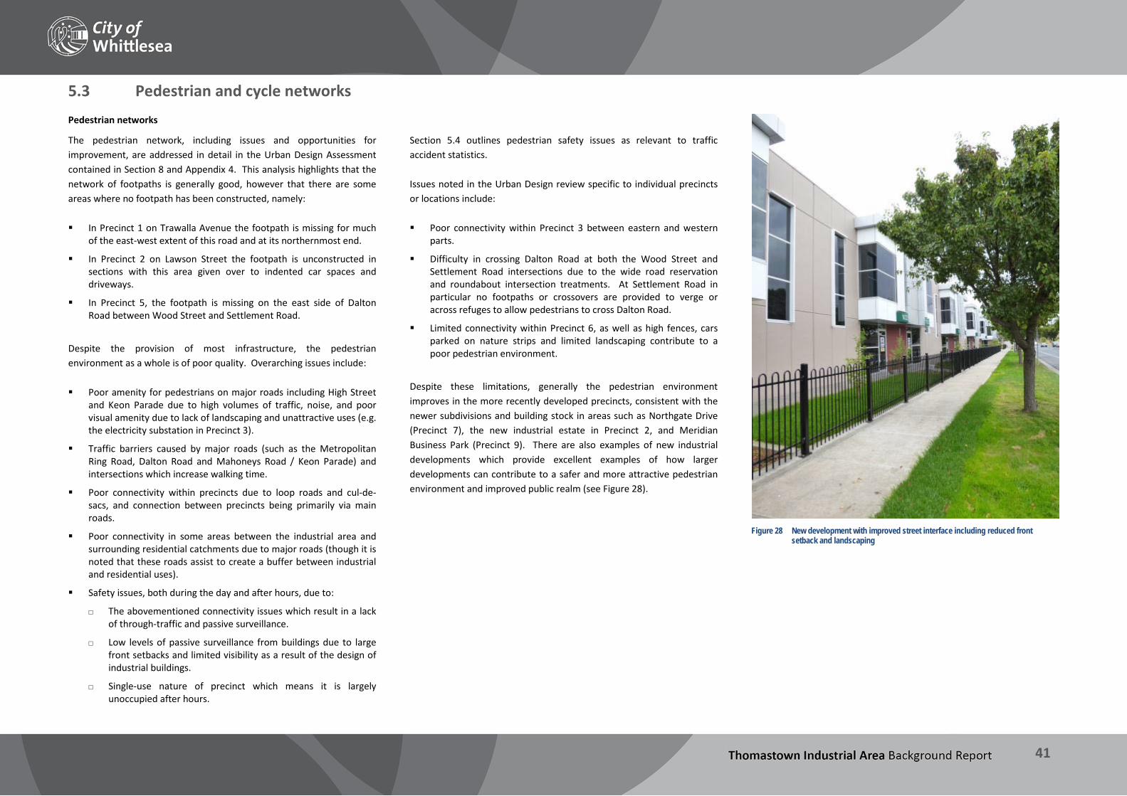
THOMASTOWN INDUSTRIAL AREA Background Report
41
5.3 Pedestrian and cycle networks Pedestrian networks
The pedestrian network, including issues and opportunities for improvement, are addressed in detail in the Urban Design Assessment contained in Section 8 and Appendix 4. This analysis highlights that the network of footpaths is generally good, however that there are some areas where no footpath has been constructed, namely: In Precinct 1 on Trawalla Avenue the footpath is missing for much
of the east-west extent of this road and at its northernmost end.
In Precinct 2 on Lawson Street the footpath is unconstructed in sections with this area given over to indented car spaces and driveways.
In Precinct 5, the footpath is missing on the east side of Dalton Road between Wood Street and Settlement Road.
Despite the provision of most infrastructure, the pedestrian environment as a whole is of poor quality. Overarching issues include: Poor amenity for pedestrians on major roads including High Street
and Keon Parade due to high volumes of traffic, noise, and poor visual amenity due to lack of landscaping and unattractive uses (e.g. the electricity substation in Precinct 3).
Traffic barriers caused by major roads (such as the Metropolitan Ring Road, Dalton Road and Mahoneys Road / Keon Parade) and intersections which increase walking time.
Poor connectivity within precincts due to loop roads and cul-de-sacs, and connection between precincts being primarily via main roads.
Poor connectivity in some areas between the industrial area and surrounding residential catchments due to major roads (though it is noted that these roads assist to create a buffer between industrial and residential uses).
Safety issues, both during the day and after hours, due to:
The abovementioned connectivity issues which result in a lack of through-traffic and passive surveillance.
Low levels of passive surveillance from buildings due to large front setbacks and limited visibility as a result of the design of industrial buildings.
Single-use nature of precinct which means it is largely unoccupied after hours.
Section 5.4 outlines pedestrian safety issues as relevant to traffic accident statistics. Issues noted in the Urban Design review specific to individual precincts or locations include: Poor connectivity within Precinct 3 between eastern and western
parts.
Difficulty in crossing Dalton Road at both the Wood Street and Settlement Road intersections due to the wide road reservation and roundabout intersection treatments. At Settlement Road in particular no footpaths or crossovers are provided to verge or across refuges to allow pedestrians to cross Dalton Road.
Limited connectivity within Precinct 6, as well as high fences, cars parked on nature strips and limited landscaping contribute to a poor pedestrian environment.
Despite these limitations, generally the pedestrian environment improves in the more recently developed precincts, consistent with the newer subdivisions and building stock in areas such as Northgate Drive (Precinct 7), the new industrial estate in Precinct 2, and Meridian Business Park (Precinct 9). There are also examples of new industrial developments which provide excellent examples of how larger developments can contribute to a safer and more attractive pedestrian environment and improved public realm (see Figure 28).
Figure 28 New development with improved street interface including reduced front
setback and landscaping

THOMASTOWN INDUSTRIAL AREA Background Report
42
Cycling networks
Cycling infrastructure within the industrial area is extremely limited. Whilst upgrades are proposed under the draft Whittlesea Bicycle Plan 2014-2018, the existing cycle network is restricted to on-road bike lanes on Mahoney’s Road / Keon Parade, the Metropolitan Ring Road Trail (off-road), and a short (350 metres) segment of on-road bike lane on Edgars Road on the southbound side only. These lanes are shown on the map at Figure 30, together with proposed on-road bike lanes on Edgars Road, High Street and Dalton Road, and off-road shared paths on Dalton Road.
Figure 29 Shared path – west side Dalton Road
This additional cycling infrastructure will improve links through the precinct as well as to public transport links such as the railway stations via High Street – there is therefore a key opportunity to provide for increased cycling to places of work from outside the industrial area, and for multi-modal trips using both trains and cycling. Increased opportunities for employees to cycle to work was a recurring theme during the initial consultation (refer Section 9.2).
Opportunities to provide for increased cycling within the industrial area however are limited by the existing road layout. Due to the prevalence of loop roads and cul-de-sacs within the local road network, connectivity between precincts is primarily via busy arterial roads, with associated safety issues including busy intersections and use by heavy vehicles. The Urban Design Review identifies several more local walking and cycling connections that may improve internal connectivity, which are also shown in Figure 30.

THOMASTOWN INDUSTRIAL AREA Background Report
43
Figure 30 Cycling network
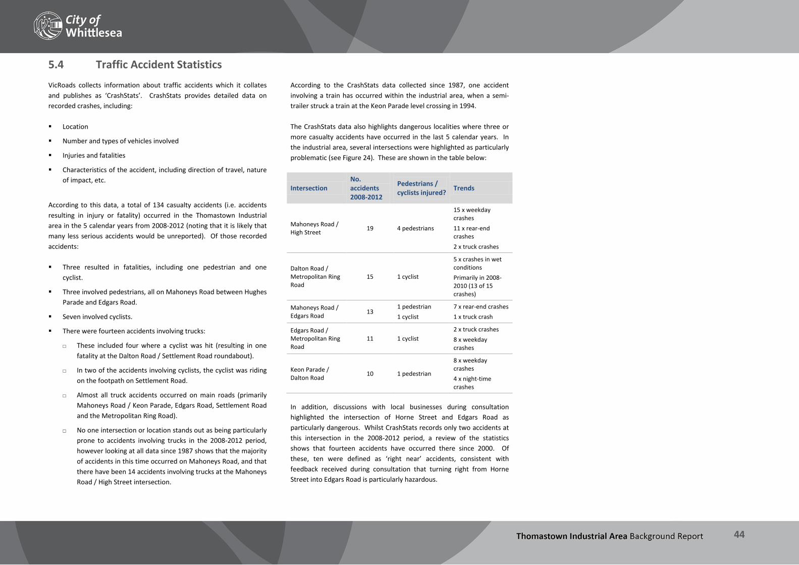
THOMASTOWN INDUSTRIAL AREA Background Report
44
5.4 Traffic Accident Statistics VicRoads collects information about traffic accidents which it collates and publishes as ‘CrashStats’. CrashStats provides detailed data on recorded crashes, including: Location
Number and types of vehicles involved
Injuries and fatalities
Characteristics of the accident, including direction of travel, nature of impact, etc.
According to this data, a total of 134 casualty accidents (i.e. accidents resulting in injury or fatality) occurred in the Thomastown Industrial area in the 5 calendar years from 2008-2012 (noting that it is likely that many less serious accidents would be unreported). Of those recorded accidents: Three resulted in fatalities, including one pedestrian and one
cyclist.
Three involved pedestrians, all on Mahoneys Road between Hughes Parade and Edgars Road.
Seven involved cyclists.
There were fourteen accidents involving trucks:
These included four where a cyclist was hit (resulting in one fatality at the Dalton Road / Settlement Road roundabout).
In two of the accidents involving cyclists, the cyclist was riding on the footpath on Settlement Road.
Almost all truck accidents occurred on main roads (primarily Mahoneys Road / Keon Parade, Edgars Road, Settlement Road and the Metropolitan Ring Road).
No one intersection or location stands out as being particularly prone to accidents involving trucks in the 2008-2012 period, however looking at all data since 1987 shows that the majority of accidents in this time occurred on Mahoneys Road, and that there have been 14 accidents involving trucks at the Mahoneys Road / High Street intersection.
According to the CrashStats data collected since 1987, one accident involving a train has occurred within the industrial area, when a semi-trailer struck a train at the Keon Parade level crossing in 1994. The CrashStats data also highlights dangerous localities where three or more casualty accidents have occurred in the last 5 calendar years. In the industrial area, several intersections were highlighted as particularly problematic (see Figure 24). These are shown in the table below:
Intersection No. accidents 2008-2012
Pedestrians / cyclists injured? Trends
Mahoneys Road / High Street 19 4 pedestrians
15 x weekday crashes 11 x rear-end crashes 2 x truck crashes
Dalton Road / Metropolitan Ring Road
15 1 cyclist
5 x crashes in wet conditions Primarily in 2008-2010 (13 of 15 crashes)
Mahoneys Road / Edgars Road 13
1 pedestrian 1 cyclist
7 x rear-end crashes 1 x truck crash
Edgars Road / Metropolitan Ring Road
11 1 cyclist 2 x truck crashes 8 x weekday crashes
Keon Parade / Dalton Road 10 1 pedestrian
8 x weekday crashes 4 x night-time crashes
In addition, discussions with local businesses during consultation highlighted the intersection of Horne Street and Edgars Road as particularly dangerous. Whilst CrashStats records only two accidents at this intersection in the 2008-2012 period, a review of the statistics shows that fourteen accidents have occurred there since 2000. Of these, ten were defined as ‘right near’ accidents, consistent with feedback received during consultation that turning right from Horne Street into Edgars Road is particularly hazardous.

THOMASTOWN INDUSTRIAL AREA Background Report
45
5.5 Utility Infrastructure Utility infrastructure is a feature of the industrial area, major transmission and distribution for electricity and gas networks as well as drainage assets are located throughout. The easements for this infrastructure in many cases are on private land although utility providers such as SP Ausnet, APA Gasworks, Melbourne Water and Yarra Valley Water own some parcels of land as well. Major utility infrastructure in the industrial area is described below. Gas infrastructure
There are a number of gas pipelines and assets that transect the industrial area. A major asset is the APA Gasnet owned Keon Park to Wollert Pipeline and this is situated in the western part of the industrial area. It is a high pressure pipeline which forms part of the Victorian natural gas transmission system and was commissioned in 1976. The line runs north-south and connects from just south of Mahoneys Road and directly north primarily along the Hume Freeway (it is approximately 14.2km in length in total). A further APA Networks (Envestra) gas pipeline runs east-west through the industrial area within the Mahoney’s Road/Keon Parade road reservations. This pipeline then continues further east along Holt Parade towards Bundoora.
Figure 31 The Comdain / Envestra / APA site
Primary and secondary location classifications are set out by Australian Standard 2885.1 and these require consideration to be given to future development proximate to the gas pipeline routes both within and outside the easement area. Generally the standard requires measurement lengths from the pipeline subject to location classes and
these designations are based on the risk associated with a failure of the pipeline.
Electricity Infrastructure
There are a number of electricity assets which transect the industrial area, anchored from SP Ausnet’s major electricity transmission station which is situated on the north-west corner of High Street and Mahoneys Road. This site is one of the largest parcels in the industrial area at almost 34 hectares, and is a key gateway to the City of Whittlesea via High Street, however the transmission station presents poorly to this corner.
Figure 32 Transmission lines viewed from street
The site also contains zone substations which allows for electricity distribution directly from the site. The transmission station was established in the 1950s and connects to Brunswick and South Morang Terminal Stations and as such forms part of the transmission and distribution network for the northern suburbs. The lines operate at 220 kV, similar to many 220 kV lines in the Melbourne metropolitan area. A number of overhead subtransmission lines (66 kV lines) connect from
the transmission station as well. Most of SP Ausnet’s assets, outside their terminal station site, are within easements on privately owned land. Drainage infrastructure
There are a number of drainage assets throughout the industrial area. These include assets managed by Council, Melbourne Water and Yarra Valley Water. Significant drainage assets include the Yarra Valley Water Morang to Preston water transfer main that runs north-south and is situated along the east side of Dalton Road. Also along the eastern boundary of the industrial area runs the Melbourne Water pipe track reservation (the former Maroondah Aqueduct).
Figure 33 Melbourne Water drainage easement, Dalton Road
Some of these assets present as opportunities to improve connectivity, with the potential for cycle and pedestrian pathways to be created within some of the utility easements. The potential for this is restricted as many of the easements are within private property, however opportunities for improved amenity through revegetating, landscaping and provision of paths through these areas and allowing them to be available for public use should be explored. Another opportunity to improve pedestrian and cycling connectivity is via the Edgars Creek reserve – this currently functions primarily as a drainage reserve through the industrial area, but could be improved significantly through targeted revegetation and the development of shared paths, seating areas and so on.
THOMASTOWN INDUSTRIAL AREA Background Report
46
Key findings – Transport and infrastructure The review of the existing transport and utility infrastructure in the industrial area highlights the following: The road network within and adjacent to the industrial area is a
significant asset that is key to the ongoing success of businesses in the precinct.
Further work is required to assess the functionality of the road network to identify any capacity issues, and model future development scenarios and their potential impact on roads in the industrial area.
Connectivity to regional and interstate port and logistics facilities is excellent.
Freight connectivity is good, with the arterial network and several local roads able to accommodate heavy vehicles.
The development of the future Beveridge Freight Terminal will be a further advantage to businesses in the industrial area, and provide further opportunities for both delivery and receipt of freight to and from state-wide and national networks.
Public transport coverage by rail and bus is good, with two train stations servicing precincts in the centre of the industrial area, and buses providing access more broadly. Further analysis will be required to obtain a more detailed assessment of the proportion of land in the industrial area accessible by public transport and an assessment of the opportunities this may present.
Cycling infrastructure in the industrial area is extremely limited, and is a significant barrier to improving the modal split between private vehicles and sustainable transport for workers in the area (see discussion at Section 9.2). Safety concerns for cyclists include dangerous roundabouts and high traffic volumes and speed limits. Opportunities exist for on-road cycle lanes on arterial roads to connect to the existing network, and for improved connections from local streets.
Pedestrian amenity in the industrial area is poor. Whilst footpaths exist on the majority of streets (with some notable exceptions – refer Section 5), noisy and high speed traffic, poor connectivity, and poor surveillance contribute to a poor pedestrian environment.
Crash data highlights these conflicts between pedestrians, cyclists and vehicle traffic, as well as the problem intersections where a relatively high number of accidents occur. Further work is required to assess the critical factors in these accidents and determine what, if any, interventions may be required to improve these intersections and prevent future accidents.
Utility infrastructure throughout the industrial area has a significant impact on the landscape and affects visual amenity and (in some areas) development capacity. While these assets are more or less fixed in place, opportunities exist to improve their presentation to the industrial area and enhance them for public purposes including shared paths and linear open space.

THOMASTOWN INDUSTRIAL AREA Background Report
47
6 Environmental Conditions The main environmental features of the area, including sites which have potential for revegetation, are the four creeks which are described below. The industrial area also has a small number of public open spaces in the form of pocket parks. Areas of open space are discussed in Section 8. The impacts on the natural environment from the industrial (and commercial) operations can be significant. Environmental constraints that affect the area may also impact future development potential of some sites in the industrial area, while also create opportunities for improvements.

THOMASTOWN INDUSTRIAL AREA Background Report
48
6.1 Stormwater Urban stormwater runoff impacts directly on the municipality’s waterways, and runoff generated by the industrial areas is a significant issue. Under normal circumstances, rainfall filters into the soil where it is absorbed, only running into creeks when the soil is saturated. In urban environments, impervious surfaces created by roofs and paved areas prevent this absorption, which impacts both the quantity and quality of water flowing into creeks: Quantity: significantly more water flows from the drainage system
into creeks when it rains, increasing the rate of flow and the turbidity (cloudiness) of the water.
Quality: stormwater runoff collects pollutants as it flows over hard surfaces, depositing them into local waterways through the drainage system, often without any treatment.
Figure 34 Debris left by downstream flooding of Darebin Creek, June 2013
In industrial areas there is a much higher proportion of impervious surfaces – including paved outdoor areas and roofing for large building footprints – compared to other land uses such as residential areas which usually incorporate front and back gardens, wide nature strips, and neighbourhood parks. This high proportion of impervious surface is a common characteristic in many parts of the Thomastown industrial area in both new and older building stock. This development has a cumulative effect over the length of a waterway, with excessive upstream runoff into creeks having the potential to cause significant downstream flooding impacts (see Figure 34).
Council’s Stormwater Management Plan 2012-17 outlines significant management issues with stormwater including ongoing stormwater quality and quantity threats such as litter and poor management practices. In addition to the issues caused by industrial development patterns, serious stormwater pollution associated with workplace practices, particularly in industrial areas such as Thomastown, has also been identified. Stormwater runoff from the industrial area, and urban development more generally, into the Edgars, Merri and Darebin Creeks have negatively impacted the waterways both locally and downstream. Common pollutants identified include: Toxic chemicals, such as paints, solvents, and pesticides
Nutrients such as nitrogen, fertilizers, and organic materials
Litter, fuels, oils and automotive materials from roads
Sediment, mud or silt resulting from erosion
Monitoring undertaken by the EPA in 2009 of businesses within the industrial area highlighted business types that posed the highest risk to stormwater due to the types of materials and equipment used, including Automotive Services & Machinery, Metalwork, Food Processing / Manufacturing, Hardware, Construction, Light Industry, and Manufacturing. Their report (BMT WBM Pty Ltd on behalf of EPA Victoria, EPA site inspections 2009: Thomastown and Coburg, December 2009) identified that land uses such as general manufacturing, and retail and wholesale trade were high risk businesses (i.e. have the greatest potential to impact on stormwater), and that solid and liquid waste in drains remained a significant threat to stormwater quality. Litter was also highlighted as an on-going problem in industrial areas including Thomastown. Merri, Edgars and Darebin Creeks have been found to be polluted with heavy metals and other toxic pollutants and litter as a result of stormwater runoff from uses in the industrial area. Analysis undertaken in 2011 (Victorian Centre for Aquatic Pollution Identification and Management, Technical Report #05, July 2011) found higher levels of pollutants in the stormwater drainage network in the Thomaston industrial area, compared to residential networks. Pollutants found included arsenic, chromium, copper, lead, mercury and silver. The study also identified the area between Mahoneys Road and the Thomastown Main Drain as a pollution hotspot.
Figure 35 Site photo from 2009 EPA monitoring: spilled engine fluids washing into
stormwater drain
There are opportunities to explore improvements to the quality of stormwater run-off from industrial sites through improved stormwater management systems. The development of design guidelines for industrial premises is a key opportunity to influence the stormwater impact of new buildings, and extensions to existing ones. Improvements in stormwater quality and run off are also likely to occur over time as businesses types change and practices such as lean manufacturing become more engrained in general industry. There may be opportunities to seek improvements to existing premises through the installation of appropriately sized rainwater tanks as part of development associated with alterations and additions to existing buildings. Such installations would capture roof runoff and allow the gradual release of water into the stormwater system, which reduces the risk of downstream flooding and benefits waterways by reducing peak flows. Other measures include ensuring water flows directly into the sewer rather than the stormwater system, and the use of on-site bioretention within landscaping areas to slow the flow of runoff and filter pollutants.

THOMASTOWN INDUSTRIAL AREA Background Report
49
6.2 Site Contamination Potentially contaminated sites
Ministerial Direction No. 1 (Potentially Contaminated Land) defines contaminated land as that used or known to have been used for industry, mining or the storage of chemicals, gas, wastes or liquid fuel (if not ancillary to another use of land). It requires planning authorities when preparing planning scheme amendments, to satisfy themselves that the environmental conditions of land proposed to be used for a sensitive use (defined as residential, child-care centre, pre-school centre or primary school), agriculture or public open space are, or will be, suitable for that use. The Potentially Contaminated Land General Practice Note (June 2005) lists a number of uses common to the industrial area that have a high potential for contamination such as abattoirs, automotive repair / engine works, chemical manufacturing/storage/blending, electrical components manufacture, glass manufacture, mining and extractive industries, and textile operations. Current and previous uses on sites within the industrial area may have caused contamination. Land used for extractive industry and subsequently filled may also have been contaminated. Such uses could have implications for the future redevelopment of the land on which they are located, including the extension and refurbishment of existing buildings due to the historic nature of the uses. Extensive investigations have not been undertaken to date on land within the industrial area that may be contaminated due to their land use history. Further detailed assessments may be required to determine what land contamination is present and whether measures need to be put in place to ensure future redevelopment of the land addresses any remedial works that are required. Known contaminated sites
The EPA’s Priority Sites Register identifies sites where notices have been issued to address land and/or groundwater contamination. The EPA has assessed the condition of these sites as not being compatible with the current or approved use of the site, and identified where active management is required to reduce the risk to human health and the environment. It should be noted that these sites are only the known major contaminated sites and there may be other contaminated sites within the study area given the nature of the existing and/or historical land uses and processes that have been undertaken on site, chemicals
that have been used and/or the age of infrastructure and management processes/practices. The Register currently includes three sites within the industrial area that require assessment and or/clean up: 51 High Street (current industrial site).
342 Settlement Road (former service station).
6 Dunstans Court (former industrial site).
Two of the above sites (342 Settlement Road and 6 Dunstans Court) could present as redevelopment opportunities in the shorter term. 342 Settlement Road is currently vacant and covers an area of approximately 3.3ha while 6 Dunstan Court which comprises an area of 12.7ha is partially vacant, with buildings existing on the western part of the site. Any redevelopment on these sites is likely to be subject to environmental audits, and remediation works may be required. The time and costs involved in this may constrain future investment and development potential. 51 High Street is currently occupied by Bostik Findlay and it is unknown whether future redevelopment of this site is likely to occur. This site is also located close to the Edgars Creek where opportunities exist to enhance and revegetate the creek and potentially create an open space link through this area. Quarry sites
The area does not have a significant history of quarrying and subsequent landfilling. There are only two known sites which have been or are being used for quarrying and these are discussed below. It is possible that other areas have been quarried and landfilled and due to the age of the operations have not been identified in this background review. 2 Trawalla Avenue is located in Precinct 1. It is a quarry that is
currently operational and used for quarrying of clay by Boral Bricks. At the end of its life options will be investigated for landfill of this site. The undertaking of remedial works to ensure the site is safe to redevelop and the potential for filling of the quarry holes is a long term prospect for this site. Anecdotally the site is thought to provide habitat for populations of the Growling Grass Frog.
149 McKimmies Road is located in Precinct 8 and was previously used as a quarry. The site is now used for landfill, accepting clean
fill, as well as having some materials recycling operations. The EPA advised that both these uses do not require works approval or licensing in accordance with the Environment Protection (Scheduled Premises and Exemptions) Regulations 2007. This site is also known to provide habitat for significant populations of the Growling Grass Frog and also contains significant remnant vegetation.
There are opportunities emerging to use former quarry sites in the City of Whittlesea as stormwater storage for later reuse in irrigation, which could occur in conjunction with the use of these sites for public open space for community and environmental benefit. The quarry sites could also provide future opportunities for adaptive reuse, with the potential for commercial or mixed use development (noting that this is heavily dependent on geotechnical considerations and contamination risk).

THOMASTOWN INDUSTRIAL AREA Background Report
50
6.3 Amenity considerations Visual Amenity
Council’s Planning Enforcement and Local Laws teams regularly monitor the industrial area to ensure the amenity and appearance of the area is maintained and enhanced. Council’s Environmental Operations team also has an ongoing program of monitoring the pollutants from stormwater run-off in industrial areas (as discussed in the previous section). Utility providers such as APA Gasnet and SP Ausnet also regularly monitor their assets, chiefly for safety reasons, and enact enforcement measures when required. Breaches commonly noted by these agencies include: Poor maintenance of properties including landscaping not being
maintained, or rubbish/waste stored in publicly visible areas;
On-site car parking areas used for storage;
Storage containers and other structures being constructed illegally or being located on electricity or gas easements;
Illegal uses, such as storage of materials, or conducting retail sales out of warehouses;
Illegal signage, such as ‘A’ Frames;
Non-compliance with planning permit conditions, particularly in regards to design elements i.e. not painting concrete walls and landscaping not completed/maintained;
Fencing, usually inappropriate or non-compliant front fencing; and
Graffiti and vandalism.
Some parts of the industrial area have also been identified as being more prone to breaches than others. These are generally the older parts of the industrial area, such as the older areas of Precincts 2, 4 and 9, where there is often limited scope for enforcement action due to a lack of permits for these properties. There are also ongoing issues with graffiti on large walls presenting to key interfaces such as the Metropolitan Ring Road (see Figure 36), which are frequently cleaned up by site owners then re-vandalised. It is worth noting that with regard to industrial amenity impacts, such as noise, odour, dust etc., both the EPA and the City of Whittlesea’s Local Laws department report that they have received no complaints or
requests to investigate any properties or businesses operating within the Thomastown Industrial Area.
Figure 36 Graffiti on building façade
While some breaches will require ongoing monitoring by Council and other agencies, opportunities exist to improve the functionality of the area through the implementation of appropriate design guidelines through planning permits for new developments, extensions to existing buildings and potentially for change of use (in some circumstances). New subdivisions can also be designed to reduce the potential for future encroachment of buildings or structures onto easement areas, and construction materials and general design measures can be used to limit graffiti. Advertising guidelines and standards for businesses identification signage can also significantly improve the visual amenity of the area while also providing a consistent approach across industrial areas. Opportunities to allow businesses to have more exposure to attract business and trade while ensure the area is attractive will need to be explored further through the Urban Design Review.
Waste
Waste management continues to be an issue for the industrial area, as is the dumping of rubbish and litter. Waste generated by some industrial uses can also be potentially hazardous to humans and the environments and requires a higher level of control in how it is disposed of and/or reused. Site visits undertaken by the EPA in 2009 found that 20% of
Thomastown businesses had some litter on site, particularly cigarette butt litter, with 21% of businesses also containing litter in their drains. This litter has the potential to be blown off site and into drains and creeks, contributing to the degradation of the waterways. While litter and the dumping of rubbish cannot always be addressed through planning, consideration should be given to the design of new developments to ensure that there is active surveillance of public areas to reduce potential for illegal dumping. Appropriately designed waste disposal areas within new developments also has the potential to limit the storage of waste in car parking areas in the front setback, which may in turn prevent car parking conflicts caused by vehicles spilling out onto the street and nature strips.
Figure 37 Inappropriate stockpiling of waste materials in front setback
There are currently no recycling programs undertaken by Council for the collection of recycled materials in the industrial area, although private companies and contractors do provide this service. The Council is also trialling recycling services for commercial properties, though currently this predominantly applies to retail premises. There may be opportunities to consider this for industrial properties in the future. There are also opportunities to develop guidelines and standards to ensure that waste and recycle bin storage areas are appropriately designed into new developments to improve the overall amenity of the area as well as functionality for businesses.

THOMASTOWN INDUSTRIAL AREA Background Report
51
Key influences – Environmental conditions The review of the environmental conditions highlights the following: Poor stormwater quality and subsequent pollution of the creeks
and waterways in the area is a significant issue. There are opportunities to explore improvements to the quality of stormwater run-off from industrial sites through improved stormwater management. As outlined in Section 2 design guidelines for industrial development along with sustainable measures through design could assist with addressing the contamination problems caused by pollutants from industrial sites into the waterways through the stormwater system.
Monitoring of stormwater quality is a good indicator of the health of industry in the industrial area and can provide an insight into changes in practices of industry as it demonstrates that the quality of procedures (such as lean manufacturing practices) are likely to have increased and resulted in less contaminants entering the stormwater system.
There are a number of sites which have been identified on EPA’s Priority Sites Register where issues of land and/or groundwater contamination need to be addressed.
Extensive investigations on land within the industrial area have not been undertaken to date with a history of works contamination. Further detailed assessments would be required to determine what land contamination is present and whether measures need to be put in place to ensure future redevelopment of the land addresses any remedial works that are required.
Ministerial Direction No. 1 (Potentially Contaminated Land) requires planning authorities when preparing planning scheme amendments, to satisfy themselves that the environmental conditions of land proposed to be used for a sensitive use. This may influence future redevelopment potential of certain sites and remedial works may be required to enable future development.
The quarry sites represent future development opportunities but have significant environmental constraints which need to be considered and managed before redevelopment can be accommodated.

THOMASTOWN INDUSTRIAL AREA Background Report
52
7 Land Use Influences The Thomastown Industrial Area has unique characteristics which make it a highly suitable and competitive employment area. While providing excellent local employment opportunities due to its proximity to established residential areas, it is also uniquely situated in terms of being buffered from sensitive land uses. This section describes the implications of land use zoning and existing land use profile of the industrial area.
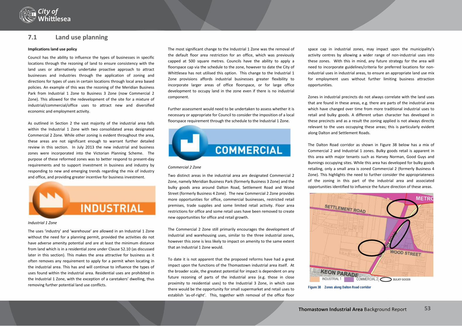
THOMASTOWN INDUSTRIAL AREA Background Report
53
7.1 Land use planning Implications land use policy
Council has the ability to influence the types of businesses in specific locations through the rezoning of land to ensure consistency with the land uses or alternatively undertake proactive approach to attract businesses and industries through the application of zoning and directions for types of uses in certain locations through local area based policies. An example of this was the rezoning of the Meridian Business Park from Industrial 1 Zone to Business 3 Zone (now Commercial 2 Zone). This allowed for the redevelopment of the site for a mixture of industrial/commercial/office uses to attract new and diversified economic and employment activity. As outlined in Section 2 the vast majority of the industrial area falls within the Industrial 1 Zone with two consolidated areas designated Commercial 2 Zone. While other zoning is evident throughout the area, these areas are not significant enough to warrant further detailed review in this section. In July 2013 the new industrial and business zones were incorporated into the Victorian Planning Scheme. The purpose of these reformed zones was to better respond to present-day requirements and to support investment in business and industry by responding to new and emerging trends regarding the mix of industry and office, and providing greater incentive for business investment.
Industrial 1 Zone
The uses ‘industry’ and ‘warehouse’ are allowed in an Industrial 1 Zone without the need for a planning permit, provided the activities do not have adverse amenity potential and are at least the minimum distance from land which is in a residential zone under Clause 52.10 (as discussed later in this section). This makes the area attractive for business as it often removes any requirement to apply for a permit when locating in the industrial area. This has and will continue to influence the types of uses found within the industrial area. Residential uses are prohibited in the Industrial 1 Zone, with the exception of a caretakers’ dwelling, thus removing further potential land use conflicts.
The most significant change to the Industrial 1 Zone was the removal of the default floor area restriction for an office, which was previously capped at 500 square metres. Councils have the ability to apply a floorspace cap via the schedule to the zone, however to date the City of Whittlesea has not utilised this option. This change to the Industrial 1 Zone provisions affords industrial businesses greater flexibility to incorporate larger areas of office floorspace, or for large office development to occupy land in the zone even if there is no industrial component. Further assessment would need to be undertaken to assess whether it is necessary or appropriate for Council to consider the imposition of a local floorspace requirement through the schedule to the Industrial 1 Zone.
Commercial 2 Zone
Two distinct areas in the industrial area are designated Commercial 2 Zone, namely Meridian Business Park (formerly Business 3 Zone) and the bulky goods area around Dalton Road, Settlement Road and Wood Street (formerly Business 4 Zone). The new Commercial 2 Zone provides more opportunities for office, commercial businesses, restricted retail premises, trade supplies and some limited retail activity. Floor area restrictions for office and some retail uses have been removed to create new opportunities for office and retail growth. The Commercial 2 Zone still primarily encourages the development of industrial and warehousing uses, similar to the three industrial zones, however this zone is less likely to impact on amenity to the same extent that an Industrial 1 Zone would. To date it is not apparent that the proposed reforms have had a great impact upon the functions of the Thomastown industrial area itself. At the broader scale, the greatest potential for impact is dependent on any future rezoning of parts of the industrial area (e.g. those in close proximity to residential uses) to the Industrial 3 Zone, in which case there would be the opportunity for small supermarket and retail uses to establish ‘as-of-right’. This, together with removal of the office floor
space cap in industrial zones, may impact upon the municipality’s activity centres by allowing a wider range of non-industrial uses into these zones. With this in mind, any future strategy for the area will need to incorporate guidelines/criteria for preferred locations for non-industrial uses in industrial areas, to ensure an appropriate land use mix for employment uses without further limiting business attraction opportunities. Zones in industrial precincts do not always correlate with the land uses that are found in these areas, e.g. there are parts of the industrial area which have changed over time from more traditional industrial uses to retail and bulky goods. A different urban character has developed in these precincts and as a result the zoning applied is not always directly relevant to the uses occupying these areas; this is particularly evident along Dalton and Settlement Roads. The Dalton Road corridor as shown in Figure 38 below has a mix of Commercial 2 and Industrial 1 zones. Bulky goods retail is apparent in this area with major tenants such as Harvey Norman, Good Guys and Bunnings occupying sites. While this area has developed for bulky goods retailing, only a small area is zoned Commercial 2 (formerly Business 4 Zone). This highlights the need to further consider the appropriateness of the zoning in this part of the industrial area and associated opportunities identified to influence the future direction of these areas.
Figure 38 Zones along Dalton Road corridor

THOMASTOWN INDUSTRIAL AREA Background Report
54
Potential land use conflicts
Land use planning plays a significant role in ensuring that uses which have the potential to cause adverse amenity impacts are situated away from sensitive uses, through zoning and other mechanisms. Where appropriate, the planning scheme also specifies threshold distances for certain industrial uses to minimise their off-site impacts on sensitive land uses. As described in Section 2 there are a number of policies and guidelines which seek to protect areas which contain sensitive uses from industrial uses with adverse amenity potential. When considering any planning permit application within an industrial zone, Council must consider the impact that the proposal may have upon any nearby sensitive uses, such as residential, including land in neighbouring municipalities. Clause 52.10 of the Whittlesea Planning Scheme (‘Uses with adverse amenity potential’) identifies industrial and warehousing activities which if not appropriately designed and located may cause offence or unacceptable risk to the neighbourhood. It provides threshold distances for these uses to more sensitive zones/uses. These threshold distances are applied in all Victorian Planning Schemes. The threshold distances vary dependent on the processes to be used and the materials to be processed or stored, however in the Industrial 1 Zone, all industrial and warehousing uses are required to avoid any adverse amenity impacts on nearby sensitive uses through the: Transport of materials, goods or commodities to or from the land;
Appearance of any stored goods or materials; or
Emission of noise, artificial light, vibration, odour, fumes, smoke, vapour, steam, soot, ash, dust, water, waste products.
A key strength of the Thomastown industrial area is that it is one of the largest consolidated areas of industrially zoned land in the City of Whittlesea and in Melbourne’s northern region. This provides opportunities for uses that may trigger minimum buffer distances to locate in many parts of the industrial area with limited risk of amenity impacts on sensitive uses (e.g. through noise, odour or dust). While future directions for land use must have specific regard to potential land use conflicts, it should also be recognised that not all land use conflicts are avoidable due to historical land use patterns and the interaction between different land uses.
A detailed assessment of the zoning within the industrial area may be warranted, including the appropriateness of the Industrial 1 Zone in certain locations, such as those within close proximity to residentially zoned land. The purpose of the Industrial 3 Zone is to act as a buffer between the Industrial 1 Zone and local communities, and facilitate more compatible intermediate uses. It is intended to provide for industries and associated uses in specific areas where special consideration of the nature and impacts of industrial uses is required or to avoid inter-industry conflict and ensure that uses do not affect the safety and amenity of adjacent, more sensitive land uses. Some industrial land shares an interface with residential areas. The majority of interfaces with residentially zoned land are buffered by major roads or land in public use. The potential conflict between industrial uses and residential areas does however require careful consideration of zoning and long term strategic planning of these areas.
Figure 39 Vacant residential site in foreground directly adjacent to industrial premises in
Longview Court
The table below shows that there are areas within the industrial area that have a higher potential for land use conflict than others. Key areas which currently have residential land adjacent or proximate to the Industrial 1 Zone (i.e. not separated by a major road) and which will need further detailed consideration include: Location Description Proximity to
sensitive area
Precinct
Tunaley Parade (R1Z) and Holt Parade (IN1Z)
Properties on the south side of Holt Parade directly border residentially zoned land (within the City of Darebin).
0 metres 6
Warrenwood Place and Lagen Court (R1Z) and Settlement Road, Apex Court and Nevin Drive (IN1Z)
Properties to the southeast of Settlement Road, Apex Court and Nevin Drive border PUZ (Melbourne Water Pipe Track) which abuts residentially zoned land.
20 metres (width of pipetrack reservation)
6
Virginia Crescent (R1Z) and Commercial Drive and Longview Court (IN1Z)
Properties to the southeast of Commercial Drive and Longview Court border PUZ (Melbourne Water Pipe Track) which abuts residentially zoned land.
20-25 metres (width of pipetrack reservation)
7
Land at 172 Greenhills Road (R1Z)
South of the Metropolitan Ring Road R1Z (within industrial area boundary) borders land in IN1Z known as 51-55 and 64-68 Longview Court and 22-38 Wells Road. North of the Metropolitan Ring Road R1Z borders land in IN1Z known as 172 Greenhills Road.
Within Study Area
7 & 8
Bramble Crescent, Scarlet Crescent, Lemon Gum, Oasis Place (R1Z) and 149 McKimmies Road (IN1Z)
Land directly adjoins R1Z. This land also forms part of the land reserved for public acquisition when the E6 is constructed.
0 metres 8
Alison Street (R1Z) and Spencer Street (IN1Z)
Properties to the north of Spencer Street directly adjoin residentially zoned land.
0 metres 9
Heyington Avenue (IN1Z, C2Z and R1Z)
Residentially zoned land is situated to the northern side of Heyington Avenue.
20 metres (width of Heyington Avenue)
9
THOMASTOWN INDUSTRIAL AREA Background Report
55
The above assessment also demonstrates that land west of High Street, specifically Precincts 1-5, is well situated away from sensitive uses, and predominantly buffered by major roads. These precincts have the greatest potential for accommodating uses with adverse amenity potential and are not considered to require further assessment in relation to the need for buffer zoning. Further consideration will however be required in relation to whether changes in zoning of the residential areas described above where IN1Z directly adjoins or is located in close proximity. It should be highlighted that while Precincts 6-9 do have some sensitive interfaces, a significant proportion of these areas are situated well away from sensitive uses and are therefore unlikely to be the source of major land use conflict in future. A significant risk to the ongoing strength and functioning of the industrial area is further encroachment of non-industrial uses, including but not limited to residential uses, which could affect the ongoing viability of existing industrial operations. This has already been observed in other areas of the municipality; for example Golden Circle in Mill Park has announced it will be closing in July 2014, citing (among other factors) ongoing operational issues due to residential encroachment on surrounding land. Section 7.2 contains an existing use profile of the industrial area based on surveys carried out in January 2014. A further detailed assessment of some of the environmental impacts of the types of uses such as noise, pollution, dust, odours and heavy vehicle movements is outlined in this section as well.
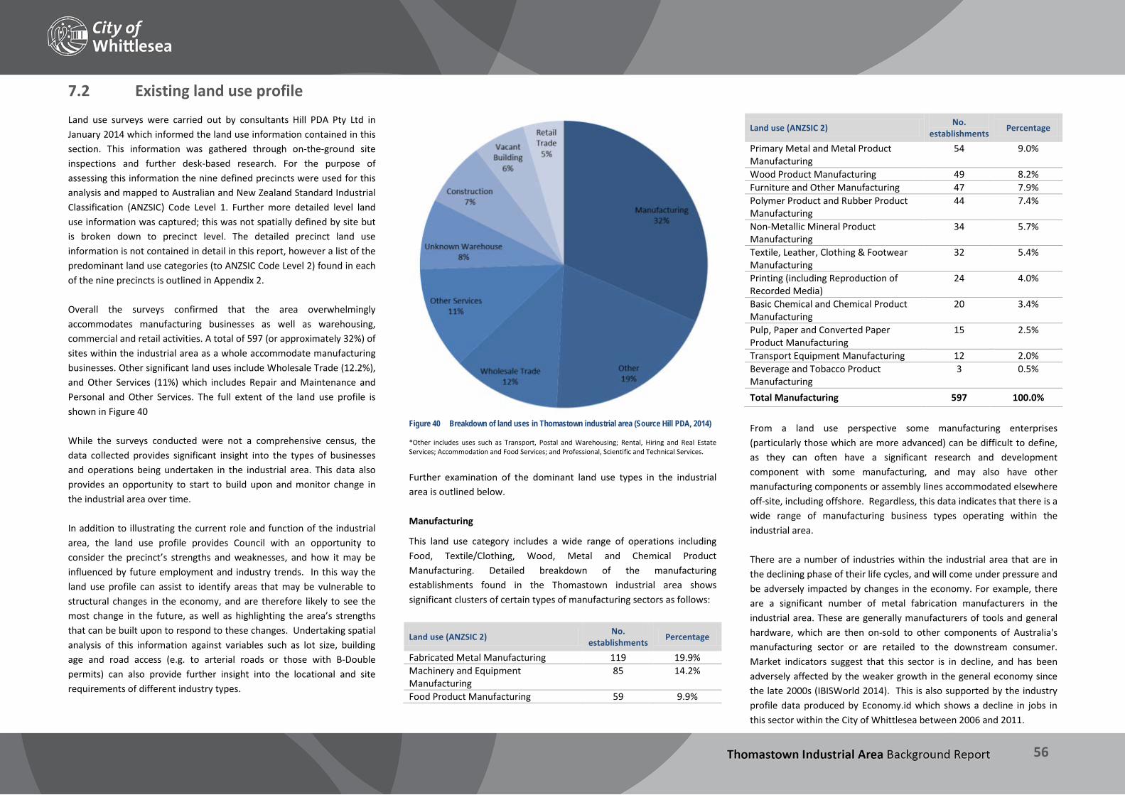
THOMASTOWN INDUSTRIAL AREA Background Report
56
7.2 Existing land use profile Land use surveys were carried out by consultants Hill PDA Pty Ltd in January 2014 which informed the land use information contained in this section. This information was gathered through on-the-ground site inspections and further desk-based research. For the purpose of assessing this information the nine defined precincts were used for this analysis and mapped to Australian and New Zealand Standard Industrial Classification (ANZSIC) Code Level 1. Further more detailed level land use information was captured; this was not spatially defined by site but is broken down to precinct level. The detailed precinct land use information is not contained in detail in this report, however a list of the predominant land use categories (to ANZSIC Code Level 2) found in each of the nine precincts is outlined in Appendix 2. Overall the surveys confirmed that the area overwhelmingly accommodates manufacturing businesses as well as warehousing, commercial and retail activities. A total of 597 (or approximately 32%) of sites within the industrial area as a whole accommodate manufacturing businesses. Other significant land uses include Wholesale Trade (12.2%), and Other Services (11%) which includes Repair and Maintenance and Personal and Other Services. The full extent of the land use profile is shown in Figure 40 While the surveys conducted were not a comprehensive census, the data collected provides significant insight into the types of businesses and operations being undertaken in the industrial area. This data also provides an opportunity to start to build upon and monitor change in the industrial area over time. In addition to illustrating the current role and function of the industrial area, the land use profile provides Council with an opportunity to consider the precinct’s strengths and weaknesses, and how it may be influenced by future employment and industry trends. In this way the land use profile can assist to identify areas that may be vulnerable to structural changes in the economy, and are therefore likely to see the most change in the future, as well as highlighting the area’s strengths that can be built upon to respond to these changes. Undertaking spatial analysis of this information against variables such as lot size, building age and road access (e.g. to arterial roads or those with B-Double permits) can also provide further insight into the locational and site requirements of different industry types.
Figure 40 Breakdown of land uses in Thomastown industrial area (Source Hill PDA, 2014)
*Other includes uses such as Transport, Postal and Warehousing; Rental, Hiring and Real Estate Services; Accommodation and Food Services; and Professional, Scientific and Technical Services. Further examination of the dominant land use types in the industrial area is outlined below. Manufacturing
This land use category includes a wide range of operations including Food, Textile/Clothing, Wood, Metal and Chemical Product Manufacturing. Detailed breakdown of the manufacturing establishments found in the Thomastown industrial area shows significant clusters of certain types of manufacturing sectors as follows:
Land use (ANZSIC 2) No. establishments Percentage
Fabricated Metal Manufacturing 119 19.9% Machinery and Equipment Manufacturing
85 14.2%
Food Product Manufacturing 59 9.9%
Land use (ANZSIC 2) No. establishments Percentage
Primary Metal and Metal Product Manufacturing
54 9.0%
Wood Product Manufacturing 49 8.2% Furniture and Other Manufacturing 47 7.9% Polymer Product and Rubber Product Manufacturing
44 7.4%
Non-Metallic Mineral Product Manufacturing
34 5.7%
Textile, Leather, Clothing & Footwear Manufacturing
32 5.4%
Printing (including Reproduction of Recorded Media)
24 4.0%
Basic Chemical and Chemical Product Manufacturing
20 3.4%
Pulp, Paper and Converted Paper Product Manufacturing
15 2.5%
Transport Equipment Manufacturing 12 2.0% Beverage and Tobacco Product Manufacturing
3 0.5%
Total Manufacturing 597 100.0% From a land use perspective some manufacturing enterprises (particularly those which are more advanced) can be difficult to define, as they can often have a significant research and development component with some manufacturing, and may also have other manufacturing components or assembly lines accommodated elsewhere off-site, including offshore. Regardless, this data indicates that there is a wide range of manufacturing business types operating within the industrial area. There are a number of industries within the industrial area that are in the declining phase of their life cycles, and will come under pressure and be adversely impacted by changes in the economy. For example, there are a significant number of metal fabrication manufacturers in the industrial area. These are generally manufacturers of tools and general hardware, which are then on-sold to other components of Australia's manufacturing sector or are retailed to the downstream consumer. Market indicators suggest that this sector is in decline, and has been adversely affected by the weaker growth in the general economy since the late 2000s (IBISWorld 2014). This is also supported by the industry profile data produced by Economy.id which shows a decline in jobs in this sector within the City of Whittlesea between 2006 and 2011.

THOMASTOWN INDUSTRIAL AREA Background Report
57
There are also a number of auto component manufacturers within the precinct which may experience change as a result of the broader decline in the car manufacturing industry in Australia. Areas where these uses are concentrated are most likely to see changes in occupancies as the economy shifts and adjusts to this decline. These areas may also come under increased development pressure, particularly for high value land uses such as mixed use or residential. Integral to the ongoing viability and vitality of the industrial area will be its ability to accommodate and retain and attract a wide range of industry. Trends have shown that the industrial composition of the area has changed and the dynamism can continue. From a land use planning perspective this will mean having regard to the locational and site requirements for such these types of businesses and ensuring there is adequate infrastructure to facilitate these industries. As outlined above, certain industrial and warehouse uses including fabricated metal production; food, beverage and tobacco production and other manufacturing such as printing and fibre glass production trigger threshold distance requirements as set out in Clause 52.10 of the Planning Scheme. By virtue of its size and established buffers from sensitive uses, the Thomastown precinct has the capacity to host a broad range of these higher-impact uses. By contrast, more inner-city municipalities such as Darebin, Yarra and Moreland generally have smaller tracts of Industrial 1 zoned land, often in closer proximity to sensitive uses. These areas are under increasing pressure for rezoning of land for commercial, residential or mixed uses, increasing land prices and squeezing out traditional manufacturing businesses. Wholesale Trade
The Wholesale Trade industry sector includes a wide range of businesses. These are defined as businesses which purchase and stores goods in large quantities which are then sold, in batches of a designated quantity, to resellers, professional users or groups, but not to final consumers. In the Thomastown industrial area key wholesaling sectors include:
Land use (ANZSIC 2) No. establishments Percentage
Other Goods Wholesaling 112 48.7% Basic Material Wholesaling 37 16.1% Machinery and Equipment Wholesaling 34 14.8%
Land use (ANZSIC 2) No. establishments Percentage
Grocery, Liquor and Tobacco Product Wholesaling 29 12.6%
Motor Vehicle and Motor Vehicle Parts Wholesaling 17 7.4%
Commission-Based Wholesaling 1 0.4% Wholesale Trade 230 100.0% Between 2006 and 2011 Wholesale Trade declined slightly as a proportion of all employment in the City of Whittlesea, however the number of total jobs in the sector did increase over that time. Other services
There are a number of population serving industries within the industrial area. These are businesses that seek to serve a trade catchment such as local urban services such as car repairs and maintenance. In Thomastown industrial area key service sectors include:
Land use (ANZSIC 2) No. of Establishments Percentage
Repair and Maintenance 200 91.7% Personal and Other Services 18 8.3% Other Services 218 100.0%
These activities can occupy a variety of sites and buildings and are often clustered together in certain locations. A prominent example of this is car servicing and repair businesses clustering with Panel Beaters along Lawson Crescent and Spencer Street. Furthermore, uses such as Panel Beaters for example are also listed in Clause 52.10 and require a minimum buffer distance from residentially zoned land due to the potential for adverse amenity impacts. Other population serving industries are also found throughout the industrial area, these include self-storage and wholesale supplies. While catchment areas vary for different businesses depend on the commodity or service being provided, these are commonly situated within the local catchment area they serve and are often clustered with similar businesses. Given well established population base surrounding Thomastown Industrial Area such uses are likely to continue to be attracted to the area and benefit from this strong population catchment.
Vacant land and premises
The take-up of vacant industrial land and the vacancy rate of premises are two important indicators of the viability and vitality of an area. While take-up of industrial land is not significant in the industrial area due to its established nature, redevelopment of sites has occurred throughout in recent years. The scale of this however has not been significant and predominantly limited to a few major redevelopments of large scale sites such as the former Goodyear Tyre site (now the Meridian Business Park). The land use surveys undertaken for the Thomastown industrial area indicated that just under 6% of buildings in the industrial area are currently vacant. Vacancy rates in industrial precincts generally average between 6 and 12% depending on location, market cycle and quality of premises (Hill PDA 2014). In this regard Thomastown is considered to be at the higher end of occupancy rates generally seen across industrial precincts. Whilst the appearance of some parts suggests that the area is run-down and lacks investment, in terms of occupancy of premises and diversity of business types the area is performing well. Non-industrial uses
Some non-industrial uses, or uses that are considered to be non-employment generating, have established in some parts of the industrial area. While these are not significant in number or prevalent throughout, the types of uses which do exist include: Restricted retail (including bulky goods) premises;
Manufacturing sales (direct-to-public sales);
Reception centres;
Leisure and recreation uses (including sporting and recreational facilities and gyms);
Places of worship;
Education and training;
Health care and services;
Fast food premises; and
Caretakers’ dwellings.
Some of these non-industrial uses, such as food and drinks premises and medical clinics, provide goods and services to employees and businesses and reduce the need for travel outside the industrial precinct to access

THOMASTOWN INDUSTRIAL AREA Background Report
58
them. These types of services make areas more self-sufficient, and make the area a more attractive place to work or establish a business if well designed and integrated into the area. The Thomastown industrial area is currently not well serviced by these uses. Whilst their scale and location needs to be considered in the context of the wider retail hierarchy, including local centres such as that on High Street to the north, the provision of such uses which service the local employment catchment in the precinct are likely to support further business attraction and retention. Other non-industrial uses such as places of worship, leisure uses and some larger scale health services are often attracted to industrial areas to take advantage of lower land and rental values, street frontage and in the case of Thomastown its reasonably close proximity to a residential catchment. These uses also tend to attract visitors and are considered destination activities. Generally the preferred location for these types of uses is in existing activity and local centres rather than designated employment or industrial areas. Ongoing pressure for non-industrial uses to locate in the industrial area is likely to continue. The extent of the impact of these uses (whether positive or negative) on the core industrial function of the precinct should be monitored over time to ensure that its employment role and function is not compromised. There may be opportunities to further consider and explore principles that should apply to guide the preferred type, form and location of non-industrial uses within the industrial area.

THOMASTOWN INDUSTRIAL AREA Background Report
59
Key findings – Land use influences The review of the existing land use conditions and influences highlights the following: Land use planning is one aspect of the range of economic
development initiatives available by Council to direct and attract investment. Ability to influence the types of uses and attract certain industries can in part be influenced by the zones and overlays applied to certain locations.
Zoning also plays an important role in ensuring the viability and vitality of employment areas, and that the operations of key industries are not impacted by proximity to sensitive uses. Detailed consideration of the zoning and land use profile as well as the potential for inter-industry conflict demonstrates that there are opportunities to further consider the appropriateness of the zoning and be more directive with the future intentions and direction for land use in these areas.
It is evident that Thomastown industrial area provides for a wide range of business types from major firms with international distribution networks, local catchment-based service industries, and small start-up businesses.
High level consideration of land use demonstrates that the area is performing well and provides for a wide range of business types and uses, ranging from large scale manufacturing firms to smaller catchment-based industries. Further investigation may be required to consider the types of uses that maximise employment generation. The analysis also demonstrates that the area has comparatively low vacancy rates indicating a high demand for premises.
The land use data available demonstrates the potential for this information to be further defined and considered (e.g. at the precinct level) to further consider and identify industries and associated uses in specific areas where special consideration of the nature and impacts of industrial uses is required or to avoid inter-industry conflict.
Demographic and economic data shows changes in industry sectors and this enables some verification of data about the local economy (usually at municipality level and above), and together with the land use surveys undertaken provides some quantified information
about employment and economic performance of the industrial area.
Opportunities may exist for further retail and other non-industrial uses to establish in the area (including convenience shops, small scale supermarkets and leisure uses), however consideration of these opportunities must have regard to ensuring that future directions do not affect the safety and amenity of adjacent, more sensitive land uses or the ongoing viability of existing businesses. It is paramount to ensure the area remains a viable and vibrant employment precinct, and these issues will need to be further considered in the assessment of issues and opportunities in Part 2 of this project.
As there is also no detailed monitoring framework for the industrial area, it is currently difficult to assess and understand the development market, including what is driving speculative development and what is being delivered. Analysis of development and market activity, together with the existing land use data would allow some insights into demand and changes in land use composition and trends. A significant opportunity exists to track the development pipeline for the area to better respond to evolving market trends.

THOMASTOWN INDUSTRIAL AREA Background Report
60
8 Urban Design Review An urban design review has been undertaken of the Thomastown Industrial Area, precinct by precinct, to inform the Thomastown Industrial Area Strategy in terms of the industrial area’s visual amenity, connectivity, public realm, and built form. Detailed discussion of the features and character of each precinct is provided in this section. The observations and analysis contained in this section will directly inform the Issues and Opportunities Report, and will form the basis of many of the recommendations relating to built form, streetscapes, open space, and infrastructure requirements, as well as assist to identify further strategic work required.

THOMASTOWN INDUSTRIAL AREA Background Report
61
BUILT FORM STREETSCAPE ICONIC ELEMENTS
Heights This precinct has a mixture of single and double storey built form. Front Setbacks The building setback varies. Along the east/ west section of Trawalla Avenue the setback is generous. The north/south section of Trawalla Avenue has a lesser setback and more on-street car parking pressure. Storage and Loading There is limited storage of goods in the front setback area of the precinct which helps to improve its streetscape character. Where storage of goods takes place in the front setback, landscape screening has been effectively utilised. Loading occurs at front, side and rear of premises.
Landscape East/west section of Trawalla Avenue features a good quality landscape character both in the front setback area and the nature strips. There are also some mature trees in the nature strip. North/south section of Trawalla Avenue has limited landscape opportunities as a result of lesser building setbacks and more pressures generated by on-street car parking which limits planting opportunities. Pedestrian Environment Pedestrian footpaths are generally confined to east west section of Trawalla Avenue which makes this precinct not very pedestrian friendly. Car Parking Car parking is predominantly on site for most premises with limited on street parking opportunities.
The quarry and lake in the Boral site is a key element of the precinct. It is not publicly accessible however. On a smaller scale, stainless steel silos associated with Pantalica Cheese operations is another feature of the precinct.

THOMASTOWN INDUSTRIAL AREA Background Report
62
STRENGTH WEAKNESS THREAT OPPORTUNITY - Convenient vehicle access from
Western Ring Road and Hume Freeway
- Good landscape in east west section of Trawalla Avenue
- Cluster of uses (food manufacturing) - No through traffic
- Small sites have caused some businesses to expand across a number of individual non-contiguous sites, with resulting operational impacts and disruption of traffic and circulation within the precinct.
- On-street car parking pressures in the north-south section of Trawalla Avenue
- Poor appearance and visual quality of the older building stock
- Pedestrian / cycle and public transport access to the precinct is constrained
- No direct thoroughfare through precinct
- Further car park pressures degrading quality of the existing landscape
- Storage of goods in the front setback (without appropriate landscape screening) diminishing quality of the public realm
- Creating a pedestrian/cycle link to Merri Creek and Merri Creek Trail (Merri Creek Trail currently runs along the southern edge of Western Ring Road)
- Existing quarry provides an opportunity to create a future open space when quarry operations cease
- Footpaths and landscape improvements along north-south section of Trawalla Avenue - Façade improvements / upgrades to improve the visual character and attractiveness of the
precinct including landscape in front setback area - Public realm improvements including signage upgrades, landscaping and gateway
treatments to enhance public visitation and take advantage of food manufacturing industry offering
- Investigate long term opportunity for Business Park on quarry site - Opportunity to open up / provide connections to Melbourne Water Site

THOMASTOWN INDUSTRIAL AREA Background Report
63
BUILT FORM STREETSCAPE ICONIC ELEMENTS
Heights This precinct has a mixture of single and double storey built form. Double storey built form is generally in the newer eastern part of the precinct accessible from Edgars Road. Front Setbacks Overall the precinct features generous building setbacks mostly utilised for off-street car parking. Storage and Loading There is limited storage of goods in the front setback area of the precinct which helps to improve its streetscape character. Loading generally occurs at the front of premises.
Landscape There is generally a good quality of landscape outcome throughout the precinct. Newer part of the precinct features a very high standard of landscape presentation. Pedestrian Environment Pedestrian footpaths are provided extensively throughout the precinct. Lawson Crescent is one exception to this where limited building setback coupled with car park pressures has resulted in removal of pedestrian footpaths and a streetscape which is largely dominated by parked vehicles. Car Parking Car parking is predominantly on site for most premises with some on street parking opportunities.
Metropolitan Ring Road Trail runs along the north-western section of the site. Powerlines running east/west is a prominent element in this precinct with businesses utilising this space for storage and car parking.

THOMASTOWN INDUSTRIAL AREA Background Report
64
STRENGTH WEAKNESS THREAT OPPORTUNITY - Easy / convenient Access: vehicular,
pedestrian, cycle (via Metropolitan Ring Road trail) and public transport.
- Extensive provision of footpaths - Generally good quality of landscape
outcome - Cluster of uses (automotive and food
manufacturing)
- On-site car parking needs of businesses on the southern side of Lawson Crescent are not being met due to comparatively smaller lot sizes.
- Appearance and visual quality of the older building stock
- Further car park pressures degrading quality of the existing landscape
- Storage of goods in the front setback diminishing quality of the public realm
- Prepare a Landscape Masterplan for Mahoneys Road - Façade improvements / upgrades to improve the visual character and attractiveness of the
precinct including landscape in front setback area - Improved pedestrian/cycle circulation along Lawson Crescent - Use of vacant sites as a temporary pop-up/informal open space opportunity - Use signage to emphasise access to Metropolitan Ring Road Trail for cyclists via Blaxland
Avenue

THOMASTOWN INDUSTRIAL AREA Background Report
65
BUILT FORM STREETSCAPE ICONIC ELEMENTS
Heights This precinct has a mixture of single and double storey built form. Double storey built form is typical in the newly developed industrial site along Mahoneys Road (Photo 3). Front Setbacks Overall the precinct features generous building setbacks mostly utilised for off-street car parking with some landscape provision. Storage and Loading There is limited visible storage of goods in the front setback area of the precinct which helps to improve its streetscape character. Where storage of goods takes place in the front setback, landscape screening has been utilised. Loading generally occurs at the front of premises.
Landscape There is generally a good quality of borrowed landscape outcome from landscaping in private properties in the western half of the precinct. It is significant to note that canopy trees are predominantly located in the front setback of individual properties. New development in the precinct along Mahoneys Road has very limited landscape and is dominated by hardscape surfaces. Pedestrian Environment Footpaths are provided extensively throughout the precinct. The nature of land use along High Street and Mahoneys Roads creates a poor quality pedestrian environment. Car Parking Car parking is predominantly on-site for most premises with some on-street parking opportunities.
Edgars Creek is a prominent feature of the precinct. Power lines running east-west and the Thomastown Terminal Station are also visually dominant. Bostik on High Street was one of the first businesses to locate in the area (1958).

THOMASTOWN INDUSTRIAL AREA Background Report
66
STRENGTH WEAKNESS THREAT OPPORTUNITY - Easy / convenient vehicular access - Southern and eastern parts of the
precinct are well services by public transport and easily accessible to pedestrians and cyclists
- Extensive provision of footpaths - Generally good quality of landscape
outcome
- Limited pedestrian/cycle connectivity between east and west parts of the precinct.
- Appearance and visual quality of the older building stock
- Western half of the precinct is predominantly accessible by car
- Access to Horne Street from Edgars Road dangerous particularly at peak times
- High Street does not have access to Metropolitan Ring Road
- Poor visual amenity at key gateways (i.e. corner of High Street / Mahoneys Road)
- Fragmented ownership impedes opportunities for connection to and along Edgars Creek and amenity of creek environment is poor
- Poor building interface with High Street
- Removal of landscape in the front setback area of premises
- Further car park pressures degrading quality of the existing landscape
- Storage of goods in the front setback diminishing quality of the public realm
- Site contamination (i.e. 51 High Street served with EPA clean up notice)
- Prepare a Landscape Masterplan for Edgars Road, High Street and Mahoneys Road - Opportunity to investigate public art intervention along High Street - East-west cycle / pedestrian link across natural floodway to improve access and
permeability in the precinct - Develop informal open space provision abutting east-west cycle/pedestrian link across
Edgars Creek (including habitat corridor / link) - Enhance / re-vegetate Edgars Creek - Façade improvements/upgrades to improve the visual character and attractiveness of the
precinct including landscape in front setback area - Gateway opportunities: to precinct at Horne Street / Edgars Road and to municipality on
High Street north of SPI Ausnet site - Streetscape improvements at corner of High Street / Mahoneys Road and screening of SPI
Ausnet site

THOMASTOWN INDUSTRIAL AREA Background Report
67
BUILT FORM STREETSCAPE ICONIC ELEMENTS
Heights This precinct has predominantly single storey brick built form. Double storey built form is generally delivered during redevelopment of individual sites as evident along Keon Parade and Brock Street. Front Setbacks Overall the precinct features generous building setbacks mostly utilised for off-street car parking. Storage and Loading There is limited visible storage of goods in the front setback area of the precinct which helps to improve its streetscape character. Where storage of goods takes place in the front setback, landscape screening has been utilised. Loading generally occurs at the front of premises.
Landscape There is generally good quality landscaping in the streets off Settlement Road. Canopy trees are generally located in the nature strips with some additional landscaping within private lots. Canopy trees on Settlement Road and High Street are immature. Keon Parade and Dalton Road have limited landscape provision. Pedestrian Environment Footpaths are provided extensively throughout the precinct and most streets are generally attractive to walk. Main roads characterised by larger volumes of traffic such as Settlement Road, High Street, Keon Parade and Dalton Road have poorer quality pedestrian environment due to noise, limited landscape and land use character. Car Parking Car parking is on-site for most premises with some on-street parking opportunities.
Power lines are visually prominent in parts of the precinct. The Fowler Pottery building is located in this precinct. It was the first industrial building in the area and was established in 1927. The train line was built and opened circa 1888-1889.

THOMASTOWN INDUSTRIAL AREA Background Report
68
STRENGTH WEAKNESS THREAT OPPORTUNITY - Easy / convenient vehicular access - The precinct is generally well
serviced by public transport including train and bus services
- Extensive provision of footpaths - Proximity to Keon Park Station for
many sites - Generally good quality of landscape
outcome
- Poor quality of pedestrian environment along Settlement Road, High Street, Keon Parade and Dalton Road due to noise and limited landscaping
- Appearance and visual quality of the older building stock
- Poor connectivity in some parts - Intersection at High Street /
Settlement Road is affected by rail services
- Pedestrian crossing at Keon Parade / High Street creates congestion at peak times
- Further car park pressures degrading quality of the existing landscape
- Storage of goods in the front setback diminishing quality of the public realm
- Removal of landscape within individual lots
- Site contamination
- Explore opportunities for more intensive use / employment within walkable catchment of train station
- Prepare a Landscape Masterplan for High Street, Settlement Road and Keon Parade - Investigate potential for a bus service along Settlement Road - Façade improvements / upgrades to improve the visual character and attractiveness of the
precinct including landscape in front setback area - Gateway opportunity - Investigate cycling opportunity on the east side of railway line - Continuation of Metropolitan Ring Road trail along the northern part of the precinct

THOMASTOWN INDUSTRIAL AREA Background Report
69
BUILT FORM STREETSCAPE ICONIC ELEMENTS
Heights This precinct has predominantly single storey built form, however the height of buildings is generally equivalent to a two-storey scale. This is due to land use characterised by bulky goods retailing. Front Setbacks Front setbacks are generous and largely used for car parking to service respective premises. Storage and Loading There is no storage of items in the front setback area. Loading generally occurs at the rear and side of premises.
Landscape There is generally limited provision of landscaping in the precinct. One exception is a section of verge near the corner of Dalton Road and Settlement Road which features a double row of established canopy trees and a footpath running through the middle. Pedestrian Environment Footpaths are provided in most parts of the precinct, with the exception of Dalton Road which has missing sections, sections constructed of granitic sand rather than concrete, and missing/dangerous crossing points at the Wood Street and Settlement Road intersections. Noise and limited landscaping also detract from amenity. Car Parking Car parking is provided on-site in the front setback area and generally features large open areas with limited landscaping.
Verge planting near the corner of Dalton/Settlement Road provides a memorable feature.

THOMASTOWN INDUSTRIAL AREA Background Report
70
STRENGTH WEAKNESS THREAT OPPORTUNITY - Easy / convenient vehicular access - Bus stops located on Dalton Road - Better visual amenity in some parts - Newer buildings - High occupancy
- Poor quality of pedestrian environment along Dalton Road due to noise, limited landscape, and barriers including road width and dangerous roundabouts
- Built environment contributes to poor pedestrian amenity with large setbacks and expanses of at-grade parking at street frontage
- East side of Dalton Road section between Wood Street and Settlement Road does not have a pedestrian footpath
- Large open areas of car parks dominate the streetscape
- Pedestrian crossing at Dalton Road/Wood Street and Dalton/Settlement Roads intersections is difficult
- Further car park pressures degrading quality of the existing/future landscape
- Storage of goods/high fences in the front setback area diminishing quality of the public realm
- Prepare a Landscape Masterplan for Dalton Road - Provision of a shared path on the east side of Dalton Road (connecting Dalton Road to
Cheddar Road and to existing shared path network). - Investigate Metropolitan Ring Road Trail along northern section of the precinct - Investigate ways to improve pedestrian/cycle crossing of Dalton Road at key intersections - Investigate informal open space provision opportunity - Develop design requirements for bulky goods uses to minimise expansive car parking at
the street interface and improve landscape amenity - Improved integration of bulky goods uses to encourage greater access through the
precinct by users

THOMASTOWN INDUSTRIAL AREA Background Report
71
BUILT FORM STREETSCAPE ICONIC ELEMENTS
Heights This precinct has a mixture of single and double storey built form. Double storey built form occurs generally on new redevelopment sites. Front Setbacks Overall the precinct features generous building setbacks mostly utilised for off-street car parking with generally limited landscape provision. Storage and Loading There is some visible storage of goods in the front setback area of the precinct. Loading generally occurs at the front of premises.
Landscape The landscape character of this precinct is of poorer quality. This could be attributed to car parking pressures which limits landscape opportunities within individual premises, parking on nature strips and large number of crossovers. Pedestrian Environment Pedestrian footpaths are provided extensively throughout the precinct however due to limited landscaping, high fences and cars parked on the nature strips, the pedestrian environment overall is quite poor. Car Parking Car parking is predominantly on-site for most premises. It is significant to note that there are limited on street car parking opportunities which leads to cars parking on the nature strips.
Power lines are visually prominent in the precinct.
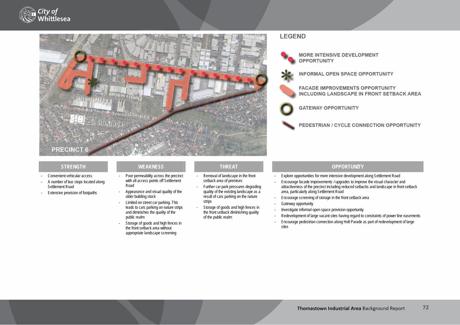
THOMASTOWN INDUSTRIAL AREA Background Report
72
STRENGTH WEAKNESS THREAT OPPORTUNITY - Convenient vehicular access - A number of bus stops located along
Settlement Road - Extensive provision of footpaths
- Poor permeability across the precinct with all access points off Settlement Road
- Appearance and visual quality of the older building stock
- Limited on street car parking. This leads to cars parking on nature strips and diminishes the quality of the public realm
- Storage of goods and high fences in the front setback area without appropriate landscape screening
- Removal of landscape in the front setback area of premises
- Further car park pressures degrading quality of the existing landscape as a result of cars parking on the nature strips
- Storage of goods and high fences in the front setback diminishing quality of the public realm
- Explore opportunities for more intensive development along Settlement Road - Encourage facade improvements / upgrades to improve the visual character and
attractiveness of the precinct including reduced setbacks and landscape in front setback area, particularly along Settlement Road
- Encourage screening of storage in the front setback area - Gateway opportunity - Investigate informal open space provision opportunity - Redevelopment of large vacant sites having regard to constraints of power line easements - Encourage pedestrian connection along Holt Parade as part of redevelopment of large
sites
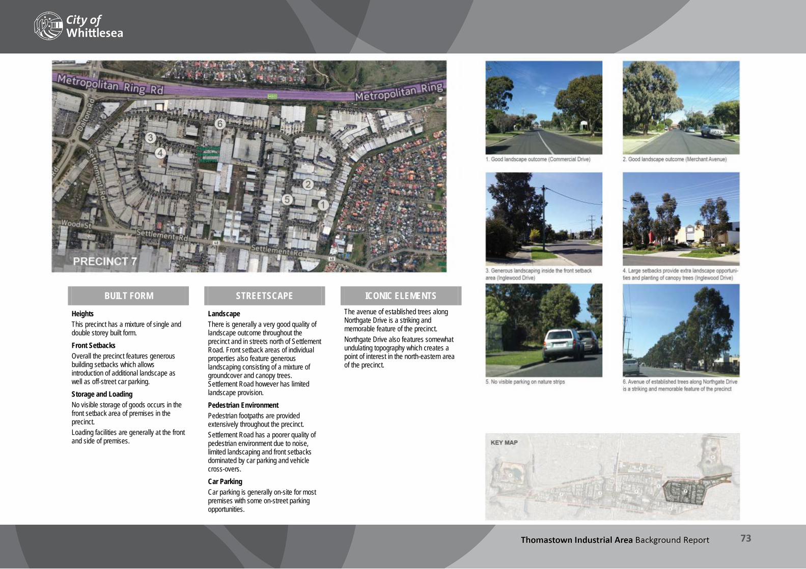
THOMASTOWN INDUSTRIAL AREA Background Report
73
BUILT FORM STREETSCAPE ICONIC ELEMENTS
Heights This precinct has a mixture of single and double storey built form. Front Setbacks Overall the precinct features generous building setbacks which allows introduction of additional landscape as well as off-street car parking. Storage and Loading No visible storage of goods occurs in the front setback area of premises in the precinct. Loading facilities are generally at the front and side of premises.
Landscape There is generally a very good quality of landscape outcome throughout the precinct and in streets north of Settlement Road. Front setback areas of individual properties also feature generous landscaping consisting of a mixture of groundcover and canopy trees. Settlement Road however has limited landscape provision. Pedestrian Environment Pedestrian footpaths are provided extensively throughout the precinct. Settlement Road has a poorer quality of pedestrian environment due to noise, limited landscaping and front setbacks dominated by car parking and vehicle cross-overs. Car Parking Car parking is generally on-site for most premises with some on-street parking opportunities.
The avenue of established trees along Northgate Drive is a striking and memorable feature of the precinct. Northgate Drive also features somewhat undulating topography which creates a point of interest in the north-eastern area of the precinct.

THOMASTOWN INDUSTRIAL AREA Background Report
74
STRENGTH WEAKNESS THREAT OPPORTUNITY
- Easy / convenient vehicular access
- A number of bus stops located along Settlement Road
- Extensive provision of footpaths - Very good quality of landscape
outcome
- Poor appearance of the older building stock
- Settlement Road is a poor quality environment for pedestrians and cyclists
- Cluttered and inconsistent signage reduces visual amenity
- High site coverage reduces opportunities for improved landscape outcomes
- Removal of landscape in the front setback area of premises
- Further car park pressures degrading the quality of the existing landscape
- Storage of goods in the front setback diminishes the quality of the public realm
- Potential for future land use conflicts due to residential zoning in north-eastern corner of the precinct
- Renewal of existing open space. - Façade improvements / upgrades would improve the visual character and
attractiveness of the precinct including landscape in front setback area - Gateway opportunities

THOMASTOWN INDUSTRIAL AREA Background Report
75
BUILT FORM STREETSCAPE ICONIC ELEMENTS Dyson’s Bus Company and a privately owned rubbish tip occupy the precinct. Dyson’s site features multiple buildings of generally double storey scale, sheds and a bus terminal. The rubbish tip has a single storey building and associated open space.
Pedestrian Environment A footpath is provided along the northern section of McKimmies Road, however due to noise and limited landscaping this environment is not conducive to walking. Car Parking Car parking is provided on-site.
The open landscape and creek environment are striking features of this precinct. There is also a significant population of Growling Grass Frogs in this precinct.

THOMASTOWN INDUSTRIAL AREA Background Report
76
STRENGTH WEAKNESS THREAT OPPORTUNITY - Proximity to Thomastown East
Recreation Reserve - Bus stop along McKimmies Road
- Access to the site is restricted to McKimmies Road
- Currently no pedestrian/cycle access to the precinct (though the majority is undeveloped) with the exception of the area adjacent to McKimmies Road to the north.
- Under-development of the site may compromise site’s potential
- Loss of significant native vegetation / frog population
- Development of E6 freeway may reduce amenity and development potential of key sites in future
- Need to manage interfaces to adjoining residential land and freeway reservation
- Opportunity to provide cycle/pedestrian connection to Darebin Creek Trail - Build on proximity of Thomastown East Recreation Reserve to expand open space and
explore conservation opportunities - E6 connection (PAO in place) - Assess development potential of landfill site within horizon of Strategy
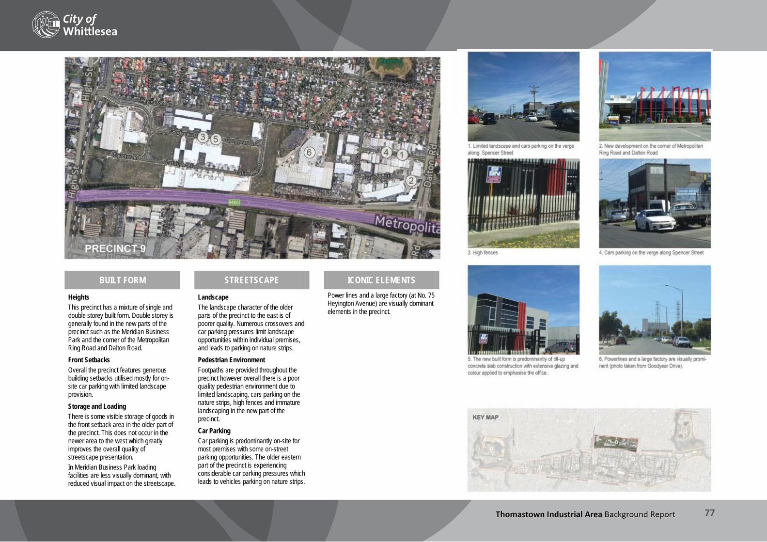
THOMASTOWN INDUSTRIAL AREA Background Report
77
BUILT FORM STREETSCAPE ICONIC ELEMENTS
Heights This precinct has a mixture of single and double storey built form. Double storey is generally found in the new parts of the precinct such as the Meridian Business Park and the corner of the Metropolitan Ring Road and Dalton Road. Front Setbacks Overall the precinct features generous building setbacks utilised mostly for on-site car parking with limited landscape provision. Storage and Loading There is some visible storage of goods in the front setback area in the older part of the precinct. This does not occur in the newer area to the west which greatly improves the overall quality of streetscape presentation. In Meridian Business Park loading facilities are less visually dominant, with reduced visual impact on the streetscape.
Landscape The landscape character of the older parts of the precinct to the east is of poorer quality. Numerous crossovers and car parking pressures limit landscape opportunities within individual premises, and leads to parking on nature strips. Pedestrian Environment Footpaths are provided throughout the precinct however overall there is a poor quality pedestrian environment due to limited landscaping, cars parking on the nature strips, high fences and immature landscaping in the new part of the precinct. Car Parking Car parking is predominantly on-site for most premises with some on-street parking opportunities. The older eastern part of the precinct is experiencing considerable car parking pressures which leads to vehicles parking on nature strips.
Power lines and a large factory (at No. 75 Heyington Avenue) are visually dominant elements in the precinct.

THOMASTOWN INDUSTRIAL AREA Background Report
78
STRENGTH WEAKNESS THREAT OPPORTUNITY - Convenient access (vehicular, cycle,
public transport) - Extensive provision of footpaths - New redevelopment sites set a good
benchmark for quality of design and landscape outcomes
- Businesses in western half of precinct have good access to Thomastown Station and Thomastown Neighbourhood Activity Centre
The following weaknesses generally apply to the older part of the precinct and are as follows: - Appearance and visual quality of the
older building stock - Limited on-street car parking which
leads to cars parking on nature strips and diminished quality of the public realm
- Storage of goods and high fences in the front setback area without appropriate landscape screening
- Cluttered and inconsistent signage reduces visual amenity in older part of precinct
- Poor quality or absent landscaping (and immature landscaping in developing areas of precinct)
- Storage of goods in the front setback diminishing quality of the public realm
- Removal of landscape in the front setback area of premises
- Further car park pressures degrading quality of the existing landscape as a result of cars parking on the nature strips
- Residential interface poses risk of land use conflict
- Investigate appropriate treatment to emphasise gateways into the precinct. Spencer Street gateway will require a solution that can address the car park pressures without detrimental impact on the operational requirements of the businesses
- Improve the visual presentation of older areas of the precinct through upgrades to façades, including landscaping in the front setback area
- Discourage storage of items in the front setback area without appropriate landscape screening

THOMASTOWN INDUSTRIAL AREA Background Report
79
Key findings – Urban Design The Urban Design Review highlighted the following: The layout and location of the industrial area provides for good
vehicle access and connections to major local and metropolitan infrastructure.
Connectivity to walking, cycling and public transport could be improved:
Footpaths are provided in most areas, however they are missing on some streets.
Public transport coverage is reasonable with two train stations and multiple bus routes.
Bicycle lanes are limited and generally on main roads only.
Connectivity is hindered by the subdivision pattern (comprising loop roads and cul-de-sacs), and the amenity and safety of the pedestrian environment is poor due to busy roads and conflicts with vehicles including parked cars. Poor safety and amenity is further compounded by inactive frontages and a lack of passive surveillance, particularly after hours.
Opportunities exist to improve connectivity through the construction of links in specific locations, and to address amenity issues via design guidelines requiring
Landscaping in the area is mixed: street trees are established in most precincts, however nature strips are often used for car parking which degrades the landscape quality. Newer developments generally have good landscaping compared to older areas of the precinct, however landscaping on private lots is often poorly maintained or even removed. Inadequate permit conditions exist to adequately address this issue for some older developments (e.g. through planning enforcement action; see Section 9.3). Landscaping in the public realm would benefit from the preparation of a Landscape Masterplan for main roads and emphasis of gateways through landscaping and public art.
Built form quality varies substantially throughout the industrial area, again being generally better in the case of newer developments, with older building stock often less well designed and maintained. Consistency could be achieved through the development of Design Guidelines for the area which could address:
Treatments for main roads and secondary roads.
Setbacks, storage and car parking.
Building and fencing materials.
Entrance points.
Landscaping.
Car parking is a source of conflict:
Storage of goods in the front setback parking area of premises displaces cars to the street (including nature strips as per above).
Nature strips and footpaths in some precincts have been removed in favour of additional parking.
Some precincts commonly experience parking pressures, particularly where clusters of automotive businesses operate.
Opportunities exist to improve the natural environment and open space in the industrial area, including conservation of native flora and fauna along creek lines, creation of accessible open space for use by workers in the area, strategies to address site contamination and runoff to creeks, and improvement of built form interfaces to open space.
Interfaces to existing residential areas need to be carefully managed (see further discussion at Section 7), and inappropriate encroachment by new residential uses avoided.
Signage is inconsistent and often contributes to visual clutter. A Signage Strategy may assist to provide clarity and guidance for future development.

THOMASTOWN INDUSTRIAL AREA Background Report
80
9 Consultation The City of Whittlesea has publicly stated its commitment to an all of Council approach which demonstrates best practice in inclusive governance, consultation and community engagement through the following statement: “All voices are heard and decision making takes account of all views. Our inclusive, engaged community is resilient and strong” (Community Plan, 2013). This section describes the proposed stages of consultation proposed for the project and reports on the initial findings of first stage of consultation.
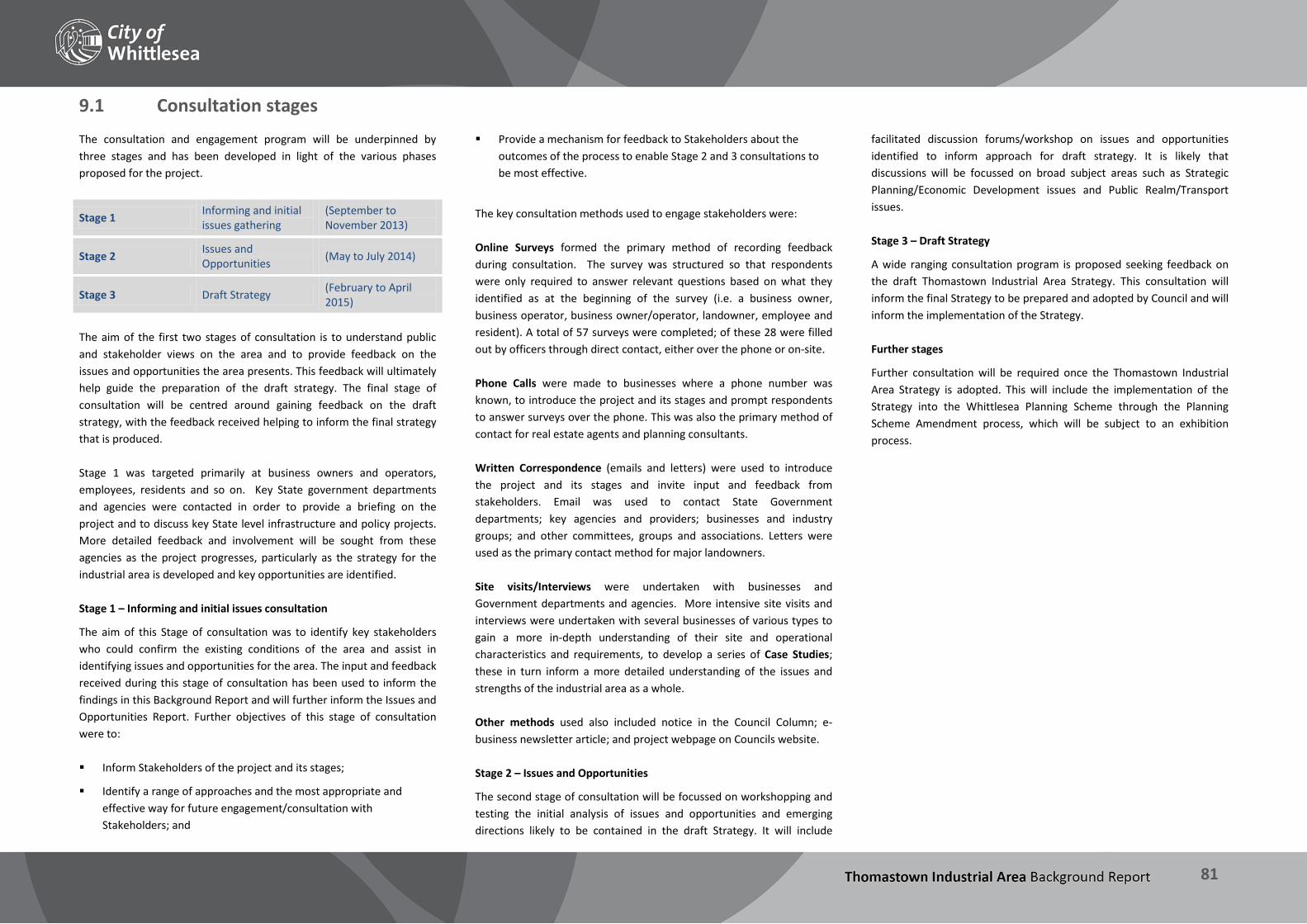
THOMASTOWN INDUSTRIAL AREA Background Report
81
9.1 Consultation stages The consultation and engagement program will be underpinned by three stages and has been developed in light of the various phases proposed for the project.
Stage 1 Informing and initial issues gathering
(September to November 2013)
Stage 2 Issues and Opportunities (May to July 2014)
Stage 3 Draft Strategy (February to April 2015)
The aim of the first two stages of consultation is to understand public and stakeholder views on the area and to provide feedback on the issues and opportunities the area presents. This feedback will ultimately help guide the preparation of the draft strategy. The final stage of consultation will be centred around gaining feedback on the draft strategy, with the feedback received helping to inform the final strategy that is produced. Stage 1 was targeted primarily at business owners and operators, employees, residents and so on. Key State government departments and agencies were contacted in order to provide a briefing on the project and to discuss key State level infrastructure and policy projects. More detailed feedback and involvement will be sought from these agencies as the project progresses, particularly as the strategy for the industrial area is developed and key opportunities are identified. Stage 1 – Informing and initial issues consultation
The aim of this Stage of consultation was to identify key stakeholders who could confirm the existing conditions of the area and assist in identifying issues and opportunities for the area. The input and feedback received during this stage of consultation has been used to inform the findings in this Background Report and will further inform the Issues and Opportunities Report. Further objectives of this stage of consultation were to: Inform Stakeholders of the project and its stages;
Identify a range of approaches and the most appropriate and effective way for future engagement/consultation with Stakeholders; and
Provide a mechanism for feedback to Stakeholders about the outcomes of the process to enable Stage 2 and 3 consultations to be most effective.
The key consultation methods used to engage stakeholders were: Online Surveys formed the primary method of recording feedback during consultation. The survey was structured so that respondents were only required to answer relevant questions based on what they identified as at the beginning of the survey (i.e. a business owner, business operator, business owner/operator, landowner, employee and resident). A total of 57 surveys were completed; of these 28 were filled out by officers through direct contact, either over the phone or on-site. Phone Calls were made to businesses where a phone number was known, to introduce the project and its stages and prompt respondents to answer surveys over the phone. This was also the primary method of contact for real estate agents and planning consultants. Written Correspondence (emails and letters) were used to introduce the project and its stages and invite input and feedback from stakeholders. Email was used to contact State Government departments; key agencies and providers; businesses and industry groups; and other committees, groups and associations. Letters were used as the primary contact method for major landowners. Site visits/Interviews were undertaken with businesses and Government departments and agencies. More intensive site visits and interviews were undertaken with several businesses of various types to gain a more in-depth understanding of their site and operational characteristics and requirements, to develop a series of Case Studies; these in turn inform a more detailed understanding of the issues and strengths of the industrial area as a whole. Other methods used also included notice in the Council Column; e-business newsletter article; and project webpage on Councils website. Stage 2 – Issues and Opportunities
The second stage of consultation will be focussed on workshopping and testing the initial analysis of issues and opportunities and emerging directions likely to be contained in the draft Strategy. It will include
facilitated discussion forums/workshop on issues and opportunities identified to inform approach for draft strategy. It is likely that discussions will be focussed on broad subject areas such as Strategic Planning/Economic Development issues and Public Realm/Transport issues. Stage 3 – Draft Strategy
A wide ranging consultation program is proposed seeking feedback on the draft Thomastown Industrial Area Strategy. This consultation will inform the final Strategy to be prepared and adopted by Council and will inform the implementation of the Strategy. Further stages
Further consultation will be required once the Thomastown Industrial Area Strategy is adopted. This will include the implementation of the Strategy into the Whittlesea Planning Scheme through the Planning Scheme Amendment process, which will be subject to an exhibition process.

THOMASTOWN INDUSTRIAL AREA Background Report
82
9.2 Community consultation – Stage 1 findings During September and December 2013 over 60 businesses currently located in the industrial area were interviewed or filled in a survey. A small number of other groups, including some residents who live in the municipality, also made observations on the area. The findings of the consultation are summarised as follows: General views of the area
The majority of businesses indicated they were “very satisfied” or “satisfied” with the industrial precinct and indicated that the area has major strengths which added to the value and functionality of the area.
More than half of the businesses interviewed and surveyed stated that they were long standing operators in the area, having been established in the industrial area for more than 15 years. Many of the businesses in the area relocated from Melbourne’s inner middle suburbs such as Coburg and Brunswick in the late 1980s and early 1990s, many seeking to expand their business and/or benefit from cheaper land and rental prices.
The majority of businesses interviewed and surveyed indicated that the main reasons they located in the industrial area were for suitably sized land and buildings, proximity to transport infrastructure, and access to the labour market. Many business owners also indicated that they were attracted to the area because it was close to home.
Some long-standing businesses noted the changes in character of the area over time and how industry has adapted to changing economic and market conditions. One food manufacturer noted:
“We moved to the area in the 1990s and back then most of the premises around us were clothing manufacturers; today there are few left”
Business needs and operations
The quality of premises – including their ability to meet operational needs, their condition and upkeep, and potential to accommodate business expansion – was a key concern identified by a number of business owners and occupiers, and a major factor influencing decision-making to either remain within the industrial area or move elsewhere. One respondent wrote:
“We are growing, and may have the need for larger or alternative premises which are unavailable in our current area at present.”
Of the businesses surveyed, 80% reported their current premises were meeting their needs. The main reasons provided were: the premises are the right size, has good access for trucks, are fitted out for their needs, location was good, adequate storage space available and good parking facilities available. Of those that stated their premises were not meeting their needs, the main reason highlighted was that their premises or site was not large enough. Some other reasons included inability to install necessary equipment, signage restrictions and distance from customer base.
Businesses that reported they were considering relocating were generally doing so because their business had expanded and outgrown their existing premises. New locations being considered varied considerably. Other businesses also reported restricting and consolidating their operations in order to remain at their current premises.
Figure 41 Parking area used for storage
Many manufacturing businesses highlighted that changes in the economic environment means they require much higher outputs than ever before. This has impacts on truck movements per day, investment required in machinery and infrastructure and increasing upfront investment in their business operations to ensure they are competitive. Other businesses indicated that in order to be competitive in the global market they have to invest significantly in research and development of their products to stay five years ahead of their overseas competitors:
“Our business has had to transform from 100% manufacturing to 50% manufacturing and 50% design; we have had to adapt over time to remain competitive and ahead of the market”
Some respondents reported there being an ageing industrial workforce, and identified associated issues, including:
The need for appropriate local services, particularly medical and allied health services, to assist with workers returning to work after injury and for day-to-day access for older workers.
Difficulty for older workers in ‘upskilling’ and adapting to changing job requirements due to changing trends in manufacturing, and the need for targeted local training facilities to assist.
Other pressures on businesses outlined included: rising costs of wages, increased red tape from government and other regulations, growing competitive global markets, and austerity by governments, particularly the Victorian Government.
Transport
Road network
Overwhelmingly the main strength identified and a valued element of the area was access to key transport infrastructure and in particular the Metropolitan Ring Road. One business operator stated:
“Getting product out of the State and to other areas of Melbourne is important to the business. In 10 minutes, the truck can be on its way to Sydney or Adelaide. If we were in Dandenong, we would have to worry about getting to the Ring Road for a couple of hours with traffic.”
Businesses indicated that access to the port, airport and the state and national road networks (the Metropolitan Ring Road and Hume Freeway in particular), were crucial to the operation of their business and to why they were attracted to or remained in the area.
Traffic congestion, a lack of roads to accommodate large vehicles and trucks and the continued construction of the Metropolitan Ring Road were identified as critical issues facing businesses which impact the efficiency of their operations. Many noted the

THOMASTOWN INDUSTRIAL AREA Background Report
83
completion of the Metropolitan Ring Road upgrade will be a great benefit as will the eventual construction of the E6.
To improve their operations, some respondents suggested that a new logistics hub located in the area would allow for more efficient movement of goods from manufacturers to regional and interstate freight transport networks.
Conflicts with on-street parking, illegal parking in ‘No Parking’ areas and on nature strips were identified as concerns in parts of the industrial area, particularly in the older areas. Conflicts with street parking of vehicles and areas available for standing trucks was also highlighted as a problem for some businesses. One respondent commented:
“Cars very often parked in the street outside our factory contrary to "No Parking" signs which often makes it difficult for container trucks to access our premises. We have to spend time trying to track down the owners of the illegally parked vehicles for them to move! Council parking inspectors do not patrol the street to fine vehicles parked illegally!”
Figure 42 Street congestion caused by truck parking
Public transport, cycling and walking
Businesses indicated that overwhelmingly their employees travelled to work by car. Some respondents also indicated that many employees would like to cycle to work but connections to the area were often dangerous and therefore did not choose this mode of transport.
A lack of bike lanes and access onto Settlement Road, dangers associated with using Dalton Road, and disconnected cycle links were highlighted as issues with the cycle network.
Improving the road network and increasing public transport were highlighted as important areas to improve on in the future. In particular, an increase in public transport was seen as important for workers as well as reducing traffic congestion. One respondent commented they would like to see:
“Increase public transport to cut cars. Car parks have reached capacity and some ‘stupid’ spots. Trucks get in the way and causes interference (particularly in the Temple Drive bend).”
Appearance and Amenity
The dumping of rubbish, vacant and run-down sites, a lack of amenities and shops, and a reputation as being ‘a lower class area’ were concerns listed by businesses as hindrances to investment and amenity in the area. Comments from respondents included:
“Empty and run down sites bring the area down and do not attract investment or amenity.”
“Demolish bad buildings and beautify the area.”
Hoon driving was raised as a problem in many parts of the industrial area due to the lack of activity at night and the number of cul-de-sac roads within the area. Further concerns raised included problems with graffiti and vandalism including break-ins.
Improvements to the appearance of the industrial area were identified as an important future direction, including improved amenities (such as access to open space), streetscape upgrades, and improvements to the appearance of some businesses/buildings/sites. Comments included:
“Have amenities and shops.”
“Improved streetscape with amenity for staff to have lunch in. Consistent maintenance as well.”
“Any visual improvements to the streetscapes i.e. more landscaping, is always good.”
“Bustling hub, not unattractive and not intimidating for a woman alone if she has to visit a business in the area (visual amenity stuff I guess). Open space for workers on breaks to use.”
Figure 43 Evidence of hoon driving on Ivanhoe Court (Precinct 9)
Other infrastructure
Respondents reported the need for upgraded infrastructure including better internet connectivity via the NBN, underground power and telephone lines, and more street lighting and CCTV. One respondent wrote that:
“Internet infrastructure needs to be in place for business to grow.”
Others wanted to see increased investment in alternative and efficient energy:
“Invest money into co-gen, alternative energy, energy efficiency trials and development or automation of equipment so that overheads and labour costs are kept to a minimum.”
Partnerships and economic development opportunities
Relationships between businesses, different levels of government and other industries were highlighted in several responses.
Some businesses reported that they felt the Council was not pro-business enough and that often there was too much regulation and enforcement in relation to minor and inconsequential issues.
Others wanted to see improved marketing and exposure of businesses in the area by Council, as well as for Council to play a more active role in facilitating relationships between industry and government.
“…want to develop partnerships with Industry, particularity food industry to run Melbourne Food and Wine Festival event in 2015.
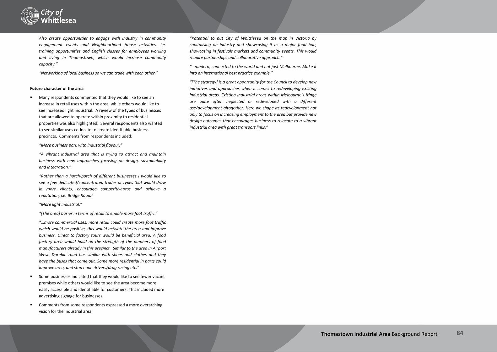
THOMASTOWN INDUSTRIAL AREA Background Report
84
Also create opportunities to engage with Industry in community engagement events and Neighbourhood House activities, i.e. training opportunities and English classes for employees working and living in Thomastown, which would increase community capacity.”
“Networking of local business so we can trade with each other.”
Future character of the area
Many respondents commented that they would like to see an increase in retail uses within the area, while others would like to see increased light industrial. A review of the types of businesses that are allowed to operate within proximity to residential properties was also highlighted. Several respondents also wanted to see similar uses co-locate to create identifiable business precincts. Comments from respondents included:
“More business park with industrial flavour.”
“A vibrant industrial area that is trying to attract and maintain business with new approaches focusing on design, sustainability and integration.”
“Rather than a hotch-potch of different businesses I would like to see a few dedicated/concentrated trades or types that would draw in more clients, encourage competitiveness and achieve a reputation, i.e. Bridge Road.”
“More light industrial.”
“[The area] busier in terms of retail to enable more foot traffic.”
“…more commercial uses, more retail could create more foot traffic which would be positive, this would activate the area and improve business. Direct to factory tours would be beneficial area. A food factory area would build on the strength of the numbers of food manufacturers already in this precinct. Similar to the area in Airport West. Darebin road has similar with shoes and clothes and they have the buses that come out. Some more residential in parts could improve area, and stop hoon drivers/drag racing etc.”
Some businesses indicated that they would like to see fewer vacant premises while others would like to see the area become more easily accessible and identifiable for customers. This included more advertising signage for businesses.
Comments from some respondents expressed a more overarching vision for the industrial area:
“Potential to put City of Whittlesea on the map in Victoria by capitalising on industry and showcasing it as a major food hub, showcasing in festivals markets and community events. This would require partnerships and collaborative approach.”
“…modern, connected to the world and not just Melbourne. Make it into an international best practice example.”
“[The strategy] is a great opportunity for the Council to develop new initiatives and approaches when it comes to redeveloping existing industrial areas. Existing Industrial areas within Melbourne’s fringe are quite often neglected or redeveloped with a different use/development altogether. Here we shape its redevelopment not only to focus on increasing employment to the area but provide new design outcomes that encourages business to relocate to a vibrant industrial area with great transport links.”
THOMASTOWN INDUSTRIAL AREA Background Report
85
Key findings – Consultation The first stage of consultation undertaken highlighted the following: There is broad consistency between the observations and analysis
carried out for this Background Report and the issues reported by stakeholders during consultation.
Business operators view the Thomastown industrial area as a desirable location, but some reported that whilst relocation would be necessary in the future to accommodate their expanding operations, a lack of suitable space in the industrial area means that they will need to look elsewhere for new premises.
The industrial area has maintained a number of long standing businesses in the area. Many businesses have been in the industrial area for more than 15 years having relocated to Thomastown from inner metropolitan areas.
Access to transport infrastructure is by far the most commonly reported strength of the area and the key attractor for businesses choosing to locate and remain in the industrial area.
Many businesses reported that many of their workers were from the local area (living within 10kms) and this was a key consideration in relation to why they remained in Thomastown.
The need for clearer strategic direction on building design, in order to encourage the development of more diverse, attractive and flexible commercial spaces that can adapt as businesses grow and change, was a common theme.
There is a clear need for further detailed investigation in this regard to determine how best to accommodate and retain existing businesses and their changing needs to ensure the area can remain competitive and capture ongoing investment businesses want to and are willing to make.
There is a clear trend towards businesses adapting and changing in response to the economic climate: both at the macro scale (i.e. in terms of the overall mix of businesses) and at the individual business level as operators adapt their businesses in order to remain competitive. This included increasing outputs and production through use of technology, and reducing costs, particularly labour costs.
Issues relating to car parking commonly arose, and in particular the problems created by overcrowded on-street parking which restricts
manoeuvrability and access to premises for trucks. There were mixed views as to the need for more or less parking restriction.
Business operators want Council to play an increased role in a variety of aspects of the operation of the industrial area, including undertaking more investment attraction, assistance in provision of modern infrastructure including alternative energy sources and high-speed internet, and improvements to streetscapes and open space.
The appearance of the area was widely perceived as playing a key role in attracting new investment (and conversely, as a potential deterrent if the area is not maintained to a high standard).
A key trend emerging from the consultation is the desire of many respondents for the industrial area to be more than simply a collection of individual businesses, but rather as a functioning whole, encompassing:
Synergies between land uses and business types, with identifiable business precincts.
Shared open spaces for the enjoyment of employees.
Investment in streetscapes and the public realm.
Coherent signage.
Functional access and parking arrangements for trucks, employees and visitors.
Partnerships between business and government to promote the precinct and attract investment.
Modern infrastructure that will allow businesses to adapt to changes in the regional and global economies.
Opportunities for greater use of sustainable transport by workers was seen by respondents as having multiple benefits, including to reduce transport costs for employees and to reduce car parking pressure in the vicinity of businesses.
The consultation served to reinforce the strengths of the Thomastown industrial area, whilst also highlighting areas for improvement, and providing helpful direction in articulating a future vision for the precinct in areas including land use mix, design elements, the public realm, and the relationship between the private sector and government.

THOMASTOWN INDUSTRIAL AREA Background Report
86
10 Conclusion This Background Report provides the detailed analysis which will help to inform the next stages of the Thomastown Industrial Area project.

THOMASTOWN INDUSTRIAL AREA Background Report
87
10.1 What does this mean? The Thomastown Industrial Area is an important local employment hub, and is an essential driver of the economy both for the City of Whittlesea and the northern region as a whole. The area is well placed strategically to attract business, being well serviced by freeways and the arterial road network, which provide fast access to key destinations including the CBD, Melbourne Airport and the Hume Freeway corridor. Newly developing industrial areas in Melbourne and structural changes to the manufacturing sector and land use composition throughout Melbourne, particularly in inner and middle suburbs, will place increased pressure on established industrial areas such as Thomastown to accommodate growth. This highlights the importance of having an in-depth understanding of the market positioning of the area and how it is developing and functioning – both internally and also within the broader regional and metropolitan context – and establishing a clear future direction in response. Furthermore, as the population of the City of Whittlesea grows in line with projections, not only the size, but the age structure and socio-economic characteristics of the community will change. It is highly likely that in the future the population will be more socio-economically diverse as a result. Over time the industrial and manufacturing sectors are increasingly requiring a highly skilled workforce. The match between the local population profile and the types of employment generating activities occurring in the City of Whittlesea will need ongoing consideration so that local jobs are both accessible and matched to the skills of the local community. The existing policy framework confirms the strategic significance and importance of the area, but there is a lack of detailed strategic direction to define the area’s role and function within the wider city structure of Melbourne, or within the regional hierarchy of employment land. Through this project, there is the potential to generate a focused area-based framework to assist with improving the amenity of the area, facilitate and attract higher employment generating uses, and provide the certainty to attract investment to the area. The industrial area has good access to a variety of transport infrastructure including major arterial roads and public transport. There are parts of the industrial area which are poorly connected and hazardous and conflicts between vehicles (trucks and cars, as well as
pedestrians and cyclists) are common throughout. On-street parking and site access issues also place pressure on the road network, business operations and those visiting the area. Opportunities exist to improve internal connectivity and consider public realm solutions to address these conflicts, and enhance the overall visual amenity and functionality of the area. This will provide benefits not only to employees and businesses, but to the wider community and those who travel throughout the southern area of the municipality. There are a number of environmental assets within the industrial area including creek environs and quarry holes which can be improved and present future opportunities to achieve improved environmental outcomes. There is also increasing awareness that industrial development, with its high proportion of hard surfaces (including roof areas and car parking), can have a negative impact on the health of local waterways through increased runoff and heavy pollutant loads. This has been shown in Thomastown, where there are ongoing issues with contamination of the creeks running through the area. Whilst some parts of the industrial area are run-down and appear to lack investment, on the whole the area is performing well, as evidenced by the wide range of industrial and commercial activities, low vacancy rates and high demand for premises, and healthy employment numbers, particularly for local residents. Public realm improvements along key street frontages and gateway areas will enable the amenity of the area to be enhanced and improve the image and business attraction potential of the area. This together with design and advertising sign guidelines which can be applied in the case of private development proposals will enable the overall functionality, amenity and image of the area to be enhanced. Ownership throughout the industrial area is fragmented and only a small proportion of landowners own multiple contiguous sites. This presents challenges to future regeneration opportunities – e.g. restructuring parcels for urban renewal, or creating and accessing new open space – due to the number of land owners with which outcomes would need to be negotiated. There is a reasonably strong correlation between age of building stock and lot size in the industrial area. In the 1960s the majority of construction took place on sites greater than 5,000 square metres in
area, whilst in the 1970s to 2000s most development activity was occurring on sites of 500-2,000 square metres or less. Recent development activity in the industrial area has been limited and where this has occurred it has been predominantly for smaller lot warehouse developments. These trends are positive as they show investment in the area, but may compromise the ability of large scale businesses to locate in the precinct, and ultimately may lead to a reduced ability to attract diverse business sectors if this is the only form of development activity. In many cases investment in the built environment can result in a lift for the local construction industry but can sometimes fail to maximise ongoing employment densities. This highlights the need to monitor and review the development pipeline for the area. In terms of existing land use composition, manufacturing is still the predominant industry but structural changes in this sector have seen this change over time, with trends showing that other sectors are emerging as major employers for the municipality. ABS data shows that the largest growth in jobs between 2006 and 2011 was in retail trade, health care and social assistance, construction, and education and training. Changes within the manufacturing industry and macroeconomic trends have also seen changes in the types of manufacturing businesses within the municipality and Thomastown, including a notable increase in food product manufacturing, and a decline in textile and clothing manufacturing jobs. Ongoing monitoring and review of the industrial area is important to provide the ability to analyse and assess land use and employment patterns, and provide an informed response to development proposals. It is currently difficult to assess and understand the development market, including what is driving speculative development, the type of development ultimately being delivered, and who the end users of these premises are. Analysis of development and market activity, together with existing base-line land use data will allow some insights into demand and changes in land use composition and trends over time. A significant opportunity exists to track the development pipeline for the area to provide a better planning-based response to evolving market trends. Capturing time series data and trend information on land use and employment will also assist in tracking the performance of the industrial area.

THOMASTOWN INDUSTRIAL AREA Background Report
88
10.2 Next steps Land use planning is one part of a variety of economic development initiatives that can enable Council to direct and attract investment and provide increased employment opportunities for the community. While there is the ability to influence land uses and attract certain industries to particular locations via zones and overlays, and through the preparation and delivery of land use strategies, there will also be a need to link the initiatives identified to Council’s broader economic development portfolio. One example of this may include developing a marketing strategy for the area, and by assisting to build relationships and partnerships between stakeholders. The area benefits from an engaged business community who are strongly committed to the area and have valuable and innovative views and ideas for how the area could be improved as it changes over time. These views range from the detailed and pragmatic to the broad-ranging and visionary. This commitment by the community will be fundamental to shaping and providing direction to Council as the Thomastown Industrial Area Strategy is developed but also for the implementation and ultimate success of the identified actions and initiatives within it. The next stages of the project will be to further develop the key findings of the Background Report, together with findings contained in the technical studies, into an Issues and Opportunities Report. This document will be used throughout Stage 2 consultation, where the issues and opportunities identified will be reviewed, tested and discussed by key stakeholders including Government departments and agencies, landholders and business and industry bodies to inform the directions of the draft Strategy. Following this, the draft Thomastown Industrial Area Strategy will be developed to set out the key policy directions for the precinct in terms of land use, design, sustainability, infrastructure and investment. The draft will be reviewed through further stakeholder engagement before the Strategy is finalised and adopted.

THOMASTOWN INDUSTRIAL AREA Background Report
89
11 Resources City of Whittlesea Heritage Study – Volume 1: Thematic environmental history, Context Pty. Ltd. on behalf of the City of Whittlesea, September 2013 Council Plan 2013-2017, City of Whittlesea, 2013 ‘CrashStats’ road accident data program, VicRoads, 2014 Creating quality jobs: Transforming the economic development landscape, International Economic Development Council, March 2010 Draft Whittlesea Bicycle Plan 2014-2018, City of Whittlesea, 2014 Economy.id (http://economy.id.com.au/whittlesea), .id Consulting, 2014 Environmental Sustainability Strategy 2012-2022, City of Whittlesea, 2013 EPA site inspections 2009: Thomastown and Coburg, BMT WBM Pty Ltd on behalf of EPA Victoria, December 2009 Fabricated Metal Product Manufacturing Market Research Report, IBISWorld, 2014 Growth Corridor Plans: Activity Centre and Employment Planning, Essential Economics Pty Ltd on behalf of the Growth Areas Authority, November 2011 Housing Diversity Strategy 2013-2033, City of Whittlesea, December 2013 Integrated Transport Strategy, City of Whittlesea, March 2014 Manufacturing in Melbourne’s North: Now and into the future, A Northern Melbourne RDA report, April 2012 Melbourne’s North – the new knowledge economy, National Institute of Economic and Industry Research (NIEIR), 2009
Merri Creek and Environs Strategy 2009-2014, Merri Creek Management Committee, May 2009 Ministerial Direction No. 1 – Potentially Contaminated Land, Minister for Planning, September 2001 Network Development Plan – Metropolitan Rail, Public Transport Victoria, December 2012 Northern Melbourne RDA Regional Plan 2013-2016, Northern Melbourne Regional Development Australia Committee, August 2013 Plan Melbourne: Metropolitan Planning Strategy (draft), Department of Transport, Planning and Local Infrastructure, October 2013 Planning Guidelines for Industrial Development, City of Whittlesea, January 1997 Potentially Contaminated Land: General Practice Note, Department of Sustainability and Environment and EPA Victoria, June 2005 Securing Victoria’s Economy: Planning. Building. Delivering, State Government of Victoria, December 2012 Stormwater Management Plan 2012-2017, City of Whittlesea, April 2012 Technical Report #05: City of Whittlesea stormwater quality monitoring program, Victorian Centre for Aquatic Pollution Identification and Management, July 2011 The North Growth Corridor Plan, Metropolitan Planning Authority, June 2012 Thomastown Industrial Area Economic and Market Analysis, Hill PDA P/L, 2014 Urban Development Program: Metropolitan Melbourne 2013, Department of Transport, Planning and Local Infrastructure, December 2013
State Significant Employment Precincts, Deloitte Access Economics on behalf of the Department of Business and Innovation, April 2013 Victoria, The Freight State – The Victorian Freight and Logistics Plan, State Government of Victoria, August 2013 Whittlesea Planning Scheme, 2014

THOMASTOWN INDUSTRIAL AREA Background Report
90
Appendices

THOMASTOWN INDUSTRIAL AREA Background Report
91
Appendix 1 – Urban Design Review Lot size composition
PRECINCT 1 PRECINCT 2 PRECINCT 3 PRECINCT 4 PRECINCT 5
A range of lot sizes are found, while Boral site and the quarry occupy large parcels measuring well over 2.0Ha in size. The balance of the precinct consists of predominantly larger sites measuring 5000sqm - 2.0Ha.
The majority of lots in are smaller lots measuring 500sqm to 1500 sqm. Medium sized lots (1500 sqm to 2500sqm) are scattered throughout the precinct. Larger sites of 5000sqm to 2.0Ha are situated along Mahoneys Road and off Lipton Drive.
A mixture of very large sites as well as smaller lots are typical in this precinct. Eastern half of the precinct features lots well in excess of 2.0Ha, whilst western half consists of lots generally in the order of 500sqm - 2500 sqm.
Generally consists of larger lots up to and in excess of 2.0Ha. Along Settlement Road lot sizes vary between 500sqm to 2500 sqm. A large proportion of sites measuring 5000sqm to 2.0Ha are situated along Keon Parade.
Generally consists of larger lots of 5000sqm to 2.0Ha and 2.0Ha and over. While some sites are significant in size they do comprise smaller tenancies such as the Harvey Norman site which contains number of restricted retail premises.
PRECINCT 6 PRECINCT 7 PRECINCT 8 PRECINCT 9 KEY FACTS
A mixture of large, medium and small sized lots. Large sites are in excess of 2.0Ha, medium sized lots range between 1500sqm to 2.0Ha and smaller sites are less than 1500sqm in size.
Predominantly made up of small to medium sized lots. Medium sized lots range between 1500sqm to 2.0Ha and smaller sites are less than 1500sqm in size.
Features only very large sites well in excess of 2.0Ha in size.
A mixture of large, medium and small sized lots are typical in this precinct. Large sites are in excess of 2.0Ha, medium sized lots range between 1500sqm to 2.0Ha and smaller sites are less than 1500sqm in size.
Over 30% of parcels between 1000-5000sqm 40 lots are larger than 2Ha

THOMASTOWN INDUSTRIAL AREA Background Report
92
Subdivision pattern and access
PRECINCT 1 PRECINCT 2 PRECINCT 3 PRECINCT 4 PRECINCT 5
The subdivision pattern can be characterised by a cul-de-sac system. Access to the precinct is only possible off Mahoneys Road via Industrial Avenue which becomes Trawalla Avenue. Trawalla Avenue is the only road that services the precinct and the majority of premises front onto this road.
The subdivision pattern is characterised by a loop and cul-de-sac system. Access and circulation is facilitated via Mahoneys and Edgars Roads including a series of looping roads within the precinct. Pedestrian and vehicular connectivity between different parts of the precinct is limited.
The subdivision pattern is characterised by a loop and cul-de-sac system. Access and circulation is facilitated via Edgars / Mahoneys Roads and High Street including a series of looping roads within the precinct. Pedestrian and vehicular connectivity between different parts of the precinct is limited.
The predominant subdivision pattern can be characterised by a cul-de-sac system. Lots fronting Keon Parade are directly accessible whilst Settlement Road provides primary access to a series of cul-de-sac streets. Pedestrian and vehicular connectivity between different parts of the precinct is limited.
Situated within a busy and major transport node and is easily accessible via Dalton and Settlement Roads.
PRECINCT 6 PRECINCT 7 PRECINCT 8 PRECINCT 9 KEY FACTS
The subdivision pattern is characterised by a loop and cul-de-sac system. Access and circulation is facilitated via Settlement Road / Wood Street feeding a cul-de-sac system. Pedestrian and vehicular connectivity between different parts of the precinct is limited.
The subdivision pattern can be largely characterised by a loop system with some cul-de-sacs. Access and circulation is facilitated via internal looping roads feeding off Settlement and Dalton Roads. Pedestrian and vehicular connectivity between different parts of the precinct is good.
With only two major operators Dyson’s Bus Company and a privately owned landfill site (former quarry site) there is no apparent subdivision pattern for this precinct. Access into the precinct is very limited and only available through entering Dyson’s Bus Company or the landfill site off McKimmies Road. There is no further access past these two sites.
The subdivision pattern can be largely characterised by a loop system with some cul-de-sacs. Access and circulation is facilitated via internal looping roads feeding off Dalton Road and Heyington Avenue. Pedestrian and vehicular connectivity between different parts of the precinct is good.
Connections to Metropolitan Ring Road available from Dalton and Edgars Roads. Other major roads include:
High Street Mahoneys Road Keon Parade Settlement Road Wood Street
Loop and cul de sac layout for pedestrians.

THOMASTOWN INDUSTRIAL AREA Background Report
93
Age of building stock
PRECINCT 1 PRECINCT 2 PRECINCT 3 PRECINCT 4 PRECINCT 5
There is a broad range of building ages in the precinct. Some buildings in the precinct are 40 years and older whilst others are less than 10 years old.
A mix of building ages are found in this precinct. The north east corner of the precinct features a more recently developed area which is less than 10 years old. By contrast, the remainder of the precinct is characterised by much older buildings that are 30 - 40 years and older.
The building stock is predominantly 20 - 40 years old. Some buildings are less than 10 years old, including the more recently constructed small lot subdivision along Mahoneys Road which was formerly SP Ausnet land.
The building stock is predominantly over 40 years old and contains the largest area of old building stock in the industrial area. The remainder of building stock is generally 30-40 years old, while there are some limited examples more recently constructed buildings (less than 10 years old) along Keon Parade.
The building stock is predominantly 10 - 20 years old, although there are some examples of older building stock along Dalton Road (30 – 40 years).
PRECINCT 6 PRECINCT 7 PRECINCT 8 PRECINCT 9 KEY FACTS
The building stock is predominantly 20 - 30 years old. Some buildings along Wood Street are 40 years and older.
The building stock is predominantly 20 - 30 years old along Settlement Road and Wood Street while the newer building stock is located along Northgate Drive which is typically 10-20 year old construction.
Most of the land in this precinct in undeveloped. Dysons Bus Company features multiple single storey buildings, sheds and a bus terminal/driveway. These facilities appear to be less than 10 years old.
This precinct has a diverse range of building ages. The western half contains buildings that are less than 10 years old (part of MAB’s Meridian Business Park). By contrast, the remainder of the precinct is characterised by older building stock which is 30 - 40 years and older.
18% of buildings are more than 30 years old 18% were constructed post 2000 4.5% of parcels have no built form (vacant land)
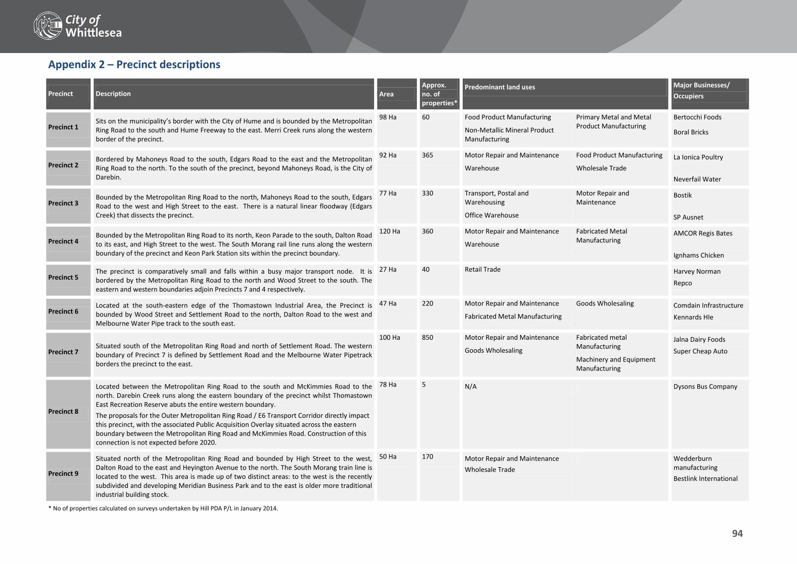
THOMASTOWN INDUSTRIAL AREA Background Report
94
Appendix 2 – Precinct descriptions
Precinct Description Area Approx. no. of properties*
Predominant land uses Major Businesses/ Occupiers
Precinct 1 Sits on the municipality’s border with the City of Hume and is bounded by the Metropolitan Ring Road to the south and Hume Freeway to the east. Merri Creek runs along the western border of the precinct.
98 Ha 60 Food Product Manufacturing
Non-Metallic Mineral Product Manufacturing
Primary Metal and Metal Product Manufacturing
Bertocchi Foods
Boral Bricks
Precinct 2 Bordered by Mahoneys Road to the south, Edgars Road to the east and the Metropolitan Ring Road to the north. To the south of the precinct, beyond Mahoneys Road, is the City of Darebin.
92 Ha 365 Motor Repair and Maintenance
Warehouse
Food Product Manufacturing
Wholesale Trade La Ionica Poultry Neverfail Water
Precinct 3 Bounded by the Metropolitan Ring Road to the north, Mahoneys Road to the south, Edgars Road to the west and High Street to the east. There is a natural linear floodway (Edgars Creek) that dissects the precinct.
77 Ha 330 Transport, Postal and Warehousing
Office Warehouse
Motor Repair and Maintenance
Bostik SP Ausnet
Precinct 4 Bounded by the Metropolitan Ring Road to its north, Keon Parade to the south, Dalton Road to its east, and High Street to the west. The South Morang rail line runs along the western boundary of the precinct and Keon Park Station sits within the precinct boundary.
120 Ha 360 Motor Repair and Maintenance
Warehouse
Fabricated Metal Manufacturing
AMCOR Regis Bates Ignhams Chicken
Precinct 5 The precinct is comparatively small and falls within a busy major transport node. It is bordered by the Metropolitan Ring Road to the north and Wood Street to the south. The eastern and western boundaries adjoin Precincts 7 and 4 respectively.
27 Ha 40 Retail Trade Harvey Norman Repco
Precinct 6 Located at the south-eastern edge of the Thomastown Industrial Area, the Precinct is bounded by Wood Street and Settlement Road to the north, Dalton Road to the west and Melbourne Water Pipe track to the south east.
47 Ha 220 Motor Repair and Maintenance
Fabricated Metal Manufacturing
Goods Wholesaling Comdain Infrastructure
Kennards HIe
Precinct 7 Situated south of the Metropolitan Ring Road and north of Settlement Road. The western boundary of Precinct 7 is defined by Settlement Road and the Melbourne Water Pipetrack borders the precinct to the east.
100 Ha 850 Motor Repair and Maintenance
Goods Wholesaling
Fabricated metal Manufacturing
Machinery and Equipment Manufacturing
Jalna Dairy Foods
Super Cheap Auto
Precinct 8
Located between the Metropolitan Ring Road to the south and McKimmies Road to the north. Darebin Creek runs along the eastern boundary of the precinct whilst Thomastown East Recreation Reserve abuts the entire western boundary. The proposals for the Outer Metropolitan Ring Road / E6 Transport Corridor directly impact this precinct, with the associated Public Acquisition Overlay situated across the eastern boundary between the Metropolitan Ring Road and McKimmies Road. Construction of this connection is not expected before 2020.
78 Ha 5 N/A Dysons Bus Company
Precinct 9
Situated north of the Metropolitan Ring Road and bounded by High Street to the west, Dalton Road to the east and Heyington Avenue to the north. The South Morang train line is located to the west. This area is made up of two distinct areas: to the west is the recently subdivided and developing Meridian Business Park and to the east is older more traditional industrial building stock.
50 Ha 170 Motor Repair and Maintenance Wholesale Trade
Wedderburn manufacturing Bestlink International
* No of properties calculated on surveys undertaken by Hill PDA P/L in January 2014.

THOMASTOWN INDUSTRIAL AREA Background Report
95

96