Embed Size (px)
Citation preview

8/12/2019 Thomas Street
http://slidepdf.com/reader/full/thomas-street 1/42

8/12/2019 Thomas Street
http://slidepdf.com/reader/full/thomas-street 2/42
777 Thomas Street
Seattle Landmark Nomination
INDEX
I. Introduction 3
II. Building information 3
III. Architectural description 4Site and Adjacent neighborhood contextBuilding description
IV. Historical contextThe development of the South Lake Union neighborhood 6Building owners and occupants 9Art Deco architecture in Seattle 12
V. Bibliography and sources 13
VI. Preparer and Reviewer information 15
VII. Report illustrations 16
Appendix A – Selected architectural material, tax assessor records, site plan Following

8/12/2019 Thomas Street
http://slidepdf.com/reader/full/thomas-street 3/42

8/12/2019 Thomas Street
http://slidepdf.com/reader/full/thomas-street 4/42
III. ARCHITECTURAL DESCRIPTION
Site and Adjacent Neighborhood Context
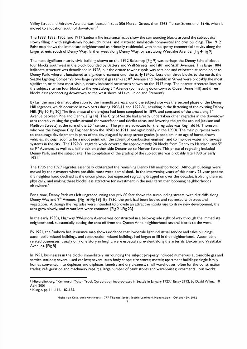
The subject building is located on a gently sloping, corner site on Thomas Street and 8th
Avenue N., one block north ofDenny Park. The building completely fills the parcel. The building lot has an alley to the west. The arterial DexterAvenue is one block away to the west, running north to south, and one block further west is the major arterial AuroraAvenue/Highway 99. [Fig 1-Fig 3]
The subject site and surrounding blocks are zoned SM-85 (Seattle Mixed Use, maximum height 85’). The surroundingblocks (other than the nearby Seattle Center) are marked primarily by one- and two-story mid-20th-century lightindustrial and commercial buildings, and some parking lots. The character of the surrounding area changes markedlysouth of Denny Way, in the Belltown neighborhood, with increasingly denser urban fabric of modern high-rise mixed-use residential towers intermixed with c.1920-30s brick apartment buildings. Similar development occurs to the southaround Westlake and Stewart/Olive Streets.
The nearest Seattle historic landmark is the Street Clock, West Earth Company, at Dexter Avenue N. and HarrisonStreet. Other nearby Seattle historic landmarks within a few blocks include:
• Terry Avenue Building (James Schack, 1915) on 320 Terry Avenue N. between Harrison and Thomas
• The Van Vorst Building (between 1909-1915) on Boren between Harrison and Republican
• Troy Laundry Building (Victor Voorhees, 1927) on Fairview between Harrison and Thomas
• Seattle Times Building (Robert Reamer, 1931) at Fairview and John.
Because Aurora Avenue is a below-grade highway with only a few east-west crossing points available, the noisyroadway forms a powerful western boundary to the immediate neighborhood. Relatively close landmarks to the westof Aurora include the following, but experientially, they are not conveniently reached:
• The Space Needle (John Graham Jr., Victor Steinbrueck, and John Ridley, 1961-62) at Broad and Thomas
• The Seattle Monorail (1961-62) along Fifth Avenue, at Thomas Street
• Seattle First National Bank (John Maloney, 1950, after a prototype by J. Lister Holmes, 1946), at 6th Avenue N.and Denny Way
8/12/2019 Thomas Street
http://slidepdf.com/reader/full/thomas-street 5/42
which are supported at the other end on brick and concrete piers engaging the exterior walls, and on the girders are2x12 wood joists supporting roof decking.
The north elevation, along Thomas Street, consists of six wide window bays on a 19-20 foot module which retain the
original steel sash windows, above low concrete bulkheads. In recent years, portions of the windows have been simplycovered by corrugated metal siding in order to create office space and more privacy for the interior, with the originalmetal sash underneath. The building piers between the six bays have cast-stone ornament which feature a singlevertical band of overlapping, upward-pointing chevron “scales” contained by three incised lines on each side of thechevrons.
Viewing the north elevation, there is primary entrance located in the second bay from the left, and a full-bay-widthgarage door occupying the second bay from the right. The garage door on the interior connects to the interior floorby a short ramp down. Non-original light fixtures are affixed to each pier.
The primary entrance is located in the center of the window bay it occupies, but stands free from the piers of thewindow bay. The door surrounds feature Art Deco cast-stone masonry elements consisting of superimposed curvedand pointed geometric shapes, superimposed vertical lines or planes, and two stylized volutes.
The east elevation, along 8th Avenue N., resembles the north elevation, except that it consists of three window bays,with a garage door in the center bay, and a secondary entrance integral to the left bay’s window.
The west elevation, along the alley, features three large windows and one small window (lacking the regular three-bayappearance of the east elevation). The windows, which are intact with original steel sash, are entirely covered by
painted plywood. This elevation is utilitarian in nature and without ornament, except for a corner pier featuring thechevron band and parapet fretwork which wraps around to the alley as a continuation of the north elevation cornerpier.
The south elevation is constructed as a party wall condition, although the adjacent property is a surface parking lotwith no structures on it. This south elevation has no windows at all. There is no exterior ornament, except that theparapet fretwork wraps the southeast corner by about two feet.

8/12/2019 Thomas Street
http://slidepdf.com/reader/full/thomas-street 6/42
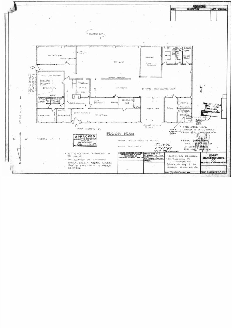
1988 Alteration of building interior; add spray booth; create new entry; change use from office, wholesale,manufacturing to auto repair.
IV. HISTORICAL CONTEXT
The development of the South Lake Union neighborhood
The subject building is located in what is today called the South Lake Union neighborhood, as it merges into the LowerQueen Anne neighborhood to the west (sometimes called the Uptown neighborhood), and the Denny Regradeneighborhood to the south. The 2005 South Lake Union Historic Survey and Inventory for the Department ofNeighborhoods considers the South Lake Union area to be bounded by Fairview Avenue to the east, Aurora Avenueto the west, Mercer Street to the north, and Denny Way to the south. The older Cascade neighborhood is consideredto generally be the area east and southeast of South Lake Union, traditionally having a closer relationship with CapitolHill until the construction of the Interstate 5 corridor. All of these areas share common and overlapping histories dueto topography and land use patterns over the decades.1
The blocks around the subject site were originally part of the 320-acre 1853 land claim of David T. Denny, one of theoriginal pioneer settlers of Seattle, which encompassed the south end of Lake Union westward to Elliott Bay, fromMercer Street to Denny Way. In David Denny’s time, his land was nestled in a valley between Denny Hill to the southand Queen Anne Hill to the north. Prior to the Denny settlement, the area was noted for a large meadow and severalDuwamish encampments, particularly where a small stream (today the course of Westlake Avenue) met the shore of
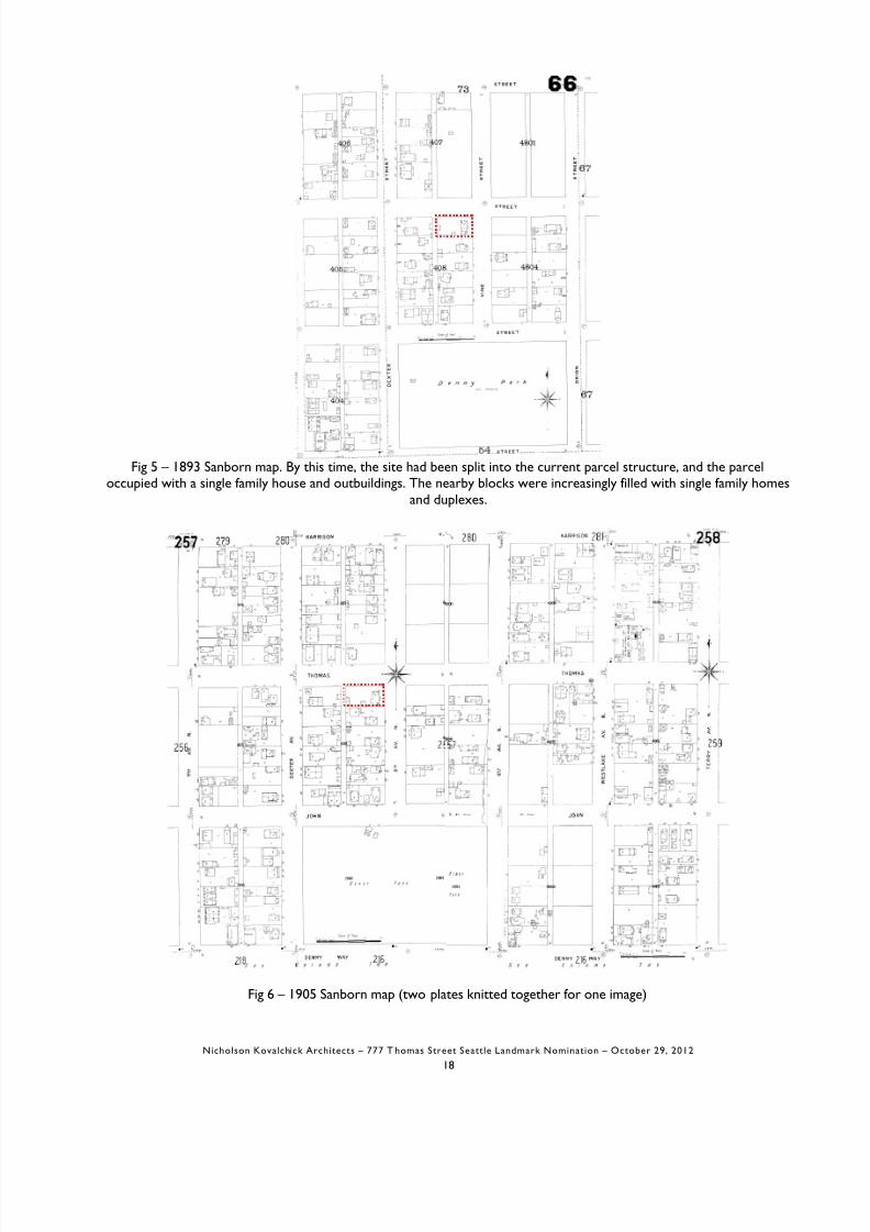
Lake Union. The Denny’s modest home was located at 8th and Republican.2 Nearby Denny Park at Dexter and JohnStreet—one block south of the subject site—originally was six acres donated by David Denny in 1864 for use as a citycemetery, but was rededicated as a public park in 1883, becoming Seattle’s oldest park. 3 In the 1860s, a north-southmilitary road was cut through the area, following an Indian trail (today's Dexter Avenue). David Denny subdivided hisland into 500 building lots in 1872, but the area was relatively slow to develop, compared to the Belltown area to thesouth.4 [Fig 4-Fig 9]
The area owes most of its character to transportation systems that developed around Lake Union and early rail
8/12/2019 Thomas Street
http://slidepdf.com/reader/full/thomas-street 7/42
Valley Street and Fairview Avenue, was located first at 506 Mercer Street, then 1263 Mercer Street until 1946, when itmoved to a location south of downtown. 5
The 1888, 1893, 1905, and 1917 Sanborn fire insurance maps show the surrounding blocks around the subject site
slowly filling in with single-family houses, churches, and scattered small-scale commercial and civic buildings. The 1912Baist map shows the immediate neighborhood as primarily residential, with some spotty commercial activity along thelarger streets south of Denny Way, farther west along Denny Way, or east along Westlake Avenue. [Fig 4-Fig 9]
The most significant nearby civic building shown on the 1912 Baist map [Fig 9] was perhaps the Denny School, aboutfour blocks southwest in the block bounded by Battery and Wall Streets, and Fifth and Sixth Avenues. This large 1884Italianate structure was demolished in 1928, but the ornate tower cupola was retained and relocated at some point toDenny Park, where it functioned as a garden ornament until the early 1940s. Less than three blocks to the north, theSeattle Lighting Company’s two large cylindrical gas tanks at 8th Avenue and Republican Street were probably the mostsignificant, or at least most visible, nearby industrial structures shown on the 1912 map. The nearest streetcar lines tothe subject site ran four blocks to the west along 5th Avenue (connecting downtown to Queen Anne Hill) and threeblocks east (connecting downtown to the west shore of Lake Union and Fremont).
By far, the most dramatic alteration to the immediate area around the subject site was the second phase of the DennyHill regrades, which occurred in two parts during 1906-11 and 1929-31, resulting in the flattening of the existing DennyHill. [Fig 10-Fig 20] The first phase of the project had been completed in 1899, and consisted of the area along 1st Avenue between Pine and Denny. [Fig 14] The City of Seattle had already undertaken other regrades in the downtownarea (notably raising the grades around the waterfront and tideflat areas, and lowering the grades around Jackson andMadison Streets) at the turn of the 20th century. The primary advocate for the regrades was Reginald H. Thomson,
who was the longtime City Engineer from the 1890s to 1911, and again briefly in the 1930s. The main purposes wereto encourage development in parts of the city plagued by steep street grades (a problem in an age of horse-drawnvehicles, although soon to be a moot point with the advent of combustion engines), and to improve water and sewagesystems in the city. The 1929-31 regrade work covered the approximately 20 blocks from Denny to Harrison, and 5th to 9th Avenues, as well as a half-block on either side Dexter up to Mercer Street. This phase of regrading includedDenny Park, and the subject site. The completion of the grading of the subject site was probably late 1930 or early1931.

8/12/2019 Thomas Street
http://slidepdf.com/reader/full/thomas-street 8/42
several electrical supply companies; many plumbing supply shops, some with a pipe yard and cutting area; a printer; anupholsterer; a roller bearings supplier; several general storage buildings; offices of Pacific Telephone and Telegraph; anda few restaurants. [Fig 24-Fig 25] Interspersed between these buildings on the 1951 map are wood frame single-familyhouses, which presumably were either untouched by the regrades (if outside the boundary of the work), or were lifted
and moved back into place after the regrades.
Around 1960, several blocks west of Broad and north of Denny—several blocks west of the subject parcel—werechosen to be the site for the 1962 World’s Fair. This area had already been developing as a civic center since the1920s. Existing buildings on the site which were to be adapted to Fair uses included the 1928 Civic Auditorium(today's Opera House), the 1939 Armory (now the Center House), and the 1948 Memorial Stadium.7 The city wasalso interested in encouraging redevelopment of the area, which was untouched by but just northwest of the regrades,and which was by that time perceived to be "blighted." As part of the development, several streets were closed off,blocks were agglomerated, and the World’s Fair site—today’s Seattle Center campus—became the primary westernneighborhood edge and traffic obstacle in the immediate area. In anticipation of the 1962 World’s Fair, nearby blockswest of the subject site were developed with hotels, motels, restaurants, and other draws to attract the tourist dollar.
Since the 1960s, the nearby Lower Queen Anne and Belltown neighborhoods have seen increasing development,particularly during the economic prosperity of the 1980s and 1990s and changes in the city’s land use code. In theDenny Regrade neighborhood south of Denny, several modern residential or mixed-use towers were developed,creating an increasingly denser neighborhood. More restaurants and neighborhood shops and services wereintroduced into the area, so that the traditionally densely residential Lower Queen Anne area has begun to mergeseamlessly with the Regrade/Belltown area between Denny and Broad at Western, 1st, and 2nd Avenues. The SeattleCenter campus has remained an integral and key component of the city’s civic and tourist resources, with
improvements and additions made over the decades to the Pacific Science Center, the Space Needle, Seattle Children’sTheater, the International Fountain and former Flag Pavilion areas, and the Center House. In addition, two significantmodern buildings and institutions have been established in the neighborhood in the past several years: the ExperienceMusic Project (Frank Gehry, 2000) and the Bill and Melinda Gates Foundation (NBBJ, 2010), both about six blocks fromthe subject site. However, the Seattle Center and Gates Foundation are located on the west side of Aurora, soalthough only a few blocks away, they have less of an impact on the subject site’s neighborhood than might beexpected.
8/12/2019 Thomas Street
http://slidepdf.com/reader/full/thomas-street 9/42
Building owners and occupants
King County Tax Assessor information was used to determine the most recent owners, and historic tax information
was used to determine likely owners in earlier decades. Polk's Directories were scanned in order to determineresidents of the property (beginning with the 1938 reverse directory).
The property is one block from Denny Park, the oldest park in the city. The site was occupied by a wood frame,single-family residence, with yard and outbuildings, by 1893. Between 1905 and 1912, another frame structure,apparently a single-family house, was built in the back yard along the alley. At that time, the nearby blocks werecharacterized by similar structures. These original buildings on the subject site were presumably demolished when thisblock and surrounding area were regraded during the final part of the Denny Hill regrades in 1928-30. The owner priorto 1931 was not discovered.
The property appears to have been owned at least by the 1930s by the Pigott family. Tax records show that the feeowner from 1931 until at least 1937 was Ada E. Pigott “et al.” The Pigotts were prominent in Seattle as owners of twomajor companies, the Seattle Steel Company and the Seattle Car Manufacturing Company (later known as PACCAR).Ada Pigott was the widow of William Pigott Sr., the philanthropist and former head of the Seattle Steel Company. Adadied in 1941, but her husband had died in 1929, so the subject property may have been one of William’s investmentproperties, perhaps purchased during the regrades, and inherited by his widow and heirs.9
In 1931 the subject building was constructed as an automobile service building for W. C. Lewis, who appears to havebeen a real estate businessman and developer, who may have owned the adjoining parcels. No additional information
could be found on Lewis. A newspaper article described the building as a “$15,000 project” and that it was to beoccupied by the Gabulson Motor Company. 10 Gabulson was an automobile service and sales company that had existedin Seattle since at least the early 1920s, and was located at 4th Avenue and Madison downtown. They serviced Cadillacsin the early 1920s, then sold and serviced new and used Packards by 1924 when they moved to a new location at 4th Avenue and James Street. For unknown reasons, Gabulson may not have moved into the subject building in 1931, butinstead moved to another address down the block at 4th and Jefferson Street, based on newspaper advertisements.However, phonebook listings show Gabulson Motors located at the subject building for 1931-32. In any event,Gabulson’s automobile repair shop was located in 1933 at 228 Dexter then from 1934 to 1937 at 515 Dexter After

8/12/2019 Thomas Street
http://slidepdf.com/reader/full/thomas-street 10/42
White-Henry-Stuart office building downtown (part of the Metropolitan Tract developed by the University ofWashington), with another location at 1247 6th Avenue S. (probably the materials warehouse).
The Johns-Manville Company has its roots in two mid-19th century businesses: The H.W. Johns Manufacturing
Company was founded in New York City in 1858, an early pioneer in the development of asbestos as a fire-resistantbuilding material; and the Manville Covering Company, founded in 1886 in Milwaukee, Wisconsin, which developedasbestos as a heat-insulating material. In 1901 the two companies merged, added to the product line were asbestoscement, and acoustical and magnesia products. In the late 1920s, the company was purchased by financier J.P. Morgan,became a publicly traded company, and was selected to join the Dow Jones Industrial stock listings. In 1939, thecompany began to gear up for wartime production; by 1945, the federal government mandated the production ofasbestos-containing insulation products to insulate Navy vessels, as well as products for other war purposes. In 1958,the company expanded into fiber glass insulation; by 1971 it was the leading developer of fiber glass mat. In the early1970s, Johns-Manville moved their headquarters from New York to Denver, had sales exceeding $1 billion, and wasone of the nation’s leading manufacturers of fiber glass, asbestos-cement pipe, and PVC pipe. In the 1980s, overgrowing health concerns and lawsuits over asbestos-related illnesses, Johns-Manville declared Chapter 11 bankruptcyand established a trust to handle the large number of personal injury and class action lawsuits filed against them. Today,the company has 45 factories in North America, China, and Europe, and is a wholly-owned subsidiary of the BerkshireHathaway conglomerate holding company. Johns-Manville manufactures building insulation, mechanical insulation,commercial roofing, and roof insulation, as well as fibers and nonwoven materials for commercial, industrial, andresidential applications. Their products are used in the fields of aerospace, automotive and transportation, air handling,appliance, HVAC, pipe and equipment, filtration, waterproofing, building, flooring, interiors, and wind energy. Todaythey employ 7,000 people and have annual sales of approximately $2.5 billion.15
By 1958, Johns-Manville had moved out of the subject building to 4304 Stone Way, at the north end of Lake Union.From 1958 to the mid-1960s, the building was occupied by several small home appliance sales and service concerns.
By 1967 the fee owner of the building, and apparently by 1971 the property owner, was Boris V. Korry (1904-1970).Korry was an early Boeing employee who in 1937 invented the first lighted cockpit controls for the developing militaryand commercial aviation industry. His firm, Korry Manufacturing Company, is currently owned by the EsterlineCompany, headquartered in Everett, and makes aviation electronics and controls. Korry had begun his company in anearby building down the block at 223 8th Avenue N in the mid-1950s He expanded his company into nearby

8/12/2019 Thomas Street
http://slidepdf.com/reader/full/thomas-street 11/42
(1923); the Winthrop Hotel at S. Broadway and S. 9 th Street in Tacoma (1925); the Dutton residence at 3355 E.Laurelhurst Drive (1926) and the Wallace Bowles residence (c.1929).
The subject building, dating from 1931, would have been a relatively early work in his independent career. Stoddard
designed two other Art Deco buildings in 1931, both extant: the second Metropolitan Press Building at 2603 3
rd
Avenue in Belltown (today a Rite Aid pharmacy), and the Builder’s Hardware Supply Company in South Lake Union at227 9th Avenue N. Another example of a light industrial building from this period is the Williams Potato Chip plant akathe Harlan Fairbanks Company (1931), at 1405 Elliott Avenue W.
Stoddard is primarily known for post-WWII and mid-century modernist designs for educational buildings, medicalbuildings, banks, retail, and apartment buildings. One source describes this work as follows: “Stoddard's early workutilized the Moderne style, such as the Harlan Fairbanks Company (1931) on Elliott Avenue. However, after the war,he became fully committed to the tenants of modernism, and often pushed the architectural envelope.” 17 For example,he invented the concept of a “transportable school” which was built around a core with classroom structures thatcould be added or removed as needed. Three were constructed in the Seattle area in 1949; they were believed to bethe first of their kind in the nation.
In 1955, he formed a partnership with Francis E. Huggard, naming their firm, George W. Stoddard-Huggard &Associates, Architects and Engineers.
Works by Stoddard include the following:1920-30s Many custom houses throughout area1927 Winthrop Hotel, Tacoma
1930s Many houses in Blue Ridge, Sheridan Beach, Broadmoor subdivisions (for Puget Mill Co.)1930s Many custom houses throughout area1931 Harlan Fairbanks Company1934 Harbor Island fire station1936 Normandy Arms apartments1936 Grace Episcopal Parsonage1938 “Quintec” modular house company1938 Queen City Yacht Club

8/12/2019 Thomas Street
http://slidepdf.com/reader/full/thomas-street 12/42
the board of the Seattle Symphony for many years. A member of the Washington State Chapter of the AmericanInstitute of Architects since 1922, Stoddard served as president of the chapter in 1946-1947.
Stoddard retired in 1960, and died in 1967 at the age of 71. 18
Art Deco architecture in Seattle
Art Deco was a popular style in Seattle in the late 1920s and early 1930s, and was a term applied to a style thatappeared first at the Exposition des Arts Decoratifs et Industriels Modernes held in Paris in 1925. It is technically not a“modernist” style, because it primarily decorative in nature, whereas modernism shunned applied decoration entirely.
The style refers to a wide variety of designs, including everything from household goods and furniture, to graphic arts,to fashion, to architectural design. Art Deco buildings generally have richly textured surfaces including inlays, castings,polychromy, cut glass, and so forth. Art Deco was influenced by Art Nouveau, the Vienna Secession movement, theBauhaus, industrial design, and ancient or exotic forms, usually heavily stylized. Popular patterns were derived fromAmerican Indian, Egyptian, and Mayan sources, to name a few.
The style was popular in the late 1920s, and these examples are generally “high-end” and richly detailed. After 1929and the start of the Great Depression, buildings were often more spare in design.
In Seattle, excellent examples of Art Deco exist, including the Seattle Tower, Macy’s (former Bon Marche), theExchange Building, the Seattle (Asian) Art Museum, the Seattle Times Building, and several apartment buildings such as
the Baroness on First Hill. [Fig 28] These designs often use locally-derived patterns from nature for geometricinspiration—for example, marine plants or animals such as seaweed or starfish; or local flower forms such asrhododendrons and tulips; or ferns, or mountains, waves, or clouds. Both the interiors and exteriors of these buildingsoften create an appearance of rich materials and luxurious surfaces, frequently concentrated at entries, lobbies, aroundwindows, or at parapets.
“Zigzag” is a subset of Art Deco marked by primarily geometric patterns, especially chevrons and zigzags, which couldbe done at relatively less cost and for buildings with smaller budgets—for example simply by careful brickwork could

8/12/2019 Thomas Street
http://slidepdf.com/reader/full/thomas-street 13/42
V. BIBLIOGRAPHY
Bauer, E.E. Boeing: The First Century. Enumclaw, Washington: TABA Publishing, 2000.
Berner, Richard C. Seattle 1900-1920: From Boomtown, Urban Turbulence, to Restoration. Seattle: Charles Press, 1991.
BOLA Architecture + Planning, “Seattle-First National Bank / Bank of America, 6th & Denny Branch” Seattle landmarknomination, Seattle Department of Neighborhoods, August 2006.
Boeing Company, Historical Archives. Year by Year: 75 Years of Boeing History, 1916-1991. Seattle: Boeing HistoricalArchives, 1991.
City of Seattle:
• Department of Neighborhoods, Historic Resources Survey database,www.seattle.gov/neighborhoods/preservation/historicresources
• Department of Planning and Development, Microfilm Library, permit records and drawings.
• Department Of Planning and Development Parcel Data, 2012. www.seattle.gov.
• Seattle Municipal Archives Photograph Collection, http://clerk.ci.seattle.wa.us/~public/phot1.htm.
D.A. Sanborn. Sanborn Fire Insurance Maps. Seattle, Washington (various dates) maps accessed from Seattle Public
Libraries, online. www.spl.org.
Gottfried, Herbert and Jan Jennings. American Vernacular Buildings and Interiors: 1870-1960. New York: W.W. Norton& Co., 2009.
HistoryLink, the Online Encyclopedia to Washington State History. www.historylink.org.
Holmes, Jim. “Director’s Report, Zoning Changes for the South Lake Union Urban Center,” Seattle Department ofPlanning and Development South Lake Union Rezone DIR, September 5, 2012, Version #2. Accessed fromhttp://www.seattle.gov/DPD/Planning/South_Lake_Union/Overview.

8/12/2019 Thomas Street
http://slidepdf.com/reader/full/thomas-street 14/42
R.L. Polk and Company. Polk’s Directory to the City of Seattle. Seattle: various dates.
Rodgers, Eugene. Flying High: The Story of Boeing and the Rise of the Jetliner Industry. New York: Atlantic Monthly Press,
1996.
Seattle Parks Department, Don Sherwood Historical Files, “Denny Park,” 1955-1977.
Serling, Robert J. Legend and Legacy: The Story of Boeing and Its People. New York: St. Martin’s Press, 1992.
Thomas Street History Services. “Context Statement: South Lake Union Historic Survey and Inventory, Prepared for
the Historic Preservation Program, Department of Neighborhoods, City of Seattle,” August, 2005.
The Seattle Times newspaper. Seattle, Washington. Includes previous incarnations as The Seattle Press Times, The Seattle
Daily Times, and The Seattle Sunday Times.
Washington State Division of Archives and Record Management. Historic Photo and Assessor Documentation.
Wilson, William H. Shaper of Seattle: Reginald Heber Thomson’s Pacific Northwest. Pullman: Washington State University
Press, 2009.
Woodbridge, Sally, and Roger Montgomery. A Guide to Architecture in Washington State. Seattle: University of
Washington Press, 1980.

8/12/2019 Thomas Street
http://slidepdf.com/reader/full/thomas-street 15/42
VI. PREPARER AND REVIEWER INFORMATION
Submitted & Prepared by: Nicholson Kovalchick Architects
310 First Avenue S., Suite 4SSeattle, WA 98104
Phone: 206-933-1150
Contact: David PetersonEmail: [email protected]: 206-494-9791
Date: October 29, 2012
Reviewed by:
Date:
8/12/2019 Thomas Street
http://slidepdf.com/reader/full/thomas-street 16/42
VII. REPORT ILLUSTRATIONS
Fig 1 – Site map; red box indicates location of site. Seattle Center at upper left. North is up. (Google Maps, 2012)

8/12/2019 Thomas Street
http://slidepdf.com/reader/full/thomas-street 17/42
Fig 3 – City of Seattle zoning map, 2012. Site indicated by red rectangle and arrow. North is up.
8/12/2019 Thomas Street
http://slidepdf.com/reader/full/thomas-street 18/42
Fig 5 – 1893 Sanborn map. By this time, the site had been split into the current parcel structure, and the parceloccupied with a single family house and outbuildings. The nearby blocks were increasingly filled with single family homes
and duplexes.

8/12/2019 Thomas Street
http://slidepdf.com/reader/full/thomas-street 19/42
Fig 7 – 1917 Sanborn map (two plates knitted together for one image). By this time, another structure, perhaps a singlefamily home, appears to have been built at the rear of the lot, along the alley. The block at the corner of 9th Avenue N.and Denny Way is now angled, because 9th has become a busier north-south road; the meandering line extending north
from Denny Park indicates the high edge of the steep slope which will be removed with the regrades (see Fig. 16).
8/12/2019 Thomas Street
http://slidepdf.com/reader/full/thomas-street 20/42
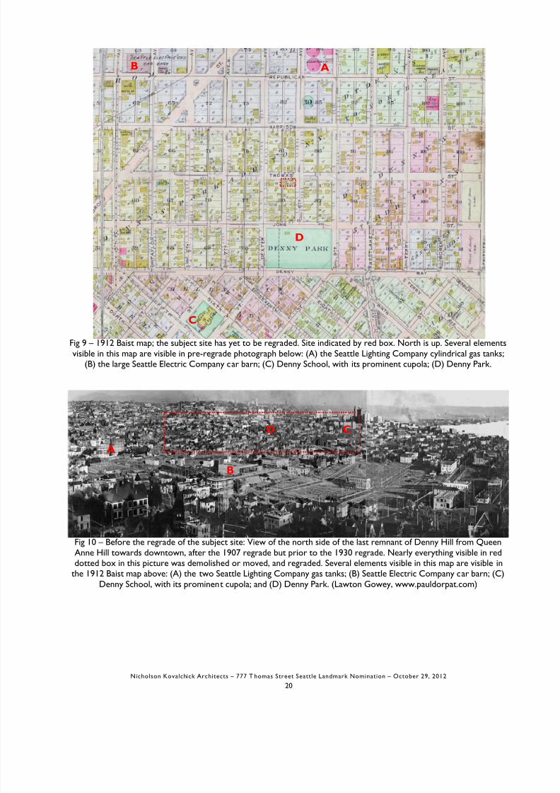
Fig 9 – 1912 Baist map; the subject site has yet to be regraded. Site indicated by red box. North is up. Several elementsvisible in this map are visible in pre-regrade photograph below: (A) the Seattle Lighting Company cylindrical gas tanks;
(B) the large Seattle Electric Company car barn; (C) Denny School, with its prominent cupola; (D) Denny Park.
AB
C
D

8/12/2019 Thomas Street
http://slidepdf.com/reader/full/thomas-street 21/42
Fig 11 – Before the regrade of the subject site: Detail of previous figure. View of the site from Queen Anne Hilltowards downtown, after the 1907 regrade but prior to the 1930 regrade. The red oval indicates the approximate
location of where the subject parcel was, prior to the regrade. Several sites on the 1912 Baist map are visible here: (B)Seattle Electric Company car barn; (C) Denny School, with its prominent cupola (soon to be demolished and its site
regraded); and (D) Denny Park. (Lawton Gowey, www.pauldorpat.com)
C
B
D

8/12/2019 Thomas Street
http://slidepdf.com/reader/full/thomas-street 22/42
Fig 14 – (Left) Map of the second phase of the Denny Hill regrades; the second phase was performed in two sectionscalled here “No. 1” (1906-11) and “No. 2” (1929-31). The first phase of the Denny regrade was completed in 1899,
and lowered 1st Avenue between Pine and Denny. Subject site approximately indicated by red box. A 1940 Kroll mapsuggests that the regrade may have spared the two blocks north of the subject site. (From Wilson, p.92). (Right)
“Power required on different grades” chart, 1913, used to justify regrades. (Seattle Municipal Archives #82).

8/12/2019 Thomas Street
http://slidepdf.com/reader/full/thomas-street 23/42
Fig 17 – During the regrades: View west on John Street, with 9th Avenue ahead running left to right, in 1930. Thesubject site is one block away at 8th and Thomas. The right of way that the camera sits upon will soon plow through the
hill ahead; the area to the left is the soon-to-be-flattened Denny Park. (SMA #4014).

8/12/2019 Thomas Street
http://slidepdf.com/reader/full/thomas-street 24/42
Fig 20 – Triptych view of the south side of the last part of Denny Hill from downtown: in 1928 (“Before ” top image)

8/12/2019 Thomas Street
http://slidepdf.com/reader/full/thomas-street 25/42
Fig 22 – 1939 southward view of Seattle's civic center, location of 1962 Seattle World's Fair. Broad Street anglesacross the upper left of the photo. The 1929-31 Denny regrade is visible in the upper left, as evidenced by starkly bare
mostly empty lots, with faint diagonal walking paths across parcels. The red dot is located at the intersection of 6th Avenue and Thomas Street (which is oriented left-right in this picture); the subject site is two blocks farther to the left,
at 8th and Thomas. (1983.10.17888, PEMCO Webster & Stevens Collection, MOHAI)

8/12/2019 Thomas Street
http://slidepdf.com/reader/full/thomas-street 26/42
2121 Westlake Avenue N. (1925); and 333 Westlake Avenue N. aka Durant Motor Company (1928)
513 Dexter Avenue N. aka Gabulson Packard Service (1928); and 400 Westlake Avenue N. aka Firestone Tire (1929)

8/12/2019 Thomas Street
http://slidepdf.com/reader/full/thomas-street 27/42
227 9th Avenue N. aka Builder’s Hardware Supply Co. (1931); and 234 9th Avenue N. aka Jones Soda Building (1940)
305 9th Avenue N. at Harrison Street (1949); and 228 Dexter Avenue N. at Thomas Street (1933)

8/12/2019 Thomas Street
http://slidepdf.com/reader/full/thomas-street 28/42
Period revival: Winthrop Hotel, Tacoma, 1927, at right in image (www.wikipedia.org)
Art Deco: 227 9th Avenue N. aka Builder’s Hardware, 1931 (current tax assessor photo); and 2603 3rd Ave. akaMetropolitan Press/Rite Aid, 1931 (NK Architects photo)

8/12/2019 Thomas Street
http://slidepdf.com/reader/full/thomas-street 29/42
Residential: Home in Blue Ridge neighborhood, 1935 (Seattle Times, June 2, 1935 p.15); and Yesler Terrace publichousing development, 1940s (www.pauldorpat.com)
S S 9 0 ( S C 9909 ) G

8/12/2019 Thomas Street
http://slidepdf.com/reader/full/thomas-street 30/42
Three images above: Exchange Building (John Graham Sr., 1929-31)
Left two images: Macy’s/Bon Marche (John Graham Sr., 1928-29); Right: Seattle Times Bldg (Robert Reamer, 1931)
8/12/2019 Thomas Street
http://slidepdf.com/reader/full/thomas-street 31/42
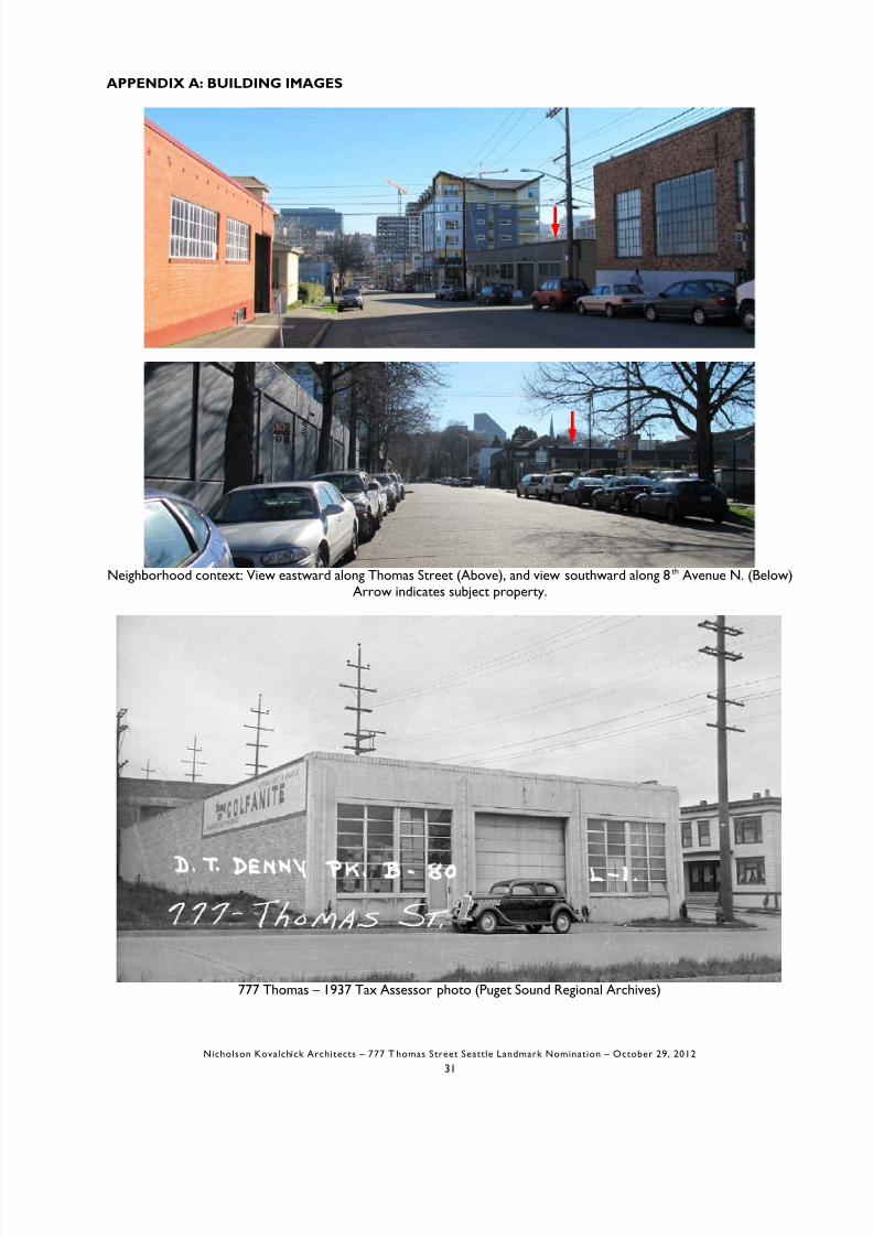
APPENDIX A: BUILDING IMAGES
Neighborhood context: View eastward along Thomas Street (Above) and view southward along 8th Avenue N (Below)

8/12/2019 Thomas Street
http://slidepdf.com/reader/full/thomas-street 32/42
777 Thomas – 1967 Tax Assessor photo (Puget Sound Regional Archives)

8/12/2019 Thomas Street
http://slidepdf.com/reader/full/thomas-street 33/42
777 Thomas – North elevation (facing Thomas Street)

8/12/2019 Thomas Street
http://slidepdf.com/reader/full/thomas-street 34/42
777 Thomas – South elevation (facing adjacent parking lot)

8/12/2019 Thomas Street
http://slidepdf.com/reader/full/thomas-street 35/42
777 Thomas – Detail, entry at north elevation.

8/12/2019 Thomas Street
http://slidepdf.com/reader/full/thomas-street 36/42
777 Thomas – Details of concrete work (left) and cast stone (right)

8/12/2019 Thomas Street
http://slidepdf.com/reader/full/thomas-street 37/42
777 Thomas – Interior; west (alley) wall in the distance at left, north (Thomas Street) wall at right. Note rampconnecting interior floor with Thomas Street garage entrance at center left of picture.

8/12/2019 Thomas Street
http://slidepdf.com/reader/full/thomas-street 38/42
.
·
...
.·
8/12/2019 Thomas Street
http://slidepdf.com/reader/full/thomas-street 39/42
..
.>
'
.-
.
-
.
.
';·
'
t
• .
I
.-
. __
•
l.
·..

8/12/2019 Thomas Street
http://slidepdf.com/reader/full/thomas-street 40/42
i:'
r
2
sI
tE - - - l l ~ wII
)
L...Jr- - - - ,-·· ·---
t
'
u-- ·
l;L..UE.
pk; lN; . ·-;,.·,
.... . _ ..
E.l-t CTI C:r )'-l• Cu\..A6
I,EC\lE:TA(<:If.-5
._ f · ' = = : : r £ : : : E ' ::=L:c==u:::::= l:::::.:.. : = : : I : : = = = : ~6 -
APPROVEDSUBJECT TO INSPECTION
CtliEF 0FFIRE DEPARTMENT
ft ®&4.. 7 .
: . : : : . , : ' < : _ . , ~ . E . 1 "" : a
;::: r :- Ai..._.. • rl\C:E. Z' DNE. NO. '2.
s · F • c:,\<L)UP 6 CK.<..upAr-...\C.Y
~ b l < ~ . T' <PE TION
-Oil): f . ~ - " ' - f c c . . - : . : . 1 : >~ - P A ~ \ ~ N I O . : . : .1 l 'N '2QO_:

8/12/2019 Thomas Street
http://slidepdf.com/reader/full/thomas-street 41/42
5\
E - - - - ~ ~ 7 · vf)
,... .. .: , 'v· ·H J .:. ,... , r r> •
, <. . \
. I
I
I
I
I
_ _ j
'1 \t ..
n- · - '1> o <Yi-1 70'' I( T1 P. 4 fL<.5
I
_I
. - 1 . ~ . - - - - - -
\.. L 1- ."".T - . , ••
c . · c - - · ~ .;-) --=- : .
\ z
II
_ ., . \ :y•
I .• . jt -• .
C,.;__us
· ~ .
;.:_, _ ...... . ":\
;- u'-1 ,6(:1 5-JH.f'nr z o o ~
I c .FM
l ' ~ l ; l f • 5 o P P £ . t,__l -:• "r- 0':' .1_U 1
• "- __·-y' - J •
A = " · . . . : : + - { ; . A , " D ~ \ C O : :l<.'t:KAIN IN G
}..
lJ.-..J._j
-<;(
I,zoo c 1
r-M
"F ... : \.: : ·. - , ~ : \ .,.... r•... '' :•r ·
/ ;n f C J ~ •J '
, , ; ; , s ~ Fic · i".-'\D
I i ~ " : a ' J .J '" ' • i .
. lL tl L• . + · c t \ ~ 1 " £ " ' . .t" N\:._....... •-:-::a._ · : - : ' -S"• ;,;:
7_5QD ~ F M tKISTrN'1
/VIO:C/1 . E f i - A " '• F \ 1.C:E. . : : ' C O " - ' · ~• ·::--; ,_<_() )
• 'T'-tPEME-IttH. SUPPl i .:; E:n;l}c,-r
G C><:.c...utoAr-...\C.Y
~ . . . S fC:U::....\1 ,)f'-l
•b CAt' f'.o-r' S FOOT 1>·-IZ.Cp
, . :: r , • , ~ - I ~ » WI N IN ~ ' - ' LJ fl.,\,
PE.;c s.?.:..c:. ?. st5
TAPJL<= l ' f ~ " ' A " FAC.7IR,'{;i
• \ . . . c : : ~ : - ? . 1 - \ ' - £ < < - f ..-n u"-J:.
L <:) T 1 . \-3ux . . . J c:>f"
D.\. -. C::vNY' :. P . ~ ; ; ; ; - KA D ~ , - 1\J O::Or.4TTLE-

8/12/2019 Thomas Street
http://slidepdf.com/reader/full/thomas-street 42/42
SUBJECT SITE


![Index [ ] · PDF fileIndex A Adair, Sean (Free State soldier) ... James (Bridge Street, ... Bourke, Martin (see Martin Burke) Bourke, Thomas (see Thomas Burke)](https://img.pdfslide.us/doc/110x75/5aacd3737f8b9a59658d81d7/index-a-adair-sean-free-state-soldier-james-bridge-street-bourke.jpg)