Embed Size (px)
Citation preview
1
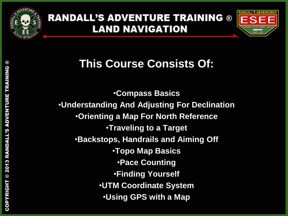
This Course Consists Of:
•Compass Basics
•Understanding And Adjusting For Declination
•Orienting a Map For North Reference
•Traveling to a Target
•Backstops, Handrails and Aiming Off
•Topo Map Basics
•Pace Counting
•Finding Yourself
•UTM Coordinate System
•Using GPS with a Map
3
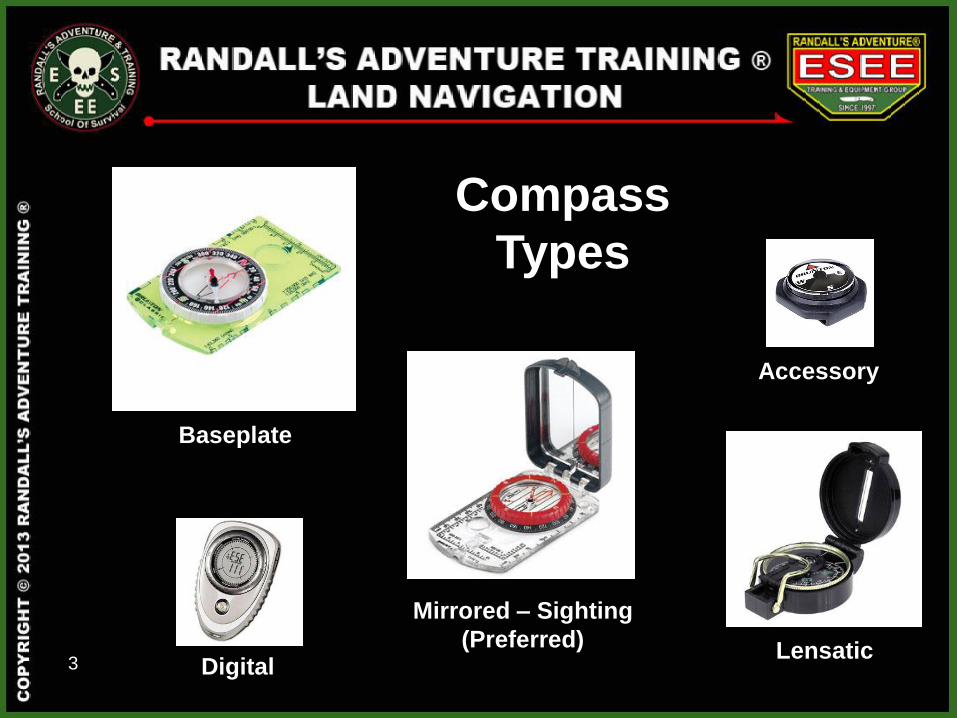
Compass
Types
Baseplate
Digital
Accessory
Lensatic
Mirrored – Sighting
(Preferred)
4
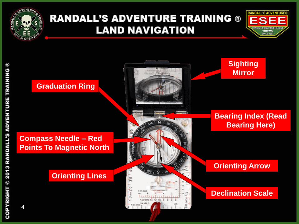
Bearing Index (Read
Bearing Here)
Orienting Arrow
Compass Needle – Red
Points To Magnetic North
Orienting Lines
Graduation Ring
Sighting
Mirror
Declination Scale
5
Declination
Magnetic Declination is the difference between True
North and Magnetic North. A compass needle
ALWAYS points to Magnetic North.
6
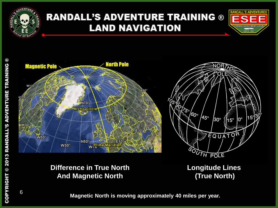
Longitude Lines
(True North)
Difference in True North
And Magnetic North
Magnetic North is moving approximately 40 miles per year.
7
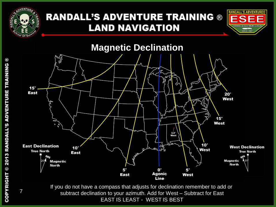
Magnetic Declination
West East
If you do not have a compass that adjusts for declination remember to add or
subtract declination to your azimuth. Add for West – Subtract for East
EAST IS LEAST - WEST IS BEST
8
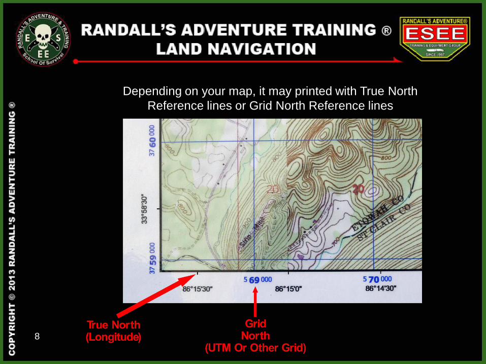
Depending on your map, it may printed with True North
Reference lines or Grid North Reference lines
1000 meters
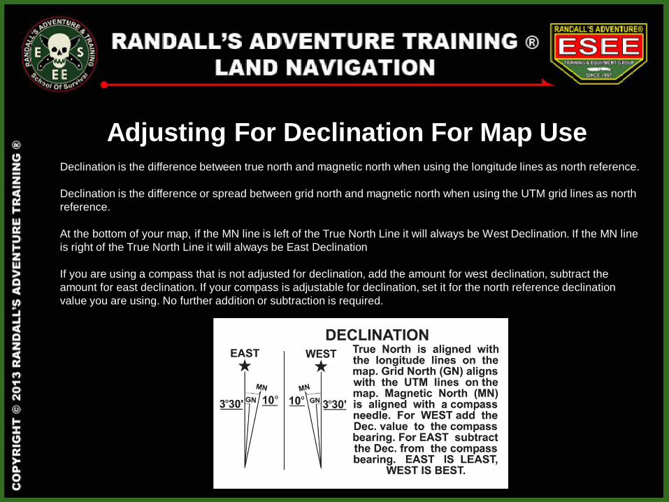
Declination is the difference between true north and magnetic north when using the longitude lines as north reference.
Declination is the difference or spread between grid north and magnetic north when using the UTM grid lines as north
reference.
At the bottom of your map, if the MN line is left of the True North Line it will always be West Declination. If the MN line
is right of the True North Line it will always be East Declination
If you are using a compass that is not adjusted for declination, add the amount for west declination, subtract the
amount for east declination. If your compass is adjustable for declination, set it for the north reference declination
value you are using. No further addition or subtraction is required.
Adjusting For Declination For Map Use
10
Ft. Payne, AL
3.5 Degrees West
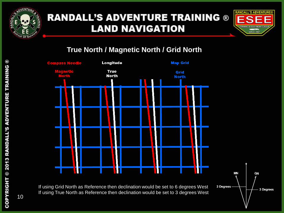
True North / Magnetic North / Grid North
If using Grid North as Reference then declination would be set to 6 degrees West
If using True North as Reference then declination would be set to 3 degrees West
11
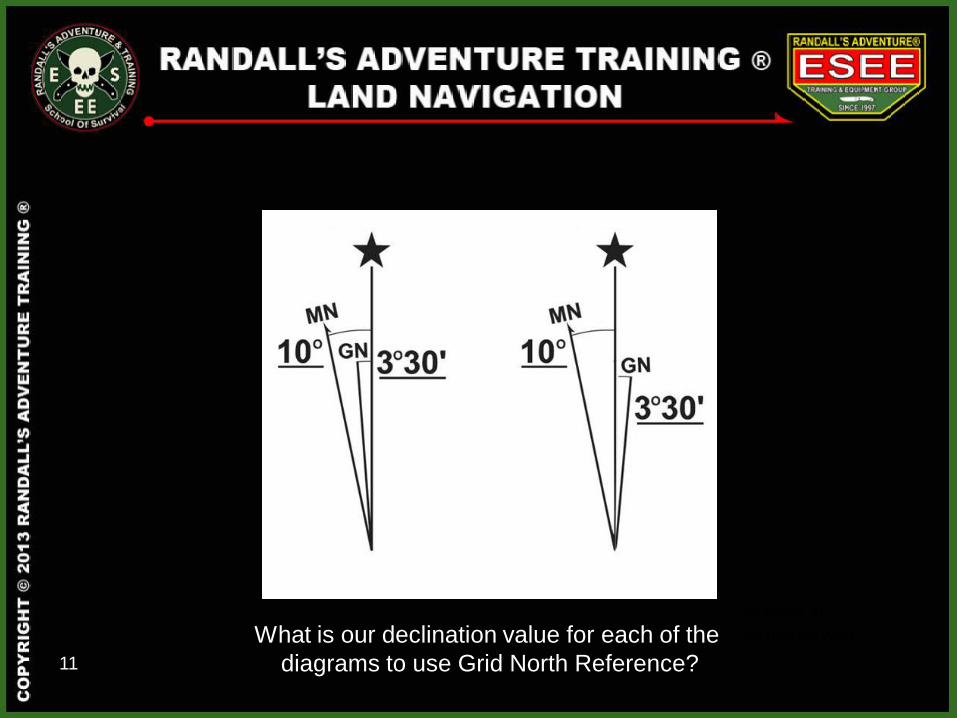
Ft. Payne, AL
3.5 Degrees West What is our declination value for each of the
diagrams to use Grid North Reference?
12
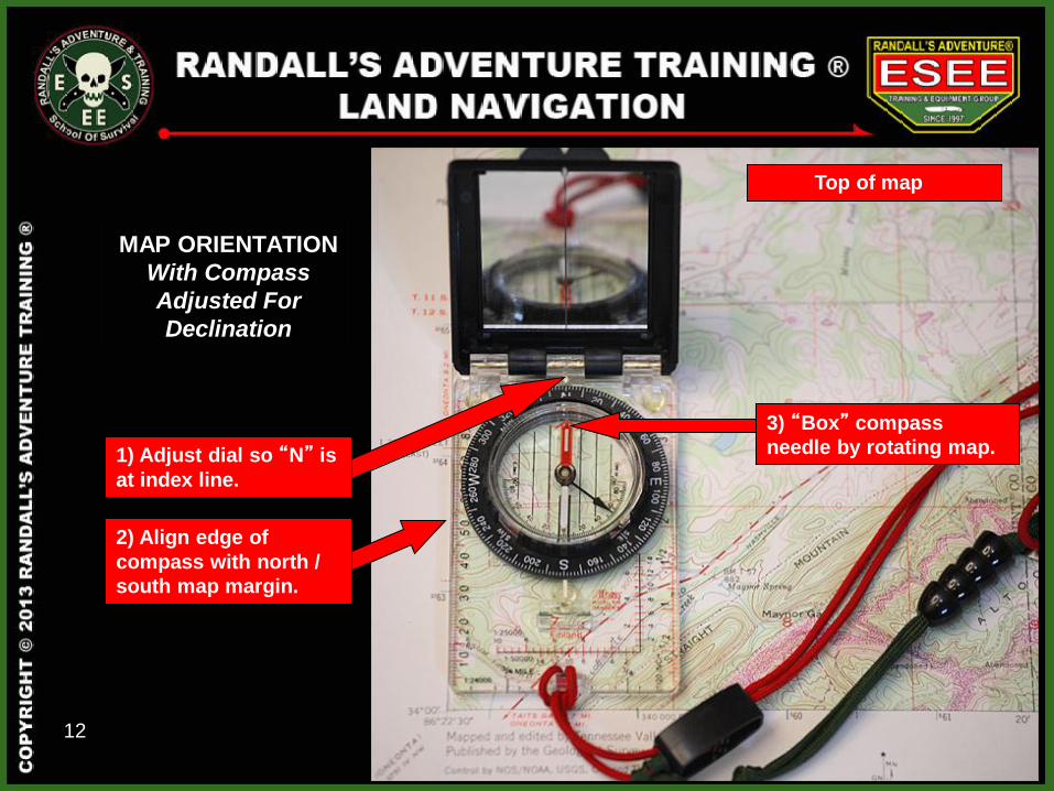
3) “Box” compass
needle by rotating map.
2) Align edge of
compass with north /
south map margin.
Top of map
MAP ORIENTATION
With Compass
Adjusted For
Declination
1) Adjust dial so “N” is
at index line.
13
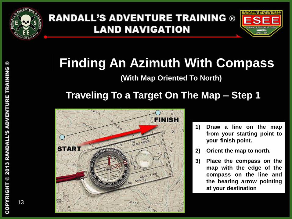
Traveling To a Target On The Map – Step 1
1) Draw a line on the map
from your starting point to
your finish point.
2) Orient the map to north.
3) Place the compass on the
map with the edge of the
compass on the line and
the bearing arrow pointing
at your destination
Finding An Azimuth With Compass (With Map Oriented To North)
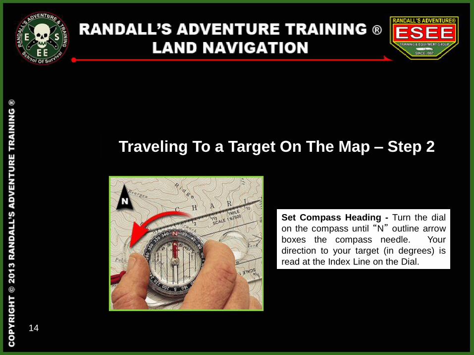
14
Set Compass Heading - Turn the dial
on the compass until “N” outline arrow
boxes the compass needle. Your
direction to your target (in degrees) is
read at the Index Line on the Dial.
Traveling To a Target On The Map – Step 2
15
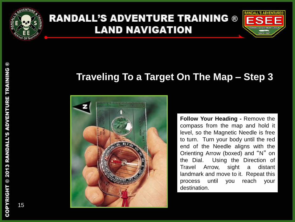
Follow Your Heading - Remove the
compass from the map and hold it
level, so the Magnetic Needle is free
to turn. Turn your body until the red
end of the Needle aligns with the
Orienting Arrow (boxed) and “N” on
the Dial. Using the Direction of
Travel Arrow, sight a distant
landmark and move to it. Repeat this
process until you reach your
destination.
Traveling To a Target On The Map – Step 3
16
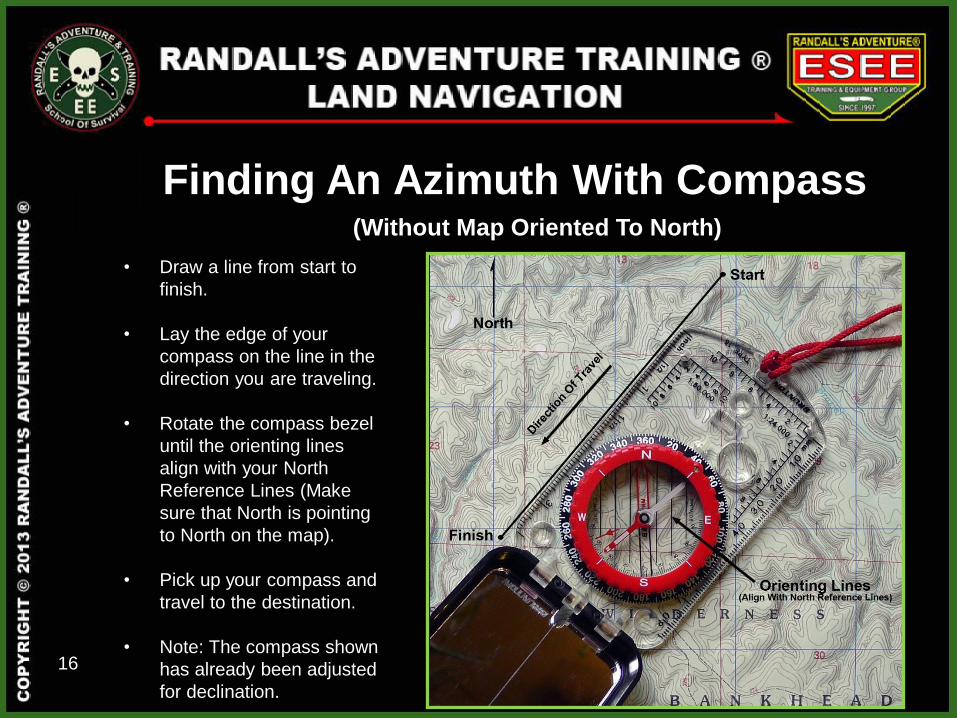
Finding An Azimuth With Compass (Without Map Oriented To North)
• Draw a line from start to
finish.
• Lay the edge of your
compass on the line in the
direction you are traveling.
• Rotate the compass bezel
until the orienting lines
align with your North
Reference Lines (Make
sure that North is pointing
to North on the map).
• Pick up your compass and
travel to the destination.
• Note: The compass shown
has already been adjusted
for declination.
17
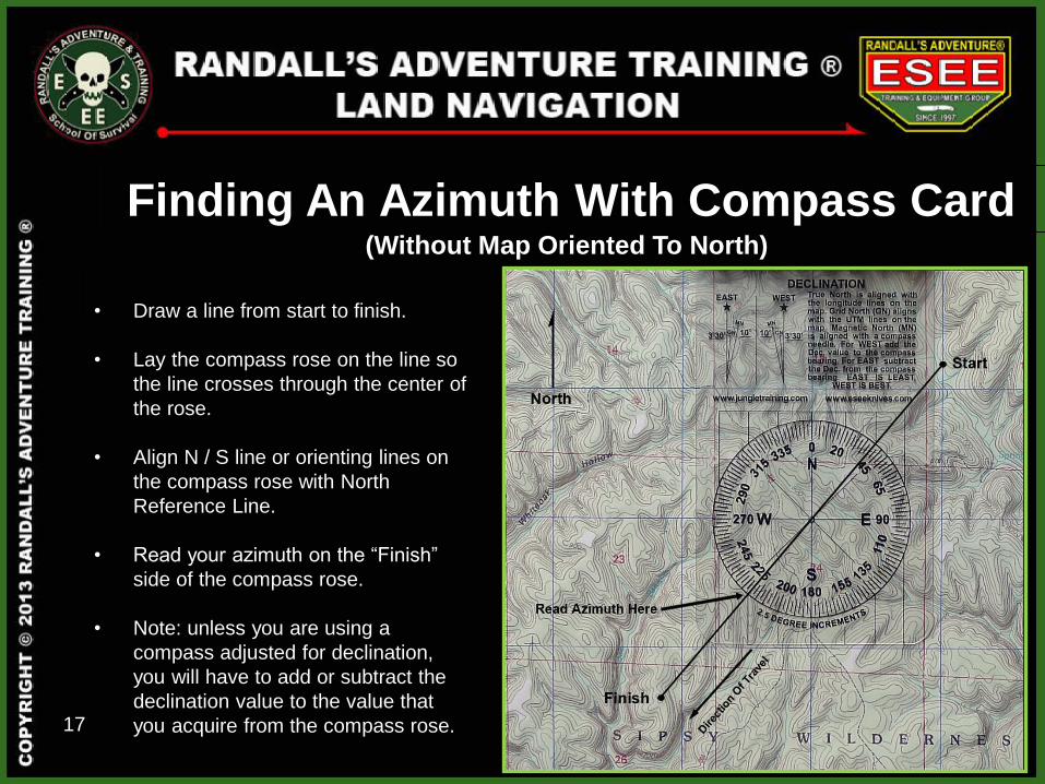
Finding An Azimuth With Compass Card (Without Map Oriented To North)
• Draw a line from start to finish.
• Lay the compass rose on the line so
the line crosses through the center of
the rose.
• Align N / S line or orienting lines on
the compass rose with North
Reference Line.
• Read your azimuth on the “Finish”
side of the compass rose.
• Note: unless you are using a
compass adjusted for declination,
you will have to add or subtract the
declination value to the value that
you acquire from the compass rose.
18
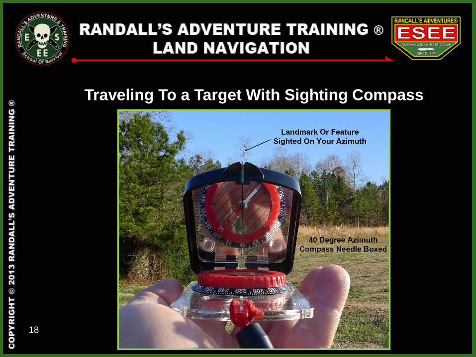
Traveling To a Target With Sighting Compass
19
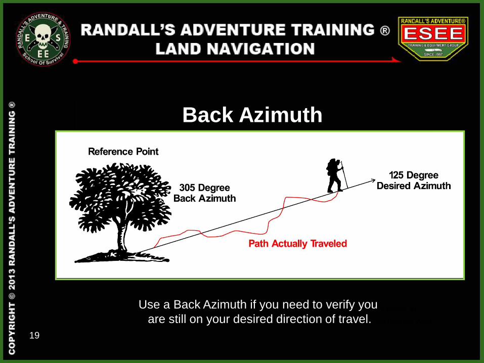
Back Azimuth
Ft. Payne, AL
3.5 Degrees West
Use a Back Azimuth if you need to verify you
are still on your desired direction of travel.
20
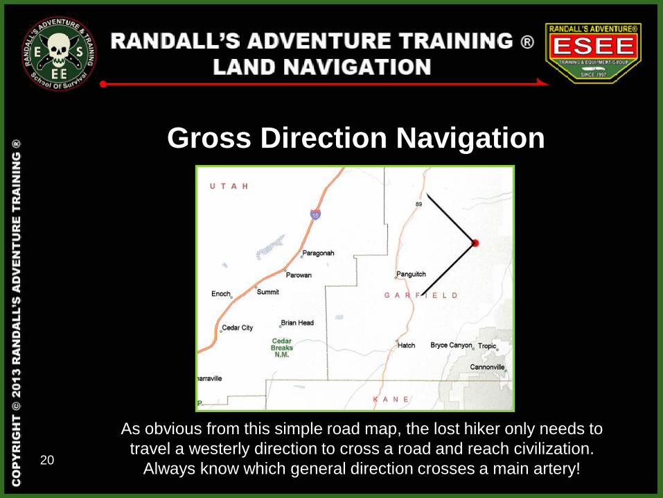
Gross Direction Navigation
Ft. Payne, AL
3.5 Degrees West As obvious from this simple road map, the lost hiker only needs to
travel a westerly direction to cross a road and reach civilization.
Always know which general direction crosses a main artery!
21
Terrain Association Navigation
Ft. Payne, AL
3.5 Degrees West
This is the most widely used method of navigation. The navigator plans
his route so that he moves from terrain feature to terrain feature. An
automobile driver in a city uses this technique as he moves along a street
or series of streets, guiding on intersections or features such as stores,
parks or houses. Like the driver, the navigator selects routes or streets
between key points or intersections. These key points can be lakes,
mountains, roads or any other terrain feature readily recognized on a
map. Before you hike a new area, familiarize yourself with the terrain by
studying maps, satellite photos or any other available information.
22
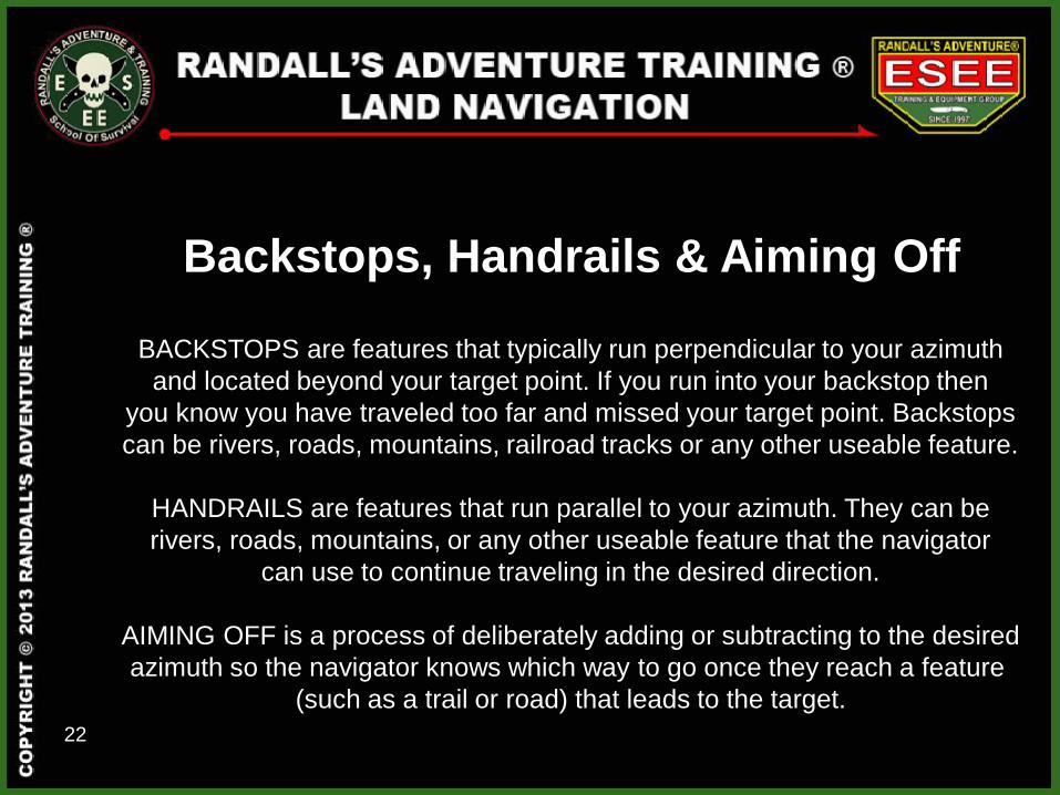
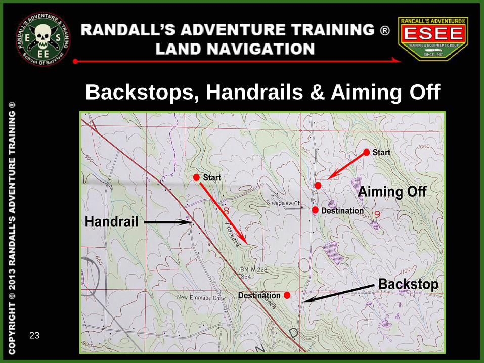
Backstops, Handrails & Aiming Off
BACKSTOPS are features that typically run perpendicular to your azimuth
and located beyond your target point. If you run into your backstop then
you know you have traveled too far and missed your target point. Backstops
can be rivers, roads, mountains, railroad tracks or any other useable feature.
HANDRAILS are features that run parallel to your azimuth. They can be
rivers, roads, mountains, or any other useable feature that the navigator
can use to continue traveling in the desired direction.
AIMING OFF is a process of deliberately adding or subtracting to the desired
azimuth so the navigator knows which way to go once they reach a feature
(such as a trail or road) that leads to the target.
23
Backstops, Handrails & Aiming Off
24
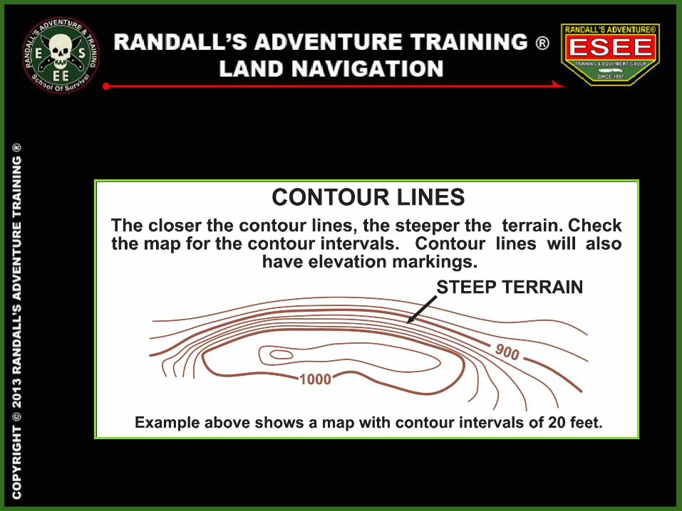
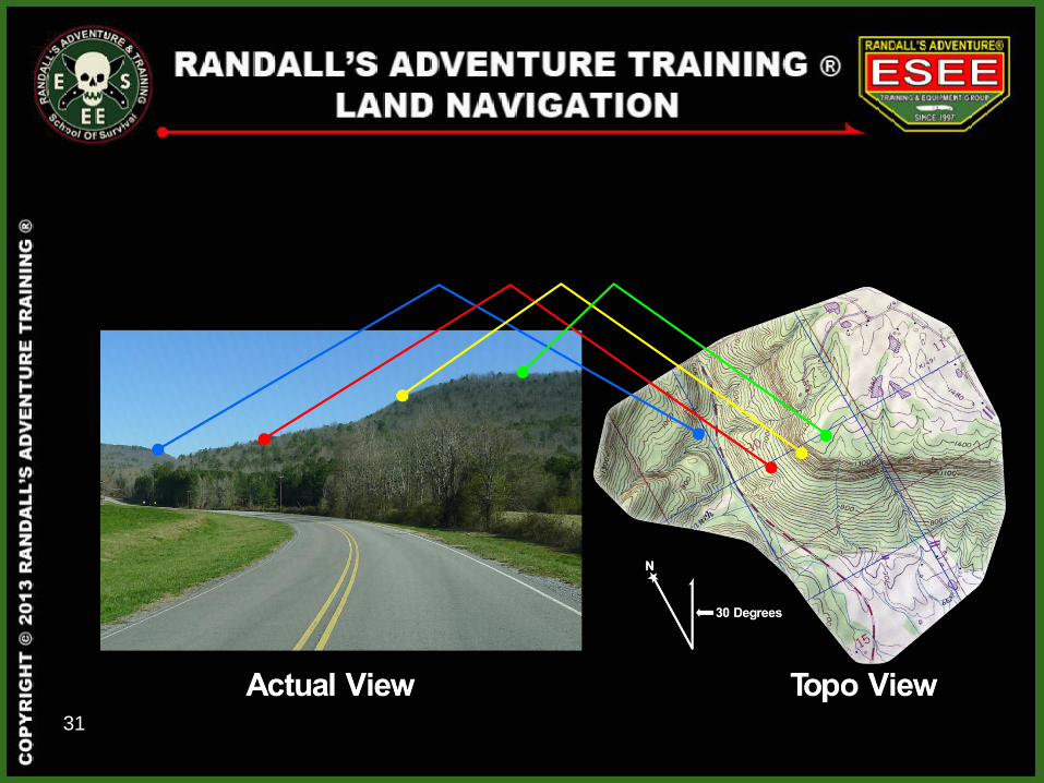
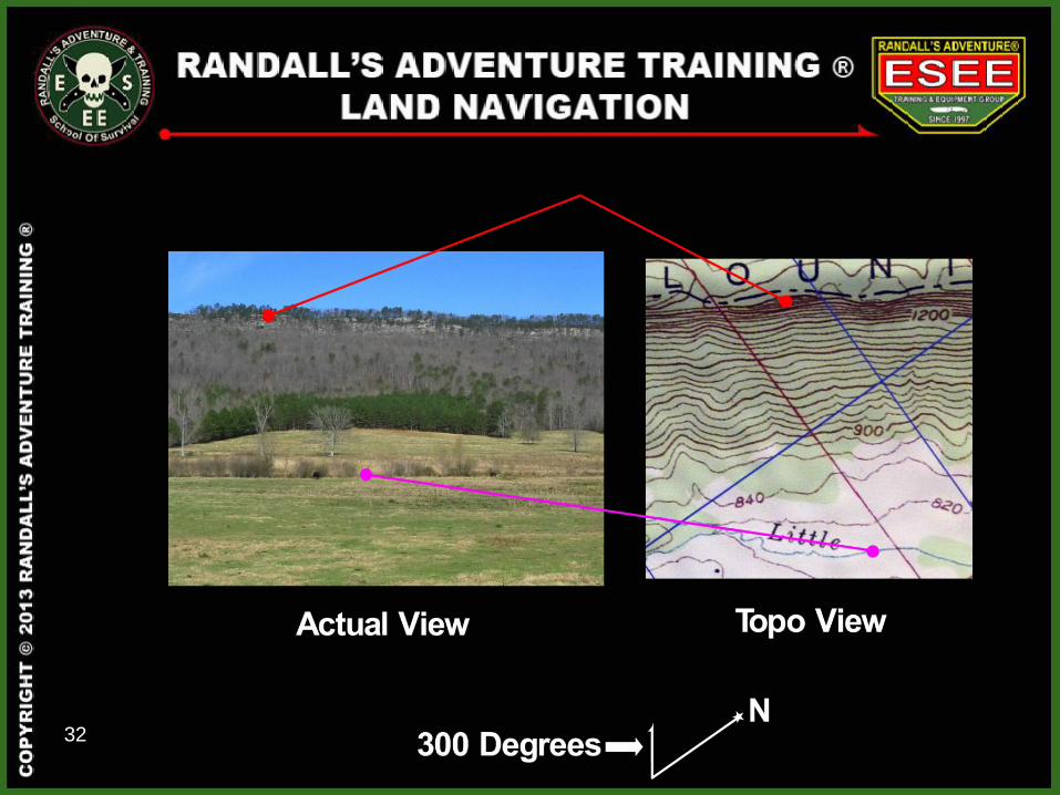
TOPO MAP BASICS
25
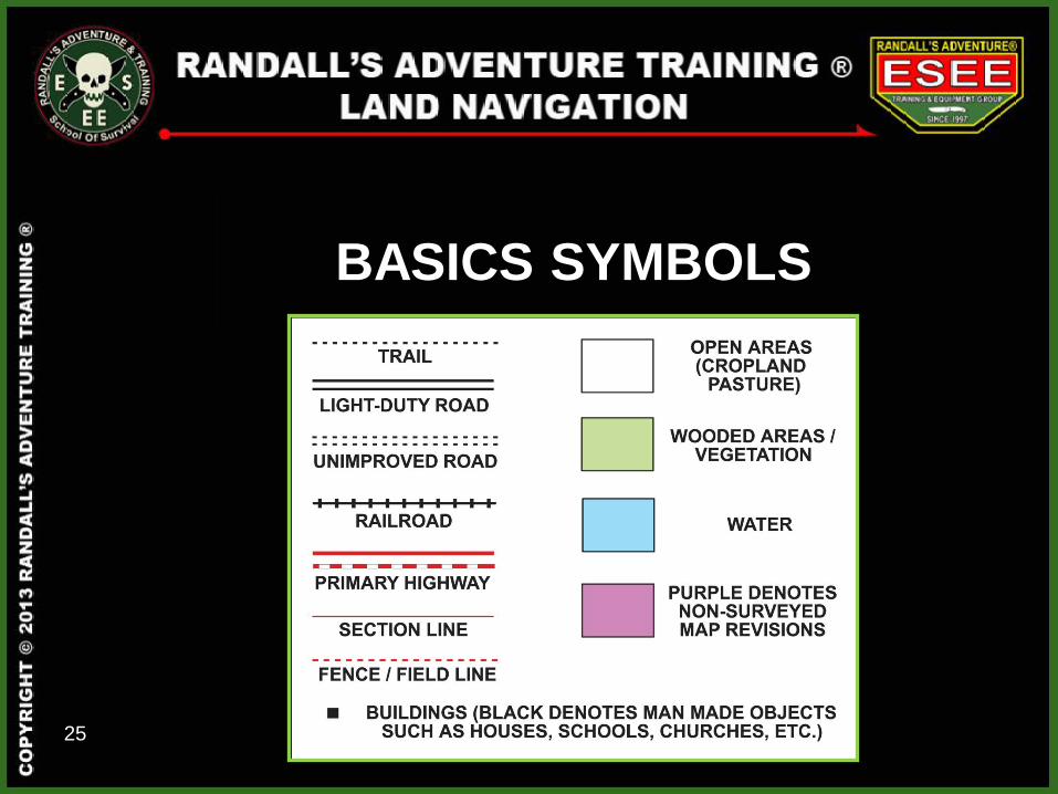
BASICS SYMBOLS
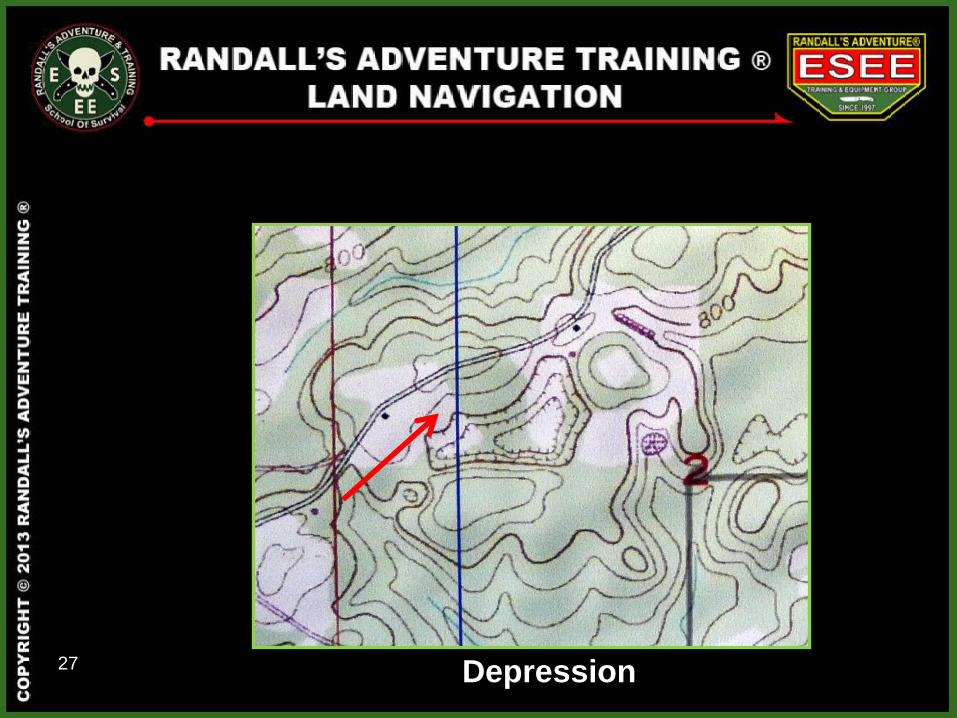
27 Depression
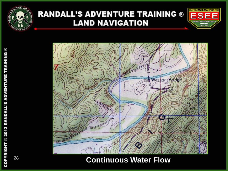
28 Continuous Water Flow
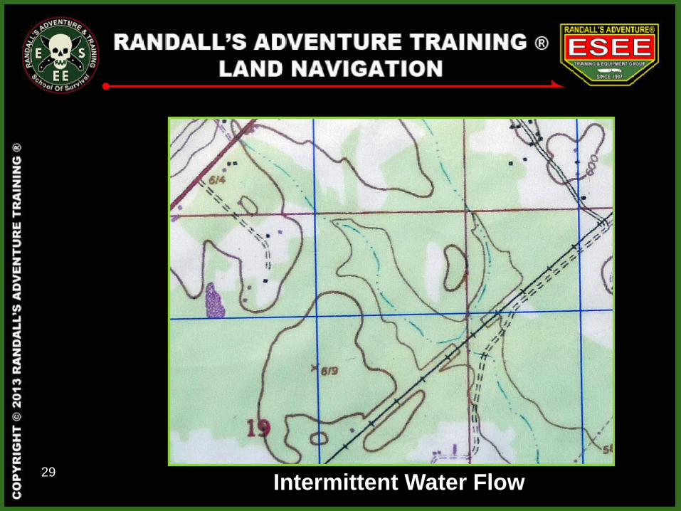
29 Intermittent Water Flow
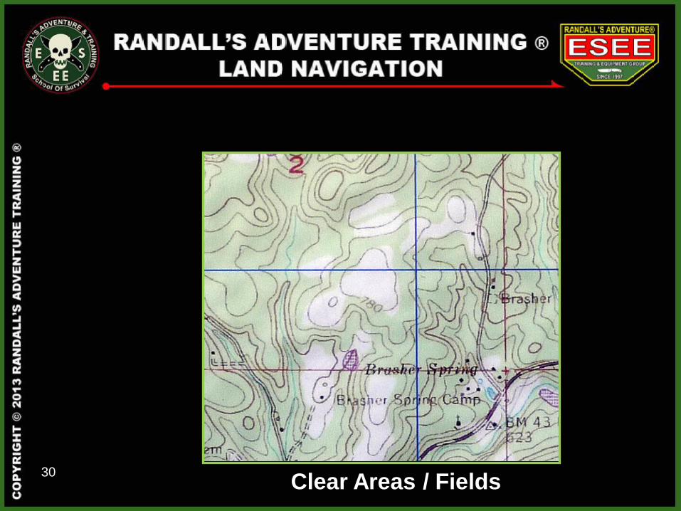
30 Clear Areas / Fields
31
32
DETERMINING DISTANCE
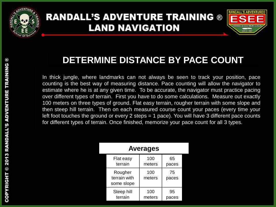
DETERMINE DISTANCE BY PACE COUNT
In thick jungle, where landmarks can not always be seen to track your position, pace
counting is the best way of measuring distance. Pace counting will allow the navigator to
estimate where he is at any given time. To be accurate, the navigator must practice pacing
over different types of terrain. First you have to do some calculations. Measure out exactly
100 meters on three types of ground. Flat easy terrain, rougher terrain with some slope and
then steep hill terrain. Then on each measured course count your paces (every time your
left foot touches the ground or every 2 steps = 1 pace). You will have 3 different pace counts
for different types of terrain. Once finished, memorize your pace count for all 3 types.
Flat easy
terrain
100
meters
65
paces
Rougher
terrain with
some slope
100
meters
75
paces
Steep hill
terrain
100
meters
95
paces
Averages
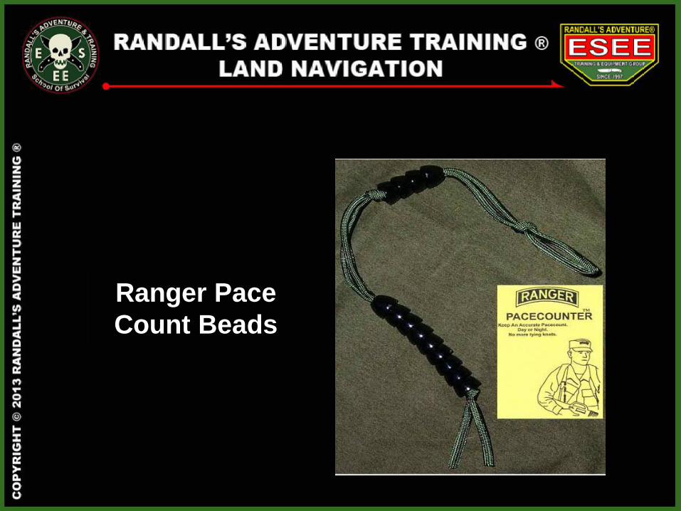
Ranger Pace
Count Beads
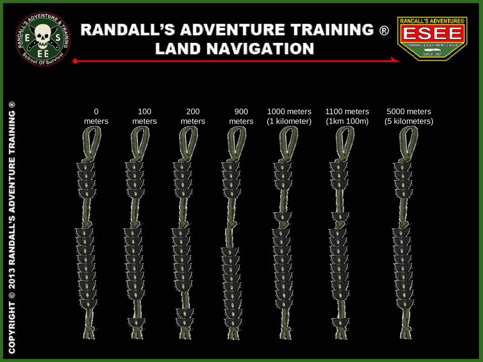
4 3 2
1000 meters
(1 kilometer)
9 8 7 6 5 4 3 2
1
1100 meters
(1km 100m)
9 8 7 6 5 4 3 2
4
3 2
0
meters
4 3 2 1
9 8 7 6 5 4 3 2 1
100
meters
9 8 7 6 5 4 3 2
4 3 2 1
200
meters
9 8 7 6 5 4 3
1
4 3 2 1
900
meters
8 7 6 5 4 3 2
1
4 3 2 1
5000 meters
(5 kilometers)
4 3 2 1
9 8 7 6 5 4 3 2 1
FINDING YOURSELF
38
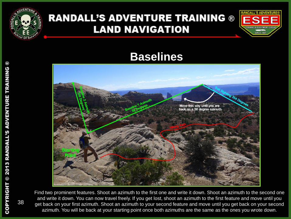
Baselines
Find two prominent features. Shoot an azimuth to the first one and write it down. Shoot an azimuth to the second one
and write it down. You can now travel freely. If you get lost, shoot an azimuth to the first feature and move until you
get back on your first azimuth. Shoot an azimuth to your second feature and move until you get back on your second
azimuth. You will be back at your starting point once both azimuths are the same as the ones you wrote down.
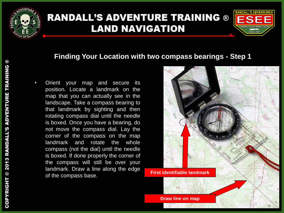
Finding Your Location with two compass bearings - Step 1
• Orient your map and secure its
position. Locate a landmark on the
map that you can actually see in the
landscape. Take a compass bearing to
that landmark by sighting and then
rotating compass dial until the needle
is boxed. Once you have a bearing, do
not move the compass dial. Lay the
corner of the compass on the map
landmark and rotate the whole
compass (not the dial) until the needle
is boxed. If done properly the corner of
the compass will still be over your
landmark. Draw a line along the edge
of the compass base. YOU ARE HERE
First identifiable landmark
Draw line on map
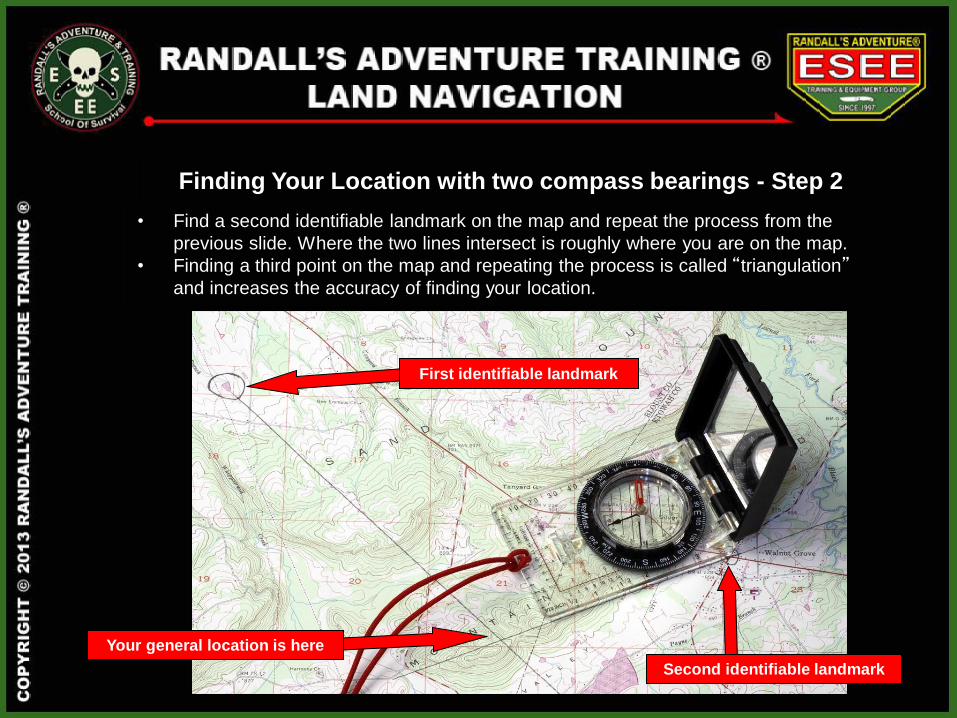
Finding Your Location with two compass bearings - Step 2
• Find a second identifiable landmark on the map and repeat the process from the
previous slide. Where the two lines intersect is roughly where you are on the map.
• Finding a third point on the map and repeating the process is called “triangulation” and increases the accuracy of finding your location.
First identifiable landmark
Your general location is here
Second identifiable landmark
PLOTTING COORDINATES
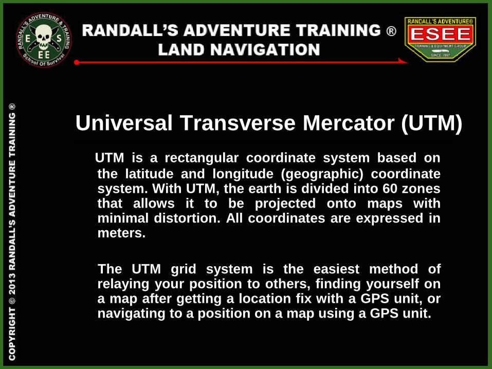
UTM is a rectangular coordinate system based on
the latitude and longitude (geographic) coordinate system. With UTM, the earth is divided into 60 zones that allows it to be projected onto maps with minimal distortion. All coordinates are expressed in meters.
The UTM grid system is the easiest method of relaying your position to others, finding yourself on a map after getting a location fix with a GPS unit, or navigating to a position on a map using a GPS unit.
Universal Transverse Mercator (UTM)
1 60
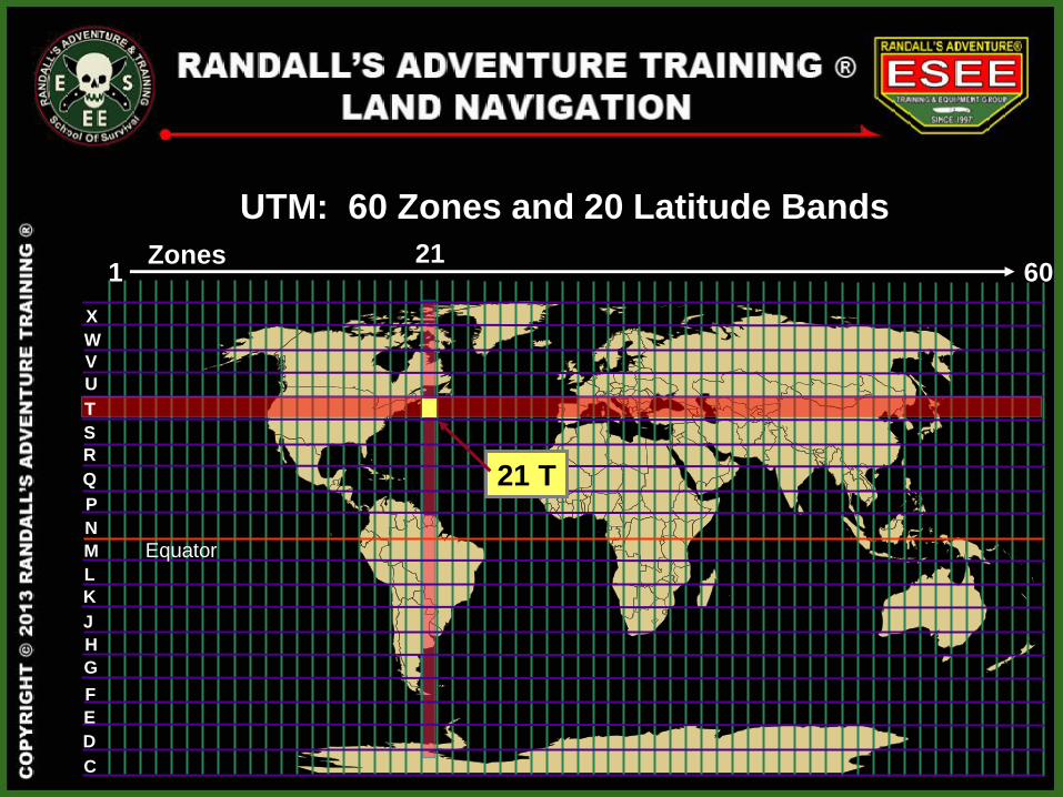
UTM: 60 Zones and 20 Latitude Bands
21
G
M
W
X
D
C
E
F
H
J
K
L
N
P
Q
R
S
T
U
V
21 T
T
Zones
Equator
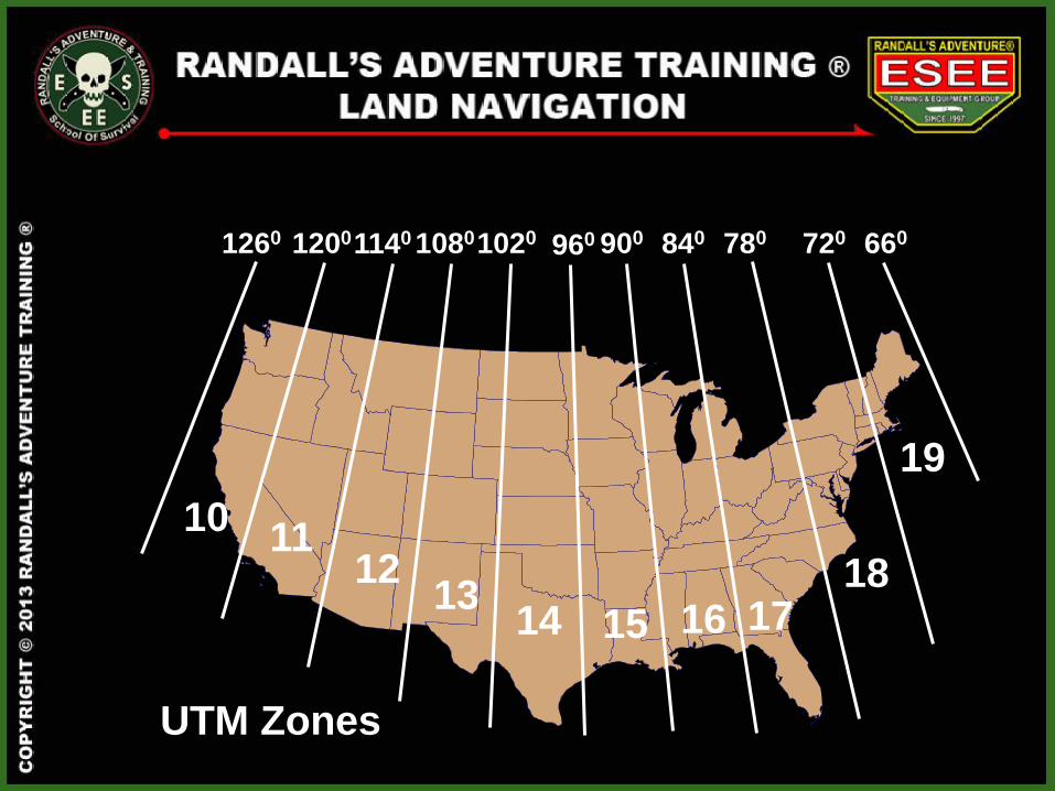
1260 1200 1140 1080 1020 960 900 840 780 720 660
10 11
12 13
14 15 16 17 18
19
UTM Zones
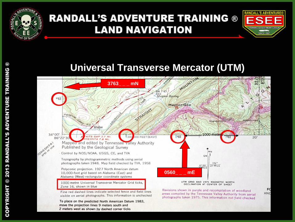
Universal Transverse Mercator (UTM)
0560_ _ _ mE
3763_ _ _ mN
1000 meters
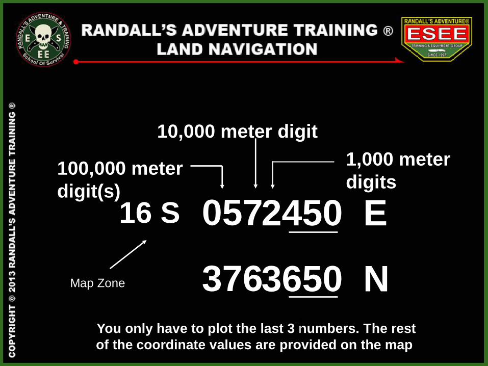
2450 E
3650 N
100,000 meter
digit(s)
10,000 meter digit
05
37
7
6
1,000 meter
digits
You only have to plot the last 3 numbers. The rest
of the coordinate values are provided on the map.
16 S
Map Zone
1000 meters
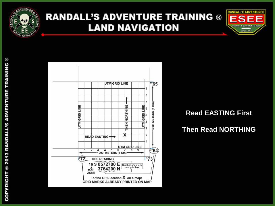
Read EASTING First
Then Read NORTHING
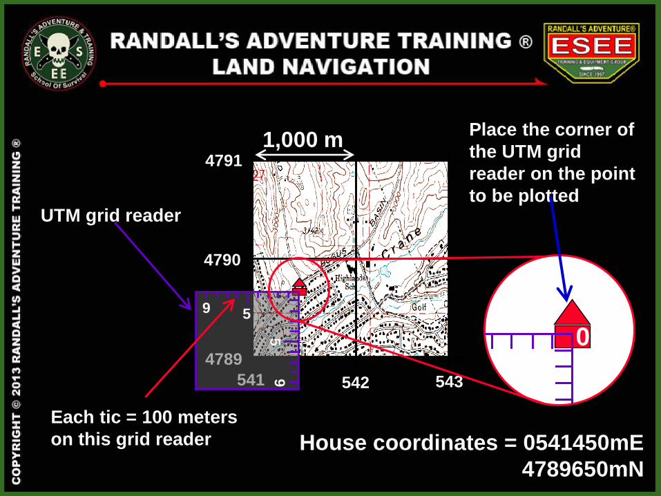
House coordinates = 0541450mE
4789650mN
UTM grid reader
Place the corner of
the UTM grid
reader on the point
to be plotted
542 543
4790
4791 1,000 m
541
4789
5
5
9
9
Each tic = 100 meters
on this grid reader
0
1000 meters
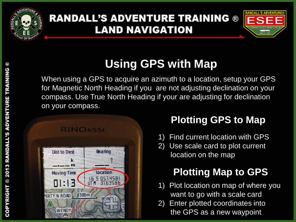
Plotting GPS to Map
1) Find current location with GPS
2) Use scale card to plot current
location on the map
Plotting Map to GPS
1) Plot location on map of where you
want to go with a scale card
2) Enter plotted coordinates into
the GPS as a new waypoint
When using a GPS to acquire an azimuth to a location, setup your GPS
for Magnetic North Heading if you are not adjusting declination on your
compass. Use True North Heading if your are adjusting for declination
on your compass.
Using GPS with Map