Embed Size (px)
Citation preview

New Jersey Well Vulnerability QuestionnaireFor Obtaining a Pesticide and/or SOC Waiver
INTRODUCTION
A Synthetic Organic Compound (SOC) Waiver may save you up to $30,000 in water samplingcosts The purpose of this Questionnaire is to help you obtain a waiver from sampling for some or all ofthe SOCs (primarily pesticides) that are part of the federal drinking water monitoring requirements Withouta waiver, you are required by the federal regulations to conduct four rounds of quarterly sampling forcertain pesticides and SOCs Eligibility for a SOC Waiver may result in a reduction or elimination of theneed to monitor at your water system However, the Bureau of Safe Drinking Water (Bureau) cannotdetermine your system's eligibility for a waiver without the Questionnaire information
INSTRUCTIONS
1 To be considered for a SOC waiver, a completed Questionnaire must be on file with the Bureau foreach well at your system
2 There are FOUR PAGES OF QUESTIONS to complete (pages 3, 6, 7, and 8) On those pages,there are five parts Parts A, B, C, D and E Detailedinstructions accompany each section Youmust fill out and return all four (pages 3, 6, 7, and 8) pages of the Questionnaire
3 Note that if more than one well is in use at your system, then you should photocopy pages 3, 6, 7and 8 of the Questionnaire, and complete those pages for each well listed
4 There are four attachments, listed below, which will further assist you in filling out the Questionnaire
5 When completed, please return the Questionnaire (pages 3, 6, ,7 and 8) to
NJDEP, Mail Code 401-03Bureau of Safe Drinking WaterPO Box 420
Trenton, NJ 08625-0420
6 Ifyou have anyquestions, please callthe Bureau of Safe Drinking Water at (609) 292-5550
7 Be sure to make a photocopy for your own records
8 We strongly suggest that you complete the Questionnaire within the specified timeframe It will saveyou a considerable amount of time andmoney in monitoring costs and/or possible enforcementactions
ATTACHMENTS
Attachment 1 - Table Used to Determine the Calculated Fixed Radius for a Well
Attachment 2 - Well Record Information Form
Attachment 3 - CFR Table Selection Based on Geologic Formation or Aquifer Name
Attachment 4 - CFR Table Selection Based on Municipality

New Jersey Well Vulnerability QuestionnaireFor Obtaining a Pesticide and /or SOC Waiver
Part A Well Information
Complete Part A for each well in your system, questions 1 through 15 Detailedinstructions for each question appear in Italics, adjacent to the question Based on/theanswers provided to questions 7,10, 11, 12 and 14, you should be able to select theappropriate "calculated fixed radius (CFR) from one of the fourtables contained inAttachment 1 The CFR value is the answer to question 15 Once you havedetermined the CFR value, you use it to define an area which surrounds the well TheCFR value is the length, in feet, of the radiusof a circle, which defines the vulnerablearea surrounding your well The vulnerability of your well to contamination is based onwell construction, land uses and activities within the CFR area To demonstrate theCFR concept, page 5 shows an idealized CFRarea, enlarged to three times itsnormal size There are detailed instructions on page 4 for determining the correctCFR for each well
The resulting CFR area is the region around the well that you visually inspect inorder to answer the land use and activity questions in parts B and C of theQuestionnaire Instructions to determine your CFR area follow
If the answer to question 12 or to 14 is unknown, then the CFR cannot bedetermined and the well's vulnerability cannot be assessed Without the CFRdetermination, the Questionnaire cannot be completed and the Bureau cannotconsider granting a waiver As such, if a waiver is desired, it is in the best interest ofthe water system to find the missing information The water system/well owner cansubmit a request to the Bureau for a wellrecord search to locate the missinginformation, orcan contact a licensed well driller to take the needed measurementsAttachment 2, contains a request form fora wellrecordsearch
Part B Current Land Use SurveyOnce you have determined the calculated fixed radius (CFR), go to your well
site Visually inspect the CFR area for each of the five land use categories in PartB-1 Circle the percent which best describes each land use within the CFR Ifanyof thelandis used for agriculture, indicate which types of crops are grown in Part B-2Agricultural crops If there is no agricultural use with in the CFR, skip PartB-2
Part C Current Activities SurveyPartC must be completedby canvassing the area within the CFR and visually
inspecting that area Indicate whether ornot a particular activity occurs within the CFRby placingan "x" in eitherthe YES or NO column
Part D Additional Information
Indicate the answer to the question with an "x"
Part E Questionnaire CertificationThe person who signs the Questionnaire should be the owner oroperator of
the water system ora designated representative authonzed to sign and to acceptresponsibility for the answers provided in the Questionnaire

New Jersey Well Vulnerability Questionnaire for Obtaining a Pesticide/SOC Waiver
PWSID# NJ Facility ID # TP Well ID # WL
Part A Well Information (specific instructions or comments for each question below in italics)
Important Note much of the information requested below can now be found under the Facilities tab on theBureau s Drinking Water Watch website at https//www11 state n| us/DEP WaterWatch public/index isp
INSTRUCTIONS WELL INFORMATION
1) Print the Public Water System ID # It starts with the letters NJ followed by 7 digits PWSID #
2) Print the name of the Water System SYSTEM NAME
3) Printthe Well Name (e g Well 1 back up well) Ifyou are unsure this can be foundusing the Bureaus Dnnkmg Water Watch website mentionedabove
WELL NAME
4) The Facility Code for the well starts with the letters WL followed by6 digits Ifyouare unsure this can be found using the Bureaus Dnnkmg WaterWatch websitementioned above
WELL FACILITY ID #
5) Printthe name ofthe treatment plant/facility associated with the well (e g Park StreetTreatment Plant Well A Treatment Plant)
TREATMENT FACILITY NAME
6) The Facility Codeforthe treatmentplant/facility associated with the well starts withthe letters TP followed by 6 digits Ifyou are unsure thiscan be found using theBureau s Dnnkmg WaterWatchwebsite mentioned above
TREATMENT FACILITY ID #
7) Print the Municipality where the WELL is located (notwhere the office or treatmentplant is located)
MUNICIPALITY
8) Print the County wherethe WELL is located (not wherethe office or treatment plantislocated)
COUNTY
9)TheWell Permit # may be known or found in the owner s records or may be labeledon the well head itself If it is unknown, please reauest a well record search usma theform provided in Attachment 2
WELL PERMIT*
10)The Aquifer Namemay be known bythe owneror found on the well record If notavailable itmaybe requested using the form in Attachment 2 Attachment 3 lists allrelevant aquifer names
AQUIFER NAME
11)The Geologic Formation maybe known byowneror found on the well record Ifnotavailable it may be requested using the form inAttachment 2 Attachment 3 lists allrelevant geologic formations
GEOLOGIC FORMATION
12)The Well Depth can be found on the well permit/record (see question 9 above) If itis unknown please request itusing the form provided in Attachment 2 The rest of thisQuestionnaire cannot be completed without the well depth
WELL DEPTH (FT)
13)The Casing Length can be found on the well permit/record If it is unknown it maybe requested using the form provided inAttachment 2
CASING LENGTH (FT)
14) The Pump Capacity can be found onthe well permit/record (see question 9 above)If it is unknown please request itusing the form provided in Attachment 2 The rest ofthis Questionnaire cannot be completed without the pump capacity
PUMP CAPACITY (GPM)
15)TheCalculated Fixed Radius (CFR) should be looked upin Attachment 1 (seedetailed CFR instructions on the next page) The rest of this Questionnaire cannot becompleted without determining the CFR
CALCULATED FIXED RADIUS

New Jersey Well Vulnerability QuestionnaireFor Obtaining a Pesticide and/or SOC Waiver
Part A FINDING YOUR WELL'S CALCULATED FIXED RADIUS
STEP A See Attachment 1-Tables used to Determine the Calculated Fixed Radius
There are four tables in Attachment 1 containing CFR values You need todetermine which of these four tables you should use foryour well This can be done intwo ways The easiest way (and more precise way) is ifyou know the aquiferorgeologic formation in which your well is screened You simply look up the name of theaquifer or formation inAttachment 3, which lists allaquifers and geologic formations inthe State, in alphabeticalorder Once you find aquiferor formation in the list, then youcan see which table in Attachment 1 you need to use to identify the correct CFR valuefor your well
Ifyou do not know the name of the aquifer orthe geologic formation, then youmust use the second method This is to look up the county and the municipalityin whichthe well (not the office or treatment facility) is located, usingAttachment 4 Themunicipalities are listed under the appropriate county, in alphabetical order Once youfind the municipality in the list, then you can see which table in Attachment 1 you needto use to identify the correctCFR value foryour well
At this point you should know which of the four tables in Attachment 1 you mustrefer to, and can proceed with Step B below
Step B On the appropriate table in Attachment 1, there are well depth ranges listedhorizontally along the top row From among these ranges, select the one which includesyour well's depth, as noted in Part A question 12 Listed vertically, along the left-handside of the table are pump capacity ranges Select the pump capacity range whichcontains the capacity ofyour well, as noted in PartA question 14 Run your finger downthe depth column andhorizontally along the pump capacity row andfind the box wherethe two intersect This is yourwell's calculatedfixed radius (CFR) value
STEP C Use this CFR value to answer question 15 in Part A This value is the length,in feet, of the radius of a circle around your well, which vou must visually inspect toanswer the vulnerability questions in Part B Land Use and Part C Activities Survey,(pages 6&7) An example of applying the CFR area is illustrated onpage 5
The remainder of the Questionnaire cannot be completed without firstdetermining the CFR value
Without a completed Questionnaire, the Bureau cannot evaluate your watersystem's eligibility to receive a waiver

pageS [>-?

New Jersey Well Vulnerability Questionnaire for Obtaining a Pesticide/SOC Waiver
PWSID # NJ Facility ID # TP Well ID # WL
Part B-1° Current Land Use SurveyGo outside and inspect the CFR area in order to answer the following Questions This can be done bywalking or dnvmg through the area Some people find it helpful to mark different land uses on their mapas they pass through the area The different land uses noted in the CFR area should total to 100percent You can circle more than one percentage value within each landuse type if it is appropriate, forexample 75% and 10% if 85% of the land use is residential
LAND USE WITHIN THE CFR PERCENT
AGRICULTURAL LAND 0 10 25 50 75 100
RESiDEmTAL 0 10 25 est1 WW
URBAN/COMMERCIAL 0 10 25 50 75 100
IINDUSTRIAL 0 10 25 50 75 100
IUNDEVELOPED 0 10 25 50 75 100
Part B-2: Current Agricultural Crops(Complete only if there is agncultural land use within the CFR )
TYPES OF CROPS YES
FIELD CROPS (corn, soybeans, wheat, sorghum, alfalfa, etc)
TREE FRUrT (apples, peaches, cherries, pears, plums, etc)
SMALL FRUITS (cranberries, bluebemes, grapes, raspberries, etc)
VEGETABLES (tomatoes, beans, potatoes, squash, etc)
LIVESTOCK (cattle, poultry, hogs, etc)
NO

New Jersey Well Vulnerability Questionnaire for Obtaining a Pesticide/SOC Waiver
PWSID# NJ Facility ID # TP Well ID # WL
Part C Current Activities Survey
ACnvmES WITHIN THE CFR
ABANDONED WELL (include the date the well was sealed)
AIRPORT, PUBLIC ROADWAY, STREET, LANE, RAILROAD, CANAL
AUTO REPAIR/GAS STATION
CHEMICAL MANUFACTURING FACILITY (other thanpesticides)
COMMERCIAL GREENHOUSE/NURSERY
COMMERCIAL OR MUNICIPAL COMPOSTING
nny QlEAnEP
FOUNDRY/SMELTER
FURNITURE STRIPPING
GOLF COURSE
GRAIN SILO
HAZARDOUS WASTE RECOVERY FACILITY
JUNKYARD/LANDRLL
MACHINE SHOP/METAL WORK
MILITARY BASE/DEPOT
PAPER Mia
PARKING LOT
PESTICIDE APPLICATOR (businesses that seD/stere pesticides: lawn care, exterminator, etc)
PESTICIDE DISTRIBUTOR (farm supplier agricultural chemical wholesaler, etc)
PESTICIDE MANUFACTURER/FORMULATOR
PETROLEUM STORAGE/TANK FARM
PHOTOLAB PRINTERS
PLASTICS MANUFACTURING/MOLDING
POWERANDTRANSMISSION UNES (above ground)
SEPTIC SYSTEMS (domestic and commercial)
SOD FARM/SITEUSING PROFESSIONAL LAWNCARE
SUPERFUND SITE
UNDERGROUND FUEL STORAGETANK (commercial and industrial)
WOOD PRESERVATIVE FACILITY/LUMBERYARD
YES NO

New Jersey Well Vulnerability Questionnaire for Obtaining a Pesticide/SOC Waiver
PWSID# NJ Facility ID # TP Well ID # WL
Part D Additional Information
ADDITIONAL QUESTIONS YES NO UNKNOWN
1) Has the well ever been taken off-line or dnlled deeperbecause ofany water-quality related problem'? Ifso please explain below
2) Is the water treated for the removal of organic chemicals pnor toconsumption? (example airstnpping, granularactivated carbonfilter, ozonation) If so please explain below
3) Are any pesticides applied or stored within 50 feet of the wellhead?
4) Is any part of your water distribution system sealed with a productcontaining coal tar or benzo(ajpyrene? (example pipe l.nmg}
5) As part of your treatment process, do you add any polymers'?
Additional explanations should be noted below
Part E. Questionnaire Certification/ certify that the answers provided in this questionnaire are, to the best ofmy knowledge truthful,
accurate and complete Iam aware that the information reported in this questionnaire will be verifieddunng the next compliance inspection of the system and that false orincomplete information couldresult in the revoking of a waiver
Signature of Respondent
Printed Name of Respondent
Title of Respondent
Phone Number ( )
Street Address
City.
Date
State Zip Code
(Please return pages 3, 6, 7, B, and ifapplicable Attachment 5 to the Bureau of Sare Dnnkmg Water)(Be certain to make a photocopy for your own records )

New jersey Well Vulnerability QuestionnaireAttachments
ATTACHMENT 1Tables Used to Determine the Calculated Fixed Radius

New Jersey Well Vulnerability QuestionnaireAttachments
TABLES GENERIC CALCULATED FDCED RADIUS (FEET) FOR TIER 2 WHPA - FIVE YEAR TIME OF TRAVEL
TABLE 1 UNCONSOUDATED SANDS. GRAVELS AND CLAYS (POROSITY VALUE » 0 23)
*"^^^ DEPTHPUMP —s^^CAPACITY (GPM)^-*^
0-50 ft 51-100 ft 101-200 ft 201-300 ft. 301-400 ft. > 400 ft
<25gpm 490 350 250 200 170 160
25-50 gpm 700 490 350 280 250 220
51-100 gpm 990 700 490 400 350 310
101 200 gpm 1390 990 700 570 500 440
201-300 gpm 1710 1210 850 700 600 540
301-400 gpm 1970 1390 990 810 700 620
401*500 gpm 2210 1560 1110 900 780 700
501-600 gpm 2420 1710 1210 990 850 760
601-700 gpm 2600 1850 1300 1070 920 830
701-800 gpm 2790 1970 1390 1140 990 880
I 801-900 gpm 2960 2090 1480 1210 % 1050 940
1>900 gpm 3120 2210 1560 1270 1100 990
TABLE 2: BASAlJ, DIABASE, SI4ALES, METAMORPHICS AND IGNEOUS (POROSITY VALUE - 005)
^*****^^^ DEPTHPUMP ^^-^^CAPACITY (GPM)^^^
0-50 ft. 51-100 ft 101-200 ft 201-300 ft 301-400 ft > 400 ft
<25gpm 1060 750 530 430 370 330
25-50 gpm 1500 1060 750 610 530 470
51-100 gpm 2200 1500 1060 860 750 670
101-200 gpm 2990 2120 1500 1220 1060 950
201-300 gpm 3660 2590 1830 1500 1300 1160
301-400 gpm 4230 2990 2120 1730 1500 1340
401 500 gpm 4730 3350 2370 1930 1670 1500
501-600 gpm 5180 3660 2590 2120 1830 1640
601 700 gpm 5600 3960 2800 2290 1980 1770
701-800 gpm 5980 4230 2990 2440 2120 1890
801 900 gpm 6350 4490 3170 2590 2240 2010
> 900 gpm 68501 :
J 4730 3350 2730 2370 2120

New Jersey Well Vulnerability QuestionnaireAttachments
TABLES GENENC CALCULATED FIXED RADIUS (FEET)FOR TIER 2WHPA -FIVE YEAR TIME OF TRAVEL (CONTINUED)TABLE 3 GLACIAL VALLEY RLLS (POROSITY VALUE - 0.25)
TABLE 4 SANDSTONES AND UMESTONES (POROSITY VALUE - o15)

New uersey Well Vulnerability QuestionnaireAttachments
ATTACHMENT 2WEU RECORD REQUEST FORM
IV

Attachment 2
REQUEST FOR WELL PERMIT/WELL RECORD
To obtain a copy ofyour NJ State Well Drilling Permit/Well Record, complete as much of this formas possible and return tothe address listed at the bottom The information you provide will enablethe Bureau ofSafe Drinking Water to perform a search of the Department's well permit databaseRemember to provide all appropnate contact information Please allow 2 weeks for the Bureau toperform your well search
Current Property Owner Name
Public Water System ID # (PWSID#)
Water System Name / Business Name
Street Address of Property (where the well is located)
Nearest intersection or Cross Street
Lot & Block number of property (where the well is located)(Lot &Block number may be obtained from your municipal taxassessor's office)Municipality CountyApproximate Year well was drilled or building was constructedAddressofproperty owner (if different than address where well is located)
If the current property owner did not own the property at the time that well was dnlled, list allknown previous property owner names and business names [ex Charles Jones (owner)Charlie's Restaurant (business name) below ] This information is critical to perform thedatabase search
Provide contact information below necessary for the record searchRequestor Name
Mailing Address
Phone Number
Fax Number
E-mail Address
Please return this form by mail or by fax toLinda Walsh
NJDEP-Bureau of Safe Drinking WaterPO Box 420
Trenton, NJ 08625-0420Fax #(609) 292-1654
Last Revised 06/18/12

New Jersey Well Vulnerability QuestionnaireAttachments
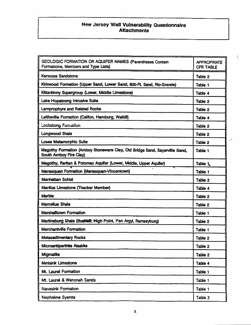
^r-«_ ATTACHMENT 3CFR TABLE SELECTION BASED ON GEOLOGIC FORMATION OR AQUIFER
VII
NAME

New Jersey Well Vulnerability QuestionnaireAttachments
GEOLOGIC FORMATION OR AQUIFER NAMES (Parentheses ContainFormations. Members and Type Lists)
APPROPRIATE
CFR TABLE
Alblte Oligoclase Granite Table 2
Allentown Dolomite (Upper. Umeport) Table 4
Alluvial Deposits (Alluvium. Beach Sand. Channel Deposits, Colluvium, DeltaicSediments, Eolian, Estuanne Deposits. Fans. Roodpiain Deposits. RuvialDeposits, Gravels, Sands)
Table 1
Amphlbollte Table 2
Basalt (1st/2nd/3rd Watchung Rows, Hook Mt, Orange Mt, Preakness,Weathered)
Table 2
Beacon Hill Gravel Table 1
Beekmantown Group (Upper, Lower) Table 4
Beemerville Intrusive Suite Table 2
Beilvale Sandstone * Table 4
Berkshire Valley Formation Table 4
Blotite Granite Table 2
Bloomsburg Red Beds Table 2
Boonton Formation Table 4
Bossardville Limestone Table 4
Bridgeton Formation Tablet
Brunswick Sedimentary Group Table 4
Buttermilk Falls Umestone Table 4
Byram Intrusive Suite Table 2
Cape May Sands Tablet
Chestnut Hfll Formation Table 2
Coeymans Formation (Depue Umestone, Peters Valley, Ravena Shawnee,StormvUle)
Table 4
Cohansey Sand Table 1
Cohansey-Kirkwood Aquifer Table 1
Conglomerate (Connelly. Greenpond, Skunnemunk Umestone) Table 2
VIII

New Jersey Well Vulnerability QuestionnaireAttachments
GEOLOGIC FORMATION OR AQUIFER NAMES (Parentheses ContainFormations, Members and Type Usts)
Cornwall Shale
Decker Formation (Clove Brook, Wallpack)
Diabase (Late Proterozoic, Weathered)
Diorite
Engllshtown Formation (or Aquifer)
Epler Formation (Branchville, Lafayette, Big Spnngs)fcsopus hormanon
Feltville Formation
Franklin Umestone
GlaciaJ Deposits (Delta, Lag, Lake, Lake Bottom, Moraine, TBI, Tnistone)
Glacial Deposits (Kame, Kame Terrace. Lacustrine Fan, Lacustrine BottomMeltwater Terrace, Stratified Drift, Valley Outwash)Glenarie Formation
Gneiss (Baltimore, Blotite-Plagioclaise. Monazlte, Potassic-Feldspar PrecambrianSyenite, Weathered, Wissahickon) c-r«aspar, precambrian.
QuTrSter88^6' Bi0tlt8, Homb,ende' ^ Eve' Precambrian, Pyroxene Syenite.Graybed Homfels
Green Pond Conglomerate
Hammer Creek Formation
Hardyston Quartzite
High Falls Formation
Holly Beach Water-bearing Zone
Hornerstown Sand
Homfel
Jacksonburg Umestone (Cement Umestone Facie, Cement Rock Facie. Wantage
Jutland Kiippe Sequence (Unit A, Unit B)
Kalkberg Umestone
IX
APPROPRIATECFR TABLE
Table 2
Table 4
Table 2
Table 2
Table 1
Table 4
Table 2
Table 4
Table 2
Table 4
Table 3
Table 4
Table 2
Table 2
Table 2
Table 2
Table 2
Table 2
Table 2
Table 1
Table 1
Table 2
Table 4
Table 4
Table 4
New Jersey Well Vulnerability QuestionnaireAttachments
GEOLOGIC FORMATION OR AQUIFER NAMES (Parentheses ContainFormations, Members and Type Lists)
APPROPRIATE
CFR TABLE
Kanouse Sandstone Table 2
Kirkwood Formation (Upper Sand. Lower Sand, 800-Fl Sand. Rio-Grande) Table 1
Klttantinny Supergroup (Lower, Middle Umestone) Table 4
Lake Hopatcong Intrusive Suite Table 2
Lamprophyre and Related Rocks Table 2
Leithsville Formation (Calffon, Hamburg, Walkfll) Table 4
•jOCKalOng ruiiiiaiioii Table 2
Longwood Shale Table 2
Losee Metamorphlc Suite Table 2
Magothy Formation (Amboy Stoneware Clay, Old Bridge Sand, Sayervillle Sand,South Amboy Fire Clay)
Table 1
| Magothy, Raritan &Potomac Aquifer (Lower, Middle, Upper Aquifer) Tablet.
1 Manasquan Formation (Manasquan-Vincentown) Tablet
Manhattan Schist Table 2
Manilus Umestone (Thacker Member) Table 4
Marble Table 2
Marcellus Shale Table 2
Marshalitown Formation Table 1
Martinsburg Shale (Bushkflt, High Point, Pen Argyi, Ramseyburg) Table 2
MerchantvDIe Formation Table 1
Metasedimentary Rocks Table 2
Microantiperthite Aiaskite Table 2
Mlgmatite Table 2
Minisink Limestone Table 4
ML Laurel Formation Table 1
ML Laurel & Wenonah Sands Table 1
Navesink Formation Table 1
Nepheiine Syenite Table 2

riew Jersey Well Vulnerability QuestionnaireAttachments
GEOLOGIC FORMATION OR AQUIFER NAMES (Parentheses Conta.nFormations, Members and Type Usts)
New Scotland Formation (Flatbrookville)
Onondaga Umestone
Ontelaunee Formation (Beaver Run, Harmonyvale)1Oriskany Group
Ouachitite Breccia, Volcanic Breccia
Passaic Formation
rennsauKen Formation iPennsauken-Bridgeton)
Plney Point Aquifer
Port Ewen Shale
Potomac Formation (Upper, Middle, Lower)
Poxono Island Formation
ferttan Form. (Farrington Sand, Fire Qay, Sayrevnie Sand, Woodbridoe ClavlRed-bed Hornfels
Red Bank Sand
Rlckenback Dolomite (Hope. Lower)
Ridgeiy Sandstone
Rondout Formation (Duttonville, Mashipacong, Whlteport Dolomite)Schoharie Formation
Serpentinite
Shark River Formation
Shawangunk Formation
Shriver Chert
Skunnemunk Conglomerate
Stockton Formation
Stonehenge Formation
Swamp and Marsh Deposits
tf Tinton Sand
xt
APPROPRIATECFR TABLE
Table 2
Table 4
Table 4
Table 2
Table 4
Table 4
Tablet
Tablet
Table 2
Table 1
Table 2
Table 1
Table 2
Table 1
Table 4
Table 4
Table 4
Table 2
Table 2
Tablet
Table 2
Table 2
Table 2
Table 4
Table 2
Table 3
Table 1
New Jersey Well Vulnerability QuestionnaireAttachments
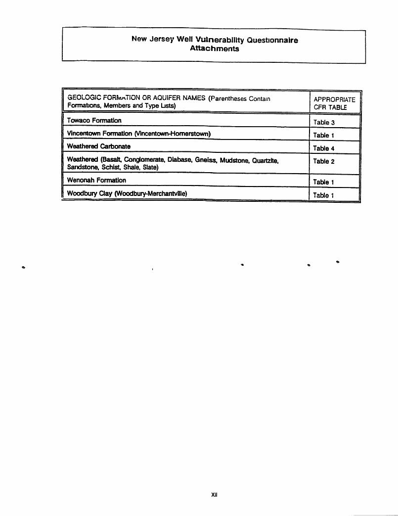
GEOLOGIC FORfanTION OR AQUIFER NAMES (Parentheses ContainFormations, Members and Type Usts)
Towaco Formation
Vincentown Formation (vlncentown-Hornerstown)
Weathered Carbonate
Weathered (Basalt, Conglomerate, Diabase, Gneiss, Mudstone, Quartzite,Sandstone, Schist, Shale. Slate)
Wenonah Formation
Woodbury Clay (Woodbury-MerchantvMe)
XII
APPROPRIATECFR TABLE
Table 3
Table 1
Table 4
Table 2
Table 1
Table 1

New Jersey Well Vulnerability QuestionnaireAttachments
ATTACHMENT 4CFR TABLE SELECTION BASED ON MUNICIPALITY
XIII

New Jersey Well Vulnerability QuestionnaireAttachments
1 COUNTY MUNICIPAUTY CFR TABLE ~]1Atlantic ALL MUNICIPALITIES Table 1 I
COUNTY MUNICIPALITY CFR TABLE I|
1Bergen Allendale Boro Table 4 [uoiyoii ASpHe 3oro Tn^lr 1 I
• ouie c
Bergen Bergenfield Boro Table 4
Bergen Bogota Boro Table 4
Bergen Carlstadt Boro Table 4
Bergen aiffside Park Boro Table 2
Bergen Ooster Boro Table 4
Bergen Cresskni Boro Table 4
Bergen Demarest Boro Table 4
MM
Bergen Dumont Boro Table 4
1Bergen East Rutherford Boro Table 4 |Bergen Edgewater Boro Table 2
Bergen Bmwood Park Boro Table 4
Bergen Emerson Boro Table 4
Bergen EngJewood City Table 2
Bergen Engiewood Cliffs Boro Table 2
Bergen Fair Lawn Boro Table 4
Bergen Fairview Boro Table 2
Bergen Fort Lee Boro Table 2
Bergen Franklin Lakes Boro Table 2
Bergen Garfield City Table 4
Bergen Glen Rock Boro Table 4
XIV

Bergen
Bergen
Bergen
Bergen
Bergen
Bergen
Bergen
Beraen
Bergen
Bergen
Bergen
Bergen
Bergen
Bergen
Bergen
Bergen
Bergen
Bergen
Bergen
Bergen
Bergen
Bergen
Bergen
Bergen
Bergen
Bergen
Bergen
Bergen
Bergen
New Jersey Well Vulnerability QuestionnaireAttachments
Hackensack City Table 4
Harrington Park Boro Table 4
Hasbrouck Heights Boro Table 4
Haworth Boro Table 4
Hillsdale Boro Table 4
Hohokus Boro Table 4
Leonia Boro Table 4
Little Ferrv Boro Table 4
Lodi Boro Table 4
Lyndhurst Twp Table 4
Mahwah Twp Table 2
Maywood Boro Table 4
Midland Park Boro table 4
Montvale Boro Table 4
Moonachie Bono Table 4
New Milford Boro Table 4
North Arlington Boro Table 4
Northvale Boro Table 4
Norwood Boro Table 4
Oakland Boro Table 2
Old Tappan Boro Table 4
Oradeil Boro Table 4
Palisades Park Boro Table 2
Paramus Boro Table 4
Park Ridge Boro Table 4
Ramsey Boro Table 4
Ridgefieid Boro Table 4
Ridgefieid Park Village Table 4
Ridgewood Village Table 4
xv

Bergen
Bergen
Bergen
Bergen
Bergen
Bergen
Bergen
Bergen
Bergen
Bergen
Bergen
Bergen
Bergen
Bergen*
Bergen
Bergen
Bergen
Bergen
Bergen
COUNTY
I Burlington
New Jersey Well Vulnerability QuestionnaireAttachments
River Edge Boro
River Vale Twp
Rochelle Park Twp
Rockleigh Boro
Rutherford Boro
Saddle BrookTwp
Saddle River Boro
South Hackensack Twp
TeaneckTwp
Tenafly Boro
Teterboro Boro
Upper Saddle River Boro
Waldwick Boro
Wallington Boro
WashingtonTwp
Westwood Boro
Wooddiff Lake Boro
Wood-Ridge Boro
Wyckoff Twp
MUNICIPALITY
ALL MUNICIPALITIES
xvi>
Table 4
Table 4
Table 4
Table 4
Table 4
Table 4
Table 4
Table 4
Table 4
Table 2
Table 4
Table 4
Table 4
Table 4
Table 4
Table 4
Table 4
Table 4
Table 4
CFR TABLE
Tablet

COUNTY
Cape May
COUNTY
Cumberland
COUNTY
Essex
Essex
Essex
Essex
Essex
Essex
Essex
Essex
Essex
Essex -
Essex
Essex
Essex
Essex
Essex
cssex
Essex
Essex
New Jersey Well Vulnerability QuestionnaireAttachments
MUNICIPALITY CFR TABLE
ALL MUNICIPALITIES Table 1
MUNICIPALITY CFR TABLE
Belleville Town Table 4
«. BioomfieW Town Table 4*.
Caldwell Boro Table 2
Cedar Grove Twp Table 2
East Orange City Table 4
Essex Fells Boro Table 2
Fairfield Boro Table 3
Glen Ridge Boro Table 4
Irvmgton Town Table 4
Livingston Twp Table 2
MaplewoodTwp Table 4
MDIburn Twp Table 2
Morrtdalr Town Table 4
Newark City Table 4
North Caldwell Boro Table 2
Nutiey Town Table 4
Orange City Table 4
Roseiand Boro Table 2
xvn

Essex
Essex
Essex
Essex
COUNTY
ITGloucester
COUNTY
Hudson^
Hudson
Hudson
Hudson
Hudson
Hudson
Hudson
Hudson
Hudson
Hudson
Hudson
Hudson
New Jersey Well Vulnerability QuestionnaireAttachments
South Orange Village Table 4
Verona Boro Table 2
West Caldwell Boro Table 2
West Orange Town Table 2
MUNICIPALITY CFR TABLE
ALL MUNICIPAUTIES Table 1
MUNICIPALITY CFR TABLE
Bayonne City Tatye2
East Newark Boro Table 4
Guttenberg Town Table 2
Harrison Town Table 4
Hoboken City Table 2
Jersey City Table 2
Kearny Town Table 4
North BergenTwp. Table 2
Secaucus Twp Table 4
Union City Table 2
Weehawken Twp Table 2
West New York Town Table 2
XVIII

New Jersey Well Vulnerability QuestionnaireAttachments
1 COUNTY MUNICIPALITY CFR TABLE ]| Hunterdon Alexandria Twp Table 2
1 Hunterdon Bethlehem Twp Table 2
Hunterdon Bloomsbury Boro Table 4
Hunterdon Callfon Boro Table 2
Hunterdon Clinton Town Table 2
Hunterdon Clinton Twp Table 2
Hunterdon Delaware Twp Table 2
Hunterdon East Amwell Twp Table 2
] Hunterdon Remington Boro Table 4"•"~
1 Hunterdon Franklin Twp Table 2
I HunterdonH a "tj—
Frenchtown Boro Table 4
1 Hunterdon Glen Gardner Boro Table 2
Hunterdon Hampton Boro Table 2
Hunterdon High Bridge Boro Table 2
Hunterdon Holland Twp Table 2
Hunterdon KJngwood Twp Table 2
Hunterdon Lambertvflle City Table 2
Hunterdon Lebanon Boro Table 2
_•_
Hunterdon Lebanon Twp Table 2
Hunterdon MUford Boro Table 4
——_
Hunterdon Raritan Twp Table 2
i^——
Hunterdon Readington Twp Table 4
Hunterdon Stockton Boro Table 4
Hunterdon Tewksbury Twp Table 2
Hunterdon Union Twp Table 2
Hunterdon West Amwell Twp Table 2
XIX

COUNTY
Mercer
Mercer
Mercer
Mercer
Mercer
Mercer
Mercer
Mercer
Mercer
Mercer
Mercer
Mercer
Mercer
COUNTY
Middlesex
Middlesex
Middlesex
Middlesex
Middlesex
Middlesex
Middlesex
Middlesex
Middlesex
[m.Middlesex
New Jersey Weil Vulnerability QuestionnaireAttachments
MUNICIPALITY CFR Table
East Windsor Twp Table 1
Ewing Twp Table 2
Hamilton Twp Table 1
Hightstown Boro Table 1
Hopewell Boro Table 2
Hopewell Twp Table 2
Lawrence Twp Table 2
Pennington Boro Table 4
Princeton Boro Table 2
Princeton Twp Table 2
Trenton City Table 2
Washington Twp Table 1
West Windsor Twp Table 4
MUNICIPALITY CFR Table
Carteret Boro Table 4
Cranbury Twp Table 4
Duneilen Boro Table 1
East Brunswick Twp Table 1
Edison Twp Table 4
Heimetta Boro Table 1
Highland Park Boro Table 4
Jamesburg Boro Table 1
Metuchen Boro Table 4
Middlesex Boro Table 4
xx
1

New Jersey Well Vulnerability QuestionnaireAttachments
Middlesex MilItown Boro Table 4
Middlesex Monroe Twp Table 1
Middlesex New Brunswick City Table 4
Middlesex North Brunswick Twp Table 4
Middlesex Old Bridge Twp Table 1
Middlesex Perth Amboy City Tablet
Middlesex Piscataway Twp Table 4
II Middlesex Plainsboro Twp TaKIa Ouuig t.
Middlesex Sayreville Boro Table 1
Middlesex South Amboy City Table 1
Middlesex South Brunswick Twp Table 2
Middlesex South Plainfield Boro Table 4
Middlesex & m South River Boro Table 1
Middlesex Spotswood Boro Table 1
Middlesex Woodbridge Twp Table 4
| COUNTY MUNICIPALITY CFR TABLE
1 Monmouth ALL MUNICIPALITIES Table 1 I
| COUNTY MUNICIPALITY CFR TABLE
1 Morris Boonton Town Table 2
Moms Booton Twp Table 2
Moms Butler Boro Table 2
Moms Chatham Boro Table 2
Moms Chatham Twp Table 2
XXI

Morns
Morris
Morns
Morris
Moms
Morris
Morris
Morris
Morris
Morns
Moms
Morris
Morris
Morris
Morris
Morris
Morris
Morns
Morris
Morris
Morris
Morris
Morris
Moms
Morris
Morns
Moms
Morris
Moms
New Jersey Well Vulnerability QuestionnaireAttachments
Chester Boro Table 2
Chester Twp Table 2
DenvilleTwp Table 2
Dover Town Table 2
East HanoverTwp Table 4
Florham Park Boro Table 4
Hanover Twp Table 4
Harding Twp Table 2
Jefferson Twp Table 2
Kinneion Boro Table 2
Lincoln Parte Boro Table 2
Madison Boro Table 4
Mendham Boro Table 2
Mendham Twp Table 2
Mine HOI Twp Table 2
MontvDIe Twp Table 2
Morris Plains Boro Table 2
Morris Twp Table 2
Morristown Town Table 2
Mount Arlington Boro Table 2
Mount Olive Twp Table 2
Mountain Lakes Boro Table 2
Netcong Boro Table 2
Parsippany-Troy HBIs Twp Table 4
Passaic Twp Table 2
Pequannock Twp Table 4
Randolph Twp Table 2
Riverdale Boro Table 2
Rockaway Boro Table 2
XXII

Moms
Moms
Morns
Moms
Morris
Ocean
Passaic
Passaic
Passaic
Passaic
Passaic
Passaic
Passaic
Passaic
Passaic
Passaic
Passaic
Passaic
Passaic
Passaic
Passaic
COUNTY
COUNTY
New Jersey Well Vulnerability QuestionnaireAttachments
Rockaway Twp
Roxbury Twp
Victory Gardens Boro
WashingtonTwp
Wharton Boro
MUNICIPALITY
ALL MUNICIPALITIES
MUNICIPALITY
Bloomlngdale Boro
Clifton City
Haledon Boro
Hawthorne Boro
Utile FailsTwp
North Haledon Boro
Passaic City
Paterson City
Pompton Lakes Boro
Prospect Park Boro
Ringwood Boro
Totowa Boro
Wanaque Boro
Wayne Twp
West Milford Twp
XXIII
Table 2
Table 2
Table 2
Table 2
Table 2
CFR TABLE
Table 1
CFR TABLE
Table 2
Table 4
Table 2
Table 4
Table 2
Table 2
Table 4
Table 4
Table 2
Table 2
Table 2
Table 2
Table 2
Table 2
Table 2

Passaic
COUNTY
Salem
COUNTY
Somerset
Somerset
Somerset
Somerset
Somerset
Somerset
Somerset
Somerset
Somerset
Somerset
Somerset
Somerset
Somerset
Somerset
Somerset
Somerset
Somerset
Somerset
Somerset
New Jersey Well Vulnerability QuestionnaireAttachments
West Paterson Boro Table 2
MUNICIPALITY CFR TABLE
ALL MUNICIPALITIES Table 1
MUNICIPALITY CFR Table
BedministerTwp Table 4
Bernards Twp. Table 2
BernardsvDIe Boro Table 2
Bound J3rook Boro Table 4
Branchburg Twp Table 4
Bridgewater Twp Table 2
Far HOIs Boro Table 2
Franklin Twp Table 4
Green Brook Twp Table 2
HillsboroughTwp Table 4
ManvBie Boro Table 4
Millstone Boro Table 4
Montgomery Twp Table 4
North Plainfleid Boro Table 4
Peapack Gladstone Boro Table 2
Raritan Boro Table 4
Rocky HOI Boro Table 4
SomervDIe Boro Table 4
South Bound Brook Boro Table 4
XXIV

•• *.
Somerset
Somerset
Sussex
Sussex
bussex
Sussex
Sussex
Sussex
Sussex
Sussex
Sussex
Sussex
Sussex
Sussex
Sussex
Sussex
Sussex
Sussex
Sussex
Sussex
Sussex
Sussex
Sussex
Sussex
Sussex
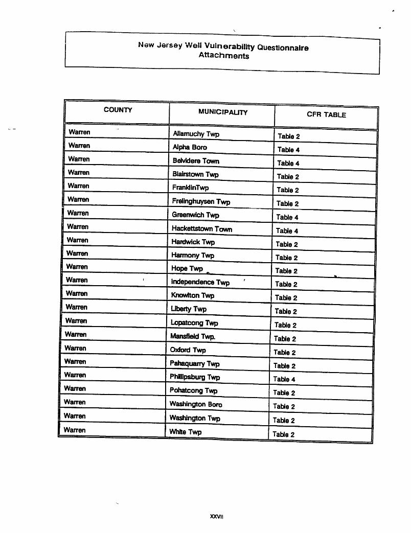
COUNTY
New Jersey Well Vulnerability QuestionnaireAttachments
Warren Twp
Watchung Boro
MUNICIPALITY
Andover Boro
Andover Twp
Branchvllle Boro
ByramTwp
Frankford Twp
Franklin Boro
Fredon Twp
Green Twp
Hamburg Boro
Hampton Twp
HardystonTwp
Hopatcong Boro
Lafayette Twp
Montague Twp
Newton Town
Ogdensburg Boro
Sandyston Twp
Sparta Twp
Stanhope Boro
Stillwater Twp
Sussex Boro
Vernon Twp
Walpack Twp
xxv
Table 2
Table 2
Table 2
Table 2
Table 2
Table 2
Table 2
Table 2
Table 2
Table 2
Table 2
Table 2
Table 2
Table 2
Table 2
Table 2
Table 2
Table 2
Table 2
Table 2
Table 2
Table 2
Table 2
Table 2
Table 2
CFR TABLE
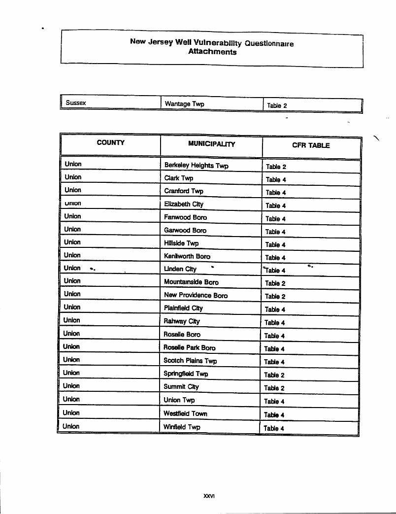
Sussex
Union
Union
Union
union
Union
Union
Union
Union
Union
Union
Union
Union
Union
Union
Union
Union
Union
Union
Union
Union
UnionJW
COUNTY
New Jersey Well Vulnerability QuestionnaireAttachments
Wantage Twp
MUNICIPALITY
Berkeley Heights Twp
Clark Twp
Cranford Twp
Elizabeth City
Fanwood Boro
Garwood Boro
HillsideTwp
Kenilworth Boro
Linden City
Mountainside Boro
New Providence Boro
Plainfield City
Rahway City
Roselle Boro
Roselle Park Boro
Scotch Plains Twp
Springfield Twp
Summit City
Union Twp
Westfield Town
Winfield Twp
xxvi
Table 2
Table 2
Table 4
Table 4
Table 4
Table 4
Table 4
Table 4
Table 4
*Table4
Table 2
Table 2
Table 4
Table 4
Table 4
Table 4
Table 4
Table 2
Table 2
Table 4
Table 4
Table 4
CFR TABLEX
New Jersey Well Vulnerability QuestionnaireAttachments
XXVII


![080723 ANDE Social metrics [Read-Only]](https://img.pdfslide.us/doc/110x75/618d6907fcb5d732f767169b/080723-ande-social-metrics-read-only.jpg)