Embed Size (px)
Citation preview
THE SETTLEMENT SYSTEM OF THE DUTCH LINEARBANDKERAMIK
C.C. BAKELS
Dutch Linearbandkeramik settlements are analysed on three levels. The first level includes a descrip-tion of the individual settlement. This is followed by the analysis of a cluster of settlements; tin-cluster is thought to have functioned as a kind of unit. The third level involves comparison of theDutch cluster with neighbouring clusters of settlements.
Introduction
Up t i l l 1982 thir ty two Linearbandkeramik siteshave been discovered in the Netherlands andthese are entirely restricted to the southeasternpart of the country. The "sites" are defined bythe occurrence of pottery. Many have beendemonstrated to be real settlement sites withhouses, and fu r the r investigation may wellprove that this was also the case with the remain-der. Isolated finds of f l int tools and adzes arenot considered here.
Leaving aside their in te rna l structure, thesesettlements can be studied on three levels. Thefirst level involves analysis of the settlements asindividual units. The second level examines thedegree of association between settlements, andthe third level involves comparison with neigh-bouring settlement systems.
I'he individual settlement
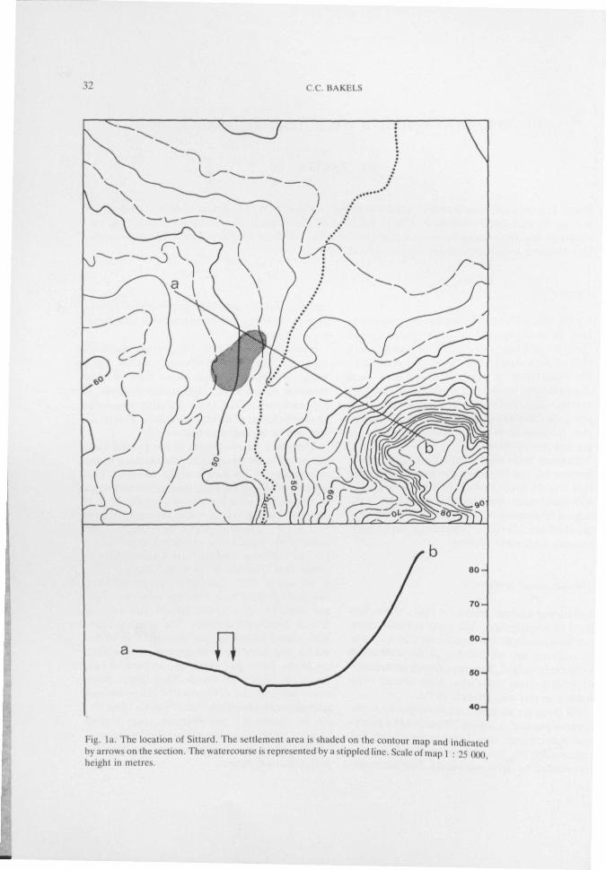
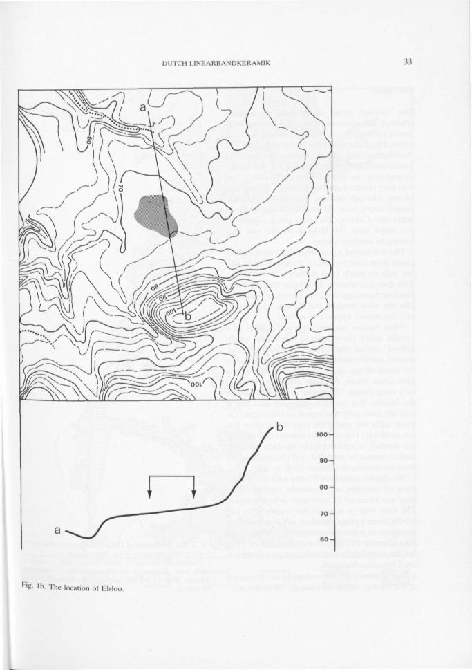
Locational analysis forms the basis of the firstlevel of investigation. The geographical settingcan be described, and an attempt can be madeto establish the relationship of the settlementto its environment. The three Dutch sett lements»l Sittard, Stein and Elsloo have already beenstudied in this way (Bakels 1978).
All three are located 1. on the edge of a loess-covered plateau, 2. within 750 metres of a peren-nial watercourse, and 3. on more or less flatterrain (fig. la, Ih). All the settlements weresurrounded by dense woodland. Further inves-
tigation shows tha t these geographical (actorsapply to twenty six of the thirty two Linearband-keramik sites.
Such factors do not, of course, cover allaspects of individual settlement location, but amore complex approach is not easy. Recon-struct ion of economic aspects, for example, isinevitably superficial and it is almost impossibleto deal in terms of quantitative data. This prob-lem will be returned to below.
There are six exceptions to the general loca-t ional rules, involving either the distance to thewatercourse or the nature of the substrate. Twosites lie relatively far away from perennial waterin the middle of a loess-covered pla teau. It isunclear whether these were settlements withreal houses. Despite careful investigation, thesettlements have never produced more than afew rubbish pits. The sites are Urmond-Graet-heide and Urmond-Hennekens (Bakels 1978,p. 50 and p. 130). The other exceptional sitesare distinguished by a different substrate. Twoare situated on a sandy subsoil and two onMeuse floodloam deposits. The sites on sand,both called Montfort, arc possibly real settle-ments, but have yet to be excavated. The siteson loam, Horn and Heel, are at present justf ind spots with a few sherds. They might , how-ever, fall into the category of "unknown andunexpected settlements in river valleys" describ-ed by Quitta for the German river valleys(Quitta 1969). Even then it remains to be seenwhether they are real, permanent settlementswith the usual houses.
32 C.C. BAKF.I.S
Fig la. The location of Sittard. The se t t lement area is shaded on the contour map and indicatedby arrows on the section. The watercourse is represented by a stippled line. Scale of map 1 : 25 ( K M ) ,height in metres.
Kl I C H I I N I \ K l : X M ' K I K \ \ 1 I K 33
F'g- lb. The location ol I -Mo.
34 C C BAKF.I.S
The cluster
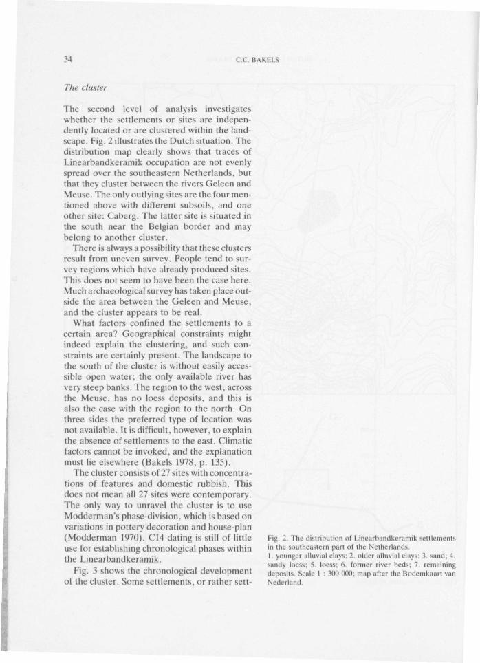
The second level of analysis investigateswhether the settlements or sites are indepen-dently located or are clustered within the land-scape. Fig. 2 illustrates the Dutch situation. Thedistribution map clearly shows that traces ofLinearbandkeramik occupation are not evenlyspread over the southeastern Netherlands, butthat they cluster between the rivers Geleen andMeuse. The only outlying sites are the four men-tioned above with different subsoils, and oneother site: Caberg. The latter site is situated inthe south near the Belgian border and maybelong to another cluster.
There is always a possibility that these clustersresult from uneven survey. People tend to sur-vey regions which have already produced sites.This does not seem to have been the case here.Much archaeological survey has taken place out-side the area between the Geleen and Meuse,and the cluster appears to be real.
What factors confined the settlements to acertain area? Geographical constraints mightindeed explain the clustering, and such con-straints are certainly present. The landscape tothe south of the cluster is without easily acces-sible open water; the only available river hasvery steep banks. The region to the west, acrossthe Meuse, has no loess deposits, and this isalso the case with the region to the north. Onthree sides the preferred type of location wasnot available. It is diff icul t , however, to explainthe absence of settlements to the east. Climaticfactors cannot be invoked, and the explanationmust lie elsewhere (Bakels 1978, p. 135).
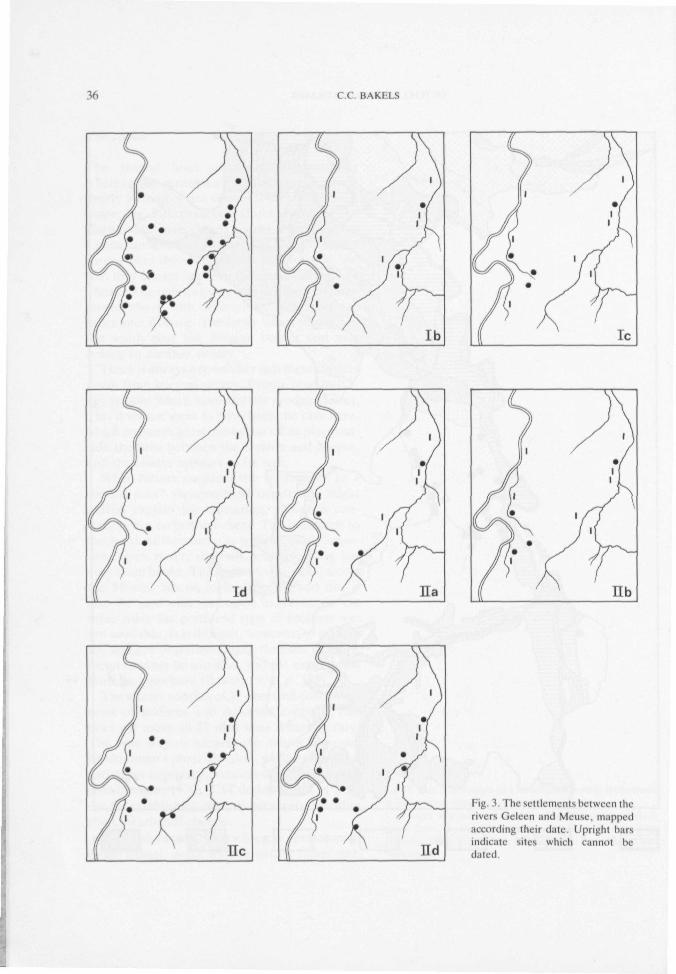
The cluster consists of 27 sites with concentra-tions of features and domestic rubbish. Thisdoes not mean all 27 sites were contemporary.The only way to unravel the cluster is to useModderman's phase-division, which is based onvariations in pottery decoration and house-plan(Modderman 1970). C14 dating is still of littleuse for establishing chronological phases wi th inthe Linearbandkeramik.
Fig. 3 shows the chronological developmentof the cluster. Some set t lements, or rather sctt-
f-'ig 2. The dis t r ibut ion of l . inearbandkeramik sett lementsin the sou theas t e rn part ot the Ne the r l ands1. younger a l luvia l clays; 2. older a l l u v i a l c la\s . 1 sand; 4.sandy loess. 5 loess, d former river beds, 7 remain ingdeposits Scale I : 3(K) 000; map af ter the Bodemkaart vanNederland
DUTCH LINEARBANDKERAMIK 35
36 C.C. BAKH.S
Ib Ie
ld
lic
Fig. 3. The settlements between therivers Geleen and Meuse, mappedaccording their date. Upright barsindicate sites which cannot bedated
DUTCH UNF.ARBANDKFRAMIK 37
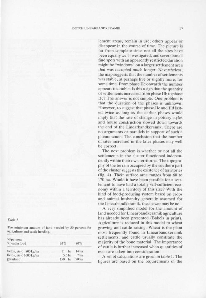
Table I
The minimum amount of land needed by 50 persons loragriculture and cattle herding.
30 personswheat ui food
fields, yield 8(K) kg/halields. yield 16(10 kg/h.igrassland
65%
I I h a5. 5 ha
150 ha
80%
14ha7h.i
90 h a
lement areas, remain in use; others appear ordisappear in the course of t ime. The picture isfar from complete since not all the sites havebeen equally well investigated, and several smallfind spots wi th an apparently restricted durationmight he "windows" on a larger settlement areathat was occupied much longer. Nevertheless,the map suggests that the number of settlementswas stable, at perhaps five or slightly more, forsome time. From phase He onwards the numberappears to double. Is this a sign that the quantityot set t lements increased from phase lib to phaseHe? The answer is not simple. One problem isthat the duration of the phases is unknown.However, to suggest that phase lie and lid last-ed twice as long as the earlier phases wouldimply that the rate of change in pottery stylesand house construction slowed down towardsthe end of the Linearbandkeramik. There areno arguments or parallels in support of such aphenomenon. The conclusion that the numberof sites increased in the later phases may wellbe correct.
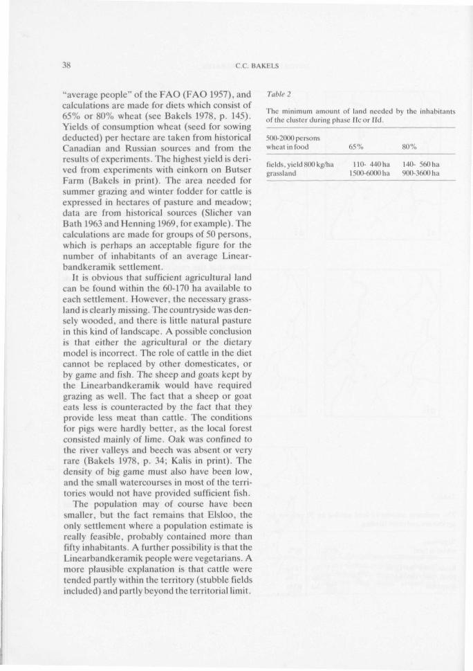
The next problem is whether or not all thesettlements in the cluster functioned indepen-dently within their own territories. The topogra-phy of the terrain occupied by the southern partof the cluster suggests the existence of territories(fig. 4). Their surface area ranges from 60 to170 ha. Would it have been possible for a sett-lement to have had a totally self-sufficient eco-nomy within a territory of this size? With thekind of food-producing system based on cropsand animal husbandry generally assumed forthe Linearbandkeramik, the answer may be no.
A very simplified model for the amount ofland needed for Linearbandkeramik agriculturehas already been presented (Bakels in print).Agriculture is reduced in this model to wheatgrowing and cattle raising. Wheat is the plantmost frequently found in Linearbandkeramiksettlements, and cattle usua l ly constitute themajori ty of the bone material. The importanceof cattle is further increased when quantities ofmeat are taken into consideration.
A set of calculations are given in table 1. Thefigures are based on the requirements of the
38 C.C. BAKH1.S
"average people" of the FAO (FAO 1957), andcalculations are made for diets which consist of65% or 80% wheat (see Bakels 1978, p. 145).Yields of consumption wheat (seed for sowingdeducted) per hectare are taken from historicalCanadian and Russian sources and from theresults of experiments. The highest yield is deri-ved from experiments with einkorn on ButserFarm (Bakels in print). The area needed forsummer grazing and winter fodder for cattle isexpressed in hectares of pasture and meadow;data are from historical sources (Sucher vanBath 1963 and Henning 1969, for example). Thecalculations are made for groups of 50 persons,which is perhaps an acceptable figure for thenumber of inhabitants of an average Linear-handkeramik set t lement.
It is obvious that sufficient agricultural landcan be found within the 60-170 ha available toeach settlement. However, the necessary grass-land is clearly missing. The countryside was den-sely wooded, and there is l i t t le natural pasturein this kind of landscape. A possible conclusionis that either the agricultural or the dietarymodel is incorrect. The role of cattle in the dietcannot be replaced by other domesticates, orby game and fish. The sheep and goats kept bythe Linearbandkeramik would have requiredgrazing as well. The fact that a sheep or goateats less is counteracted by the fact that theyprovide less meat than cattle. The conditionsfor pigs were hardly better, as the local forestconsisted mainly of lime. Oak was confined tothe river valleys and beech was absent or veryrare (Bakels 1978, p. 34; Kalis in print). Thedensity of big game must also have been low,and the small watercourses in most of the terri-tories would not have provided sufficient fish.
The population may of course have beensmaller, but the fact remains that Elsloo, theonly settlement where a population estimate isreally feasible, probably contained more thanfif ty inhabitants. A fur ther possibility is that theLinearbandkeramik people were vegetarians. Amore plausible explanation is that cattle weretended partly within the territory (stubble fieldsincluded) and partly beyond the territorial limit.
Table 2
The minimum amount of land needed hy the inhabit,nilsof the cluster during phase lie or lid.
500-200(1 personswheat in food 65% SO",,
fields, yield 8(H> kg/hagrassland
110- 440 ha1500-6000 ha
140- 560 ha9<MM600ha
DUTCH LINKARBANDKKRAMIK 39
Hil i r 1 The southern part of the cluster area, showing possible site terri tories in phase l i d The set t lements shown arethose ol Ste in . I Isloo. Meek and dcleen1. alluvial clay; 2. valleys and dry valleys; 3 sands and p r a \ e l s exposed in slopes. 4 loess; V and (v te r r i to r ies . Seale1 : 75 ( M X ) ; map a l t e r Make l s 1978.
I I the same calculations arc made lor thewhole cluster ol settlements in the densely popu-lated f ina l phases, the figures listed in table 2are reached. There were at least 10 contempo-rary set t lements at this time and perhaps even20 if the undated sites are taken into account.Further set t lements may await discovery underdeep colluvial deposits. An estimate of the clus-ter 's to ta l population might lie between 500 and
2000. The latter figure is based on the assump-tion that all the settlements were of similar si/eto Elsloo, which contained a possible 100-200inhabi tants during its f inal phases (Modderman1970; Bakels 1978).
The plateau between the Geleen and Meusecovers 5700 ha. With the exception of the twosites mentioned above, the settlements are loca-ted on the edge of the plateau. Fig. 5 shows
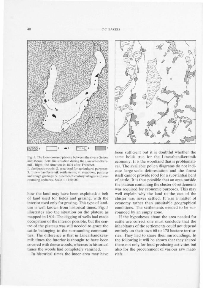
40 C C B A K I l S
cm[•ig s; I ht-loess-covered plateau between the rivers Gclecnand Meuse. Left: the situation during the Linearnandkera-mik. Right: the situation in 1804 after Tranchot.I deciduous woods, 2 area used for agricultural purposes,3. Linearhandkeramik settlements; 4. meadows, pasturesand rough grazings; 5. nineteenth century villages with sur-rounding orchards. Scale I : 150 ( K M )
how the land may have been exploited: a beltof land used for fields and grazing, with theinterior used only for grazing. This type of land-use is well known from historical times. Fig. 5illustrates also the situation on the plateau asmapped in 1804. The digging of wells had madeoccupation of the interior possible, but the cen-tre of the plateau was still needed to graze thecattle belonging to the surrounding communi-ties. The difference is that in Linearbandkera-mik times the interior is thought to have beencovered with dense woods, whereas in historicaltimes the woods had completely vanished.
In historical times the inner area may have
been sufficient but it is doubtful whether thesame holds true for the Linearbandkeramikeconomy. It is the woodland that is problemati-cal. The available pollen diagrams do not indi-cate large-scale deforestation and the forestitself cannot provide food for a substantial herdof cattle. It is thus possible that an area outsidethe plateau containing the cluster of settlementswas required for economic purposes. This maywell explain why the land to the east of thecluster was never settled. It was a matter ofeconomy rather than unsuitable geographicalconditions. The settlements needed to be sur-rounded by an empty zone.
If the hypotheses about the area needed lot-cattle are correct one must conclude that theinhabitants of the settlements could not dependentirely on their own 60 to 170 hectare territo-ries. They had to share their surroundings. Inthe following it will be shown that they sharedthese not only for food-producing activities butalso for the procurement of various raw mate-rials.
M l U 1 1 l I N I \ K l : \ \ M K I K \ \ l l k 41
l'ahlf
l . firewoodwood for housesloam tor houseslo.im loi pottery
.V ehert
2. wood for housesroek for quernsrock torgrinding-stonespebblesquar/ i le tor .id/es ( minor source )ehert (minor source)
4. amphibolite made into ad/esbasalt made m t o a c l / e slydite made into ad/eshemat i te
Table 3 lists the materials known to have beenused in the Dutch settlements. They fall intofour categories. Category 1 includes materialsfound within the postulated territory of eachsettlement. Category 2 contains materials foundwithin the cluster area. Category 3 includesmaterials that are not found within easy reachof the se t t lements but s t i l l w i th in six hours wal-king distance (i.e. a day's return journey). Cate-gory 4 comprises the real long-distance imports.Category 1 and 2, the local materials, are themost interest ing here. Rock is the best knownmaterial, and the most important source for therocks was the bed of the river Meuse. All thesettlements in the cluster obtained the bulk oftheir rocks from the Meuse gravel bars. As noteach territory is adjacent to the river, peoplein the cluster had to share th i s local commodity.
It is argued here that the whole cluster ofsettlements between the Geleen and the Meusemight be considered, in part at least, as a formof economic uni t . This is not to suggest that theinhabi tan ts shared all they needed for their dailylife. The supposition is that they encounteredeach other frequently and were interdépendantboth economically and in other ways as well.
The ideas discussed above do not, of course,explain why there was a cluster at al l . The expla-nation must be sought in social and demographicaspects of living and working together. Onesmall settlement cannot have survived on itsown, if only for demographic reasons. Here weare straying outside the scope of this paper, butone remark is worth making. Up t i l l now onlyone cemetery has been found in the region.Apart from two or three possible graves in thesettlement at Geleen-Rijkswcg (known also asGeleen-Kermisplein and Geleen-Haesselder-veld) , and some hypothetical ones at Stein, Els-loo is the only cemetery within the cluster (forGeleen see Bakels & van den Broeke 1980-1981,for Stein Modderman 1970, p. 78). The ceme-tery may only have been used by the inhabitantsof the Elsloo settlement, and the absence ofcemeteries elsewhere may be due to the factt h a t graves contain less artefacts than rubbishpits and are therefore less easy to detect. It is
42 C.C HAKF.I.S
striking, however, that there are far moreLinearbandkeramik settlements than cemete-ries. An explanation might he that settlementsin a cluster shared one burial ground. The rela-tively low number of graves in the Elsloo cem-etery, which led to the conclusion that it belon-ged to one settlement, may also reflect the factthat not everyone had the status to be buriedthere.
Comparison with neighbouring clusters
The third level of investigation is the compari-son of the Dutch cluster with settlementsbelonging to adjacent regions. The present evi-dence suggests that the neighbours tended tolive in clusters as well . The nearest clusters areon the Aldenhovencr Platte, 30 kms to the eastin Germany, and around the Heeswater, 20 kmsto the south-west in Belgium. The former isvery well documented. In Belgium only Ros-meer and Vlijtingen have been investigated toany extent.
Although the Aldenhovener Platte cluster ismuch larger than the other two, the clusters arevery much alike. The settlements occupy com-parable locations and were founded at the sametime (Modderman phase Ib). Do the clustersdiffer in any way'.' Regional variation within theLinearbandkeramik can involve 1. agricultureas reflected in carboni/.ed plant remains, 2.house-plans, 3. pottery, 4. flint tools and 5. rocksources. As far as 1. and 2. are concerned thereappear to be no important differences betweenthe three clusters. A comparison of pottery andflint tools will be possible in the near futurewhen data from Rosmeer and Vlijt ingen havebeen published. The data from the Aldenhove-ner Platte indicate that differences were cer-ta in ly present. In theory local rock sources canbe different iat ing. Materials from long distancesources are expected to be the same. A clearresult of comparison of the German and Dutchclusters is that the rocks used for the manufac-ture of local artefacts such as querns and certainadzes differ from one cluster to the other. Dif-ferences between the Dutch and Belgian cluster
are less easy to distinguish. This probablybecause the inhabitants of the Belgian settle-ments used the gravel bars of the Meuse as theirmain source of material; these gravels are simi-lar to the Dutch ones. If this is the case it willnot be possible to differentiate between Dutchand Belgian material . In the absence of moredetailed investigation into this problem it is per-haps unwise to say more. The imported rocksare better known and the same rocks are indeedfound in all three clusters.
It is to be expected that it wil l always be mucheasier to detect s imi lar i t ies than differencesbetween neighbouring clusters. The changesfrom cluster to cluster are perhaps so gradualas to be vir tual ly invisible. Differences standout better on a wider, regional scale, and th isbrings us to a fourth level of analysis: the inter-regional comparison of sets of clusters. Whilstthe fourth level may appear more rewarding,l i t t le work has been carried out (in the thirdlevel and its importance should not be underes-timated.
muni I . I N K A R B A N D K I R A M I K 43
BIBLIOGRAPHY
Bakels, C.C. (1978), Four Lincarhaiulkcramik Settlements and Their Environment: A Paleoeco-logieal Study of Sittard. Stein, Elsloo and Hienheim, Analecta fraelustorica I.eidensia 11 .
Bakels, C.C. and P.W. van den Broekc (1980-1981). Geleen, Publications de lu Société Historiqueet Archéologique dans le l.imbourg IHvl 17, p. 39-42.
Bakels, C.C. (in print). Zum wirtschaftlichen Nutzungsraum einer handkeramischen Siedlung,in: Siedlungen der Kultur mit l ineaikeidinik in l iiro/ia. ed. by Archeologickv l ' s t . iv . SlovenskejAkademie Vied, Nitra.
Modemkaar t van Nederland (1%0), l : 200 (XX), Stihoka Wageningen.F. A.O. (1957), Calorie Requirements. Report of the Second Committee on Calorie Requirements,
Rome.Henning, F.H. (1969), Bauemwirtschafi umi limierneinkommen in Ostpreussen im 18. Jahrhundert.
Würzhurg.Kalis, A.J. (in pr in t ) , Spätpleistozäne und liolo/ane Vegetationsgeschiehte in der westliehen
Niederrheinischen Bucht , l-.iszeitalier und (.legenwurt, Sonderheft.Modderman, P.J .R. (1970), Linearhandkeramik aus Elsloo und Stein, Analecta Praehistorica
l.eidensia 3.Quitta, H. (1969), Zur Deutung handkeramischer Siedlungsfunde aus Auen und grundwasserna-
hen Standorten, in: K.H. Otto and J. Herrman. eds., Siedlung. Burg und Stadt. DeutscheAkademie der Wissenschaften zu Merlin, Schriften der Sektion für Vor- und l-'ruligescluclite 25.p. 42-55.
Slichervan Bath, B.H. (1963), The Agrarian History of Western i'.uropeA.D. 500-1850, London.Tranchot-kaart , de, van het gehied tussen Maas en R i j n . Nederlands Gedeelte 1803-1806, facsimile-
reproductie 1967-1971, Köln and Maas t r ich t .


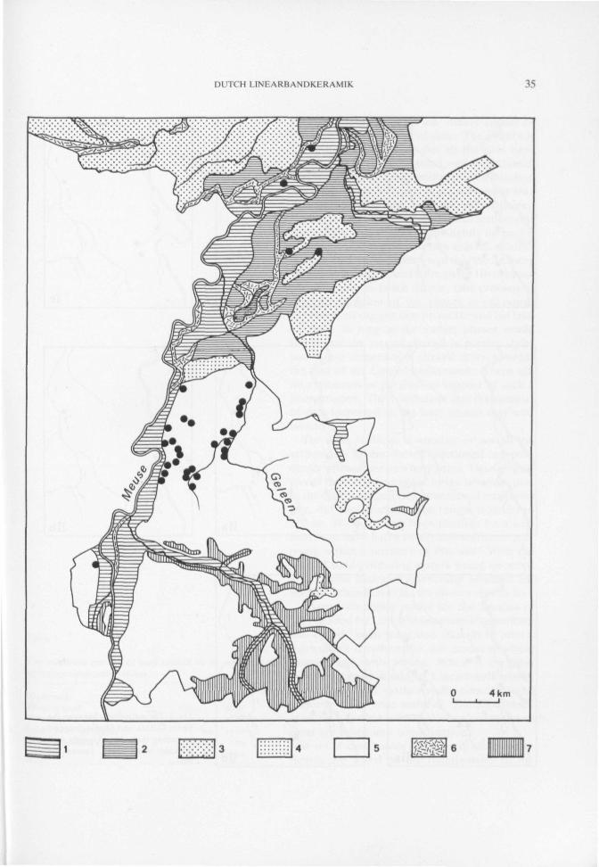
![The Mystery of the Plockhoy Settlement [Dutch]](https://img.pdfslide.us/doc/110x75/55cf9c27550346d033a8cc84/the-mystery-of-the-plockhoy-settlement-dutch.jpg)