Embed Size (px)
Citation preview
The Roles of Satellites
in Marine Meteorology and Operational Oceanography
Alain Ratier and Marie Colton*
EUMETSAT Darmstadt, Germany
*NOAA/NESDIS Silver Springs, United States
ABSTRACT – In 1853, when Lt. Matthew Fontaine Maury of the United States Navy proposed his vision for “establishing a uniform system of meteorological observations at sea and concurring in a general plan of observation on the winds and currents of the ocean”, sparse observations were the only recorded source of information. This vision laid the foundation of operational meteorology and oceanography, with the establishment of the World Metorological Organisation, and became even more universal with time, with the shift of emphasis from observations to information and knowledge on the ocean and its increasing demand for international cooperation and capacity building. Satellite programmes are no exception, as international commitments were crucial to establish the ERS and Topex-Poseidon missions in the late seventies as corner stones of the WOCE observing strategy, long after the pioneering Seasat and Nimbus-7 missions. Pre-operational ocean satellites are now providing global maps of ocean surface wind and topography in quasi-real time, and have de facto contributed to “establishing the uniform system of meteorological observations” called for by Lt. Maury. Providing also information on sea surface temperature, sea state and chlorophyll, they are now part and parcel of the ocean information systems operationally used for monitoring or forecasting weather, sea state, pollution and marine ecosystem dynamics, ocean circulation, seasonal and climate variability. Satellite-based data collection systems play also an increasingly important data integration role in merging all types of in situ data in the open ocean. In the context of the ongoing transition from research to operational oceanography, the main challenge of the next decades will be to establish, maintain and gradually improve a fully operational satellite system for the observation of key ocean parameters. In practice, this could be achieved by the combination of an expansion of the planned meteorological missions, the implementation of dedicated satellites whenever necessary and allocation of a fraction of the resources of selected high-resolution imagery missions to marine meteorology. However, this will not be possible without international co-operation, considering the need for sharing satellite costs and resources, leading edge technology and know-how, and planning transitions from research to operational missions. Therefore, Lt Maury’s vision remains current, providing the driving principle of initiatives like the Integrated Global Observing Strategy-Partnership, the recent Earth Observations Summit or the European Global Monitoring for Environment and Security (GMES).
1. INTRODUCTION: THE HERITAGE AND REALISATION OF LT. MAURY’S
VISION At the time of the Brussels Maritime Conference of 1853, observations were sparse over the ocean and were the only recorded source of information, limiting the scope of knowledge in marine meteorology and oceanography. Both disciplines were therefore in their infancy, attempting to improve the description of the general atmospheric circulation over the ocean and the typical weather and surface current patterns that affect navigation, military operations and trade. This objective was in itself a challenge, due to the critical under-sampling achieved by observations at harbours and at sea, over the ocean areas frequently covered by shipping lines and military vessels, and because of the lack of agreed observation standards. Indeed, the shortcomings of the observing system were the most prominent obstacle that could only be overcome by the vision proposed by Lt. Matthew Fontaine Maury of the United States Navy of “establishing a uniform system of meteorological observations at sea, and concurring in a general plan of observation on the winds and currents of the ocean”. Although the objective may appear relatively modest in retrospect, in light of the fantastic progress achieved today in weather and ocean forecasting and in geosciences in general, the vision proved to be fully universal. It laid the foundation of operational meteorology and oceanography, and paved the way for the establishment of the World Meteorological Organisation (WMO), the Intergovernmental Oceanographic Commission (IOC) and other international organisations or programmes dealing with geosciences and environmental services. This recognises that international cooperation is the only possible approach for standardising, cross-calibrating, planning, collecting at global scale and sharing in a timely manner the critical observations required to constrain the underdetermined problems addressed by global or regional geo-information systems (e.g. Numerical Weather Prediction systems) used operationally or for research. Despite sometimes-conflicting policies, economic or strategic interests, all nations need to share this “common” environmental information because none can afford it in isolation. In 2003, this remains fully valid and the need is even more stringent nowadays. This is, first, because environmental information plays an increasing role in the global economy and in sustainable development, and second, because global scale information drives at their external boundaries the local information systems that are critical to local economy (e.g. coastal or shelf sea current models, limited-area NWP models). The vision of Lt. Maury has been realised far beyond the initial focus on observations of winds and currents at the surface of the ocean. It has been successfully applied to other types of observations across all components of the Earth system, at all stages of the development of geosciences and their operational applications. For instance, in the field of ocean research, the World Ocean Circulation Experiment could not have established the first comprehensive snapshot of the global three-dimensional ocean circulation without planning, implementing and maintaining a massive, multi-component observing system through international cooperation including international satellite programmes. Conversely, the unique reference dataset collected and shared through this effort is now part of human patrimonies, and is a cornerstone of the ongoing development of operational ocean circulation models and the Global Ocean Observing System. Likewise, the World Weather Watch is a prominent example of
- - 2
the success of international cooperation under the aegis of WMO in the operational area. Modern geosciences and environmental applications being now based on integrated information systems involving observations, numerical models or geospatial information systems (GIS) and other data, observations alone cannot be equated anymore to knowledge. As a result, Lt. Maury’s vision has been naturally generalised from observations to information and knowledge, and WMO and IOC are now stimulating international exchange of all types of information. Beyond climatology and general conditions at sea, forecasting capabilities are now available and further developing in the oceanographic area, placing requirements on quasi real time exchange, and calling for the use of advanced broadband multicasting and network systems. Last but not least, in the context of intensive use of leading edge technology, the exchange of know-how and knowledge is being extensively addressed by outreach programmes and international cooperation on training of trainers and users. As illustrated in section 2 below, satellites have become one key component of the overall observing system and have played a major contribution in realising and exceeding the initial objective set by Lt. Maury. Here again, international cooperation has been and remains essential to share the financial burden of satellite systems and to plan, enhance and optimise their contribution to the full observing system, including continuity and back-up capabilities. This is currently achieved through dedicated efforts of WMO, IOC, the Coordination Group for Meteorological Satellites (CGMS), Coordination of Earth Observation Satellites (CEOS), the Integrated Global Observing Strategy Partnership (IGOS-P) and other dedicated initiatives, including the follow-up to the Earth Observations Summit held in Washington in July 2003. In summary, the approach proposed by Lt. Maury has been successfully applied since 1853 for the benefit of the worldwide community, based on international cooperation under the umbrella of WMO, IOC, CEOS and other organisations and programmes. It has progressively generalised and expanded to all sources of observations, information and knowledge, as necessary to adapt to the present knowledge-based society. The approach will undoubtedly continue to remain central to any scientifically sound attempt to advance our knowledge of and capability to predict the dynamics of any component of the Earth system. 2. THE HISTORICAL CONTRIBUTION OF OCEAN SATELLITES Ocean satellite systems have made major contributions to achieving the objective of the Brussels Maritime Conference of 1853, although only few visionary book writers like Jules Verne could have imagined so at that time. In retrospect, ocean observing satellites appear to be a natural response to Lt. Maury’s requirement for a uniform system of meteorological observations of ocean winds and currents”, considering their unique capability to provide repetitive, homogeneous observations with broad coverage. This became a credible perspective only after the launch of the first Sputnik and, much later, with the demonstration of relevant space-based observing techniques. The major event in this regard was the advent of passive and active microwave instruments first flown on two NASA visionary proof-of-concept and relatively low cost missions launched in the late seventies: Seasat and Nimbus-7. Both missions
- - 3
demonstrated the potential for collecting useful observations from space on wind and ocean circulation, complementing the Sea Surface Temperature (SST) measurements already available from meteorological infrared imagery. These landmark missions paved the way for follow-up pre-operational missions with increasing performances and real time capabilities, and ultimately, for the transition from ocean remote sensing or space oceanography to operational oceanography.
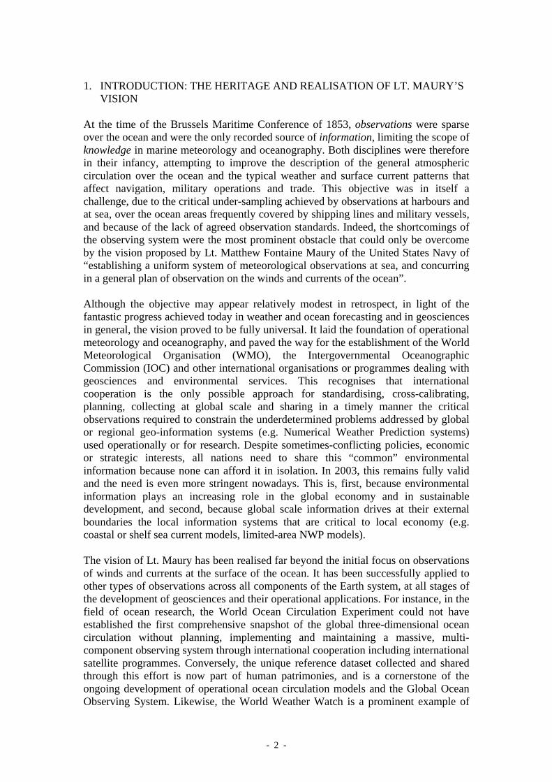
“Observations on the winds” (at the surface of the ocean) Scatterometry and, to a lesser degree, microwave imaging radiometry are now fulfilling the objective of mapping surface wind over the ocean. Both techniques were demonstrated in 1978 by the short-lived Seasat and by Nimbus-7. The Seasat SASS Ku-band scatterometer produced the first global observations of ocean wind vectors, whilst the SMMR imaging microwave radiometer flown on both missions produced maps of surface wind speed over the 9-year lifetime of Nimbus-7.
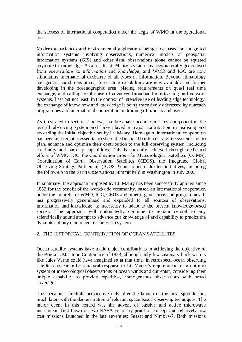
Figure 1: Artist views of Seasat (left) and Nimbus-7 (right) and first global map of sea surface wind vector extracted from backscatter measurements by the Seasat KU-band scatterometer (middle). (Courtesy: NASA/JPL) The scientific evaluation of the data sets of these pioneering missions enabled the optimisation of the design of the next generation of wind measuring missions launched in the nineties. The Active Microwave Instrument (AMI/Wind mode) flown on ERS-1 and ERS-2 from 1991 to 2003 was the first scatterometer after the SASS. Despite its relatively narrow swath (500 km), it had the considerable merit of providing the first real time data service, enabling operational use of data for nowcasting and assimilation in Numerical Weather Prediction (NWP) models. Following the demonstration of a positive impact on weather forecasting (Miller, 1999; Isaksen et al., 2000), EUMETSAT approved as part of its operational Polar System (EPS) programme a series of three improved, double-swath instruments for a 14-year service starting in 2006. A second line of wide-swath scatterometers was initiated in parallel by NASA in cooperation with NASDA of Japan, with three SeaWinds instruments embarked on ADEOS, Quickscat and ADEOS-2, respectively launched in 1996, 2000 and 2002. Following the unfortunate loss of ADEOS and ADEOS-2 in orbit, the AMI and SeaWinds instruments of ERS-2 and Quickscat are the only instruments currently available in orbit and are used by a number of operational centres.
- - 4
The observations of both scatterometers provide the reference for the ongoing evaluation of the wind vector capability of a fully polarimetric microwave radiometer flown on the Windsat/Coriolis mission launched in 2003. Polarimetry should add directional information to wind speed maps available from SSM-I and follow-up microwave radiometers.
Figure 2: Artist views of satellites flying scaterrometers. From left to right: ERS-1/-2 (ESA), ADEOS (NASDA) and Quikscat (NASA)
“Observation on the currents of the ocean” The emergence of space-based altimetry was the real breakthrough for the monitoring of ocean circulation at global scale. Following the relatively inaccurate observations collected by GEOS-3 in 1975, SEASAT confirmed the potential of radar altimetry to accurately measure Sea Surface Height (SSH), the only observable from space that relates directly to three-dimensional ocean circulation. The evaluation was hampered by the three-month lifetime of the mission and limited in scope to mesoscale circulation. This was nevertheless sufficiently encouraging to stimulate the development of a quasi-continuous series of more advanced missions, starting with Geosat (launched in 1985) and continuing with ERS-1/2 (1991 and 1995), Topex-Poseidon (1992), Geosat-Follow-On (GFO, 1998), Jason (2001) and ENVISAT (2002). As a result, the development of the applications of altimetry has been steady, with outstanding benefits. Increasing performances have reduced the error budget for sea surface height by several orders of magnitude, down to the centimetre level. The consequent reduction in the correlated part of the error now means that large-scale ocean circulation patterns can be extracted. With the parallel operations of Topex-Poseidon and ERS, now followed by Jason, Envisat and GFO, the user community has had access since 1992 to a multi-satellite system providing unprecedented accuracy, space-time sampling and coverage of the global ocean, including the polar ocean, and pre-operational near real time data services.
- - 5
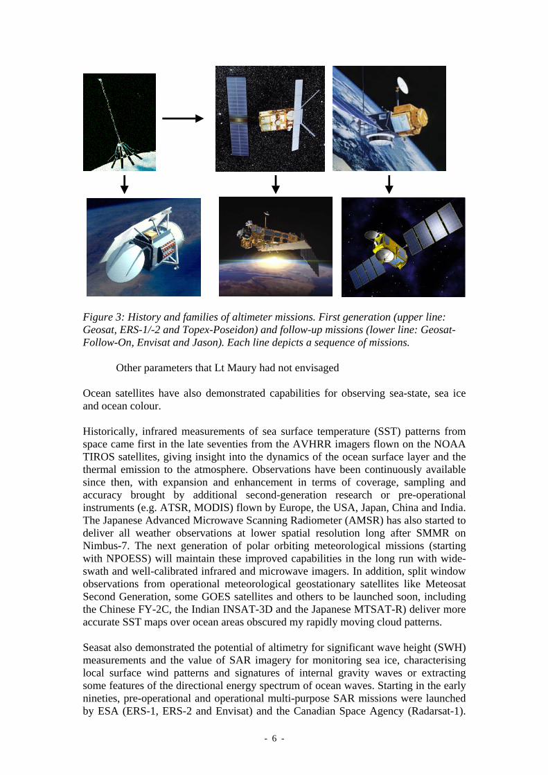
Figure 3: History and families of altimeter missions. First generation (upper line: Geosat, ERS-1/-2 and Topex-Poseidon) and follow-up missions (lower line: Geosat-Follow-On, Envisat and Jason). Each line depicts a sequence of missions.
Other parameters that Lt Maury had not envisaged Ocean satellites have also demonstrated capabilities for observing sea-state, sea ice and ocean colour. Historically, infrared measurements of sea surface temperature (SST) patterns from space came first in the late seventies from the AVHRR imagers flown on the NOAA TIROS satellites, giving insight into the dynamics of the ocean surface layer and the thermal emission to the atmosphere. Observations have been continuously available since then, with expansion and enhancement in terms of coverage, sampling and accuracy brought by additional second-generation research or pre-operational instruments (e.g. ATSR, MODIS) flown by Europe, the USA, Japan, China and India. The Japanese Advanced Microwave Scanning Radiometer (AMSR) has also started to deliver all weather observations at lower spatial resolution long after SMMR on Nimbus-7. The next generation of polar orbiting meteorological missions (starting with NPOESS) will maintain these improved capabilities in the long run with wide-swath and well-calibrated infrared and microwave imagers. In addition, split window observations from operational meteorological geostationary satellites like Meteosat Second Generation, some GOES satellites and others to be launched soon, including the Chinese FY-2C, the Indian INSAT-3D and the Japanese MTSAT-R) deliver more accurate SST maps over ocean areas obscured my rapidly moving cloud patterns. Seasat also demonstrated the potential of altimetry for significant wave height (SWH) measurements and the value of SAR imagery for monitoring sea ice, characterising local surface wind patterns and signatures of internal gravity waves or extracting some features of the directional energy spectrum of ocean waves. Starting in the early nineties, pre-operational and operational multi-purpose SAR missions were launched by ESA (ERS-1, ERS-2 and Envisat) and the Canadian Space Agency (Radarsat-1).
- - 6
Further approved missions are planned in the next few years by Japan (ALOS), Canada (Radarsat-2), Germany (Terrasar) and Italy (Cosmo-Skymed) securing continuity of observations well into the next decade. The Coastal Zone Color Scanner flown on NIMBUS-7 demonstrated capabilities to observe water turbidity and chlorophyll from space. After a long interruption, a large number of ocean colour missions have now been launched or are planned, including SeaWifs and MODIS (US), MOS and OCM on IRS-P3/4 (India), FY-1C (China) and MERIS (ESA). Follow-on missions are planned in Japan, China (FY-3 series) and the US (VIIRS on NPP and NPOESS satellites) where the operational transition has already been approved. NOAA is also considering Ocean Colour capabilities for the hyperspectral imager planned for flight around 2012 on its next generation geostationary satellites (GOES-R)
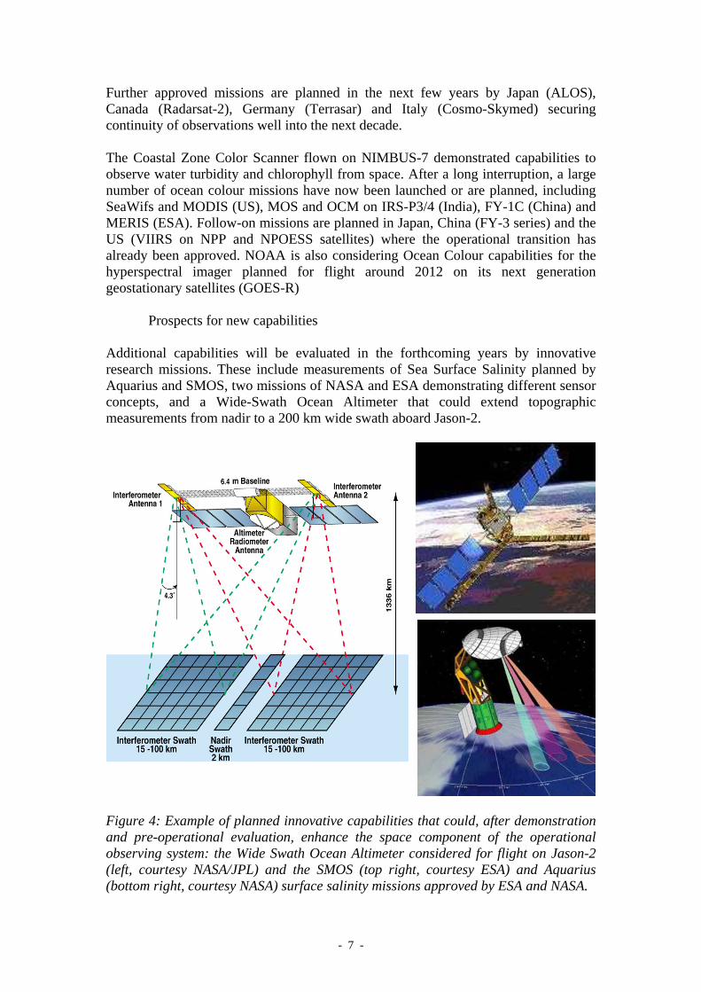
Prospects for new capabilities Additional capabilities will be evaluated in the forthcoming years by innovative research missions. These include measurements of Sea Surface Salinity planned by Aquarius and SMOS, two missions of NASA and ESA demonstrating different sensor concepts, and a Wide-Swath Ocean Altimeter that could extend topographic measurements from nadir to a 200 km wide swath aboard Jason-2.
Figure 4: Example of planned innovative capabilities that could, after demonstration and pre-operational evaluation, enhance the space component of the operational observing system: the Wide Swath Ocean Altimeter considered for flight on Jason-2 (left, courtesy NASA/JPL) and the SMOS (top right, courtesy ESA) and Aquarius (bottom right, courtesy NASA) surface salinity missions approved by ESA and NASA.
- - 7
3. CONTRIBUTIONS OF SATELLITES TO MARINE METEOROLOGY, OPERATIONAL OCEANOGRAPHY AND OTHER APPLICATIONS: A BRIEF OVERVIEW 3.1. Marine meteorology, sea state forecasting and sea ice monitoring All “atmospheric” contributions of satellites to NWP and operational meteorological forecasting are basically relevant to marine meteorology, if one defines this discipline as meteorology over the sea. It has been amply demonstrated that temperature and moisture soundings from space that feed modern NWP systems have contributed to the massive improvements in forecasting performances that are now comparable in both hemispheres. Likewise geostationary imagery and other LEO observations of the structure of the atmosphere have become critical to nowcasting over land and sea. These aspects are not further addressed in this paper, which rather concentrates on the air-sea interface and sea ice parameters that affect navigation and other activities off shore or at sea. It is however
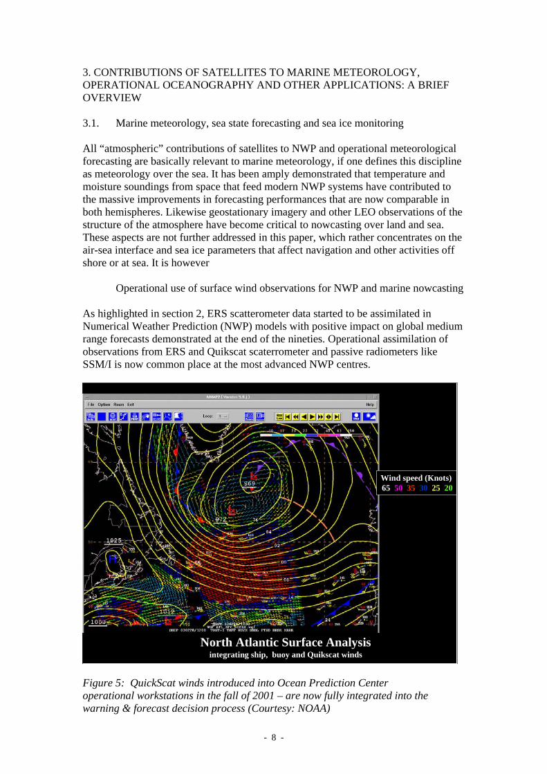
Operational use of surface wind observations for NWP and marine nowcasting As highlighted in section 2, ERS scatterometer data started to be assimilated in Numerical Weather Prediction (NWP) models with positive impact on global medium range forecasts demonstrated at the end of the nineties. Operational assimilation of observations from ERS and Quikscat scaterrometer and passive radiometers like SSM/I is now common place at the most advanced NWP centres.
Ocean surface wind vector maps from Scatterometers
ERS (ESA) since 1991
Seawinds (NASA) since 2000
North Atlantic Surface Analysisintegrating ship, buoy and Quikscat winds
Wind speed (Knots) 65 50 35 30 25 20
Figure 5: QuickScat winds introduced into Ocean Prediction Center operational workstations in the fall of 2001 – are now fully integrated into the warning & forecast decision process (Courtesy: NOAA)
- - 8
Direct use of scatterometer wind products, alone or in combination with model outputs and other information, has also rapidly developed in the field of nowcasting, with the advent of modern nowcasting work stations.
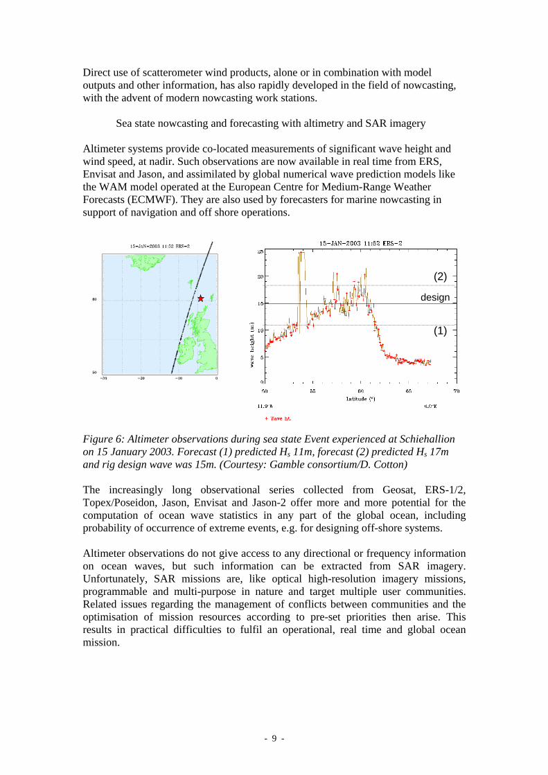
Sea state nowcasting and forecasting with altimetry and SAR imagery Altimeter systems provide co-located measurements of significant wave height and wind speed, at nadir. Such observations are now available in real time from ERS, Envisat and Jason, and assimilated by global numerical wave prediction models like the WAM model operated at the European Centre for Medium-Range Weather Forecasts (ECMWF). They are also used by forecasters for marine nowcasting in support of navigation and off shore operations.
(2)
(1)
design
Figure 6: Altimeter observations during sea state Event experienced at Schiehallion on 15 January 2003. Forecast (1) predicted Hs 11m, forecast (2) predicted Hs 17m and rig design wave was 15m. (Courtesy: Gamble consortium/D. Cotton) The increasingly long observational series collected from Geosat, ERS-1/2, Topex/Poseidon, Jason, Envisat and Jason-2 offer more and more potential for the computation of ocean wave statistics in any part of the global ocean, including probability of occurrence of extreme events, e.g. for designing off-shore systems. Altimeter observations do not give access to any directional or frequency information on ocean waves, but such information can be extracted from SAR imagery. Unfortunately, SAR missions are, like optical high-resolution imagery missions, programmable and multi-purpose in nature and target multiple user communities. Related issues regarding the management of conflicts between communities and the optimisation of mission resources according to pre-set priorities then arise. This results in practical difficulties to fulfil an operational, real time and global ocean mission.
- - 9
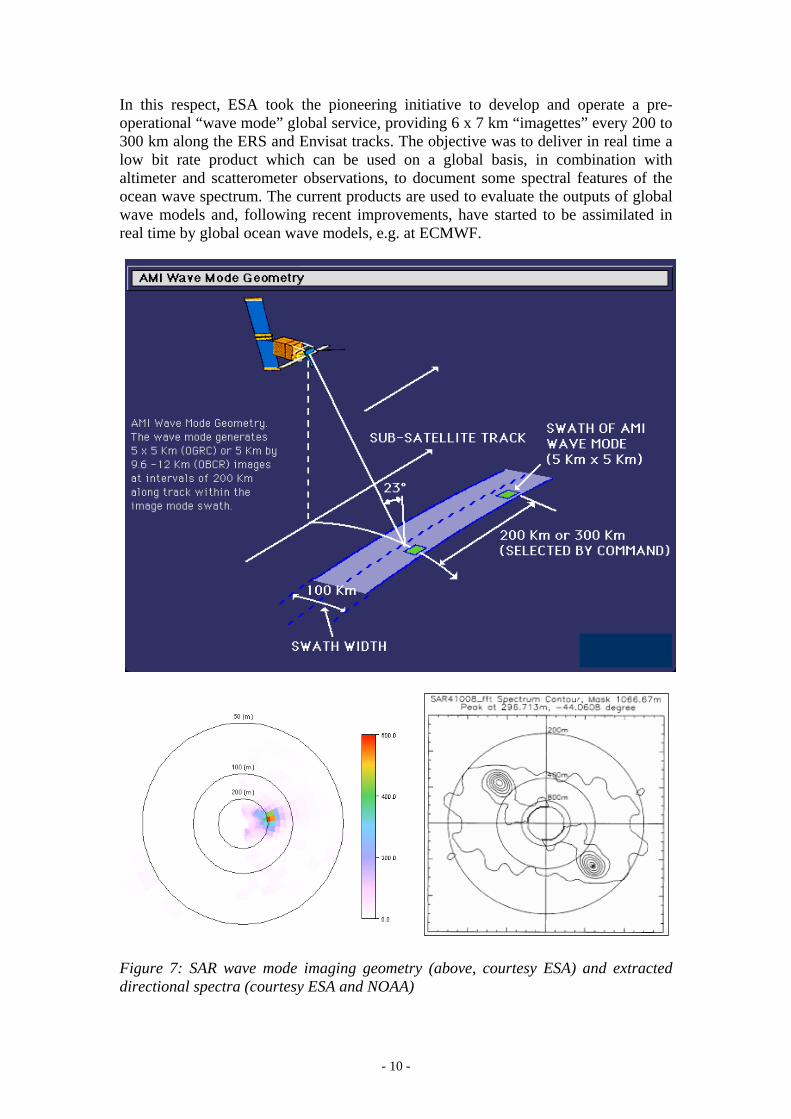
In this respect, ESA took the pioneering initiative to develop and operate a pre-operational “wave mode” global service, providing 6 x 7 km “imagettes” every 200 to 300 km along the ERS and Envisat tracks. The objective was to deliver in real time a low bit rate product which can be used on a global basis, in combination with altimeter and scatterometer observations, to document some spectral features of the ocean wave spectrum. The current products are used to evaluate the outputs of global wave models and, following recent improvements, have started to be assimilated in real time by global ocean wave models, e.g. at ECMWF.
Figure 7: SAR wave mode imaging geometry (above, courtesy ESA) and extracted directional spectra (courtesy ESA and NOAA)
- - 10
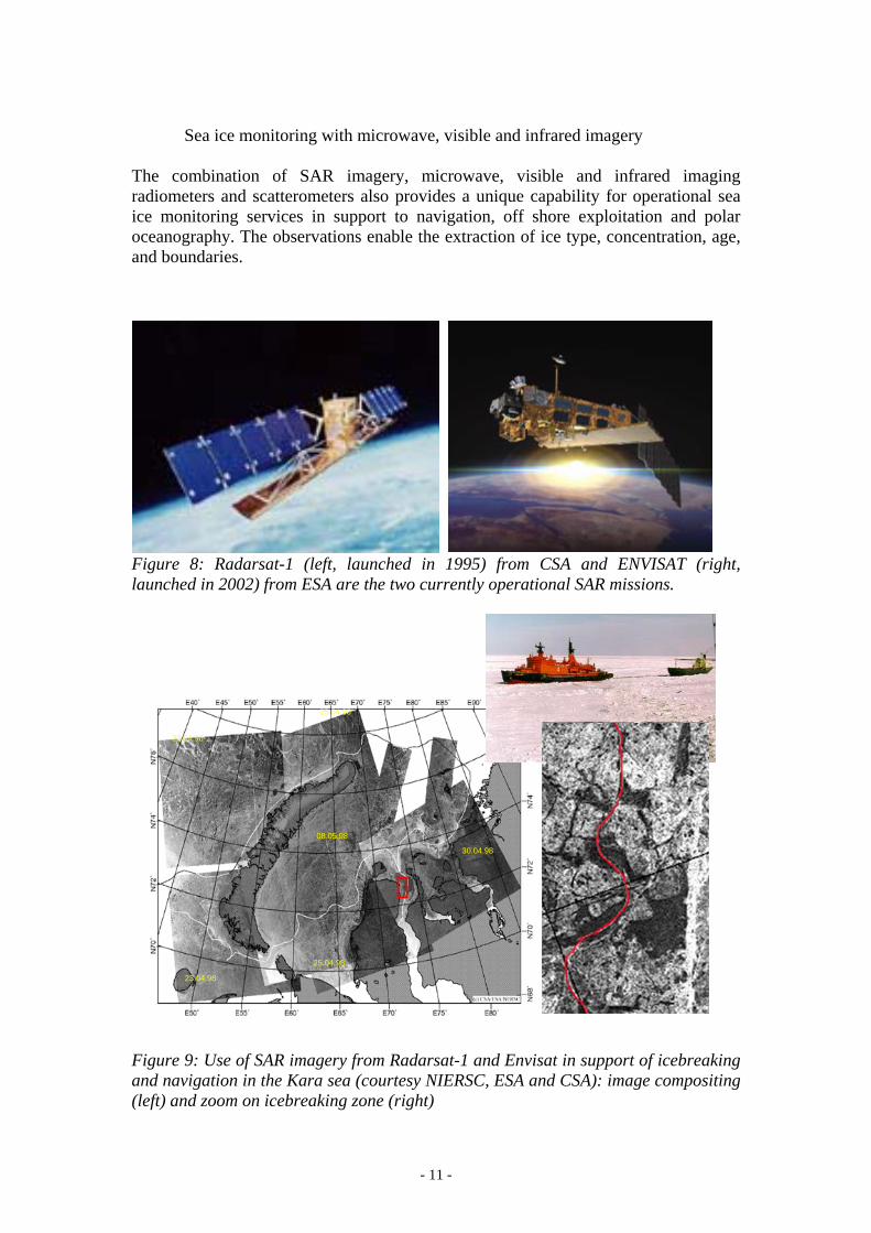
Sea ice monitoring with microwave, visible and infrared imagery The combination of SAR imagery, microwave, visible and infrared imaging radiometers and scatterometers also provides a unique capability for operational sea ice monitoring services in support to navigation, off shore exploitation and polar oceanography. The observations enable the extraction of ice type, concentration, age, and boundaries.
Figure 8: Radarsat-1 (left, launched in 1995) from CSA and ENVISAT (right, launched in 2002) from ESA are the two currently operational SAR missions.
23.04.98
30.04.98
25.04.98
23.04.98
08.05.98
25.04.98
Figure 9: Use of SAR imagery from Radarsat-1 and Envisat in support of icebreaking and navigation in the Kara sea (courtesy NIERSC, ESA and CSA): image compositing (left) and zoom on icebreaking zone (right)
- - 11
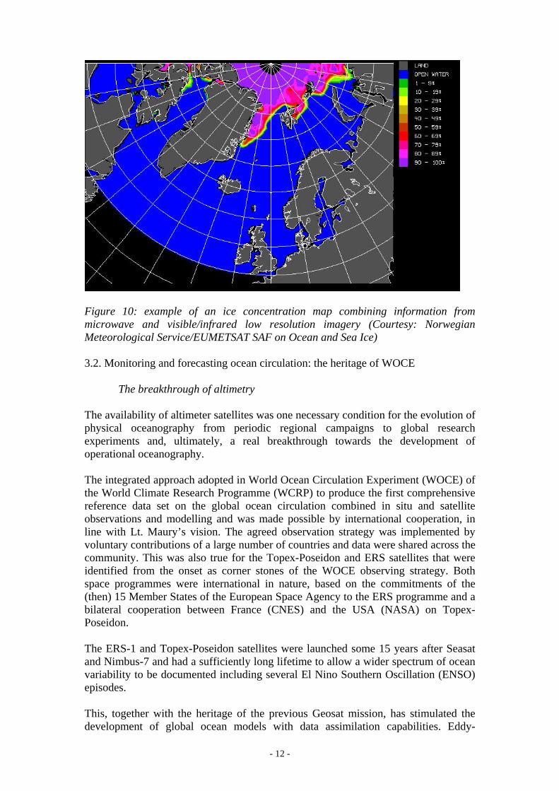
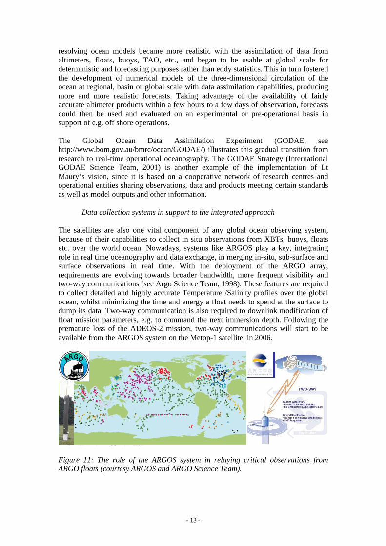
Figure 10: example of an ice concentration map combining information from microwave and visible/infrared low resolution imagery (Courtesy: Norwegian Meteorological Service/EUMETSAT SAF on Ocean and Sea Ice) 3.2. Monitoring and forecasting ocean circulation: the heritage of WOCE
The breakthrough of altimetry The availability of altimeter satellites was one necessary condition for the evolution of physical oceanography from periodic regional campaigns to global research experiments and, ultimately, a real breakthrough towards the development of operational oceanography. The integrated approach adopted in World Ocean Circulation Experiment (WOCE) of the World Climate Research Programme (WCRP) to produce the first comprehensive reference data set on the global ocean circulation combined in situ and satellite observations and modelling and was made possible by international cooperation, in line with Lt. Maury’s vision. The agreed observation strategy was implemented by voluntary contributions of a large number of countries and data were shared across the community. This was also true for the Topex-Poseidon and ERS satellites that were identified from the onset as corner stones of the WOCE observing strategy. Both space programmes were international in nature, based on the commitments of the (then) 15 Member States of the European Space Agency to the ERS programme and a bilateral cooperation between France (CNES) and the USA (NASA) on Topex-Poseidon. The ERS-1 and Topex-Poseidon satellites were launched some 15 years after Seasat and Nimbus-7 and had a sufficiently long lifetime to allow a wider spectrum of ocean variability to be documented including several El Nino Southern Oscillation (ENSO) episodes. This, together with the heritage of the previous Geosat mission, has stimulated the development of global ocean models with data assimilation capabilities. Eddy-
- - 12
resolving ocean models became more realistic with the assimilation of data from altimeters, floats, buoys, TAO, etc., and began to be usable at global scale for deterministic and forecasting purposes rather than eddy statistics. This in turn fostered the development of numerical models of the three-dimensional circulation of the ocean at regional, basin or global scale with data assimilation capabilities, producing more and more realistic forecasts. Taking advantage of the availability of fairly accurate altimeter products within a few hours to a few days of observation, forecasts could then be used and evaluated on an experimental or pre-operational basis in support of e.g. off shore operations. The Global Ocean Data Assimilation Experiment (GODAE, see http://www.bom.gov.au/bmrc/ocean/GODAE/) illustrates this gradual transition from research to real-time operational oceanography. The GODAE Strategy (International GODAE Science Team, 2001) is another example of the implementation of Lt Maury’s vision, since it is based on a cooperative network of research centres and operational entities sharing observations, data and products meeting certain standards as well as model outputs and other information.
Data collection systems in support to the integrated approach The satellites are also one vital component of any global ocean observing system, because of their capabilities to collect in situ observations from XBTs, buoys, floats etc. over the world ocean. Nowadays, systems like ARGOS play a key, integrating role in real time oceanography and data exchange, in merging in-situ, sub-surface and surface observations in real time. With the deployment of the ARGO array, requirements are evolving towards broader bandwidth, more frequent visibility and two-way communications (see Argo Science Team, 1998). These features are required to collect detailed and highly accurate Temperature /Salinity profiles over the global ocean, whilst minimizing the time and energy a float needs to spend at the surface to dump its data. Two-way communication is also required to downlink modification of float mission parameters, e.g. to command the next immersion depth. Following the premature loss of the ADEOS-2 mission, two-way communications will start to be available from the ARGOS system on the Metop-1 satellite, in 2006.
Drifting & Moored Buoys
Figure 11: The role of the ARGOS system in relaying critical observations from ARGO floats (courtesy ARGOS and ARGO Science Team).
- - 13
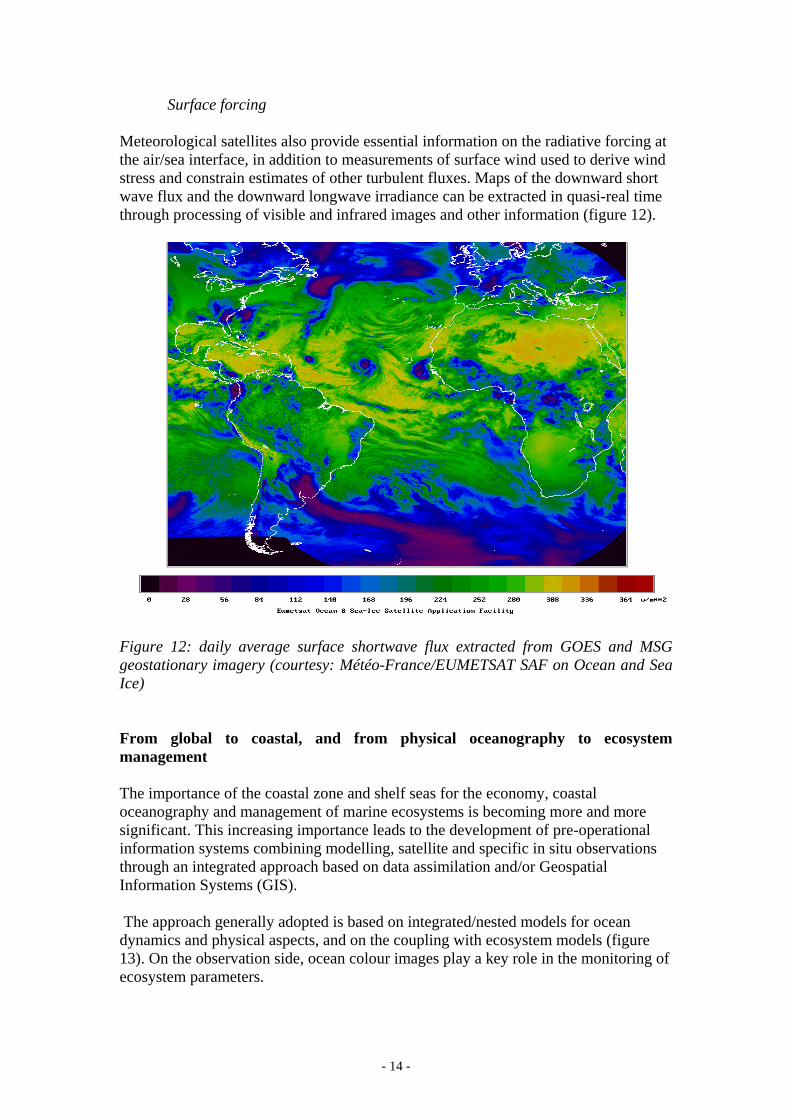
Surface forcing Meteorological satellites also provide essential information on the radiative forcing at the air/sea interface, in addition to measurements of surface wind used to derive wind stress and constrain estimates of other turbulent fluxes. Maps of the downward short wave flux and the downward longwave irradiance can be extracted in quasi-real time through processing of visible and infrared images and other information (figure 12).
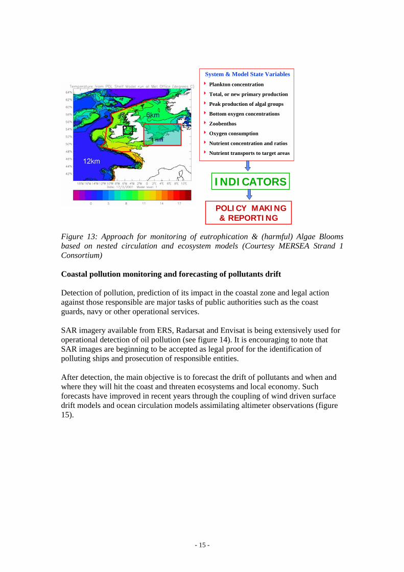
Figure 12: daily average surface shortwave flux extracted from GOES and MSG geostationary imagery (courtesy: Météo-France/EUMETSAT SAF on Ocean and Sea Ice) From global to coastal, and from physical oceanography to ecosystem management The importance of the coastal zone and shelf seas for the economy, coastal oceanography and management of marine ecosystems is becoming more and more significant. This increasing importance leads to the development of pre-operational information systems combining modelling, satellite and specific in situ observations through an integrated approach based on data assimilation and/or Geospatial Information Systems (GIS). The approach generally adopted is based on integrated/nested models for ocean dynamics and physical aspects, and on the coupling with ecosystem models (figure 13). On the observation side, ocean colour images play a key role in the monitoring of ecosystem parameters.
- - 14
System & Model State Variables4 Plankton concentration
4 Total, or new primary production
4 Peak production of algal groups
4 Bottom oxygen concentrations
4 Zoobenthos
4 Oxygen consumption
4 Nutrient concentration and ratios
4 Nutrient transports to target areasOcean Colour
SmartBuoys
POLICY MAKING& REPORTING
INDICATORS
Figure 13: Approach for monitoring of eutrophication & (harmful) Algae Blooms based on nested circulation and ecosystem models (Courtesy MERSEA Strand 1 Consortium) Coastal pollution monitoring and forecasting of pollutants drift Detection of pollution, prediction of its impact in the coastal zone and legal action against those responsible are major tasks of public authorities such as the coast guards, navy or other operational services. SAR imagery available from ERS, Radarsat and Envisat is being extensively used for operational detection of oil pollution (see figure 14). It is encouraging to note that SAR images are beginning to be accepted as legal proof for the identification of polluting ships and prosecution of responsible entities. After detection, the main objective is to forecast the drift of pollutants and when and where they will hit the coast and threaten ecosystems and local economy. Such forecasts have improved in recent years through the coupling of wind driven surface drift models and ocean circulation models assimilating altimeter observations (figure 15).
- - 15
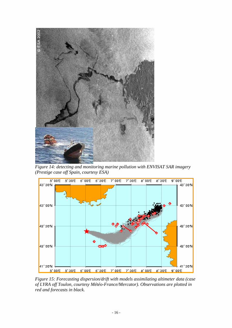
Figure 14: detecting and monitoring marine pollution with ENVISAT SAR imagery (Prestige case off Spain, courtesy ESA)
Figure 15: Forecasting dispersion/drift with models assimilating altimeter data (case of LYRA off Toulon, courtesy Météo-France/Mercator). Observations are plotted in red and forecasts in black.
- - 16
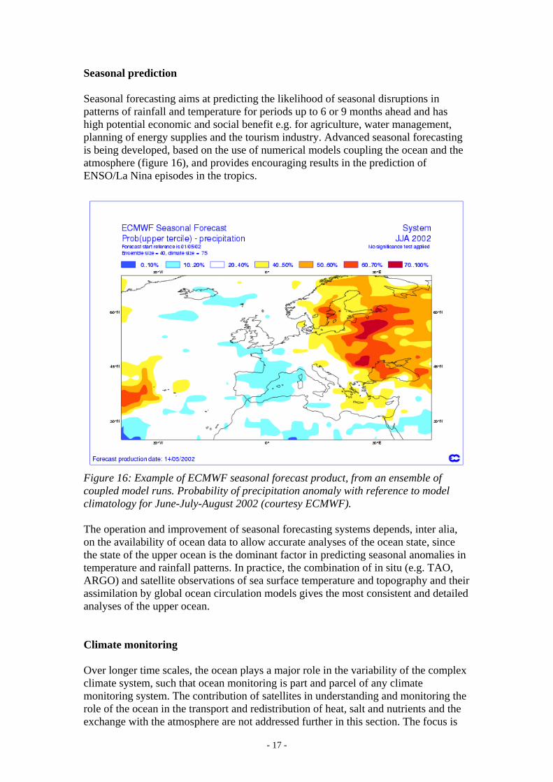
Seasonal prediction Seasonal forecasting aims at predicting the likelihood of seasonal disruptions in patterns of rainfall and temperature for periods up to 6 or 9 months ahead and has high potential economic and social benefit e.g. for agriculture, water management, planning of energy supplies and the tourism industry. Advanced seasonal forecasting is being developed, based on the use of numerical models coupling the ocean and the atmosphere (figure 16), and provides encouraging results in the prediction of ENSO/La Nina episodes in the tropics.
Figure 16: Example of ECMWF seasonal forecast product, from an ensemble of coupled model runs. Probability of precipitation anomaly with reference to model climatology for June-July-August 2002 (courtesy ECMWF). The operation and improvement of seasonal forecasting systems depends, inter alia, on the availability of ocean data to allow accurate analyses of the ocean state, since the state of the upper ocean is the dominant factor in predicting seasonal anomalies in temperature and rainfall patterns. In practice, the combination of in situ (e.g. TAO, ARGO) and satellite observations of sea surface temperature and topography and their assimilation by global ocean circulation models gives the most consistent and detailed analyses of the upper ocean. Climate monitoring Over longer time scales, the ocean plays a major role in the variability of the complex climate system, such that ocean monitoring is part and parcel of any climate monitoring system. The contribution of satellites in understanding and monitoring the role of the ocean in the transport and redistribution of heat, salt and nutrients and the exchange with the atmosphere are not addressed further in this section. The focus is
- - 17
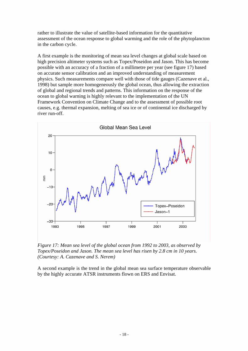
rather to illustrate the value of satellite-based information for the quantitative assessment of the ocean response to global warming and the role of the phytoplancton in the carbon cycle. A first example is the monitoring of mean sea level changes at global scale based on high precision altimeter systems such as Topex/Poseidon and Jason. This has become possible with an accuracy of a fraction of a millimetre per year (see figure 17) based on accurate sensor calibration and an improved understanding of measurement physics. Such measurements compare well with those of tide gauges (Cazenave et al., 1998) but sample more homogeneously the global ocean, thus allowing the extraction of global and regional trends and patterns. This information on the response of the ocean to global warning is highly relevant to the implementation of the UN Framework Convention on Climate Change and to the assessment of possible root causes, e.g. thermal expansion, melting of sea ice or of continental ice discharged by river run-off.
Figure 17: Mean sea level of the global ocean from 1992 to 2003, as observed by Topex/Poseidon and Jason. The mean sea level has risen by 2.8 cm in 10 years. (Courtesy: A. Cazenave and S. Nerem) A second example is the trend in the global mean sea surface temperature observable by the highly accurate ATSR instruments flown on ERS and Envisat.
- - 18
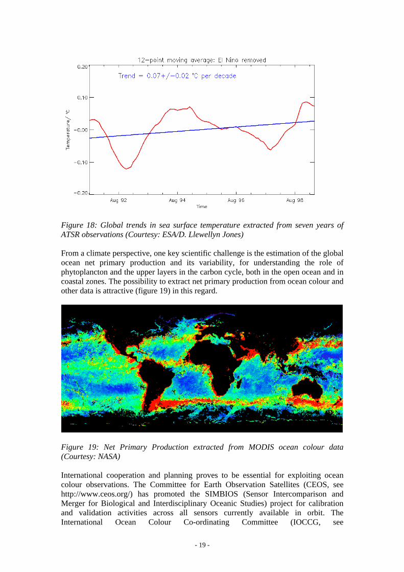
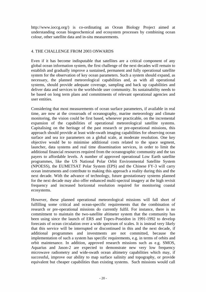
Figure 18: Global trends in sea surface temperature extracted from seven years of ATSR observations (Courtesy: ESA/D. Llewellyn Jones) From a climate perspective, one key scientific challenge is the estimation of the global ocean net primary production and its variability, for understanding the role of phytoplancton and the upper layers in the carbon cycle, both in the open ocean and in coastal zones. The possibility to extract net primary production from ocean colour and other data is attractive (figure 19) in this regard.
Figure 19: Net Primary Production extracted from MODIS ocean colour data (Courtesy: NASA) International cooperation and planning proves to be essential for exploiting ocean colour observations. The Committee for Earth Observation Satellites (CEOS, see http://www.ceos.org/) has promoted the SIMBIOS (Sensor Intercomparison and Merger for Biological and Interdisciplinary Oceanic Studies) project for calibration and validation activities across all sensors currently available in orbit. The International Ocean Colour Co-ordinating Committee (IOCCG, see
- - 19
http://www.ioccg.org/) is co-ordinating an Ocean Biology Project aimed at understanding ocean biogeochemical and ecosystem processes by combining ocean colour, other satellite data and in-situ measurements. 4. THE CHALLENGE FROM 2003 ONWARDS Even if it has become indisputable that satellites are a critical component of any global ocean information system, the first challenge of the next decades will remain to establish and gradually improve a sustained, permanent and fully operational satellite system for the observation of key ocean parameters. Such a system should expand, as necessary, the planned meteorological capabilities and, as with all operational systems, should provide adequate coverage, sampling and back up capabilities and deliver data and services to the worldwide user community. Its sustainability needs to be based on long term plans and commitments of relevant operational agencies and user entities. Considering that most measurements of ocean surface parameters, if available in real time, are now at the crossroads of oceanography, marine meteorology and climate monitoring, the vision could be first based, whenever practicable, on the incremental expansion of the capabilities of operational meteorological satellite systems. Capitalising on the heritage of the past research or pre-operational missions, this approach should provide at least wide-swath imaging capabilities for observing ocean surface and sea ice parameters on a global scale, at moderate resolution. One key objective would be to minimise additional costs related to the space segment, launcher, data systems and real time dissemination services, in order to limit the additional financial resources required from the oceanographic community and the tax payers to affordable levels. A number of approved operational Low Earth satellite programmes, like the US National Polar Orbit Environmental Satellite System (NPOESS), the EUMETSAT Polar System (EPS) and the Chinese FY-3 will carry ocean instruments and contribute to making this approach a reality during this and the next decade. With the advance of technology, future geostationary systems planned for the next decade may also offer enhanced multi-spectral imagery at the high revisit frequency and increased horizontal resolution required for monitoring coastal ecosystems. However, these planned operational meteorological missions will fall short of fulfilling some critical and ocean-specific requirements that the combination of research or pre-operational missions do currently fulfil. For instance, there is no commitment to maintain the two-satellite altimeter system that the community has been using since the launch of ERS and Topex-Poseidon in 1991-1992 to develop forecasts of ocean circulation over a wide spectrum of scales. It is instead very likely that this service will be interrupted or discontinued in this and the next decade, if additional programmes and investments are not committed, because the implementation of such a system has specific requirements, e.g. in terms of orbits and orbit maintenance. In addition, approved research missions such as e.g. SMOS, Aquarius and Jason-2 are expected to demonstrate new very low frequency microwave radiometry and wide-swath ocean altimetry capabilities which may, if successful, improve our ability to map surface salinity and topography, or provide equivalent but cheaper capabilities than existing systems. Such missions would call
- - 20
for operational follow-ups if they bring a (measurable) benefit to end users and/or satellite operators. From a general standpoint, the sustained development of applications such as seasonal prediction, ocean circulation forecasting, monitoring of marine and coastal ecosystems and climate monitoring will undoubtedly require a successful and seamless transition from existing research missions to operational capabilities. Therefore, another facet of the challenge of the next decades will be to plan and implement this transition, based on timely, convergent and co-ordinated initiatives from the development and operational space agencies. This will first require that the operational user community be given open, real-time access to data from demonstration missions, through the mechanisms proposed by WMO to space agencies. The resulting early assessment of the added value of new capabilities in the actual operational context would justify and speed up the transition. Access to high resolution SAR and optical imagery could be a specific issue, because open civilian systems will probably continue to be multipurpose and programmable in nature, at least as long as the ownership cost of such systems remains too high to be affordable by one user community alone. A further reason is that it takes several satellites to fulfill critical revisit requirements in the coastal zone (e.g. for pollution or sea ice monitoring) while, paradoxically, one satellite offers significant imaging capacities that cannot be used by one or another user community. The challenge will therefore be to establish mechanisms for securing the satellite resources necessary to provide systematic operational coverage of critical coastal areas from the available systems. In this regard, the interest of the “metoc” community could be to establish its baseline requirements for observations and data services, for negotiation with operators of such missions, or to establish relevant public/private partnership arrangements. The above considerations show that international co-operation and planning will remain as essential as in 1853, but with higher complexity brought by a number of factors. These include the need for sharing satellite costs and resources (sometimes with other user communities), leading edge technology and know-how, as well as difficulties to plan transitions from research to operational missions. Various frameworks, including the Integrated Global Observing Strategy-Partnership, are available to avoid duplication of efforts, whilst preserving the minimum redundancy required by operational services, as illustrated by the Ocean Theme report (IGOS Ocean Theme Team, 2001). At the political level, the Earth Observations Summit held in Washington in July 2003, its follow-up events and the European Global Monitoring for Environment and Security (GMES) initiative provide altogether attractive frameworks for the definition of a relevant political agenda, including the concept for an overarching observing architecture. The success of the implementation phase will require focus on priorities, in order to attract relevant voluntary contributions and long term financial commitments from nations and agencies. The support of the leadership and cooperation mechanisms established by WMO, IOC, IGOS-P Themes and CEOS will be essential for agreeing implementation priorities, coordinating planning and promoting capacity building worldwide.
- - 21
Acknowledgements The authors are grateful to José Achache (ESA), Johnny Johannesen (NIERSC), Clemente Colon (NOAA), Anny Cazenave (CNES), Lee Fu (NASA), Yves Ménard (CNES), Cotton, Jean-François Minster (Ifremer), Mike Bell (Met. Office), Stan Wilson (NOAA), and D. Llewellyn Jones (Leicester University) for providing material and expertise for this paper. REFERENCES Anderson, D., Stockdale, T., Ferranti, L., Balmaseda, M., The ECMWF seasonal forecasting system, ECMWF newsletter, 98, summer 2003. Argo Science Team, 1998, On The Design and Implementation of Argo, An initial plan for a Global Array of Profiling Floats, ICPO Report n°21, Godae Report n°5 (available on http://www.argo.ucsd.edu/). Cazenave, A., Dominh K., Gennero, M., Ferret, B., and Brossier, C., 1998, Global mean sea level changes from Topex/Poseidon and ERS-1, Physics and Chemistry of the Earth, 23, 1069-1075. Cazenave, A., Nerem R. S., 2004, Present-day sea level change: observations and causes, Reviews of Geophysics, 42, to be published. Cotton, P.D., and Menard Y., 2003, The Future Role of Satellite Altimetry - Early Recommendations from the GAMBLE Project, Proceedings of the 2003 EUMETSAT meteorological Satellite Conference. The International GODAE Science Team, 2001, Global Ocean Data Assimilation Experiment: Strategic Plan, GODAE Report N°6. The IGOS Ocean Theme Team, 2001, An Ocean Theme for the IGOS Partnership, final report of the Ocean Theme Team Isaksen, L. and Stoffelen A., 2000, ERS Scatterometer Wind Data Impact on ECMWF's Tropical Cyclone Forecasts. IEEE Trans. Geosci. Remote Sensing, vol. 38, pp. 1885-1892.
- - 22