Embed Size (px)
DESCRIPTION
Marine Meteorology (Beaufort Scale)
Citation preview
National Meteorological Library and Archive
Fact sheet No. 6 – The Beaufort Scale Introduction It is often said that Francis Beaufort, of the British Royal Navy, was the first to devise a scale of wind force - towards the start of the 19th century. However, in reality he was not, in fact, the originator of such a scale. A similar one was actually in use at least a century earlier - and probably long before that. We do not know who first devised a scale of wind force. But it would be surprising if medieval Arab seafarers did not use one because they had, by the late 15th century, classified in detail virtually every aspect of the weather that had any navigational significance. It would be surprising, too, if the mariners of ancient times did not use such a scale - but as they left so few records, we can only speculate. The scale we all know - the one that bears Beaufort's name - was formulated at the start of the 19th century. But accounts from 1704 show that a similar scale was in use a century earlier.
The table of degrees
Defoe’s terms:
Stark calm
Calm weather
Little wind
A fine breeze
A small gale
A fresh gale
A topsail gale
Blows fresh
A hard gale of wind
A fret of wind
A storm
A tempest
Daniel Defoe, in his account of the dreadful tempest that visited the British Isles on 26-27 November 1703, entitled ‘A Collection of the most remarkable Casualties and Disasters which happen'd in the late dreadful Tempest both by Sea and Land’, referred to a 12-point scale that he called a 'table of degrees'. This comprised, as he put it, "bald terms used by our sailors":
Table 1. Defoe’s table of degrees.
© Crown Copyright Updated: September 2007
Met Office National Meteorological Library and Archive
Fact sheet No. 6: The Beaufort Scale
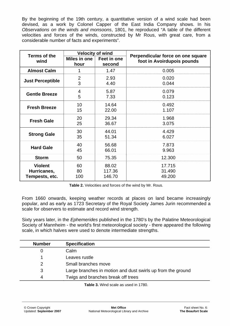
By the beginning of the 19th century, a quantitative version of a wind scale had been devised, as a work by Colonel Capper of the East India Company shows. In his Observations on the winds and monsoons, 1801, he reproduced “A table of the different velocities and forces of the winds, constructed by Mr Rous, with great care, from a considerable number of facts and experiments”.
Velocity of wind Terms of the wind Miles in one
hour Feet in one
second
Perpendicular force on one square foot in Avoirdupois pounds
Almost Calm 1 1.47 0.005
Just Perceptible 2 3
2.93 4.40
0.020 0.044
Gentle Breeze 4 5
5.87 7.33
0.079 0.123
Fresh Breeze 10 15
14.64 22.00
0.492 1.107
Fresh Gale 20 25
29.34 36.67
1.968 3.075
Strong Gale 30 35
44.01 51.34
4.429 6.027
Hard Gale 40 45
56.68 66.01
7.873 9.963
Storm 50 75.35 12.300
Violent Hurricanes,
Tempests, etc.
60 80
100
88.02 117.36 146.70
17.715 31.490 49.200
Table 2. Velocities and forces of the wind by Mr. Rous.
From 1660 onwards, keeping weather records at places on land became increasingly popular, and as early as 1723 Secretary of the Royal Society James Jurin recommended a scale for observers to estimate and record wind strength. Sixty years later, in the Ephemerides published in the 1780’s by the Palatine Meteorological Society of Mannheim - the world's first meteorological society - there appeared the following scale, in which halves were used to denote intermediate strengths.
Number Specification 0 Calm 1 Leaves rustle 2 Small branches move 3 Large branches in motion and dust swirls up from the ground 4 Twigs and branches break off trees
Table 3. Wind scale as used in 1780.
© Crown Copyright Updated: September 2007
Met Office National Meteorological Library and Archive
Fact sheet No. 6: The Beaufort Scale
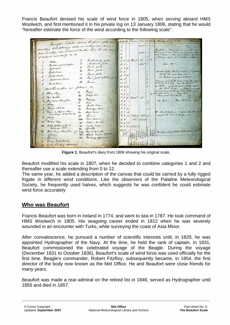
Francis Beaufort devised his scale of wind force in 1805, when serving aboard HMS Woolwich, and first mentioned it in his private log on 13 January 1806, stating that he would "hereafter estimate the force of the wind according to the following scale".
Figure 1. Beaufort’s diary from 1806 showing his original scale. Beaufort modified his scale in 1807, when he decided to combine categories 1 and 2 and thereafter use a scale extending from 0 to 12. The same year, he added a description of the canvas that could be carried by a fully rigged frigate in different wind conditions. Like the observers of the Palatine Meteorological Society, he frequently used halves, which suggests he was confident he could estimate wind force accurately
Who was Beaufort
Francis Beaufort was born in Ireland in 1774, and went to sea in 1787. He took command of HMS Woolwich in 1805. His seagoing career ended in 1812 when he was severely wounded in an encounter with Turks, while surveying the coast of Asia Minor. After convalescence, he pursued a number of scientific interests until, in 1829, he was appointed Hydrographer of the Navy. At the time, he held the rank of captain. In 1831, Beaufort commissioned the celebrated voyage of the Beagle. During the voyage (December 1831 to October 1836), Beaufort's scale of wind force was used officially for the first time. Beagle's commander, Robert FitzRoy, subsequently became, in 1854, the first director of the body now known as the Met Office. He and Beaufort were close friends for many years. Beaufort was made a rear-admiral on the retired list in 1846, served as Hydrographer until 1855 and died in 1857.
© Crown Copyright Updated: September 2007
Met Office National Meteorological Library and Archive
Fact sheet No. 6: The Beaufort Scale
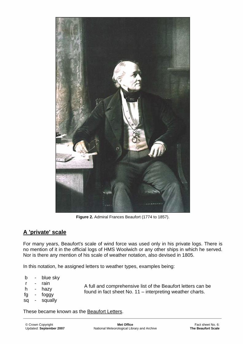
Figure 2. Admiral Frances Beaufort (1774 to 1857).
A 'private' scale
For many years, Beaufort's scale of wind force was used only in his private logs. There is no mention of it in the official logs of HMS Woolwich or any other ships in which he served. Nor is there any mention of his scale of weather notation, also devised in 1805. In this notation, he assigned letters to weather types, examples being: b - blue sky r - rain h - hazy fg - foggy sq - squally
A full and comprehensive list of the Beaufort letters can be found in fact sheet No. 11 – interpreting weather charts.
These became known as the Beaufort Letters.
© Crown Copyright Updated: September 2007
Met Office National Meteorological Library and Archive
Fact sheet No. 6: The Beaufort Scale
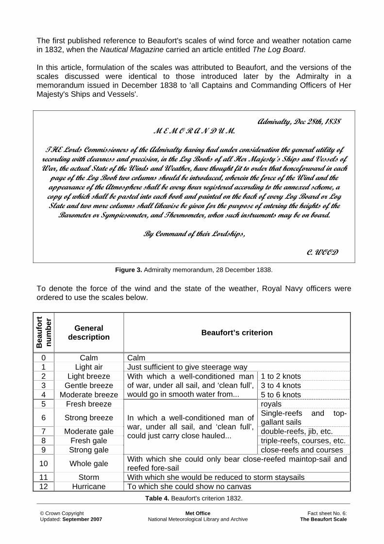
The first published reference to Beaufort's scales of wind force and weather notation came in 1832, when the Nautical Magazine carried an article entitled The Log Board. In this article, formulation of the scales was attributed to Beaufort, and the versions of the scales discussed were identical to those introduced later by the Admiralty in a memorandum issued in December 1838 to 'all Captains and Commanding Officers of Her Majesty's Ships and Vessels'.
Admiralty, Dec 28th, 1838
M E M O R A N D U M.
THE Lords Commissioners of the Admiralty having had under consideration the general utility of recording with clearness and precision, in the Log Books of all Her Majesty's Ships and Vessels of War, the actual State of the Winds and Weather, have thought fit to order that henceforward in each
page of the Log Book two columns should be introduced, wherein the force of the Wind and the appearance of the Atmosphere shall be every hour registered according to the annexed scheme, a copy of which shall be pasted into each book and painted on the back of every Log Board or Log Slate and two more columns shall likewise be given for the purpose of entering the heights of the
Barometer or Sympiesometer, and Thermometer, when such instruments may be on board.
By Command of their Lordships,
C. WOOD
Figure 3. Admiralty memorandum, 28 December 1838. To denote the force of the wind and the state of the weather, Royal Navy officers were ordered to use the scales below.
Bea
ufor
t nu
mbe
r
General description Beaufort’s criterion
0 Calm Calm 1 Light air Just sufficient to give steerage way 2 Light breeze 1 to 2 knots 3 Gentle breeze 3 to 4 knots 4 Moderate breeze
With which a well-conditioned man of war, under all sail, and ‘clean full’, would go in smooth water from... 5 to 6 knots
5 Fresh breeze royals
6 Strong breeze Single-reefs and top-gallant sails
7 Moderate gale double-reefs, jib, etc. 8 Fresh gale triple-reefs, courses, etc. 9 Strong gale
In which a well-conditioned man of war, under all sail, and ‘clean full’, could just carry close hauled...
close-reefs and courses
10 Whole gale With which she could only bear close-reefed maintop-sail and reefed fore-sail
11 Storm With which she would be reduced to storm staysails 12 Hurricane To which she could show no canvas
Table 4. Beaufort's criterion 1832.
© Crown Copyright Updated: September 2007
Met Office National Meteorological Library and Archive
Fact sheet No. 6: The Beaufort Scale
An evolving system
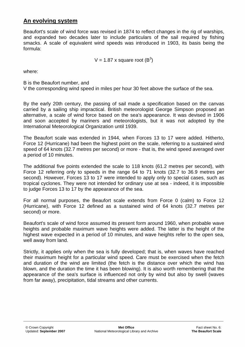
Beaufort's scale of wind force was revised in 1874 to reflect changes in the rig of warships, and expanded two decades later to include particulars of the sail required by fishing smacks. A scale of equivalent wind speeds was introduced in 1903, its basis being the formula:
V = 1.87 x square root (B3) where: B is the Beaufort number, and V the corresponding wind speed in miles per hour 30 feet above the surface of the sea.
By the early 20th century, the passing of sail made a specification based on the canvas carried by a sailing ship impractical. British meteorologist George Simpson proposed an alternative, a scale of wind force based on the sea's appearance. It was devised in 1906 and soon accepted by mariners and meteorologists, but it was not adopted by the International Meteorological Organization until 1939. The Beaufort scale was extended in 1944, when Forces 13 to 17 were added. Hitherto, Force 12 (Hurricane) had been the highest point on the scale, referring to a sustained wind speed of 64 knots (32.7 metres per second) or more - that is, the wind speed averaged over a period of 10 minutes. The additional five points extended the scale to 118 knots (61.2 metres per second), with Force 12 referring only to speeds in the range 64 to 71 knots (32.7 to 36.9 metres per second). However, Forces 13 to 17 were intended to apply only to special cases, such as tropical cyclones. They were not intended for ordinary use at sea - indeed, it is impossible to judge Forces 13 to 17 by the appearance of the sea. For all normal purposes, the Beaufort scale extends from Force 0 (calm) to Force 12 (Hurricane), with Force 12 defined as a sustained wind of 64 knots (32.7 metres per second) or more. Beaufort's scale of wind force assumed its present form around 1960, when probable wave heights and probable maximum wave heights were added. The latter is the height of the highest wave expected in a period of 10 minutes, and wave heights refer to the open sea, well away from land. Strictly, it applies only when the sea is fully developed; that is, when waves have reached their maximum height for a particular wind speed. Care must be exercised when the fetch and duration of the wind are limited (the fetch is the distance over which the wind has blown, and the duration the time it has been blowing). It is also worth remembering that the appearance of the sea's surface is influenced not only by wind but also by swell (waves from far away), precipitation, tidal streams and other currents.
© Crown Copyright Updated: September 2007
Met Office National Meteorological Library and Archive
Fact sheet No. 6: The Beaufort Scale
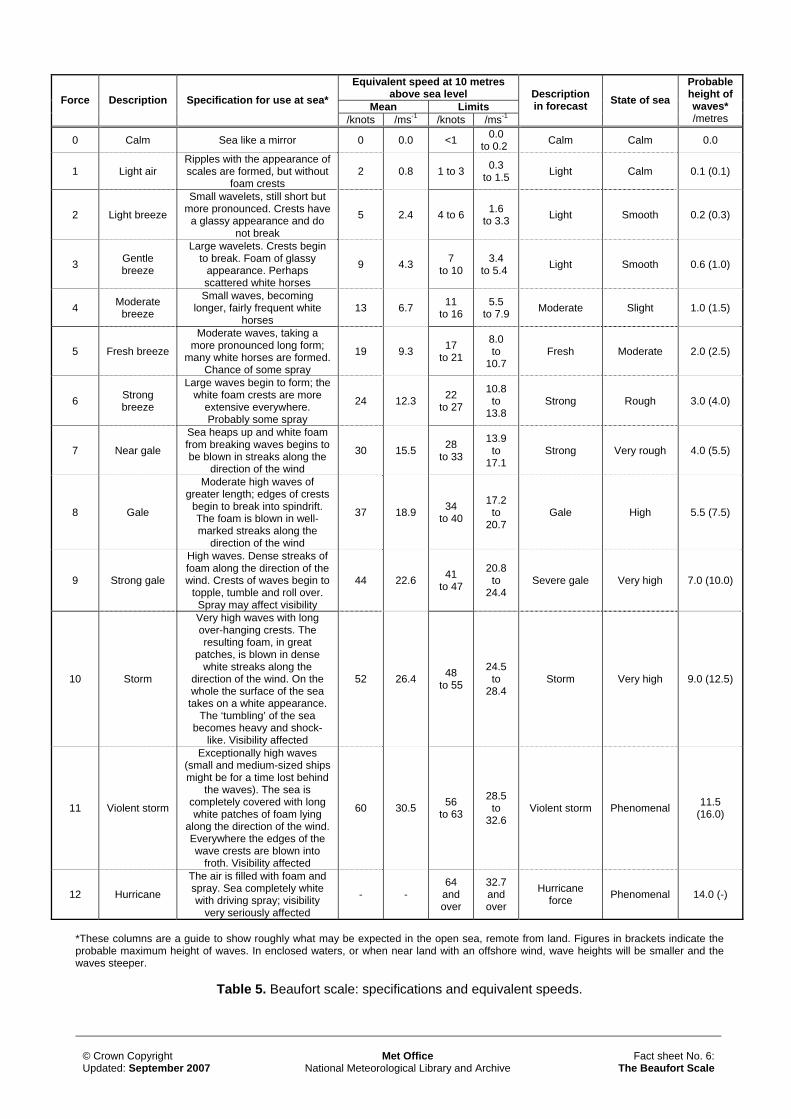
Equivalent speed at 10 metres
above sea level Mean Limits Force Description Specification for use at sea*
/knots /ms-1 /knots /ms-1
Description in forecast State of sea
Probable height of waves* /metres
0 Calm Sea like a mirror 0 0.0 <1 0.0 to 0.2 Calm Calm 0.0
1 Light air Ripples with the appearance of scales are formed, but without
foam crests 2 0.8 1 to 3 0.3
to 1.5 Light Calm 0.1 (0.1)
2 Light breeze
Small wavelets, still short but more pronounced. Crests have
a glassy appearance and do not break
5 2.4 4 to 6 1.6 to 3.3 Light Smooth 0.2 (0.3)
3 Gentle breeze
Large wavelets. Crests begin to break. Foam of glassy
appearance. Perhaps scattered white horses
9 4.3 7 to 10
3.4 to 5.4 Light Smooth 0.6 (1.0)
4 Moderate breeze
Small waves, becoming longer, fairly frequent white
horses 13 6.7 11
to 16 5.5
to 7.9 Moderate Slight 1.0 (1.5)
5 Fresh breeze
Moderate waves, taking a more pronounced long form;
many white horses are formed. Chance of some spray
19 9.3 17 to 21
8.0 to
10.7 Fresh Moderate 2.0 (2.5)
6 Strong breeze
Large waves begin to form; the white foam crests are more
extensive everywhere. Probably some spray
24 12.3 22 to 27
10.8 to
13.8 Strong Rough 3.0 (4.0)
7 Near gale
Sea heaps up and white foam from breaking waves begins to be blown in streaks along the
direction of the wind
30 15.5 28 to 33
13.9 to
17.1 Strong Very rough 4.0 (5.5)
8 Gale
Moderate high waves of greater length; edges of crests
begin to break into spindrift. The foam is blown in well-marked streaks along the
direction of the wind
37 18.9 34 to 40
17.2 to
20.7 Gale High 5.5 (7.5)
9 Strong gale
High waves. Dense streaks of foam along the direction of the wind. Crests of waves begin to
topple, tumble and roll over. Spray may affect visibility
44 22.6 41 to 47
20.8 to
24.4 Severe gale Very high 7.0 (10.0)
10 Storm
Very high waves with long over-hanging crests. The resulting foam, in great
patches, is blown in dense white streaks along the
direction of the wind. On the whole the surface of the sea
takes on a white appearance. The ‘tumbling’ of the sea
becomes heavy and shock-like. Visibility affected
52 26.4 48 to 55
24.5 to
28.4 Storm Very high 9.0 (12.5)
11 Violent storm
Exceptionally high waves (small and medium-sized ships might be for a time lost behind
the waves). The sea is completely covered with long white patches of foam lying
along the direction of the wind. Everywhere the edges of the wave crests are blown into
froth. Visibility affected
60 30.5 56 to 63
28.5 to
32.6 Violent storm Phenomenal 11.5
(16.0)
12 Hurricane
The air is filled with foam and spray. Sea completely white with driving spray; visibility
very seriously affected
- - 64
and over
32.7 and over
Hurricane force Phenomenal 14.0 (-)
*These columns are a guide to show roughly what may be expected in the open sea, remote from land. Figures in brackets indicate the probable maximum height of waves. In enclosed waters, or when near land with an offshore wind, wave heights will be smaller and the waves steeper.
Table 5. Beaufort scale: specifications and equivalent speeds.
© Crown Copyright Updated: September 2007
Met Office National Meteorological Library and Archive
Fact sheet No. 6: The Beaufort Scale
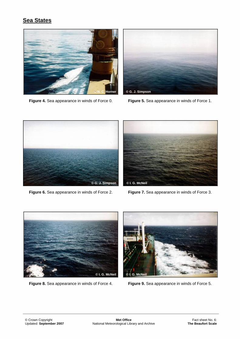
Sea States
Figure 4. Sea appearance in winds of Force 0.
Figure 5. Sea appearance in winds of Force 1.
© N. C. Horner © G. J. Simpson
Figure 6. Sea appearance in winds of Force 2.
© G. J. Simpson © I. G. McNeil
Figure 7. Sea appearance in winds of Force 3.
© I. G. McNeil © I. G. McNeil
Figure 8. Sea appearance in winds of Force 4. Figure 9. Sea appearance in winds of Force 5.
© Crown Copyright Updated: September 2007
Met Office National Meteorological Library and Archive
Fact sheet No. 6: The Beaufort Scale
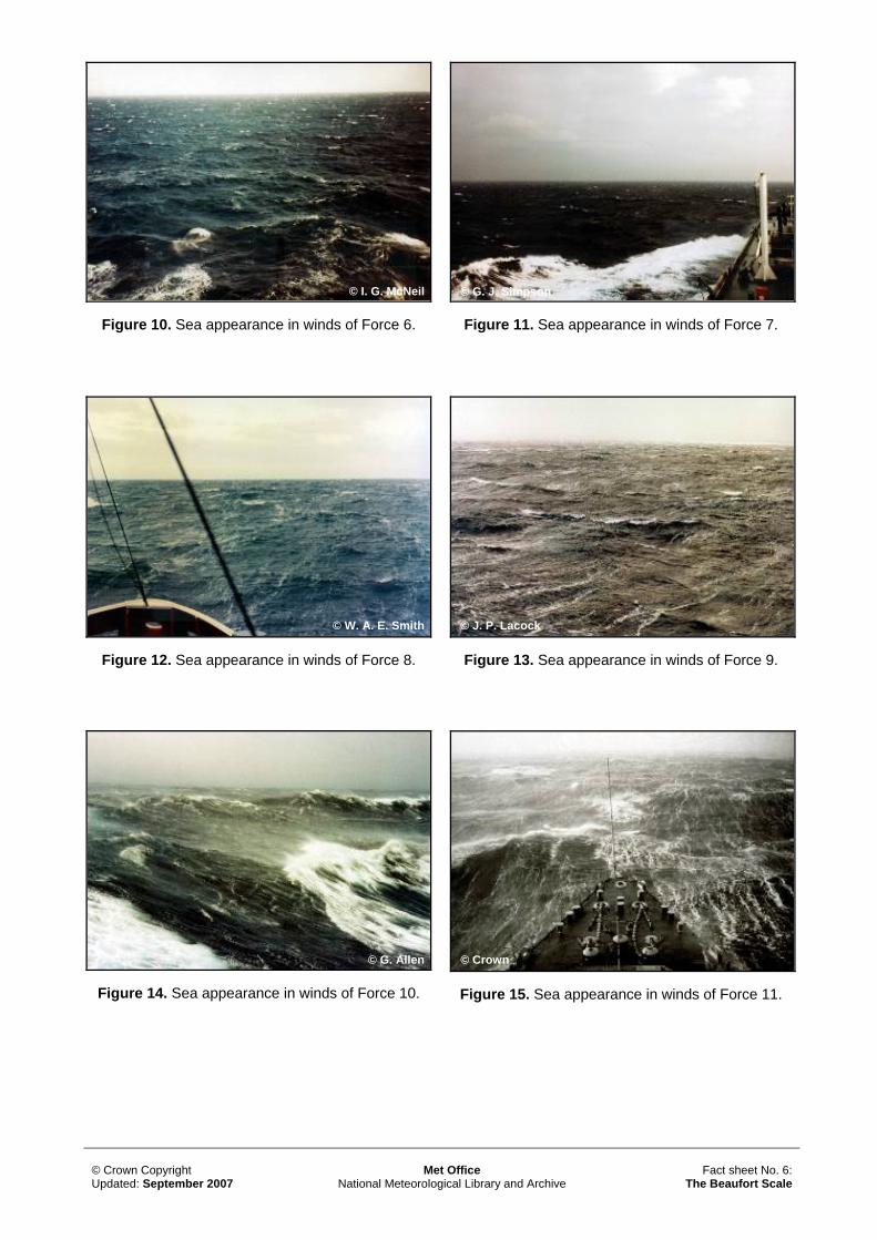
Figure 10. Sea appearance in winds of Force 6.
© I. G. McNeil © G. J. Simpson
Figure 11. Sea appearance in winds of Force 7.
© W. A. E. Smith © J. P. Lacock
Figure 12. Sea appearance in winds of Force 8. Figure 13. Sea appearance in winds of Force 9.
© G. Allen © Crown
Figure 14. Sea appearance in winds of Force 10. Figure 15. Sea appearance in winds of Force 11.
© Crown Copyright Updated: September 2007
Met Office National Meteorological Library and Archive
Fact sheet No. 6: The Beaufort Scale
© J. F. Thompson
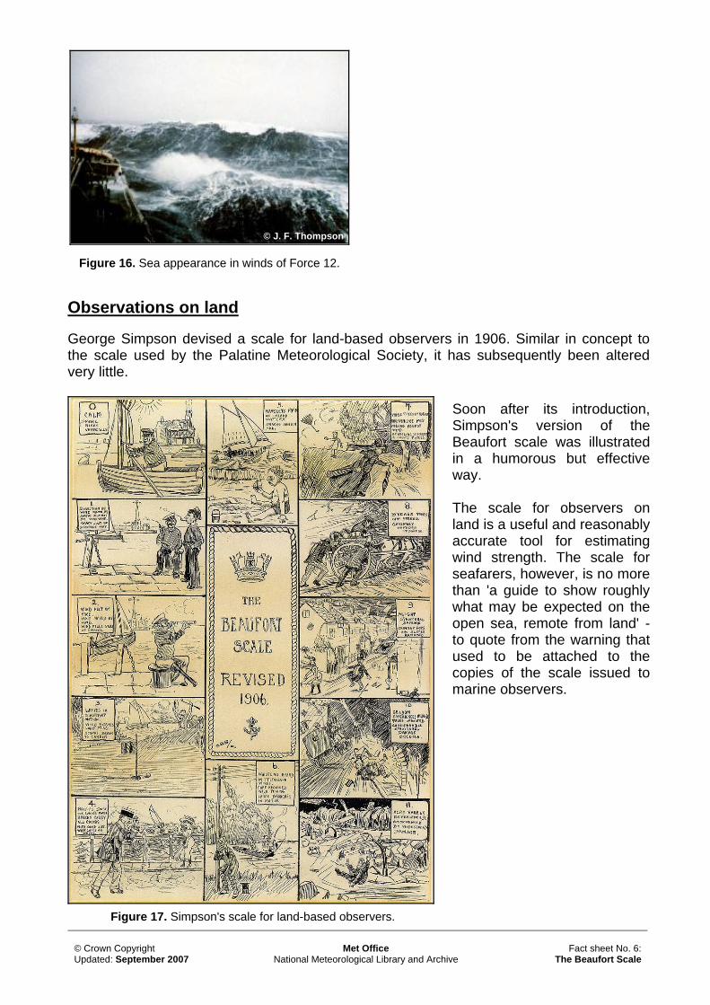
Figure 16. Sea appearance in winds of Force 12.
Observations on land George Simpson devised a scale for land-based observers in 1906. Similar in concept to the scale used by the Palatine Meteorological Society, it has subsequently been altered very little.
Soon after its introduction, Simpson's version of the Beaufort scale was illustrated in a humorous but effective way. The scale for observers on land is a useful and reasonably accurate tool for estimating wind strength. The scale for seafarers, however, is no more than 'a guide to show roughly what may be expected on the open sea, remote from land' - to quote from the warning that used to be attached to the copies of the scale issued to marine observers.
Figure 17. Simpson's scale for land-based observers.
© Crown Copyright Updated: September 2007
Met Office National Meteorological Library and Archive
Fact sheet No. 6: The Beaufort Scale

This fact sheet has been produced in conjunction with the Met Office’s Education section. You can contact the Education service through the Met Office Customer Centre. Contact the Customer Centre: Tel: 0870 900 0100 Fax: 0870 900 5050 Email: [email protected] If you are outside the UK: Tel: +44 (0)1392 885680 Fax: +44 (0)1392 885681 For Primary and Secondary education enquiries: Email: [email protected] All of the images used in this fact sheet along with many others covering all aspects of meteorology can be obtained from the National Meteorological Library’s Visual Aids section. For more information about what images are available, please contact the Visual Aids Officer at: Tel: 01392 884845 Email: [email protected] Our unique collection of weather images is available via the National Meteorological Library and Archive’s online catalogue. The collection illustrates all aspects of meteorology, from clouds and weather phenomena, to instruments and the work of the Met Office. Our online catalogue can be found at: www.metoffice.gov.uk/corporate/library/catalogue.html All of the fact sheets in this series are available to download from the Met Office’s website. The full list can be found at: www.metoffice.gov.uk/corporate/library/factsheets.html
Other titles in this series still available: • Number 1 – Clouds
• Number 2 - Thunderstorms
• Number 3 – Water in the atmosphere • Number 4 – Climate of the British Isles • Number 5 – White Christmases
• Number 7 – Climate of Southwest England • Number 8 – The Shipping Forecasts • Number 9 – Weather extremes
• Number 10 – Air masses and weather fronts • Number 11 – Interpreting weather charts • Number 12 – National Meteorological Archive • Number 13 – Upper air observations and the tephigram • Number 14 – Microclimates • Number 15 – Weather radar • Number 16 – World climates
© Crown Copyright Updated: September 2007
Met Office National Meteorological Library and Archive
Fact sheet No. 6: The Beaufort Scale