Embed Size (px)
Citation preview
1
THE RIVER FLOWS FOREVER ON:
LANDSCAPE AGENCY IN SOUTH-WESTERN
SWEDEN, 550-1750 A.D.
Lund University
Department of Archaeology and Ancient History
Master‘s thesis in Historical Archaeology
ARKM22, spring 2014
Author: Oscar Jacobsson
Supervisor: Martin Hansson

2
ABSTRACT
This thesis studies the interaction between rivers and human culture through a wide theoretical
perspective combining the theories of Fernand Braudel, Jean-Paul Sartre, Homi Bhabha and
recent “symmetrical archaeology”. While landscape archaeology previously to a large degree
has been focused on phenomenology and studies of symbolic landscapes, this thesis tries to
emphasise the importance of the land itself. Rivers have strangely been rather overlooked in
landscape archaeology considering their central role in the natural landscape. Two river
systems – Göta Älv and Ätran – are selected for closer analysis of the period between 550-1750
A.D. The main questions raised are:
Have the rivers in question contributed to the construction of society?
Has the interaction between nature and culture created riverine hybrid landscapes?
These questions are explored and analysed through the development of a geodatabase with
digital information from several official databases such as: FMIS, SGU, SMHI, KARL, GEORG,
Lantmäteriet and SDHK. The methodology is centered on the investigation of a large diversity of
river uses, including the natural preconditions, economic factors and ideological aspects. Three
case studies for each river are selected for a more detailed study and the synthesis is then
analysed through a comparative perspective.
The analysis shows that although there might be certain differences between Göta Älv and
Ätran, some common patterns of character exist. Both rivers have clearly contributed to society
in a large variety of ways and on a diverse number of levels. Both economically and
ideologically Göta Älv and Ätran have affected their surrounding settlements. The hybrid
character of the riverine landscapes is difficult to capture physically, although a few clear
examples exist. Both milling and water meadows are suggested as examples of important factors
in the creation of hybrid landscapes.
Further suggestions for future research are also given, along with a discussion concerning the
problematic nature of the present landscape archaeological discourse.
Key words: landscape archaeology, long-term perspectives, GIS, geodatabase, river interaction,
river use, riverine history, symmetrical archaeology, archaeological theory, Middle Ages,
Early Modern, Iron Age, environment, culture and nature, historical maps, FMIS.

3
Contents
List of figures ................................................................................................................................................. 7
Acknowledgements ....................................................................................................................................... 8
1. Introduction .............................................................................................................................................. 9
1.1 Problem Formulation and Aims .......................................................................................................... 9
1.1.3 A Note on the Written Structure ............................................................................................... 10
1.2 Previous Research ............................................................................................................................. 11
1.2.1 On the international history of rivers ........................................................................................ 11
1.2.2 Riverine research in Scandinavia ............................................................................................... 13
1.3 Choice of Source Material ................................................................................................................. 14
1.3.1 FMIS and BeBR ........................................................................................................................... 14
1.3.2 Lantmäteriet .............................................................................................................................. 17
1.3.3 KARL and GEORG ........................................................................................................................ 17
1.3.4 SDHK ........................................................................................................................................... 18
1.3.5 SMHI ........................................................................................................................................... 18
1.3.6 SGU ............................................................................................................................................. 19
1.4 Limitations ......................................................................................................................................... 19
2. Theories of Active Landscapes ................................................................................................................ 21
2.1 Definitions ......................................................................................................................................... 21
2.1.1 Nature and Culture .................................................................................................................... 21
2.1.2 The Character of a River ............................................................................................................. 22
2.2 Theoretical issues of GIS ................................................................................................................... 23
2.3 Natural agency .................................................................................................................................. 24
2.3.1 La longue durée.......................................................................................................................... 24
2.3.2 Jean-Paul Sartre and the power of the individual...................................................................... 25
2.3.3. Symmetrical Archaeology and Non-human Agency ................................................................. 26
2.4 Hybridity and Third Space ................................................................................................................. 28
2.5 Concluding Remarks .......................................................................................................................... 29
3. Method and critique ............................................................................................................................... 31
3.1 Method ............................................................................................................................................. 31
3.1.1 The Natural Preconditions ......................................................................................................... 32
3.1.2 Economic factors ........................................................................................................................ 34

4
3.1.3 Ideological and Symbolical aspects ............................................................................................ 34
3.1.4 Issues of Chronology .................................................................................................................. 35
3.1.5 Area of Study and Scale of Inference ......................................................................................... 36
3.2 Critique .............................................................................................................................................. 38
4. The River System ..................................................................................................................................... 41
4.1. The Water Cycle ............................................................................................................................... 41
4.2 The River as a Transporter ................................................................................................................ 42
4.3. River flooding ................................................................................................................................... 43
4.4 Environmental Considerations .......................................................................................................... 44
5. Analysis: Göta Älv .................................................................................................................................... 47
5.1 Natural preconditions ....................................................................................................................... 47
5.2 Åkerström ......................................................................................................................................... 50
5.2.1 The Late Iron Age ....................................................................................................................... 50
5.2.2 The Middle Ages and onwards ................................................................................................... 51
5.3 Lödöse ............................................................................................................................................... 54
5.3.1 The Late Iron Age ....................................................................................................................... 54
5.3.2 The Middle Ages and onwards ................................................................................................... 56
5.4 Kungahälla-Bohus ............................................................................................................................. 57
5.4.1 The Late Iron Age ....................................................................................................................... 57
5.5 Chapter Conclusions ......................................................................................................................... 61
5.5.1 Natural Factors of Human Activity ............................................................................................. 62
5.5.2 Economic factors of river use ..................................................................................................... 63
5.5.3 Ideological aspects of river use .................................................................................................. 64
6. Analysis: Ätran ........................................................................................................................................ 67
6.1 Natural Preconditions ....................................................................................................................... 68
6.2 The Upper Ätran Valley – Kölaby and Blidsberg ............................................................................... 69
6.2.1 The Late Iron Age ....................................................................................................................... 69
6.2.2 The Middle Ages and onwards ................................................................................................... 70
6.3 Östra Frölunda .................................................................................................................................. 71
6.3.1 The Late Iron Age ....................................................................................................................... 71
6.3.2 The Middle Ages and Beyond .................................................................................................... 74
6.4 Falkenberg and the estuary region of Ätran ..................................................................................... 76
5
6.4.1 The Late Iron Age ....................................................................................................................... 76
6.4.2 The Middle Ages and Onwards .................................................................................................. 77
6.5 Chapter Conclusions ......................................................................................................................... 78
6.5.1 Natural Factors of Human Activity ............................................................................................. 78
6.5.2 Economic factors of river use ..................................................................................................... 80
6.5.3 Ideological aspects of river use .................................................................................................. 80
7. Characterisation of the River .................................................................................................................. 83
7.1 Categories ......................................................................................................................................... 83
7.1.1 Natural Factors of Human Activity ............................................................................................. 83
7.1.2 Economic factors of river use ..................................................................................................... 84
7.1.3 Ideological aspects of river use .................................................................................................. 84
7.2 Patterns of Character ........................................................................................................................ 85
7.2.1 The Flow of Water and Its Relation to Economy ....................................................................... 86
7.2.2 The Separating and Connecting character of the river .............................................................. 87
7.2.3 Individual actions of river characterisation ............................................................................... 88
7.2.4 The Character of the River in Agriculture .................................................................................. 90
8. Conclusions ............................................................................................................................................. 92
8.1 Riverine societal contribution ........................................................................................................... 92
8.2 The question of agency and the hybridity of the riverine landscape ............................................... 94
8.3 A possible discoursive transformation? ............................................................................................ 95
8.4 Suggestions for future research ........................................................................................................ 97
9. Summary ................................................................................................................................................. 98
Chapter 1. Introduction .......................................................................................................................... 98
Chapter 2. Theory ................................................................................................................................... 98
Chapter 3. Method .................................................................................................................................. 99
Chapter 4. The River System ................................................................................................................. 100
Chapter 5. Göta Älv ............................................................................................................................... 100
Chapter 6. Ätran .................................................................................................................................... 101
Chapter 7. Charactersation of the River ............................................................................................... 101
Chapter 8. Conclusions ......................................................................................................................... 102
REFERENCES .............................................................................................................................................. 103
Literature .............................................................................................................................................. 103

6
Websites ............................................................................................................................................... 112
APPENDIX 1: Data Manipulation ............................................................................................................... 114
1.1 FMIS: Geographical overviews ........................................................................................................ 114
1.2 FMIS: Data Categories ..................................................................................................................... 114
1.2.1 Communication ........................................................................................................................ 114
1.2.2 Economy ................................................................................................................................... 115
1.2.3 Farming .................................................................................................................................... 116
1.2.4 Military ..................................................................................................................................... 116
1.2.5 Religion/symbology .................................................................................................................. 117
1.3 Rectification of Historical Maps ...................................................................................................... 118
1.4 Geodatabase Structure ................................................................................................................... 119
APPENDIX 2: Figures ................................................................................................................................. 120
7
List of figures
-Figure 1. The density of ancient fields and farmlands in FMIS –
in Northern Halland and Southern Västra Götaland. 16
-Figure 2. Map comparing the geomorphological change of the
stream of Ryrbäcken near Åkerström in the vicinity of Göta Älv,
between 1653 and 2013. 33
-Figure 3. Map of the studied rivers, with the locations of the case
studies marked 37
-Figure 4. The water cycle 41
-Figure 5. The Hjulström diagram which describes the relationship
between particle size, flow velocity, transportation, erosion and
deposition 43
-Figure 6. Formula to calculate flood recurrence. 44
-Figure 7. Mean temperature variations in the Northern
Hemisphere, based on proxy data. 45
-Figure 8. Temperature variations in the Northern Hemisphere
during the last 1300 years. 46
-Figure 9. Map of Göta Älv, marking the location of the three
case studies. 49
-Figure 10. Digitised map of Åkerström in 1653, on top of a
modern orthoimage. 52
-Figure 11. Viewshed analysis from the gravefield RAÄ
Skepplanda 65:1, based on LIDAR models. 55
-Figure 12. Map showing the location of the medieval town
Kungahälla and related archaeological features. 59
-Figure 13. Map of Ätran showing the locations of the three
case studies. 67
-Figure 14. Blidsberg church and Kölaby church. 70
-Figure 15. Map showing the Iron Age features in the area
close to Östra Frölunda. 73
-Figure 16. LIDAR model of Kindahus Castle. 74
-Table 1. Levels of source material representation and
summarising definitions based on material prejudice. 39
-Table 2. Histograms showing the average distances between
two categories of religious features and Göta Älv. 65
-Table 3. Histograms showing the average distances between
two categories of religious features and Ätran. 82

8
Acknowledgements First and foremost I would like to thank my supervisor Martin Hansson at the Department of
Archaeology and Ancient History, who has provided me with constant support and invaluable
advice in the writing of this thesis. Special thanks to him for also introducing me to tons of
highly useful literature which would otherwhise have remained unkown to me.
My second thanks must be directed to the project members of YGK (Yngre Geometriska
Kartor) at the National Archives, especially project leader Clas Tollin at the Swedish University
of Agricultural Sciences for letting me participate and contribute to their database. Kristoffer
Jupiter should be given special thanks for bearing with my intitally limited knowledge
concerning the younger geometrical maps, and it is through your teaching that I have managed to
use that material to a large extent in this thesis.
Thirdly I must thank my fellow student Justin Kimball for correcting my English during the
intitial writing process. Your guidance gave me the confidence to write this thesis using a second
language, and your comments and thoughts made me revaluate and improve my writing a lot.
Dan Hammarlund at the Department of Geology deserves special thanks for giving me some
intial guidance in the djungle of paleoclimatology and providing me with information on one of
his ongoing research projects. He also introduced me to Helena Alexandersson at the same
department, who deserves thanks for giving her thoughts on the problematic issue of the
contribution of mills to fluvial geomorphology.
I would also like to thank Anders Ödman at the Department of Archaeology and Ancient
History for his valuable insights and knowledge concerning Scandinavian river history and river
use in general. He also read the first draft of this thesis and gave some initial constructive
critique that really improved the quality of the text below.
Jonathan M. Feldman at the Department of Economic History at Stockholm University should
also be mentioned here, as he introduced me to the wide philosophical and cross-theoretical
thoughts of Jean-Paul Sartre and C. Wright Mills. This thesis would not be as daring or as
theoretically aware without your teaching.
Last but not least I would also like to thank: My dearest love Hillewi Elgstrand for bearing
with me and my rather constant preoccupation during these months. My fellow students at Lund
University, Stockholm University and Gothenburg University for providing a stimulating arena
of discussion. My family for always encouraging me to follow my own interests and ideas.
Without you the writing of this thesis would have been impossible.

9
“There is a town that once was green,
And the river flowed to the sea.
The river flows forever on,
But the dear green place is gone.” //
The Dear Green Place by Battlefield Band
1. Introduction This master‘s thesis is the result of several years of interaction with nature, in its many forms.
Much like the famous British landscape historian W.G. Hoskins (Johnson 2007: 36), I spent my
childhood exploring the forests of my home, contemplating over the serene qualities of snow-
clad fields, the beauty of summer leaves and the overwhelming power of the autumn storms that
often ravage the west coast of Sweden. It is not strange – rather, it is quite obvious – that this has
hugely influenced the ways in which I analyse the world. Being aware of this fact, as an author,
makes it easier to contrast your work to that of other authors and academics. Biographical
analysis, like the progressive-regressive method promoted by Jean-Paul Sartre (1968), is an
important tool in the understanding of personal bias. This thesis is – while of course also the
result of serious and entangled work – also the result of a bias; that of a romanticized view on
nature and its power to influence the individual.
The aim of the thesis is not however, to propagate the poetic thoughts of 19th
century
romanticism, nor in any way to reinstate the power of nature over that of society. Rather, the goal
is to show some of the ways in which nature contributes to the making of society, and how the
interaction between human and nature creates a certain hybrid coexistence.
1.1 Problem Formulation and Aims For many years of archaeological thought, there has been a discussion concerning the role of
nature in the production of human culture and society. The debate has focused on different
themes through the years; for example processual archaeology argued that nature was the force
controlling human life. Subsequently, the study of human history and culture should follow the
same rules as the natural sciences. In this kind of inquiry, it is nature alone that is the shaper of
our human world. Post-processual archaeology, which later dominated the archaeological
discourse, instead sought to bring the study of past societies closer to the social sciences –
through which the power of humanity in shaping the world around us is emphasized (Webmoor
2007: 565-68). This socially anchored research took power away from nature, much similar to
the way in which processual archaeology diminished the importance of the individual, as well as
that of culture.
This thesis combines the thoughts and ideas of recent symmetrical archaeology (for example
Gosden 2005, Webmoor 2007, Witmore 2007, Olsen 2010), which is mostly based on the works
of Latour (2005), with Fernand Braudel‘s famous concept la longue durée (Braudel 1958) and
the post-colonial conception of third space, fashioned by Homi Bhabha (1994). I have also used

10
the work of Jean-Paul Sartre (1968) to identify the contrasts of human/nature interaction. The
idea is to question the instituted hierarchy controlling the philosophical relationship between
nature and culture and, like the symmetrical agenda proposes, to not a priori treat either one as
the major agent of change. More on the issues of combining these theories can be found below.
In order to tackle this issue effectively, I have chosen to use fluvial systems – i.e. rivers – as
the main objects of study. Two issues dominate this thesis concerning the relationship between a
river and its anthropogenic surroundings. The first issue concerns the active agency of the river,
i.e.:
Have the rivers in question contributed to the construction of society? Here, note the use
of the word contributed, as it indicates that it is not nature alone that has shaped society,
but the unison force of nature and culture.
This theme is central to this essay, and leads to the second issue:
Has the interaction between nature and culture created riverine hybrid landscapes?
In Chapter 3, some additional questions have been asked, which can be seen as sublevels of the
questions above. These subquestions have directed the methodological focus of the analysis and
made it possible to characterise the rivers.
In methodology this study much resembles traditional landscape archaeology, as it was
promoted by Michael Aston (1985: 11-20). The landscape archaeological method is highly
interdisciplinary in its nature, combining several types of source material. Modern technology
has contributed to the effectiveness of this method, and I have chosen to use a Geographical
Information System as the methodological centre of this thesis.
The period of study has been limited to 550-1750 A.D. – from the beginning of the
Scandinavian Vendel period till the Agrarian Revolution of the 18th
century – spanning 1200
years of riverine history. This means that I have engaged in the study of many forms of source
material – both historical, archaeological, geographical and geological – in order to capture the
entire scope of the period. Two rivers of varying natural characteristics have been chosen for this
thesis: Göta Älv and Ätran.
1.1.3 A Note on the Written Structure
The written structure of this thesis could benefit from a short description. In this chapter I first
outline the main research questions posed to the material, then I go on to describe the research
which has previously been conducted on riverine history and the relationship between those
studies and this thesis. After that, the chapter describes in small detail what sort of source
material I have used and which limitations that I have found necessary. The next chapter outlines
in detail the theoretical background of the study, setting a foundation for the applied
methodology. Chapter 3 gives an account of the methods used in this study and then discusses
some initial point of self-critique. In Chapter 4 I have given a simple background to hydrology

11
and fluvial geomorphology, which is necessary in order to fully understand what comes after.
Chapter 5 and 6 is dedicated to the main analysis of the two river systems in question, wherin I
describe in total 6 case studies with a comparative conclusion. In Chapter 7 I have tried to
characterize the rivers in question and the patterns which have emerged in the study of their
riverine history. The argument is tied to the theoretical background. Chapter 8 concludes this
thesis, in proposing answers to the research questions posed in Chapter 1, and subsequently gives
ideas to future research.
1.2 Previous Research This subchapter gives an outline on the previous research done on the history of water/society
interaction. Of course, it is impossible to produce a complete picture of all the published work
related to this issue. Therefore this chapter should be seen merely as a small assemblage of the
research that I have found most relevant. For research history on the theoretical perspectives
used in this thesis, see Chapter 2.
1.2.1 On the international history of rivers
The research on the history of flowing water has a long and quite rich history. Many of the
earliest advanced societies were formed around the control of rivers, a fact recognized by Karl A.
Wittfogel in his research on hydraulic societies. Wittfogel argued that the control of extensive
water systems for agricultural irrigation depended on advanced administrational institutions, and
was therefore more long-lasting and influential than other stratified agrarian societies (Wittfogel
1955). Wittfogel was environmentally deterministic in his arguments, where he tried to
demonstrate that these societies only emerge in areas with specific environmental conditions – i.e.
in areas with an arid, or semi-arid, environment (Wittfogel 1957: 344). The deterministic theories
of Wittfogel are rarely used today, though his main theme of long-term hydraulic societies is still
considered important in the study of ancient civilizations (Harrower 2009). Grounded in his work
is also a recent article by Duncan Sayer, concerning the medieval management of waterways on
the East Anglian fen (Sayer 2009). Sayer argues however, that Wittfogel‘s model is too general,
and that closer investigations reveal much more complex relations (ibid: 145-46). In general
though, Sayer‘s article is an admirable attempt to apply some of the research done on ancient
civilization to a medieval period, which otherwise have been a sadly ignored time period.
In English historical geography, there has been a certain focus on discussing the use of
medieval waterways for transportation. In the 1990s, a heated debate occurred in the Journal of
Historical Geography between different authors arguing about the navigability of England‘s
rivers. The argument was more or less concluded by Jones (2000) who emphasized the fact that
the use of rivers for transport declined during the later Middle Ages, due to an increased amount
of obstructions in the upper areas of waterways, as well as lowered maintenance levels caused by
a decreasing population (Jones 2000: 72-73). This research has been followed by other
interdisciplinary works to which both historians, geographers and archaeologists have
contributed. One of the most obvious examples is the volume Waterways and Canal-building in
Medieval England edited by John Blair (2007). The volume is one of the few major recent works

12
actively discussing the use of medieval waterways, from several different perspectives. The
works presented focus on describing the economical possibilities of river transport and
communication. Though this is a highly interesting aspect of riverine history, I have chosen to
focus on the diversity of the subject rather than a single issue. Moreover, the historical study of
river transport in Sweden is full of problems, mostly due to a lack of usable source material.
A fine example of a treatise which objects of study resembles this thesis‘, is the volume by
Paolo Squatriti on early medieval Italy (Squatriti 1998). Squatriti emphasizes the pluralistic use
of water during the period 400-1000 A.D, examining diverse themes such as drinking water,
mills, irrigation, fishing etc. By attempting to create a histoire totale of water usage in early
medieval Italy, he captures the puzzling dualism that is an important characteristic of a hybrid
landscape:
An analysis of human adjustments to water in the evolving postclassical Italy is thus both an analysis of a
sometimes neutral, almost inert thing, an element with stable characteristics such as chemical composition, boiling
and freezing temperature, or susceptibility to gravity, and an analysis of people's imaginative reactions to it. This
study demonstrates one thing above all others: water was indissolubly both matter and custom, both nature and
culture in the diverse landscapes of Italy during the early Middle Ages. This duality shaped the modes of water
procurement, distribution, and usage. … The interaction of natural and cultural components is a leitmotiv of Italy's
early medieval "aqueous history" (Squatriti 1998: 4).
Sqautriti also emphasizes the importance of studying periods of transformation in the history of
water. It is highly valuable to examine how the use of water is affected by social, economic,
cultural and environmental changes (Squatriti 1998: 3). This can be related to the period studied
in this thesis, as it captures many diverse examples of change. However, Squatriti‘s study is
based mostly on historical legal documents, and needless to say this in turn leads to issues of
representation. Is a legal document a description of reality? Certainly, documental sources rarely
fully represent all the aspects and complicities of past societies. Thus, in order to explore the
relationship between humanity and water on a deeper level, a multidisciplinary approach should
be used.
One of the most relevant works on the archaeology of rivers is a volume by Matt Edgeworth
(2011) called Fluid Pasts. Archaeology of Flow. This volume more than any other study
resembles the research conducted in this thesis. Edgeworth shows how rivers have been affected
by human society throughout a large period of history, but also emphasises the importance of the
rivers themselves in shaping human life. The volume treats the subject on a highly theoretical
level, although with many practical examples of human/river interaction. I have instead through
this thesis tried to show how these questions can be explored on a more detailed level, within a
highly specific period of time. Edgeworth also raises the issue of a certain ignorance towards
rivers found within the subdiscipline of landscape archaeology. This ignorance – in which the
rivers according to Edgeworth constitute the dark matter of landscapes – is the result of the post-
processual perspective, acknowledging the landscape as a cultural construct. The rivers have
until recently only been seen as natural systems, which is why they have been largely ignored in
landscape archaeolgy (Edgeworth 2011: 25-26).

13
Richard Bradley has contributed to the archaeological research on natural landscapes in general,
first through his book An Archaeology of Natural Places (2000), where he mainly considered the
meaning and symbolism ascribed to unaltered places by prehistoric societies. In a recent article
together with David Yates (Bradley & Yates 2009), he considers Bronze Age wetland deposits in
the English Fenlands and how they can be tied to different types of ―waterscapes‖. Bradley (2000,
Bradley & Yates 2009) still, however, seems locked in an anthropocentric world-view. It is
merely the object of investigation that has changed, and both studies are still in many ways
anchored in post-processual theory.
One of the more glorious examples of recent environmental history on water-human interaction
is David Blackbourn‘s The Conquest of Nature (2006). In this volume Blackbourn engages in a
study of 300 years of German history, through a bright perspective on water control and
landscape transformation. The author describes how the wetlands of Germany were domesticated
and how country, nation and society was shaped in the process. Blackbourn also raises some
interesting thoughts on the issues of modern landscape history, and the idea of the symbolical
landscape (Blackbourn 2006: 16).
1.2.2 Riverine research in Scandinavia
Scandinavian historical research concerning the relationship between rivers and human society
has – so far – been rather limited. The questions posed have often been directed towards an
understanding of the human use of a river, rather than inquiries concerning the interaction
between rivers and society. A volume called Kring Göta Älv (Lorentzon et al. (ed.) 1993) is a
typical example of Swedish research on river history. This book is highly interdisciplinary,
including chapters by both geologists, historians, archaeologists and botanists. While this – at
least on the surface – seems like an unbeatable combination of disciplines, the combined study
still results in nothing more than a broad historical account of human activity, filled with some
small anecdotes on nature. Arvidsson‘s chapter illustrates this well, were he merely starts the
section called Kulturen och Växtligheten (―The culture and the vegetation‖) by stating that ―no
other organism has affected the vegetation to the same degree as humans (Arvidsson 1993: 28,
author‘s translation).‖ He does not recognize that vegetation plays an important part in shaping
human society as well; it is not merely a passive backdrop, threatened by anthropogenic
exploitation.
Perhaps the most illustrative example of Swedish riverine historical research is the volume
Medeltid i Ätrandalen – en resa i fyra etapper (Nicklasson (ed.) 2005), which is the result of a
project at Lund University centered on the medieval1 archaeology of the Ätran valley. Although
the Ätran valley obviously figures as the main character of the volume, the valley merely
constitutes the arena of research, rather than being a factor of agency in itself. The river – which
is the natural centre of this valley – does not appear in anything more than passing remarks in the
landscape archaeological chapter by Lihammer (2005). Moreover, the project seems to have been
limited to present day Halland, as the volume contains no active analysis of the relationship
1 It should be noted here, initially, that the medieval period in Scandinavia differs from the continent. When used
concerning the Scandinavian material in this thesis, I refer to the period between ca 1050-1550.

14
between the lower regions of the valley and the area north of the present day border between
Halland and Västra Götaland.
The importance of certain rivers to human society has been recognized by several
Scandinavian authors, although from a highly limited point of view. Recent years of research on
medieval society and Göta Älv illustrates this, where the focus is set upon an admirable
description of the political and cultural characteristics of the area – i.e. the function of the area
from a socioeconomic perspective where the river is a passive backdrop only to be used for
human purposes (Carlsson 2007, Harlitz 2010).
An important exception in this case is Jakobsson‘s article Ditching from a water system
perspective: Draining the Swedish water landscape 1200-1900 (2013), in which she explores the
practice of agrarian ditching through a combination of historical and hydrological sources.
Ditching, according to Jakobsson, creates hybrid landscapes where nature and culture is forced to
interact (Jakobsson 2013: 350).
1.3 Choice of Source Material The source material comes from a wide range of disciplines, and mostly consists of different
anthological information, such as digital databases. While the amount of information I intend to
use in this thesis may seem huge, the integration of the data into ArcGIS will make it possible to
digest and visualise. I have mainly chosen data that can be integrated easily into a GIS. Most of
the digital information used has been collected from databases connected to the administrative
authorities of Sweden, such as the Swedish National Heritage Board (RAÄ), Geological Survey
of Sweden (SGU), the National Archives (Riksarkivet), the Swedish Metrological and
Hydrological Institute (SMHI), Lantmäteriet etc. This type of data is usually well collected and
organised, which is why the data also can be easily integrated into a geodatabase. What follows
is a limited account of the source data used in this thesis. All the information has been taken
directly from the different websites connected to the projects, and links can be found in the
reference list on page 98.
1.3.1 FMIS and BeBR
FMIS is the Swedish register of ancient monuments and remains, administered by the National
Heritage Board, containing information concerning different sites of archaeological interest. The
information has been collected mainly from archaeological surveys and excavations, but the
database also contains information on finds made by locals. FMIS online application visualises
the data in points and polygons, with the possibility to use several maps as a backdrop. Each
point contains information regarding the archaeological nature of the site/find, relative dating,
administrative data, excavation status etc. Tied to this are also notes taken by the surveyor which
often provide invaluable information. It is also possible to query the database, by searching for
different attributes. While FMIS is a public database, with a rather public profile, its purpose is
mainly to provide information to companies and the data is commonly used in administrative
planning and exploitation. The data is available as downloadable georeferenced shapefiles –
though this function is restricted to community planners, students and researchers. While the

15
downloaded shapefiles contain much valuable information, the notes taken by the surveyor are
missing – perhaps a result of the fact that the text in these files is not often digitised. Thus, it is
necessary to manually add parts of this information to the data in order to enhance its analytic
capability. For more on the data manipulation of FMIS, see Appendix 1.1 & 1.2.
A major problem in the use of FMIS for geographical studies is its representational limits,
caused by the methods and theories used during the acquisition of the data. Many parts of
Sweden have been unevenly surveyed, and the period of extensive surveys stretches over many
diverse methodological paradigms. This means that features considered important in surveys
today were not necessarily included 20 years ago. Earlier archaeological surveys were mostly
concerned with prehistorical remains, as can be seen by the instructions given to the surveyors in
1969 (Selinge 1969). The necessity to expand the different classes of features that were included
was discussed just a few years later (Selinge 1974), but it was not until relatively recently that
the classification system assumed its present appearance. For example, many pre-industrial mills
were not previously included in the database if they could not be supported by written historical
documents before 1750. It is also important to recognize that the classification involved in
archaeological surveying also influences the results gained from the use of this database.
According to Rubensson (2000) the picture produced by FMIS must never be seen as a complete
illustration of archaeological remains in an area. The result should rather be seen as an overview
of the frequency of certain remains (Rubensson 2000: 261).
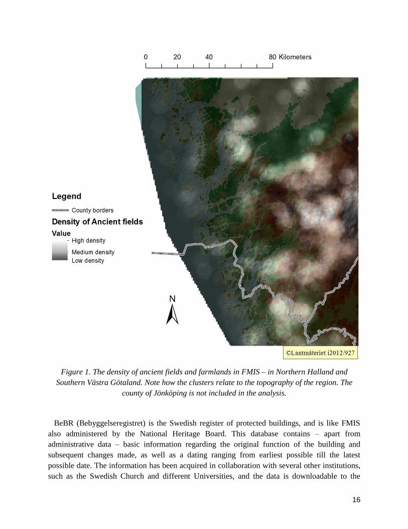
Figure 1 illustrates this by showing the geographical spread of ancient farmlands in Halland
and Southern Västra Götaland. On a first glance, the ancient cultivated areas of the region seem
constricted to the uplands. However, this is a result of the methodology involved in surveying,
where this type of land is usually – in this region – recognized by clearance cairns. While this is
certainly valid, it raises several problems for the geographical analyst. Clearance cairns are
mainly the results of the farmers need to clear the soil of smaller rocks which prevents effective
cultivation. This in turn is a result of the soil type, as such rocks are often found in coarse
moraine soils. Coarse moraine usually clings to the higher topography of the land, where it has
been deposited by glacial rivers and the ice sheet that covered the landscape during the last Ice
Age. Thus, these traces are rarely found on sedimentary or fine soils, which generally provide a
better foundation for cultivation. Ancient farmlands in river valleys, by the coastline and on the
extensive plains of Västra Götaland are not well illustrated on the map. This is mainly connected
to the fact that these areas have been heavily farmed during a long period of time, something
which has affected the preservation of older systems of farming. The picture produced thus
merely illustrates the historical farming of rather liminal areas. This emphasizes the importance
of understanding the fundamental conditions under which all types of data is produced.
16
Figure 1. The density of ancient fields and farmlands in FMIS – in Northern Halland and
Southern Västra Götaland. Note how the clusters relate to the topography of the region. The
county of Jönköping is not included in the analysis.
BeBR (Bebyggelseregistret) is the Swedish register of protected buildings, and is like FMIS
also administered by the National Heritage Board. This database contains – apart from
administrative data – basic information regarding the original function of the building and
subsequent changes made, as well as a dating ranging from earliest possible till the latest
possible date. The information has been acquired in collaboration with several other institutions,
such as the Swedish Church and different Universities, and the data is downloadable to the

17
general public in point shapefiles. In the web application of the database, it is also possible to
view photos of some buildings and see further information regarding the institutional sources.
BeBR of course suffers from many of the same problems as FMIS, though the use of this
database should be seen as a secondary supportive source material. I have not intended to base
my inferences on this register alone.
1.3.2 Lantmäteriet
Lantmäteriet is the administrative authority that leads the digital mapping of Sweden. Mostly,
these maps cover the visible parts of the country along with administrative boundaries and
private property. The data is available in different levels of detail, from overview maps to large-
scale2 information concerning different forms of terrain, paths, individual houses etc. This
information is usually provided in vector data, although it is also possible to download raster
versions. Georeferenced orthophotos are also available for download. Quite recently,
Lantmäteriet also added LIDAR data to their databases, which stands for LIght Detection And
Ranging. This data is collected by airplanes equipped with a certain type of laser scanner, which
produces a relatively high resolution terrain model of an area. The laser can also penetrate the
vegetation, which makes it possible to visualize a heavily forested area on a ground level. This
GIS data is available to students and university staffs via an online service called ―GET‖,
administered by the Swedish University of Agricultural Sciences.
Lantmäteriet also administers a database containing most of the historical maps in Sweden.
This database contains invaluable information to historians, geographers and archaeologists, but
is not downloadable to the general public. The maps can be visualized and surveyed in the online
service, although the resolution is often too low. I have been given access to the downloadable
section of this database, in connection to my work on this thesis. This gives the possibility to
download high resolution versions of the maps, which can then be integrated as raster data in the
GIS. After georeferencing, these maps provide much information on historical land use. For
more information on the georeferencing procedures conducted in this thesis, see Appendix 1.3.
1.3.3 KARL and GEORG
KARL and GEORG are two databases administered by the National Archives, containing
historical large scale maps from the 17th century. KARL is the only database that is currently
available to the general public, as it was the result of a project called ―Äldre Geometriska
Kartor‖ (Older geometrical maps) between 2001-2010. The project called ―Yngre Geometriska
Kartor‖ (Younger Geometrical Maps), which eventually will result in the publication of GEORG,
is still ongoing and is expected to be finished by autumn 2014. Both these projects have put an
effort into creating high quality digital copies of the maps, and the resolution is therefore much
higher than the maps from Lantmäteriet. KARL also allows the user to download the maps for
free.
2 When I use the word ‖large-scale‖ in this thesis, I refer to the geographical use of the word. In this context, a large
scale is the more detailed scale, showing a smaller area. I have used the word ―macro‖ (as compared to ―micro‖) to
refer to an analysis focused on a larger amount of material, or covering a larger area.

18
KARL is a user-friendly online database with many functions, such as the ability to visualize
the features found in the historical maps with Google Maps imagery as backdrop. Among the
included features some are more interesting for the questions posed in this thesis, e.g: mills,
fishing stations, weirs and bridges. The maps themselves often provide invaluable information
regarding the land use of the time, as well as physical information concerning the terrain. Small
pieces of text describes different features of interest directly on the map, sometimes regarding
peasant feuds, place names, soil quality etc. Apart from this, the maps also include a separate
accompanying text which details economic information on a household level, such as the amount
of arable lands and meadows, as well as the yields. Hopyards, gardens and secondary economical
resources are also often described in this text, which has been transcripted, digitised and is
searchable in the database. This information has been statistically structured with the use of GIS,
and is downloadable in XML-format, with the possibility to include coordinates. GEORG will
also be published in much the same manner.
I have chosen to use the maps in KARL and GEORG mostly as a resource on terrain and river
use. The statistical data is valuable in more macroanalytical studies, and could have been used to
illuminate the rivers contribution to agriculture on a national level. This is however a quite
complicated task and is not covered by this study.
1.3.4 SDHK
SDHK (Svenskt Diplomatariums Huvudkartotek) is an online database into which all medieval
letters in Sweden are registered. The information is based on the printed publications of
Diplomatarium Suecanum, a project which started in the early 19th
century and whose goal is to
make medieval writings more accessible. Since 1976, the project is administered by the National
Archives and has covered the years up till 1378, and 1401-1420. All the letters are available to
the general public in SDHK, where it is possible to query the database for specific information.
The detail of the information on each written source often varies – e.g. some letters only contain
a summary of the text whereas others contain a digital photocopy, a detailed summary and a
transcription of the original text. In this thesis, I have mainly used SDHK to query the contents
of the letters, for information on different places of interest. The database has also been used to
establish and confirm the historical chronology of the landscape. More on this in Chapter 3.
The letters in SDHK is referred to by using the format ―SDHK nr X‖ (where X symbolises the
number of the letter), and is a reference to the online database. This differs from a more
traditional reference using the printed version of the medieval letters, which goes by the format
―DS-nr X‖ (for Diplomatarium Suecanum) or ―SD-nr X‖ (for Svenskt Diplomatarium).
1.3.5 SMHI
SMHI (Swedish Metrological and Hydrological Institute) have several online databases, mostly
concerning climate and hydrological information. In this thesis, I have used the hydrological
information to understand how the investigated rivers function within their natural system. All
the databases are more or less available to the general public.
The databases most useful in this study have been SVAR (Svenskt Vattenarkiv), which
provides georeferenced information on drainage areas, lakes and rivers, and Vattenwebb.

19
Vattenwebb provides downloadable information on water discharge measurements from several
stations in Sweden. The measurement data also contains historical information, as the water
discharge information has sometimes been recorded on a daily basis since the 1930s. This is
invaluable information, as it shows how the flow of water through a river system can fluctuate
according to environment and weather. It also illustrates the variation of water bearing on a
yearly basis, where the flow is most concentrated during spring and late winter.
1.3.6 SGU
SGU (Geological Survey of Sweden) is the organisation responsible for documenting,
examining and providing geological data of Sweden. They are also actively trying to promote the
use of geology in societal planning, the mineral industry and environmental planning. The
databases of SGU are free to the general public via their online application, but cannot be
downloaded. Instead, the organisation provides georeferenced data in shape file format to
researchers and students, bound by a rather strict license as the data is highly valuable. The data
from SGU which is used in this thesis is mainly limited to soil geology.
1.4 Limitations The area of study has been limited to Southern Sweden, though this is more due to a large
amount of easily accessible material than to any pressing need to conduct studies in this specific
region. Really, the study could have been made in any country/region or across conventional
borders, given a similar amount of useful data. Although the main area of study is limited, the
thesis also draws on a comparative material, where international studies are used to illustrate
areas of research which have been rather ignored by local inquiry. Also, this comparative
material helps articulating the defining traits of human/river interaction, and put the results of
localised studies into the context of a more global world.
The period covered in this thesis spans 1200 years of history, but is nonetheless indeed a major
limitation. It could be argued that the study of an even longer period of time would bring more
clarity into the complex nature of human/river interaction. For example, an investigation
comparing the rivers in question during the Early and the Late Iron Ages would almost certainly
prove fruitful in illuminating the possible social and natural structures formed by riverine
landscapes, not the least because the Scandinavian Migration period traditionally has been seen
as a major period of change and social unrest. However, it must be recognized that the
representational limits of the prehistoric material in the studied areas constitutes a large problem
to any study focusing on the diverse aspects of river interaction. I have thus chosen the specific
period of investigation for reasons tied to the variety of the material, as it covers a highly useful
range of written, archaeological and geographical sources.
I have chosen two rivers as the main objects of investigation: Göta Älv and Ätran. Both of
these rivers have different natural and historical characteristics, which is why a comparison of
the two provides a solid foundation for contrasting analysis. I have mainly dealt with features
that actively connect to the rivers – like mills, harbours, fishing stations etc. However, as many
of these features are also tied to human settlement – and thus raising several questions which a

20
mere economical perspective would overlook – I have also chosen to include farms, buildings
and symbolic elements into the study of the rivers in question. In this case, the area of interest
has been limited to elements of the landscape which can be geologically or visually connected to
the river. Farms, towns and different forms of land use have been included mainly according to
their geological relevance, i.e. their location on soils which are the results of the river‘s water
flow. In some cases, settlements have a diverse geological foundation of which just a part can be
included in this thesis. For example, the village of Faurås by the river Ätran used the riverbank
for meadows, but the fields lay further uphill and cannot be geologically tied to the river. This is
a clear example of a case where the meadows are included in the main analysis, but the fields are
not. Symbolic elements have been included according to their visual connection with the river.
Iron Age graves which have a clear view of the water itself therefore figures in the main analysis.
As the thesis covers a huge amount of source material, I have found it necessary to make some
further limitations concerning the features included in the analysis. Thus the thesis is mainly
concerned with features which can be relatively easily fitted into studied timeframe. Features
such as clearance cairns – which could have been used to analyse farming in river areas – are
highly difficult to date effectively and are therefore not included in the analysis.
Some other aspects which have not been covered in this thesis are the powerful individual
human actors known as kings, high noblemen and religious leaders. Traditionally, Swedish
literature covering the historical aspects of certain river valleys is full of references to these men
(e.g. Löfberg 1992, Ekre 1993, Carlsson 2007: 165 ff.). This has according to myself attributed a
rather unearthly power to these nonetheless important figures, giving them a status in society as
the dictators of history. The early written source material in Sweden is centered around
politically important characters and does not in any way reflect an objective reality. Nonetheless,
these individuals may indeed have influenced certain aspects of river use, but that is not the main
focus of this study. Instead, I have chosen to focus on the more general relationship between the
rivers and their surrounding human population. To a certain extent, the rivers in question have
been raised to the status of individuals, and by doing so I have tried to analyse how these natural
agents have contributed to the course of history.

21
2. Theories of Active Landscapes The scope of this thesis incorporates a quite large variety of theories. I have used thoughts from a
diverse range of theoretical ―disciplines‖ and tried to merge them into a coherent research
perspective. This is not an easy task, as these theories rarely have been used in unity before.
However, the ideas in question – regardless of their diversity and contradictions – can be
manipulated to form new perspectives. Some of the theories are originally focused on discussing
dimensions of this world that is not of main interest to this study. In those cases – like in the case
of Sartre (1968) – I have chosen to use the writings of the authors as an allegory for my own
investigation. While it may not have been the intention of Sartre to promote the individuality of
Nature, this is indeed an interesting aspect which his theories can illuminate.
This chapter is dedicated to the description of how the different theoretical perspectives used in
this study can form a coherent unity. First of all, the keywords of the thesis are defined in order
to bring clarity to rest of the chapter. Then, I elaborate on the theoretical issues of GIS and lastly
turn to the broad, theoretical discussion of natural agency and Third Space.
2.1 Definitions
2.1.1 Nature and Culture
As should be obvious by now, this thesis encompasses a certain criticism of the traditional
definitions of nature and culture. Although the use of these terms is highly problematic, and
carries with them a certain inherent assumption, the terminology is difficult to avoid. This is a
problem common to post-colonial archaeological research, where the deconstruction of a present
terminology seldom leads to any useful conclusions on how to develop a new terminology,
moving away from the old one. It is also common that the present definitions are heavily
criticised in the opening passages of an article, yet still used in some manner within the actual
analysis of the material. An article by Jimenez (2011), studying Late Iron Age Iberian sculptures,
is a good example of the problems involved in deconstructing terminology. Though she
admirably tries to apply the theories of Homi Bhabha (1994) to archaeology, she still ends up
using an old definition of culture in describing the ―colonizing‖ culture of the Romans – which is
described more or less as a homogenetic unity (Jimenez 2011: 117-18).
However, I still firmly believe that – in order to properly tackle the issues of a certain
terminology – it is necessary to create a connection between old and new definitions. The way
forward is not cleared by a disconnection, which would create a discourse without origin and
with nothing to build upon. It would mean shaping the archaeological discourse anew; building a
temple of ―enlightened‖ research on a secluded shore, without even the driftwood of past
archaeological thinking as foundation. Instead, a terminological shift is a slowly changing
process, where the discourse is at first balanced on both legs, in both past and future definitions.
My intention is not to create a new terminology for archaeological and historical research.
Moreover, it is not to completely deconstruct the definitions of nature and culture. Rather, I
intend to use the present terminology against itself, and by doing so also setting the foundations

22
for something new. In a way, I intend to transform the definitions through a terminological Third
Space (see Chapter 2.4). This will be discussed in the final chapter of the thesis (Chapter 8.3).
Nature is thus traditionally defined: ―The phenomena of the physical world collectively; esp.
plants, animals, and other features and products of the earth itself, as opposed to humans and
human creations (Oxford English Dictionary 2003: nature 11b).‖
Culture is thus traditionally defined: ―sammanfattning ... av de förhållanden gm vilka
människan l. ett visst folk l. en viss folkgrupp … i sitt allmänna levnadssätt l. på ngt visst …
område höjer sig över djurstadiet (l. primitiva förhållanden); (andlig l. materiell) odling; gm
dylika strävanden uppnått (högre) utvecklingsstadium (SAOB 1938: Kultur 8).‖
[―a summary of those conditions by which humanity 1. a certain people 1. a certain ethnic
group … in their common ways of life 1. in some certain area has advanced beyond animal level
(1. primitive conditions); (spiritual 1. physical) cultivation; through such endeavours reached a
(higher) stage of development‖, author‘s translation.]
2.1.2 The Character of a River
In this thesis, I have sought to explore the character of each river. Some effort should be put
into the description of my use of this term, and how it relates to other perhaps similar choice of
words. The observant reader may already have noticed my choice of words in the title of this
chapter, where I chose to write character, rather than nature. The term nature is usually used to
define something stable, with a clear purpose, and carries with it a certain belief in an absolute
truth. In more plain language, the term speaks of the essence of the object, in ontological terms.
It is rarely that the essence of an object (or in this case, a natural phenomenon) changes. In the
natural sciences, it is therefore possible speak of the nature of rivers, as this is defined through
hydrological and geological terms. The word character, on the other hand, implies that the object
is not entirely passive, that it is somehow extroverted. It is only in relation to other objects that
character arises, while nature somehow resides within the object, regardless of how it acts upon
the world.
It is the relations which shape the character of a river that is of central importance to this thesis.
Therefore, when I speak of character in this thesis, I mean the relational essence of an object
during a specific time in the past. The character is the generalised core of the river‘s temporal
relations, regardless of whether this was obvious to common people during the period in question.
When these relations change, so does the character.

23
2.2 Theoretical issues of GIS In this thesis, I use GIS mainly as a tool for handling large amounts of geospatial information.
The data – as well as the methodology – could have been utilized without the use of GIS, and it
is not GIS that have chosen the source material. Still, there are some important theoretical issues
that need to be discussed when using GIS analysis in archaeology.
The use of GIS in research has been discussed extensively within the discipline of Geography.
The discussion has focused on debating the issue of describing GIS as a ―tool‖, or a ―science‖
(Connolly & Lake 2006: 6). A discussion concerning this definition appeared on an online forum
in 1993 (Wright et al. 1997: 347), where proponents of the ―tool view‖ argued that GIS cannot
be seen as a science, as it ―gains meaning only by its goals (ibid: 349).‖ A scientist may use GIS,
but it is not science in itself. Those who argued for GIS as a science instead saw it as a method in
which spatial theories can be put to the test (ibid.). This issue is, as can be seen, an old one
within Geography. However, the discussion is obviously still flourishing, which have contributed
to the creation of the geographical sub-discipline Critical GIS. In CGIS researchers are actively
engaging in the use of GIS, but with a critical agenda aiming to unravel the different problems of
the software and its methodology. The main question asked is: What are the representational
limits of GIS? (Hacigüzeller 2012: 246-49).
Within archaeology, GIS analysis has been hugely popular in studies of landscape. However,
the traditional cartographic school in this subdiscipline has been criticised for using a level of
analysis that alienates ―ordinary people‖. To use maps – and consequently GIS – in
archaeological research is to view the world from ―God‘s eye‖, i.e. a type of vision which could
not possibly have been available to the peoples of the past (Wickstead 2009: 250). Wickstead
argues that the critique of this technology should move away from these representational issues,
where it has previously followed a uniform pattern that is heavily generalising. The discussion
must rather follow the unique circumstances and methodological collaborations in which GIS is
used. Each cartographic endeavor has its own characteristics, and also helps to produce a certain
―reality‖ based on the investigation in which GIS is involved. This also means that the
technology can be used to reshape a discourse (ibid: 254-59). While I cannot take into account
all the circumstances under which the data used in this thesis has been produced, it is important
to bear this in mind. Had I conducted this study for a longer period of time, a more detailed
background analysis of the data would have been useful.
Another issue relates to how different aspects of GIS have been used in archaeology, and their
theoretical implications. Landscape archaeologists commonly use viewshed analysis to
investigate different phenomenological aspects of past societies (e.g. von Hackwitz 2009,
Rennell 2012). This analysis basically illuminates the area that is visible from a chosen point in
the landscape. It is inferred that visibility and experience were important aspects governing the
location of settlements, monuments and sites (von Hackwitz 2009: 152). This analysis is subject-
centered (Rennell 2012: 511) and therefore anthropocentric in character, in that it rarely goes
beyond the human senses. Needless to say, I find this rather provocative. According to Olsen
(2010), phenomenological landscape archaeology rarely acknowledges the importance of the

24
landscape itself. The contemplative human present in phenomenological studies is somehow far
removed from the complexities of everyday life. In a way, this style of research has more in
common with the practice of landscape painting, than any investigation into the relationship
between humans and landscapes (Olsen 2010: 31). Another important issue is that meanings in a
landscape are not necessarily formed through the senses. Symbolic meaning can also be ascribed
to things with certain physical or practical attributes, which are not captured in a viewshed
analysis, or in phenomenological observations. Thus, I have chosen to focus on diverse aspects
of human-nature interaction, something which is reflected in the applied GIS methodology.
While the use of experiential tools is not entirely absent from the study, they do not constitute the
only form of analysis on which inferences are based. More on this in Chapter 3. The multitude of
aspects central to this thesis is also reflected in the theoretical discussion below.
2.3 Natural agency
2.3.1 La longue durée
In 1958 the French historian Fernand Braudel published an article by the name of La longue
durée (1958) which had a huge impact on the discipline of history. In this article, Braudel
discussed the movement and rhythms of time, which he divided into three different timeframes.
The first and most central to this thesis is La longue durée, in which changes only can be
observed over long periods of time. Braudel labeled the forces driving this timeframe structures
– i.e. a phenomenon or constellation that has almost completely withstood the test of time.
Geography and environment, according to Braudel, were important structures in the shaping of
human society:
The most accessible example still seems that of geographical constraint. Man is a prisoner – for centuries – to
climate, vegetation, animal populations, cultures and slowly builds a balance; he may not depart without risking to
challenge everything. Look at the place of transhumance in mountain life, the permanence of certain sectors of
maritime life, rooted in such privileged points that are coastally articulated; look at the location of lasting towns, the
persistence of roads and traffic, the surprisingly fixed nature of the geographical setting of civilizations (Braudel
1958: 731-32, author‘s translation).3
Braudel‘s use of the word contrainte [constraint] is telling, as it reveals the philosophy behind
his thinking. In this view, humanity has its own agenda – e.g. the domestication of animals and
plants, or the control of water – in which nature constitutes the boundary of possibilities. It is
impossible to entirely breach this natural wall without challenging everything. Although Braudel
recognizes the discrepancy between human agenda and nature, he also recognizes that humanity
is a part of – and highly dependent upon – nature.
3
“L'exemple le plus accessible semble encore celui de la contrainte géographique. L'homme est prisonnier, des siècles durant, de
climats, de végétations, de populations animales, de cultures, d'un équilibre lentement construit, dont il ne peut s'écarter sans
risquer de remettre tout en cause. Voyez la place de la transhumance dans la vie montagnarde, la permanence de certains secteurs
de vie maritime, enracinés en tels points privilégiés des articulations littorales, voyez la durable implantation des villes, la
persistance des routes et des trafics, la fixité surprenante du cadre géographique des civilisations (Braudel 1958: 731-32).‖

25
In Swedish historical research, the perspectives of Braudel are rarely used. According to Elgán
(2010), this is related to a certain cowardice, where historians do not dare to create
generalisations out of their research. She argues that without generalisations it is impossible to
connect the results of an investigation to broader questions, which consequently renders history
pointless (Elgán 2010: 746). Historians need to study the cause of long-term change and
continuity in order to make history meaningful (ibid.: 748).
Braudel‘s theories have been more extensively used in Swedish archaeology, though the
research often focus on the more easily accessible timescapes, called conjunctures (social and
economic history) and l’historie événementielle (history of events, politics, kings etc.) (Braudel
1958: 727). Kristina Carlsson uses the history of events and the long-term mainly to illuminate
the history of conjunctures, in her analysis of the medieval politics and religion of Western
Sweden (Carlsson 2007: 26).
2.3.2 Jean-Paul Sartre and the power of the individual
I have chosen to study la longue durée in this thesis mainly as a result of my interest in natural
agency. This agency is best captured by first searching for long-term historical and geographical
structures which have affected society. However, it can also be discussed how those very
structures are illuminated.
Jean-Paul Sartre tried, in his volume Search for a Method (1968), to emphasize the ways in
which the individual has a certain power over structures. He argued – among other things – that
an individual is affected by structures, but not governed by them; i.e. that a person is not entirely
the direct result of an external social or natural force. However, he also recognizes that there are
certain material preconditions that controls the ways in which a person may act (Sartre 1968: 92-
93). These material conditions are opposed by the field of possibles:
The structures of a society which is created by human work define for each man an objective situation as a starting
point … The material conditions of his existence circumscribe the field of his possibilities (his work is too hard, he
is too tired to show any interest in union or political activity). Thus the field of possibility is the goal toward which
the agent surpasses his objective situation. And this field in turn depends strictly on the social, historical reality. …
Yet the field of possibles, however reduced it may be, always exists, and we must not think of it as a zone of
indetermination, but rather as a strongly structured region which depends upon all of History and which includes its
own contradictions. It is by transcending the given towards the field of possibles and by realizing one possibility
from among all others that the individual objectifies himself and contributes to making History. … [The action] then
takes on a reality which the agent himself may not know, one which, through the conflicts it manifests and
engenders, influences the course of events (Sartre 1968: 93-94).
This quote captures well the scope of Sartre‘s progressive-regressive method (ibid.: 85-166),
where he tries to define a method to understand an individual; her motifs and actions. The
structures that affect an individual can be seen through her actions, and situations where the
individual confronts and bypasses a structure are the moments when it is the most visible. A
biographical study of a revolutionary – to take an example close to Sartre – tells us more about
the preconditions of the revolution, rather than its consequences.

26
The work of Sartre has been used in archaeological research, but with a certain focus on other
parts of his theory, such as the concept of seriality which discusses the classification of social
groups (Young 2008: 231-36, for archaeological examples see Cornell 2004, Johanesson 2004,
Fahlander 2011). In this study, I have instead chosen to use certain aspects of the progressive-
regressive method to emphasize the diversity of riverine characteristics.
Sartre‘s perspective has mostly been used in the direct study of humanity. I use his arguments
to illuminate the notion that even natural forces, governed by very complex systems (like the
hydrological cycle), cannot be wholly described in functionalistic terms. A river is not only a
result of the natural structure of which it is a part, but also of the local variations formed by
bedrock, soils, precipitation etc. It is these material conditions that limit a river‘s field of
possibles. Yet through interaction with human society, or through some other agent which
changes the course of a river, the river has surpassed the given. It is in those circumstances, in
the conflict between a system and the ―individual‖ action, that the ―true character‖ of an agent
arises.
2.3.3. Symmetrical Archaeology and Non-human Agency
In recent years of archaeological research, there has been a certain focus on discussing the
concept of agency. As a reaction to post-processual relativism, authors have tried to increase the
number of active agents involved in the shaping of society (e.g. Gosden 2005, Webmoor 2007,
Whitmore 2007, Olsen 2010). This theoretical approach has been labeled ―symmetrical
archaeology‖, and is mostly based on the work of Latour (2005).
According to Latour, there are no such things as a socially built structure. Everything is based
on some form of material reality. Even laws, ethics or discriminations are not socially
constructed, but rather centered on things:
It is always things—and I now mean this last word literally—which, in practice, lend their ‗steely‘ quality to the
hapless ‗society‘. So, in effect, what sociologists mean by the ‗power of society‘ is not society itself—that would be
magical indeed—but some sort of summary for all the entities already mobilized to render asymmetries longer
lasting (Latour 2005: 68).
Latour argues that the range of agents in the shaping of ―structures‖ should be increased,
as an agent is anything that affects the action of another agent. This means that things can shape
the course of an action. E.g. it is the combination of axe and human that chops firewood. If the
axe had not been present, then the action would not be the same (Latour 2005: 70-71).
Gosden‘s study of the Romanisation of Britain is a good example of how these ideas have been
used in archaeology. By discussing material inertia and how the form, style and function of an
object shapes social relations, Gosden shows how a much more complex picture of the
―romanisation‖ arises (Gosden 2005: 195-97). For example, the introduction of orthogonal
roman villas has previously been seen as a revolution in British prehistory. However, Gosden
emphasizes that the change from roundhouse to an orthogonal building is not a major change of
form. Rather, the central hearth still remained in the Roman villa, a feature that helped to solidify
the social relations and prevented any remarkable change (ibid: 199-200). Thus, the material
27
qualities of social structures can make them long-lasting.
Processual archaeology saw nature as the force controlling human life, and the methods of the
natural sciences could therefore be used to interpret past societies. The post-processual reaction
during the 80s instead was to use theories from the social sciences to criticise the processual way
of conducting research, and to emphasize the human factor involved in the construction of
society. This meant that non-functionalistic themes of investigation became more important,
such as meaning, symbolism, social structures and rituals (Webmoor 2007: 565-68). Nature was
thus forgotten, and humanity ruled the worlds of the past once more.
Symmetrical archaeology then, should be seen as a reaction to the past 50 years of
archaeological thinking. Within this style of inquiry, the focus lies on the dialogue between
nature and culture, and how this has shaped human society. There should be no a priori
designation of natural or cultural explanation, and the world should be seen as a labyrinthine web
of different thoughts, materials and times (Whitmore 2007: 546-47). The perspective on time is
one which in many ways connects to the ideas of Fernand Braudel (1958). According to
Christopher Whitmore (2007), the past is not exclusively past in symmetrical archaeology. A
common theme in post-processual archaeology is to regard the past as separated from the present
by a deep rupture, which is possible to bridge but not to cross entirely. This, according to
Whitmore, is to oversimplify the complexities of time, and is the result of modernist linear
thinking. Archaeological objects are useful examples of the present past – although artifacts may
be difficult to interpret, they are still physical remains of a distant time – yet some material
entities created in the past still in many ways control people‘s lives in a much more concrete way.
Here, Whitmore exemplifies this by describing how Roman roads still affect traffic in Europe
today (Whitmore 2007: 556).
Considering this, it is somewhat strange that none of the authors above have connected their
perspectives on time and long-term changes to those of Fernand Braudel, who already in 1958
published an article which promoted a basically similar idea.
More importantly, symmetrical archaeology also recognises the problems and assumptions
involved in using the terms ―nature‖ and ―culture‖. Webmoor (2007) argues that modernist
thought has divided our world into separate entities based on qualities such as ―intentionality‖
and ―consciousness‖. These qualities are assigned to a subject based on human prejudice, where
an object labeled unintentional or unconscious – from a distinctly human point-of-view – is
considered separate from humanity. Nature, in this view, is not intentional but rather follows the
strict rules of ―natural ―systems. According to Webmoor, this presumption has resulted in a
series of central concepts within archaeological research (Webmoor 2007: 570). Tvedt and
Oestigaard have directed certain critique towards this kind of thinking, arguing that nature and
culture ―exist as two distinct systems, and this differentiation is indispenseble and real (Tvedt &
Oestigaard 2011: 8).‖ However, they still recognise the shifting borders between the two
definitions, arguing that water specifically is both a social and a natural bond (ibid.).
A similar conclusion is drawn by Matt Edgeworth (2011), who shows that rivers are so called
entanglements of nature and culture. Even some of the most natural systems, such as meandering

28
rivers, have cultural – or archaeological – dimensions. This means that in order to fully
understand a landscape, especially a fluvial one, it is important to recognize both the cultural and
natural aspects of the land (Edgeworth 2011: 31).
This aspect of archaeological thinking is important, in that it recognises certain colonial
concepts of humanity‘s relation to nature. What right have we to believe that it is only humanity
who holds the power of intentionality? This is an important question, and although it is
impossible to answer it is useful to consider such aspects in the interpretation of past societies. In
this sense, I have chosen to use the perspectives of symmetrical archaeology as a sort of bridge
between the different worlds of nature and culture. Only by considering the cultural aspects of
nature as well as the natural aspects of culture can the questions posed in this thesis be answered.
2.4 Hybridity and Third Space Post-colonial archaeology is in its very nature anti-generalising and focused on local studies.
This can be a problem, for it is necessary – as discussed above – to generalise in order to create
historical meaning. However, some of the ideas involved in the post-colonial agenda are
extremely useful in this discussion.
One of the most influential modern thinkers within the post-colonial movement is Homi
Bhabha, who fashioned the concept of ―Third Space‖. According to Bhabha, Third Space is the
result of an interaction between opposing social units, where they are forced to negotiate and
adopt. This social encounter produces something new, both resembling the units involved, but
also with previously unknown characteristics (Bhabha 1994: 40-41, 53). According to Fahlander,
this renders any concept of ―pure‖ cultures meaningless, and useless. If everything is a hybrid
creation, then no such thing as a uniform culture exists (Fahlander 2007: 22). However, this
concept is also rather ambiguous, which has led to many different variations of the use of Third
Space in archaeological research (ibid: 24) – e.g. Varberg (2007) interprets the concept as an
actual physical space, rather than a social one.
Bhabha‘s idea has been extensively used by archaeologists to criticise traditional concepts of
cultures in past societies. Fahlander (2006) uses Third Space to illustrate the diversity of
Scandinavian Neolithic culture, promoting local studies which emphasize material variations.
Peterson (2011) criticises the use of a specific archaeological material as an indicator of
homogenous culture. The example she takes is the spread of Bronze Age house urns, which has
previously been interpreted in this manner. Third Space is indeed a useful concept in the critique
of cultural categorisation, but it can also be used in a way closer to the symmetrical agenda. The
concept has rarely been used in discussing the colonial aspects of nature/culture.
The term ―hybrid landscapes‖ is used within certain forms of environmental history. White
(2004) uses the concept to discuss the Salton Sea, which was the result of an accident in which
the Colorado River was diverted into the Colorado Desert. This created a sea, which superficially
resembled a prehistoric one. However, ―none of the earlier seas lay below rich agricultural areas
and growing towns, which pumped them full of sewage and agricultural runoff. This waste
mixed with naturally occurring salts and minerals of the area and created a toxic stew (White

29
2004: 564)‖. The product was thus a hybrid creation created in ways similar to a Third Space
encounter. The mistake that caused the accident had a cultural origin (human miscalculation),
the driving force was nature (Colorado River) and the result was mixed with both natural and
cultural contents (e.g. water and agricultural waste).
Jakobsson (2013) also shows how this concept can be used in more historically relevant studies.
Her study of ditching practices in Sweden from 1200-1900 illuminates a clear example of how a
hybrid landscape is created, and how it interacts with both nature and culture. According to
Jakobsson, human uses of water – like ditching, land reclamation and transportation – constitutes
complex systems in themselves, which in turn have to coexist within the natural system of water.
A certain duality is involved in this, where these systems are dependent upon both the
hydrological cycle and human control. In order to keep the water flowing through a ditch, it has
to be cleared and receive regular maintenance. This illustrates a dialogue between the natural and
the human system, and thus the result is the creation of a hybrid landscape (Jakobsson 2013:
350).
Ditching in Sweden during this period obviously sheds light on the intricate interaction
between natural and cultural identities. This interaction creates a new form of hydrological entity,
the ditch, which is dependent upon both hydrology and human action. At the same time, it also
forces people to collaborate and thus actively shapes society. The draining of water from a
farmer‘s land in turn affected his neighbor, as the flow of water was redirected into someone
else‘s land (Jakobsson 2013: 351-52). Therefore, the dialogue sometimes creates multiple Third
Space entities. The ditch itself is a Third Space, but also the shapes of society that consequently
have been articulated through the negotiation between nature and culture – in this case the
several laws that regulated ditching from the 13th century and onwards (ibid.).
Although none of the authors mentioned above connects the idea of hybrid nature to Bhabha‘s
work, the connections are quite clear. Jakobsson‘s study shows how the concept of hybrid
landscapes, here related to Third Space, may change our view of how society is shaped. This is a
theme that is central to this study, and it is important that these aspects of the landscape are
illuminated.
2.5 Concluding Remarks As explained in the beginning of this chapter, the thesis combines several different theories
into a uniform perspective. A certain friction is involved in the practical application of these
different perspectives, e.g. the theories of Braudel and Sartre have rarely been combined as they
form a sort of opposing units. While Braudel argued that long-term structures more or less
governed history, Sartre promoted the individual‘s power over those structures. This is a
contradiction, of course, and not without its inherent problems. However, I have not taken these
authors on their absolute word; i.e. I have chosen – like C. Wright Mills (Mills 2000 [1959]) – to
use the parts of their work which brings light on the objects studied as well as new perspectives.
Thus, I use Sartre‘s theory of biographical importance to bring forth the contrasts in the
interaction between human and nature. He would probably turn in his grave had he known that I
use his theory to discuss the power of Braudel‘s long lasting structures.

30
It is basically Braudel and Sartre that shapes the foundation of the theory used in this thesis, as
their thoughts contribute to the analysis of the data itself. La longue durée is used to illuminate
the long-term structures that have shaped the relationship in question, and the progressive-
regressive method to see how individual actions – or events – have shaped or reshaped those
structures. Symmetrical archaeology – which is all too often only emerged in theory – can be
combined with Third Space without any real friction, and helps to motivate the study itself. By
emphasising the colonial and asymmetrical aspects of former research, it is clear that the
perspective raised here is not only interesting, but also sorely needed.
It should also be said, that the generalisations created through this thesis are based on inductive
reasoning (Godfrey-Smith 2003: 42-42), where the two rivers in question have served as case
studies. From observations made during the study of their history, I make generalisations
concerning a larger picture. The generalisations should not, however, be seen as a search for a
uniform reality which can be applied everywhere. They rather form the synthesis of the study,
which directs future research and asks further questions to the nonetheless limited cases.
The inferences made in this thesis are analytically based on several themes, which are both
theoretically and methodologically anchored. A river can contribute to society in many ways –
not just economically and socially, but also symbolically. Therefore, it is important to not a
priori assume that a river‘s agency is physically manifested. This is covered by the methodology
applied in the construction of this thesis, which is centered on several questions of interest. More
on this below.

31
3. Method and critique
3.1 Method As described in the concluding remarks of the chapter above, the methodology used is centered
around additional questions of interest. First of all it is of absolute necessity to briefly investigate
how the rivers have physically affected the surrounding natural/cultural landscape. This can be
traced geologically and geographically, where erosion, deposition, hydrology etc. have all
contributed to the qualities of a river landscape. This in turn serves as the natural foundation on
which human society is based, and which constitutes Sartre‘s (1968) material limitations. For
example, the most arable soils of Sweden lie beneath the Highest Coastline (―Högsta
Kustlinjen‖), where glacial sediments were deposited in water. This natural precondition still
limits agriculture in Sweden to this day. Second, it is interesting to investigate how the rivers in
questions have been used throughout the period of study. Can a change be discerned, and for
what reasons? It is vital to explore several sublevels of this question, e.g. how the introduction of
mills and the development of riverine agricultural systems correlate with social, religious or
environmental changes. Third, symbolical aspects such as the link between different types of
rivers and structures of power or religion need to be explored. Göta Älv was a famous scene of
Scandinavian politics during the medieval and the early modern period, and Ätran also
periodically served as a sort of national border. Is this anchored in prehistory as well? These sub-
questions are of course interrelated, but should be methodologically divided. It is only in the
synthesis of this information that the questions originally posed can be answered.
In relation to this, the thesis uses a large amount of source material. Such ―source pluralism‖ is
something which is common within historical research focused on the more obscure aspects of
history, an approach which has previously been promoted by Janken Myrdal (2007). The only
way to be able (within a limited time frame) to analyse this amount of material is through the use
of GIS. The analysis will be made by putting different forms of information together to identify
specific historical characteristics of the investigated rivers. This sort of interdisciplinary inquiry
is not new; it was advocated already by the founders of the English Landscape tradition in the
50s (Johnson 2007: 81-95), followed by Michael Aston in the 80s (1984). The basic
methodology of landscape archaeology has remained rather strangely intact, and is still promoted
today – though with enhanced technology and larger sets of information (e.g. Chapman 2009).
To answer the questions posed in this thesis, I have first of all created a database of
georeferenced information (For the visualized structure of the database, see Appendix 1.4). Most
– if not all – of the original information could have been analysed in isolation, but the scope of
this study goes much further than that. By integrating the data into the different layers of the
geodatabase it is possible to compare, combine and contrast the information. This does not only
simplify the research procedure, but also generates new information. As explained in chapter 1.3,
some of the data has been modified in the integration process, in order to make the information
useful for answering the research questions. I have tried to describe the manipulation procedure
in some detail in Appendix 1: Data manipulation.
32
The database can most of all be used to find traces of different structures – i.e. long lasting
patterns in the landscape. In this small scale (geographically speaking), it is possible to analyse
the larger context of the rivers, how they relate to human settlement, topography, ancient
monuments, land use etc. To go beyond the structural scope is difficult, and it is thus necessary
to use historical literature, archaeological and geological reports as reference in order to find the
traces of events. Such information gives insight into themes such as chronology, biography and
rapid changes, and can to a certain extent also be integrated into the geodatabase. However, the
procedure in which this information is georeferenced to produce a base for full structural analysis
is a project in itself. Instead, I have mainly used this as a basis for settlement history and to
illuminate certain aspects of the landscape. Literature – used in its base format – brings a
historical depth to the flat image produced in the GIS.
The rivers that constitute the foundation of this thesis have been divided into two case studies.
Within these case studies several themes are explored: natural, economical and ideological
aspects. Beneath I have tried to explain how I have sought patterns in the landscape within these
three themes.
3.1.1 The Natural Preconditions
As already noted above, the geology, hydrology and geography of a place constitutes the
―base‖ of human society and culture. Without the possibility to cultivate the soil, there would be
no farmlands. The importance of natural preconditions to the formation of human culture and
society has been recognized elsewhere, e.g. in Britain (Knight & Harrison 2013). In order to
investigate this, I have incorporated data from SGU, SMHI and Lantmäteriet in the geodatabase.
This has given me the possibility to see how different forms of human settlement and land-use
relate to the natural geography of a region. If a certain form of industry/settlement can be tied to
a specific soil type shaped by the river, then it can be assumed that the river in question may
have interacted with human society.
More importantly, the combined natural geography of a river makes it possible to investigate
the vulnerability of the system. For example, Göta Älv flows through a valley that is frequented
by landslides, which is caused by a combination of soil geology and hydrology. The danger of
landslides is not something new in this region, and is also indicated in the historical source
material. This in turn could have shaped the relationships between the river and the human world,
which was presumably aware of this fact. While it is impossible to entirely reconstruct the
hydrology of the distant timescapes in question, it is possible to evaluate the relative risks of
settling down on a riverbed, and how this could have affected the uses of the river. To a certain
extent, the geomorphological development of a river can be analysed through the use of
historical maps. By comparing the historical map to the contemporary morphology of the river, it
is possible to analyse the ways in which the river has meandered through the centuries, as well as
changes in the hydrological context of the river. Many rivers seems much more fixed in
geomorphology than can be imagined (Figure 2.).

33
Figure 2. Map comparing the geomorphological change of the stream of Ryrbäcken near
Åkerström in the vicinity of Göta Älv, between 1653 and 2013. Although some obvious changes
can be observed in the meandering pattern the stream has stayed rather fixed, regardless of
many human impacts on the surrounding area. Of course, the mistakes of the surveyor must also
be taken into account.

34
3.1.2 Economic factors
The economical use of a river is important in the shaping of its character. Economy can be
illuminated through the geographical analysis of different industries and resources. Here, I have
intended to explore the river as a centre of activity, where people have fished, travelled and used
the water for different purposes. During the period in question many changes can be seen in river
use, e.g. watermills – both small and large – were introduced during the Middle Ages.
Presumably, many of the other activities changed as well. Two questions are therefore central to
the exploration of the economical aspects of river use.
The first question: Can different forms of economical activity be tied to specific periods of
time? As described above, the use of watermills has been demonstrated from the Middle Ages
and onwards – but can river transport, fishing and travel be similarly connected? River transport
and travel, both on boats and on foot along the riverbed, can be illuminated for example through
the spread of trade goods and patterns of communication. Here, FMIS plays a vital role where it
is possible to illustrate different forms of archaeological and historical remains geographically. I
have also found the work of Rollof (Rollof 1960, 1977, 1979, 1981) invaluable in the historical
investigation of river transport, though his studies are mostly based on written source material
and more focused on the Industrial Era. Fishing in rivers is hard to illuminate archaeologically,
and I have therefore mostly used the cartographic material to analyse this form of river use, as
well as the osteological anlaysises made by others where available. The various forms of
secondary resources found in the historical cartographic material constitute a highly important
source material.
The second question: Can different forms of economical activity be tied to specific types of
rivers? Here I have intended to compare the two rivers, which both have different characteristics.
The comparison illuminates the variance of economical uses that can be seen in the source
material, but also the common features that unites river economy in general.
3.1.3 Ideological and Symbolical aspects
As described in chapter 2, a landscape of meaning is not necessarily physically manifested.
Instead, many natural places have mental functions, as explored by Bradley (2000). A river may
serve as a border between neighboring countries, or it could be seen as a dangerous force of evil
– e.g. in 19th
century Värmland (Sweden) it was considered dangerous to cross a flowing body of
water without spitting in it (Tillhagen 1997: 105).
To explore the mental aspects of human-river interaction I have mainly chosen to focus on
politics and religious life, both of which are sternly connected to ideology and symbolism. Göta
Älv was a famous arena of politics during the middle ages, and this has been well covered by
other authors (e.g. Ekre 1993, Linge 1993, Carlsson 2007, Harlitz 2010). Ätran‘s medieval
political history is less explored (c.f. Andersson 1992). I have based my analysis to a certain
extent on the literature written on Göta Älv and Ätran, but the main focus is once again the
geodatabase.
By analyzing the patterns of military activity and features it is possible to analyse the political

35
function of a river. If castles or fortifications are connected to a river, it is logical to assume that
the political control of the watercourse was important. Administrative borders between countries,
counties, hundreds and parishes are often quite easy to examine through the use of historical
maps. For prehistory, it is interesting to explore the relation of the rivers in question to
prehistoric hill forts, which illuminates the historical depth of later political importance.
Religious life in river valleys is best illustrated through a geographical analysis of religious
buildings and archaeological remains. Investigating the relationship between Iron Age grave
fields, churches and popular beliefs in river regions it is possible to discuss the potential
symbolic importance of flowing water. This could of course also relate to other things – e.g. a
geographical concentration of grave fields to river valleys can be merely the result of economic
factors.
In order to take this seriously – and to further analyse the symbolic aspects of rivers – I have
used different experiential methods. Tools such as viewshed analysis have been utilised in this
thesis to investigate the relation between features in the landscape and river visibility. It is
assumed that features which are not visible from the river – or from which the river is not visible
– cannot be consciously affected by the water. I have further tried to physically visit many of the
places in question, and by doing so also exposed myself to phenomenological experience, which
can be used to a certain extent. Phenomenology in its traditional landscape archaeological
context may be problematic, but working in unison with other theoretical perspectives it is a
highly useful tool.
3.1.4 Issues of Chronology
The most difficult methodological problem in this study is connected to historical chronology.
This thesis is centered around structures and change – the image provided in the GIS is only
superficial and can only be said to represent a locked period in time. To illuminate change it is
necessary to decide which features are older than others within the palimpsest4 of the landscape.
Most of the historical information used in the geodatabase is not easily positioned within a
specific period of time. For example, FMIS only contains rough estimations of a relative dating,
based on its classification system. This system is general, and thus all grave fields are labeled
―stone age/bronze age/iron age‖, disregarding the fact that a majority of those features are
commonly connected exclusively to the Iron Age. However, the enormity of effectively dating
all the visible features of the geodatabase cannot be covered within the limited pages of this
thesis.
This methodological issue is common within historical geography, which often encounters the
problems of working with palimpsests. In order to study medieval land use, historical
geographers in Sweden often use maps from the 17th
century. These maps contain information
that can be traced backwards, using a so called retrogressive method. Studies using this method
have shown that many features found in Early Modern maps also reflect medieval land use and
4 the palimpsest metaphor is common within landscape archaeology, and refers to the similarities between landscape
and written texts. A landscape in this manner could be seen as a parchment upon which generations after generations
have scribed their own layers of meaning. For more on this metaphor, see Johnson (2009: 52 onwards).

36
administration (Karsvall 2013: 411-13). This method has also been used to analyse pre-medieval
settlement patterns and their relation to medieval outland colonisation. Tollin (1999) uses the
boundaries of villages in Småland found on historical maps, along with written source material
and archaeological features in the landscape to study the chronological development of
settlements during the early middle ages. He shows that the relative size of a village‘s boundaries
is connected to the age of the settlement. Villages with larger tracts of land – and a relatively
high number of farms – most likely existed during and before the turn of the 12th
century. Tollin
has also used a similar method to analyse village chronology in Södra Säm parish in south-
eastern Västra Götaland (Tollin 2010), and shows that it can be used in other contexts as well.
This classification – where ―large‖ prehistoric villages are distinguished from smaller medieval
agricultural units – is a rather generalised method of chronological analysis. I have thus only
chosen to use village ―size‖ as an indicator of prehistoric origins where no other evidence exists.
Göta Älv, for example, has long been the focus of historical research and the chronology of
places such as Kungahälla and Lödöse has been developed through a rich material of
archaeological and historical sources. In places such as Ätran however, it is sometimes necessary
to adopt a different perspective, where this kind of source material is lacking.
Another source material that assists the chronological investigation is SDHK, which often can
provide the first written evidence of a village. For example, Dalum by Ätran first appears in
SDHK nr 814, which is dated to 1262 A.D. Apparently, the village existed at this time, and the
vicar received 300 ―mark penningar‖ for his land sold to Håkan of Änglatorp.
3.1.5 Area of Study and Scale of Inference
As described above I have chosen to compare two rivers of different size and natural
characteristics. The idea has been to see if a difference in river interaction arises in the
comparison between these rivers, which would indicate that each river has affected society in an
individual way. Similarities seen in the material instead point towards an enduring larger
structure of human/nature interaction, which is active more or less regardless of river size and
characteristics. I have also assumed that some forms of river use have not historically been
suitable to all types of rivers. A relatively small body of water like the upper reaches of Ätran
should have been much more suitable for milling, whereas the large river Göta Älv was more
suited for large scale water transport. Thus, by including not only the large and politically
important rivers of Sweden, but also smaller variants, it is possible to investigate a more diverse
complex of river interaction.

37
Figure 3. Map of the studied rivers, with the locations of the case studies marked.

38
As described above, it is impossible to produce a histoire totale of the rivers in question;
regardless of the time spent conducting this form of study, the amount of detailed material
needed to construct such a work does not simply exist. Like many other landscape archaeologists,
I have therefore chosen to focus on certain local areas within each case study – thereby setting
the ground for generalisation using inductive reasoning. However, a problem common to the
landscape archaeological method has been the particularisation from which those generalisations
have been produced. A local study does not, after all, tell us anything about the surrounding area
if it is not effectively and contextually compared.
In order to properly address this issue – and to counter the problems of limited time – I have
chosen to start on the local scale, where three illustrative areas on each river have been selected
for closer analysis (Figure 3.). Within this local scale, structures of la longue durée can be
observed alongside more temporal patterns of change. The results gained from this can then be
used to analyse the possibility of large scale structures by comparing them to a regional – and
subsequently, an interregional – scale. A local pattern which can be observed in a larger area is
an ideal example of a larger – geographically tied – structure.
The area of study has thus on each river been limited to three case studies in the manner
described above. In cases where I have chosen to explore beyond these areas, features which
connect with the river physically or visually are included. On a macro level, I have also included
features within the drainage area of each river, to provide a context to local observations.
3.2 Critique The first major critique which can be directed towards this kind of inquiry is the
representational limits of the source material. As described above, the study stretches over
traditional borders of investigation, with highly different sets of information. An analysis of the
Prehistoric period is mostly based on the silent source material of archaeological features and
finds. Traditionally, the feature most important to archaeology in Sweden has been the burial
feature, which has resulted in an overrepresentation of ideas and thoughts connected to such
features in archaeological research. Unlike the farms of the Early Modern period, not many
definite traces of Prehistoric land use can still be seen today. The only exception is the ―ancient
farmlands‖ registered in FMIS, which for reasons described in Chapter 1.3.1 and 1.4 have not
been included in this study. Of course, Prehistoric agriculture can also be illuminated through the
close analysis of archaeological material such as tools, but such an inquiry goes beyond the
scope of this thesis. This thesis has mostly been concerned with traces left in the landscape, as
the connection of such elements to the rivers in question can be easily determined. In turn, this
leads to the overrepresentation of burial remains in the analysis of the Late Iron Age, as these
features relatively easy can be dated and included in the study. Looking at the landscape through
the eyes of burial features in FMIS illuminates the religious aspects of past societies but does not
include much else, although the geography of these features may to a certain extent be used to
analyse settlement location. It is important to recognise that an analysis of Late Iron Age use of
water power is almost impossible simply due to a lack of source material. Beneath I have tried to

39
summarise the nature of the source material for each period studied in this thesis. The result
gives an important overview of the representational limits of the material and also illuminates the
differing amounts of the sources used in this thesis. A shallow analysis would give the
impression that each period can be defined in different terms than another, and the last column
define the periods according to this material prejudice. Note that the material included in the
table below is entirely based on the sources used in this thesis. For example the written source
material on Early Modern politics is rather huge, but has not been included to any great extent in
this thesis.
High Level Medium Level Low Level Summary:
Definition
Late Iron Age Religion: burial
features, deposited
finds, written
sources.
Settlements: burial
features, place
names, excavations,
written sources (h.
limited).
General
Economy: dated
ancient fields, iron
industry.
Age of Religion
Middle Ages Ideology
(politics/religion):
written sources,
churches, grave
yards, castles,
borders, towns.
Agriculture:
written sources,
historical maps,
agricultural tools,
osteological
material.
Secondary
economy: written
sources, historical
maps, excavated
towns.
Age of Ideology
and Agriculture
Early Modern Economy: historical
maps, written
sources, FMIS
(mills, iron
industries, quarries
etc.).
Politics: written
sources, fortresses,
towns, borders.
Religion: written
sources, churches,
grave yards, local
traditions.
Age of Economy
Table 1. Levels of source material representation and summarising definitions based on material
prejudice. Note that the levels of representation are relative to the period in question. Thus, a
“High” level of representation in the Late Iron Age is not the same as a “High” level of
representation in the Early Modern period.
The over simplistic nature of the summarising definitions described above is indeed highly
problematic if not taken seriously. However, I have throughout this study tried to emphasise the
diversity of the material, not weighing the concepts against each other. Although the Early
Modern period is raised as a period of economic river use in this thesis, it does not necessarily
mean that the ideological or religious aspects were unimportant. The character of the rivers in
question has thus not been defined entirely by the status of their periodical source material.
Instead, the diverse nature of the material has been used to supplement the different aspects,
rather than to contradict.
Another problem that might be pointed out is that I have consciously chosen to ignore the use

40
of the written cadastral source material in the study of the historical landscape. These sources
have traditionally been used to analyse medieval villages, popularly in combination with
historical maps. However, the limited time dedicated to the construction of this thesis has forced
me to use the material which has been easily available, and thus I have chosen to mainly rely on
the historical maps for the analysis of the historical landscape. Furthermore, it has been argued
that the large-scale historical maps (often referred to as geometrical cadastral sources) produce a
much more valid picture than the use of the written counterparts (Höglund 2008: 11).

41
4. The River System In order to analyse the interaction between a river and its human environment, it is necessary to
understand the natural systems that controls it. While it is impossible to produce a full
background of hydrology, limnology and geomorphology within this limited space, I have
intended to describe some of the basic information needed to understand the results below.
4.1. The Water Cycle
First of all, freshwater constitutes only 3% of the hydrosphere – of which 2% is locked in
glaciers and icecaps, and almost 1% consists of groundwater. The movement of water which can
be directly observed in the landscape – i.e. rivers and lakes – account for only 0.02% of the
earth‘s freshwater. Needless to say, this resource – which is so valuable to human life – only
affects a highly limited part of the planet. Freshwater is transported inland in what is commonly
called ―the water cycle‖ (Figure 4.), where heat from the sun causes the evaporation of other
bodies of water, like the ocean (Bertoni 2011: 2). The evaporated water is then condensed in the
atmosphere, transported by winds inland and forced upwards by the rising topography. This, due
to lower temperature and atmospheric pressure, causes the water to fall like rain (Rundgren 2006:
46-48).
Figure 4. The water cycle. (Bertoni 2011: 2).
This water is then infiltrated through the ground (causing a flow of groundwater), or
transported on the surface of the land. The surface runoff is collected into bodies of water - i.e.
rivers, streams, lakes. Usually, these bodies of water converge into a single unit, which
constitutes the main water transport system of a drainage basin. This is the result of an often
ancient developmental process, where the water‘s surge to establish stability and energy-
efficiency has reshaped the topography – this is called water erosion. The erosion process is

42
rather complicated and difficult to describe, but in short, water erosion mainly works through
either the transportation of material (like stones, rocks, sediments etc.) which mechanically
reshapes the landscape through its motion, or through congelifraction (e.g. frost wedging) in
mountains, highlands and during winter (Adrielsson 2006: 300-1). Water erosion is connected to
the discharge of a river - i.e. the volume of water which flows through a given point in the fluvial
system during a specific period of time. Usually, discharge is measured in cubic meters per
second, and determines the relative size of a river according to depth, width and speed. A high
discharge leads to heavy erosion (Charlton 2008: 3-6).
4.2 The River as a Transporter
Within the hydrological system, the river is a carrier of different forms of material. The
transported material varies depending on different natural factors. Original sediments derive
mainly from the bedrock, and are the results of weathering which have broken the material into
transportable pieces. Sediments also derives from the river banks where water erosion, landslides
etc. deposits particles of soil in the water (Charlton 2008: 37). The size of the transported
particles varies according to the topography of the landscape. In areas with steep slopes, running
water naturally has a higher velocity and thus a higher transportive capacity (Bertoni 2011: 5).
The capability to transport a specific particle is determined by resisting and driving forces, where
the resisting force is mainly constituted by the weight of the particle. Driving forces are divided
into two concepts: drag force and lift force. The drag force follows the direction of flow of the
river and drags the particle along, exercising a greater pressure upstream than downstream of the
object. A particle can be lifted only when the lift force exceeds the gravitational force. This is
also a result of water flow, as the water flowing above an object moves faster than below, thus
creating lower pressure (Charlton 2008: 98-100). The transportive nature of a river section can
be roughly calculated with the mean flow velocity of the specific area, using the Hjulström
diagram (Figure 5.).

43
Figure 5. The Hjulström diagram which describes the relationship between particle size, flow
velocity, transportation, erosion and deposition (from Charlton 2008: 102).
The aspects of transportation, erosion and deposition in fluvial systems create certain distinct
channel forms. Streams and rapids, which are able to transport blocks of greater size, generally
erodes their way into the bedrock – often creating V-shaped valleys. The heavier particles are
then deposited in the border between such regions and flatlands, where the flow velocity drops.
In large lowland areas, or places with a flat topography, the river starts to meander its way
through the landscape, by a complex system of deposition, transportation and erosion
(Adrielsson 2006: 305-6).
4.3. River flooding
Although the discharge of a river system can vary a lot during a one-year cycle, most of the
water – and the transported sediment – is kept locked within the actual channel. However,
sometimes the discharge reaches such a level that the channel itself cannot withhold the amount
of water flowing through the system. This results in the flooding of the areas surrounding the
river and is often caused by sudden flashes of heavy precipitation, storms and snowmelts.
Flooding is a highly natural part of the river‘s system and vital for the biological formation of the
riverbed (Kling 2007: 15). This is especially true of the many river valleys filled with clay and
silt, as such small particles can only be deposited when the water level exceeds the channel and
flows onto the floodplain (Adrielsson 2006: 305). Floods are also geomorphological forces with
the power to significantly reshape their river channels (Charlton 2008: 30-33). This can be easily
imagined by looking at Hjulström‘s diagram (Figure 5). An increased discharge leads to a higher
flow velocity – as more water is forced through the same channel – and particles which would

44
normally be more or less stationary is transported by the water.
A normal river usually floods, to some extent, with a frequency between every 3-5 years (Kling
2007: 15), but the recurrence of specifically extreme floods can be roughly calculated using
records of water discharge, preferably from more than thirty years of measurements. The records
from every year are used to produce an annual maximum discharge series, which is then ranked
according to flood size (―1‖ being flood with the highest discharge). Using a simple formula, the
recurrence interval of the specific flood can be calculated (Charlton 2008:31):
Figure 6. Formula to calculate flood recurrence. T = return period in years, n = years in record,
m = rank. (From Charlton 2008: 31).
The result is of course merely a rough estimation, and should be used with caution. It is only
relevant in combination with proper consideration of the environmental, historical and
contemporary contexts during which these floods occur.
4.4 Environmental Considerations Apart from being distinguished by many social and economic changes, the period studied in
this thesis is also one of large environmental variations. These variations of course affected the
landscape in different ways, and society along with it. Of course, the ways in which climatic
changes affects societal development and change can be discussed (Lagerås 2007: 29); but this is
not the time or the place for that discussion. In this study, I have not been concerned with the
direct effects of climate on human life. Rather, the interest lies in the effects of environmental
variations on the life of the rivers in question.
Paleoclimate is a topic of high interest in modern society, mostly because of its relation to
phenomenon such as global warming. Climate changes, both today and in the past, affect the
weather in many different ways, which also consequently leads to changes in hydrology. It is not
entirely easy to reconstruct paleohydrology, but the variations in temperature can be used as an
indication with which to discuss the hydrological effects on river flow.
One interesting examples is the climate anomaly of the Early Middle Ages (Figure 7.) – here
referring to the continental use of the term – during the decline of the Roman Empire. Studies
have shown that the agricultural system, especially in central and northern Europe was entirely
redefined between ca. 500-700 A.D. (Cheyette 2008: 163). This, according to Cheyette, was
caused by increased precipitation and a generally colder climate. Fields in river valleys which
had earlier been relatively dry now became waterlogged, resulting in crop failure, starvation and
subsequently a general economic and demographic disaster. The peoples of Europe turned from a
field based to a pasture based economy – which was not as sensitive to the uncertain
environment – and in general moved their settlements to more secure sites uphill (Cheyette 2008).

45
Figure 7. Mean temperature variations in the Northern Hemisphere, based on proxy data (From:
Christiansen et al. 2012: 775). This figure is used in this thesis for the Iron Age. A more
commonly referred graph for the Medieval and Early Modern period can be seen in Figure 8.
The general climatic decline also coincided with other disastrous events, such as the volcanic
eruption – perhaps causing the introduction of harsh winters to legends in later mythologies –
and the Justinian plague, both occurring during the middle of the 6th
century (Gräslund 2007).
These events, according to Gräslund, caused large portions of the cultural landscape in Sweden
and Northern Europe to disappear (ibid.: 110-11). The archaeological material also illustrates a
decline, showing an extensive decline and reorganization during the Vendel period (ibid.: 110-
13).
Considering this and analysing the mean temperature variations in Figure 7, it is possible to
theorise on the ways in which temperature variations affected the weather, and consequently
human society. The beginning of the period studied in this thesis was – as have been shown
above – a period defined by a wet and cold climate. During the Medieval Climate Optimum
(Solomon et. al. 2007: 6.10, Figure 8), the climate became more dry and warm, with increased
agricultural possibilities (Mann 2002). The later temperature decline would have caused the
return of a wet climate with increased precipitation and generally worse agricultural conditions.

46
Figure 8. Temperature variations in the Northern Hemisphere during the last 1300 years (From
Climate Change 2007: The Physical Science Basis. Working Group I Contribution to the Fourth
Assessment Report of the Intergovernmental Panel on Climate Change, Figure 6.10. Cambridge
University Press.).

47
5. Analysis: Göta Älv Göta Älv is the largest river of Sweden, which drainage area covers most of the county of Västra
Götaland. This is mostly due to the river‘s connection with the lake Vänern, into which a large
amount of waterways flows from the northernmost border of Värmland and beyond. In length,
Göta Älv itself is not as impressive as its water bearing capacity (Appendix 2, Figure 1.) – only
covering half the length of the much smaller river Ätran. Nonetheless, the region surrounding
Göta Älv is one which is rich in history and archaeological remains. The river has during long
periods of time been the focal point of political activity between rivaling countries and agents of
power. This political history has been the interest of many researchers (e.g. Carlsson 2007,
Harlitz 2010), but the importance of the river itself remains strangely unexplored. In more recent
times, Göta Älv has become a highly active agent in determining the relationship between
humanity and nature (SGIa 2012), but is this an entirely new agenda?
One of the most defining features of the history of Göta Älv is its function as a national border
between Denmark, Sweden and Norway. During the Late Iron Age, the entire Göta Älv valley
has been seen more or less as a cultural unity, with many similarities in material culture, place
names etc (Harlitz 2010: 57-59). The national borders of the river were not established until the
13th
century, when Sweden first can be seen as a united country (Carlsson 2007: 143). This
border function lasted until 1658, when Bohuslän and Halland was incorporated into the Swedish
realm (Rådmark 1993: 102). It has previously been suggested that Göta Älv served as a national
border already during the 11th
and 12th
centuries, with reference to Icelandic tales and meetings
between the kings of Norway, Sweden and Denmark (e.g. Bengtsson 2001). However, this has
been criticised by more recent research, raising the problematic nature of this written source
material and its relation to the formation of the Swedish state (Harlitz 2010: 61).
This chapter – like the Analysis chapter that follows – has been structured according to the
direction of flow of the river in question (Figure 9.). It starts by defining the natural
preconditions which have governed the river valley and human settlement. Then, I have started
my analysis at the origin of the river, in a place which is highly connected to downstream activity,
and the chapter subsequently moves along the flow of Göta Älv towards the estuary. In the end, I
have dedicated a subchapter to drawing conclusions from the three case studies, also comparing
these to other sites of interest along the river.
5.1 Natural preconditions Göta Älv flows through an older shear zone, which has been eroded by water for many
hundreds of millions of years. This erosion, along with bedrock movement and glacial processes,
has given the valley a rather unstable character (Hillefors 1993: 12). Moraine deposited during
the last Ice Age can mostly be found on the westerns hills of the valley, and during the same
period the river floor was covered by the ocean (ibid.: 24). Oceanic sediment deposition from the
Ice Age has filled the valley with a layer of salted clay, which in places is 100-200 meters thick
(SGI 2012a: 17). The salt that stabilises this clay has been leached by precipitation and
groundwater in more recent times, which in turn has led to an increasing rate of dangerous

48
landslides (Hillefors 1993: 24). This leaching process creates quick clay – a form of clay which
is transformed into an almost liquid form when set in motion. The liquid character of quick clay
can cause extensive landslides, especially in slopes where the groundwater pressure is high (SGI
2012a: 17-18). This has shaped the landscape that can be observed in the region today, and the
process was indisputably active during historical times as well (Appendix 2, Figure 1.). At least 6
extensive landslides are known from the period studied in this thesis, and the oldest one in record
occurred in 1150 (Hågeryd et.al 2007: 10). This disastrous event sealed the eastern channel of
Göta Älv entirely, perhaps forcing the water to flow through the narrower western channel called
―Nordre Älv‖ (Bengtsson 1993: 78) (Figure 9.). However, after considerable dredging in the 20th
century Norde Älv still bears more than 70% of the water flowing out of the river system
(Bengtsson 1998a: 1). Another landslide has left its mark on the historical records by the name of
―Stora Jordafallet‖, which occurred in 1648. The large water masses which were released when
the earth masses eventually eroded (Hultén et. al 2006: 13-14) away completely destroyed the
settlement of Lilla Edet (Särlvik 1993: 187).
From the 1930s the waters flowing into Göta Älv from the lake Vänern were regulated by
dams, which have evened the spring and autumn floods downstream of Trollhättan. According to
Bengtsson (1998a), regular flooding of the river valley was much more common in the past. This
is supported by measurements done before 1930 which indicates that the relative water level of
Göta Älv could increase with up to two meters during heavy storms (Bengtsson 1998a: 2).
Among other things, two large floods occurred in 1661 and 1697 which caused considerable
damage to the settlement of Lilla Edet. Between these floods, the water level was unusually low
which made an effective use of the many water based industries in Lilla Edet impossible (Särlvik
1993: 187).

49
Figure 9. Map of Göta Älv, marking the location of the three case studies (Kungahälla, Lödöse
and Åkerström) and the twin estuary of the river (Nordre Älv, Göta Älv).

50
5.2 Åkerström The area surrounding the village of Åkerström south of Trollhättan was a region of some
importance during the 16th
and 17th
centuries. Where the border of Norway followed the course
of Göta Älv from the Estuary at Kungahälla, Åkerström marks the location from where the
opposite riverbanks were under Swedish control. The prehistory and medieval setting of this area
remains rather unexplored, though I have tried to give an outline of the general Iron Age
settlement pattern below. From the 16th
century and onwards, a rich quantity of written source
material is available from which to analyse the use of the river in this region. Göta Älv was an
important waterway for the transport of different goods during this period, and largely shaped the
patterns of international trade in western Sweden. The area of Åkerström summarises both the
macro-scale economic aspects of Göta Älv, as it was here that goods were transferred from land
to water transport.
5.2.1 The Late Iron Age
As already noted above, the Iron Age of Åkerström remains rather shrouded in mystery. In
general, the picture generated from archaeological remains in the area seems to indicate that the
Late Iron Age was a period of decrease in population. This is contradicted by pollen analyses,
which has shown a clear agrarian expansion in the region surrounding Åkerström and Trollhättan
(Munkenberg 2011: 34). While this of course complicates the action of drawing conclusions on
the Late Iron Age of the region, it also emphasises the complexity of archaeological remains.
Typical late Iron Age features such as grave fields and burial mounds are almost unrepresented
in the vicinity of Åkerström. Considering the pollen results, it is necessary to recognise the fact
that the grave structures of this region does not entirely represent the pattern of settlements,
which of course makes the Late Iron Age society of Åkerström very difficult to trace.
A map of the Iron Age features within the vicinity of Åkerström shows that the potential
settlements cannot be clearly tied to the river. The later villages of Slätthult and Stubbered seem
to have no connection to Iron Age grave types. Three hill forts are located on mountains
overlooking the watercourse and RAÄ Trollhättan 161:1 is located close to the villages described
above. Hillforts are traditionally seen as fortifications constructed for the benefit of the local
population, to which they could withdraw during enemy raids, invasions and times of trouble
(Stenberger 1979: 550, Andersson et al. 1993: 48). Thus they are also connected to pathways of
communication, with a visual control of the directions from where a potential enemy could
attack. With a comparatively large number of hill forts, Göta Älv (Appendix 2, Figure 4.) has
been interpreted as an important communicative waterway during the Iron Age (Andersson et al.
1993: 48). A viewshed analysis from Trollhättan 161:1 reveals that the hill fort had a
considerable visual control over Göta Älv to the northeast (Appendix 2, Figure 5.).

51
5.2.2 The Middle Ages and onwards
Little is known of the area surrounding Åkerström during the medieval period – few written
records remain and no archaeological features can be clearly tied to the Middle Ages. The early
modern period, from the 16th
century and onwards, is much more easily defined through a
cartographic and historical source material.
According to Carlsson (2011), the absence of a typical early medieval christian culture in the
northern region of Göta Älv indicates that the local chieftains continued to practice older
traditions and rituals into the medieval period (Carlsson 2011: 38). However, the christianisation
of the Göta Älv region in general is difficult to define and, compared to the rest of Västra
Götaland, the valley seems to have been an area of political – rather than religious – focus
(Carlsson 2007: 165-66).
The main area of settlement during the Middle Ages lay to the northeast of Åkerström, by the
contemporary city of Trollhättan. With a soil made of clay and silt this region was highly
suitable for farming, and the proximity to the lake of Vänern as well as extensive forests created
a foundation for a diverse range of secondary resources. Cattle farming was the most important
agrarian resource in the area, something which to a certain extent has been observed already
during the Late Iron Age. In the Middle Ages, cattle – and its byproducts – became an important
resource in long distance trade (Carlsson 2011: 48-49). 18th
century maps indicate that the land
used for cattle farming and meadows can be tied to the riverbanks (Gäddebäck O208-19:1, Näset
O208-49:1). The extent of early river transport on the northern parts of Göta Älv is difficult to
trace, but the river should at least sporadically have been used in this manner during the entire
medieval period (Carlsson 2011: 39, 49).
Åkerström and the surrounding villages may have played an important role in the transhipment
of goods already during the Middle Ages. The waterfalls at Trollhättan were impossible to
traverse with boats, which had to be carried on land to reach the navigable parts of the waterway.
According to Icelandic tales, this was done during the summer of 1064 by the Norwegian king
Harald Hårdråde (Rollof 1979: 219). During later centuries, a road named ―Edsvägen‖ (―Ed‖
being a place name connected to an area between two navigable waters) was used to transport
goods up and down the northern reach of Göta Älv. Goods were either transhipped in Lilla Edet,
where another waterfall was situated, or carried by boats from Åkerström (ibid.: 221).
The area of Åkerström must then be seen as a liminal area in the landscapes surrounding Göta
Älv during the Middle Ages. Not much is known from this period, but the river itself seems not
to have attracted settlement in this mountainous forest region. Instead, it is likely that any
potential household in this area was highly specialised and did not leave any significant traces of
agrarian settlement.

52
Figure 10. Digitised map of Åkerström in 1653 (Främmestad: 61), on top of a modern
orthoimage.

53
A map from 1653 (Främmestad: 61) is perhaps one of the most valuable sources on Early
Modern Åkerström, and it contains many features of high interest to this study (Figure 10.).
Although Åkerström itself is not described in great detail, the neighboring farms of Slätthult and
Stubbered are both recorded in Notarum Explicatio5. These farms – which both have separate
fields and meadows – can be seen as single households, traditionally tied to outland colonisation
during the Middle Ages and the Early Modern period. Thus there is no retrogressive evidence of
prehistoric settlement found on the map. The map also contains two fishing huts named
―Knuorraboo‖, a name which has not survived to contemporary times. Of the farms introduced
above, Slätthult is the most interesting, as the surveyor have described that this farm makes good
revenues from rafts going down the river towards Gothenburg. As the farm – according to the
surveyor – also produces timber these rafts are most likely connected to timber rafting. This is
further supported by two sawmills which lay on the land owned by Slätthult. These sawmills
were however abandoned at the time of surveying. On the opposite side of the river lay a place
named ―Järnbodarna‖ (―the iron huts‖), which might indicate that the rafts were also used to
transport iron. Apart from this, the surveyor makes it clear that Slätthult also had access to fine
fishing waters in Göta Älv. Although the historical depth of this relationship between long
distance trade and local entrepreneurs cannot be seen in the studied material, the connection of
Slätthult to what seems to be the transshipment station of Åkerström is clear.
Åkerström first appears in written records from 1552, in letters connected to the iron industry.
During the 16th
century, iron from the county of Värmland was transported on the river from
Åkerström, brought by carts on the road ―Edsvägen‖ (Rollof 1979: 222). This continued into
later centuries, which is also supported by the ―iron huts‖ illustrated on the map described above.
Timber rafting from Åkerström began during the middle of 16th
century and in the 17th
century
almost half of Sweden‘s timber export was transported on Göta Älv. The timber came from such
distant places like the counties of Dalsland and Värmland (Larsson 2011: 77-78), but the local
area was also – as have been shown above – included in this activity. That timber rafting in Göta
Älv can be traced back to the Middle Ages has previously been suggested by Carlsson (2007:
154), but no clear evidence exists.
The map also marks the location where the borders between Denmark and Sweden met Göta
Älv. This border seems to have followed the course of a small stream which exits into the river.
A note on the map also connects this stream to a landslide called ―Stora Jordfallet‖. This
landslide occurred in 1648 and was a disastrous event, costing the lives of at least 85 people.
Several houses and ships were destroyed and the entire river blocked by earth mass. When the
water eventually broke through this natural dam, the discharge created a tidal wave which swept
down the valley, causing severe damages to the surrounding settlements along the way (Hultén et.
al 2006: 13-14).
The meadows and fields of the Early Modern farms that surrounded Åkerström were
geologically mostly connected to fine glacial clay. A limited part of the land used by Stubbered
5 Notarum explicatio is the written description which is almost always found on geometrical maps in Sweden. This
description contains information concerning ownership, fields, meadows, secondary resources etc.
54
lay on postglacial sand and silt which cannot be connected in its entirety to Göta Älv (SGU).
5.3 Lödöse Lödöse was one of the earliest towns in western Sweden, founded somewhere during the end
of the 11th
or the beginning of the 12th
century (Carlsson 2007: 96). The town has traditionally
been tied to Swedish interests and long distance trade, and has been called ―the western gateway
of Sweden‖. This traditional view is rather complicated, as this mostly reflects a reality which
was first established during the 13th
century (ibid.: 143). The origin and establishment of Lödöse
is still a topic of discussion, and Harlitz (2010) has shown that the settlement can be tied to the
Norwegian urbanisation of the 11th
century, in contrast to traditional ideas (Harlitz 2010: 148).
While the town itself has been the focus of substantial research (e.g. Ekre 1993, Carlsson 2007,
Harlitz 2010), its relationship to the estuary region of Göta Älv and the town of Kungahälla has
been a rather neglected topic (limited examples in Carlsson 2007, 2011).
5.3.1 The Late Iron Age
No real traces of Iron Age activity exists within the vicinity of Lödöse. Instead, the area to the
east of present day Alvhem seems to have been the central settlement of the area, at least from
the bronze age and onwards (Carlsson 2007: 76). This stands in stark contrast to the estuary
region of Göta Älv, where many settlement traces can be found in more direct connection to the
river. To the north lies Lilla Edet, which was settled during the Iron Age to a limited extent, and
downstream from Lödöse lies a hillfort overlooking the watercourse. The area surrounding
Lödöse itself contains few traces of Iron Age river use. This might be the result of modern
exploitation, or of natural changes such as landslides. It is also interesting that the area
surrounding these riverbanks might have been considered a dangerous place to settle, because of
the unpredictable nature of Göta Älv. The area close to Lödöse is not however a danger zone in
this manner, according to modern research (SGIb 2012: 13-19).

55
Figure 11. Viewshed analysis from the gravefield RAÄ Skepplanda 65:1, based on LIDAR
models.
It is clear that the proposed settlement to the east of Alvhem was visually connected to the river,
as shown in the viewshed analysis (Figure 11.). The spread of visible space surrounding the
grave field Skepplanda 65:1 could correlate with the possible locations of the local Iron Age
farms. It is highly likely that the riverbanks of Göta Älv, although devoid of human settlement,
were areas with a high symbolic or strategic value. A visual control of the river would have
granted the inhabitants of the area a better protection against potential enemies. The need for
protection could explain the relatively uninhabited river banks distinguishing the Late Iron Age

56
in this area.
That Göta Älv was used by boats during the Late Iron Age is evidenced by a famous ship
named ―Äskekärrsskeppet‖, which was found in 1933 close to the river, about 8 kilometers to the
south of Lödöse. The ship was used during the whole 10th
century for trade and transport over
long distances (Andersson et.al. 1993: 48).
5.3.2 The Middle Ages and onwards
As described above, the town of Lödöse was founded sometimes between the end of the 11th
and the beginning of the 12th
century, and has been the object of several archaeological
investigations during the 20th
century (Carlsson 2007: 75-78). The town was already during its
early stages connected to long distance trade with Germany and Eastern England and during the
13th
century trade also commenced with France. Traces of minting activities in the central areas
of Lödöse have been seen as evidence of royal interests, at least between the end of the 12th
century till the 13th
century (ibid.: 79-90). The topography of the town was radically changed
during the middle of the 12th
century, with a new layout and architectural style. This continued
into the 13th
century, when a castle was built in the western part of the town, along with an
extensive system of moats (ibid.: 95-97). A new district tied to metalwork was founded during
the 13th
century, and Carlsson (2011) argues that the material needed for the construction work
could have been shipped from the northern parts of Göta Älv (Carlsson 2011:44).
According to Harlitz (2010), Lödöse was under Norwegian control during the most part of the
12th
century, which included the early minting industry. The regulation of streets, changes in
town layout and the evidence of Swedish coin production in the town should be seen as a change
in political control, when the royal power of Sweden assumed control over Lödöse. Harlitz ties
the important early role of Lödöse to the changing national borders of the region, which from the
foundation of the archbishopric of Uppsala in 1164 went through Göta Älv. The town also served
as a portal town of long distance trade, which contributed to its importance (Harlitz 2010: 87-88).
During the 13th
century, the central political role of Lödöse was further established by the
construction of the castle, which supported the solidification of Göta Älv as a national border
between Norway and Sweden. The Hanseatic league also began to operate in Lödöse during this
period (ibid.: 126). In the 14th
century, Lödöse and the Göta Älv valley became the object of
political conflict and the town lost much of its ideological importance due to the construction of
the fortress of Bohus, which after its foundation became the administrative centre of the King of
Sweden and Norway, Magnus Eriksson (Andersson 1997: 105). A rather dramatic event in the
medieval history of the Göta Älv valley is the Hanseatic attack on the Scandinavian towns of the
area in 1368. During this attack – caused by a tension between the King of Denmark (Valdemar
Atterdag) and the Northern German trading towns – the Hanseatic fleet burned the town of
Lödöse, along with a church and the castle described above, although the exact extent of the
destruction is not known (Ekre 1993: 62). This attack however, did not affect long distance trade
– which continued into the 15th
century (Harlitz 2010: 117-18) – although a limited material
decline can be seen during the years that followed the attack (Carlsson 2011: 45). During the 15th
century, the town eventually lost its contacts to long distance trading routes. The newly founded

57
town of Nya Lödöse – close to present day Gothenburg – became the focal point of Swedish
international trade in the region (Harlitz 2010: 126). According to Linge (1993), the foundation
of Nya Lödöse can be partly tied to the toll that was collected at the fortress of Bohus, and which
prevented Swedish trade (Linge 1993: 90). The old town of Lödöse still retained a regional
position after this, with seasonal markets and a connection to local trade (Harlitz 2010: 125). A
riverine activity which continued in Old Lödöse till modern days is the construction of ships in
the local wharf. The wharf became of central importance especially during the 16th
and 17th
centuries, as one of the wharfs in the Göta Älv region which constructed ships to the crown
(Persson 2003: 11).
A map from 1653 (Främmestad: 62) provides a highly limited account of the early modern
functions of Lödöse. Only one farm has been mapped, located at the ―bridge by Old Lödöse‖
(author‘s translation)6. No part of the map shows Göta Älv itself, although the river is mentioned
in Notarum Explicatio. The surveyor writes: ―Limited fishing, for it is forbidden to them in the
large river … he has only access to small trade and to row people to and fro in the river between
Gothenburg and Old Lödöse (author‘s translation)‖.7
5.4 Kungahälla-Bohus Where Göta Älv and Nordre Älv separates from each other stands today a landmark of
Scandinavian history: the fortress of Bohus. This fortress – which was originally founded in the
14th
century – is a symbol not only of its time, but also of the historical research which has been
conducted on the dual estuaries of Göta Älv (see above). The estuary region of Göta Älv has
rarely been comparatively studied (c.f. Carlsson 2011), and this investigation has sought –
among other things – to put this region into a larger context.
5.4.1 The Late Iron Age
Long before the construction of the fortress of Bohus, an older settlement called ―Kungahälla‖
acted as the focal place of the region. The prehistoric origins of Kungahälla remains rather
shrouded in mystery, although researchers have tried to connect the medieval town to a large
Iron Age grave field in Ytterby (RAÄ Ytterby 22:1, Figure 12.) to the west (e.g. Bengtsson
1998b). Although interesting, the exact location of prehistoric Kungahälla will not be discussed
here. Recent excavations have uncovered a complex set of buildings at the location of the grave
field in Ytterby. These buildings have in general produced an Early Iron Age C14
dating,
although the place seems to have been active also during the initial stages of the Vendel period
(Karlsson et.al 2012). The largest building – a long house which was 48m long and 10m wide –
has been dated to the migration period, and must have played a central role in the estuary of
Nordre Älv. This house was most likely abandoned during the early Vendel period, and no
continuity into the period discussed in this thesis has been secured (ibid.: 35-36). However, the
6 ―Bron vedh Gamble löösa (Främmestad: 61)‖.
7 ―Fijskerij ringha, dy dhet ähr dem förbudit ij storre elffwen ... , allenaste han haffwer läygenheet med små handell
och roo folck af och an ij elffwen emelom Giötheborg och Gamblößa (Främmestad: 61)‖.

58
nearby grave field contains features of both an Early and Late Iron Age type, among them 15
burial mounds. This indicates that the area was still settled during the Vendel period and onwards,
but to what extent remains unknown.
A map of the grave fields in Halland and Västra Götaland (Appendix 2, Figure 3.) shows that
the estuary of Göta Älv, with the island of Hisingen, was a central region in Iron Age society.
Compared to the rest of the river, the estuary seems to have been a focal point of Iron Age
religion. Although the majority of the grave fields lie on the inlands of Hisingen, the mountains
and hills surrounding the medieval site of Kungahälla – as well as the outlet of Nordre Älv –
were places of concentrated burials. The importance of the outlet itself is marked by a series of
poles, which were found stuck into the river (RAÄ Säve:404). This feature was most likely
constructed for defensive purposes, and has been C14
dated to somewhere between 965-1200
A.D. Considering this, the poles might be a medieval feature rather than an Iron Age one. The
feature can be found at almost the exact location where Nordre Älv becomes thinner and
surrounded by steepening cliffs. A grave field containing 65 graves (RAÄ Säve 70:1) is located
about 200 meters south of this feature, on the bank of the river. The Iron Age hill forts of the
estuary region display a similar pattern to the grave fields, where a large concentration can be
found on the island of Hisingen. RAÄ Säve:404 is also connected to a hill fort (RAÄ Harestad
19:1), which along with another hill fort (RAÄ Rödbo 5:1) close to the location of the medieval
castle Ragnhildsholmen indicate that a more physical control of the estuary of Nordre Älv was
considered important already during the Iron Age.

59
5.4.2 The Middle Ages and Onwards
Figure 12. Map showing the location of the medieval town Kungahälla and related
archaeological features.

60
The medieval settlement of Kungahälla (Figure 12.), which lies about 2.5 kilometers southwest
of present Kungälv, was established sometime between the end of the 11th
century and the
beginning of the 12th
century. This town has been excavated mainly during the period 1985-2001,
although to a rather limited extent (Carlsson 2007: 37). According to conventional ideas, the
early medieval town was an intricate part of a royal manifestation and system of power, and
served as an administrative centre. The later economical functions that the town served in this
region have been seen mainly as a byproduct of its political importance (Andersson & Carlsson
2001: 9-12). During the later stages of the 12th
century the older buildings of the settlement were
replaced, and a more complex pattern of urban life becomes clear. This phase is also marked by
finds of long distance trade – mainly with Northern Germany and northwestern France (Carlsson
2007: 104) – and during the 13th
century this development continued with increased contacts with
eastern England. Pottery from this youngest phase also indicates that the patterns of
communication became more regionalised than before (Carlsson 2001: 72). Sheep was the most
important livestock in medieval Kungahälla, which indicates that the landscape was open and
deforested. Fish seems to have been the main source of food, and according to Wretemark (2001)
Kungahälla became a place of exchange between a maritime and an agricultural population. Cod,
which is the major fish species seen in the osteological material of the town, was also an
important trade good during this period (Wretemark 2001: 125-32). The original town of
Kungahälla was finally burnt by Swedish soldiers in 1612, and a new town called ―Ny Kongelf‖
was founded by King Christian IV on the island where the fortress of Bohus was located. Ny
Kongelf was also destroyed by Swedish soldiers in 1645, but the settlement endured for some
years after. When the region became Swedish in 1658, the settlement lost its town charter. In
1676 Ny Kongelf was finally burnt to the ground by Danish troops. A new settlement had by
then already started to appear on the northern shores of Nordre Älv, where present day Kungälv
is situated. When Ny Kongelf was incorporated into the Swedish realm long distance trade with
the town became forbidden, and the settlement afterwards relied mostly on an agrarian economy
(Hökerberg 2003: 14-15).
Two castles can be directly tied to river use in this region: Ragnhildsholmen and the fortress of
Bohus. Ragnhildsholmen was founded by king Håkon Håkonsson of Norway on an island in
Nordre älv during the middle of the 13th
century, its function tied to the protection of the town of
Kungahälla (Schönborg 1992: 148). As a result of the major earth slide described above,
Ragnhildsholmen and Kungahälla also served a central function in controlling the river trade of
Göta Älv during the first centuries of the Middle Ages (Bengtsson 1993: 79). In 1308 the fortress
of Bohus was constructed by the Norwegian king Håkon V Magnusson, and came to play an
important role in the political and economic development of the Göta Älv region. The fortress
constituted an obstacle to trade and communication on the river already during the 14th
century,
and tolls were collected from the castle at least from the beginning of the 15th
century and
onwards (Linge 1993: 89). During the centuries that followed, the economic and political status
of the fortress became a central topic of discussion and negotiation (ibid).
The medieval land use of Kungahälla is somewhat difficult to analyse, as there is no 17th

61
century map of the area. A map from 1750 (N135-15:1) – on the exact border of the period
covered in this thesis – indicates that the riverbanks were used for meadows in this region, with
mostly dry soils which gave good revenues. Many fields are also connected to the riverbanks –
such as the fields of the manor ―Castellegården‖ on the former land of medieval Kungahälla. No
traces of an active urban settlement can be found on the map, although the surveyor writes that
the manor ―lies on the location of the former town of Konghell, where a few ruins still can be
seen (author‘s translation).‖8 This manor was moved here in 1594, after the remnants of the
medieval monastery had been usurped by the crown during the Reformation (Bengtsson 1993:
74-75).
The land use of the early modern period in this area is geologically tied to different forms of
clay (SGU). About 47% of the meadows connected to the manor ―Castellegården‖ in 1750 lay on
postglacial clay and flooding sediments. The cultivated fields of the same manor all lay on
postglacial clay.
Nordre Älv seems to have been the main waterway used by ships travelling up and down the
river, at least up till the 16th
century (Bengtsson 1998a: 2-3). During the 17th
century, the
southern estuary channel leading to the newly founded town of Gothenburg became more
important, perhaps due to political decisions rather than natural factors. In the middle of the 18th
century however, voices were raised concerning the shallow nature of Nordre Älv (Rollof 1979:
21), which presumably hindered effective transport on the river.
The southern estuary of Göta Älv – by modern day Gothenburg – should perhaps also be
mentioned in this context, as it seemingly became politically important during the middle of the
14th
century – after the construction of Bohus. This is manifested in the construction of the
Swedish castle Älvsborg – on the south bank of the estuary – which first appears in written
records 1366 when the fortress was placed under Danish control. The castle was involved in
several political struggles during the Late Middle Ages and the Early Modern period, and was
finally razed in 1673. A new fortress named Nya Älvsborg was then constructed on the northern
shores of the estuary. This fortress stayed in active use until 1869 (Asker 1997: 10-11). Together
with the foundation of Nya Lödöse and eventually Gothenburg the southern estuary is in many
ways as interesting as the northern. Both estuaries obviously formed a central arena of the
political struggles during the period studied in this thesis.
5.5 Chapter Conclusions This chapter has shown that Göta Älv was a river which has figured historically in a diverse
number of ways according to traditional research. Although many interesting observations have
been made in the text above, the material presented does not immediately answer the research
questions posed in the introduction chapter of this thesis. As much of the previous research has
been focused on answering questions based on human interaction, I have beneath tried to draw
some of my own conclusions on which the later argumentation will partly be based. This
subchapter should then be seen both as a summary of what has been written above – which is
8 ―på den Plan dereff Staden Konghell fordom varit belägen, hvaraf några få Rudera ännu skönjas kunna (N135-
13:1)‖

62
mainly based on the geodatabase and the interpretative texts written by other authors – but also
as a space of text where I develop some of my own interpretations. Here, the three themes raised
in Chapter 3 (Natural Factors, Economy, Ideology) are summarized for the whole river and the
three case studies are compared to produce a fuller picture.
5.5.1 Natural Factors of Human Activity
The most clear natural factor in developing the human society surrounding Göta Älv is the
unstable geology of the valley. This has been most defining for the upper reaches of the river,
where the risk of landslides is high even today (SGI 2012b), perhaps best illustrated by the area
close to Åkerström where the Late Iron Age settlements are located inland from Göta Älv. The
estuary region of Nordre Älv and Kungahälla was not affected in this manner, as grave fields and
prehistoric settlements seem to have clustered around the outlet of the river. As no prehistoric
record of landslides exists, it is not possible to calculate the relative frequency of landslides in
the Göta Älv region during the Late Iron Age. Considering the mean temperature variations of
the period (Figure 7 and 8.), it is likely that the years from 500-900 A.D were marked by similar
weather conditions as the years that followed the 12th
century – a period in which the landslide of
1150 occurs. Although based on rather shallow evidence – as weather is not entirely a result of
the mean temperature – this would indicate that at least the risk of landslides was equally high
during the Vendel Period.
During the historical period covered in this thesis two landslides emerge as significant
moments in which Göta Älv acts upon the surrounding human environment – ―Jordafallet‖ in
1150 and ―Stora Jordafallet‖ in 1648 (see above). The first landslide blocked the southern
estuary of Göta Älv and most likely redefined the hydrology and geomorphology of the western
estuary. In theory such an event – due to a high increase in discharge – would have caused a
greater erosion of the riverbed and the surrounding banks than before. Although difficult to say,
this may be reason why Nordre Älv still carries the majority of water in Göta Älv. This natural
event also corresponds with the expansion of Kungahälla during the latter half of the 12th
century,
which indicates that the communications of the area were redirected in the process. The southern
passage of Göta Älv was – according to Bengtsson (1993) – blocked for an unknown amount of
time. It is highly likely that the earth masses eventually were eroded away sometime during the
13th
century.
As described above, cattle farming was important to the farmers of the Göta Älv valley at least
from the Middle Ages and onwards. The meadows which were vital in providing food for the
livestock during winters can to a certain extent be connected to the riverbanks, at least during the
Early Modern period. This is most clear in the estuary region close to medieval Kungahälla, but
also in the upper reaches of the river, to the north of modern Trollhättan. The soil geology of the
estuary mostly consists of postglacial clay, which has been deposited by the river and upon
which most of the valuable meadows are situated. In the upper reaches, the soil geology consists
of glacial clay and postglacial silt (SGU), where at least the latter is connected to the meadows
found on the map of Näset O208-49:1.
Grain production in the Göta Älv valley was not the main resource on which society was based,
63
but can to a certain extent be connected to the riverbanks, at least during the 18th
century. The
historical map of Castellegården (N135-15:1) shows that some cultivated fields were located
rather close to the river.
Another natural factor which limited the possibilities of effective waterway transportation was
the waterfalls at Lilla Edet and Trollhättan. This constituted an obstacle to river-based
communication during the whole period studied in this thesis. During the reign of king Karl XI
of Sweden (1655-1697) a river lock was constructed in Lilla Edet to overcome the first waterfall
(Hallberg 1993: 171), something which shows that the falls were indeed considered a
problematic obstacle. Thus, it is not possible to discuss any macro scale upstream river
transportation above Lödöse before this period. Downstream transportation was perhaps also
limited by this natural factor, but could be more easily overcome. Barges of timber, for example,
would be more easily transportable downstream than upstream, and were not as vulnerable to the
waterfalls as boats would have been. The waterfalls at Trollhättan and Lilla Edet nonetheless
limited the possibilities of waterbased transport, and the transhipping functions of both locations
separated the long distance transports into several smaller steps. This is further emphasised by
the function of ―Edsvägen‖ which connected Åkerström with Trollhättan.
5.5.2 Economic factors of river use
The economical use of Göta Älv has been diverse in character, mostly depending on the local
topography and natural geography which surrounds the river. Kungahälla and the surrounding
landscape became a human metaphor for the relationship between the river and the ocean. Goods
of both maritime and agrarian origin were exchanged within the precincts of the medieval town
of Kungahälla, and the fortress of Bohus served a similar function during the Late Middle Ages
and the Early Modern period. Lödöse is a clear example of how the river connected the inlands
to international economic communication, which must have contributed to the local economy of
the town. The river at both Kungahälla and Bohus was inseparably entwined with the exchange
and trade of the region, setting the foundation for overseas contacts as well as being the locus of
local communication. However, while Göta Älv in its estuary region and middle reaches – at
least from the Early Middle Ages till the end of the studied period – fed an economy based on
both primary and secondary resources, the area surrounding Åkerström seems to have been
connected to a largely river-based secondary economy. The importance of Göta Älv in providing
a foundation for secondary economies in the upper reaches has been emphasized by Larsson
(2011). In Trollhättan – a few kilometers to the north of Åkerström – small mills were located in
the waterfalls already during the 15th
century. These mills were later developed and became a
centre of activity in the area (Larsson 2011: 83-84). Mills were also located by the waterfalls at
Lilla Edet, which also became of central economic importance during the Early Modern Period
(Särlvik 1993: 187). The river also provided plenty of fish for sustenance, something which in
accord with the milling industry made the Göta Älv region more resilient to agricultural crises
(Larsson 2011: 61).
The farmstead of Slätthult serves as an excellent example in illustrating the possibilities given
by Göta Älv to local households in Åkerström during the Early Modern period. Slätthult was a

64
modest farm in terms of agricultural yields, but seems to have been engaged to a great extent in
the important resource export of the area. The forest industry in which the farm was engaged
seems to have suffered from the natural disaster of 1648, which is indicated by the abandoned
saw mills in the stream ―Rydbäcken‖. A farm near Lödöse was also personally engaged in a
rather commercial enterprise connected to the river, which is illuminated in the Notarum
Explicatio of Främmestad: 62. The farmer used some form of rowing boat to transport people
between Old Lödöse and Gothenburg, which indicates that the river was also used for travel
during the Early Modern period.
In itself, the southern estuary of Göta Älv is highly interesting, but has been covered only
limitedly in this thesis. The towns of Nya Lödöse and Gothenburg can perhaps be more tied to
maritime communications than riverine. It is however clear that they also served a certain
riverine purpose, which is why a larger study would need to compare these towns with the older
ones upstream the river. It can be noted that the town of Gothenburg, which was founded in the
beginning of the 17th
century, affected the trade of Göta Älv positively (Linge 1993: 94). The
river, with both estuaries, seems generally to have constituted a good foundation for an urban
economy, although the foundation of several towns can – and have been – also tied to ideological
factors.
5.5.3 Ideological aspects of river use
As noted by Kristina Carlsson (2007, 2011), the Göta Älv region became an arena of political
struggles during the middle ages, rather devoid of traces of early Christian religion. The estuary
was a central area in the Iron Age society of the river valley, for unknown reasons. According to
Bengtsson (1998c) the area appears several times in the writings of Snorri Sturlasson, which
generally seems to indicate that this was a border region already during the Viking period. This
is perhaps not too far-fetched – as the river obviously must have been an obstacle to everyday
communication – although it must be said that a source material from 13th
century must be used
with caution in the analysis of this period. Still, the communications of the valley may be
reflected in contemporary parish borders, which to a large extent follow the course of Göta Älv –
the only exceptions being the parishes of Trollhättan and Gothenburg (Appendix 2, Figure 6.).
This is further discussed in the chapters below.
As noted by Carlsson (2007: 75), the Göta Älv valley from the estuary to Lödöse has a high
concentration of ancient hill forts (Appendix 2, Figure 4.), which suggests that the river was an
important waterway during the Iron Age. Control of the river was central to settlements in the
vicinity, which is marked for example by the viewshed analysis from the grave field RAÄ
Skepplanda 65:1 (Figure 11.). This control was of course more visually than physically
connected, and it is likely that a visual control gave some sense of security. A potential enemy or
threat could be observed from a safe distance and precautions taken. This agenda of control is
something which to a certain extent continued into the Middle Ages – marked by the castles of
Ragnhildsholmen, Bohus, Älvsborg and Lödöse – and eventually the river developed into a
national border. The political struggles of the Early Modern period were also represented in this
region, where a certain emphasis on the control of the river based economy can be observed.

65
Control in this manner adopted a physical shape, and the regulation of waterborne
communication apparently became a more central agenda than in earlier periods.
Religious and symbolical values are more difficult to illuminate in the valley of Göta Älv.
Many Iron Age grave fields of the estuary lie in close proximity to the river, but further upstream
the surrounding slopes seems to have been the preferred location of settlement. It can be
discussed whether this merely reflects a natural logic – where the river banks of the upper region
were unsuitable for any sort of settlement or burial feature – or whether it is a result of different
forms of symbolical values. The viewshed analysis of RAÄ Skepplanda 65:1 shows that even
though the graves in the proximity of Lödöse lay rather far away from the river, they clearly had
a visual connection with the watercourse.
Table 2. Histograms showing the average distance between two categories of religious features
and Göta Älv (Grave fields from FMIS, Churches from BeBR).
66
Table 2 shows that both grave fields and churches generally lie some distance away from the
actual river of Göta Älv. A majority of both features lie more than 1 kilometer from the
watercourse. There seems also to be no correlation between river proximity and church
foundation, as most of the medieval churches lie more than 1.2 kilometers away. The only
exception in this case is the 12th
century church in the parish of Hjärtum, which lies 870 meters
from Göta Älv. If compared to geographical spread of the features, the table above largely
displays the great variety of locations within the whole river valley. A certain concentration of
grave fields within less than 500 meters from Göta Älv (in total 8 features) is found around the
estuary and the area of Kungahälla. Apart from this, the geographical spread is quite even.

67
6. Analysis: Ätran
Figure 13. Map of Ätran showing the locations of the three case studies.
Ätran is one of the major rivers of Halland, and its drainage area covers 3338.561 square
kilometers (SMHI). With its source in the inlands of southern Västra Götaland, it flows through a
diverse region of natural and cultural heritage before reaching the ocean in Falkenberg on the
west coast of Halland. In past times, this area was a border region between different settlement

68
centres – the Ätran valley was one of the few natural links between the coast and the central
inlands of Sweden. During the Iron Age and onwards, the highland through which Ätran flows
seems to have constituted a natural border, only scarcely populated (Appendix 2, Figure 3.)
For many years, the border region between the counties of Västra Götaland and Halland
figured as the border between Denmark and Sweden. The relationship between the Nordic
countries was tense during the whole Middle Ages, and the aggressions continued more or less
till the end of the 17th century. Subsequent Danish and Swedish invasions and raids pestered the
border regions with only limited periods of peace (Wahlöö et. al 2003: 9-11). Halland was
incorporated into Sweden from 1645 and onwards, after which the border region of Ätran
became a much more stable area. This chapter starts with the definition of the natural
preconditions from which human society in this river region was formed, and then continues to
explore the three case studies connected to Ätran: The Upper Ätran Valley, Östra Frölunda and
Falkenberg (Figure 13.).
6.1 Natural Preconditions At its northern source, Ätran is a rather small river meandering through a flat landscape. After
reaching the lake Åsunden however, Ätran has cut a road through the highlands, surrounded by
more steep topography. As a result, the further south the river flows, the more water is added to
its flow. The average water bearing recorded at the station ―Yngeredsforsen‖, close to the
community Ätrafors, is almost 8 times higher than the water bearing at Hillared, just southwest
of Åsunden (for details see Appendix 2, Figure 2.). Ätran follows the course of an older glacial
river, which can be seen on the soil map from SGU. As a consequence, the river valley is in most
parts filled with glacial alluvial sediments – i.e. a range of rounded particle types which can be
diverse in size. Depending on local topography the size of the transported particles varies, and
can in places reach a quite significant depth (Nilsson 2003: 7-8). The amount of rapids on Ätran
also varies depending on the landscape. In the uplands, the variation in speed of flow is higher
than in the lowlands, and it is on the border between these differing topographies that rapids are
the most common. This affected the past communication in the area, where the slowly flowing
Ätran on the lowland plains of Halland was unsuitable – if not impossible – to ford. Still in the
18th
century, there were only two effective crossing places on the southern watercourse (Carlie
2004: 18-22), which illustrates the difficulty to construct effective methods of river crossing on
Ätran. This is also emphasised by an old verse, saying that Ätran claims twice as many lives as
the neighboring rivers Nissan and Lagan in unison (Rollof 1977: 198).
In recent times several dams and hydroelectric plants have changed the flow of water in the
southern Ätran valley and the exact historical course of the river is hard to estimate. The picture
seen in historical maps seems to indicate that the upper course of the river has remained largely
intact since the mid-17th
century (see for example the map of Blidsberg O3: 71-72). Modern
alterations – among them ditching, drainage of marshland and obstacle clearing – along with a
changing climate have caused the river to flood rather severely during the last decades. An
untouched natural river system normally floods every 3-5 years (Kling 2007), but a higher
frequency of large floods has recently caused problems in the communities surrounding Ätran

69
(Borås tidning 2012). This problem was not common in the past, when more water could be
stored in the wetlands of the valley and dead wood often obstructed the watercourse (Kling 2007:
7-16). However, the 17th
century maps shows a heavily deforested landscape surrounding Ätran,
especially to the south of the lake Åsunden, where heather moors covered a large part of the land
(e.g. Torpa: 88-89, O1: 13-14). This process began already during the Late Iron Age (Wallin
2004: 52-54) and dead wood in the channel of Ätran cannot have been common during the most
of the period covered in this thesis.
6.2 The Upper Ätran Valley – Kölaby and Blidsberg The upper reaches of Ätran is highly different from the area surrounding the estuary and Östra
Frölunda. Here, rather uncharacteristically, the river meanders through a flat landscape with
several marshlands and cultivated fields. As seen on the map (Appendix 2, Figure 7) this area
was central in the Iron Age society of the region, with a clear correlation between grave fields
and the river. During the Middle Ages, the ancient road ―Redvägen‖ or ―Ätranstigen‖ followed
the course of Ätran. This road was used several times to transport Danish and Swedish troops
during times of war (Andersson 1992). During the Early Modern period, traditionally a period of
Swedish expansion, the area north of Ulricehamn is characterised by a diverse range of
secondary agrarian resources – such as hop yards among other things. As shown by the analysis
beneath these villages are places with a rather long continuity, and in certain aspects deviates
from the common pattern of the Ätran valley.
6.2.1 The Late Iron Age
The upper Ätran valley is a region rich in archaeological remains, and continuous settlement
can be traced from the Bronze Age and onwards. Iron Age graves from the whole period seems
to indicate a similar pattern of settlement localisation, and graves from the younger period are
often found built on top of older burial features, such as flat graves. Two concentrations of grave
fields are found in Kölaby and Borred (Artelius 1993: 10-13), but there is also a constellation
near Blidsberg. The general settlement pattern of the area is further emphasised by the rune
stones, which at large correlates with the grave field geography. There are a comparatively large
number of rune stones in the upper Ätran Valley, a feature which is otherwise not common in
Västra Götaland (Selinge 1997: 58). Only one of the rune stones can be clearly tied to the
Christian period (RAÄ Bjärka 7:1), whereas many others refer to travels in the east. Only two
rune stones (RAÄ Dalum 10:2, Ulricehamn 21:1) mention travels to the west and three (RAÄ
Böne 2:2, Norra Åsarp 2:1 and SRI Vg 183) refer to the construction of bridges (Svärdström
1958: 308-335).
The settlement pattern in the upper Ätran valley thus has a long continuity, where people for
various reasons have found the area suitable for cultivation. Grave fields in Kölaby indicate that
the area was inhabited by a large variety of social classes, and excavations have uncovered both
humble and rather luxurious grave goods – although nothing remarkable. Continental contacts
are illuminated by silver coins from both eastern and western travels (Artelius 1993: 95-97),
which indicate along with the rune stones that this region – at least during the Viking Age – was
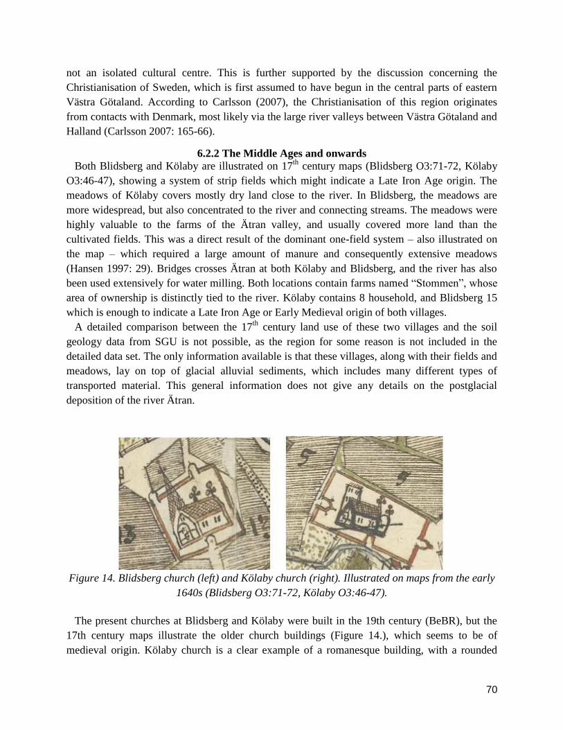
70
not an isolated cultural centre. This is further supported by the discussion concerning the
Christianisation of Sweden, which is first assumed to have begun in the central parts of eastern
Västra Götaland. According to Carlsson (2007), the Christianisation of this region originates
from contacts with Denmark, most likely via the large river valleys between Västra Götaland and
Halland (Carlsson 2007: 165-66).
6.2.2 The Middle Ages and onwards
Both Blidsberg and Kölaby are illustrated on 17th
century maps (Blidsberg O3:71-72, Kölaby
O3:46-47), showing a system of strip fields which might indicate a Late Iron Age origin. The
meadows of Kölaby covers mostly dry land close to the river. In Blidsberg, the meadows are
more widespread, but also concentrated to the river and connecting streams. The meadows were
highly valuable to the farms of the Ätran valley, and usually covered more land than the
cultivated fields. This was a direct result of the dominant one-field system – also illustrated on
the map – which required a large amount of manure and consequently extensive meadows
(Hansen 1997: 29). Bridges crosses Ätran at both Kölaby and Blidsberg, and the river has also
been used extensively for water milling. Both locations contain farms named ―Stommen‖, whose
area of ownership is distinctly tied to the river. Kölaby contains 8 household, and Blidsberg 15
which is enough to indicate a Late Iron Age or Early Medieval origin of both villages.
A detailed comparison between the 17th
century land use of these two villages and the soil
geology data from SGU is not possible, as the region for some reason is not included in the
detailed data set. The only information available is that these villages, along with their fields and
meadows, lay on top of glacial alluvial sediments, which includes many different types of
transported material. This general information does not give any details on the postglacial
deposition of the river Ätran.
Figure 14. Blidsberg church (left) and Kölaby church (right). Illustrated on maps from the early
1640s (Blidsberg O3:71-72, Kölaby O3:46-47).
The present churches at Blidsberg and Kölaby were built in the 19th century (BeBR), but the
17th century maps illustrate the older church buildings (Figure 14.), which seems to be of
medieval origin. Kölaby church is a clear example of a romanesque building, with a rounded

71
choir and a square tower. Blidsberg church seems to be a gothic construction, with no traces of a
secluded choir. The tower is pointed and might be an indication of an earlier romanesque
building (as shown in Halland by Nilsson 2009: 255-58), especially as few towers were
reconstructed during the period of Gothic architecture (Bonnier 2008: 142-44). In general, Västra
Götaland‘s churches were built between the 11th and 13th centuries, and it is therefore highly
likely that the church at Blidsberg has romanesque origins. Very few gothic buildings were built
in this region during the High Middle Ages (ibid.: 164), in which the parish structure of Västra
Götaland was founded.
Ätran has been used for milling during the early 17th century, at several locations; something
which is common in this region during the period and also illustrates the differences between this
area and the border region of Östra Frölunda. At Blidsberg, 8 water mills of unknown type are
located in Ätran, and most of these ran all year round. The map of Kölaby does not show any
mill in Ätran itself, although a minor stream has been used for milling during autumn and spring.
Further upstream a mill stands in Ätran on the riverbank opposite of Kölaby‘s meadows (Kölaby
O3:50-51). Water mills were mainly – like the mills seen in the maps of Blidsberg and Kölaby –
used for household purposes, and were introduced to Sweden during the Middle Ages (Nilsson
2010: 29). According to Sven B. Ek (1962) both small and large water mills9 existed in Sweden
and Denmark to a limited extent before the 13th
century, but first appear in more common
contexts during the 15th
century (Ek 1962: 99). However, this is perhaps only the result of the
limited nature of the written source material.
6.3 Östra Frölunda The village of Östra Frölunda lies in the middle of the border region between Halland and
Västra Götaland. During medieval times, this village was the centre of Östra Frölunda parish,
which first clearly appears in a letter from 1375 (SDHK nr 10634). Östra Frölunda has been
selected for closer analysis mainly for its location and political importance during the late 14th
century. This subchapter starts by searching for a prehistorical origin of the village.
6.3.1 The Late Iron Age
The neighboring area of Östra Frölunda is defined by continuous traces of prehistorical
communication and settlement. Several bronze age cairns follow the course of the river valley,
and are located close to graves of a traditional Iron Age type (graves of various forms covered
with stone and stone circles). Both Bronze Age and Iron Age burial customs in the area seem to
follow contemporary pathways of communication, and graves of different types are commonly
found connected to modern roads (see Appendix 2, Figure 8.). Whether this reflects a continuous
system of roads, or just the spread of prehistoric settlements cannot be known at this point.
An exact picture of Late Iron Age settlement in the area surrounding Östra Frölunda is difficult
to produce, for a number of reasons. The Iron Age graves found in this region are of types that
9 ―Large‖ and ―small‖ water mills in this thesis have been defined according to the Swedish terminology. A large
water mill is called ―hjulkvarn‖ in Swedish, which basically is a water mill with a vertical wheel. A small water mill
is called ―skvaltkvarn‖ in Swedish, which is a water mill with a horizontal wheel.

72
have traditionally been connected to the Early Iron Age. A Late Iron Age burial practice
dominated by mounds is simply not represented in this area. According to Selinge (1997) this
illustrates that the relatively mobile settlement system of the Bronze Age continued into the early
Iron Age, shown by the correlation in grave locations between these two periods (Selinge 1997:
54). However, considering the natural soil foundations of the region – where moraine dominates
the landscape – the ability to construct traditional grave mounds is highly limited (see Appendix
2, Figure 9.). Building material would have to be collected from limited parts of the river bed,
transported over huge distances or extracted through an exhaustive clearing of moraine soils in
order to raise a mound similar to the graves found in central Västra Götaland.
However, the exact distinction between mound and round stone filled graves is not entirely
clear, and a great variation can be observed in the landscape. In southern Småland – where the
natural conditions are very similar to the central Ätran valley – round stone filled graves are
common within late Iron Age contexts. To distinguish the late from the early period it has been
suggested that grave fields containing a larger number of graves can be tied to Late Iron Age
settlement (Hansson 1999: 52-53).
There are no grave fields in connection to Östra Frölunda, and the only remains of Iron Age
burials in the area are two stone circles in the northern part of the village (RAÄ Östra Frölunda
15:1-2), and six loosely connected graves almost 3 kilometers to the southwest (RAÄ Östra
Frölunda 58:2, 58:4-5, 59:1-2 and 60:1) – the latter lie in clear correlation with two Bronze Age
cairns. Instead, the only relatively solid evidence of late Iron Age activity within the vicinity of
the village, seems to indicate that the nearby farm of Torsvi, by the tributary river Lillån, was
settled (Figure 15.). However, considering the problematic nature of the traditional ideas of Late
Iron Age settlement culture, the pattern produced is most likely highly simplistic.
The retrogressive material provided by the historical map of Östra Frölunda from 1732 (0226-
8:6) shows a village with in total 4 households, which is not enough to indicate a pre-medieval
origin. However, the map also shows fields and meadows belonging to what must be a recently
abandoned farm, raising the number of households to 5, which is within the limits of a pre-
medieval settlement. The village boundaries, taken from a 19th
century geographical map called
―Häradsekonomiska kartan‖ (J112-25-25), have a relative ―boundary radius‖10
of 2.5 kilometers.
Tollin (1999: 190) has shown that this is a measured radius often tied to settlements with a
medieval origin. The origin of Östra Frölunda is thus somewhat ambiguous in character, and
considering the unreliable nature of the archaeological remains in the area it is impossible to say
with any certainty that the village existed before the Middle Ages. If viewed traditionally, Östra
Frölunda could be seen as a resettlement of lands which were abandoned during the middle of
the Iron Age.
10
―Boundary radius‖ is a translation of Tollin‘s term ―ägoradie‖, which refers to a measurement from the central
area of a settlement to the most distant boundary mark (Tollin 1999: 35).

73
Figure 15. Map showing the Iron Age features in the area close to Östra Frölunda. The grave
field at Torsvi RAÄ Östra Frölunda 11:1, with 7 features of different types – including an oval
stone circle, a trident formation etc. – can be classified as a Late Iron Age settlement, according
to traditional ideas.

74
6.3.2 The Middle Ages and Beyond
During the Middle Ages, Östra Frölunda became a place of significant strategic importance,
which was marked by the construction of Kindahus Castle sometime during the High Middle
Ages. Kindahus has been as Swedish royal castle (Ekre 1992: 109) and first appears in the
Chronicle of Erik (Erikskrönikan, written during the 1320s) where a Danish army stayed at or
laid siege to the castle sometime between 1306-1307 (Jansson 1991: 116-117, Andersson 1997:
110). The strategic importance was, according to Andersson (1992), the result of the
communicative values of the Ätran Valley, through which the old road ―Ätranstigen‖ (being the
same as ―Redvägen‖ described in the chapter above) penetrated the landscape towards the
inlands of Västra Götaland. This road was used several times to transport Danish troops into
Sweden, and the construction of Kindahus Castle should be considered a mainly military action
(Andersson 1992: 169-72). Figure 16 shows how Ätran has been used for tactical purposes,
where the river itself constitutes the northern moat of the castle. Clearly, there is a certain
defensive tactical emphasis directed towards the southeast, which is indicated by the directions
of the moats as well as the remains of the southeastern tower, guarding the entrance. The
innermost space of the castle, which was most probably the location of the main keep, is directed
towards the river. Ätran was thus not considered a weak point in the defensive system. This
meandering part of the river – where the flow of water is generally slow – was difficult to ford
(Carlie 2004), which in turn meant that a crossing would have required the use of boats, a rather
hazardous enterprise under military circumstances.
Figure 16. LIDAR model of Kindahus Castle. Note how the river has been a feature included in
the defensive system of moats.

75
Another interesting factor connected to the establishment of Kindahus Castle is the iron
production in Västra Götaland, especially in neighboring Tranemo where a high concentration of
bloomeries can be seen. This production began during the early Viking Age and continued till
the middle of the 14th
century. According to Englund (2002), this iron production was the result
the Danish market, and a large part of the resources were shipped to central Denmark. From the
Late Middle Ages the Danish iron making industry was instead concentrated to Halland and
Scania (Englund 2002: 356). In this context, the construction of Kindahus Castle – which is
assumed to be of Swedish origin – becomes interesting. The castle was built in the period when
the iron production of the area began to recede, raising the possibility that this was the result of a
Swedish strategic counteraction. Preventing a source of Danish iron – which was presumably
transported by land or water down the Ätran Valley – the construction of the castle led to a
decreasing production.
While there is no direct evidence with which to discuss the medieval settlement in Östra
Frölunda, a map dating from 1732 (see Appendix 2, Figure 10 and 11.) shows some elements
that can be retrogressively studied. First of all, the farm named ―Storegården‖ on the map seems
to indicate a previous household of some stature. The land directly owned by this farm was not
mapped by the surveyor in the 18th
century, which is evidence of its unique status in the village.
Although uncertain, this might indicate a manorial farm, perhaps formed during the foundation
of Kindahus Castle, or earlier. The farm named ―Stommen‖, which in 1732 was owned by the
local priest, can perhaps be traced back to the formation of Östra Frölunda Parish sometime
before 1375 (SDHK nr 10634). This has been indicated under similar circumstances elsewhere
(Tollin 2010: 58) and is also supported by the architectonic features of the church illustrated on
the map. The map shows a gothic church with a single hall, giving the building a relative dating
between 1250-1350 (Bonnier 2008: 145-55). In addition, the long central field strips seen in the
map (in Swedish called ―bandparceller‖) has within the same hundred (Kinds härad) been dated
to the late Iron Age (Hansen 1997: 31). It is therefore relatively safe to assume that these fields
also existed during the medieval period.
The medieval and later land use can to a certain extent be analysed through this retrogressive
material. Assuming that farming at both ―Storegården‖ and ―Stommen‖ was active during the
Middle Ages, it is highly likely that the land use seen in the map from 1732 has a long history.
What becomes clear when analysing the digitised map (Appendix 2, Figure 11.) is that the
infields were aligned in a south-north direction along the western riverbank. The meadows were
especially tied to the river, and were highly important resources in the household economy of the
region. A large majority of the meadows in Östra Frölunda lay on glacial alluvial sand, but there
were also some parts of the used land which was covered in postglacial flooding sediments
(SGU).

76
6.4 Falkenberg and the estuary region of Ätran The southern Ätran valley is rich in archaeological remains, and seems – along with
neighboring areas – to be a central region of Late Iron Age culture. The area has been cultivated
since the Neolithic period, with an almost equal amount of cultivation in both coastal and inland
areas until the forests regrew sometime during the Middle Ages. The Iron Age can be
characterised by extensive agricultural expansion, where the landscape was transformed, e.g. by
the forest colonisation. During the period studied in this thesis, heather moors also expanded in
Halland, as a result of deforestation and increased grazing (Wallin 2004: 52-54).
The town of Falkenberg was originally the site of a castle, from where several high noblemen
exercised their power. Ätran also served as a border between the two Counties of Halland, of
which the northern one reached a form of temporal sovereignty during the 14th century (Rosén
2004: 338-41). As described above, the province of Halland was under Danish rule until 1645,
and is usually described as a poor region in the historical source material (ibid.: 351). The region
is thus the object of many changes during the studied period, and structures are difficult to trace.
This is further complicated by the aspect of Halland‘s mobile medieval villages, where the
settlement had been relocated to improve cultivation standards as the necessity arose (Håkansson
2004: 286). Falkenberg and the estuary of Ätran is an area which summarises a diverse history of
change, and has therefore been selected for closer analysis.
6.4.1 The Late Iron Age
The prehistory of this region is tied to the river in many ways. During the Neolithic Period,
most settlements can be found in direct contact with the riverbank. From the Bronze Age and
onwards, a change can be observed where the settlements have moved further uphill from the
river. The wet riverbanks were, according to Carlie (2004), most suitable for meadows and
greenyards, while the land above the riverbank was used for farming (Carlie 2004: 16-18). A
rough sketch of the Late Iron Age settlement pattern can be produced through a map of grave
fields and mounds in this region (Appendix 2, Figure 12.). The map shows that the settlements
close to present day Falkenberg cannot be tied in any particular way to Ätran itself, which at
large corresponds with the ideas of Carlie. Northeast of the estuary, where the lowlands give way
to a highland topography, the settlements can be more easily tied to the river.
A central settlement in the area surrounding the estuary was Stafsinge, where silver hoards and
two large long houses have been found. The houses have been C14 dated to somewhere between
1000-1200, and the archaeological material indicates a settlement with a complex set of internal
relationships (Rosén 2004: 329-30). Other places, such as Faurås and Vinberg became so called
―Kungalev‖ (royal manors) during the Middle Ages (ibid.: 330) and these can be tied to a
relatively high concentration of burial mounds – something which in turn indicates a Late Iron
Age origin. Although most of these sites cannot be clearly tied to Ätran, they often lie on slopes
overlooking the main watercourse.
However, some of the settlements had graves in close proximity to the riverbed. One of these is
RAÄ Vinberg 5:1-2, with two Late Iron Age burial mounds which lies on a slope about 250
meters from the banks of Ätran. A viewshed analysis shows that the mounds have a clear visual

77
connection with the surrounding river valley (Appendix 2, Figure 13.), and also that surprisingly
distant burial mounds and grave fields are visible from this location – some more than 8
kilometers away. A total of 25% of all burial features seen in the map are visible from Vinberg
5:2. While this visual result is not remarkable, it emphasises that intervisual contact was not
entirely unimportant. The viewshed analysis also serves as an example in illustrating the visual
relationship between the Late Iron Age settlements of the area and the river.
According to Carlie (2004), the communications in this region have been determined by the
waterways, which have constituted natural obstacles. Contacts in the south-north direction were
dependent upon reliable fords, which were relatively uncommon in the estuary region of Ätran.
At least during the Early Iron Age, only the rapids of Vessige and Falkenberg were places where
an effective fording could be secured (Carlie 2004: 22).
6.4.2 The Middle Ages and Onwards
During the Middle Ages, Halland in general became a theatre of political importance. The
province was divided into two counties – a northern and a southern – and Ätran constituted the
border between these regions. In the early years of the 14th century, the northern county assumed
a sort of sovereignty – after years of political unrest - until 1326 when it was placed under the
rule of Magnus Eriksson. In 1360 the county came under Danish rule once more (Rosén 2004:
338-40).
During these years of political change, the castle of Falkenberg was founded by the estuary of
Ätran (Rosén 2004: 338) – on the south side of the river. The original settlement was rather small,
and concentrated around the castle of Falkenberg, most probably based on an earlier royal manor
of some sort which existed at least during the end of the 13th
century. A castle was founded later,
during the initial stages of the 14th
century, and the location has been seen as a point of
administrative and political importance due to its border function. This castle was used in
military action during the 14th
century, and was destroyed in 1346. The castle was rebuilt after
this, but was finally razed during the rebellion of Engelbrekt in 1434, after which it was not
reconstructed (Redin 1983). It has been argued that the settlement which existed before the castle
can be tied to village supposedly named ―Ätraby‖, which is mentioned in written sources 1313
(Dahlblom & Skoglund 2011: 42). Ätran has been discussed as a main factor affecting the
localisation of this settlement, in establishing the foundation for oversea contacts and the fishing
of salmon – a species which is still today common in Ätran – or herring (ibid.: 166, 184).
However, no extensive evidence of a strong economic foundation seems to exist in the
archaeological material. During the middle of 15th
century, the town of Falkenberg emerges in
the written source material, and later during the same century two locations of urban character
existed in the area – called ―The Old‖ and ―The New‖ Falkenberg, of which the elder one lay
closer to the estuary. Both towns lost their town charters during the latter half of the 16th
century.
However, the town of Falkenberg was given a common charter in 1582 (Redin 1983).
Little is known of the christianisation of this region. In BeBR, only one church (The Church of
Falkenberg) has been dated to the 12th century, though most of the building is renovated. The
parish structure of the region supports the idea of Ätran as a natural border, where the parish

78
borders follows the course of the river until it reaches the parish of Gällared, to the northeast of
Falkenberg (Appendix 2, Figure 14.).
While the early cartographic material from this region is highly limited, the villages of Faurås
and Höstena were mapped in 1692 and 1694 (Faurås M2:37-38, Höstena M2:54-55). The map of
Faurås is poorly detailed, but indicates that the riverbanks were used as meadows. According to
the surveyor, the meadows were dry but gave quite poor revenues. The surveyor writes,
regarding the only farm to have been mapped, that no specific mill or fishing activity can be tied
to it. Of the other farms that existed in Faurås, none were mapped and we presently know
nothing about them. Höstena – which lies much further north – was obviously mapped with
greater detail, although most of the land here also remains unsurveyed. The riverbanks were used
for meadows of much the same quality as in Faurås, and salmon have previously been caught in
the river, although not at the time of surveying. In total three natural springs are recorded on the
map, which at the present are places of local tradition called ―Höstena Källor‖11
. According to
local tourist information, the largest – and the only remaining – of these springs have been called
―bottomless‖ (halland.se). In the map, the stream leading down from the this spring (called
―Ådrebrunnan‖ by the surveyor) exits into Ätran. These springs have also been noted in FMIS
( RAÄ Ljungby 180:1) where a legend which refers to ―boiling‖ water has been recorded.
The historical maps described above cannot be effectively georeferenced, due to the lack of
detail. However, as their connection to the riverbanks still has been shown in the limited material
– a land use also observed during the Iron Age (Carlie 2004) – the banks themselves can be
geologically discussed. The riverbanks of the lower region of Ätran mostly consist of different
forms of flooding sediments – which includes clay, silt, sand and gravel (SGU). As proposed by
Carlie (2004), the wet nature of these soils provided a good foundation for cattle farming with its
connected resources.
6.5 Chapter Conclusions Although the written sources concerning Ätran are limited, the analysis above has shown that a
closer analysis of the archaeological and historical geographical source material emphasises
different aspects which cannot be clearly seen in the region of Göta Älv. To illustrate this I have
beneath – apart from summarising the case studies above – also included some comparisons with
other sites of the Ätran valley.
6.5.1 Natural Factors of Human Activity
The three case studies above have shown that the meadows of each village can be clearly tied
to the riverbanks. Although the soil geology which served as foundation for these meadows
varied in nature, they were all in some way connected to alluvial sediments. Of all the case
studies, the region of the lower Ätran valley shows most traces of river soils in connection to
meadows, with a high degree of flooding sediments. Although the historical development of such
sediments has not been covered in this thesis, it is highly likely that flooding is an element which
has affected the riverbanks during a long period of time. The meadows seem to have been
11
―Källor‖ in Swedish means ―natural springs‖

79
dependent upon the regular flooding which occurs in any form of river system, and therefore this
natural factor dictated the agriculture of the whole region. A sudden change in water discharge
would have affected a large proportion of the settlements close to Ätran in a negative way. More
on this later, as it connects to a broader discussion.
The watermills of the Ätran Valley have mostly been connected to the upper regions, where the
natural factors have provided a good foundation for using the river as a power source. In Östra
Frölunda, the only mill of the village makes use of a smaller stream which enters Ätran, but the
large river itself was not suitable for milling. In addition to this, the milling industry of the upper
Ätran valley must have affected the watercourse. The construction of a mill required certain
changes to be made to a previously ―natural‖ body of flowing water – such as the construction of
dams and channels. This enterprise altered the flowing properties of the river, changing the speed
of flow as well as the relative discharge. As seen in the Hjulström diagram (Figure 4.), this also
changes the erosion and deposition of the river. Moreover, in such a place as the upper Ätran
Valley – where mills presumably have been abandonded, constructed and rebuilt since the Early
Middle Ages – the changes brought by mills to the river system have been active for many
centuries. It has recently been shown by Walter & Merritts (2008) specifically that the
abandonment of mills contributes to the reshaping of river morphology where sediments are built
up behind the mill dams, which eventually breaks due to a lack of maintenance. This process of
buildup and breaking of dams results in a much larger erosion and deposition pattern which
eventually leads to a meandering morphology. Rivers which are affected in this manner have
much higher riverbanks than what could be provided by the bankfull discharge12
(Walter &
Merritts 2008: 303). This can be related to the upper course of Ätran, especially to the north of
Blidsberg where the river is characterised by many 17th
century mills and a clear meandering
pattern. Such a pattern would be natural in the estuary region of a large river but as described this
is only in the beginning of Ätran where the river still has a comparatively small discharge. Ätran
had obviously formed a heavy meandering pattern already during the middle of the 17th
century
(see for example the historical maps O3:10-11 & O3:96-97), which would then indicate that the
river had already been the object of extensive milling for quite some time. However, the
meandering pattern could also be a natural development and it is not possible to say to what
extent full mill dams existed during earlier centuries on the locations studied in this thesis.
Different sorts of dams were common in connection to both small and large water mills, but side
channels were also common (Ek 1962: 8-10, 92) which would perhaps not leave as clear a mark
upon the natural character of the river. Nevertheless, dam accidents where not uncommon during
the Middle Ages and appears in several provincial laws from the period (ibid.: 92). The issue of
the contribution of milling to the geomorphological development of Ätran is highly interesting
and should thus be discussed. It would be rather strange if major milling activity of at least the
Early Modern period did not leave any clear mark upon the riverine landscape.
12
The bankfull discharge is a term referring to the level of discharge when the river channel is completely filled. An
even higher level of discharge leads to flooding, which consequently results in the deposition of sediments above the
riverbanks.

80
6.5.2 Economic factors of river use
During the whole period studied in this thesis, Ätran seems to have flowed through a valley
which in many ways was based on a primarily agrarian economy. The only clear exception is
Östra Frölunda and the area immediately to the north of the village, which was connected to the
iron industry in present day Tranemo – an industry with Iron Age origins. The topography has
once again dictated the rules of economic life in the valley of Ätran, where the villages in the
border region between Västra Götaland and Halland – where Tranemo and Östra Frölunda are
located – due to its highland nature and largely moraine soils became more engaged in secondary
resource production. The 17th
century farms of the region obviously used their cattle-based
economy in this manner and paid their taxes partly in butter (see for example Torpa: 86, O1: 11
and O1: 16). In Buttorp (Torpa: 88-89) the butter was produced in a large watermill located in
Ätran, a quite uncommon feature in this part of the river. This shows that the river in many ways
was central to this secondary resource production, and not just in its relation to the meadows.
The watermills of the upper Ätran valley also illustrates that the river was a considerable agent in
defining the economy of the surrounding settlements. How these mills affected the society on the
long term is not however easily analysed. Apart from this, Ätran does not distinguish itself as a
central economic entity. The river seems instead to have played a more important ideological
role, based on its communicative values. This is manifested in the town of Falkenberg, which
was not founded on economic purposes – as compared to Kungahälla and Lödöse. Of course, the
town in itself channeled the local economy, but cannot be tied to any extensive economic river
use.
6.5.3 Ideological aspects of river use
The ideological aspects of Ätran are distinctly tied to the communications of the river valley, in
which the river has formed the base of contacts and travel for many centuries. It is easy to
imagine that the river could have been used for water based transport – as it is one of the major
rivers of southern Sweden – but no clear evidence of such river use has been shown in this study.
This is most likely related to the fact that Ätran – in contrast to Göta Älv – stretches across a
wide variety of topographies, with many waterfalls and rapids. Nonetheless, the river has carved
out a valley which for many centuries served as a connection between the inlands of Västra
Götaland and Halland. The road of ―Ätranstigen‖ played an important role in the shaping of the
societies of both Counties. Although the history of this road remains rather unexplored, the rune
stones in the upper Ätran Valley indicate that it might have been used for travels to the west
during the Viking Period. The striking correlation between prehistoric burial features and the
modern road system shown in Appendix 2 Figure 8 also gives the impression of a long lasting
communication structure. Ätranstigen was a strategically important road during the Middle Ages,
illustrated by the castle of Kindahus in Östra Frölunda. The notion raised by Carlsson (2007) –
concerning the christianisation of Västra Götaland – also shows that the road might have been
used for more non-military communication.
As shown by Carlie (2004), Ätran affected cross-river communication already during the Iron
Age. The borders of our contemporary parishes may in some ways reflect the prehistoric

81
communicative limits of the river (Appendix 2, Figure 14). Although the exact borders of a
parish may not be a structure engraved upon the landscape, the medieval parish formation was
most likely built upon pre-existing patterns of daily communication. Ätran dictated the rules of
casual contact for the people living in its vicinity – where crossing the river was dangerous or
complicated the physical interaction between the inhabitants of the opposite riverbanks was
highly limited. The region immediately upstream of Falkenberg was such an area, and the ford at
present day Garvareforsen became a tunnel of north-south communication. In some of those
places, were the meandering pattern of Ätran is particularly clear or where the river is wide, the
parish border follows the course of the river. However, in the upper Ätran Valley – in which the
river‘s meandering geomorphology is similar – the parish borders are not connected to the river.
This indicates that cross-river communication in the area was not limited during the period of
parish formation. As shown above, the river geomorphology of this region may have been
radically altered by the introduction of mills during the Middle Ages. The previous watercourse
may have been more suitable to cross on foot, with a more limited sediment deposition. Thus it is
possible that the medieval parish structure, in connection to the river, in some ways reflects the
possibilities of pre-Christian – or at least pre-parish – regular communication. This relationship –
founded on the preconditions of nature in the area – later shaped the ideological and
administrative functions of the river valleys. As argued by Claes Theliander (2005), the inlands
of Västra Götaland converted to some sort of Christendom during the middle of the 10th
century,
before the church gained an administrative power over the region. Religious parishes were
formed in a ―spontaneous‖ manner, without connection to missionaries or church officials
(Theliander 2005: 350), which also supports the idea of organically formed parish structures
based on communicative patterns. The rune stones of the upper Ätran valley should also be
mentioned in this context, as they refer to the construction of ―bridges‖. However, such bridges
often referred to rather simple constructions and ―road-like‖ features across wetlands and
marshes, which is why they cannot be seen as the equivalents of more ―modern‖ bridges
(Haverling 1996: 25, Andersson & Nordberg 2009).
Table 3 shows the general correlations between grave fields and churches in their distances to
Ätran. Both features have a quite clear connection to the river, and a majority lies within a
distance of less than 700 meters. All the churches included in the table have been founded during
the Middle Ages, according to BeBR most likely during the 12th
century. Thus no clear
correlation between church age and river proximity can be seen.
Considering the more regional spread and geographical aspects of the table above, the
prehistoric graves by Ätran show a rather greater diversity in location. In the upper reaches, in
the present day county of Västra Götaland, there is a rather clear correlation between Late Iron
Age burials and the river. The middle region of Ätran, where Östra Frölunda lies, is difficult to
analyse due to the problematic nature of the Iron Age graves of the area, and very few typical
graves of the Late Iron Age can be found here. By the estuary region close to present day
Falkenberg, many grave fields are found with a visual connection to the river course, but are
otherwise generally located some distance away from the actual water. A similar situation

82
emerges when looking at the medieval churches of the studied area. The upper Ätran valley
shows a striking connection between Ätran and the parish churches. This also applies to the
cultivated fields owned by the priests of these churches, at least during the Early Modern period,
which often laid in more or less direct connection to the watercourse. Östra Frölunda displays a
similar pattern, but the area surrounding Falkenberg does not.
Table 3. Histograms showing the average distances between two categories of religious features
and Ätran (Grave fields from FMIS, Churches from BeBR). The three churches of Kölaby,
Blidsberg and Östra Frölunda are not included in the table, as these are not present in BeBR. A
larger study including the churches seen in the cartographic material would provide a fuller
picture.

83
7. Characterisation of the River In Chapter 3 I outlined the methodological structure of this thesis, concerned with three
categories of river interaction: nature, economy and ideology. This structure has been carefully
followed in the investigation of the case studies described above. However, in order to delve
deeper into the problems and possibilities of riverine historical research a more holistic approach
should be used. A river – according to the theoretical approach adopted in this thesis – should not
be seen a simple natural entity, used and exercising its agency according to strict categorical
definitions. Rather, the uses of a river – like that of most landscapes – are connected to each
other in a complex scheme of interaction. E.g. the symbolic value imbued upon a river may not
only be connected to religion or popular beliefs, but also to the natural characteristics of the river
or its economic values. This is a somewhat complicated discussion, which can only incorporate
certain aspects of the above study which has proven more useful than others. Thus this chapter
and the chapter that follows compare the two river systems in a more general way, trying to put
the discussion into a more widely usable context. However, before engaging in such a specific
yet wide argumentation, a short interpretational summary of the methodological categories and
the periods investigated in this thesis should be presented.
7.1 Categories The categorisation involved in the methodological construction of this thesis has proven highly
valuable. Such divisions of the material make the study more easily accessible, not the least
because the sources used are quite numerable. It also shows – in ways which have been
discussed in the following subchapter – that this categorization in itself raises the complexity of
riverine material and its associated agencies. This subchapter tries to summarise the
methodological results in an interpretative way, to further connect the following discussion with
the analysis of the two river systems (Chapter 5 & 6).
7.1.1 Natural Factors of Human Activity
Göta Älv flows through a valley which to a large degree is filled with more or less thick layers
of clay. This has provided certain preconditions to human life, by defining the dangers involved
in living within the valley – landslides, floods etc. – as well as being the foundation of
agricultural life. Variations in water levels have most likely affected the agriculture of this valley,
which is why many meadows – as opposed to cultivated fields – are found in close connection to
the water. A similar picture has been produced in the Ätran valley, where the same connection
can be seen between the meadows and the river. Cultivated fields were almost never found in
direct contact with the riverside. However, Ätran has not been a danger zone in a manner similar
to Göta Älv. Flooding levels could have brought a certain degree of caution to the settlements
surrounding the river, but there seems to have been no imminent risk of landslides.
Both rivers have also been used for water power during the Medieval and Early Modern periods,
but the role of nature in defining the preconditions for such industries varies in the two valleys.

84
Milling on Göta Älv seems to have mostly concentrated to the falls at Trollhättan, where the
waterfalls have been the precondition of the industry, requiring small alterations to be utilised
effectively. The upper Ätran valley – where most water mills were found – did not have any
waterfalls of a size comparable to Trollhättan, and an effective milling industry thus required
larger river alterations. Later, this may have completely reshaped the geomorphological pattern
of the river.
7.1.2 Economic factors of river use
What both the rivers have in common in economy is that the flowing water has generated the
foundations of secondary resource production. In the Ätran valley this is manifested in the
production of butter, perhaps using the water mills as shown in one example, and perhaps the
Iron production of the Early Medieval Period in Tranemo which was presumably transported on
the road ―Ätranstigen‖. In the Göta Älv region, the use of the river as an important waterway
connected the towns of the valley to international as well as local trading patterns. At least from
the Late Middle Ages and onwards, the forest industry became a central secondary industry to
the settlements surrounding the river, as illustrated on the 17th
century map of Åkerström. This
map, along with the map of Lödöse, shows that Göta Älv also functioned as an economic entity
on several levels, both locally, regionally and internationally. This can be opposed to Ätran,
which economic functions were more tied to local settlements than to long-distance
communications – with a few exceptions. In the valleys of both Ätran and Göta Älv, cattle
farming seem to have been the most central agrarian resource, at least from the Middle Ages into
the Early Modern period. The historical depth of this agrarian land use is further argued in the
chapters below.
7.1.3 Ideological aspects of river use
Both Ätran and Göta Älv have functioned as borders in some way, although not in an entirely
similar way. Göta Älv has – similar to its economic functions – served as a border on both the
local, regional and national level at least since the middle of the Medieval period. How this
border affected the settlements of the valley is a complicated issue, although the region has been
seen as a cultural unity at least during the prehistoric periods. It is my opinion that this
oversimplifies many things, and the river should have served a separating function – at least
locally – even during these periods. The river was obviously impossible to ford and while boats
may have been in common use by the locals, cross-river daily communication must still have
been rather limited. Ätran‘s lower reaches served a separating function in this manner during the
Iron Age, where the meandering parts of the river limited the communications of the area –
something which is to certain extent still reflected in contemporary parish patterns.
The ideological importance of the river systems in question seems to be mostly connected to
these communicative functions. During the Iron Age, several hill forts on the hills and mountains
overlooking the Göta Älv valley emphasise that such ideologies were also present in the
prehistoric periods, and the both rivers are connected to visual control during the Iron Age – also

85
considering the visual capabilities of several grave fields. It is impossible to know if physical
control was also considered important during this period. This is instead manifested during the
historical periods, when several castles – e.g. Ragnhildsholmen, Bohus, Falkenberg and
Kindahus – are established with a direct physical connection to the rivers. These castles gave
their inhabitants a certain power over the communicative values of Ätran and Göta Älv,
something which was obviously considered important.
The symbolical values imbued upon the river in question have been difficult to capture, not the
least for the Late Iron Age. In general terms, Ätran was seemingly more connected to religious
features (Iron Age graves and Medieval churches) than Göta Älv. In both river valleys certain
regions are found which have been central in Iron Age society. The estuary of Göta Älv is such a
place, and a larger quantity of Iron Age burials can be seen in closer proximity to the river – if
compared to Trollhättan on the upper reaches. However, no other area of study has sported the
same Iron Age riverine burial connection as the upper reaches of Ätran, where a close connection
between medieval churches and the river also can be observed. Whether this in fact reflects some
sort of religious symbolism is difficult to ascertain.
7.2 Patterns of Character The observant reader will have already noticed that certain aspects of river use have proven
more valuable than others in this study. It is clear that this subject raises questions of interest,
and in the written text above I have raised some thoughts which cannot be covered in their
entirety within the limited pages of this thesis. As these thoughts are not clearly connected to the
research questions posed in the Introduction chapter, I have chosen to leave them to future
studies. Some of those thoughts have been listed in Chapter 8.3. However, several patterns have
emerged through the analysis of Göta Älv and Ätran which in this chapter have been selected for
some detailed reasoning. These patterns are as follows:
The location of secondary resource production and ―industry‖ – such as water milling,
timber rafting and private fishing – largely correlates with the flow of the river, i.e. these
activities were concentrated to and originated from the upper reaches of the rivers. In the
lower reaches of the rivers, where sediment deposition is high, the river was mostly used
as a backdrop for primary resource production, such as agriculture. The relative size of
the river also affected the river use, where mills are almost never found in the lower areas
of the main watercourse.
The rivers are both connecting and separating in their character. Göta Älv itself has been
used for transportation during many centuries, both by private individuals and on a larger
scale, whereas the old road ―Ätranstigen‖ or ―Redvägen‖ used the river valley of Ätran to
connect Halland with the inlands of Västra Götaland. At the same time, both rivers have
figured as border regions, both on a national, regional and a local scale. The river as an
obstacle to cross-river communication is a theme applicable to both Göta Älv and Ätran.
Both rivers show signs of individual action. Göta Älv acted – and still acts – upon the
human society in the river valley by a series of landslides, some of them with catastrophic

86
results. It is not unthinkable that this shaped the mindsets of the people of the Göta Älv
region, as well as influencing settlement location. Ätran instead may have reshaped itself
through human action. This is most clear in the northern part of the river, where intensive
water milling most likely has contributed to river morphology. In turn, this also must
have affected the surrounding human society, whose communication possibilities became
limited by the meandering pattern of Ätran.
Meadows and cattle farming are closely tied to the rivers, although with a somewhat
varying geological connection. Fluvial soils in general – both glacial and postglacial –
seem vital to farms dependent on cattle farming in river regions. The fluvial dependence
might also be a result of a limited amount of usable land, where the cultivated fields –
which were more vulnerable to flooding – lay further away from the river.
Beneath I have chosen to briefly investigate each of these themes further, in order to develop a
discussion from which I have drawn my conclusions and answered the research questions posed
in the beginning of this thesis. As will be shown in the following subchapters, all of the patterns
described above are more or less related to each other, and it is not possible to entirely separate
the one from the other.
7.2.1 The Flow of Water and Its Relation to Economy
The first of the patterns mentioned above regards the relationship between the local natural
characteristics of a river and economic possibilities. In the case studies described in this thesis, it
is clear that the natural characteristics of a river in many ways define the economic possibilities
of the surrounding settlements. This is most clear during the historical periods studied, when
both Göta Älv and Ätran were the objects of intensive milling. The mills at Trollhättan, active at
least during the 15th
century and onwards, were located where the waterfalls brought the natural
power needed to maintain a concentrated industrially active settlement. In the upper Ätran valley,
the flow of the river was much gentler than Göta Älv at Trollhättan and the concentration of
mills should rather be tied to the relatively easily maintained character of the river in this region.
In contrast to the falls of Trollhättan, the effectiveness of the mills at Kölaby and Blidsberg were
most likely based on human alterations to the river, such as dams. Göta Älv to the south of
Trollhättan – as well as the estuary region of Ätran – was not in itself used in this manner, most
probably due to the difficulty of controlling the water. In such regions – where the size of the
river and its natural character prevented effective use and control – mills where uncommon or
connected to smaller watercourses which entered the main river. Such was the case in Östra
Frölunda, for example.
The estuary regions of both rivers can be seen as places of passage between terrestrial and
maritime economies, something which is quite symbolically reflected in the natural mixture of
the river and the ocean. Perhaps this is best illustrated by the medieval town of Kungahälla,
where agrarian and maritime resources where exchanged. International trade also illuminates the
fact that the access to water gave the opportunity to engage in long-distant economic

87
communication. This in turn must have served as a foundation for the central administrative role
of many estuary settlements during historical times. Thus, Göta Älv became a central urban
arena during the Early Middle Ages and the river should perhaps be seen as the main agent in
defining the urban characteristics and the economy of the region. Although the urban entities in
the Göta Älv valley were constantly changing in location, ownership and characteristics, the
river still remained the force of connection between the different towns. Had the river itself been
inactive in agency, the towns would not have been so intricately entwined with riverine locations
and activities. If the river was considered economically unimportant, the towns would have been
engaged in rather different enterprises, following other patterns of development. Thus, I would
argue that the economic possibilities granted by Göta Älv contributed to the formation of central
places in the region. The urban character of Göta Älv, which was also formed through its
ideological aspects (see below), is an enduring structure formed through the periods covered in
this study, constituting perhaps one of the most clear examples of natural agency in the manner
argued by Fernand Braudel (1958). This structure is still active today, governing the lives of
hundreds of thousands of people.
7.2.2 The Separating and Connecting character of the river
One of the most defining characteristics of a river has been seen in the material studied in this
thesis. Both rivers in question have to a certain degree figured as borders during the studied
period, yet have still served a connecting function between the estuary and the inlands. The most
clear example is that of Göta Älv, which served as both a national, regional and local (parish)
border during historical times – a structure which origin has been the object of some debate. It is
clear that the river must have constituted a large obstacle to daily cross-river communication
during the whole period studied in this thesis. At the same time, communications – both land-
based and riverine – up and down the river valley connected the north and south regions of Göta
Älv. This communication was not entirely restricted to grand scale economic schemes –
governed by persons of considerable power – but was also exploited within a more private
sphere, as have been shown in Lödöse and Åkerström during the 17th
century. The historical
depth of the communicative relationship is difficult to analyse, but it is clear – from ancient hill
forts and Norse sagas among other things – that the river could have been used in a similar
manner during the prehistoric and medieval periods.
Ätran served a somewhat similar function, though the communicative values of the river itself
can indeed be questioned. It is not impossible that the river was used for water-borne transport in
the past – especially on a local scale – but no evidence of such interactions has survived. Instead,
the river has carved out a valley which has served as a land based communication line at least
since the Iron Age. The river formed a central – but to a certain extent inactive – part of this road,
not the least visually. At the same time, as have been shown above, Ätran posed a considerable
obstacle to cross-river communication during the Iron Age, something which later shaped the
border relationships of the river valley.
Both rivers have also formed the ideological and political patterns of the surrounding agents of

88
power, mainly I would argue as a result of the long-term structures of riverine communication.
Göta Älv has most likely been an important connecting factor since the Iron Age, reflected in the
Hill Fort pattern of the valley. The struggle for controlling this valley is manifested mostly
during the historical periods and the history of urbanisation connected to the river. Many of the
towns became temporary administrative centres, something which reflects both the separating
and connecting functions of the river. The foundation of Falkenberg and Kindahus indicates that
Ätran served a similar purpose, and the estuary regions of both rivers seem to have been central
political arenas during the medieval period. Thus the rivers both separated different countries
from each other and connected them politically through the formation of the administrative
centres.
The dualistic character of riverine communication is something which is reflected on all levels
of river interaction. Even in its natural foundation, a river both unites and separates the land
through which it flows. By constantly seeking an ideal equilibrium on its way to the ocean, the
river carves out a valley which can be seen as a natural unity, due to sediment deposition and
morphology. But this valley simultaneously splits a preexisting natural unity – such as a region
with similar soil geology – into two parts, divided by the sediment deposited by the fluvial
system. The river also carries in its waters the geological remnants of its source, constantly
causing a mixture of minerals and soils, forming a hybrid natural entity until it finally enters the
ocean. Thus every single part of the fluvial system is a mixture of both local and upstream
geological variations.
Considering this, the character of riverine communication must be seen as a long-term
structure which has defined the contacts of the river valleys through many periods of history. An
interesting notion is that human attempts to manipulate this structure – such as the building of
bridges – create Third Space entities. The actions surrounding the construction and maintenance
of bridges can initially be seen as a rather physical negotiation between nature and culture, but it
is the need to cross the river at a specific location that is the most interesting. The relationship
between the desire and the natural world forces the human mind to devise ways in which the
preexisting structure can be overcome, something which in turn requires profound knowledge
concerning the character of the natural object – i.e. the river. Out of this mental dialogue comes a
physical creation, which is dependent upon both the ―cultural‖ and the ―natural‖ world. Perhaps
it is the complexities of crossing a river and the difficulties in overcoming the structure which
subsequently have turned into symbolical manifestations in later Scandinavian folklore (for more
on this folklore see Tillhagen 1997: 93-111).
7.2.3 Individual actions of river characterisation
The theoretical approach promoted by Jean-Paul Sartre (1968) has been used in this thesis to
analyse how the character of the rivers in question have changed in individualistic manners. Both
rivers have proven valuable case studies in this manner.
Göta Älv is a river whose character for many years of human history must have been defined
by danger and natural hazards. It is clear that landslides, sometimes with disastrous effects, have
shaped the river valley to a large degree, something which cannot be easily tied to the river itself.

89
Of course, Göta Älv also affects the relative risk of landslides by undermining the deposited
clays of the valley, but it seems like precipitation and ground water flow plays a more important
role in determining landslide frequency and shape. A major event which may have shaped the
character of Göta Älv during historical times is the landslide called Jordafallet, which as have
been described above occurred most likely in 1150. This landslide perhaps reshaped the entire
geomorphological appearance of the estuary, which redirected the previous lines of
communication and contributed to the rise of the town of Kungahälla. In turn this may have
started a certain struggle for economic power in the valley of Göta Älv, especially as the
landslide occurred in a region of high economic activity. In this aspect the large landslide of the
17th
century becomes interesting, although no major material associated with this event has been
uncovered in this thesis. A specific investigation of the more macro scale economic effects of
this natural disaster would prove highly valuable to future research. However, it is clear that
Göta Älv has not only acted on its own behalf, but also been affected by other natural agents
which have defined its character. The interaction with human agents of alteration has not been
covered in this thesis, as it is a complicated subject. Clearly, the locks which were installed in
Lilla Edet during the 17th
century would have affected the geomorphology of the river, but to
what extent remains rather uncertain and needs further investigation.
Ätran, as opposed to Göta Älv, instead shows some signs that might be connected to human
agency and river change. Especially the upper region of the Ätran valley has been used
extensively for milling, a type of river use which most probably has a long history in the area –
although the age of the mills seen on the 17th
century maps still remains unknown. I have
described above how the meandering pattern of some rivers may be the result of mill
construction and abandonment, an aspect of fluvial geomorphology which is intimately bound to
questions regarding the relationship between nature and culture. If such man-made
geomorphology can indeed be traced in the upper reaches of Ätran, then it is a clear example of
how a river surpasses its field of possibles. However, other aspects must be taken into account –
such as the fact that Ätran was a glacial river during the Ice Age, with an entirely different level
of discharge and transport capacity. Here once again further studies are required to investigate
this, using a similar methodology as Walter and Merritts (2008). Nonetheless, the extensive
milling on the upper reaches of Ätran must have left geomorphological traces, to a certain extent.
At least locally, the increased sediment build up behind mill dams may have contributed to other
aspects of river use, such as constituting land which was highly suitable for meadows.
What have become clear in this study is that a river is by no means an isolated natural
phenomenon, which can be explained using simple formulas and deductive reasoning. Above all
else, the ―natural‖ character of a river is defined by a large range of external agents, dependent
upon local variations of ―natural‖ and ―cultural‖ entities. Thus – although rivers may follow
some common patterns of geomorphology – each river should be seen as an individual character
which is not only able to act, but also free to be acted upon.
90
7.2.4 The Character of the River in Agriculture
Another structure which has been observed in the material studied in this thesis is the
connection between meadows and rivers. This structure can be observed during the whole period
studied, at least on some locations like the estuary region of Ätran. I would suggest that most –
but not all – meadows with a riverine connection in the past lay on so called temporary wetlands,
either natural or artificial ones. Such wetlands are maintained by yearly floods, when the
bankfull discharge is surpassed and the river spills out unto the surrounding soils. Such events
are common on most types of river, but it can also be managed by the construction of artificial
irrigation channels or dykes. These types of water meadows are called ―madängar‖ or
―översilningsängar‖ in Swedish and have been described by other authors. John Granlund writes
of the meadows in Högsby parish by the river of Emån in Småland:
What the Nile was to the fields of Egypt, was Emån to the nearby meadows of Högsby. Letting the spring flood
rise over the meadow – soaking it properly and leaving behind nutritious silt – was considered the foundation of a
good harvest of fodder. It was considered necessary to keep the meadow temporarily under water [author‘s
translation] (Granlund 1969: 291).13
It is difficult to say with any certainty to what extent such habits were exercised during the
period studied in this thesis, and a more detailed analysis would require a close investigation of
the written source material concerning the local farming culture. In England, the introduction of
artificially managed water meadows has been dated to the early 16th
century, although an earlier
introduction has been discussed – especially as such systems were used in medieval France, e.g.
by Cistercian monasteries (Cook et al. 2003). However, no clear evidence of irrigation channels
has been observed in the material studied in this thesis, and many meadows in the area of study
may have been naturally managed. Another problem is the fact that later years of water drainage
and river regulation has in many ways reshaped the hydrological landscape. Historical water
levels of the rivers in Sweden – as well as in most parts of the world – are therefore difficult to
find. The use of historical maps only gives information in 2D, but could perhaps be combined
with LIDAR data to explore this further.
In any case, the rivers must have played an important role in defining the preconditions for
effective livestock farming, as many extensive meadows are found in connection to flowing
water. This might also be the result of a human risk adaption, as very few cultivated fields are
found in connection to the rivers. The risk of flooding is always present in a river valley, and
could be disastrous to the fields. This is evidenced by the ditching and water draining of fields
during the historical period studied in this thesis (Jakobsson 2013). Valleys such as the Ätran
valley also restrict the amount of land which can be effectively used for agricultural purposes.
Thus, farmers – following a common tradition and given a limited amount of usable land – chose
to place the meadows close to water, as they – compared to the fields – would not be rendered
13
‖Vad Nilen var för Egyptens åkrar, var Emån för de närliggande ängarna i Högsby. Att låta vårfloden stiga över
ängen, ge den en grundlig rötblöta och lämna kvar näringsrikt slam ingick i förutsättningarna för en rik foderfångst.
Att ha ängen tidvis under vatten ansågs nödvändigt (Granlund 1969: 291).‖

91
useless by a flooding event. The fields instead were more commonly placed inland, within a
more secure distance from the river.
What can be observed in the above arguments is also a negotiation between humanity and
nature. The river – along with local geology and biological foundations – forces the cultivation
of the valley to take a form which is not a mere result of human agency. Society and river use is
shaped by the natural preconditions of the valley, and reshaped when these conditions changes –
as have been argued by Cheyette in a more general way (2008). Considering the climatic changes
which also occurred after the Vendel period, such as the Medieval Climate Optimum and the
Little Ice Age, it would not be surprising to find that the land use seen in the historical maps is
one with old roots, but with a changeable character. During the dry and warmer periods between
the 9th
and the 12th
centuries in the Northern Hemisphere (Figure 7 and 8), the amount of land
dedicated to meadows were perhaps more limited than in earlier and later centuries. The change
to a colder climate with increased summer precipitation after the 12th
century then led to a
change in agricultural structure, with the result visible in the historical maps of the 17th
and early
18th
centuries.
This shows that agriculture in river valleys is not detached from the river; it is in many ways
entwined with it. To take this even further would be to argue that the meadows – and in some
ways the whole agricultural system – is a hybrid landscape on a grand scale. The agricultural
structure is not only related to the rather fixed characteristics of the land – such as soils,
topography, bedrock etc. – but also to moving entities of change like rivers and streams. Rivers –
as argued by Edgeworth (2011) – cannot be seen as natural features which are separated from the
cultural landscape.

92
8. Conclusions Throughout this thesis, I have tried to emphasise many important aspects of how rivers
interact with human society. The argument which has been followed is that a fluvial system is
not a passive agent and that it is the hybrid quality of both natural and cultural actions which has
constructed riverine societies. In the beginning of this study I posed two research questions – the
first one referring to the active contribution of rivers to the construction of society and the second
one to the hybrid nature of human/river interaction. These questions have been the goal towards
which this thesis has steered, and in this chapter I have tried – in the best way possible – to
answer them properly. It should be noted initially that there can be no thing such as a definite
answer – in my opinion – and what follows have therefore taken the form of a conclusive
discussion in which future investigations may be founded. The topic of riverine landscapes is far
too huge to be covered in its entirety within the limited pages of this study.
8.1 Riverine societal contribution It is clear that the rivers studied in this thesis to a certain degree have affected society on
several levels. Economically, ideologically, locally and regionally Göta Älv and Ätran have
contributed to the construction of society.
A river seems to interact with human society in many ways. First of all, it constitutes a central
part of the natural landscape in which human settlements are founded. Within its own watershed,
a river is indeed the centre of activity and change, contained within the slow processes tied to
geological time perspectives. It would indeed be quite foolish to assume that this fundamental
natural characteristic was unperceivable to the peoples of the past. In certain ways, this is
reflected in the human society of river valleys such as Göta Älv, where the river was indeed a
focal point of human activity. The urbanisation of the region illustrates how people, ideologies
and culture were drawn to the river, much similar to the way in which the tributary rivers of a
watershed join with the main watercourse.
Secondly, a river is not only a part of the landscape, it is also an object which can be utilised
and used for human purposes. The milling of the upper Ätran valley and Trollhättan by Göta Älv
illustrates that the natural conditions in an area often give rise to human innovations which later
must have shaped the society of the region. Every type of river is not suitable for milling, and
thus such industries must be located according to the natural characteristics of a place. Thus it is
clear that the construction of a mill – which at first might seem like an idea entirely of human
origin – is dictated by the rules of a natural agent. A similar argument may be applied to other
actions, such as water transport, fishing, water/land based travel, the construction of bridges etc.
Thirdly, a river also actively reacts against human action. Any human manipulation to a fluvial
system is a temporary one, as a river eventually will reshape almost anything which comes in its
path. Therefore, every human use of a river is either dependent upon a complete understanding
of the system – which does not exist today – or doomed to be locked in a continuous struggle
against a natural agent. The discussion concerning the meandering pattern of the Ätran valley
shows that the outcome of such a struggle may result in something completely new, in its own
93
way affecting the surrounding settlements. Jakobsson (2013) also shows that the struggle
between humans and water itself shapes society and local relationships, something which might
also be applicable to the scenarios described in this thesis.
Fourthly, rivers are also forces of societal change in their own right. Above I have discussed
the possibility of temporal patterns of agriculture in river valleys, being the results of climatic
changes and variations of riverine water levels. It is clear that the environment affects human
society in certain ways, but one of the main environmental driving forces is the river. The effects
of increased precipitation on inland areas will be most visible in the watershed, which in turn is
summarised in the main river. Therefore, societies which are based in river valleys will most
likely be affected in some manner by environmental changes, which will force the adaption to
new natural conditions of life. For example, the dominating one field system of the Ätran valley
can be seen as the result of an environmental adaption, to a cattle based farming which was less
vulnerable to variations in precipitation. A large stock of cattle would in turn produce a large
amount of manure, which could be utilised to cultivate the same field on a yearly basis.
Considering the four aspects of river agency mentioned above it is clear that rivers at least have
the possibility to contribute to the construction of society in a diverse number of ways. When
discussing the relationship between culture and nature in river valleys it is thus important to take
a large number of aspects into account. Had this study been focused on the investigation of
water-borne transport, for example, many important elements of river interaction would have
been completely ignored. Water transport in its own right leaves few tangible traces in the fluvial
system, which is why the rivers would have emerged as more purely ―natural‖ characters, as
compared to the complex picture generated in the text above.
An aspect which has been difficult to cover in this thesis has been the purely symbolical
contributions of rivers to human cosmology and religion, mostly due to a lack of source material.
I would argue that an investigation of such matters is a huge study in itself and needs to
incorporate a large amount of qualitative archaeological – religiously connected – material. As
stated in Chapter 2.5 the agency of a river is not always physically manifested, something which
also applies to investigations of symbolism. Meanings of water are not purely formulated
through its visual qualities, which is why its related symbolism is not easily seen in a
geodatabase. However, regardless of the difficulties involved, the rivers – which as have been
discussed above are central features of any river valley – must have contributed symbolically to
human society, not the least because the agricultural life was often distinctly tied to the flow of
water. This is especially relevant for the Upper Ätran valley, where long settlement continuity
can be observed from the Prehistoric periods till the Modern day. Future investigations should
thus focus on such areas, with a high potential.

94
8.2 The question of agency and the hybridity of the riverine landscape Seemingly – considering the theme followed in this thesis and illustrated by the discussion
above – this thesis might be seen as an attempt to put humanity in its rightful place, as a
substratum to the overwhelming force of nature. This study has taken the perspective of the
rivers, which is why a certain emphasis has been put upon describing the effects of fluvial
systems on society. An important question to be raised is therefore: Is human society in river
valleys entirely shaped by these watery landscapes? My answer is: No, of course not. A river
valley is not an isolated hub of cultural activity. Thus, it is also important to consider the
influences of cultural contacts, Third Spaces and other aspects tied to a more ―human‖ world.
The question itself interestingly raises another question: What is an interaction and how is it
related to the agent?
To answer this question it is first of all necessary to look at the difference between an action
and an interaction. A simple action – I would argue – is formulated internally within the agent,
without a clear external purpose. The result may for example take the form of waving one‘s hand
at no one in particular. An interaction – on the other hand – is negotiated both internally and
externally, caused by a relationship between the agent and an object. E.g. the eating of an apple
requires the existence of the apple, a desire to eat and the knowledge to refer to the apple as
edible. Following the words of Latour (2005: 70), an agent is anything which affects the course
of an action, and thus the apple must take the form an agent as its mere existence formulates the
action. Therefore, following this argument, any action related to external factors should be seen
as an interaction, requiring two or more agents.
River interaction cannot then be seen as a simplistic one-way communication where the river
alone is the active agent. Instead it should be seen as a complex system of actions, reactions and
counteractions – which all in my definition could be seen as parts of an interaction – where the
agents involved are both ―natural‖ and ―human‖. As this is an archaeological study each of the
elements involved in the text somehow requires the existence of a human agent – as I have not
intended to investigate the relationship between e.g. rivers and frogs. Thus, as every form of
river interaction covered in this thesis is based on a dualistic agency, any human use of the river
may be seen as a result of the hybrid negotiation of a Third Space. This argumentation however,
might be criticised for drawing conclusions on a far too abstract level of inference. It is therefore
necessary to consider more tangible aspects of landscape hybridity.
Such hybrid factors are most easily seen in human alterations to a river, such as the
construction of a canal, a dam, a mill or irrigation channels. As described in the previous
subchapter, such alterations results in a very real interaction; the struggle between the
hydrological system and human intentions. A possible example of this would perhaps be the
milling of the upper Ätran valley, which may have left a mark on the riverine landscape.
Resulting in the meandering pattern of the river, the mills – of which most are invisible to the
untrained eye today – symbolizes the struggle between culture and nature. Even after the
abandonment and destruction of the dams, mills still interact with the fluvial system. This hybrid
negotiation has then shaped the landscape on a long-term basis.

95
The discussion concerning the ―unnatural‖ character of the upper Ätran valley is still however
moving on a highly hypothetical level. Another argument, perhaps based on more solid evidence,
concerns the meadows relationship to rivers. Human adaptions to riverine environments have
resulted in the extensive use of both natural and artificial water meadows, as seen both in the
Ätran and Göta Älv valleys. Such meadows may be seen as a type of Third Space, shaped by the
interaction between the human and the riverine agent. One interesting aspect is that river
meadows are both geographical and mental Third Spaces. The meadow is located on the border
between a river and the human settlement, and thus both agents meet within that space.
Interaction also occurs on a mental level – as a result of the geographical meeting – where the
meadows are utilised in a specific way, resulting in more intangible changes to human society.
8.3 A possible discoursive transformation? As shown by the arguments above, the traditional post-processual and processual discourses
are highly problematic in the historical study of landscape interaction. By using a simplistic
terminology many interesting questions and relations are ignored. The use of a cultural
explanation excludes fundamental ―natural‖ factors of cultural development and vice versa. Both
Göta Älv and Ätran have not only played an active part in defining the preconditions of human
settlements, but also acts in their own continuous way upon the surrounding society. Rivers can
not be seen as stabile entities whose lives are stable structures in the ―natural order‖, but are
instead changing in character according to a multitude of external factors. Riverine settlements
are not separated from this process but are entwined with it and to a large degree contribute to the
flow of change.
The discourse then– if described in deconstructive terms – must be seen as governed by
superficial separative theoretical constructions whose generalisations oversimplifies the
complexities of the world. It is not the landscape which is socially constructed (e.g. as described
by Greider & Garkovich 1994) – and thus becoming a human creation – but our perception of it.
As written so elegantly by David Blackbourn (2007):
Rivers flow and do their work whether or not people are present. That is to say, they do what we call ―flow‖ and
―work‖: the river has no name for these things, which are human constructs every bit as much as saying that the
river has been ―conquered‖ (Blackbourn 2007: 17).
This means that the separation of ―nature‖ and ―culture‖ is also a social construction with
which the world becomes understandable, in a contemporary context. It is impossible to argue
that such terminology is a description of ―reality‖, or that it has been universally used since the
dawn of human time. Therefore – as humanity must indeed still be seen as a product of this
world – the border between culture and nature is nothing but an imagined construction. As
shown by the argumentation above, rivers carry within them certain characteristics which have
previously only been given to individuals (e.g. by Jean-Paul Sartre 1968). Human society
depends on and relates to riverine changes. The world is thus constituted by an increadibly
complex system of relations which is impossibly difficult to describe in its entirety.

96
Still, generalisations such as those on which the traditional discourse is built is an important
tool in order to understand the world and produce progress. The discourse should then be seen as
a limited functional description rather than an ultimate truth. Sadly, although this is rather
obvious, theoretical ideas tend to be used in rather deterministic ways. The social construction of
landscapes is one such example, where the original idea – which was probably only to capture
the social elements of the land – has developed into an entire research agenda almost ignoring all
else. A generalisation should thus – however valid – be recognised and discussed but must never
steer the discourse.
What alternatives are there then? Is it possible to move away from the traditional terminology?
A Third Space regeneration of the discourse would propel the researcher into an unknown
territory where disciplines, definitions and concepts are blurred into each other. For example, if
―nature‖ and ―culture‖ were seen as one, then ―cultural‖ and ―natural‖ heritage would merely be
labeled ―heritage‖, following the same laws and sets of rules. In a similar way, archaeology,
history, ancient history, paleoclimatology, osteology and aspects of geology, ethnology,
geography, hydrology, biology etc. could all be formed into a single discipline merely labeled
―historical studies‖ which is concerned with the past in general. The structures of the academic
world and of society in general do not at the moment allow such a discipline to be formed.
Interdisciplinarity does not solve this issue (as seen in Nilsson et al. 1993, described in chapter
1.2.2) and the use of source-pluralism is highly constrained by human limits (as noted by Bloch
1953: 68). It is not therefore possible – at this moment – to forsake the traditional discourse for a
new one.
The only thing that remains is then to increase the collaborations between the disciplines. In
my opinion, articles written by representatives from different disciplines may provide the best
examples of the above mentioned research agenda. Interdisciplinary research published in a
single volume with a chapter – or an ―article‖ – for each discipline is in some ways a waste of
time. The authors in this case have not collaborated, only taken their own separate points-of-view
on a given topic or area. If published in a single text with a common conclusion (where each
author takes an active part), the researchers are instead forced to collaborate. Only then has the
―interdisciplinarity‖ transcended the superficial.
Another aspect which is important is to further raise the problems of the discourse, while still
relating to it. As shown by this thesis, the material is often already there to be used. It is in most
cases the questions that need to expanded, and the historical study of Göta Älv and Ätran clearly
shows – although in a limited way – the possibilies of such research.

97
8.4 Suggestions for future research In this subchapter, I have given my opinion of future directions of potentially valuable riverine
research. Many more aspects may be found in the chapters above which can be further explored
through more traditional perspectives. However, below I have listed some areas of investigation
which are highly valuable for the researcher interested in landscape interaction and
―symmetrical‖ archaeological research.
The study of Göta Älv should include a larger number of case studies, such as Nya
Lödöse and Gothenburg.
A comparative historical analysis of the rivers of Halland could prove highly valuable.
Such a study should also include the entire Iron Age period.
A more thorough investigation of the meandering pattern of the upper Ätran valley,
with a hydrological focus on the effects of milling.
A deeper contrasting analysis comparing several types of rivers and streams. The
relationship between tributary and main system rivers is highly interesting in this
manner. The use of smaller streams is also of central importance, and needs to be
contrasted to the use of larger rivers.
Further investigations concerning the relationship between rivers, waterways and
urbanisation.
A study concerning the role of the environment in societal change, with a focus on the
riverine landscapes. Here, the flooding capacities of the rivers must be taken into
account, perhaps combined with the use of 3D terrain models and historical maps.
A spatial investigation of the relationship between historical meadows and fluvial
landforms. Once again the use of historical maps, and the databases of GEORG and
KARL, might be found highly valuable. Such an investigation would need to take
agricultural yields and amount of used land into account. Incorporating a large amount
of written source material and local farming traditions would provide more qualitative
aspects to such a research agenda.
A problematising analysis of the relationship between cultural and natural heritage in
riverine areas. The analysis could perhaps relate to issues of funding and protection of
heritage and the differences between laws governing natural and cultural heritage.
Public awareness, opinion and discussion is highly interesting from this point of view.
A comparative analysis of riverine cosmology, beliefs and religion through a long-term
perspective using written sources, anthropological and ethnographic source materials in
combination with material culture. This analysis would need to incorporate the
problematic nature of the retrogressive study of folk beliefs as well as focusing on a
large range of both natural and human agents.

98
9. Summary This thesis has encompassed a large amount of source material, ideas and thoughts. In this
chapter I have therefore tried to summarise to entire text above in a manner which can be useful
to the impatient reader. Needless to say, this summary is a rough simplification of the text above,
and it is not recommended to read this chapter alone. I have merely tried to write a simple
overview of the topics discussed.
Chapter 1. Introduction The purpose of this text has been to investigate the relationship between human culture and
nature, through a problematising theoretical perspective. I have chosen to study two rivers in
southwestern Sweden – Göta Älv and Ätran – between 550-1750 A.D, mainly by taking the
perspective of the rivers themselves. The main research questions which have directed the study
are:
Have the rivers in question contributed to the construction of society?
Has the interaction between nature and culture created riverine hybrid landscapes?
These questions have been studied using a mainly landscape archaeological method and
through the development of a GIS database with relevant interdisciplinary data.
The study of riverine history in general has a long international history. Previous research has
however been rather limited in several ways. Where the theoretical ideas have been comparable
to those of this thesis the material studied has served as a limiting factor. What is clear though is
that the interaction between culture and nature has recently become an active research agenda,
where the relations of water to society and the problems of the previous traditional discourses
have been raised. In Sweden, very few comparable studies have been conducted and the
theoretical ideas adopted in this thesis are rarely found in previous Swedish riverine research,
although a few exceptions exist.
The choice of source material has mainly been limited to information which can be easily
integrated into the geodatabase. Included data is taken from the databases of: FMIS, BeBR,
Lantmäteriet, KARL, GEORG, SDHK, SMHI and SGU. The information from each database
suffers from its own specific limits and also provides certain possibilities.
The thesis has been mainly limited to Southwestern Sweden due to a large amount of usable
source material in this area. However, comparative material from other regions, both national
and international, is included to provide a context for the analysis. I have chosen to study mainly
features which actively connect to the river, but nearby settlements and symbolic elements have
been included to a certain degree.
Chapter 2. Theory Nature and culture are terms which are central to the questions asked in this thesis. I have
chosen to use the traditional definitions of these terms to illustrate the flaws of the previous
discourse. By doing so, I have also actively connected this thesis to previous research, building
the foundation for something new. The term character is also central to the questions asked, as I
have to a certain extent intended to define the characteristic traits of each river.

99
The theoretical issues of GIS are many, especially in a study focused on quantitative analysis.
In this thesis, however, I have chosen to use GIS as a tool rather than a science. My point is that
the material could have been studied in the exact same way without the use of GIS, which merely
makes it possible to conduct a comparative analysis faster. In landscape archaeology, recent
research has focused a lot of energy on the use of experiential tools in GIS. The use of such tools
is highly problematic from a theoretical point of view, and has only been used to a highly limited
degree in this study.
The active role of Nature in defining the material constraints of human society has previously
been recognized by Fernand Braudel. In his concept la longue durée, Braudel captured the slow
geographical structures which govern the lives of humans. The progressive-regressive method
developed by Jean-Paul Sartre illuminates how the structures of society can be illuminated
through the study of significant moments. This theory also illuminates the possibilities of
individuals to transcend those structures, creating something new. I have used this theoretical
concept to discuss how the rivers in question have transcended their ―natural preconditions‖, and
to illuminate the individualistic traits of each fluvial system. Symmetrical archaeology is a
branch of theory largely based on the works of Latour and argues that the range of agents should
be increased in archaeological research. The world is not easily divided into separate entities and
should rather be seen as a complex system of relations between objects, landscapes, humans etc.
This is an important philosophical concept, which raises certain colonial aspects of humanity‘s
relationship with nature. Post-colonial theory, especially the concept of Third Space developed
by Homi Bhabha, has been used in archaeology to discuss the problems of cultural concepts.
Such archaeology emphasises the diversity that can be found within a ―homogenuous culture‖
and the importance of local studies. Third space is a term defining the interaction between
opposing social units, i.e. a product produced when those units are forced to negotiate and adopt
to each other‘s rules. This in turn creates something entirely new, which is not enitirely a mere
―hybrid creation‖. In recent environmental history, the hybridity of the landscape has been raised
as an important concept which can be connected to the theories of Homi Bhabha. The theoretical
focus of this study can thus be divided into two separate theoretical categories: the theories of
Braudel and Sartre direct the means of investigation and the concepts of symmetrical
archaeology and Homi Bhabha motivates the research questions.
Chapter 3. Method The methodology adopted in this thesis is centered on additional questions of interest. These
questions are divided into three separate categories: natural preconditions, economic factors and
ideological/symbolic aspects. This has been explored through the use of the geodatabase – which
illuminates the structures of the landscape – in combination with literature and other sources
which to a further extent emphasise the temporality of the material.
The natural preconditions have been explored through the incorporation of data from SGU,
SMHI and Lantmäteriet in the geodatabase, which makes it possible to see how human
settlements and land use relates to natural factors such as hydrology, topography and geology.
Economic factors to a large degree shape the relations between the river and human society, and

100
thus also contribute to the character of the river. I have explored the rivers as centres of activity,
where the water has been used for different purposes such as milling, fishing or transportation.
The ideological aspects are centrered around concepts concerning politics and religious life – the
latter which incorporates both official religion and popular beliefs. I have explored this mainly
through analysing patterns of military and religious activity which can be tied to the rivers in
question.
One main issue in this kind of inquiry is the historical chronology of the landscape, which is a
major problem in any form of landscape analysis. I have used a retrogressive method – primarly
developed by historical geographers – in combination with SDHK to explore the chronology of
places where the history of development – otherwhise usually taken from previous historical or
archaeological investigations – remains unclear.
The area of detailed study has been limited to three locations on each river, but a comparative
material is also used which relates to the rivers or to river use in general.
A problem with any analysis which studies long-term perspectives is the representative limits
of the source material which, also varies in amount and quality for each period. I have tackled
this issue by recognising these limits and by comparing the periods according to their qualities
rather than the quantity of the material.
Chapter 4. The River System Any river is a part of the hydrological cycle and is mainly the result of precipitation. Rivers are
also transporters of different forms of natural material, which varies according to several natural
factors. Bedrock, soils and other forms of sediment is transported and deposited in a way
described in Hjulström‘s diagram. This in turn develops the channel form of the river, which
takes different shapes according to the levels of transportation and deposition. River flooding –
which is a natural part of the fluvial system – is another factor which contributes to a river‘s
morphological development.
The period studied in this thesis captures some major environmental changes. For example,
during the 6th
century, the climate turned cold which in turn affected the agricultural system and
settlement patterns of almost the entire European continent. Other climatic changes of interest to
this thesis are the Medieval Climate Optimum and the Little Ice Age. These changes were mostly
articulated by variations of precipitation, which in turn affected the river systems and their
surrounding settlements.
Chapter 5. Göta Älv The three case studies of Göta Älv are Åkerström, Lödöse and Kungahälla/Bohus. Åkerström
mainly emerge as a settlement connected to economic river activity during the Early Modern
period, with few relevant indications of earlier river use. The town of Lödöse became important
during the Middle Ages, and can be tied both to ideological and economic significance. A grave
field in the area shows how prehistoric features which lay quite far away from the actual
watercourse were still connectec visually with the river. At Kungahälla/Bohus a longer
continuity can be observed with traces of activity during the whole studied period. The dual

101
estuary of Göta Älv became a location of central political and economic importance during the
Middle Ages and onwards, where the human activities are intimately tied to the river.
The natural factors of Göta Älv to a certain degree affected the societal development of the
area, where landslides and floods have possibly contributed to the course of events. Economic
activity was highly connected to the river, with a large variation in character depending on local
topography and the natural traits of the river. The river served as a border on several scales
during the whole period, something which to a large degree shaped the politics and ideologies of
the river valley. Visual control of Göta Älv was important during the Iron Age and during the
Historic periods this developed into an actual physical control.
Chapter 6. Ätran The three case studies of Ätran are The Upper Ätran Valley, Östra Frölunda and Falkenberg.
The Upper Ätran Valley is a region were settlements from the whole period can be clearly tied to
the river. During the Early Modern period – but most likely also earlier – the river was used
extensively for milling. The riverbanks can also be clearly tied to meadows which were a central
part of the agricultural system of the region. Östra Frölunda emerges as an important strategic
location during the Middle Ages with the construction of Kindahus Castle. The meadows of the
Early Modern settlement at this location were also connected to the river. Falkenberg became
ideologically important during the Middle Ages, but the region also shows that Iron Age
settlements cannot be clearly tied to the river – compared to the Upper Ätran Valley. The
riverbanks seems to have been used for meadows here as well.
The meandering pattern of the Upper Ätran Valley is highly interesting in connection to the
milling activities of the region, which might have contributed to the geomorphological
development of the river. This in turn may have affected the communications in the area, which
previously had not been limited by a meandering river. Economically, Ätran provided a valuable
foundation for an agrarian economy in an area which was otherwhise not really suitable for
effective farming. The dominating cattle-based farming of the valley may be a result of Ätran‘s
natural characteristics. Ideologically, Ätran became an important political river during the
historical period, with many castles being constructed and troop movements along the connected
road ―Ätranstigen‖ or ―Redvägen‖. The river also to a large degree may have shaped the parish
borders of the region, which reflects the pre-parish patterns of daily communication. Religious
features from the whole period can also be closely tied to the river.
Chapter 7. Charactersation of the River This chapter starts with a summary of the methodological results, which has already been
described in the summary of chapters 5 and 6.
Several patterns emerged from the analysis of Göta Älv and Ätran. The location of secondary
resource production and industry were largely concentrated to the upper reaches of the rivers. A
certain natural foundation produces specific types of economic possibilities, which is why many
mills can be found in the upper regions where most waterfalls are located. The lower regions of a

102
river connect the inlands with the ocean, which in turn raises the possibility of long distance
trade, communication and cross-water exchange.
Both Göta Älv and Ätran have served separating and connecting functions. Göta Älv was used
as a waterway during most of the studied period and an old road followed the course of Ätran
connecting the lowlands of Halland with the inlands of Västra Götaland. At the same time, both
rivers have limited the local cross-river communications, something which is to a certain degree
still reflected in contemporary parish patterns. Humanity has tried to overcome this natural
structure in several different ways, which can be connected to Third Space theories.
Göta Älv and Ätran both show signs of individualistic properties connected to the theory of
Jean-Paul Sartre. Göta Älv transcended its material conditions through natural events – e.g.
Jordafallet 1150 A.D. – which in turn affected and changed the human society of the valley.
Ätran may have acted upon human alterations by a change of morphology which altered the
communicative properties of the river valley.
The meadows that can be clearly connected to the rivers were most likely water meadows,
which were either naturally or artificially maintained. Especially in the Ätran valley, the
meadows served an important agricultural function and their location might also be a result of
the limited amount of arable land in the river valley. The cultivated fields were generally not
located close to the water, which might be the result of an environmental adaption and extensive
floods would have ruined any fields connected to the river.
Chapter 8. Conclusions It is clear that the rivers have to a varying extent contributed to the construction of society on
several different levels. A river is a central part of the landscape, and most human settlements in
a river valley would need to relate to the fluid system in some way. The rivers were also objects
which could be used for human purposes, but this in turn also depended upon certain natural
factors. A river may also react against such human uses. Therefore human riverine societies, with
their mills, boats, bridges and canals, must always adapt to the flow of water. The fluvial system
may also be an agent of change in itself as it is the main channel of environmental change, which
often takes the form of variations in precipitation.
However, human societies in river valleys are not just shaped by natural agents such as rivers,
as inter-human communication also affects the development of culture. This thesis has focused
on investigating the interaction between rivers and their surrounding human society. An
interaction is not a one-way communication but relies on two agents which both to some degree
influence the course of an action. Therefore, every form of river interaction can be seen as a
hybrid negotiation, creating a Third Space entity. The most clear example of this are the riverine
meadows, which are both geographical and mental Third Spaces.

103
REFERENCES
Literature
Adrielsson, L. (2006). Landskapets processer och former. In Andréasson, P.G. (ed.).
Geobiosfären: en introduktion. Poland.
Andersson, H. (1997). Maktens medeltida landskap. In Håkansson, M. (ed). Älvsborgs län:
Historia i gränsbygd. Uddevalla.
Andersson, H. & Carlsson, K. (2001). Kungahällaprojektet - en bakgrundsteckning. In
Andersson, H., Carlsson, K., & Wretemark, M. (eds.). Kungahälla. Problem och forskning kring
stadens äldsta historia. Uddevalla-Stockholm.
Andersson, L. (1992). Borgar och vägsystem: Om några viktiga transportleder mellan Halland
och Västergötland. In Andersson, S., Hall, B. & Öborn, G. (ed.). Borgar från forntid och
medeltid i Västsverige. Göteborg.
Andersson, L. & Nordberg, A. (2009). Jarlabankes bro. Arkeologisk förundersökning av
Jarlabankes bro, RAÄ 4 i Täby socken och kommun, Uppland. Nacka.
Andersson, S., Svensson, K.R. & Wigforss, J. (1993). Spår från forntiden. In Lorentzson, M.,
Lööf, L., Nilson, A.T., Pilborg, L., Svensson, K.R. (ed.). Kring Göta Älv: Studier i en dalgång.
Göteborg.
Artelius, T. (1993). Kölaby – vikingatida kulturbygd i övre Ätradalen. Göteborg.
Arvidsson, L. (1993). Flora och vegetation i Älvdalen. In Lorentzson, M., Lööf, L., Nilson, A.T.,
Pilborg, L., Svensson, K.R. (ed.). Kring Göta Älv: Studier i en dalgång. Göteborg.
Asker, B. (1997). Älvsborgs län – ett gränslän. In Håkansson, M. (ed). Älvsborgs län: Historia i
gränsbygd. Uddevalla.
Aston, M. (1985). Interpreting the Landscape: Landscape archaeology and local history.
London: Routledge.
Bengtsson, K. (1993). Hälla – Kungahälla. In Lorentzson, M., Lööf, L., Nilson, A.T., Pilborg, L.,
Svensson, K.R. (eds.). Kring Göta Älv: Studier i en dalgång. Göteborg.
Bengtsson, K. (1998a). Kongelfen – Nordre älv: Från fjord till älv. In Fynd, 1-2/98.
104
Bengtsson, K. (1998b). Den flyttande staden. In Fynd, 1-2/98.
Bengtsson, K. (2001). ‖Vid landamäret‖ – var möttes de tre kungarna? I Linge, L. (ed.). Särtryck
ur Nordiska Möten. Kungälv.
Bertoni, R. (2011). Limnology of rivers and lakes. In Gobal, B. (ed.) Limnology, in Encyclopedia
of Life Support Systems (EOLSS). Oxford.
Bhabha, H. (1994). The Location of Culture. London and New York.
Blackbourn, D. (2006). The Conquest of Nature. New York.
Blair, J. (ed.) (2007). Waterways and Canal-building in Medieval England. New York.
Bloch, M. (1953). The Historian’s Craft. New York.
Bonnier; A.C. (2008). Sockenkyrkorna under medeltiden. In Dahlberg, M. & Franzén, K. (eds.).
Sockenkyrkorna: Kulturarv och bebyggelsehistoria. Kristianstad.
Bradley, R. (2000). An Archaeology of Natural Places. London.
Braudel, F. (1958). Histoire et Sciences sociales: La longue durée. In Annales. Économies,
Sociétés, Civilisation, 13:4.
Carlie, L. (2004). Interaktion i ett gränsområde – äldre kommunikationsstråk utmed Ätran. In
Carlie, L., Ryberg, E., Streiffert, J. & Wranning, P. (eds.). Landskap i förändring, volym 6.
Hållplatser I det förgångna. Ödeshög.
Carlsson, K. (2001). Keramiken i Kungahälla - kronologi, handel och funktion. In Andersson, H.,
Carlsson, K., & Wretemark, M. (eds.). Kungahälla. Problem och forskning kring stadens äldsta
historia. Uddevalla-Stockholm.
Carlsson, K. (2007). Var går gränsen – Arkeologiska uttryck för religiösa och politiska aktörer i
nuvarande Västsverige under perioden 1000-1300. Nossebro.
Carlsson, K. (2011). Trollhättetrakten under medeltiden. In Larsson, D. Vid fallen. Om
Trollhättebygdens historia. Nossebro.
Chapman, H. (2009). Landscape Archaeology and GIS. Didcot.
Charlton, R. (2008). Fundamentals of Fluvial Geomorphology. New York.

105
Cheyette, F.L. (2008). The disappearance of the ancient landscape and the climatic anomaly
of the early Middle Ages: a question to be pursued. In Early Medieval Europe, 16:2.
Christiansen, B. & Ljungqvist, F.C. (2012). The extra-tropical Northern Hemisphere temperature
in the last two millennia: reconstructions of low-frequency variability. In Climate of the Past, 8.
Connolly, J. & Lake, M. (2006). Geographical Information Systems in Archaeology. Cambridge.
Cook, H., Stearne, K. & Williamson, T. (2003). The origins of water meadows in England. In
Agricultural History Review, 51:2.
Cornell, P. (2004). Social Identity, the Body, and Power. In Fahlander, F. & Oestigaard, T. (ed.).
Material Culture and Other Things: Post-disciplinary Studies in the 21st Century. Göteborg.
Dahlbom, M. & Skoglund, P. (2011). Falkenberg i Dansk Medeltid. Falkenberg.
Edgeworth, M. (2011). Fluid Pasts. Archaeology of Flow. London.
Ek. S.B. (1962). Väderkvarnar och Vattenmöllor. En etnologisk studie i kvarnarnas historia.
Stockholm.
Ekre, R. (1992). Västergötlands medeltidsborgar. In Andersson, S., Hall, B. & Öborn, G. (ed.).
Borgar från forntid och medeltid i Västsverige. Göteborg.
Ekre, R. (1993). Lödöse och Göta älvdalen från 1200-talet till 1500-talet. In Lorentzson, M.,
Lööf, L., Nilson, A.T., Pilborg, L., Svensson, K.R. (ed.). (1993). Kring Göta Älv: Studier i en
dalgång. Göteborg.
Elgán, E. (2010). Fernand Braudels artikel ―La longue durée‖ och svensk historieskrivning idag
– några reflexioner. In Historisk Tidskrift, 130:4.
Englund, L.E. (2002). Blästbruk – Myrjärnshanteringens förändringar i ett långtidsperspektiv.
Uppsala.
Fahlander, F. (2006). Liv och död i det tredje rummet – Hybriditet och materialitet under mellan-
neolitikum. In Oestigaard, T. (ed.). Lik og ulik : tilnaerminger til variasjon i gravskikk. Bergen.
Fahlander, F. (2007). Third Space Encounters: Hybridity, Mimicry and Interstitial Practise. In
Cornell, P. & Fahlander, F. (ed.) Encounters, Materialities, Confrontations: Archaeologies of
Social Space and Interaction. Newcastle.
106
Fahlander, F. (2011). Bilder av Barn och Barndom. In Fahlander, F. (ed.). Spåren av De Små:
Arkeologiska perspektiv på barn och barndom. Stockholm.
Godfrey-Smith, P. (2003). Theory and Reality, An Introduction to the Philosophy of Science.
Chicago.
Gosden, C. (2005). What Do Objects Want? In Journal of Archaeological Method and Theory,
12:3.
Granlund, J. (1969). Högsby socken och dess byar, näringsliv samt sed och tro. In Eriksson, H.
& Franzén, O. (eds.). Högsbyboken – Högsby, Långemåla och Fågelfors bygd och liv. Västervik.
Greider, T. & Garkovich, L. (1994). Landscapes: The Social Construction of Nature and the
Environment. In Rural Sociology, 59:1.
Gräslund, B. (2007). Fimbulvintern, Ragnarök and klimatkrisen år 536-537 e.Kr. In Saga och
Sed.
Hacigüzeller, P. (2012). GIS, critique, representation and beyond. In Journal of Social
Archaeology, 12.
Hallberg, S. (1993). Sjötrafiken på Göta Älv. In Lorentzson, M., Lööf, L., Nilson, A.T., Pilborg,
L., Svensson, K.R. (ed.). (1993). Kring Göta Älv: Studier i en dalgång. Göteborg.
Hansen, B.R. (1997). Storbyar och ensamgårdar – om bebyggelsens anpassning till ett
omväxlande landskap. In Håkansson, M. (ed). Älvsborgs län: Historia i gränsbygd. Uddevalla.
Hansson, M. (1999). Graves, Grave-Fields and Burial Customs – Variations as Theme: A
Discussion of Late Iron Age Grave-Fields in the Inland of Småland. In Lund Archaeological
Review, 4.
Harlitz, E. (2010). Urbana system och riksbildning i Skandinavien: En studie av Lödöses
uppgång och fall ca 1050-1646. Kungsbacka.
Harrower, M.J. (2009). Is the hydraulic hypothesis dead yet? Irrigation and social change in
ancient Yemen. In World Archaeology, 41:1.
Haverling, S. (1996). Kungsvägen genom Halland. Bidrag till halländsk kulturhistoria och
underlag för vägminnesvårdsprogram. Göteborg.
Hillefors, Å. (1993). Göta älvdalens uppkomst och utveckling. In Lorentzson, M., Lööf, L.,
107
Nilson, A.T., Pilborg, L., Svensson, K.R. (ed.). (1993). Kring Göta Älv: Studier i en dalgång.
Göteborg.
Hultén, C., Edstam, E., Arvidsson, O. & Nilsson, G. (2006). Geotekniska förutsättningar för
ökad tappning från Vänern till Göta älv. Linköping.
Hågeryd, A.C., Viberg, L. & Lind. B (2007). Frekvens av skred i Sverige. Linköping. SGI.
Håkansson, A. (2004). Sotarp, en vandrande medeltida landsby - om nyetablering av gårdar i
mellanhalländsk bybildningstid. In Carlie, L., Ryberg, E., Streiffert, J. & Wranning, P. (eds.).
Landskap i förändring, volym 6. Hållplatser i det förgångna. Ödeshög.
Hökerberg, H. (2003). Kungälv tar form. Stadens bebyggelsemönster. Slovenien.
Höglund, M. (2008). Inledning. In Höglund, M (ed.). 1600-talets jordbrukslandskap. En
introduktion till de äldre geometriska kartorna. Sundbyberg.
Jakobsson, E. (2013). Ditching from a water system perspective. Draining the Swedish water
landscape 1200-1900. In Water History, 5.
Jansson, S.B. (1991). Erikskrönikan. Kristianstad.
Jiménez, A. (2011). Pure hybridism: Late Iron Age sculpture in southern Iberia. World
Archaeology, 43:1.
Johanesson, J.M. (2004). Operational Ethnicity - Serial Practice and Materiality. In Cornell, P. &
Fahlander, F. (ed.) Encounters, Materialities, Confrontations: Archaeologies of Social Space and
Interaction. Newcastle.
Johnson, M. (2007). Ideas of Landscape. Oxford.
Jones, E.T. (2000). River navigation in Medieval England. In Journal of Historical Geography,
26:1.
Karlsson, K. (2008). Röttle kvarnar och stampar: En 700-årig industrihistoria. Gränna.
Karlsson, S., Ragnesten, B. & Westblom, J. (2012). Bebyggelsekomplex med hallbyggnad:
fornlämning RAÄ 22:1, Ytterby Socken, Bohuslän, grävsäsongen 2011. Göteborg.

108
Karsvall, O. (2013). Retrogressiv metod: En översikt med exempel från historisk geografi och
agrarhistoria. In Historisk Tidskrift, 133:3.
Kling, J. (2007). Effekten av död ved på de hydrogeomorfologiska processerna och
översvämningsrisken i Ätran. Undersökning inom projektet Restaurering av Ätran – Etapp II,
Svenljunga Kommun. [electronic resource]
http://www.vattenorganisationer.se/atransvro/downloads/28/usr/local/www/vattenmyndigheterna
/PeGe/Rapport%20dodved%20Atran.pdf#page=8&zoom=auto,0,670
Knight, J. & Harrison, S. (2013). ‗A land history of men‘: The intersection of geomorphology,
culture and heritage in Cornwall, southwest England. In Applied Geography, 42.
Lagerås, P. (2007). The Ecology of Expansion and Abandonment: Medieval and Post-Medieval
Land-use and Settlement Dynamics in a Landscape Perspective. Stockholm.
Larsson, D. (2011). Vid fallen. Om Trollhättebygdens historia. Nossebro.
Latour, B. (2005). Reassembling the social: an introduction to Actor-network theory. Oxford.
Lihammer, A. (2005). Landskapet och makten. Området kring Ätran under yngre järnålder och
tidig medeltid. In Nicklasson, P (ed.). Medeltid i Ätrandalen – en resa i fyra etapper. Stockholm.
Linge, L. (1993). Göta älv som riksgräns och handelsled. In Lorentzson, M., Lööf, L., Nilson,
A.T., Pilborg, L., Svensson, K.R. (ed.). (1993). Kring Göta Älv: Studier i en dalgång. Göteborg.
Lorentzson, M., Lööf, L., Nilson, A.T., Pilborg, L., Svensson, K.R. (ed.). (1993). Kring Göta Älv:
Studier i en dalgång. Göteborg.
Löfberg, T. (1992). Borgar i gränslandskap. Kring tillkomsten av borgen på Ragnhildsholmen
och Bohus slott 1250-1319. In Andersson, S., Hall, B. & Öborn, G. (ed.). Borgar från forntid och
medeltid i Västsverige. Göteborg.
Mann, M. E. 2002. Medieval Climate Optimum. In MacCracken, M. C. & Perry, J. S. (eds.),
Encyclopedia of Global Environmental Change. Chichester.
Mills, C.W. (2000 [1959]). The Sociological Imagination. New York.
Munkenberg, B.A. (2011). De första 10 000 åren. In Larsson, D. Vid fallen. Om
Trollhättebygdens historia. Nossebro.

109
Myrdal, J. (2007). Källpluralismen och dess inkluderande metodpaktet. In Historisk Tidskrift,
127:3.
Nicklasson, P (ed.). (2005). Medeltid i Ätrandalen – en resa i fyra etapper. Stockholm.
Nilsson, G. (2003). Handledning i jordartsklassificering för mindre markvärmesystem.
Linköping.
Nilsson, I. (2009). Mellan Makten och Himmelriket. Perspektiv på Hallands medeltida kyrkor.
Lund.
Nilsson, P. (2010). Bortom åker och äng: Förekomst och betydelse av kvarnar, fiske, humle- och
fruktodlingar enligt de äldre geometriska kartorna (ca 1630-1650). Uppsala.
Olsen, B. (2010). In Defense of Things: Archaeology and the Ontology of Objects. Lanham.
Persson, E. (2003). Lödöse Varf. Sveriges äldsta Skeppsbyggeri Mot Västerhavet. Lilla Edet.
Peterson, C. (2011). In Things We Trust: Hybridity and the Borders of Categorization in
Archaeology. Current Swedish Archaeology, 19.
Redin, L. (1983). Medeltidsstaden 43: Falkenberg. Stockholm.
Rennell, R. (2012). Landscape, Experience and GIS: Exploring the Potential for Methodological
Dialogue. In Journal of Archaeological Method and Theory, 19:4.
Rollof, Y. (1960). Inre Vattenvägar i Götaland. Karlskrona.
Rollof, Y. (1977). Sveriges Inre Vattenvägar: Skåne, Blekinge, Halland, Småland. Stockholm.
Rollof, Y. (1979). Sveriges Inre Vattenvägar Del 3: Bohuslän, Dalsland, Trollhätte Kanal.
Kristianstad.
Rollof, Y. (1981). Sveriges Inre Vattenvägar Del 4: Västergötland, Östergötland, Göta Kanal.
Arlöv.
Rosén, C. (2004). Makt, gränser och samhällets omvandling - södra Ätradalen under 700 år. In
Carlie, L., Ryberg, E., Streiffert, J. & Wranning, P. (eds.). Landskap i förändring, volym 6.
Hållplatser I det förgångna. Ödeshög.
110
Rubensson, L. (2000). Det småländska blästbruket och de arkeologiska spåren. In Larsson, L.O.
& Rubensson, L. Från blästbruk till bruksdöd, Småländsk järnhantering under 1000 år: II.
Stockholm.
Rundgren, M. (2006). Hydrosfären. In Andréasson, P.G. (ed.). Geobiosfären: en introduktion.
Poland.
Rådmark, G. (1993). Älvdalen i kartor. In Lorentzson, M., Lööf, L., Nilson, A.T., Pilborg, L.,
Svensson, K.R. (ed.). (1993). Kring Göta Älv: Studier i en dalgång. Göteborg.
Sartre, J. (1968). Search for a Method. New York..
Sayer, D. (2009). Medieval waterways and hydraulic economics: monasteries, towns
and the East Anglian fen. In World Archaeology, 41:1.
Schönborg, G. (1992). Medeltida byggnadstegel i västra Sverige. Om 1200- och 1300-talens
tegelarkitektur i svensk-norsk gränsbygd. In Andersson, S., Hall, B. & Öborn, G. (ed.). Borgar
från forntid och medeltid i Västsverige. Göteborg.
Selinge, K.G. (1969). Inventering av fasta fornlämningar: Arbetsföreskrifter 1969. Stockholm.
Selinge, K.G. (1974). Fornminnesinventeringen: Kulturlandskapet - översiktlig dokumentation
och planering. Stockholm.
Selinge, K.G. (1997). Fornlämningar i gränsbygd: Om arkeologisk miljö i Älvsborgs län. In
Håkansson, M. (ed). Älvsborgs län: Historia i gränsbygd. Uddevalla.
SGIa rapport. (2012). Skredrisker i Göta älvdalen i ett förändrat klimat: Del 1-
Samhällskonsekvenser. Linköping.
SGIb rapport. (2012). Skredrisker i Göta älvdalen i ett förändrat klimat: Del 3- kartor.
Linköping.
Stenberger, M. (1979). Det forntida Sverige. Lund.
Solomon, S., Qin, D., Manning, M., Chen, Z., Marquis, M., Averyt, K.B., Tignor, M. & Miller,
H.L. (eds.) (2007). Contribution of Working Group I to the Fourth Assessment Report of the
Intergovernmental Panel on Climate Change. Cambridge. Online resource:
http://www.ipcc.ch/publications_and_data/ar4/wg1/en/contents.html [accessed 1/4 2014].
Squatriti, P. (1998). Water and Society in early medieval Italy, AD 400-1000. Cambridge.
111
Svärdström, E. (1958). Västergötlands runiskrifter. 4. Älvsborgs län samt Göteborgs och
Bohusläns runstenar. Stockholm.
Särlvik, I. (1993). Industrierna kring fallen. In Lorentzson, M., Lööf, L., Nilson, A.T., Pilborg,
L., Svensson, K.R. (ed.). (1993). Kring Göta Älv: Studier i en dalgång. Göteborg.
Theliander, C. (2005). Västergötlands Kristnande. Religionsskifte och gravskickets förändring
700-1200. Göteborg.
Tillhagen, C.H. (1997). Vattnens Folklore. Uddevalla.
Tollin, C. (1999). Rågångar, Gränshallar och Ägoområden: Rekonstruktion av fastighetsstruktur
och bebyggelseutveckling i mellersta Småland under äldre medeltid. Stockholm.
Tollin, C. (2010). Södra Säm. En bebyggelsegenetisk studie. In Theliander & Tollin. Projektet
Säms Kyrkor: RAÄ 49 & 55, Södra Säms Socken, Ulricehamns Kommun, Västergötland. Rapport.
Lödöse Museum.
Tvedt, T. & Oestigaard, T. (2011). A History of the Ideas of Water: Deconstructing Nature and
Constructing Society. In Tvedt, T. & Oestigaard, T. (eds.). A History of Water, Series II, Volume
1. Ideas of Water from Ancient Societies to the Modern World. Wiltshire.
Varberg, J. (2007). Dawn of a New Age: The Late Neolithic as Third Space. In Cornell, P. &
Fahlander, F. (ed.) Encounters, Materialities, Confrontations: Archaeologies of Social Space and
Interaction. Newcastle.
Von Hackwitz, K. (2009). Längs med Hjälmarens stränder och förbi – relationen mellan den
gropkeramiska kulturen och båtyxekulturen. Stockholm.
Wahlöö, C. & Larsson, G. (2003). Slaget vid Lund. Ett mord och icke ett fältslag. Lund.
Wallin, J.E. (2004). Människan och landskapet i Halland – en miljöhistorisk studie i brons- och
järnåldersbygd, baserad på pollenanalyser. In Carlie, L., Ryberg, E., Streiffert, J. & Wranning, P.
(eds.). Landskap i förändring, volym 6. Hållplatser I det förgångna. Ödeshög.
Walter, R.C. & Merritts, D.J. (2008). Natural Streams and the Legacy of Water-powered Mills.
In Science, 319:5861.
Webmoor, T. (2007). What about ‗one more turn after the social‘ in archaeological reasoning?
Taking things seriously. In World Archaeology, 39:4.

112
White, R. (2004). From Wilderness to Hybrid Landscapes: The Cultural Turn in Environmental
History. In Historian, 66:3.
Wickstead, H. (2009). The Uber Archaeologist: Art, GIS and male gaze revisited. In Journal of
Social Archaeology, 9:2.
Wittfogel, K.A. (1955). Developmental aspects of hydraulic societies. In Steward, J.H. (ed.).
Irrigation Civilizations: A Comparative Study. Washington.
Wittfogel, K.A. (1957). Chinese Society: An Historical Survey. In The Journal of Asian Studies,
16:3.
Witmore, C.L. (2007). Symmetrical archaeology: excerpts of a manifesto. In World Archaeology,
39:4
Wretemark, M. (2001). Kungahälla - Om handel och varuutbyte med animalieprodukter. In
Andersson, H., Carlsson, K., & Wretemark, M. (eds.). Kungahälla. Problem och forskning kring
stadens äldsta historia. Uddevalla-Stockholm.
Wright, D.J., Goodchild, M.F. & Proctor, J.D. (1997). GIS: Tool or Science? Demystifying the
Persistent Ambiguity of GIS as ―Tool‖ versus ―Science‖. In Annals of the Association of
American Geographers, 87:2.
Young, I. M. (2008). Att kasta tjejkast: texter om feminism och rättvisa. Stockholm.
Websites
BeBR
http://www.raa.se/hitta-information/bebyggelseregistret/
[accessed 5th February 2014].
Borås Tidning 2012 (Ätran floods)
http://www.bt.se/nyheter/svenljunga/fortsatt-varning-for-vattennivaer-i-
atran%283100485%29.gm
[accessed 28th May 2014]
FMIS
http://www.raa.se/hitta-information/fornsok-fmis/
[accessed 5th February 2014].

113
GEORG
http://riksarkivet.se/yngre-geometriska-kartor
[accessed 12th
February 2014]
Halland.se (Höstena källor)
http://www.halland.se/sv/visit/go/5235-hostena-kallor?page_id=696
[accessed 20th
March 2014]
KARL
http://riksarkivet.se/geometriska
[accessed 12th
February 2014]
Lantmäteriet
http://lantmateriet.se/Kartor-och-geografisk-information/
[accessed 6th February 2014].
https://maps.slu.se/get/
[accessed 6th February 2014].
SAOB
http://g3.spraakdata.gu.se/saob/
[accessed 8th
February 2014].
SDHK
http://sok.riksarkivet.se/sdhk
[accessed 26th
February 2014].
SGU
http://www.sgu.se/en/about-sgu/
[accessed 13th
May 2014]
SMHI
http://www.smhi.se/klimatdata/
[accessed 24th
February 2014].

114
APPENDIX 1: Data Manipulation
1.1 FMIS: Geographical overviews The data in FMIS comes in two different shape file formats: point and polygons. In order to
analyse the geographical patterns of ancient monuments I have converted the polygon data into
point data, and merged the two shapefiles. This gives me one shapefile with all the information
in points, which in turn can be used to produce point density maps, like Figure 1.
1.2 FMIS: Data Categories I have divided the data from FMIS into five different categories, which in turn correspond to
the two different ―cultural‖ aspects investigated in this thesis – i.e. economy and
ideology/symbology. Beneath is a complete list of the different archaeological monuments,
remains and features that is included in each category. The name of each post is given in the
original Swedish FMIS format, but I have also where possible tried to translate the name into
English. Consequently, the translations may not be perfectly idiomatic, as I have attempted a
literal translation. The five different categories are as follows: Communication, Economy,
Farming, Military and Religion.
It should be noted that the division of these features may seem unbalanced and unmotivated.
For example, ancient farmlands and fields have been given a specific category, but could have
been logically fitted within the Economy category. However, the categorisation of the FMIS data
has not been used to form the arguments upon which I have based my interpretations. I have
instead used these categories to sort the point data shape files in order to get a better visual
overview of a larger area. For example, the ancient farmlands constitutes a huge number of
points in the general FMIS shape file, which makes it impossible to easily find features which
are of more interest to this thesis, such as mills, dams, smithies etc. By breaking the data into
smaller parts, it is possible to produce a more clear overview of the research interests in an area
which I had not previously explored.
1.2.1 Communication
FMIS Post
Lamningtyp English
Bro Bridge
Båtlänning Boat launch
Fartygs/båtlämning Shipwreck
Färdväg Road
Färdvägssystem System of roads
Förlisningsuppgift Information on wreckage
Förtöjningsanordning Anchoring device

115
Gränsmärke Boundary mark
Kanal Canal
Kanalmärke Canal mark
Sjömärke Sea mark
Vad Ford
Vägmärke Way mark
1.2.2 Economy
FMIS Post
Lamningtyp English
Bergshistorisk lämning övrig Other mountain historical remain
Blästbrukslämning Bloomery remain
Blästplats Blooming area
Brott/täkt Quarry/catchment
Brunn/kallkälla Well/spring
Brytningsyta Quarried area
Dammvall Damming weir
Dike/ränna Ditch
Fiskeläge Fishing station
Fångstanläggning övrig Other fishing/hunting feature
Fångstgård Trapping yard
Fångstgrop Trapping pit
Fångstgropssystem System of trapping pits
Förvaringsanläggning Storage
Glasindustri Glassworks
Gruvhål Mining shaft
Gruvområde Mining area
Hammare/smedja Hammer/smithy
Hammarområde Hammer area
Hamnanläggning Harbour
Hamnområde Harbour area
Hägnad Fence
Hägnadsormåde Fenced area
Hyttlämning Metalwork remain
Hyttområde Metalwork area
Industri övrig Other industry
Kalkugn Lime kiln
Kemisk industri Chemical industry

116
Kokgrop Cooking pit
Kolningsanläggning Coaling feature
Kvarn Mill
Livsmedelsindustri Food industry
Metallindustri/järnbruk Metal industry/ironwork
Område med skogsbrukslämningar Area with forestry remains
Pappersindustri Paper industry
Småindustriområde Small-scale industrial area
Smideslämning Smithy remain
Stenindustri Stone industry
Tegelindustri Brick industry
Textilindustri Textile industry
Tomtning Tomtning
Träindustri Wood working industry
Varv/slip Ship yard
1.2.3 Farming
FMIS Post
Lamningtyp English
Fossil åker Ancient (fossil) field
Fäbod Hill farm
Område med fossil åkermark Area with ancient fields
Röjningsröse Clearance cairn
Terrassering Terracing
1.2.4 Military
FMIS Post
Lamningtyp English
Borg Castle
Fornborg Ancient hill fort
Fästning/skans Fort/sconce
Gränsmärke Boundary mark
Militär anläggning övrig Other military feature
Slagfält Battlefield
Spärranordning Catch device (for ships)

117
Stadsvall/stadsmur City wall
Stridsvärn Military emplacement
1.2.5 Religion/symbology
FMIS Post
Lamningtyp English
Begravningsplats Burial place
Begravisningsplats enstaka Single burial place
Bildristning Picture carving
Depåfynd Deposited find
Flatmarksgrav Flat grave
Grav- och boplatsområde Grave and settlement area
Grav markerad av sten/block Grave marked with stone/boulder
Gravfält Grave field
Gravklot Grave sphere ?
Gravvård Moved grave stone
Grav övrig Grave other
Hällbild Picture on flat rock
Hällmålning Painting on flat rock
Hällristning Rock carving
Hög Grave mound
Källa med tradition Spring with local tradition
Kompassros/väderstreckspil Wind rose
Kyrka/Kapell Church/chapel
Minnesmärke Memorial monument
Naturföremål/-bildning med tradition Natural feature with local tradition
Offerkast Sacrifice pile
Offerplats Place of sacrifice
Park/trädgårdsanläggning Park/garden
Plats med tradition Place with local tradition
Röse Cairn
Runristning Rune carving
Slott/herresäte Palace/manor
Stenkammargrav Stone chamber tomb
Stenkistgrav Cist
Stenkrets Stone circle
Stensättning Stone setting

118
1.3 Rectification of Historical Maps
The rectification of historical maps has been invaluable to the study; in that they form the basis
of producing historically tied – georeferenced – digital information with which to compare other
forms of geographical data. Some cultural geographers are rather critical towards the way in
which archaeologist use rectification of historical maps. This is mostly based on the fact that
archaeologists seldom have the fundamental experience and knowledge needed to understand
and successfully work with historical maps. Features and similarities in historical and
contemporary maps are often taken for granted – such as the stability of roads, boundaries and
farms. In my experience in working with historical maps, I am often quite critical towards the
use of humanly made structures in the rectification process. Buildings should only be used in rare
circumstances when the stability of the structure can be easily established. This is the case with
many pre-modern churches and manors, which are often stabile features of the landscape. Often,
it is much more valuable to use the natural topography as a base for rectification. Rocky hills and
other forms of impediments were not cultivated in historical times, and often still remain
uncultivated today. These land forms are thus often highly valuable in giving control points for
the rectification of historical maps.
Another error often conducted by archaeologists is the use of too many control points. The
surveyors which drew the historical maps were often much more accurate than can be imagined.
Archaeologists sometimes use more than 10 control points, which stretches the digital image of
the map to a point where the measurements of the surveyor are no longer valid. In my work, I
have often found – even in early 17th
century maps – that 2 points are enough for producing a
usable rectification. Such few points only scale and turn the map, keeping the original
measurement values intact.
Here, the limitations of the surveyor should be also emphasised. When two control points are
not enough to produce a usable picture, this is not the result of a poorly drawn map. The
surveyors were often concentrated on the cultivated land, which is where their measurements are
the most accurate. Outlands, forests and large rivers were not the primary focus. The picture thus
varies in accuracy, which has been taken into account during the rectification process.

119
1.4 Geodatabase Structure
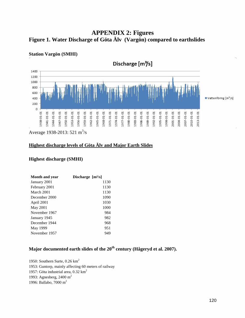
120
APPENDIX 2: Figures Figure 1. Water Discharge of Göta Älv (Vargön) compared to earthslides
Station Vargön (SMHI)
Average 1938-2013: 521 m
3/s
Highest discharge levels of Göta Älv and Major Earth Slides
Highest discharge (SMHI)
Month and year Discharge [m³/s]
January 2001 1130
February 2001 1130
March 2001 1130
December 2000 1090
April 2001 1030
May 2001 1000
November 1967 984
January 1945 982
December 1944 968
May 1999 951
November 1957 949
Major documented earth slides of the 20th
century (Hågeryd et al. 2007).
1950: Southern Surte, 0.26 km2
1953: Guntorp, mainly affecting 60 meters of railway
1957: Göta industrial area, 0.32 km2
1993: Agnesberg, 2400 m2
1996: Ballabo, 7000 m2

121
Figure 2. Water discharge of Ätran – Hillared and Yngeredsforsen
Station Hillared (SMHI)
Average 1997-2013: 11.9 m
3/s
Highest flood return frequency (60m3/s): 81 years
Station Yngeredsforsen (SMHI)
Average 1997-2013: 89 m
3/s
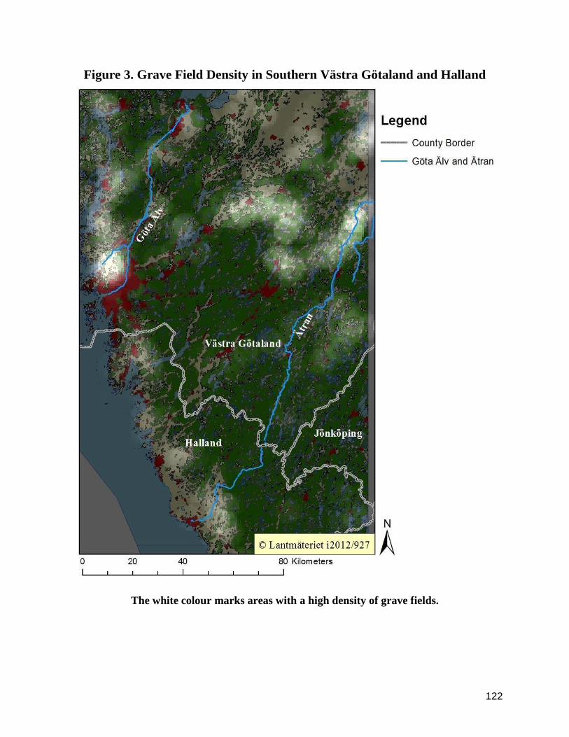
122
Figure 3. Grave Field Density in Southern Västra Götaland and Halland
The white colour marks areas with a high density of grave fields.

123
Figure 4. Hill Forts in the Göta Älv valley and on the coast of Bohuslän

124
Figure 5. Viewshed Analysis from the Hill fort RAÄ Trollhättan 161:1,
Åkerström

125
Figure 6. Alignment of Parish Borders to Göta Älv
Aligning parish borders are marked by a deep blue colour
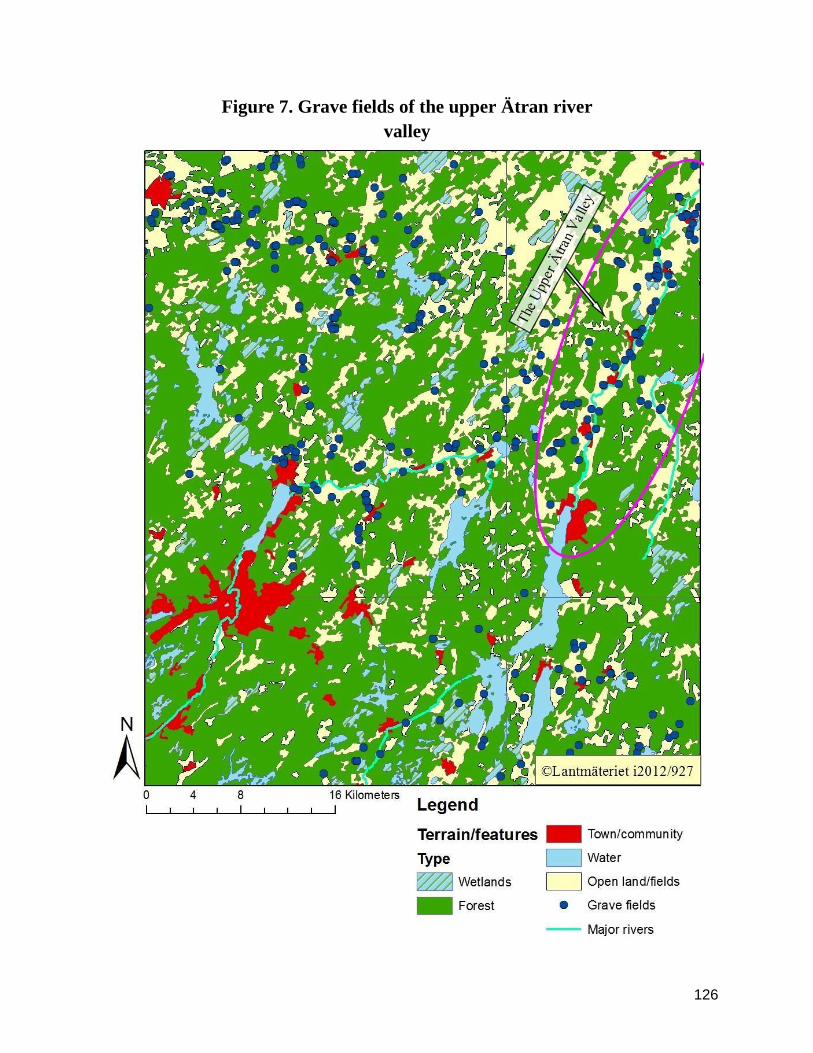
126
Figure 7. Grave fields of the upper Ätran river
valley
127
Figure 8. Prehistoric Graves and Roads: North of Östra Frölunda

128
Figure 9. Grave Mounds and Soil Types in Västra Götaland and Halland.

129
Figure 10. Map of Östra Frölunda 1732 (Lantmäteriet 0226-8:6): Ownership
of fields and meadows

130
Figure 11. Map of Östra Frölunda 1732 (Lantmäteriet 0226-8:6): Land use

131
Figure 12. Grave fields and mounds of the Ätran estuary.

132
Figure 13. Viewshed Analysis from Vinberg RAÄ 5:2

133
Figure 14. The Alignment of Parish Borders to Ätran
The aligning parish borders are marked by a deep blue colour.

134
Figure 15. 17th
century mills in Blidsberg (O3:71-72)