Embed Size (px)
Citation preview

LOGOAutomatic Land Parcel Valuation to Support
the Land and Buildings Tax Information System by Developing the Open Source
Software
Automatic Land Parcel Valuation to Support the Land and Buildings Tax Information System by Developing the Open Source
Software
Bambang Edhi Leksono, YulianaSusilowati,
Andriyan Bayu Suksmono
Graduate Program for Land Administration,Bandung Institute of Technology.
Labtek IX-C 3rd floor, Jl. Ganesha 10,Bandung, 40132, Indonesia.
Tel. +62 22 2530701Fax. +62 22 2530702
Email. [email protected]@bdg.centrin.net.id
AUTOMATIC LAND PARCEL VALUATION
The purpose of Land Valuation:
Provide a credible and realiable and cost-effective estimate
of land value as of given point in time

BACKGROUND
Multicolinearity
Uncertainty
VariableLocation
Non Linearity
Land Value CharacteristicLand Value
Characteristic
ANN MethodANN Method
MRA Method
Problem Identification &Conceptual Framework
Multiple Regression Analysis (MRA)
LAND VALUEMETHOD
Artificial Neural Network (ANN)
MRA is one of the most widely used method for land valuation models. MRA is
a statistically based analysis that evaluates linear relationship between a
dependent (response) variable and several independent (predictor variable),
and extracts parameter estimates for independent variables used collectively to estimate value in a mathematical model.
ANN is Computation method applies approach of pattern
recognition to solve problem. ANN can calibrate models that consist of both linear and nonlinear term
simultaneously.

RESEARCH QUESTION
1
What is the most significant Variabel of
the Land Value system?
3
How is the result of MRA method compare with
the ANN Method?
2
What is the most proper model of the Land Value
system?
OBJECTIVES
Objective
The aim of this study is to develop the automatic land valuation method using spatial analysis
and artificial neural network.

METHOD
Multiple Regression Analysis (MRA)
LAND VALUEMETHOD
Artificial Neural Network (ANN)
Case Study analysis in using MRA Method
Case Study analysis in using ANN Method
Comparison between of the result of MRA Method and ANN Method
Artificial Neural Network Method
Computational process
Mathematical ModelY = f(X) = v1 X-1 + v2 X-2 + v3 X-3 + ... +v23 X-23 + bj

Architecture of Artificial Neural Network
Mathematical Model:Hj = f(X) = v1 X-1 + v2 X-2 + v3 X-3 + ... +v23 X-23 + bjY = g(H) =g( f(X)) = w1 H-1 + w2 H-2 + w3 H3 + ... + w46 H-46 + bk
JL. KH A DAHLAN
01,000,0002,000,0003,000,0004,000,0005,000,0006,000,0007,000,000
0 500 1,000 1,500 2,000 2,500 3,000
JARAK
NILA
I TAN
AH
LAND VALUE VARIABLES
Central Business District
Higher Education Facility
Health Care Facility
Public School Facility
Transportation FacilityLand Land ValueValue

SPATIAL DATA OF LAND VALUEYEAR 2007
VARIABLES MEASUREMENT
Direct Measurement of Centroid Measurement of Buffer

Characteristic ofTransportation Facility to the Land Value
Scatter Diagram Nilai Tanah dan Jarak ke JL. KH A DAHLAN
0
1,000,000
2,000,000
3,000,000
4,000,000
5,000,000
6,000,000
7,000,000
0 500 1,000 1,500 2,000 2,500 3,000
JARAK
NILA
I TAN
AH
Characteristic ofCentral Business Distric to the Land Value
BANDUNG SUPERMALL
01,000,0002,000,0003,000,0004,000,0005,000,0006,000,0007,000,000
0 500 1,000 1,500 2,000 2,500 3,000 3,500
JARAK
NILA
I TAN
AH
ALUN-ALUN
01,000,0002,000,0003,000,0004,000,0005,000,0006,000,0007,000,000
0 1,000 2,000 3,000 4,000
JARAK
NILA
I TAN
AH
PASAR KOSAMBI
01,000,0002,000,0003,000,0004,000,0005,000,0006,000,0007,000,000
0 1,000 2,000 3,000 4,000
JARAK
NILA
I TAN
AHN
nila
i Tan
ah (R
p/m
2)
Nni
lai T
anah
(Rp/
m2)
Nni
lai T
anah
(Rp/
m2)
Jarak (m)Jarak (m)
Jarak (m)
JL. KH A DAHLAN
01,000,0002,000,0003,000,0004,000,0005,000,0006,000,0007,000,000
0 500 1,000 1,500 2,000 2,500 3,000
JARAK
NILA
I TA
NAH
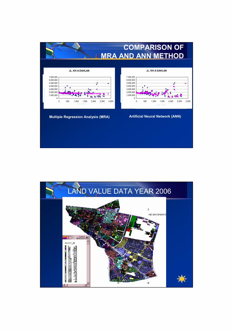
COMPARISON OF MRA AND ANN METHOD
JL. KH A DAHLAN
01,000,0002,000,0003,000,0004,000,0005,000,0006,000,0007,000,000
0 500 1,000 1,500 2,000 2,500 3,000
JARAK
NILA
I TAN
AH
JL. KH A DAHLAN
01,000,0002,000,0003,000,0004,000,0005,000,0006,000,0007,000,000
0 500 1,000 1,500 2,000 2,500 3,000
JARAK
NILA
I TAN
AH
Jarak (meter)Jarak (meter)
Nila
i Tan
ah (R
p/m
2 )
Nila
i Tan
ah (R
p/m
2 )
Multiple Regression Analysis (MRA) Artificial Neural Network (ANN)
LAND VALUE DATA YEAR 2006

LAND VALUE MODELMultiple Regression Analysis (MRA) Method
Contrast Land Value Variation
LAND VALUE MODEL Artificial Neural Network (ANN) Method
Smooth Land Value Variation

COMAPRISON OF THE RESULT
SPATIAL INTERPOLATION OFLAND VALUE DATA YEAR 2006

SPATIAL INTERPOLATION OF LAND VALUE MODELMultiple Regression Analysis (MRA) Method
SPATIAL INTERPOLATION OFLAND VALUE MODEL Artificial Neural Network (ANN) Method

COMAPRISON OFTHE RESULT
CONCLUSSION
Multiple regression analysis (MRA) is the most widely used method for calibrating model. The used of MRA has been the long standing choice for calibration of land value model. MRA is a statistically based analysis that evaluates linear relationship between a dependent (response) variable and several independent (predictor variable), and extracts parameter estimates for independent variables used collectively to estimate value in a mathematical model.
Artificial neural network can calibrate models that consist of both linear and nonlinear term simultaneously.

CONCLUSSION
LINEARITY ASSUMPTION CANNOT BE SUPPORTED BY THE LAND VALUE VARIABLES
THE USE OF NONLINEAR METHOD IS RECOMMENDED FOR THE LAND VALUE MODELING
The land value modeling using spatial analysis and artificial neural network is a promising method for the automatic land valuation activities.
LOGO