Embed Size (px)
Citation preview

The primary initiation of deep convection from boundary-layer convection during CSIP
School of Earth and EnvironmentNATIONAL CENTRE FOR ATMOSPHERIC SCIENCE (NCAS)
John Marsham1, Lindsay Bennett1 , Alan Blyth1, Keith Browning1, Peter Clark2,3, Qian Huang1,4, Cyril Morcette3, Doug Parker1, Tammy Weckwerth5.
1NCAS, The University of Leeds, UK
2The University of Reading, UK
3The Met Office Joint Centre for Mesoscale Meteorology (JCMM)
4Lanzhou University, China.
5TheNational Center for Atmospheric Research, USA.

Introduction
Overcoming CIN is a necessary but not sufficient condition for initiation of deep convection (E.g. Ziegler and Rasmussen, 1998). Dilution of initially buoyant parcel can restrict depths of clouds (E.g. Redelsperger et al, 2002, Chaboureau et al, 2004) According to Neggers et al 2002 and Houston and Niyogi 2007, the dilution is greater for less buoyant parcels
Therefore lids (e.g. Bennett et al, 2009) should affect dilution.
Therefore to forecast initiation must predict: Not only the synoptic and mesoscale and controls of “source air” and
“profile” (lifting, warming/moistening) but also CBL scale, entrainment and mixing.

(1)Interaction of synoptic and mesoscalesE.g. CSIP IOP 1, Morcrette et al, 2007
200 km
200 km
200 km
Meteosat (visible)
Radar rainrate
Meteosat: water vapour
Chilbolton radar cross section
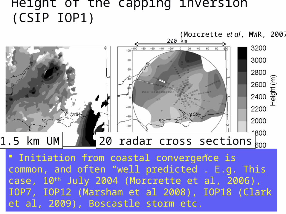
Height of the capping inversion (CSIP IOP1)
1.5 km UM 20 radar cross sections
Lifting of lid well modelled (coastal convergence and PV anomaly)
(Morcrette et al, MWR, 2007)200 km
Initiation from coastal convergence is common, and often “well predicted”. E.g. This case, 10th July 2004 (Morcrette et al, 2006), IOP7, IOP12 (Marsham et al 2008), IOP18 (Clark et al, 2009), Boscastle storm etc.
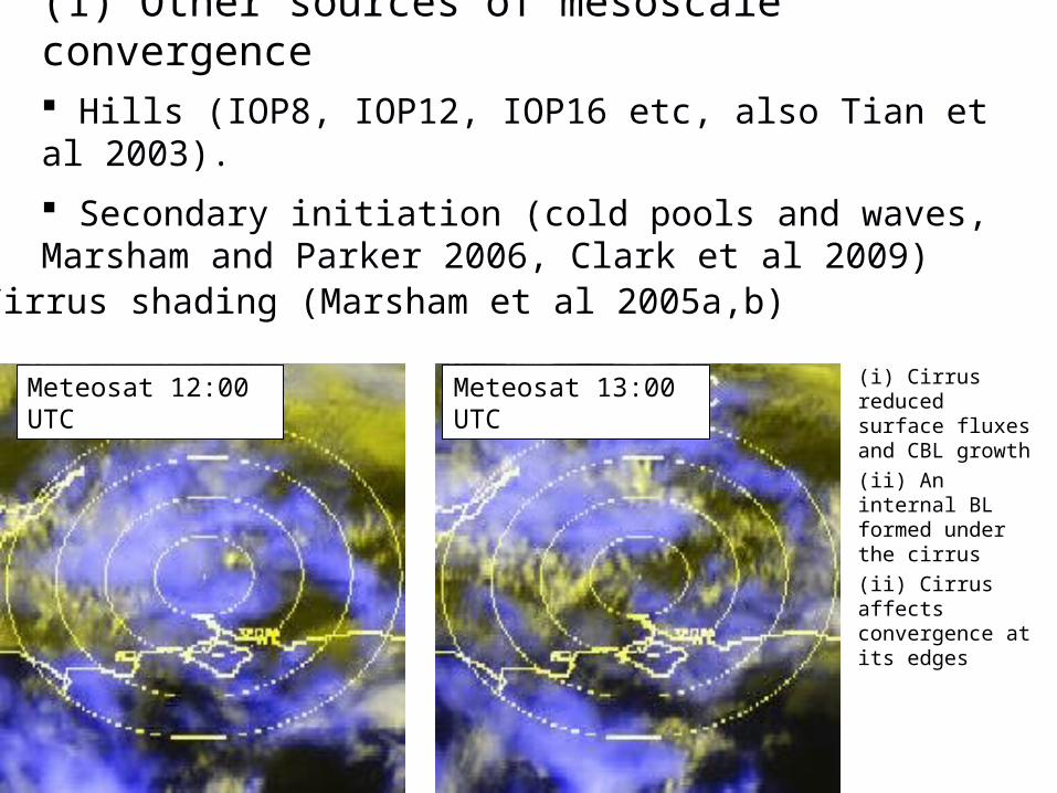
(1) Other sources of mesoscale convergence Hills (IOP8, IOP12, IOP16 etc, also Tian et al 2003).
Secondary initiation (cold pools and waves, Marsham and Parker 2006, Clark et al 2009)
Meteosat 12:00 UTC
Meteosat 13:00 UTC
Cirrus shading (Marsham et al 2005a,b)
(i) Cirrus reduced surface fluxes and CBL growth
(ii) An internal BL formed under the cirrus
(ii) Cirrus affects convergence at its edges

3) CBL scale variability
Rolls are ubiquitous. E.g. for 22 out of 44 days during TRMM-LBA the initial storms were initiated from rolls (Lima & Wilson, 2008).
E.g. Weckwerth et al, 1996, CBL roll updrafts are:
(i) 0.5 K warmer and up to 2.5 g/kg moister
(ii) Consistent with the observed LCL.
Weckwerth, 2000: Can predict storms from soundings, only if BL variability is accounted for using aircraft data.
Storms
No storms
CIN (J/kg)
CA
PE
(J/
kg)

CSIP IOP 12: Observed initiation from BL rolls
Meteosat Visible
10 UTC (almost no precipitation)
50 km
Chilbolton radar
Spacing ~ 6km
Larkhill
Swanage
Radar cross-section
(Extended abstract: Marsham et al, ICCP, Cancun, Mexico, 2008)

CSIP IOP 12: Multiple lids
Lid 3 (CIN)
Lid 2 (CIN)
Lid 1 (CIN)
11:00 UTC

CSIP IOP 12: Observed initiation from BL rolls
Meteosat Visible
12 UTC (significant precipitation)
Spacing ~12 km
Radar cross section
Apparent Doubling of spacing as clouds broke through from “Lid 2” to “Lid 3”.
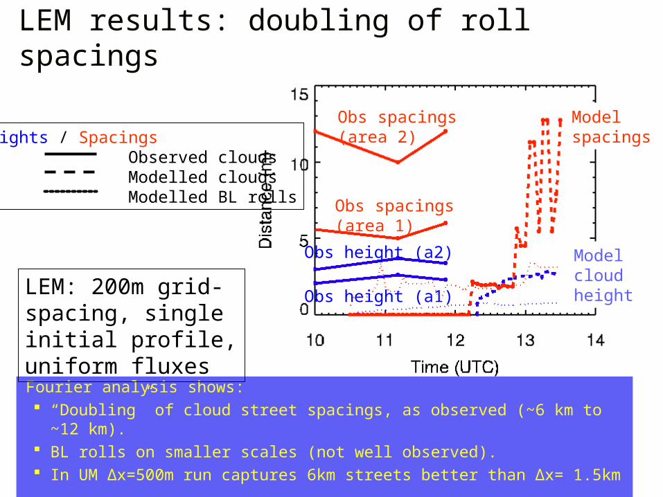
LEM results: doubling of roll spacings
Fourier analysis shows: “Doubling” of cloud street spacings, as observed (~6 km to ~12 km). BL rolls on smaller scales (not well observed). In UM Δx=500m run captures 6km streets better than Δx= 1.5km
Obs height (a2)
Obs spacings(area 2)
Obs height (a1)
Obs spacings (area 1)
Heights / Spacings Observed clouds Modelled clouds Modelled BL rolls
Model spacings
Model cloud heightLEM: 200m grid-
spacing, single initial profile, uniform fluxes
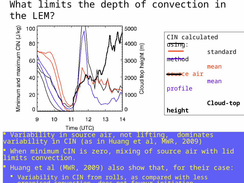
What limits the depth of convection in the LEM?
Variability in source air, not lifting, dominates variability in CIN (as in Huang et al, MWR, 2009) When minimum CIN is zero, mixing of source air with lid limits convection. Huang et al (MWR, 2009) also show that, for their case:
Variability in CIN from rolls, as compared with less organised convection, does not favour initiation.
CIN calculated using: standard method mean source air mean profile
Cloud-top height

CSIP IOP8: Larger CBL variations
IOP 814:02 UTC
Convection capped by dry lid
Aircraft data: strong CBL thermals
< (4 ms-1, 1 gkg-1, 1 K). Bennett, PhD, 2009.

Effects of moisture above the BL – IOP 8
Initial WVMR
LWPCloud-top & base
IOP 8: LEM initialised using 14:00 UTC radiosonde profile ( ), dry layer at 2 km to 3 km ( ) and 3 km to 4 km ( ).
WVMR
500 m
1200 m
CSIP IOP8: Dilution, the role of water vapour in the FT
Reduced humidity in lower FT, reduces cloud-top heights and LWP.
Conclusions Initiation of convection during CSIP occurred as a result of a wide variety of synoptic, meoscale and CBL-scale processes.
Many papers have evaluated the sources, predictability and model representations of synoptic/mesoscale processes.
Work ongoing on the coupling of CBL (BL rolls and thermals) with the larger scales.
Main impact of BL convection is source air variability
Overcoming CIN is a necessary but not sufficient condition for initiating deep convection – entrainment can restrict otherwise buoyant clouds.
E.g. CSIP IOP8, half hour delay in LEM for a drier FT
The overall importance of accurately representing CBL processes and entrainment in the moist maritime environment of the UK is unclear.