Embed Size (px)
Citation preview

506
Bulletin of the Seismological Society of America, Vol. 94, No. 2, pp. 506–530, April 2004
The Offshore Palos Verdes Fault Zone near San Pedro, Southern California
by Michael A. Fisher, William R. Normark, Victoria E. Langenheim, Andrew J. Calvert,and Ray Sliter
Abstract High-resolution seismic-reflection data are combined with a variety ofother geophysical and geological data to interpret the offshore structure and earth-quake hazards of the San Pedro shelf, near Los Angeles, California. Prominent struc-tures investigated include the Wilmington graben, the Palos Verdes fault zone, vari-ous faults below the west part of the San Pedro shelf and slope, and the deep-waterSan Pedro basin. The structure of the Palos Verdes fault zone changes markedlyalong strike southeastward across the San Pedro shelf and slope. Under the northpart of the shelf, this fault zone includes several strands, with the main strand dippingwest. Under the slope, the main fault strands exhibit normal separation and mostlydip east. To the southeast near Lasuen Knoll, the Palos Verdes fault zone locally islow angle, but elsewhere near this knoll, the fault dips steeply. Fresh seafloor scarpsnear Lasuen Knoll indicate recent fault movement. We explain the observed struc-tural variation along the Palos Verdes fault zone as the result of changes in strikeand fault geometry along a master right-lateral strike-slip fault at depth. Complicatedmovement along this deep fault zone is suggested by the possible wave-cut terraceson Lasuen Knoll, which indicate subaerial exposure during the last sea level lowstandand subsequent subsidence of the knoll. Modeling of aeromagnetic data indicates alarge magnetic body under the west part of the San Pedro shelf and upper slope. Weinterpret this body to be thick basalt of probable Miocene age. This basalt massappears to have affected the pattern of rock deformation, perhaps because the basaltwas more competent during deformation than the sedimentary rocks that encased thebasalt. West of the Palos Verdes fault zone, other northwest-striking faults deformthe outer shelf and slope. Evidence for recent movement along these faults is equivo-cal, because we lack age dates on deformed or offset sediment.
Introduction
Numerous thrust and strike-slip faults crosscut the re-gion that includes the city of Los Angeles, southern Cali-fornia (Fig. 1), and they pose a significant earthquake hazardto this burgeoning population center (e.g., Wright, 1991; Do-lan et al., 2000). Much effort has been expended to locateand determine the displacement history of these faults; evenso, a category of fault that remains poorly understood in-cludes active offshore faults within about 50 km of the coast.Largely because of a lack of information, such faults areoften omitted from models of tectonic evolution and esti-mates of regional seismic hazard.
Historical seismicity indicates that offshore faults canunleash earthquakes with at least moderate magnitude (Astizand Shearer, 2000). In 1933, a large (MW 6.4) offshore earth-quake near Long Beach probably struck along the Newport–Inglewood fault (Barrows, 1974; Hauksson and Gross,1991). Offshore epicenters in and around the study area arediffuse but tend to cluster over the western San Pedro shelfand eastern San Pedro Basin (Fig. 1). Two moderate, off-
shore earthquakes (M 5.2 in 1979 and M 5.0 in 1989) oc-curred near the coastal town of Malibu (Hauksson and Sal-divar, 1986; Johnson and Acosta, 1989) (see inset to Fig. 1).No large earthquakes have occurred along the Palos Verdesfault zone, which strikes generally southeast across the studyarea (Fig. 1). However, McNeilan et al. (1996) estimatedthat this fault could produce an earthquake as large as M 7.
The dearth of information about Holocene activity alongoffshore faults provided the impetus to study the geologicstructure offshore from southern California. During 1998through 2000, the U.S. Geological Survey (USGS) collectedhigh- and medium-resolution, marine seismic-reflection data(Fig. 2) with the goal of locating active faults and estimatingtheir displacement histories. A related research goal is un-derstanding the susceptibility of the offshore region to earth-quake-induced landslides and consequent local tsunamis.The Portuguese Bend landslide on the Palos Verdes Penin-sula (e.g., Woodring et al., 1946) and offshore landslidesevident in seismic-reflection and multibeam bathymetric

The Offshore Palos Verdes Fault Zone near San Pedro, Southern California 507
Figure 1. Location of the study area near the San Pedro shelf, as well as the mainfaults, epicenters (epoch 1978–1998; Astiz and Shearer [2000]), and bathymetry. Theshort-dashed line labeled “WA” shows the axis of the Wilmington anticline.
data (e.g., Locat and Lee, 2002) indicate that local sedimentbodies under the seafloor are susceptible to catastrophicdownslope movement.
In this article, we focus on the offshore structure andstratigraphy southeastward from the Palos Verdes Peninsulato near Dana Point (Fig. 1). This area includes the PalosVerdes (Fischer et al., 1987; McNeilan et al., 1996) andNewport–Inglewood faults (Barrows, 1974; Fischer, 1992)that are thought to play key roles in the regional earthquakehazard. In particular, we document the detailed changes instructure along the strike of the offshore Palos Verdes faultzone.
Geophysical Data
Seismic-Reflection Data
Multichannel seismic (MCS) reflection data used herein(Fig. 2) were collected by the USGS during three cruises(Normark et al., 1999a,b; Gutmacher et al., 2000). The seis-
mic system included a 24-channel streamer with 10-m-longhydrophone sections. The resulting, 5-m common-depth-point interval provided high spatial resolution. The soundsource was a dual-chambered generator-injector airgun; bothchambers had a volume of 35 in3. The airgun was suspendedfrom a float to maintain a constant source depth of 1 m, andthe airgun was fired every 12 sec with an air pressure of3000 psi.
Deep-crustal MCS data, collected in 1994 off southernCalifornia for the Los Angeles Regional Seismic Experiment(LARSE) (see Fig. 2 for seismic line location) (Brocher etal., 1995), are 40-fold and were collected aboard the R/VMaurice Ewing, using a source array of 20 airguns with atotal chamber volume of 137.7 L (8470 in3). The digitalstreamer was 4200 m long and had 160 data channels.
Potential-Field Data
Offshore aeromagnetic data were obtained during a re-gional survey (Langenheim et al., 1993) flown along flight-

508 M. A. Fisher, W. R. Normark, V. E. Langenheim, A. J. Calvert, and R. Sliter
Figure 2. Tracklines of small airgun seismic-reflection data obtained during 1997–1998 by the USGS. These data were obtained with a 240-m-long streamer and witheither a generator-injector airgun (each chamber was 35 in3) or a 40 in3 Bolt airgun.Location of LARSE 1 deep crustal seismic-reflection line is also shown (Brocher et al.,1995). “MCS 125” and “MCS 129” indicate multichannel seismic-reflection data col-lected by the USGS during 1990.
lines spaced 1.6 km apart. A magnetic high is located overthe western San Pedro shelf, where seismic lines 115 and200 intersect (Fig. 3, top). To help delineate the outline ofthe magnetic body (shown as a dashed line in both parts ofFig. 3), we used a computer algorithm to locate the maxi-mum horizontal gradient of the magnetic field.
Offshore gravity values (Fig. 3, bottom) are from a 3-km grid of gravity measurements derived from scatteredfield data collected by the National Oceanic and Atmo-spheric Administration and the USGS and reduced to iso-static gravity values. These gravity data are accurate to sev-eral milligalileos, so they are suitable for regional but notdetailed studies, and these data reveal mainly density vari-ations within the middle and upper crust.
Tectonic Evolution and Regional Geology
The study area includes the San Pedro continental shelfand the eastern part of the deep-water San Pedro basin,which lie west of the Los Angeles basin (Fig. 1), within theinner California Continental Borderland (CCB). During theearly Miocene, lower crustal rocks were unroofed and ex-posed in wide areas of the CCB, when part of the Farallonoceanic plate that lay west of southern California stoppedsubducting and began to move northward with the Pacificplate (Nicholson et al., 1994; Atwater and Stock, 1998).During this tectonism, regional oblique rifting and strike-slip deformation replaced margin-normal subduction. Theresulting oblique extension of the continental margin isthought to have occurred simultaneously with the clockwiserotation of the Transverse Ranges (Luyendyk et al., 1980;

The Offshore Palos Verdes Fault Zone near San Pedro, Southern California 509
Figure 3. (Top) Aeromagnetic anomaly map of the study area. An aeromagneticanomaly near the northwest corner of the Palos Verdes Peninsula occurs near an on-shore basalt outcrop, and a well within the outline of this anomaly penetrated thickMiocene basalt. Gravity and magnetic models of the isolated anomaly over the westernSan Pedro shelf are shown in Figure 2. Ages of seafloor rocks are from Nardin andHenyey (1978). Onshore geology is from Woodring et al. (1946). (Bottom) Isostaticgravity map of the study area.

510 M. A. Fisher, W. R. Normark, V. E. Langenheim, A. J. Calvert, and R. Sliter
Kamerling and Luyendyk, 1985; Crouch and Suppe, 1993;Nicholson et al., 1994). Blueschist- and amphibolite-faciesmetamorphic rocks from the former subduction zone wereuplifted from lower-crustal depths and exposed at the sur-face. These rocks, which typically outcrop as the CatalinaSchist, make up the basement complex beneath much of theinner CCB. Within the study area, this basement complex isburied beneath sedimentary rocks no older than Miocene.Middle Miocene volcanism that followed the crustal exten-sion (Dickinson, 1997) produced pillow basalt and basaltsills exposed on the Palos Verdes Peninsula (Woodring etal., 1946; Conrad and Ehlig, 1987; Stanley et al., 2000)(Fig. 4).
In late Pliocene and Quaternary time, mainly the last 4Ma, extensionally deformed rocks of the continental marginwere involved in regional transpression (e.g., Wright, 1991;Crouch and Suppe, 1993). During the tectonic transitionfrom extension to transpression, some middle Miocene nor-mal and oblique-normal faults were reactivated as reverseand strike-slip faults (Rivero et al., 2000). Blind thrust faultsand fault-propagation folds also may have begun to formoffshore and beneath the densely populated Los Angeles re-gion (e.g., Namson and Davis, 1990; Shaw and Suppe,1996). Near the San Pedro shelf, evidence for the Plioceneonset of this transpressive deformation comes from oil in-dustry wells that penetrate the large Wilmington anticline.This anticline (axis shown in Fig. 1) deforms rocks northeastof the study area but did not exist prior to deposition of upperMiocene and lower Pliocene rocks (Olson, 1974). Transpres-sive folding of this anticline apparently was completed be-fore the end of the late Pliocene (Truex, 1973).
Onshore Rocks
On the Palos Verdes Peninsula, metamorphic basementrocks are overlain with marked unconformity by a middleMiocene through Pliocene sedimentary succession that issimilar to rock sequences encountered in offshore oil wellsand revealed in MCS data (e.g., Fischer et al., 1987; Wright,1991). Under the peninsula, middle and late Miocene, deepmarine rocks form a thick, heterogeneous sequence assignedto the Monterey Formation (Woodring et al., 1946; Conradand Ehlig, 1987; Barron and Isaacs, 2001) (Fig. 4). Thisformation includes not only cherty and phosphatic shale butalso volcanic tuff and basalt. The volcanic rocks have beendated to between 15 and 14 Ma (Conrad and Ehlig, 1987;Henry, 1987; Stanley et al., 2000). Lower Pliocene rocks onthe Palos Verdes Peninsula unconformably overlie the Mon-terey Formation, and upper Pliocene rocks are absent.
Rocks under the Palos Verdes Peninsula have long at-tracted the attention of geologists because rapid uplift duringQuaternary time caused an impressive flight of wave-cut ter-races to develop (Woodring et al., 1946; Bryan, 1987; Wardand Valensisie, 1994). A concern of seismologists is that thisintense deformation extends south of the Palos Verdes Pen-insula to involve offshore faults. This possibility has beendifficult to evaluate, given the generally featureless mor-
phology of the San Pedro shelf, which is broad, flat, andshallow, most of it is less than 50 m deep (Fig. 1).
Age of Offshore Rocks
The offshore stratigraphy is known primarily from oilindustry coring and drilling. Numerous shallow cores, ob-tained south of the Palos Verdes Peninsula and west of thePalos Verdes fault zone, show that middle Miocene throughPliocene rocks are exposed at the seafloor in a southeast-trending zone near the shelf break (Nardin and Henyey,1978) (Fig. 4). These seafloor rocks cause high backscatterin multibeam bathymetric data. Seismic-reflection data ob-tained over these outcrops show that reflections from Mio-cene and Pliocene rocks are distinctively parallel and con-tinuous over long distances (10–20 km).
Other information concerning the age of offshore rockscomes from geologic cross sections based on well data fromthe Beta oil field (Henry [1987]; figure 13 of Wright [1991]).Comparison of one cross section (Wright [1991], cross sec-tion location shown Fig. 4) to depth-converted, USGSseismic-reflection data (Fig. 5) reveals not only the probablethickness and age of rocks on opposite sides of the PalosVerdes fault zone, but also the depth to crystalline basementon the west side of the fault. The comparison indicates that,near the Beta oil field and west of the Palos Verdes faultzone, Quaternary sediment is thin or absent and that Mioceneand Pliocene rocks are exposed at the seafloor. This exposureagrees with findings from the shallow coring mentioned ear-lier. East of the Palos Verdes fault zone, however, late Pli-ocene and Quaternary rocks and sediment aggregate in thick-ness to as much as 1.5 km.
Depth to Offshore Metamorphic Basement
In general, reflections from the top of metamorphic base-ment are not apparent in small airgun, seismic-reflection datadescribed here, but evidence from rock outcrop, oil industryoperations, and seismic-refraction data all indicate that thisbasement lies at relatively shallow depth (�3 km) beneaththe shelf and slope.
Regionally, the depth to basement decreases westwardfrom within the Los Angeles basin toward the offshore studyarea, and basement deepens offshore, southeastward from itscrop out on the Palos Verdes Peninsula (e.g., Olson, 1974;Fischer et al., 1987; Wright, 1991). This configuration isdemonstrated primarily by information complied from oilindustry sources. For example, regional cross sections byseveral authors indicate that east of the Palos Verdes faultzone and Peninsula, the top of basement is mainly 1–1.5 kmdeep (sections 5 and 12 of Davis and Namson [2002]; lo-cations shown in Fig. 4). The top of basement deepens south-eastward into the offshore area to a depth of about 3 km.
Another regional cross section, constructed in part fromdepth-converted seismic-reflection data (Shaw, 1999) (sum-marized in Fig. 5, bottom; section location shown in Fig. 2),indicates that basement rocks below the coast southwest of
The Offshore Palos Verdes Fault Zone near San Pedro, Southern California 511
Figure 4. Locations of regional cross-sections compiled by various authors anddiscussed in the text. A cross section through the Beta oil field (Wright, 1991) showsthe approximate age of basin fill in Figure 5. Biostratigraphic data from strata exposedat the seafloor are from Nardin and Henyey (1978). Onshore geology of the PalosVerdes Peninsula is from Woodring et al. (1946).
the Newport–Inglewood fault were encountered in a well atabout 3-km depth. A cross section through the Beta oil field(figure 13 in Wright [1991]) provides the only direct infor-mation we have on basement depth southwest of the PalosVerdes fault zone, where an oil well encountered basementrocks at about 2.5 km depth (Fig. 5).
Basement depth determined from drilling in the Betafield compares favorably to the depth estimated from to-mographic analysis of wide-angle seismic data collected dur-ing the LARSE experiment (ten Brink et al., 2000) (locationof LARSE 1 seismic-reflection line shown in Fig. 2). Assum-ing that rock velocities exceeding 5 km/sec indicate acousticbasement, either volcanic or metamorphic rock, then north-east of the Palos Verdes fault zone, basement is 2.5–3 kmdeep, and southwest of this fault zone, basement is about2.5 km deep and deepens to the southwest.
Previous Findings about the Main Offshore Structures
The major offshore faults include the Newport–Inglewood, Thums–Huntington Beach, and Palos Verdesfault zones (Fig. 1). The Newport–Inglewood fault exhibitsright-lateral strike-slip motion and either forms the contactbetween different basement types or closely follows thiscontact (Barrows, 1974; Wright, 1991; Bohannon and Geist,1998). North and east of this fault, basement rocks consistof Jurassic and Cretaceous crystalline continental crust, typ-ical of the Peninsular Ranges, whereas south and west of thefault, the basement is Catalina Schist. The 1933 Long Beachearthquake (MW 6.4) probably occurred along the Newport–Inglewood fault (Hauksson and Gross, 1991) and was thelargest recorded earthquake to have struck near the coast.
The Thums–Huntington Beach fault splays southeast-

512 M. A. Fisher, W. R. Normark, V. E. Langenheim, A. J. Calvert, and R. Sliter
Figure 5. Comparison of depth-convertedseismic-reflection data from this study withstratigraphic information from the Beta oilfield (Wright, 1991). Rocks west of the PalosVerdes fault zone are mainly Miocene and Pli-ocene in age, whereas thick late Pliocene andQuaternary rocks and sediment lie on this faultzone’s east side.
ward away from the Palos Verdes fault zone (Wright, 1991)(Fig. 1). Interpretive cross sections differ on fundamentalissues about this fault in that one shows a normal fault thatdips east and is downthrown on the east (Wright, 1991);another section shows that it dips west and is downthrownon the west and merges downward with the Palos Verdesfault zone (Davis and Namson, 2002).
The Palos Verdes fault zone has been postulated to ex-tend southeastward from the northern part of Santa MonicaBay and to continue southwest of Lasuen Knoll (e.g., Greeneand Kennedy, 1987; Legg et al., 1991; Wright, 1991)(Fig. 1). Although the Palos Verdes fault zone has been pos-tulated to end in the northwest below northern Santa Monica
Bay, no indication of a recently active part of this fault hasbeen observed in high-resolution seismic-reflection data col-lected in the southern part of this bay (Nardin and Henyey,1978; Fisher et al., 2003). Where the Palos Verdes fault zonepasses northeast of the Palos Verdes Peninsula, the totalfault-slip rate appears to be around 3 mm/yr, based on anal-ysis of wave-cut terraces and offset stream courses (Wardand Valensisie, 1994; McNeilan et al., 1996). McNeilan etal. (1996) proposed that in the recent past, the main style ofmovement along the Palos Verdes fault zone has been strikeslip. Multibeam bathymetric data show recent scarps alongthis fault near Lasuen Knoll (Marlow et al., 2000).
The geometry of the Palos Verdes fault zone at depth is

The Offshore Palos Verdes Fault Zone near San Pedro, Southern California 513
not well characterized. Davis and Namson (2002) depictedthis fault zone with a steep southwestern dip (about 60�) inthe upper 5 km of the crust, and below 7 km, the dip wasproposed to shallow to about 25� southwest. Similarly, Shaw(1999) indicated that the Palos Verdes fault zone is steep tovertical in the upper 5 km of the crust, and at greater depth,the fault dips about 30� southwest (Fig. 6, bottom). A stackof LARSE MCS data shows a similar west-dipping fault ge-ometry (Fig. 6, top). However, cross sections by Wright(1991) depict the Palos Verdes fault zone as a vertical orsteeply east-dipping, strike-slip fault, at least for depths shal-lower than about 9 km.
Offshore Structure from Seismic-Reflection Data
To facilitate discussion, we divide the study area intotwo structural belts that are separated by the Palos Verdesfault zone. The eastern belt includes the Wilmington graben(Fig. 1), which includes a thick (1–2 km) section of Quater-nary rocks and sediment. The western structural belt includesvariably deformed, primarily Miocene and Pliocene rocksthat lie west of the Palos Verdes fault zone.
Structural Belt East of the Palos Verdes Fault Zone:The Wilmington Graben
The eastern belt includes the Wilmington graben, whichis an elongate, nearshore basin confined between theNewport–Inglewood and Palos Verdes fault zones (Fig. 1).(The term “Wilmington graben” [Fischer et al., 1987] issomewhat misleading because the graben is bounded bywhat are probably strike-slip, not normal, faults. Even so,we use this term because of its precedence in the literatureand common usage.) The Thums–Huntington Beach faultdeforms rocks within the graben (Fig. 2). Unfortunately, ow-ing to environmental restrictions placed on our surveys, noneof our seismic-reflection lines crosses this fault. However,geologic cross sections published elsewhere show this fault’sstructure (see section locations in Fig. 4). For example,Wright (1991) showed that the northeast side of this faultdropped down, forming the large Wilmington anticline.
Rocks within the Wilmington graben are only mildlydeformed, except in the far western part of the graben, di-rectly adjacent to the Palos Verdes fault zone (Fig. 7; loca-tion shown in Fig. 2). Seismic-reflection data indicate thatvery shallow strata within the graben are subhorizontal andoverlie a shallow unconformity (at a travel time of about0.2 sec), but this relationship is largely obscured by water-bottom multiples. This unconformity and the uppermost partof the section in the Wilmington graben are deformed byand extend cross the Palos Verdes fault zone, indicating rela-tively recent fault movement. The unconformity truncatesthe tops of underlying beds that have an apparent southwestdip. Down to a travel time of about 0.8 sec (about 800-mdepth), a deltaic sequence progrades across the graben in anapparent southwestward direction. A reverse fault within thegraben (Fig. 7; below shotpoint [SP] 1500) offsets this un-conformity but does not extend far upward through the over-
lying rocks. A third unconformity is evident on the right halfof Figure 7, at a travel time of 1.5 sec.
The Wilmington graben ends to the southeast along theeast-striking part of the continental slope that delimits theSan Pedro shelf (Fig. 2). This graben probably ends belowthe east-striking part of the continental slope that bounds theSan Pedro shelf on the southeast. However, our MCS datado not reveal the structure where the graben ends. In the farsoutheastern part of the study area, east of Lasuen Knoll, theNewport–Inglewood fault and the Palos Verdes fault zonediverge, and the widening deep-water area between thesefaults has received extensive and thick turbidite fill fromchannels that make up the Newport Canyon.
Structural Variation along the Palos VerdesFault Zone
The Palos Verdes fault zone is the most prominent andarguably the most complicated structure revealed by ourseismic-reflection data. The fault zone separates the foldedshelf rocks, primarily of Miocene and Pliocene age, that oc-cur west of the Palos Verdes fault zone (Nardin and Henyey,1978) from a thick (1-km typical) section of mainly flat-lying upper Pliocene and Quaternary rocks and sedimentalong the fault’s east side (Fig. 5).
Cross sections (locations shown in Fig. 4) indicate thatat shallow depth (�1 km) under the San Pedro shelf, thePalos Verdes fault zone is nearly vertical but that it curvesdownward to dip steeply west. This west dip is also evidentin a stack of MCS reflection data obtained along LARSE line1 (Fig. 6, top). MCS data in Shaw (1999) (Fig. 6, bottom)depict this fault zone with a west dip and indicate that rocksbelow about 1 km depth along the west side of the fault dipeast and terminate against the fault plane.
Small airgun, seismic-reflection data (Plate 1 [unboundinsert to this issue]) reveal that at shallow depth (�1 km)under the northern San Pedro shelf, the Palos Verdes faultzone dips steeply west or is vertical (Plate 1, seismic-reflec-tion sections 115 and 118). Also shallow strata within theWilmington graben extend westward through the Palos Ver-des fault zone, are offset by the fault strands, and appear tooverlie unconformably Miocene and Pliocene rocks on thefault’s west side.
The intensity of compressional deformation decreasessoutheastward across the San Pedro shelf. In particular, theanticline along the west side of the fault zone (Plate 1; seis-mic section 115) decreases in structural relief and broadenssoutheastward (Plate 1; seismic section 118). Southeast ofthe shelf, below the upper part of the slope, this anticlinedies out entirely, as little trace of it appears on seismic sec-tion 84 (Plate 1). In fact, this section shows that faults alongthe projected location of the Palos Verdes fault zone all ex-hibit normal separation. Such faults are more readily evidenton seismic-reflection section 66 (Plate 1), where the mainfault strands dip east.
A bathymetric saddle, where the seafloor attains a depthas great as 500 m, separates the southeastern edge of the San

514
Figu
re6.
(Top
)St
ack
ofL
AR
SElin
e1,
deep
-cru
stal
,se
ism
ic-r
eflec
tion
(Bro
cher
etal
.,19
95)
data
obta
ined
acro
ssth
eSa
nPe
dro
shel
fan
dth
ePa
los
Ver
des
faul
tzo
ne(s
eism
iclin
elo
catio
nsh
own
inFi
g.2)
.T
hese
data
show
that
the
faul
tzo
nedi
psw
est
atla
rge
trav
eltim
es.(
Bot
tom
)A
sim
plifi
edvi
ewof
the
com
posi
tecr
oss
sect
ion
bySh
aw(1
999)
(loc
atio
nsh
own
inFi
g.3
top)
,whi
chsh
ows
one
inte
rpre
tatio
nof
the
deep
-cru
stal
stru
ctur
eof
the
Palo
sV
erde
sfa
ult
zone
.

515
Figu
re7.
Seis
mic
sect
ion
over
the
Palo
sV
erde
sfa
ult
zone
and
Wilm
ingt
ongr
aben
unde
rth
eSa
nPe
dro
shel
f.Se
ctio
nlo
catio
nis
show
nin
Figu
re2.

516 M. A. Fisher, W. R. Normark, V. E. Langenheim, A. J. Calvert, and R. Sliter
Figure 8. Oblique view to the northwest of multibeam bathymetric data over theSan Pedro shelf and Lasuen Knoll (Gardner and Dartnell, 2002). Annotation on thefigure such as “84:1800” refers to seismic section 84, SP 1800 on Plate 1. Dashed linesshow interpreted faults.
Pedro shelf from the high-standing Lasuen Knoll (bathy-metric contours shown in Fig. 1 and the index map in Plate1). An oblique view of multibeam bathymetric data obtainedover the San Pedro shelf and slope (Fig. 8) shows the incisedhead of the San Gabriel Canyon at the southeastern edge ofthe San Pedro shelf. This channel head is located where un-derlying rocks are deformed by normal faults that make upthe Palos Verdes fault zone, suggesting that the extensionaldeformation helped determine the course of the channel’supper reach. The San Gabriel Canyon crosses the PalosVerdes fault zone at a highly oblique angle, and this channelis not obviously deflected, either horizontally or vertically.This channel, however, does bifurcate near this crossing:
One channel branch extends southeastward along the westscarp of the Lasuen Knoll, following the Palos Verdes faultzone (Marlow et al., 2000). The other channel branch veerssouthwest across the floor of the San Pedro basin.
The bathymetric saddle marks an important structuraltransition along the Palos Verdes fault zone, because south-eastward through the saddle both the dip and the vergencedirection of the fault zone change. The sequence of seismicsections 67, 81, and 80 (Plate 1) shows that near LasuenKnoll, this fault zone exhibits reverse separation and dipseast, which is opposite to the west dip of the fault under thenorthern San Pedro shelf. This east dip is apparent on seis-mic section 67. The dip change of the Palos Verdes fault
The Offshore Palos Verdes Fault Zone near San Pedro, Southern California 517
zone occurs under the bathymetric saddle and possibly underthe zone of normal faults described earlier.
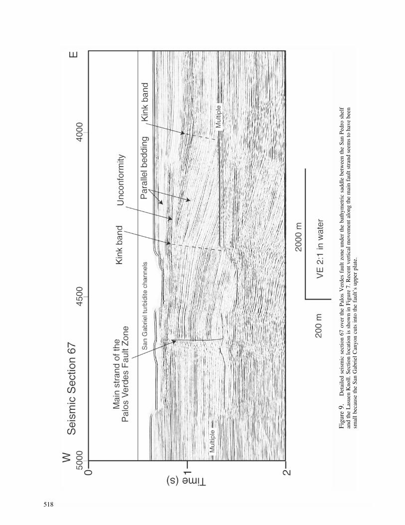
Seismic section 66 (Plate 1) shows that rocks within theWilmington graben flex upward along a short-radius foldthat clearly does not include shallow faulting. However,faulting becomes progressively more apparent southeast-ward along the east boundary of the dipping rocks. For ex-ample, kink bands clearly evident on seismic section 67(Plate 1 and Fig. 9; below SPs 4000 and 4300) reveal to-pography on the plane of an underlying, east-dipping thrustfault. The underlying fault lies below the depth of penetra-tion of our seismic-reflection data; even so, we interpret thisfault to be the Palos Verdes fault zone.
Clear faulting along the east flank of the dipping rocksection is shown by seismic section 80 (Plate 1, below SP1500), where the dip change occurs along a west-dippingfault, showing reverse separation, that offsets very shallowsediment and perhaps the seafloor. The increased intensityof faulting along this zone to the southeast mirrors theheightened bathymetric expression of the knoll.
A shallow unconformity that truncates east-dippingrocks in the Wilmington graben (Fig. 9) crosses the PalosVerdes fault zone. Strongly but irregularly reflective stratareveal coarse deposits, probably channel-fill and (or) lobedeposits, within the San Gabriel turbidite system that overliethis unconformity. Complex reflections from these depositsfoiled our attempt to determine whether or not the uncon-formity extends unbroken across the Palos Verdes faultzone. However, between SPs 4000 and 4200 (Fig. 9), east-dipping rocks under the unconformity are parallel beddedand dip east; in contrast, strata above the unconformity areflat lying. These relationships suggest that along the PalosVerdes fault zone near the north part of Lasuen Knoll, east-ward tilting ended before the erosion that cut the unconfor-mity. Significantly, tilting has not resumed since the erosion,because the turbidite channels of the San Gabriel Canyonhave not been shifted away from what was once the locusof uplift and tilting (Fig. 8). Hence, the vertical componentof deformation ended before the unconformity’s cutting andthe later establishment of the modern turbidite system.
A somewhat different picture of the deformation historyis revealed by seismic section 68 (Fig. 10), which crossesthe Palos Verdes fault zone close to Lausen Knoll (locationshown in Fig. 2). This seismic section shows a sharp seafloorscarp that is perched above and west of an anticline and aneast-dipping fault (below SP 2500). These structures liealong the Palos Verdes fault zone, and following Marlow etal. (2000), we propose that they are the southeastward ex-tension of this fault zone along the west flank of LasuenKnoll. The seafloor scarp associated with the Palos Verdesfault zone (Fig. 10) is clearly evident in the oblique views ofmultibeam bathymetric data (Fig. 8, labeled “sharp scarp”).Other multibeam bathymetric data show this scarp has sharpedges that contrast strongly with the rounded contours of theseafloor elsewhere. On this basis, the scarp appears to beyoung. Taken together, seismic-reflection and multibeam
bathymetric data show that the Palos Verdes fault zone nearLasuen Knoll exhibits reverse separation and dips east. Fur-thermore, this part of the fault zone has been active recently.
An unconformity (indicated by an arrow below SP 3200on Fig. 10) separates rocks below, which have constantthickness, from sediment above, which thins westward. Sed-iment just above the unconformity thins gradually westward,whereas beds higher up in the section thin more sharply. Thegeometry of these strata indicates that broad eastward tiltingof the upper plate of the Palos Verdes fault zone beganshortly after the unconformity was cut and buried.
An anticline underlies the seafloor scarp along the eastside of the Palos Verdes fault zone (Fig. 10, below SP 2500),and the anticline dies out upward through the rock section,so that shallow rocks are barely arched. Likewise, a minorfault east of the anticline, below SP 2700, offsets deep basinrocks and extends upward through the unconformity but diesout just above the unconformity. A minor anticline (belowSP 3000) also dies out upward. All of these structures indi-cate that through time near the knoll, folding and faultingfocused along the Palos Verdes fault zone decreased in in-tensity to be replaced by regional tilting.
East-dipping rocks under the crest of Lasuen Knoll aretruncated at the seafloor, and this truncation may have oc-curred subaerially, as suggested by a modified version ofseismic section 69 (Fig. 11). To make this figure, the seismicsection was rotated 3� counterclockwise so that discontinu-ous, flat parts of the knoll’s crest as well as notches in theseafloor can be connected by dashed horizontal lines. Wepropose that these lines connect wave-cut platforms and ter-races. This interpretation is bolstered by the recovery of ashelf-edge benthic fauna from a piston core obtained underdeep water (373 m) along the knoll’s flank; this fauna doesnot appear to have been displaced (M. McGann, personalcomm., 2003). This finding is consistent with our proposalthat the terraces were cut at sea level. The youth of submer-gence derived from fossil evidence agrees with the conclu-sion we drew earlier about the youth of the tilting of rocksalong the west side of the Wilmington graben.
A point we emphasize is that the sharpness of the sea-floor scarp (“sharp scarp” in Fig. 8) indicates that the PalosVerdes fault zone was reactivated recently and is most likelyresponsible for the eastward tilting of rocks in the Wilming-ton graben and under Lasuen Knoll. The style of deforma-tion that involves broad tilting differs from the folding andfaulting that preceded the erosion that produced the uncon-formity. This older deformation appears to have been localto the fault zone.
A scarp transverse (labeled in Fig. 8) to Lasuen Knollhas sharp edges and is nearly perpendicular to the Palos Ver-des fault zone. This scarp marks the beginning of the sharpscarp that for nearly 30 km extends along the foot of theLasuen Knoll and marks the location of the Palos Verdesfault zone. We propose that a fault underlies the transversescarp and that it played a key role in the recent uplift ofLasuen Knoll.
518
Figu
re9.
Det
aile
dse
ism
icse
ctio
n67
over
the
Palo
sV
erde
sfa
ult
zone
unde
rth
eba
thym
etri
csa
ddle
betw
een
the
San
Pedr
osh
elf
and
the
Las
uen
Kno
ll.Se
ctio
nlo
catio
nis
show
nin
Figu
re7.
Rec
entv
ertic
alm
ovem
enta
long
the
mai
nfa
ults
tran
dse
ems
toha
vebe
ensm
all
beca
use
the
San
Gab
riel
Can
yon
cuts
into
the
faul
t’s
uppe
rpl
ate.

519
Figu
re10
.D
etai
led
seis
mic
sect
ion
68ov
erth
ePa
los
Ver
des
faul
tzo
nean
dL
asue
nK
noll,
show
ing
the
stra
tigra
phy
and
stru
ctur
eof
the
“sha
rpsc
arp”
that
isal
soan
nota
ted
indi
spla
yof
mul
tibea
mba
thym
etri
cda
ta(F
ig.1
1).S
ectio
nlo
catio
nis
show
nin
Figu
re7.

520
Figu
re11
.D
etai
led
seis
mic
sect
ion
69fr
omne
arth
ecr
esto
fL
asue
nK
noll,
show
ing
infe
rred
wav
e-cu
tter
race
s.T
hese
ism
icse
ctio
nis
vert
ical
lyex
agge
rate
dan
dha
sbe
enro
tate
dco
unte
rclo
ckw
ise
by10
�,w
hich
corr
espo
nds
toa
3�ro
tatio
nin
natu
ral
coor
dina
tes,
asan
nota
ted
onth
ese
ctio
n.Se
ctio
nlo
catio
nis
show
nin
Figu
re7.

The Offshore Palos Verdes Fault Zone near San Pedro, Southern California 521
Southeast of the crest of Lasuen Knoll (seismic sections69 and 70 on Plate 1), deep rocks on the west side of thePalos Verdes fault zone are faulted and folded. Youngerrocks onlap these deep, deformed rocks with sharp angular-ity. The dip of the Palos Verdes fault zone in the area ofseismic sections 69 and 70 is ambiguous owing to complexrock structure, but the fault appears to be steep. The faultzone is about 1 km wide and includes at least four faultstrands.
Poorly reflective rocks make up the west part of thefault’s upper plate. This loss of reflectivity could be due tohigh strain along closely spaced faults. Another possibilityis that the poor reflectivity indicates an ancient landslide.
The Palos Verdes fault zone is difficult to trace south-east of the Lasuen Knoll, mainly because seismic lines arewidely spaced, but also the geologic structure is less distinctthan farther northwest. Seismic section 213 (Plate 1), forexample, shows only subdued seafloor and structural relief,and reflections indicate several candidate features that couldbe the fault zone’s southeastward extension. On the basis ofthe eastward curve of bathymetric contours that outline theLasuen Knoll between seismic lines 70 and 213 (index mapto Plate 1), the Palos Verdes fault zone might intersect seis-mic-reflection line 213 between SPs 5000 and 6000. Anotherpossibility is that motion along the Palos Verdes fault zoneis transferred onto several fault splays southeast of the knoll.
Structural Belt West of the Palos Verdes Fault Zone
The western structural belt includes rocks west of thePalos Verdes fault zone and under the western San Pedroshelf as well as those below the slope and within the deep-water San Pedro Basin (Fig. 1). The western belt harborsmuch evidence for strong deformation and active tectonics.For example, the floor of the San Pedro Sea Valley, a deepnotch cut southwestward into the shelf edge, is covered bydebris from recent submarine landslides. Furthermore, themain geologic structures in the western belt include a largeanticline and syncline (see Figs. 12 and 13) that border thePalos Verdes fault zone on the west.
The subshelf anticline increases in structural reliefnorthwestward beneath the San Pedro shelf. Projecting thisanticline’s axis (Fig. 12) northwestward along the strike in-dicates that this axis would traverse the area where Mioceneand Pliocene rocks crop out at the seafloor (Nardin and Hen-yey, 1978) (Fig. 4). In addition, the projected axis wouldmerge with the trend of the high topographic elevation ofthe Palos Verdes Peninsula.
The axis of the syncline under the west part of the SanPedro shelf (Fig. 12) can be extended northwestward to con-tinue along the axis of the San Pedro Sea Valley. This con-nection strongly suggests that the sea valley’s location wascontrolled by the synclinal structure of underlying rocks.The walls of this valley, especially the north wall, are knownto have spawned one or more submarine landslides (e.g.,Locat and Lee, 2002). A debris avalanche that is 14 km longand partly fills the San Pedro Sea Valley occurred about
7500 years ago is much larger than more recent failures(Normark et al., 2002). The dips of rocks along both seavalley walls are toward the colinear axes of the syncline andsea valley. This inward dip probably explains why landslideswere more commonly shed here than elsewhere along theSan Pedro margin.
Seismic-reflection line 85 (Fig. 13; location shown onFig. 2) provides a nearly perpendicular section through theanticline and syncline. Both structures are crosscut by aswarm of normal faults that have offsets of less than about100 m. These faults extend to within a short distance of theseafloor but do not appear to offset it. The strike of individ-ual faults cannot be determined because of the coarse gridof seismic-reflection lines. This normal-fault zone has a pe-culiar orientation with respect to neighboring structures, inthat it crosscuts the axes of the large anticline and syncline.Also, this zone is not obviously related to whatever rockscause the western-shelf magnetic anomaly (magnetic data inFig. 3, top; causative body outlined in Fig. 11). Olson (1974)described potentially analogous structures: the Wilmingtonanticline is cut transverse to strike by numerous small normalfaults.
South of the San Pedro shelf, an important category offault lies west of and subparallel to the Palos Verdes faultzone. For example, the northeastward view of multibeambathymetric data (Fig. 8) shows a seafloor ridge, labeled“A,” on the slope west of the Palos Verdes fault zone. Seis-mic-reflection sections 84 and 66 (Plate 1) show that thisridge is underlain by an anticline and by a west-dipping faultand that the anticline decreases in amplitude and radius offolding northwestward. Bathymetric data (Fig. 8) show thatseafloor ridge A, and presumably its underlying fold andfault, is convex to the east. This convexity is located directlywest of where normal-separation faults make up the PalosVerdes fault zone (Fig. 11). An important point is that theseafloor ridge has clearest expression and the underlyinganticline has maximum relief directly west of where thePalos Verdes fault zone comprises a series of faults withnormal separation. This structural arrangement, best de-picted in seismic section 66 (Plate 1), suggests that thesefaults and folds are connected within a displacement-transferzone, but our data are insufficient to unravel this connection.
Bathymetric data (Fig. 8) indicate that the seafloor overridge A is unfaulted. Seismic reflection data show that lo-cally, the trace of the fault associated with this ridge is buriedby undisturbed sediment (Plate 1, section 66), but elsewherethis fault extends upward almost to the seafloor (Plate 1,section 67).
The discontinuous seafloor ridge B, revealed by bath-ymetric data (Fig. 8), is subparallel to and west of ridge A,and ridge B is also underlain by an anticline and west-dipping fault. Seismic section 84 (Plate 1) shows that rocksunder ridge B are mainly deformed by an anticline. Section65 (Fig. 14, section location shown on Fig. 2), however,crosses the ridge farther northwest, where faulting is morereadily evident. A fault (below SP 5100 on Fig. 14) is clearly

522 M. A. Fisher, W. R. Normark, V. E. Langenheim, A. J. Calvert, and R. Sliter
Figure 12. Summary of the main structures in the region of the San Pedro shelfand Lasuen Knoll.
expressed by the different appearance of reflections from therock masses the fault separates. This seismic section showsthat the fault dips steeply west, and this fault’s tip is coveredby a thin sediment drape, indicating relatively recent ac-tivity.
Rocks under the slope and west of ridge B dip west andare truncated at the seafloor along the narrow crest of theridge (Fig. 14; seismic section 65). These rocks have theMiocene reflective appearance that was described earlier, inwhich the reflections are strong, parallel, uniform in ap-pearance, and continuous over long distances. Multibeambathymetric data (Fig. 8) show approximately where theserocks are truncated along the lower slope of the San Pedromargin. We propose that the seafloor truncation of indurated,Miocene(?) rocks evident on seismic section 65 and on othernearby sections occurred subaerially.
Rocks under the slope, between the shelf break and theflat seafloor over the San Pedro basin, produce reflections
that are continuous for about 2 km (Fig. 14, at travel timesbetween 1.0 and 1.5 sec below SP 5700 in seismic section65), but these rocks end abruptly to the east against a rockmass that returns only few reflections. One interpretation ofthis reflection geometry is that the abrupt end of reflectionsreveals buried relief of deep rocks, possibly metamorphicbasement or Miocene volcanic rocks.
Some rocks under the slope have the Miocene reflectiveappearance and pinch out westward in an obvious wedge(Fig. 14, seismic sections 65 and 37). The apex of the wedgeprobably marks the western limit of the basin that containedthe Miocene rocks. This interpretation accords with Henry(1987), who showed the regional extent of the margin of theMiocene basin margin near the Palos Verdes Peninsula andSan Pedro shelf (basin margin is reproduced in Fig. 12). Thismarginal wedge and other parts of the Miocene basin havesince been disrupted by oblique-slip faulting and draped overthe high standing area that now makes up the San Pedro shelf.

523
Figu
re13
.D
etai
led
seis
mic
sect
ion
85fr
omSa
nPe
dro
shel
f,sh
owin
gth
ela
rge
antic
line
and
sync
line
that
bord
erth
ePa
los
Ver
des
faul
tzo
ne(F
ig.1
6).T
hese
stru
ctur
esar
ecu
tby
num
erou
s,sm
all
norm
alfa
ults
.Sec
tion
loca
tion
issh
own
inFi
gure
2.

524
Figu
re14
.Se
ism
icse
ctio
ns65
and
37ov
erth
esl
ope
wes
tof
the
San
Pedr
osh
elf,
show
ing
wha
tm
aybe
Mio
cene
(?)
rock
sat
shal
low
subs
urfa
cede
pth
ortr
unca
ted
atth
ese
afloo
ran
dth
ew
edgi
ngof
Mio
cene
(?)
rock
sat
the
mar
gin
ofth
eba
sin
inw
hich
they
wer
ede
posi
ted.
Loc
atio
nof
sect
ions
issh
own
inFi
gure
7.

The Offshore Palos Verdes Fault Zone near San Pedro, Southern California 525
The lower-slope compressional zone (Fig. 12) includescomplicated, compressional deformation of rocks that un-derlie the slope and a small part of the San Pedro basin (Fig.15; location of seismic section 115 is shown in Fig. 2). Thiscompressional zone is about 8 km wide, and structuralgrowth therein has produced a complicated stratigraphy withnumerous unconformities and other bed truncations. Foldsand thrust faults within the zone appear to belong to twogenerations. Some deep-seated faults, like the one below SPs3800 (Fig. 15), appear to be inactive because they do notextend upward to deform rocks at or at near the seafloor.Other faults (e.g., below SPs 3000 and 3500; Fig. 15) arepart of a younger generation that arches the seafloor anddeforms shallow sediment. Seismic-reflection data availableto us lack the penetration to determine how these structuresare related at depth, but we propose that they merge into adecollement.
Discussion
Potential-Field Modeling
Gravity and magnetic models of the isolated, pro-nounced aeromagnetic anomaly over the western San Pedroshelf (Fig. 3) reveal the presence of a large magnetic body.Assuming reasonable magnetizations, which are based onmeasurements made on a wide variety of rock samples, theresulting magnetic models (Fig. 16) indicate that a largemass, as thick as 5.5 km, of magnetic rock underlies the outerpart of the San Pedro shelf. Susceptibility values in themodel as high as 0.0019 � 10�3 cgs units indicate that theserocks are moderately to strongly magnetic. Sedimentaryrocks are usually weakly magnetic and are unlikely sourcesfor the magnetic anomaly. Catalina schist forms the crystal-line basement in this region but does not produce significantaeromagnetic anomalies where it is exposed on Catalina Is-land. The most likely source for the anomaly is middle Mio-cene basalt. In support of the idea that the magnetic sourceis basalt, we note that a high-amplitude aeromagnetic anom-aly is located just west of the Palos Verdes Peninsula (Fig.3), and an oil well located within the aeromagnetic anomalyencountered at least a 1-km thickness of basalt (Dibblee,1999). This implies that a significant thickness of basalt isneeded to produce a large aeromagnetic anomaly like theone measured over the outer San Pedro shelf.
The gravity map and models indicate that the magneticsource rocks do not produce an associated gravity high.However, density measurements on samples of Tertiary ba-salt near the Los Angeles basin indicate a low average den-sity of only 2.58 g/cm3 (29 samples), which is substantiallyless dense than the Catalina schist. In our opinion, the lackof an gravity high associated with the outer-shelf magneticanomaly results from the basalt’s low density.
The inferred mass of basalt may have affected the styleof deformation of sedimentary rocks that encase the basalt.The mass of magnetic rocks; the lower-slope compressional
zone, which extends along the southwest margin of the mag-netic rocks; and the puzzling east–west zone of numerous,small, normal faults, which lie along the east margin of thebasalt(?) (Figs. 13 and 14), may be linked genetically. Forexample the distribution of compressive and extensionalfaulting (Fig. 11) could have resulted from clockwise rota-tion and perhaps westward translation of the basalt(?) rela-tive to its encasing sedimentary rock.
Faults and Earthquake Hazards
To fully understand the earthquake threat posed by off-shore faults near Los Angeles requires that substantial inter-pretive differences be resolved that now persist among re-searchers. For example, Namson and Davis (1990) and Shawand Suppe (1996), among others, assumed that only limitedstrike-slip movement occurs along major faults; they pos-tulated instead that mainly thrust or reverse movement oc-curs at depth along blind faults. Such faults are commonlyexpressed at Earth’s surface as broad folds and as discontin-uous fault strands that may have styles of deformation andoffset that are dissimilar to what occurs along the deeper,master faults. Hypocenters 8–12 km deep are interpreted tolie along a down-dip, southwestward projection of the PalosVerdes fault zone (Shaw [1999]; shown in Fig. 6, bottom);the aligned hypocenters show mainly reverse fault move-ment in this depth range. Other researchers, however, em-phasized the importance of strike- or oblique-slip offset (e.g.,Nardin and Henyey, 1978; Wright, 1991; Francis et al.,1996; McNeilan et al., 1996; Bohannon and Geist, 1998).According to this view, movement along the Palos Verdesfault zone is mainly strike slip and large positive structureshave developed along it, possibly owing to restraining bendsin the fault zone.
The controversy about predominant slip mode alongfaults remains unresolved because data presented here do notreveal sufficiently deep structural levels to unravel the re-lationships among offshore faults. In our view, however, thediversity in the near-surface structural expression of thePalos Verdes fault zone is best explained by movementalong a deep strike-slip fault.
Using seismic-reflection data presented herein, we di-vide the offshore stretch of the Palos Verdes fault zone intothree segments that are based on the fault zone’s structurein the upper 2 km of the crust. The northwestern segmentunderlies the San Pedro shelf (Fig. 16), where the shallowfault zone is vertical or dips steeply west. The middle fault-zone segment underlies the bathymetric saddle that separatesthe San Pedro shelf from Lasuen Knoll. The fault zone inthis segment is made up of east-dipping faults with normalseparation. Near Lasuen Knoll the southeastern segment ofthe Palos Verdes fault zone shows reverse separation andlocally dips east at shallow angles, but along much of theknoll’s west scarp the fault zone appears to dip steeply.
The northwest segment of the Palos Verdes fault zoneevidently deforms young rocks and the seafloor (McNeilanet al., 1996; Clarke et al., 1998). Some high-resolution seis-

526
Figu
re15
.Se
ism
icse
ctio
n11
5ov
erth
esl
ope
wes
tof
the
San
Pedr
osh
elf,
show
ing
the
low
er-s
lope
com
pres
sion
alzo
ne.S
ectio
nlo
catio
nis
show
nin
Figu
re2.

The Offshore Palos Verdes Fault Zone near San Pedro, Southern California 527
Figure 16. 2.5-dimensional magnetic and gravity models along seismic sections200 (top) and 115 (bottom). “D” refers to the density of the body in grams per cubiccentimeter; “S” is the susceptibility assigned to the body in 10�3 cgs units. PVF, PalosVerdes fault zone. Differences in physical properties assigned to the magnetic bodycan be attributed to inadequate modeling of the three-dimensionality of the source.
528 M. A. Fisher, W. R. Normark, V. E. Langenheim, A. J. Calvert, and R. Sliter
mic-reflection data (Francis et al., 1996) reveal a restrainingbend and attendant flower structure along this part of thefault zone that coincides with a low seafloor swale about1–4 m high. This deformation apparently postdates submer-gence and erosion of the shelf during the past 10 ka. Seismic-reflection data presented here indicate that shallow fill in theWilmington graben is offset by the fault zone. This fill ex-tends across this zone and overlies truncated Miocene rockssouthwest of the fault zone.
The middle segment of the Palos Verdes fault zone in-cludes normal-separation faults under the part of the conti-nental slope that deepens southeastward from the San Pedroshelf. These fault segments extend downward at least 1–2km into the crust. These normal faults may have developedanalogously to faults in the Inglewood oil field, which islocated along the strike-slip Newport–Inglewood fault (fig-ures 19 and 20 of Wright [1991]). There, a central grabendeveloped in the upper 1 km of the crust, at the crest of ananticline, where the main and underlying, strike-slip faultundergoes a minor (about 2�–5�) change in strike. We pro-pose that the normal-separation faults in the middle segmentof the Palos Verdes fault zone probably formed within areleasing bend along a right-lateral strike-slip fault.
The middle segment of the Palos Verdes fault zone endsabruptly between San Pedro shelf and Lasuen Knoll, andnear this end, the modern San Gabriel Canyon is incised intothe upper plate of the Palos Verdes fault zone, close to thefault zone’s trace (Fig. 9). Seismic-reflection data indicatethat the channel has been in this position while the upperpart of the sediment along the fault’s east side was beingdeposited over a prominent unconformity. These observa-tions require that as the channel meandered laterally, move-ment along the Palos Verdes fault zone involved little or novertical separation; otherwise the channel would have beendiverted elsewhere. This limitation does not preclude purestrike-slip movement along the fault zone, but the reversefault under the channel (Fig. 9) has had little or no verticalmovement.
Along the southeast segment of the Palos Verdes faultzone, sharp seafloor scarps that border Lasuen Knoll, pos-sible tilted wave-cut terraces, and disrupted shallow sedi-ment all attest to recent fault movement. Lasuen Knoll ap-pears to be underlain by a pop-up structure, like those thatdevelop along a restraining bend or step-over in a strike-slipfault system.
Probable wave-cut terraces and fresh fault scarps evi-dent near Lasuen Knoll indicate a complex history of verticalmotion that will hinder efforts to decipher recent fault offset.The shallow unconformity along the west side of the PalosVerdes fault zone at Lasuen Knoll (Fig. 9) suggests a se-quence of events that includes sediment deposition, uplift,erosion, and then subsidence. The sharp fault scarps border-ing Lasuen Knoll indicate relatively recent uplift that post-dates the final subsidence.
The Cabrillo fault (Fig. 12) extends at least as far off-shore, southeast from the Palos Verdes Peninsula, as seis-
mic-reflection line 115, as indicated by Marlow et al. (2000).In our seismic-reflection data, this fault lies along an obviousand abrupt change in the appearance of reflections from Mio-cene rocks, but the fault cannot be followed with certaintysoutheast of line 115.
A maze of reverse faults that forms the lower-slopecompressional zone (Fig. 15) appears to be restricted to thearea of the margin that lies west of the San Pedro shelf.Whether or not these discontinuous faults connect withdeeper, more extensive faults that would constitute an earth-quake hazard cannot be determined using our data.
Offshore faults that parallel the Palos Verdes fault zoneinclude those that developed along with seafloor ridges Aand B (Plate 1). Ridge A has its greatest structural devel-opment due west of where normal-separation faults make upthe Palos Verdes fault zone. These faults are probably linkedin the subsurface and must be considered as a whole whenevaluating earthquake hazards.
Conclusion
1. Geological and geophysical data reveal the structural ge-ology and earthquake hazards of the area just offshorefrom the Los Angeles urban region. Prominent structuresinclude the Wilmington graben, the Palos Verdes faultzone, and faults below the west part of the shelf andslope.
2. In the shallow (�2 km) crust, the Palos Verdes fault zoneincludes three segments. Under the San Pedro shelf, themain fault strand in this zone dips west and is probablyan oblique-slip fault. Southeast of the shelf, the fault zonecomprises several normal-separation faults, most ofwhich dip east. Near Lasuen Knoll, the Palos Verdes faultzone exhibits reverse separation and dips east at a lowangle, and what appear to be fresh seafloor scarps indicaterecent fault movement. This segmentation probably re-sults from changes in geometry along a master, right-lateral, strike-slip fault zone at depth. This segmentationcould complicate efforts to apportion seismic hazardalong this fault zone because changes in fault geometrycould effect dynamic earthquake rupture.
3. Rocks under Lasuen Knoll and those under the PalosVerdes Peninsula are involved in oblique deformationand uplift. The relief of Lasuen Knoll and some second-ary faults associated with this knoll terminate abruptlynorthward along a bathymetric scarp that is transverse tothe Palos Verdes fault zone. In like fashion, the high reliefof the Palos Verdes Peninsula ends abruptly along thesouth shore of Santa Monica Bay. Perhaps structures un-der the peninsula end along a transverse fault like thetransverse one near Lasuen Knoll.
4. Seismic-reflection and multibeam bathymetric data re-veal the extent of several northwest-striking faults underthe outer shelf and slope. These faults deform rocks intoanticlines that have clear geomorphic expression as sea-floor ridges. Evidence for recent movement along these

The Offshore Palos Verdes Fault Zone near San Pedro, Southern California 529
faults is equivocal, however, because at many locationsundated sediment just under the seafloor appears to beundeformed.
5. Significant tsunamis can result from major submarinelandslides, and the debris from one or more landslides isevident along the axis of the San Pedro Sea Valley. Thissea valley follows the axis of a large syncline under theSan Pedro shelf, so that synclinal rocks, of probable Mio-cene and Pliocene age, dip toward the axis of the seavalley. This indicates that more landslides, and hence tsu-namis, could occur because the synclinal rocks dip fa-vorably for the development of coherent slide masses.
6. The stratigraphy under the San Pedro shelf, derived usingseismic-reflection data as well as information from oilwells and seafloor samples, indicates that east of the PalosVerdes fault zone, the Wilmington graben contains thick(as much as 1.5 km) Quaternary deposits, whereas westof the fault zone, Miocene and Pliocene rocks are trun-cated at the seafloor. Rocks under the slope are assignedprovisional, Miocene and Pliocene ages on the basis ofthe appearance of seismic reflections. These provisionallydated rocks under the slope end in the west in a wedgethat probably marks the margin of the basin in whichthese rocks were deposited.
7. Modeling of aeromagnetic data reveals a large magneticbody under the west part of the San Pedro shelf and theadjacent upper slope. This body is probably Miocene ba-salt. The basalt may be more competent than its encasingsedimentary rocks, which could explain the distributionof local structures arrayed around the magnetic mass.
Acknowledgments
We thank Gary Fuis, Daniel Ponti, and Thomas Brocher for criticalcomments on this article. Craig Nicholson was especially helpful in focus-ing the presentation of results in this article. Christina Gutmacher, FlorenceWong, and Carolyn Degnan assisted our effort greatly in data collection,processing, and display.
References
Astiz, L., and P. M. Shearer (2000). Earthquake locations in the inner Con-tinental Borderland, offshore southern California, Bull. Seism. Soc.Am. 90, 425–449.
Atwater, T., and J. Stock (1998). Neogene plate tectonic history of south-western United States: an update, in New Zealand Geophysical So-ciety 1998 Joint Annual Conference: Programme and Abstracts, Geol.Soc. New Zealand Misc. Pub. 101A, 31.
Barron, J. A., and C. M. Isaacs (2001). Updated chronostratigraphic frame-work for the California Miocene, in The Monterey Formation fromRocks to Molecules, Isaccs C. M. and J. Rullkotter (Editors), Colum-bia U Press, New York, 393–395.
Barrows, A. G. (1974). A review of the geology and earthquake history ofthe Newport–Inglewood structural zone, southern California, Calif.Div. Mines and Geol. Sp. Rept. 114, 115 pp.
Bohannon, R. G., and E. L. Geist (1998). Upper crustal structure and Neo-gene tectonic development of the California Continental Borderland,Geol. Soc. Amer. Bull. 110, 779–800.
Brocher, T. M., R. W. Clayton, K. D. Klitgord, R. G. Bohannon, R. Sliter,
J. K. McRaney, J. V. Gardner, and J. B. Keene (1995). MultichannelSeismic-Reflection Profiling on the R/V Maruice Ewing during theLos Angeles Region Seismic Experiment (LARSE), California, U.S.Geol. Surv. Open-File Rept. 95-228, 70 pp.
Bryan, M. E. (1987). Emergent marine terraces and Quaternary tectonics,Palos Verdes Peninsula, California, in Geology of the Palos VerdesPeninsula and San Pedro Bay, P. J. Fischer (Editor), Pacific SectionSEPM and AAPG Field Trip Guide Book 55, SEPM, Tulsa, Okla-homa, 63–78.
Clarke, S. H., and M. P. Kennedy (1998). Analysis of late Quaternaryfaulting in the Los Angeles Harbor area and hazard to the VincentThomas Bridge, California Dept. of Conservation, Division of Minesand Geology Open-File Rept. 98-01, 50 pp.
Conrad, C. L., and P. L. Ehlig (1987). The Monterey Formation of thePalos Verdes Peninsula, California: an example of sedimentation ina tectonically active basin within the California Continental Border-land, in Geology of the Palos Verdes Peninsula and San Pedro Bay,P. J. Fischer (Editor), Pacific Section SEPM and AAPG Field TripGuide Book 55, SEPM, Tulsa, Oklahoma, 17–30.
Crouch, J. K., and J. Suppe (1993). Late Cenozoic tectonic evolution of theLos Angeles basin and inner California borderland: a model for corecomplex-like crustal extension, Geol. Soc. Am. Bull. 105, 1415–1434.
Davis, T., and J. Namson (2002). Nine regional cross-sections across theLos Angeles Basin, www.davisnamson.com/downloads/index.htm(last accessed March 2004).
Dibblee, T. W., Jr. (1999). Geologic map of the Palos Verdes Peninsulaand vicinity, Redondo Beach, Torrance, and San Pedro quadrangles,Los Angeles County, California: Dibblee Geological Foundation mapDF-70, scale 1:24,000.
Dickinson, W. R. (1997). Tectonic implications of Cenozoic volcanism incoastal California, Geol. Soc. Am. Bull. 109, 936–954.
Dolan, J. F., K. Sieh, and T. K. Rockwell (2000). Late Quaternary activityand seismic potential of the Santa Monica fault system, Los Angeles,California, Geol. Soc. Am. Bull. 112, 1559–1581.
Fischer, P. J. (1992). Neotectonics of the Newport–Inglewood and PalosVerdes fault zones along the offshore margins of the greater Los An-geles basin, in Proc. of the 35th Annual Meeting, M. L. Stout (Editor),Assoc. Engineering Geol. Long Beach, California 1012-9/1992, 603–615.
Fischer, P. J., R. H. Patterson, C. Darrow, J. H. Rudat, and G. Simila (1987).The Palos Verdes fault zone: onshore to offshore, in Geology of thePalos Verdes Peninsula and San Pedro Bay, P. J. Fischer (Editor),Pacific Section SEPM and AAPG Field Trip Guide Book 55, SEPM,Tulsa, Oklahoma, 91–133.
Fisher, M. A., W. R. Normark, R. G. Bohannon, R. Sliter, and A. J. Calvert(2003). Geology of the continental margin beneath Santa Monica Bay,southern California, from seismic-reflection data, Bull. Seism. Soc.Am. 93, 1955–1983.
Francis, R. D., M. R. Legg, D. R. Sigurdson, and P. J. Fischer (1996).Restraining bend along the Palos Verdes fault zone, offshore southernCalifornia, EOS 77, no. 46, 512.
Gardner, J. V., and P. Dartnell (2002). Multibeam Mapping of the LosAngeles, California Margin, U.S. Geol. Surv. Open-File Rept. OF02-162.
Greene, H. G., and M. P. Kennedy (Editors) (1987). Geology of the innersouthern California continental margin, California Division of Minesand Geology, California Continental margin Geologic Map Series,scale 1:250,000.
Gutmacher, C. E., W. R. Normark, S. L. Ross, B. D. Edwards, R. Sliter,P. Hart, B. Cooper, J. Childs, and, J. A. Reid (2000). Cruise Reportfor A1-00-SC Southern California Earthquake Hazards Project, PartA, U.S. Geol. Surv. Open-File Rept. 00-516, 67 pp.; http://geopubs.wr.usgs.gov/open-file/of00-516/of00-516p.pdf (last accessed March2004).
Hauksson, E., and S. J. Gross (1991). Source parameters of the 1933 LongBeach earthquake, Bull. Seism. Soc. Am. 81, 81–98.
Hauksson, E., and G. V. Saldivar (1986). The 1930 Santa Monica and the

530 M. A. Fisher, W. R. Normark, V. E. Langenheim, A. J. Calvert, and R. Sliter
1979 Malibu, California, earthquakes, Bull. Seism. Soc. Am. 76, 1542–1559.
Henry, M. J. (1987). Los Angeles basin: an overview, in Geologic FieldGuide to the Long Beach Area, D. Clarke and C. Henderson (Editors),Pacific Section AAPG Field Trip Guide Book 58, 1–29.
Johnson, D. A., and A. V. Acosta (1989). Strong-Motion Data from theMalibu, California, Earthquake of January 19, 1989, U.S. Geol. Surv.Open-File Rept. OF 89-0186, 21 pp.
Kamerling, M. J., and B. P. Luyendyk (1985). Paleomagnetism and Neo-gene tectonics of the northern Channel Islands, California, J. Geo-phys. Res. 90, 12,485–12,502.
Langenheim, V. E., P. F. Halvorson, E. L Castellanos, and R. C. Jachens(1993). Aeromagnetic Map of the Southern California BorderlandEast of the Patton Escarpment, U.S. Geol. Surv. Open-File Rept. 93-250, scale 1:500,000.
Legg, M. R., O. V. Wong, and F. Suarez-Vidal (1991). Geologic structureand tectonics of the inner continental borderland of northern BajaCalifornia, in The Gulf and Peninsular Province of the Californias,J. P. Dauphin and R. T. Bernd (Editors), American Association ofPetroleum Geologists Memoir 47, 145–177.
Locat, J., and H. J. Lee (2002). Submarine landslides: advances and chal-lenges, Can. Geotech. J. 39, 193–212.
Luyendyk, B. P., M. J. Kamerling, and R. R. Terres (1980). Geometricmodel for Neogene crustal rotations in southern California, Geol. Soc.Am. Bull. 91, 211–217.
Marlow, M. S., J. V. Gardner, and W. R. Normark (2000). Using high-resolution multibeam bathymetry to identify seafloor surface rupturealong the Palos Verdes fault zone complex in offshore southern Cali-fornia, Geology 28, 587–590.
McNeilan, T. W., T. K. Rockwell, and G. Resnik (1996). Style and rate ofHolocene slip, Palos Verdes fault zone, southern California, J. Geo-phys. Res. 101, 8317–8334.
Namson, J. S., and T. L. Davis (1990). Late Cenozoic fold and thrust beltof the southern Coast Ranges and Santa Maria basin, California, Am.Assoc. Petrol. Geol. Bull. 74, 467–492.
Nardin, T. R., and T. L. Henyey (1978). Pliocene–Pleistocene diastrophismof Santa Monica and San Pedro shelves, California continental bor-derland, Am. Assoc. Petrol. Geol. Bull. 62, 247–272.
Nicholson, C., C. Sorlien, T. Atwater, J. C. Crowell, and B. P. Luyendyk(1994). Microplate capture, rotation of the western TransverseRanges, and initiation of the San Andreas transform as a low-anglefault system, Geology 22, 491–495.
Normark, W. R., R. G. Bohannon, R. Sliter, G. Dunhill, D. W. Scholl, J.Laursen, J. A. Reid, and D. Holton (1999a). Cruise Report for A1-98-SC Southern California Earthquake Hazards Project, U.S. Geol.Surv. Open-File Rept. 99-152, 60 pp.
Normark, W. R., J. A. Reid, R. W. Sliter, D. Holton, C. E. Gutmacher, M.A. Fisher, and J. R. Childs (1999b). Cruise Report for 01-99-SC:Southern California Earthquake Hazards Project, U.S. Geol. Surv.Open-File Rept. 99–560, http://geopubs.wr.usgs.gov/open-file/of99-560/ (last accessed March 2004).
Normark, W. R., R. Sliter, and M. McGann (2002). Emplacement of the
7,500 yr B.P. Palos Verdes submarine debris avalanche, southernCalifornia, EOS (Fall Meeting Supp.) 83, no. 47, T71E-1219.
Olson, L. J. (1974). Belmont oil field, California Department of Conser-vation, Division of Oil and Gas Publication TP01, Sacramento, Cali-fornia, 1–14.
Rivero, C., J. H. Shaw, and K. L. Mueller (2000). Oceanside and ThirtymileBank blind thrusts: implications for earthquake hazards in coastalsouthern California, Geology 28, 891–894.
Shaw, J. H. (1999). Annual Report, 1999, to the Southern California Earth-quake Center: Seismic-reflection transect and geologic cross-sectionacross the central Los Angeles basin and San Pedro Bay; www.scec.org/research/99research/99shaw.pdf (last accessed March 2004).
Shaw, J. H., and J. Suppe (1996). Earthquake hazards of active blind-thrustfaults under the central Los Angeles basin, California, J. Geophys.Res. 101, 8623–8642.
Stanley, R. G., D. S. Wilson, and P. A. McCrory (2000). Locations andAges of Middle Tertiary Volcanic Centers in Coastal California, U.S.Geol. Surv. Open-File Rept. 00-154, 27 pp.
ten Brink, U. S., J. Zhang, T. M. Brocher, D. A. Okaya, K. D. Klitgord,and G. S. Fuis (2000). Geophysical evidence for the evolution of theCalifornia inner continental borderland as a metamorphic core com-plex, J. Geophys. Res. 105, 5835–5857.
Truex, J. N. (1973). Structural evolution of Wilmington anticline, Califor-nia (abstract), Am. Assoc. Petrol. Geol. Bull. 57, 809.
Ward, S. N., and G. Valensise (1994). The Palos Verdes terraces, Califor-nia: bathtub rings from a buried reverse fault, J. Geophys. Res. 99,4485–4494.
Woodring, W. P., M. N. Bramlette, and W. S. W. Kew (1946). Geologyand paleontology of the Palos Verdes Hills, California, U.S. Geol.Surv. Profess. Pap. 207, 145 pp.
Wright, T. L. (1991). Structural geology and tectonic evolution of the LosAngeles Basin, California, in Active Margin Basins, K. T. Biddle(Editor), American Association Petroleum Geologists Memoir 52,35–134.
U.S. Geological SurveyCoastal and Marine Geology Team345 Middlefield Road, MS 999Menlo Park, California [email protected]
(M.A.F., W.R.N., R.S.)
U.S. Geological SurveyEarth Surface Processes Team345 Middlefield RoadMenlo Park, California 94025
(V.E.L.)
Department of Earth SciencesSimon Fraser UniversityBurnaby, B.C. V5A 1S6, Canada
(A.J.C.)
Manuscript received 26 February 2003.