Embed Size (px)
Citation preview

The Indian Ocean Tsunami Warning and Mitigation System
ITU/ESCAP Workshop on Disaster Communications 12 - 15 December 2006, Bangkok, Thailand
Tony Elliott, Head ICG/IOTWS Secretariat, IOC/UNESCO

26 December 2004
• c.230,000 Dead – Nations of the region react• IOC invited to lead Tsunami EWS establishment• UN/OCHA project to ISDR starts March 2005, $11 million:
– Core system implementation – IOC lead– Integrated risk knowledge– Public awareness and education– Community level approaches– Project coordination
11 countries ~230,000 deaths1 million displaced

What is the System?
The system must be:
• Fully owned by Indian Ocean countries
• Based on international and multilateral cooperation
• Based on open and free data exchange
• Protect all countries in Indian Ocean
• Transparent and accountable to all countries

How does it function?
• Based on joint operation of international networks of detection connected with national tsunami warning centres
• High-level commitment by country with UN governance provided under the IOC
• Each nation is responsible for issuing warnings in their territory and for protecting its own population.
• National centres must have strong links with emergency preparedness authorities (national, provincial and local)
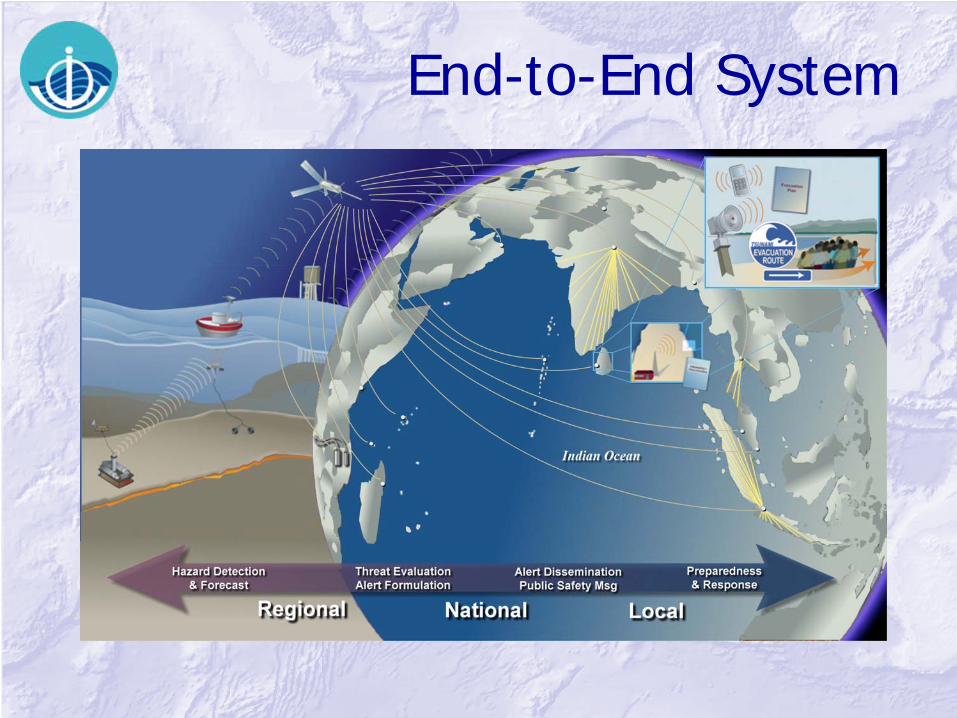
End-to-End System
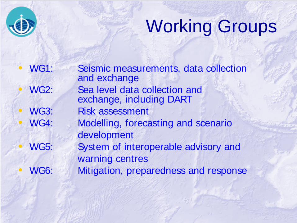
Working Groups
• WG1: Seismic measurements, data collection and exchange
• WG2: Sea level data collection and exchange, including DART
• WG3: Risk assessment• WG4: Modelling, forecasting and scenario
development• WG5: System of interoperable advisory and
warning centres• WG6: Mitigation, preparedness and response

WG1 – Seismic Measurements, Data Collection and Exchange
Chair: Dr. Prih Harjadi / Dr. Fauzi, Indonesia
Goals:-• Core network of seismic stations, meeting instrument
requirements, operational by 2010 and being maintained
• Ensure that all earthquakes >6 can be reliably located and quantified.
• Reduce time required for earthquake source characterisation to meet a local warning response of 5 to 10 minutes
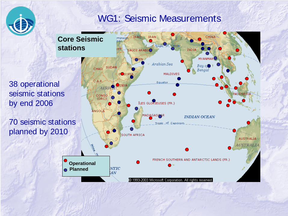
WG1: Seismic Measurements
38 operational seismic stations by end 2006
Core Seismicstations
OperationalPlanned
70 seismic stations planned by 2010

WG2 – Sea Level Measurements, Data collection and Exchange
Chair: Mr Prem Kumar, India
Goals:-• Regional core network of coastal sea level stations and
deep ocean stations, meeting instrument requirements and standards, operational by 2010 and being maintained by countries in the region

Plans – Coastal Stations (GLOSS only)

DART Buoys

Proposed Deep Ocean Sea Level Measurement Network
End 2008: 28 stations planned by all countries


WG3 – Risk Assessment Chair: Dr Sam Hettiarachchi, Sri Lanka
Goals:-• Standardised hazard risk assessment methods and
products developed and employed to reduce vulnerability and strengthen coping capacity of coastal communities to tsunami hazards
• Assessment of environmental flashpoints at subnational level for use in preparedness and spatial planning and disaster risk reduction
WG4 – Modelling, Forecasting and Scenario Development
Chair: Dr Charitha Pattiaratchi, Sri Lanka
Goals:-• Provide benchmarked and validated numerical modelling
methods and software applicable for the Indian Ocean
• Develop and sustain national and regional capacity to apply numerical modelling for tsunami source generation, wave propagation, and coastal inundation in the Indian Ocean
WG5 – System of Interoperable Advisory and Warning Centres
Chair: Mr Geoff Crane, Australia
Goals:-• Coordinated regional warning system for the entire
Indian Ocean region composed of network of interoperable Regional Tsunami Watch Providers and National Tsunami Warning Centres.
• National tsunami warning centres established and operating as authoritative source for tsunami advice and warnings.
• Tsunami alerts disseminated to the “last mile” through effective communications programmes.
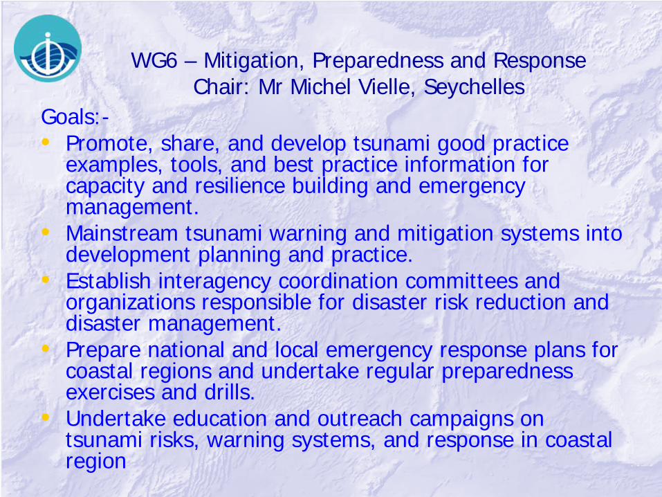
WG6 – Mitigation, Preparedness and Response Chair: Mr Michel Vielle, Seychelles
Goals:-• Promote, share, and develop tsunami good practice
examples, tools, and best practice information for capacity and resilience building and emergency management.
• Mainstream tsunami warning and mitigation systems into development planning and practice.
• Establish interagency coordination committees and organizations responsible for disaster risk reduction and disaster management.
• Prepare national and local emergency response plans for coastal regions and undertake regular preparedness exercises and drills.
• Undertake education and outreach campaigns on tsunami risks, warning systems, and response in coastal region
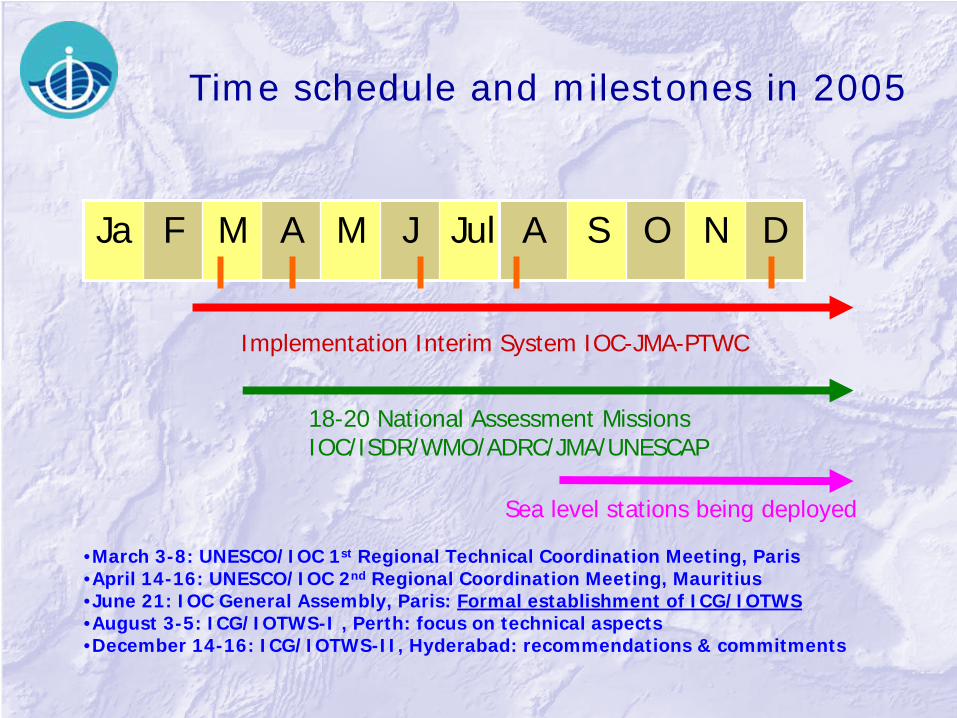
Time schedule and milestones in 2005
Ja F M A M J Jul A S O N D
Implementation Interim System IOC-JMA-PTWC
18-20 National Assessment MissionsIOC/ISDR/WMO/ADRC/JMA/UNESCAP
•March 3-8: UNESCO/IOC 1st Regional Technical Coordination Meeting, Paris•April 14-16: UNESCO/IOC 2nd Regional Coordination Meeting, Mauritius•June 21: IOC General Assembly, Paris: Formal establishment of ICG/IOTWS•August 3-5: ICG/IOTWS-I , Perth: focus on technical aspects•December 14-16: ICG/IOTWS-II, Hyderabad: recommendations & commitments
Sea level stations being deployed

Time schedule and milestones for 2006
Ja F M A M J Jul A S O N D
Initial IOTWS established
Core Regional System build up
IOTWS Implementation Plan
•March 27: IOTWS Roundtable, in the margin of EWC-III, Bonn, Germany•April 22-24: WMO meeting on Multi-hazard, Geneva, Switzerland•June 21-29: IOC Executive Council: Report to Member States on ICG/IOTWS•July 31-August 2: ICG/IOTWS-III, Bali: IOTWS Implementation Plan adopted
Focus on National Plans
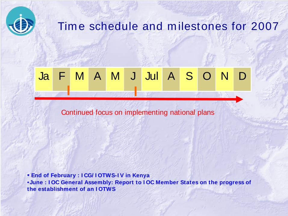
Time schedule and milestones for 2007
Ja F M A M J Jul A S O N D
Continued focus on implementing national plans
• End of February : ICG/IOTWS-IV in Kenya•June : IOC General Assembly: Report to IOC Member States on the progress of the establishment of an IOTWS

End-to-End System

Tsunami Early Warning System
• Upstream– detection, verification, prediction of tsunami wave,
dissemination of tsunami information, international, intergovernmental
• Downstream– issue national warnings, initiate national warning
command chain, prepare and implement standardized reaction
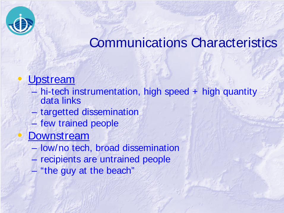
Communications Characteristics
• Upstream– hi-tech instrumentation, high speed + high quantity
data links – targetted dissemination – few trained people
• Downstream– low/no tech, broad dissemination – recipients are untrained people – “the guy at the beach”
Needs
• Upstream– TRAINING, TRAINING– Robust, standardized data streams– redundancy of sensors + power– power independent
– accepted data policy

Needs
• Downstream– TRAINING, TRAINING– simple robust, technology– power independent– standardized simple contents– non oral communication– standardized simple glossary

RANET
Radio and Internet Technologies
Dissemination and Communicationof
Environmental Informationfor
Rural and Remote Community Development

What is RANET?
• An international collaboration, began in Africa in 2000
• Makes information accessible to remote and resource- poor populations
• Aids day-to-day resource decisions and preparation against natural hazards

Any combination of networks to deliver products including:
- Web and Internet- FM Radio- HF Radio- SMS (Cellular Text) Messaging- Social and community networks
How does RANET deliver?
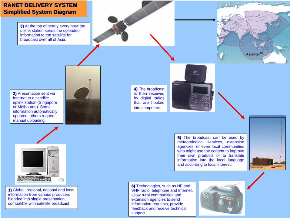
RANET DELIVERY SYSTEMRANET DELIVERY SYSTEMSimplified System DiagramSimplified System Diagram
2)2) Presentation sent via Internet to a satellite uplink station (Singapore or Melbourne). Some information automatically updated, others require manual uploading.
3)3) At the top of nearly every hour the uplink station sends the uploaded information to the satellite for broadcast over all of Asia.
5)5) The broadcast can be used by meteorological services, extension agencies, or even local communities who might use the content to improve their own products or to translate information into the local language and according to local interest.
1)1) Global, regional, national and local information from various producers blended into single presentation, compatible with satellite broadcast
6)6) Technologies, such as HF and VHF radio, telephone and Internet, allow rural communities and extension agencies to send information requests, provide feedback and receive technical support.
4)4) The broadcast is then received by digital radios that are hooked into computers.

WorldSpace Coverage

RANET and Tsunami Warnings
• In partnership with Australian BoM, time critical warnings through high priority switching through Melbourne GTS hub uplinked to Worldspace through Singapore
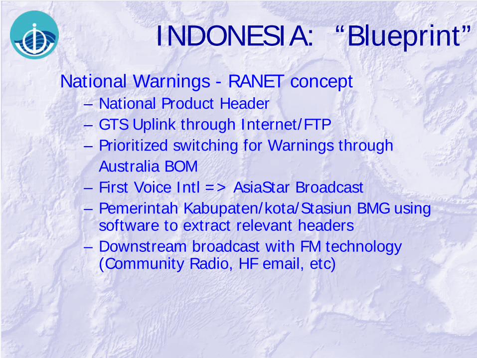
INDONESIA: “Blueprint”National Warnings - RANET concept
– National Product Header– GTS Uplink through Internet/FTP– Prioritized switching for Warnings through
Australia BOM– First Voice Intl => AsiaStar Broadcast– Pemerintah Kabupaten/kota/Stasiun BMG using
software to extract relevant headers– Downstream broadcast with FM technology
(Community Radio, HF email, etc)

Key Benefits
• Reception equipment relatively cheap• Local ownership and maintenance• Every community has its own needs and can
configure the services they receive
• “Sustainable communications are the backbone of early warning”

Problems/Issues• Tonga Earthquake 3 May 2006:
– Tsunami advisory, media turned it into warning
• Merapi Volcano 2006:– SMS clogged satellites after 92 secs
• Java Tsunami 17 July 2006:– Downstream path delayed
• Commercial Warning Services– Standards? Accountability?
• Hoaxes– Authenticity?
Conclusions
• Standardization of means and contents • Keep it simple, get it cheaper • Get sustained funding • Don’t overload the people involved • Training at all levels, again and again • Upstream:
– clear responsibilities, instant reaction • Downstream:
– low tech, simple message, trained response

A perfect warning will be uselessif people do not know what to do in case of an emergency
Awareness and preparedness at the national and local level is essential
“We cannot stop natural calamities, but we can and must better equip individuals and
communities to withstand them.”
“Should disaster strike again, and it will in some part of the world,
we must be able to say that we did everything humanly possible to build resilient societies.”
UN Secretary-General Kofi Annan