Embed Size (px)
Citation preview
GPS Database Management Page 1 11/1/2011
The GPS Database Management Package
Table of Contents
1. Introduction 3 2. Requirements 3 3. Overview 3 3.1 Communications 3.2 File Generation 3.3 Database Management 3.4 General Guide to Usage 3.5 Benefits 4. Installation 7 4.1 Software 4.2 Hardware 5. Getting Started 9 6. Making a New Image File 10 7. Uploading a New Image 11 8. File Management 12
8.1 Binary Files 8.2 ISAM Database Files 8.3 Batch Update Files 9. Detailed Program Descriptions 14 9.1 GPS_COM Serial Communications Program 9.2 GPS_GEN File Generation Program 9.3 GPS_DBM ISAM Database Management Program 9.4 ConvAIR Airways Data Translation Program 9.5 RemDups Duplicate Entry Removal Program 9.6 AutoGEN Control File Generation Program 9.7 GPS_USB Communications Program for USB 9.8 GPS_OBS TAWS File Utility

GPS Database Management Page 2 11/1/2011
10. Command Line Options 29 11. Technical Notes 30
GPS Database Management Page 3 11/1/2011
The GPS Database Management Package
1. Introduction
The GPS models 89, 90, 92, 95, 190, 195, 196, 295, 296, 396, 496, 695, 696, Aera, 96, 96C, III Pilot, and iQue3600a hold a huge amount of information in their memory, with up to six types of waypoint, a routes database, an almanac, a track point file, and ‘special use’ airspace information.
In a typical Aviation Database, there are 20-40,000 different waypoints divided into four classes, and covering one third of the world. There is normally ample room for additional information.
The GPS Database Management Package allows you to archive, list, and make changes to all of this data, with a basic set of three easy to use programs and many useful utilities.
2. Requirements
A standard PC is required, running at least Windows 98, and up to 5MB of hard disc space.
To make effective use of the Aviation Database section, it is also necessary to have a copy of the manufacturer's "Database Update” for one of the above models.
3. Overview
All Garmin Aviation handheld GPS units carry their aviation database in a compiled binary “image” file. No matter what software is used to transfer the aviation database from your PC to your GPS, it is an image file which is sent.
AviaDBM operates on image files, which are given the extension “.img”. Garmin uses “.awp” files, which are merely image files with a header and a trailer. “GEN” programs will strip this header and trailer when given an .awp file, and automatically create a .img file with the same name in the same folder. Any operation will do this, such as listing one of the sections.
GPS_COM and GPS_USB send image files to a GPS unit via a serial or usb port.
GPS Database Management Page 4 11/1/2011
If you want to make any changes to the data in the image file, it has to be completely de-compiled into an ISAM database on your PC using the appropriate GEN program. Then changes can be made to the ISAM data using GPS_DBM, and a GEN program used to make a new image file from this data.
The package is divided into three distinct sections, each one managed by its own program. This is also shewn in diagrammatic form in Appendix ‘A’.
Please do not forget to read the Technical Notes in section 11 below, the SUA Manual, the Release Notes, the FAQs, and the “News” page on the website, all of which are provided to enhance your knowledge of this complex package once you have obtained a basic understanding.
3.1 Communications - GPS_COM & GPS_USB
GPS_COM allows data to be transferred into and out of the GPS via its serial interface, and held on the disc drive of the PC in the form of compact binary files. GPS_USB does the same for USB equipped models, and operates in a very similar way. Where this description mentions GPS_COM you can usually substitute GPS_USB.
You choose the file and direction of transfer, and the program does the rest, keeping you informed of its progress.
With this program alone, you have the ability to take secure re-loadable copies of all the data you have keyed into your GPS, and to make hard-copy listings of it.
The program places no restriction on the number of GPS units it serves, and will upload manufacturer's ".IMG" files even if they have been 'used' previously on a different unit.
Aviation database files with extensions .awp, .taw, .im2/im2, .rg1/rg2/rgn have to be converted to a single .img file by using the appropriate _GEN program. This action is a byproduct of any operation such as listing one of the sections or creating an ISAM database on the PC.
3.2 File Generation - GPS_GEN
In order to make changes to the aviation database, the package requires that the data be transferred from the compact binary .img file into a full relational ISAM database.
The particular program you use depends on the GPS unit you own. G90_GEN is for the models 90, 95XL, and 95AVD, G89_GEN is for the model 89, G92_GEN is for
GPS Database Management Page 5 11/1/2011
models 92 and 190, G3P_GEN is for the III Pilot, G496_GEN is for the 495 and 496, G696_GEN is for 695/6 and Aera, and GPS_GEN is for all the remaining models. The program handles the transfer of image data, either into or out of the relational database, and will be referred to by its generic name GPS_GEN from here on.
GPS_GEN also offers a "Batch" update service for the ISAM database, so that collections of previously prepared additions or changes may be re-applied if necessary in a fail-safe way. Batch files are plain ASCII text. It is also possible to dump as much of the image file as you like into text files in screen format or batch format.
If you would like to add the British Gliding Association database of 1196 official turning points to your unit, perhaps as NDBs, this batch facility is ideal. A BGA batch is supplied with the package.
Batch changes are fail-safe, in that they may be re-played over and over on the same ISAM database without duplication or error, and may also be used on an ISAM database generated from a later issue of the manufacturer’s ".IMG" file.
3.3 Database Management - GPS_DBM
This program allows you to display, select, search for, scroll through, print, and make changes to, most parts of the ISAM database.
Sub-sets of the data may be selected by country and/or identifier.
All changes you make are also copied, together with their date and time, to a "Batch" file, providing an "audit trail" of your actions. There is no need to keep backups of the ISAM database, since it can always be re-created from the binary files and this Batch file.
If you make any serious mistakes, the Batch file is easily edited using any text editor (such as Notepad), and the situation restored as above. A full description of the format used is incorporated in the example Batch file supplied.
3.4 General Guide to Usage
This is a summary of the actions normally required to achieve various goals.
3.4.1 Extract the .awp or .taw file from the issued .exe file using WinZip. 3.4.2 If this file is not an aviation database update, use GPS_USB to upload it to
your gps unit.
GPS Database Management Page 6 11/1/2011
3.4.3 If this file is an aviation database, Create ISAM database on your PC, using GPS_GEN and this file. As a side effect of this you will find an image file (.img) in the same folder.
3.4.4 If you do not want to make any changes, this image file can be uploaded using GPS_COM or GPS_USB.
3.4.5 If you do wish to make changes, use GPS_DBM to perform them on the ISAM data, then use GPS_GEN to Create Image from ISAM, and then upload this new image.
3.4.6 This applies only to the APT, INT, NDB, and VOR sections. You can also make changes to these sections of the ISAM db using GPS_GEN Perform Batch Update together with a text file of changes in batch format.
3.4.7 The SUA, APR, and AWY sections use a different method for making changes. They have to be dumped in text format to a .all file which can be edited and re-compiled using GPS_GEN.
3.4.8 Finally, if the target unit is not the same type as the update file (as will be the case for obsolete units), the Create ISAM operation has to be performed using the GPS_GEN program appropriate for the update type, and the Create Image operation using the GPS_GEN program appropriate to the target unit.
3.4.9 Please also read the Release Notes for more detailed descriptions of recent additions, together with the FAQ and Known Errors pages.
3.5 Benefits
While it may be desirable to purchase a new manufacturer’s database update every two years (say), there are many simple, but none-the-less irritating, changes occurring every month. This package enables you to keep your GPS up to date.
Once you have the ability to list out the information, you will quickly see that the issued database is a bit short of detail in some areas. For instance, NONE of the UK airport Approach Frequencies are included in models prior to the III Pilot. This ability to upgrade the level of information for your particular area is very useful.
As mentioned previously, the BGA turning point database is easily accommodated by the units. The recommended method is to enter them as NDBs, with a new ’Country’ name "UK BGA TP" (say), and a recognizable frequency to set them apart from the real thing, 130.10 perhaps. On the other hand, you may decide that you do not need NDBs at all, and prefer to use this section exclusively for turning points.
The ability to up and down load data you have keyed into the unit, gives you security against its loss from battery failure. You may also keep more than one set of USR waypoints and Routes, perhaps for different parts of the world, and make hard-copy listings of them.
GPS Database Management Page 7 11/1/2011
If you are like me, you will also perceive great benefit from having complete control over a very clever little unit that cost you a lot of money.
4. Installation
4.1 Software
The package comes in a self-extracting exe file, which, when run, loads the package into a folder of your choice on your hard disk. If you accept the default destination, ‘C:\AviaDBM’, then after installation, your disk will contain:
C:\AviaDBM\Docs\Release Notes.pdf
C:\AviaDBM\Docs\Userman.pdf C:\AviaDBM\Docs\appendxa.pdf C:\AviaDBM\Docs\appendxb.pdf C:\AviaDBM\Docs\appendxc.pdf C:\AviaDBM\Docs\appendxd.pdf C:\AviaDBM\Docs\appendxe.pdf C:\AviaDBM\Docs\SUA Manual.pdf C:\AviaDBM\Docs\Imperfections.pdf C:\AviaDBM\Docs\SUA_Corrupt_Names.pdf C:\AviaDBM\Docs\AviaDBM_FAQ.pdf C:\AviaDBM\BIN\gps_com.exe C:\AviaDBM\BIN\gps_usb.exe C:\AviaDBM\BIN\gps_obs.exe C:\AviaDBM\BIN\g90_gen.exe C:\AviaDBM\BIN\g89_gen.exe C:\AviaDBM\BIN\g92_gen.exe C:\AviaDBM\BIN\gps_gen.exe C:\AviaDBM\BIN\g3p_gen.exe C:\AviaDBM\BIN\g496_gen.exe C:\AviaDBM\BIN\g696_gen.exe C:\AviaDBM\BIN\gps_dbm.exe C:\AviaDBM\BIN\dbview.exe C:\AviaDBM\BIN\ConvAir.exe C:\AviaDBM\BIN\RemDups.exe C:\AviaDBM\BIN\AutoGEN.exe C:\AviaDBM\BIN\MapSUA.exe C:\AviaDBM\BATCHES\upd_bat.txt C:\AviaDBM\BATCHES\bga_tp10.txt C:\AviaDBM\BATCHES\pol_tp.txt C:\AviaDBM\BATCHES\eu_tpt.txt
GPS Database Management Page 8 11/1/2011
C:\AviaDBM\BATCHES\GENcfexample.txt C:\AviaDBM\BATCHES\DUPcfexample.txt C:\AviaDBM\BATCHES\UKAirways.air C:\AviaDBM\BATCHES\UKAirways08.air
The installation process also creates a Start Menu Folder, with entries for each of the programs of the package, and most of the .pdf documents such as the Release Notes which everyone should read, this User Manual, and the SUA Editor’s Manual.
4.2 Hardware
You need a cable to connect your GPS to a USB port, or PC COM port. The GPS comes with sufficient cables and plugs to make a serial port cable, apart from the COM port connector itself. The wiring is very simple, since only three wires need to be connected to the COM port. Referring to the GPS User Manual, you will see that five 'tails' emerge from the GPS connector. Connect these as follows:
GPS Connector 9 Way D type or 25 Way D typeBlack (2) Ground 5 7
Brown (3) Data Out 2 2 White (4) Data In 3 3
It is also advisable to provide a +12 volt DC supply to power the GPS, rather than use its internal batteries.
Red (1) Power +12 volts
Black (2) Ground 0 volts
A car battery would serve in the absence of a bench power supply.
If you would rather buy a cable ready made, or you have installed some of the original parts in your aircraft, the manufacturer offers a "PC and Database Update Cable" as an accessory.
5. Getting Started
These instructions assume that you are familiar with Windows, and are able to use Windows Explorer, and Notepad, or their equivalents. You should also be reasonably conversant with your GPS unit, particularly the ‘Interface’ page.
Having installed the software, connected your GPS to your chosen COM or USB port, and to its bench power supply (or battery), you are ready to go.
GPS Database Management Page 9 11/1/2011
We will assume that you placed the package in C:\AviaDBM, so if you chose a different directory, please replace “C:\AviaDBM” in the following text.
To start with, we will transfer your User Waypoints out of the GPS and into a file on your PC named “usr.gar” in the C:\AviaDBM directory. This will not change what is inside your GPS in any way.
If you have not created any USR waypoints in your GPS yet, there should be one placed there by the manufacturer - the location of his factory. Failing this, please create one now - the easiest way is to press AUTO-STORE or Mark, and ENTER
5.1 On the PC, open the AviaDBM5 programs group and run GPS_COM.5.2 The program displays the Setup dialog on start-up, already filled in to Read the
USR database using COM1. 5.3 If you are not using COM1, change the selection as necessary. 5.4 Move the cursor to the filename box, and type 'usr.gar' 5.5 Click the OK button; a new dialog appears, with 'GO' and 'Cancel' buttons. 5.6 Read the job description in the main window. 5.7 Make sure the GPS Interface page is indicating HOST or Garmin mode. 5.8 Click the GO button; the transfer should start, and progress should be displayed
on both the PC and the GPS. 5.9 If nothing happens, the chances are you got the wires wrong in the interface
cable, or there is a problem with the COM port. 5.10 If the transfer was successful, a “Transfer Complete” message will appear on
the message page of the GPS. Clear this in the normal way. 5.11 If the transfer failed, you should clear it by placing the cursor on the HOST
field of the Interface page, and change it to another mode, then back to HOST again. You will also have to reset the program GPS_COM, by clicking on the second Toolbar button (the Hand), or choosing STOP/RESET from the File Menu. If the failure occurred after a baudrate change, it may be necessary to exit from GPS_COM and restart. You should also try reducing the maximum permitted baudrate in the Setup Dialog, possibly to as low as 9600. The shorter you make the cable the better.
5.12 If necessary, correct the cable, and try again from the top. You should now have a file on your hard disk called C:\AviaDBM\usr.gar. We will now list its contents on screen, and print them on the system printer. 5.13 If the “Setup Communications” dialog box is not displayed, click the first
Toolbar button (the Lightning symbol), or choose Setup Comms from the File menu.
GPS Database Management Page 10 11/1/2011
5.14 Select “List” from the Mode drop-down, and type “usr.gar” in the Filename entry box. You can also fill the Filename box by clicking the Browse button and using the “Select Binary File” dialog.
5.15 Click OK and GO. The USR waypoints will be displayed, and may be printed
by clicking the third Toolbar button (the Printer), or choosing Print from the File menu.
5.16 You may also view the pages before you print them by choosing Print Preview
from the File menu, or write them to a plain ASCII file using Save As. 5.17 Exit from the program.
6. Making a New Image File
6.1 The rest of the package is concerned with the maintenance of the Aviation database, consisting of APT, INT, NDB, VOR, and optionally SUA, FSS, TCC, and Approach sections, together with associated Runways, Frequencies, Country and Place Names.
6.2 Since it is not possible to download this database from the GPS unit, you must
use a manufacturer’s database update file as the source of this information. Copy the file (or files) into your C:\AviaDBM folder. Program WinZip will extract a .awp or .taw file from the .exe file you downloaded from his web site.
6.3 Using the appropriate GEN program, from the “Select Required Operation”
dialog box, which appears when the program is started, choose Create ISAM Database in the Mode drop-down, and enter the full pathname of the image file in the Filename box. Alternatively, click the Browse button and find the file using the “Select Image File” dialog.
6.4 Click OK, verify the details of the operation in the main window, and click
GO. The program creates the ISAM database, displaying its progress in the form of record counters in the main window.
6.5 When the “Database Complete” message appears, exit from GPS_GEN, and
run program GPS_DBM. 6.6 The database manager displays the Airports window on start-up. Since you
have no filters set, the whole database is selected, starting at the first airport. Windows are available for simultaneous display of INT, NDB, and VOR sections, activated by Toolbar buttons I, N, and V.
GPS Database Management Page 11 11/1/2011
6.7 Choose “Filters” from the View menu, and choose your country from the Country drop-down list, and click OK. All windows will re-draw to show only waypoints with your country code.
6.8 In the Airports Database window, click on one of the Tower frequency lines. It
will be highlighted in blue. Now click on the ‘/’ (Change) Toolbar button, or choose Chg FRQ from the Edit menu. The “Add or Change a Comms Frequency” dialog box appears.
6.9 Make an alteration, and click OK. The highlighted item will be updated. Now
exit from the program, and run GPS_GEN again. 6.10 Choose “Create Image File from ISAM database” mode, and enter
“custom.img” in the Filename box. Click OK, confirm your selections in the main window, and click GO. The program creates the new image file, displaying its progress in the form of record counters.
6.11 When “Image Complete” appears, exit the program. 6.12 If you are creating an image for an obsolete unit such as the GSP90, you should
use the GEN program appropriate to your download to create the ISAM db, and then the GEN program appropriate to your unit to create the new image.
7. Uploading a New Image 7.1 This operation is irreversible, in the sense that the original contents of your
GPS unit can only be restored if you have the Image file it was loaded from. 7.2 Run program GPS_COM, and choose Write from the Mode list, and Aviation
from the Database drop-down. Enter the full path name of the image file, and check that the correct COM port is selected.
7.3 If your unit is a 196, 296, 396, 96, 96C, or 295, the program first has to upload
a database 'loader' which it has to obtain from a manufacturer's update file. A suitable file (eg: .awp, or .rg1) must be located in the same folder as your new image.
7.4 Check all connections, and ensure the GPS is in HOST or Garmin/Garmin
mode. Click OK, and then GO. The transfer commences, the date and time of manufacture of your GPS is displayed (later units employ a hex serial number), and the program has to wait while the existing database is erased inside the unit. During this waiting period, the message “Waiting for Erase to end” is displayed every few seconds.
GPS Database Management Page 12 11/1/2011
7.5 During the database upload, a record count is displayed on the screen, and also
on the Interface page of earlier GPS units. If any proximity points are set, a message will be generated to tell you that they have been locked.
7.6 When the transfer is complete, verify its success by switching the GPS unit off
and then on again, in order to view the title page. (The III Pilot and later units return to this page without switching off).
7.7 If a problem occurs, or the transfer stops before completion, reset both
GPS_COM and the unit, and start the transfer again. You might consider using a lower baudrate.
8. File Management
If you have been following the instructions in sections 6 and 7, your ’C:\AviaDBM ’ directory now contains new files:
’usr.gar’ created by GPS_COM. ‘custom.img’ created by GPS_GEN. ‘upd_bat.txt’ created by GPS_DBM.
Subdirectory 'DB50' now contains an ISAM database.
8.1 Binary files
There are two types of binary file, recognized by their internal data format, and carrying the preferred extensions '.img' and '.gar'. The filename parts are your choice.
Each '.gar' file may hold just one database, chosen from USR waypoints, Routes, Proximity points, Track points, or Almanac.
An '.img' file contains the whole of the Aviation section, that is to say APTs, INTs, NDBs, VORs, SUAs, FSS, TCC, and Approaches, together with ancillary information. Images generated by this package for the GPS95 are either 1048576 or 768432 bytes long, depending on whether SUA records are included, 1507328 bytes long for the III Pilot, and 2Mb for the modern units.
8.2 ISAM Database files
GPS Database Management Page 13 11/1/2011
GPS_GEN and GPS_DBM expect to find the ISAM database in subdirectory ’DB50’ of the current working directory. If there is no subdirectory ‘DB50’, you are given the opportunity to select a DB50 directory anywhere on the system.
The ISAM database consists of pairs of files having extensions '.dta' (data) and '.dtx' (index), and self explanatory names. There is rarely any need to have more than one set of these files on your disk, but you can take a copy of them if you wish.
If any of the database files are absent, both programs will create new empty ones when required, so you may remove them in pairs or in groups as you wish. There would be no point in deleting the COUNTRY or NAMES files and leaving any others, since without Countries and Names, the information in the other files would be invalid. Likewise, you should not remove the APTS files without also deleting the RWYS, FREQS, and RESTR files.
You must NOT delete a data file without deleting the index file of the same name.
You can only transfer data from Binary files into EMPTY (or absent) ISAM database files. The Create ISAM operation deletes the whole ISAM database and re-creates it from scratch. If you want to remove a whole section, by all means delete its two files.
If SUA information was available, there will also be a file named ‘sua.dat’. G3P_GEN, G92_GEN, G496_GEN, and GPS_GEN also create a file named 'tcc.dat' containing the FSS and ARTCC data.
You must not mix database or sua/tcc files which were created from different image files, since most of the relational joins are expressed as record numbers. It is also not possible to use sua.dat files for a 495/496 with any other unit.
Only one Image file can be transferred into the ISAM database using Create ISAM. If you need to add the data from other Image files, it can be dumped to text files in Batch format and input as a Batch Update. AutoGEN can be used to aid in this process.
8.3 Batch Update files
GPS_DBM opens the file 'upd_bat.txt' in the current working directory (C:\AviaDBM), immediately after locating the ISAM database. If the file exists, it is opened, otherwise it is created with zero length. Nothing will be added (save for a comment containing today's date) until a change is made to some Aviation data; nothing is ever deleted from this file by the package.
It is a good idea to keep backup copies of this file, since it will contain every change you have made to the database. You can edit any mistakes you make using 'Notepad'.
GPS Database Management Page 14 11/1/2011
If you like you can maintain your whole database using Notepad to create a batch file, and GPS_GEN to apply it to the ISAM database, without ever using GPS_DBM.
If you have just completed section 6 above, have a look at upd_bat.txt now.
9. Detailed Program Descriptions
The programs will now be described in detail. In addition to their basic functions, they provide many supplementary facilities. In some cases, these facilities are duplicated between programs, for instance, you can list most things both direct from the image files and out of the ISAM database. Appendix A shows all this in pictorial fashion.
9.1 GPS_COM Communications Program
9.1.1 Basic Action
GPS_COM handles the process of moving data in and out of the GPS unit. In the PC, all data transferred by GPS_COM is held in the form of compact Binary files, which the program recognizes by their internal data format. You should give them meaningful names, so you can remember what is in them too; Aviation Binary files should have the file extension ’.img’, while the remainder should be given the extension ’.gar’. If you have aviation database files with extensions .awp, .im1/im2, .rg1/rg2/rgn you must first convert them to a .img file by listing one of the sections using the appropriate GPS_GEN program.
9.1.2 Setup Dialog
The setup dialog is displayed automatically when you start the program. Subsequently you may activate it from the File menu, or from the first Toolbar button. If the program is in transfer or listing mode, you may have to select STOP/RESET from the File menu, or the second Toolbar button, before Setup is available again.
9.1.3 Modes
The program offers Read, Write, Host, and List modes in the Mode box. Read mode extracts data from the GPS, Write mode transfers data to the GPS, and List mode will display the contents of any ’.gar’ file in scrollable and printable form.
GPS Database Management Page 15 11/1/2011
Host Mode is provided in case you want to initiate data transfers from the GPS Interface page, instead of from the PC. In this case you cannot choose your own Binary file names, rather they are chosen for you from a built-in set, all beginning with the characters ’H_’.
9.1.4 Databases
USR, Aviation, Routes, Proximity, Almanac, and Track databases may be chosen in the Database box. There are however some illegal combinations of Mode and Database, the most obvious being Read Aviation.
List mode lists the chosen ’.gar’ file, and does not need to be told what type of data that you think the file holds.
9.1.5 Filenames
With the exception of Host mode, all modes require you to fill in the Filename box. If no path is included with the name, then the current working directory is used. If the mode is Read, and the file exists, you will be prompted to agree to it being overwritten.
9.1.6 Browse Button
The easiest way to fill in the Filename box is to use the Browse button, which displays a standard File Dialog. This may be used to select the file, or to select the path to a filename which you type in yourself.
9.1.7 Max Baud
Units which are able to change the baudrate of their serial port will be asked to use the baudrate you have selected from the Max Baud dropdown list. Some units can operate at 115k, others at only 38k, but the negotiation will not settle on a rate higher than you have selected. If you experience any transmission problems, the first thing to try is a lower baudrate. The older the PC hardware, or the longer the interface cable, the more likely you are to get hang-ups, timeouts, and re-transmissions. Garmin does not use flow control on its serial interfaces, so you cannot use USB-to-serial converters which expect to be able to control the flow.
9.1.8 New Protocol
GPS Database Management Page 16 11/1/2011
Most units can use only one protocol, either the legacy protocol, or the new protocol encompassing mapsource uploads. For modern models, the new protocol is used automatically without user intervention. For III Pilot models, you can choose either, although the ’new hardware’ units (s/w versions 2.10 and above) seem to prefer the new protocol. Earlier models automatically use the old protocol.
9.1.9 OK Button
When the Startup Dialog is completed to your satisfaction, click on the OK button. If there are any problems with your selections, a message box will appear to describe it, after which the Startup dialog returns. If all is well, complete details of the intended action are displayed in the main window.
9.1.10 GO Button
When the Startup dialog details are acceptable, a message box with GO and Cancel buttons is displayed. When you click the GO button, the chosen action should commence. Transfer times are variable, the worst case being Write Aviation which can take up to 30 minutes at 9600 baud.
If you are uploading a .img file to a modern unit, the program will look for a .awp file in the same directory. This is because these units require a loader program to be uploaded before they can accept the .img file, and this loader is located in .awp files. Please ensure that the .awp file is also for your unit type.
On earlier units, feel free to clear any beeping messages from the GPS by pressing the PWR/STAT key on the GPS twice. The GPS unit will generate a message at the end of every transfer; in addition, if you have nominated any Proximity points, a message telling you they are locked will occur at the start of Writing the Aviation Image file. The III Pilot aviation database transfer disables the unit for the duration of the upload; if anything goes wrong feel free to turn the unit off and on again to clear this state (you will then have "No Aviation Data" until you perform a successful upload).
9.1.9 Printing
The current scrollable contents of the main window can be printed on the system printer at any time, by selecting Print from the File menu, or by clicking on the third Toolbar button. This is most useful for listing '.gar' files, although the ‘activity log’ which accumulates in the main window can also be printed.
GPS Database Management Page 17 11/1/2011
Print Preview is also available in the File menu, giving you an idea of what you will get on the printer, and Save As, which writes the output to a plain ASCII file instead of the printer. Use File/PrintFont to adjust the character size if necessary.
9.1.10 General Points
The Write Aviation Database operation is an ’Erase and Replace’ operation, so if you interrupt it, you will then have no Aviation data in the unit. This is not a problem, because you can simply do it again. You will also get this situation if you try to upload an image which is too big for the unit.
Writing ’.gar’ files on the other hand, is a ’merge’ operation. Nothing is deleted, and nothing is duplicated, but existing items are updated and new ones added.
If your unit has waypoints from the Aviation section in current Routes - the normal situation, then during the Write Aviation operation these waypoints are ’locked’. If the waypoints are not in the new Aviation section, then they remain locked. This is not a problem, because you can simply delete or replace them.
Due to a manufacturer’s omission, it is not possible to up and down load the ’Ref’ information in a USR waypoint. This field of a USR waypoint will be blank in waypoints which have been loaded from the PC. You will also find that the ‘Ref’ fields change when a new Aviation database is loaded. This is because they are held internally as pointers instead of characters; this is the same for any method of database upload.
9.2. GPS_GEN File Generation Programs
9.2.1 Basic Functions
GPS_GEN handles conversions of ‘.img’ files into entries in the ISAM Database, and the creation of ‘.img’ files from ISAM database records.
The program has up to five other modes, Batch Update, List Image File Sections, Compile SUA Text, Compile FSS/TCC Text, and Compile APR Text. Batch Update mode applies a Batch of updates to the current ISAM database. You supply the name of the Batch file in the filename box, and each command is listed as it is performed. The operation is fail-safe; the whole file can be re-run if necessary, perhaps to incorporate just a few extra changes.
GPS Database Management Page 18 11/1/2011
Listing mode enables you to examine and print an ’.img’ file section by section. The File/SaveAs menu item enables APT, INT, NDB, and VOR listings to be written as text files in one of eight different modes. Complete SUA, FSS, TCC, and Approach listings may also be written out in this way.
9.2.2 Select Database Dialog
This dialog box only appears if the program cannot find the subdirectory ‘DB50’ in the current working directory. Use this standard File Dialog to find a ‘DB50’ directory somewhere on the system. The program will not continue until one is found.
9.2.3 Setup Dialog
The setup dialog is displayed on program start up; after this, it is available via the Setup item in the File menu, or by clicking the first Toolbar button. If the program is in Listing mode, you may have to select STOP/RESET from the File menu, or the second Toolbar button first.
The Mode box may be set to 'Create ISAM Database', 'Update ISAM Database', 'Create Image File', 'List Image File Sections', or 'Compile SUA, FSS/TCC, APR or AWY Text'.
For ISAM Database Creation, the file in the 'Filename' box must exist and be of the correct type. For Image File Creation, if the File exists, you will be asked to confirm that you want to overwrite it.
In Update mode, the file must be a plain ASCII file containing update commands, as per the issued example files in the BATCHES subdirectory.
A 'Browse' button is provided to assist you to complete the 'Filename' box.
Listing mode may only be selected for '.img' files. You choose what you wish to list by selecting a section from the “Section” drop-down. If you choose the SUA section, in order to create a modifiable text file for re-compilation, you should normally have no Filters set, and choose File Type *sua.all. Similarly for FSS / TCC sections, which should be placed together in the same file for re-compilation, and APR sections.
The 'Filters' button displays the Filters Dialog in the same way as from the View menu. The Listing checkbox allows you to inhibit the listing to screen of the input lines for the batch and compile functions.
GPS Database Management Page 19 11/1/2011
In Create Image mode, a ’Title’ button is available, leading to a dialog box enabling you to enter your own title-page identification. The default is CUSTOMISED DB. Only the first 20 characters will be used, less on some units.
Compile SUA Text mode enables you to re-create an ’sua.dat’ file from an SUA SaveAs file, normally after making some modifications. This whole process is described fully in the SUA Manual. Compile FSS/TCC is similar, but is included only to facilitate the creation of world-wide databases, so the co-ordinate section is not expanded.
The Approaches data is kept in the ISAM database, and Compile APR is provided to allow this data to be updated. Normally this will be from a file previously created using SaveAs *apr.all. Airways can similarly be dumped and re-compiled.
9.2.4 GO Button
When details of the intended operation have been agreed, a summary is displayed in the main window, and a new message box with GO and Cancel buttons appears. Click GO to start the operation.
A limits dialog will be displayed allowing you to impose geographical limits on the data being processed. These limits can be entered as "Nddmmss Wdddmmss" (where N and W can be S and E, and d=degrees, m=minutes, s=seconds). The format must be exactly as stated, and will be used to re-display any entries. Alternatively, they may be entered in the form "Ndd~mm.mmm Wddd~mm.mmm".
If you have chosen Create Database mode, and a database already exists, the program will delete it. You may like to archive the files by making copies of them before they are deleted.
Image operations can take some time, during which comprehensive details of progress are displayed. As a guide, my old 486-66 takes about 10 minutes to hack through a complete ’.img’ file, so I can imagine some lap-tops taking considerably longer. (My Athlon 2400 does it in a flash.) You will see exactly how many items there are in each category as the transfer progresses.
9.2.5 Optimization
When creating a ’.img’ file, the program also optimizes the Names, Runways, and Frequencies, by not including unused records. This means that you never need to delete runways and frequencies when deleting an airport. The View menu items "Optimise" and "Optimise Countries" may be checked/unchecked to vary the default actions. Note that if you choose to optimize the countries file you will remove all the countries in the half of the world not represented by your database. This will be a
GPS Database Management Page 20 11/1/2011
problem if you have routes in your unit using aviation db waypoints, since the country of each waypoint was stored as an index to the countries table, and will most probably now be the wrong value. This can be avoided by reading the routes out into a .gar file where the countries are held as two-letter idents, and writing it back after uploading the new database.
9.2.6 Accreditation
It is important that the user of the GPS unit knows that he is using an Aviation database that you have modified, particularly since any errors you might make could be blamed on the manufacturer. To this end, the ’title’ page is changed to read ’Customised DB’ (although you have the option to set it to anything else), and the Cycle Number, Valid From, and Valid To dates are all set to the date that you created the ’.img’ file. For modern units, the copyright notice is changed by replacing the manufacturer’s name with ’AviaDBM’.
9.2.7 Section Box
For Listing mode, the Section box enables you to choose the part of the ’.img’ file to be listed. In addition to the APT, INT, NDB, and VOR sections offered by GPS_DBM, you can also list the Countries and Names tables, SUA, FSS, ARTCC, and Approach sections.
9.2.8 Filters dialog
This dialog is available from the Filters button of the Setup dialog, or from the View menu, and enables you to preset filters for Country, Name, and ICAO Ident in any combination. A country filter can only consist of the specific two letter ident for one country (the UK would be ‘EG’, Germany ‘ED’, etc), and wildcards are not permitted in any filter. The ICAO ident field may also be used to specify a starting record number in hexadecimal, by entering the required value preceded by '0X', eg: 0X23A.
9.2.9 Printing
Choose Print from the File menu to print the whole of the scrollable contents of the main window. See GPS_DBM for notes on printing, scrolling, and print preview.
9.2.10 Save As Text
GPS Database Management Page 21 11/1/2011
Choose SaveAs from the File menu to dump the whole of the scrollable contents of the main window to a text file. There are eight possible modes of operation, controlled by the filename used to receive the output, and the country filter. 9.2.10.1 If the letters ’bat’ immediately preceded the dot (filename matches
’*bat.*’), the ouput will be in batch format, otherwise normal text format. 9.2.10.2 If the extension is ’all’ (filename matches ’*.all’), and one of the four main
waypoint types is being listed, all four waypoint types will be dumped, otherwise only the selected type is output. (This mode is not limited to 2000 lines like the others). If the current listing is SUAs, and file type *sua.all is selected, the whole of the SUA section is output in a form suitable for re-compilation. For FSS or TCC the filename should match *tcc.all, and for approaches it should match *apr.all.
9.2.10.3 A country filter may be applied to any output, except where it would be
meaningless. Note that only APT, INT, NDB, and VOR records carry a country identifier.
9.2.11 Compile SUA This facility is described in the separate SUA Editor’s Manual. A Compile filters dialog box is presented to allow the SUAs to be filtered by applying a maximum base altitude (which must be a multiple of 100 feet), and by specifying the South West and North East limits of the area required. These co-ordinates must be given in degrees, minutes and seconds, Nddmmss for North (or S for South), and Edddmmss for East (W for West).
9.2.12 Compile FSS/TCC The principal reason for the inclusion of FSS/TCC re-compilation is to enable the creation of images using the specified-area method. In particular, the co-ordinate sections of the TCC data are not expanded, so modification by hand is not possible.
9.2.13 Compile APR This function will read and interpret a text file created in *apr.all format. Unlike the other two compile functions, CompileAPR updates the section of the ISAM database holding approach data, and remains the only way of making changes to this section.
GPS Database Management Page 22 11/1/2011
9.2.14 Control File Operation For complex operations such as the creation of a whole-world ISAM database, followed by the creation of new image files by specifying a geographical area, the GEN programs may be operated in Control File mode. This is activated by including the name of the control file on the command line preceded by -F. Program AutoGEN is provided to make construction of these files easy, and an example of the format is provided in file C:\AviaDBM\Batches\GENcfexample.txt.
9.3 GPS_DBM ISAM Database Management Program
9.3.1 Basic Action
GPS_DBM allows you to examine, change, and print all the information in the ISAM database. Any changes you make are also recorded in the file ’upd_bat.txt’ in the current working directory.
A separate window is provided for each of the database types, that is to say, APTs, INTs, NDBs, VORs, USR, and RTE. The operations Add, Change, and Delete, are provided in all categories. SUA, FSS, and ARTCC information is not kept in the ISAM database, and cannot be changed using GPS_DBM. USR and RTE databases are imported and exported directly from/to their ’*.gar’ files using File menu options.
9.3.2 Select Database Dialog
This dialog box only appears if the program cannot find the subdirectory ‘DB50’ in the current working directory. Use this standard File Dialog to find a ‘DB50’ directory somewhere on the system. The program will not continue until one is found.
9.3.3 Choosing the Section
The APT section is opened at start-up; sections which are not already open can be opened by selection in the File menu, or by buttons in the Toolbar labeled A, I, N, V, U, R. Windows may be iconized or closed at will, but only one instance of each may be active at any time.
9.3.4 Setting a Filter
GPS Database Management Page 23 11/1/2011
The “Filter Setup” dialog is opened by choosing Filters from the View menu. You can reduce the amount of information displayed by setting a Country filter, and/or an ICAO ident filter.
A country filter is set by selecting a country from the Country drop-down list. In addition to using the scroll-bar, the list may be scrolled by typing one or more of the leading characters of the name..
An ident filter is set by entering characters in the ICAO Filter box and may consist of one or more characters from the start of the desired set. For instance, a British user may enter EG, or perhaps the complete ident of the desired waypoint.
The program will then display only items which match the characters entered.
Note that these filters are applied to all windows at the same time. Although country idents and ICAO idents often use the same letters for airports, this is not the case for the other types of waypoint.
9.3.5 Scrolling Performance
Most database packages force you to select one item at a time to display and make changes to. I decided that a scrollable display of all items was far better. However, there are limitations to this approach.
We are dealing with a massive amount of data here, so there is no way it can be held in the PC memory in anything like reasonable chunks. I therefore decided not to hold ANY in memory; every line is displayed directly from disk file. Depending on the power of your computer, and the amount of disk caching employed, this will be more or less apparent when you search or scroll the display. One line at a time is no problem, one page at a time is more serious, and dragging the scroll button up and down is really not advisable - I would have disabled it if I'd known how to. (Actually, my latest PC can keep up with scroll dragging, and I have also improved the performance by generating an in-memory list of record numbers in the background. Note the asterisk in the window title bar, and the greyed print commands in the File menu during this process).
Do make use of the Country and ICAO filters, they get you there much more quickly.
Note that due to a library restriction, you cannot have more than about 2000 lines in a scrollable window, so if you really do scroll through that many lines, the end may be premature - another case for using filters.
GPS Database Management Page 24 11/1/2011
9.3.6 Making Changes
You can Add a new item in the active window at any time, by selecting Add in the Edit menu, or by the ’+’ button in the Toolbar.
An ’Add or Change’ dialog is displayed, into which you must put all necessary data.
To change or delete an item, you must first select it by clicking on an item in the window. Then choose Change in the Edit menu, or the ’/’ Toolbar button to obtain the ’Add or Change’ dialog, and Delete in the Edit menu or the ’-’ button in the Toolbar to obtain the ’Delete’ dialog.
Airports have Frequency and Runway sub-sections which may also be selected, added to, changed, or deleted. Note however that ’brief’ runways (those with zero heading displayed as ’..-..’) can only exist on their own, so any attempt to Add a runway in the presence of a ’brief’ description will become a Change operation on the brief runway.
Runways also have a ’Picture’ field, depicted on the main display as ’(p)’, and in the dialog as runway threshold co-ordinates and bearings. The earlier models (90/92/95) require only one threshold, whereas later models (3P/195/196/295/etc) also require the co-ordinates of the reciprocal end. In addition, even if not entering the runway picture details, later models require the bearing if the icon is to have its stripe oriented correctly.
9.3.7 Record Numbers
If the program is called with option ‘-r’, the first column of all listings is the record number of that item in the ISAM database. Unless you are really into debugging databases, this has little value, save to indicate where changes have been made - you get a large and out-of-sequence number for a new record.
If you are using a low resolution display, you may like to get rid of this column, thereby shrinking the width and hopefully getting it on the screen. Choose the Record Numbers item in the View menu to toggle these record numbers on and off.
9.3.8 Printing
You can print the whole of the data in the active scrollable window, by choosing Print from the File menu, or the Print button on the Toolbar. If you have not set any filters, back up a truck of paper, and go on holiday for a week.
Print Preview is also available from the File menu.
GPS Database Management Page 25 11/1/2011
9.3.9 Data Formats
When filling-in the boxes in the ’Add or Change’ dialog, you should enter everything in the format used to display these items in the main window.
All alphabetical characters are converted to upper case, so you can type them in lower case if you like. This also applies to Batch files.
There is a concession with respect to the tilde ’~’ character which separates the degrees portion of a Latitude or Longitude from the minutes part - you may substitute a hash ’#’ or a semicolon ’;’ if you prefer.
9.3.10 Accuracy
The GPS unit keeps Latitude and Longitude values which the user enters via the keyboard to an accuracy of 26 binary bits. This is roughly equivalent to 0.00016 minutes of arc, or 6 feet in distance, and far exceeds the accuracy of the unit and any of its display modes.
Latitude and Longitude in the Aviation section are only held to an accuracy of 21 bits, giving a resolution of 0.00515 minutes, or about 61 feet in distance. The effects of this are visible when you examine the Aviation waypoints - they all appear to be held to a greater accuracy than is quoted by official sources. The reality is that the values were entered with the third decimal place set to zero (say), but on conversion to 21 bit binary, they incurred an offset of up to + or - 0.0052 minutes.
Now that you are able to make your own entries in the Aviation section, you will see this inaccuracy at first hand. GPS_DBM makes the conversion at the earliest opportunity, so you can if you like influence the final result by adjusting the value you enter.
Co-ordinates in the SUA section are only held in 18 bit resolution, making them a further eight times less accurate. Not a real problem since you are never likely to try to land on an SUA boundary (unless you are based at our farm strip).
Note that resolutions have been increased by 4 bits in models 696 and later.
9.3.11 USR Waypoints
USR Waypoints differ from the AVD sections of the database, in that, apart from the batch update facility of GPS_GEN, they are maintained entirely from GPS_DBM.
GPS Database Management Page 26 11/1/2011
To read records into the USR section, make USR the active window, and choose File/Import to add the waypoints from a ’.gar’ format file created by GPS_COM. If a waypoint is already present in the ISAM database, it will be updated if the imported waypoint carries a later (or zero) date, otherwise all imported waypoints are added. File/Clear is also available if you want to start again. Choose File/Export to create a ’.gar’ format file from the current database. Support is included at this point for the different waypoint formats employed by different models, making it possible to convert waypoint files from one model to another. You can also dump them in Batch File format using File->BatchDump.
9.3.12 Routes To read routes into the RTE section, make Routes the active window, and choose File/Import to add the routes from a ’.gar’ format file created by GPS_COM. If a route is already present in the ISAM database, it will be replaced, otherwise all imported routes are added. Adds and Deletes (but not Changes) are allowed for single waypoints or whole routes. When adding to a route, any one of the five waypoint types is available - provided that the appropriate window is also open. If a waypoint is selected in a given window, then details will be copied into the Add Waypoint dialog, making the construction of routes a near Drag and Drop operation. The default Add action is to add a waypoint before the selected one, but this may be varied by clicking the ’Add After’ checkbox in the dialog. If the ’Route Number’ line is selected, then add-after is automatic (Wpt 01 will be added), or for Delete, the whole route will be deleted. To add to an existing route, a waypoint must first be selected in that route. To add the first waypoint of a new route, that route number must not exist in the database. Choose File/Export to create a ’.gar’ format file from the current database, choosing the appropriate model from the dropdown list.
9.4 ConvAIR Airways Data Conversion Program
9.4.1 Action
Airways data is normally published by naming the co-ordinates of the start and end of the centre line, and specifying the width in nautical miles. To include this data in the SUA section it must be converted into the co-ordinates of the four corner points of the rectangle, and ConvAIR is provided to perform this task. In addition it handles
GPS Database Management Page 27 11/1/2011
airways which ’dog-leg’ by modifying the join to a single line instead of the implied overlapping box ends. More detail is included in the SUA Manual.
9.5 RemDups Text File Duplication Removal Program
9.5.1 Action RemDups will read one or more text files and look for duplication, then allow the user to create a new file without the duplicated sections. For the purposes of operating on SUA, FSS, TCC, and APR text dumps, a section is defined as beginning with a line having SUA, FSS, TCC, or APR at its start, and continuing until the next section start, or the end of file.
9.5.2 Operation
Select a file to be scanned using the File Open dialog, repeat for as many similar files to be included in the whole output file, then write the file with duplicates removed using the File SaveAs dialog. This process can take a significant time if there are thousands of entries.
9.5.3 Operation from a Control File
For complex operations such as the creation of a whole-world ISAM database, RemDups may be operated in Control File mode. This is activated by including the name of the control file on the command line preceded by -F. Program AutoGEN is provided to make construction of these files easy, and an example of the format is provided in file C:\AviaDBM\Batches\DUPcfexample.txt.
9.6 AutoGEN Control File Generation Program
9.6.1 Description AutoGEN is a Console mode program which creates the batch files and associated control files required to create a whole-world ISAM database, and create new images based on user-defined geographical limits. The name of the subdir to be used is fixed at "Auto" (eg: C:\AviaDBM\Auto), and the program expects to be started in C:\AviaDBM or one of the subdirs "bin" or "Auto".
9.6.2 Operation
GPS Database Management Page 28 11/1/2011
Place the necessary .awp files in the Auto subdirectory. Only .awp files which match the standard manufacturer’s naming convention can be used. Run AutoGEN which will create Auto.bat and Control.txt files numbered 1 to 4, then edit the head of Control4.txt to preset the required geographical limits of the image to be created. Then run each Auto.bat file by double clicking on it. The GEN programs and RemDups have been configured to stop when their control file operations are completed, leaving the screen log for examination, so they each must be dismissed manually before running the next Auto.bat file. After the first complete cycle, Control4.txt can be re-edited and Auto4.bat re-run if different geographical limits are required, or indeed if a different GEN program needs to be run.
9.7 GPS_USB Communications Program
9.7.1 Description In addition to the facilities offered by GPS_COM on the serial interfaces, GPS_USB includes the ability to upload VRP files from G496 ".awp" files, and Obstacle or Terrain files from ".taw files". (It will also upload SafeTaxi and AOPA files to models able to use them). Apart from avdb image files, GPS_USB does not place any restriction on which file you send to what unit, relying on the unit to complain if it cannot accept the type of data chosen, or its size. For instance, you can upload the European obstacles included in a G496 update to a G96, G296, etc quite happily, whereas an attempt to upload a 221Mb terrain file to a G296 will end in failure when the unit’s memory becomes full.
9.7.2 Operation
The program follows the lines of GPS_COM, but has an additional database option “VRP/TAWS” which should be used for uploading VRP data (from a 496 .awp file) and TAWS data from .taw files (eg: Obstacles, Terrain, AOPA, SafeTaxi).
9.8 GPS_OBS TAWS File Utility
9.8.1 Description
GPS_OBS allows Obstacle and AOPA data from .taw files, and VRP data from .awp files to be listed and saved in text format. Obstacle and VRP data can also be saved in Batch format for use in units which do not have these facilities. Editing and re-
GPS Database Management Page 29 11/1/2011
compiling is not possible yet, while terrain and safe taxi are not accessible by this program. GPS_OBS dumps obstacles as INTs with idents contrived to indicate the max height amsl, while VRPs are dumped as INTs with idents built from their descriptions. In both cases, where the generated ident conflicts with an earlier one it is changed by altering the final character or characters as necessary. These files are plain text and can be edited before applying them to the ISAM database.
9.8.2 Operation
If you want the data in Batch Format, this should be selected in the View Menu before opening a file, because SaveAs will only save the currently displayed data.
10. Command Line Options
A Program Shortcut allows you to specify more than just the name of the program that will be run when you double-click its icon. You can also specify the ’current working directory’ (Start In), and place arguments after the program name.
If you find that you usually need to set something every time you run a program, some of the options can be specified by writing them after the program name, separated from it and each other by spaces.
10.1 GPS_COM Options
-COMn Make COMn the default COM port in the Setup dialog. If ’n’ is greater than 4, a new choice is added to the list and selected. -AVD In Host mode, the program identifies itself as a model 95AVD,
instead of the default model 90. -NEWPCL Make the new protocol the default setting. (G3P units only). -89 In Host mode, the program identifies itself as a model 89. -92 In Host mode, the program identifies itself as a model 92. -195 In Host mode, the program identifies itself as a model 195. -196 In Host mode, the program identifies itself as a model 196. -295 In Host mode, the program identifies itself as a model 295. -3P In Host mode, the program identifies itself as a model III Pilot. -d The GPS model identity is displayed at the start of a transfer. Since the GPS190 and GPS92 use the same image, gps_com treats them alike.
GPS Database Management Page 30 11/1/2011
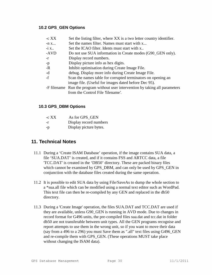
10.2 GPS_GEN Options
-c XX Set the listing filter, where XX is a two letter country identifier. -n x... Set the names filter. Names must start with x... -i x.. Set the ICAO filter. Idents must start with x.. -AVD Do not use SUA information in Create modes (G90_GEN only). -r Display record numbers. -p Display picture info as hex digits. -R Inhibit optimisation during Create Image File. -d debug. Display more info during Create Image File. -f Scan the names table for corrupted terminators on opening an
image file. (Useful for images dated before Dec 95). -F filename Run the program without user intervention by taking all parameters
from the Control File ’filename’.
10.3 GPS_DBM Options
-c XX As for GPS_GEN -r Display record numbers -p Display picture bytes.
11. Technical Notes
11.1 During a ‘Create ISAM Database’ operation, if the image contains SUA data, a file ‘SUA.DAT’ is created, and if it contains FSS and ARTCC data, a file 'TCC.DAT' is created in the ‘DB50’ directory. These are packed binary files which cannot be examined by GPS_DBM, and can only be used by GPS_GEN in conjunction with the database files created during the same operation.
11.2 It is possible to edit SUA data by using File/SaveAs to dump the whole section to
a *sua.all file which can be modified using a normal text editor such as WordPad. This text file can then be re-compiled by any GEN and replaced in the db50 directory.
11.3 During a 'Create Image' operation, the files SUA.DAT and TCC.DAT are used if
they are available, unless G90_GEN is running in AVD mode. Due to changes in record format for G496 units, the pre-compiled files sua.dat and tcc.dat in folder db50 are not transferable between unit types. All the GEN programs recognise and report attempts to use them in the wrong unit, so if you want to move their data (say from a 496 to a 296) you must Save them as ".all" text files using G496_GEN and re-compile them with GPS_GEN. (These operations MUST take place without changing the ISAM data).
GPS Database Management Page 31 11/1/2011
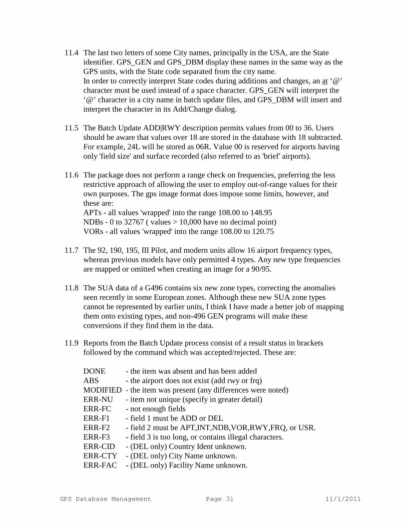
11.4 The last two letters of some City names, principally in the USA, are the State identifier. GPS_GEN and GPS_DBM display these names in the same way as the GPS units, with the State code separated from the city name.
In order to correctly interpret State codes during additions and changes, an at ‘@’ character must be used instead of a space character. GPS_GEN will interpret the ‘@’ character in a city name in batch update files, and GPS_DBM will insert and interpret the character in its Add/Change dialog.
11.5 The Batch Update ADD|RWY description permits values from 00 to 36. Users
should be aware that values over 18 are stored in the database with 18 subtracted. For example, 24L will be stored as 06R. Value 00 is reserved for airports having only 'field size' and surface recorded (also referred to as 'brief' airports).
11.6 The package does not perform a range check on frequencies, preferring the less
restrictive approach of allowing the user to employ out-of-range values for their own purposes. The gps image format does impose some limits, however, and these are:
APTs - all values 'wrapped' into the range 108.00 to 148.95 NDBs - 0 to 32767 ( values > 10,000 have no decimal point) VORs - all values 'wrapped' into the range 108.00 to 120.75 11.7 The 92, 190, 195, III Pilot, and modern units allow 16 airport frequency types,
whereas previous models have only permitted 4 types. Any new type frequencies are mapped or omitted when creating an image for a 90/95.
11.8 The SUA data of a G496 contains six new zone types, correcting the anomalies
seen recently in some European zones. Although these new SUA zone types cannot be represented by earlier units, I think I have made a better job of mapping them onto existing types, and non-496 GEN programs will make these conversions if they find them in the data.
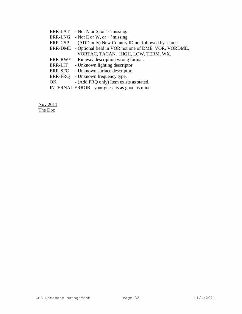
11.9 Reports from the Batch Update process consist of a result status in brackets
followed by the command which was accepted/rejected. These are:
DONE - the item was absent and has been added ABS - the airport does not exist (add rwy or frq) MODIFIED - the item was present (any differences were noted) ERR-NU - item not unique (specify in greater detail) ERR-FC - not enough fields ERR-F1 - field 1 must be ADD or DEL ERR-F2 - field 2 must be APT,INT,NDB,VOR,RWY,FRQ, or USR. ERR-F3 - field 3 is too long, or contains illegal characters. ERR-CID - (DEL only) Country Ident unknown. ERR-CTY - (DEL only) City Name unknown. ERR-FAC - (DEL only) Facility Name unknown.
GPS Database Management Page 32 11/1/2011
ERR-LAT - Not N or S, or ’~’ missing. ERR-LNG - Not E or W, or ’~’ missing. ERR-CSP - (ADD only) New Country ID not followed by -name. ERR-DME - Optional field in VOR not one of DME, VOR, VORDME, VORTAC, TACAN, HIGH, LOW, TERM, WX. ERR-RWY - Runway description wrong format. ERR-LIT - Unknown lighting descriptor. ERR-SFC - Unknown surface descriptor. ERR-FRQ - Unknown frequency type. OK - (Add FRQ only) Item exists as stated. INTERNAL ERROR - your guess is as good as mine.
Nov 2011The Doc