Embed Size (px)
Citation preview
AAAA----GPS Application NoteGPS Application NoteGPS Application NoteGPS Application Note
80000NT10066A Rev. 4 – 2013-11- 29
Reproduction forbidden without written authorization from Telit Communications S.p.A. - All Rights Reserved. Page 1 of 36 Mod. 0809 2011-07 Rev.2
Assisted GPS (A-GPS)
Application Note 80000NT10066A Rev. 4 – 2013-11- 29
AAAA----GPS Application NoteGPS Application NoteGPS Application NoteGPS Application Note
80000NT10066A Rev. 4 – 2013-11- 29
Reproduction forbidden without written authorization from Telit Communications S.p.A. - All Rights Reserved. Page 2 of 36 Mod. 0809 2011-07 Rev.2
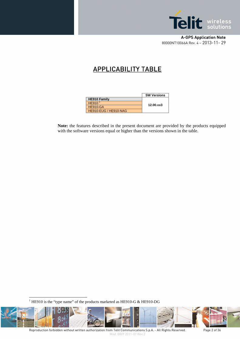
APPLICABILITY TABLEAPPLICABILITY TABLEAPPLICABILITY TABLEAPPLICABILITY TABLE
SW Versions HE910 Family
12.00.xx3 HE910 1 HE910-GA HE910-EUG / HE910-NAG
Note: the features described in the present document are provided by the products equipped with the software versions equal or higher than the versions shown in the table.
1 HE910 is the “type name” of the products marketed as HE910-G & HE910-DG
AAAA----GPS Application NoteGPS Application NoteGPS Application NoteGPS Application Note
80000NT10066A Rev. 4 – 2013-11- 29
Reproduction forbidden without written authorization from Telit Communications S.p.A. - All Rights Reserved. Page 3 of 36 Mod. 0809 2011-07 Rev.2
SPECIFICATIONS SUBJECT TO CHANGE WITHOUT NOTICE
Notice While reasonable efforts have been made to assure the accuracy of this document, Telit assumes no liability resulting from any inaccuracies or omissions in this document, or from use of the information obtained herein. The information in this document has been carefully checked and is believed to be entirely reliable. However, no responsibility is assumed for inaccuracies or omissions. Telit reserves the right to make changes to any products described herein and reserves the right to revise this document and to make changes from time to time in content hereof with no obligation to notify any person of revisions or changes. Telit does not assume any liability arising out of the application or use of any product, software, or circuit described herein; neither does it convey license under its patent rights or the rights of others. It is possible that this publication may contain references to, or information about Telit products (machines and programs), programming, or services that are not announced in your country. Such references or information must not be construed to mean that Telit intends to announce such Telit products, programming, or services in your country.
Copyrights This instruction manual and the Telit products described in this instruction manual may be, include or describe copyrighted Telit material, such as computer programs stored in semiconductor memories or other media. Laws in the Italy and other countries preserve for Telit and its licensors certain exclusive rights for copyrighted material, including the exclusive right to copy, reproduce in any form, distribute and make derivative works of the copyrighted material. Accordingly, any copyrighted material of Telit and its licensors contained herein or in the Telit products described in this instruction manual may not be copied, reproduced, distributed, merged or modified in any manner without the express written permission of Telit. Furthermore, the purchase of Telit products shall not be deemed to grant either directly or by implication, estoppel, or otherwise, any license under the copyrights, patents or patent applications of Telit, as arises by operation of law in the sale of a product.
Computer Software Copyrights The Telit and 3rd Party supplied Software (SW) products described in this instruction manual may include copyrighted Telit and other 3rd Party supplied computer programs stored in semiconductor memories or other media. Laws in the Italy and other countries preserve for Telit and other 3rd Party supplied SW certain exclusive rights for copyrighted computer programs, including the exclusive right to copy or reproduce in any form the copyrighted computer program. Accordingly, any copyrighted Telit or other 3rd Party supplied SW computer programs contained in the Telit products described in this instruction manual may not be copied (reverse engineered) or reproduced in any manner without the express written permission of Telit or the 3rd Party SW supplier. Furthermore, the purchase of Telit products shall not be deemed to grant either directly or by implication, estoppel, or otherwise, any license under the copyrights, patents or patent applications of Telit or other 3rd Party supplied SW, except for the normal non-exclusive, royalty free license to use that arises by operation of law in the sale of a product.
AAAA----GPS Application NoteGPS Application NoteGPS Application NoteGPS Application Note
80000NT10066A Rev. 4 – 2013-11- 29
Reproduction forbidden without written authorization from Telit Communications S.p.A. - All Rights Reserved. Page 4 of 36 Mod. 0809 2011-07 Rev.2
Usage and Disclosure Restrictions
License Agreements The software described in this document is the property of Telit and its licensors. It is furnished by express license agreement only and may be used only in accordance with the terms of such an agreement.
Copyrighted Materials Software and documentation are copyrighted materials. Making unauthorized copies is prohibited by law. No part of the software or documentation may be reproduced, transmitted, transcribed, stored in a retrieval system, or translated into any language or computer language, in any form or by any means, without prior written permission of Telit
High Risk Materials Components, units, or third-party products used in the product described herein are NOT fault-tolerant and are NOT designed, manufactured, or intended for use as on-line control equipment in the following hazardous environments requiring fail-safe controls: the operation of Nuclear Facilities, Aircraft Navigation or Aircraft Communication Systems, Air Traffic Control, Life Support, or Weapons Systems (High Risk Activities"). Telit and its supplier(s) specifically disclaim any expressed or implied warranty of fitness for such High Risk Activities.
Trademarks TELIT and the Stylized T Logo are registered in Trademark Office. All other product or service names are the property of their respective owners.
Copyright © Telit Communications S.p.A.
AAAA----GPS Application NoteGPS Application NoteGPS Application NoteGPS Application Note
80000NT10066A Rev. 4 – 2013-11- 29
Reproduction forbidden without written authorization from Telit Communications S.p.A. - All Rights Reserved. Page 5 of 36 Mod. 0809 2011-07 Rev.2
ContentsContentsContentsContents
1.1.1.1. IntroductionIntroductionIntroductionIntroduction ............................................................................................................................................................................................................................................................................................................................................................................................................................................ 7777
1.1. Scope ............................................................................................................................ 7
1.2. Audience ....................................................................................................................... 7
1.3. Contact Information, Support ...................................................................................... 7
1.4. Document Organization ............................................................................................... 8
1.5. Text Conventions .......................................................................................................... 8
1.6. Related Documents ..................................................................................................... 8
2.2.2.2. Document HistoryDocument HistoryDocument HistoryDocument History ........................................................................................................................................................................................................................................................................................................................................................................................................ 9999
3.3.3.3. A brief GPS IntroductionA brief GPS IntroductionA brief GPS IntroductionA brief GPS Introduction............................................................................................................................................................................................................................................................................................................................................................ 10101010
4.4.4.4. GPS SolutionsGPS SolutionsGPS SolutionsGPS Solutions ........................................................................................................................................................................................................................................................................................................................................................................................................................ 12121212
4.1. Standalone GPS (S-GPS) ............................................................................................ 13
4.2. Assisted GPS (A-GPS) ................................................................................................ 15
4.2.1. C-Plane Network ........................................................................................................... 16
4.2.1.1. Mobile Originated Location Request (MO-LR) ........................................................ 16
4.2.1.2. Mobile Terminated Location Request (MT-LR) ...................................................... 22
4.2.2. Secure User Plane Location (SUPL) .............................................................................. 24
4.2.2.1. SET Initiated Session .............................................................................................. 28
4.2.2.2. Network Initiated Session ...................................................................................... 34
5.5.5.5. Abbreviations and acronymsAbbreviations and acronymsAbbreviations and acronymsAbbreviations and acronyms ................................................................................................................................................................................................................................................................................................................................ 36363636
AAAA----GPS Application NoteGPS Application NoteGPS Application NoteGPS Application Note
80000NT10066A Rev. 4 – 2013-11- 29
Reproduction forbidden without written authorization from Telit Communications S.p.A. - All Rights Reserved. Page 6 of 36 Mod. 0809 2011-07 Rev.2
FiguresFiguresFiguresFigures fig. 1: ECEF coordinate system [from Wikipedia] ................................................................................ 10
fig. 2: GPS ............................................................................................................................................. 12
fig. 3: C-Plane / MO-LR / MS-Assisted Mode ...................................................................................... 18
fig. 4: C-Plane / MO-LR / MS-Based Mode .......................................................................................... 21
fig. 5: C-Plane / MT-LR ........................................................................................................................ 23
fig. 6: Module configuration for Network or Set Initiated Session (con’t) ........................................... 26
fig. 7: Module configuration for Network or Set Initiated Session ...................................................... 27
fig. 8: SET Initiated Session / MS Assisted Mode (SUPL) ..................................................................... 30
fig. 9: SET Initiated Session / MS Based Mode (SUPL) ........................................................................ 33
fig. 10: Network Initiated Session (SUPL) ............................................................................................ 35
AAAA----GPS Application NoteGPS Application NoteGPS Application NoteGPS Application Note
80000NT10066A Rev. 4 – 2013-11- 29
Reproduction forbidden without written authorization from Telit Communications S.p.A. - All Rights Reserved. Page 7 of 36 Mod. 0809 2011-07 Rev.2
1.1.1.1. IntroductionIntroductionIntroductionIntroduction
The present document provides the reader with a guideline concerning the use of the Assisted GPS (A-GPS) provided by the Telit’s Modules of the HE910 family. The document also deals with the Standalone GPS (S-GPS) to give to the reader an ease way to compare the AT commands used to set up and manage the two GPS solutions.
1.1.1.1.1.1.1.1. ScopeScopeScopeScope The Application Note covers the Control-Plane Network and the Secure User Plane Location (SUPL) standards created by two different standardization bodies: the 3GPP and the OMA respectively.
1.2.1.2.1.2.1.2. AudienceAudienceAudienceAudience This document is intended for those users that need to develop applications dealing with LoCation Service (LCS).
1.3.1.3.1.3.1.3. Contact Information, SupportContact Information, SupportContact Information, SupportContact Information, Support For general contact, technical support, to report documentation errors and to order manuals, contact Telit Technical Support Center (TTSC) at:
[email protected] [email protected] [email protected] [email protected]
Alternatively, use:
http://www.telit.com/en/products/technical-support-center/contact.php
For detailed information about where you can buy the Telit modules or for recommendations on accessories and components visit:
http://www.telit.com
To register for product news and announcements or for product questions contact Telit Technical Support Center (TTSC).
Our aim is to make this guide as helpful as possible. Keep us informed of your comments and suggestions for improvements.
Telit appreciates feedback from the users of our information.
AAAA----GPS Application NoteGPS Application NoteGPS Application NoteGPS Application Note
80000NT10066A Rev. 4 – 2013-11- 29
Reproduction forbidden without written authorization from Telit Communications S.p.A. - All Rights Reserved. Page 8 of 36 Mod. 0809 2011-07 Rev.2
1.4.1.4.1.4.1.4. Document OrganizationDocument OrganizationDocument OrganizationDocument Organization This document contains the following chapters addressing the listed main topics:
Chapter 1: introduction, scope, target audience, contact and support information;
Chapter 2: document history;
Chapter 3: brief GPS introduction;
Chapter 4: S-GPS and A-GPS Solutions;
Chapter 5: Abbreviations and acronyms.
1.5.1.5.1.5.1.5. Text ConventionsText ConventionsText ConventionsText Conventions
Danger – This information MUST be followed or catastrophic equipment failure or bodily injury may occur.
Caution or Warning – Alerts the user to important points about integrating the module, if these points are not followed, the module and end user equipment may fail or malfunction.
Tip or Information – Provides advice and suggestions that may be useful when integrating the module.
All dates are in ISO 8601 format, i.e. YYYY-MM-DD.
1.6.1.6.1.6.1.6. Related DocumentsRelated DocumentsRelated DocumentsRelated Documents [1] HE910 Hardware User Guide, Telit document: 1vv0300925
[2] HE910/UE910 Families Ports Arrangements User Guide, Telit document: 1vv0300971
[3] HE910/UE910 AT Commands Reference Guide, Telit document: 80378ST10091A
[4] WGS84 Implementation Manual, Eurocontrol and ifEN
[5] NMEA-0183 Standard for Interfacing Marine Electronic Devices
[6] SSL/TSL User Guide, Telit document 1vv0300989
AAAA----GPS Application NoteGPS Application NoteGPS Application NoteGPS Application Note
80000NT10066A Rev. 4 – 2013-11- 29
Reproduction forbidden without written authorization from Telit Communications S.p.A. - All Rights Reserved. Page 9 of 36 Mod. 0809 2011-07 Rev.2
2.2.2.2. Document HistoryDocument HistoryDocument HistoryDocument History
Revision Date Product/ SW Version Changes
0 2012-04-26 HE910/12.00.xx3 First issue
1 2012-05-14 / Added sequence diagrams and AT#FRWL command. Updated Applicability Table.
2 2012-10-15 / Added note about satellites visibility in chapters: 4.2.2.1.1, and 4.2.2.1.2
3 2012-11-02 /
Updated chapters 4.1, 4.2.2, 4.2.1.1.1, 4.2.1.1.2, 4.2.2.1.1, and 4.2.2.1.2. Deleted warnings about internal firewall. Deleted “Preliminary” from title page.
4 2013-11-29 / Reorganized the entire document.
AAAA----GPS Application NoteGPS Application NoteGPS Application NoteGPS Application Note
80000NT10066A Rev. 4 – 2013-11- 29
Reproduction forbidden without written authorization from Telit Communications S.p.A. - All Rights Reserved. Page 10 of 36 Mod. 0809 2011-07 Rev.2
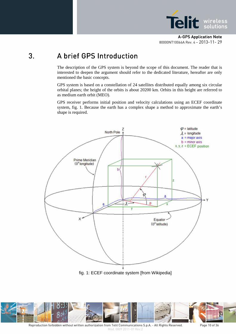
3.3.3.3. A brief GPS IntroductionA brief GPS IntroductionA brief GPS IntroductionA brief GPS Introduction
The description of the GPS system is beyond the scope of this document. The reader that is interested to deepen the argument should refer to the dedicated literature, hereafter are only mentioned the basic concepts.
GPS system is based on a constellation of 24 satellites distributed equally among six circular orbital planes; the height of the orbits is about 20200 km. Orbits in this height are referred to as medium earth orbit (MEO).
GPS receiver performs initial position and velocity calculations using an ECEF coordinate system, fig. 1. Because the earth has a complex shape a method to approximate the earth’s shape is required.
fig. 1: ECEF coordinate system [from Wikipedia]

AAAA----GPS Application NoteGPS Application NoteGPS Application NoteGPS Application Note
80000NT10066A Rev. 4 – 2013-11- 29
Reproduction forbidden without written authorization from Telit Communications S.p.A. - All Rights Reserved. Page 11 of 36 Mod. 0809 2011-07 Rev.2
The use of a geodetic reference (reference ellipsoid) allows for the conversion of the ECEF coordinates to the more commonly used coordinates of Latitude, Longitude and Altitude (LLA).
GPS receiver, used by GPS Telit solution, uses (by default) the geodetic reference (datum) WGS 84 [4] which provides a worldwide common grid system that may be translated into local coordinate systems or map datums. Many reference ellipsoids are used throughout the word. The main reason for choosing a reference datum other than WGS 84 is to minimize the local differences between the geoid and the ellipsoid separation or other mapping distortions. Local map datums are a best fit to the local shape of the earth and not valid worldwide.
AAAA----GPS Application NoteGPS Application NoteGPS Application NoteGPS Application Note
80000NT10066A Rev. 4 – 2013-11- 29
Reproduction forbidden without written authorization from Telit Communications S.p.A. - All Rights Reserved. Page 12 of 36 Mod. 0809 2011-07 Rev.2
4.4.4.4. GPS GPS GPS GPS SolutionsSolutionsSolutionsSolutions
Nowadays there are several Positioning Techniques to provide the localization of target MS. One of them is the A-GPS Positioning Technique based on the help of a cellular network deploying an A-GPS server.
At this point, it is advisable to introduce the definition of: Time to First Fix (TTFF):
TTFF indicates the time and process required for a GPS device to get adequate satellite signals and data to provide accurate navigation.
A GPS uses the following sets of data to provide accurate position
• GPS satellite signals,
• Almanac data,
• Ephemeris data.
If a GPS device has been turned off for a long period of time, when it is turned on it will take longer to acquire these data sets and get a "Time to First Fix". One way to speed up TTFF is to use the A-GPS Positioning Technique.
A "cold" start indicates the scenario in which the GPS must get all data in order to start navigation, and may take up to several minutes.
A "warm" start indicates the scenario in which the GPS has most of the data it needs in memory, and will start quickly, a minute or less.
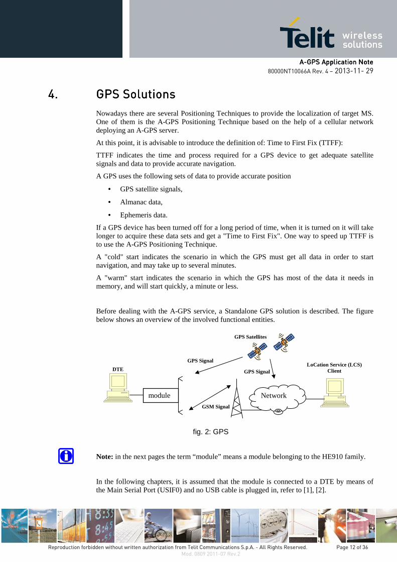
Before dealing with the A-GPS service, a Standalone GPS solution is described. The figure below shows an overview of the involved functional entities.
fig. 2: GPS
Note: in the next pages the term “module” means a module belonging to the HE910 family.
In the following chapters, it is assumed that the module is connected to a DTE by means of the Main Serial Port (USIF0) and no USB cable is plugged in, refer to [1], [2].
module
GSM Signal
GPS Signal
GPS Satellites
DTE
Network
LoCation Service (LCS) Client
GPS Signal
AAAA----GPS Application NoteGPS Application NoteGPS Application NoteGPS Application Note
80000NT10066A Rev. 4 – 2013-11- 29
Reproduction forbidden without written authorization from Telit Communications S.p.A. - All Rights Reserved. Page 13 of 36 Mod. 0809 2011-07 Rev.2
Warning: to have more information about the syntax and parameters of the GPS AT commands described in the document refer to [3].
4.1.4.1.4.1.4.1. Standalone GPS (SStandalone GPS (SStandalone GPS (SStandalone GPS (S----GPGPGPGPS)S)S)S) Standalone (or autonomous) GPS mode is a feature that allows the GPS receiver, installed on the module, to perform its First Fixing activity without assistance data coming from cellular network. The GPS receiver estimates its position directly from GPS satellites in its line of sight. The S-GPS is sometime slower to compute its First Fix; this phenomenon is evident in very poor signal conditions, for example in a city where the satellites signals are corrupted by the multipath propagation.
To set up the GPS receiver in standalone mode the user should go through the following steps of the example.
Switch off/on the module and restore the default GPS parameters in order to start from a known GPS setting.
AT$GPSRST
OK
Delete the GPS information stored in NVM. It is the history buffer interfacing the GPS receiver to the module. This action is not mandatory; it should be performed only if you need to clean the buffer:
AT$GPSNVRAM=15,0
OK
Check that after history buffer cleaning no GPS information is available
AT$GPSACP
$GPSACP:
OK
Enable unsolicited messages of GPS data in NMEA format, refer to [5]. Only Global Positioning System Fix Data (GGA) sentence is enabled:
AT$GPSNMUN=1,1,0,0,0,0,0
OK
Start the GPS receiver in standalone mode:
AT$GPSP=1
OK
AAAA----GPS Application NoteGPS Application NoteGPS Application NoteGPS Application Note
80000NT10066A Rev. 4 – 2013-11- 29
Reproduction forbidden without written authorization from Telit Communications S.p.A. - All Rights Reserved. Page 14 of 36 Mod. 0809 2011-07 Rev.2
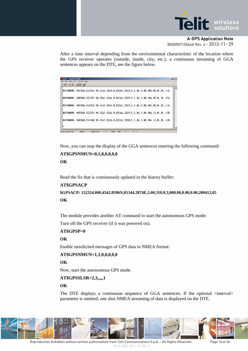
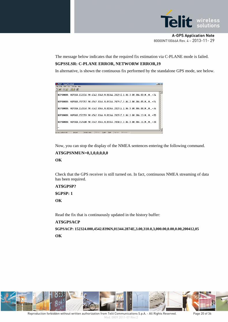
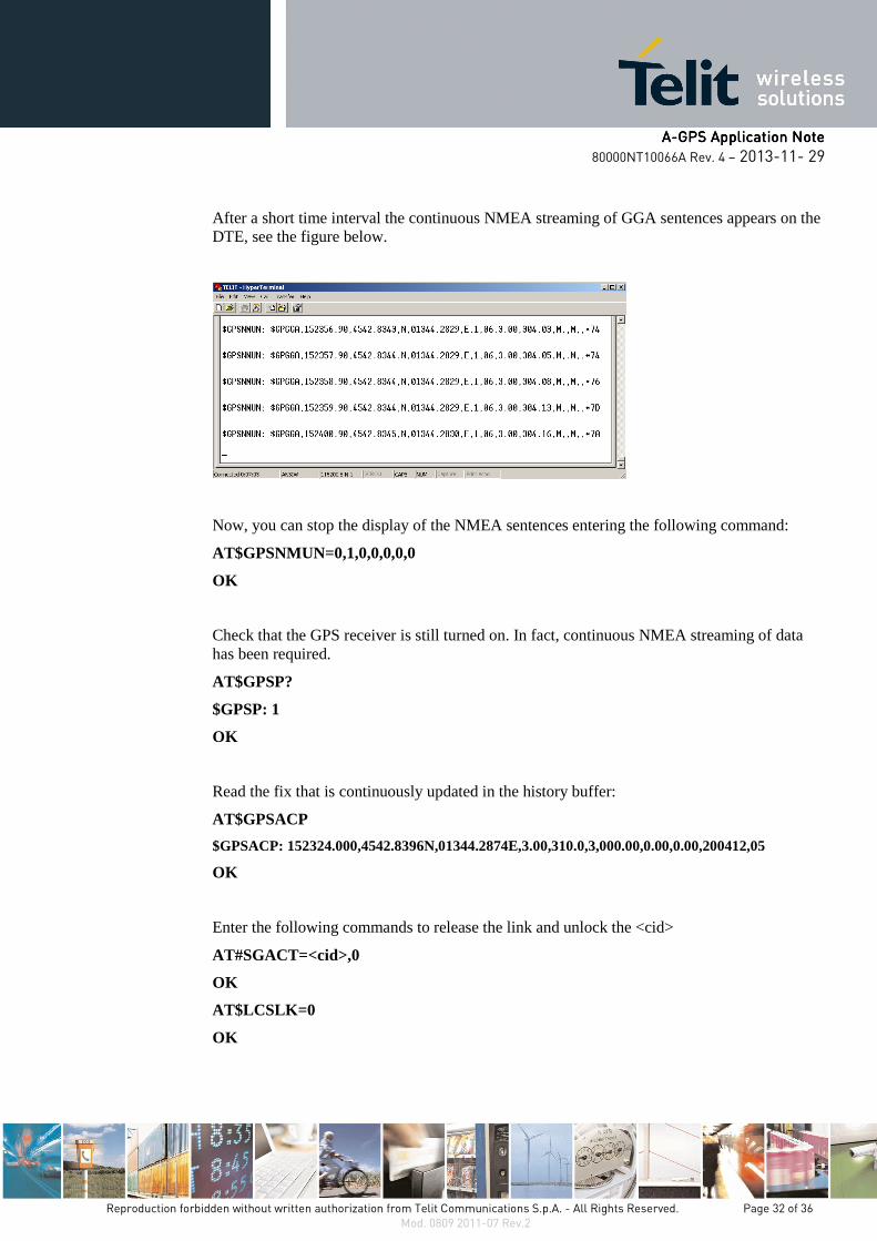
After a time interval depending from the environmental characteristic of the location where the GPS receiver operates (outside, inside, city, etc.), a continuous streaming of GGA sentences appears on the DTE, see the figure below.
Now, you can stop the display of the GGA sentences entering the following command:
AT$GPSNMUN=0,1,0,0,0,0,0
OK
Read the fix that is continuously updated in the history buffer:
AT$GPSACP
$GPSACP: 152324.000,4542.8396N,01344.2874E,3.00,310.0,3,000.00,0.00,0.00,200412,05
OK
The module provides another AT command to start the autonomous GPS mode:
Turn off the GPS receiver (if it was powered on).
AT$GPSP=0
OK
Enable unsolicited messages of GPS data in NMEA format:
AT$GPSNMUN=1,1,0,0,0,0,0
OK
Now, start the autonomous GPS mode.
AT$GPSSLSR=2,3,,,,,1
OK
The DTE displays a continuous sequence of GGA sentences. If the optional <interval> parameter is omitted, one shot NMEA streaming of data is displayed on the DTE.
AAAA----GPS Application NoteGPS Application NoteGPS Application NoteGPS Application Note
80000NT10066A Rev. 4 – 2013-11- 29
Reproduction forbidden without written authorization from Telit Communications S.p.A. - All Rights Reserved. Page 15 of 36 Mod. 0809 2011-07 Rev.2
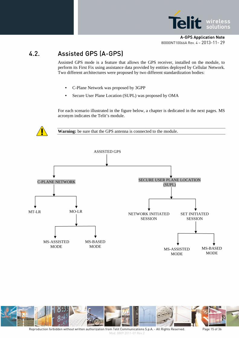
4.2.4.2.4.2.4.2. Assisted GPS (AAssisted GPS (AAssisted GPS (AAssisted GPS (A----GPS)GPS)GPS)GPS) Assisted GPS mode is a feature that allows the GPS receiver, installed on the module, to perform its First Fix using assistance data provided by entities deployed by Cellular Network. Two different architectures were proposed by two different standardization bodies:
• C-Plane Network was proposed by 3GPP
• Secure User Plane Location (SUPL) was proposed by OMA
For each scenario illustrated in the figure below, a chapter is dedicated in the next pages. MS acronym indicates the Telit’s module.
Warning: be sure that the GPS antenna is connected to the module.
ASSISTED GPS
NETWORK INITIATED SESSION
SECURE USER PLANE LOCATION (SUPL)
C-PLANE NETWORK
SET INITIATED SESSION
MT-LR
MS-ASSISTED MODE
MS-BASED MODE
MO-LR
MS-ASSISTED MODE
MS-BASED MODE
AAAA----GPS Application NoteGPS Application NoteGPS Application NoteGPS Application Note
80000NT10066A Rev. 4 – 2013-11- 29
Reproduction forbidden without written authorization from Telit Communications S.p.A. - All Rights Reserved. Page 16 of 36 Mod. 0809 2011-07 Rev.2
4.2.1.4.2.1.4.2.1.4.2.1. CCCC----Plane NetworkPlane NetworkPlane NetworkPlane Network
Two functional entities must be added to the network to make it supporting the A-GPS Service: Serving Mobile Location Center (SMLC) and a Gateway Mobile Location Center (GMLC).
4.2.1.1.4.2.1.1.4.2.1.1.4.2.1.1. Mobile Originated LocMobile Originated LocMobile Originated LocMobile Originated Location Request (MOation Request (MOation Request (MOation Request (MO----LR)LR)LR)LR)
In this scenario the Location Request is started by the module itself. Two modes are available:
• MS-Assisted
• MS-Based
4.2.1.1.1. MS-Assisted mode
In MS-Assisted mode, the module requires assistance data to the network (SMLC). With the help of this data, the A-GPS receiver, installed on the module, receives signals from the visible satellites and sends the measurement to the network. The SMLC calculates the position and sends it back to the module. See the following example to perform the First Fix.
Switch off/on the module and set the location’s Quality of Service (QoS). The setting can be stored via the AT$GPSSAV command.
AT$GPSQOS=100,50,25,0
OK
Delete the GPS information stored in NVM. It is the history buffer interfacing the GPS receiver to the module. This action is not mandatory; it should be performed only if you need to clean the buffer:
AT$GPSNVRAM=15,0
OK
Check that after history buffer cleaning no GPS information is available
AT$GPSACP
$GPSACP:
OK
Enable unsolicited messages of GPS data in NMEA format. Only Global Positioning System Fix Data (GGA) sentence is enabled (optional):
AT$GPSNMUN=1,1,0,0,0,0,0
OK
Check that the GPS receiver is turned off.
AT$GPSP?
AAAA----GPS Application NoteGPS Application NoteGPS Application NoteGPS Application Note
80000NT10066A Rev. 4 – 2013-11- 29
Reproduction forbidden without written authorization from Telit Communications S.p.A. - All Rights Reserved. Page 17 of 36 Mod. 0809 2011-07 Rev.2
$GPSP: 0
OK
Start the MO-LR using the MS-Assisted mode to calculate the First Fix. After a short time interval one shot NMEA streaming of data appears on the DTE.
AT$GPSSLSR=0,0
OK
The message below indicates that the required fix estimation via C-PLANE mode is failed.
$GPSSLSR: C-PLANE ERROR, NETWORW ERROR,19
In alternative, is shown the fix performed by the standalone GPS mode, see below.
$GPSNMUN: $GPGGA,160546.000,4542.7971,N,01344.2759,E,1,06,2.75,294.0,M,,M,,0000*7F
Check that the GPS receiver is turned off. In fact, only one shot NMEA streaming of data has been required.
AT$GPSP?
$GPSP: 0
OK
Read the already estimated fix stored in the history buffer:
AT$GPSACP
$GPSACP: 160546.000,4542.7971N,01344.2759E,2.75,294.0,3,000.00,1.29,0.69,171212,06
OK
AAAA----GPS Application NoteGPS Application NoteGPS Application NoteGPS Application Note
80000NT10066A Rev. 4 – 2013-11- 29
Reproduction forbidden without written authorization from Telit Communications S.p.A. - All Rights Reserved. Page 18 of 36 Mod. 0809 2011-07 Rev.2
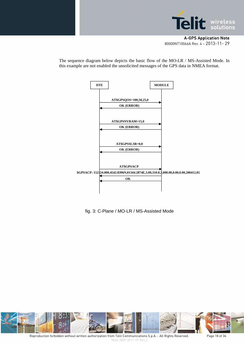
The sequence diagram below depicts the basic flow of the MO-LR / MS-Assisted Mode. In this example are not enabled the unsolicited messages of the GPS data in NMEA format.
fig. 3: C-Plane / MO-LR / MS-Assisted Mode
DTE MODULE
AT$GPSQOS=100,50,25,0
OK (ERROR)
AT$GPSNVRAM=15,0
OK (ERROR)
AT$GPSSLSR=0,0
OK (ERROR)
AT$GPSACP
$GPSACP: 152324.000,4542.8396N,01344.2874E,3.00,310.0,3,000.00,0.00,0.00,200412,05
OK

AAAA----GPS Application NoteGPS Application NoteGPS Application NoteGPS Application Note
80000NT10066A Rev. 4 – 2013-11- 29
Reproduction forbidden without written authorization from Telit Communications S.p.A. - All Rights Reserved. Page 19 of 36 Mod. 0809 2011-07 Rev.2
4.2.1.1.2. MS- Based mode
In MS-Based mode, the module requires assistance data to the network (SMLC). With the help of this data, the A-GPS receiver, installed on the module, receives signals from the visible satellites and calculates the position. See the following example to perform the First Fix. Assume that the module is powered down.
Switch on the module.
Set the location’s Quality of Service (QoS):
AT$GPSQOS=100,50,25,0
OK
Delete the GPS information stored in NVM. It is the history buffer between the GPS device and the module. This action is not mandatory; it must be performed only if you need to clean the buffer:
AT$GPSNVRAM=15,0
OK
Check that after history buffer cleaning no GPS information are available
AT$GPSACP
$GPSACP:
OK
Enable unsolicited messages of GPS data (NMEA format). Only Global Positioning System Fix Data (GGA) sentence is enabled (optional):
AT$GPSNMUN=1,1,0,0,0,0,0
OK
Check that the GPS receiver is turned off.
AT$GPSP?
$GPSP: 0
OK
Start the MO-LR using the MS-Based mode. After a short time interval a continuous NMEA streaming (GGA sentences) appears on the DTE.
AT$GPSSLSR=0,1,,,,,1
OK
AAAA----GPS Application NoteGPS Application NoteGPS Application NoteGPS Application Note
80000NT10066A Rev. 4 – 2013-11- 29
Reproduction forbidden without written authorization from Telit Communications S.p.A. - All Rights Reserved. Page 20 of 36 Mod. 0809 2011-07 Rev.2
The message below indicates that the required fix estimation via C-PLANE mode is failed.
$GPSSLSR: C-PLANE ERROR, NETWORW ERROR,19
In alternative, is shown the continuous fix performed by the standalone GPS mode, see below.
Now, you can stop the display of the NMEA sentences entering the following command.
AT$GPSNMUN=0,1,0,0,0,0,0
OK
Check that the GPS receiver is still turned on. In fact, continuous NMEA streaming of data has been required.
AT$GPSP?
$GPSP: 1
OK
Read the fix that is continuously updated in the history buffer:
AT$GPSACP
$GPSACP: 152324.000,4542.8396N,01344.2874E,3.00,310.0,3,000.00,0.00,0.00,200412,05
OK
AAAA----GPS Application NoteGPS Application NoteGPS Application NoteGPS Application Note
80000NT10066A Rev. 4 – 2013-11- 29
Reproduction forbidden without written authorization from Telit Communications S.p.A. - All Rights Reserved. Page 21 of 36 Mod. 0809 2011-07 Rev.2
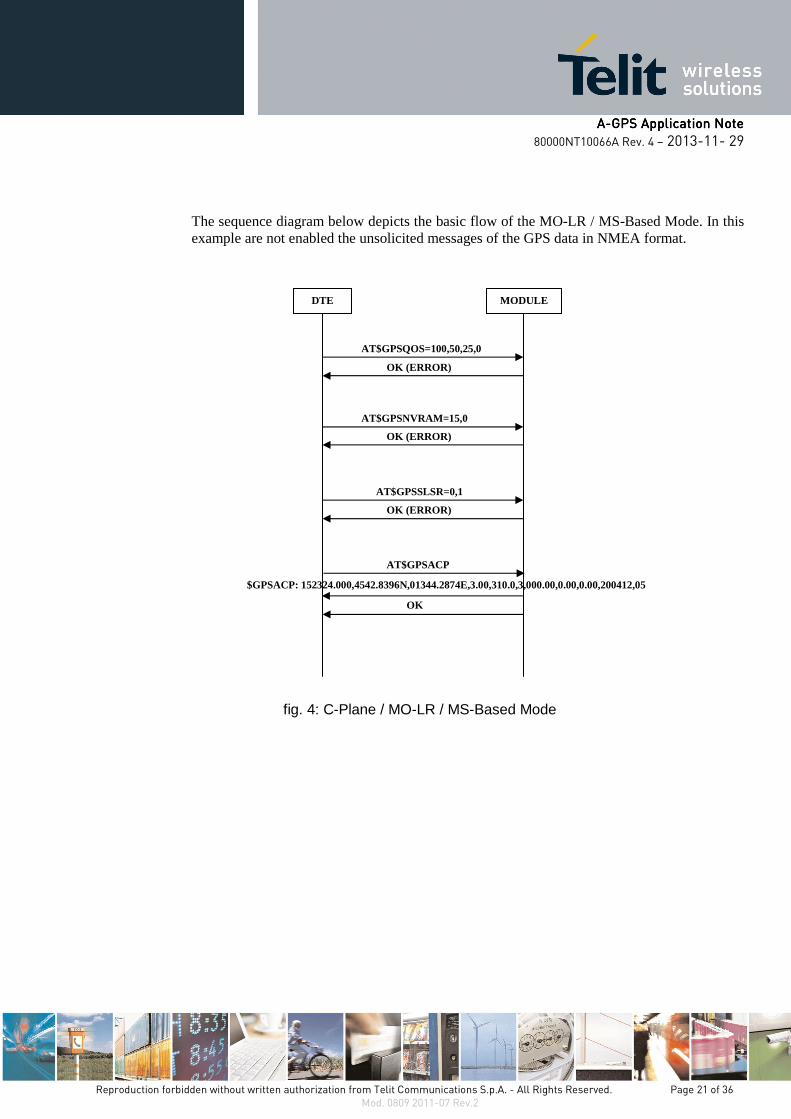
The sequence diagram below depicts the basic flow of the MO-LR / MS-Based Mode. In this example are not enabled the unsolicited messages of the GPS data in NMEA format.
fig. 4: C-Plane / MO-LR / MS-Based Mode
DTE MODULE
AT$GPSQOS=100,50,25,0
OK (ERROR)
AT$GPSNVRAM=15,0
OK (ERROR)
AT$GPSSLSR=0,1
OK (ERROR)
AT$GPSACP
$GPSACP: 152324.000,4542.8396N,01344.2874E,3.00,310.0,3,000.00,0.00,0.00,200412,05
OK
AAAA----GPS Application NoteGPS Application NoteGPS Application NoteGPS Application Note
80000NT10066A Rev. 4 – 2013-11- 29
Reproduction forbidden without written authorization from Telit Communications S.p.A. - All Rights Reserved. Page 22 of 36 Mod. 0809 2011-07 Rev.2
4.2.1.2.4.2.1.2.4.2.1.2.4.2.1.2. Mobile Terminated Location Request (MTMobile Terminated Location Request (MTMobile Terminated Location Request (MTMobile Terminated Location Request (MT----LR)LR)LR)LR)
The network (an external LCS client2 connected to a GMLC) can request the current location of a target MS. To perform this activity the network establishes an MT toward the target MS. The MS to detect a possible incoming call must enable the $LCSLRMT unsolicited response with the following command:
Enable unsolicited $LCSLRMT response:
AT$LCSLRMT=1 � Default value is 1
OK
When the network establishes the MT, the target MS displays on the DTE the following unsolicited message:
$LCSLRMT : <transport_protocol>,<Notif_type>,<Loc_estimate_type>,
<Client_Id>,<Client_Name_Encoding_type>,<Client_Name_Type>,
<Client_Name>,<Requestor_Id_Encoding_type>,<Requestor_Id_Type>,
<Requestor_Id>,<Codeword>,<Service_Type_id>,<reqid>
If the request is accepted enter the next command to notify it to the network (Location Service Client). Use <reqid> to identify univocally the Location Request:
AT$LCSLRV=1,<reqid>
OK
Or to reject the request use:
AT$LCSLRV=0,<reqid>
OK
2 Location Services Client description is beyond the scope of this document.

AAAA----GPS Application NoteGPS Application NoteGPS Application NoteGPS Application Note
80000NT10066A Rev. 4 – 2013-11- 29
Reproduction forbidden without written authorization from Telit Communications S.p.A. - All Rights Reserved. Page 23 of 36 Mod. 0809 2011-07 Rev.2
The sequence diagram below depicts the basic flow of the MT-LR. The example shows an accepted location request.
fig. 5: C-Plane / MT-LR
DTE MODULE
AT$LCSLRMT=1
OK (ERROR)
Mobile terminated Location Request
$LCSLRMT: <transport_protocol>,<Notif_type>,<Loc_estimate_type>,
<Client_Id>,<Client_Name_Encoding_type>,<Client_Name_Type>,
<Client_Name>,<Requestor_Id_Encoding_type>,<Requestor_Id_Type>,
<Requestor_Id>,<Codeword>,<Service_Type_id>,<reqid>
AT$LCSLRV=1,<reqid>
OK (ERROR)
NETWORK
AAAA----GPS Application NoteGPS Application NoteGPS Application NoteGPS Application Note
80000NT10066A Rev. 4 – 2013-11- 29
Reproduction forbidden without written authorization from Telit Communications S.p.A. - All Rights Reserved. Page 24 of 36 Mod. 0809 2011-07 Rev.2
4.2.2.4.2.2.4.2.2.4.2.2. Secure User Plane Location (SUPL)Secure User Plane Location (SUPL)Secure User Plane Location (SUPL)Secure User Plane Location (SUPL)
This Location Service architecture is composed of two basic elements: a SUPL Enabled Terminal (SET) and a SUPL Location Platform (SLP). The SET corresponds to the module, more specifically to the SUPL Agent that handles location transactions between the SET and the SLP server. The SLP manages several tasks: authentication, location request, etc. The Telit’s module supports the SUPL ver. 1.0.
Two scenarios are available about the Location Request:
• Network Initiated Session
• SET Initiated Session
Before describing the scenarios mentioned above, it is needed to configure the Telit’s module using the AT commands listed hereafter. It is advisable to point out that in this configuration example is not indicated the SUPL Server; it is responsibility of the user to select one. Assume that the module is powered off.
Switch on the module.
Set the module current time:
AT+CCLK=” year/month/day,hour:minute:seconds±time zone”
OK
Delete the GPS information stored in NVM. It is the history buffer between the GPS device and the module. This action is not mandatory; it must be performed only if you need to clean the buffer:
AT$GPSNVRAM=15,0
OK
Check that after history buffer cleaning no GPS information are available
AT$GPSACP
$GPSACP:
OK
Enable unsolicited messages of GPS data in NMEA format. Only Global Positioning System Fix Data (GGA) sentence is enabled (optional):
AT$GPSNMUN=1,1,0,0,0,0,0
OK
AAAA----GPS Application NoteGPS Application NoteGPS Application NoteGPS Application Note
80000NT10066A Rev. 4 – 2013-11- 29
Reproduction forbidden without written authorization from Telit Communications S.p.A. - All Rights Reserved. Page 25 of 36 Mod. 0809 2011-07 Rev.2
Load Transport Layer Security (TLS) Certificate. As already stated, it is responsibility of the user to select the SUPL Server provided by the Location Service Provider. The AT$LTC command allows the user to store into NVM two certificates.
AT$LTC="<certificate in Hexa format MAX 300 >",<t otal Length of the certificate>,<Seq Number>,0
OK
Define the PDP context that will be used by the LoCation Service (LCS). It must be in accordance with the selected Network Provider:
AT+CGDCONT=<cid>,”IP”,<apn>
OK
Warning: recalling that the SSL socket can be opened only with <cid> =1, it is suggested – for LoCation Service - to assign to it another value. To have information about SSL socket refer to document [6].
Lock <cid> for SUPL use:
AT$LCSLK=1,<cid>
OK
Set the selected SLP address and port number (default 7275):
AT$LCSSLP=<slp_address_type>,<slp_address>,7275
OK
Configure the SET ID, for example IMSI:
AT$LCSTER=1 � Default value is 1
OK
Enable unsolicited $LCSLRMT notification (used only by Network Initiated Session):
AT$LCSLRMT=1 � Default value is 1
OK
Enable unsolicited $LICLS notification (used by Network and SET Initiated Sessions):
AT$LICLS=1 � Default value is 1
OK
Set the location’s Quality of Service (QoS). AT$GPSSAV command is used to save GPS parameters into NVM.
AT$GPSQOS=50,50,100,0
OK
AAAA----GPS Application NoteGPS Application NoteGPS Application NoteGPS Application Note
80000NT10066A Rev. 4 – 2013-11- 29
Reproduction forbidden without written authorization from Telit Communications S.p.A. - All Rights Reserved. Page 26 of 36 Mod. 0809 2011-07 Rev.2
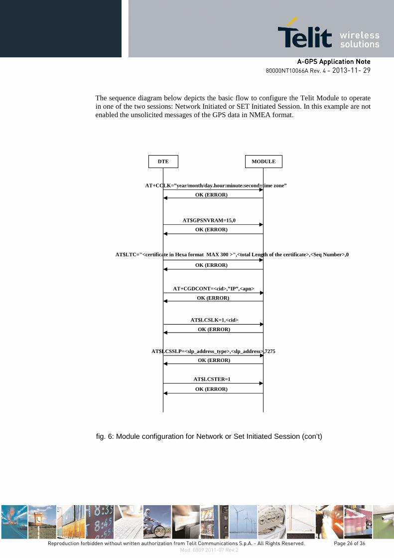
The sequence diagram below depicts the basic flow to configure the Telit Module to operate in one of the two sessions: Network Initiated or SET Initiated Session. In this example are not enabled the unsolicited messages of the GPS data in NMEA format.
fig. 6: Module configuration for Network or Set Initiated Session (con’t)
DTE MODULE
AT+CCLK=”year/month/day.hour:minute:second±time zone”
OK (ERROR)
AT$GPSNVRAM=15,0
OK (ERROR)
AT$LTC="<certificate in Hexa format MAX 300 >",<to tal Length of the certificate>,<Seq Number>,0
OK (ERROR)
AT+CGDCONT=<cid>,”IP”,<apn>
AT$LCSLK=1,<cid>
OK (ERROR)
OK (ERROR)
AT$LCSSLP=<slp_address_type>,<slp_address>,7275
OK (ERROR)
AT$LCSTER=1
OK (ERROR)
AAAA----GPS Application NoteGPS Application NoteGPS Application NoteGPS Application Note
80000NT10066A Rev. 4 – 2013-11- 29
Reproduction forbidden without written authorization from Telit Communications S.p.A. - All Rights Reserved. Page 27 of 36 Mod. 0809 2011-07 Rev.2
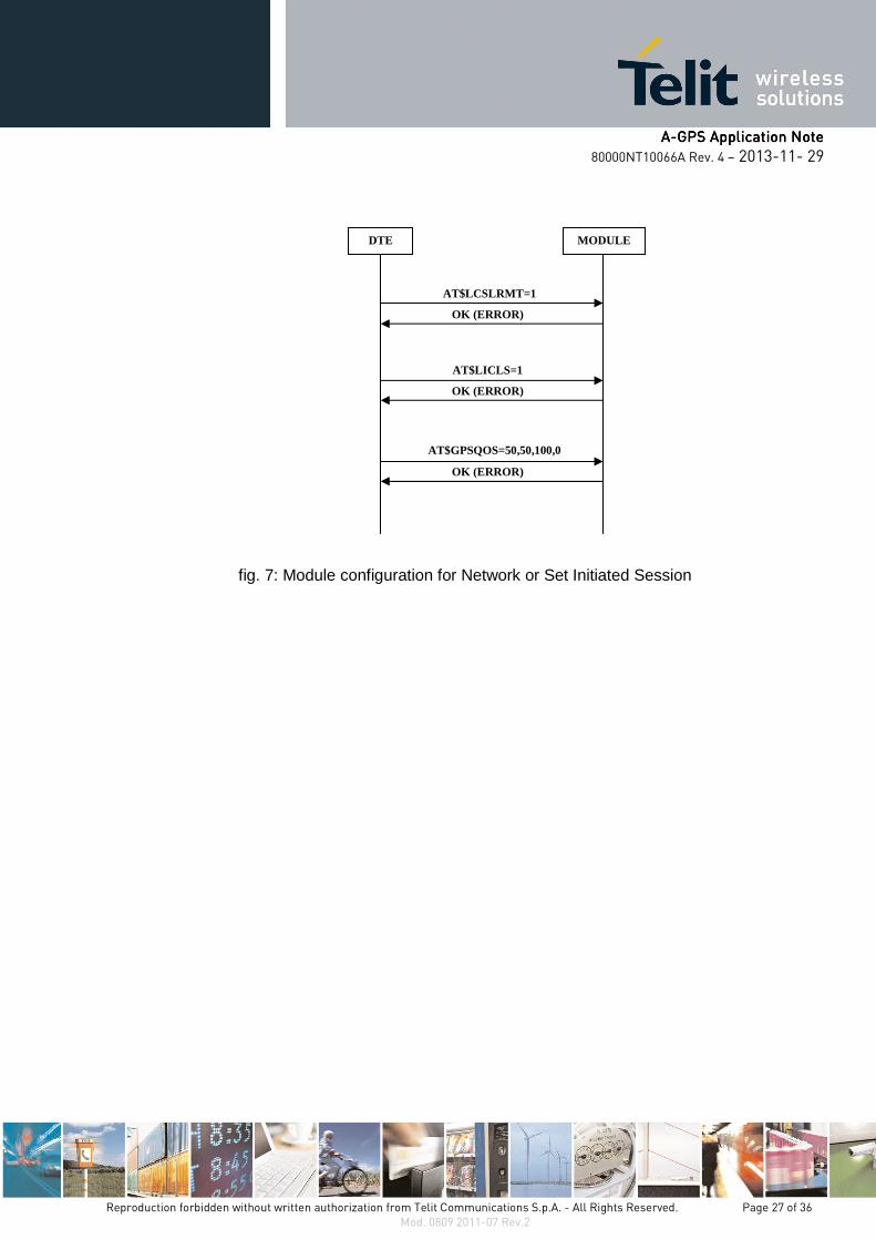
fig. 7: Module configuration for Network or Set Initiated Session
DTE MODULE
OK (ERROR)
OK (ERROR)
OK (ERROR)
AT$LCSLRMT=1
AT$LICLS=1
AT$GPSQOS=50,50,100,0
AAAA----GPS Application NoteGPS Application NoteGPS Application NoteGPS Application Note
80000NT10066A Rev. 4 – 2013-11- 29
Reproduction forbidden without written authorization from Telit Communications S.p.A. - All Rights Reserved. Page 28 of 36 Mod. 0809 2011-07 Rev.2
4.2.2.1.4.2.2.1.4.2.2.1.4.2.2.1. SET Initiated SessionSET Initiated SessionSET Initiated SessionSET Initiated Session
The module (SET), on its initiative, connects to an SLP Server through an IP network, two modes are available:
• MS-Assisted
• MS-Based
4.2.2.1.1. MS-Assisted mode
It is assumed that you have performed the module configuration described in the chapter 4.2.2. In MS-Assisted mode, the module requires assistance data to the SLP Server. With the help of this data, the A-GPS receiver, installed on the module, receives signals from the visible satellites and sends the measurement to the SLP Server. The SLP Server calculates the position and sends it back to the module.
NOTE: if the required satellites visibility is not available, no NMEA sentences are provided by the A-GPS receiver.
See the following example to perform the First Fix.
Check that the GPS receiver is turned off.
AT$GPSP?
$GPSP: 0
OK
Start the SET Initiated Session using the MS-Assisted mode
AT$GPSSLSR=1,0,,,,,1 ���� continuous NMEA streaming of data is selected
OK
The following unsolicited message is displayed on DTE:
$LICLS:0
After receiving the unsolicited message the module knows that the SLP Server has required to be connected to it by means of the TCP/IP protocol. In accordance, activate the <cid> PDP context locked for LoCation Service (LCS), refer to AT$LCSLK command on chapter 4.2.2.
AT#SGACT=<cid>,1
#SGACT: <IP address>
OK

AAAA----GPS Application NoteGPS Application NoteGPS Application NoteGPS Application Note
80000NT10066A Rev. 4 – 2013-11- 29
Reproduction forbidden without written authorization from Telit Communications S.p.A. - All Rights Reserved. Page 29 of 36 Mod. 0809 2011-07 Rev.2
On the DTE is displayed the next URC
$LICLS:<request_type>,<cid>
After a short time interval the continuous NMEA streaming of GGA sentences appears on the DTE, see the figure below.
Now, you can stop the display of the GGA sentences entering the following command:
AT$GPSNMUN=0,1,0,0,0,0,0
OK
Check that the GPS receiver is still turned on. In fact, continuous NMEA streaming of data has been required.
AT$GPSP?
$GPSP: 1
OK
Read the fix that is continuously updated in the history buffer:
AT$GPSACP
$GPSACP: 152324.000,4542.8396N,01344.2874E,3.00,310.0,3,000.00,0.00,0.00,200412,05
OK
Enter the following commands to release the link and unlock the <cid>
AT#SGACT=<cid>,0
OK
AT$LCSLK=0
AAAA----GPS Application NoteGPS Application NoteGPS Application NoteGPS Application Note
80000NT10066A Rev. 4 – 2013-11- 29
Reproduction forbidden without written authorization from Telit Communications S.p.A. - All Rights Reserved. Page 30 of 36 Mod. 0809 2011-07 Rev.2
OK
NOTE: After releasing the link and unlock the <cid>, you can continue display the NMEA sentences enabling them via the AT$GPSNMUN command or read the fix using the AT$GPSACP command. The position estimate is carried out in standalone GPS mode.
NOTE: an example to switch from a SUPL session to the autonomous GPS mode is provided by the following sequence of commands: AT$GPSP=0, AT$GPSNMUN=1,1,0,0,0,0,0, AT$GPSSLSR=2,3,,,,,1. It triggers the continuous GGA streaming of data displayed every second.
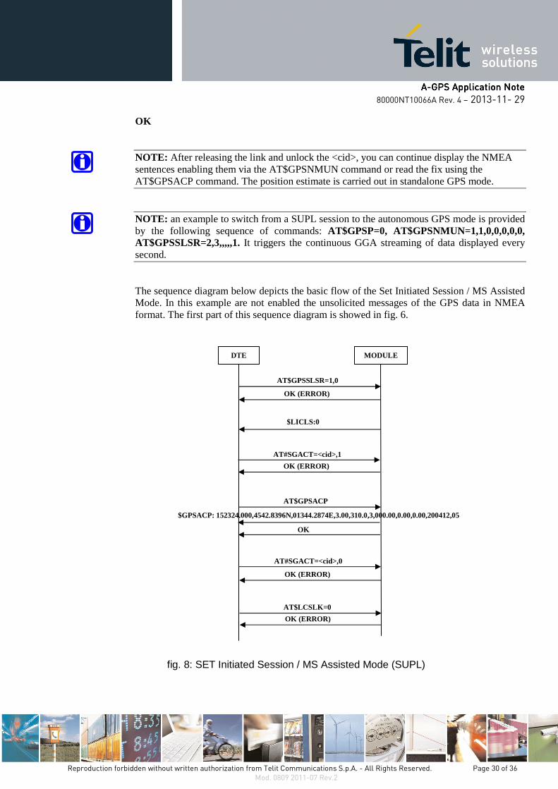
The sequence diagram below depicts the basic flow of the Set Initiated Session / MS Assisted Mode. In this example are not enabled the unsolicited messages of the GPS data in NMEA format. The first part of this sequence diagram is showed in fig. 6.
fig. 8: SET Initiated Session / MS Assisted Mode (SUPL)
DTE MODULE
$LICLS:0
OK (ERROR)
AT$LCSLK=0
OK (ERROR)
AT#SGACT=<cid>,0
AT$GPSSLSR=1,0
OK (ERROR)
AT$GPSACP
$GPSACP: 152324.000,4542.8396N,01344.2874E,3.00,310.0,3,000.00,0.00,0.00,200412,05
OK
OK (ERROR)
AT#SGACT=<cid>,1
AAAA----GPS Application NoteGPS Application NoteGPS Application NoteGPS Application Note
80000NT10066A Rev. 4 – 2013-11- 29
Reproduction forbidden without written authorization from Telit Communications S.p.A. - All Rights Reserved. Page 31 of 36 Mod. 0809 2011-07 Rev.2
4.2.2.1.2. MS-Based mode
It is assumed that you have performed the module configuration described in the chapter 4.2.2. In MS-Based mode, the module requires assistance data to the SLP Server. The A-GPS receiver, installed on the module, receives the signals from the visible satellites and with the help of the data received from the SLP Server calculates its position.
NOTE: if the required satellites visibility is not available, no NMEA sentences are provided by the A-GPS receiver.
See the following example to perform the First Fix.
Check that the GPS receiver is turned off.
AT$GPSP?
$GPSP: 0
OK
Start the SET Initiated Session using the MS-Based mode
AT$GPSSLSR=1,1,,,,,1 ���� continuous NMEA streaming of data is selected
OK
The following URC is displayed on DTE:
$LICLS:0
After receiving the unsolicited message the module knows that the SLP Server has required to be connected to it by means of the TCP/IP protocol. In accordance, activate the <cid> PDP context locked for LoCation Service (LCS), refer to AT$LCSLK command on chapter 4.2.2.
AT#SGACT=<cid>,1
#SGACT:<IP address>
OK
On the DTE is displayed the next URC
$LICLS:<request_type>,<cid>
AAAA----GPS Application NoteGPS Application NoteGPS Application NoteGPS Application Note
80000NT10066A Rev. 4 – 2013-11- 29
Reproduction forbidden without written authorization from Telit Communications S.p.A. - All Rights Reserved. Page 32 of 36 Mod. 0809 2011-07 Rev.2
After a short time interval the continuous NMEA streaming of GGA sentences appears on the DTE, see the figure below.
Now, you can stop the display of the NMEA sentences entering the following command:
AT$GPSNMUN=0,1,0,0,0,0,0
OK
Check that the GPS receiver is still turned on. In fact, continuous NMEA streaming of data has been required.
AT$GPSP?
$GPSP: 1
OK
Read the fix that is continuously updated in the history buffer:
AT$GPSACP
$GPSACP: 152324.000,4542.8396N,01344.2874E,3.00,310.0,3,000.00,0.00,0.00,200412,05
OK
Enter the following commands to release the link and unlock the <cid>
AT#SGACT=<cid>,0
OK
AT$LCSLK=0
OK

AAAA----GPS Application NoteGPS Application NoteGPS Application NoteGPS Application Note
80000NT10066A Rev. 4 – 2013-11- 29
Reproduction forbidden without written authorization from Telit Communications S.p.A. - All Rights Reserved. Page 33 of 36 Mod. 0809 2011-07 Rev.2
NOTE: After releasing the link and unlock the <cid>, you can continue display the NMEA sentences enabling them via the AT$GPSNMUN command or read the fix using the AT$GPSACP command. The position estimate is carried out in standalone GPS mode.
NOTE: an example to switch from a SUPL session to the autonomous GPS mode is provided by the following sequence of commands: AT$GPSP=0, AT$GPSNMUN=1,1,0,0,0,0,0, AT$GPSSLSR=2,3,,,,,1. It triggers the continuous GGA streaming of data displayed every second.
The sequence diagram below depicts the basic flow of the Set Initiated Session / MS Based Mode. In this example are not enabled the unsolicited messages of the GPS data in NMEA format. The first part of this sequence diagram is showed in fig. 6.
fig. 9: SET Initiated Session / MS Based Mode (SUPL)
DTE MODULE
$LICLS:0
OK (ERROR)
AT$LCSLK=0
OK (ERROR)
AT#SGACT=<cid>,0
AT$GPSSLSR=1,1
OK (ERROR)
AT$GPSACP
$GPSACP: 152324.000,4542.8396N,01344.2874E,3.00,310.0,3,000.00,0.00,0.00,200412,05
OK
OK (ERROR)
AT#SGACT=<cid>,1
AAAA----GPS Application NoteGPS Application NoteGPS Application NoteGPS Application Note
80000NT10066A Rev. 4 – 2013-11- 29
Reproduction forbidden without written authorization from Telit Communications S.p.A. - All Rights Reserved. Page 34 of 36 Mod. 0809 2011-07 Rev.2
4.2.2.2.4.2.2.2.4.2.2.2.4.2.2.2. Network Initiated SessionNetwork Initiated SessionNetwork Initiated SessionNetwork Initiated Session
It is assumed that you have performed the module configuration described on the chapter 4.2.2. Now, let’s suppose that a generic Location Service Client3 needs to know the position of the target module. To carry out this activity, the Location Service Client sends the request to the SLP Server, which in turn, by means of the cellular network, sends an SMS message to the target module. When the module receives the SMS message, on the DTE is displayed the following unsolicited message:
$LICLS:0
After receiving $LICLS:0 unsolicited message, the module knows that the SLP Server needs to be connected to it via the TCP/IP protocol. Activate the <cid> context locked for LoCation Service (LCS), refer to AT$LCSLK command on chapter 4.2.2.
AT#SGACT=<cid>,1
OK
Now, an unsolicited notification is received:
$LCSLRMT : <transport_protocol>,<Notif_type>,<Loc_estimate_type>,
<Client_Id>,<Client_Name_Encoding_type>,<Client_Name_Type>,
<Client_Name>,<Requestor_Id_Encoding_type>,<Requestor_Id_Type>,
<Requestor_Id>,<Codeword>,<Service_Type_id>,<reqid>
If the request is accepted enter the following command to notify it to the network (Location Service Client). Use <reqid> to identify univocally the Location Request:
AT$LCSLRV=1,<reqid>
OK
To reject the request use:
AT$LCSLRV=0,<reqid>
OK
Enter the following commands to release the link and unlock the <cid>
AT#SGACT=<cid>,0
OK
AT$LCSLK=0
OK 3 Location Services Client description is beyond the scope of this document.
AAAA----GPS Application NoteGPS Application NoteGPS Application NoteGPS Application Note
80000NT10066A Rev. 4 – 2013-11- 29
Reproduction forbidden without written authorization from Telit Communications S.p.A. - All Rights Reserved. Page 35 of 36 Mod. 0809 2011-07 Rev.2
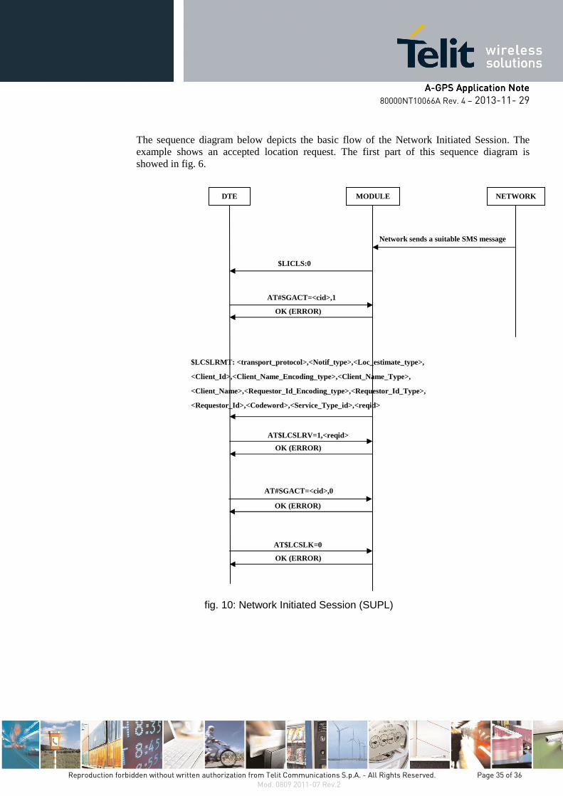
The sequence diagram below depicts the basic flow of the Network Initiated Session. The example shows an accepted location request. The first part of this sequence diagram is showed in fig. 6.
fig. 10: Network Initiated Session (SUPL)
DTE MODULE
AT#SGACT=<cid>,1
$LICLS:0
Network sends a suitable SMS message
$LCSLRMT: <transport_protocol>,<Notif_type>,<Loc_estimate_type>,
<Client_Id>,<Client_Name_Encoding_type>,<Client_Name_Type>,
<Client_Name>,<Requestor_Id_Encoding_type>,<Requestor_Id_Type>,
<Requestor_Id>,<Codeword>,<Service_Type_id>,<reqid>
AT$LCSLRV=1,<reqid>
OK (ERROR)
NETWORK
OK (ERROR)
OK (ERROR)
AT$LCSLK=0
OK (ERROR)
AT#SGACT=<cid>,0
AAAA----GPS Application NoteGPS Application NoteGPS Application NoteGPS Application Note
80000NT10066A Rev. 4 – 2013-11- 29
Reproduction forbidden without written authorization from Telit Communications S.p.A. - All Rights Reserved. Page 36 of 36 Mod. 0809 2011-07 Rev.2
5.5.5.5. Abbreviations and acronymsAbbreviations and acronymsAbbreviations and acronymsAbbreviations and acronyms
3GPP Third Generation Partnership Project
A-GPS Assisted-Global Positioning System
C-Plane Network Control Plane Network
ECEF Earth-Centered Earth-Fixed
GMLC Gateway Mobile Location Center
GPS Global Positioning System
LCS LoCation Service
MO-LR Mobile Originated-Location Request
MS Mobile Station
MT-LR Mobile Terminated-Location Request
NMEA National Marine Electronics Association
NVM Non Volatile Memory
OMA Open Mobile Alliance
PDP Packet Data Protocol
SET SUPL Enable Terminal
S-GPS Standalone-Global Positioning System
SLP SUPL Location Platform
SMLC Serving Mobile Location Center
SMS Short Message Service
SSL Secure Socket Layer
SUPL Secure User Plane Location
TTFF Time To First Fix
URC Unsolicited Result Code