Embed Size (px)
Citation preview

MINERALOGICAL SOCIETY OF GEORGIA
G. TSULUKIDZE MINING INSTITUTE
GEORGIAN TECHNICAL UNIVERSITY
THE DEVELOPMENT OF MINING AND
GEOLOGY IS THE PRECONDITION FOR THE
REVIVAL OF ECONOMY
BOOK OF ABSTRACTS
7th International Scientific-Practical Conference on Up-to-date
Problems of Geology
28-29 October, 2021
,,Technical University’’
Chief Partner

SCIENTIFIC COMMITTEE:
David Gurgenidze - Professor, Rector of the Georgian Technical University
Ramaz Khurodze - Academician, Academician-Secretary of the Georgian
National Academy of Science
Zurab Gasitashvili - Professor, Georgian Technical University
Nodar Poporadze - Professor, Georgian Technical University
Anzor Abshilava - Professor, Georgian Technical University
David Shengelia - Academician, A. Janelidze Institute of Geology
of I. Javakhishvili Tbilisi State University
Tornike Lipartia - Executive director, Rich Metals Group
Nikoloz Chikhradze - Director, G. Tsulukidze Mining Institute
Vaja Geleishvili - Professor, Georgian Technical University
Tamara Tsutsunava - Director, A. Janelidze Institute of Geology
of Iv. Javakhishvili Tbilisi State University
Zurab Kakulia - Director, Institute of Hydrogeology and
Engineering Geology of Georgian Technical University
ORGANIZING COMMITTEE:
Olga Seskuria - Georgian Technical University
Ketevan Gabarashvili - A. Janelidze Institute of Geology
of I. Javakhishvili Tbilisi State University
Nana Kitiashvili - National Enviromental Agency
Giorgi Khetsuriani - Rich Metals Group
Giorgi Beridze - A. Janelidze Institute of Geology
of I. Javakhishvili Tbilisi State University
Nino Japaridze - Georgian Technical University
Nino Adeishvili - Georgian Technical University
Asmat Shekiladze - G. Tsulukidze Mining Institute
Tamar Mikava - Georgian Technical University
Tamar Guruli - Georgian Technical University
Rusudan Metreveli - Georgian Technical University
Maia Kobakhidze - Georgian Technical University
4
TABLE OF CONTENTS
D. Arevadze, V. Goncharov, V. Okrugin, V. Yaroshevich,
T. Baindurashvili, C. Chkhaidze, Z. Kiknadze, K. Kupreishvili,
O. Pavlenishvili PHYSICAL AND CHEMICAL CONDITIONS FORMATION OF ENDOGE-
NOUS ORE DEPOSITS OF CAUCASUS AND EAST RUSSIA --------------- 9
I. Akhvlediani
STUDY OF BLAST IDENTIFICATION METHODS IN UNDERGROUND
BUILDINGS -------------------------------------------------------------- 12
M. Akhalkatsishvili, B. Tutberidze THE AGE RELATIONSHIP BETWEEN GLACIATION AND VOLCANISM
(AT THE EXAMPLE OF JAVAKHETI PLATEAU) ------------------------- 14
D. Abzianidze, M. Mardashova, V. Abzianidze, T. Mikava
ECOLOGICAL MONITORING OF THE RIVER LUKHUNI ---------- 16
G. Baliashvili, F. Bezhanovi, N. Sarjveladze, L. Tkemaladze OVERVIEW OF THE MECHANISM OF INFLUENCE OF WATER/CE-
MENT FACTOR ON THE STRENGTH OF CONCRETE ------------------- 20
D. Bluashvili, K. Benashvili, G. Mindiashvili
NEW DATA ABOUT GARTA ORE DEPOSIT ----------------------------- 22
D. Bluashvili, G. Mindiashvili DISCONTINUITIES, DISTRIBUTION SCALES AND FORMATION CONDI-
TIONS OF GUJARETI-TSKAROSTAVI (KHACHKOVI) ORE FIELD -------- 24
L. Basheleishvili, M. Kumelashvili STRUCTURE AND MORPHOLOGY OF THE CRYSTALLINE SUBSTRATE
OF THE SOUTHERN CAUCASUS INTERMOUNTAIN AREA (IN THE
LIMITS OF GEORGIA) --------------------------------------------------------- 26
M. Charbadze REVIEW OF THE GEOTECHNICAL CONDITIONS OF THE RIONI RIVER
GORGE IN RELATION TO HYDRAULIC ENGINEERING ---------------- 29

5
N. Chikhradze, M. Nadirashvili, T. Iashvili SYNTHESIS AND BLAST TESTING OF SOME “MOLECULAR COM-
POUNDS’’ ---------------------------------------------------------------- 31
E. Chagelishvili, B. Godibadze, A. Dgebuadze, M. Tutberidze EXPLOSIVE COMPACTION OF MULTICOMPONENT POWDER
MIXTURE ---------------------------------------------------------------- 39
G. Jandieri, O. Portyanko RECYCLING – A MODERN SOLUTION FOR IMPROVING THE OPERA-
TIONAL EFFICIENCY OF THE MINING AND METALLURGICAL ENTE-
RPRISES ------------------------------------------------------------------ 42
L. Japaridze, T. Gobejishvili
GEOTECHNICAL PROBLEMS OF VISCOUS-PLASTIC LANDSLIDES ----- 47
A. Kvitsiani PECULIARITIES OF GEOLOGY OF GOLD AND MERCURY ORE MANI-
FESTATION OF ORE-BEARING SITES IN SVANETI AND BOLNISI RE-
GIONS AND PROSPECTS ------------------------------------------------- 49
K. Khachaturian, N. Gegia, T. Guruli, E. Ukleba EVALUATION OF THE FILTERING ABILITY OF BENTONITE FROM
THE VANISKEDI DEPOSIT FOR THE PURPOSE OF ITS USE IN THE
PROCESS OF CLARIFYING WINE ---------------------------------------- 52
K. Kapanadze, A. Magalashvili, P. Imnadze ASSESSMENTS OF THE RADIATION HAZARDS DUE TO SOIL RADIO-
ACTIVITY ON THE EXAMPLE OF DZIRULA CRYSTALLINE MASSIF ---- 55
Z. Kakulia, Z. Varazashvili, M. Mardashova, A. Songhulashvili,
D. Chutkerashvili ENGINEERING-GEOLOGICAL STUDY OF VASHLIJVARI LANDSLIDE
AND ASSESSMENT OF ITS DYNAMICS ---------------------------------- 58
C. Lobjanidze, B. Kakhadze, T. Butulashvili, G. Machaidze,
G. Nanitashvili, G. Khetsuriani GLOBAL CHALLENGES AND PROSPECTS FOR EFFICIENT USE OF
MINERAL RESOURCES -------------------------------------------------- 61
6
T. Medoidze THE EFFECTIVENESS OF VERTICAL ELECTRICAL SOUNDING IN SOL-
VING ENGINEERING-GEOLOGICAL PROBLEMS ------------------------ 66
A. Maglakelidze HYDROCHEMICAL CHARACTERISTICS OF NABEGHLAVI MINERAL
WATERS PRODUCTION WELLS ----------------------------------------- 68
Sh. Malashkhia, N. Lomidze DEVELOPMENT OF AN ENVIROMENTALLY FRIENDLY TECHNOLOGY
FOR EXTRACTING GOLD FROM SECONDARY QUARTZITE HEAP
LEACH RESIDUE WITH THE USE OF BIOTECHNOLOGY ---------------
70
T. Mikava HYDROCHEMICAL CHARACTERIZATION OF ZUGDIDI-TSAISHI-
KHOBI THERMAL WATERS --------------------------------------------- 72
N. Momtselidze, G. Mindiashvili
ABOUT THE LANDSLIDE IN THE VILLAGE CHANCHKHALO ---------- 75
M. Nadirashvili, T. Iashvili, N. Abesadze, G. Tkhelidze SYNTHESIS OF METHYLPICRATE AND ITS “MOLECULAR COMPOU-
NDS” --------------------------------------------------------------------- 77
G. Nozadze, E. Tsotseria, D. Pataraia, R. Maisuradze, L.Tavlalashvili,
G. Akhvlediani, T. Kobidze
MODULAR PREFABRICATED PEDESTRIAN SUSPENSION BRIDGE ----- 79
V. Nadiradze, H. Saluqvadze, M. Apkhazava DETECTION AND SYSTEMATIZATION OF FAULT STRUCTURES IN THE
SUBURBS OF TBILISI TO IDENTIFY THE AREAS OF DANGEROUS
EVENTS ------------------------------------------------------------------ 81
V. Nadiradze, M. Apkhazava ISSUES OF METALLOGENY OF GEORGIA FROM THE POSITIONS OF
FIXISM AND MOBILISM ------------------------------------------------- 84
7
A. Okrostsvaridze, B. S. Van gosen, Yuan-His Lee, D. Bluashvili,
K. Akimidze, S. Gogoladze THE FIRST DATA ON Th AND U OCCURRENCES IN THE LATE
OROGENIC GRANITE VEINS OF THE SHKHARA VARISCAN PLUTON,
GREATER CAUCASUS, GEORGIA -------------------------------------- 88
D. Odilavadze, T. Chelidze DETERMINATION AND CONTOURING OF SPHERICAL CAVITIES IN
UNDERGROUND CONSTRUCTION AND MINING BY PHYSICAL MO-
DELING IN GPR. -------------------------------------------------------- 91
L. Popkhadze MICROFAUNA COMPLEXES OF THE MEOTIAN SEDIMENTS OF WES-
TERN GEORGIA (FORAMINIFERS, OSTRACODES) --------------------- 94
N. Poporadze, R. Metreveli USE OF MINERALS OF THE AGATE-CHALCEDONY GROUP IN
ARCHEOLOGICAL BEADS --------------------------------------------- 96
A. Shekiladze, O. Kavtelashvili, M. Bagnashvili, I. Samkharadze,
D. Mshvildadze, S. Maglakelidze INVESTIGATION OF OCHRE TYPE PIGMENT RAW MATERIAL OF
NAGOMARI DEPOSIT ON ENRICHABILITY ---------------------------- 99
D. Shengelia, T. Tsutsunava, L. Shumlyanskyy, G. Beridze,
I. Javakhishvili, G. Chichinadze ON THE ISOTOPE AGE OF ZIRCONS FROM THE TSKHETIJVARI
BASITE INTRUSIVEOF THE DZIRULA CRYSTALLINE MASSIF
(CAUCASUS) ------------------------------------------------------------ 101
E. Shapakidze, I. Kamushadze, L. Gabunia, I. Gejadze, T. Petriashvili INNOVATIVE TECHNOLOGY OF OBTAINING NEW ENVIRONMEN-
TALLY FRIENDLY HEAT-INSULATING MATERIAL -------------------- 104
E. Shapakidze, I. Kamushadze, L. Gabunia, I. Gejadze,
R. Skhvitaridze, M. Makadze, T. Petriashvili REVIVAL OF THE PRODUCTION OF CERAMIC BUILDING
MATERIALS IN GEORGIA AS ONE OF THE WAYS TO SOLVE
ENVIRONMENTAL PROBLEMS ----------------------------------------- 108
8
A. Tvalchrelidze THE PRIMARY MINERAL COMMODITY MARKET IN GEORGIA
AFTER THE PANDEMIC: OPPORTUNITIES FOR SUSTAINABLE
ECONOMIC DEVELOPMENT -------------------------------------------
111
M. Tchokonelidze, M. Gagnidze, D. Tcheishvili GEOLOGICAL STRUCTURE OF THE MUSHEVANI 3 GOLD-LOW-SUL-
PHIDE DEPOSIT ----------------------------------------------------------- 114
A. Vanishvili, D. Tsverava, S. Kvinikadze, L. Kirtadze, S. Steriakova,
G. Abashidze
PRELIMINARY RESULTS OF PERFORMED EXPERIMENTS TO OBTAIN
IMPACT RESISTANT ORGANOPLASTIC -------------------------------- 118
I. Varshanidze, N. Ghudushauri PER FECTION OF RESEARCH METODS IN COMPUTER USING
MATHEMATICAL SYSTEMS -------------------------------------------- 120
D. Zakaraia, T. Giorgobiani
FOLDED STRUCTURE OF THE GREATER CAUCASUS AT THE
CROSSING OF THE RIVER GORGES OF THE PSHAVIS ARAGVI-
KHEVSURETIS ARAGVI-TSKALSHUA-ASSA ---------------------------- 124
9
PHYSICAL AND CHEMICAL CONDITIONS FORMATION
OF ENDOGENOUS ORE DEPOSITS OF CAUCASUS AND
EAST RUSSIA
D. AREVADZE1, V. GONCHAROV2, V. OKRUGIN3,
V. YAROSHEVICH1, T. BAINDURASHVILI1,
C. CHKHAIDZE1, Z. KIKNADZE1, K. KUPREISHVILI1,
O.PAVLENISHVILI 1A.Tvalchrelidze Caucasian Institute of Mineral Resources
2North East Complex Scientific Institute of the Russian Academy of Sciences
3Institute of Volcanology and Seismology, Far East Branch, Russian Academy of Sciences
In order to determine the physicochemical parameters of
the formation and sources of matter of endogenous ore depo-
sits, there have been established the chemical composition,
concentrations, stable isotopes of hydrogen and oxygen of
ore-forming fluids, as well as stable isotopes of sulfur and
hydrocarbon of ore-forming minerals of copper-molybde-
num-porphyry, skarn-iron ore, copper pyrite, copper-poly-
metallic, barite-copper-base metal, barite-base metal, gold-
sulfide, gold-base metal, gold-antimony and silver deposits of
the Caucasus and the Far East of Russia were established.
Research has shown the prevailing role of deep-seated
solutions. The exception is the manganese-iron ores of the
barite-manganese-polymetallic deposit Zhairem (Kazakh-
stan), which are formed by seawater mixing with hydro-
thermal fluids.

10
Table 1

11
12
STUDY OF BLAST IDENTIFICATION METHODS IN
UNDERGROUND BUILDINGS
I. AKHVLEDIANI G. Tsulukidze Mining Institute, Tbilisi, Georgia
Protection of population and infrastructure from man-
made, accidental and terrorist explosions is one of the major
challenges of modernity. Statistics show that critical infra-
structure facilities, such as transportation and metro tunnels,
underground storages of explosives and ammunition, and
other underground industrial and living spaces are at a parti-
cularly high risk of being affected by unauthorized blasts.
Accidents caused by methane blast in coal mines are also a
major problem. Quick identification of threats, procession of
information and quick response are the only way to minimize
severe consequences. Experience shows that the reliability
and time characteristics of existing explosion detection sys-
tems fail to respond modern requirements.
The paper analyzes processes accompanying an explosion,
along with the existing methods of blast detection. It exa-
mines methods of blast identification in underground struc-
tures, which are based on monitoring and analysis of seismic
oscillations in tunnels, electromagnetic pulses, optical radia-
tion or overpressure.
Based on the results of preliminary studies, a system for the
detection of accidental explosions and wireless transmission
of emergency signals has been developed. The proposed wire-
less system consists of transmitter and receiver modules. A tran-
smitter module contains a sensor, a microprocessor equipped
with a blast identification software and transmitter that serves
to transmit an encoded signal at the 868.35 MHz frequency.
A receiver module has a transmitter, which serves to receive
13
a signal at the 868.35 MHz frequency, a microprocessor and a
decoder, which produces a starting signal for the operation of
a protection device. A system prototype was manufactured
and tested under real explosion conditions in the tunnel of the
underground experimental base of the Mining Institute. Test
results showed high reliability and speed of operation of the
system. The distance between a transmitter and a receiverin
the open air was at least 1000m, in a direct tunnel – at least
150m, in a tunnel with a 900 bending - 50m. The detection
system is designed to instantly activate the explosion protec-
tion device and transmit the emergency signal to the rescue
service.
REFERENCES:
1. Akhvlediani I., Mataradze E., Chikhradze M., Bochorishvili N.
EXPLOSION PROTECTION SYSTEM DEVELOPMENT. 6th
International Scientific-Practical Conference on Up-to-date
Problems of Mining and Geology. 24-25 September, Tbilisi 2020;
2. Akhvlediani I., Mataradze E., Chikhradze M., Marjanishvili Sh.,
Bochorishvili. Research and processing of electromagnetic
signals generated in tunnels. Proceedings "Signal Processing
Symposium", Poland, SPS-2013;
3. Akhvlediani I., Marjanishvili Sh., Bochorishvili N., Chikhradze
M. Wireless device for random explosion detectors in
underground buildings. Proceedings of the International
Symposium on the Interaction of the Effects of Munitions with
Structures, Potsdam, Germany, ISIEMS-15, 2013;
4. Akhvlediani I., Chikhradze M., Bochorishvili N., Kukhalashvili
D., Kalichava I., Mataradze E. Wireless system for explosion
detection in underground structures. Photonics Applications in
Communications, Industry, and High-Energy Physics Experi-
ments, Proc. SPIE, Vol. 7502, 2009
http://spie.org/x648.html?product_id=837523.

14
THE AGE RELATIONSHIP BETWEEN GLACIATION AND
VOLCANISM
(AT THE EXAMPLE OF JAVAKHETI PLATEAU)
M. AKHALKATSISHVILI, B. TUTBERIDZE I. Javakhishvili Tbilisi State University, Tbilisi, Georgia
The correlation method is successfully applied in a set of
proven methods of stratigraphic subdivision of the Late Ceno-
zoic extrusions of the Javakheti plateau, age dating of volcanic
structures and paleogeographic reconstructions. To establish
age relationship of volcanism and glaciation, in parallel to stu-
dies of geomorphological structure and stratigraphy of Late
Cenozoic volcanic and volcanogenic-sedimentary formations
of the Samsar and Javakheti ridges, visual, aerial decoding and
glacier reconstruction methods were used to clarify bounda-
ries of old glaciation spreading and the direction of move-
ment. The morphological and morphometric characteristics
of the glaciers were also determined. In carrying out the
fieldwork, we were guided by the data of the work carried out
by previous researchers, and participation in the expedition
together with Professor R. Gobedzhishvili. Tectonics and
volcanism play a crucial role in the formation of the modern
relief of the Javakheti plateau. Tectonic movements are espe-
cially strong during the Late Miocene and Early Pliocene
(Attic orophase), which actually determined the features not
only of the Javakheti plateau, but also of the main relief forms
of the entire Caucasus.In the Javakheti region, tectonic move-
ments of this period are connected with strong Miocene-
Pliocene extrusive volcanism, the eruption of which is served
by a multitude of monogenic and stratovolcanic apparatuses
of various heights, sizes and shapes. The main foci of glacia-
tion from the latter are associated with large stratovolcanoes

15
of the Great Abul and Samsar, currently severely eroded but
having the required heights to form the Firne Valley.Glacial
precipitation is also recorded in the Samsar caldera, the flatte-
ned surface of which creates favorable conditions for the acc-
umulation of snow cover for the active development of glacial
processes. According to our calculations, the total area of
glaciers is 75 m2, out of which 45 m2 is covered by the Samsara
mass. Morphologically, the glaciers of the Samsara ridge are
of Corrie, Corrie-Valley glaciers (alpine glaciers) types. Mora-
ine deposits are formed of andesite, dacite and of stone-tuff
breccias of rhyodacite compositions, lava breccias, lava frag-
ments, Lahari and pyroclastic breccias. Using of petrographic
and petrochemical methods in determining these deposits
made it possible to relate them genetically and physically to
the bedrock of the Late Miocene-Early Pleistocene volcanic
massifs of Abul and Samsar. It is noteworthy that since the
Late Pliocene, intense tectonic movements and formation of
heights necessary for the development of the Firne Valley
were observed in the region, though the glacial process did
not repeat itself here. This fact indicates that glaciation on the
Javakheti plateau is of one-time nature and belongs to the
time interval of early Late Pliocene- Early Pleistocene.
16
ECOLOGICAL MONITORING OF THE
RIVER LUKHUNI
D. ABZIANIDZE, M. MARDASHOVA,
V. ABZIANIDZE, T. MIKAVA Institute of Hydrogeology and Engineering Geology of
Georgian Technical University, Tbilisi, Georgia
One of the most beautiful regions of Georgia - Ambrolauri
and Lukhuni river valley is the object of our research. What
is the ecological condition of this river valley, why do the po-
pulation complain about the impact of arsenic, whether the
ecological condition is the reason for the migration of the po-
pulation. Here are the issues that have not yet been explored.
The main source of heavy metal pollution in this area is the
former Lukhuni deposit, where ore has been mined since
1933 and its processing began in 1937. Production has stopped
ore extraction and processing since 1991. The company that
won the tender in 2017 had to carry out a number of works
to improve the ecological situation in the area: dismantling
the buildings of former mining and chemical plants, removing
contaminated soil, and more. But, unfortunately, the work
was done with shortcomings. Part of the waste was left out
[1].
The latest studies were conducted in 2019 by the National
Environment Agency of the Ministry of Environment Prote-
ction and Agriculture of Georgia. They examined the condi-
tion of various villages in Ambrolauri Municipality, in parti-
cular, the moving form of arsenic was determined. According
to the results of the research, arsenic is the most polluted soil
in Uravi. The maximum content of arsenic according to the
data of November 2019 is 81.35 (valid value -40.7), 45.33
(valid value-22.7) mg / kg at a depths of 0-5 and 5-20 cm,
17
respectively. Other villages are also polluted [2]. Such an eco-
logical situation was encountered before the first field work
in Racha. Several tests were performed to actually assess the
ecological condition, to monitor the condition in time and
space. We focused not only on observations but also on predi-
cting the situation.The river Lukhun is very difficult in relief
because it flows into a deep ravine and due to it we could not
take a pre-planned number of samples. But to eliminate these
shortcomings we used mathematical ecology, its ability to use
methods of statistical analysis, probability theory, we also
used data interpolation. Finally we have a mathematical mo-
del of the situation, which allows us to assess the situation,
monitor and develop modern concepts of management and
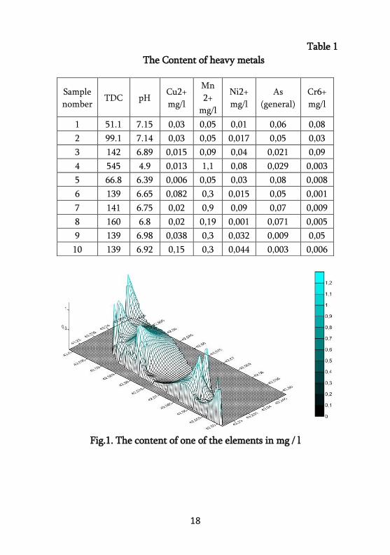
allow us to avoid time-consuming and costly work [3].The
table 1 shows the result of the work. Only the data of the main
points are presented. The data obtained by the mathematical
model were also confirmed using a geo-information programs
statistical analysis apparatus. There is spatial analysis in GIS.
The purpose of spatial analysis is to obtain new information
from existing data using mathematical, statistical and geogra-
phical operations.
With Geostatistical Analyzes we can build a thematic map
based on that data. The picture shows a map showing the con-
tent of one of the elements in mg/l (Fig.1). Created with
ArcMap Spatial Analyst Tools [4].
18
Table 1
The Content of heavy metals
Fig.1. The content of one of the elements in mg / l
Sample
nomber TDC pH
Cu2+
mg/l
Mn
2+
mg/l
Ni2+
mg/l
As
(general)
Cr6+
mg/l
1 51.1 7.15 0,03 0,05 0,01 0,06 0,08
2 99.1 7.14 0,03 0,05 0,017 0,05 0,03
3 142 6.89 0,015 0,09 0,04 0,021 0,09
4 545 4.9 0,013 1,1 0,08 0,029 0,003
5 66.8 6.39 0,006 0,05 0,03 0,08 0,008
6 139 6.65 0,082 0,3 0,015 0,05 0,001
7 141 6.75 0,02 0,9 0,09 0,07 0,009
8 160 6.8 0,02 0,19 0,001 0,071 0,005
9 139 6.98 0,038 0,3 0,032 0,009 0,05
10 139 6.92 0,15 0,3 0,044 0,003 0,006

19
REFERENSES:
1. What violations were found in the tender for the conservation
of waste from the Uravi Arsenic Plant, mtisambebi.ge. February
2020 (in Georgian);
2. Shavliashvili, M. Arabidze, E. Bakradze, G. Kuchava, M.
Tabatadze. Chemical study of arsenic content in soils of
Ambrolauri municipality. Collection of scientific works of the
Institute of Hydrometeorology of the Georgian Technical
University (in Georgian);
3. Mathematical modeling/Per. from English Under the editorship
of Yu. P. Gupalo.-M .: Mir, 1979 ( in Russian);
4. Mitchell A. The ESRI Guide for GIS Analysis, Valume 1, USA,
2018 (in English).

20
OVERVIEW OF THE MECHANISM OF INFLUENCE OF
WATER/CEMENT FACTOR ON THE STRENGTH OF
CONCRETE
G. BALIASHVILI, F. BEZHANOVI,
N. SARJVELADZE, L. TKEMALADZE G. Tsulukidze Mining Institute, Tbilisi
The concept of water/cement factor was first developed by
the American scientist Duff A. Abrams and published in 1918.
The water/cement factor is the ratio of the mass of water
used in a concrete mix to the mass of cement. Its reduction
increases the strength of the concrete, but makes it difficult
to pump the mixture and place it in the construction form-
work.
If, in addition to cement, other binders are used in the
concrete mix, such as fly ash, granulated slag, microsilica, rice
husk ash and natural pozzolans, the mass of the binders prese-
nted is taken into account along with the cement.
The use of water in a concrete mix is necessary to enter
into a chemical reaction with its cement, ie hydration, in or-
der to form a cement dough-gel. At this time only the requi-
red, necessary and minimum amount of water is required.
Excess, unreacted water reduces the strength of the concrete.
The reduction mechanism is as follows. When water is freely
in the concrete, during its solidification the water evaporates
and a void is formed in its place. The void in turn is one of the
weakest points in concrete in terms of strength. The water/
cement factor is one of the means of making frost-resistant
concrete.
There are currently a number of literary sources around
the subject matter, for example [1; 2; 3; 4; 5]. A remarkable
result is obtained. Nevertheless, no acceptable mechanism for

21
influencing the strength, corrosion resistance and other pro-
perties of concrete with water/cement factor has been estab-
lished to date.
Therefore, reviewing the published papers on the water/
cement factor is one of the main, necessary and topical issues
in solving the important problem of the development of con-
crete mechanism.
The work will result in a review and critical analysis of the
current publication. In this way another step will be taken to
design, manufacture and use the appropriate concrete mixture
in construction.
REFERENCES:
1. Water–cement ratio – Wikipedia.
2. Which admixture increase the strength of concrete?
https://www.quora.com/Which-admixture-increase-the-strength-
of-concrete;
3. Shan Somayaji Civil Engineering Materials. 2011-EDN-2;
4. What is Water Cement Ratio? Its Calculation [Complete Guide]
https://civilseek.com/water-cement-ratio/.
5. Importance of Water-Cement Ratio in Concrete –Mystery
Revealed https://gharpedia.com/blog/water-cement-ratio-in-
concrete/.

22
NEW DATA ABOUT GARTA ORE DEPOSIT
D. BLUASHVILI1, K. BENASHVILI2, G. MINDIASHVILI3 1Georgian technical University
2RMG Group 3I. Javakhishvili Tbilisi state University
The sample set consists of rock chips and fragments of drill
core from drill holes. The samples were first macroscopically
and microscopically examined with a focus of the alteration
assemblage and copper mineralization, in addition to the ge-
neral mineralogical composition.
The researches were carried out at the micro analytical la-
boratory in the Department of Earth, Ocean, and Atmosphe-
ric Sciences (EOAS) at UBC and in the Georgian Technical
University (by the Department of Geology) The methodology
included transmitted and reflected light microscopy, X-ray
powder diffraction (XRD) analysis and scanning electron mic-
roscopy on selected samples. Furthermore, some thin sections
were selected for a scanning electron microscope (SEM) study
to identify submicroscopic phases and to assess the composi-
tion of the Fe-oxides and Fe-sulfides. The thin sections were
carbon-coated and studied using a Philips XL30 scanning ele-
ctron microscope with a Bruker Quanta 200 energy-disper-
sion X-ray microanalysis system (EDX) at the microanalytical
laboratory in the EOAS at UBC. As a result of the research,
the mineralogical composition, modal content, degree and
type of alteration were determined.
23
REFERENCES:
1. Gamkrelidze P. Geological structure of Adjara-Trialeti fold
system. Edition of the Academy of Sciences of the Republic of
Georgia. Tbilisi 1949;
2. Nadiradze V. Intrusions and ore manifestations of the Adjara-
Trialety folded system. Dr. Dis. MSU, М. 1956;
3. Arevadze V. Anchabadze E. Report on the results of the
prospecting in the central part of Adjara-Trialeti folded zone for
1974-76. Geol. Funds. Tbilisi, 1977.
24
DISCONTINUITIES, DISTRIBUTION SCALES AND
FORMATION CONDITIONS OF GUJARETI-TSKAROSTAVI
(KHACHKOVI) ORE FIELD
D. BLUASHVILI1, G. MINDIASHVILI2 1Georgian technical University
2I. Javakhishvili Tbilisi state University
Discontinuities, distribution scales and formation conditi-
ons of Adjara-Trialeti Gujareti-Tskarostavi ore field are revie-
wed in the work. As known, studying ore field structures has
got great significance for increasing efficiency of exploration
activities. Gujareti-Tskarostavi ore field is highly complicated
from tectonic viewpoint. Various type disjunctive structures
and fractures are observed. The role of fold structures, Arjeva-
ni-Bakuriani fault and other geological elements in the distri-
bution of the ore field is presented in the article. A large role
is devoted to the characterization of the ore columnar structu-
re, which is associated with magmatic formations, folded
forms and rupture dislocations. Basic and specialized methods
of studying structures are used in the work.
Besides, Gujareti-Tskarostavi ore field was studied by us
with remote sensing method and as a result main fault and
stress structures were revealed where the best conditions for
the formation of ore field occur. In particular, the territory
adjacent to the Arjevani-Bakuriani fault represents favorable
conditions for mineralization.
25
REFERENCES:
1. Tskhelishvili M. et al. Results of general exploration activities in
the region of Rekha-Gujareti and Khachkov gold and polimeta-
llic occurrence. Tbilisi, Georgia, 1985;
2. Beradze R. and et al. Geological Précising works conducted in
central part of Adjara-Trialeti geological-economical region.
Tbilisi, Georgia, 1982;
3. Liangpu Zhu, Geologic remote sensing, 1994.

26
STRUCTURE AND MORPHOLOGY OF THE CRYSTALLINE
SUBSTRATE OF THE SOUTHERN CAUCASUS
INTERMOUNTAIN AREA
(IN THE LIMITS OF GEORGIA)
1L. BASHELEISHVILI, 2M. KUMELASHVILI 1A. Janelidze Institute of Geology of Tbilisi State University,
Tbilisi, Georgia 2Georgian Technical University, Tbilisi, Georgia
The formation of the modern structure of the Southern
Caucasus (Rioni and Kura) molassic depressions is largely de-
termined by both the meridional (submeridional) and latitu-
dinal systems of faults covering different depths of the Earth's
crust. The noted faults are often side boundaries of the blocks
of the crystalline basement of the Earth's crust, creating a pic-
ture of its mosaic-block structure. The analysis of the lithofa-
cies and thicknesses of the sedimentary cover developed wi-
thin their limits, in a number of cases, indicates their autono-
mous and inversion nature of development. Comparison of
geophysical and drilling data, as well as, the application of the
method of system analysis of disjunctive structures made it
possible to clarify some issues of the structural-kinematic evo-
lution and morpho-genetics of individual blocks and faults of
the pre-Jurassic crystalline basement within the limits of the
Southern Caucasus.
The block diagram of the surface of the crystalline base-
ment constructed by us within the Colkhida depression shows
the spatial arrangement and the character of the inversion
nature of individual blocks, indicating the manifestations of
the Alpine and Late Alpine phases of tectogenesis.Thus, the
Odishi block, located approximately in the central part of the
depression from the western and eastern sides is bounded by
27
faults of a strike-slip nature, above which in the sedimentary
cover supra-fault echelon folds are developed, indicating the
right-lateral component of the faults. In general, the kinema-
tics of the Odishi block indicates its shift in the southwest
direction; the block is slightly inclined in the eastern part in
relation to the Askhi and Okriba blocks. From the south it is
bounded by the Abasha block - one of the most subsided
structures of the Colkhida depression. Analysis of the actual
material, geophysical and geological data for the intra-Cauca-
sian intermountain area allows us to draw the following con-
clusions: the Georgian Block (a fragment of the Transcauca-
sian median massif, microplates, terrane) with a pre-Jurassic
crystalline substrate (Dzirula uplift) exposed in its central
part, is divided into the western and eastern subsidence zones,
which in turn disintegrate into separate blocks. From the cen-
tral zone of the uplift of the Georgian Block to the east and
west, a gradual “stepwise” subsidence and tilting of the blocks
of the crystalline substrate is outlined. Similar structures are
known in the literature as the so-called tilt blocks. They are
quite distinctly recorded on different geophysical profiles. In
some cases, the transverse uplifts of the crystalline basement
are recorded by drilling data.
A number of transverse faults are associated with earth-
quakes, the mechanism of which are characterized by tensile
stress and, therefore, can have a fault character with the incli-
nation of the shear planes towards the centers of maximum
tension. As a result of gravitational modeling, it is established
that the M-boundary within this profile is indicated by a local
uplifting under the Central Black Sea, Agdzhabedin and South
Caspian regions and a comparative subsidence under the Dzi-
rula and Saatlinsky uplifts. From the above, we can conclude
that in the modern structure of the pre-Alpine consolidated

28
crust of the South Caucasian median massif, two plans of
structural symmetry are outlined. The first (latitudinal profi-
le) is characterized by the existence of extensional structures,
mainly in the form of stepwise tilting blocks, which subse-
quently transformed into listric faults. The second (meridio-
nal) is characterized by tangential submeridial compression of
the region caused by the advancement of the Arabian inlier
to the north with the formation of the Transcaucasian
transverse uplift and other collision structures.

29
REVIEW OF THE GEOTECHNICAL CONDITIONS OF
THE RIONI RIVER GORGE IN RELATION TO
HYDRAULIC ENGINEERING
M. CHARBADZE
Georgian Technical University, Tbilisi, Georgia
The Rioni River is one of the major rivers of Georgia. It
originates at Pasi Mountain in the Greater Caucasus and flows
into the Black Sea at the city of Poti. The 327 km long river
embraces 41 percent of the whole area of the western Georgia.
The Rioni is of critical importance from the point of view
of hydraulic engineering; assimilation of the river for the
above purposes was started in the 1930s (at present, the mid-
dle and the lower reaches of the river have been assimilated).
Within the middle-stream and downstream sections of the
river, the bedrocks are dislocated, dissected by cracks and
would exhibit presence of crushing and thus weak tectonic
areas. These unfavourable structural-tectonic elements will
predetermine further dissection of the bedrocks and their sli-
ding down the gliding surface what in its turn facilitates acti-
vation of the geodynamic processes within the river gorge.
Landslides of structural and creep nature are to be observed
here rather frequently.
The above geodynamic processes predetermined in their
main by moistening the bedrock as a result of frequent and
abundant rainfall; that facilitates drainage of the rainwater
from the dingles existing within the river gorge. According
to the physical and mechanical properties of the depositional
material prevailing in the gorge, the stability coefficient of the
soil placed in the water environment is low; consequently, its
cohesion forces are low too. As is evident from the observa-
tion data, the slopes of the gorge are really dotted with traces

30
of landslide movements to be observed in any place where the
deposits are represented by mighty/thick deluvial-eluvial or
semi-rocky series.
When hydraulic power stations are designed, evident pre-
valence of landslides within the gorge as well as actual pote-
ntials of their formation in future should be double checked;
the risks associated with landslide formation should be ever
kept in mind.
REFERENCES:
1. Lomtadze V. "Engineering Geology, Engineering Geodynamics".
Tbilisi 2000 423 p. STU Library 556.3 (02)/12;
2. Khmaladze O., Shautidze O. Changes of channel morphology of
the Rioni river , Central Caucasus. IHP-V Technical Documents
in Hydrology No. 10 UNESCO, 1997, pp.361-367;
3. Klaven A. Hydro morphological aspect of channel process
modeling. Erosion of cohesive materials. Paris: IHP_V Technical
Documents in Hydrology. No. 10. UNESCO, 1997, pp. 361-367;
4. Kopaliani Z., Tvalavadze O., Noselidze D. Methodology for
Hydraulic of river channels in mountain-piedmont zone.
31
SYNTHESIS AND BLAST TESTING OF SOME
“MOLECULAR COMPOUNDS’’
N. CHIKHRADZE, M. NADIRASHVILI, T. IASHVILI G. Tsulukidze mining institute
Explosives have the greatest importance in human practi-
cal activities, not only at time of war, but at tranquility as
well, which includes mining, engineering, arrangement of
underground and surface infrastructure, etc.
Picric acid and trotyl are well-known explosives – enough
strong, relatively cheap and safe – for use. There are several
possibilities for the synthesis of new explosives from picric
acid and trotyl. One of them is the synthesis of so-called “Mo-
lecular compounds” which is easily carried out, with a high
yield of target substances.
As the blast testing shows the “Molecular compounds” re-
tain enough strong explosion nature, moreover, it is quite
strongly expressed.
The article describes the synthesis of two “Molecular
compounds” from picric acid and trotyl, with toluene and
resorcine. The mechanism of the process is explained. The
schemes of reactions are shown.
The article also includes a descriptions of blast testing of
the obtained “molecular compounds”.
Introduction
A vast majority of explosives are produced by the chemical
synthesis, including picric acid, trotil, octogene, nitroglyce-
rine and other well-known explosives. At the end of XX cen-
tury in the USA were synthesized powerful explosives with
the highest technical characteristics – octanitrocubane and
hexanitrohexaazaisowurzitane - CL-20 [1-2]:
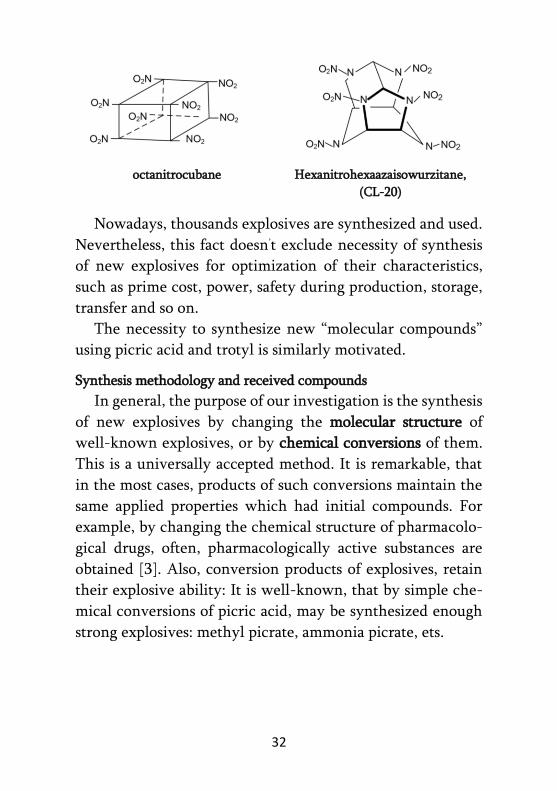
32
octanitrocubane Hexanitrohexaazaisowurzitane,
(CL-20)
Nowadays, thousands explosives are synthesized and used.
Nevertheless, this fact doesn’t exclude necessity of synthesis
of new explosives for optimization of their characteristics,
such as prime cost, power, safety during production, storage,
transfer and so on.
The necessity to synthesize new “molecular compounds”
using picric acid and trotyl is similarly motivated.
Synthesis methodology and received compounds
In general, the purpose of our investigation is the synthesis
of new explosives by changing the molecular structure of
well-known explosives, or by chemical conversions of them.
This is a universally accepted method. It is remarkable, that
in the most cases, products of such conversions maintain the
same applied properties which had initial compounds. For
example, by changing the chemical structure of pharmacolo-
gical drugs, often, pharmacologically active substances are
obtained [3]. Also, conversion products of explosives, retain
their explosive ability: It is well-known, that by simple che-
mical conversions of picric acid, may be synthesized enough
strong explosives: methyl picrate, ammonia picrate, ets.

33
Methyl picrate Picric acid Ammonia
picrate
One of the examples of explosive’s conversion is the syn-
thesis of “Molecular Compounds’’, or “Charge Transfer Com-
pounds’’ [3-5]. Such ability have picric acid, methyl picrate,
ammonia picrate, as well trotyl, styphnic acid and other poly
nitro aromatic compounds. It should be noticed, that the pre-
sence of three nitro groups impoverishes the π-electronic sys-
tem of the aromatic nucleus of molecules and gives the men-
tioned substances strong electro acceptor properties. Conse-
quently, their molecules arises the ability to transfer π-elec-
trons from electro donor molecules to themselves. Electrosta-
tic attraction arises, and a result of which, bimolecular aggre-
gates are formed – the so-called “Molecular Compounds’’:
Picric acid, TNP Benzene, C6H6 Molecular
Compound
According to existent view, in the similar reactions the
aromatic fragments of molecules are placed to each other in
parallel planes [1].
By interaction of picric acid with toluene, and trotyl – with
resorcine were synthesized corresponding molecular com-
pounds. The synthesis’ schemes are as follows:

34
As for the “morphology’’ of formulas, it is some conditio-
nal, and resembles with the rule of representation of some
other formulas, such as double salts, for example silvinite –
KClNaCl, compound of ammonia with boron trifluoride -
H3NBF3, and other bimolecular structures.
Testing of synthesized compounds on blast conversion
Primary laboratory studies were performed to determine
the ability of chemical conversions by blasting of synthesized
molecular compounds, to induce detonation and to assess pos-
sible workability.
Blast testing was carried out in a camera integrated into the
tunnel system of an underground experimental explosive base
of G. Tsulukidze Mining Institute.
The views of the base’s portal and camera are shown on the
figure 1.
Fig. 1 The portal of the unferground tunnel system (a)
The blasting camera (b)

35
Two types of “molecular compounds” were synthesized for
testing, each weighing 25 g. The compounds were obtained in
the form of crystalline powders, in which the granulometric
consist of the particles varies in the range 0-5 mm. Their mic-
rophotographs are shown in figure 2.
a b
Fig. 2 Synthesized “,molecular compounds’’:
a – substance I
b – substance II
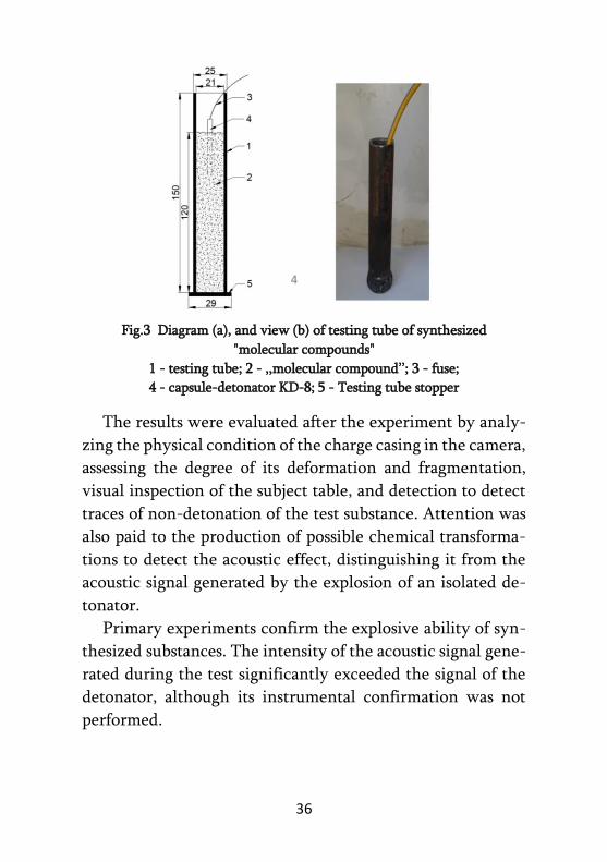
To test the ability to induce detonation, a standard test
scheme localized in a solid state of charge was used, as shown
in figure 3. In particular, to obtain longitudinal charges, the
test substance was loaded into a low-carbon steel tube. One
end of the tube is closed with a stopper of the same material,
while the other side (in the area of the detonator) is not char-
ged and is in a free state. The pipe diameter was selected con-
ditionally, according to the analogy of the tests of brisant exp-
losives. A capsule detonator KD-8 with a fuse was used to
initiate the detonation.
36
Fig.3 Diagram (a), and view (b) of testing tube of synthesized
"molecular compounds"
1 - testing tube; 2 - ,,molecular compound’’; 3 - fuse;
4 - capsule-detonator KD-8; 5 - Testing tube stopper
The results were evaluated after the experiment by analy-
zing the physical condition of the charge casing in the camera,
assessing the degree of its deformation and fragmentation,
visual inspection of the subject table, and detection to detect
traces of non-detonation of the test substance. Attention was
also paid to the production of possible chemical transforma-
tions to detect the acoustic effect, distinguishing it from the
acoustic signal generated by the explosion of an isolated de-
tonator.
Primary experiments confirm the explosive ability of syn-
thesized substances. The intensity of the acoustic signal gene-
rated during the test significantly exceeded the signal of the
detonator, although its instrumental confirmation was not
performed.
37
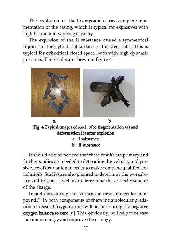
The explosion of the I compound caused complete frag-
mentation of the casing, which is typical for explosives with
high brisant and working capacity.
The explosion of the II substance caused a symmetrical
rupture of the cylindrical surface of the steel tube. This is
typical for cylindrical closed space loads with high dynamic
pressures. The results are shown in figure 4.
a b Fig. 4 Typical images of steel tube fragmentation (a) and
deformation (b) after explosion
a - I substance
b - II substance
It should also be noticed that these results are primary and
further studies are needed to determine the velocity and per-
sistence of detonation in order to make complete qualified co-
nclusions. Studies are also planned to determine the workabi-
lity and brisant as well as to determine the critical diameter
of the charge.
In addition, during the synthesis of new ,,molecular com-
pounds’’, in both components of them intramolecular grada-
tion increase of oxygen atoms will occur to bring the negative
oxygen balance to zero [6]. This, obviously, will help to release
maximum energy and improve the ecology.

38
Conclusion
Thus, two "molecular compounds" are synthesized on the base
of picric acid and trotyl. These compounds were tested using
a capsule detonator to detect blast properties.
Both substances were found to have a fairly strong explosi-
ve ability.
Because the electron donor components of "molecular co-
mpounds" are much cheaper than the electron acceptor one’s,
in the case of their use, there may appear the prospect of
economic effect.
REFERENCES:
1. Astakhov A., Stepanov R. and Babushkin A. On the detonation
parameters of octanitrocubane, Combustion, Explosion and
Shock Waves, Volume 34, pages 85-87(1998);
2. Nair U., Sivabalan R., ets., Hexanitrohexaazaisowurzitane (CL-
20), CL-20 based formulations (review), Combustion, Explosion
and Shock Waves, Volume 41, pages (121-132), March 2005;
3. Nesmeyanov A., Nesmeyanov N. ,,Fundamentals of Organic
Chemistry’’, v.2., 1970, pp. 120-121 (in Russian);
4. Yuriev I. ,,Practical Works in Organic Chemistry’’, TSU Publi-
shing House, Tbilisi, 1969, p.510 (in Georgian);
5. Nadirashvili M., Apriashvili A., beinashvili G., Iashvili T.
“Sinthesis and research of “Molekular Compounds” from some
explosives ,,The Development of Mining and Geology is the
Precondition for the Revival of Economy’’, 6th International
Scientific-Practical Conference on Up-to-date Problems of
Mining and Geology BOOK OF ABSTRACTS, p.70, Tbilisi,
2020;
6. Nadirashvili M., Khomeriki S., Chikhradze N., Khvadagiani a.,
Bakutashvili G., Varshanidze I. The role of endogenous oxygen
in explosives. Mining Hournal, 2 (39), p.p. 52-59. (in Georgian).

39
EXPLOSIVE COMPACTION OF MULTICOMPONENT
POWDER MIXTURE
E. CHAGELISHVILI1, B. GODIBADZE2, A. DGEBUADZE1,
M. TUTBERIDZE1 1LEPL G. Tsulukidze Mining Institute, Tbilisi, Georgia
2LEPL F. Tavadze Ferdinand Tavadze Metallurgy and Materials Science Institute, Tbilisi, Georgia
Compaction of multicomponent powder mixtures is acco-
mpanied by some difficulties due to the drastically different
properties of the components. Compacting powders by explo-
sive technology method, within a few microseconds the bon-
ding of substances takes place against the background of con-
tact areas, interparticle boundaries and high degree of plastic
deformation. When selecting the optimal parameters for po-
wder explosive compaction, it is essential to maintain the uni-
formity of the load along the entire length of the matrix and
not to collapse the matrix. Since explosive compaction is a
high-energy process, changes in the qualitative properties of
substances may occur.
In the experiments carried out, the following explosives
were used: ammonite, a mixture of ammonite and ammonium
nitrate in different percentages. The detonation velocity of
each mixture was determined to select the optimal shock
wave parameters.
Three by three compositions, based on mixtures with diffe-
rent percentages of silicon carbide, in size 150-120 µ, 300-350
µ and 500-550 µ, were compacted by explosive technology.
The polished sections are fabricated from explosive compac-
ted samples (Fig. 1). As a result of appropriate processing of
polished sections, the microstructure and density of samples
obtained by explosive compaction were investigated. On Fig.2
40
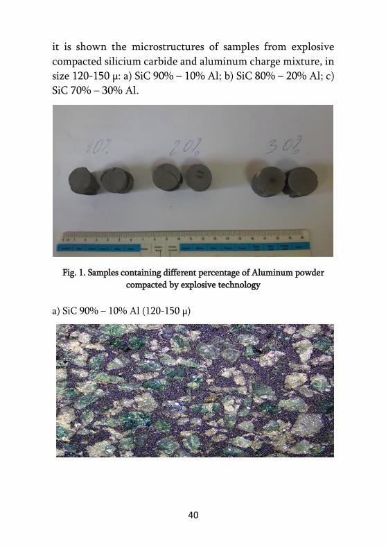
it is shown the microstructures of samples from explosive
compacted silicium carbide and aluminum charge mixture, in
size 120-150 µ: a) SiC 90% – 10% Al; b) SiC 80% – 20% Al; c)
SiC 70% – 30% Al.
Fig. 1. Samples containing different percentage of Aluminum powder
compacted by explosive technology
a) SiC 90% – 10% Al (120-150 µ)

41
b) SiC 80% – 20% Al (120-150 µ)
c) SiC 80% – 20% Al (120-150 µ)
c) SiC 80% – 20% Al (120-150 µ)
Fig. 2. The microstructures of samples from explosive compacted silicium
carbide and aluminum charge mixture, in size 120-150 µ

42
RECYCLING – A MODERN SOLUTION FOR IMPROVING
THE OPERATIONAL EFFICIENCY OF THE MINING AND
METALLURGICAL ENTERPRISES
G. JANDIERI1,2, O. PORTYANKO2 1Metallurgical Engineering & Consulting LTD, Tbilisi, Georgia
2IN-Consulting LTD, Kyiv, Ukraine
Mining and ore processing companies are increasingly
using ISO 14001 certified environmental management syste-
ms (EMS), the key requirement of which is the continuous
management of the operational efficiency of the enterprise at
all stages of its life cycle [1]. In turn, the key criteria for
assessing management efficiency include such indicators as
the degree of useful (target) development of extracted resour-
ces (metals), the level of disturbance and pollution of adjacent
land, the degree of safety of closing the exploited mine or
technogenic deposit, the quality of rehabilitation-remedia-
tion of the technogenic-degraded environment, etc. [2, 3]. At
the same time, within the framework of another concept of
sustainable development of the mining and metallurgical in-
dustry, the emphasis is mainly focused to the need to expand
the life cycle of developed deposits [3, 4]. This concept com-
plements the requirements of EMS and provides for the ma-
ximum possible reduction in the amount of extracted material
and preservation of reserves for future generations by maxi-
mizing the degree of extraction and useful use of ore resour-
ces, for which it is proposed to develop new, combined, envi-
ronmentally friendly technological approaches for additional
extraction (deep extraction) of target components [5].
The problem of maximizing the degree of extraction and
targeted use of mined minerals is especially acute for Georgia
in front of the Chiatura manganese mine and the Zestafoni

43
Ferroalloy Plant, which processes manganese ore/concentrate
mined in Chiatura. The total efficiency of these enterprises in
terms of extraction and useful use of manganese does not
exceed 50%. Waste generated during mining, enrichment and
metallurgical processing causes significant economic damage
to enterprises, irreparable environmental damage is caused to
the environment.
According to the concept of the United Nations Environ-
ment Program (UNEP), industrial recycling and ensuring the
complete disposal of waste generated after recycling are con-
sidered as one of the main priorities for the sustainable deve-
lopment of the modern world economy. Therefore, in the mo-
dern world, more and more attention is paid to solving the
problems of improving recycling systems.
Based on the above, there is no doubt that an increase in
the recycling degree will lead to an increase in the operational
efficiency of mining and ore recovery enterprises, but in prac-
tice, this will also be closely related to the need to assess the
expected techno-economic-environmental efficiency from
the chosen recycling strategy.
For any selected recycling strategy, the total degree of
useful (target) development of the mined, processed and recy-
clable metal-bearing resources (ξ) can be calculated by the
formula:
100/))100()100(( metwmetworeoremetore KKKKKK (1)
where Kore is the extraction of the useful component during
mining and beneficiation operations, %; Kmet - recovery of the
resulting concentrate during metallurgical processing, %;
Kore.w - additional extraction during mining waste recycling,

44
%; Kmet.w - additional recovery after recycling of metallurgical
waste,% (values are determined experimentally).
Due to the increase in the total recovery of the target com-
ponent, the rate of consumption of the extracted ore raw ma-
terials will decrease, which will lead to an increase in the ope-
rating period of the developed deposit by:
n
i jiqi
n
j orej
lc
NQ
QT
1
1 (2)
Where, ΔTlc - increase of life expectancy of the mine, y; Qjore -
resource of extractable j-th metal-containing raw materials,
ths. t; Qi - quantity of metal transferred to the product (i.e.
reduced), thousand t/g; NΔqji - reduced consumption rate of the
main j-th ore raw materials for the production of the i-th final
product, ths. t.
In turn, the time during which it will be possible to fully
utilize and neutralize the previously accumulated waste can
be calculated from the formula:
n
jn
ij jii
jw
lcw
NQ
QT
11,
(3)
where, Tlcw is the time, i.e. - duration of the life cycle of a
technogenic deposit, y; Qjw - resource potential of accumula-
ted waste of j-th type, thousand tons; Nji - the norm of
consumption of the j-th secondary resource for the produc-
tion of the i-th final product, i.e.
The expected economic and environmental effect E from
recycling will be:
n
i
awllcwpqjilc iiiiiQQDDDTTCNCTE
1
21 )()()( (4)
45
where, ΔС is the degree of reduction in labor costs for the
development of new or expansion of the operated mines, $/y; Сp - the self-cost of the processed ore raw materials/ conce-
ntrate; T - the duration of the impact on the environment
before the start of recycling, y; Dl - the degree of damage
(pollution) of lands from mined metals, t/y; Dw is the degree
of damage to water resources (pollution with water-soluble
salts), t/y; Da - the degree of atmospheric pollution (spraying),
t/y; n - the amount of the type of recyclable waste; Q1 - the
total amount of the target metal in the technogenic accumu-
lation before the start of its processing, ths. t; Q2 - amount of
residual metal after processing (Q2 = f (Kore.w; Kmet.w)), ths. t;
The proposed approach to assessing the key indicators of
the operational efficiency of enterprises shows that the higher
the degree of intensification of the in-house recycling system,
the more efficient the enterprise and the less harmful envi-
ronmental impact on the environment. Consequently, the
proposed approach can be effectively used to organize a mo-
dern resource-saving, low-waste production.
REFERENCES:
1. Awuah-Offei, K., Adekpedjou, A. Application of life cycle asse-
ssment in the mining industry. Int J Life Cycle Assess, vol. 16,
2011, pp. 82–89. https://doi.org/10.1007/s11367-010-0246-6;
2. Jishkariani G., Jandieri G., Sakhvadze D., Tavadze G., Onia-
shvili G. and Aslamazishvili Z. Ecological Problems Related to
Mining-Metallurgical Industries and Innovatory, Energy-Effi-
cient Ways of Solving Them. Engineering, Vol. 4 No. 2, 2012,
pp. 83-89. https://doi.org/10.4236/eng.2012.42011;
3. Miranda R. Gorman, David A. Dzombak, A. Review of sustaina-
ble mining and resource management: Transitioning from the
life cycle of the mine to the life cycle of the mineral, Resources,

46
Conservation and Recycling, Volume 137, 2018, 281-291.
https://doi.org/10.1016/j.resconrec.2018.06.001;
4. Dzhandieri G.V. Diagnostics of Efficiency and Optimization of
the Organizational and Economic System of Ferrous Metals
Recycling. Chernye Metally, 2020, No.1 (1057), pp. 56-63 (in
Russian) http://www.scopus.com/inward/record.url?eid=2-
s2.0-85081219521&partnerID=MN8TOARS;
5. Jandieri, G., Sakhvadze, D. & Raphava, A. Manganese
Biomining from Manganese-Bearing Industrial Wastes of
Georgia. J. Inst. Eng. India Ser. D 101, 2020, pp. 303-316.
https://doi.org/10.1007/s40033-020-00235-0.

47
GEOTECHNICAL PROBLEMS OF VISCOUS-PLASTIC
LANDSLIDES
L. JAPARIDZE, T. GOBEJISHVILI
G. Tsulukidze Mining Institute, Tbilisi, Georgia
Throughout the long history of the study of geotechnical pheno-
mena, notwithstanding the great number of scientific researches
and created methods, the assessment of the stability of landslide-
prone slopes is still performed under conditions of marginal equili-
brium, Coulomb-Moor, and similar theories. The influence of the
time factor, according to the recent studies, can only be indirectly
reflected due to the rock shear strength reduction factor (SSRF).
Shear strength reduction factor is very important when calcula-
ting the stability of rocky block type landslide bodies. In contrast,
viscous-plastic landslides are of more rheological properties. It may
happen in rock masses virtually everywhere, and depending on
what intensity active stresses are acting on a particular slide surface
and what the mechanical parameters of the mass are, creep defor-
mations can occur very rapidly or extremely slowly, over periods
of time varying from several hours to centuries.
Therefore, when solving geomechanical problems, along with
the rock strength parameters (cohesion, internal friction angle), it
is necessary to know the deformation parameters, including the
creep parameters. They can be determined by processing a large vo-
lume of geological material taken from a landslide-prone slope,
through laboratory study of samples and pre-monitoring the image
obtained on a rock mass by ,,back analysis’’ method. It should be
noted that the full use of the later will be possible in the wake of
the creation and improvement of a direct analytical apparatus for
giving a picture of self-crawling plastic landslides, which is still a
current problem.
Nowadays, the importance of rheological processes in mining
geomechanical tasks for the rational solution of mineral processing
problems is rapidly increasing. Similar, though much less intense

48
trends are observed in the field of landslide geomechanics. This
mainly happens in the conditions of nature, before or after starting
engineering works at the design stage, defined as potentially lan-
dslide-prone slopes according to the legal documents or monitoring
. This can be explained by the fact that clear criteria have not yet
been developed for the existence of rheological parameters in
landslide geomechanics tasks and methods for solving them, which
is related to the knowledge of the stress-strain condition of the
slope.
Using the numerical methods and special computer programs
developed in recent years, it is possible to assess the stress-deformed
state of complex slopes and the prospect of indirectly reflecting the
reduction of rock strength and deformation parameters when sol-
ving the task. The possibility of applying this to the finite element
method has been called the ,,new era in landslide sustainability
calculation theory’’ [1].
The assessment of the stability of viscous-plastic type landslide
slopes should reflect the slow rheological deformations in the rock
mass and, consequently, the time factor. This problem is important
and relevant both theoretically and practically in general, because
there are many geological formations in Georgia, where we find
"viscous-plastic" landslides. Landslides of this type, whether local
or large-scale, are expected in areas of undulating relief [2] unless
special attention has been paid to their avoidance at an early, design
stage in the context of intensified infrastructure construction.
REFERENCES:
1. Rockscience. A New Era in Slope Stability Analysis: Shear Stren-
gth Reduction Finite Element Technique. Strength redu-
ction.pdf. 2004;
2. Ministry of Environment Protection and Agriculture of Georgia
National Environment Agency. Department of Geology. Engin-
eering-geodynamic conditions of Tbilisi territory and assess-
ment of geological threats. Tbilisi, 2019. PDF. (In Georgian).
49
PECULIARITIES OF GEOLOGY OF GOLD AND MERCURY
ORE MANIFESTATION OF ORE-BEARING SITES IN
SVANETI AND BOLNISI REGIONS AND PROSPECTS
A. KVITSIANI LEPL Ivane Javakhishvili Tbilisi State University, Tbilisi, Georgia
Alexandre Tvalchrelidze Institute of Mineral Resources, Tbilisi, Georgia
1. In the 1980s, we studied the peculiarities of the geology
and structure of gold and mercury ore manifestation of ore-
bearing sites in Svaneti and Bolnisi Regions. As a result of
the mineralogical and chemical studies, high contents of
gold, copper and tellurium were identified in the ore depo-
sits and ore-close metasomatites. Consequently, the gold
and mercury ore-bearing formation was identified [1]:
2. The ore deposit researchers paid particular attention to the
gold and mercury deposits after one of the largest deposits
in Nevada State, Carlin deposit, opened and was put to ope-
ration in the 1980s [2].
3. At present, quite strong gold and mercury deposits (Carlin,
Cotet, Belly, New-India, Hamly, Dubaishan, Vorotsons-
koe, Murzinskoe, Svetloe, Salamon, etc.) are manifested
and used in the gold-bearing regions of the world (the
USA, China, Iran, the Urals, Khabarovsk Krai, Central
Asia, East Baikal, Mongolia, Kazakhstan, Italy, Spain,
Canada, Macedonia).
4. The given type of mineralization is spatially and genetica-
lly associated with different complexes of endogenic depo-
sits. They identify four types of gold-mercury minerali-
zation: gold-arsenic-silver, gold-antimonite-mercury, gold
-tellurium-mercury and gold-copper-mercury types [3].

50
5. The researchers attribute gold-mercury deposits to the
low-temperature series. They are always formed in the cro-
ne of the metasomatic column, in the discharge zones of
the gold-bearing hydrothermal solutions near the earth
surface.
6. Two of the four types of gold-mercury mineralization are
identified in Svaneti and Bolnisi Regions: gold-tellurium-
mercury and gold-copper-mercury. The former is located
in Gagra-Java metallogenic zone and the latter is found
within the Poladauri deposit zone;
7. Gold-tellurium-mercury ore manifestations (Tsiteli-Khevi,
Barjashi) are localized in the Bajocian porphyry stratum
[4], while gold-copper-mercury ore manifestations (Darba-
zi, Vazis-Khevi, Bolnisi) are found in the volcanogenic-
sedimentary rocks of rhyodacite Mashavera and Gasandam
strata.
8. The content of ore manifestations is quite simple. The ma-
jor minerals are: Cinnabarite, gold, copper, pyrite, marca-
site, tellurium, dickite, quartz, carbonate. Getchellite,
Sphalerite and galena are found rare.
9. Ore-close metasomatites are presented by: quartzites, argi-
llizites and silicified tuffas.
10. In the future, thorough detailed geological survey and exp-
loratory works may identify large deposits of gold and me-
rcury in Svaneti and Bolnisi as evidenced by strong geo-
physical and geo-chemical aureoles and suitable geologi-
cal-structural conditions.
51
REFERENCES:
1. Kvitsiani A., Geleishvili V. Salia D.G.Gold-Mercury Deposit for-
mation (on the example of one ore-bearing region). Bulletin of
the Academy of Sciences of Georgian SSR, vol.102, №3, 1981,
pp 617-619 (in Russian); 2. Radtke A. Geology of Carlin Gold Deposit, Nevada. Surv, Pro-
fess. Pap. 1267, 1985, 124 p.; 3. Borisenko F., Naumov E., Obolenskyi A. Types of Gold-Mercury
Deposits and Terms of their Formation. Geology and Geophy-
sics, vol. 47, №3, 2006, pp. 342-354 (in Russian); 4. Togonidze G., Kajaia N. the al. Structural Conditions of Forma-
tion of Tsiteli-Khevi and Barjian deposits of Mercury and Dire-
ctions of Furher Geological Survey Works to Estomate Their
Prospects. Funds of Georgian State University Publication, 1973,
p. 350 (in Russian).

52
EVALUATION OF THE FILTERING ABILITY OF
BENTONITE FROM THE VANISKEDI DEPOSIT FOR THE
PURPOSE OF ITS USE IN THE PROCESS OF CLARIFYING
WINE
K. KHACHATURIAN, N. GEGIA, T. GURULI, E. UKLEBA
LEPL TSU Alexander Tvalchrelidze Caucasus Institute of Mineral Resources, Tbilisi, Georgia
A study of the filtering capacity of bentonite clay of the
Vaniskedi deposit (Georgia) was carried out to establish the
possibility of its use in the process of clarifying white wine. In
this work, the object of comparison was Askangel "B," which,
as is known, is the most effective means for gluing all kinds of
wine materials; in the experiments, young homemade white
wine was used; transparency, stability and quality of filtered
wine were evaluated.
The corresponding indicators [1] required by the industry
standard [2] for the use of bentonites in the wine industry
were previously determined for the bentonite under investi-
gation. As shown by the organoleptic assessment of wine trea-
ted with taken bentonite, by this parameter it is not inferior
to Askangel "B"; Vaniskedi bentonite also exhibits a good cla-
rifying ability that satisfies acceptable standards; as expected,
Askangel "B" has a very good clarifying ability. Based on all
the results obtained in [1], it was concluded that Vaniskedi
bentonite mainly meets the requirements of the industry sta-
ndard [2] and, therefore, it is possible to use it in winemaking,
along with Askangel "B.
To clarify the wine, respectively, the process instruction
for processing gums and wines with bentonites, a trial treat-
ment with Vaniskedi bentonite was carried out in advance
and the necessary dosage was established. To this end, a 20%
53
aqueous suspension of bentonite was prepared, from which a
5% aqueous wine suspension was then prepared by adding
wine. It has been found that the optimal dose at which the
best brightening is obtained with the densest precipitate and
with the smallest amount of bentonite taken is 0.8 ml of a 5%
water-wine suspension per 20 ml of wine, which corresponds
to 2 g of bentonite per 1 l of wine. Based on the fact that the
doses of bentonite used in practice range from 2 to 5 g/l, we
obtained a good result.
To evaluate the filtering capacity of the bentonite under
study, various versions of experiments were previously used,
in which the size of the fraction, the weight of the sample, the
volume of filtered wine, and the temperature mode of sample
preparation changed. Filtered wine was evaluated not only for
transparency and stability, but also for: color, smell and volu-
me of filtrate, filtration rate, pH value, chemical composition
of the initial and filtered wine. Most subsequent experiments
used a thin fraction of bentonite (- 0.08 + 0 mm); the maxi-
mum retention time of filtered wine was 114 days.
When studying the filtering ability of Vaniskedi bentonite,
more than 10 versions of white wine treatment were carried
out; the obtained results of the change in the degree of trans-
parency of filtered wine over time, as well as the change in its
pH value, for the last five versions showed that in these expe-
riments the filtered wine was initially mainly transparent,
very transparent and even crystal clear. But then, when held,
after almost every fixed period of time, stability does not
acquire and becomes turbid; in some experiments, precipita-
tes of various types appeared: crystalline, protein, colloidal
and turbid, so the filtrate was re-filtered each time; sometimes
there was no precipitation at all. It should be noted that in all
54
preliminary experiments the filtered wine was opaque and
colloidal precipitate was observed.
The best lightening effect was obtained only in experiment
No. 3, where the filtered wine is not only crystal-clear, but
also shows stability during the studied period of time, and
retains its crystal transparency when aged. In this test, after 7
days, a crystalline precipitate appeared in the form of clear
crystals of tartar, which, as is known, is absolutely harmless
and indicates the naturalness of the wine, without affecting
its taste. It should be noted that a thin fraction of bentonite (-
0.08 + 0 mm) was used here and the contact time of bentonite
with wine was minimal.
Thus, based on the results of the study of the filtering abi-
lity of bentonite clay of the Vaniskedi deposit, carried out in
laboratory conditions for small volumes of wine, an optimal
version of clarifying home white wine with this bentonite
was established, which, apparently, makes it possible to reco-
mmend it for clarifying wine, along with Askangel "B."
REFERENCES:
1. Khachaturian K., Gegia N., Guruli T., Gagniashvili N. Opportu-
nity assessment use of bentonites of Georgia in winemaking.
Works: First International Scientific-practical conference "New
Initiatives", Kutaisi, 2019, p.p. 330-339 (in Russian);
2. Industry standard OST 18-49-71 Bentonita for the wine indust-
ry. Ed. Official, Moscow, 1973, p.12 (in Russian).

55
ASSESSMENTS OF THE RADIATION HAZARDS DUE TO
SOIL RADIOACTIVITY ON THE EXAMPLE OF DZIRULA
CRYSTALLINE MASSIF
K. KAPANADZE1, A. MAGALASHVILI1, P. IMNADZE2 1Ilia State University, Tbilisi, Georgia
2Andronikashvili Institute of Physics of Javakhishvili Tbilisi State University, Tbilisi, Georgia
Natural radioactivity of the soils and ionizing gamma ra-
diation coming from soils depend on the concentrations of
natural radionuclides in it, and artificial (anthropogenic) ra-
dioactive contamination of the area. In turn, concentrations
of natural radionuclides in soil depend on soil forming parent
material (mother rock) and other forming factors of the soil.
As a rule, relatively increased level of radioactivity is associa-
ted with igneous rocks (e.g. granitoides) and the decreased
level with sedimentary rocks. Differences are also observed in
igneous rocks themselves, for example, felsic igneous rocks
contain a relatively high concentration of natural radionucli-
des than ultramafic and mafic igneous rocks [1, 2].
As it is well known, in Georgia, granitic rocks are occurred
in axial region of Caucasus Main Ridge, as well as in the crys-
talline massifs of Dzirula, Khrami, and Loki, which represent
the salient of old (Variscan) terrain of Georgian massif [3].
Our previous study was devoted to the Khrami crystalline
massif [4]. At this stage of the research, the Dzirula crystalline
massif (namely, its north-eastern part) was selected. During
the selection of the study area, apart from the petrology, some
other important factors were considered, such as the existence
of populated localities, agricultural and mining (of natural
industrial materials) activities.

56
The aim of the research was to investigate the distribution
of natural radionuclides - 238U, 232Th and 40K in the soils, taking
into account the geological characteristics of the study area,
as well as calculating the basic radiological parameters and es-
timating the radiation exposure risks of the population based
on the obtained results.
Soil samples were collected and processed for laboratory
works in accordance with well-proven methodologies. Using
the gamma ray spectrometric method, based on the using of
high purity germanium detector (HPGe), activity concentra-
tions and content of natural radionuclides (238U, 232Th and 40K)
and anthropogenic radioisotope of 137Cs were measured in soil
samples. Based on the obtained results, main radiological
parameters used for assessment of exposure risks to the popu-
lation were determined (absorbed gamma dose rate in the air;
annual effective dose rate; external and internal hazard inde-
xes, radium equivalent activity, and cancer risk due to exter-
nal gamma radiation).
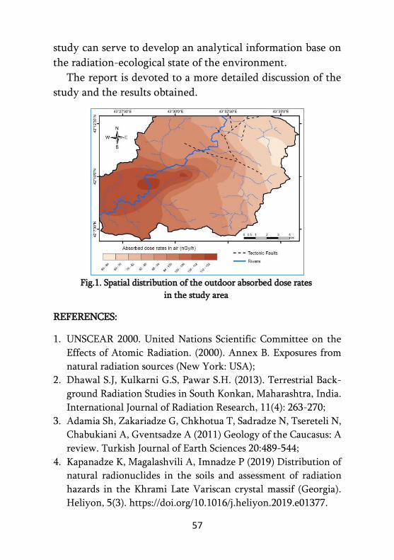
As a result, the nature of the natural background radiation
was identified for the study area (Fig. 1). The relationship
between the radiological parameters and the geological pecu-
liarities of the study area was determined. By the determina-
tion of concentrations of anthropogenic radionuclide 137Cs
along with natural radionuclides, the picture of artificial radi-
oactive contamination (pollution) of the study area was re-
vealed. Results were compared with similar studies conducted
in other countries and other regions of Georgia, as well as
with data and recommendations set by international organi-
zations. Comparison of the results showed, that the radioac-
tive characteristics of the study area are slightly increased, but
remain within the recommended limits. The results of the
57
study can serve to develop an analytical information base on
the radiation-ecological state of the environment.
The report is devoted to a more detailed discussion of the
study and the results obtained.
Fig.1. Spatial distribution of the outdoor absorbed dose rates
in the study area
REFERENCES:
1. UNSCEAR 2000. United Nations Scientific Committee on the
Effects of Atomic Radiation. (2000). Annex B. Exposures from
natural radiation sources (New York: USA);
2. Dhawal S.J, Kulkarni G.S, Pawar S.H. (2013). Terrestrial Back-
ground Radiation Studies in South Konkan, Maharashtra, India.
International Journal of Radiation Research, 11(4): 263-270;
3. Adamia Sh, Zakariadze G, Chkhotua T, Sadradze N, Tsereteli N,
Chabukiani A, Gventsadze A (2011) Geology of the Caucasus: A
review. Turkish Journal of Earth Sciences 20:489-544;
4. Kapanadze K, Magalashvili A, Imnadze P (2019) Distribution of
natural radionuclides in the soils and assessment of radiation
hazards in the Khrami Late Variscan crystal massif (Georgia).
Heliyon, 5(3). https://doi.org/10.1016/j.heliyon.2019.e01377.
58
ENGINEERING-GEOLOGICAL STUDY OF VASHLIJVARI
LANDSLIDE AND ASSESSMENT OF ITS DYNAMICS
Z. KAKULIA, Z. VARAZASHVILI, M. MARDASHOVA,
A. SONGHULASHVILI, D. CHUTKERASHVILI Institute of Hydrogeology and Engineering Geology of GTU
The landslide, which occurred on the territory of Vashli-
jvari, on the road connecting Saburtalo and Digomi (M. Ma-
chavariani Street), caused a great resonance in the life of our
city. A group of specialists was formed in connection with this
issue, in which the researchers of the Institute of Hydrogeo-
logy and Engineering-Geology of the Georgian Technical
University gathered. In March of this year, the group inspec-
ted the landslide area and its surrounding area several times
in detail, resulting in the following conclusions:
Of course, the factors of origin of such cases should be sought
in geological conditions, in particular, in the lithological
structure of the mentioned slope, which is represented by
alternating sandstones and argillites of the Middle Eocene.
Attenuation zones are formed on the slopes, while the layers
of argillite between the sandstones are directly supplied to
form the flats. Added to all this is one very important circum-
stance: the bed shapes of these rocks coincide with the direc-
tion of the slope, which doubles the probability of landslides.
The research made it possible to identify the natural factors
that contributed to the landslide, including:
1. Geological factors:
- Sandstones with argillite interlayers take part in the
construction of the slopes. The slope of these rocks is
similar to the slope slope, which increases the probabili-
ty of landslides several times;

59
- Sandstones and especially argillites - are very easily dep-
leted rocks, due to which weak zones are formed on the
slopes. Such weakening zones are easily formed on the
layers of argillites.
2. To the above geological factors we must add the following
natural factors:
- Impact of atmospheric precipitation - Due to the crac-
king of the rocks, they penetrate smoothly into the de-
pth of the slope and reduce the compaction between the
rocks, and
- seismic shocks, which play an important role in weake-
ning the landslide slope stability. In the pre-landslide
period, these events were quite active - during this pe-
riod, several seismic tremors were recorded in Racha
and Tbilisi with a magnitude of 3.0-3.5.
- Finally, the main reason for the landslide is the road
construction works, during which the slopes are impro-
perly processed, which contributes to the emergence of
driving forces.
REFERENCES:
1. Kvashilava N., Chakhaia G., Varazashvili Z. Assessment of lan-
dslide sustainability in river Gldaniskhevi valley. Journal of
“Science and Technology”, N2 (722), Tbilisi, 2016; 2. Lomtadze V. "Engineering Geology, Engineering Geodynamics".
Tbilisi 2000 423 P. STU Library 556.3 (02)/12; 3. Maruashvili L.I. Geomorphology of Georgia. ,,METSNIEREBA’’
Publishing. Tbilisi, 1971;

60
4. Zviadadze U., Mardashova M. Some features of engineering
geological conditions and construction of territories d. Tbilisi
(Georgia). "Development of Geodetic and Geotechnical Cons-
truction", №13, Published with the support of the Technical
Committee №207, "Interdependence of Foundations and Arma-
ment" ISSMGE, St. Petersburg, 2011; 5. Braja M. Shallow Foundations. Bearing Capacity and Settlement.
California State University, Sacramento. 1999; 6. Braja M. Principles of Geotechnical Engineering. Adapted Inter-
national Student Edition. California State University, Sacrame-
nto. 2007; 7. Zviadadze U., Mardashova M. Groundwater dynamics. "Techni-
cal University" Publishing, Tbilisi, 2013; 8. Japaridze G. "Engineering Geology of Tbilisi". Tbilisi, 1974.

61
GLOBAL CHALLENGES AND PROSPECTS FOR
EFFICIENT USE OF MINERAL RESOURCES
C. LOBJANIDZE, B. KAKHADZE,
T. BUTULASHVILI, G. MACHAIDZE,
G. NANITASHVILI, G. KHETSURIANI Georgian Technical University, Tbilisi, Georgia
1. The paper discusses the potential impact of global risks
and the COVID-19 pandemic on future demand for mineral
resources, development prospects for the mining industry, as
well as tactical and strategic directions for the development
of mining companies in the context of rapid and effective
crisis resolution. The COVID-19 pandemic has made signifi-
cant changes in our lives and has quite significant and diffe-
rent impacts on commodity markets and the mining industry
around the world. Mineral companies have been somewhat
hampered by coronavirus epidemics and government-spon-
sored demand, which has led to falling demand for many
commodities. Companies are forced to upgrade and streng-
then the staff sanitation organization, which incurs additional
costs, hence the office staff moved to the so-called ,,On re-
mote work“.
2. The mining industry has maintained some resilience in
the context of COVID-19's impact on the global economy and
manufacturing, as mining companies are relatively financia-
lly strong and most continue to operate with more or less sta-
bility, although increased levels of caution and preventive
control. However, the long-term consequences of the pande-
mic are still unknown. Clearly, in such conditions, the top-40
mining companies should take advantage of the existing fina-
ncial stability and reconsider their strategy, which will inc-
rease the stability of the business in the future.
62
Despite the pandemic, the mining industry is relatively
stable, producing minerals, and developing coal and ore de-
posits, but this is happening in increasingly difficult condi-
tions – both geographically and geologically, with the aboli-
tion of tax breaks by the state leading to the development of
difficult deposits, closing hundreds of mines and losing jobs.
3. The COVID-19 pandemic, which has no precedent in
the past, casts some doubt on some well-established truths
about mining.
COVID-19 has become a catalyst for digital growth that
has enhanced sustainable development compliance, creating
new trends in the areas of personnel management, delivery
organization and public relations in creating a sustainable
business management model.
Many mining companies, including some of them are ex-
periencing the negative consequences of supply chain globa-
lization for the first time, in terms of over-saving production
and specialization.
The pandemic has highlighted the sustainability of the in-
dustry and the role that mining companies play in supporting
local communities and the economy as a whole. While the
way out of the crisis is still far away, mining companies are
already analyzing the lessons they have learned from the si-
tuation they have created. Important in this regard are the
key risks, opportunities and trends of 2021 for the mining
industry presented in table 1.

63
Table 1
Mining Risks, Opportunities and Trends for 2021[4,5,7,8]
# Risks and Opportunities Trend
1 Commodity
price risk Innovation
Building resilience amid volatility -
Scenarios for strategic leaders
2 Global
pandemic
Digital and
Data
M&A in an altered world - Winning
back investor trust
3
Economic
downturn/un
certainty
Volatility
ESG (Environmental, Social, and Cor-
porate Governance): Getting serious
about decarbonization - From strategy
to execution
4
Community
relations and
social license
to operate
Workforce
ESG: Working to overcome the social
trust deficit - Linking social invest-
ments to sustainable outcomes
5
Environment
al risks,
including
new
regulations
Capital Agenda
ESG: Corporate governance adding to
competitive advantage - Emerging risks
mandate greater oversight
6 Permitting
risk Geopolitics
ESG: Corporate governance adding to
competitive advantage - Emerging risks
mandate greater oversight
7
Political
instability/nat
ionalization
Decarbonisatio
n and green
agenda
Creating an agile supply chain - Over-
coming the Vulnerabilities exposed by
global shocks
8
Access to
capital,
including
liquidity
Productivity
and rising costs
Advancing the future of work - Redefi-
ning leadership and adapting the wor-
kplace culture
9
Ability to
access and
replace
reserves
High-Impact
Risks
On the road to zero harm - Creating the
next generation of integrated predic-
tive safety systems
10
Regulatory
and
compliance
changes/burd
en
License to
Operate
Meeting demand for green and critical
minerals - Mining’s role in the trans-
ition to a clean energy future

64
4. In this regard, it is unreasonable to rely solely on tradi-
tional solutions, taking into account the world experience of
increasingly expanding the key factors determining the com-
petitiveness of mining and metallurgical enterprises – digital
transformation, sustainable development and digitalisation
(business transformation and tackling). Newly qualified engi-
neering specialists in mines and shafts will be employed in
the areas of information technology and software solutions,
who will have the knowledge of the so-called ,,Digital Twins’’
and Automated Business Project Management Systems; At
the same time, the digital transformation approach is taken
into account, when the technology and information environ-
ment are transformed into 4 main elements – business proce-
sses, product, company culture and customer relationship
channels so that the company is in line with modern market
challenges and gains competitive advantage in the fastest
way.
Companies that rely on the latest digital technology tools
(EcoStruxure digital architecture, digital twins, MES systems,
smart mills and other technologies) to increase the efficiency
of business management, as well as climate change technolo-
gies, will become the main drivers of economic development
in the coming years.
5. The sustainable business management model envisages
three phases of overcoming turbulence: response, recovery
and further growth. The initiatives of the last three years have
enabled many mining companies to optimize their asset por-
tfolio, ,,strengthen’’ their balance sheet and, as a result,
respond effectively to the challenges posed by COVID-19 in
order to gradually recover long-term business prospects. Who
65
have high sustainability standards and long-term plans to
decarbonize their business.
REFERENCES:
1. Tvalchrelidze A. Economics of Commodities & Commodity
Marke (Economic Issues, Problems and Perspectives). Nova
Science Publishers Inc; UK ed. Edition, 2011, 906 p. (in English);
2. Chikava L. Innovative Econjmics. Tbilisi, “Siakhle”, 2006. 356 p.
(in Georgian)
3. Dzidziguri A.A., Betaneli K.P. and others, Mineral Resources of
Georgia and Their problems rational development, Tbilisi,
“Metsniereba”, 1991, 279 p. (in Russian);
4. Tracking the trends 2021. Closing the trust deficit. Deloitte.
Insights. 2021. 94 p. (in English);
5. Global mining and metals top 10 business risks and opportuni-
ties – 2021. 2020 EYGM Limited. 34 p. (in English).
6. https://minemagma.com/2021-global-mining-investment-
outlook-2/;
7. https://home.kpmg/xx/en/home/insights/2021/02/risks-and-
opportunities-for-mining.html;
8. https://assets.kpmg/content/dam/kpmg/xx/pdf/2021/03/risk-
and-opportunities-for-mining-2021-report.pdf.
66
THE EFFECTIVENESS OF VERTICAL
ELECTRICAL SOUNDING IN SOLVING
ENGINEERING-GEOLOGICAL PROBLEMS
T. MEDOIDZE Georgian Technical University
The study area is located in Khulo Municipality, on the left side
of the middle part of the Skhalta river gorge in the vicinity of the
village of Kintchauri.
Village Kintchauri is located in 3 kilometers from the dam under
construction. Accordingly, the influence of the landslide on the na-
tural and social environment can be expected within the bounda-
ries of this municipality.
From a morphological point of view, the territory is a slope of
the erosive-denudation type. Its inclination fluctuates in different
places from 300 to 500. Although, in some places forms of relatively
low inclination are recorded. In most cases, the slopes are chara-
cterized by a pronounced wavy surface.
The purpose of the study was engineering-lithological mapping
of the territory, including: establishing boundaries between Quate-
rnary sediments and Basic rocks and identification of hazardous
geological processes.
In the upper, Eastern part of the slope, at the mouth of one of
the sources, a powerful landslide process is developed, as a result of
which heavily depleted and highly fractured bed rocks are exposed.
The upper, western part of the slope is generally represented by a
paleo-landslide body. For its delineation the method of Vertical
electrical sounding was used.
Vertical Electrical Sounding was carried out at 25 points. At
each point, using the apparent resistivity of the medium, the diffe-
rentiation of the sediments, the identification of geophysical hori-
zons and the construction of the corresponding geo-electric colu-
mns were carried out.

67
Geophysical data were compared with data obtained from a well
drilled in this area. The results obtained once again confirmed the
effectiveness of Vertical Electric Sounding in the study of landslide
zones.
REFERENCES:
1. Electrical prospecting Handbook of electrical prospecting.
Nedra, 1980;
2. The companies "GEG", Ltd.;
3. Bienavsky Z. Engineering-construction classification of rock
mass;
4. Gamkrelidze P. Geological structure of Adjara-Trialeti fold
system. 1949.
68
HYDROCHEMICAL CHARACTERISTICS OF
NABEGHLAVI MINERAL WATERS
PRODUCTION WELLS
A. MAGLAKELIDZE Georgian Technical University, Department of Applied Geology;
0160, m. Kostava 75, Tbilisi, Georgia Gamma Consulting Ltd. 0192, Guramishvili Avenue 19d,
Tbilisi, Georgia
Nabeghlavi groundwater deposit is located in the Guba-
zeuli river gorge, vil.Nabeghlavi, Chokhatauri municipality,
Georgia. According to the hydrogeological zoning scheme of
Georgia, it belongs to artesian system of Adjara-Imereti fissu-
re waters. Nabeghlavi mineral waters circulate in the Middle
Eocene volcanic-sedimentary rocks and are met in the fissure
zones of the bedrocks [1].
Nabeghlavi mineral water was discovered in 1905. Initially
it was used for drinking, healing purposes and balneotherapy.
Nowadays it is used for drinking and bottling.
It should be noted that in order to renew and develop the
Nabeghlavi mineral water deposit, as well as taking into acco-
unt a number of factors (such as yied decrease, cessation of
outflow, natural disasters, inflow of substandard waters), new
wells have been arranged to replace/substitute the old explo-
itation ones.
As of today, #2k, 17a, 66a and 67 are production bore-
holes, whereas the #44 and #47 are used for observation.
Resuts of chemical analysis of water from exploitation
wells carried out in 2015-2020 have been analysed from hyd-
rochemical point of view. Three groups have been distingui-
shed: Group I (borehole #17a) – weakly mineralised (1.6-1.9
g/l) carbonic acid bicarbonate-sodium, silica mineral water;

69
Group II (boreholes #2k and #66a) – weakly mineralized
(3.3-3.9 g / l) carbonic acid bicarbonate-sodium, boron, silica
mineral water; Group III (borehole #67) - low-mineraliza-
tion (5.7-5.8 g / l) carbonic acid bicarbonate sodium, boron,
silica mineral water. Thus, the Nabeghlavi mineral waters are
bicarbonate sodium, of weak and low mineralization. Specific
components are boric acid and silicic acid.
As for the quality of water from exploitation wells - it
meets the mineral water requirements set by the national
standard [2] and the EC directive [3].
REFERENCES:
1. Zautashvili B., Mkheidze B. “Hydrogeology of Georgia”, 2011
(In Georgian);
2. ,,Packed technical regulation of natural mineral water and
spring water’’ № 719, 2014 (In Georgian);
3. COMMISSION DIRECTIVE 2003/40/EC of 16 May 2003 establi-
shing the list, concentration limits and labelling requirements
for the constituents of natural mineral waters and the conditions
for using ozone-enriched air for the treatment of natural mine-
ral waters and spring waters, 2003 (In English).

70
DEVELOPMENT OF AN ENVIROMENTALLY FRIENDLY
TECHNOLOGY FOR EXTRACTING GOLD FROM
SECONDARY QUARTZITE HEAP LEACH RESIDUE WITH
THE USE OF BIOTECHNOLOGY
SH. MALASHKHIA, N. LOMIDZE LEPL Independt Scientic und Research Unit- A. Tvalchrelidze Caucasus Institute of Mineral Resourses of Ivane Javachishvili
Tbilisi State University, Tbilisi, Georgia
At the copper-barite-polymetallic ore deposit, almost half
of the gold remains in the residue of the heap cyanide lea-
ching of gold-bearing quartzites, mainly concentrated in large
fractions.
The chemical composition of the secondary quartzite heap
cyanidation residue is shown in Table 1.
Table 1 Composition, %
SiO2 Fe2O3 Al2O3 CaO MgO K2O Na2O S Au,
g/t
Ag,
g/t
85.4 3.9 2.3 1.2 0.58 0.55 0.1 0.3 0.9 6.2
The study of the material composition of the residue show-
ed that the average gold content reaches 0.85-0.9 g/t. Of this,
the cyanidable form is 66.7%, 11.1% is encapsulated in quartz
and 22.2% is covered with an acid-soluble layer. Grain-size
analysis shows that the -10 + 1.0mm grade is 69.8% and con-
tains 82.1% gold, while the fine -1.0 + 0 grade is poor in gold,
indicating that during heap cyanidation the gold is mainly
extracted from the material of same size. Since it is difficult to
dilute the existing gold with cyanide in large grades, we used

71
pretreatment of raw materials (residues) with silicate bacteria
(Bacilusmucilaginosus) to intensify the process.
The density of quartzite is due to its structural perfection,
which is due to the abundance of strong bonds ≡Si-O-Si≡ and
≡ S-O-Al = S = in it. Silicate bacteria have the ability to break
or weaken these types of bonds. The beginning of the decom-
position of silicates is associated with the formation of organic
compounds produced by the vital activity of bacteria on the
cell’s enzymatic apparatus, which dramatically changes the
properties of the siloxane bond and causes the formation of
cracks in the mineral, penetration to which intensively expa-
nds the inner surface in depth in all directions, mainly in the
areas of localization of silicon-containing clusters, due to
which the density of the ore is significantly reduced, which
contributes to increasing the efficiency of processing on an
industrial scale.
Laboratory studies have shown that the gold content in the
solution after the cyanide treatment of quartzite residues with
silicate bacteria increases by an average of 10%.
REFERENCES:
1. Lomidze N., Kandelaki M., Malashkhia Sh. et al. Prospects for
processing low-grade rebeillious copper ores of the Madneuli
deposit by heap bioleaching. Annals of agrarian Science. 18
(2020) 474-482;
2. Avakian Z. Microflora of rocks and role in the leaching of
silicate minerals. Book of works of the medical scientific
seminar, Modern aspects of microbiological hydrometallurgy,
M. 1985, pp.181-199.

72
HYDROCHEMICAL CHARACTERIZATION OF ZUGDIDI-
TSAISHI-KHOBI THERMAL WATERS
T. MIKAVA Georgian Technical University
The study of the Earth's heat field began at the beginning
of our era. Natural hot springs were already being used by this
time. It is impossible to determine the temperature of the
Earth's core experimentally and to study its heat field. This
problem cannot be solved directly by geological and geophy-
sical methods. It becomes necessary to build mathematical
models of the earth and to solve the tasks posed to these mo-
dels.
Geothermal observations of temperature determination in
wells provide material on which to base the distribution of
temperature inside the Earth. But the information obtained in
this way is limited by the possibility of drilling techniques
that is why the temperature distribution data are limited to a
depth of 8-10 km. Information on deeper layer temperatures
is virtually non-existent.
The heat field is disturbed in the aeration zone, but the
impact of waters is sometimes observed even on deeper hori-
zons. Heat field disturbance is often associated with water
movement in cracks and sloping flats. Although groundwater
dynamics have some influence on geothermal parameters and
it is necessary to take this influence into account when dete-
rmining flow, there is currently no established theory.
The history of the use of thermal water for energy purposes
in Georgia dates back to the 50s of the last century, when coal
explorers in the well near the village of Tsaishi in Zugdidi
took water at a temperature of 800C.
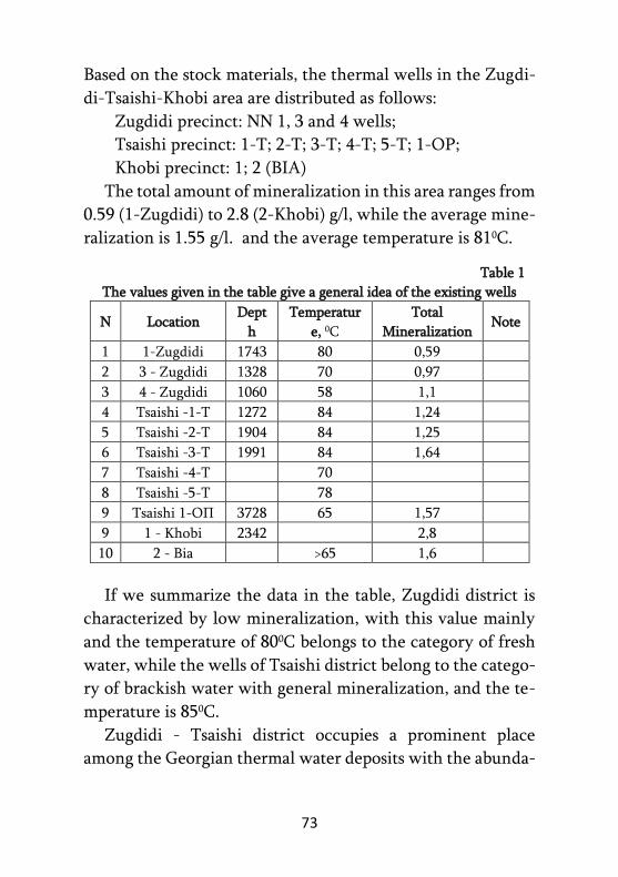
73
Based on the stock materials, the thermal wells in the Zugdi-
di-Tsaishi-Khobi area are distributed as follows:
Zugdidi precinct: NN 1, 3 and 4 wells;
Tsaishi precinct: 1-T; 2-T; 3-T; 4-T; 5-T; 1-OP;
Khobi precinct: 1; 2 (BIA)
The total amount of mineralization in this area ranges from
0.59 (1-Zugdidi) to 2.8 (2-Khobi) g/l, while the average mine-
ralization is 1.55 g/l. and the average temperature is 810C.
Table 1
The values given in the table give a general idea of the existing wells
N Location Dept
h
Temperatur
e, 0C
Total
Mineralization Note
1 1-Zugdidi 1743 80 0,59
2 3 - Zugdidi 1328 70 0,97
3 4 - Zugdidi 1060 58 1,1
4 Tsaishi -1-T 1272 84 1,24
5 Tsaishi -2-T 1904 84 1,25
6 Tsaishi -3-T 1991 84 1,64
7 Tsaishi -4-T 70
8 Tsaishi -5-T 78
9 Tsaishi 1-ОП 3728 65 1,57
9 1 - Khobi 2342 2,8
10 2 - Bia >65 1,6
If we summarize the data in the table, Zugdidi district is
characterized by low mineralization, with this value mainly
and the temperature of 800C belongs to the category of fresh
water, while the wells of Tsaishi district belong to the catego-
ry of brackish water with general mineralization, and the te-
mperature is 850C.
Zugdidi - Tsaishi district occupies a prominent place
among the Georgian thermal water deposits with the abunda-

74
nce of exploitation and wells, the amount of identified resou-
rces, the level of readiness for the development of the deposit
and the existence of a large-scale user.
REFERENCES:
1. Zautashvili B. General Hydrogeology. Technical University
Publishing. Tbilisi 1997;
2. Zautashvili B. Geochemistry of trace elements of deep under-
ground waters in Georgia. - Tbilisi, Metsniereba, 1978, art. 162;
3. Tsertsvadze N., Buachidze G. et al. Thermal waters of Georgia.
Georgian Geothermal Association, Tbilisi 2015].

75
ABOUT THE LANDSLIDE IN THE
VILLAGE CHANCHKHALO
N. MOMTSELIDZE, G. MINDIASHVILI Georgian Technical University
Village Chanchkhalo is located in Shuakhevi municipality,
on the right landsliding slope of the river of the same name
(right tributary of Adjaristskali).
Here morphologically, two (maybe three) main landslide
terraces (bodies) are distinguished. In each of them are deve-
loped small, local landslide bodies.
Landslides are basically developed in loose sediments of the
Quaternary age: In alluvial-deluvial, possibly in elluvial for-
mations. Which are products of weathering of Middle Eocene
volcanogenic-sedimentary rocks - andesite-basalts (tuffs, la-
vas, tuff breccias).
The main landslide body, which is developed in the village
area, is of creeping type, surface of rupture is relatively deep.
It is divided into small landslide bodies of avalanche type.
The main road to the village of Chanchkhalo, crosses one
of the landslide areas. This landslide is generated in the dilu-
vion (boulder, gravel and rock debris with clay filler). Dilu-
vion is dry, but during rains, the filler clay softens and a large
fraction loses its friction.
Diluvion, as is clear from the general geological and engi-
neering-geological maps and stock materials, is located on the
Middle Eocene andesitic basalts, which is creviced.
We have identified one engineering-geological element
(EGE) at the surveyed site: EGE 1 Eluvial-deluvial rock deb-
ris– with clay filler, boulder and pebble inclusions.

76
REFERENCES:
1. Lomtadze V. "Engineering Geology, Engineering Geodyna-
mics". Tbilisi 2000 423 P. STU Library 556.3 (02)/12;
2. Zviadadze U., Mardashova M. Some features of engineering
geological conditions and construction of territories d. Tbilisi
(Georgia). "Development of Geodetic and Geotechnical Cons-
truction", №13, Published with the support of the Technical
Committee №207, "Interdependence of Foundations and Ar-
mament" ISSMGE, St. Petersburg, 2011;
3. Kvashilava N., Chakhaia G., Varazashvili Z. Assessment of lan-
dslide sustainability in river Gldaniskhevi valley. Journal of
“Science and Technology”, N2 (722), Tbilisi, 2016;
4. Maruashvili L.I. Geomorphology of Georgia. “METSNIE-
REBA” Publishing . Tbilisi, 1971.
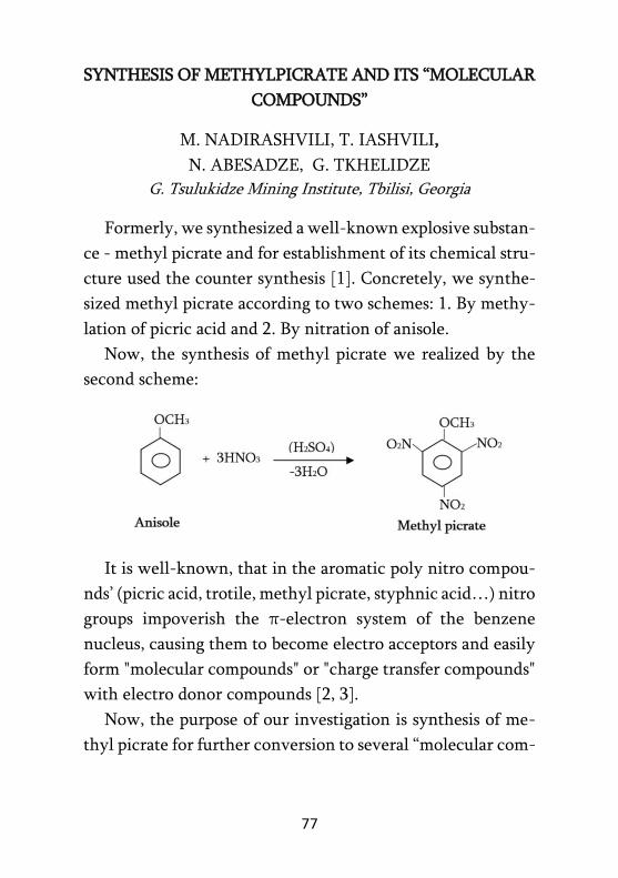
77
SYNTHESIS OF METHYLPICRATE AND ITS “MOLECULAR
COMPOUNDS”
M. NADIRASHVILI, T. IASHVILI,
N. ABESADZE, G. TKHELIDZE
G. Tsulukidze Mining Institute, Tbilisi, Georgia
Formerly, we synthesized a well-known explosive substan-
ce - methyl picrate and for establishment of its chemical stru-
cture used the counter synthesis [1]. Concretely, we synthe-
sized methyl picrate according to two schemes: 1. By methy-
lation of picric acid and 2. By nitration of anisole.
Now, the synthesis of methyl picrate we realized by the
second scheme:
It is well-known, that in the aromatic poly nitro compou-
nds’ (picric acid, trotile, methyl picrate, styphnic acid…) nitro
groups impoverish the π-electron system of the benzene
nucleus, causing them to become electro acceptors and easily
form "molecular compounds" or "charge transfer compounds"
with electro donor compounds [2, 3].
Now, the purpose of our investigation is synthesis of me-
thyl picrate for further conversion to several “molecular com-
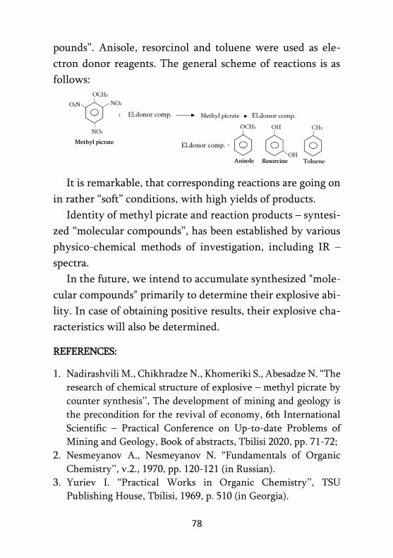
78
pounds”. Anisole, resorcinol and toluene were used as ele-
ctron donor reagents. The general scheme of reactions is as
follows:
It is remarkable, that corresponding reactions are going on
in rather “soft” conditions, with high yields of products.
Identity of methyl picrate and reaction products – syntesi-
zed “molecular compounds”, has been established by various
physico-chemical methods of investigation, including IR –
spectra.
In the future, we intend to accumulate synthesized "mole-
cular compounds" primarily to determine their explosive abi-
lity. In case of obtaining positive results, their explosive cha-
racteristics will also be determined.
REFERENCES:
1. Nadirashvili M., Chikhradze N., Khomeriki S., Abesadze N. “The
research of chemical structure of explosive – methyl picrate by
counter synthesis’’, The development of mining and geology is
the precondition for the revival of economy, 6th International
Scientific – Practical Conference on Up-to-date Problems of
Mining and Geology, Book of abstracts, Tbilisi 2020, pp. 71-72;
2. Nesmeyanov A., Nesmeyanov N. “Fundamentals of Organic
Chemistry’’, v.2., 1970, pp. 120-121 (in Russian).
3. Yuriev I. “Practical Works in Organic Chemistry’’, TSU
Publishing House, Tbilisi, 1969, p. 510 (in Georgia).

79
MODULAR PREFABRICATED PEDESTRIAN SUSPENSION
BRIDGE
G. NOZADZE, E. TSOTSERIA, D.PATARAIA, R.
MAISURADZE, L.TAVLALASHVILI,
G. AKHVLEDIANI, T. KOBIDZE LEPL G. Tsulukidze Mining Institute
The report discusses the implementation of a simplified de-
sign scheme for a light pedestrian suspension bridge up to 120
meters long [1-3].
Fig. 1. Schematic of a pedestrian suspended rope bridge
The diagram of the construction of the bridge is given, ta-
king into account the modular principle of the bridge carria-
geway arrangement. It is proposed to make a suspension brid-
ge module from a standard assortment of metal material 2 m
- in assemblies, in which the use of modern tiles made of com-
posite materials together with traditional ones is provided for
the construction of the roadway (Fig.2)
Fig. 2. 2 m. Prefabricated pedestrian bridge module

80
The article discusses the method of constructing the "gravi-
tational" anchor of steel ropes of the supporting structure of
the bridge in soft soils (Fig. 3).
Fig. 3. The device of the "gravitational" anchor of the bearing cable of the
suspension bridge using gabions.
For the construction of the ,,gravitational’’ anchor, it is
proposed to use gabions built from inert mass in situ.
REFERENCES:
1. Antony Schofield, Arup Pty Ltd, „ DESIGN AND CONSTRUC-
TION OF PURLING BROOK FALLS SUSPENSION BRIDGE
(JOHN STACEY BRIDGE), SPRINGBROOK NATIONAL
PARK, QLD“ , 2015, Brisbane, Australia; 2. GUIDELINE FOR SURVEY, DESIGN & CONSTRUCTION.
Short Span Trail Bridge Standard Suspended Type Volume 1;
3. Suspended Pedestrian Bridge Part 1: Design and Analysis. First
edition. 2009.

81
DETECTION AND SYSTEMATIZATION OF FAULT
STRUCTURES IN THE SUBURBS OF TBILISI TO IDENTIFY
THE AREAS OF DANGEROUS EVENTS
V. NADIRADZE, H. SALUQVADZE, M. APKHAZAVA LEPL TSU Alexandre Tvalchrelidze Caucasian
Institute of Mineral Resources
Due to dangerous geological events in different districts of
Tbilisi, several catastrophes have been mentioned, which en-
ded in casualties and huge material damage. In the forties of
the last century, a tragedy caused by a flood occurred in Aba-
notubani, which sacrificed many people. In recent decades,
several floods have also developed along the river, in the Vere
Valley; the most devastating among them was in 2015, with
many casualties and great material losses. Dangerous landsli-
des occurred in 2020, on the slope of Lake Lisi, and so on.
Various special works have been carried out by local and
invited specialists to prevent and predict these events. As a
result, several papers have been created, which, in our opi-
nion, contain one disadvantage - the role of tectonics in the
development of these events is not properly reflected.
Dangerous geological events, floods, landslides, rock falls,
etc., are mostly related to tectonic events, and most of them
are caused by tectonic faults, so the main subject of the resea-
rch should be the study and detection of rupture structures.
As a result of our researches, the territory of Georgia re-
vealed the morphological features of faulty structures (linea-
ments) - they are linear structures and create a grid of ortho-
gonal-diagonal systems, which consists of several (3-4) ele-
ments and usually a low-ranking structure is part of a high-
ranking structure.
82
From the mentioned systems, the latitudinal and diagonal-
northwest directions lineaments are mainly developed on the
territory of Georgia. They dominate the creation of fold struc-
tures and the formation of structural-facial zones. The line-
aments of latitudinal and northeast directions are intersecting
in nature and usually form block structures.
Tbilisi is located at the eastern end of the Adjara-Trialeti
structural zone, on the Trialeti ridge. The territory is built
mainly of Eocene-Oligocene sediments and is connected with
a complex tectonic node. This node is manifested by a sharp
change of the flow of the Mtkvari River, which is connected
with lineaments of different directions. The river Mtkvari
flows in the latitudinal direction in the west of Tbilisi, which
is due to the disruption of Gori-Mtskheta. In the northern
part of the city, the river changes direction sharply on the me-
ridian, and its direction near the Metekhi bridge also changes
sharply on the diagonal - south-east. The abrupt change of the
river is related to three strong fault structures: one is the Gori-
Mtskheta regional fault, it is part of the tectonic zone that
separates Adjara-Trialeti from the Georgian Belt, the second
is the meridional fault, allocated by us, which is part of the
Arpa-Chechnya transregional lineament that crosses the
whole Caucasus and continues beyond its borders, and the
third is the north-eastern direction diagonal fault, which is
also part of a larger structure.
To solve this issue we believe that geological research
should be carried out on the territory of Tbilisi and its surr-
oundings, using aerospace materials. Is it clear, that in the city
area itself, due to the infrastructure, the effectiveness of
detecting tectonic structures will be minimal, which can be
filled at the expense of studying the city surroundings. The
main focus of the studies will be dedicated to detect and study

83
tectonic faults, their morphology, quality of activity, identifi-
cation of fault crossing nodes, with which are associated areas
of potentially dangerous geological events. Proper attention
should be paid to hidden fault structures, which will require
morphostructural analysis of the area. As a result of the study,
a 1:25000 scale tectonic map of the surroundings of Tbilisi
should be compiled, which will show the fault structures and
the areas of dangerous geological events related to them.

84
ISSUES OF METALLOGENY OF GEORGIA FROM THE
POSITIONS OF FIXISM AND MOBILISM
V. NADIRADZE, M. APKHAZAVA LEPL TSU Alexandre Tvalchrelidze Caucasus
Institute of Mineral Resources
The tectonophilic theory, which is based on the invariabi-
lity of the Earth's volume, along with many other issues, fails
to explain the phenomena of expansion and contraction of the
Earth's crust, which is reflected in the recurrent development
of riftogenic and orogenic cycles. The concept also makes it
difficult to explain the existence of long-term fixed global-
scale geological structures that intersect continents, multiple
structural-facial zones, and are even expelled into the oceans.
Along with many shortcomings, this concept also fails to pre-
dict ore deposits.
The Caucasus region, whose part is Georgia, has been con-
sidered as an active edge of the European continent for almost
half a century, only according to the theory of plate tectonics.
Consequently, the interpretation of the facts in this region is
mainly reduced to the search for the remains of the oceanic
crust and to the determination of the Benioff Paleozone,
which this crust was absorbed by. There is no consensus
among researchers on both the number of absorption zones
and the primary source of ophiolites from which they should
be derived.
In our opinion, these discrepancies can be explained by the
concept of global tectonics, which is based on the idea of
pulsating expansion of the Earth and attributes a leading role
to the process of riftogenesis. The periodicity of these proce-
sses and their activation cycles related to the expansion of the
Earth’s crust has been established. During the formation of
85
geosynclines, it caused thinning of the continental crust (in
miogeosynclines, sometimes splitting of the crust completely
(in the eugosynclines) and forming of an ocean-type crust.
Stretching periods were replaced by compression phases, whi-
ch conditioned closure of rift structures and narrowing of
geosynclinal basins; this process was accompanied by intense
folding, formation of sloping structures, and horizontal move-
ment of masses. However, this process did not have the scale
envisaged by the concept of tectonophiles.
Within the Mediterranean-Himalayan fold system, the
Caucasus geosynclinal area was formed mainly as a result of
intersection of two global-scale linear zones. One of them is a
500 km thick, the Caucasus - Tian-Shan zone, which is stret-
ched from Atlantic Ocean to the Pacific Ocean, between the
latitudes 400 and 450, and which defines the morphology of
many geostructures. It is also observed in the Sea of Japan,
where it forms a system of geophysical anomalies and forms
an underwater abyss.
The 200 km long linear zone of the second system inter-
sects the Caucasus diagonally, to the northwest. It is represen-
ted by the Elbrus and Khamadan zones in the south, on the
territory of Iran, and in the north by the Ukrainian shield -
by the deep fault of Podolsky. These two main structures for-
med weakened zones in the Caucasus, along which narrow
but rather deep graben-like depths were formed. The course
of this process from the beginning of the Paleozoic to the
Middle of Sarmatian is evidenced by paleo schemes. The line-
aments, which have the northeast and meridian directions are
also part of global-scale structures. They mostly form block
structures, while rarely form fold structures.
The vast majority of the nonferrous, rare and noble depo-
sits on the territory of Georgia are located in the north-west

86
linear zone, while the ore regions are connected to the meri-
dian system by their crossing nodes.
Barite-polymetallic deposits are mainly found in Middle
Jurassic volcanic rocks, although their Upper Tertiary age is
documented by many facts. Accordingly, the spatial connec-
tion of this formation with volcanic zones requires explana-
tion. The study of spreading zones and rifts in the oceans sho-
wed that in the active zones, hydrothermal-exhalation proce-
sses take place intensively on their seabed, with the accumu-
lation of large amounts of endogenous substance. A clear exa-
mple is the Red Sea Rift, where ore deposits are localized in
the form of colloidal masses of barium, zinc, and strontium
rust.
Supposedly, scattered mineralization of barium and poly-
metals was similarly accumulated in the Caucasus, in the Mid-
dle Jurassic volcanic zones, at the initial stage of their rift de-
velopment. After that, in the upper third, as a result of tecto-
nic-magmatic activation, these substances were recycled and
concentrated along with the meridional structures, forming
deposits, where there is several million tons of barite mass and
its content reaches 90-95%.
Special attention should be paid to the copper-sulphide de-
posits of Adange and Zeskho, on which without success exp-
loration works has been conducted for many years. These ore
manifestations are related to the Main thrust zone of the Gre-
ater Caucasus and are presented in the form of ore containing
blocks (sometimes colossal in size). In our opinion, the cop-
per-sulphide mineralization of these manifestations must be
related to the period when Jurassic, rift-like processes were
underway on the southern slope of the Greater Caucasus,
which is confirmed by the age of transformation into ore.
Subsequently, the process of tectonic formation of the Greater
87
Caucasus destroyed these ore bodies. This process was expre-
ssed by the bringing of tectonic blocks out on the modern
surface, along the main thrust. Young copper-sulphide depo-
sits are also found in the same region, some of them are related
to the structures of meridional direction, such as Shou-didi.
Therefore, in our opinion, the predictive resources obtained
from these ore occurrences are exaggerated and unrealistic.
Oil-gasification is controlled by latitudinal lineaments and
these types of deposits are also connected to the nodes of
intersection with structures of the meridian system.
REFERENCES:
1. Nadiradze V. Participation of lineaments in geological structures
and location of minerals in the Caucasus. A. Janelidze Geological
Institute Procceding, New Series. Vol. 119, 2004. Pp. 122-129.
(In Russian);
2. Nadiradze V. Tectogenic conditions of formation barite minera-
lization of the Mediterranean- Alpine belt. Caucas. Inst. Min.
Res. Proceding, 2009, pp 75-89. (In Russian);
3. Nadiradze V. Morfological and metallogenic analysis of linea-
ments in Georgia. Mining Jurnal. 2019, #1 (42), pp 13-16. (In
Georgian).

88
THE FIRST DATA ON Th AND U OCCURRENCES IN THE
LATE OROGENIC GRANITE VEINS OF THE SHKHARA
VARISCAN PLUTON, GREATER CAUCASUS, GEORGIA
A. OKROSTSVARIDZE1, B. S. VAN GOSEN2, YUAN-HIS
LEE3, D. BLUASHVILI4, K. AKIMIDZE5, S. GOGOLADZE1 1Institute of Earth Sciences, Ilia state University, Tbilisi, Georgia; 2 U.S. Geological Survey, Denver Federal Center, Denver, U.S.A.;
3National Chung-Cheng University, Daxue road 168,
62102 Chiayi, Taiwan; 4Tbilisi State University, Tbilisi, Georgia;
5Georgian Technical University, Tbilisi, Georgia.
During the field research provided by the project of the
Shota Rustaveli National Science Foundation (#FR-18-
8122), in the Shkhara pluton of Variscan generation hydrot-
hermal uranium and thorium occurrences were detected,
about which the information will be represented in this pub-
lication for the first time. It is noteworthy that hydrothermal
uranium ore deposits have an important economic value, they
are consisting of 30% of global uranium reserves and there-
fore, approximately same percentage of global product [1].
During the fieldwork the radiation monitoring of rocks
was conducted by the Portable Gamma Radiation Dose Rate
Meter Type FAG FH 40 F2. Geochemical analyses of rocks
were performed on ICP-MS, in MSLABS laboratory, Canada.
The U-Pb zircon geochronology was conducted at the Natio-
nal Chung Cheng University, Taiwan, equipped with an Agi-
lent 7500s quadrupole ICP–MS.
The Shkhara pluton crops out in the headwaters of the
river Enguri and it forms ~5 m high and ~15 m long ridge. It
is mainly composed of granodiorites with inclusions of bio-
tite-bearing gneisses. This pluton is intruded by various veins
89
of albite-microcline series with thickness ranging between
~0.2 to 5 m [2].
In two granite-aplite veins intruding the Shkhara pluton
with thicknesses of ~1.5 m and 0.7 m, high level of radiation
was detected. Common radiation level measures ~1.7-1.9
Sv/h, but within some parts these values increase up to 2.7-
3.0 Sv/h. This means that the radiation level in veins is ~10-
20 times higher than the common radiation level in pluton.
Moreover, performed analytical work showed the average
concentrations of elements in veins, only uranium and thori-
um concentrations revealed some anomalies. Thorium con-
tent ranging between 29.5 g/t to 47.5 g/t that is almost one
order higher compared to the norm. The uranium concentra-
tions deserve particular interest that varies between 174.3g/t
to 290.9 g/t that is 10-15 orders higher than the normal con-
tent. These concentrations vary between 62.4 g/t to 105 g/t in
the contact areas of veins that are also high content. In all
samples taken from the Shkhara pluton, the Th/U ratio is low-
er than two that indicates that the uranium in these veins
should be represented by the mineral uraninite (UO2). Accor-
ding to the modern researches the vein type hydrothermal
uranium ore deposits are associated with the late orogenic
phase of the Late Paleozoic and Mesozoic granite magmatism
(western and central Europe, China, Canada) [1, 3].
Besides geochemical research, we performed LA-ICP-MS
U-Pb zircon geochronology of the Shkhara pluton as well,
that are represented for the first time in this publication.
Based on the obtained data, during the Variscan orogeny
(316.9±8.8 Ma) (20 grains MSWD=2.2) the Shkhara plutonic
body intruded into the Late Paleozoic gneiss infrastructure
(488.5±8.5 Ma) (28 grains, MSWD=2.7). The granitic vein
intruding into the Shkhara pluton was dated at 310.2±7.5 Ma

90
(25 grains, MSWD=2.6). In these types of the late orogenic
veins were detected high mineralization of uranium and
thorium.
Based on geochemical and geochronological investigation
it is obvious that Uranium and Thorium vein type minerali-
zations of the Shkhara pluton reveals full identity to the
analogous deposits of Central-Western Europe, China and
Canada. All of these Uranium ore deposits belong to the Late
Variscan orogeny granite vein systems. Therefore, these re-
sults let us conclude that the scientific and commercial resea-
rch of these ore deposits must be continued. In addition, it is
advisable to check surrounding sedimentary formations of
the Shkhara Pluton perhaps they are enriched with depleted
uranium.
REFERENCES:
1. Rene M., 2012. Uranium hydrothermal deposits. In book:
Uranium: Characteristics, Occurrence and Human Exposure.
Publisher: Nova Science Publishers. pp. 211-244;
2. Okrostsvaridze, A., 2007. Hercynian granitoid magmatizm of
the Greater Caucasus. Tbilisi, Intelect, 223 p.;
3. Bonnetti Ch., Meradier J., Liu X., Cuney M., 2017. The genesis
of granite-related hydrothermal uranium deposits in the Xiazh-
uang and Zhuguang ore fields, North Guangdong Province, SE
China. J. Ore Geology Reviews, 92, pp. 588-612.
91
DETERMINATION AND CONTOURING OF SPHERICAL
CAVITIES IN UNDERGROUND CONSTRUCTION AND
MINING BY PHYSICAL MODELING IN GPR.
D. ODILAVADZE, T. CHELIDZE M. Nodia Institute of Geophysics of Tbilisi State University,
Tbilisi, Georgia
Currently, the issues of construction and protection of un-
derground structures for various purposes, including vertical
shaft shafts and underground spherical cavities, remain topi-
cal. At the same time, it becomes necessary to solve a number
of related tasks, such as combating emergency consequences
(rock bumps, underground explosive works, environmental
protection from pollution, seismic safety problems, etc.). As a
result, blockages are formed leading to the death of people and
stoppages of production, which in turn requires an accurate
determination of the location of underground objects for liq-
uidation of the consequences, both for access from the earth's
surface and from underground.
GPR laboratory studies [1] for a hollow sphere and a sphere
with a metal cylindrical inclusion were carried out using the
method of physical modeling of GPR. The work was carried
out on an enclosing medium installation with a volume of
2.5mX1.5mX1.5m from the day surface [2] for a hollow sphe-
rical object with a diameter of 34 cm immersed in a sandy
medium and for the same sphere, containing a vertical metal
cylinder. The aim of the work was to obtain a radio image of
a model of an underground object, which, in accordance with
the theory of the similarity of electromagnetic fields, corres-
ponds to a radio image of a full-scale object [1, 2, 3, 4, 5]. Mo-
del GPR works [1,2,3,4,5] were carried out using the Zond12e
GPR with a 2 GHz antenna and Prism 2.5 software. We give

92
radio images on radarograms for the central profiles of the
sphere model with a hollow and with a metal inclusion (Fig.
1-2).
Fig. 1. Radarogram of a hollow sphere, the in-phase axes show the
presence of a cavity at the upper part of the radio
image with burred lines.
The paper identifies and defines the contouring criteria
and features of a spherical surface in a radio image with a ca-
vity and with the inclusion of parallel profiles above the ob-
ject surface for radarograms. Thus, the possibility of recogni-
zing a spherical cavity under the ground from the day surface
during ground-penetrating radar works for the needs of mi-
ning and underground construction has been revealed.
Fig. 2. Radarogram of a sphere with a vertical metal cylinder
turned on, the in-phase axes show the presence of a rigidly reflecting
object surface at the upper part of the radio image with clear bright lines.

93
REFERENCES:
1. Odilavadze D., Chelidze T. Geophysical modeling of the geora-
diolocation field in direct and inverse tasks of electrodynamics.
Geophysical Journal, V.35, № 4, 2013, pp. 154-160 (in Russian);
2. Odilavadze D., Chelidze T. Physical modeling of lava tubes in
the GPR. Transactions of Mikheil Nodia Institute of Geophysics,
vol. LXVII, ISSN 1512-1135, Publishing house of the Tbilisi
State University, Tbilisi, 2017, pp. 129-142;
3. Odilavadze D., Chelidze T., TskhvediashviliG. Georadiolocation
physical modeling for disk-shaped voids. JOURNAL OF THE
GEORGIAN GEOPHYSICAL SOCIETY. Vol 18, PHYSICS OF
SOLID EARTH, 2015, p. p. 26-39;
4. Odilavadze D., Chelidze T., Ghlonti N., Kiria J., Tarkhnishvili A.
Physical modelling of a layered wedge type model in direct and
inverse tasks of georadiolocation. Transactions of Mikheil Nodia
Institute of Geophysics, vol. LXIX, ISSN 1512-1135, Publishing
house of the Tbilisi State University, Tbilisi, 2018, p. p. 44-61;
5. Odilavadze D., Kiria J., Ghlonti N., Yavolovskaya O. The Results
of Archaeogeoradiolocation Investigations of the Territory
Inside the Rampart of St. Sophia Church of Khobi. Bulletin of
the Georgian National Academy of Sciences. V.14, no.4, 2020, p.
p. 51-56.

94
MICROFAUNA COMPLEXES OF THE MEOTIAN
SEDIMENTS OF WESTERN GEORGIA
(FORAMINIFERS, OSTRACODES)
L. POPKHADZE I. Javakhishvili Tbilisi State University,
A. Janelidze Institute of Geology
The freshening of the Late Sarmatian basin led to the impo-
verishment of fauna. Significant conditions for the develop-
ment of microfauna occurred as a result of the restored conne-
ction with the open sea in the Early Meotian. This was well
reflected in the stratigraphic sections of the Meotian sedime-
nts of Western Georgia (the rivers Tskhenistskali, Ghalidzga,
Ghejiri, Kulistskali, and the villages Urta, Bia, Chochkhati,
Tkhinvali) studied by microfauna. The biocenic variability of
foraminifera and ostracodes over time confirms the subdivi-
sion of Meotoan sediments into two sub-stages.
According to the microfauna is possible dividing of the
sub-stages into shorter units, where the tendency to gradual
desalination of the basin is manifested. There are distingui-
shed following microfauna complexes: 1) Foraminifera and
ostracode species fron the following genera – Nonion, Poroso-nonion, Ammonia, Elphidium, Leptocythere, Cyprideis that
passedfrom the Sarmatian sediments. Genetic connections of
some forms of microfauna of the Sarmatian-Meotian sedime-
nts have been established [1]. 2) Species of foraminifera of
Mediterranean origin from the genera Quinqueloculina, Mili-olinella. 3) Species of the Meotian sediments, which are wi-
despread in the synchronous sediments of the Caucasus – Qui-nqueloculina seminulum maeotica (Gerke), Q. bogatschovi Bogd., Leptocythere maeotica (Livent.), L. sulakensis Suzin, L. crebra Suzin, Xestoleberis maeotica Suzin and so on. 4)
95
Endemic species: Quinqueloculina disparilis galidzgensis Bo-
gd., Q. iberiae Bogd., Q. kvezanensis Popch., Hauerina iljinae Bogd., H. tselidzei Popch., Miliolinella majuscule Popch., Le-ptocythere retusa Popch., L. chochkatensis Popch., L. zinae Popch., Loxoconcha bella Popch., Candona propria Popch
and so on. 5) Small amounts of foraminifera and significant
amount of ostracodes continuing their existence in the Pon-
tian sediments. Species from the following genera: Quenquel-oculina, Ammonia, Elphidium, Cytherissa, Leptocythere, Lo-xoconcha are found.
REFERENCES:
1. Popkhadze L. Genetic Connections of Some Forms of Sarmatian-
Meotian Sediments of Western Georgia (foraminifers and ostra-
codes). Bulletin of the Academy of Sciences of Georgia, 151, N2.
B. 263-265, (1995) (in Georgian).

96
USE OF MINERALS OF THE AGATE-CHALCEDONY
GROUP IN ARCHEOLOGICAL BEADS
N. POPORADZE, R. METREVELI Georgian Technical University, Tbilisi, Georgia
Semiprecious minerals or gemstones are quite widespread
in Georgia. Among them, minerals of the agate-chalcedony
group are of particular importance and have been mined and
used for jewellery purposes since ancient times; discovered in
burials numerous pieces of jewelry made of them and decora-
ted with them are evidence of it. The reason for the predomi-
nance of the agate-chalcedony group of minerals in our artifa-
cts should primarily be their accessibility which is due to their
large spread on the territory of Georgia. These minerals are
distinguished by a highly decorative appearance, great densi-
ty, resistance to environmental conditions and, most importa-
ntly, good visual and attractive color. The Samtavro Burrow ground is a colorful burial due to the
carnelian beads having been found there. The beads are repre-
sented by a variety of the quartz group, here we find carnelian,
chalcedony, agate, and jasper. We have raw materials of a si-
milar type of gem stones in different regions of Georgia, inc-
luding the Chokrak deposits - in the Mtskheta and Kaspi area.
Fig. 1. Samtavro necropolis beads
97
According to the visual description of the available beads
they differ from each other in color and texture. These differe-
nces became even more apparent when studying their internal
structure under a microscope. We defined form and size of
each bead; we used an X-ray fluorescence analyzer to deter-
mine the chemical composition of a certain number of beads. The results of the research carried out by the authors are
the following: most beads are made of carnelian, but there also
occur a relatively small number of beads made of chalcedony,
agate and jasper. Their textures significantly differ from each
other. In some cases, there are distinctly observed zones of
growth with a circular or banded texture, sometimes in the
form of impregnations or spotted texture. Most of the beads
are of uneven coloration, with occasionally visible cracks and
inclusions. The degree of transparency of the beads ranges
from half-transparent to opaque. As for the shape and proce-
ssing of the beads they are represented in various forms; there
occur barrel-shaped, wheel-shaped, kneecap-shape, spherical,
cylindrical, cone-shaped, drop-shaped, triangular and nave-
shaped beads. The surface of some beads is represented by
diverse ornaments, there are also beads with simple forms of
cutting made of carnelian of dark and uniform color. The tech-
nique of making a hole through them is also interesting. In
most cases, they are drilled on both sides in the opposite
direction. As for the raw material for beads the analyses carried out
by optical microscope (Amscop PZ600T), X-ray fluorescence
analyzer (EDEXR 3600B) and X-ray diffraction analyzer
(DRON3) show that the chemical composition (both basic and
admixed elements) and the crystalline structure of the beads
studied by the authors and those of quartz-chalcedony-carne-
lian raw material, mined in various regions of Georgia, are

98
identical and thus it suggests the possibility of making the
studied beads locally from the local raw materials by local
craftsmen. We consider that different in color and relatively
homogeneous beads are mainly made from the raw material
extracted in the Chokrak deposits, while the heterogeneous
ones - from the raw material in the Pamachi and Shurdo agate
deposits of the Bajocian porphyritic series.
REFERENCES:
1. Mgeliashvili T. Geoarchaeology of Georgia. “Metsniereba”, 1991,
p. 169 (in Georgian);
2. Poporadze N., Gachechiladze Kh., Seskuria O. Mineral Compo-
sition of Archeological Finds Of Georgia, “Technical University”,
2016, p. 75 (in Georgian).
99
INVESTIGATION OF OCHRE TYPE PIGMENT RAW
MATERIAL OF NAGOMARI DEPOSIT ON
ENRICHABILITY
A.SHEKILADZE, O. KAVTELASHVILI,
M. BAGNASHVILI, I. SAMKHARADZE,
D. MSHVILDADZE, S. MAGLAKELIDZE Lepl G. Tsulukidze mining institute
To study the enrichability of ochre-containing pigment
raw material and the dyeing properties of the product (fini-
shed product) obtained from it, based on the familiarization
with geological archive material, Nagomari deposit was
selected for investigation, from which a small laboratory-
technological sample was taken. According to the minera-
logical analysis of the test sample, the material with thickness
above 80 μm is mainly represented by transparent and milky
quartz, limonitized clay particles, single earthy hematite and,
rarely, magnetite and ilmenite grains. According to the
chemical analysis of the initial sample, the Fe2O3 content in
the ore is 9.78%. With this parameter in natural form it fails
to meet the requirements for pigment raw materials and needs
enrichment. An electrolytic precipitation method has been
selected for enrichment, for the peptization of clays with the
addition of sodium metasilicate. The technological scheme of
the precipitation process and the optimal operating condi-
tions were determined. The recommended technological
scheme allows to obtain 461.8 kg of finished product from 1
ton of raw material with Fe2O3 content of 19.43%, and
recovery - 91.75%. The result obtained meets the paints and
varnishes industry requirements for the pigment.
From the raw materials of the deposit it is possible to pro-
duce high quality, ecologically safe, beautiful color, and high
100
dyeing pigments. It can be achieved by creating small manu-
facturing enterprises with a simple technological line, which
will make a defined contribution to the development of our
national economy. Nagomari deposit has favorable mining-
geological conditions for development. In horizontal bedding
conditions of ochre layers the opencast mining is possible.

101
ON THE ISOTOPE AGE OF ZIRCONS FROM THE
TSKHETIJVARI BASITE INTRUSIVEOF THE DZIRULA
CRYSTALLINE MASSIF (CAUCASUS)
D. SHENGELIA1, T. TSUTSUNAVA1, L. SHUMLYANSKYY2,
G. BERIDZE1, I. JAVAKHISHVILI1, G. CHICHINADZE 1 1 TSU, Al. Janelidze Institute of Geology, Tbilisi, Georgia
2School of Earth and Planetary Sciences, Curtin University, Perth, Australia
The Dzirula massif is the largest outcrop of the Black Sea-
Central Transcaucasian pre-Alpine crystalline basement. Exp-
osures of Early Cambrian basites are widespread within the
massif, the largest of which (several km2) are mapped in the
Gezrula and Dedaberastskali river-gorges and in the vicinity
of the village Tskhetijvari. Variously sized relics of the basites
occurring mainly in the Variscan granites are observed as
well. They are represented by gabbro, gabbro-diorite and gab-
bro-diabase. Their primary magmatic minerals are monocli-
nic pyroxene, hornblende and plagioclase, rarely biotite. Se-
condary minerals widespread in the rock are chlorite, actino-
lite and minerals of epidote group. They are the products of
the Variscan retrograde metamorphism, and the appearance
of quartz, albite, microcline and zircon is caused by the inf-
luence of the Variscan granites. The basites cut through Neop-
roterozoic (Rb/Sr – 686 ± 54Ma [3]) quartz-diorite orthognei-
sses, and, in their turn, are cut by granitoids of the tonalite-
granodiorite series generated during the Late Pan-African
(Late Baikalian, Rb/Sr – 538 ± 53Ma [3]) tectonogenesis. Thus,
crystallization of basites apparently took place during the
Cadomian orogeny, in the interval 650-550 Ma. The U-Pb

102
LA-ICP-MS zircon dating of the Dedaberastskali and Gezrula
basites recorded only the Late Varician ages of 317.5 ± 6 and
323.7 ± 2.5Ma [2, 4] which reflect the influence of the Varis-
can granites and retrograde metamorphism.
As to the age of the Tskhetijvari gabbro, it is dated by the
Sm-Nd method at 607 ± 78Ma [6]. Despite the large error, this
age, in our opinion, fits the geological position of the intrusive
and corresponds to the age of the Cadomian orogeny. We
have performed 34 local measurements of zircons from the
Tskhetijvari basites by U-Pb LA-ICP-MS method and distin-
guished there three age populations: I – 352-314 Ma (20 mea-
surements), II - 445-371 Ma (9 measurements), and III - 2934-
2085 Ma (5 measurements). Zircons of the first population
have crystallized under the influence of Late Variscan grani-
tes; their concordant age is 329.7 ± 2.8 Ma and corresponds to
the Middle Carboniferous. The endogenic process correspon-
ding to the second population is not recorded on the Dzirula
crystalline massif. The age of the third group of zircons is in
the range of 2934–2085 Ma, which is probably the age of
zircons captured by the basite intrusion from the mafic layer
[1, 5], located under the sialic layer.
The above data indicate that zircons did not crystallize du-
ring the formation of the Tskhetijvari, Gezrula, and Dedabe-
rastskali basites, and therefore their U-Pb LA-ICP-MS zircon
dating cannot reveal the crystallization age of these intru-
sions. Only Tskhetijvari basites, besides the zircons crystalli-
zed under the influence of the Late Variscan granites, contain
zircons of pre-Paleoproterozoic age, which, presumably, were
captured by the intrusion.
103
REFERENCES:
1. Gamkrelidze I., Shengelia D. (2005). Precambrian-Paleozoic
regional metamorphism, granitoid magmatism and geodynamics
of the Caucaus. M.: 458 (in Russian);
2. Gamkrelidze I., Shengelia D., Tsutsunava T., Chung Sun-Lin,
Yichiu Han, Chikhelidze K. (2011). New Data on the U-Pb Zir-
con Age of the Pre-Alpine Crystalline Basement of the Black
Sea-Central Transcaucasian Terrane and its Geological Signifi-
cance. Bull. of Georgian Nat. Acad. of Sci. Vol. 5, N.1;
3. Okrotsvaridze A., Clarke D., Reynolds P. (2002). Sm-Nd, Rb-Sr
and K-Ar isotope system and geochronology age of the pre-
Alpine granitoids of Dzirula salient of the Caucasian Median
Massif. A. Janelidze Institute of Geology, Proceedings. New Se-
ries Vol. 117 (in Russian);
4. Shengelia D., Dudauri O., Chikhelidze K. (2010). U-Pb Isotope
Geochronology of the Pre-Alpine Formations of the Dzirula
Crystalline Massif (Georgia) According to Zircons. Alexandre
Janelidze Institute of Geology, Proceedings, New Series. Vol.
125, p. 51-61;
5. Shengelia D.M., Okrostsvaridze A.V. (1998). New data on the
structure of the Dzirula salient of the pre-Alpine basement of
the Georgian Block // Dokl. RAN. Vol. 359, N. 6, pp. 801-803;
6. Zakariadze G., Karpenko S., Basilev B., Adamia Sh., Oberkha-
nseli R., Solovieva N., Lialikov A. (1998). Petrology, geo-
chemistry and Sm-Nd age of pre-Late Hercynian paleooceanic
complex of Dzirula salient of Transcaucasian massif. Petrology
6, 422-444 (in Russian).

104
INNOVATIVE TECHNOLOGY OF OBTAINING NEW
ENVIRONMENTALLY FRIENDLY HEAT-INSULATING
MATERIAL
E. SHAPAKIDZE, I. KAMUSHADZE, L. GABUNIA,
I. GEJADZE, T. PETRIASHVILI I. Javakhishvili Tbilisi State University, A. Tvalchrelidze Caucasian
Institute of Mineral Resources Tbilisi, Georgia
All over the world, including Georgia, there is an acute
issue of a critical increase in emissions of the so-called green-
house gases, oxygen dioxide in the environment, as it has a
destructive effect on the earth's climate.
One of the means of lowering of carbon dioxide emission
in the atmosphere is the minimization of energy usage on hea-
ting of buildings, which can be achieved by using heat-insula-
ting materials.
In Georgia construction business is continually increasing
but local heat-insulating materials are not produced. The mar-
ket is full of imported heat-insulating organic materials, whi-
ch cannot resist high temperatures, are not fireproof materials
and in the course of time they are deteriorating and decaying.
Besides they cost quite high.
In Georgia the heat-insulation of residential and other buil-
dings is disregarded, which, on its part is the reason for high
energy consumption for heating and conditioning. The adop-
tion of ecologically clean, heat-insulating material can beco-
me an important factor in order to reduce energy loss, espe-
cially when natural and mineral raw materials for producing
them are abundant in Georgia.
Therefore, from this viewpoint, it becomes significant to
elaborate simplified technology and new compositions in
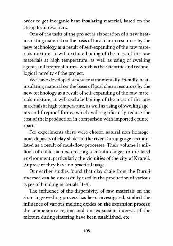
105
order to get inorganic heat-insulating material, based on the
cheap local resources.
One of the tasks of the project is elaboration of a new heat-
insulating material on the basis of local cheap resources by the
new technology as a result of self-expanding of the raw mate-
rials mixture. It will exclude boiling of the mass of the raw
materials at high temperature, as well as using of swelling
agents and fireproof forms, which is the scientific and techno-
logical novelty of the project.
We have developed a new environmentally friendly heat-
insulating material on the basis of local cheap resources by the
new technology as a result of self-expanding of the raw mate-
rials mixture. It will exclude boiling of the mass of the raw
materials at high temperature, as well as using of swelling age-
nts and fireproof forms, which will significantly reduce the
cost of their production in comparison with imported counte-
rparts.
For experiments there were chosen natural non-homoge-
nous deposits of clay shales of the river Duruji gorge accumu-
lated as a result of mud-flow processes. Their volume is mil-
lions of cubic meters, creating a certain danger to the local
environment, particularly the vicinities of the city of Kvareli.
At present they have no practical usage.
Our earlier studies found that clay shale from the Duruji
riverbed can be successfully used in the production of various
types of building materials [1-4].
The influence of the dispersivity of raw materials on the
sintering-swelling process has been investigated; studied the
influence of various melting oxides on the expansion process;
the temperature regime and the expansion interval of the
mixture during sintering have been established, etc.
106
Fig. 1 shows a laboratory sample of a new environmentally
friendly heat-insulating building material obtained from clay
shale using an innovative technology.
Fig. 1. Heat-insulating building material
REFERENCES:
1. Gabunia L., Kamushadze I., Shapakidze E., Gejadze I., Kvata-
shidze R. Reception of swollen materials with application of
local magmatic rocks. Journal of Georgian Ceramists Association
"Ceramics", 2014, 2(25), p.p. 3-5 (in Georgian).
2. Shapakidze E., Skhvitaridze R., Gejadze I., Maisuradze V., Nadi-
rashvili M., Khuchua E.. Study of Alluvium Shales (Falling Ro-
cks of Caucasian Ridge, Generated as a Result of Sill- Mudflows),
as a Pozzolanic Additive for Cement. Journal of Georgian Cera-
mists Association "Ceramics", 2016, 1(35), p.p. 17-21.
3. Shapakidze E., Gejadze I., Nadirashvili M., Maisuradze V., Petri-
ashvili T., Sxvitaridze A. Using Clay Rocks of Georgia to Obtain
High-Active Pozzolanic Additives to Portland Cement. Interna-
tional Journal of Applied Engineering Research. Volume 14,
Number 18 (2019) pp.3689-3695.

107
4. Shapakidze E., Kamushadze I., Gabunia L., Gejadze I., Skhvita-
ridze R., Petriashvili T. Development of Technology for Produ-
ction of Modern Energy Efficient Building Materials on The
Basis of Clay Rocks of Georgia. Journal of Georgian Ceramists
Association "Ceramics", 2020. V.22. 2(44), p. 3-7 (in Georgian).
This work was supported by the Shota Rustaveli National
Science Foundation of Georgia (SRNSFG) [grant № AR-18-
343].
108
REVIVAL OF THE PRODUCTION OF CERAMIC
BUILDING MATERIALS IN GEORGIA AS ONE OF THE
WAYS TO SOLVE ENVIRONMENTAL PROBLEMS
E. SHAPAKIDZE1, I. KAMUSHADZE1,
L. GABUNIA1, I. GEJADZE1,
R. SKHVITARIDZE2, M. MAKADZE1, T. PETRIASHVILI1 1I. Javakhishvili Tbilisi State University, A. Tvalchrelidze Caucasian Institute of Mineral Resources Tbilisi, Georgia
2Georgian Technical University, Tbilisi, Georgia
Ceramic building materials (ceramic bricks and blocks, ce-
ramic finishing slabs, clinker bricks (for finishing of roads,
facades, etc.) are one of the cornerstones of construction indu-
stry. Production of ceramic building materials is accompanied
with less emission into the atmosphere and less heating-ene-
rgy resources are consumed for their production; synthesis of
ceramic bricks requires 900-1000°C, whereas synthesis of ce-
ment clinker requires 1450-1500°C. At the same time, the
wall, built of ceramic bricks, can breathe and is safer for hu-
man health then that built of cement/concrete.
Presently only Metekhi brick factory operates in Georgia,
which works with clay of Metekhi deposit. Metekhi clay de-
posit is exhaustible. The content of CaO in the remaining lay-
ers of clay is high (12-19 %), negatively affecting the quality
of bricks. Brick clays of other deposits also have high content
of CaO, forming white sports on the surface of bricks, lowe-
ring frost resistance. Unlike them, Kvareli clay shales are re-
markable for low content of CaO (1-2%).
It is known that in Kakheti region, in the gorge of Duruji
River, as a result of extensive, exogenous processes over 20
million m3 of rock taluses have been accumulated and annual
surplus makes about 500 thousand m3. Mudflow processes of

109
ruinous power periodically develop in the gorge, creating risk
of ecological catastrophe to the local environment and, in par-
ticular, to Kvareli and its population of 10 thousand, living in
this risk zone.
There is no doubt that for the purpose of restoration of eco-
logical balance in the region, it is necessary to remove the
mass of rocks, accumulated in the outskirts of Kvareli during
years. The matter is that the rock alluvium, brought by Duruji
River are destroyed clay shales - natural deposit of useful raw
material, in the case of rational use of which many types of
products may be manufactures with considerable economic
benefits, not to say anything about ecological need.
Our earlier studies have proved that the Kvareli shale can
be successfully used to obtain various building materials [1-4].
The purpose of this work is to develop technologies for pro-
ducing modern building ceramic materials: building bricks
and clinker bricks from Kvareli clay shales, which will contri-
bute to the revival of the production of building ceramics and
a certain solution to environmental problems in Georgia.
REFERENCES:
1. Sarukhanishvili A., Skhvitaridze R., Shapakidze E. and others.
Innovative Solution of Utilization of the Clay Slates Accumu-
lated in the Gorge. IBSU Journal of Technical Science and Tech-
nologies. Vol 5, No 2, 2016, p.p. 27-32;
2. Shapakidze E., Gejadze I., Nadirashvili M., Maisuradze V., Pet-
riashvili T., Skhvitaridze A. Using Clay Rocks of Georgia to Ob-
tain High-Active Pozzolanic Additives to Portland Cement. In-
ternational Journal of Applied Engineering Research. Volume
14, Number 18, 2019, p.p.3689-3695;
110
3. Shapakidze E., Kamushadze I., Gabunia L., Gejadze I., Skhvita-
ridze R., Petriashvili T. Development of Technology for Produ-
ction of Modern Energy Efficient Building Materials on The
Basis of Clay Rocks of Georgia. Journal of Georgian Ceramists
Association "Ceramics", V.22. 2(44), 2020, p.p. 3-7 (in Georgian).
This work was supported by the Shota Rustaveli National
Science Foundation of Georgia (SRNSFG) [grant № CARYS-
19-158].
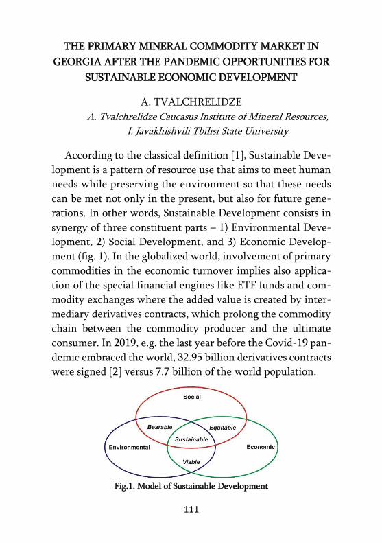
111
THE PRIMARY MINERAL COMMODITY MARKET IN
GEORGIA AFTER THE PANDEMIC OPPORTUNITIES FOR
SUSTAINABLE ECONOMIC DEVELOPMENT
A. TVALCHRELIDZE
A. Tvalchrelidze Caucasus Institute of Mineral Resources,
I. Javakhishvili Tbilisi State University
According to the classical definition [1], Sustainable Deve-
lopment is a pattern of resource use that aims to meet human
needs while preserving the environment so that these needs
can be met not only in the present, but also for future gene-
rations. In other words, Sustainable Development consists in
synergy of three constituent parts – 1) Environmental Deve-
lopment, 2) Social Development, and 3) Economic Develop-
ment (fig. 1). In the globalized world, involvement of primary
commodities in the economic turnover implies also applica-
tion of the special financial engines like ETF funds and com-
modity exchanges where the added value is created by inter-
mediary derivatives contracts, which prolong the commodity
chain between the commodity producer and the ultimate
consumer. In 2019, e.g. the last year before the Covid-19 pan-
demic embraced the world, 32.95 billion derivatives contracts
were signed [2] versus 7.7 billion of the world population.
Fig.1. Model of Sustainable Development

112
In 2020 the coronavirus pandemic created a new economic
& political reality, “pandemopolitics” [3], which consisted in
governmental efforts to combat both the epidemic and the
economic crisis. The latter, first of all, was determined by ca-
tastrophic crash of commodity prices at all markets and, as co-
nsequence, by withdraw of investors from basic commodity
exchanges. According to our in-depth analysis [4], already in
mid-summer commodity markets gained equilibrium, howe-
ver, in 2020 4.89 times less derivatives contracts were signed
than in 2019. Just this fact determined deterioration of the
2020 world GDP by, at least, -8% [5].
Georgia is not implied in international commodity mar-
kets, correspondingly, pandemic’s impact on its economy was
less vulnerable. However, the fast social & economic recovery
after the pandemic seems to be impossible without applica-
tion of the financial instruments and engines of the modern
globalized world. Economic modelling has clearly shown that
augmentation of oil and, correspondingly, of other mineral
commodity prices is the best remedy for extremely fast, two-
year term, regaining of the world GDP to the 2019 level.
Such accelerated economic growth is suggested to be
impossible in Georgia due to lack of the corresponding eco-
nomic engines. It seems obvious that modernization of the
Georgian social environment and switching with the Euro-
pean Union will be impossible if the economic framework is
not synchronized and if the commodity markets in its modern
shape is not launched in the country. Economic modelling has
shown that just application of these free-market financial
instruments will accelerate economic development by, at
least, three times.

113
It may be added as a conclusion that the irreversible econo-
mic reformation of Georgia must tend towards introduction
of the modern free market instruments, which calls for
updating of corresponding legislation including introduction
of the modern Mining Code. This is the sole possibility to
mobilize cheap money for huge investments in the mining
sector and this way to ensure combating poverty.
If we want to have a modern state, we should have the
modern mining industry.
REFERENCES:
1. Adams W. The Future of Sustainability: Re-Thinking Environ-
ment and Development in the Twenty-First Century. Report of
the IUCN Renowned Thinkers Meeting 29-31 January, 2006,
pp.1-19;
2. The WFE’s Derivatives Report 2019. London, World Federa-
tion of Exchanges, 2020, 53 pp.;
3. Mionel V., Neguț S., Mionel M. Pandemopolitics. How a Public
Health Problem Become a Geopolitical and Geoeconomic Issue.
Eurasian Geography and Economics, vol. 61, №4-5, 2020, pp.
389-403;
4. Tvalchrelidze A., Silagadze A. Influence of COVID-19 Coro-
navirus Pandemic on International Oil Markets. Scientific Jou-
rnals of the Maritime University of Szczecin, vol. 63, №135,
2020, pp. 97-103;
5. Wheeler C., Baffes J., Kabundi A., Kindberg-Hanlon G., Nagle
P. S., Ohnsorge, F. L. Adding Fuel to the Fire: Cheap Oil During
the COVID-19 Pandemic. Policy Research Working Paper
9320. Washington, DC, The World Bank Group, 2020, 47 pp.

114
GEOLOGICAL STRUCTURE OF THE MUSHEVANI 3 GOLD-
LOW-SULPHIDE DEPOSIT
M. TCHOKONELIDZE, M. GAGNIDZE, D. TCHEISHVILI Caucasian Mining Group ltd., Tbilisi, Georgia
The Mushevani 3 gold—low-sulfide deposit is located wi-
thin the Bolnisi ore-bearing region, approximately 5 km nor-
theastward from the Madneuli enrichment plant; it occupies
watershed range of sub-latitudinal strike (absolute elevation -
1009 m).
The position of the deposit is defined by the presence of
junction point among latitudinal, north-western, north-meri-
dional and close to meridional fault zones.
Host rocks of the deposit are represented by Upper Creta-
ceous, Senonian volcanics of the Mashavera suite.
The upper part of the deposit hosts silicified (to secondary
quartzites – silicite), oxidized, weakly barytized, vitro-crysta-
lline-lithoclastic grey-yellowish psephitic tuffs of rhyodacitic
composition. The ore oxidation is met as deep as 50 m. Within
strongly fractured areas, the maximum depth of oxidized zone
reaches 85 m. The oxidized zone hosts mainly iron hydroxi-
des. As for baritization, it occurs as white, unevenly distribu-
ted macrolaminar assemblages in a form of their aggregates,
inclusions, veinlet-disseminations, and scarcely as veins.
The mentioned formations are underlain by crysltalline-
vitro-lithoclastic coarse fragmental green-greyish tuffs of the
same rhyodacitic composition. The suite also hosts scare fine
grained (psammitic and aleurolitic) tuff interlayers. The tuffs
are unsorted; the amount of clastic material in groundmass is
about 30%.

115
Within the Mushevani 3 suite, there are two horizons of
light greenish ignimbrite vitro-clastic tuffs – upper and lo-
wer ones. These tuffs also show mainly psephitic structure,
although, in their packets some fine-fragmental tuff inter-
layers are observed. The thickness of the ignimbrite tuffs of
the upper zone is 40-45 m, while the thickness of the lower
- ranges between 120-220 m.
The deposit exhibits facies transitions of variously fragme-
nted tuffogenic rocks both along strike and dip.
The host rocks underwent synvolcanic propylitic altera-
tion, which is represented by chlorite-(epidote)-albite-quar-
tz-pyrite mineral associations. Chlorite within the mentioned
metasomatites has both quantitative and functional importa-
nce. In some places, the rocks along with silicification under-
went argillization.
The tuffogenic rocks are cut by rhyodacitic subvolcanic
bodies of various forms and sizes. Small phenocrysts in rhyo-
dacites are represented by albite, K-fieldspar and quartzite
disseminated within felsitic groundmass. Rhyodacitic bodies
form distinct positive forms in the relief.
The deposit also hosts andesite vertical dykes of north-eas-
tern strike with maximum thickness of 20 m.
The Quaternary sediments, here, are represented by eluvi-
al, deluvial, rarely proluvial formations. Their thickness rea-
ches some 12 m.
The Mushevani 3 deposit is hosted by weakly folded, mo-
nocline structure. Host rocks dip northward; dip angle is 200.
The structure of the deposit is complex and shows north-
eastern, northwestern, close to meridianal and sub-latitudinal
disjunctive structures.The fault structures are difficult to be
identified since they often are hidden below the Quaternary
cover, or diguised by regional metasomatic processes. Most

116
disjunctives resulted mainly from pre-ore tectonic events.
Apparently, during further tectonic activations, the fault stru-
ctures were reorganized for several times, although, the post-
ore period is characterized by the presence of fault zones
without any significant deformations and displacement. Their
inner structure is featured by the presence of fault and clayey
zones. The fault zones and host rocks are characterized by
later stage of carbonitization. Orientation of fractured system
corresponds to general plan of tectonic stress.
The deposit is divided into several blocks, within which
different types of voids (interlayers spaces, pores, caverns etc)
in the associated with folding and faulting fractures and rocks
have accumulated ores.
Within the top hypsometric horizons, the barite minerali-
zation is accompanied by weak copper mineralization, which
appear in the form of its oxidized variations, in particular, as
malachite and azurite impregnations and disseminations, and
rarely chalcopyrite disseminations. These hypsometric hori-
zons show prints of gold mineralization along with quartz.
Barite concentration gradually decreases with depth inc-
rease, although, it is recorded in the boreholes as deep as 200
m, and even deeper it appears in the form of scarce small vein-
lets, lenses, and inclusions. Simultaneously with barite dec-
rease in the depth, there occurs zinc, gold and copper mine-
ralization represented by quartz-gold-sulphide (chalcopyrite,
sphalerite, galena, pyrite) ores. In these ores, the overprinted
quartz mineralization plays an important role in regard to
gold accumulation.
About 80% of ore intersections are registered in silicified
and argilized tuffs, 15% - in ignimbrite tuffs, and 5% - in oxi-
dized zones and andesite bodies.
117
Ore bodies occur in form of gently dipping lenses. They
also occur as pockets. The general strike of ore zone is north-
eastern.
The deposit hosts veinlet-disseminated, gold—low-sulph-
ide type of ores. Along with gold, here, very uneven distribu-
tion of silver, copper, zinc, rarely lead and barite is recorded;
ore mineralization is distributed vertically as well as laterally.
The deposit is of epithermal genesis.

118
PRELIMINARY RESULTS OF PERFORMED EXPERIMENTS
TO OBTAIN IMPACT RESISTANT ORGANOPLASTIC
A. VANISHVILI1, D. TSVERAVA1, S. KVINIKADZE1,
L. KIRTADZE1, S. STERIAKOVA1, G. ABASHIDZE1
1LELP G. Tsulukidze Mining Institute
The results of the matrix material research are presented.
Polyester - urea modified polyester resin is selected as the ma-
trix material. The purpose of resin modification is to enhance
the adhesive properties. It should be noted that among similar
types of polymers, polyester-ureas are characterized by the
highest mechanical properties (Young modulus 6.0 GPa).
Akron University (Akron U., USA) is actively working on its
introduction.
The principle of selection of reinforcement element of or-
ganoplastic, its input control, technological methods of fiber
surface treatment to give different specific properties are also
presented. The physical and mechanical properties of orga-
noplastics and the influence of various factors on these chara-
cteristics are analyzed. Surface treatment methods for reinfo-
rcements to reduce the impact of harmful factors are discu-
ssed.
The research also refers to impact resistance and dynamic
loads of laboratory-made organoplastics. Impact determina-
tion methods involve the study of the load falling on a speci-
men from a certain height and the impact of explosion-indu-
ced load on the specimen. Impact test specimens were 67 mm
diameter discs with a thickness of 2.5 mm. Samples made of
organoplastic were tested on a 3 m high impact coper at a drop
load of 2 kg. A special stand mounted in an explosion chamber
was used to study the impact on the material caused by the
explosion. The sample placed on the stand was a 350x350x3

119
mm steel sheet with or without a protective layer. After the
test, the deformation values (bending) of the steel sheets were
measured. The result showed that protecting the steel sheet
with organoplastics layer about 2 mm thick reduced the defo-
rmation by about three times.
Acknowledgment(s)
This work was supported by the Shota Rustaveli National
Science Foundation (SRNSF) [Grant CARYS19-836, Title:
“Development of shock-resistant and biodegradable polyme-
ric composites and provision of a technology transfer”].
REFERENCES:
1. Ravid M., Bodner S., Chochron I. Penetration analysis of cera-
mic armor with composite material backing //Proceedings of the
Nineteenth First International Symposium on Ballistics;
2. Selivanov V., Kobilkin I., Novikov S. Explosive technologies.
М, 2014;
3. Walker J., Anderson Ch. An analytical model for ceramic – face
light armor // Proceedings of the Seventeenth First International
Symposium on Ballistics. Midrand. South Africa 1998.

120
PER FECTION OF RESEARCH METODS IN COMPUTER USING
MATHEMATICAL SYSTEMS
I. VARSHANIDZE, N. GHUDUSHAURI G. Tsulukidze Mining Institute, Tbilisi, Georgia
The high pace of development of production technologies
makes it impossible to maintain the existing research mecha-
nisms. This creates the need for developing new research me-
thods and designing and manufacturing appropriate tools.
Modern industrial explosives are characterized by reduced
sensitivity to external influences and zero or near to it oxygen
balance, which results in the release of toxic gases during the
chemical transformation process. Explosives are characterized
by high sensitivity and pronounced negative or positive oxy-
gen balance. Consequently, their direct use for industrial pur-
poses is prohibited in accordance with international norms.
The manufacture of modern industrial explosive mixtures
on the basis of explosives involves the introduction of various
substances in their form as mixtures, which leads to an inc-
rease in the critical diameter of the charge. It’s noteworthy
that the critical diameter / mass is the maximum / minimum
diameter / mass of the charge that causes an explosion. Accor-
ding to our research, the so-called “refinement” of explosives
has led to an increase in the charge diameter / mass of the
charge by up to one kilogram, while the current testing equi-
pment is designed to explode a charge of 50 to 150 grams in
diameter / mass. This circumstance precluded the determina-
tion of the detonation and energy characteristics of the obtai-
ned explosive mixtures using existing methods and equip-
ment.
The need to develop a methodology and design and manu-
facture of equipment that will allow any crisis mass / diameter

121
test charge to explode has been put on the agenda. For this
purpose, the Grigol Tsulukidze Mining Institute developed a
device for measuring the rate of detonation working on opti-
cal transmitters, the principle of operation of which is based
on the discrete registration of the chemical transformation
process through ionization and optical transmission. It can
measure reaction speed in both critically large (1 kg and more)
critical diameter / mass as well as critically small (10-20 g)
charges. In addition, the tool allows us to determine the dy-
namics of reaction velocity variability and to determine the
forms, areas and conditions of reaction induction, accelera-
tion, explosion and detonation. One of the disadvantages of
this method is the high sensitivity to electromagnetic radia-
tion, which leads to distortion of the signal on the recording
device when testing modern explosives. In order to test the
energy performance of modern industrial explosives with inc-
reased crisis diameter, the Grigol Tsulukidze Mining Institute
designed a modern multifunctional calorimetric device, whi-
ch will be adapted to be used both for the research of explo-
sives produced on the basis of utilized gunpowder, as well as
for testing the composition of electric / physical-chemical and
reaction products of modern mass produced industrial (as well
as military) explosives.
The principle of the operation of the device is based on the
rise in the temperature of the calorimetric liquid as a result of
explosion-induced heat release. The increase in the tempera-
ture of the calorimetric liquid equals the energy, the heat of
the explosion, created as a result of the chemical transforma-
tion, which makes it possible to determine all main thermo-
dynamic parameters.
It is noteworthy that the key detail of the modern multi-
functional calorimetric device – the explosion chamber – was

122
designed on the basis of a computing experiment using mo-
dern research methods, specifically, computer mathematics
systems. For this purpose, a computing model of an explosion
chamber having parameters and form obtained as a result of
analytical research was designed. In order to validate the re-
sults, the LS-DYNA software package imitated and visualized
the explosion of a test charge weighing 1 kg. Based on the
optimization and analysis of the results, the thickness of the
blast chamber wall was selected, during which the integrity
of the chamber surface was fully maintained until the cham-
ber was fully unloaded, without residual deformation and
breakage. The concurrence of the results obtained by analyti-
cal solution and computer modeling led to the reliability of
the project model on the basis of which a draft project of exp-
losion chamber was prepared and handed over to the Scie-
ntific Centre for Construction Research and Drafting for pre-
paration of drawings. Instrument manufacturing procedures
are currently underway.
Based on the above, a computational experiment based on
modern research methods allows us to conduct scientific
research on explosive transformation processes without any
costs and risks and to "replace" the experimental research
methods.
REFERENCES:
1. Baum F., Orlenko L. Staniukovich C., Chelousev B., Shekhter
B.I. Book: Explosive phusik. (Russian) pp.1-704; Nauka 1975;
2. Urbanski T.Cemistry and Technology of Exposives, Pergramon
Press , Oxford 1983-1985;
3. Poznyak N., Kuleshov A., Kurlypo A. Computer Mathematics
and New Technologies;

123
4. Chikhradze N., Khomeriki S., Varshanidze I., Shatberashvili G.
New type of calorimetric device. 5th Annual Scientific Confe-
rence "Current Problems of Mining and Geology", December 14,
2018 Tbilisi, Mining Institute;
5. Varshanidze I. Study of Detonation Skills of Expired Explosives
and Improvement of Methods for Determining Energy Chara-
cteristics. Dissertation. Supervisor: N. Chikhradze. Tbilisi. Geor-
gian Technical University, 2019.

124
FOLDED STRUCTURE OF THE GREATER CAUCASUS AT
THE CROSSING OF THE RIVER GORGES OF THE PSHAVIS
ARAGVI-KHEVSURETIS ARAGVI-TSKALSHUA-ASSA
1D. ZAKARAIA, 2T. GIORGOBIANI
1 Javakhishvili Tbilisi State University, M.Nodia Institute of
Geophysics. Georgia, Tbilisi
2 Javakhishvili Tbilisi State University, Al.Janelidze Institute of
Geology. Georgia, Tbilisi,
Annotation. The relevance of the work. The article consi-
ders the folded structure of the Greater Caucasus at the com-
plete intersection of the gorges of the Pshavi Aragvi-Khev-
sureti Aragvi-Tskalshua-Assa rivers. Despite the surveys ca-
rried out in previous years, the geological study of the region,
the detailed characteristic features of its folded structure are
still insufficiently studied [1, 2, 3, 4, 5, 6, 7]. At the same time,
the study of the folding of the Greater Caucasus is of decisive
importance for the determination of the conditions of for-
mation of the modern folded structure of the region. Purpose
of work. The establishment of important features of the fol-
ding of the Greater Caucasus essential for identification of the
reason and mechanism of its structure formation, which is not
yet fully resolved problem. The research methodology consi-
sted in a very detailed sketching of the folding of the region
along the gorges of the noted rivers on with a scale of 1: 1000,
which allowed to record all the features of the studied struc-
ture. The cross section compiled during field studies was
reduced to 1:100,000 scale. The resulting geological-structural
profile sufficiently fully and accurately reflects the main fea-
tures of the structural building of this intersection. Results. In

125
the studied section, a number of important features of the
folded structure of its Mesozoic-Cenozoic strata are establi-
shed. First of all, it should be noted that the fold structures are
multi-order and of different age and in most cases of sublati-
tudinal strike. The first-order structures are earlier folds and
are represented by asymmetric southwardly declined, highly
compressed 1-5 km wide folds. Complicating large structures,
folds of higher orders are also tightly compressed and asym-
metric with the axes dipping to the north and in some places
to the south. Their size varies widely - from 0.5 m to several
tens of meters. The sublatitudinal strike of the folding indica-
tes that it formed in a different deformation environment
than the main northwestern structure of the Greater Cauca-
sus. The axial part of the cross-section is pierced by dikes of
various sizes and diabase composition. Discussion of results
and conclusions. The nature of folding indicates a different
genesis of the structures during the two-stage diverse multi-
faceted deformation of the region. At the first stage of defo-
rmation (Jurassic-Middle Miocene), the Caucasus experienced
northeast tangential compression caused by the horizontal
advance and pressing of the Black Sea-Transcaucasian micro-
continent to the Greater Caucasus. As a result, the main linear
folded structure of the northwestern strike, large regional fau-
lts, and layered cleavage were formed in the region. At the
second stage of deformation (Late Miocene-Anthropogene),
the folded structure of the Greater Caucasus experienced obli-
que submeridional horizontal compression. In the southern
part, the reason of the deformation was the longitudinal
movement of the Zhinvali shol, the corresponding block of

126
the microcontinent, and their emplacement into the folded
structure of the Greater Caucasus. These dislocations in the
region contribute generation of the late low folding superim-
posed on the early structure, small shear faults and crosscut-
ting cleavage of the sub-latitudinal direction. Thus, different
mechanisms formed the modern structure of the southern
slope, and also revealed a new detailed structure of northern
slope of the Greater Caucasus at the intersection of the noted
gorges during the alpine cycle of regional tectogenesis.
REFERENCES:
1. Belyankin D. Materials for petrography of the Central Caucasus
(Arkhoti pass - Georgian Military road) // Izv. SPb. polytechnic
in-te. Dept. tech., eating. and mate. 1912., V. 18. No. 1. P. 21-48.
(in Russian);
2. Rengarten V. Geological sketch of the area of the Georgian Mili-
tary road // Tr. Vses. geological-development about. 1932. Issue.
148. 70 p. (in Russian);
3. Rengarten V. Georgian Military Road. Int. XVII geol. Congr. Ex-
cursion across the Caucasus. - Rostov-Tbilisi: ONTI. 1937. P. 69-
110. (in Russian);
4. Kakhadze I. Georgia in Jurassic Time // Tr. GIN AN GSSR. Ser.
geol. T. III (VIII). Tbilisi. 1947. 371 p. (in Russian);
5. Chikhradze G. Lithology of the Lower and Middle Jurassic
deposits of the southern slope of the Greater Caucasus // Tr. GIN
AN GSSR. New ser. 1979. Issue. 62. 189 p. (in Russian);
6. Giorgobiani T., Zakaraia D. 1991. Tectonics of the zone of deve-
lopment of the Lower-Middle Jurassic deposits // In collection:
Geological structure of the Assa-Aragvi crossing of the Greater
Caucasus. "Metsniereba". Tbilisi. P. 82-101. (in Russian);
7. Gambashidze R., Kakabadze M., Kvantaliani I., Paichadze T.,
Topchishvili M., Chikhradze G., Beridze M., Khutsishvili O.,
Salukvadze N., Lobzhanidze G., Gamkrelidze I., Maisadze F.,
127
Kavelashvili A., Kokrashvili Z., Kuloshvili S., Kutsnashvili O.
// Ed. - Gamkrelidze I.P., Beridze M.A. In collection: Geological
structure of the Assa-Aragvi crossing of the Greater Caucasus.
Proceedings of the GIN. New Ser. 102. "Metsniereba". Tbilisi.
188 p. (in Russian).

128
Correction – Elene Akhmeteli