Embed Size (px)
Citation preview

BIG DATA
The Challenges of Geospatial Analytics in the Era of Big Data
Dr Noordin Ahmad
National Space Agency of Malaysia (ANGKASA)CITA 2015: 4-5 August 2015
Kuching, Sarawak

BIG DATA
Big data is an all-encompassing
term for any collection of data sets
so large and complex that it
becomes difficult to process them
using traditional data processing
applications.
http://en.wikipedia.org/wiki/Big_data

BIG DATA
?
BIG DATA

BIG DATA
Big processing of big imagery data
Imagery analysis in the cloud has become a reality through web services.
Flood of Big Data comes from mobile devices.
Big Data analytics is an effective way to enhance the power of location with
many comes from mobile devices.
GIS moves to processing in the cloud.
Apache Hadoop, an open source framework based on Google’s
MapReduce, has been used by many projects to perform geospatial
processing in the cloud or in cloud-like enterprise data centers.
Transaction oriented analytics: processing of streaming spatial data.
Relationships become more apparent with each user interaction, each
addition of data or each new algorithm that's introduced in a discovery
session.
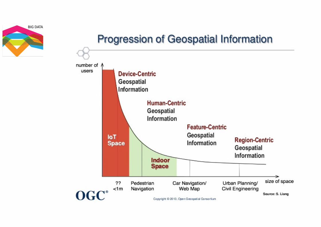
Big Geospatial Data ………….

BIG DATA

BIG DATA
SATELLITE TRANSPORTING BIG DATA
DISTRIBUTED DATA CENTRES

BIG DATA
Global Forest Extent and Change 2000–2012
Source: Hansen, Potapov, Moore, Hancher et al. , Science, 15 November 2013http://earthenginepartners.appspot.com/science-2013-global-forest
654kLandsat scenes
1MHours of
computation
700Terapixels
of data
10,000CPUsused
4Days to
complete
12Yearsof data
BIG DATA
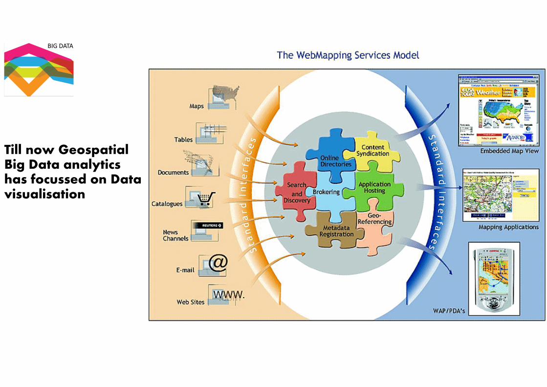
Till now Geospatial Big Data analytics has focussed on Data visualisation

BIG DATA
Reliable sources of geospatial information are essential to…
…support broad national objectives such as economic growth, social cohesion and well-being, and environmental management
4

BIG DATA
e.g. Big Data for Disaster Risk Reduction
Phase Data Type Example Data Sets Notes
Preparedness and
Early Warning
User-generated Twitter (food crisis, earthquake),
web traffic (Flu)
Requires machine learning,
classification algorithms
Sensor Precipitation (PERSIAN,
TRMM), evapotranspiration, soil moisture, temperature, vegetation
density and water content (MODIS, LANDSAT),
groundwater levels (GRACE)
Should be paired with validated and
calibrated biophysical models. Used for droughts, floods, fires, epidemics.
Impact and
Response
User-generated CDR, Flickr, Twitter Requires verification, algorithms to
separate signal from noise. CDR data requires agreement with cell provider
Sensor Imagery(LANDSAT, MODIS, Geoeye) thermal (LANDSAT,
MODIS), radar (RADARSAT-1, CARTOSAT), spatial video
Crowdsourcing aids damage detection. Crisis map mash ups by volunteer
cartographers help publicize and visualize data.
Mitigation, Risk and Vulnerability
Modeling
User-generated CDR, emergency call content, facebook
Data may not be representative of population.
sensor Nighttime Lights (NTL), Imagery, thermal, Radar, spatial
video, Temporal Flood Inundation Mapping (GIEMS)
Populations without electricity not identified by NTL. Must be paired
with socioecological vulnerability models. Uncertainty and scale issues.
institutional, public
GCM (Global Climate Model), Transportation data (subway,
bikeshare), census, Worldpop, Open Cities
Issues in uncertainty- GCMs are most uncertain at predicting extremes,
Worldpop combines data scales for modeling and has associated
uncertainties

BIG DATA
The process …..

BIG DATA
Legal/Administrative Issues
� Ethical Legal Practices
� Confidentiality, Security, and
Sensitive Information
� Privacy
� Intellectual Property
� Copyright
� Licensing
� Data Sharing
� Liability
� Archiving and Preservation
� Data Quality
Technological/Trends
� Open Data
� Volunteered Geographic
Information (VGI)
� Open Source
� Web 2.0 and the GeoWeb
� Cloud Computing
� Mobile and Location-based
Services
� High Resolution Imagery
� Mass Market Geomatics
� “Big data” /data Integration
The challenge of making the Technology trends into “Reliable” Data (Values)

BIG DATA
Geospatial Data Sharing & Geospatial Data Sharing & Geospatial Data Sharing & Geospatial Data Sharing &
CollaborationCollaborationCollaborationCollaboration::::
• Leveraging Agency DatasetsLeveraging Agency DatasetsLeveraging Agency DatasetsLeveraging Agency Datasets
• PPPPrrrroooommmmooootttteeeessss OOOOppppeeeennnn GGGGoooovvvveeeerrrrnnnnmmmmeeeennnntttt
BBBBeeeennnneeeeffffiiiittttssss ooooffff CCCCoooollllllllaaaabbbboooorrrraaaattttiiiivvvveeee DDDDeeeecccciiiissssiiiioooonnnn
Making Making Making Making fomfomfomfom GGGGeeeeoooossssppppaaaattttiiiiaaaallll BBBBiiiigggg DDDDaaaattttaaaa::::
• Same Map at the Same TimeSame Map at the Same TimeSame Map at the Same TimeSame Map at the Same Time
• SSSShhhhaaaarrrreeeedddd DDDDaaaattttaaaa AAAAccccrrrroooossssssss PPPPllllaaaattttffffoooorrrrmmmmssss
• Accelerates Situational Accelerates Situational Accelerates Situational Accelerates Situational
AwarenessAwarenessAwarenessAwareness
• Accelerates Decision MakingAccelerates Decision MakingAccelerates Decision MakingAccelerates Decision Making
• LLLLeeeevvvveeeerrrraaaaggggeeeessss CCCCoooommmmmmmmoooonnnn OOOOppppeeeerrrraaaattttiiiinnnngggg
Pictures already in Pictures already in Pictures already in Pictures already in useuseuseuse
Collaborative Decision Making
BIG DATA
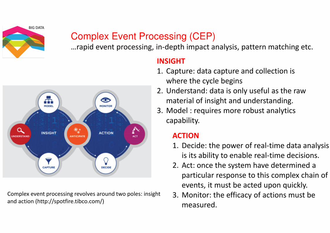
Complex Event Processing (CEP)…rapid event processing, in-depth impact analysis, pattern matching etc.
Complex event processing revolves around two poles: insight
and action (http://spotfire.tibco.com/)
INSIGHT
1. Capture: data capture and collection is
where the cycle begins
2. Understand: data is only useful as the raw
material of insight and understanding.
3. Model : requires more robust analytics
capability.
ACTION
1. Decide: the power of real-time data analysis
is its ability to enable real-time decisions.
2. Act: once the system have determined a
particular response to this complex chain of
events, it must be acted upon quickly.
3. Monitor: the efficacy of actions must be
measured.

BIG DATA
3 main type of Geospatial analytics
1.Predictive analytics
Likelihood of future events or happenings.
BIG DATA
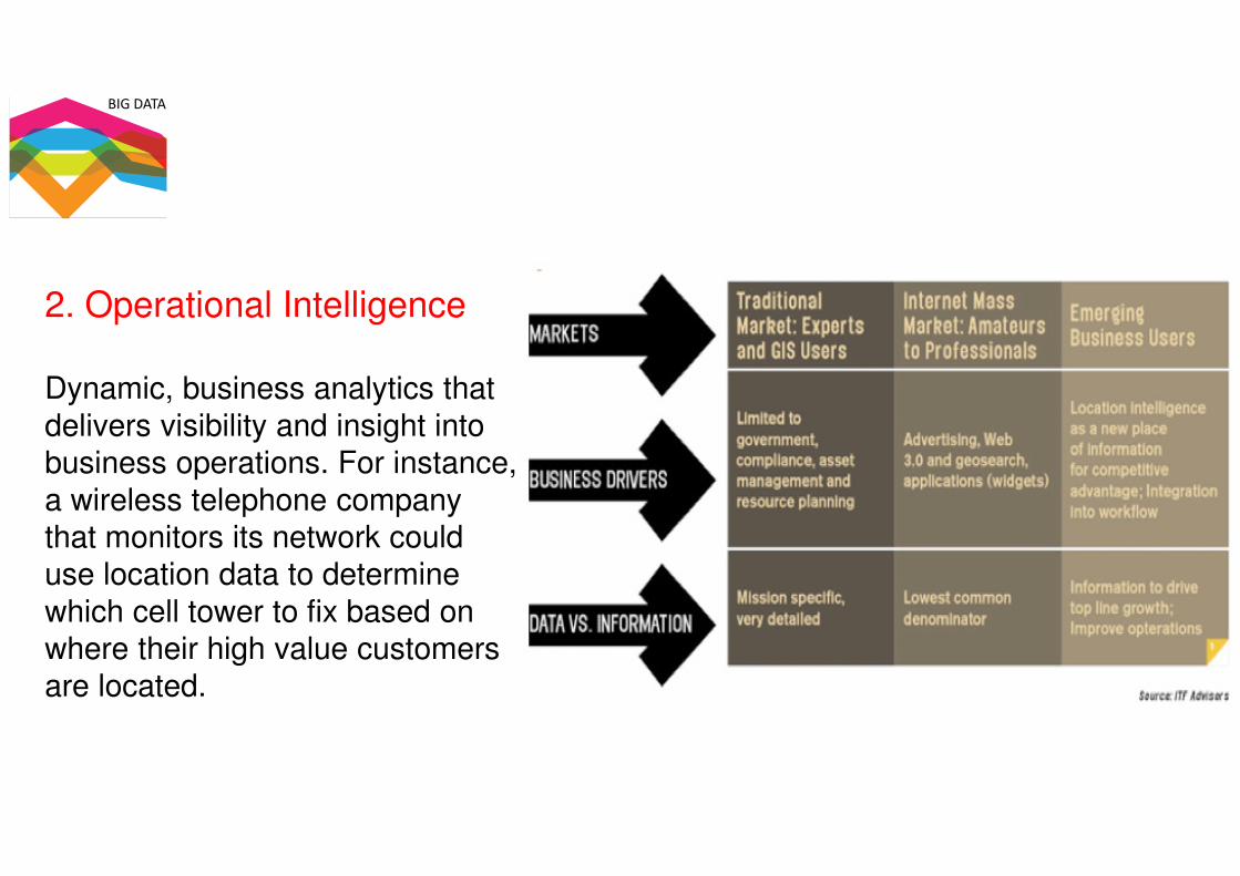
2. Operational Intelligence
Dynamic, business analytics that
delivers visibility and insight into
business operations. For instance,
a wireless telephone company
that monitors its network could
use location data to determine
which cell tower to fix based on
where their high value customers
are located.

BIG DATA
3. Situational intelligence
Integrates and correlates large volumes of
multidimensional real time and historical
data to identify and act on a problem.
Visualizing and analyzing this data can help
answer questions like what happened,
where did it happen, and why did it happen.

BIG DATA