Embed Size (px)
Citation preview

SOUTH-SOUTH COOPERATION PROGRAMME ON ENVIRONMENTALLY
SOUND SOCIO-ECONOMIC DEVELOPMENT IN THE HUMID TROPICS
WORKING PAPERS
No 13,1995
- ORGANISATION
MSCI DES NATIONS UNIES -POUR L’tDUCATION.
LA SCIENCE ET LA CULTURE
PROGRAMME SUR L’HOMME ET LA BlOSPHiRE
L’UNIVERSlTi DES NATIONS UNIES
TIERS MONDE

The Working Paners series is a publication of the South-South Cooperation Programme for Environmentally Sound Socio-Economic Development in the Humid Tropics. The series
aimes to disseminate the results of the research on Biosphere Reserves on such topics as (i) the
prevailing conservation and resource-use pattern ands, (ii) the ways of improving traditional
practices and orientation for applied research aimed at a more intensive and sustainable use of the
biodiversity to provide a better livelihood to the local population in the buffer and transition
zones. On more general issues, the Working: Papers are also an attempt to identify key problems
that will become areas of concentration for international cooperation.
The map on the front page has been produced by using a commercial software programme. The boundaries do not imply official endorsement or acceptance by Unesco or the United Nations. Neither do the ideas and opinions expressed in the Workina Paoers series, which are solely engaging their authors.
The Workina Paoers series is published as necessary either in English, French or Spanishen depending on the language used by the author.
0 Permission to reproduce any material of the Workina Paoers series will be given without any previous authorization, provided that full reference to the author, title, series title, date, institution editor and place of publication are given.
Edited by : UNESCO Division of Ecological Sciences Telephone : 33 * (1) 45.68.41.46 South-South Cooperation Programme Telefax : 33 - (1) 40.65.98.97 7, place de Fontenoy Telex : 20.44.61 Paris 75 700 PARIS (FRANCE) E-mail : smcl@ unesco.org
ij ‘~~~3~~~~~~~~~~~~~~~~~~~~ ~~~~~~~~~~~~~~~~~~~~~~~~~~~~ :.:.>..:, :...:.. . ..A...> . . . . . . . . . . . . .../ . . . . .,.. . . . ..,........ . . . . . . . . . . . ,...............
Ignacy SACHS ...ti(cuei CL’91’~.EN.~R-GODT
ECOLE DES HAUTES UNITED NATIONS EDUCA- ETUDES EN SCIENCES TIONAL, SCIENTIFIC AND SOCIALES (EHESS) CULTURAL ORGANIZATION Centre de Recherche sur le Bresil Contemporain (CRBS)
(UNESCO) Division of Ecological Sciences South-South Cooperation
54 Bd. Raspail 75 270 PARIS Cedex 06 FRANCE Telephone : 33 w (1) 49.54.20.85 Telecopie : 33 w (1) 45.48.83.53
Programme 1, rue Miollis 75 732 PARIS Cedex 15 FRANCE Telephone : 33 M (1) 45.68.41.46 Telecopie : 33 _ (1) 40.65.98.97
UNIVERSITY CLAUDE BERNARD LYON 1 (UCBLl) lnstitut d’Analyse des Systemes Biologiques et Socio-Economiques (IASBSE) Sociecologie et Conservation
43, Bd. du 11 novembre 1918 69622 VILLEURBANNE Cedex FRANCE Telephone : 33 w 72.43.12.48 Telecopie : 33 w 72.43.12..47
SC-95/ws-34

1
The Biosphere Reserves or similar managed areas that are joining the South-South Cooperation Programme, are, requested to produce an overview of their covering area containing
first hand information on its conditions and urging problems.
These reports will be primarily used as background materials for the comparative
projects agreed upon in the programme of activities established at the Chiang Mai meeting, held
in May1994. For more details please report to the newsletter South-South Persnectives (No 1,
October 1994 [28 pp.], UNESCO, Paris [France]).
Given the rich information value of these reports, there are being made available to a
wide audience. They may be obtained by contacting UNESCO/MAB Secretariat, Division of
Ecological Sciences.
For other documents available in the series, see the back-cover
Working Paper W 8, 1995, UNESCO (South-South Cooperation Programme), Paris (France)

3
Moreover, archeo-ecotouristic programs valorize the natural scenery and the first-class
archeological sites of the area. In order to add value to the forest and second-growth vegetation
areas often degraded, it is of little use to keep the forested areas only as a reserve for fallow
agriculture. Maize production supported by green manure or cover crops are meant to sedentarize
the maize plot, that is to replace fallow agriculture by a permanent one. Finally, multiple use
family orchards and crafts work integrate women and children to conservation work.
The “peasant to peasant” extension methodology is used to provide a regional technical
capacity.
Calakmul est l’une des plus importantes forets tropicales du Mexique. Son extension de
723.440 hectares, ajoutee aux forets des Stats Mexicains de Camp&he, Chiapas et Quintana
Roo, et a celles de Peten au Guatemala et de Belize, constitue la plus importante for& tropicale de
1’Hemisphere Nord Americain. Des restes de cites mayas, abandon&es en 900 de non-e ere,
montrent que ce n’est pas une for& vierge. Nous pouvons ainsi observer, de nos jours, une t&s
vaste for& pluviale resistante, constituant egalement un phenomene bio-culturel, en ce qui
conceme la relation entre nature et socied. Nous n’avons pas affaire seulement a une Reserve de
Biosphere mais egalement 51. un patrimoine culture1 de l’humanid.
En 1989, le gouvemement mexicain constituait une partie de cette foret pluviale maya en
Reserve de Biosphere. Dans la zone d’influence et dans la zone tampon, vivent 72 communautes
paysannes, dont beaucoup appartiennent a differents groupes ethniques, en particulier a quatre
groupes mayas. La plupart des villages se sont developpes dans la for&, a la suite de
programmes recents de colonisation qui ont amen6 dans cette zone des gens venant de 23 etats
mexicains.
En 199 1, une importante experience associant developpement et conservation fut lancee
par une organisation paysanne, des ONG et quelques agences gouvemementales. Consider-ant
que la population peut etre un facteur de stabilisation aussi bien que le contraire, l’accent fut mis
plus sur des activites de persuasion que sur des actions d’interdiction. Afin de garantir la
conservation de la Reserve, les activites paysannes locales furent conceptuellement reorientees en
occupation sociale de la for& oii conservation et developpement sont compatibles. Pour atteindre
cet objectif, il fut necessaire de creer un plan institutionnel, principalement autour d’une
organisation regionale de paysans, afin que les objectifs 5 moyen terme des paysans deviennent
un element actif dans le plan de conservation et de developpement. Ce programme conceme la
gestion de la for& naturelle selon le schema developpe dans l’accord Mexico-Allemand et le “Plan
Pilot0 Forestal” de l’etat voisin de Quintana Roo.
Working Paper N’ 13, 1995, UNESCO (South-South Cooperation Programme), Paris (France)

L’un des problemes fondamentaux de la zone provient du fait que les forks ont Cd
abattues selectivement par de grandes entreprises empechant les communautes locales de vivre de
ces ressources. C’est pourquoi il Ctait necessaire de developper une strategic qui prenne en
consideration les usages multiples de ce pays, ce qui est valorisant non seulement pour la
ressource de foresterie mais egalement pour d’autres activites Cconomiques comme l’apiculture,
le quatre-Cpices naturel, les palmiers et la gestion de la faune sauvage, tout cela en plus des
activites paysannes traditionnelles.
De plus, les programmes arch&-ecotouristiques permettent de valoriser le decor nature1
et les sites archeologiques de premiere classe de cette zone. Afii d’ajouter de la valeur aux zones
souvent degradees de la for& et de la vegetation secondaire, il est peu utile de conserver des
zones forestieres uniquement comme reserves pour l’agriculture de jachere. La production de
mdis, arnelioree par l’engrais vex-t et par des cultures de couverture, permettront de stabiliser les
parcelles de mdis, remplacant l’agriculture de jachere par une agriculture permanente. Enfin, les
vergers familiaux a usages multiples et l’artisanat permettent d’indgrer femrnes et enfants aux
travaux de conservation.
L’extension de la methodologie “peasant to peasant” permet d’apporter une capacite
technique regionale.
Doctor Eckart BOEGE works at INAH, in Veracruz State (Mexico).
Eckart BOEGE : The Calakmul Biosphere Reserve (Mexico)

I- INTRODUCTiON ..;. .......................................................................................................... 6 1) Biodiversity ........................................................................................................... 6
a- Geographic features ............................................................................. 6 b Flora and fauna ....................................................................................... 8
2) Historv and social context ........................................................................... 10 a- The Mayans.. .......................................................................................... .I 0 b- The twentieth century ......................................................................... 12 c- Present situation ................................................................................... 13
3) The processes of forest devastation and the creation of . iosphere Reserve of Calakmyl ............................................................ 13 a- Environmental conditions ............................................................... .l 5 b- Land tenure ............................................................................................. 16
4) The reaional peasants I . . oraanizations .................................................. I6
II- CONSTRAINTS AND OPPORTUNITIES.. ......................................................... .l 6 I) A panorama of the reaional DrObkmS.. ................................................ .1 8
2) The construction of an alternative of sustainable develoDment in a more intensive use of biodiversity .......................... 19 3) The silvicultural component ....................................................................... 22
. 4) Harnessma of the
. non timber I forest resources ................................ 24
a- Extraction of chicle resin .................................................................. 24 b- Harvesting of allspice ........................................................................ 25 c- Apiculture ................................................................................................. . 5 d- Agroforestry ............................................................................................. 26
5) Sustainable aariculture ................................................................................ 27 a- Subsistence agriculture .................................................................... 27 b- Development of agroecological alternatives .......................... 28 c- Production of chili pepper ................................................................ . 0
6) lntensive home aarde m ns .............................................................................. 31 7) Ecotourism .......................................................................................................... 32 8) Institutional framework ................................................................................. 33
Ill- EVALUATION AND MONITORING ....................................................................... . 5
BIBLIOGRAPHY .................................................................................................................. 38
Working Paper N* 13, 1995, UNESCO (South-South Cooperation Progmamme), Paris (France)

6
I- INTRODUCTION
In the South of the Yucatan Peninsula, in the Mexican state of Campeche, close to the
border with Guatemala and Belize, lie the remnants of a Mayan city that flourished during
A.D. 300-900. It was baptized CaZakmul (meaning ‘two pyramids’) by Mayan ‘chicleros’ at the
beginning of our century. This city, abandoned long time ago, is at the heart of one of the largest
biosphere reserves of Mexico, which is in turn part of the most important tropical forest in the
Northern Hemisphere of the Americas, spanning over three countries: Guatemala, Belize and the
Southeast of Mexico, and including areas with tropical evergreen forest and deciduous forest.
1) Biodiversitv
a- Geographic features
A key feature of this forest is its resilience. For millennia it has regenerated in response
to a spectrum of drastic disturbances, both natural (the cyclic hurricanes) and anthropogenic (the
fire). The hurricanes, coming from the Atlantic and the Caribbean Sea, hit the land about twice a
year knocking down or defoliating thousands of hectares of forest (Cf. SNOOK).
Two large climatic systems converge in this region: the Neoartic and the Neotropical. It
is here where the winter storms (‘nortes’) coming from Canada and the United States are
dissipated.
The Yucatan Peninsula is an enormous limestone slab that has been slowly emerging
from the sea in recent geological times. The Southern portion, where Calakmul lies, is dominated
by rocks corresponding to the upper Cretaceous, subjacent to limestone from the medium
Eocene, forming the oldest outcroppings of the area. The lower areas contain alluvial deposits
from the Quatemary, outcome of limestone dilution and transport. The soils are mostly shallow,
dominated by calcic rendzines, as well as by limestone-derived lithosols and vertisols (Cf.
FIGURE 1).
This karstic-soils environment, with smooth hills between 200 and 300 m above sea
level, is dominated by plateaus with meager or null superficial runoff, highly permeable soils,
and a water table as much as 200 m deep (and with water not always suitable for human use).
There is a large proportion of intermittently flooded lowlands, as well as some permanent
flooded areas (‘aguadas’). The Reserve of Calakmul is a recharge area for the water-table that
drains underground towards the coast of the state of Campeche (Cf. GARCIA & MARCH).
Eckart BOEGE : The Calakmul Biosphere Reserve (Mexico)

7
FIGURE 1 : Dominant vegetation and soils in a typicalprofile of Campeche
DOMINANT VEGETATION
MEDIUM FOREST LOW FOREST HIGH FOREST HYDROPHITES
Maniikara zapota Haematoxflum Manr7kam zapota Tipha angustifoia Uitex gamueri campechianum Brosinum aficastrum Pospalum fasiculatum Bursera simaruba Bucida buceras Swietenia macrophyla Camerafia IatSfoiia Cedreia odorata Metopitim brownei Talasia o6vaefonis Mimosa albida
Bucida buceras
WATER TABLE:
E-EASE DEGREE OF SUPERFICIAL DRAINAGE
‘Chat lu’um’ (rendzine) (vertisol and gleysol) ‘Pus lu’um’ (rendzine)
DOMINANT SOILS
The rainfall is very unstable, and with strong seasonal variations. It is larger in the
Southern part of the Peninsula, especially during the Winter. In an average year it reaches about
1,300 mm in the South, and 1,000 mm in the North. On the other hand, GRAPH 1 shows the
significant variations measured during 37 years in a meteorological station located in the center of
the Reserve (Zoh-laguna). The larger amounts correspond to years with exceptional hurricanes.
We can perceive a long-term trend of rainfall decrease (Cf. BOEGE & MURGUk).
GRAPH I : Rainfall regime in Calakmul during the last decades
1800 ,
1600 --
--
3
1400
If 1200 --
1000 -- _
3 Ii 800 --
2 600 --
400 --
200 --
O- I I
50 55 60 65 70 75 80 85 SIJ
Year 3 Working Paper N” 8, 1995, UNESCO (South-South Cooperation Programme), Paris
(France)

8
b- Flora and fauna
The following institutions have carried out ecological research in the region of the
Reserve: * Under the auspices of The Nature Conservancy and the World-wide
Wildlife Fund (WWF), PRONATURA-Peninsula de Yucatan and the Yucatan University (LADY)
have carried out basic studies of flora, fishes and birds. * The Institute of Ecology (Instituto de Ecologfa, A.C.) with the support of
PROW~TURA, made a punctual research on mammals (especially felines). * The National Commission for Biodiversity is developing a large-scope
biodiversity research project. * A peasants’ organization (The Regional Council of X’pujil; Cf. p. 16)
sponsored several forestry inventories in permanent forest areas (Cf. p. 20) located in the buffer
and influence zones of the Reserve. (By virtue of these inventories, the composition of the forest
in these areas is now better known than that of the Reserve’s core areas themselves.) * The management of the Reserve created in 1993-94 the infrastructure for a
herbarium, an insect collection, a geographical information system and a training center for
sustainable development in the biological station of the Reserve (located in Zoh-laguna).
Even though these studies are still sparse and most of them remain unpublished, the
following results have been obtained:
The analysis of the local flora sponsored by the management of the Reserve (Cf.
MARTINEZ & TAVERA) reveals one class (with two species) of gymnospermous and two
classes of angiospermous: dicotyledonous (8 1 families) and monocotyledonous (14 families).
Out of the 1060 species that have been collected, 45 are endemic for the Yucatan Peninsula. The
families with the largest number of species are: Leguminosae 13 1, Euphorbiaceae 54,
Orquidiaceae 52 (Cf. ANDREWS; UCAN-EK et al.), Rubiaceae 42, Compositae 38,
Bromeliaceae 31, Bignoniaceae 24, Sapindaceae 23, Convolvulaceae 17, Gramineae 15,
Passifloraceae 9.
The vegetation can be geographically classified as follows: Low semi-evergreen forest,
low semi-deciduous forest, low deciduous forest, medium semi-evergreen forest, medium semi-
deciduous forest, high evergreen forest, savannah and groupings of hydrophites (Cf. FIGURE 1
and MAP 1)
Hylidae is the family of amphibians with more species, and all of them are associated
with water bodies, except the salamander. As for the reptiles, the crocodile, the Bassiliscus lizard
and five species of turtles inhabit the permanent water bodies. Other species of lizards live in the
trees and the soils of the forest.
350 species of birds inhabit in or migrate through Calakmul (Cf. WOOD &
BERLANGA). Since this is 33% of all the species identified in Mexico, the region is very
Luis YALLICO, Gustav0 SUAREZ de FREITAS : The Mum Biosphere Reserve (Peru)
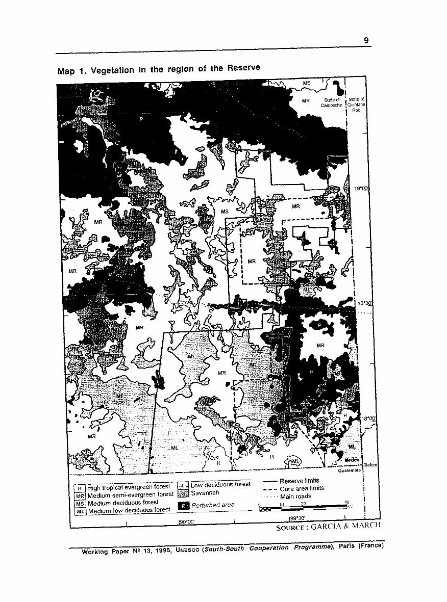
Map 1. Vegetation in the region of the Reserve
High tropical evergreen forest - Reserve limits -w- Core area limits . . . . . Main roads
40 km
I I 1 I ~9O”OO I (89”30
SOURCE : GARCiA Rr MARCH
Working Paper Ng 13, 1995, UNESCO (South-South Cooperation Programme), Paris (France)
10
important from the points of view of ornithology and conservation. Out of these 350 species,
218 are permanent inhabitants and the rest are long-distance neo-tropical migrants. The latter are
in turn divided in two groups: 46 species have Calakmul as their last destination, and the rest
continue their migration towards Central and South America. Due to its location, the Reserve is
essential for the conservation of these birds.
Calakmul is especially important for rare or threatened species of birds of prey such as
the king vulture (Sarcoramphus papa), the black hawk-eagle (Spizaetus tyrannus), the ornate
hawk-eagle (Spizaetus ornatus) and the black-and-white hawk-eagle (Spizastur melanoleucus). Other non-prey birds such as the crested guan (Penelope purpuascens), the great curassow (Crax rubra) and the ocellated turkey (Agrichoraris ocellata), the latter endemic for the Yucatan
Peninsula, are also hunted for sport or food.
There are in Calakmu194 species of wild mammals, including two species of primates
(out of the 3 species known in Mexico) and 6 species of marsupials (out of 7). Moreover,
Calakmul is distinguished as the reserve with the most important population of felines in the
whole North-american subcontinent, belonging to 5 species (out of the 6 living in Mexico),
some of which are under threat (Cf. SEDESOL). 90% of the species of mammals prefer a forest
environment, and more than 90% depend in one way or another on the existence of the forests
(Cf. ARANDA & GUZM&.
The main species considered as rare, threatened or in danger of extinction in Calakmul
are: Birds: Mycteria americana, Ramphastos sujkratos, Amazona albifrons, Cardinalis cardinalis, Icterus gularis, Anhinga anhinga, Sarcoramphus papa, Agriocharia ocellata, Pionopsitta haematotis, Pionus senilism, Amazona xantophora, Pteroglossus torquatus, Bombycilla cedrorum, Icterus cucullatus. Mammals: Caluromys debianus, Alouata pigra, Ateles geoffroyi, Tamandua mexicana, Galictis vittata, Lutra longicaudis, Tapir-us baidii, Felis concolor, Coendou mexicanus, Panthera onca, Felis padalis, Felis wiedii, Felis yagouaroundi, Tayassu pecari, Philander opossum. Reptiles: Crocodylus moreletti, Tacheys scripta, Claudius angustatus, Boa constrictor.
2) Historv and social context
a- The Mayans
As in other forests of the Mexican Southeast, there is here a phenomenon that goes
beyond the concept of protected natural area: This immense forest is a silent witness of the old
prehispanic civilizations - in this case the Mayans. The archeological sites, remainders of a
system of large Mayan cities built between the years B.C. 500 and A.D. 900, are a cultural
legacy (most of it covered now by vegetation) alongside the natural legacy. For this reason, this
Eckart BOEGE : The Calakmul Biosphere Reserve (Mexico)

11
is not only a Biosphere Reserve, but also an area that keeps part of the cultural patrimony of the
mankind; this area can be called the Mayan forest, or “Selva Maya”.
The Mayans built a complex society of polities (Cf. MAP 2). Their civilization was
based on shifting agriculture, practiced in the region since the year B.C. 2,000, whereby patches
of forest are cleared and burned, planted and cultivated for one or more years, then abandoned
and recolonized by forest species (Cf. p. 11). There is a controversy among the specialists
about the food supply for the high population density that existed in the region during the apogee
of the Mayans (even higher than in the present): Some of them reckon that this slash-and-bum
agricultural system was virtually the solely supplier; the other think that there was in addition a
more intensive system with a very significant output. The latter hypothesis is supported on
certain archeological evidences.
These large urban and ceremonial centers were abandoned in about A.D. 900 for
unclear reasons, although the specialists are inclined to think on a long drought (Cf. TERAN &
RASMUSSEN) or other ecological phenomena. The density of population was strongly reduced,
but the Yucatan Peninsula stayed inhabited by Mayan groups practicing the slash-and-bum
agriculture, without disrupting the fragile ecological equilibrium of this forest with shallow soils.
MAP 2 : Geopolitical organization of the Mayan area at A.D. 790
SOURCE : SCHELE & FREIDEL
Working Paper N’ 13, 1995, UNESCO (South-South Cooperation Programme), Paris (France)

12
b- The twentieth century
From the end of the 19” century, all the area was devastated by 8 large American timber
companies that got the concession for the exploitation of more than 1 million ha, where they
extracted mainly cedar (Cedrela mexicana), mahogany (Swietenia macrophylla) and ‘palo de
Campeche’ (Haematoxylum campechianum), the latter used for the production of a powerful
coloring. On the other hand, in 1902 began the extraction of the chicle, the resin of the abundant
hard-wood sapodilla tree (Manilkara zapota). This resin is used as a base for chewing gum.
The Mexican Revolution lead to the distribution of the large estates of the American and
Mexican concessions, and a number of ‘ejidos’ and ejido forest extensions were created
(Cf. p. 12). Ejidos are communal land grants distributed to the “heads of the family” (the men),
who have permanent usufrnct rights, rights to make their livings from the ejido, as long as they
continue to live on the land and fulfill certain obligations to the community. Ejidos are governed
democratically, its ultimate authority being the assembly. After a recent reform of the law, the
ejido land can be sold, if the assembly of the ejido agree.
Finally, the extraction of chicle was reorganized, and the concession was given to a
large workers’ cooperative. However, an alliance was gradually built between the local
government, the forestry authorities, the large timber companies and the peasant corporative
unions. In this alliance the least benefited were the peasants and the biodiversity. Indeed, the
large timber companies ransacked the forest, creaming it off its fancy woods, and giving to the
peasants a meager revenue.
The extraction of chicle had several successive peaks and depressions; the former
coincided with the military activity of the U.S. army, since a daily ration of chewing gum was
provided to the soldiers during the wars. This significant market finished during the War of
Korea, when the artificial chewing gum was introduced (CJ KONRAD).
Similarly, the coloring of the ‘palo de Campeche’ was substituted by the artificial
anilines. This pattern is repeated in other parts of the World: A natural product is plundered for
long-distance commerce, it has an important peak, and then, when the equivalent synthetic
product is generated, the price and the production fall sharply.
In spite of this decline, the extraction of chicle, together with the timber production,
remained the main activities in the region during some decades.
A strong immigration started in the seventies, coming from at least 23 states of Mexico.
This is an heterogeneous population, frequently displaced by social conflicts in their native lands,
that came to colonize the forest of the region. A large portion of the population belongs to the
Mayan, Chol and Tzeltal ethnic groups from the state of Chiapas, and to the Yucatec Mayan
group of the states of Campeche and Yucatan. A number of Chol people were displaced by the
eruption of the Chichonal volcano, and other Chol people, as well as the Tzeltals, are running
away from the recent conflict in the state of Chiapas. Nowadays, the aboriginal inhabitants, the
Eckart BOEGE : The Calakmul Biosphere Reserve (Mexico)

13
Yucatec Mayan people, live in about 10 out of the 72 communities that exist around the Reserve
of calakmul.
c- Present situation
Fifteen thousand people live in these 72 communities. A recent survey of 51
communities (made by the county authorities of X’pujil in 1992) showed a distribution of 52%
males and 48% females. The size of the communities varies between 8 and 991 inhabitants.
The average age of the individuals surveyed is 19 years old, and the median is 14. The
population is expansive, with 19% under 5 years of age and 51% under 15%. Four percent of
the population is under the age of one year and only 2% is 65 or older. Women in the
childbearing years (ages 15-49) make up 21% of the population. (This age distribution shows
that the programs toward sustainability should be addressed mainly to young people.)
The majority of the population of the Reserve is located in the Eastern strip and in the
East-West corridor (around the main road; C+‘. MAP 4). The Western strip is made up of nearly
uninhabited “forest extensions” (Cf. p. 13).
The living conditions of the indigenous-peasant people in the reserve and around it are
within the worst in Mexico, with minimal public services, difficult communications, emigration
and a high level of illiteracy. All this in an unfavorable environmental context, with harsh
conditions for the settlement of human populations.
There is still some immigration, mostly due to the armed conflict in Chiapas, whereas
the cyclic drought intermittently leads some people to emigrate definitively.
3) The Drocesses of forest devastation and the creation of the Biowhere Reserve of Calakmul
A satellite photograph toured the world in 1989 (Cf. GARRETT). It is a NASA image
showing the border between Mexico and Guatemala, that was at that time the limit of devastation.
This devastation takes place primarily in the Mexican states of Tabasco and Chiapas, whereas
Calakmul, at the top right comer of the photograph, is an undisturbed spot.
The destruction of the forests of Tabasco and Chiapas was caused mainly by the
development of extensive cattle-raising and commercial agriculture, financed by the government
and frequently supported by the World Bank. In addition, we identify in the Mexican historic
context some further causes of devastation, namely the contradictory programs of the
development agencies, including government agencies; the economic and social structures of
pillage of the cornmon resources; the processes of spontaneous colonization; the relation between
poverty and resource-use intensity, and the migration towards the agricultural boundary.
Working Paper NO 13, 1995, UNESCO (South-South Cooperation Programme), Paris (France)

14
The region of Calakmul was left relatively undisturbed by virtue of the high cost of
building and operating deep wells or rain-water reservoirs. Indeed, several extensive cattle-
raising programs in Campeche and Quintana Roo ended up in failure for lack of water, unlike
similar programs in the states of Tabasco and Chiapas.
The massive destruction arrived to its climax in the eighties. Although the Mexican
government was late in criticizing this policy, it made some efforts to revert its effects. In this
context were created, in the late eighties, the biosphere reserves of Calakmul, Sian Ka’an and
Montes Azules. Other biodiversity conservation efforts have been made as well in Guatemala and
Belize (Cf. MAP 3), although it is still necessary to establish a u-irrational conservation and
development policy.
In 1989 the Biosphere Reserve of Calakmul was created in the state of Campeche, with
a surface area of 723,185 hectares. Out of this area, 227,860 ha correspond to two core areas
MAP 3: Forested areas and biosphere reserves in Guatemala, Belize and the Southeast of Mexico
ha Biosohere Reserve
Society Hall Natural Reserve
’ Montes Azules
Guatemala I.
_, .- , Honduras
Eckart BOEGE : The Calakmul Biosphere Reserve (Mexico)

15
and the rest to a buffer zone. The two core areas protect 12% of the tropical seasonal forest of the country
(Cf. MAP 1). In 1993 the reserve was inscribed in the Man and the Biosphere Program. Calakmul is an important link between the forests of Campeche, Quintana Roo and
Yucatan (its remaining patch), on one hand, and the Guatemalan Peten, on the other. MAP 3 shows the biological corridor between the Mexican reserves of Sian Ka’an and Calakmul, that
consists of permanent forest areas (Cf. p. 15) managed by the peasants, mostly in the state of
Quintana Roo, and at present as well in Campeche.
Even though the Reserve of Calakmul is not very important from the point of view of
endemic species, it represents, on account of its largeness and location, one of the last
possibilities to preserve genetically healthy populations of species in serious danger of extinction
(Cf. ARANDA & GUZMAN).
a- Environmental conditions
The region of the Reserve has been partially perturbed (although not to the extent of
Chiapas and Tabasco) (i) by degradation of the forest, (ii) by deforestation and (iii) by
degradation of the slash-and-bum lands.
i) The degradation of the forest is due to the logging with a mining style by the large
timber companies for many years, without any regeneration plan nor any land-use ecological
planing, that has reduced the value of the timber resources of the small-scale land owners. In this
creamed-off forest, the production of fancy woods can not be the only incentive to keep the
peasants from clearing, and therefore the degradation of the forest is linked to its deforestation.
ii) While the cattle-raising has not succeeded for a lack of water, the production of
chili pepper (the most dynamic cash-crop) has become an important source of income and
employment and therefore this is the activity that generates deforestation in a larger scale. The
agriculture in newly-cleared plots takes advantage of the high fertility and humidity of the rain-
forest soils, as well as of the low incidence of plagues. (These advantages, however, benefit
mostly the larger producers, since they are the only who can save their earnings to face the bad
years in such an unstable weather.)
iii) The degradation of the slash-and-burn lands consists in the reduction of fallow
areas and periods on account of the demographic pressure. In addition, most of the present
population are immigrants, coming from close but very different habitats, who do not command,
as the Yucatec-Mayan minority do, the management of the culturally-created germ plasma (i.e. local species of fruit trees, timber trees, maize, pumpkins, beans, chili peppers, etc.)
The MAP 1 shows that only the South of the Reserve accommodates areas of rain-
forest, and that only one portion of this rain-forest is protected by the Southern core area.
Moreover, the dynamics of the perturbation can be observed in the North, in the Eastern strip
Working Paper N’ 13, 1995, UNESCO (South-South Cooperation Programme), Paris (France)

16
- very important - and surrounding the main road, in the East-West axis that splits in two the
Reserve.
b- Land tenure
The majority of the surface area of the region has the ownership status of ejido, and
there are some small private properties. The ejidos are divided into three categories: * The first one corresponds to the large ejido forest extensions
(‘ampliaciones forestales ejidales’) located in the West of the Reserve (Cf. MAP 4) that were
given in the forties to some already existing ejidos for the extraction of chicle when several large
estates were expropriated. These extensions have an average surface area of 60,000 ha, most of
it unexploited and uninhabited (except Conhuas). * The forest ejidos (‘ejidos forestales’), exploited and inhabited, are the
second category, created in the sixties and located in the East and North of the Reserve. Their
surface area varies from 10,000 to 50,000 ha, and usually more than 40% is made up by
permanent forest areas (Cf- p. 16). * Finally, the third category is a string of small ejidos (1,000 to 3,000 ha)
denominated new ejido population centers (‘nuevos centres de poblacidn ejidal’), that were
created in the seventies and the eighties to accommodate the vast immigration. They occupy two
strips, one in the East of the Reserve, the other in the East-West central corridor (around the main
EscG.rcega-Chetumal road). They are the more densely populated, and their communal forested
areas do not exceed 500 ha.
When the reserve was laid out, the existing (legal) settlements (some ejido forest
extensions, some forest ejidos and some private farms) in the core areas were not taken into
account (Cf. MAP 4). Now there is a proposal to shift both core areas to the West, in order to
solve this problem.
4) The reaional r>easants’ oraanizations
Some of the regional ejidos created in the eighties an organization to fight against a
private company that was exploiting the forest with a mining-like style, and paying very low
prices to the forest owners. In 1991 this organization was transformed into the Regional Council
of X’pujil, aimed at promoting the sustainable development in the buffer and influence zones of
the reserve.
Forty four out of the 72 ejidos located around the reserve are represented in this
Council, with 2 representatives for each ejido. Other ejidos are represented by different
organizations, and a few of them are isolated. This document is concerned only with the
experience of the Regional Council of x’pujil.
Eckart BOEGE : The Calakmul Biosphere Reserve (Mexico)

17
MAP 4 : Land tenure in the region of the Reserve
I I I I I- I I I I
‘3
I I sate of
Campeche Of
hltnta “a
BIOSPHERE RESERVE
CORE AREAS
EJIDOS 9’C w
EJIDO FOREST EXTENSIONS
PRIVATE PROPERTIES
ROADS
\ \
\ - 18”.
-
18 ‘15
18” KY
,.-- : .’ f ’
_ Mexico i Be, _ .- -. -a ,ize uatemala j
9o”oo 89”45 89”30 I I I I I I I
89-15’ ;
SOURCE : GA&A
Working Paper NC 13, 1995, UNESCO (South-South Cooperation Programme), Paris (France)

18
The Regional Council meets once a month to discuss the regional problems, and its
authorities are elected every two years. Even though this organization has its own resources, it is
not self-sustaining, since it requires a multi-sourced subsidy in order to provide technical and
management support services. These support services have enabled the communities to advance
towards sustainability.
As a conclusion, the mining-style scheme of exploitation by the large timber companies
has been ended by the confrontation between them and the peasants. At present the schemes are
in the process of redefinition, with an important role for the peasant communities and their
Regional Council. They are developing around the Biosphere Reserve of Calakmul a concept of
ecological, social and economic sustainable development.
II- CONSTRAINTS AND OPPORTUNITIES
1) A Danorama of the reaional problems
The adverse conditions faced by the Regional Council of x’pujil and the management of
the Biosphere Reserve of Calakmul in their attempts to construct a strategy of sustainable use of
biodiversity can be summarized as follows: The Reserve is seated in a partially perturbed region
(Cf. p. 18) with an unstable population (Cf. p. 18).
The promotion of any program requires a stable population, and in Calakmul it is not
possible even to foresee the dynamics of the population in the future. Under these conditions, it
is difficult to design a land-use planing and to generate an adequate attitude towards the
resources.
In addition, many of the immigrants have come to the region looking for a piece of land
for agriculture or cattle-raising, and forestry is not in their minds: They regard the forested areas
just as territorial reserves for agriculture or cattle-raising.
Finally, the highly populated Eastern strip exerts a strong pressure upon the Reserve,
and the West side may soon present similar conditions, since some large ejidos were sold (on
account of the recent reforms to the law; Cf. p. 18) and face an uncertain future.
We have to make the following initial assumption: The processes of perturbation are the
dominant dynamics in spite of the protection laws. For a reserve to be effective, especially in its
buffer and influence zones, these processes have to be understood, and an upstream policy
developed.
This outlook arises the question of whether the decree that created the reserve will
effectively hold back the process of perturbation, or other measures are required.
Eckart BOEGE : The Calakmul Biosphere Reserve (Mexico)

19
2) The construction of an alternative of sustainable develoDment in a more intensive use of biodiversity
When the Biosphere Reserve was created by decree of the President, nobody asked
their opinion to the local inhabitants. This was a source of conflict for the peasants, since the
design of the Reserve from the outside did not take into account the existing communities. This
procedure generated then a “programmed” conflict between the new entity - the Reserve - and
the population that had colonized this land with their own utopia in mind.
In fact, at the beginning, when the Reserve was about to be created and just after its
creation, the fear of imminent bans motivated a paradoxical surge of deforestation.
In the early times of the Reserve, the federal department in charge of the protected areas
had no clear program of action. The relevant policies were drawn only in 1992 when both the
new state administration and the new federal administration in charge of protected areas took
office. This was achieved with the advice of the staff of the forest pilot plan (‘Plan Pilot0
Forestal’, created within the Mexican-German Agreement, financed by the Gesellschaft fur
Technische Zusammenarbeit; Cf. JANKA), who had a lo-year-long experience on sustainable
forestry with the peasant communities of the forest. They had been able to stabilize more than
500,000 ha of forest, that constitute the important biological corridor between the reserves of
Calakmul and Sian Ka’an (Cf. MAP 3). In addition to this advice, some NGO’S and the “Model
Forest” program of the Mexican-Canadian agreement (Cf. CRASX) contributed to define the
government program ‘ecologia productiva’, aimed at supporting the peasants to achieve a
sustainable development in the Eastern strip and the central East-West corridor of the Reserve,
within the buffer and influence zones . More recently, the World Bank’s Global Environment
Facilities Program is providing additional support.
Simultaneously, the World-wide Wildlife Fund (WWF) is supporting a Mexican NGO
(PRONATURA-Peninsula de Yucatan) to work alongside the Regional Council to develop WWF’s
methodology related to the Integrated Projects for Conservation and Development and to apply it
in the buffer zones of 5 reserves of the Southeast of Mexico. Moreover, The Nature
Conservancy is supporting some programs around the core areas.
Since 1991 the program of the Reserve has as a guide-line to work “from the outside to
the inside” and to socially “besiege” the area with a strategy of regional development involving all
the activities that permit the stability of the forest. Therefore, the basic projects that involve an
ecological land-use planing are supported.
At the same time, the program provides social services (water supply, communications,
etc.) and some employment. This strategy covers all the way from the development projects of
the peasants’ organizations to the management of the Reserve as a whole. A social subject is so
created, which leads to a favorable correlation of forces from the point of view of conservation.
Working Paper N’ 13, 1995, UNESCO (South-Sooth Cooperation Programme), Paris (France)

20
All this requires that the management of the Reserve is prepared to work with the peasants’
organizations around the Reserve.
According to the experience accumulated so far, we can identify the following basic
elements of the path towards sustainability: * An ecological land-use planing with a silvicultural approach and a
diversified management of the natural resources, including timber and other forest resources
(fauna, chicle, honey, palms, etc.), ecotourism, agroforestry and sustainable agriculture. * The creation of technical and administrative expertise within the democratic
social organizations dealing with the management of natural resources. * The development of markets for the produce of sustainable management of
natural resources. * The adequate conversion of the industrial infrastructure to the production
of timber and other resources with a sustainable approach. * A “political umbrella” supporting the whole process, even against the
preeminent trends of financial institutions and private entities that encourage the devastation. * The creation of a consultant group with leadership abilities but
subordinated to the peasants’ organizations.
The “Model Forest” proposal (1994) involves the development of a North-South and an
East-West axes within the reserve, using the available experience to design a strategy of land-use ecological planing around the issue of conservation and regional development with social
equality. The land-use planing involves the voluntary creation of permanentforest areas (PFA’s)
by the general assemblies of at least ten ejidos with large forested areas (a total of 65,000 ha).
Moreover, some ejidos have established by decree wildlife reserves. The most important aspect
of this land-use planing is that the forest and wildlife areas become the object for the
implementation of sustainable techniques.
The second element of the land-use planing is the establishment
programs in newly cleared or degraded areas.
A third point is to sedentarize the present slash-and-burn agricultural
of agroforestry
system, so as to
restrict the deforestation caused by the production of chili pepper (in practice the only cash-crop).
This is a question of improving the traditional peasant technologies following the concept of “low
external input and sustainable agriculture”, and according to the tropical soils and climate.
Finally, it is believed that by means of small reservoirs and an adequate management of
micro-basins, it will be possible to store enough water to face the droughts. These communal
reservoirs, as well as a household rain-water storage tank, are now in a test stage.
The whole proposal for the land-use planing of the ejidos is sketched in FIGURE 2.
We will now expose briefly the specific designs and their problems:
Eckart BOEGE : The Calakmul Biosphere Reserve (Mexico)

21
FIGURE 2 : Scheme of the ecological land-use planing for the ejidos with permanent forest areas in the influence and buffer zones
ONE PLOT
* Forested area and
; Timber resources ,/ 0 inventories
/ 0 management plan 0 natural reproduction 0 forest enrichment
--& - - Non-timber resources
+k wildlife management
area (common), with 25 annual Tarvesting blocks
* allspice harvesting
* palms harvesting
‘LArcheological ecotourism
# ejido or inter-ejido tours
ONE ANNUAL HARVESTING BLOCK
The global objective is to stop the devastation of the forest and to generate activities and
income related to a sustainable production. The land-use ecological planing is complex. Firstly,
there are the agreements within each ejido to create the PFA’S and the wildlife areas. It is not just
a question of living on the timber production, but rather “to live on the forest”, with all the
activities that have been already tested. In the second place, the program tries to enhance the
value of the land with agroforestry schemes and with multiple plantations outside the permanent
areas. Thirdly, the idea is to sedentarize the agriculture and specially its most dynamic sectors.
Fourthly, to canalize the animal-raising interest of the peasants towards the intensive raising of
minor species or the semi-intensive cattle-raising. And finally, to create family-size intensive
home-gardens.
Working Paper N’ 13, 1995, UNESCO (South-South Cooperation Programme), Paris (France)

22
The specific objective of the project of the Regional Council is that each community
creates by consensus an inventory and an integral land-use ecological planing, based on old and
new agroecological and silvicultural principles, promoting multiple non-destructive economic
activities, and aimed at achieving a compatibility between productive income and forest
conservation.
3) The silviculturai comDonent
The “Model Forest” program is located on the East side of the Reserve, in the buffer
and influence zones. Out of a total surface area of 380,000 ha, 138,000 ha correspond to
mature forests, and 157,000 ha to secondary forests, 1 to 20 years old. The peasants of these
ejidos have in their individual plots forested areas from 30 to 100 ha. This means that, like in the
neighboring state of Quintana Roo, the success of the forestry strategy is due to the voluntary
involvement of the peasants in the production of timber and other products (Cf. CRASX).
There are seven steps to achieve a programmed harvest in the natural forest. In the
forest ejidos, these 7 steps are conceived as a learning process:
i) To establish the PFA’S by means of a process of internal negotiation between the
collective owners of the forest. In order to achieve such a consensus, there must be within the
people the conviction that the forest resources are valuable for the community.
ii) To program the timber production according to the species, to guarantee the
survival of the different species and to obtain constant or growing extraction volumes. For this
purpose, each PFA is divided in 25 blocks (annual harvesting blocks), harvested consecutively
during a rotation cycle of 25 years (the historic reason of such a system is that after 3 cycles = 75
years, mahogany trees reach an adequate size for commercial purposes). Every 5 years an
inventory is made for 5 blocks in order to determine the individuals that will be extracted. This
procedure was established just as a first trial, since the growth rates of many tree species are still
unknown. On the other hand, some species with a clustering trend can be managed in patches.
iii) To transform the inventories from a bureaucratic formality (as they are perceived at
present) to an effective planing tool. To have a total inventory and to carry out the inventories for
the quinquennial plans.
iv) To devise a management plan and to draw on an accurate map the extraction areas
on a yearly basis. The determination of the extraction volumes should rely only on strictly
technical considerations and not on the result of political negotiations.
v) To set up test plots to measure the growth rates of the different species and then
adjust the management plans, so as to obtain constant extraction volumes of the commercial
species without reducing the forest stock.
Eckart BOEGE : The Calakmul Biosphere Reserve (Mexico)

23
vi) To create routines for a sustainable silvicultural management, as well as periodical
controls of their efficiency (low ecological and economic impact extraction with adequate
machinery, clearings for the natural reforestation of the heliophile species, preservation of good-
quality father-trees, efc.).
vii) To set up permanent research and experimentation programs on forestry and on
adequate resource-management models.
The fust inventories, carried out with the support of WWF, depict a precarious situation
of the mahogany and cedar timber-yielding resources. The consequence of this balance is that,
for the present, these species can not be the axis of the natural forest husbandry. The hard-wood
and soft-wood species have the largest potential.
Indeed, a central issue that has not been solved in the region is that of harnessing the
diversity of timber-yielding species. The tropical forests have small volumes per hectare of any
single species, but the market prefers large volumes per species. The strategy under development
is to assemble several species with similar characteristics and to work them in “technological
groups”, adapting the transformation technology to the need to make a better use of biodiversity.
There is in addition a strong difference in size and productive objective between the
ejidos: Out of the 14 ejidos that have established PFA’S, only 5 (and possibly 7) could reach a
sustainable annual production.
On account of these differences in size and available species, the organization, the
design of the land-use planing, and the manufacture and marketing strategies have to vary
according to the local conditions. For example, the ejidos with large timber volumes can
concentrate their efforts in marketing their produce collectively.
On the other hand, the ejidos with small volumes need a completely different approach.
In the first place, their PFA’S are usually too small to enable a sustainable output, which means
that, either the extraction will take place not annually but e.g. every three or five years, or
alternatively the timber will be extracted annually from small areas and with severe annual
variations of volume per unit area. In these difficult conditions it becomes especially important to
devise appropriate technological solutions aimed at incorporating value-added to the production.
An example of such solutions is the mobile sawmill, that makes more efficient the
exploitation of the raw material by enabling the use of tree tips and branches. Other
improvements that have yet to be tested are new drying techniques and smaller lathes and
“slicers”.
However, the greatest impact is achieved by locally transforming the raw material in
small carpentxies designed for products of small size such as blind-doors for closets, toys,
floors, handles, beehives and other products for bee-keeping, etc.
Working Paper N’ 13, 1995, UNESCO (South-South Cooperation /Jrogramme), Paris (France)

24
This is demonstrated by the experience of two ejidos that are using their own timber as
raw-material for their carpentries. This scheme is very interesting, since it provides employment
for a group of peasants’ new generation. Moreover, when the carpentries produce bee-hives for
the local bee-keepers, an internal economic exchange is created, which means that the money
stays within the region.
Indeed, the management of the forest should not be restricted to the large-scale business
and the large volumes: the small ejidos can be incorporated in a new concept of forestry, not just
by increasing the value-added in small industries or workshops, but also by using non-timber
products and by diversifying the land-use in these small areas.
Some ejidos are at present in the stage of developing the first quinquennial management
plans and the first extraction routines. Moreover, they are reproducing some over-exploited
species. There is however much more to be done in this domain: The land-use planing requires a
careful analysis of the inventories and the dominant species in each harvesting block. The
reforestation techniques, for instance, depend on the species: most of them are heliophiles, and
require therefore a gap in the forest for their growth. Recent research has shown indeed that the
perturbations, both human (by burning the forest) and natural (hurricanes) have played a key role
in enabling the reproduction of mahogany trees, although these findings have not yet been fully
taken into account in the silvicultural strategy,
External conditions do also have an important effect in the region’s forestry: The crisis
of the Mexican timber market, due to the NAFTA (North-American Free-Trade Agreement) and
the timber smuggling from Guatemala, as well as the lack of diversification of the usable species
(at present only about 6 out of 35), puts in a dangerous condition the real possibilities of a
multiple approach to the natural forest.
Its survival possibly depends on the opening of a “green-stamped” regional, national
and international market, and on well-oriented subsidies to mitigate the unequal development, the
unfavorable conditions (pillage and smuggling) and the high indirect costs (especially roads),
absorbed in other countries by the state.
This would enable negotiating the sale of soft-woods and hard-woods, which could be
the sparkle for the forest ejidos getting organized around an important product. With the
inventories validated, a silvicultural hypothesis linked to the natural growth rates in the PFA’s
would need to be developed. The agroforestry program could then sustain the production of such
species in addition to the PFA’s.
Lastly, the management of the Reserve should develop forestry policies aimed at the
RFA’s, located principally in the North and West of the Reserve.
Eckart BOEGE : The Calakmul Biosphere Reserve (Mexico)

25
4) Harnessina of the non-timber forest resources
The enhancement of the value of the non-timber forest resources is essential in this
region, due to the restrictions in the timber market.
a- Extraction of chicle resin
Even though the boom of the chicle finished some decades ago, there is still a demand
for it in the international market, especially in Japan and Italy.
The process of extraction of the chicle resin involves that the whole family moves to the
forest for several months, although it is only the man who does the tapping. The resin is then
cooked and the end-result is a solid block. The income from this activity is then proportional to
the individual performance, which is an advantage. According to a 1994 survey of the ejidos
within the Council, 160 men worked on the tapping.
Several problems affect this activity. Firstly, the market is shrinking. Secondly, there is
a tradition of corruption between the exporting bureaucracy and the ejido peasants. Usually, an
advance is given and the rest is paid only when the produce is sold. This procedure gives way to
wrong practices from all the concerned agents. Finally, for a lack of training, some trees are
dying (a careful tapping does not damage the trees).
The first organizational attempts have been already made to avoid the exporting
middlemen in order to increase the profits. In 1994,50 tons of chicle were exported directly to
Japan.
In addition, it would be convenient to initiate a training program to teach the young
chicleros how to reduce the tree mortality and improve the quality of the product. The
experienced chicleros themselves should be in charge of the training.
b- Harvesting of allspice
There are in all the region patches of allspice, both in the PFA'S and in the individual
plots. So far, the allspice has been simply harvested, without any management of the forest
patch. On the other hand, the market is quite erratic and the competition with the traditional
producers is difficult.
In order to increase the production of allspice, the tree nurseries of two ejidos are
already reproducing allspice trees aimed at agroforestry plantations.
The allspice production should be considered a complementary line. The production of
wild allspice does not represent any difficulty, since it can be organized individually or in small
groups, in a similar way to the extraction of the chicle resin. In addition, a silvicultural
management would guarantee an annual production. Finally, it would be convenient to fmd out if
Working Paper N’ 13, 1995, UNESCO (South-South Cooperation Programme), Paris (France)

26
there is any niche in the market for the “organic allspice”, and to open channels for direct export,
as some peasants’ organizations in other regions have already made.
c- Apiculture
The apiculture has been, since the seventies, a profitable activity requiring a low capital
investment. In spite of the low prices, the investment is recovered in a single season, It enhances
the economic value of the -A’s, the secondary forests and the agroforestry areas and can be
undertaken from a broad range of technological levels (beginner, intermediate or advanced).
Finally, the apiculture generates income for several months, valuable especially when there is no
income from other activities. In addition to honey, the apiculture produces propolis, beeswax,
pollen and royal jelly
As in other fields, there are problems of corruption in the established marketing
agencies, but the first attempts have been made to set up independent marketing organizations.
On the other hand, the apiculture of the forest had to face the invasion of the African
bees, which was genetically lessened by the presence of a critical mass of European bees in the
beehives. The regional strategy that followed the invasion was to rebuild the whole activity,
improving the technology and especially the quality of the beehives. Initially, a government
subsidy was obtained by the Council, and then this subsidy had a multiplying effect: several bee-
keepers are now buying colonies and equipment; and in one small ejido without PFA, the
peasants became interested in the conservation of a patch of primary forest just because it was
destined to act as feeding ground for the apiculture.
Moreover, the local production of beehives, lids, frames and other implements for
apiculture is now promoted, especially by using the tips and branches of the trees, which are
normally wasted. A modest internal economic circuit between the local carpentries of the ejidos
and the apiculture is then generated.
Although the present scheme of the Council has had positive effects, other elements
could be taken into account, as part of a regional strategy to face the afiicanization and to promote
the apiculture.
Firstly, the local technical expertise should be encouraged.
In the second place, the quality of the produce could be improved by applying a deep
knowledge of the forest to locate the beehives according to the dominant flowerings, in order to
offer different flavors to the market. This is incidentally another way to strengthen the use of
biodiversity. Moreover, an export quality could be achieved by establishing technified collecting
centers, which could use specialized bottling processes.
The marketing could be improved by detecting niches in the national or the international
markets interested in “organic honey”. This would require the relevant certification. A
Eckart BOEGE : The Calakmul Biosphere Reserve (Mexico)

27
“Biosphere Reserve of Calakrnul” brand or stamp might also be beneficial from the marketing
point of view.
As a conclusion, the apiculture has a large scope for the creation of manufacturing and
marketing micro-enterprises, to obtain a larger value-added, according to the organizational level
of the producers, and especially of women’s organizations.
d- Agroforestry
The agroforestry plays an important role within the ecological land-use planing. It is
based on the restoration of the degraded lands and the spaced-out forestry harnessing, according
to the following scheme:
i) In the first year the peasant slashes and bums for the production of maize, and
seeds the medium-term fruit trees and the long-term timber trees.
ii) The basic crops are repeated until the fifth year.
iii) In the third or fourth year, the fruit trees will begin to produce, and, to the extent
that the timber trees grow (sometimes with a fruit component, like the ‘siricote’, Cordia dodecandra), the terrain becomes properly a forest. The growth rates are faster than in the natural
regeneration, and it is possible to cut some trees at the age of 25. In the case of cedar and
mahogany, it becomes convenient to cut trees with diameters smaller than those permitted by the
usual commercial practice.
The concept is very attractive. The first agroforestry plots around Calakmul are in fact
beginning to produce fruits (citrics) sold in the local markets (especially restaurants). On the
other hand, the tree-nurseries of some ejidos, which are essential for the dissemination of this
program, are beginning to produce regional fruit-trees with good markets, such as the ‘zapote
mamey’ (Pouteria sapota), the ‘zapote negro’ (Diospyros digyna), the ‘chicozapote’ (Manilkara zapota) and the ‘huaya’ (Talisia olivaeformis). Improving their genetic quality is still one of the
challenges of the agroforestry program.
However, the following entailing problems have been detected: Firstly, the scheme
requires a large subsidy at the beginning, and it is assumed that, once the model works, the
peasants will become interested in its reproduction. Spectacular growth rates for cedar and
mahogany have been detected in some plots, but it is necessary to fumigate several times per
year. This means that the concept has to be improved, since no peasant would invest so many
resources (especially pesticides) for an undefined-term harvest that he will probably never see.
Moreover, the weather variations and the sporadic hurricanes indicate that there may be important
losses.
As a conclusion, it is necessary to assimilate the regional experience accumulated in
Calakmul as well as in Quintana Roo, in order to analyze its prospects, since the peasants are
Working Paper N’ 13, 1995, UNESCO (South-South Cooperation /Jrogramme), Paris (France)

28
very interested on this scheme. The first hints indicate that it works very well with very
motivated people and in a small scale.
5) Sustainable aariculture
a- Subsistence agriculture
The traditional agriculture of the Mayans in the tropical forests of Mexico is centered on
the slash-and-burn agriculture with complementary activities in the home-garden and in the
fallow areas (Cf. TEXAN & RASMUSSEN): * The slash-and-bum agriculture is a complex and diverse system called
‘milpa’, based on the association of gramineous (maize) and leguminous (beans) crops. In
addition to maize and beans (at least eight local kinds), it includes pumpkin, chili, tomato, wild
herbs, peanuts, ‘jicama’, and tubercles such as cassava and ‘makal’, permitting a diversified
production out of small plots. The itinerant milpa with very long fallow periods takes advantage
of the natural fertility accumulated in the forest and the relatively low initial incidence of weeds
and plagues, although it requires a relatively large useless forest reserve to sustain the
replacement cycle between forest and agriculture. * The home-garden has several fruit trees from the forest, medicinal plants,
animals (e.g. turkeys) and palms for the roofs of houses. * Finally, the secondary forest provides several products during the different
successional stages of the fallow period: timber, fire-wood, non-timber products and animals for
self-subsistence, namely deers, boars and some birds that are attracted by leaving on purpose
some maize on the fields next to the dense secondary forests. At present the Mayans practice as
well the traditional apiculture with native American sting-less bees.
It is difficult to quantify accurately the surface area used every year in the region of
Calakmul for self-subsistence maize farming, since the farming and fallow periods vary.
The banks do not provide loans to the agriculture of this region, firstly because they
consider that the risk of disaster is too high, and secondly because there is no organization
backing the applications. Therefore the only possible pattern for the local agriculture is a low
external input.
In addition to the chili pepper (see below), the main income-yielding crop within the
maize-based multiple-crop agriculture is the pumpkin. Its farming does not require a high
investment (especially as compared with the chili pepper), since it is made with traditional
techniques and with almost no input of chemical products.
Eckart BOEGE : The Calakmul Biosphere Reserve (Mexico)

29
The slash and burn technique on its own does not damage the forest, since the
biodiversity is restored in some extent during the fallow period, especially when the tree stumps
are left in place, and the soil fertility is recovered by the successional processes.
The conflict between this technique and the sustainable use begins when the basic
ecological principles of regeneration are not understood, or when the required fallow periods are
reduced on account of the demographic or monetary pressure of the population. Indeed, at the
present time, the slash and burn technique in the tropical forest is beginning to lose its efficiency
as a sustainable, biodiversity-keeping, agroecological system.
b- Development of agroecological alternatives
Farming in the tropical forest should be an opportunity rather than an adversity.
Therefore, the strategy for a sustainable use consists in achieving to the largest extent the
consistency between the natural fertility conditions of the forest and the production of goods for
human consumption.
The following questions arise: If we take into account the basic elements for the
replacement of the nutriments and the management of the weeds, is it feasible to develop a non-
itinerant forest-integrated agriculture in tropical shallow soils?, i.e.: is it feasible to fix the plots,
leaving the remaining surface for the forestry and agroforestry management of the natural forest?;
in other words, is it feasible to improve the agroecological conditions of the maize plot without
rotation and clearing?, is it feasible to farm permanently and improve the soils without burning?
There are several attempts to answer these questions. The idea is to develop an integral
agroecological concept that includes the secondary forest as a reforestation area, the non-itinerant
multiple-crop plot with some agroforestry elements to improve the soils and a maize farming with
diversified crops in association. This idea is based on handling animal manure, compost and leaf
mold, on minimal tillage (an attempt to use a heavy tractor for the chopping-off failed, since it
removed the thin humus layer), and on the possible integration of apiculture, that yields honey
from the forested areas.
Another objective for the future is to gradually and naturally regenerate the soils and to
stabilize the production of maize by using aboriginal seeds. In addition, some promissory
options already in the test stage are the cultivation of chili (a profitable crop) in a yearly rotation
system, and the use of a kind of pumpkin as an additional cover crop.
However, the most impressive improvement has been achieved in the last years by the
introduction of some leguminous species, preferable local, either as annual crops or as perennial
or semi-perennial, shrubby or arboreal plantations.
These nitrogen-fixing leguminous, such as the ‘jicama’ (Pachyrhizus erosus), the ‘ib’
(Phaseolus lunatus), the ‘cocuite’ or ‘xabyaab’ (Gliricidia sepium) and the ‘uaxim’ (Leucaenia glauca), used in association with other crops, make possible a permanent soil cover, which is
Working Paper N’ 13, 1995, UNESCO (South-South Cooperation Programme), Paris (France)

30
one of the main requirements for a sustainable agricultural use. Therefore, the land can be used
continuously, without letting it lie fallow for long periods.
Leguminous cover crops such as Canavalia ensiformis or Mucuna pruriens (both
imported by the peasants) are excellent nitrogen-fixing agents that accelerate the introduction of
biomass to the agricultural ecosystem: up to 5 tons per annum per hectare of organic dry matter
(equivalent to about 35 tons of green matter). In addition to their soil generation and regeneration
abilities, they control weeds and help to keep the humidity of the soil.
Moreover, in addition to its application as leaf mold, Mucuna pruriens is used in a
limited way as nutriment for pigs and even for humans.
Even though these leguminous have been used only recently, good results are already
observed. One of the principles of their application is not to bum, so that a good soil-protecting
superficial layer can be obtained. Once the peasants experience their use and understand their
principles, their range of applications is broadened. The emphasis is made not on the plants by
themselves (they are not “miraculous”), but rather on the development of efficient agroecological
principles for the local weather and soil and for the needs of the peasants.
The use of leguminous opens a wide spectrum of association possibilities, that enable a
continuous production: annual or biannual agriculture; fruit plantations with short-term (3 years)
or medium-term (7 years) production, and even long-term (25 years) fancy woods plantations.
This multi-crop approach damps the negative impact that has had the reduction of prices on
single-crop economies. On the other hand, it creates a continuity between the forest and the
agricultural land, without sudden breaks in flora and fauna.
Since the use of local and regional nitrogen-fixing plants is a technique, that harness the
natural productivity of the ecosystems as an energy-input (thus reducing the external inputs and
the use of fossil energy sources), it achieves a two-fold (and up to five-fold) increase in
productivity. The ensuing creation of the fixed plot means that, for the first time in the Yucatan
peninsula, a non-itinerant agriculture is possible. This reduces the use of the slash and bum
technique and therefore increases the available area for forestry use.
The leguminous are the more abundant plants in the region, and their use takes
advantage of the naturally and culturally generated biodiversity. Their multiple applications
should be investigated further.
c- Production of chili pepper
The farming of chili pepper started approximately 10 years ago, as a practice coming
from the states of Tabasco, Chiapas and Veracruz.
The chili is generally cultivated in newly-cleared areas (often gullies), formerly ram-
forest or old secondary forest (4 or 5 years old). Each producer farms an average of 2 ha every
Eckart BOEGE : The Calakmul Biosphere Reserve (Mexico)

31
year. If more land is available, the chili plot is abandoned after the second year. Many producers
prefer clearing tropical rain-forest areas, in order to take advantage of the natural fertility and the
relatively low initial incidence of weeds and plagues. For this reason, up to 4,000 ha of tropical
rain-forest have been cleared in a single year for the cultivation of chili.
This commercial agriculture is very risky, since it depends on the credit, the price
fluctuations, the weather, the timely detection of plagues and the adequate use of agrochemical
products. In spite of its instability, the chili sector is the top provider of employment and income.
Most of this income, however, is concentrated by the long chain of middlemen, that buy
most of the production. They are the ones who provide the loans, which means in practice that
part of the harvest is bought in advance. Some of the middlemen are in addition ejido farmers,
some are just local residents, but most of them are outsiders.
Taking into account the large deforestation caused by the production of chili, the
Regional Council started to work with this powerful sector and established a project consisting in
combining leguminous with chili. This association has doubled the production and reduced the
clearing of the forest. In fact, the most important producers of chili have not cleared new areas
for three consecutive years.
However, the long-term sustainability of these changes requires that the interests of the
chili producers are adequately represented. Otherwise, we will face the risk of an increasing
devastation of the tropical rain-forest, favoring the interests of a small group of middlemen, with
little or no interest in changing the present practices.
6) Intensive home-aardens
A recent and modest project, aimed a the women, is concerned with the intensification
of the home-gardens, based on the experience of the traditional multiple gardens. Its objectives
are (Cf. FIGURE 3):
* To achieve a sustainable food production incorporating local inputs such as
compost, ashes, leaf mold and animal manure, and using an integral plague control. * To handle the organic waste, converting it into a resource for the
production. * To catch rainwater from the roofs to use it in the dry season. * To plant and to look after trees (fruit, forage and firewood trees; the latter
in hedges). * To use the local biodiversity for medicinal purposes, revaluing the
experience of the women themselves as well as that of the local healers. * To learn the integration of agriculture, forestry and stabled or semi-stabled
animal raising.
Working Paper NQ 13, 1995, UNESCO (South-South Cooperation Programme), Paris (France)

32
FIGURE 3 : Home-garden designed by a young peasant
SOURCE : Lt)PEZ
* To use the products of organic agriculture for human and animal consumption.
* To generate an environmental consciousness and a regional identity in regard
to the Calakmul Biosphere Reserve and its archeological sites.
7) Ecotourism
The region of the Reserve has a large potential for the development of archeological ecotourism, since it contains several first-order Mayan ruins, a few hours away from Chetumal
international airport (minimum 2, maximum 6 hours). This is one of the ways to achieve a social
occupation of the forest and to enhance the value of its natural and cultural resources. Moreover,
the excavation works of the ruins have provided temporary employment for many people.
This new concept contemplates an economic benefit for the local population, without the
ecological, cultural and social harm brought about by massive tourism. The idea is to attract a
local, national and international “cultural” tourism, with an interest on the educational and
recreative features of both the natural and cultural aspects of the region; a non-massive but steady
tourism.
Eckart BOEGE : The Calakmul Biosphere Reserve (Mexico)
33
In order to avoid the concentration of tourists in a single location, two ecotouristic
circuits are being envisaged in the region. In addition, similar circuits are already operating in the
neighboring state of Quintana Roo. One of the two regional circuits visits several Mayan cities
and temples located near X’pujil (Be&r, Chicana, Rio Bet and Hormiguero), whereas the other
one involves the archeological sites of Calakmul and Balamku.
The condition of Biosphere Reserve increases the touristic interest. In fact, two wildlife
reserves have already been created around the ruins of Hormiguero and Rio Bet. The peasants of
the local ejidos are now participating in the design of an ecological land-use planing that bans
hunting around the ruins, to prevent the animals from fleeing and thus increase the chances of the
tourists watching them. This new concept, at present in an incipient stage of development, is
arousing the local residents’ interest towards conservation.
Some cabins and restaurants have been built in the village of X’pujil, as well as a luxury
hotel in Chicana. This diversity permits the promotion of the ecotourism among a wide spectrum
of pockets.
Other programs of the Council linked to the ecotourism are the promotion of craft-
making; the framing in the carpentries of local beetles to be sold (contribution of the biodiversity
studies program); and finally the first workshop for ecotourism guides, which arose the
enthusiasm of young people, who are now learning English in order to become ecotouristic
service providers.
Although it is still difficult to evaluate the economic potential of this activity, it will
certainly benefit the ejidos by providing sources of employment and income.
8) Institutional framework
An important component for sustainability is the institutional framework, that props the
concept of development.
The experience of Calakmul has been a gradual process of integration of the different
social agents, with the creation of settlement mechanisms at different levels. The strategic work
for the construction of the Reserve from the social point of view starts with the coordination
between the management of the Reserve and the social organizations. The peasants take a
rotatory part in the surveillance as well as in the discussion on the programs and subsidies for
conservation, and thus get acquainted with the presence of a reserve. The cardinal issue is how
the population appropriate the Reserve so that any antagonism is avoided. The outcome of this
gradual process is the following structure:
i) The management of the Reserve negotiates with the different peasant organizations
the general actions leading towards conservation and development. A general council of the
Reserve, representing all the concerned social sectors, may come out of this process.
Working Paper NC 13, 1995, UNESCO (South-South Cooperation /Jrogramme), Paris (France)

34
ii) Each peasant organization looks by itself for governmental and non-governmental
support for its development programs. A coordination commission with monthly meetings is
formed with the participation of the management of the Reserve, the management of the Regional
Council, the governmental agencies, the non-governmental organizations and the research
institutions.
iii) There is a feed-back to the communities through their representatives in the council
meetings. These monthly meetings are attended by the management of the Reserve, the
representatives of the communities, the peasants’ trade organizations (forest owners, bee-
keepers, women’s micro-enterprises, etc.) and the technical staff promoting the “concept” of
sustainable development in the different sectors.
iv) In addition, some inter-community interest groups are formed for specific
occupations (bee-keepers, chicle tappers, allspice harvesters, etc.).
At the beginning, the peasant communities were stimulated to get organized and to
designate two representatives for a Regional Council. This Regional Council discusses the
development and social programs of the government agencies and also of the NGO'S.
The recurrent problem is their chaos; it happens often, for example, that the programs of
the state and the federal governments are contradictory with each other. Therefore the need of the
Council to put them in order, i.e. to coordinate all the actions related to the region and to ensure
their consistency with a regional policy. In addition, the management of the Reserve coordinates
its actions with the Regional Council.
This is a summary of the functions of the Council: * It brings together the ejidos and their interests around a general “concept”.
Otherwise they would act independently, as unrelated entities. The council works as a gearing
belt for information (especially market information), projects and funds. * Its main office works as the headquarters of the forestry service, where the
sustainable silvicultural policies and routines are defined. The relevant information is processed
there and then distributed or reverted to all the ejidos, especially the smaller ones. * It acts as well as the headquarters of the technical groups on apiculture,
fauna management, agriculture and agroforestry, environmental education and kitchen gardens. * It is a negotiating front for the forestry policies. This is an extremely
important role, since the Council represents a social power that the adverse parties can not put
aside. * It is a common front to negotiate prices for the sale of products, especially
timber. * It provides a framework to canalize to the ejidos funds and subsidies from
the federal government and NGO's.
Eckart BOEGE : The Calakmul Biosphere Reserve (Mexico)

35
* It owns and hires to the ejidos plant machinery (for road construction) and
a mobile saw-mill. The latter is aimed especially at the smaller ejidos lacking such facilities. * It supports micro-industries created by groups of peasants. * It is a learning ground for parliamentary and negotiation techniques, and
for leadership on sustainable development.
The key problem is how to stimulate by means of these services the sustainable
development. It is a question of who develops the specific ideas, who designs the activities with
the peasants, taking into account their experience, how to create the local technical expertise and
how to transfer the scattered knowledge of the region.
As mentioned before, the main office works as the headquarters for several technical
teams. These teams are paid partly by the Council (funds received for specific projects) and
partly by NGO’S and government agencies. In addition, a negligible income (that could grow in
the future) is generated by the projects themselves. Although the external funding of these
technicians has had troubles, it would be very difficult to achieve their self-sustainability in the
short-term.
Given the lack of technical personnel with a background on the sustainability of the
productive processes, the Council has had to develop the local expertise. This has been achieved
in an empirical way, highlighting the knowledge transfer “from peasant to peasant” (Cf.
BUNCH): The technician (a peasant himself) works with a group of peasants, especially those
that have stood out in the experimentation of agroecological designs. Then he works for some
years part-time for the project to disseminate this experience among other peasants.
Ill- EVALUATION AND MONITORING
The main objective of the monitoring is to evaluate to what extent the induced projects
are indeed leading to sustainable agroecological activities and to the management of the natural
forest without degrading the biodiversity, without devastating the forest, improving the social
organization and increasing the income.
This monitoring system, still in an embryonic stage, is a complex system that has to
include the following stages: Firstly the establishment of the hypothesis to be verified,
concerning conservation and development. Secondly, the definition of a year-zero or reference
condition. Thirdly the determination and measurement of the relevant indicators, both objective
and subjective, in the year-zero and subsequently. And finally the analysis of these
measurements to produce actual results.
Up to the present, the monitoring has been made by directly observing a sample of 10%
of the communities, in order to evaluate the areas corresponding to slash-and-bum and to the
expansion of commercial crops, as well as to check the stability of the PFA'S.
Working Paper N” 13, 1995, UNESCO (South-South Cooperation Programme), Paris (France)

36
The plan for the long term is to get financial resources in order to establish a
geographical information system using satellite images and aerial photographs. Such a system
would enable as well the monitoring of the stability of the core area of the Reserve
A further indicator is the amount of communities with important PFA's in the influence
and buffer zones that have accomplished ecological land-use planings and that are managing the
natural forest by dividing it into 25 annual harvesting blocks.
Finally, the quantitative (output) and qualitative (techniques) information about all the
fields of production has been gathered by means of surveys and questionnaires.
This is a list of the hypothesis that have to be verified by the monitoring system: * The supply from the PFA'S of an important income, both through timber
and non-timber products (honey, chicle, allspice, palm and commercial fauna). * The reduction of deforestation, the protection of the PFA'S and the
stopping of the expansion of the agricultural boundary, accountable to the introduction of
agroecological techniques in agroforestry and agriculture, along with the silvicultural
management of the forest. * The improvement of the soils. * The quantitative increase in the harvests, both for self-subsistence and for
commerce. * The adoption and expansion by
as sedentary agriculture, agroforestry, apiculture and
products.
the peasants of sustainable activities such
the harvesting of other non-timber forest
* The proper extraction of timber by the peasants, according to the minimum
diameters; the natural reproduction of the extracted species, especially those that require clearings
(heliophile species), by means of silvicultural techniques; the reliability of the inventories and the
management plan, confirmed by external technical audits; the existence of a market for certified,
“green-stamped” umber. * The organization of the peasants to ensure a better sale of their products
and to incorporate value-added. * The development of private and social industries, quantitatively and
qualitatively “adequate” to the produce of sustainable production. * The representativity, with parliamentary practices, of the Regional Council
and the trade organizations (forest owners, bee-keepers, allspice harvesters, etc.); the control of
their management by internal and external audits ordered respectively by their general assemblies
and by the external donors.
The following exercise (Cf. FIGURE 4) reflects the framework of the global process
leading towards the integration of the communities in a development and conservation process.
Eckart BOEGE : The Calakmul Biosphere Reserve (Mexico)

37
FIGURE 4 : Framework diagram and economic incentives
PRESSURES and THREATS * Migration and demographic pressure * Extractii logging
* Forest clearing for chili * Poaching * Middlemen: external economic interests
SUSTAINABILITY 3
* Farmer to farmer * Local capacity
* Local organizations
* Low-external-input sustainable use of biodiversity
CONSERVATION * After projects
+
9 INTERVENTION (INTEGRATED APPROACH) + Ecological &territorial zoning * Community-controlled access * PFA * Bee-keeping
COMMUNITY- - * Sedentarization of agriculture
* Agroforestv
INVOLVING * Non-timber plants
JI
IMPACTS * Reduced deforestation * improved soil fertility
* Higher yields
t Improved livelihood It INSTITUTIONAL FRAMEWORK * General stewardship
REVALUE RESOURCES (ECONOMIC INCENTIVES) * Honey * Timber prices * Low internal input * Higher yields * Allspice
Working Paper NC 13, 1995, UNESCO (South-South Cooperation Programme), Paris (France)

38
BIBLIOGRAPHY
ANDREWS, J.M. : Preliminary List. Orchids / Calakmul Biosphere Reserve Area, Campeche RRONATURA-Peninsula de Yucatan, Merida (Yuc., Mexico), 1994.
ARANDA M., GUZMAN S. : Fauna in : SEDESOL : Programa de manejo. Reserva de la Biosfera. Calakmul, Camp&he Secretark de Desanollo Social (SEDESOL), Mexico City (Mexico), 1992.
BOEGE E., MURGUh R. : Diagndstico de las actividades humanas que se realizan en la Reserva de la Biosfera de Calakmul, estado de Campeche PRONATURA-Peninsula de Yucatan, M&da (Yuc., Mexico), 1989.
BUNCH R. : DOS Mazorcas de Maiz: Una guia para el mejoramiento agricola orientado hacia la gente World Neighbors, Oklahoma (USA), 1986.
CRASX : Bosque Modelo para Calakmul. Ecologia Productiva. Propuesta Consejo Regional Agrosilvopecuario y de Servicios de x’pujil, S.C. (CRASX), Zoh-laguna (Camp, Mexico), 1994.
GARCh G. : Cartografia temdtica para el manejo de la Reserva de la Biosfera de Calakmul, Campeche RRONATURA-Peninsula de Yucatan, M&da (Yuc., Mexico), 1993.
GARCiA G., MARCH I. J. : Cartografia temdtica bdsica y base geogr&fica de datos para la zona de Calakmul, Campeche PRONATLJRA-Peninsula de Yucatan, Merida (Yuc., Mexico), 1990.
GARRETT W.E. (ed) : Ia Ruta Maya in : National Geographic Magazine, Vol. 176, No. 4, October 1989.
JAN&i H. : La alternativa forestal comunal: tuna alternativa para el tropic0 humedo? in : Acuerdo Mexico-Alemania: Alternativas para el use de1 sue10 en a’reas forestales de1 trdpico hlimedo SARH-INIF, Mexico City (Mexico), 1981.
KONRAD H. : Plantation Labor Systems in Tropical Forests. The case of chewing-gum trappers ms., Calgary (Alberta, Canada),1984.
L6PEZ G. : Memoria de1 taller de capacitacidn e intercambio de experiencias campesinas efectuado en Zoh-laguna, Hop., Camp., de1 3 al 5 de febrero de 1994 ms., Zoh-laguna (Camp., Mexico), 1994
MARTfNEZ E., TAVERA, G. : Inventariofloristico de la region de Xpujil Direction de la Reserva de la Biosfera de Calakmul and Consejo Regional Agrosilvopecuario y de Servicios de X’pujil, S.C., Zoh-laguna (Camp., Mexico), 1995.
SCHELE L., FREIDEL D. : A Forest of Kings: The Untold Story of the Ancient Maya Quill William Morrow, New York (USA), 1990.
Eckart BOEGE : The Calakmul Biosphere Reserve (Mexico)

39
SEDESOL : Areas naturales protegidas Secretaria de Desarrollo Social (SEDESOL), Mexico City (Mexico), 1993.
SNOOK L. : Opportunities and Constraints for Sustainable Tropical Forestry: Lessons from the Plan Pilot0 Forestal, Quintanu Roo in: Development Strategies for Fragile Lands project, Tropical Research and Development Inc., US Forest Service : Humid Tropical Lowlands Conference. Development Strategies and Natural Resource Management Panama City (Panama), 1991.
TERAN S., RASMUSSEN C. : La milpa de 10s mayas DANIDA, M&da (Yuc., Mexico), 1994.
UCAN-EK E., ORTEGA L.M., FLORES S., ORTIZ J.J. : Flora y Vegetacidn in : SEDESOL : Programa de manejo. Reserva de la Biosfera. Calakmul, Campeche Secretia de Desarrollo Social (SEDESOL), Mexico City (Mexico), 1992.
WOOD P., BERLANGA M. : Ornithological Studies of the Calakmul Biosphere Reserve, Campeche, Mexico PRONATURA-Peninsula de Yucatrin, M&da (Yuc., Mexico), 1993.
Mayan m
glyph of the ancient city of Calak ;mul
Working Paper N” 13, 1995, UNESCO (South-South Cooperation Programme), Paris (France)

.,,., ,......., ,:,.. . . . . . . . . . . . .A.., ,“,,i,:,.c . . . . . . . . . . . . . . . . . . . . . ..I . . . . . . . . . . . . . . . . . . . . . . . . . . . . . . . . . . . . . . . . . . . . . . . . . . . . ;.-:-:-:-:-:- >:
., ,. :, ,. ,. ,. . . . .,., ,.,. ., .,. .,.,. . . ./. ., ,. ..,...,.,. ,. . . . . . . . . . . . . . . . . . . . . . . . . . . . . . . . . ..‘:.....‘.‘........‘. .’
.,., :...:.:..: . . . . . . . . .,.,., . . . . . . . :. . . . . .. ,.
..,...,. .,.,.,.,.,.,.,.,.,.,.,.,.,.,.,.,.,.,.,.,.,.,.,.,.,.,.,.,.,.,.,.,.,., ,.,.,.,.,.,., ,.,.,.,.,.,.,..., ,.,., ,. .,., .:.::.:.:.:,:,:.:.:.~.:.: : ,. ‘. ..:.::‘:::i’iii’i:;~~~,u~~E~E~~~~~ j,j.l:...i:l,~~~~ ‘j ~::..:;i.li:iiil~~~~~~~~~~~:::~:r,ii,,.:(.i:l:liiii::li.i:i::i
. . . . :.. .; .; ,.,‘,., .‘,::‘:‘:::::.:::::,:::~::::.::.,. .:v.: :.:. :y:. :.:::::::v.:~
..:...::.:.:.:.:...:.:.:.j:.:.::.:.:.:.:.:.:.: .///\ . ..A . . . . . . . . . . . . . . . . . . . . . . ..~~...~~.~~~~~~............,::.;~ ,,::, I+
j,:j:j.:j.. : j j:j:j::::.:: ,: :::;:; j:j:j j:.:j ‘:‘.: : ..:.:.:.:.:.:...:.:. :.::.:.:.:.:.:.:.:::.:.:.:.:.,.:.~;)~~:.~.:~~~~~..,: ,.,.,.: ..,. :.:.:::.::::..:::::.. ,. . . . . . . . . . . . ..(..... .,.,.......(...,.....,.,. .,.,.,.,.i,.,.,.,.,.,.,.,,.,.,.,.,.,.,.,.,.,.,.,.,.,.,.,.,.,.,.,.,.,.,.,,.,. :.> ,.,. :.:.:.,.:.:.,.:.: .,.,.,.,.,.,,.j,.,.,.,.,.,.,.,.,.,.,. >:.::.:: ,.,. >,.: . . ..\I.\. .:.... ,.,...,.................,...,.,.,.,...,.,.........,...,.,...,. . . . . . . . . . . . . . . . . . . . . . . . . . . . ,.. . . . . . . . . . . . . . . . . . . . . . . . . . . . . . . . . . . . . . . . . . ..: ::.
The Programme is publishing its Newsletter South-South Perspectives,
which can be received free of charge on request.
The first Newsletter was published in October 1994and the second in October 1995. The Newsletter is edited in English, French and
Spanish.
In the Newsletter, its editors would be glad to write short notes about books received and other kind of publications
on environment conservation, biodiversity, sustainable management of renewable resources and
South-South cooperation.
We would also reflect information on the present South-South cooperation activities in these fields.
All comments are welcome.

Working Papers
No 1 (1995) : The Mata Atlantica Biosphere Reserve (Brazil) : An overview Antonio Carlos DIEGUES
No 2 (1995) : The Xishuangbanna Biosphere Reserve (China) : A Tropical Land of Natural and Cultural Diversity WU Zhaolu, OU Xiaokun
No 3 (1995) : The Mae Sa-Kog Ma Biosphere Reserve (Thailand) Benjavan RERKASSEM, Kanok RERKASEM
No 4 (1995) : La Reserve de la Biosphere de Dimonika (Congo) Jean DIAMOUANGANA
No 5 (1995) : Le part national de Tai’ (Cote d’lvoire) : un maillon essentiel du programme de conservation de la nature Yaya SANGARe
No 6 (1995) : La Reserve de la Biosphere de Mananara-Nord (Madagascar) 1988- 1994 : bilan et perspectives NoHine RAONDRY, Victor SOLO, Martha KLEIN
No 7 (1995) : A Study of the Homegarden Ecosystem in the Mekong River Delta and the HoChiMinh City (Viet Nam) Nguyen Thi Ngoc AN
No 8 (1995) : The Manu Biosphere Reserve (Peru)
Luis YALLICO, Gustav0 SUAREZ DE FREITAS
No 9 (1995) : The Beni Biosphere Reserve (Bolivia) Carmen MIRANDA L.
No 10 (1995) : La Reserva de la Biosfera Sierra de/ Rosario (Cuba) Maria HERRERA Alvarez, Maritza GARCIA Garcia
No 11 (1995) : The Omo Biosphere Reserve (Nigeria) Augustine 0. ISICHEI
No 12 (1995) : Environnement nature/ et socio-economique de la foret c/as&e de la Lama (Benin) Marcel A. BAGLO, Bonaventure GUEDEGBE
No 13 (1995) : The Calakmuk Biosphere Reserve (Mexico) Eckart BOEGE