Embed Size (px)
Citation preview
Guidebook
Environmentally Sustainable Log Handling Facilities in British Columbia
April 2003
NATIONAL LIBRARY OF CANADA CATALOGUING IN PUBLICATION DATA
G3 Consulting Ltd.
Guidebook: Environmentally Sustainable Log Handling Facilities in British Columbia
This guidebook is a publication of the Habitat and Enhancement Branch of Fisheries and Oceans Canada.Includes bibliographical references.Also issued in print format.
Mode of access: www site of Fisheries and Oceans CanadaISBN 0-9733595-0-1
Keywords1. log handling – British Columbia2. best management practices3. environmental impacts4. marine5. freshwaterI. Fisheries and Oceans CanadaII. Habitat and Enhancement BranchIII. Title
Publication Citation
G3 Consulting Ltd. 2003. Guidebook: Environmentally Sustainable Log Handling Facilities inBritish Columbia. Report prepared for Fisheries and Oceans Canada, Pacific and Yukon Region,Habitat and Enhancement Branch by G3 Consulting Ltd., Burnaby BC. 72 pp. + appendices
Log Handling BMPs Guidebook
iii
AcknowledgementsFisheries and Oceans Canada and Environment Canada provided funding for this project. Fisheries andOceans Canada guided and administered this project, under the direction of David Harper, SteeringCommittee Chair. The authors drew upon previous work done to protect fish and fish habitat fromidentified impacts of log handling activities.
Consultation and collaboration were invaluable in the development of a clear and relevant Guidebook.Members of the steering committee met through several review cycles and contributed greatly by pro-viding guidance, vision, opinion and technical review. Contributions of members of the steeringcommittee and others who reviewed the document are gratefully acknowledged.
Guidebook Steering CommitteeDavid Harper, Fisheries and Oceans CanadaAllan Cowan, Fisheries and Oceans CanadaAlec Drysdale, Land and Water BC Inc.Carole Karlsson, Ministry of Forests, BC Les Kiss, Coast Forest and Lumber AssociationLarry Kristianson, Ministry of Forests, BCScott Northrup, Fisheries and Oceans CanadaColin Parkinson, Fisheries and Oceans Canada (Canadian Coast Guard)Andrew Robinson, Environment Canada (Canadian Wildlife Service)Rob Russell, Fisheries and Oceans CanadaSean Standing, Environment Canada (Conservation and Protection)Richard Thompson, Ministry of Water, Land and Air Protection, BC
Other ReviewersElaine Antilla, Fisheries and Oceans Canada Hubert Bunce, Ministry of Water, Land and Air Protection, BCBruce Clark, Fisheries and Oceans Canada John Clark, Department of JusticeJoy Hillier, Fisheries and Oceans CanadaPaul Georgison, Land and Water BC Inc.Dan Potts, Council of Forest IndustriesJeffery Taylor, Environment CanadaMargaret Wright, Fisheries and Oceans CanadaRick Young, Weyerhaeuser Ltd.
Preface
This Guidebook was developed in response to needs identified by regulatory agencies and organizationsinvolved in the log handling industry in British Columbia. Many acts and regulations provide a legalframework for protecting fish and wildlife, their habitat and other aspects of a healthy ecosystem. Thisdocument was created to help translate such policies into practice, and to provide clear direction on meansto operate log handling facilities that prevent, limit or compensate for damage to fish and fish habitat.
The log handling industry has a long history in British Columbia and, historically, business practices oftenresulted in habitat disruption or damage. While recognizing the reality that, today, there is a mix of olderand modern industry practices, this Guidebook stresses the requirement to meet all relevant laws andregulations and provides general direction on how to achieve this.
This Guidebook describes environmentally sustainable and sound industrial practices (called BestManagement Practices or BMPs). These BMPs will guide proponents away from critical and importanthabitats, provide options and recommendations and describe likely outcomes. Following the Guidebookwill assist in the development of proposals that adequately address environmental concerns and will havegreater likelihood of approval.
In these ways, it is hoped that the goals of economically and environmentally sustainable log han-dling practices can be achieved together.
Guidebook Log Handling BMPs
iv
CaveatThis Guidebook should not be considered as or relied upon for legal advice. If proponents require legaladvice on specific projects, they are urged to consult their own legal counsel.
Following this document does not preclude liability for prosecution under any federal, provincial ormunicipal laws. The agency and industry representatives on the steering committee, and the authors,do not make any expressed or implied warranty concerning the thoughts and ideas expressed herein,should they fail to work as planned, if utilized.
This document is intended as general guidance to assist forest companies and their consultants exerciseprofessional and technical judgement to develop site-specific operational plans. The principles in thisGuidebook regarding habitat protection and environmentally sound operational practices are based uponexisting legislation, caselaw and policy. The most suitable procedure for an individual site will vary depend-ing upon habitat type, pre-existing operations and other site-specific circumstances. This Guidebook doesnot preclude the use of alternative practices, so long as they are environmentally sound and consistentwith provincial and federal legislation.
It is recommended that proponents check with local agencies for any site-specific requirements,changes to review processes and requirements for proposal submission.
Log Handling BMPs Guidebook
v
Contents1.0 Introduction & Application Procedure . . . . . . . . . . . . . . . . . . . . . . . . . . . . . . . . . . . . . .1
1.1 Log Handling Operations & Potential Habitat Impacts . . . . . . . . . . . . . . . . . . . . . . . . . .11.2 Applicable Legislation & Regulatory Requirements . . . . . . . . . . . . . . . . . . . . . . . . . . . . . .21.3 Best Management Practices . . . . . . . . . . . . . . . . . . . . . . . . . . . . . . . . . . . . . . . . . . . . . . . .31.4 Environmental Monitoring & Reporting . . . . . . . . . . . . . . . . . . . . . . . . . . . . . . . . . . . . .31.5 Application & Review Process . . . . . . . . . . . . . . . . . . . . . . . . . . . . . . . . . . . . . . . . . . . . . .4
2.0 Habitat Considerations . . . . . . . . . . . . . . . . . . . . . . . . . . . . . . . . . . . . . . . . . . . . . . . . . .92.1 Habitat Rating System for Log Handling Proposals . . . . . . . . . . . . . . . . . . . . . . . . . . . . . .92.2 Critical & Important Marine Habitat . . . . . . . . . . . . . . . . . . . . . . . . . . . . . . . . . . . . . . . .102.3 Critical & Important Freshwater Habitat . . . . . . . . . . . . . . . . . . . . . . . . . . . . . . . . . . . . .132.4 Marginal Habitat . . . . . . . . . . . . . . . . . . . . . . . . . . . . . . . . . . . . . . . . . . . . . . . . . . . . . . .15
3.0 Log Handling Operations . . . . . . . . . . . . . . . . . . . . . . . . . . . . . . . . . . . . . . . . . . . . . . .173.1 Log Dumping . . . . . . . . . . . . . . . . . . . . . . . . . . . . . . . . . . . . . . . . . . . . . . . . . . . . . . . . . .203.2 Log Sorting . . . . . . . . . . . . . . . . . . . . . . . . . . . . . . . . . . . . . . . . . . . . . . . . . . . . . . . . . . . .213.3 Log Booming, Barging & Transport . . . . . . . . . . . . . . . . . . . . . . . . . . . . . . . . . . . . . . . .223.4 Storage . . . . . . . . . . . . . . . . . . . . . . . . . . . . . . . . . . . . . . . . . . . . . . . . . . . . . . . . . . . . . . .243.5 Retrieval at Processing Plants . . . . . . . . . . . . . . . . . . . . . . . . . . . . . . . . . . . . . . . . . . . . . .24
4.0 Relevant Legislation . . . . . . . . . . . . . . . . . . . . . . . . . . . . . . . . . . . . . . . . . . . . . . . . . . . .254.1 The Federal Government . . . . . . . . . . . . . . . . . . . . . . . . . . . . . . . . . . . . . . . . . . . . . . . . .254.2 British Columbia Government . . . . . . . . . . . . . . . . . . . . . . . . . . . . . . . . . . . . . . . . . . . . .254.3 First Nations . . . . . . . . . . . . . . . . . . . . . . . . . . . . . . . . . . . . . . . . . . . . . . . . . . . . . . . . . . .26
5.0 BMPs for Siting & Design . . . . . . . . . . . . . . . . . . . . . . . . . . . . . . . . . . . . . . . . . . . . . . .295.1 Facility Siting . . . . . . . . . . . . . . . . . . . . . . . . . . . . . . . . . . . . . . . . . . . . . . . . . . . . . . . . . .295.2 Facility Design . . . . . . . . . . . . . . . . . . . . . . . . . . . . . . . . . . . . . . . . . . . . . . . . . . . . . . . . .32
6.0 BMPs During Construction & Operation . . . . . . . . . . . . . . . . . . . . . . . . . . . . . . . . . . .376.1 Construction Practices . . . . . . . . . . . . . . . . . . . . . . . . . . . . . . . . . . . . . . . . . . . . . . . . . . .376.2 Managing Surface Runoff During Construction & Operation . . . . . . . . . . . . . . . . . . . .396.3 Facility Operation & Debris Management . . . . . . . . . . . . . . . . . . . . . . . . . . . . . . . . . . .426.4 Navigation & Vessel Maintenance Considerations . . . . . . . . . . . . . . . . . . . . . . . . . . . . . .486.5 Control of Hydrocarbons, Liquid Wastes & Other Residues . . . . . . . . . . . . . . . . . . . . . .496.6 Management of Log-Bundle Strand . . . . . . . . . . . . . . . . . . . . . . . . . . . . . . . . . . . . . . . . .52
7.0 Site Deactivation & Remediation . . . . . . . . . . . . . . . . . . . . . . . . . . . . . . . . . . . . . . . . .537.1 Decommissioning Facilities . . . . . . . . . . . . . . . . . . . . . . . . . . . . . . . . . . . . . . . . . . . . . . .537.2 Site Rehabilitation . . . . . . . . . . . . . . . . . . . . . . . . . . . . . . . . . . . . . . . . . . . . . . . . . . . . . .54
8.0 Monitoring & Reporting . . . . . . . . . . . . . . . . . . . . . . . . . . . . . . . . . . . . . . . . . . . . . . .558.1 Environmental Monitoring & Reporting Requirements . . . . . . . . . . . . . . . . . . . . . . . . .558.2 Environmental Monitoring & Assessment Methods . . . . . . . . . . . . . . . . . . . . . . . . . . . .57
9.0 Literature Sources . . . . . . . . . . . . . . . . . . . . . . . . . . . . . . . . . . . . . . . . . . . . . . . . . . . . .59Glossary . . . . . . . . . . . . . . . . . . . . . . . . . . . . . . . . . . . . . . . . . . . . . . . . . . . . . . . . . . . . . . .63Appendices . . . . . . . . . . . . . . . . . . . . . . . . . . . . . . . . . . . . . . . . . . . . . . . . . . . . . . . . . . . . . .65
Guidebook Log Handling BMPs
vi
List of PhotosPhoto 1. Intertidal marsh habitat (critical habitat) . . . . . . . . . . . . . . . . . . . . . . . . . . . . . . . . . . .1Photo 2. Estuarine habitat in winter (critical habitat) . . . . . . . . . . . . . . . . . . . . . . . . . . . . . . . .2Photo 3. Well-vegetated shore in steep and deep habitat . . . . . . . . . . . . . . . . . . . . . . . . . . . . . .2Photo 4. Log dump located on steeply sloped shoreline, with logs used for
debris containment visible in the distance . . . . . . . . . . . . . . . . . . . . . . . . . . . . . . . . . .3Photo 5. Extensive woody debris accumulation on intertidal habitat . . . . . . . . . . . . . . . . . . . .3Photo 6. Rocky intertidal habitat . . . . . . . . . . . . . . . . . . . . . . . . . . . . . . . . . . . . . . . . . . . . . . .11Photo 7. Mudflats in an estuary . . . . . . . . . . . . . . . . . . . . . . . . . . . . . . . . . . . . . . . . . . . . . . . .12Photo 8. River habitat near the mouth of the Fraser River . . . . . . . . . . . . . . . . . . . . . . . . . . . .14Photo 9. Rocky shoreline in steep and deep habitat . . . . . . . . . . . . . . . . . . . . . . . . . . . . . . . . .15Photo 10. Fine woody debris deposited in an intertidal area . . . . . . . . . . . . . . . . . . . . . . . . . . .17Photo 11. Logs, bark and other woody debris accumulation . . . . . . . . . . . . . . . . . . . . . . . . . . .17Photo 12. Log booms grounded at low tide. . . . . . . . . . . . . . . . . . . . . . . . . . . . . . . . . . . . . . . .18Photo 13. Sediment plume developed from high velocity dumping of logs . . . . . . . . . . . . . . . .18Photo 14. Log dumping using steel skids, skids span intertidal area . . . . . . . . . . . . . . . . . . . . .20Photo 15. Log dump using steel skids on steep shoreline . . . . . . . . . . . . . . . . . . . . . . . . . . . . .20Photo 16. Log dumping using a vertical hoist method . . . . . . . . . . . . . . . . . . . . . . . . . . . . . . .21Photo 17. Helicopter log drop, directly to a barge . . . . . . . . . . . . . . . . . . . . . . . . . . . . . . . . . .21Photo 18. Log booming operation . . . . . . . . . . . . . . . . . . . . . . . . . . . . . . . . . . . . . . . . . . . . . .22Photo 19. Bundled logs stored in a river . . . . . . . . . . . . . . . . . . . . . . . . . . . . . . . . . . . . . . . . . .23Photo 20. Booming in a contained area . . . . . . . . . . . . . . . . . . . . . . . . . . . . . . . . . . . . . . . . . . .23Photo 21. Log retrieval at a sawmill . . . . . . . . . . . . . . . . . . . . . . . . . . . . . . . . . . . . . . . . . . . . . .24Photo 22. Well contained log dumping and booming along a steep shoreline . . . . . . . . . . . . .30Photo 23. Modification of an existing rocky outcrop in steep and deep habitat . . . . . . . . . . . .30Photo 24. Log handling situated away from an estuary . . . . . . . . . . . . . . . . . . . . . . . . . . . . . . .30Photo 25. Runoff control (sediment settling pond) . . . . . . . . . . . . . . . . . . . . . . . . . . . . . . . . . .39Photo 26. Poor runoff control through lack of maintenance of existing structure . . . . . . . . . .40Photo 27. Debris net in position below a metal skid . . . . . . . . . . . . . . . . . . . . . . . . . . . . . . . . .43Photo 28. Containment booms in place at a skidway . . . . . . . . . . . . . . . . . . . . . . . . . . . . . . . . .43Photo 29. Woody debris management at a paved dryland sort operation . . . . . . . . . . . . . . . . .45Photo 30. The "sea rake", developed by Triumph Timber Ltd. to
collect debris for disposal . . . . . . . . . . . . . . . . . . . . . . . . . . . . . . . . . . . . . . . . . . . . . .46Photo 31. Log bundle strand on a log boom . . . . . . . . . . . . . . . . . . . . . . . . . . . . . . . . . . . . . .52Photo 32. Recycled log bundle strand . . . . . . . . . . . . . . . . . . . . . . . . . . . . . . . . . . . . . . . . . . . .52Photo 33. The colonized riprap fill along the shore should not be disturbed
when the site is decommissioned . . . . . . . . . . . . . . . . . . . . . . . . . . . . . . . . . . . . . . . .54Photo 34. Evaluating compensatory habitat. Creation of marsh habitat was
successful relative to the unvegetated areas; however, woody debris accumulation has reduced effectiveness of the compensation. . . . . . . . . . . . . . . . . .56
Photo 35. Assessment of intertidal habitat . . . . . . . . . . . . . . . . . . . . . . . . . . . . . . . . . . . . . . . .57Photo 36. Assessment of intertidal and subtidal habitat . . . . . . . . . . . . . . . . . . . . . . . . . . . . . . .57
Log Handling BMPs Guidebook
vii
List of TablesTable 1: Habitat Rating System for Proposed Log Handling Facilities . . . . . . . . . . . . . . . . . . . . .6
Table 2: Potential Harmful Environmental Impacts of Siting & Construction . . . . . . . . . . . . . .18
Table 3: Potential Harmful Environmental Impacts of Log Handling Operations . . . . . . . . . . .19
Table 4: Federal Legislation Relevant to Log Handling Operations . . . . . . . . . . . . . . . . . . . . . .26
Table 5: Provincial Legislation Relevant to Log Handling Operations . . . . . . . . . . . . . . . . . . . .27
Appendices
Appendix 1: Notes on Applicable Legislation
Appendix 2: Requirements for Using Treated Wood
Appendix 3: Examples of Debris Management Plans & Spill Reporting Forms
Appendix 4: Marine Foreshore Environmental Assessment Methods

Guidebook Log Handling BMPs
viii
Log Handling BMPs Guidebook
1
This Guidebook for Environmentally SustainableLog Handling Operations in British Columbiahas been developed to assist proponents andregulatory agency personnel in complying withenvironmental legislation relevant to log han-dling operations. A steering committee, com-prised of representatives of regulatory agenciesand industry, directed Guidebook developmentto address the needs of those involved in loghandling operations.
Currently, Land and Water British Columbia Inc.(LWBC) reviews all applications for log handlingoperations on Crown land, which includes tenuresand leases on foreshore areas. LWBC refers appli-cations to relevant provincial and federal agen-cies for comment on environmental, First Nations,forestry, site-specific and other concerns. Agenciessuch as Fisheries and Oceans Canada (DFO),Environment Canada (EC) and Ministry of Water,Land and Air Protection (MWLAP) address envi-ronmental concerns and Canadian Coast Guard(DFO) addresses navigational concerns.
The application process, consisting of a flow chart,is presented in this section to help proponentsidentify regulatory requirements and assesswhether proposed activities will result in envi-ronmental impacts that will be unacceptable toDFO. Using this information, the proponent maydecide whether to continue developing the pro-posal by including mitigation or compensationstrategies, relocate to a more appropriate area orabandon the proposal. Reduced costs are antici-pated for industry and regulators by clarifying theapplication process, expediting the review processand reducing the number of proposals rejectedor returned for revision. Subsequent sections pro-vide information on types and value of aquatichabitat, log handling operations and their poten-
tial environmental impacts, relevant legislation,Best Management Practices (BMPs), monitoringand reporting requirements and cited literature.The enclosed glossary and appendices provideadditional information.
1.1 Log Handling Operations & Potential Habitat Impacts
The log handling industry in British Columbia hasa long history, and in the past, business was oftenconducted in ways that resulted in habitat disrup-tion or damage. While recognizing the reality that,today, there is a mix of older and modern industrypractices, this guidebook stresses the requirement tomeet all relevant laws and regulations and providesdirection on how to achieve this.
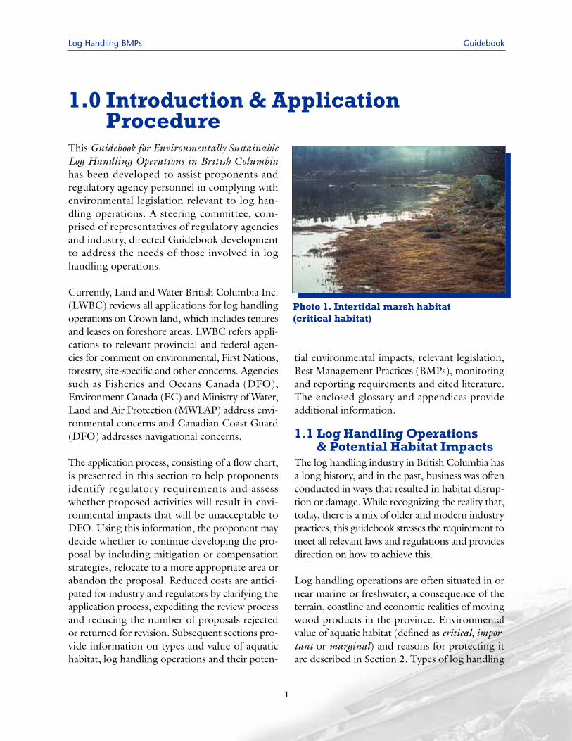
Log handling operations are often situated in ornear marine or freshwater, a consequence of theterrain, coastline and economic realities of movingwood products in the province. Environmentalvalue of aquatic habitat (defined as critical, impor-tant or marginal) and reasons for protecting itare described in Section 2. Types of log handling
1.0 Introduction & ApplicationProcedure
Photo 1. Intertidal marsh habitat (critical habitat)
Guidebook Log Handling BMPs
operations (initial transfer to water, sorting, boom-ing, barging, transport, storage), and their poten-tial impacts to fish habitat and water quality aredescribed in Section 3. Commonly observedimpacts include damage to shoreline and under-water substrate during construction or operationand deposition of wood waste, mostly bark, whichcan smother habitat and its inhabitants.
1.2 Applicable Legislation &Regulatory Requirements
The federal Fisheries Act is the guiding legislation ofthis document. Section 4 describes this and otheracts that may apply to log handling. Forexample, DFO requires that an applicationcontain a Debris Management Plan thataddresses Canadian Coast Guard (CCG)concerns on potential impacts to naviga-tion of escaped logs and deadheads (underthe Navigable Waters Protection Act) andHabitat and Enhancement Branch (HEB)concerns for environmental impacts ofwoody debris accumulation (under theFisheries Act). Under the provincial WasteManagement Act, MWLAP requires a per-mit for activities that involve discharge ofwaste (e.g., sewage, solid waste disposal bylandfill or incineration, treatment of haz-ardous wastes). Various acts protect birds,wildlife and their habitat. Consultationwith First Nations may also be required.
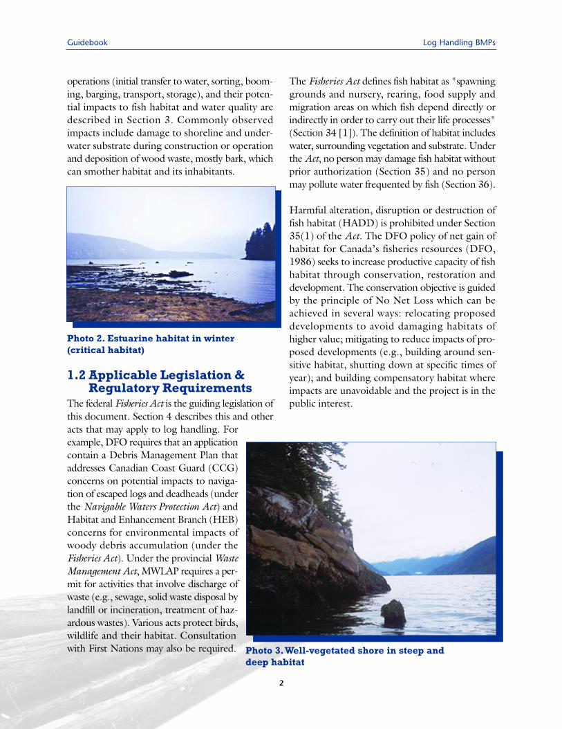
The Fisheries Act defines fish habitat as "spawninggrounds and nursery, rearing, food supply andmigration areas on which fish depend directly orindirectly in order to carry out their life processes"(Section 34 [1]). The definition of habitat includeswater, surrounding vegetation and substrate. Underthe Act, no person may damage fish habitat withoutprior authorization (Section 35) and no personmay pollute water frequented by fish (Section 36).
Harmful alteration, disruption or destruction offish habitat (HADD) is prohibited under Section35(1) of the Act. The DFO policy of net gain ofhabitat for Canada’s fisheries resources (DFO,1986) seeks to increase productive capacity of fishhabitat through conservation, restoration anddevelopment. The conservation objective is guidedby the principle of No Net Loss which can beachieved in several ways: relocating proposeddevelopments to avoid damaging habitats ofhigher value; mitigating to reduce impacts of pro-posed developments (e.g., building around sen-sitive habitat, shutting down at specific times ofyear); and building compensatory habitat whereimpacts are unavoidable and the project is in thepublic interest.
Photo 2. Estuarine habitat in winter (critical habitat)
Photo 3.Well-vegetated shore in steep anddeep habitat
2
Log Handling BMPs Guidebook
3
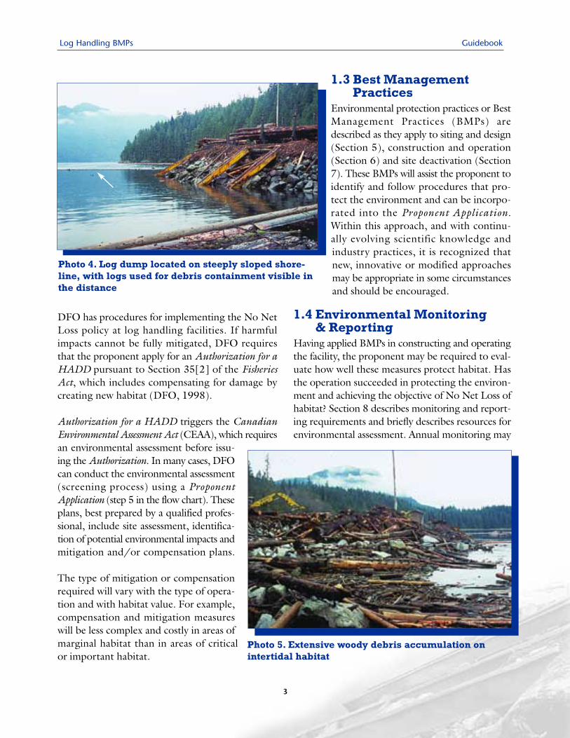
DFO has procedures for implementing the No NetLoss policy at log handling facilities. If harmfulimpacts cannot be fully mitigated, DFO requiresthat the proponent apply for an Authorization for aHADD pursuant to Section 35[2] of the FisheriesAct, which includes compensating for damage bycreating new habitat (DFO, 1998).
Authorization for a HADD triggers the CanadianEnvironmental Assessment Act (CEAA), which requiresan environmental assessment before issu-ing the Authorization. In many cases, DFOcan conduct the environmental assessment(screening process) using a ProponentApplication (step 5 in the flow chart). Theseplans, best prepared by a qualified profes-sional, include site assessment, identifica-tion of potential environmental impacts andmitigation and/or compensation plans.
The type of mitigation or compensationrequired will vary with the type of opera-tion and with habitat value. For example,compensation and mitigation measureswill be less complex and costly in areas ofmarginal habitat than in areas of criticalor important habitat.
1.3 Best ManagementPractices
Environmental protection practices or BestManagement Practices (BMPs) aredescribed as they apply to siting and design(Section 5), construction and operation(Section 6) and site deactivation (Section7). These BMPs will assist the proponent toidentify and follow procedures that pro-tect the environment and can be incorpo-rated into the Proponent Application.Within this approach, and with continu-ally evolving scientific knowledge andindustry practices, it is recognized thatnew, innovative or modified approachesmay be appropriate in some circumstancesand should be encouraged.
1.4 Environmental Monitoring & Reporting
Having applied BMPs in constructing and operatingthe facility, the proponent may be required to eval-uate how well these measures protect habitat. Hasthe operation succeeded in protecting the environ-ment and achieving the objective of No Net Loss ofhabitat? Section 8 describes monitoring and report-ing requirements and briefly describes resources forenvironmental assessment. Annual monitoring may
Photo 4. Log dump located on steeply sloped shore-line, with logs used for debris containment visible inthe distance
Photo 5. Extensive woody debris accumulation onintertidal habitat
Log Handling BMPs
4
be required to assess mitigation and compensa-tion measures, use of BMPs and environmen-tal impacts (e.g., oil sheen, bark management). Ifsubstances from the List of Toxic Compounds(Schedule 1 of Canadian EnvironmentalProtection Act, 1999; CEPA) are used at thefacility, a Pollution Prevention Plan may berequired under Part 4 of CEPA. Regulatoryagencies and industry may choose to monitorthe effectiveness of BMPs.
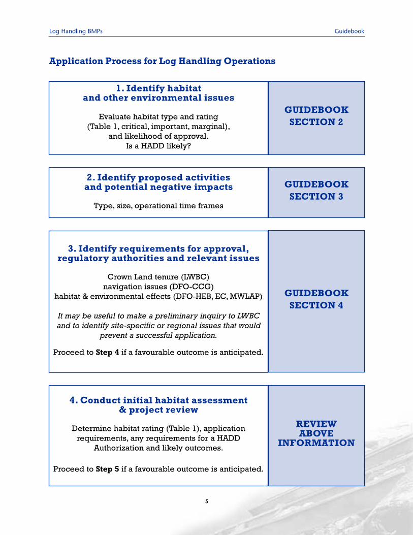
1.5 Application & Review ProcessThe application process described in the followingflow chart identifies seven steps and is designed tomake requirements and the process clear to theproponent. This should enable agencies to evaluatewell-prepared applications, expedite review andresult in fewer rejected or revised applications.
Guidebook
Log Handling BMPs Guidebook
5
Application Process for Log Handling Operations
1. Identify habitat and other environmental issues
Evaluate habitat type and rating (Table 1, critical, important, marginal),
and likelihood of approval.Is a HADD likely?
GUIDEBOOK SECTION 2
2. Identify proposed activities and potential negative impacts
Type, size, operational time frames
GUIDEBOOK SECTION 3
3. Identify requirements for approval,regulatory authorities and relevant issues
Crown Land tenure (LWBC)navigation issues (DFO-CCG)
habitat & environmental effects (DFO-HEB, EC, MWLAP)
It may be useful to make a preliminary inquiry to LWBCand to identify site-specific or regional issues that would
prevent a successful application.
Proceed to Step 4 if a favourable outcome is anticipated.
GUIDEBOOK SECTION 4
4. Conduct initial habitat assessment & project review
Determine habitat rating (Table 1), application requirements, any requirements for a HADD
Authorization and likely outcomes.
Proceed to Step 5 if a favourable outcome is anticipated.
REVIEW ABOVE
INFORMATION
Guidebook Log Handling BMPs
6
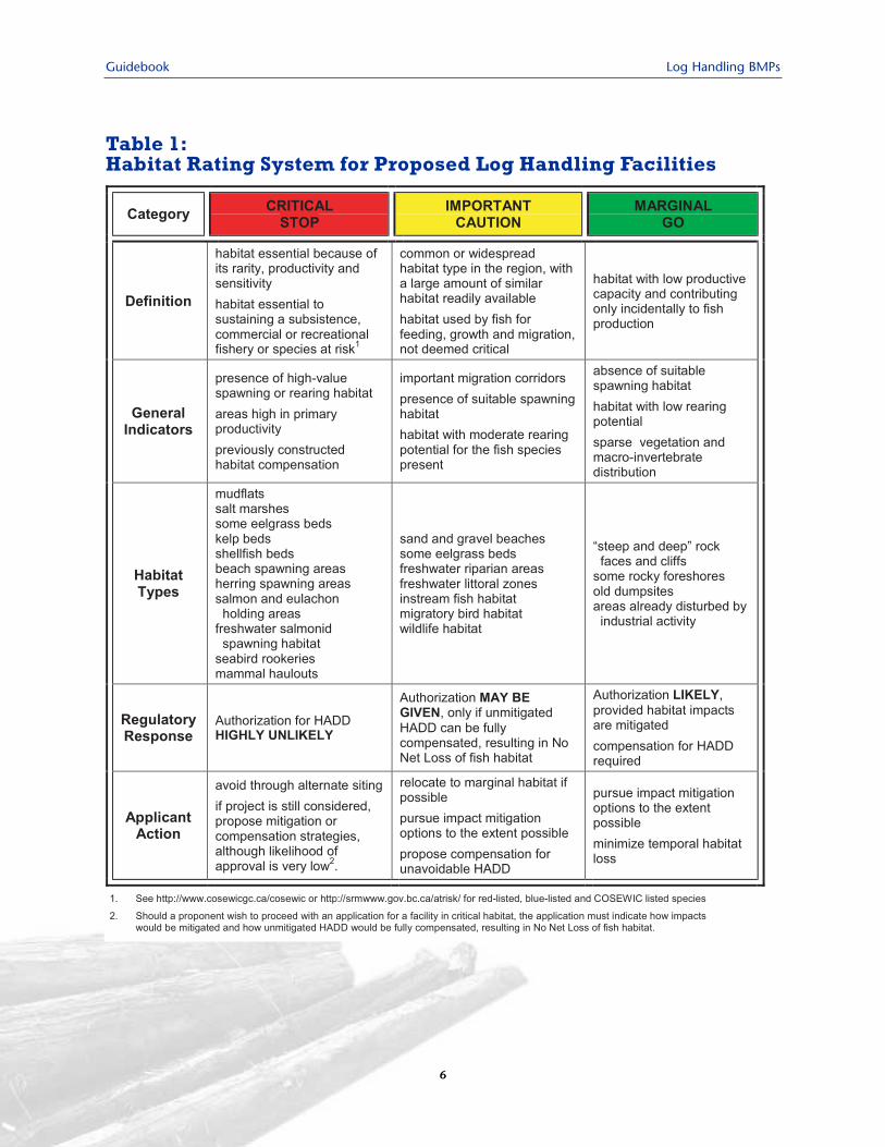
Table 1:Habitat Rating System for Proposed Log Handling Facilities
Log Handling BMPs Guidebook
7
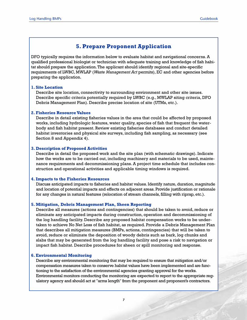
5. Prepare Proponent Application
DFO typically requires the information below to evaluate habitat and navigational concerns. Aqualified professional biologist or technician with adequate training and knowledge of fish habi-tat should prepare the application. The applicant should identify regional and site-specificrequirements of LWBC, MWLAP (Waste Management Act permits), EC and other agencies beforepreparing the application.
1. Site LocationDescribe site location, connectivity to surrounding environment and other site issues.Describe specific criteria potentially required by LWBC (e.g., MWLAP siting criteria, DFODebris Management Plan). Describe precise location of site (UTMs, etc.).
2. Fisheries Resource ValuesDescribe in detail existing fisheries values in the area that could be affected by proposedworks, including hydrologic features, water quality, species of fish that frequent the water-body and fish habitat present. Review existing fisheries databases and conduct detailedhabitat inventories and physical site surveys, including fish sampling, as necessary (seeSection 8 and Appendix 4).
3. Description of Proposed Activities Describe in detail the proposed work and the site plan (with schematic drawings). Indicatehow the works are to be carried out, including machinery and materials to be used, mainte-nance requirements and decommissioning plans. A project time schedule that includes con-struction and operational activities and applicable timing windows is required.
4. Impacts to the Fisheries ResourcesDiscuss anticipated impacts to fisheries and habitat values. Identify nature, duration, magnitudeand location of potential impacts and effects on adjacent areas. Provide justification or rationalefor any changes in natural features (relocation of stream channels, filling with riprap, etc.).
5. Mitigation, Debris Management Plan, Sheen ReportingDescribe all measures (actions and contingencies) that should be taken to avoid, reduce oreliminate any anticipated impacts during construction, operation and decommissioning ofthe log handling facility. Describe any proposed habitat compensation works to be under-taken to achieve No Net Loss of fish habitat, as required. Provide a Debris Management Planthat describes all mitigation measures (BMPs, actions, contingencies) that will be taken toavoid, reduce or eliminate the deposition of woody debris such as bark, log chunks andslabs that may be generated from the log handling facility and pose a risk to navigation orimpact fish habitat. Describe procedures for sheen or spill monitoring and response.
6. Environmental MonitoringDescribe any environmental monitoring that may be required to ensure that mitigation and/orcompensation measures taken to conserve habitat values have been implemented and are func-tioning to the satisfaction of the environmental agencies granting approval for the works.Environmental monitors conducting the monitoring are expected to report to the appropriate reg-ulatory agency and should act at "arms length" from the proponent and proponent’s contractors.
Guidebook Log Handling BMPs
8
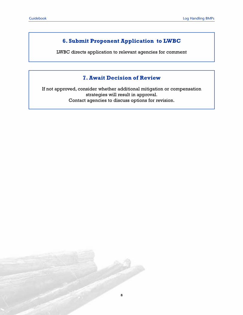
6. Submit Proponent Application to LWBC
LWBC directs application to relevant agencies for comment
7. Await Decision of Review
If not approved, consider whether additional mitigation or compensation strategies will result in approval.
Contact agencies to discuss options for revision.
Log Handling BMPs Guidebook
9
Marine, estuarine and freshwater habitats in BCsupport diverse and productive biological com-munities, including fish stocks with high commer-cial, recreational and ecological value. Manyphysical, chemical, geophysical and human-relatedfactors interact to influence productivity and speciescomposition. These include currents, tides, nutrientcycling, geology, topography, habitat disturbanceand harvesting rates. Log handling operations areoften situated next to or in these aquatic habitats,and have the potential to create negative impacts.
Information for this section was adapted fromFREMP (1991; undated), BC Nearshore HabitatLoss Work Group (2001), Swanson (2001) andMOF (2002).
2.1 Habitat Rating System forLog Handling Proposals
Although all habitat types are ecologically impor-tant, DFO assigns a higher value to some than toothers, based on productivity, intensity of use,rareness, sensitivity to human exploitation or alter-ation and other factors considered important bysociety. Table 1 (Section 1) presents a habitat rat-ing system that links habitat type to requirementsfor acceptance of proposals and likelihood ofapproval. This system was based on models usedby various regulatory agencies (e.g., Fish-StreamCrossing Guidebook; MOF, 2002) and uses a "traf-fic light" approach to describe habitat as Critical,Important and Marginal.
When the proponent understands the level ofeffort required for approval by DFO (e.g., miti-gation plans, compensation plans for an authorizedHADD) in various habitat types, a decision can bemade whether to proceed as planned or modifythe application prior to submission. Mitigationoptions include minimizing footprint and other
harmful effects through design modification andavoiding sensitive times of year. Compensationfor any unmitigated HADD will be required,although the extent and cost is also linked to habi-tat quality.
Critical HabitatRed denotes stop when considering where todevelop, unless designated habitat features can becompletely avoided. This is Critical habitat, highlyproductive and most sensitive biologically to dis-turbance. A HADD of critical fish habitat is unac-ceptable and it is unlikely that DFO will approveproposals sited in such habitat. The proposal shouldbe moved to an alternative site or not considered.If a proponent wishes to make an applicationinvolving siting in Critical habitat (e.g., no alter-nate feasible site), the application must indicatehow impacts would be fully mitigated and howunmitigated HADD would be fully compensated,resulting in No Net Loss of fish habitat.
Important HabitatYellow denotes proceed with caution in devel-oping a proposal. This Important habitat is mod-erately productive or seasonally important andmoderately sensitive to disturbance. It is unlikelythat DFO will approve proposals that will result ina HADD, unless the proposal includes mitigationand a plan for full compensation of the unmiti-gated HADD so as to result in No Net Loss of fishhabitat. The proponent should relocate the proj-ect to marginal habitat wherever possible or notconsider the application.
Marginal HabitatGreen denotes go, while considering potentialhabitat impacts. Marginal habitat, although stillproductive, is the least biologically sensitive todisturbance and more suited to log handling oper-
2.0 Habitat Considerations
Guidebook Log Handling BMPs
10
ations. DFO is more likely to approve proposalsfor Marginal areas, and will likely not require aHADD authorization if any damage to fish habi-tat can be mitigated, but will require authorizationand compensation for an unmitigated HADD.
2.2 Critical & ImportantMarine Habitat
Coastal habitats are among the most diverse andproductive ecosystems, vital to ecologicalprocesses. Along the BC coast, mixing of PacificOcean seawater with in-flowing freshwater, cur-rents, tides, wind, waves and temperature influencedistribution of marine species and define habi-tats. Physical factors interact with biological factors,such as lifecycle stage, mobility, predation, com-petition and whether the organism is solitary orcommunal, to produce distinct distribution pat-terns or zonation of organisms.
Habitats in coastal and estuarine areas include rockyshorelines, shallow subtidal areas, marshes, beaches,sandflats, mudflats, eelgrass and kelp beds. Theyprovide shelter, food and a relatively wide rangeof conditions for many species of fish and inverte-brates, including economically important speciesof salmon, steelhead and cutthroat trout, herring,smelt, sturgeon, shellfish and crabs. Some areasprovide habitat year-round, whereas others are usedseasonally for rearing, migration, holding or spawn-ing (e.g., juvenile salmon rearing, adult salmonmigration, herring spawning). Significant seasonaluse may be mitigated by temporary shutdown ofoperations during sensitive periods.
All five species of Pacific salmon (sockeye, coho,chinook, chum, pink) spend some time rearingin estuarine and nearshore areas, mature in theocean and return to their natal streams to spawnand die. Depending on species and location,smolts (juveniles) may spend days to months feed-ing in estuaries and nearshore areas any timebetween late winter and early summer, feeding
on rich populations of invertebrates and larvalfish. Adults returning to spawn may be abundantat passes and river mouths, during which timethey may be sensitive to log handling operations.Sea-run cutthroat trout and steelhead also usenearshore and estuarine habitat as juveniles andmaturing adults. Sturgeon use intertidal, subti-dal and river habitat at various life stages.
Migratory and indigenous mammals such as har-bour seals, sea lions, killer whales, otters and minkdepend on habitat provided by rocky shores,beaches, pocket coves and sheltered bays, feed-ing on the abundant finfish and shellfish. Sealsand sea lions use nearshore rocks, reefs and estu-arine sandbars for resting, giving birth and nursing.Thousands of sea lions congregate in rookeriesduring the summer. The Northern fur seal,Northern elephant seal and California sea lion arefrequent migrants.
Seabirds include divers (loons, grebes, cormorants,alcids), waterfowl (swans, geese, ducks) and gulls.
Critical• mudflats• salt marshes• some eelgrass beds• kelp beds• seabird rookeries• mammal haulouts• beach spawning areas • herring spawning areas• salmon holding areas• eulachon holding areas• shellfish beds
Important• sand and gravel beaches• some eelgrass beds• migratory bird habitat• wildlife habitat
Log Handling BMPs Guidebook
11
They use a variety of coastal habitats and are mostabundant from October to April. Habitat require-ments vary from species to species, with mostfound on waters less than 10 m deep. Althoughseasonal and regional differences in food require-ments are poorly documented, diving ducks andgulls are known to consume benthic fish and inver-tebrates, while grazers such as Brant and othergeese feed extensively on eelgrass.
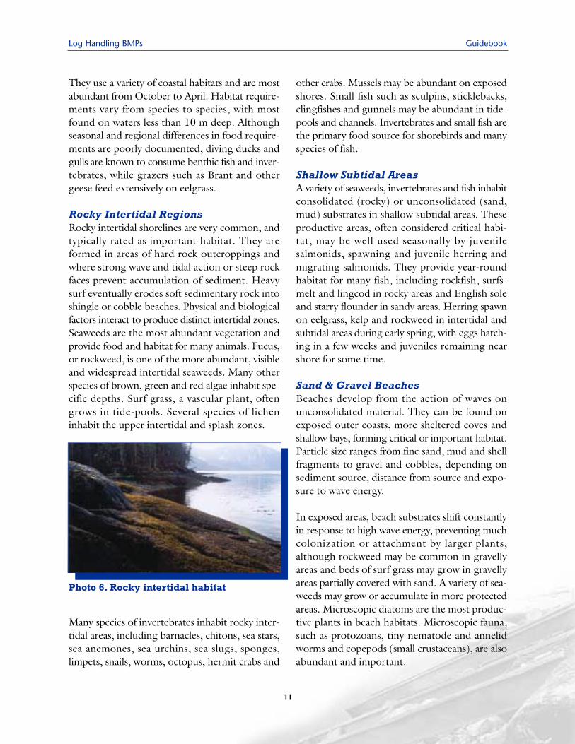
Rocky Intertidal RegionsRocky intertidal shorelines are very common, andtypically rated as important habitat. They areformed in areas of hard rock outcroppings andwhere strong wave and tidal action or steep rockfaces prevent accumulation of sediment. Heavysurf eventually erodes soft sedimentary rock intoshingle or cobble beaches. Physical and biologicalfactors interact to produce distinct intertidal zones.Seaweeds are the most abundant vegetation andprovide food and habitat for many animals. Fucus,or rockweed, is one of the more abundant, visibleand widespread intertidal seaweeds. Many otherspecies of brown, green and red algae inhabit spe-cific depths. Surf grass, a vascular plant, oftengrows in tide-pools. Several species of licheninhabit the upper intertidal and splash zones.
Many species of invertebrates inhabit rocky inter-tidal areas, including barnacles, chitons, sea stars,sea anemones, sea urchins, sea slugs, sponges,limpets, snails, worms, octopus, hermit crabs and
other crabs. Mussels may be abundant on exposedshores. Small fish such as sculpins, sticklebacks,clingfishes and gunnels may be abundant in tide-pools and channels. Invertebrates and small fish arethe primary food source for shorebirds and manyspecies of fish.
Shallow Subtidal AreasA variety of seaweeds, invertebrates and fish inhabitconsolidated (rocky) or unconsolidated (sand,mud) substrates in shallow subtidal areas. Theseproductive areas, often considered critical habi-tat, may be well used seasonally by juvenilesalmonids, spawning and juvenile herring andmigrating salmonids. They provide year-roundhabitat for many fish, including rockfish, surfs-melt and lingcod in rocky areas and English soleand starry flounder in sandy areas. Herring spawnon eelgrass, kelp and rockweed in intertidal andsubtidal areas during early spring, with eggs hatch-ing in a few weeks and juveniles remaining nearshore for some time.
Sand & Gravel BeachesBeaches develop from the action of waves onunconsolidated material. They can be found onexposed outer coasts, more sheltered coves andshallow bays, forming critical or important habitat.Particle size ranges from fine sand, mud and shellfragments to gravel and cobbles, depending onsediment source, distance from source and expo-sure to wave energy.
In exposed areas, beach substrates shift constantlyin response to high wave energy, preventing muchcolonization or attachment by larger plants,although rockweed may be common in gravellyareas and beds of surf grass may grow in gravellyareas partially covered with sand. A variety of sea-weeds may grow or accumulate in more protectedareas. Microscopic diatoms are the most produc-tive plants in beach habitats. Microscopic fauna,such as protozoans, tiny nematode and annelidworms and copepods (small crustaceans), are alsoabundant and important.
Photo 6. Rocky intertidal habitat
Guidebook Log Handling BMPs
12
Larger animals live as filter feeders burrowing intosediment (e.g., Pacific razor clam, little neck clam),scavengers (e.g., sand fleas, isopods, some snails,Dungeness crabs, polychaetes) or predators (e.g.,amphipods, bloodworms, moon snails). Severalcommercially or recreationally important species ofshellfish and crustaceans are abundant in inter-tidal areas of sandy beaches. The Pacific oystergrows on small stones, cobbles and shells in lowerintertidal flats. Adult Dungeness crabs are mostabundant on lower intertidal sand and mud flatsand along the delta front and continental shelf,to a depth of 90 m. Fish such as sand lance, smeltand herring lay their eggs on vegetation or sandduring high spring tides. The eggs hatch whenwater levels later reach the same elevation. Thesefish provide important prey for Pacific salmon.
Sea gulls are common and abundant shorebirds,scavenging dead and dying plant and animal matterand feeding on shellfish. Less abundant are sander-lings, dunlins, western sandpipers and godwits,which probe the sand for worms and amphipods.
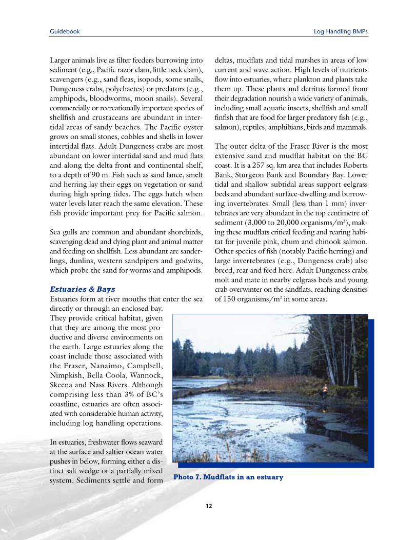
Estuaries & BaysEstuaries form at river mouths that enter the seadirectly or through an enclosed bay.They provide critical habitat, giventhat they are among the most pro-ductive and diverse environments onthe earth. Large estuaries along thecoast include those associated with the Fraser, Nanaimo, Campbell,Nimpkish, Bella Coola, Wannock,Skeena and Nass Rivers. Althoughcomprising less than 3% of BC’scoastline, estuaries are often associ-ated with considerable human activity,including log handling operations.
In estuaries, freshwater flows seawardat the surface and saltier ocean waterpushes in below, forming either a dis-tinct salt wedge or a partially mixedsystem. Sediments settle and form
deltas, mudflats and tidal marshes in areas of lowcurrent and wave action. High levels of nutrientsflow into estuaries, where plankton and plants takethem up. These plants and detritus formed fromtheir degradation nourish a wide variety of animals,including small aquatic insects, shellfish and smallfinfish that are food for larger predatory fish (e.g.,salmon), reptiles, amphibians, birds and mammals.
The outer delta of the Fraser River is the mostextensive sand and mudflat habitat on the BCcoast. It is a 257 sq. km area that includes RobertsBank, Sturgeon Bank and Boundary Bay. Lowertidal and shallow subtidal areas support eelgrassbeds and abundant surface-dwelling and burrow-ing invertebrates. Small (less than 1 mm) inver-tebrates are very abundant in the top centimetre ofsediment (3,000 to 20,000 organisms/m2), mak-ing these mudflats critical feeding and rearing habi-tat for juvenile pink, chum and chinook salmon.Other species of fish (notably Pacific herring) andlarge invertebrates (e.g., Dungeness crab) alsobreed, rear and feed here. Adult Dungeness crabsmolt and mate in nearby eelgrass beds and youngcrab overwinter on the sandflats, reaching densitiesof 150 organisms/m2 in some areas.
Photo 7. Mudflats in an estuary
Log Handling BMPs Guidebook
13
Eelgrass (Zostera marina) meadows are particu-larly critical communities in shallow intertidal andsubtidal areas, providing ideal rearing habitat forjuvenile chum salmon and rearing or spawninghabitat for approximately 60 other species of fish,notably Pacific herring. Eelgrass can form extensivestands in firm, muddy to sandy substrates, in areasof moderate salinity sheltered from surf, at an ele-vation of approximately +1.8 m to –6.6 m (ChartDatum). A diverse community of microscopic algaeand small seaweeds living on the eelgrass often con-tributes at least as much productivity as the eel-grass. Eelgrass provides a major source of detritus,nutrients and habitat for many animals and a directfood source for waterfowl. Small, sediment-dwellinginvertebrates are much more abundant in eelgrassmeadows than in adjacent unvegetated mudflats.Among this group are harpacticoid copepods, themost important prey of juvenile chum salmon whilethey reside in the estuary.
Bird life is varied and abundant year-round inestuaries and nearshore ecosystems. Some arrivein spring to nest, rear young and depart in the fall,some spend the winter and many others aremigrants along the Pacific Flyway. Large flocksof migrating waterfowl such as black Brant geese,Canada geese, widgeons, scoters and canvasbackscan consume enough eelgrass to create visibledenuded patches and increase habitat complexity.Marsh and shore birds include waders (heronsand bitterns) and smaller species (sandpipers,plovers, etc.). Many species of songbirds are wide-spread, particularly in areas of emergent and ripar-ian vegetation, although their abundance anduse of estuarine habitat is difficult to assess.Raptors use upper intertidal areas, meadows andfields, where prey is readily available and openareas provide easy hunting and vegetation forperching, nesting and cover. Peregrine falcons,gyrfalcons, goshawks and merlins are attractedto the abundant bird life. Owls and hawks areattracted to the abundant small rodents in theupper foreshore and nearby fields.
Kelp BedsLarge attached brown algae form extensive kelpbed and forests in subtidal areas of the open coast,contributing critical habitat. Species such as giantkelp (Macrocystis) and bull kelp (Nereocystis) grow inwater 3 m to 30 m deep. These large seaweeds areso thick and well anchored to the sandy bottomthat they significantly reduce wave action, helpingprotect beaches from erosion. Their dense canopiesoften reach the surface and provide habitat for giantkelpfish, striped seaperch and a small but expandingpopulation of sea otters. Herring often spawn onMacrocystis. Other animals that live at the seabedinclude flatfish (e.g., sole and flounder), scallops, seacucumbers, sea pens and sand dollars.
2.3 Critical & ImportantFreshwater Habitat
Rivers and lakes, with their associated wetlands andriparian areas, are of great ecological and economicimportance. They provide critical and importanthabitat for many species of resident and anadro-mous fish, including the five species of Pacificsalmon, for all or part of their lifecycles and provideimportant stopover habitat for migrating water-fowl and songbirds.
Critical• spawning habitat for salmonids
Important• riparian areas• littoral zones of lakes• instream fish habitat• migratory bird habitat• wildlife habitat
Guidebook Log Handling BMPs
14
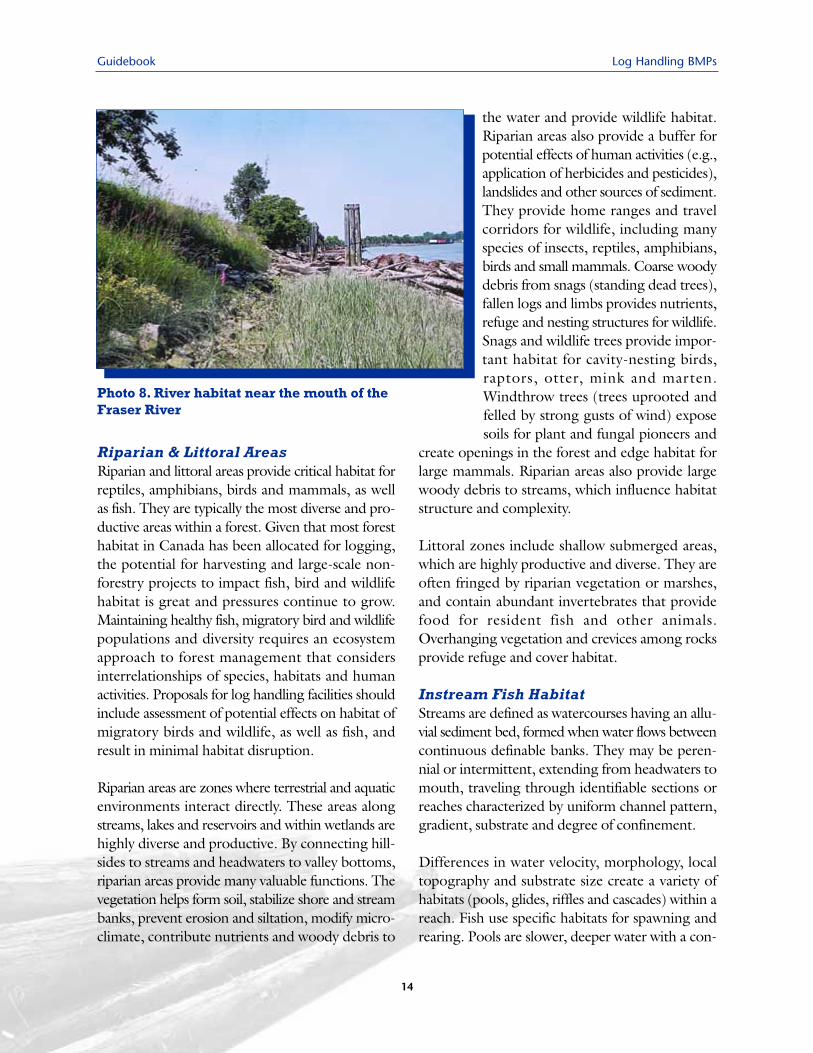
Riparian & Littoral AreasRiparian and littoral areas provide critical habitat forreptiles, amphibians, birds and mammals, as wellas fish. They are typically the most diverse and pro-ductive areas within a forest. Given that most foresthabitat in Canada has been allocated for logging,the potential for harvesting and large-scale non-forestry projects to impact fish, bird and wildlifehabitat is great and pressures continue to grow.Maintaining healthy fish, migratory bird and wildlifepopulations and diversity requires an ecosystemapproach to forest management that considersinterrelationships of species, habitats and humanactivities. Proposals for log handling facilities shouldinclude assessment of potential effects on habitat ofmigratory birds and wildlife, as well as fish, andresult in minimal habitat disruption.
Riparian areas are zones where terrestrial and aquaticenvironments interact directly. These areas alongstreams, lakes and reservoirs and within wetlands arehighly diverse and productive. By connecting hill-sides to streams and headwaters to valley bottoms,riparian areas provide many valuable functions. Thevegetation helps form soil, stabilize shore and streambanks, prevent erosion and siltation, modify micro-climate, contribute nutrients and woody debris to
the water and provide wildlife habitat.Riparian areas also provide a buffer forpotential effects of human activities (e.g.,application of herbicides and pesticides),landslides and other sources of sediment.They provide home ranges and travelcorridors for wildlife, including manyspecies of insects, reptiles, amphibians,birds and small mammals. Coarse woodydebris from snags (standing dead trees),fallen logs and limbs provides nutrients,refuge and nesting structures for wildlife.Snags and wildlife trees provide impor-tant habitat for cavity-nesting birds, raptors, otter, mink and marten.Windthrow trees (trees uprooted andfelled by strong gusts of wind) exposesoils for plant and fungal pioneers and
create openings in the forest and edge habitat forlarge mammals. Riparian areas also provide largewoody debris to streams, which influence habitatstructure and complexity.
Littoral zones include shallow submerged areas,which are highly productive and diverse. They areoften fringed by riparian vegetation or marshes,and contain abundant invertebrates that providefood for resident fish and other animals.Overhanging vegetation and crevices among rocksprovide refuge and cover habitat.
Instream Fish HabitatStreams are defined as watercourses having an allu-vial sediment bed, formed when water flows betweencontinuous definable banks. They may be peren-nial or intermittent, extending from headwaters tomouth, traveling through identifiable sections orreaches characterized by uniform channel pattern,gradient, substrate and degree of confinement.
Differences in water velocity, morphology, localtopography and substrate size create a variety ofhabitats (pools, glides, riffles and cascades) within areach. Fish use specific habitats for spawning andrearing. Pools are slower, deeper water with a con-
Photo 8. River habitat near the mouth of the Fraser River
Log Handling BMPs Guidebook
15
cave bottom, fine sediments and alow gradient water surface. Theseare important rearing areas for juve-nile fish and holding areas for adultfish. Glides often occur at the bot-tom end of a pool and are fast-flow-ing, non-turbulent and relatively flatbottomed. They provide spawninghabitat for salmonids. Riffles are tur-bulent, fast-flowing, relatively shal-low areas, moderate in gradient,with gravel or cobble substrates andboulders projecting above the water.Gravel substrates in riffles provideessential spawning habitat forsalmonids. Cascades are steep,stepped riffles of bedrock or emer-gent boulders.
Water quality, physical structure and flow regimecontribute to the value of particular habitat to fish,plants and invertebrates. Water quality is affected bytemperature, turbidity, dissolved oxygen, nutrients,chemicals, light, pH and toxic compounds. Physicalstructures such as large woody debris, boulders,stream banks and riparian vegetation may directlyalter or enhance the stream. Logging, which canreduce physical structures, may reduce habitat diver-sity. Flow regime is the quantity, depth, velocity anddirection of water in a stream channel. Flow regimecan be affected by seasonal precipitation, peak flowevents and removal of vegetation, which in turninfluence channel structure and available habitat.
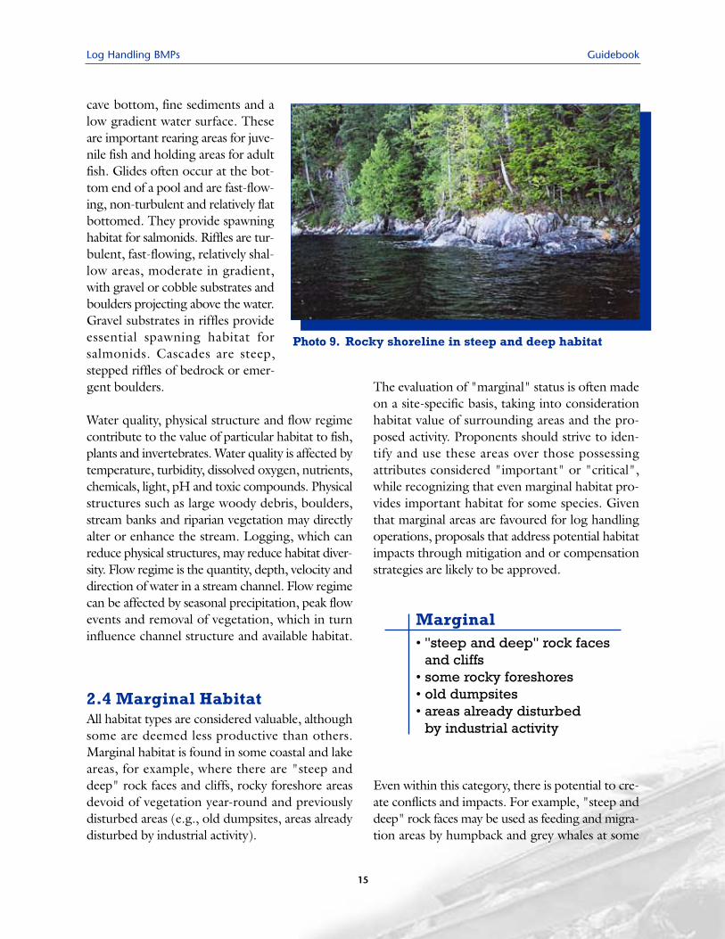
2.4 Marginal HabitatAll habitat types are considered valuable, althoughsome are deemed less productive than others.Marginal habitat is found in some coastal and lakeareas, for example, where there are "steep anddeep" rock faces and cliffs, rocky foreshore areasdevoid of vegetation year-round and previouslydisturbed areas (e.g., old dumpsites, areas alreadydisturbed by industrial activity).
The evaluation of "marginal" status is often madeon a site-specific basis, taking into considerationhabitat value of surrounding areas and the pro-posed activity. Proponents should strive to iden-tify and use these areas over those possessingattributes considered "important" or "critical",while recognizing that even marginal habitat pro-vides important habitat for some species. Giventhat marginal areas are favoured for log handlingoperations, proposals that address potential habitatimpacts through mitigation and or compensationstrategies are likely to be approved.
Even within this category, there is potential to cre-ate conflicts and impacts. For example, "steep anddeep" rock faces may be used as feeding and migra-tion areas by humpback and grey whales at some
Photo 9. Rocky shoreline in steep and deep habitat
Marginal• "steep and deep" rock faces
and cliffs• some rocky foreshores• old dumpsites• areas already disturbed
by industrial activity
Guidebook Log Handling BMPs
16
times of years. Humpback whale populations, pre-viously in decline, are now rebounding and ani-mals are moving back into some North Coast areas.Typically, they are present between early June andmid-November. Mitigation strategies, such as mon-itoring whale activity at sensitive times of year andtemporarily stopping activities such as helicopterlogging when whales are present may be required.
The suitability of re-using old dumpsites should beassessed based on their location (e.g., avoidingestuaries), time since deactivation and ability torestore productive habitat. For example, it maybe appropriate to use previously disturbed sites ifhabitat has already been damaged and there ispotential for restoration once the proposed activ-ity is concluded.
Log Handling BMPs Guidebook
17
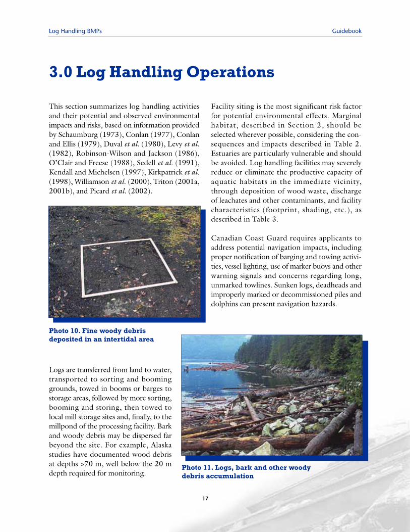
This section summarizes log handling activitiesand their potential and observed environmentalimpacts and risks, based on information providedby Schaumburg (1973), Conlan (1977), Conlanand Ellis (1979), Duval et al. (1980), Levy et al.(1982), Robinson-Wilson and Jackson (1986),O’Clair and Freese (1988), Sedell et al. (1991),Kendall and Michelsen (1997), Kirkpatrick et al.(1998), Williamson et al. (2000), Triton (2001a,2001b), and Picard et al. (2002).
Logs are transferred from land to water,transported to sorting and boominggrounds, towed in booms or barges tostorage areas, followed by more sorting,booming and storing, then towed tolocal mill storage sites and, finally, to themillpond of the processing facility. Barkand woody debris may be dispersed farbeyond the site. For example, Alaskastudies have documented wood debrisat depths >70 m, well below the 20 mdepth required for monitoring.
Facility siting is the most significant risk factorfor potential environmental effects. Marginalhabitat, described in Section 2, should beselected wherever possible, considering the con-sequences and impacts described in Table 2.Estuaries are particularly vulnerable and shouldbe avoided. Log handling facilities may severelyreduce or eliminate the productive capacity ofaquatic habitats in the immediate vicinity,through deposition of wood waste, dischargeof leachates and other contaminants, and facilitycharacteristics (footprint, shading, etc.), asdescribed in Table 3.
Canadian Coast Guard requires applicants toaddress potential navigation impacts, includingproper notification of barging and towing activi-ties, vessel lighting, use of marker buoys and otherwarning signals and concerns regarding long,unmarked towlines. Sunken logs, deadheads andimproperly marked or decommissioned piles anddolphins can present navigation hazards.
3.0 Log Handling Operations
Photo 10. Fine woody debrisdeposited in an intertidal area
Photo 11. Logs, bark and other woody debris accumulation
Guidebook Log Handling BMPs
18
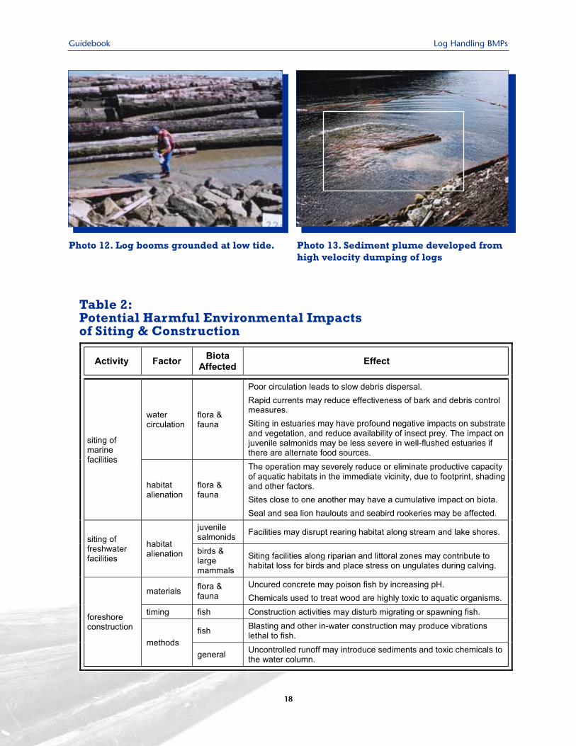
Photo 12. Log booms grounded at low tide. Photo 13. Sediment plume developed fromhigh velocity dumping of logs
Table 2:Potential Harmful Environmental Impacts of Siting & Construction
Log Handling BMPs Guidebook
19
Table 3:Potential Harmful Environmental Impacts of Log Handling Operations
Guidebook Log Handling BMPs
20
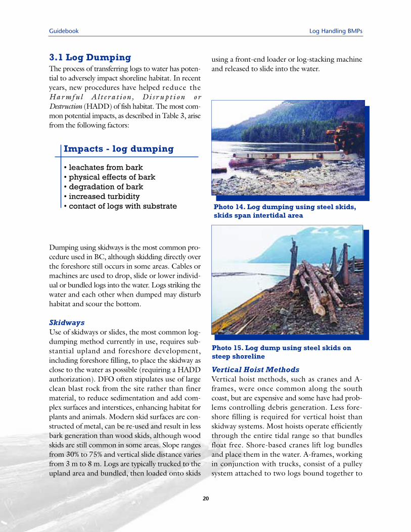
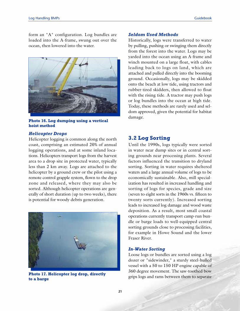
3.1 Log DumpingThe process of transferring logs to water has poten-tial to adversely impact shoreline habitat. In recentyears, new procedures have helped reduce theHarmful Al t erat ion , D i s r u p t i o n o rDestruction (HADD) of fish habitat. The most com-mon potential impacts, as described in Table 3, arisefrom the following factors:
Dumping using skidways is the most common pro-cedure used in BC, although skidding directly overthe foreshore still occurs in some areas. Cables ormachines are used to drop, slide or lower individ-ual or bundled logs into the water. Logs striking thewater and each other when dumped may disturbhabitat and scour the bottom.
SkidwaysUse of skidways or slides, the most common log-dumping method currently in use, requires sub-stantial upland and foreshore development,including foreshore filling, to place the skidway asclose to the water as possible (requiring a HADDauthorization). DFO often stipulates use of largeclean blast rock from the site rather than finermaterial, to reduce sedimentation and add com-plex surfaces and interstices, enhancing habitat forplants and animals. Modern skid surfaces are con-structed of metal, can be re-used and result in lessbark generation than wood skids, although woodskids are still common in some areas. Slope rangesfrom 30% to 75% and vertical slide distance variesfrom 3 m to 8 m. Logs are typically trucked to theupland area and bundled, then loaded onto skids
using a front-end loader or log-stacking machineand released to slide into the water.
Vertical Hoist MethodsVertical hoist methods, such as cranes and A-frames, were once common along the southcoast, but are expensive and some have had prob-lems controlling debris generation. Less fore-shore filling is required for vertical hoist thanskidway systems. Most hoists operate efficientlythrough the entire tidal range so that bundlesfloat free. Shore-based cranes lift log bundlesand place them in the water. A-frames, workingin conjunction with trucks, consist of a pulleysystem attached to two logs bound together to
Impacts - log dumping
• leachates from bark• physical effects of bark• degradation of bark• increased turbidity • contact of logs with substrate Photo 14. Log dumping using steel skids,
skids span intertidal area
Photo 15. Log dump using steel skids onsteep shoreline
Log Handling BMPs Guidebook
form an "A" configuration. Log bundles areloaded into the A-frame, swung out over theocean, then lowered into the water.
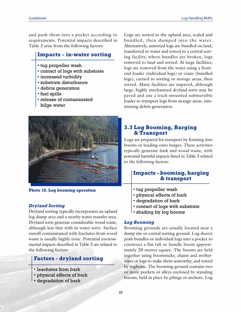
Helicopter DropsHelicopter logging is common along the northcoast, comprising an estimated 20% of annuallogging operations, and at some inland loca-tions. Helicopters transport logs from the harvestarea to a drop site in protected water, typicallyless than 2 km away. Logs are attached to thehelicopter by a ground crew or the pilot using aremote control grapple system, flown to the dropzone and released, where they may also besorted. Although helicopter operations are gen-erally of short duration (up to two weeks), thereis potential for woody debris generation.
Seldom Used MethodsHistorically, logs were transferred to waterby pulling, pushing or swinging them directlyfrom the forest into the water. Logs may beyarded into the ocean using an A-frame andwinch mounted on a large float, with cablesleading back to logs on land, which areattached and pulled directly into the boomingground. Occasionally, logs may be skiddedonto the beach at low tide, using tractors andrubber-tired skidders, then allowed to floatwith the rising tide. A tractor may push logsor log bundles into the ocean at high tide.Today, these methods are rarely used and sel-dom approved, given the potential for habitatdamage.
3.2 Log SortingUntil the 1990s, logs typically were sortedin water near dump sites or in central sort-ing grounds near processing plants. Severalfactors influenced the transition to drylandsorting. Sorting in water requires shelteredwaters and a large annual volume of logs to beeconomically sustainable. Also, mill special-ization has resulted in increased handling andsorting of logs for species, grade and size(seven to eight sorts in the 1960s vs. fifteen totwenty sorts currently). Increased sortingleads to increased log damage and wood wastedeposition. As a result, most small coastaloperations currently transport camp-run bun-dle or barge loads to well-equipped centralsorting grounds close to processing facilities,for example in Howe Sound and the lowerFraser River.
In-Water SortingLoose logs or bundles are sorted using a logdozer or "sidewinder," a sturdy steel-hulledvessel with a 50 to 150 HP engine capable of360 degree movement. The saw-toothed bowgrips logs and rams between them to separate
Photo 16. Log dumping using a verticalhoist method
Photo 17. Helicopter log drop, directlyto a barge
21
Guidebook Log Handling BMPs
and push them into a pocket according torequirements. Potential impacts described inTable 3 arise from the following factors:
Dryland SortingDryland sorting typically incorporates an uplandlog dump area and a nearby water transfer area.Dryland sorts generate considerable wood waste,although less that with in-water sorts. Surfacerunoff contaminated with leachates from woodwaste is usually highly toxic. Potential environ-mental impacts described in Table 3 are related tothe following factors:
Logs are sorted in the upland area, scaled andbundled, then dumped into the water.Alternatively, unsorted logs are bundled on land,transferred to water and towed to a central sort-ing facility, where bundles are broken, logsremoved to land and sorted. At large facilities,logs are removed from the water using a front-end loader (individual logs) or crane (bundledlogs), carried to sorting or storage areas, thensorted. Many facilities are unpaved, althoughlarge, highly mechanized dryland sorts may bepaved and use a track-mounted submersibleloader to transport logs from storage areas, min-imizing debris generation.
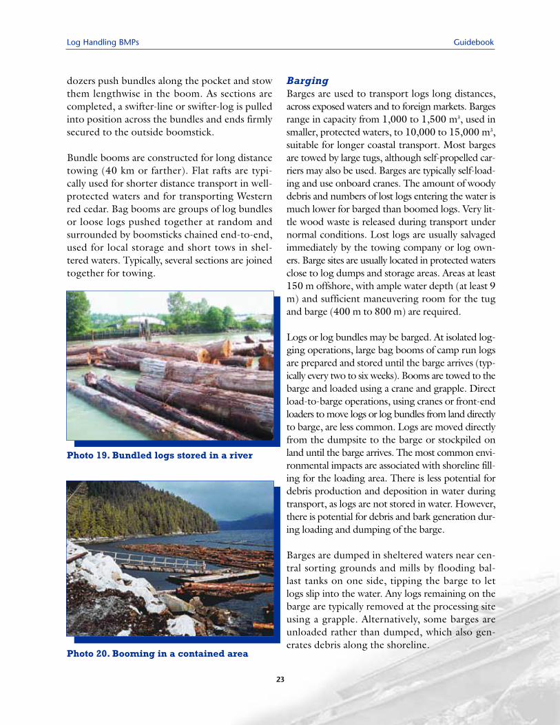
3.3 Log Booming, Barging & Transport
Logs are prepared for transport by forming intobooms or loading onto barges. These activitiestypically generate bark and wood waste, withpotential harmful impacts listed in Table 3 relatedto the following factors:
Log BoomingBooming grounds are usually located near adump site or central sorting ground. Log dozerspush bundles or individual logs into a pocket toconstruct a flat raft or bundle boom approxi-mately 20 metres square. The booms are heldtogether using boomsticks, chains and swifter-wires or logs to make them seaworthy, and towedby tugboats. The booming ground contains twoor more pockets or alleys enclosed by standingbooms, held in place by pilings or anchors. Log
Impacts - in-water sorting
• tug propeller wash• contact of logs with substrate• increased turbidity • substrate disturbance• debris generation• fuel spills • release of contaminated
bilge water
Photo 18. Log booming operation
Factors - dryland sorting
• leachates from bark• physical effects of bark• degradation of bark
Impacts - booming, barging & transport
• tug propeller wash• physical effects of bark• degradation of bark• contact of logs with substrate• shading by log booms
22
Log Handling BMPs Guidebook
23
dozers push bundles along the pocket and stowthem lengthwise in the boom. As sections arecompleted, a swifter-line or swifter-log is pulledinto position across the bundles and ends firmlysecured to the outside boomstick.
Bundle booms are constructed for long distancetowing (40 km or farther). Flat rafts are typi-cally used for shorter distance transport in well-protected waters and for transporting Westernred cedar. Bag booms are groups of log bundlesor loose logs pushed together at random andsurrounded by boomsticks chained end-to-end,used for local storage and short tows in shel-tered waters. Typically, several sections are joinedtogether for towing.
BargingBarges are used to transport logs long distances,across exposed waters and to foreign markets. Bargesrange in capacity from 1,000 to 1,500 m3, used insmaller, protected waters, to 10,000 to 15,000 m3,suitable for longer coastal transport. Most bargesare towed by large tugs, although self-propelled car-riers may also be used. Barges are typically self-load-ing and use onboard cranes. The amount of woodydebris and numbers of lost logs entering the water ismuch lower for barged than boomed logs. Very lit-tle wood waste is released during transport undernormal conditions. Lost logs are usually salvagedimmediately by the towing company or log own-ers. Barge sites are usually located in protected watersclose to log dumps and storage areas. Areas at least150 m offshore, with ample water depth (at least 9m) and sufficient maneuvering room for the tugand barge (400 m to 800 m) are required.
Logs or log bundles may be barged. At isolated log-ging operations, large bag booms of camp run logsare prepared and stored until the barge arrives (typ-ically every two to six weeks). Booms are towed to thebarge and loaded using a crane and grapple. Directload-to-barge operations, using cranes or front-endloaders to move logs or log bundles from land directlyto barge, are less common. Logs are moved directlyfrom the dumpsite to the barge or stockpiled onland until the barge arrives. The most common envi-ronmental impacts are associated with shoreline fill-ing for the loading area. There is less potential fordebris production and deposition in water duringtransport, as logs are not stored in water. However,there is potential for debris and bark generation dur-ing loading and dumping of the barge.
Barges are dumped in sheltered waters near cen-tral sorting grounds and mills by flooding bal-last tanks on one side, tipping the barge to letlogs slip into the water. Any logs remaining on thebarge are typically removed at the processing siteusing a grapple. Alternatively, some barges areunloaded rather than dumped, which also gen-erates debris along the shoreline.
Photo 19. Bundled logs stored in a river
Photo 20. Booming in a contained area
Guidebook Log Handling BMPs
3.4 StorageLogs are stored in sheltered water at severalstages, at or near the logging operation, sortingand processing centres and intermediate tie-ups.Booms are held in place in deep water usinganchors, can buoys and boom chains and in shal-lower water attached to dolphins. Although notrecommended, due to potential damage to fishhabitat, some storage areas are located in shallowintertidal regions. Potential impacts describedin Table 3 relate to the following factors:
Camp storage generally requires 2 to 40 hectares ofwater surface. Storage sites at logging operationsare often located in an estuary, sheltered bay oralong a protected, steep shoreline. In an estuary,sufficient water depth to allow movement ofbooms without scouring of bottom or foreshore isessential. In shallow areas, booms are tied to pil-ings, dolphins or standing booms. In areas of steepshoreline, they are tied to a standing boom (stringof boomsticks) held offshore by jill-poke sticks.
During transit in adverse weather, temporarystorage sites may be needed. Several intermedi-ate storage areas, ranging in size from 2 to 20hectares, are located behind rocky points orwithin sheltered bays along the main GeorgiaStrait towing routes. Booms are tied up at per-manent standing booms or dolphins. These sitesare used for only a short period, so individualbooms are not expected to generate much woodwaste; however, substantial amounts of bark mayaccumulate over time (decades in some cases).
Large sorting grounds (e.g., Howe Sound, mouthof the Fraser River) service many incoming andoutgoing booms and provide tie up at dolphin
standing booms, jill-poke sticks or permanent con-crete pillars. There is minimal buffeting or damageto logs at these protected sites. Large storagegrounds may have programs to remove and disposeof accumulated debris, deadheads and log sinkers.The duration of log storage varies greatly, anddepends on supply and demand. The industryprefers storage in lower salinity estuaries, as there isless growth of the wood-boring shipworm (Bankiasetacea), locally referred to as "teredos."
Most mill storage areas are located in estuaries,bays or along steep, protected shorelines andprovide storage for one week to two months.Most mills prefer water storage, as land storage isoften not available, expensive or exposes logs toinsect attack.
3.5 Retrieval at ProcessingPlants
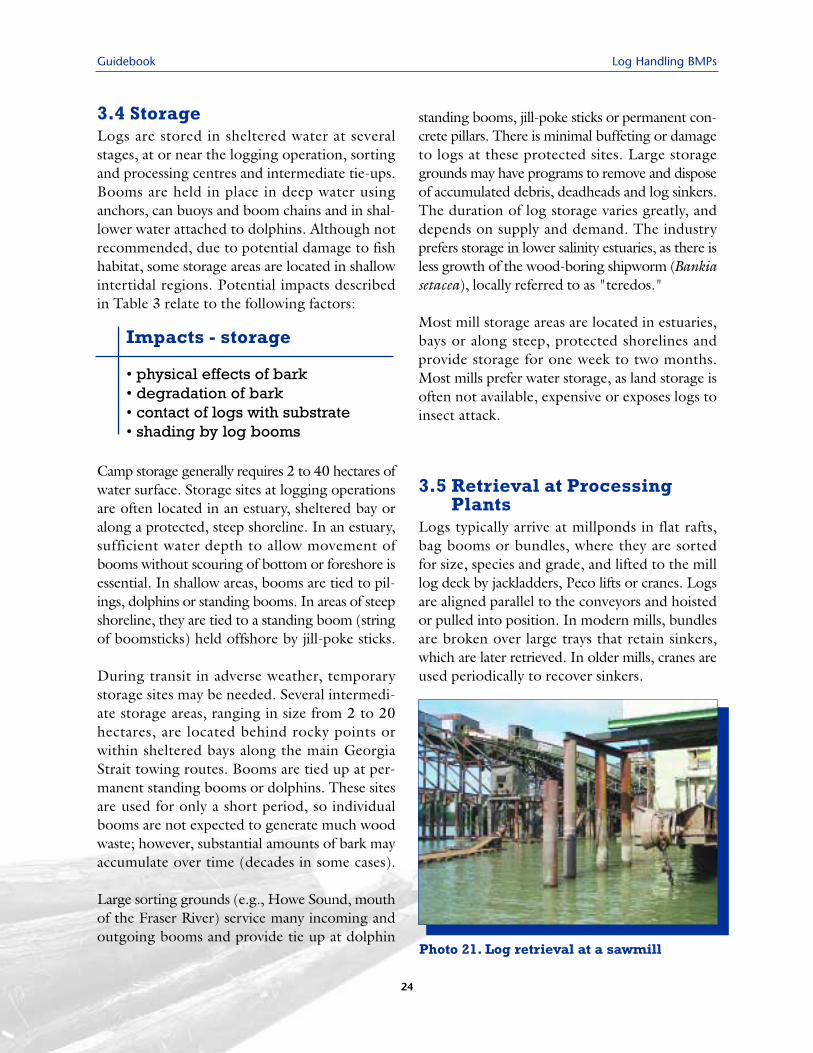
Logs typically arrive at millponds in flat rafts,bag booms or bundles, where they are sortedfor size, species and grade, and lifted to the milllog deck by jackladders, Peco lifts or cranes. Logsare aligned parallel to the conveyors and hoistedor pulled into position. In modern mills, bundlesare broken over large trays that retain sinkers,which are later retrieved. In older mills, cranes areused periodically to recover sinkers.
Impacts - storage
• physical effects of bark• degradation of bark• contact of logs with substrate• shading by log booms
Photo 21. Log retrieval at a sawmill
24
Log Handling BMPs Guidebook
25
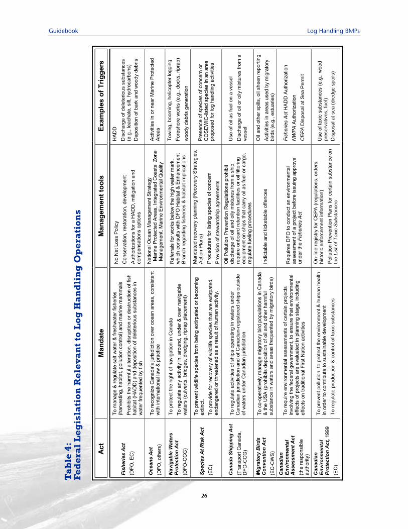
This section describes legislation and regulatoryagencies relevant to siting and operating log han-dling facilities. Appendix 1 provides additionalinformation. Full details are available on gov-ernment Internet sites. Legislation is enforcedthrough compliance monitoring, fines, "ceaseand desist" orders, formal agreements, BestManagement Practices Plans and other mecha-nisms. The federal Fisheries Act is particularly rel-evant to log handling operations.
The Constitution Act (1867) defines areas oflegislative authority for federal and provincialgovernments. The federal government is respon-sible for "seacoast and inland fisheries", whichincludes the protection of fish habitat. Provincialgovernments, both through ownership ofProvincial Land (including water lots) and leg-islative powers, have the ability to regulate andcontrol many aspects of log handling operations.By administrative arrangement, the Province ofBC is responsible for management and protectionof freshwater fish and anadromous stocks of steel-head, cutthroat trout and Dolly Varden char.The federal government retains responsibilityfor management and protection of fish habitat,marine fishes and Pacific salmon.
Although both federal and provincial agencieshave responsibility for protecting various aspectsof the environment, both levels of governmentmake significant efforts to work co-operatively.For example, the Canada-British ColumbiaAgreement for Environmental AssessmentCooperation was created to harmonize activitiesrelated to the Canadian and BC EnvironmentalAssessment Acts. This resulted in a comprehen-sive process for major projects, increased effi-ciency and cost effectiveness, information sharingand improved communication.
4.1 The Federal GovernmentThe federal government, primarily throughFisheries and Oceans Canada (DFO) andEnvironment Canada (EC), administers severalActs that apply to log handling operations. Theseinclude the Fisheries Act, Oceans Act, NavigableWaters Protection Act, Migratory Birds ConventionAct, Canadian Environmental Assessment Act,Canadian Environmental Protection Act, 1999,Canada Shipping Act (Oil Pollution PreventionRegulations) and Species at Risk Act (Table 4).
4.2 British ColumbiaGovernment
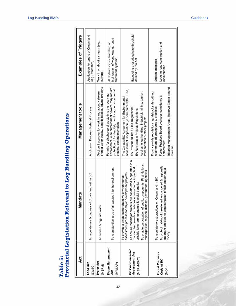
Responsibility for environmental regulations iscurrently shared between the Ministry of Water,Land and Air Protection (MWLAP), Ministryof Sustainable Resource Management (MSRM)and Land and Water BC Inc. (LWBC). TheMinistry of Forests (MOF) is responsible foractivities related to the forest industry. Provinciallegislation that may apply to log handling facil-ities, listed in Table 5, include the Land Act,Water Act, Waste Manage-ment Act and theForest Act (including the Forest Practices Code).
4.3 First NationsConcerns of First Nations and impacts on theirtraditional activities should also be consideredwhen selecting appropriate sites. In some loca-tions, First Nations concerns’ will precludeplacement of log handling facilities. TheProvincial Guide to First Nations consulta-tion, available on the Provincial Governmentwebsite, provides a comprehensive review ofthis issue.
4.0 Relevant Legislation
Guidebook Log Handling BMPs
26
Ta
ble
4:
Fed
era
l L
eg
isla
tio
n R
ele
va
nt
to L
og
Ha
nd
lin
g O
pe
rati
on
s
Log Handling BMPs Guidebook
27
Ta
ble
5:
Pro
vin
cia
l L
eg
isla
tio
n R
ele
va
nt
to L
og
Ha
nd
lin
g O
pe
rati
on
s

Guidebook Log Handling BMPs
28
Log Handling BMPs Guidebook
29
This section describes BMPs that apply when select-ing sites for new log handling facilities. They addressscale, features and configuration. BMPs were con-solidated from existing Canadian guidelines used byDFO and other agencies, and from applicable USsources (Toews and Brownlee, 1981; LTF-GTS,1985; DFO and MELP, 1995; EC and DFO, 1996;BCAL and MELP, 1999; Hutton and Samis, 2000;Warrington, 2000; Adams, 2002; EC, undated;MELP, 2001; MWLAP, 2001).
Numbered statements refer to specific BMPs, with"S" referring to the siting and design stage.
5.1 Facility Siting Careful evaluation of potential log handling sites helpsminimize environmental risks and costs of site deacti-vation and remediation. Avoiding sensitive aquatic andwildlife habitat (Table 1) when selecting sites and design-ing facilities can prevent many potentially adverse effectsof log handling (Table 2). Sites for in-water storage ortransfer of logs should be located in available areas withthe least productive intertidal and subtidal habitat andgenerally should be situated at least 100 m from wet-lands, deltas, river and creek mouths and other critical
and important habitat. The following BMPs describehow to avoid sensitive habitat during siting of loghandling facilities, including dryland sorts.
These BMPs are to be considered when developingthe proposal (Proponent Application), as they areessential to project authorization. Relevant sitingissues include avoiding sensitive habitat, the roleof exposure and setting in determining or mitigat-ing potential impacts, and cumulative impacts. Theyapply to log handling facilities and associated floatcamps, mooring basins, docks and floats.
The CEAA process requires that cumulative effectsof the proposed operation be considered in relationto existing foreshore developments in the area (e.g.,marinas, abandoned canneries, other industrial oper-ations), even though potential adverse impacts mayappear minor when viewed in isolation. Proponentsare encouraged, where possible, to consolidate loghandling activities at one location to facilitate debrismanagement and other mitigation efforts. Whereroad constraints do not permit consolidation, new loghandling facilities should be situated at least 5 kmfrom existing log handling operations.
5.0 BMPs for Siting & Design
Avoiding Sensitive Habitat S1. No facilities should be developed on or adjacent to extensive tidal flats, salt
marshes, kelp or eelgrass beds, seaweed-harvest areas or shellfish beds.Site-specific minimal distances will be derived from assessments.
S2. Log dumps, helicopter log dumps and booming areas generally should besituated at least 100 m from the mouth of an anadromous fish-bearing stream.
S3. Facilities should not be developed in areas known to be important spawningor rearing habitat for commercially or recreationally important finfish (e.g.,salmonids, herring or eulachon) or shellfish.
S4. Construction or operational activities should not occur closer than 100 m tosignificant wildlife trees (e.g., active raptor nests) and 300 m from heronries.
S5. Facilities should not be sited where there is a risk that construction or opera-tion will have an impact on protected water resources and special habitats(e.g., marine protected areas, national or provincial parks), critical or sensi-tive ecosystems, seabird congregating areas, marine mammal haulouts orwildlife migration paths.
Guidebook Log Handling BMPs
30
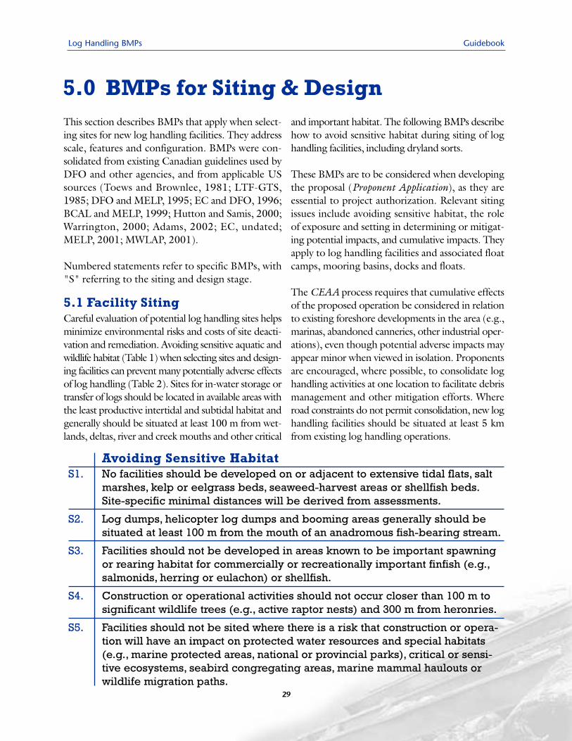
Photo 22.Well contained log dumping andbooming along a steep shoreline
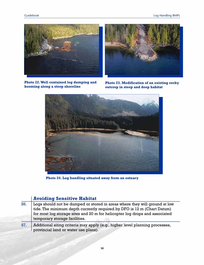
Photo 23. Modification of an existing rockyoutcrop in steep and deep habitat
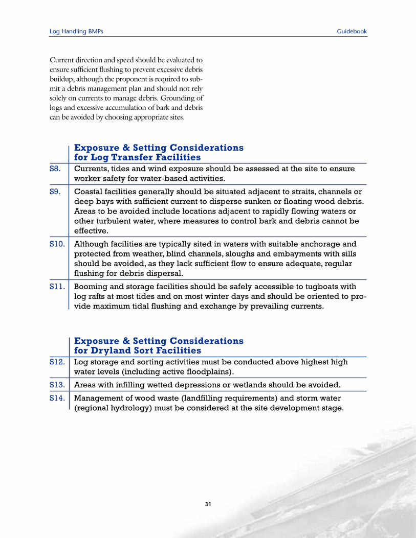
Photo 24. Log handling situated away from an estuary
Avoiding Sensitive Habitat S6. Logs should not be dumped or stored in areas where they will ground at low
tide. The minimum depth currently required by DFO is 12 m (Chart Datum) for most log storage sites and 20 m for helicopter log drops and associated temporary storage facilities.
S7. Additional siting criteria may apply (e.g., higher level planning processes,provincial land or water use plans).
Log Handling BMPs Guidebook
31
Current direction and speed should be evaluated toensure sufficient flushing to prevent excessive debrisbuildup, although the proponent is required to sub-mit a debris management plan and should not relysolely on currents to manage debris. Grounding oflogs and excessive accumulation of bark and debriscan be avoided by choosing appropriate sites.
Exposure & Setting Considerations for Log Transfer Facilities
S8. Currents, tides and wind exposure should be assessed at the site to ensureworker safety for water-based activities.
S9. Coastal facilities generally should be situated adjacent to straits, channels ordeep bays with sufficient current to disperse sunken or floating wood debris.Areas to be avoided include locations adjacent to rapidly flowing waters orother turbulent water, where measures to control bark and debris cannot beeffective.
S10. Although facilities are typically sited in waters with suitable anchorage andprotected from weather, blind channels, sloughs and embayments with sillsshould be avoided, as they lack sufficient flow to ensure adequate, regularflushing for debris dispersal.
S11. Booming and storage facilities should be safely accessible to tugboats withlog rafts at most tides and on most winter days and should be oriented to pro-vide maximum tidal flushing and exchange by prevailing currents.
Exposure & Setting Considerations for Dryland Sort Facilities
S12. Log storage and sorting activities must be conducted above highest highwater levels (including active floodplains).
S13. Areas with infilling wetted depressions or wetlands should be avoided.
S14. Management of wood waste (landfilling requirements) and storm water(regional hydrology) must be considered at the site development stage.
Guidebook Log Handling BMPs
32
5.2 Facility Design Facility design should be based on the most envi-ronmentally sustainable, economically viableoption. The Fish-Stream Crossing Guidebook(MOF, 2002) should be consulted when provid-ing access roads across fish-bearing streams.Facilities should be situated to use existing land-scape features to advantage and result in minimalexcavation and recontouring. Although not envi-ronmental requirements, the amount of suitableupland working surface and grade for road access
should also be considered. The rock fill and riprapstructures often required to armour shorelinesmay, if well designed, provide substrate for colo-nization by plants and invertebrates, typicallywithin one or two years. Riprap may providerefuge to a diverse population of invertebrates,fish, amphibians, reptiles and small mammals,both above and below normal high water. If antic-ipated adverse impacts cannot be fully mitigated,a HADD Authorization may require provision ofcompensatory habitat.
Design of Fill & Revetment StructuresS15. Fill structures should be designed and constructed to prevent erosion, pollu-
tion and structural displacement by using the largest and roughest rocks pos-sible to maximize surface area in interstices and provide the greatest amountof habitat relative to size.
S16. Footprint of fill structures should be minimized and the amount of fill placedon floodplains kept to a minimum to reduce potential for upstream flooding.
S17. When riprap is used along stream banks, live stakes of willow or other easilyrooted woody vegetation should be planted in the interstices to promoteriparian vegetation growth and improve fish habitat quality.
Floating or pile-supported structures constructedon or over water should be designed to protectplants and animals living in the water and on thebottom. Although some species may quickly col-onize the structures, habitat for other speciesmay be destroyed unless care is taken at sitingand construction stages. If anticipated adverseimpacts cannot be fully mitigated, a HADD
Authorization may require provision of com-pensatory habitat. When foreshore structures aredesigned and built to minimize environmentalimpacts, there may be cost savings associatedwith improved safety and reduced requirementsfor maintenance, habitat compensation and atten-dant assessment and monitoring.
Log Handling BMPs Guidebook
33
Design & Orientation of Wharves, Docks, Piers & FloatsS18. All docks, walkways and piers should span the intertidal zone and maintain
free flow of water currents beneath, to prevent erosion and sedimentationalong the shore.Where possible, floats should be oriented with currents orprevailing winds to prevent trapping surface debris and oily residue.
S19. Piers should be elevated a minimum of 1 m above high water and built asnarrow as possible to minimize shading of bottom vegetation.
S20. Dock floats must remain afloat at the lowest tides, should not be placed over obvious areas of vegetation and should minimize shading of bottom substrates.
S21. Piles should not be placed over significant marine or intertidal vegetation beds.
S22. Piers or trestles supporting mechanical or refueling equipment should incor-porate an impermeable deck and a spill containment and collection systemfor surface runoff.
S23. Protective wear strips (e.g., high-density polyethylene) should be used ontreated wood surfaces subject to abrasion.Where creosote-treated wood isexposed to high temperatures, creosote containment (e.g., pile wrapping)should be considered.
S24. Steel piles used in saltwater should have a coal tar epoxy coating or cathodicprotection. Use of creosote-treated wood piles should be avoided in saltwater.
Construction Materials & Chemical Treatment forWharves, Docks, Piers & Floats
Construction materials directly influence applicability of the following BMPs.Appendix 2 provides an overview of preservatives used to treat wood.
S25. Where possible, docks and float camp facilities should be constructed of pre-cast concrete, steel or plastic rather than treated wood, especially in poorlyflushed areas; pre-cast concrete is preferred in areas of low current velocityand anoxic, fine-textured sediment.
S26. Concrete support piles installed in marine environments should have coarsesurfaces that enable ready attachment of encrusting organisms.
S27. Piles constructed of untreated wood should be used at sites of limited tenureor in freshwater, where possible. A BMP certification mark (CSA O80) isrequired for treated wood used in or over water.
S28. High-density or encapsulated foam is preferred to Styrofoam or foam-filledtires for floats.
S29. Wood treated with water-based preservatives rather than creosote should beused in structures, except where there is a risk from marine borers or ademonstrated need for creosote. Creosote-treated wood should not be usedin fresh water, as leaching rates for toxic compounds are greater for freshthan salt water.
Guidebook Log Handling BMPs
34
The following BMPs address site-specific con-cerns regarding management of wood waste,stormwater runoff, landfilling and facility operationat dryland sorts and log transfer facilities. Giventhat issues related to management of water, refuse
and petroleum products have been identified atthese operations (MELP, 2001), site selectionshould consider the following requirements, inaddition to those already described for log trans-fer, wharves, road construction and other activities.
BMPs Specific to Design of Dryland Sort Facilities Site Runoff
S30. Runoff water should be collected and diverted to treatment works for settlingof solids and removal of hydrocarbons prior to discharge.
S31. Treatment works should be designed to be capable of handling all expecteddischarge flows, including major storm events.Where site space is limited,treatment systems for solids and hydrocarbons may be combined.
S32. Where engineered wetlands are used for treatment of site runoff, a thoroughassessment of wetland composition and leachate (runoff) water constituentsmust be completed to ensure effectiveness.
S33. Final site runoff should be released to the least sensitive portion of the receiv-ing environment and discharged in a manner that minimizes local impact.
S34. Surfacing material that allows for efficient, effective and regular removal ofwood waste should be used (e.g., asphalt or concrete for large or high vol-ume sites).
Log Handling BMPs Guidebook
35
BMPs Specific to Design of Dryland Sort Facilities Wood Waste Management
S35. Site design should consider operational requirements for regular wood wasteremoval from high generation areas (e.g., loading bunks) and removal toappropriate storage or disposal sites.
S36. Temporary storage areas for wood waste should be sited as far as possiblefrom streams or other sensitive receiving environments.
S37. Containment works or buffers for wood waste may need to be incorporated.
Landfill SitingA Waste Management permit or approval is required for landfilling of woodwaste residue. A qualified professional should design the landfill, consideringwater infiltration, means to minimize leachate generation and/or impact and thefollowing BMPs:
S38. Where landfill for wood waste residue is required, an engineering assess-ment of the region may be required to determine a suitable location suffi-ciently far from surface water, groundwater, marine environments and othersensitive habitats.
S39. Use of existing landfills in the operating region should be considered beforedeveloping new landfill sites.
S40. New landfills should be sited as far as feasible from streams or other sensi-tive environments and should incorporate appropriate buffers. MWLAP(2001) provides the following siting criteria for municipal solid waste andwood waste landfills:
- 100 m from geotechnically unstable areas.- 50 m from property boundary, with 15 m vegetated buffer adjacent to boundary;- 300 m from nearest residence or residential/commercial property;- 100 m from surface water sources; and,- removed from the 200-year floodplain or having adequate flood protection.

Guidebook Log Handling BMPs
36
Log Handling BMPs Guidebook
37
This section describes BMPs that apply during con-struction and operation of log handling facilities.Potential impacts of these activities are described inSection 3, including Tables 2 and 3. Specific BMPswill vary according to the type of facility and howlong it is in use. For example, there is little or noupland development associated with helicopterdumping, whereas there is potential for blasting,excavation, road building and foreshore filling atskidway operations. The size of dryland sorts isrelated to the volume of material, operational time-frame and available suitable terrain. Booming, tow-ing and barging operations have particularwater-based concerns. BMPS in this section refer tomanagement of woody debris, other waste and sur-face runoff and associated environmental issues.
Literature sources used to develop these BMPsinclude Liu et al. (1995), Toews and Brownlee(1981), LTF-GTS (1985), USEPA (2000), DFOand MELP (1995), Environment Canada and
DFO (1996), CFLA (1997), MacMillan BloedelLtd. (1998), Samis et al. (1999), Hutton andSamis (2000), Warrington (2000), MELP (2001)and Environment Canada (undated). MOF(2002) provides BMPs applicable to constructionof stream crossings along forest roads that accesslog handling facilities.
Numbered statements refer to specific BMPs, with"C" referring to the construction stage and "O"to the operation and maintenance stage.
6.1 Construction PracticesMany potentially adverse impacts can be avoidedby timing construction for dry periods or whenvalued species or life stages are not present at thesite. Breeding land birds, seabirds and nearshorenesters such as raptors, herons and waterfowl areparticularly sensitive to disturbance from con-struction. General construction practices that helpprotect water quality should also be incorporated.
6.0 BMPs During Construction & Operation
Scheduling & General Construction ConsiderationsC1. In-water construction, blasting or filling should be scheduled to limit adverse
impacts (including water quality and sediment) on marine and estuarine fish-ery resources and marine mammals, and avoid conflicts with other user groups.
C2. Blasting and other intrusive activities should be conducted in periods of lowest bird use of nearby upland areas (generally not during spring).
C3. Construction should be scheduled, as much as possible, during the dry season (to minimize erosion) and to minimize the amount of land activelycleared and easily eroded at one time (some areas being revegetated,other areas not yet cleared).
C4. Excavation should be minimized and existing soil and vegetation retained asmuch as possible. Trees, shrubs and soils that are to remain in their naturalstate should be protected from damage or compaction by construction equipment by, for example, installation of temporary snow fencing.
C5. An approved pad with spill control and collection measures should be installedif fueling, lubricating and hydraulic top-up of equipment will occur on-site.
C6. Wood wastes (e.g., hog fuel, sawdust, chips) should not be buried on site as they produce toxic leachates.
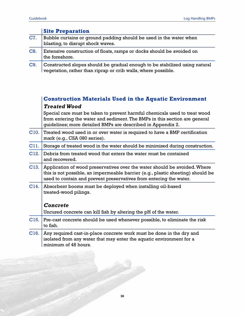
Guidebook Log Handling BMPs
38
Site PreparationC7. Bubble curtains or ground padding should be used in the water when
blasting, to disrupt shock waves.
C8. Extensive construction of floats, ramps or docks should be avoided on the foreshore.
C9. Constructed slopes should be gradual enough to be stabilized using naturalvegetation, rather than riprap or crib walls, where possible.
Construction Materials Used in the Aquatic EnvironmentTreated Wood Special care must be taken to prevent harmful chemicals used to treat woodfrom entering the water and sediment. The BMPs in this section are generalguidelines; more detailed BMPs are described in Appendix 2.
C10. Treated wood used in or over water is required to have a BMP certificationmark (e.g., CSA 080 series).
C11. Storage of treated wood in the water should be minimized during construction.
C12. Debris from treated wood that enters the water must be contained and recovered.
C13. Application of wood preservatives over the water should be avoided.Wherethis is not possible, an impermeable barrier (e.g., plastic sheeting) should beused to contain and prevent preservatives from entering the water.
C14. Absorbent booms must be deployed when installing oil-based treated-wood pilings.
Concrete Uncured concrete can kill fish by altering the pH of the water.
C15. Pre-cast concrete should be used whenever possible, to eliminate the risk to fish.
C16. Any required cast-in-place concrete work must be done in the dry and isolated from any water that may enter the aquatic environment for a minimum of 48 hours.
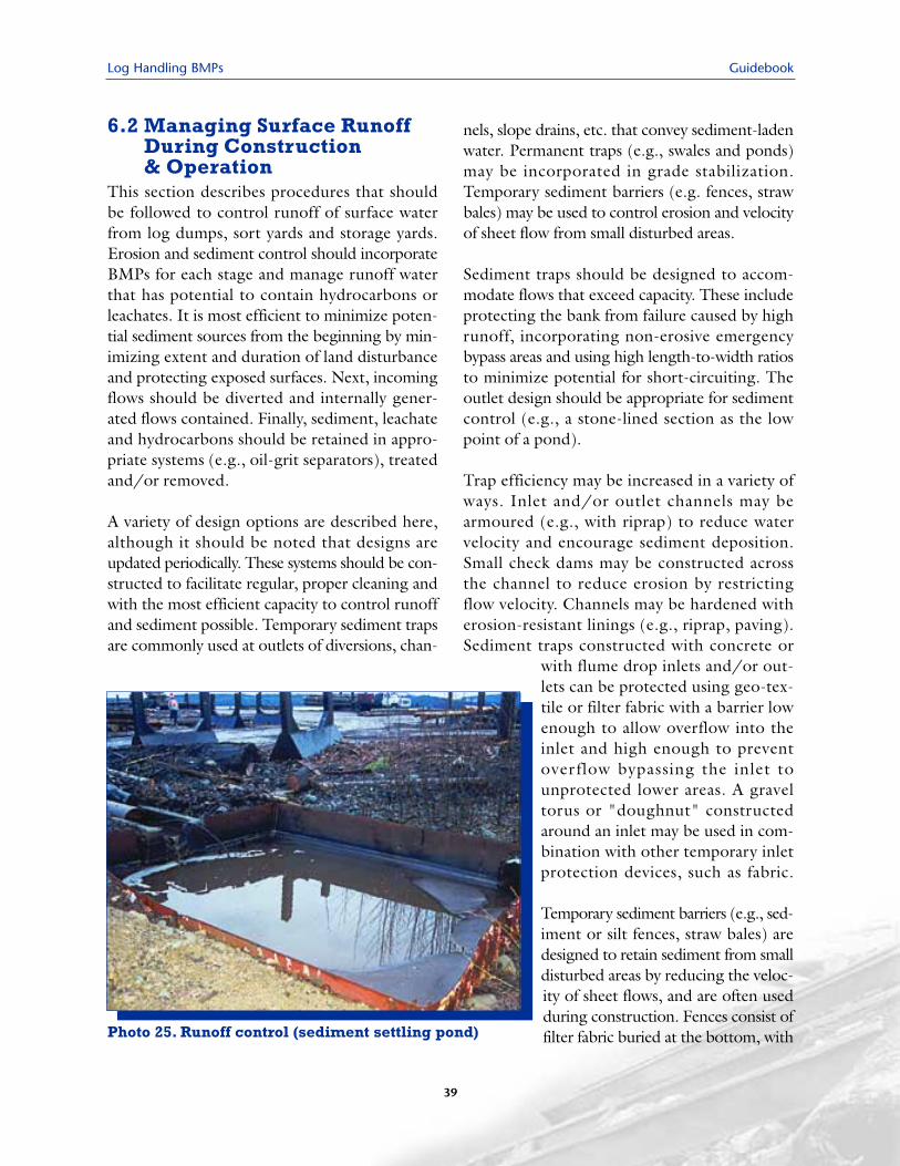
Log Handling BMPs Guidebook
39
6.2 Managing Surface RunoffDuring Construction & Operation
This section describes procedures that shouldbe followed to control runoff of surface waterfrom log dumps, sort yards and storage yards.Erosion and sediment control should incorporateBMPs for each stage and manage runoff waterthat has potential to contain hydrocarbons orleachates. It is most efficient to minimize poten-tial sediment sources from the beginning by min-imizing extent and duration of land disturbanceand protecting exposed surfaces. Next, incomingflows should be diverted and internally gener-ated flows contained. Finally, sediment, leachateand hydrocarbons should be retained in appro-priate systems (e.g., oil-grit separators), treatedand/or removed.
A variety of design options are described here,although it should be noted that designs areupdated periodically. These systems should be con-structed to facilitate regular, proper cleaning andwith the most efficient capacity to control runoffand sediment possible. Temporary sediment trapsare commonly used at outlets of diversions, chan-
nels, slope drains, etc. that convey sediment-ladenwater. Permanent traps (e.g., swales and ponds)may be incorporated in grade stabilization.Temporary sediment barriers (e.g. fences, strawbales) may be used to control erosion and velocityof sheet flow from small disturbed areas.
Sediment traps should be designed to accom-modate flows that exceed capacity. These includeprotecting the bank from failure caused by highrunoff, incorporating non-erosive emergencybypass areas and using high length-to-width ratiosto minimize potential for short-circuiting. Theoutlet design should be appropriate for sedimentcontrol (e.g., a stone-lined section as the lowpoint of a pond).
Trap efficiency may be increased in a variety ofways. Inlet and/or outlet channels may bearmoured (e.g., with riprap) to reduce watervelocity and encourage sediment deposition.Small check dams may be constructed acrossthe channel to reduce erosion by restrictingflow velocity. Channels may be hardened witherosion-resistant linings (e.g., riprap, paving).Sediment traps constructed with concrete or
with flume drop inlets and/or out-lets can be protected using geo-tex-tile or filter fabric with a barrier lowenough to allow overflow into theinlet and high enough to preventover flow bypassing the inlet tounprotected lower areas. A graveltorus or "doughnut" constructedaround an inlet may be used in com-bination with other temporary inletprotection devices, such as fabric.
Temporary sediment barriers (e.g., sed-iment or silt fences, straw bales) aredesigned to retain sediment from smalldisturbed areas by reducing the veloc-ity of sheet flows, and are often usedduring construction. Fences consist offilter fabric buried at the bottom, withPhoto 25. Runoff control (sediment settling pond)
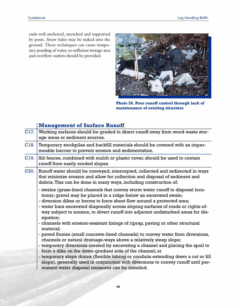
Guidebook Log Handling BMPs
40
ends well-anchored, stretched and supportedby posts. Straw bales may be staked into theground. These techniques can cause tempo-rary ponding of water, so sufficient storage areaand overflow outlets should be provided.
Photo 26. Poor runoff control through lack ofmaintenance of existing structure
Management of Surface RunoffC17. Working surfaces should be graded to direct runoff away from wood waste stor-
age areas or sediment sources.
C18. Temporary stockpiles and backfill materials should be covered with an imper-meable barrier to prevent erosion and sedimentation.
C19. Silt fences, combined with mulch or plastic cover, should be used to containrunoff from easily eroded slopes.
C20. Runoff water should be conveyed, intercepted, collected and redirected in waysthat minimize erosion and allow for collection and disposal of sediment anddebris. This can be done in many ways, including construction of:
- swales (grass-lined channels that convey storm water runoff to disposal loca-tions); gravel may be placed in a ridge below an excavated swale;
- diversion dikes or berms to force sheet flow around a protected area;- water bars excavated diagonally across sloping surfaces of roads or rights-of-
way subject to erosion, to divert runoff into adjacent undisturbed areas for dis-sipation;
- channels with erosion-resistant linings of riprap, paving or other structuralmaterial;
- paved flumes (small concrete-lined channels) to convey water from diversions,channels or natural drainage-ways above a relatively steep slope;
- temporary diversions created by excavating a channel and placing the spoil toform a dike on the down-gradient side of the channel; or
- temporary slope drains (flexible tubing or conduits extending down a cut or fillslope), generally used in conjunction with diversions to convey runoff until per-manent water disposal measures can be installed.
Log Handling BMPs Guidebook
41
Sediment Containment & ManagementC21. Sediment should be contained during construction; structures should facili-
tate proper clean out on a regular basis. Several design options are available:
- sediment traps (small, temporary ponding basins formed by an embank-ment or excavation to capture sediment from runoff); most commonly usedat outlets of diversions, channels, slope drains or other runoff conveyances;
- permanent swales, ponds, wetlands or lakes included as part of a grade sta-bilization system; or,
- temporary barriers (e.g., sediment fences, silt fences, straw bale barriers).
The most appropriate means of improving sediment control efficiency shouldbe employed (e.g., armouring of inlet and/or outlet channels, construction ofsmall check dams across a drainage, hardening of the channel, protection ofconcrete traps inlets and outlets with geo-textile or filter fabric, constructionof gravel torus around an inlet).
Release of Runoff Water to Receiving EnvironmentC22. Where water is directed out of a containment or diversion structure, outlets
should be protected by installing:
- level spreaders (outlets designed to convert concentrated runoff to sheetflow and disperse it uniformly across a slope without causing erosion);
- riprap-lined aprons (relatively low in cost and easy to install); or
- riprap-lined basins or plunge pools (where there are drops or waterfalls at theend of the pipe or where high flows would require excessive apron length).
An oil/water separator should be installed in the outlet from a sediment pondthat receives surface drainage with potential to contain oily water (e.g., sort,fuelling or equipment servicing areas). A simple baffled box structure maybe used and it should be large enough to handle expected water flows, prop-erly maintained and frequently cleaned.
Surfacing of Dryland Sort FacilitiesC23. Dry land sorts should be surfaced with an appropriate material that allows
for effective and regular removal of wood waste. For high-volume facilities,consideration should be given to paving the site.
C24. Paved yards must be sloped toward collection ditches that lead to appro-priate sediment and oil/water separators prior to water discharge.
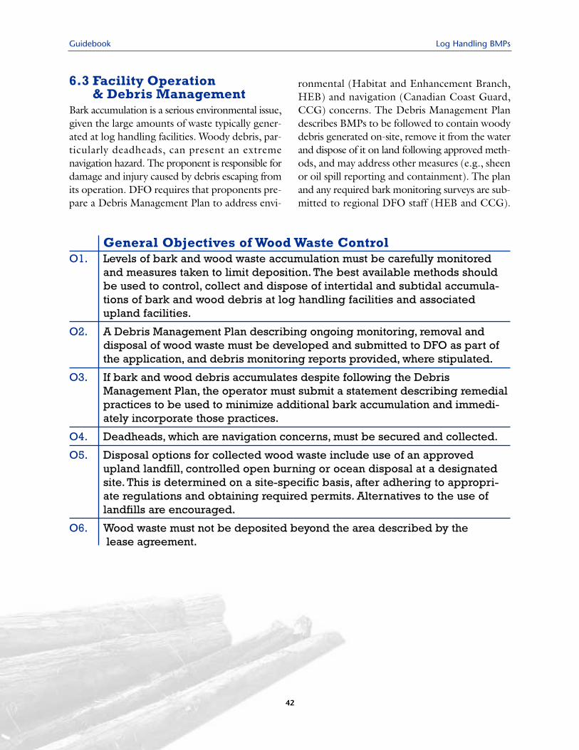
Guidebook Log Handling BMPs
42
6.3 Facility Operation & Debris Management
Bark accumulation is a serious environmental issue,given the large amounts of waste typically gener-ated at log handling facilities. Woody debris, par-ticularly deadheads, can present an extremenavigation hazard. The proponent is responsible fordamage and injury caused by debris escaping fromits operation. DFO requires that proponents pre-pare a Debris Management Plan to address envi-
ronmental (Habitat and Enhancement Branch,HEB) and navigation (Canadian Coast Guard,CCG) concerns. The Debris Management Plandescribes BMPs to be followed to contain woodydebris generated on-site, remove it from the waterand dispose of it on land following approved meth-ods, and may address other measures (e.g., sheenor oil spill reporting and containment). The planand any required bark monitoring surveys are sub-mitted to regional DFO staff (HEB and CCG).
General Objectives of Wood Waste Control O1. Levels of bark and wood waste accumulation must be carefully monitored
and measures taken to limit deposition. The best available methods shouldbe used to control, collect and dispose of intertidal and subtidal accumula-tions of bark and wood debris at log handling facilities and associatedupland facilities.
O2. A Debris Management Plan describing ongoing monitoring, removal and disposal of wood waste must be developed and submitted to DFO as part ofthe application, and debris monitoring reports provided, where stipulated.
O3. If bark and wood debris accumulates despite following the DebrisManagement Plan, the operator must submit a statement describing remedialpractices to be used to minimize additional bark accumulation and immedi-ately incorporate those practices.
O4. Deadheads, which are navigation concerns, must be secured and collected.
O5. Disposal options for collected wood waste include use of an approvedupland landfill, controlled open burning or ocean disposal at a designatedsite. This is determined on a site-specific basis, after adhering to appropri-ate regulations and obtaining required permits. Alternatives to the use oflandfills are encouraged.
O6. Wood waste must not be deposited beyond the area described by thelease agreement.
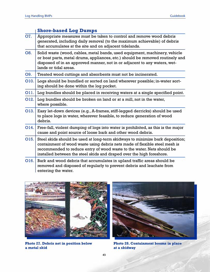
Log Handling BMPs Guidebook
43
Shore-based Log DumpsO7. Appropriate measures must be taken to control and remove wood debris
generated, including daily removal (to the maximum achievable) of debristhat accumulates at the site and on adjacent tidelands.
O8. Solid waste (wood, cables, metal bands, used equipment, machinery, vehicleor boat parts, metal drums, appliances, etc.) should be removed routinely anddisposed of in an approved manner, not in or adjacent to any waters, wet-lands or tidal areas.
O9. Treated wood cuttings and absorbents must not be incinerated.
O10. Logs should be bundled or sorted on land wherever possible; in-water sort-ing should be done within the log pocket.
O11. Log bundles should be placed in receiving waters at a single specified point.
O12. Log bundles should be broken on land or at a mill, not in the water,where possible.
O13. Easy let-down devices (e.g., A-frames, stiff-legged derricks) should be usedto place logs in water, wherever feasible, to reduce generation of wooddebris.
O14. Free-fall, violent dumping of logs into water is prohibited, as this is the majorcause and point source of loose bark and other wood debris.
O15. Steel skids should be used at long-term skidways to minimize bark deposition;containment of wood waste using debris nets made of flexible steel mesh isrecommended to reduce entry of wood waste to the water. Nets should beinstalled between the steel skids and draped over the high foreshore.
O16. Bark and wood debris that accumulates in upland traffic areas should beremoved and disposed of regularly to prevent debris and leachate fromentering the water.
Photo 27. Debris net in position belowa metal skid
Photo 28. Containment booms in placeat a skidway
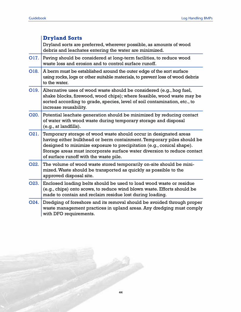
Guidebook Log Handling BMPs
44
Dryland SortsDryland sorts are preferred, wherever possible, as amounts of wooddebris and leachates entering the water are minimized.
O17. Paving should be considered at long-term facilities, to reduce woodwaste loss and erosion and to control surface runoff.
O18. A berm must be established around the outer edge of the sort surface using rocks, logs or other suitable materials, to prevent loss of wood debristo the water.
O19. Alternative uses of wood waste should be considered (e.g., hog fuel,shake blocks, firewood, wood chips); where feasible, wood waste may besorted according to grade, species, level of soil contamination, etc., toincrease reusability.
O20. Potential leachate generation should be minimized by reducing contactof water with wood waste during temporary storage and disposal (e.g., at landfills).
O21. Temporary storage of wood waste should occur in designated areas having either bulkhead or berm containment. Temporary piles should bedesigned to minimize exposure to precipitation (e.g., conical shape).Storage areas must incorporate surface water diversion to reduce contactof surface runoff with the waste pile.
O22. The volume of wood waste stored temporarily on-site should be mini-mized.Waste should be transported as quickly as possible to theapproved disposal site.
O23. Enclosed loading belts should be used to load wood waste or residue(e.g., chips) onto scows, to reduce wind blown waste. Efforts should bemade to contain and reclaim residue lost during loading.
O24. Dredging of foreshore and its removal should be avoided through properwaste management practices in upland areas. Any dredging must complywith DFO requirements.
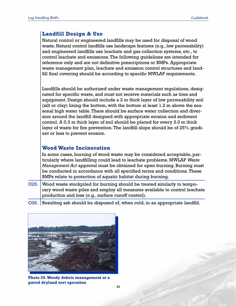
Log Handling BMPs Guidebook
Landfill Design & UseNatural control or engineered landfills may be used for disposal of woodwaste. Natural control landfills use landscape features (e.g., low permeability)and engineered landfills use leachate and gas collection systems, etc., tocontrol leachate and emissions. The following guidelines are intended forreference only and are not definitive prescriptions or BMPs. Appropriatewaste management plan, leachate and emission control structures and land-fill final covering should be according to specific MWLAP requirements.
Landfills should be authorized under waste management regulations, desig-nated for specific waste, and must not receive materials such as tires andequipment. Design should include a 2 m thick layer of low permeability soil(silt or clay) lining the bottom, with the bottom at least 1.2 m above the sea-sonal high water table. There should be surface water collection and diver-sion around the landfill designed with appropriate erosion and sedimentcontrol. A 0.3 m thick layer of soil should be placed for every 3.0 m thicklayer of waste for fire prevention. The landfill slope should be of 25% gradi-ent or less to prevent erosion.
Wood Waste Incineration In some cases, burning of wood waste may be considered acceptable, par-ticularly where landfilling could lead to leachate problems. MWLAP WasteManagement Act approval must be obtained for open burning. Burning mustbe conducted in accordance with all specified terms and conditions. TheseBMPs relate to protection of aquatic habitat during burning.
O25. Wood waste stockpiled for burning should be treated similarly to tempo-rary wood waste piles and employ all measures available to control leachateproduction and loss (e.g., surface runoff control).
O26. Resulting ash should be disposed of, when cold, in an appropriate landfill.
Photo 29.Woody debris management at apaved dryland sort operation
45
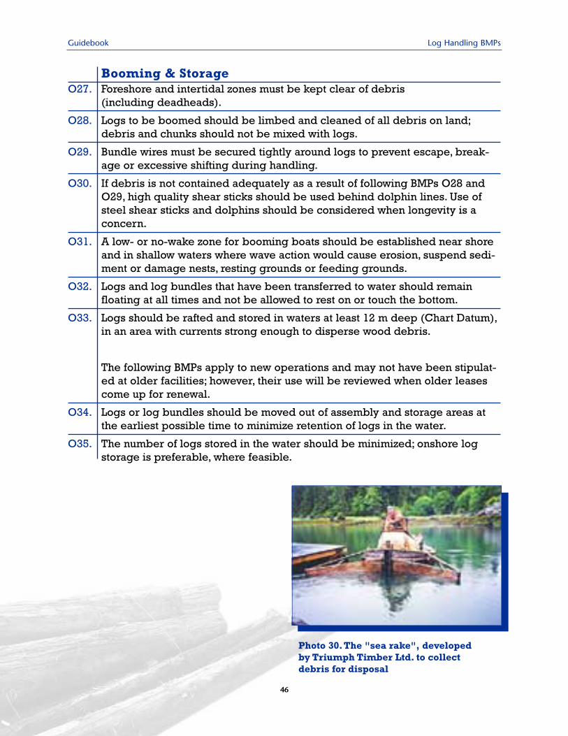
Guidebook Log Handling BMPs
Booming & StorageO27. Foreshore and intertidal zones must be kept clear of debris
(including deadheads).
O28. Logs to be boomed should be limbed and cleaned of all debris on land;debris and chunks should not be mixed with logs.
O29. Bundle wires must be secured tightly around logs to prevent escape, break-age or excessive shifting during handling.
O30. If debris is not contained adequately as a result of following BMPs O28 andO29, high quality shear sticks should be used behind dolphin lines. Use ofsteel shear sticks and dolphins should be considered when longevity is aconcern.
O31. A low- or no-wake zone for booming boats should be established near shoreand in shallow waters where wave action would cause erosion, suspend sedi-ment or damage nests, resting grounds or feeding grounds.
O32. Logs and log bundles that have been transferred to water should remainfloating at all times and not be allowed to rest on or touch the bottom.
O33. Logs should be rafted and stored in waters at least 12 m deep (Chart Datum),in an area with currents strong enough to disperse wood debris.
The following BMPs apply to new operations and may not have been stipulat-ed at older facilities; however, their use will be reviewed when older leasescome up for renewal.
O34. Logs or log bundles should be moved out of assembly and storage areas atthe earliest possible time to minimize retention of logs in the water.
O35. The number of logs stored in the water should be minimized; onshore logstorage is preferable, where feasible.
Photo 30. The "sea rake", developedby Triumph Timber Ltd. to collectdebris for disposal
46
Log Handling BMPs Guidebook
47
Barging & TowingO36. High-quality, high-floating (low-density) boomsticks must be used and should
be inspected regularly, particularly in areas where marine burrowers can befound; headsticks and tailsticks must be appropriate for towing.
O37. Booms should be inspected before towing and, if necessary, repaired to meetapplicable standards.
O38. Booms should be constructed securely to prevent breakage and loss of logsand debris, using durable materials (e.g., steel bands, recycled bundlingstrand). Debris should be prevented from escaping when booms are beingbroken down or restrung.Where feasible, transport of bundled logs shouldbe considered, as this results in less potential for wood waste generation andloss of logs than does transport of individual logs.
O39. Towline lengths should be adjusted to prevent tug propeller wash from rins-ing debris out of booms.
O40. Barges should be loaded and unloaded in ways that do not break or damagelogs within bundles or create debris that can be deposited on the bargedeck. Unloading speeds should be low enough to prevent log breakage.Wood debris should be collected and properly disposed of on land.
O41. High-quality, high-floating, double-wide catch sticks should be used to con-tain all debris when dumping barges, and debris collected and properly dis-posed of on land.
O42. Barges and scows should be inspected and, if necessary, repaired to preventchips, hog fuel or sawdust being lost during loading or towing.
Helicopter Log DropsO43. Crews must be briefed on the Debris Management Plan before operation start-
up. A support vessel and crew must be on standby to frequently monitor thestorage area for escaped debris between helicopter turns and collect debris.
O44. Logs should be limbed on land as much as practical, before being transferredto water, and any debris disposed of on land.
O45. Log should be bundled on land, not in water, where practical.
O46. Log bundles should be placed in the water at one specified point, marked withappropriate buoys. Drop zones must be located in waters at least 20 m deep(Chart Datum). Slower drop speeds and similar or greater depths should be usedin fresh water, given the different buoyancy of wood in salt and fresh water.
O47. Double containment sticks should be used in log storage areas to control debris.
O48. Consideration should be made of marine mammals that may be present in thearea, notably humpback and grey whales. Between May 15 and Dec. 1, a crewmember should watch for whales and monitor their behaviour.Work should betemporarily stopped if whales approach to within 300 m of a helicopter flightpath or if marked changes in whale behaviour are exhibited.
Guidebook Log Handling BMPs
48
6.4 Navigation & VesselMaintenance Considerations
Helicopter log dumps and booming, barging andtowing activities pose a significant navigation hazard.The proponent is responsible for ensuring approvalshave been obtained under the Navigable WatersProtection Act (NWPA) and that existing worksconform with approved plans. Any questions shouldbe directed to the NWPA Officer for the region,who will review alterations or additions to the plan.
All vessels used in log handing operations mustmeet requirements of the Canada Shipping Act forvessel size, tonnage and horsepower. Vessels shouldbe regularly maintained and checked for prob-lems, particularly as they relate to release of fuelslicks and contaminated bilge water, which areconsidered deleterious substances under theFisheries Act.
Navigation & NWPA RegulationsO49. Notice to Shipping must be issued prior to operation of helicopter log
dumps. Given that mariners may not be aware of the temporary operation,all efforts must be made to mark the work site.
O50. All buoys must conform with Private Buoy Regulations (i.e., orange and whitebuoys for mooring barges and vessels, yellow buoys for attaching booms toanchor lines, yellow radar- and light-reflective marker buoys for helicopterdrop zones).
O51. The outside perimeter of booming grounds should conform to approved plansand be marked with radar- and light-reflective marker buoys (steel, 0.6 m indiameter or larger, painted and maintained as per Private Buoy Regulations).
Vessel MaintenanceO52. Free water should not be allowed to accumulate in bilges.
O53. Proper confined-space entry procedures should be followed before carryingout maintenance.
O54. Barges should be checked for leaks and holes in the deck, which can lead todown-flooding.
O55. Barges used as equipment ferries should be equipped with an oil spill kit.
O56. Boom boats should be inspected regularly for leakage and water buildupwhile in the water (at least every two days, more frequently in wet weather).They should be equipped with two automatic bilge pumps wired to separatefloat assemblies.
O57. Boom boats should be removed from the water during periods of inactivity toreduce problems associated with accidental sinking and release of fuel slicks.
Log Handling BMPs Guidebook
49
6.5 Control of Hydrocarbons,Liquid Wastes & OtherResidues
It is essential to know and comply with all regu-lations governing storage, handling and use ofsubstances that can be deleterious to fish and fishhabitat, including wood preservatives, paints, fuel,lubricants and fertilizers. Wood preservatives con-taining creosote, chlorophenols, zinc or copperare extremely toxic to fish and should not be usedwhere they can enter the aquatic environment. Itis particularly important to employ BMPs relatedto control of hydrocarbons and other residues,
given their persistence in the environment andtendency to bioaccumulate in animal tissues.
The Canadian Coast Guard is the lead agencyfor all spills into the marine environment (andother navigable waters) from ships, oil handlingfacilities during transfer operations, and unknownsources. CCG works in conjunction withEnvironment Canada and the ProvincialEmergency Program to ensure communicationand response to reported spills. MWLAP(Provincial Emergency Program) is the leadagency for spills into the freshwater environment.
Handling of Hazardous SubstancesSpill Response
O58. ALL SPILLS INTO THE MARINE ENVIRONMENT MUST BE REPORTED TO THECANADIAN COAST GUARD IMMEDIATELY. ALL SPILLS INTO FRESHWATERMUST BE REPORTED TO THE PROVINCIAL EMERGENCY PROGRAM IMMEDI-ATELY.
O59. Every fuel handling facility must have an up-to-date Spill Response Kit andSpill Response Plan. Site-specific spill cleanup equipment must be on-site and properly maintained and staff must be trained in its proper use.
O60. Site workers should be informed on proper disposal for all materials and apermitted waste handler contracted to remove wastes.
O61. An accurate, up-to-date inventory of all stored materials should be kept, toenable cleanup crews and fire fighters to anticipate potentially hazardouscombinations.
O62. Discharges must not violate the BC Waste Management Act, federal Water Actor Canadian Environmental Protection Act, 1999.
Guidebook Log Handling BMPs
50
Preventative PracticesO63. Log handling equipment should be operated and maintained in ways that
minimize the risk of petroleum and lubricating products entering waters.
O64. Volatile compounds from newly installed creosote piles near sensitive habitatareas and poorly circulated areas must be contained and absorbed.
O65. No bark, wood debris, scum, floating solids, oily or greasy wastes and hydrocarbons, foam, or other residues should be discharged that alone,or in combination with other substances, causes:
- receiving waters to be unfit or unsafe for use in water supply, recreation,growth and propagation of finfish, shellfish, other aquatic life and terrestrial wildlife, or the harvesting and consumption of raw mollusks or other aquatic life;
- discolouration, film or sheen on the water surface, bottom substrate oradjoining shoreline;
- leaching of toxic or deleterious substances; or
- a sludge, solid, or emulsion to be deposited upon the surface of the water,within the water column, on the bottom or on adjoining shorelines.
O66. Fueling equipment should have automatic shutoff nozzles to reduce spillagewhen fueling.
O67. Impervious pavement, berms, curbs or other means of spill containmentshould be provided, and connected to spill collection sumps for fuel and storage tank areas.
Containment & Storage O68. Storage tank containment areas should be elevated and provided with a roof
to prevent storm runoff from spilling over the berm and overwhelming thecollection sumps.
O69. Underground storage tanks should not be used as they eventually corrodeand leak, causing extensive ground and water pollution that is very costly toclean up.
O70. Labeled, unbreakable, double-walled, inert storage containers with sealedlids should be used. Secondary containment should be used for large quantities. Fluid storage containers should be equipped with level ndicators to prevent overfilling and spillage.
O71. Dykes or berms capable of holding 25% of the total stored fluids or 110% ofthe largest container should be installed to contain spills; in general, severalsmaller tanks are more economical and safer than one large container.
O72. Fuels and other highly flammable fluids should be stored in a separate area,and in a manner that complies with local fire department regulations.
Log Handling BMPs Guidebook
51
Disposal O73. Separate containers should be provided for disposal of waste oil, gasoline,
antifreeze, diesel, kerosene and mineral spirits. Containers should be clearlylabeled and colour coded or of different designs. Containers should be storedon an impervious surface and properly covered against weather in fire-resist-ant enclosures or fenced secure areas. Containers should not be stacked.
O74. Liquid waste storage tanks should be equipped with overfill protectiondevices and situated in 110% capacity containment trays.
O75. Drip pans and open containers should be emptied and cleaned promptly.
O76. Oil filters should be drained before recycling.
O77. Wastewater from an on-site oil/water separator should not be discharged tosewers or to ground unless it is demonstrated to contain less than 15 mg/L of oil.
O78. Waste liquids should not be discharged down floor, sink or storm drains.
O79. Storm water should be drained though a siphon from uncovered waste storage areas enclosed by berms.
O80. Waste oil recycling tanks should be pumped out regularly to ensure ample capacity.
O81. Valves and hose connections should be properly maintained to prevent leaks;hydraulic hoses with coupled ends should be stored in leak-proof containers.
Worker FacilitiesO82. Care should be taken to ensure that sewage disposal is adequate to prevent
contamination of nearby waters. Land disposal of sewage is preferred,e.g., pit privy, chemical/incinerator toilets, holding tanks (48-hour retentiontime) or septic tank and tile field located well away from the foreshore.
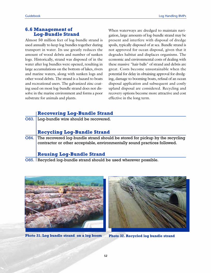
Guidebook Log Handling BMPs
52
6.6 Management of Log-Bundle Strand
Almost 50 million feet of log-bundle strand isused annually to keep log bundles together duringtransport in water. Its use greatly reduces theamount of wood debris and number of sunkenlogs. Historically, strand was disposed of in thewater after log bundles were opened, resulting inlarge accumulations on the bottom of lakes, riversand marine waters, along with sunken logs andother wood debris. The strand is a hazard to boatsand recreational users. The galvanized zinc coat-ing used on most log-bundle strand does not dis-solve in the marine environment and forms a poorsubstrate for animals and plants.
When waterways are dredged to maintain navi-gation, large amounts of log-bundle strand may bepresent and interfere with disposal of dredgespoils, typically disposed of at sea. Bundle strand isnot approved for ocean disposal, given that itdegrades habitat and displaces organisms. Theeconomic and environmental costs of dealing withthese massive "hair-balls" of strand and debris aregreat. Costs become unsustainable when thepotential for delay in obtaining approval for dredg-ing, damage to booming boats, refusal of an oceandisposal application and subsequent and costlyupland disposal are considered. Recycling andrecovery options become more attractive and costeffective in the long term.
Recovering Log-Bundle StrandO83. Log-bundle wire should be recovered.
Recycling Log-Bundle StrandO84. The recovered log-bundle strand should be stored for pickup by the recycling
contractor or other acceptable, environmentally sound practices followed.
Reusing Log-Bundle StrandO85. Recycled log-bundle strand should be used wherever possible.
Photo 31. Log bundle strand on a log boom Photo 32. Recycled log bundle strand
Log Handling BMPs Guidebook
53
Site deactivation requirements are set by DFO,EC, MWLAP and other agencies associated withthe referral process, and are outlined in LWBClease agreements. Deactivation and decommis-sioning procedures are site-specific and usually havethe goal of returning an area to a pre-existing stateor to conditions closely resembling those of adjacentnatural areas. Sources of BMPs listed in this sec-tion include Hutton and Samis (2000), Warrington(2000) and Environment Canada (undated).
Numbered statements refer to specific BMPs, withthe "D" code referring to site deactivation andremediation.
7.1 Decommissioning FacilitiesIf and when an operator desires to close, abandonor decommission an authorized facility (unlesstransferring interests to a third party), the NavigableWaters Protection Division of CCG must be advisedand the area restored to a satisfactory condition,as defined in the lease. All works, including anchorsand piles, must be removed from the water. Theproponent is liable for any damage or injuries causedby remaining works. A separate review is required ifthe proponent desires to leave works in the water.Use of logs to mark anchors is not acceptable. Aremoval order will be issued for any works remain-ing in the water and the Crown will recover fromthe owner all costs associated with removal.
7.0 Site Deactivation & Remediation
Decommissioning FacilitiesD1. All woody debris and demolition materials must be disposed of or reused in
an appropriate manner and in accordance with applicable provincial andmunicipal laws and policies.
D2. When removing a whole pile, a slow, steady pull should be used to minimizesubstrate disturbance and avoid bringing contaminated sediments to the sur-face. If the pile breaks off below the biologically active sediment zone, noattempt should be made to extract the buried portion, as impacts from dredg-ing may outweigh any benefit from removing a minor source of polycyclicaromatic hydrocarbons (PAH).
D3. When cutting off a pile, it should be cut off at or near the substrate level withan underwater saw. This prevents release of contaminated sediments, elimi-nates the hazard associated with broken off piles and retains existing sub-strate features (e.g., gravel bars in channels).
D4. Proper silt control measures must be applied when deactivating roads in theupland area of the operation.
D5. When decommissioning log dumps, the skidway must be removed from thesite.
D6. When deactivating log booming and storage operations, all boomsticks usedto contain logs stored in the water must be removed.
D7. Logs lining the drop pocket at helicopter drop zones must be removed.
D8. All anchors, cables, buoys and dolphins must be removed.
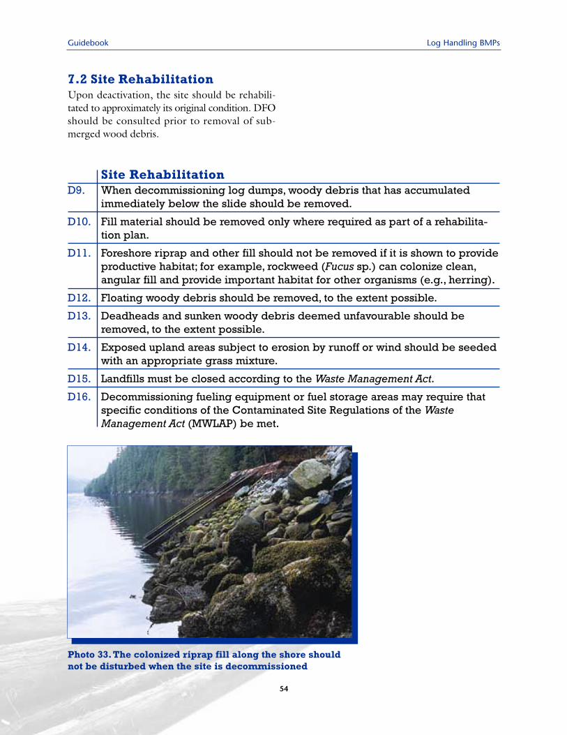
Guidebook Log Handling BMPs
7.2 Site RehabilitationUpon deactivation, the site should be rehabili-tated to approximately its original condition. DFOshould be consulted prior to removal of sub-merged wood debris.
Site RehabilitationD9. When decommissioning log dumps, woody debris that has accumulated
immediately below the slide should be removed.
D10. Fill material should be removed only where required as part of a rehabilita-tion plan.
D11. Foreshore riprap and other fill should not be removed if it is shown to provideproductive habitat; for example, rockweed (Fucus sp.) can colonize clean,angular fill and provide important habitat for other organisms (e.g., herring).
D12. Floating woody debris should be removed, to the extent possible.
D13. Deadheads and sunken woody debris deemed unfavourable should beremoved, to the extent possible.
D14. Exposed upland areas subject to erosion by runoff or wind should be seededwith an appropriate grass mixture.
D15. Landfills must be closed according to the Waste Management Act.
D16. Decommissioning fueling equipment or fuel storage areas may require thatspecific conditions of the Contaminated Site Regulations of the WasteManagement Act (MWLAP) be met.
Photo 33. The colonized riprap fill along the shore shouldnot be disturbed when the site is decommissioned
54
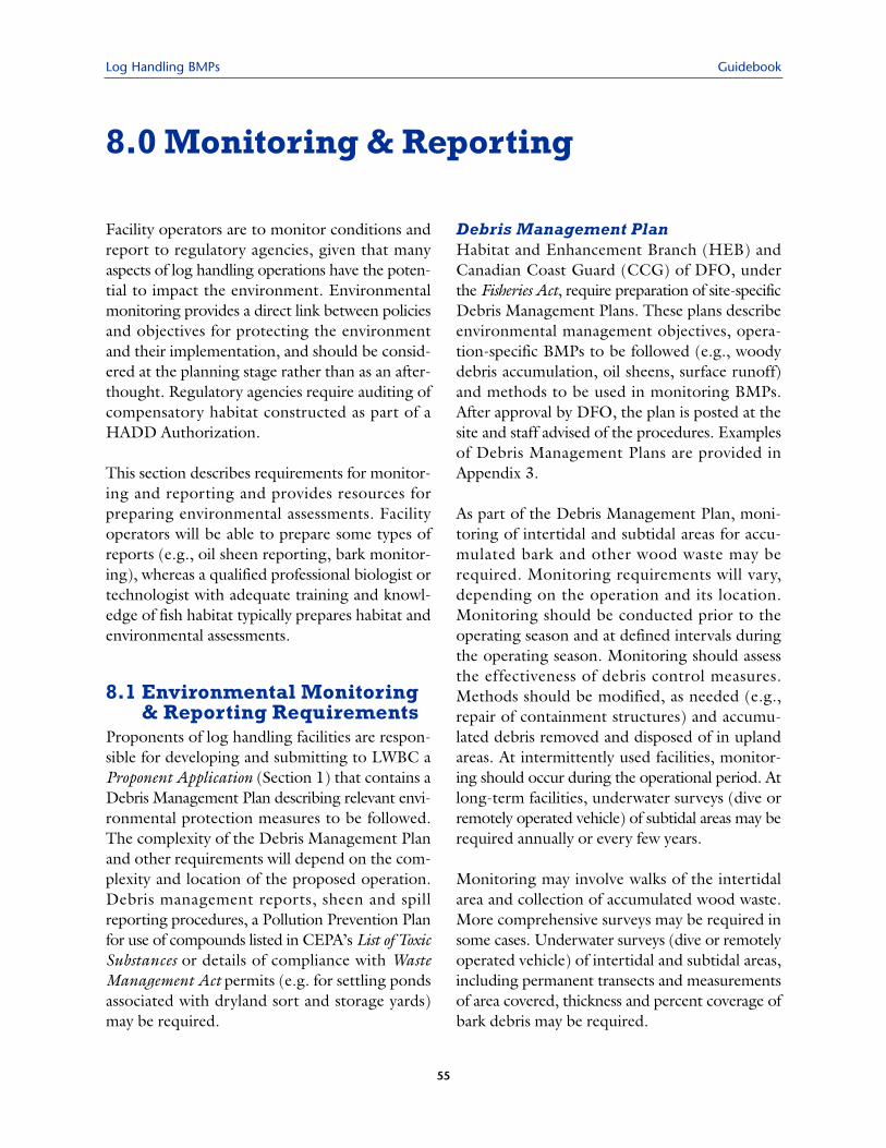
Log Handling BMPs Guidebook
55
Facility operators are to monitor conditions andreport to regulatory agencies, given that manyaspects of log handling operations have the poten-tial to impact the environment. Environmentalmonitoring provides a direct link between policiesand objectives for protecting the environmentand their implementation, and should be consid-ered at the planning stage rather than as an after-thought. Regulatory agencies require auditing ofcompensatory habitat constructed as part of aHADD Authorization.
This section describes requirements for monitor-ing and reporting and provides resources forpreparing environmental assessments. Facilityoperators will be able to prepare some types ofreports (e.g., oil sheen reporting, bark monitor-ing), whereas a qualified professional biologist ortechnologist with adequate training and knowl-edge of fish habitat typically prepares habitat andenvironmental assessments.
8.1 Environmental Monitoring& Reporting Requirements
Proponents of log handling facilities are respon-sible for developing and submitting to LWBC aProponent Application (Section 1) that contains aDebris Management Plan describing relevant envi-ronmental protection measures to be followed.The complexity of the Debris Management Planand other requirements will depend on the com-plexity and location of the proposed operation.Debris management reports, sheen and spillreporting procedures, a Pollution Prevention Planfor use of compounds listed in CEPA’s List of ToxicSubstances or details of compliance with WasteManagement Act permits (e.g. for settling pondsassociated with dryland sort and storage yards)may be required.
Debris Management PlanHabitat and Enhancement Branch (HEB) andCanadian Coast Guard (CCG) of DFO, underthe Fisheries Act, require preparation of site-specificDebris Management Plans. These plans describeenvironmental management objectives, opera-tion-specific BMPs to be followed (e.g., woodydebris accumulation, oil sheens, surface runoff)and methods to be used in monitoring BMPs.After approval by DFO, the plan is posted at thesite and staff advised of the procedures. Examplesof Debris Management Plans are provided inAppendix 3.
As part of the Debris Management Plan, moni-toring of intertidal and subtidal areas for accu-mulated bark and other wood waste may berequired. Monitoring requirements will vary,depending on the operation and its location.Monitoring should be conducted prior to theoperating season and at defined intervals duringthe operating season. Monitoring should assessthe effectiveness of debris control measures.Methods should be modified, as needed (e.g.,repair of containment structures) and accumu-lated debris removed and disposed of in uplandareas. At intermittently used facilities, monitor-ing should occur during the operational period. Atlong-term facilities, underwater surveys (dive orremotely operated vehicle) of subtidal areas may berequired annually or every few years.
Monitoring may involve walks of the intertidalarea and collection of accumulated wood waste.More comprehensive surveys may be required insome cases. Underwater surveys (dive or remotelyoperated vehicle) of intertidal and subtidal areas,including permanent transects and measurementsof area covered, thickness and percent coverage ofbark debris may be required.
8.0 Monitoring & Reporting
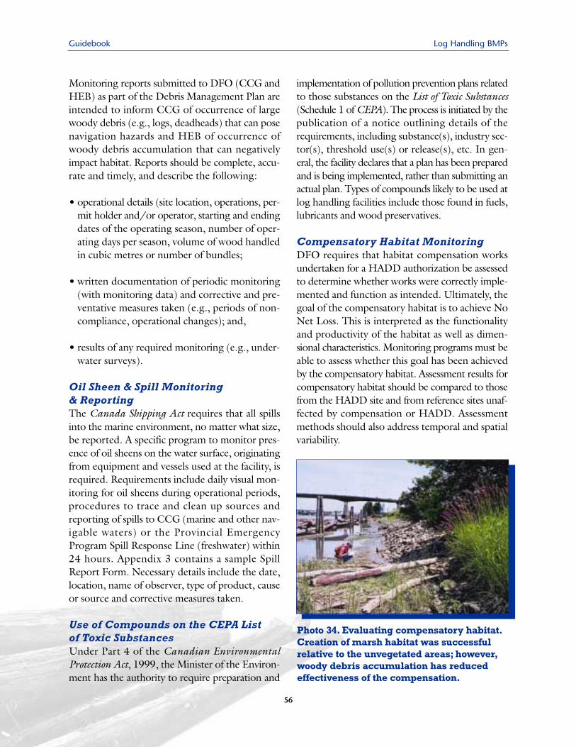
Guidebook Log Handling BMPs
Monitoring reports submitted to DFO (CCG andHEB) as part of the Debris Management Plan areintended to inform CCG of occurrence of largewoody debris (e.g., logs, deadheads) that can posenavigation hazards and HEB of occurrence ofwoody debris accumulation that can negativelyimpact habitat. Reports should be complete, accu-rate and timely, and describe the following:
• operational details (site location, operations, per-mit holder and/or operator, starting and endingdates of the operating season, number of oper-ating days per season, volume of wood handledin cubic metres or number of bundles;
• written documentation of periodic monitoring(with monitoring data) and corrective and pre-ventative measures taken (e.g., periods of non-compliance, operational changes); and,
• results of any required monitoring (e.g., under-water surveys).
Oil Sheen & Spill Monitoring & ReportingThe Canada Shipping Act requires that all spillsinto the marine environment, no matter what size,be reported. A specific program to monitor pres-ence of oil sheens on the water surface, originatingfrom equipment and vessels used at the facility, isrequired. Requirements include daily visual mon-itoring for oil sheens during operational periods,procedures to trace and clean up sources andreporting of spills to CCG (marine and other nav-igable waters) or the Provincial EmergencyProgram Spill Response Line (freshwater) within24 hours. Appendix 3 contains a sample SpillReport Form. Necessary details include the date,location, name of observer, type of product, causeor source and corrective measures taken.
Use of Compounds on the CEPA List of Toxic SubstancesUnder Part 4 of the Canadian EnvironmentalProtection Act, 1999, the Minister of the Environ-ment has the authority to require preparation and
implementation of pollution prevention plans relatedto those substances on the List of Toxic Substances(Schedule 1 of CEPA). The process is initiated by thepublication of a notice outlining details of therequirements, including substance(s), industry sec-tor(s), threshold use(s) or release(s), etc. In gen-eral, the facility declares that a plan has been preparedand is being implemented, rather than submitting anactual plan. Types of compounds likely to be used atlog handling facilities include those found in fuels,lubricants and wood preservatives.
Compensatory Habitat MonitoringDFO requires that habitat compensation worksundertaken for a HADD authorization be assessedto determine whether works were correctly imple-mented and function as intended. Ultimately, thegoal of the compensatory habitat is to achieve NoNet Loss. This is interpreted as the functionalityand productivity of the habitat as well as dimen-sional characteristics. Monitoring programs must beable to assess whether this goal has been achievedby the compensatory habitat. Assessment results forcompensatory habitat should be compared to thosefrom the HADD site and from reference sites unaf-fected by compensation or HADD. Assessmentmethods should also address temporal and spatialvariability.
Photo 34. Evaluating compensatory habitat.Creation of marsh habitat was successfulrelative to the unvegetated areas; however,woody debris accumulation has reducedeffectiveness of the compensation.
56
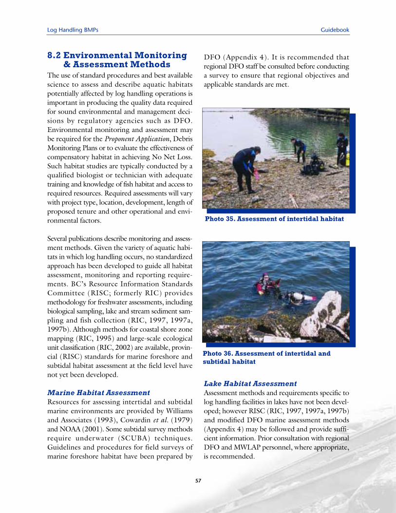
Log Handling BMPs Guidebook
57
8.2 Environmental Monitoring& Assessment Methods
The use of standard procedures and best availablescience to assess and describe aquatic habitatspotentially affected by log handling operations isimportant in producing the quality data requiredfor sound environmental and management deci-sions by regulatory agencies such as DFO.Environmental monitoring and assessment maybe required for the Proponent Application, DebrisMonitoring Plans or to evaluate the effectiveness ofcompensatory habitat in achieving No Net Loss.Such habitat studies are typically conducted by aqualified biologist or technician with adequatetraining and knowledge of fish habitat and access torequired resources. Required assessments will varywith project type, location, development, length ofproposed tenure and other operational and envi-ronmental factors.
Several publications describe monitoring and assess-ment methods. Given the variety of aquatic habi-tats in which log handling occurs, no standardizedapproach has been developed to guide all habitatassessment, monitoring and reporting require-ments. BC’s Resource Information StandardsCommittee (RISC; formerly RIC) providesmethodology for freshwater assessments, includingbiological sampling, lake and stream sediment sam-pling and fish collection (RIC, 1997, 1997a,1997b). Although methods for coastal shore zonemapping (RIC, 1995) and large-scale ecologicalunit classification (RIC, 2002) are available, provin-cial (RISC) standards for marine foreshore andsubtidal habitat assessment at the field level havenot yet been developed.
Marine Habitat Assessment Resources for assessing intertidal and subtidalmarine environments are provided by Williamsand Associates (1993), Cowardin et al. (1979)and NOAA (2001). Some subtidal survey methodsrequire underwater (SCUBA) techniques.Guidelines and procedures for field surveys ofmarine foreshore habitat have been prepared by
DFO (Appendix 4). It is recommended thatregional DFO staff be consulted before conductinga survey to ensure that regional objectives andapplicable standards are met.
Lake Habitat AssessmentAssessment methods and requirements specific tolog handling facilities in lakes have not been devel-oped; however RISC (RIC, 1997, 1997a, 1997b)and modified DFO marine assessment methods(Appendix 4) may be followed and provide suffi-cient information. Prior consultation with regionalDFO and MWLAP personnel, where appropriate,is recommended.
Photo 35. Assessment of intertidal habitat
Photo 36. Assessment of intertidal and subtidal habitat
Guidebook Log Handling BMPs
58
Stream Habitat AssessmentStandardized stream assessment methodology isavailable. Fish stream classification is requiredwhere a proposed project includes stream crossingsor development adjacent to a stream. If fish streamclassification information is not available for thestream, RISC or Forest Practices Code methodsdescribed in RIC (2001) and MELP and MOF(1998) should be followed. Riparian classificationand assessment is required where a project mayimpact riparian habitat, using methods described inMELP and MOF (1995). Stream crossings shouldbe installed in accordance to standards described inMOF (2002).
Additional Regulatory RequirementsConsultation with regional DFO personnel is rec-ommended to ensure compliance with regionalDFO habitat assessment and other regulatoryrequirements. Appropriate permits for fish collec-tion must be obtained from DFO and MWLAPprior to any required fish collection. For SCUBAsurveys, Workers Compensation Board (WCB) ofBC requires that divers conducting occupationaldiving in BC, including habitat assessments, meetWCB Occupational SCUBA Diving standards(WCB, 1998). Part 24 of the Occupational Healthand Safety Regulation (WCB, 1998) is particu-larly relevant. Works completed in and about astream often require approval from MWLAP pur-suant to Section 9 of the British Columbia WaterAct. It is recommended the proponent contactregional MWLAP personnel to determine require-ments for in-stream activities.
Log Handling BMPs Guidebook
59
9.0 LITERATURE SOURCESAdams, M.A. 2002. Shoreline structures environmental design: a guide for structures along estuar-
ies and large rivers. Fisheries and Oceans Canada, Vancouver BC and Environment Canada,Delta BC. 68 pp.
BCAL and MELP, 1999. Memorandum of Understanding between BC Assets and Land Corp.(BCAL) Vancouver Island Region and Ministry of Environment, Lands and Parks (MELP),Environment and Lands Division, Vancouver Island Region regarding BCAL land allocationand environmental stewardship activities within the Vancouver Island Region. Schedule IILog Handling and Storage. Nanaimo. 7 pp. + app.
British Columbia Nearshore Habitat Loss Work Group. 2001. A strategy to prevent coastal habitatloss and degradation in the Georgia Basin. 56 pp.
CFLA (Coast Forest and Lumber Association). 1997. Best management practices for debrismanagement for forestry operations on the Fraser River. Vancouver; 17 pp.
Conlan, K.E. 1977. The effects of wood deposition from a coastal log handling operation on thebenthos of a shallow sand bed in Saanich Inlet, British Columbia. M. Sc. thesis, University ofVictoria. Victoria, BC; 207 pp.
Conlan, K.E. and D.V. Ellis. 1979. Effects of wood waste on band-bed benthos. Mar. Poll. Bull.10:262–267.
Cowardin, L.M., V. Carter, F. Golet and E. LaRoe. 1979. Classification of wetlands and deepwaterhabitats of the United States. Prepared for US Department of the interior. Washington D.C.
DFO (Fisheries & Oceans Canada). 1986. The Department of Fisheries and Oceans policy for themanagement of fish habitat. Fish Habitat Management Branch. Ottawa; 28 pp.
DFO. 1998. Decision framework for the determination and authorization of harmful alteration, dis-ruption or destruction of fish habitat. Habitat Management Branch. Ottawa; 22 pp.
DFO and MELP (Ministry of Environment, Lands and Parks). 1995. Marina developmentguidelines for the protection of fish and fish habitat. Vancouver, BC; 66 pp.
Duval, W.S., ESL Environmental Sciences Ltd. and F.F. Slaney & Company Ltd. 1980. A review ofthe impacts of log handling on coastal marine environments and resources. Prepared for theEnvironmental Review Panel of the Council of Forest Industries/Government Estuary,Foreshore and Water Log Handling and Transportation Study. 224 pp.
Environment Canada. undated. Environment Canada guidelines for log storage and handling. 3 pp.
Guidebook Log Handling BMPs
60
Environment Canada and DFO, 1996. Fraser River Action Plan. Guidelines on storage, use and disposalof wood residue for the protection of fish and fish habitat in British Columbia. March. 28 pp.
FREMP (Fraser River Estuary Management Program). 1991. Log management in the Fraser Riverestuary. Report of the Log Management Activity Workgroup. Vancouver; 42 pp. + app.
FREMP. undated. Internet site viewed August 2001. http://www.bieapfremp.org/habitat_classifi-cation.htm; and ~/color_coding_class.htm
Hutton, K.E. and S.C. Samis. 2000. Guidelines to protect fish and fish habitat from treated wood usedin aquatic environments in the Pacific Region. Can. Tech. Rep. Fish. Aquat. Sci. 2314. 34 pp.
Kendall, D. and T. Michelsen. 1997. Management of wood waste under dredged material manage-ment programs (DMMP) and the sediment management standards (SMS) cleanup program.DMMP Issue Paper, SMS Draught Technical Information Memorandum. USACE andWashington Department of Ecology. Internet site viewed November 2001.http://www.nws.usace.army.mil/dmmo/ 9th_ARM/WOOD_97
Kirkpatrick, B., T.C. Shirley and C.E. O’Clair. 1998. Deep-water bark accumulation and benthosrichness at log transfer and storage facilities. Alaska Fishery Res. Bull. 5:103–115.
Levy, D.A., T.G. Northcote and R.M. Barr. 1982. Effects of estuarine log storage on juvenilesalmon. Tech. Rep. 27. The University of British Columbia, Westwater Research Centre.Vancouver; 101 pp.
Liu, S.D., M.D. Nassichuk and S.C. Samis. 1995. Guidelines on storage, use and disposal of woodresidue for the protection of fish and fish habitat in British Columbia. DOE/DFO FRAPReport 95-18. Environment Canada and Fisheries and Oceans Canada. Vancouver, BC; 29 pp.
LTF-GTS (Log Transfer Facility Guidelines Technical Subcommittee). 1985. Log transfer facilitysiting, construction, operation and monitoring/reporting guidelines. Prepared for the USDept. of Agriculture, Forest Service. Juneau, Alaska; 19 pp. + bibl. and app.
MacMillan Bloedel Ltd., 1998. BC woodlands waste management standard. First edition.Environmental Services and Corporate Forestry. Vancouver.
MELP (Ministry of Environment, Lands and Parks). 2001. Environmental audit report for drylandlog sorting operations in the Vancouver Island Region. Pollution Prevention Program,Vancouver Island Region. April 2001. 37 pp. + app.
MELP and MOF (Ministry of Forests). 1995. Riparian Management Area Guidebook. ForestPractices Code of British Columbia Guidebook. Victoria, BC.
MELP and MOF. 1998. Fish-stream Identification (Second edition) Version 2.1. Forest PracticesCode of British Columbia Guidebook. Victoria, BC.
Log Handling BMPs Guidebook
61
MOF (Ministry of Forests). 2002. Fish-stream crossing guidebook. Forest Practices Code of BritishColumbia guidebook. Forest Practices Branch. Victoria, BC; 68 pp.
MWLAP (Ministry of Water, Land and Air Protection). 2001. Landfill criteria for municipal solid waste.Environmental Protection Division. Internet sitehttp://wlapwww.gov.bc.ca/epd/epdpa/mpp/lcmsw.html#RTFToC14. Updated January 2001.
NOAA (National Oceanic and Atmospheric Administration). 2001. NOAA Diving Manual, Divingfor Science and Technology. Fourth Edition. Best Publishing Co., Flagstaff AZ.
O’Clair, C.E. and J.L. Freese. 1988. Reproductive condition of Dungeness crabs, Cancer magister,at or near log transfer facilities in southeastern Alaska. Marine Environmental Research26:57–81.
Picard, C., B. Bornhold and J. Harper. 2002. Impacts of wood debris accumulation on seabed ecol-ogy in British Columbia estuaries.
RIC (Resource Inventory Committee). 1995. BC Biological Shore-Zone Mapping System.Prepared for Resource Inventory Committee. Victoria.
RIC. 1997. Freshwater biological sampling manual. Prepared for Resource Inventory Committee.Victoria.
RIC. 1997a. Lake and stream bottom sediment sampling manual. Prepared for Resource InventoryCommittee. Victoria.
RIC. 1997b. Fish Collection Methods and Standards - Version 4.0. Prepared for ResourceInventory Committee. Victoria.
RIC. 2001. Reconnaissance (1:20 000) Fish and Fish Habitat Inventory: Standards and Procedures- Version 2.0. http:// www.for.gov.bc.ca/ric
RISC (Resource Information Standards Committee). 2002. BC Marine Ecological Classification:Marine Ecosections and Ecounits. Prepared for Resource Information Standards Committee.Victoria.
Robinson-Wilson, E.F. and R. Jackson. 1986. Relationship between bark loss and log transfermethod at five log transfer facilities in Southeast Alaska. Wildlife and Fisheries HabitatManagement Notes. US Dept. of Agriculture, Forest Service, Alaska Region Admin. Doc.No. 157. Juneau, AK; 28 pp.
Samis, S.C., S.D. Liu, B.G. Wernick and M.D. Nassichuk. 1999. Mitigation of fisheries impactsfrom the use and disposal of wood residue in British Columbia and the Yukon. Can. Tech.Rep. Fish. Aquat. Sci. 2296. 91 pp.

Guidebook Log Handling BMPs
62
Schaumburg, F.D. 1973. The influence of log handling on water quality. EPA-R2-73-085. Office ofResearch and Monitoring, USEPA. Washington, DC; 105 pp.
Sedell, J.R., F.N. Leone and W.S. Duval. 1991. Chapter 9. Water transportation and storage of logs.In: W.R. Meehan (ed.). Influences of forest and rangeland management on salmonid fishes andtheir habitats. American Fisheries Society Special Publication 19. Bethesda, MD; pp. 325-368.
Swanson, T. (ed.). 2001. Managing Washington’s coast. Washington’s coastal zone managementprogram. US Nat. Oceanic & Atmospheric Administration & WA Dept. of Ecology.Publication 00-06-029. 132 pp.
Toews, D.A.A. and M.J. Brownlee. 1981. A handbook for fish habitat protection on forest lands inBritish Columbia. DFO, Land Use Unit, Habitat Protection Division, Field Services Branch.Vancouver, BC; 173 pp.
Triton Environmental Consultants Ltd. 2001a (March 20 Review Draft). Current and alternativewater based log handling practices on the north coast of British Columbia which addressresource management issues. Prepared for North Coast LRMP. Richmond, BC; 7 pp.
Triton Environmental Consultants Ltd. 2001b (March 20 Review Draft). An overview of waterbased log handling on the north coast of British Columbia. Prepared for North Coast LRMP.Richmond, BC; 34 pp.
USEPA (United States Environmental Protection Agency, Region 10). 2000. Authorization to dis-charge under the national pollutant discharge elimination system for log transfer facilities inAlaska. NPDES Permit Number AK-G70-1000. Seattle Wash.
Warrington, P. 2000. Best management practices to protect water quality. BC Lake StewardshipSociety, Kelowna, BC; Posted on the website of the North American Lake ManagementSociety, Madison, WI. http://www.nalms.org/bclss/bmphome.html
WCB (Workers Compensation Board of British Columbia). 1998. Occupational Health & SafetyRegulation: BC Regulation 296/97, as amended by BC Regulation 185/99. .
Williams, G.L. & Associates Ltd., 1993. Coast/estuarine fish habitat description & assessment man-ual. Parts 1 and 2. Prepared for Habitat Management Division, DFO. Vancouver.
Williamson, C.J., C.D. Levings, J.S. Macdonald, E. White, K. Kopeck and T. Pendray. 2000. A pre-liminary assessment of wood debris at four log dumps on Douglas Channel, British Columbia:Comparison of techniques. Can. Manuscr. Rep. Fish. Aquat. Sci. 2539: 75 pp.
Log Handling BMPs Guidebook
Algae A group of simple chlorophyll-containingplants, mostly aquatic; range in size frommicroscopic to several metres.
Anadromous Fish species that incubate and rearin freshwater, migrate to the ocean for addi-tional rearing, then return to freshwater forspawning.
Anoxic Lacking oxygen.Armouring Application of materials, e.g., riprap,
to protect stream banks or shorelines fromerosion.
Benthic Living on or near the bottom.Benthic Fauna Vertebrate and invertebrate
animals associated with a lake, river orocean bottom.
Best Management Practices (BMPs) A stan-dard set of measures taken by industry toprevent damage to habitat and water qual-ity and to mitigate negative impacts.
Biodiversity or Biological Diversity The relativevariety of living organisms; includes thediversity of genes, species and ecosystemsand the evolutionary and functionalprocesses that link them.
Biota Living organisms.Cover Objects providing protection from preda-
tors or high stream flow; may be for thepurpose of escape, feeding, hiding or resting.
Crustaceans Members of the class Crustacea;includes crabs, shrimps, crayfish, copepodsand water fleas.
Debris Organic material deposited in the flood-plain or within the channel.
Dolphin A mooring post in relatively shallowwater to which log booms can be attached.
Dolphin Line A series of dolphins positioned ina line (e.g., along the shore) to protect sen-sitive onshore habitat (e.g., embayment,intertidal area, river shoreline).
Ecosystem The total vegetation, animals andphysical environment in a segment of theworld chosen for study.
Endangered Species facing imminent extirpation(extinction in a defined region) or extinction.
Enhancement In this report, the outcome ofany method or process by which the qualityor carrying capacity of a habitat unit isimproved beyond natural levels.
Environment In this report, the total organicand inorganic context within which anecosystem component (such as an animalor plant) being studied functions.
Estuary, Estuarine A semi-enclosed body ofwater (e.g., river mouth) where salinity isintermediate between the ocean and fresh-water and influenced by tidal action.
Fauna Assemblage of animals inhabiting a region.Fish Habitat Spawning grounds and nursery,
rearing, food supply and migration areason which fish depend directly or indirectlyin order to carry out their life processes.
Floodplain A flat or nearly flat lowland borderinga stream and covered by water during floods.
Foreshore A strip of land along a waterbody,exposed between high and low water periods.
Habitat The place where a population lives andits surroundings, both living and non-living;includes provision of life requirements suchas food and shelter.
HADD Harmful alteration, disruption, ordestruction of fish habitat, as defined underthe federal Fisheries Act.
Heavy Metals Metallic elements of high atomicweight (e.g., copper, lead).
Impact A discernible change directly or indirectlybrought about by a human-produced activ-ity; positive or negative impact should bespecified; negative impact is often implied.
Infauna Benthic animals living in the substrate,especially in a soft sea bottom.
Invertebrates Animals without backbones;includes insects, crustaceans, shellfish andworms.
Glossary
63
Guidebook Log Handling BMPs
64
Large Mammal Mammals with an adult weighttypically over 5 kg (e.g., wolves, cougars, bears).
Large Woody Debris (LWD) Fallen tree trunksand large limbs in watercourses and riparianareas, important to stream morphology andfish habitat and as nutrient sources.
Marsh A type of wetland that does not accumu-late appreciable peat deposits and is domi-nated by herbaceous vegetation; may befresh or salt water, tidal or non-tidal.
Mitigation Environmental management tech-niques used in response to a predicted oractual negative impact on a valued part ofthe ecosystem, with the aim of control-ling extent, magnitude or duration ofimpact to levels tolerated by applicableregulatory bodies.
Nutrient A substance necessary for growth anddevelopment of organisms.
Organic Referring to or derived from livingorganisms.
pH An expression of acidity and alkalinity on ascale of 0-14; pH 7 represents neutrality,pH values below 7 represent acid condi-tions and values above 7 are alkaline; pHof water can have an important influenceon toxicity of many compounds.
Plankton Small, usually microscopic, fauna andflora that inhabit open water habitats.
Prescription In this report, a restorative or reha-bilitative recommendation at the specifictask level, based on higher level watershedobjectives.
Productive Capacity The maximum naturalcapability of habitats to produce healthyfish, safe for human consumption, or tosupport or produce aquatic organisms uponwhich fish feed.
Rehabilitation Environmental design measuresthat stabilize and improve the condition ofdisturbed sites.
Resident (fish) Non-anadromous fish, spend-ing entire life history in fresh water.
Restoration Environmental design measuresaimed at rehabilitating disturbed sites to thepoint at which they resemble the pre-dis-turbance condition to the extent practicable.
Riparian Synonymous with streamside; riparianzones may be defined functionally as zonesof direct interaction between terrestrial andaquatic environments.
Salmonid Fish species belonging to the familySalmonidae, including Pacific salmon, trout,chars, whitefishes and graylings.
Sediment Fragmental material resulting fromweathering of rocks and organic materials,transported, suspended and deposited bywater (or air).
Shear Sticks Containment boomsticks fixed tothe side of dolphins; comprise a "line ofdefense" against loss of the log bundle.
Silt Inorganic bed material between 0.004 mmand 0.062 mm diameter.
Small Mammal Mammal species with an adultweight typically under 5 kg (e.g., rodents,mustelids).
Spawning Reproduction in fish.Species The smallest discrete unit of biological
classification; organisms are said to belongto the same species if they are members of apopulation that breeds under natural con-ditions and produces viable (i.e., fertile)offspring.
Stream A natural watercourse with an alluvialchannel formed when water flows betweencontinuous, definable banks.
Turbidity The optical property of water, meas-ured in turbidity units, reflecting theamount of material suspended in the water.
Wetlands Lands that are wet enough or inun-dated frequently enough to develop andsupport a distinctive natural vegetation covercompared to adjacent better drained lands.
Wildlife Tree A standing live or dead tree withspecial characteristics that provide valuablehabitat for conservation or enhancementof wildlife.
Log Handling BMPs Guidebook
Appendices
Appendix 1Notes on Applicable Legislation
Appendix 2:Requirements For Using Treated Wood
Appendix 3:Examples of Debris Management Plans & Spill Reporting Forms
Appendix 4:Marine Foreshore Environmental Assessment Procedures
65

Guidebook Log Handling BMPs
66

Log Handling BMPs Guidebook
Appendix 1
Notes onApplicable Legislation
67
Guidebook Log Handling BMPs
APPENDIX 1:Notes on Applicable LegislationThe Fisheries ActThe Fisheries Act, one of Canada’s strongest pieces of environmental legislation, provides legislativeauthority for management and regulation of fisheries (salt and fresh waters) and is responsible forprotection of fish habitat. DFO is responsible for fisheries protection and enforcement. EC administerspollution control regulations, provides technical expertise on effluent treatment technology and over-sees environmental effects monitoring for permitted discharges. The Act is applied to thousands of devel-opment proposals across BC each year and forms the basis of DFO involvement in the inter-agencyreferral system.
The Act broadly defines fish as "all fish, shellfish, crustaceans and marine animals and the eggs, spawn,spat and juveniles of fish, shellfish, crustaceans and marine animals" (Section 2). Fish habitat is definedas "the spawning grounds, nursery, rearing, food supply and migration areas on which fish depend directlyor indirectly in order to carry out their life processes" (Section 34). Section 35 refers to protection offish habitat and Section 36 prohibits deposition of a deleterious substance in water frequented by fishor in any place where it may enter such water.
Under Section 35, if proposed projects are likely to damage fish habitat, a proponent must seekauthorization from DFO prior to construction. Section 35(1) states that no person shall carry on anywork that results in harmful alteration, disruption or destruction of fish habitat (HADD). It is designedto prevent physical damage of fish habitat, including spawning, rearing, food supply and migration areasand riparian vegetation. Section 35(2) states that no person contravenes Section 35(1) by causing aHADD of fish habitat under any conditions authorized by the Minister or by regulation. This sectiontriggers the Canadian Environmental Assessment Act (CEAA), as DFO must carry out an environmentalassessment before granting approval for a HADD.
DFO adopted the policy objective of Net Gain of habitat for Canada’s fisheries resources as part of thePolicy of the Management of Fish Habitat (DFO 1986). The policy seeks to "increase the natural pro-ductive capacity of habitats for the nation’s fisheries resources, to benefit present and future generationsof Canadians" through conservation, restoration and development. The principle of No Net Lossguides conservation of fish habitat. It is to be achieved through such measures as relocating proposeddevelopments to sites of lower habitat value, reducing impacts of proposed developments by applyingmitigation measures and building compensatory habitat where impacts would be unavoidable andthe project is in the public interest.
DFO has a procedure for ensuring proponents of log handling facilities fulfill No Net Loss policy. If habi-tat impacts cannot be fully mitigated, DFO requires that proponents compensate by constructingcompensatory habitat. DFO sets conditions relating to the location and size of compensatory habitatand to development schedule and may also stipulate annual monitoring for a number of years by a rec-ognized professional acceptable to DFO.
68
Log Handling BMPs Guidebook
The Navigable Waters Protection ActThe Navigable Waters Protection Act (NWPA) regulates activity in, around, under and over navigablewaters. The Act is administered by Navigable Waters Protection Division within the Canadian CoastGuard (CCG), part of DFO. Navigable waters are defined as any waters capable of being used forcommerce, transportation or recreation.
Any project requiring works below the high water mark, such as dredging, placement of riprap orreplacement of a bridge or major culvert, requires referral to CCG. Sections 5(1), 5(2), 6(4) and10(1) describe the types of approval that may be granted. Section 10(2) allows for repairs and modi-fications. An approval under Section 5(1) requires a set of plans be deposited, advertising in two localnewspapers and the Canada Gazette and a CEAA review. The approval will include conditions that mustbe followed to mitigate navigational impacts. Under Section 5(2), various works such as small docks,small booming grounds, skidways and float camps can be exempted if they have little or no impact onnavigation. Plans are required for such an exemption. All changes to mitigate adverse impacts on nav-igation and on the environment must be agreed upon before an exemption is issued. Under Section 6(4),a work on which construction has already commenced or is completed may be approved after thefact. All requirements for approval under Section 5(1) must be met. Under Sections 10(1) and 10(2),any lawful work can be rebuilt, repaired or altered if such action does not, in the opinion of theMinister (or representative), create further interference with navigation.
The Canadian Environmental Assessment ActThe Canadian Environmental Assessment Act (CEAA) establishes a process for conducting environ-mental assessments (EA) of projects for which the federal government holds decision-making author-ity as regulator, proponent, land administrator or source of funds. It requires a determination as towhether or not a proposed project will result in significant adverse environmental effects. DFO must com-plete an EA before issuing an approval under the Fisheries Act Sections 22, 32, 35(2) and 37(2).Most DFO EAs are conducted as a result of Section 35(2) authorizations and NWPA Section 5(1) per-mits. DFO often utilizes assessment work undertaken by proponents.
The Canadian Environmental Protection Act, 1999The Canadian Environment Protection Act, 1999 (CEPA), administered by EC, focuses on pollutionprevention and protection of the environment and human health, regulating production and controlof toxic substances. A company may be required to develop a Pollution Prevention Plan to deal with asubstance defined as toxic under the Act. Although these plans are not normally submitted to EC, facil-ities must file written declaration that a plan has been prepared and implemented. CEPA also addressesDisposal-at-Sea, which requires a permit for disposal (and incineration) of wastes in oceans withinCanadian jurisdiction and by Canadian ships in international waters. Log handling operations occasionallyrequest permits to dispose of dredged materials.
Species At Risk ActThe Species at Risk Act was proclaimed, with Part 1 coming into effect in 2003 and Part 2 to be in effectin 2004. The Act was designed to protect wildlife, including aquatic species, from being extirpated orextinct, and protects their habitat. Part 1 provides a protocol for evaluating and listing species at risk andrequires mandated recovery planning (Recovery Strategies, Action Plans) for such species. Part 2 willprovide prohibitions and enforcement provisions. Three competent ministers have been identified:
69
Guidebook Log Handling BMPs
the Ministry of Environment (overall coordination, migratory birds, all other non-aquatic species), theMinister of Fisheries and Oceans (for aquatic species) and the Minister for Canadian Heritage (for speciesin national parks or historic sites).
Canada Shipping ActThe Canada Shipping Act, administered by Transport Canada, regulates activities of vessels operatingin waters under Canadian control and of Canadian-registered vessels operating outside of waters underCanadian jurisdiction. The Oil Pollution Prevention Regulations are relevant to log handling operationsinvolving use of oils as fuel for vessels. The regulations prohibit discharge of oil and oily mixturesfrom a ship.
The Migratory Birds Convention ActMost migrating birds found in Canada are protected under the Migratory Birds Convention Act(MBCA). The Wildlife Enforcement Division of EC administers the Act in co-operation with provin-cial and territorial governments. Section 35 states: "no person shall deposit or permit to be depositedoil, oil wastes or any other substance harmful to migratory birds in any waters or any area frequented bymigratory birds."
Provincial Laws
The Land ActThe Land Act regulates use and sale of Crown land within BC and is administered by LWBC.Applications for log handling operations are submitted to LWBC, given that most applications requirea lease of Provincial foreshore land. LWBC then refers the application to relevant federal and provincialagencies for comment.
The Water ActThe Water Protection Branch of MSRM licenses and regulates water under the Water Act. Section 9approvals are required for any work in and about a stream to ensure that changes meet standards for pro-tecting water quality, aquatic habitat and private property. It addresses preventing sedimentation anddeposition of deleterious substances into streams, timing to avoid fish-sensitive periods, maintaining min-imum flows, fish salvage and protection of private property from erosion and sedimentation. While Section9 defers to the Forest Practices Code, proponents are responsible for ensuring that works in and abouta stream are undertaken in accordance with the Water Act.
The Waste Management ActThe Waste Management Act is the main anti-pollution law in BC and is administered by MWLAP.The Act requires a permit to be issued before any waste is discharged, unless it complies with a waste man-agement plan or the Act’s regulations, enters an approved public waste disposal system or has specialapproval under the Act. The Act applies to the forestry industry mainly for items like fuel leaks and land-fills. A permit may require monitoring, reporting, spill contingency plans, construction of spill con-tainment works or recycle of certain wastes and recovering of reusable resources.
70
Log Handling BMPs Guidebook
The BC Environmental Assessment ActThe BC Environmental Assessment Act (BCEAA) established a single, comprehensive environmental assess-ment process for major development projects in BC (similar to CEAA) and is administered by theEnvironmental Assessment Office of MSRM. The Act is aimed at ensuring that major projects are con-structed and operated in a manner that avoids or reduces environmental impacts and provides eco-nomic and social benefits over the long term. Although the forest industry is exempt from BCEAA, coastallog handling facilities may be subject to BCEAA, depending on the size and nature of the operations.
The Forest Act & Forest Practices CodeThe Forest Act, administered by MOF, establishes management structure and regulations that governthe forestry industry. The Forest Practices Code of BC Act (FPC), the main law regulating forest practices,consists of the Act, province-wide regulations and guidebooks describing recommended procedures andpractices. The FPC applies to approximately 85 percent of the land base in the province (mostlyCrown land in provincial forest or wilderness areas). It does not apply to private land unless that landis within a tree farm or woodlot license issued under the Forest Act.
The FPC contains provisions that protect habitat of threatened, endangered and regionally importantspecies and habitat of fish supporting a fishery on public forest lands. This includes fish stream identi-fication, riparian zone preservation, watershed assessment and control of logging practices adjacent tostreams. The FPC protects coastal areas through, e.g., regulations for riparian areas that protectstreams and estuaries; "marine sensitive zones" that include herring spawning beds, marsh areas, aqua-culture sites, juvenile salmonid rearing sites, shellfish beds and adult holding areas.
71

Guidebook Log Handling BMPs
72
Log Handling BMPs Guidebook
Appendix 2
Requirements for Using Treated Wood
73
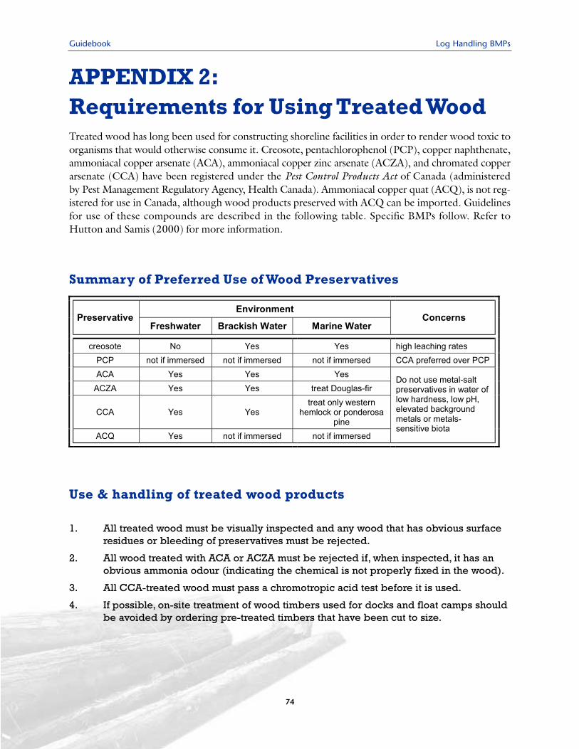
Guidebook Log Handling BMPs
APPENDIX 2:Requirements for Using Treated WoodTreated wood has long been used for constructing shoreline facilities in order to render wood toxic toorganisms that would otherwise consume it. Creosote, pentachlorophenol (PCP), copper naphthenate,ammoniacal copper arsenate (ACA), ammoniacal copper zinc arsenate (ACZA), and chromated copperarsenate (CCA) have been registered under the Pest Control Products Act of Canada (administeredby Pest Management Regulatory Agency, Health Canada). Ammoniacal copper quat (ACQ), is not reg-istered for use in Canada, although wood products preserved with ACQ can be imported. Guidelinesfor use of these compounds are described in the following table. Specific BMPs follow. Refer toHutton and Samis (2000) for more information.
74
Summary of Preferred Use of Wood Preservatives
Use & handling of treated wood products
1. All treated wood must be visually inspected and any wood that has obvious surfaceresidues or bleeding of preservatives must be rejected.
2. All wood treated with ACA or ACZA must be rejected if, when inspected, it has anobvious ammonia odour (indicating the chemical is not properly fixed in the wood).
3. All CCA-treated wood must pass a chromotropic acid test before it is used.
4. If possible, on-site treatment of wood timbers used for docks and float camps shouldbe avoided by ordering pre-treated timbers that have been cut to size.
Log Handling BMPs Guidebook
75
5. All construction timbers should be prefabricated, treated and dried in a containedupland area prior to use, not in place and over the water; where this is not possible,drapery should be used to prevent preservatives entering the water. A minimum of45 days should be allowed for drying.
6. Creosote-treated wood should be aged at least 45 days before use to enable volatileconstituents to evaporate.
7. Treated wood debris should be disposed of on land in accordance with provincialand municipal laws and policies.
Preferred wood preservatives for various uses
8. Creosote-treated wood should not be used in locations with sediment of littleor no oxygen, low total organic carbon or elevated levels of polycyclic aro-matic hydrocarbons (PAH).
9. Wood treated with PCP should only be used where it will not be immersed inwater (e.g., overhead construction). CCA is preferred over PCP.
10. ACZA is the preferred metal-oxide pesticide for treating marine pilings ofDouglas fir.
11. CCA is the preferred metal-oxide pesticide for treating marine pilings of west-ern hemlock or ponderosa pine, but should not be used to treat Douglas fir.
12. In most instances, use of CCA-treated piles and timbers should be restrictedto brackish and freshwater environments, as copper and chromium leach fromCCA-treated wood up to twenty times more in saltwater than in freshwater.
13. Wood treated with ACQ is not appropriate for marine use, except when limit-ed to above-water applications, such as decking.
14. Metal-salt treated wood should not be used in conditions of low water hardness(15 mg/L to 25 mg/L CaCO3), low pH (5.5 or lower), elevated levels of back-ground metals or where metals-sensitive biota (e.g., shellfish) are prevalent.
15. Where ambient levels of heavy metals are already high and use of woodtreated with CCA, ACAZ or ACZ is proposed, consideration should be givento having the wood pre-washed at the manufacturing site.

Guidebook Log Handling BMPs
76
Log Handling BMPs Guidebook
Appendix 3
Examples of Debris Management Plans
& Spill Reporting Forms
77
Guidebook Log Handling BMPs
DEBRIS MANAGEMENT PLAN FOR _____ LOG STORAGE AND BARGE LOADING FACILITY
This plan was adapted from a specific log storage and barging operation and is provided as an example. Such plans are developed in consultation with DFO for specific operations and locations.
These debris management procedures apply to the log storage and barge loading facility at _____. The objective of the plan is to minimize the deposition of debris such as bark, log chunks and slabs,or any other debris generated from the log storage and barge loading operations. These activities areintended to manage for the No Net Loss of Fish Habitat Policy of DFO.
General Conditions
• Only bundle booms will be stored at the site.
• All bundle booms will be secured at all times to ensure that bundles are kept at water depthsgreater than the "0 Chart Datum" line.
• Log bundles will be approximately 30 m3 to 50 m3 per bundle. The licensee will attempt to maxi-mize the bundle sizes where operationally feasible in order to minimize exposed individual logsurfaces and minimize loss of wood debris and bark from bundles.
• No loose logs will be stored at this site.
• All logs will be limbed prior to watering at the Log Dump.
• Log bundles will not be allowed to touch the ocean bottom or de-water.
• Logging-related boats (i.e. boom boats, crew boats) will not drive in and around the intertidal flats
• No fuel will be stored on-site.
• Log bundles will be removed from the storage area as soon as practically possible for towing orbarge loading (typically within two months).
• All bundle booms will be towed to deep water areas in the bay for ship or barge loading to ensurethat bundles do not contact the ground during loading.
• Bundle booms will not be stored within 30 m of the mouth of the creek on the eastern shore ofthe tenure area between mid-May and the end of June unless there is stream inventory/classifi-cation data that confirms that the stream is non-fish bearing.
Regular Assessment
• Visual assessment by boat of bark and wood debris accumulations in the intertidal zone will becompleted at low tide periodically during each operating season. Visual inspections by boat willbe completed after every significant storm event to monitor for potential debris accumulationsin the intertidal zone.
• At least two inspections of the intertidal zone will be completed during the operating season bywalking the beach area.
78
Log Handling BMPs Guidebook
• Inspection photographs and a brief report will be sent to the regional DFO Habitat andEnhancement Branch for DFO files.
• If any bark or wood debris is identified during the inspections, it will be hand cleaned from theintertidal zone at low tide and collected for upland disposal by burning at ___.
• Annual inspection reports and photographs will be kept in a binder at the Licensee office in ___.
• The Licensee will complete a dive or underwater camera survey as soon as possible within the firsttwo years of the tenure term. If there is no significant bark or wood debris deposition identifiedby the survey during the first two years of operation, an additional dive or underwater camerasurvey will be conducted prior to the end of the fifth year of the tenure. If there is no significantbark or wood debris deposition identified by the survey at the end of year five, a final survey willbe conducted prior to the end of term of the tenure.
• If bark or wood debris is identified during the dive or underwater camera surveys, the Licenseewill reassess the containment protocols and increase the survey frequency to an annual basis untilthe debris management plan is found to be effective at controlling debris and Department ofFisheries and Oceans approves a new assessment protocol.
79
Guidebook Log Handling BMPs
––––––– LOG DUMP BESTMANAGEMENT PRACTICES
This plan was adapted from a management plan developed by D. Gordon for the Ochwe Bay Log Dump, operated by Triumph Timber Ltd. It is provided as an example.Such plans are developed in consultation with DFO for specific operations and locations.
The following BMPs will be followed during operations of the log slide in ___ Bay:
1. Woody debris will not be allowed to accumulate in the intertidal zone under and adjacent to thelog slide. Debris will be hand cleaned daily, or as required.
2. Woody debris will not be allowed to accumulate on the intertidal flats of the ___ River to the eastof the site. Double boom sticks will be anchored immediately east of the slide to prevent anydebris from floating toward these flats. The flats will be periodically inspected by Licensee person-nel walking the flats at low tide to identify if any logging-related woody debris is accumulating inthis area. These inspections will be daily during the first week of the project, and will be reduced inintensity if no woody debris is found in the area. If woody debris is found, it will be removed byhand and/or skiff. As well, its mechanism for escaping the immediate log dump area will be inves-tigated and rectified.
3. Log bundles will be approximately 50 m3. No loose logs will be dumped at this site.
4. All logs will be limbed prior to watering in ___ Bay.
5. Log bundles will not be allowed to touch the ocean bottom or de-water.
6. The log storage area will be offset from the shoreline to prevent log bundles from grounding onthe shore. The log storage area will be in water greater than 20 m deep.
7. Log bundles will be removed from the storage area as soon as practically possible (typically lessthan 1 month).
8. Logging-related boats (i.e., boom boats, crew boats) will not drive in and around the intertidalflats of the ___ River. All booming activity will be confined to within the boomed area in front of,and the west of the log slide.
9. The road adjacent to the dump site will be capped with non-erodible materials such that sedimentladen water does not enter the ___ River estuary area.
10. Brow logs will line the edge of the roadway in the vicinity of the log dump area to preventwoody debris from entering the intertidal zone.
11. A suitable spill response kit will be kept at the log dump site and will be readily accessible in theevent of a hydrocarbon spill.
12. Any oily sheen on the water surface will be investigated as to its source and cleaned up. Allhydrocarbon spills will be immediately cleaned up. Spills over 1000 litres will be immediatelyreported to the Provincial Emergency Program Spill Response Line.
13. Solid waste generated on site (i.e., cables, etc.) will not be disposed of in the marine environment.
80
Log Handling BMPs Guidebook
Spill Report FormPage 1 of 2
Spill Location: Geographical Name ____________________________________________________
Latitude: _____________ Longitude:_____________________
Person Reporting Spill: ______________________________________________________________
Date And Time Of Spill: _____________________________________________________________
Product Type:______________________________________________________________________
Quantity Of Spill:___________________________________________________________________
Source Of Spill:_____________________________________________________________________
Name Of OHF: ____________________________________________________________________(Oil Handling Facility, where designated)
Owner/Operator: __________________________________________________________________
Personnel Safety: ___________________________________________________________________
Fire/Explosions Hazard:_____________________________________________________________
Cause Of Spill: _____________________________________________________________________
Weather: Wind Direction _________ Speed_____________________
Precipitation_____________ Visibility_____________________
Sea Conditions: Direction of Current Flow________________ Speed _______________________
Flood ______________________ Ebb _______________ Trend _______________________
81
Guidebook Log Handling BMPs
Spill Report FormPage 2 of 2
Response Actions: __________________________________________________________________________________________________________________________________________________________________________________________________________________________________________________________________________________________________________________________________________________________________________________________________________
Persons On Scene Or Advised: ___________________________________________________________________________________________________________________________________________________________________________________________________________________________________________________________________________________________________________________________________________________________________________________________________________________________________________________________________________________________________________________________________________________________________
Is Assistance Required?______________________________________________________________Type?___________________________________________________________________________
_______________________________________________________________________________________________________________________________________________________________________________________________________________________________________________________________________________________________________________________________________________________________________________________
Date/Time Of Next Report: _________________________________________________________
Signature: ________________________________________________________________________
82
Log Handling BMPs Guidebook
Appendix 4
Marine Foreshore EnvironmentalAssessment Procedures
83
Guidebook Log Handling BMPs
APPENDIX 4:MARINE FORESHORE ENVIRONMENTAL ASSESSMENT PROCEDURES
Source: Scott Northrup and Allan Cowan, Fisheries and Oceans Canada (Revised March 2002)
Marine development projects have the potential to affect fish1 and fish habitat2. Fisheries and OceansCanada (DFO) is responsible for the protection and management of fish habitats under the authorityof the Fisheries Act and may request plans, specifications and environmental assessments specific to marineprojects where more detailed information is required. Assessments may be necessary for all types of proj-ects, including, but not limited to aquaculture, log handling, industrial port development, marinas, pri-vate moorage facilities, marine repair facilities, pipeline or outfall installations, vessel launches or bargeramps, dredging projects and shoreline protection projects (breakwaters and seawalls). Presentedbelow are standardized, transect-based assessment procedures intended to provide DFO with thebasic information required to determine the potential effects of a development project on fish habitat.
Assessment AreaFor comparative purposes, the assessment area should include both the foreshore site proposed for devel-opment as well as the adjacent foreshore. This will provide a context for the project and may provide dataabout cumulative effects if similar developments already occur on-site. A large scale site plan, preferablyan enlargement of the hydrographic chart, with a small scale insert of the general geographic locationwill serve as a base map of the study area.
Tidal Height and Water Depth MeasurementsThe lowest normal tide (0.0 m), or chart datum, will be used as the reference point for the measurementof tidal height and water depth. Tidal height is recorded as positive relative to chart datum, whilewater depth below chart datum will be recorded as a negative value. For example, if the assessment ismade when the tide is at 2 m, and observations are taken at a water depth of 6 m, then the depth willbe recorded as -4 m. Tidal height will be corrected using the closest secondary port to the reference portfound in the Canadian Tide and Current Tables, with further correction made for daylight savings timeas required.
Transect LayoutTransects should be established perpendicular to the shoreline at regular intervals both within andadjacent to the proposed or active development area so as to sample representative fish habitat condi-tions. A preliminary low water reconnaissance or dive survey may be advisable to establish appropriateboundaries for the assessment. Transects should begin at the highest high water mark (HHWM: distance
84
1. shellfish, crustaceans, marine animals and any parts of shellfish, crustaceans or marine animals, and the eggs, sperm,spawn, larvae, spat and juvenile stages of fish, shellfish, crustaceans and marine animals;
2. spawning grounds and nursery, rearing, food supply and migration areas on which fish depend directly or indirectly in orderto carry out their life processes.
Log Handling BMPs Guidebook
referenced as Station 0.0 m) and, at a minimum, extend to a depth of -20 m (–30 m if the developmenthas the potential to effect deeper benthic habitats). Though small-scale intertidal projects may only requireintertidal transects, care must be taken to ensure that a representative sample is collected across the pro-posed development area. Procedural manuals are available from DFO if sampling of intertidal clam orbenthic invertebrates is required. To ensure complete assessment of marine plants and animals in thephotic zone, deeper transects may be necessary, especially to determine the effects of sunken debris orwoodwaste accumulations resulting from existing developments. Transects should be spaced approx-imately 25 m apart, although this interval may vary depending on the width of the site. The number oftransects required will depend on the nature of the foreshore development proposed, anticipatedeffects of the development, and local site conditions (tides and currents, geography, fetch, geology, etc.).Transects should be individually numbered and indicated on the site plan, and their commencement pointreferenced to benchmarks, where possible.
Recording ObservationsHabitat inventories should be conducted during the more productive spring and summer months.At that time, algae and saltmarsh species are more readily identifiable, enabling a better assessment ofthe productive capacity of the site.
Observations should be recorded every 5 m along the transect or at significant changes in habitattype. Observations should include substrate type and composition, presence and relative abundance ofmarine animals and plants, and any other notable features (e.g., debris accumulations) using the formatdescribed below for individual parameters.
Observations should be correlated to the transect distance from the HHWM and (corrected) tidal heightor water depth (e.g., Sta 0+80 m / +4.5 m), with information compiled in tabular form, by transect.Common names of observed animals and plants are acceptable for the data table; a species list with sci-entific names should, however, be appended to the report.
General marine plant categories (e.g., rockweed, eelgrass, bull kelp, saltmarsh, etc.) and any othernotable features should be sketched to scale directly on a copy of the site plan, drawings or photographsof the site. A site profile should be prepared for each transect showing the slope of the foreshore and thelocation of indicator marine plants or invertebrates. A sketch of the proposed marine development shouldbe superimposed over the site plan so that any potential effect of the project on fish habitat is clear.Compensatory habitat proposed for offsetting altered habitat should also be sketched on site maps andprofiles to enable review of the positioning of replacement habitat relative to the project.
SubstrateSubstrate types are to be subdivided into the following size class categories and recorded cumula-tively as percentage out of a total of 100% (e.g., Boulder 5%; Cobble 15%; Gravel 60%, Sand 20%):
Boulder Cobble Gravel Sand. Silt/mud/clayBedrock
>256 mm dia. 64-256 mm dia. 2-64 mm dia. 0.062-2 mm dia <0.062 mm dia.
85
Guidebook Log Handling BMPs
Marine PlantsMarine plants include rooted vascular vegetation (e.g., eelgrass, saltmarsh vegetation, etc.) and marinealgae (e.g., rockweed, kelp, etc.). Marine plant observations are recorded as percent areal coverage esti-mated per 5 m by 1 m transect segment. Observations can be recorded as percentages (5%, 10%, 15%,etc.) or by utilizing the following areal coverage classes:
+ 1 2 3 4<5% 5-25% 25-50% 50-75% 75-100%
Sessile AnimalsMany marine animals permanently attached to substrates function as important fish habitat (e.g., bar-nacles, bay mussels, etc.). Sessile animals are recorded as percent areal coverage along the transectline using either estimated percentages or by areal coverage classes, as presented above.
Motile AnimalsMotile animals include fish and marine invertebrates such as crabs and snails. These can be individuallycounted along the transect or, where too numerous, their estimated numbers can be recorded.Population estimates will most likely be applied to species such as herring or mysid shrimp that naturallyoccur in large numbers.
Other FeaturesAccumulations of wood bark and debris, sunken logs or other waste materials arising from on-site ornearby development activities should also be recorded. For wood bark and related small size debris, obser-vations are recorded as percent areal coverage estimates per 5 m by 1 m transect segment and estimateddeposition depth (e.g., 15% / 10 cm). For larger materials (sunken logs, wood chunks, etc.), observationscan be recorded by individual piece count or by estimate of percent areal coverage.
Photographic DocumentationIt is essential to produce a photographic record along the intertidal and subtidal transects. A videographicrecord of subtidal transects is also recommended. Photos and videos provide a real-time record ofcharacteristic fish habitat at the proposed site and can be invaluable to future post-development site mon-itoring. Photographic records also facilitate comparison of the productivity of natural habitats with anycompensatory habitat constructed to offset habitat losses. As visibility may be a problem, careful atten-tion should be given to appropriate tidal levels, and midday lighting conditions are recommended. Aerialphotos, taken at low tide, are often useful to put the site into context with the surrounding area and toverify information provided from other sources.
Assessment reports should include photographs of representative fish habitat types. Depending upon thescope of the proposed foreshore development, an unedited, labeled copy of the assessment video mayalso be required for the report submission. The video footage should be referenced with pertinent information(e.g., time, date, depth, heading, etc.), and a written or recorded interpretation should accompany the video.
86
Log Handling BMPs Guidebook
Summary of information to be submitted
1. Base map showing tenure area boundaries, surrounding area, transect locations and sampling stations
2. Shoreline video/photographs of intertidal zone
3. Underwater video/photographs of transects
4. Tabular data for each transect describing substrate type and composition, marine plants, sessile andmotile marine animals, and other notable features
5. Habitat map showing location of different substrate types, plants, animals and operational infrastructure
6. Profile diagrams of each transect showing slope, sediment types and the major marine plants oranimals observed
7. Photographs of site and aerial photographs if available.
87

Guidebook Log Handling BMPs
88