Embed Size (px)
Citation preview
DC0902MW 1
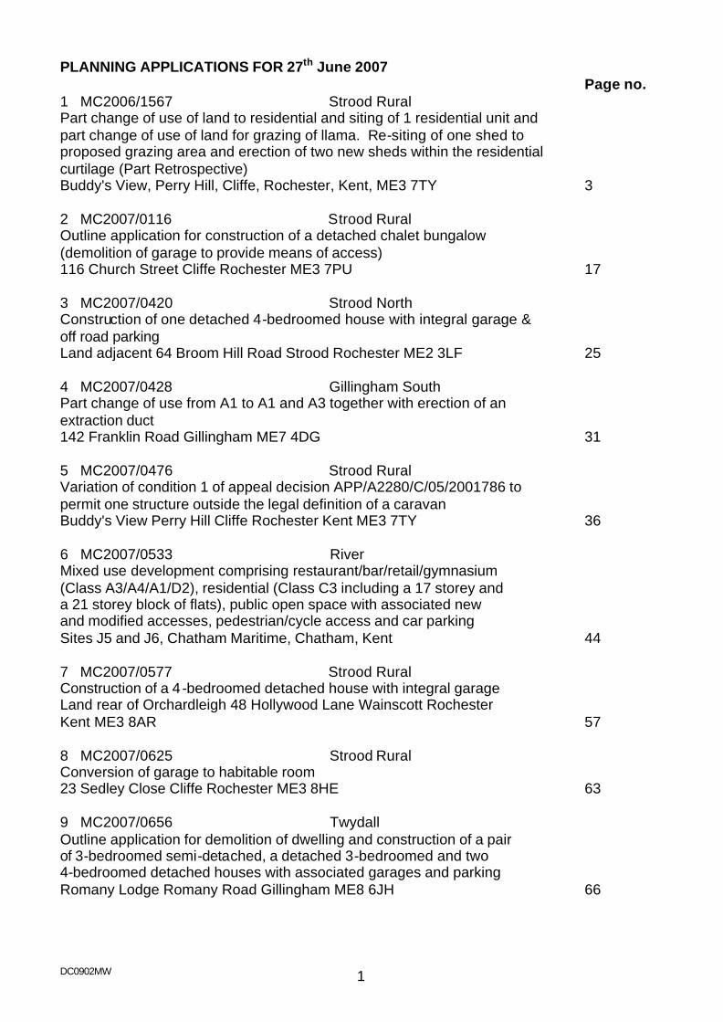
PLANNING APPLICATIONS FOR 27th June 2007 Page no. 1 MC2006/1567 Strood Rural Part change of use of land to residential and siting of 1 residential unit and part change of use of land for grazing of llama. Re-siting of one shed to proposed grazing area and erection of two new sheds within the residential curtilage (Part Retrospective) Buddy's View, Perry Hill, Cliffe, Rochester, Kent, ME3 7TY 3 2 MC2007/0116 Strood Rural Outline application for construction of a detached chalet bungalow (demolition of garage to provide means of access) 116 Church Street Cliffe Rochester ME3 7PU 17 3 MC2007/0420 Strood North Construction of one detached 4-bedroomed house with integral garage & off road parking Land adjacent 64 Broom Hill Road Strood Rochester ME2 3LF 25 4 MC2007/0428 Gillingham South Part change of use from A1 to A1 and A3 together with erection of an extraction duct 142 Franklin Road Gillingham ME7 4DG 31 5 MC2007/0476 Strood Rural Variation of condition 1 of appeal decision APP/A2280/C/05/2001786 to permit one structure outside the legal definition of a caravan Buddy's View Perry Hill Cliffe Rochester Kent ME3 7TY 36 6 MC2007/0533 River Mixed use development comprising restaurant/bar/retail/gymnasium (Class A3/A4/A1/D2), residential (Class C3 including a 17 storey and a 21 storey block of flats), public open space with associated new and modified accesses, pedestrian/cycle access and car parking Sites J5 and J6, Chatham Maritime, Chatham, Kent 44 7 MC2007/0577 Strood Rural Construction of a 4 -bedroomed detached house with integral garage Land rear of Orchardleigh 48 Hollywood Lane Wainscott Rochester Kent ME3 8AR 57 8 MC2007/0625 Strood Rural Conversion of garage to habitable room 23 Sedley Close Cliffe Rochester ME3 8HE 63 9 MC2007/0656 Twydall Outline application for demolition of dwelling and construction of a pair of 3-bedroomed semi-detached, a detached 3-bedroomed and two 4-bedroomed detached houses with associated garages and parking Romany Lodge Romany Road Gillingham ME8 6JH 66
DC0902MW 2
Page No. 10 MC2007/0712 Hempstead & Wigmore Outline application for the construction of four detached 4 -bedroomed houses with associated access Land opposite 51-58 Hickory Dell Hempstead Gillingham ME7 3SL 72 11 MC2007/0751 Rochester West Formation of mansard roof to provide two self-contained flats at third floor level 7-9 Crow Lane Rochester ME1 1RF 79 BACKGROUND PAPERS The relevant background papers relating to the individual applications comprise: the applications and all supporting documentation submitted therewith; and items identified in any Relevant History and Information section and Representations section with a report. Any information referred to is available for inspection in the Planning Offices of the Council at the Compass Centre, Chatham Maritime, Chatham.
DC0902MW 3
1 MC2006/1567
Date Received: 24th August 2006
Location: Buddy's View, Perry Hill, Cliffe, Rochester, Kent, ME3 7TY Proposal: Part change of use of land to residential and siting of 1 residential
unit and part change of use of land for grazing of llama. Re-siting of one shed to proposed grazing area and erection of two new sheds within the residential curtilage (Part Retrospective)
Applicant: Mr Ball Buddy's View Perry Hill Cliffe Kent ME3 7TY Agent: Ward: Strood Rural Recommendation - Approval with Conditions (as amended by site plan received on 26th October 2006) 1 The development hereby permitted shall be begun before the expiration of three
years from the date of this permission. 2 Details and samples of any materials to be used externally on the residential unit
shall be submitted to and agreed in writing by the Local Planning Authority before development is commenced and development shall be carried out in accordance with the approved details and thereafter maintained.
3 The sheds hereby permitted shall be used for purposes ancillary and incidental to
the enjoyment of the mobile homes/caravans permitted pursuant to appeal reference APP/A2280/C/05/2001786. The sheds shall not at any time be used for trade or business or occupied as residential accommodation.
4 The residential unit hereby permitted shall only be occupied by a person or
persons falling within the definition of a gypsy as defined in section 24(8) of the Caravan Sites and Control of Development Act 1960 (as amended). Within 1 month of the residential unit no longer being occupied by such persons the residential unit hereby permitted shall be removed from the site and that part of the site on which the residential unit is located shall be returned to a condition suitable for agricultural occupation.
5 The use of land for the grazing of a llama shall only remain whilst the residential
occupancy of the site remains in accordance with the conditions specified in the Inspector's appeal decision reference APP/A2280/C/05/2001786. Within one month of the cessation of this use or the site no longer being occupied in accordance with this appeal decision, the use of the land for the grazing of a llama hereby permitted shall cease and that part of the site shall be returned to a condition suitable for agricultural occupation.
DC0902MW 4
6 Notwithstanding the provisions of the Town and Country Planning (General Permitted Development) Order 1995 (or any Order revoking and re-enacting that Order with or without modification) no development within Part 1 or 2 of the Second Schedule to the Order shall be carried out on the site without the prior written approval of the Local Planning Authority.
7 Notwithstanding the appeal granted under ref APP/A2280/C/05/2001786, no more
than 4 caravans, of which not less than two shall be touring caravans, and the structure hereby permitted shall at any time be stationed on the developed part of the land, including the extended residential curtilage as permitted under this consent ref MC2006/1567.
For the reasons for this recommendation for approval please see Planning Appraisal section and conclusion at the end of this report. Site description The site comprises a large field situated outside of the main built confines of any town or village. To the north the site is bounded by the railway line and embankment, to the east there is a public footpath, which passes under the railway. The site is crossed east to west by electricity pylons carrying two electricity lines. There is one fixed ‘caravan’ of pre-fabricated construction occupied as a dwelling and one other touring caravan which, together with a small prefabricated outbuilding which is occupied by Mr & Mrs Ball Snr as one dwelling. There are two traditional style ‘touring’ caravans stored at the site in the open. There is a shed, used as a workshop and toilet facilities which was the subject of a previous planning application (MC2006/1201). The workshop/toilet facilities building is situated approximately 28m to the south of the railway embankment and at a distance of 2.9m from the adjacent footpath. Although the site is in open countryside for the purposes of planning considerations the presence of the railway embankment, railway bridge and the electricity pylons do urbanise the site. In addition to this the natural undulations of the site means that the land falls towards the railway line and the area closest to the railway line is the most visually unobtrusive location and is well screened from the surrounding area. There is an access road into the site and an area of hard standing used for the parking of vehicles. Proposal The proposal seeks full planning permission and the application is in three parts – firstly it is proposed to change the use of land from agricultural/and or the keeping of horses to the keeping of a llama. This element of the application also proposed to re-site an existing shed from the site adjacent to the building which houses the toilet facilities and workshop, previously considered under (MC2006/1201), into the field where the llama will graze. The relocated shed will be used to store feed and equipment associated with the keeping of the llama. The area proposed to be used to keep the llama is to the east of the site and is approximate ly 36m x 77m in size. The field boundaries are delineated by a wooden post and rail fence. The shed is sited to the west of the site (adjacent to the access track) and is of wooden construction with a pitched roof and measures approximately 1.78m wide x 2.68 long x 2.13m high to eaves and 2.58m to ridge height. This aspect of the application is retrospective. The second aspect of the application is the siting of two new sheds on land, which is already in residential use. The sheds are sited in an ‘L’ shape in relation to the building housing the
DC0902MW 5
toilet facilities and workshop (considered under application reference MC2006/1201). The proposed new sheds are small scale in nature, the shed proposed to be sited closest to the existing workshop is 1.79m in width and 2.39m in length the shed has a pitch roof and is 2.58m to the ridge. The second shed is sited at a distance of from the other proposed shed and is 1.15m wide and 1.83m in length – the overall ridge height is the same at 2.58m. The sheds are of wooden construction and are of a ‘standard’ garden shed design. This aspect of the application is not retrospective. The final aspect of the application is the change of use of land from agricultural and/or the keeping of horses to residential and to site a residential unit for the residential occupation by Mr Waynus Ball on land to the north of the site, adjacent to the railway embankment. The proposed change of use of land would extend the existing lawful residential land to the north of the site, towards the railway line, and would extend for 35m from the western boundary with the adjacent footpath. It is proposed to site a static pre-fabricated structure (referred to in the application as a mobile home) approximately 11m from the western boundary and 5m from the northern boundary (the railway embankment). The static prefabricated structure to be occupied as a dwelling is single storey in design and measures 14m in length (which is orientated east to west ie parallel with the railway line) and 6m wide. The structure has a shallow pitched roof and measures 3.5m to the highest point of the ridge. The roof is of a barn hip design. There is a gable porch detail and two bow windows to the front elevation. The dimensions of the proposed structure are such that it does not fall within the definition of a caravan as set out in the Caravan Sites and Control of Development Act 1960 and the Caravan Sites Act 1968, (see details set out in “other matters” section of the report). This part of the application is not retrospective.
Relevant Planning History There is a complex planning history for the site. MC2006/1201 Retrospective application for the retention of a shed to be used as
a store/workshop and toilet facility Approved with conditions 18 October 2006.
In addition to this, the other relevant planning history is that of an allowed appeal decision issued on 5 September 2005 under reference APP/A2280/C/2001786. The outcome of this appeal is summarised as follows:
- The lawful uses of the land are as a caravan site for gypsies (as defined in Section 24 (8) of the Caravan Sites and Control of Development Act 1960 (as amended) and the use of land for agriculture and/or the keeping of horses. The precise areas covered by these lawful uses are outlined in the plan attached to the Inspector’s appeal decision. In broad terms the caravans are required to be stationed to the north east of the site and the rest of the area is defined as agricultural and/or the keeping of horses.
- No more than 5 caravans can be stationed at the site – at least two of which must be touring caravans.
- The access road and hard standing areas at the site could remain without causing an unacceptable encroachment into the rural area.
- The appeal decision is conditioned to require that once the occupation of the site by gypsies ceases all buildings, structures and caravans must be removed and the land should be restored to a state fit for agriculture within one month of that use ceasing.
- A landscaping scheme was required to be submitted, approved and implemented.
DC0902MW 6
Essentially this appeal decision means that persons of gypsy origin can occupy the site for an unspecified and consequently an indefinite period of time. A maximum of 5 caravans can be sited on the plot - a minimum of 2 of these must be touring caravans. Agriculture and/or the keeping of horses can also continue at the site. Once the site ceases to be occupied by persons of gypsy origin then it should be restored to a state fit for the resumption of the previous agricultural use of the site. Representations The application has been advertised by way of a site notice and the owners/occupiers of Perry Hill Farm and The Poplars have been directly notified of the proposals. 14 letters of objection have been received raising the following issues:
- Application form appears to be incomplete and have parts missing – signatures have been removed and consequently the application is invalid.
- People believe that this application is a retrospective application for the existing chalet bungalow erected on the site and this is not the case.
- Drawings submitted with the application are misleading. - The planning application is for residential use and it is therefore assumed that the
occupants residing there have given up their nomadic way of life and the justification for the site is no longer applicable – the permission should therefore lapse.
- Conditions on the appeal decision requiring the land to be restored when the occupation by gypsies has ceased should be implemented.
- The inspectors appeal decision is very clear in setting out that the land shall only be used as a caravan site by gypsies and the remainder of the land for agriculture or the keeping of horses – therefore the Council has no legal authority to consider the current application as an appeal Inspector has made a decision and this should not be overridden or disregarded.
- The size and extent of the site were heavily weighted by the appeal Inspector and this application would create a far larger site than the details on which the appeal decision was made.
- The vast majority of residents in the area would object to this site ‘growing’. - The proposals would result in the loss of valuable Grade 1 agricultural land. - There is no overriding need for the development which outweighs the presumption
against permitting the loss of the best and most versatile agricultural land. - The proposed development would detract from the visual amenities of the area. - The proposals are totally unjustified and would serve to further degrade the amenities
of local residents. - Given that the Inspector’s appeal decision was recent there is no excuse for continued
failure to obtain proper planning consents prior to commencing work. - A dangerous precedent would be set if this application is allowed. - Concern over health and safety issues and impact on long-term health from living
under the high voltage power lines. New evidence suggests that children have a 69% increased risk of getting leukaemia.
- If this application is granted it will open the floodgates for other developments in other ‘green’ areas.
- Consultation in respect of this application was not wide enough. - Failure to understand how allowing a property on this land could be considered when
an application for a double garage was rejected for a double garage in the vicinity on the grounds of ‘over development of the land’ (no reference number given).
DC0902MW 7
- The site is changing from a caravan site to a housing estate. - Concern over future development of the site much of which may have planning
consent sought retrospectively. - A site notice has not been displayed for the development. - The proposed chalet bungalow is too large and is not a caravan as required by the
appeal decision. - It is unfair of the Council to consider these retrospective applications when other
people in the area have had planning applications rejected prior to building works starting.
One further representation has been received which in addition to the points outlined above, referenced a case heard in the European Court of Human Rights in 2000 and a judgement reached on 18 January 2001 (Jane Smith v. The United Kingdom). The objector stated that this case raises issues relevant to the current planning application. The case centred on whether there was a breach of the applicant’s human rights, as set out in the European Convention on Human Rights. In that case the court found that there was no breach. However, the details of the case differ enormously from the application at Buddy’s View, not least by the fact that the court case refers to a site on land designated as Green Belt and where no lawful use for residential occupation by persons of gypsy origin had been established. Since the date of that case, there have been numerous other gypsy related cases, and Circular 01/2006 (Planning for Gypsy and Traveller Caravan Sites) has been issued. It is considered that the details of the quoted court case adds little in respect of the current application. Dickens Country Protection Society objected on the grounds that no reasonable justification has been put forward in an area where this would not normally be allowed. The Perry Hill and Cooling Street Residents assoc have written a further letter that can be summarised as follows:
- There is confusion as to what is being proposed. - Proposal represents unrestricted residential development on grade 1 agricultural
land. - There is no over riding requirement for proposal especially in the light that it could
go on the area approved by Inspector. - Block paved or garden area could be used for additional caravan. - Existing chalet bungalow is not a caravan. - On site lighting at night does impact on character of area. - Appeal Inspector mis-judged personal condition re gypsy origin and his decision
was contrary to case law. - Site area is smaller than that stated in application.
Development Plan Policies Kent & Medway Structure Plan 2006
Policy SS8 (Development in the Countryside) Policy EN1 (Protecting Kent’s Countryside) Policy EP9 (Protection of Agricultural Land) Policy HP5 (Housing Development in the Countryside) Policy QL1 (Quality of Development and Design) Policy TP19 (Parking Standards)
DC0902MW 8
Medway Local Plan 2003
Policy BNE1 (General Principles for Built Development) Policy BNE2 (Amenity Protection) Policy BNE25 (Development in the Countryside) Policy BNE48 (Agricultural Land) Policy H13 (Gypsy Caravan Sites and Travelling Showpeople’s Quarters) Policy T1 (Impact of Development) Policy T13 (Vehicle Parking Standards)
Planning Appraisal Notwithstanding the recent appeal decision, in planning terms the site lies outside of the main identified area of any town or village and is, for the purposes of planning policy, in open countryside and agricultural land (In part). The key issues in respect of the separate elements of the proposals will be addressed in three parts as outlined in the ‘proposals’ section. 1. Change the use of land from agricultural/and or the keeping of horses to the keeping
of a llama (retrospective). The key issues in respect of this part of the application are:
a) Whether the change of use of the land is acceptable and b) Whether there would be any harmful visual impacts arising.
a) In terms of planning Policy, the land is technically agricultural land and as such Policies BNE48 and EP9 of the Development Plan are relevant. However, as part of the Inspectors appeal decision a caveat was added which allows the use of land for agriculture and/or the keeping of horses. Usually, in planning terms horses would fall outside the definition of agriculture. This land has permission already for the keeping of horses. Given that the keeping of horses on the land is lawful, it is reasonable to expect that there would be some fencing of the land into paddocks both to contain the animals and to allow the rotation of grazing. This has occurred in this instance. Bearing these factors in mind, the change of use proposed here would in real terms have very little impact on the actual use or the appearance of the land as it is already fenced ready to use for the keeping of horses. Added to this, the grazing of the land for a llama could be restricted to tie in with the requirement to return the land to its former use once persons of a gypsy origin cease to use the site. On balance, it is considered that there would be no policy conflict in allowing the change of use of land for the keeping of a llama in this instance. b) With regard to the visual impact of the change of use of the land, as stated above, the land has already been fenced into paddocks. Given the natural undulations of the land and the fact that the fencing is a simple post and rail design it is considered that it is visually unobtrusive and a refusal on these grounds could not be reasonably sustained.
2. Erection of 2 sheds and relocation of one shed into paddock used for grazing of llama
(part retrospective).
DC0902MW 9
The key issue in respect of this aspect of the application is whether there would be any visual impacts arising from structures. The proposed sheds are considered to be of a small scale and their use can be restricted to ancillary and storage purposes by way of suitably worded conditions. The design of the sheds is ‘standard’ and two are proposed sited close to existing structures on site which would create a ‘cluster’ of structures to the north eastern part of the site. It is not considered that there would be a harmful visual impact arising from this aspect of the proposals. The shed sited in the paddock to store feed and equipment associated with the llama is retrospective and the shed is in situ already. Again, given the small scale nature of the structure and the presence of post and rail fencing at the site the visual impact of the shed is minimal. The sheds would be visible from the adjacent footpath to the west of the site, as are the other buildings within the site. It is not considered however, that the presence of these additional structures due to their scale and design, would have a detrimental visual impact on the wider landscape to the extent where a refusal of planning permission would be justified. 3) Change of use of land from agricultural and/or the keeping of horses to residential and to
site a mobile home for the residential occupation by Mr Waynus Ball. The key issues in respect of this part of the application are:
i. Whether the principle of the loss of existing agricultural land and change to residential occupation is acceptable.
ii. Whether the design and siting of an additional structure in this location is appropriate. iii. Visual impact of the proposals. iv. Impacts on residential amenity of surrounding properties. v. Highways. vi. Other matters arising from representations received.
Principle Policies BNE48 and EP9 of the Local Plan and Structure Plan (respectively) seek to retain the best and most versatile agricultural land. In this instance, as outlined under section 1) of this report, the lawful use of the land in question is for agriculture and/or the keeping of horses. Therefore the definition of the use of this land has been extended beyond that of the usual planning definition of agriculture. Consideration must be given to the appeal decision regarding caravans and residential units on the site along with other structures. The parcel of land concerned with the proposed residential unit is immediately adjacent to the other caravans, structures and residential units in the north western corner of the site. It is also over sailed by pylons and over head lines. As a consequence the land reads as part of the cluster of structures that forms the residential element of the site and due to its size and shape would be restrictive at present to use for either agriculture or the keeping of horses. Policies BNE25 & HP5 seek to restrict sporadic development in the countryside and restricts development to those uses that demand a rural location, to agricultural workers dwellings or to modest extensions to existing buildings. As the site is used for the residential occupation by persons gypsy origin, and the use of the land would cease once this criterion fails to be met - the criterion where new development would be allowed under Policy BNE25 cannot be strictly or easily applied as this seeks to restrict permanent sporadic development. The
DC0902MW 10
proposals are not for new permanent residential development rather a separate unit of accommodation for Mr W Ball to use in association with the use granted at appeal. Policy EN1 seeks to protect the countryside for its own sake. In this instance, due to the presence of railway and electricity infrastructure; the naturally sheltered aspect of the site and the fact that there are already existing lawful structures against which the proposed residential unit will be read, it is considered that the proposal would not cause further harm to the rural open countryside character of the area. Consequently there is no conflict with the provisions of Policy EN1 in this regard. ii) Design and siting The siting of the residential unit is such that it is adjacent to the ‘cluster’ buildings/caravans approved by the appeal decision. Consequently it is considered that the building is suitably sited within the application site. The design of the building is also considered reasonable for the proposed use and its location. The building would be visible from the adjacent footpath, as are the other buildings within the site. It is not considered however, that the presence of this building given the surrounding context of the site would have a detrimental visual impact on the wider landscape to the extent where a refusal of planning permission would be justified. iii) Visual impact In terms of the visual impact of the proposed new structure, it is sited in the most visually unobtrusive part of the site where the land naturally slopes down towards the railway embankment. In addition to this, the presence of the electricity pylons, the railway embankment, the railway bridge and the existing cluster of structures against which the proposal will be seen means that the visual impact of this structure is therefore, minimal. iiii) Neighbour’s Amenity In terms of intensification of the site, the fact that Mr Waynus Ball already lives at the site with Mr & Mrs Ball Snr the creation of a separate unit of accommodation, whilst resulting in another physical structure on the site, it would not in real terms intensify the residential use of the site and the residential occupation would remain limited to the Ball Family. This residential occupation could be restricted to Mr Waynus Ball and his dependents by way of a suitably worded condition to ensure that the occupation of the site does not escalate. It is considered therefore that the residential amenity of adjoining neighbours is unlikely to suffer due to the intensification of the use. Due to the distances of the surrounding properties from the proposed new residential unit there are no issues arising in respect of overlooking or loss of privacy. v) Highways There is a large hardstanding at the site and ample parking can easily be provided. It is not considered that there are any issues arsing in respect of the existing access to the site. Consequently there are no highways issues arising in respect of these proposals. vi) Other Matters
DC0902MW 11
Gypsy status of the applicant With regard to the gypsy status of Mr Waynus Ball it is concluded that the factors afforded weight by the appeal inspector included the fact that Mr Waynus Ball and Mr Ball Snr travelled for work and educated school children regarding their traditional way of life. Gypsy status, is not therefore solely reliant on a person living in a moveable caravan and is much broader to include persons such as the Ball family who are of gypsy origin and maintain some, but not perhaps, all elements of their traditional way of life – one aspect of which is travelling for work. Moreover, the appeal decision requires that persons residing at the site are simply of gypsy origin. It is not therefore, a requirement that persons residing at the site are undertaking a nomadic or traditional way of life at the time of the occupation of the site. Given this aspect and when coupled with the fact that the appeal decision is recent it is considered that the gypsy status of the applicant should not be questioned further as part of this planning appraisal as the gypsy origin of the Ball family has already been satisfactorily demonstrated to and accepted by, the appeal Inspector. Inspectors appeal decision – it seems to be inferred from some of the representations received that the Inspectors appeal decision should preclude any further development at the site. This is not the case and the Council is legally obliged to fully consider any planning applications subsequently submitted on their own merits and to assess them against the relevant Development Plan Policies. Those factors considered during the appeal process do remain relevant, and those uses established via the appeal process are lawful. However, the outcome of the appeal should not be seen as an indication of the ‘maximum’ level of development appropriate for the site in itself. It is noted that the appeal decision does specify the number of caravans (2 touring and 3 static) that could lawfully be sited on the land. For the avoidance of doubt it should be noted that the two traditional style, wooden horse drawn caravans owned and stored at the site by the Ball family are considered to be heritage items and are not used as residential accommodation. In the light of this it is considered that these can be stored anywhere within the site as ‘chattels’ and provided they are not occupied as residential accommodation they would fall outside of the calculation of ‘touring caravans’ stored at the site. Mr and Mrs Ball Snr currently reside partly in a touring caravan and partly in a fixed structure. The shed containing the workshop and toilet facilities has planning permission in its own right. In addition to this there is a static structure occupied by Mr Frank Ball Jnr and at the time of the members site visit, related to previous submissions, there was also a touring caravan stored on this part of the site. Even with the proposed residential unit therefore the number of touring and static caravans would not exceed the limit imposed by the Inspector at appeal. The application is retrospective (in part) – retrospective planning applications are a lawful mechanism by which development that has already occurred can be regularised. The Local Planning Authority is obliged to consider retrospective planning applications and these are dealt with in the same way as planning applications that are received prior to works being carried out. The fact that an application is made retrospectively cannot count as a material consideration. The fact that the application is retrospective is insufficient grounds on which to refuse an application. Health issues - Government advice set out in PPG8 confirms that health considerations and public concern can, in principle, be a material consideration in determining applications for
DC0902MW 12
planning permission. However paragraph 98 of PPG8 states: “…it is the Government’s firm view that the planning system is not the place for determining health safeguards. It remains central Government’s responsibility to decide what measures are necessary to protect public health”. On this basis and coupled with the fact that the land already has a lawful use as residential occupation of the land by persons of gypsy origin, and that Mr Waynus Ball already resides at the site, it is not considered appropriate to resist the proposals on this basis alone. Unauthorised structures Fencing – At the time of the site visit in respect of this application it was noted that the area identified as land to be used for agriculture and/or the keeping of horses (see plan provided with the appeal decision) had been divided up into paddocks with post and rail fencing. Mr Ball has stated verbally that the fences were erected on site at the time of the previous enforcement action at the site and the Council’s own photographic evidence of the site at this time would appear to support this statement. In addition to this, the presence of the fencing was brought to the attention of the Council in a letter dated 23 October 2004. The subsequent enforcement action did not require the regularisation of the fencing. Given that the appeal against this enforcement notice was allowed and specifically refers to the keeping of horses as an appropriate use at the site, it is considered that it is reasonable to expect the enclosure of the field (approx 7.5 ha in total) into smaller paddocks to contain livestock and to allow rotation of grazing. In addition to this it is considered that the visual impact of the fencing is acceptable and consequently it would not be expedient or reasonable to pursue enforcement action against this aspect. Chalet style ‘house’ already at the site – the enforcement action and subsequent appeal at this site refers specifically to the stationing of ‘mobile homes/ caravans for use as residential accommodation’. Moreover, within the formal appeal decision it states that not more that 5 caravans shall be stationed at the site – and that not less than two shall be touring caravans. In the light of this it can reasonably be inferred that at a maximum, 3 caravans stationed at the site can be ‘static’ (i.e. not readily moveable (without an element of dismantling) or capable of being towed by a vehicle). There is no size restriction specifically mentioned in the appeal statement and there are no ‘design’ criterion applied. Whilst the structure in question is certainly not a touring caravan, this is not required under the terms of the appeal decision. It has been stated in some of the representations that the structure occupied by Mr Frank Wall Jnr is too large to count as a caravan and so the structure is unauthorised and is contrary to the terms of the appeal decision. The definition of what constitutes a ‘caravan’ in terms of size and physical permanence is found in the Caravan Sites Act 1968, this Act supplements the Caravan Sites and Control of Development Act 1960. The definition includes:
‘any structure designed or adapted for human habitation which is capable of being moved from one place to another (whether by being towed, or by being transported on a motor vehicle or trailer) and any other motor vehicle so designed or adapted’.
In terms of the unit at the site, this is a twin unit (ie two pre-fabricated units bolted together on site). These structures are also specifically referenced in the Section 13 (2) of the Act thus:
‘twin-units comprising not more than two sections, constructed or designed to be assembled on site by means of bolts, clamps or other devices, and not exceeding 60
DC0902MW 13
feet in length, 20 feet in width and 10 feet in height are also included’. (measurements converted to metric approximately 18m long x 6m wide x 3m high)
It is concluded therefore that the type of structure on site is not unacceptable per-se, rather it must comply with the size restrictions outlined above. The measurements of the existing structure have been verified as 40 feet in length, 20 feet in width and 13 feet in height. On this basis, it must be concluded that due to the fact that the height of the existing structure exceeds the legally defined limit by 3 feet it falls outside of the definition of a Caravan. Therefore, a formal planning application should be submitted for the Council’s consideration and to regularise the development. This matter has been brought to the attention of the Ball family verbally and will be formally conveyed in writing and a retrospective planning application will be invited. This matter is adequately controlled via the planning enforcement legislation and there are no reasonable grounds for this matter to prejudice the recommendation of the application currently submitted for consideration. Such an application has been forthcoming and is for also on this committee agenda for consideration by members.
Compliance with conditions imposed on the Appeal Decision – condition 6 a) of the Inspectors appeal decision issued on 5 September 2005 required that a landscaping scheme should be submitted to, and approved in writing by the Local Planning Authority. No such scheme has to date been approved although some information has been submitted in respect of landscaping. It is considered that the submission of details (albeit insufficient in detail to discharge the condition) can be taken as a reasonable indication that it is the applicant’s intention to comply with the requirements of this condition. In addition to this, a site visit was undertaken on 17 November 2006 to assess whether any landscaping had been carried out at the site, and whether this was sufficient to discharge the condition. At the time of the site visit it was ascertained that some planting to the western boundary (adjacent to the footpath) had been undertaken. This consisted of the planting of a row of Conifer trees. The Council’s Landscape Officer felt that this type of plant was not in keeping with the countryside location, and was also concerned that this species is not native. Mr and Mrs Ball stated that this approach had been adopted as the location is exposed and can become exceedingly windy at times – it was anticipated by the applicants that the conifers would act as a windbreak. There was some sympathy for this need and it has been recommended a thinning out of the existing trees and interspersing this with some native evergreens such as holly and ivy should take place to lessen the visual impact of the conifer trees. This solution would also provide an adequate windbreak. Mr and Mrs Ball stated that they were in agreement with this approach and would amend the planting as required. It is anticipated that the works can be completed in the forthcoming planting season and a site visit will be undertaken in the spring of 2007 in order to discharge the landscaping condition attached to the appeal decision. It is considered that this aspect is in the process of being brought to a satisfactory conclusion and will be monitored. As such this aspect cannot reasonably form a reason for refusal in respect of this planning application, neither is it reasonable or necessary to require the imposition of an additional landscaping condition in respect of this application. Use of land as residential curtilage and wall surrounding ‘garden area’ – This aspect has been raised in the representations received and was also raised at the members site visit
DC0902MW 14
for MC2006/1206 (retrospective application for a shed to be used as a workshop and toilet facilities). The use at the site is not straightforward ‘residential use’ rather it is specifically for the residential occupation of a restricted number mobile homes by persons of gypsy origin and the use of land for agriculture and/or the keeping of horses. As such there are no permitted development rights that would be associated with a straightforward dwellinghouse. In the light of this, the use of land as a garden and the walls that have been constructed to delineate the boundary technically require planning permission. The requirement for this has been verbally conveyed to Mr and Mrs Ball. The first stage in pursing this matter was a letter to Mr and Mrs Ball formally advising them of the requirement for planning permission for the development and inviting a retrospective planning application to regularise the development. This matter is being pursued, but if a formal planning application is not forthcoming it will be necessary to determine whether it would be expedient to pursue enforcement action.
Validity of the planning application – The validity of the planning application has been very carefully considered and the site location plan as originally submitted did include part of the adjacent road within the application site. This has now been amended by a revised site plan received on 26 October 2006. It is considered that the revised information now accurately reflects the application site and also that there is sufficient detail provided to enable the application to be determined. With regard to the lack of signatures on the application form cited in some of the letters of representation as a reason for the application to be invalidated - these are removed prior to scanning the documents and making them available on-line in order to seek to minimise the risk of fraud. The original documents on the planning application file are signed in the relevant places and consequently the application is deemed valid and can be determined on this basis. Summary of outcomes of ‘other matters’
- Landscaping is being pursued under condition number 5 of the appeal decision and this will be monitored.
- A retrospective planning application has be invited to regularise the aspects of:
1. Garden area 2. wall surrounding garden area 3. mobile home that exceeds the size threshold (height)
This is be monitored.
- Fencing at the site and the hard standing area are deemed to be acceptable and it is
not intended to pursue these matters. Members also questioned whether there was a justifiable need for the additional sheds as there is a recent grant of planning permission for a workshop at the site for Mr & Mrs Ball Senior. This matter has been pursued with Mr Waynus Ball, and in a letter received on 15 March 2007 he has responded that whilst he lives in close proximity to his family members, they nevertheless require a degree of privacy and the workshop is given over to storing tools etc for maintaining the traditional wooden caravans and it would not be possible for him to store his belongings in this shed. The additional sheds are required for storing gardens tools, bikes and camping equipment as well as feed for the Llama.
DC0902MW 15
Conclusions and reasons for Approval In the light of the preceding discussion it must be concluded that this is a rather unusual case in terms of planning policy considerations and the recent appeal decision remains a very weighty material consideration in reaching a final conclusion. In addition to this, the various parts of the application have very different implications when viewed in isolation. However, the decision must be based on the application in its entirety. It is considered that the loss of agricultural/grazing land for the grazing of the llama would not give rise to a policy conflict – particularly as the land can already be lawfully used for non-agricultural purposes in planning terms. It is also considered that there would be no harmful visual impact on the character of the area arising from the development. The sheds are considered to be of a small scale and their use can be restricted to ancillary and storage purposes. It is not considered that there would be a harmful visual impact arising from this aspect of the proposals. With regard to the change of use of land to residential and the siting of a residential unit for Mr Waynus Ball, there is already a lawful use at the site for residential occupation by persons of gypsy origin for an indefinite period won recently at appeal. The residential occupation of the site would be restricted by the terms of the appeal decision and this could be bolstered to further restrict the residential occupation to Mr Waynus Ball by way of a suitably worded condition. On this basis it is not considered that any reasonable or justifiable planning policy grounds to refuse planning permission remain for this aspect. The final aspect to consider is whether the proposals in their entirety would have a cumulative harmful visual impact or constitute over development of the site. The fencing of the paddocks could lawfully remain whether planning permission is forthcoming or not for the change of use of land for the grazing of a llama – consequently this impact cannot be weighted heavily in this appraisal. The sheds are additional structures but they are small in scale and are sited in close proximity to the rest of the structures on site. With regard to the proposed residential unit, whilst this is a larger scale building, it is sited on the most visually unobtrusive part of the site and within the ‘cluster’ of buildings already there. It is concluded, on balance therefore that the proposals in their entirety, whilst undoubtedly having an impact, would not be visually harmful to the surrounding area – particularly given the exiting lawful uses at the site and the context of the railway embankment, bridge and electricity pylons. It is also considered that the structures would occupy a relatively small part of the site as a whole and as such these proposals are not deemed to represent an over development of the site. In the light of the reasons given above, and after very careful consideration of the policies and the existing lawful uses of the site and coupled with the fact that the uses would be restricted to persons of a gypsy origin and that the site would revert back to agricultural use in accordance with the provisions of the Inspectors appeal decision, the proposals are deemed to adequately comply with the provisions of the relevant Development Plan Policies cited above. [This application would normally fall to be considered under officers’ delegated powers but has been reported for Members consideration due to the level of representations received contrary to the Officer Recommendation.

DC0902MW 16
[This application was considered by Members at the Development Control Committee on the 20th December 2006, when it was determined at officers’ request to defer for further negotiation.]
DC0902MW 17
2 MC2007/0116
Date Received: 24th January 2007
Location: 116 Church Street Cliffe Rochester ME3 7PU Proposal: Outline application for construction of a detached chalet bungalow
(demolition of garage to provide means of access) Applicant: Mr C Law 116 Church Street Cliffe Rochester Kent Agent: Mr B Saunders C & B Designs 12 St Margarets Drive Wigmore
Gillingham Kent ME8 0NR Ward: Strood Rural Recommendation - Approval with Conditions 1 Approval of the details of scale, appearance, layout and landscaping (hereinafter
called "the reserved matters") shall be obtained from the Local Planning Authority in writing before any development is commenced.
2 Plans and particulars of the reserved matters referred to in Condition 1 above shall
be submitted in writing to the Local Planning Authority for approval. Such application for approval shall be made to the Authority before the expiration of three years from the date of this permission and the reserved matters shall be carried out in accordance with the approved details.
3 The development to which this permission relates must be begun no later than the
expiration of 2 years from the final approval of the reserved matters or in the case of approval on different dates, the final approval of the last such matter to be approved.
4 No development shall take place until there has been submitted to and approved in
writing by the Local Planning Authority a plan indicating the positions, design, materials and type of boundary treatment to be erected. The boundary treatment shall be completed before the building is occupied and shall thereafter be retained. Development shall be carried out in accordance with the approved details.
5 Plans and particulars of the reserved matters referred to in Condition 1 above shall
include details of the infilling of the window, located to the south facing elevation of the house serving the lounge, adajacent to the proposed access road to the site. These works as approved shall be implemented within 1 month of the commencement of development and thereafter, maintained;
6 Notwithstanding the provisions of the Town and Country Planning (General
Permitted Development) Order 1995 (or any Order revoking and re-enacting that Order with or without modification) no development within Part 1, Classes A-F (Inc) and Part 2, Class A of the Second Schedule to the Order shall be carried out on the site without the prior written approval of the Local Planning Authority.
DC0902MW 18
7 Prior to the occupation of the development, hereby permitted the area shown on
the approved plan for vehicular access, parking and turning shall be provided in accordance with details to be submitted to and approved in writing by the Local Planning Authority and that area shall be retained for use and notwithstanding the provisions of the Town and Country Planning (General Permitted Development) Order 1995 (or any Order revoking and re-enacting that Order with or without modification), no development shall take place in these area or in such a way as to prevent vehicular access to the access, parking or turning areas without the prior written approval of the Local Planning Authority.
For the reasons for this recommendation for approval please see Planning Appraisal section and conclusion at the end of this report.
Site Description The site comprises the rear curtilage to number 116 Church Street Cliffe. The site is roughly rectangular in shape and approximately 32 m long (east to west) and 14m wide (north to south) excluding the access to the site. There is currently a single storey shed/kenne l building to the rear of the garden. The character of the area is mixed residential with both bungalows and 2 storey dwellings on Church Street. Number 116 itself is a bungalow with a single garage to the side and parking to the front of the property. There is a new build chalet style dwelling to the rear of number 118 Church Street, which was under construction and nearing completion at the time of the site visit (February 2007). Plot widths also vary enormously and there is a surgery to the south of the site accessed from Millcroft Road. The building line is staggered along the northern part of Church Street and numbers 112 and 114 are notably set back further than the other properties in the vicinity. To the south east of the site the properties situated on Turner Street back onto the site, number 7 backs directly onto the site and number 5 is set at an oblique angle to the site. Opposite the site (to the western side of church street) there is a hall and club house and playing fields. The site is currently occupied as a private dwelling with a lawful use as a commercial kennels for the outbuildings to the rear of the site. The lies within the identified urban area of Cliffe and is not the subject of any specific designations within the Medway Local Plan. Proposal The proposals seek outline planning permission for the construction of a detached chalet bungalow (demolition of garage to provide means of access). Layout, scale, appearance and landscaping are all reserved for future consideration as reserved matters. As such it is the principle of the development together with the means of access that fall to be considered as part of this application. The applicants agent has indicated that the design may be a chalet bungalow and has submitted a drawing indicating that the building line is very varied on Church Street itself and also that the proposed dwelling respects the grain of the built form in the area. It is also stated that the site is well served by public transport. An indicative layout has also been submitted showing the siting of one dwelling on the plot – although all matters except means of access are reserved for future consideration.
DC0902MW 19
Site Area/Density Site area: 0.043 ha (0.106 acres) Site density: 23 DPH (9.411 DPA)
Relevant Planning History Direct Site History for Number 116 Church Street MC2005/0531 Loft Conversion
Approved 17 May 2005. MC2005/0532 Change of use of detached kennels to commercial dog breeding
Approved 16 June 2005 In addition to the direct site history, there is also a complex history to the adjacent site, which is also of relevance and is outlined below. History for number 118 Church Street (adjacent site to the north) 80/224 First floor side extension and alterations
Approved 11 June 1980. MC2002/1506 Outline application detached house at front of plot and one detached
bungalow to the rear Approved 30 October 2002.
MC2003/1135 Reserved matters to 2002/0156
Approved 17 September 2003. MC2003/2447 Rear of 118 Church Street detached dwelling with double garage
Refused 12 January 2004. MC2004/0156 Rear of 118 Church Street detached 4-bedroom house
Refused – Appeal allowed 4 August 2004. MC2004/2150 4-bedroom house (demolition of existing)
Approved 20 December 2004. Representations The application was advertised by way of a site notice and the owners/occupiers of the following properties were directly notified of the proposals. 5, 7, 9 & 23 Turner Street, 93, 112, 114, 118 Church Street and a hand delivery was posted to the property to the rear of 118 Church Street. Kent Fire & Rescue advise that it would appear that the new build would exceed 45 m travel distance from the highway. Dickens Country Protection Society Object to the proposal on the following grounds:
DC0902MW 20
- It is an undesirable form of backland development, but there has been a precedent set at the house next door.
- It is the Societies view that the development to the rear of number 118 Church Street
is a mistake and this should not be repeated on 116. Cliffe and Cliffe Woods Parish Council object to the planning application of the following grounds:
- There is a poor and narrow access to the site - Overdevelopment of the site - Unacceptable form of backland development and increases the ‘cramming’ between
Turner Street and the site. 4 letters of representation received raising the following issues:
- The proposals would set a precedent for the area and more back gardens would then be lost to development.
- Car parking will become an issue. - The playground is opposite the site and more cars will be dangerous for children using
this facility. - The area is becoming too cramped and enclosed. - Concerns regarding overlooking, loss of light and loss of privacy. - The proposals to the rear of number 118 were meant to be a bungalow and these
have turned into a large house. - The development has been advertised as a chalet bungalow but the plans submitted
with the application show a large 4-bed house/dwelling. - The footprint of the house indicates that the north-facing wall would extend 10 ft past
the sidewall of number 118 Church Street. - The south-facing wall of the proposed house would extend some 15 ft across the rear
of the house situated in the cul-de-sac of Turner Street. - The house in Turner Street would be at right angles to it with their rear windows some
6 ft from the footprint. - The driveway to the rear of the house would be extremely narrow as it passes the
south facing side lounge windows of the front (existing) bungalow. - Could the access cope with accommodating an emergency vehicle? - The access arrangements would be detrimental to the living conditions of the
occupants of the existing bungalow. - Several neighbours in Turner Street have not been notified of the proposals. -
Development Plan Policies Kent and Medway Structure Plan 2006
Policy HP5 (Housing Development in the Countryside) Policy QL1 (Quality of Development and Design) Policy TP19 (Vehicle Parking Standards)
Medway Local Plan 2003
Policy BNE1 (General Principles for Built Development) Policy BNE2 (Amenity Protection)
DC0902MW 21
Policy H4 (Housing in Urban Areas) Policy H9 (Backland and Tandem Development) Policy T1 (Impact of Development) Policy T2 (Access to the Highway) Policy T13 (Parking Standards)
Planning Appraisal
Principle The site lies within the identified urban area of Cliffe and comprises residential curtilage and as such the principle of housing development is acceptable in accordance with Policy HP5 of the Kent and Medway Structure Plan 2006 and H4 of the Medway Local plan, 2003. In addition to this, as the site lies to the rear of an existing dwelling, which is to remain, the proposals will also be subject to the provisions of Policy H9 which refers to backland and tandem development and seeks to ensure that the character of the area will be maintained and neighbour amenities will be preserved. Therefore, whilst the proposals are acceptable as a matter of planning principle, it will be necessary to consider the design, highway and neighbour amenity issues arising is respect of the proposals under the relevant sections of the report. Street scene and design As the application is in outline form with all matters except means of access reserved for future consideration it is not possible or appropriate to consider detailed matters of layout, scale, appearance and landscaping at this stage. It is however, appropriate to consider whether a dwelling on the site would give rise to a form of development out of keeping with the prevailing character of the area. The applicant’s agent has submitted some supporting information which outlines that the varied building line to the front of Church Street and also indicates that the front building line of the tandem development at number 118 and the proposed development would be in line with the rear of the properties on Turner Street. Although it is not considered that this is a reasonable argument to make in terms of building line continuity or in terms of impacts on the street scene, there is already a ‘tandem’ development virtually completed at the adjacent site to the north (to the rear of number 118 Church Street) and as such it is considered that the tandem development proposed on this plot could not reasonably be considered as out of keeping in terms of character of the area. That said, the amenity issues arising from the proposed development will need to be carefully considered and these will be addressed below. Neighbours’ amenities In this instance, the key consideration will be whether the site can comfortably accommodate an additional dwelling whilst meeting the provisions of Policy H9. Of particular relevance to this application are the criterion of Policy H9 outlined below which state that for tandem development to be acceptable there must be:
(i) No loss of privacy from overlooking adjoining houses and/or their back gardens; and
DC0902MW 22
(iii) No significant increase in noise or disturbance to adjacent residents from traffic using the access.
It is noted that there is a recent grant of planning permission for a dwelling on land to the rear of number 118 (the adjacent site to the north) despite being granted on appeal. It should however be noted that the specifics of the current site are different in terms of the location of the adjacent properties to the south of the site which may results in very different neighbour impacts in this case. In terms of criterion (i) to Policy H9, it is considered that although the siting submitted is purely indicative, an alternative siting further to the east would result in insufficient amenity area to the rear of the property and any revised siting to the west would result in an unsatisfactory relationship between the new dwelling and the existing bungalow at number 116. As such, the siting shown on the plans will be assessed as the most favourable option, and as the position least likely to have any adverse impacts. The siting result in the proposed new dwelling at a distance of approximately 21m from the rear of the existing dwelling at number 116 Church Street and in excess of 25m at an oblique angle from the rear of number 118 Church Street and these rear-to front relationships are considered acceptable in terms of amenity issues. The property is also sited approximately 2.5m from the dwelling to the rear of number 118 and this is a flank-to-flank relationship and the front building line is mirrored with the new development and as such the siting is considered acceptable as any side elevational windows on the new property could be obscure glazed to prevent against overlooking and in any case there are no windows on the side elevation of the new dwelling to the rear of number 118 Church Street. In terms of the other surrounding properties, this is where the current site differs enormously from number 118 Church Street which has been granted permission for a dwelling to the rear in that the properties to the south east of the site are set back either directly onto the site or at an angle to the site. The rear elevation of number 7 Turner Street is set at a distance of approximately 4.5 m from the flank/rear of the dwelling and number 5 Turner street is set at an angle and is approximately 8m from the side of the proposed new dwelling. Number 7 has a ‘catslide’ rear roof form and the rear windows are roof lights giving limited outlook and therefore would not result in direct overlooking, although it is accepted that the proximity of this property could produce a feeling of enclosure to the rear garden area of the proposed new dwelling and may result in an undesirably close relationship between the two properties. However, detailing can be requested at reserved matters stage where layout and external materials can be carefully chosen to mitigate this problem. The rear of Number 114 Church Street is set at a distance of approximately 18m from the front of the proposed new dwelling. The rear number 114 was visited as part of the assessment of the site in respect of this application, and whilst on plan it may appear that the distances are sufficient, the reality is that the new dwelling to the rear of number 118 would be highly visible from the small rear garden to number 114 Church Street. It is considered that the distance, although at an angle, would be visually prominent form of development, however it is noted that the properties on Turner Street do already have a close relationship with number 114 Church Street. It is however, essential that the current proposals do not worsen the existing situation, and this issue would be looked at carefully at reserved matters
DC0902MW 23
stage (should Member’s be minded to grant this outline consent). The Council would be looking at measures to mitigate any impact that may be considered harmful. Finally, the applicant looked into the possibility of a possible shared access with number 118 Church Street, which is used for the completed development at the back of this property. Unfortunately this has transpired to be an unviable option due to the proposed use of the driveway and parking area meaning access to the proposed development behind number 116 would be difficult, if not impossible. The proposed access, between numbers 116 and 114 Church Street would be very narrow at 2.5 – 2.75m, however, the applicant has confirmed that they would be willing to increase the height of the wall from the beginning of the road (Church Street) and up to the house (no 114) by a height agreeable. There are windows on the side elevation of number 116 Church Street serving habitable rooms and it is considered that this would result in noise and disturbance to the current and any future occupants of 116 Church Street by virtue of the narrowness of the drive and the proximity of the habitable rooms to the proposed vehicular access. Whilst it is noted that the application has been submitted by the current occupants of 116 Church Street, planning decisions must be made in the wider interest, and it is not considered that this relationship would be acceptable under the provisions of either Policy H9 (i) and H9 (iii) or Policy BNE2 of the Medway Local Plan. The current occupants of this property have stated their willingness to brick up the side window if required and position a wall or fence to enclose the access in order to address this concern. This can be conditioned to the planning permission. In addition to this, it is noted that the permission at number 118 may be cited as an example of a similar situation being deemed as acceptable in the immediate vicinity, however the vehicular access at other sites may not be as acceptable and it should be noted that all applications must be dealt with under their own merits and it cannot be assumed that what may be acceptable in one location is acceptable in all. On balance therefore, it is concluded that a dwelling on this site could be accommodated, in principle, provided the applicant complies with conditions deemed suitable to mitigate any harm to residential and local amenity for the future occupants of the new dwelling and indeed the existing neighbours of the site, particularly number 114 Church Street and those properties on Turner Street, which back on to the proposed development site. Landscaping and additional boundary treatment would be required as part of any reserved matters submission and would be required to aid in mitigating any harmful effects on residential amenity. Highways Access In terms of highways considerations, means of access is not a reserved matter and as such falls to be considered as part of the current proposals. The dropped kerb to Church Street is existing and serves the existing bungalow on the site. As such it is considered that the access is acceptable in terms of visibility where the site joins the highway and there would be no detrimental impact in respect of highway safety arising from the intensification of the use of this access to serve an additional dwelling. It is proposed to demolish the existing garage on site to provide access through to the rear of the site. This would leave the vehicular access width at approximately 2.5m – again, whilst this is acceptable in terms of highway safety, there are concerns with regard to the impact
DC0902MW 24
that the proposed access arrangements would have on the occupants of the bungalow – these issues are discussed under the neighbour’s amenity section of the report (above). Parking The scheme makes provision for 2 parking spaces for each of the proposed dwellings, there is a hard standing already to the front of the existing bungalow and it is this area that would be utilised for off-road parking for the bungalow. The parking for the new unit would be to the front of the dwelling and to the rear of the garden area to number 116. The parking area would be approximately 14m from the rear of the existing bungalow and 2 spaces per dwelling is considered to be an acceptable level and in line with the Council’s adopted vehicle parking standards (which are maximum standards). Trees There are no issues arsing in respect of trees with regard to these proposals.
Conclusions and Reasons for Approval This case is finely balanced, however after careful consideration and notwithstanding the planning history and appeal at the adjacent site, it is concluded that the proposed development is acceptable in principle in terms of location and that any impacts on the visual and residential amenity can be suitably mitigated within the reserved matters still to be dealt with. This would include landscaping details, which include details of screening, with careful consideration of the proposed development’s layout and design at reserved matters stage. A development of an appropriate nature could be acceptable. The suggestions made by the applicant in order to address concerns regarding the access and the potential impacts caused should also be carefully conditioned. It is therefore considered that there are no overriding planning objections to the proposal and recommend planning permission be granted subject to conditions.
DC0902MW 25
3 MC2007/0420
Date Received: 9th March 2007
Location: Land adjacent 64 Broom Hill Road Strood Rochester ME2 3LF Proposal: Construction of one detached 4-bedroomed house with integral
garage & off road parking Applicant: Mr J Singh & Mrs Uttamjot 56 Sutton Hall Road Heston TW5 OPY Agent: Mr M Stolton Mendip Ridge Thorn Road Marden Kent TN12 9EJ Ward: Strood North Recommendation - Approval with Conditions 1 The development hereby permitted shall be begun before the expiration of three
years from the date of this permission. 2 No development shall take place until there has been submitted to and approved in
writing by the Local Planning Authority a plan indicating the positions, design, materials and type of boundary treatment to be erected. The boundary treatment shall be completed before the building is occupied and shall thereafter be retained. Development shall be carried out in accordance with the approved details.
3 Details and samples of any materials to be used externally and any means of
enclosure shall be submitted to and agreed in writing by the Local Planning Authority before development is commenced and development shall be carried out in accordance with the approved details.
4 Notwithstanding the provisions of the Town and Country Planning (General
Permitted Development Order) 1995 (or any Order revoking and re-enacting that Order with or without modification) no windows shall be installed in the flank wall(s) of the dwelling herein approved without the prior written approval of the Local Planning Authority.
5 The area shown on the permitted drawings for vehicle parking and/or garaging
shall be kept available for such use and no permanent development, whether permitted by the Town and Country Planning (General Permitted Development) Order 1995 (or any Order revoking and re-enacting that Order) or not, shall be carried out on the land so shown or in such a position as to preclude vehicular access to this reserved parking space.
6 Notwithstanding the provisions of the Town and Country Planning (General
Permitted Development) Order 1995 (or any Order revoking and re-enacting that Order with or without modification) no development within Part 1 Classes A-E of the Second Schedule to the Order shall be carried out on the site without the prior written approval of the Local Planning Authority.
DC0902MW 26
7 The proposed house shall be constructed in strict accordance with the heights and ground floor levels shown on approved drawing no. 06.531.02A
For the reasons for this recommendation for approval please see Planning Appraisal section and conclusions at the end of this report.
Site Description The application refers to an irregular shaped site located to the south of and adjacent to number 64 Broom Hill Road. The site currently forms part of the curtilage of number 64. To the south of the site there is a former chalk quarry that is overgrown with vegetation and is relatively small in area. The general character of the area is residential in use with a mix of detached, semi-detached and terraced properties. Number 64 and the application site are located on a higher level than the highway by approx. 2m. There is a brick wall to the front of the site that is approx.1m to 1.5m high. Proposal This application seeks planning permission for the construction of one detached 4-bedroomed house with integral garage and off road parking. The property would be a two-storey residential dwelling that would be approx. 8m wide, approx. 10.8m deep and approx. 8m high to the highest part of the ridge. The proposal would be located approx. 5.5m to the south and approx. 900mm back from the front elevation of number 64. At ground floor level, the accommodation would comprise a kitchen, lounge/diner, a hall, lobby and an integral garage. At first floor level, the accommodation would comprise 4 bedrooms (one with en-suite facilities), a bathroom and landing. Amenity space would be provided to the side and rear of the property and a drive area to the front would allow for vehicles turning on site.
Relevant Planning History 5/56/67 Semi-detached house Land Rear of 18 Broom Hill Road MC2006/2168 Construction of a chalet bungalow with conservatory Approved, 1 February 2007 Representations The application was advertised on site and neighbour notification letters have been sent to the owners and occupiers of 27, 29, 31, 33, 35, 64 and 66 Broom Hill Road. Four letters of objection have been received and the following concerns have been raised:
DC0902MW 27
- Loss of privacy - Height of proposal - Dust - Increased traffic - Design out-of-character - Environmental damage - Increased on-street parking pressures - Noise and disturbance - Close proximity to cliff edge
Development Plan Policies Kent and Medway Structure Plan 2006
Policy SS1 (Spatial Priorities for Development and Investment in Kent and the role of the settlement hierarchy)
Policy SS4 (Priority for Previously Developed Land & A Sequential Approach to the Location of Development)
Policy QL1 (Quality of Development and Design) Policy HP1 (Housing Provision and Distribution 2001-2016) Policy HP2 (Housing Provision: Phasing, Assessment and Sequential Approach to
Location) Policy HP3 (Contribution of Previously Developed Land and Previously Used
Buildings to Housing Provision 2001-2016) Policy HP4 (Housing: Quality and density of development) Policy TP1 (Integrated Transport Strategy) Policy TP19 (Vehicle Parking Standards)
Medway Local Plan 2003
Policy S1 (Development Strategy) Policy H1 (New Residential Development) Policy H4 (Housing in Urban Areas) Policy H5 (High Density Housing) Policy BNE1 (General Principles for Built Development) Policy BNE2 (Amenity Protection) Policy T1 (Impact of Development) Policy T13 (Parking Standards)
Planning Appraisal Having regard to the provision of the Development Plans, it is considered that the main issues arising from the proposal are as follows:
- Principle - Density, design and impact upon the street scene - Residential amenities - Highways
Principle of Development
DC0902MW 28
The application site is located within the urban area of Strood, approximately a mile from the core retail area of Strood. The site currently forms the garden area to number 64 Broom Hill and is close to a cliff edge to a former quarry. As such the site is deemed to be a previously developed site. By virtue of its location within the urban area, its previously developed status and the close proximity and accessibility to the retail centre, the application site is considered to be appropriate in terms of the principle of redevelopment for residential purposes subject to further assessment against other material considerations. The proposal is therefore considered to be in accordance with Policies SS1, SS4, HP1, HP2 and HP3 of the Kent and Medway Structure Plan 2006 and Policies S1 and H1 of the Medway Local Plan 2003.
Density, street scene and design Structure Plan Policy HP4 and Local Plan Policy H5 seek to provide development of high quality design, which avoid low densities in town centre and major urban area locations. Density is a measure of the number of dwellings, which can be accommodated on a site or in an area. The density of the proposal is 33 dwellings per hectare. Planning Policy Statement 3 (Housing), advises that 30 dwellings per hectare (d.p.h) net should be used as a national indicative minimum for density but recognises that each site/area will vary and that the density of existing development should not dictate that of new housing by stifling change or requiring replication of existing style or form. It is considered that a density of 33 d.p.h is appropriate and realistic for development in this location, however, good design is fundamental to using land efficiently and building at high density is not to be achieved to the detriment of the character of the area. Development should be of high quality and make a positive contribution to the area, as good design is fundamental to the development of high quality new housing, which contributes to the creation of sustainable, mixed communities. The general character of the area is residential in use with a mix of detached, semi-detached and terraced properties. As a result of the mix of dwelling types and designs, the construction of a detached property of the design shown by the submitted drawings, in this location would not appear alien within the context of the street scene and therefore would not result in a detrimental impact on the appearance of the locality. In terms of density and design it is considered that, for the reasons set out above, the proposal would be in accordance with Policies QL1 and HP4 of the Kent and Medway Structure Plan 2006 and Policies H4, H5 and BNE1 of the Medway Local Plan 2003. Residential amenities Permission has been granted for the construction of a chalet bungalow with conservatory (approved, 1 February 2007) within the former quarry pit. However, there are no windows proposed for the side elevations and due to the configuration of the former quarry pit there are no other properties to the rear that would be affected by the proposal. The proposal would be built on a higher level than the properties opposite but would be on a level similar to number 64. The nearest property located opposite the application site would be approx. 19m away from the front elevation of the proposed dwelling. This is similar to the existing situation for number 64 and the properties that are located on the opposite side of the road to that dwelling. It is considered that a gap of approx. 19m between the proposal and existing dwellings is sufficient to maintain an adequate level of privacy for the occupiers of both the proposal and the existing dwellings on the odd numbered side of Broom Hill Road.
DC0902MW 29
Due to the siting of the proposal set approx. 5.5m to the south and taking into account the arrangement of fenestration within the side elevation of number 64 and the design of the proposal with hipped roofs, it is considered that the proposal would not result in a detrimental impact on the amenities of any adjoining neighbour in terms of loss of outlook, daylight and overshadowing. The proposal would be in accordance with Policy QL1 of the Kent and Medway Structure Plan 2006 and Policy BNE2 of the Medway Local Plan 2003. Highways It is considered that the level of traffic that will be generated by the proposed development will not be prejudicial to the operation of the local highway network. The proposal could provide for approx. two off-road parking spaces without compromising the ability to turn within the site. Having regard to the character of the area, this level of parking provision is considered to be acceptable. It is considered that the proposed development will not be detrimental to highway safety and accordingly no objection is raised to the application under the provisions of Policies TP1 and TP19 of the Kent and Medway Structure Plan 2006 and Policies T1 and T13 of the Medway Local Plan 2003.
Conclusion and Reasons for Approval The proposed application would not detract from the appearance of the street scene or the character and spatial pattern of existing development within the area. Due to siting of the proposed dwelling and its relationship with neighbouring properties, the proposal will not cause any unacceptable harm to the amenities of occupiers of adjoining properties. The proposal therefore accords with the provisions of Policies SS1, SS4, QL1, HP1, HP2, HP3, HP4, TP1 and TP19 of the Kent and Medway Structure Plan 2006 and Policies S1, H1, H4, H5, BNE1, BNE2, T1 and T13 of the Medway Local Plan 2003 and the application is accordingly recommended for approval. This application would normally fall to be considered under the officers’ delegated powers but has been reported for Members’ consideration because of the number of representations that have been received which are contrary to the officer recommendation and at the request of Cllr Chitty reflecting the view that the application raises issues that are best considered by Committee. At the meeting of the 6 June 2007 Members were advised that “trees are referred to as being one of the main issues for consideration. Following further discussions Officers are now satisfied that the development can be carried out without causing damage to nearby trees, and this reference should be deleted”. [This application was considered by Members at the Development Control Committee on the 6th June 2007, when it was determined to defer a decision to enable a Members’ site visit to be held.]
DC0902MW 30
4 MC2007/0428
Date Received: 26th February 2007
Location: 142 Franklin Road Gillingham ME7 4DG Proposal: Part change of use from A1 to A1 and A3 together with erection of an
extraction duct Applicant: Ms J Auger 7 Glebe Road Gillingham Kent ME7 2HU Agent: Mast Projects LLP 11c Sherwood House Walderslade Road
Chatham Kent ME5 9UA Ward: Gillingham South Recommendation - Approval with Conditions 1 The development hereby permitted shall be begun before the expiration of three
years from the date of this permission. 2 Prior to the commencement of the development hereby permitted, a scheme for
the extraction and treatment of cooking fumes. including details for the control of noise and vibration from the system, shall be submitted to and approved in writing by the Local Planning Authority. The approved scheme shall be fully implemented before the development is brought into use and shall be thereafter maintained in accordance with the approved details.
3 The use hereby permitted shall only operate between the hours of 07.00 and 16.30
and shall not trade outside of these times. For the reasons for this recommendation for approval please see Planning Appraisal section and Conclusion at the end of this report.
Site Description The site occupies a corner plot adjacent to Gillingham Road and Franklin Road this location is to the northern end of the ‘Livingstone Circus’. The site is currently vacant, with the last lawful use as a shop. The building is two stories in height with a single storey element to Gillingham Road. There is a shop frontage with window display area to both Gillingham Road and Franklin Road. The upper floor of the property is painted render, the building has a pitched roof with concrete roof tiles. There is a zebra crossing adjacent to the site on the Gillingham Road frontage and consequently there are parking restrictions to this elevation. The area is mixed in character – there are commercial premises to the Livingstone Circus area and there are residential properties immediately adjacent to the site on Franklin Road.
DC0902MW 31
The site lies within the identified urban area of Gillingham and is designated as a Local Shopping Centre in the Medway Local Plan. Proposal The proposals seek full planning permission for a change of use from A1 to A1 and A3 together with the erection of an extraction flue. The application is for a change of use and does not involve any physical alterations to the main frontage of the building. The extraction flue is sited to the southern elevation of the building and has been amended in design since the original submission of the application to incorporate a vertically discharging flue as opposed to a side discharge. This change was incorporated following concerns raised by the Councils environmental Health team. The application form states that the proposals are for a 50;50 split between A1 & A3 usage, yet the floor plans indicated the majority of the floors pace as given over to a seating area (ie A3 use). This was queried with the applicant’s agent and they have confirmed that the 50:50 split refers to the anticipated business turnover and not a floor area split. It is considered that this adequately clarifies the position. The opening hours proposed are 07.00 – 16.30 seven days per week including bank holidays.
Relevant Planning History There is no planning history of relevance to this application. Representations The application was advertised by way of site notices and the owners/occupiers of the following properties were directly notified of the proposals: 134, 136, 138, 140 Franklin Road, Flat A 202, 202, 204, 206, Flat A 239, 239, 241, Flat A & B 243, 243, 245, 247, 249, 251, Flat A 259, Gillingham Road, 1, 2, 2a, 3, 3a, 4, 4a, 5, 8, 13a, 15b Livingstone Circus and Masons Hall, Franklin Rooms, The Gillingham Masonic Centre, Franklin Road. 3 letters of representation received raising the following issues:
- There are too many hot food outlets already in this area and many are within 200m of the proposed hot food takeaway proposed here.
- Late night opening will have a detrimental impact. - Another food premises will add to noise and disturbance, litter and smells particularly
as it is adjacent to residential properties in Franklin Road.
A petition with 21 signatures (from local residents) has also been received raising the following concerns:
- Too many hot food outlets in the area already. - 25% of local businesses are food outlets. - Lack of parking
DC0902MW 32
- Smells - Litter
Development Plan Policies Kent and Medway Structure Plan: 2006.
Policy QL1 (Quality of Development and Design) Policy TP19 (Vehicle Parking Standards)
Medway Local Plan 2003
Policy BNE1 (General Principles for Built Development) Policy BNE2 (Amenity Protection) Policy BNE3 (Noise) Policy R10 (Neighbourhood Centres) Policy R18 (Take Away Hot Food Shops, Restaurants, Cafes, Bars and
Public Houses) Policy T1 (Impact of Development) Policy T13 (Vehicle Parking Standards)
Planning Appraisal
Principle The site lies within the built confines of the identified urban area of Gillingham and is within a designated Local Centre (local groups and parades of shops and services) where policy R10 of the adopted Medway Local Plan 2003 seeks to resist loss of A1, A2 and A3 uses. As such therefore it is considered that the principle of the proposal to change the use of the premises from wholly A1 use to a mixed A1 and A3 use to be in accordance with the provisions of Policy R10. , Furthermore Policy R10 also seeks to avoid an over concentration of one type of use and to ensure locally accessible retail facilities and access to other services, which in turn help to promote sustainable living patterns and reduce dependence on travel by car. Given that the proposal is considered acceptable as a matter of principle, the key issues in respect of this case are outlined below:
1) Whether the flue would have a detrimental visual impact. 2) Whether there would be a detrimental impact on the residential amenity of the
surrounding residents. 3) Whether there would be a detrimental impact on highway safety. 4) Whether the change of use would result in an over concentration of one type of use
and/or have a negative impact on the Local Shopping Centre
These issues will be addressed in turn. Street scene and design In terms of street scene, the key issue for consideration here is the erection of the flue to the southern elevation of the building. The flue would extend approximately 0.7m above the ridgeline and has been amended to incorporate a vertical discharge. The plans state that the
DC0902MW 33
ducting would be painted to match the colour of the existing building and this could be secured via a suitably worded condition. Given that the area is very mixed, and that the Livingstone Circus itself is a busy area with commercial premises predominating, it is considered that the flue would not appear overly visually dominant and would not have an unacceptable negative visual impact on the elevational appearance of the building or the street scene. Neighbours’ amenities In terms of neighbour amenities, there are 2 key issues firstly there is the proposed opening hours and secondly there is the issue of noise, general disturbance and smells arising from the A3 element of the proposals. With regard to the opening hours, these are proposed as 07.00 hrs to 16.30 hrs seven days a week including bank holidays. Given that the area lies within a designated Local Shopping Centre it is reasonable to expect that there will be a degree of commercial activity at these premises, including early opening for trade. Given that the letter of representation refer to concerns over late night trading, and that the proposed opening hours stipulate a 16.30 closing time, it is considered that the hours of operation, provided controlled by a suitably worded condition, would not give rise to an unacceptable level of noise and disturbance to the detriment of residential amenity. In respect of noise and smells associated with the A3 usage of the site. The proposals include an extract flue to filter and discharge smells from the kitchen area. This is sited to the southern elevation of the building which is the furthest point from the residential properties on Franklin Road. It is considered that subject to details relating to noise and vibration associated with the extraction system being submitted and approved in writing by the Local Planning Authority, the A3 usage of the property would not give rise to an unacceptable impact on neighbour amenity through noise and/or smells related to the A3 use. Issues of litter have also been raised; the proposal is for an A3 (restaurant, snack bar or café) and not an A5 hot food takeaway that tends to generate litter, however this aspect is controlled under environmental health legislation and so is not a material consideration in the determination of this planning application. On balance and subject to the imposition of suitably worded conditions related to the extraction system and hours of operation, the proposals are considered acceptable in terms of the impacts on neighbour amenities. Highways In terms of highway safety, it is considered that a part A1 and part A3 usage would not create a significant increase in parking demand over the current lawful A1 use. The site is in a central location in close proximity to other retail units and cafes/restaurants. There is on-street parking in the vicinity and it is anticipated that the facility would predominantly serve the immediate locality and as such would attract a large number of pedestrian users. On balance, it is considered that the traffic movements and parking demand associated with this use would not have a detrimental impact on overall highway safety.
Impact on Local Shopping Centre
DC0902MW 34
In terms of the impact of the proposals on the Local Shopping Centre, many of the representations have indicated that there is an over concentration of hot food uses in the vicinity. At the time of the site visit a survey was undertaken to establish the existing uses in the designated area and a plan illustrating the various uses is attached to the presentation. Whilst it is accepted that there are a number of takeaway and food uses within the local shopping centre, they are not located so as to create an over concentration or cluster in one area. The two properties immediately to the south of the site are still in A1 usage and of this application were permitted there would be two hot food premises on the western side of Gillingham Road. There are a further 2 food premises in the wider Livingstone Circus Local Shopping Centre to the eastern side of Gillingham Road. This would result in a total of 4 food premises out of a total of 19 units equating to approximately 21% of the units. In addition to this, it is worth noting that there is a fish and chip shop to the eastern side of Gillingham Road which would trade into the evening and would offer a very different type of food premises. It is important to appreciate that the only 50% of the business use of the premises would be 50% A3 use and the remaining 50% will continue as A1 use . On balance therefore, it is considered that the impact on the function of the Local Shopping Centre would not be undermined by the proposed change of use.
Conclusions and Reasons for Approval In the light of the preceding discussion it is concluded, on balance and subject to the imposition of suitably worded conditions , that the proposals would comply with the provisions of the relevant development plans policies cited above. As such the proposals are recommended for approval. [This application would normally fall to be considered under officers’ delegated powers but has been reported for Members consideration due to the level of representations received contrary to the Officer Recommendation, and at the request of Cllr Juby].
DC0902MW 35
5 MC2007/0476
Date Received: 20th March 2007
Location: Buddy's View Perry Hill Cliffe Rochester Kent ME3 7TY Proposal: Variation of condition 1 of appeal decision APP/A2280/C/05/2001786
to permit one structure outside the legal definition of a caravan Applicant: Mr F Ball Buddy's View Perry Hill Cliffe Rochester Kent ME3 7TY Agent: Ward: Strood Rural Recommendation - Approval with Conditions 1 a) The currently developed part of the land (the approximate position and extent of
which are shown cross-hatched black on the plan attached hereto) shall not be used for any purpose other than as a caravan site for gypsies as defined in section 24(8) of the Caravan Sites and Control of Development Act 1960 (as amended) and the stationing one twin-unit residential unit measuring 40 feet in length, 20 feet in width and 13 feet in height, only
(b) The residential unit hereby permitted shall only be occupied by a person or persons falling within the definition of a gypsy as defined in section 24(8) of the Caravan Sites and Control of Development Act 1960 (as amended). Within 1 month of the residential unit no longer being occupied by such persons the residential unit hereby permitted shall be removed from the site and that part of the site on which the residential unit is located shall be returned to a condition suitable for agricultural occupation
2 Notwithstanding the appeal granted under ref APP/A2280/C/05/2001786, no more
than 3 caravans, of which not less than two shall be touring caravans, and the residential unit hereby permitted together with that permitted under MC2006/1567 shall at any time be stationed on the developed part of the land.
3 The remainder of the land (shown hatched black on the said plan) shall not be
used for any purposes other than agriculture and/or the keeping of horses. 4 When the use referred to in Condition 1 above ceases this permission shall lapse.
Within one month thereafter all buildings, structures, caravans and materials and equipment brough on to the land for the purposes of or ancillary to that use shall be removed, and the currently developed part of the land shall be restored to a condition fit for agriculture.
5 Save for the stationing on the currently developed part of the land of not more than
one vehicle not exceeding 3.5 tonnes maximum gross weight, no commercial activity, including but not limited to the deposit or storage of commercial materials shall be carried out on the land.
DC0902MW 36
6 The uses hereby permitted shall cease within one month of any of the
requirements in a) to d) below not being met: a) within three months of the date of this decision there shall have been submitted
for the approval of the Local Planning Authority a written scheme for the landscaping of the land, including a timetable for its implementation;
b) within five months of the date of this decision the said scheme shall have been approved by the Local Planning Authority, or - if the local planning authority refuse to approve the said scheme or fail to give a decision thereon within the prescribed period - within eleven months of the date of this decision there shall have been submitted to and been accepted by the Secretary of State an appeal against any such refusal or failure;
c) if an appeal is made pursuant to sub-paragarph b) above, that appeal shall have been finally determined and allowed by the Secretary of State; and
d) the approved scheme shall have been fully implemented within the timetable referred to therein.
7 Any tree or plants which within a period of five years from the date the
implementation of the said scheme is completed die, are removed or become seriously damaged or diseased shall be replaced in the next planting season with others of similar size and species unless the local planning authority given written approval to any variation.
For the reasons for this recommendation for approval please see Planning Appraisal section and conclusion at the end of this report.
Site description The site comprises a large field situated outside of the main built confines of any town or village. To the north the site is bounded by the railway line and embankment, to the east there is a public footpath, which passes under the railway. The site is crossed east to west by electricity pylons carrying two electricity lines. There is one fixed ‘caravan’ of pre-fabricated construction occupied as a dwelling and one other touring caravan which, together with a small prefabricated outbuilding which is occupied by Mr & Mrs Ball Snr as one dwelling. There are two traditional style ‘touring’ caravans stored at the site in the open. There is a shed, used as a workshop and toilet facilities which was the subject of a previous planning application (MC2006/1201). The workshop/toilet facilities building is situated approximately 28m to the south of the railway embankment and at a distance of 2.9m from the adjacent footpath. Although the site is in open countryside for the purposes of planning considerations the presence of the railway embankment, railway bridge and the electricity pylons do urbanise the site. In addition to this the natural undulations of the site means that the land falls towards the railway line and the area closest to the railway line is the most visually unobtrusive location and is well screened from the surrounding area. There is an access road into the site and an area of hard standing used for the parking of vehicles.
DC0902MW 37
Proposal The proposals seek full planning permission for the variation of condition number 1 of appeal decision reference APP/A2280/C/05/2001786 to allow one structure larger than the legal definition of a caravan. Condition number 1 of appeal decision reference APP/A2280/C/05/2001786 is set out below:
‘The currently developed part of the land (approximate position and extent of which are shown cross-hatched in black on the plan attached hereto) shall not be used for any purpose other than the as a caravan site for gypsies as defined in section 24 (8) of the Caravan Sites and Control of Development Act 1960 (as amended).’
The current proposals seek to vary this condition to allow a structure measuring as 40 feet in length, 20 feet in width and 13 feet in height. The measurements of the existing structure have been verified on site and the structure is already in situ – consequently the application is retrospective.
Relevant Planning History There is a complex planning history for the site. MC2006/1201 Retrospective application for the retention of a shed to be used as a
store/workshop and toilet facility Approved with conditions 18 October 2006.
MC2006/1567 Part change of use of land to residential and siting of 1 residential unit
and part change of use of land for grazing of llama. Re-siting of one shed to proposed grazing area and erection of two new sheds within the residential curtilage (Part Retrospective). Also for consideration by members on this committee agenda.
In addition to this, the other relevant planning history is that of an allowed appeal decision issued on 5 September 2005 under reference APP/A2280/C/2001786. The outcome of this appeal is summarised as follows:
- The lawful uses of the land are as a caravan site for gypsies (as defined in Section 24 (8) of the Caravan Sites and Control of Development Act 1960 (as amended) and the use of land for agriculture and/or the keeping of horses. The precise areas covered by these lawful uses are outlined in the plan attached to the Inspector’s appeal decision. In broad terms the caravans are required to be stationed to the north east of the site and the rest of the area is defined as agricultural and/or the keeping of horses.
- No more than 5 caravans can be stationed at the site – at least two of which must be touring caravans.
- The access road and hard standing areas at the site could remain without causing an unacceptable encroachment into the rural area.
- The appeal decision is conditioned to require that once the occupation of the site by gypsies ceases all buildings, structures and caravans must be removed and the land should be restored to a state fit for agriculture within one month of that use ceasing.
- A landscaping scheme was required to be submitted, approved and implemented.
DC0902MW 38
Essentially this appeal decision means that persons of gypsy origin can occupy the site for an unspecified and consequently an indefinite period of time. A maximum of 5 caravans can be sited on the plot - a minimum of 2 of these must be touring caravans. Agriculture and/or the keeping of horses can also continue at the site. Once the site ceases to be occupied by persons of gypsy origin then it should be restored to a state fit for the resumption of the previous agricultural use of the site. Representations The application has been advertised by way of a site notice and the owners/occupiers of Perry Hill Farm and The Poplars have been directly notified of the proposals. 8 letters of objection received raising the following issues:
- There is no overriding need for the variation of the condition. - The proposals contravene condition 1 of appeal decision APP/A2280/C/05/20011786
and the proposals directly contravene section 24 (8) of the Caravan Site conditions and Control of Development Act 1960 (as amended).
- The structure is against the planning as granted by the appeal and I wish the structure to be removed and that the council uphold enforcement as stipulated in the terms of the permission as granted by appeal.
- Approval of this application will open the floodgates for development on this land – possibly much of which will be retrospective. Concerns expressed at the time are now real and yet again the applicant is choosing to override the appeal decision.
- Having won the appeal, in which the decision confirmed the status of the applicant as ‘gypsy’ and the site as a ‘gypsy caravan site’, I have very real concerns that if variation of condition 1 of the appeal is granted, this will just be the tip of the iceberg where future residential development on this site is concerned especially as the decision states Policy H8 of the approved Kent Structure Plan establishes the regional framework for gypsy caravan site provisions, and that Medway Local Plan does not allocate land for gypsy caravan sites. I am therefore seriously concerned that that if the MLP does not allocate land for such uses will gypsies establish their own site at this location.
- I also question whether the existing pre-fabricated bungalow on this site was ever granted planning permission, another point I raised in my previous letter in as much as this building is neither a shed nor a caravan/mobile home.
- Concern over additional traffic movements. - Concern that the application was recommended for consideration under delegated
powers. - The government Inspector Mr Moxton was very precise with his conditions and that
this was to ensure, his detailed permission was able to be upheld to the letter of the law and not abused.
- Permission granted by Mr Moxton was for a personal gypsy caravan site, with very specific restrictions and this must be considered as a single entity, with regards to planning applications. It cannot be sub divided into individual planning applications.
- The Committee has another outstanding application for an identical unit on the site, including a statement by the applicants at a previous site meeting, stating that there is permission four units with others to follow, as the families grow.
- We trust that the Council will support Mr Moxton’s decision and restrictions to the letter of the law without exception and strictly enforce any deviation from the permission granted with the appropriate enforcement action.
DC0902MW 39
- I note the Council’s previous references to the fact that they consider individual planning applications in isolation and on their own merits. However this is by no means a normal application due to the high number and type existing planning infringements on the site since the appeal. At present there is still another unresolved planning application before the committee, this also includes amongst other things an application for an identical structure. Combine this with comments made to committee members at the site meeting, stating that there would be at least for such structures on site, with others being erected as the families grow. Consequently this five caravan gypsy site will be transformed into a full blown housing estate if Mr Moxton’s conditions are not upheld in their entirety.
- This application should be refused and without further consideration strictly enforce all the conditions imposed by the governments appeal Inspector.
In addition to these individual letters, 59 ‘proforma’ objections have been received which raise objection to any application to vary or relax the conditions imposed by the appeal Inspector. Other issues relating to personal matters concerning the Ball Family have also been raised, however these are not relevant or material to the consideration of this planning application and will not be discussed in this report. Perry Hill & Cooling Street Residents Association – Object on the following grounds.
- The Association have repeatedly voiced their objections to any proposal for the further expansion or development of the of the ‘Buddy’s View Gypsy Site’ and once again unanimously oppose any proposal to relax or vary the conditions of tenure as determined by Mr Moxton on appeal in September 2005.
- When granting permission for the use of the already developed part of the land as ‘A caravan site for gypsies’ as defined in Sec 24 (8) of the Caravan Sites Control of Development Act 1960 (as amended). Mr Moxton set down 7 specific conditions relating to the occupation and use of the site. These conditions, together with the penalties for non compliance were in full compliance with the ODPM’s directives regarding applications under the ‘Control & Development of Gypsy Caravan Sites’ and can be found at Sec 41 of the appeal document under the heading ‘formal decision’.
- It should be noted that at the time of Mr Moxton’s site visit the applicant had already stationed one new mobile home on the field which at that time could have satisfied the requirements of the ‘Caravan Sites and Control of Development Act 1960 (As amended)’ and as such would have complied with Mr Moxton’s formal decision. However, subsequent to attaining permission for the residential tenure of the site under ‘Gypsy status’ the applicant then chose to replace this structure with a large ‘chalet bungalow’ which by virtue of its size and the permanent nature of its installation does not comply with the legal definition of a caravan and therefore contravenes ‘Condition 1’ of the permission as granted.
- By virtue of the fact that the conditions imposed upon the residential tenure of this site are lawful and fully compliant with the current legislation we consider that there can be no justification or requirement to vary or amend them in any way. To do so for the purpose of permitting the stationing of a residential structure outside of the legal definition of a caravan would serve not only to undermine enforcement of the current legislation but would set a dangerous president over the control of development for this and other sites in the area.
- We therefore, unanimously oppose this application and trust that the Council will now fulfil its legal requirements to ensure full compliance with conditions of occupancy
DC0902MW 40
imposed upon this site or lapse the permission in accordance with Condition 4 as defined on page 7 of Mr Moxton’s report accordingly
Cliffe and Cliffe Woods Parish Council - Object on the grounds that the proposal far exceeds the development allowed by the Inspector on appeal and opens up the site to further developments of this kind and the conversion of an agricultural field outside village boundaries to become a de facto residential site. Dickens Country Protection Society - Object on the grounds that this is outside of the village envelope and does not conform to the Inspector’s decision. This stretches the definition of a caravan, and could lead to further development of the site in an area where this would not normally be permitted. Development Plan Policies Kent & Medway Structure Plan 2006
Policy EN1 (Protecting Kent’s Countryside) Policy EP9 (Protection of Agricultural Land) Policy HP5 (Housing Development in the Countryside) Policy QL1 (Quality of Development and Design) Policy TP19 (Parking Standards)
Medway Local Plan 2003
Policy BNE1 (General Principles for Built Development) Policy BNE2 (Amenity Protection) Policy BNE25 (Development in the Countryside) Policy BNE48 (Agricultural Land) Policy H13 (Gypsy Caravan Sites and Travelling Showpeople’s Quarters) Policy T1 (Impact of Development) Policy T13 (Vehicle Parking Standards)
Planning Appraisal
Principle The residential occupation of the site for persons of gypsy status has been approved by the appeal decision, and it is not contested that the structure is sited within the area designated by the appeal Inspector. Consequently the only matters for consideration are whether the variation of the wording of this condition to allow one structure outside of the legal definition of a caravan would conflict with the Development Plan Policies cited above. Legal definition of a caravan The definition of what constitutes a ‘caravan’ in terms of size and physical permanence is found in the Caravan Sites Act 1968, this Act supplements the Caravan Sites and Control of Development Act 1960. The definition includes: ‘any structure designed or adapted for human habitation which is capable of being moved from one place to another (whether by being towed, or by being transported on a motor vehicle or trailer) and any other motor vehicle so designed or adapted’.
DC0902MW 41
In terms of the unit at the site, this is a twin unit (ie two pre-fabricated units bolted together on site). These structures are also specifically referenced in the S13 (2) of the Act thus: ‘twin-units comprising not more than two sections, constructed or designed to be assembled on site by means of bolts, clamps or other devices, and not exceeding 60 feet in length, 20 feet in width and 10 feet in height are also included’. (measurements converted to metric approximately 18m long x 6m wide x 3m high) It is concluded therefore that the type of structure on site is not unacceptable per-se, rather it must comply with the size restrictions outlined above. The measurements of the existing structure have been verified as 40 feet in length, 20 feet in width and 13 feet in height. On this basis, it must be concluded that due to the fact that the height of the existing structure exceeds the legally defined limit by 3 feet in terms of its height and as such, it falls outside of the definition of a Caravan. The key considerations therefore are whether there would be a detrimental visual impact arsing from the additional height (the siting and design cannot be considered). i) Visual impact In terms of the visual impact of the existing structure, it is sited adjacent to the other structures on the site and reads as part of a ‘cluster‘ of structures on the site. In addition to this, the presence of the electricity pylons, the railway embankment, the railway bridge all serve to ‘urbanise’ the appearance of the site. Given that a structure could lawfully be placed in this location that far exceeds the current one in terms of length (a structure 20 feet longer could be placed here without contravening the definition of a caravan) and when coupled with the fact that the siting of a residential unit in this location has been deemed acceptable by an appeal inspector. It is not considered that a breach of 3 feet in terms of height could reasonably be deemed as unacceptable in this context. In addition to this, the structure is currently technically unlawful and as such none of the conditions attached to the appeal decision can be applied to this structure. By granting the variation of this condition, the structure would be brought back into the remit of the appeal decision and all of the conditions would then apply to the structure enabling the long-term future of the site to be adequately controlled. Contrary to the concerns raised in the letters of representation that by allowing this application to vary the condition it would be setting a precedent for unrestricted and uncontrolled expansion of the site, it would actually serve to better restrict and control future development by re-imposing all of the conditions set out by the appeal inspector. Inspectors appeal decision – it seems to be inferred from some of the representations received that the Inspectors appeal decision should preclude any further development at the site. This is simply not the case and the Council is legally obliged to fully consider any planning applications subsequently submitted on their own merits and to assess them against the relevant Development Plan Policies. It is also stated that the conditions must remain – however, the law does allow for applications to be made to seek to vary or remove conditions and the fact that the conditions were imposed at appeal does not alter this right.
DC0902MW 42
Those factors considered during the appeal process do remain relevant, and those uses established via the appeal process are lawful. However, the outcome of the appeal should not be seen as an indication of the ‘maximum’ level of development appropriate for the site in itself. It is noted that the appeal decision does specify the number of caravans (2 touring and 3 static) that could lawfully be sited on the land. For the avoidance of doubt it should be noted that the two traditional style, wooden horse drawn caravans owned and stored at the site by the Ball family are considered to be heritage items and are not used as residential accommodation. In the light of this it is considered tha t these can be stored anywhere within the site as ‘chattels’ and provided they are not occupied as residential accommodation they would fall outside of the calculation of ‘touring caravans’ stored at the site.
Conclusions and reasons for Approval In the light of the preceding discussion it must be concluded that this is a rather unusual case in terms of planning Policy considerations and the recent appeal decision remains a very weighty material consideration in reaching a final conclusion. After very careful consideration of the policies and the existing lawful uses of the site and coupled with the fact that the structure is already in situ, and could be replaced by a larger structure in terms of length by a considerable amount (20 feet or 6 metres), it must reasonably be concluded that the structure would not give rise to an unacceptable harmful visual impact by virtue of its height. In addition to this, there is a very clear benefit to granting the variation of this condition in that it would allow the conditions set out by the appeal inspector to be re-imposed and as such bring this structure within the remit of the appeal decision. As the structure does not comply with the legal definition of a caravan it is currently uncontrolled. Provided the conditions are re-imposed it is considered that the variation of this condition would not conflict with the development plan policies cited above. [This application would normally fall to be considered under officers’ delegated powers but has been reported for Members consideration due to the level of representations received contrary to the Officer Recommendation.
DC0902MW 43
6 MC2007/0533
Date Received: 23rd March 2007
Location: Sites J5 and J6, Chatham Maritime, Chatham, Kent Proposal: Mixed use development comprising restaurant/bar/retail/gymnasium
(Class A3/A4/A1/D2), residential (Class C3 including a 17 storey and a 21 storey block of flats), public open space with associated new and modified accesses, pedestrian/cycle access and car parking
Applicant: Byrne Estates (Chatham) Ltd & SEEDA C/O Agent Agent: Ms J Ford Rapleys Town Planning Consultancy Maddox House 1
Maddox Street London W1S 2PZ Ward: River Recommendation - Approval subject to:- A) The applicants entering into an agreement/obligation under Section 106 of the Town
and Country Planning Act 1990 (as amended) to secure:
(i) A contribution of £150,000 to facilitate the provision of a community based water activities centre on Basin 2, Chatham Maritime.
(ii) Improvements to Dock Head Road and to the junctions of Dock Head Road with Leviathan Way and with Maritime Way.
(iii) The provision of an early morning bus service to run as an extension of the Factory Outlet Centre bus service, operating for a period of 3 years. The service is to operate on a 20 minute frequency during the hours of 06:00hrs to 09:30hrs Monday to Friday; 07:30hrs to 09:30hrs on Saturday’s; and 09:00hrs to 09:30 hrs on Sunday’s. (iv) The provision and implementation of a Green Travel Plan incorporating arrangements for ongoing review and changes to the plan to deliver trip generation set out in the Transport Assessment, assessed by yearly monitoring by Medway Council at a cost of £4,000 and to include a Welcome Pack for future residents of the development in relation to green transport issues.
(vi) Provision on site of 44 units of affordable housing and a contribution of £1,000,360 to enable off-site provision to be made up to the proportion of 25% of the number of units in the proposed development; and
B) The imposition of the following conditions 1 The development hereby permitted shall be begun before the expiration of three
years from the date of this permission.
DC0902MW 44
2 Details and samples of any materials to be used externally and any means of enclosure shall be submitted to and agreed in writing by the Local Planning Authority before development is commenced. This shall include sections through the external elements (walls, roof) at a scale of no less than 1:20. The development shall be carried out in accordance with the approved details.
3 No development shall take place until full details of both hard and soft landscape
works have been submitted to and approved by the Local Planning Authority and these works shall be carried out as approved. These details shall include means of enclosure, car parking layouts, other vehicle and pedestrian access and circulation areas; hard surfacing materials; minor artifacts and structures (e.g. external furniture, play equipment, refuse or other storage units, signs, lighting etc); retained historic landscape features and proposals for restoration where relevant. Soft landscape works shall include planting plans, written specifications (including cultivation and other operations associated with grass and plant establishment, aftercare and maintenance); schedules of plants, noting species, plant sizes and proposed numbers/densities where appropriate; and implementation programme.
4 All hard and soft landscape works shall be carried out in accordance with the
details approved in accordance with condition 3 of this consent. The works shall be carried out prior to the occupation of any part of the development or in accordance with the programme agreed with the Local Planning Authority. The approved planting stock shall be maintained for a minimum period of five years following its planting and any of the stock that dies or is destroyed within this period shall be replanted in accordance with details to be submitted to and approved in writing by the Local Planning Authority.
5 A Site and Landscape Management Plan, including long term design objectives,
management responsibilities and maintenance schedules for all landscape areas within the development shall be submitted to the Local Planning Authority for approval in writing prior to the first occupation of any part of the development for its permitted use. The landscape management plan shall thereafter be carried out as approved.
6 Prior to the commencement of the development hereby permitted a site
investigation shall be undertaken to determine the nature and extent of any contamination. The results of the investigation, together with an assessment by a competent person and details of a scheme to contain, treat or remove any contamination as appropriate, shall be submitted to and approved in writing by the Local Planning Authority prior to the commencment of development. The approved scheme shall be fully implemented and a certificate issued by the competent person referred to above, stating that the remediation has been completed and that the site is suitable for the permitted use, shall be provided to the Local Planning Authority prior to first occupation of any part of the development hereby permitted.
7 The external lighting on the site shall be provided in accordance with a scheme
which has first been submitted to and approved by the Local Planning Authority in writing prior to the first occupation of any part of the development hereby approved and shall thereafter be maintained. No other external lighting of the site or buildings hereby permitted shall be allowed without the prior consent in writing of the Local Planning Authority.
DC0902MW 45
8 The area used for Class A1 retail use shall be confined to the ground floor of the
commercial building hereby permitted and shall not exceed 10% of the ground floor area of that building nor shall it occupy more than 500 square metres overall. Notwithstanding the provisions of Class A1 of the Town and Country Planning (Use Classes) Order 1987, any retailing permitted shall exclude the sale of convenience goods.
9 No part of the development shall be occupied until details have been submitted to
and approved in writing by the Local Planning Authority which show the phasing for the provision of car parking within the site in relation to the development and occupation. These details shall provide for 422 cars to be parked including some 28 in designated disabled spaces. Of these spaces 359 are to be provided for the residential development. In addition, the development shall provide spaces for the parking of 20 motorcycles and 208 cycles in allocated areas (and for the loading and unloading of service and delivery vehicles and for vehicles to turn so that they may enter and leave the site in forward gear). The deve lopment shall be undertaken in accordance with the details and timescales approved and thereafter maintained.
10 Vision splays of 2.0 metres x 2.0 metres shall be provided on both sides of the
vehicular access points and no obstruction of sight more than 0.6 metres above carriageway level shall be permitted within the splays.
11 None of the buildings hereby permitted shall be occupied until underground ducts
have been installed by the developer to enable telephone, electricity and communal television services to be connected to any premises within the site without recourse to the erection of distribution poles, overhead lines and satellite dishes. Notwithstanding the provisions of the Town and Country Planning (General Permitted Development) Order 1995 (or any Order amending, revoking and re-enacting that Order), no distribution pole, overhead line or satellite dish shall be erected within the area except with the express written consent of the Local Planning Authority.
12 Notwithstanding the provisions of part 24 of schedule 2 of the Town and Country
Planning (General Permitted Development) Order 1995 (or any order amending, revoking and re-enacting that Order) no telecommunications equipment, antenae or facilities shall be mounted on the outside any of the buildings (including their roofs) hereby permitted without the prior formal consent of the Local Planning Authority.
13 Prior to the commencement of the development details of the boundary treatment
to the dock edge shall be submitted to and approved in writing by the Local Planning Authority. The approved works shall be undertaken prior to occupation of any part of the development.
14 None of the residential flats on dock finger J5 shall be occupied until the
commercial building has been completed ready for first occupation, or such other date as may be first agreed in writing with the Local Planning Authority.
15 Prior to the commencement of development details of a car park management
scheme and a charging policy to cover on site and off site car parking and off site
DC0902MW 46
signage to alternative car parking arrangements shall be submitted to and approved by the Local Planning Authority. No part of the development shall be occupied until the agreed signage has been installed and the alternative parking arrangements approved are available for use in accordance with the approved management scheme.
16 Prior to the first occupation of any of the buildings hereby permitted a scheme shall
be submitted to and approved in writing by the Local Planning Auhority to provide details of: (i) arrangements for refuse collection; and (ii) provision and maintenance of vehicle control systems. The development shall be undertaken in accordance with the approved details and thereafter maitanied.
17 There shall be no mooring of boats to the dock fingers, J5 or J6, without the prior
written consent of the Local Planning Authority. 18 Not to cause or permit the first occupation of any part of the development
hereunder approved, until a new footpath has been provided on the south west corner of the junction of Dock Head Road with Maritime Way and the Dockside service road, in accordance with details to be first submitted to and approved in writing by the Local Planning Authority.
For the reasons for this recommendation for approval please see Planning Appraisal section and conclusions at the end of this report.
Site Description The site comprises two separate quays within a dock basin, which are known as J5 and J6. Both are about 100 metres in length and protrude northwards into Basin 1 of the former Chatham Naval Dockyard. The west quay is known as J5 and is some 65 metres wide. J6 is narrower at some 35 metres wide. A narrow neck of land joining the Quays is included in the site. The southern boundary is formed by the access road serving the Dockside Outlet Centre. The quays were originally built in Victorian times and were later modified to be used for the repair and refuelling of nuclear submarines. Both supported substantial buildings, particularly J5, which was host to a massive structure the equivalent of an 8/9 storey building. The site has been disused since the dock closed in 1984 and has now been cleared, save for a dockyard crane at the end of J5, which is to be refurbished. Water level in the dock basin is maintained and does not fluctuate with tidal flow. The site is adjoined to the east – beyond the intervening finger of water by the Ship and Trades Pub and Restaurant and the iron frame of the former Machine Shed. Both structures are listed grade 2*. It is adjoined to the west by two further quays also cleared and currently used for boat storage with the Pump House Scheduled Ancient Monument beyond. To the south lies the larger structure of the Dockside Outlet Centre and to the south west, the newly constructed Dickens World building and multi-storey car park.
DC0902MW 47
To the north, the catwalks of the Chatham Marina extend across much of the basin area. Waterfront housing at St. Mary’s Island lies beyond, about 250 metres from the nearest point of the application site. Cross section drawings submitted with the application indicate that the dock “fingers” have a stepped profile below mean water level with the maximum depth of water being approximately 10 metres. Proposal The proposal is for a “mixed use development comprising restaurant/bar /retail/gymnasium facilities (Class A3/A4/A1/D2) and residential (Class C3), public open space with associated new and modified accesses, pedestrian/cycle access and car parking.” The proposed development takes the form of two low/medium rise structures aligned north-south along the quays. The broader J5 quay is the location for the commercial elements, with a floorspace of 5690m2. The narrower J6 quay is entirely residential. At the end of each quay, overlooking the open basin, the applicants propose a slender tower, shaped like a teardrop, containing apartments. The tower on J5 is proposed to be 21 storeys in height and that on J6 17 storeys. Together with a 5 storey building on the J6 finger, a total of 334 apartments are proposed. Dealing with the elements of the proposal in detail: Dock finger J5 A 3 storey building is proposed, containing leisure and retail uses on the ground level and first floor levels, with the second floor being devoted to plant equipment and voids over the units below. The plans show the floors nominally subdivided into units, however the space has been designed to be flexible to allow the needs of the future occupiers to be met. Ground floor units are accessible from a central corridor, entered from both the north and south of the building. Five terraced areas are shown for the units at first floor level, overlooking the docks in either direction. Parking is provided below ground in a secure, enclosed parking garage area which contains 269 parking spaces. Of these, 63 spaces (including 8 disabled spaces) are allocated to the commercial elements together with 20 motorcycle bays and 28 cycle racks. The remaining 206 spaces are allocated for residential parking (at least 60 of which are for residents of J6 to address the shortfall of parking on the J6 finger in relation to the number of units provided here), including 6 disabled spaces, and 80 cycle racks. The J5 tower is 21 floors in height and contains a total of 121 apartments, comprising a mixture of studios, 1 and 2 bedroom units. A typical floor has 6 units, although the ground floor has 4, to allow for a lobby area and plant room and the top level has three larger 2 bedroom apartments. The ‘pent house’ apartments have an all-round external timber-decked terrace area. Access to the block is gained from quay level and by lift direct from the under ground car park. At “quay level” a shared pedestrian/vehicular access is proposed on J5 – along the eastern side of the “commercial building” to provide essential servicing. Public pedestrian access is
DC0902MW 48
available throughout the quay area, including around the base of the 21 storey tower and the retained dockyard crane, adjacent to it. A hard landscaped open space is provided in the space to the south of the “Leisure Building” The ‘public realm’ is also extended by projecting the circulation area out beyond the quay edge by cantilevered timber decking, with suitable railings and restraints in view of the adjacent deep water. Dock finger J6 The proposed development on J6 is entirely residential. It comprises a 5 storey block parallel to the quaysides, containing some 116, 1 bed and 2 bed apartments and a 17 storey tower, identical in all respects except height to the tower on J5, providing for a total of 97 apartments, including three large 2 bedroom ‘penthouse’ units. Access to the 5 storey residential block is gained by lifts and staircases from three ground level accesses (all located on the west side of the building) and by a series of three lifts which rise direct from the below ground car parking area. Two separate lifts and a staircase rise directly into the residential tower. The below ground car park provides 129 parking spaces. A further 24 are provided at quay level on the west side of the ‘low rise’ structure making 153 in all inclusive of 14 disabled spaces. Some 100 cycle racks are also provided in the below ground area. A total of 422 parking spaces will be provided across the site for both residential and commercial areas, as set out above. Car parking provision for the residential elements of the proposal is proposed at just over 1:1 although some of the car parking to serve J6 will be accommodated within the underground car park on J5. The J6 quay would also have a service access but on the west side and this will also provide for access to the surface parking spaces. The 5 storey building on the J6 quay is built tight to the eastern quay edge so there is no continuous access along this part of the quayside. Ground floor apartments would however have a private terrace area overlooking the dock. A number of units on floors 1-3 would have small ‘juliet’ type balconies overlooking the water. General The development will provide the following mix of units: 32 x studio flats 132 x one bed units 170 x two bed units Of the total number of 334 units, 44 will be affordable units. These will be provided in two blocks (of 36 units and 8 units), contained within the five storey residential element on J6. The breakdown of the affordable housing units is 14 one bed and 30 two bed units. Previous Application The current application is essentially a resubmission of a very similar scheme approved in 2006 under ref MC2003/2663. This gave permission for a residential development of 303
DC0902MW 49
apartments, along with the commercial elements. The current application seeks approval for 334 apartments, an increase of 31 units. The differences will be discussed in more detail in the planning appraisal section, however the most obvious amendment is to the number of stories contained within each tower. The storey numbers have increased by two floors from 15 and 19 stories to 17 and 21 stories. However, the overall height of the towers has not substantially increased from the previous approval, rather the internal floor to ceiling heights have been amended to accommodate the additional floors and residential units. Site Area/Density Site Area: 1.55 hectares (4 acres) (gross) Site Density: 215 dwellings per hectare (83.5 dwellings per acre)
Relevant Planning History 97/0224/GL Outline application for redevelopment of land and buildings including 3
Listed Buildings for leisure, business, retail and food and drink uses. Approved 31st August 2000 MC2003/1653 Town and Country Planning (EIA) Regulations 1999 for screening
opinion to determine whether or not the proposed development at J5 and J6 requires an Environmental Impact Assessment
4 September 2003 MC2003/2663 Mixed use development comprising restaurant/bar/gymnasium (Class
A3/A1/D2), residential (Class C3 including a 15 storey and a 19 storey block of flats), public open space with associated new and modified accesses, pedestrian/cycle access and car parking
Approved 26 July 2006 Representations The application has been advertised on site by the posting of a site notice, and advertised in the Press as a Major Development. Consultations have been sent to the Chatham Maritime Trust, English Heritage, Environment Agency, Kent County Council Archaeological Officer and Southern Water. Neighbour notification letters have been sent to the owner/occupier of 224 Lonsdale Drive, Rainham; 10 Sandling Way, St Mary’s Island; 110 Napier Road, Gillingham; 20 Pochard Close, St Mary’s Island; 24 Ploughmans Way, Rainham; 25 New Street, Chatham; 28 Marine View, St Mary’s Island; 31 Redshank Road, St Mary’s Island; CGMS Consulting, London; Hoo St Werburgh Parish Council; 36 College Road, The Historic Dockyard; and SEEDA. English Heritage have advised that they do not wish to offer any comments on the application, and recommend that the application be determined in accordance with National and Local Policy guidance, and on the basis of our own specialist Conservation advice. Southern Water raises no objections to the application. Four letters of objection have been received raising the following points:
DC0902MW 50
- Development out of scale with the surrounding buildings - Low rise and historic buildings will be overshadowed by these proposed structures - Towers will cast a shadow over the existing housing on the north side of the Marina
basin, like a giant sundial. - Size and design of the towers will affect the prevailing wind, increasing wind speed
and thus affecting users of the marina - The existing local landmarks of the Bell Tower, clock on the Outlet Centre and the
crane will be overshadowed by the proposed towers and ‘lost’ - Towers will be visible for miles and will ‘scar’ the skyline - Towers will affect the semi-rural feel of being on the banks of the River Medway - Towers will be visible as far away as Sheerness - Lack of parking on site, which may result in cars being parked on St Mary’s Island,
causing a road safety issue - Development likely to have an adverse impact on any application to create a World
Heritage Area comprising the Historic Dockyard - Adverse visual effect on the Medway Valley - Insufficient infrastructure exists for the on-going development in the Medway area in
general. - Development insensitive to adjacent Conservation Areas of the Historic Dockyard,
Brompton and Upnor. - Current development plan does not adequately provide for local employment, access
to remote employment by rail or road, water supply and sewage demand, NHS provision or flood risk
- Towers would diminish the aesthetic value of the excellent dockyard development to date
Development Plan Policies Kent and Medway Structure Plan 2006
Policy ME1 Medway Policy QL5 Mix of uses on sites Policy HP4 Housing: Quality and Density of Development Policy HP6 Range and mix of housing provision Policy HP7 Affordable housing provision
Medway Local Plan 2003
Policy S1 Development Strategy Policy S2 Strategic Principles Policy S4 Landscape & Urban Design
Policy S8 Chatham Maritime Policy BNE1 General Principles for Built Development Policy BNE2 Amenity Provision
Policy BNE24 Contaminated Land Policy H1 Housing Provision Policy H3 Affordable Housing
Policy H4 Housing in Urban Areas Policy H5 High Density Housing
Policy H10 Housing Mix Policy T12 Vehicle Parking Standards Policy L13 Water Based Leisure Facilities
DC0902MW 51
Medway Core Strategy Development Plan (Submission Document) August 2006 Policy CS01 Sustainable Development Policy CS02 Overall Spatial Strategy Policy CS03 Quality and Sustainable Design Policy CS04 Built and Historic Environment Medway Housing and Mixed Use Development Plan (Submission Document) August 2006 Policy HMU03 Mix and Type of Housing Policy HMU04 Housing Design and Density National and Regional planning policy and guidance Policy PPS1 Delivering Sustainable Development Policy PPS3 Housing Policy PPS6 Planning for Town Centres Policy PPS12 Local Development Frameworks Policy PPG13 Transport Policy PPG15 Planning and the Historic Environment Policy PPG16 Archaeology and Planning Planning Appraisal General The current application is a resubmission of a similar scheme to that which was approved in July 2006. A copy of the report containing a full assessment of the previous scheme is attached to this report as it is considered that in respect of the aspects of the current proposal that remain the same the comments are applicable and material in the consideration of this application. There has been no material change in terms of policy or circumstance since the grant of permission for the previous scheme. This report details the differences between the two schemes, and assesses the implications of the proposed alterations. As outlined in the proposal section the general principles of the scheme are identical to that which has been approved, in that the proposal is for a low rise commercial building to be used for a mixture of A1, A3, A4 and D2 uses, along with a residential development accommodated between two towers and a further low rise building. The principal of such a mix of development split between the J5 and J6 fingers has already been approved under the previously approved scheme. The key differences between the two schemes is set out in tabular form below:
Extant Scheme Old Storey Height
Current Scheme New Storey Height
Extant Scheme Old no. units
Current Scheme New no. units
J5 Tower 19 21 108 121 J6 Tower 15 17 84 97
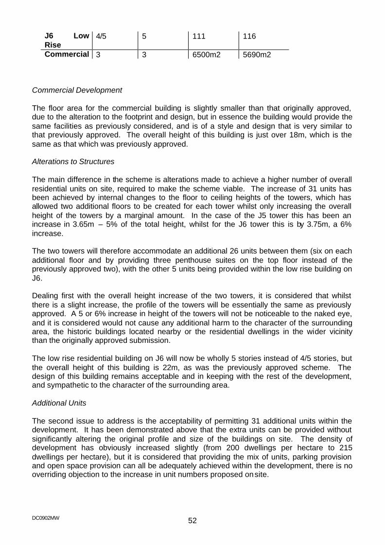
DC0902MW 52
J6 Low Rise
4/5 5 111 116
Commercial 3 3 6500m2 5690m2 Commercial Development The floor area for the commercial building is slightly smaller than that originally approved, due to the alteration to the footprint and design, but in essence the building would provide the same facilities as previously considered, and is of a style and design that is very similar to that previously approved. The overall height of this building is just over 18m, which is the same as that which was previously approved. Alterations to Structures The main difference in the scheme is alterations made to achieve a higher number of overall residential units on site, required to make the scheme viable. The increase of 31 units has been achieved by internal changes to the floor to ceiling heights of the towers, which has allowed two additional floors to be created for each tower whilst only increasing the overall height of the towers by a marginal amount. In the case of the J5 tower this has been an increase in 3.65m – 5% of the total height, whilst for the J6 tower this is by 3.75m, a 6% increase. The two towers will therefore accommodate an additional 26 units between them (six on each additional floor and by providing three penthouse suites on the top floor instead of the previously approved two), with the other 5 units being provided within the low rise building on J6. Dealing first with the overall height increase of the two towers, it is considered that whilst there is a slight increase, the profile of the towers will be essentially the same as previously approved. A 5 or 6% increase in height of the towers will not be noticeable to the naked eye, and it is considered would not cause any additional harm to the character of the surrounding area, the historic buildings located nearby or the residential dwellings in the wider vicinity than the originally approved submission. The low rise residential building on J6 will now be wholly 5 stories instead of 4/5 stories, but the overall height of this building is 22m, as was the previously approved scheme. The design of this building remains acceptable and in keeping with the rest of the development, and sympathetic to the character of the surrounding area. Additional Units The second issue to address is the acceptability of permitting 31 additional units within the development. It has been demonstrated above that the extra units can be provided without significantly altering the original profile and size of the buildings on site. The density of development has obviously increased slightly (from 200 dwellings per hectare to 215 dwellings per hectare), but it is considered that providing the mix of units, parking provision and open space provision can all be adequately achieved within the development, there is no overriding objection to the increase in unit numbers proposed on site.

DC0902MW 53
Housing Mix The third issue to address is the change in the mix of units on site. The differences between the current scheme and the extant scheme are shown below: Extant Scheme Current Scheme Studio 38 32 One Bed unit 104 132 Two Bed Unit 157 170 Three Bed Unit 4 0 Total 303 334 The number of studio apartments has been reduced, which is considered to be a positive move, in line with the objectives of the urban design team. In addition the applicant’s marketing of the site has indicated a lesser interest for these units compared to the one and two bed apartments. The four three bed units originally included as the penthouse suites have also been removed and as described above, replaced with larger two bed units. The three bed units would not have truly provided family accommodation due to the flatted scheme and their location within it (located at the very top of each tower), hence there is no overriding objection to their removal within this scheme. The mix of units in the current scheme has retained 50% of the units as two bed apartments, which allows for a reasonable mix within the development as a whole. Affordable Units The fourth issue to address is the affordable housing provision on site. In the extant scheme the affordable housing provision was for 36 units on site, with an additional contribution secured by the Section 106 agreement for off-site provision. This is not normal practice for Medway Council, however it was considered that the site was unique in that the development was specifically designed for non-family accommodation and for a particular chosen lifestyle. In this instance it was considered acceptable for a limited provision only to be made on site, with the shortfall being made up by a financial contribution. Given the increase in unit numbers in the current scheme, additional affordable housing provision is required through Policy H3, and it has been agreed that these additional units need to be accommodated wholly within the development. An additional 8 affo rdable units have been included within the scheme (which is 25% of the additional 31 units being provided), creating a total of 44 affordable units on site. These are all located within the low-rise residential building on J6. The principle of allowing a reduced percentage of affordable housing on site was established in the original consent and is not an issue to re-visit in the current scheme. This development will provide for 25% of the additional units to be affordable housing, therefore in terms of the current application, the development will meet the aims of Policy H3. Parking Provision The fifth issue to address is the parking provision on site. The majority of parking is proposed within the basement level of both J5 and J6, along with a small amount of surface parking alongside the low rise residential building on J6. The total number of spaces provided will be 422 – 153 spaces on J6 and 269 spaces on J5. 359 of these are for residential purposes, which equates to a parking provision of 1.075 spaces per unit. In the
DC0902MW 54
extant scheme the parking provision was also 1 space per unit, therefore the current situation is considered to be acceptable and follows what was agreed in the earlier application. Some of the parking provision for the apartments located on J6 will be in the basement level parking on J5, and again this replicates the parking layout in the approved scheme. The basement parking areas would also provide for motorbike and cycle parking. In total 20 motorbike spaces, and 208 cycle spaces will be provided across the site. 28 spaces for disabled users will also be accommodated within the total overall provision, appropriately split between the J5 and J6 basements. 63 spaces are to be allocated for the commercial uses, which is a slight increase compared to the extant permission (58 spaces), associated with a slightly smaller floor area of commercial development. Whilst this provision does not meet the parking standards given in the Local Plan, it does accord with what was agreed in the existing permission. Within the wider dockyard area there are other parking areas, including the surface car park and multi-storey car park serving the Factory Outlet Centre, Dickens World and the Cinema. It is likely that in some instances those using the commercial facilities provided on J5 may well have combined this use with visiting the other facilities and attractions in the wider dockyard area, and thus a sharing of the car park facilities would result. In this regard and in light of the earlier permission, the overall parking provision for the mixed-use development is considered to be acceptable. Refuse storage is also located in the basement level car parks, and arrangements for this provision and its collection remain as agreed in the extant permission. Site access issues have not altered, for either vehicles or pedestrians, therefore the current scheme raises no new issues in this regard. Design The design of the buildings remains very similar to that agreed in the extant permission. Control over the choice of materials will be achieved via the discharge of conditions, to ensure that the final appearance of the buildings is of an exceptional quality. General Layout In terms of the wider development the scheme retains all the open space and landscape principles that were established in the previous application, including the cantilevered boardwalks along the edge of the fingers, breakout seating, the amphitheatre, tree planting and low level landscaping. The detail of these elements was previously covered by conditions on the original application, and it is considered that this is again the most appropriate way to address these details. Section 106 Agreement The extant permission was subject to a legal agreement which was signed in July 2006. This agreement secured the following: - Provision of 36 affordable units on site, and a financial contribution to off-site provision
DC0902MW 55
- A financial contribution of £150,000 towards the provision of a community based water activity centre on basin 2
- Improvements to Dock Head Road - The provision of a bus enhancement service providing a late night bus service from
the site in both directions until 30 minutes after the close of the last commercial use on J5
The current application will either require the variation of the existing legal agreement, or the drafting of a revised agreement. This will need to cover the provision of the additional 8 affordable housing units on site, which are intended to be shared ownership units, as agreed with the Housing section of Medway Council. The clause relating to improvements to Dock Head Road will need to be carried over into the new agreement. The late night bus service was only a requirement until the Dickens World development was in operation – given the fact that this attraction is now open, this requirement is no longer necessary. Instead the developer has agreed to provide an early morning bus service, to cover the period 06:00 to 09:30 Monday to Friday; 07:30 – 09:30 on Saturday’s and 09:00 to 09:30 on Sunday’s – after 9.30am the Factory Outlet Centre bus service comes into operation. This service would have a 20 minute frequency and would be operated for a period of 3 years. In addition the applicant’s are now required to provide a green travel plan, incorporating arrangements for ongoing review and changes to the plan to deliver trip generation set out in the Transport Assessment. Yearly monitoring by Medway Council will also be required, which will be funded by the developer at a cost of £2,000 per site, as well as arrangements for ongoing management and promotion of the plan, including post completion of the development. A welcome pack will also be provided to the new residents of the site in relation to green transport issues. These elements will all be included within the revised S106 agreement. Conclusions and Reasons for approval In summary it is considered that the assessment of the previous scheme as set out in the appended report is applicable to the revised application. The alterations to the scheme from that which has been previously agreed would not materially affect the overall appearance or nature of the development. The profile of the buildings would essentially remain as approved, with minor alterations only, and it is considered that the result will be a high quality, landmark development, which would enhance the character of the Chatham Maritime area in general and the dockyard and marina area in particular. The scheme is therefore recommended for approval subject to the variation of the existing S106 agreement attached to planning permission MC2003/2663 and the conditions as set out above. [This application would normally fall to be determined under officer’s powers but is being reported for Members consideration due to the extent of representations that have been received contrary to the officer recommendation.]

DC0902MW 56
DC0902MW 57
7 MC2007/0577
Date Received: 4th April 2007
Location: Land rear of Orchardleigh 48 Hollywood Lane Wainscott Rochester
Kent ME3 8AR Proposal: Construction of a 4 -bedroomed detached house with integral garage Applicant: Mr & Mrs R Young C/o Agent Agent: Mr J Bolton Synergy Property & Planning Consultants The Estate
Office Windmill Business Centre Wrotham Road Meopham Kent DA13 0QA
Ward: Strood Rural Recommendation - Approval with Conditions (as amended by plans received 4 May) 1 The development hereby permitted shall be begun before the expiration of three
years from the date of this permission. 2 No development shall take place until full details and samples of all materials to be
used are submitted to and approved in writing by the Local Planning Authority and all subsequent works shall thereafter be carried out in accordance with the approved details and maintained.
3 Prior to the first occupation of the development the bathroom rooflight windows on
the rear elevations shall be fitted with obscure glass and any opening within them shall be a minimum of 1.7m above internal floor level, and shall thereafter be retained as such.
4 The area shown on the permitted drawings for vehicle parking and garaging] shall
be kept available for such use and no permanent development, whether permitted by the Town and Country Planning (General Permitted Development) Order 1995 (or any Order revoking and re-enacting that Order) or not, shall be carried out on the land so shown or in such a position as to preclude vehicular access to this reserved parking space.
5 Notwithstanding the provisions of the Town and Country Planning (General
Permitted Development) Order 1995 (or any Order revoking and re-enacting that Order with or without modification) no development within Classes B and C of Part 1 of the Second Schedule to the Order shall be carried out on the site without the prior written approval of the Local Planning Authority.
6 Notwithstanding the provisions of Town and Country Planning (General Permitted
Development) Order 1995 (or any Order revoking and re-enacting that Order with or without modification), no window, doors voids ot other openings, other than
DC0902MW 58
those shown on the approved plans, shall be installed in the flank elevations or rear roof slope of the dwelling herein approved without the prior written approval of the Local Planning Authority.
For the reasons for this recommendation for approval, please see Planning Appraisal section and conclusions at the end of this report.
Site Description The application relates to the rearmost part of the garden of 48 Hollywood Lane, which is roughly triangular in shape with maximum width and depth of approx. 19m by 45m. There are no significant land level changes across the site. It is accessed by an unmade track belonging to no. 48. A public footpath runs along the western edge of this track and then cuts across to adjoin the northwest boundary of the site, li nking Hollywood Lane to the new residential development to rear and open countryside beyond. The boundary of the site to this footpath consists of a severely lopped sycamore hedge, approx. 2m high, and the remaining boundary is formed of close board fencing approx. 1.8m high. No. 48 itself is a large detached bungalow, with a detached double garage to rear. The area is predominantly residential with the street scene very mixed. Backland properties accessed from Hollywood Lane are relatively common, including a detached two-storey property adjacent (no. 50) served by the same track. The adjacent property no. 42 is a large two-storey care home, which has detached outbuildings to rear adjacent the site. Hollywood Lane is a busy through road subject to traffic calming measures. Proposal The proposal is for a detached dwelling. Accommodation would comprise a lounge, dining room, kitchen/breakfast room, utility room, study, WC and double garage at ground floor, and four bedrooms, two with en-suite facilities, and a family bathroom at first floor. The property would be of chalet bungalow design, with first floor accommodation contained with a barn-hipped roof incorporating three pitched roof dormers to front and roof lights only to rear. It would be approx. 14m wide and 10m deep, with a ridge height of 7m. The ridge would be slightly lower over the garage element, which would also be set back slightly from the main front elevation. The private garden area would be shallow but would extend some distance to side (north). The application originally included part of the public footpath and a small section of no. 50’s plot within the red line; this has subsequently been corrected. The block plan has also been amended slightly to show the relationship between the access track and footpath. Site Area/Density Site area: 0.08078 ha (0.2 acres) Site density: 12.4 dph (5 dpa)
Relevant Planning History MC2001/0385 Construction of a single -storey rear extension
DC0902MW 59
Approved 4 May 2001 MC2003/0270 Construction of a single -storey rear extension Approved 7 April 2003 Representations The application has been advertised on site and neighbour notification letters have been sent to the owners/occupiers of: 42, 48, 50 and 52 Hollywood Lane; 3-6 (inc) Cagney Close; and 12, 14, 15 and 16 Niven Close. Six letters have been received from neighbouring residents (two from the same property), objecting on the following grounds:
- The figures given in the application for the width of the driveway are misleading and include the public footpath
- The new dwelling will increase the usage of an already inadequate unmade track
- Loss of privacy and noise disturbance to surrounding properties - Development of site surrounded by existing properties is inappropriate - Overcrowding of area and pressure on existing infrastructure - Loss of trees and shrubs having a significant impact on the local environment
and wildlife - A large walnut tree was removed and the sycamore hedge severely lopped
prior to the submission of the application Issues regarding noise disturbance and dirt from construction, and obstruction of access track by construction vehicles are also raised but are not matters that can be considered as part of the planning application. Following the correction of the red line plan, a further letter was received reiterating previous concerns and adding that the plans do not make clear that vehicles should not use the footpath and the driveway of no. 50 to turn on, making it difficult to see how vehicles from the new property can exit in a forward gear. The parish council’s footpaths officer has written objecting on the grounds that traffic from the new property will cause a safety hazard to users of the busy public footpath, and that the access track is too narrow for larger vehicles. He suggests that the footpath should be fenced off from the driveway. The parish council itself does not object but supports its footpaths officers’ comments and adds that if the footpath cannot be fenced off then a turning circle should be provided. The Kent Fire & Rescue Service has written commenting that the access track is not satisfactory; the road width must be at least 3.7m with a turning head suitable for HGVs. The Dickens’ Country Protection Society has written objecting to the proposal on the grounds that it is an undesirable form of backland development and that access would be onto an area where there is poor visibility. The applicant has written in response to the objections, stating:
DC0902MW 60
- HGVs do not have a problem negotiating the driveway; until recently both 48 and 50 did not have mains drainage and sewage tankers were frequently required.
- Previously up to 10 cars from nos. 48 and 50 have used the driveway with very few problems; the same concerns would arise anywhere more than one car uses a private drive.
- While the footpath is busier since the building of the new estate, he believes not more than 40 people use it regularly
- A number of the objections are from the new estate which was itself built on orchards that were valued by existing residents.
Development Plan Policies Kent and Medway Structure Plan 2006 Policy QL1 (Quality of Development) Policy HP4 (Housing: Quality and Density of Design) Policy TP19 (Parking Standards) Medway Local Plan 2003 Policy BNE1 (General Principles for Built Development) Policy BNE2 (Amenity Protection) Policy BNE43 (Trees and Development Sites) Policy H4 (Housing in Urban Areas) Policy H9 (Backland and Tandem Development) Policy T1 (Impact of Development) Policy T2 (Access to the Highway) Policy T3 (Provision for Pedestrians) Policy T13 (Parking Standards) Planning Appraisal The main issues arising for consideration in respect of this proposal are:
- principle of the development - design and impact on the character of the area - impact on residential amenities - highways impact, including the adjacent public footpath
Principle of Development The application site is within an established residential area where the principle of residential infilling is accepted by Policy H4 of the adopted Local Plan. Policy H9 states that backland development will be acceptable subject to detailed considerations, but that tandem development (one house directly behind the other with a shared access to the side) will not be permitted. While this would seem to apply to the current situation, the driveway in this case already exists, serving an existing backland dwelling (no. 50). Therefore the specific concerns relating to tandem development (disturbance and loss of privacy to the house at the front) already occur to some extent. In this circumstance, the principle of the development is considered acceptable, subject to detailed assessment of its impacts.
DC0902MW 61
Density, Design and Character of Area The character of the area is mixed, with some large properties in very spacious plots and some more regular semi-detached and detached properties. There is also a modern residential estate to rear where plots are much smaller, although the application site would generally be seen in relation to the older housing. In this context, the proposed density is considered appropriate, leaving good-sized plots for both the existing and proposed dwellings. As well as no. 50, there are several other backland plots in the immediate vicinity; this forms part of the established character of the area, and the siting of a new detached property in this location is therefore considered to accord with this. The design of the proposed dwelling is fairly standard but is well proportioned and fits well with the mixed but traditional designs of most surrounding properties. Several residents have objected regarding the removal/lopping of trees prior to the application being submitted. While this is unfortunate, the trees in question were not protected, and in its current state the sycamore hedge is not worthy of being protected. The hedge is shown to be replaced with fencing. Although the hedge would have greater ecological value and could in time make a contribution to visual amenity in the area, the trees make use of the public footpath difficult in places, and given the presence of this running alongside the plot, the lack of a secure boundary could raise security issues for the new property. It is therefore considered on balance that it would not be reasonable to require the retention of this hedge. Overall, the visual impact of the proposal is therefore considered acceptable. In this respect the proposal is in accordance with the relevant provisions of Policy QL1 of the Structure Plan and Policies BNE1, H4 and H9 of the adopted Local Plan. Amenity Considerations The chalet bungalow design of the proposed dwelling and its siting in relation to surrounding properties is such that there would be no significant impact on neighbouring properties in terms of loss of outlook, sunlight or daylight. Ground floor windows would be screened from neighbouring properties by boundary treatment. Habitable room windows at first floor are arranged to maintain a distance of over 21m between facing windows, and where they face over neighbouring gardens this would not be at close proximity to the most private areas. It is considered that overlooking of neighbouring properties would be no worse than might be expected in a residential area and would not cause any significant loss of privacy. As the new dwelling would be adjacent to an existing backland property, and with the much denser new development also in close proximity, it is considered that any increase in noise from the new dwelling would not have a significant impact on the amenity of surrounding properties. In terms of amenities for future occupiers, the proposed dwelling provides a good level of accommodation, and the subdivision of the plot leaves both the existing and new dwellings with good-sized private gardens. The proposal’s impact on residential amenities is therefore considered to be acceptable. In this respect the proposal is in accordance with Policy QL1 of the Structure Plan and Policy BNE2 of the adopted local plan.
DC0902MW 62
Highways The proposed property would be accessed via an existing privately owned unmade track from Hollywood Lane. The track is approx. 65m long and is between 2.6m and 3.1m wide; this is enough for a single car or slightly larger vehicle but not for two to pass. At present it serves no. 50 and the rear parking/garaging area for no. 48. A public footpath runs along the western edge of the track and then cuts across just in front of no. 50. The comments of the Kent Fire & Rescue Service are noted, but the track already serves a backland dwelling, where the same situation would arise should there be an emergency. It is therefore considered that a refusal on the ground of poor access for emergency vehicles could not be supported, particularly given the rarity of occasions when this would be necessary. However, their comments should be drawn to the applicant’s attention via an informative. The additional traffic generated by a third dwelling is not considered to be so much that the track would become unsafe for vehicles or for users of the adjacent footpath. Vehicles meeting would remain fairly rare, and would only occur at low speeds; it is therefore not considered necessary to provide passing places. While the track and proposed driveway are such that vehicles might have to turn in four or five manoeuvres rather than three to exit in a forward gear, given the low level of usage, this would not cause any harm to highway safety. Given the length of the driveway, it is unlikely that vehicles would reverse out onto the main road rather than undertake this manoeuvre. Fencing off of the footpath, as per the parish council’s footpath officer’s comments, is not considered feasible. It would not only interfere with access to no. 50, as the footpath cuts across the driveway at this point, but the footpath itself is not useable due to lack of maintenance where it runs alongside the access track. Walkers tend to use the track instead; fencing it off would remove this option and could discourage use of the footpath. The footpath itself is on land outside of the applicant’s ownership or control and its improvement cannot therefore be made a condition of this application. The level of parking provision for the proposed property is in accordance with adopted standards and is considered appropriate for a dwelling of this size in this location. Parking provision for the existing no. 48 would not be affected. The application is considered to comply with Policy TP19 of the Structure Plan and Policies T1, T2, T3 and T13 of the adopted Local Plan, and no highways objection is raised. Conclusion and Reasons for Approval Given that the access track already exists and that backland and tandem development is a common feature of the area, the principle of a dwelling on this site is acceptable. The dwelling proposed would not cause any significant detriment to the character of the area, the amenity of surrounding residential properties or to highway safety. It is therefore considered to be acceptable and is in accordance with the aforementioned planning policies. [This application would ordinarily fall for determination under officers’ delegated powers but is reported for Members’ consideration due to the level of representations contrary to the officer’s recommendation.]
DC0902MW 63
8 MC2007/0625
Date Received: 13th April 2007
Location: 23 Sedley Close Cliffe Rochester ME3 8HE Proposal: Conversion of garage to habitable room Applicant: Mr L Love 23 Sedley Close Cliffe Woods Rochester Kent ME3 8HE Agent: Ward: Strood Rural Recommendation - Approval with Conditions 1 The development hereby permitted shall be begun before the expiration of three
years from the date of this permission. 2 Materials used on the construction of external surfaces of the garage conversion
herein approved shall match those used on the existing dwelling. 3 The two parking spaces within the front garden of the property shall be retained for
use as such, and notwithstanding the provisions of the Town and Country Planning (General Permitted Development) Order 1995 (or any Order revoking and re-enacting that Order with or without modification), no development shall take place in this area or in such a way as to prevent vehicular access to it without the prior written approval of the Local Planning Authority.
For the reasons for this recommendation for approval please see the Planning Appraisal section and conclusions at the end of this report.
Site Description 23 Sedley Close is a two-storey semi-detached property, located within the village of Cliffe Woods. The property has an integral garage and small porch projecting slightly beyond the main front elevation with a hipped roof over. The front garden is largely hard surfaced providing parking for two cars. Sedley Close features properties of generally similar character but with differences in detailed design. On-street parking is available but congested. Other garage conversions are visible nearby, including the adjacent property no. 24. Proposal The proposal is for the conversion of the garage to study and storeroom. The existing garage door would be replaced by infill brickwork and a window.

DC0902MW 64
Relevant Planning History
MC2006/1615 Replacement of flat roof with new pitched roof over existing garage [includes no. 22] Approved 13/10/06
Representations The owners and occupiers of 2 and 3 Ashwood Close and 7, 8., 22 and 24 Sedley Close have been consulted on the application The Kent Fire & Rescue Service has written commenting on the proposal regarding travel distance and the possible need for sprinklers. (It is clear that these comments are not relevant to this application to convert a garage) Cliffe and Cliffe Woods Parish Council has written objecting to the proposal on the ground of loss of car parking. Development Plan Policies Kent and Medway Structure Plan 2006 Policy QL1 Quality of Development and Design Policy TP19 Parking Standards Medway Local Plan 2003 Policy BNE1 General Principles for Built Development Policy BNE2 Amenity Protection Policy T13 Parking Standards Planning Appraisal The main issues for consideration arising from this proposal are:
- Visual impact - Impact on amenities of neighbouring properties - Highways impact
Street Scene and Design While Sedley Close consists of properties of similar general character, there are differences in design detailing such as siting of garages relative to the main dwelling and roof designs. It is therefore considered that the replacement of the garage door with brickwork and a window would not be significantly detrimental to the character of the existing property or the surrounding area. It is noted in this respect that similar development has been carried out elsewhere in the road. The visual impact of the proposal is therefore considered to be in accordance with the relevant provisions of Policy QL1 of the Structure Plan and Policy BNE1 of the adopted Local Plan. Amenity Considerations
DC0902MW 65
The proposed garage conversion would not result in any additional built form and would therefore have no significant impact on the amenities of neighbouring properties. In this respect the proposal is in accordance with the relevant provisions of Policy QL1 of the Structure Plan and Policy BNE2 of the adopted Local Plan. Highways The proposed garage conversion would result in the loss of one parking space. It is recognised that parking can be an issue in this area; the demand for on street spaces is high and at times in this and nearby roads parked cars can obstruct visibility and free flow of passing traffic. However, two parking spaces would remain in the front garden, which is considered adequate for a property of this size in this location. It is in line with adopted parking standards as required by Policy TP19 of the Structure Plan and Policy T13 of the adopted local plan, and also reflects the level of parking provision at most other properties in the road, which feature as original a garage with a single driveway leading. Conclusions and Reasons for approval The proposed garage conversion is considered to have minimal and acceptable visual impact and impact on neighbours’ amenities, and it is considered that sufficient off road parking would be retained to serve the property without causing harm to highway safety or inconvenience to other road users. The application is therefore considered to comply with the above-mentioned policies and is accordingly recommended for approval. [This application would ordinarily fall to be determined under officers’ delegated powers, but has been reported for Members’ consideration due to representations received from the parish council contrary to officers’ recommendation.]
DC0902MW 66
9 MC2007/0656
Date Received: 10th April 2007
Location: Romany Lodge Romany Road Gillingham ME8 6JH Proposal: Outline application for demolition of dwelling and construction of a
pair of 3-bedroomed semi-detached, a detached 3-bedroomed and two 4-bedroomed detached houses with associated garages and parking
Applicant: Alastair Stuart (Cranbrook) Limited 3-4 Bridge Buildings Stone Street
Cranbrook Kent TN17 3HG Agent: Mr I McCourt Kent Design Partnership Grove Dairy Farm Business
Centre Bobbing Hill Sittingbourne Kent ME9 8NY Ward: Twydall Recommendation - Approval with Conditions 1 Approval of the details of layout, scale and external appearance of the building(s),
shall be obtained from the Local Planning Authority in writing before any development is commenced.
2 Plans and particulars of the reserved matters referred to in Condition 1 above shall
be submitted in writing to the Local Planning Authority for approval. Such application for approval shall be made to the Authority before the expiration of three years from the date of this permission and the reserved matters shall be carried out in accordance with the approved details.
3 The development to which this permission relates must be begun no later than the
expiration of 2 years from the final approval of the reserved matters or in the case of approval on different dates, the final approval of the last such matter to be approved.
4 The plans and particulars submitted in accordance with Condition 1 above shall
include:
a) A plan showing the location of and allocating a reference number to each existing tree on site which has a stem with a diameter, measured over the bark at a point 1.5 metres above ground level, exceeding 75mm, showing which trees are to be retained and the crown spread of each retained tree;
b) details of the species, diameter (measured in accordance with paragraph a) above, and the approximate height and an assessment of the general state of health and stability, of each retained tree and of each tree which is on land adjacent to the site and to which paragraphs c) and d) below apply;
DC0902MW 67
c) details of any proposed topping or lopping of any retained tree, or of any tree on land adjacent to the site;
d) details of any proposed alterations in existing ground levels and of the position of any proposed excavation within the crown spread of any retained tree or of any tree on land adjacent to the site within a distance of 6m from any retained tree, or any tree on land adjacent to the site, equivalent to half the height of that tree;
e) details of the specification and position of fencing and of any other measures to be taken for the protection of any retained tree from damage before or during the course of development.
In this Condition "retained tree" means an existing tree which is to be retained in accordance with paragraph a) above.
5 The details to be submitted in pursuance of Condition 01 shall show adequate
land, reserved for the parking or garaging of vehicles and upon approval of the details, no permanent development, whether or not permitted by the Town and Country Planning (General Permitted Development) Order 1995, (or any Order revoking and re-enacting that Order), shall be carried out on the land so shown (other than the erection of a private garage or garages) or in such a position as to preclude vehicular access to the reserved vehicle parking area.
For the reasons for this recommendation for approval please see planning appraisal section and conclusions at the end of this report.
Site Description The application site is an extended bungalow situated in a large plot. To the north and east are large school sites. The neighbour to the west is a bungalow set approx. 0.3m higher than the application site, with flank wall windows in the facing the application site that relate to a hallway, dining room and living room. The neighbour has confirmed that the window into the dining room is the only window serving that room and that the living room is also served by a window to the rear. The character of the area is mixed with both two storey and single storey semi-detached and detached dwellings built to different styles. To the front of the application site there are school keep clear lines and pedestrian barriers on the opposite side of the road. The rear garden is mainly laid to lawn enclosed by a conifer hedge approx. 1.8m in height. There is a slight land level difference in the rear garden of approx. 0.5m. Proposal The application seeks permission in outline with all matters except for access reserved, for the demolition of Romany Lodge and the construction of a pair of 3-bedroomed semi-detached, a 3-bedroomed detached and two 4-bedroomed detached houses with associated garages and parking. The indicative plans show the pair of semi-detached houses fronting Romany Road with access to the east for the three detached houses which are set in a line from north to south.
DC0902MW 68
Relevant planning History GL49/153B Erection of two 3bedroomed bungalows with integral garages to the rear garden
area and creation of vehicular access to the rear from the side. Refused 20/02/87. appeal dismissed 20/01/88.
Site Area/Density Site area: 0.18 Ha (0.44 acres) Site density: 27.77dph (11.36 dpa) Representations The owners and occupiers of the following properties have been consulted on the application: Allemande, Mulberry Lodge, Heather Cottage, 1, 2, 3, 4 Romany Road, 7, 9, 11, 13 Wilmington Way, 46, 48, 48a, 52, 54, 54a, 56, 58, 60, Twydall Lane and the application has been advertised on site. 10 letters have been received objecting to the application on the following grounds:
- Objection if the trees at the rear of the garden are removed reducing privacy and affecting a family of foxes
- Highway safety with regard to the location of the access in relation to the schools - The new development will reduce the stopping places for parents causing overspill of
cars into Twydall Lane which already suffers double parking and is a main road - Loss of privacy - Concern over the security of their home from the proposed access road - Over development - Concern with regard to pedestrian safety - Noise - Question if the houses will be affordable - Concern over the number of houses proposed and if the houses will conform to
current guidelines and recommendations in terms of room size, garden, outside space, provision of off road parking etc.
- Concern that the houses should extend to the inclusion of technologies to reduce the carbon footprint of the footprint
- Loss of light - Loss of outlook - The proposed scheme will create a canyon effect to Allemande - No protection to the established landscaping - Pollution - Loss of wildlife - Loss of property value (Not a planning issue)
The Kent Fire and Rescue have written stating the access is not satisfactory for the furthest proposed premises unless the access drive is constructed to accommodate the weight of a HGV and turning for a fire engine is available.
DC0902MW 69
Development Plan Policies Medway Local Plan 2003
Policy BNE1 (General Principles for Built Development) Policy BNE2 (Amenity Protection) Policy BNE3 (Noise) Policy BNE43 (Trees on Development Sites) Policy H4 (Housing in Urban Areas)
Policy T1 (Impact of Development on the Highway Network) Policy T2 (Access to the Highway)
Policy T13 (Vehicle Parking Standards) Kent & Medway Structure Plan 2006
Policy QL1 (Quality of Development and Design) Policy HP4 (Quality of and density of development) Policy TP19 (Vehicle Parking Standards)
Planning Appraisal The main issues for consideration arising from this proposal are: - Principle of development - Impact on the street scene - Density - Impact on residential amenities - Trees and - Highways impact and parking Principle of Development In terms of the principle of residential development on this site the site is within the urban area as defined in the Local Plan 2003. It is considered that this proposal is acceptable in terms of the general guidance given in PPS3 “Housing”, which encourages the re-development of existing land in urban areas to avoid inappropriate development in green field locations. Local Plan Policy H4 reflects this stance and allows for residential infilling within the urban area provided the proposed development will not have an adverse impact upon the local environment. The proposal therefore accords with the provisions of Policy H4 of the adopted Local Plan. Impact on the Street Scene The application site is currently occupied by a detached bungalow set in a very spacious garden. The site is much larger than those in the surrounding area, which generally have narrower, or shorter rear gardens. The site is set in a mixed character area with different types and styles of houses. To the north and east are school sites. While the application has indicative drawings of the development, all matters with the exception of access are reserved for future determination. As such an evaluation of the design is precluded at this time. The indicative drawing illustrates that the distance of the
DC0902MW 70
development from the road and the spacious nature of the development site and it surroundings would not result in any material harm to the character and appearance of the surrounding area. Appropriately designed dwellings, which are sited in a manner shown on the illustrative site layout would blend in with the surroundings and make a more efficient use of the land. This application is substantially different from the 1987 application refused and dismissed on appeal in so far as the 1987 application involved erection of two new dwellings in the rear garden of the existing property and creation of a separate vehicular access. The proposal therefore accords with the provisions of Policy QL1 of the Structure Plan and Policies BNE1, and H4 of the adopted Local Plan. Density The proposals provide for a density of development on the site at 27.77 d.p.h. which would be below the range identified in Government guidance and structure plan policy HP4; however the prevailing adjoining housing in Romany Road and Twydall Lane is at a lower development density and the proposed development therefore compliments the character of the area. Government guidance is clear that the character of an area is important and will assist in guiding density and on that basis may result in form of development below the guidance levels The proposal therefore accords with the provisions of Policy HP4 of the Structure Plan. Impact on residential amenities Subject to the internal layout of the dwellings, it is considered that the suggested footprint of the development combined with the distance between the neighbouring properties would not result in any unacceptable building-to-building relationships, in terms of light, outlook or privacy. The proposal therefore accords with the provisions of Policy QL1, of the Structure Plan and Policy BNE2 of the adopted Local Plan. Trees There are several trees and shrubs within the vicinity of the proposed development. The majority of the trees currently on site are of low amenity value. These trees would not be worthy of protection with a preservation order, although they do provide an effective screen from the neighbouring school and neighbouring properties. Due to the siting of the proposed dwellings some trees will be lost. Trees numbered G3 (the remainder of), G5, G6, G7, G8 and number 7, should all be situated a sufficient distance from the proposed development to be retained. These trees will require protection and a condition is recommended to protect these trees. It is considered that even though some trees and shrubs would be lost through the development it would be possible to enhance the site through the careful consideration of the reserved matter for landscaping. The proposal therefore accords with the provisions of Policy BNE43 of the adopted Local Plan.
DC0902MW 71
Highways Impact and Parking The illustrative layout demonstrates that the development would have six off road spaces in the form of garages with parking available to the front of each garage for a further six cars. This equates to a parking level of 2.4 per unit. It is considered that the proposed scheme would provide adequate parking to serve the needs of the development, particularly in light of the number of bedrooms provided in each house, the siting of the development generally and the proximity to the schools and need to get cars off the road. The proposals show a 3.8m wide access road of around 16m in length. This is in line with the Kent Design Guide (Shared Private Drive) and is considered appropriate. It is noted that in the details of the reserved matters the applicant would need to demonstrate that the scheme could provide adequate access for Fire Appliances to enter and turn on site. The proposal therefore accords with the provisions of Policy T19 of the Structure Plan and Policy T1, T2 and T13 of the adopted Local Plan. Conclusions and reasons for approval The principle of the proposed development and the details of the means of access are considered to be satisfactory. The proposed development will not be out of context with its surroundings and it is considered to be acceptable for the reasons outlined above. It is therefore recommended that the proposal be approved subject to the imposition of appropriate conditions. The proposal therefore accords with the provisions of Policy QL1, T19 and HP4 of the Structure Plan and Policies BNE1, BNE2, BNE43, T1, T2, T13, and H4 of the adopted Local Plan and the application is accordingly recommended for approval. The application would normally fall to be determined under delegated powers but has been referred to Committee due to the number of representations received contrary to officer’s recommendation and at the request of Cllr Gilry as she considers that issues regarding potential overdevelopment and the highway issues are best and most appropriately considered by committee in this instance. [This application was considered by Members at the Development Control Committee on the 4th May 2007, when it was determined to defer a decision to enable a Members’ site visit to be held.] [This application was considered by Members at the Development Control Committee on the 6th June 2007, when it was determined to defer a decision to enable a Members’ site visit to be held.]
DC0902MW 72
10 MC2007/0712
Date Received: 18th April 2007
Location: Land opposite 51-58 Hickory Dell Hempstead Gillingham ME7 3SL Proposal: Outline application for the construction of four detached 4-
bedroomed houses with associated access Applicant: Hickory Homes St James' House 8 Overcliffe Gravesend Kent DA11
OHN Agent: Mr D Croydon DACA Chartered Architects 21 Stone Street
Gravesend Kent DA12 1QY Ward: Hempstead & Wigmore Recommendation - Approval with Conditions 1 Approval of the details of scale and external appearance of the building(s), the
means of access thereto and the landscaping (hereinafter called "the reserved matters") shall be obtained from the Local Planning Authority in writing before any development is commenced.
2 Plans and particulars of the reserved matters referred to in Condition 1 above shall
be submitted in writing to the Local Planning Authority for approval. Such application for approval shall be made to the Authority before the expiration of three years from the date of this permission and the reserved matters shall be carried out in accordance with the approved details.
3 The development to which this permission relates must be begun no later than the
expiration of 2 years from the final approval of the reserved matters or in the case of approval on different dates, the final approval of the last such matter to be approved.
4 Details submitted pursuant to the Landscaping reserved matters required at
condition 1 shall include an arboricultural method statement and tree protection plan which complies with British Standard 5837 "Trees in Relation to Construction" and ensures the safe and adequate retention of the trees shown for retention. The Arboricultural method statement shall include details of any proposed alterations in existing ground levels and of the position of any proposed excavation within the crown spread of any retained tree or of any tree on land adjacent to the site within a distance of 10 metres from any retained tree, or any tree on land adjacent to the site, equivalent to half the height of that tree. Additionally the Arboricultural method statement shall include details of the specification and position of fencing and of any other measures to be taken for the protection of any retained tree from damage before or during the course of development. Such details as agreed shall be implemented in accordance with the approved details and thereafter maintained for the duration of the construction works on the site.
DC0902MW 73
5 The area shown on the permitted drawings for vehicle parking shall be kept available for such use and no permanent development, whether permitted by the Town and Country Planning (General Permitted Development) Order 1995 (or any Order revoking and re-enacting that Order) or not, shall be carried out on the land so shown or in such a position as to preclude vehicular access to this reserved parking space.
For the reasons for this recommendation for approval please see planning appraisal section and conclusions at the end of this report.
Site Description Hickory Dell is characterized by two storey detached and semi-detached housing. The southern end of the cul-de-sac has a spacious feel with development only on the western side of the road. The eastern side of the road is covered with dense shrubs and trees. The land slopes steeply up to the east with a difference in land level of approx. 10m with the houses in Speaks Road. The houses in the area have gable ends and many have weatherboarding or tile hanging over the first floor. Most houses have off road parking either in the form of a garage or parking to the front on a hard standing. Proposal The application is in outline form with all maters reserved except access and layout for the construction of four detached 4-bedroomed houses with associated access. The plans site the houses in a line from north to south with plots A-C set in excess of 8m from the road and plot D approx. 3m from the footway to the west. Each plot has two parking spaces to the front with plot D set in a tandem arrangement. The indicative floor plans show a living room, dining/family room, kitchen and cloakroom (with a study also shown in plots B and C) on the ground floor with four bedrooms (one en-suite) and a bathroom at first floor. Due to the land levels the ground floor of the houses only has windows to the front of the house. At first floor there is access onto a rear patio area and garden area shown cut into the slope. The rear amenity space for the houses varies in size from a depth of approx. 7m to 11m and in width from approx. 16.4m to 20.2m. The rear amenity space consists of a level patio area for each of the plots with garden area behind which varies in steepness. Seven trees are shown to be retained on the site. Representations The application has been advertised on site. The Hempstead Residents Association has been consulted along with the owners and occupiers of the following properties: 18, and 51-66 (inclusive) Hickory Dell; 28 Boughton Close, Twydall; 19 and 20 Ferndown Close; and Chetwyn, Estelle, Kontiki, Ritalan, Roseville, Sundown and Torvean, Spekes Road.
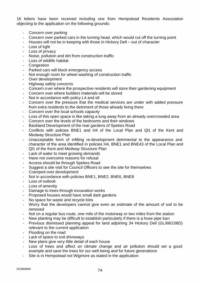
DC0902MW 74
16 letters have been received including one from Hempstead Residents Association objecting to the application on the following grounds:
- Concern over parking - Concern over parked cars in the turning head, which would cut off the turning point - Houses will not be in keeping with those in Hickory Dell – out of character - Loss of light - Loss of privacy - Noise, pollution and dirt from construction traffic - Loss of wildlife habitat - Congestion - Parked cars will block emergency access - Not enough room for wheel washing of construction traffic - Over development - Highway safety concerns - Concern over where the prospective residents will store their gardening equipment - Concern over where builders materials will be stored - Not in accordance with policy L4 and s6 - Concern over the pressure that the medical services are under with added pressure
from extra residents to the detriment of those already living there - Concern over the local schools capacity - Loss of this open space is like taking a lung away from an already overcrowded area - Concern over the levels of the bedrooms and their windows - Backland Development of the rear gardens of Spekes Road - Conflicts with policies BNE1 and H4 of the Local Plan and Ql1 of the Kent and
Medway Structure Plan - Unacceptable form of infilling re-development detrimental to the appearance and
character of the area identified in policies H4, BNE1 and BNE43 of the Local Plan and Ql1 of the Kent and Medway Structure Plan
- Lack of water to meet growing demands - Have not overcome reasons for refusal - Access should be through Spekes Road - Suggest a site visit for Council Officers to see the site for themselves - Cramped over development - Not in accordance with policies BNE1, BNE2, BNE6, BNE8 - Loss of outlook - Loss of amenity - Damage to trees through excavation works - Proposed houses would have small dark gardens - No space for waste and recycle bins - Worry that the developers cannot give even an estimate of the amount of soil to be
removed - Not on a regular bus route, one mile of the motorway or two miles from the station - New planting may be difficult to establish particularly if there is a hose pipe ban - Previous dismissed planning appeal for land adjoining 34 Hickory Dell (GL/68/108D)
relevant to the current application - Flooding on the road - Lack of space to exit driveways - New plans give very little detail of each house - Loss of trees and affect on climate change and air pollution should set a good
example and save the trees for our well being and for future generations - Site is in Hempstead not Wigmore as stated in the application
DC0902MW 75
- Damage to the road through vehicle movements during the course of the build - Proposed houses would face a retaining wall, which does not maximise the amount of
sun they would receive - Require a maximum of 12 car parking spaces not 8 as planned - Plot A is closed to No 57 Hickory Dell than 19m - Once the dam is breached there is likely to be a further application for the site - Not clear from the drawings where the link to the existing foul sewage system will be
made - Plans inaccurate
Site Density Area: 0.19 ha (0.47 acres) Density: 21.05 dph (8.51 dpa) Planning History MC2006/2010 Construction of a terrace of 9 dwellings consisting of 5 four bedroomed
and 4 three bedroomed houses with integral garages Refused 22 December 2006 Development Plan Policies
Kent and Medway Structure Plan 2006
Policy QL1 (Quality of development) Policy HP4 (Housing: Quality and density of development) Policy TP19 (Parking standards)
Medway Local Plan 2003
Policy BNE1 (General principles) Policy BNE2 (Amenity protection) Policy BNE43 (Trees on development sites) Policy H4 (Housing in urban area) Policy T1 (Impact of development) Policy T2 (Access to highway) Policy T13 (Vehicle parking standards)
Planning Appraisal This application raises the following issues for consideration: - The principle of development - Street Scene, Design and Density - Amenity issues - Highways - Trees
DC0902MW 76
Principle of Development In terms of the principle of residential development on this site, it is considered that this proposal is acceptable in terms of the general guidance given in PPS3 “Housing”, which encourages the re-development of existing land in urban areas to avoid inappropriate development in green field locations. Local Plan Policy H4 reflects this stance and allows for residential infilling within the urban area provided the proposed development will not have an adverse impact upon the local environment. The proposal therefore accords with the provisions of Policy H4 of the adopted Local Plan. Impact on the Street Scene The application site comprises the rear of gardens in Spekes road and an area of mature/semi-mature trees, shrubs and bushes set on a sloping site. While the site presents an attractive outlook to the houses opposite and forms a landscape feature to the street scene the current scheme for four houses offers a spacious feel with a number of trees within the application site shown for retention. Through the careful control of the landscaping reserved matter the development could offer a positive element within the street scene. While the application has indicative drawings of the development, all matters with the exception of access and layout are reserved for future determination. As such a detailed evaluation of the design is precluded at this time. The indicative drawing illustrates that the properties will be two-storey with pitch roofs. Appropriately designed dwellings, which are sited in a manner shown on the site layout would blend in with the surroundings and make a more efficient use of the land. The proposal therefore accords with the provisions of Policy QL1 of the Structure Plan and Policies BNE1, and H4 of the adopted Local Plan. Density The proposals provide for a density of development on the site at 21.05 d.p.h. which would be below the range identified in Government guidance and structure plan policy HP4; however the prevailing adjoining housing in Spekes Road and Hickory Dell is at a lower development density and the proposed development therefore compliments the character of the area. The proposal therefore accords with the provisions of Policy HP4 of the Structure Plan. Impact on residential amenities Subject to the internal layout of the dwellings, it is considered that the footprint of the development combined with the distance between the neighbouring properties would not result in any unacceptable building-to-building relationships, in terms of light, outlook or privacy. The proposal therefore accords with the provisions of Policy QL1, of the Structure Plan and Policy BNE2 of the adopted Local Plan.
DC0902MW 77
Trees At present the site is occupied by a number of large shrubs and mostly self sown trees. It has an overgrown and unkempt appearance although it is accepted that residents in Hickory Dell may find this an attractive backdrop to their street. Having looked at the issues related to landscaping and tree retention again Members are advised that the application site hosts 51 trees which have a low visual amenity value as individuals in most instances and are not worthy of inclusion in a Tree Preservation Order although they do add value to the area. The exception to this opinion is tree 32, a mature Beech, to the rear of Chetwynd which is worthy of inclusion on a Tree Preservation Order. The developer has identified 7 trees for retention (T24, T26, T27, T28, T29, T32, T33) however all but tree number 27 have construction works within their root protection areas as prescribed in British Standard 5837 "Trees in Relation to Construction". These works will have an adverse effect on their health and safety. In the case of tree 32 (the mature Beech tree) a root protection area of 7.8m is required but the patio is within 5.2m of the tree and the house itself 6.4m. Of the 51 trees on the site, 44 trees are identified for removal by the developer and a further 6 will be damaged during the course of works to varying degrees. In terms of the tree protection condition (condition 4) it is clear that retention of certain retained trees as identified by the developer is questionable as development is proposed closer than the distance the British Standard requires. This being the case it is recommended that a condition be imposed requiring an arboricultural method statement and tree protection plan which complies with British Standard 5837 "Trees in Relation to Construction" and ensures the safe and adequate retention of the trees shown for retention. The proposal therefore accords with the provisions of Policy BNE43 of the adopted Local Plan. Highways The application provides two off road parking spaces for each property. While this is above the maximum figure set in the Councils parking standards it is considered that in view of the suburban location of the site and the size of the units proposed that this would provide adequate parking to serve the needs of the development. In addition the northern end of Hickory Dell has 32 dwellings, and the southern end currently has 22 dwellings. The proposal seeks to even up the number of dwellings on each side of the road and no objection is raised in terms of the capacity of the road to deal with the additional traffic. The visibility at the junction with Hempstead Valley drive is considered to be acceptable for this level of development. The proposal therefore accords with the provisions of Policy QL1, and T19 Structure Plan and Policies T1, T2, and T13, of the adopted Local Plan
DC0902MW 78
Conclusions and reasons for approval The principle of the proposed development and the details of the means of access and layout are considered to be satisfactory. The proposed development will not be out of context with its surroundings and it is considered to be acceptable for the reasons outlined above. It is therefore recommended that the proposal be approved subject to the imposition of appropriate conditions. The proposal therefore accords with the provisions of Policy QL1, T19 and HP4 of the Structure Plan and Policies BNE1, BNE2, BNE43, T1, T2, T13, and H4 of the adopted Local Plan and the application is accordingly recommended for approval. The application would normally fall to be determined under delegated powers but has been referred to Committee due to the number of representations received contrary to officer’s recommendation. [This application was considered by Members at the Development Control Committee on the 6th June 2007, when it was determined to defer a decision to enable a Members’ site visit to be held.]

DC0902MW 79
11 MC2007/0751
Date Received: 1st May 2007
Location: 7-9 Crow Lane Rochester ME1 1RF Proposal: Formation of mansard roof to provide two self-contained flats at third
floor leve l Applicant: CRPD 61D Bridge Road East Molesey Surrey KT8 9ER Agent: Mr D Bowler 14 Ember Farm Way East Molesey Surrey KT8 0BL Ward: Rochester West Recommendation - Approval with Conditions 1 The development hereby permitted shall be begun before the expiration of three
years from the date of this permission.
2 No development shall take place until full details and samples of all materials to be used are submitted to and approved in writing by the Local Planning Authority and all subsequent works shall thereafter be carried out in accordance with the approved details and maintained.
For the reasons for this recommendation for approval please see planning appraisal section and conclusions at the end of this report.
Site Description This application concerns a large nondescript detached three-storey building located within the Rochester city centre though outside of its core retail area as defined in the Medway Local Plan 2003. The building dated from approximately the 1970s and its previous use was as an A2/B1 office serving as the Job Centre. This use has now ceased and the building is currently being converted into 10 flats under a recent planning permission. Surrounding the building is a mixture of building types predominately much older and of greater character than this application building. To the north east are a number of new flats in two blocks those to the north of the site are two storey with a large parapet wall, in the south western flank wall are two windows and a door on the ground floor and on the first floor one window. The block to the rear is four storey with a pitch roof with no flank wall windows facing the application site. The neighbour to the south west is a large detached house. In the flank wall is a very small window at first floor and a lounge window on the ground floor (this room is also served by other windows). To the south east is a row of terrace properties set approx. 17m from the rear structural wall of the application building with a variety of windows including habitable rooms facing.
DC0902MW 80
Proposal The application proposes the formation of mansard roof to provide two self-contained flats at third floor level The mansard roof is proposed to be set back from the front and rear elevations and to be clad in matching tiles. One flat contains 2 bedrooms one en-suite with an open plan lounge/kitchen and separate bathroom. The second comprises three bedrooms one en-suite with a separate kitchen, lounge and bathroom. Site Area/Density Site area: 0.0825 ha approx. (0.204 acres) Site density: 145.5 dph approx. (58.9 dpa) Representations The application has been advertised by way of a site notice and neighbour notifications have been sent to surrounding residential properties in Crow Lane, Eastgate Terrace, Kings Mews and Coachmans Mews. Letters received from 5 households:
- Out of character with the street - Loss of light - Loss of value of property - Question over why this proposal was not part of the original planning application - Loss of outlook - Loss of privacy - Increase in height would make the building stand out from the skyline. Rather than
improving on its bland appearance and adding to the character of the conservation area, it would draw attention to a modern bland building and detract from the neighbouring old warehouse buildings, Kings School and Restoration House.
- Would not be an enhancement to the Conservation Area, would destroy Rochester’s skyline of tree tops, chimney tops, the Cathedral and Castle
- Not sufficient parking - Drawings are inaccurate - Concern about how the building work will affect the buildings around it which are old
and also how it will affect the environment such as trees - Loss of light - Sense of enclosure - Vehicle and pedestrian safety
Kent Fire and Rescue Service have written stating “The proposed alterations may bring a situation of non-compliance, travel distance exceeding 45m. The Fire Service would look favourably upon the installation of an approved sprinkler system; you may wish to consult with the applicant.”
DC0902MW 81
Development Plan Policies Kent and Medway Structure Plan 2006
Policy HP4 Housing: quality and density of development Policy QL1 Quality of Development and Design Policy QL6 Conservation Areas Policy TP19 Vehicle Parking Standards
Medway Local Plan 2003
Policy BNE1 Built Environment Policy BNE2 Amenity Protection Policy BNE12 Conservation Areas Policy BNE14 Development in Conservation Areas Policy H4 Housing in the Urban Areas Policy H5 Densities Policy T1 Impact of Development Policy T13 Parking Standards
Planning History MC2006/0710 Conversion of existing property into ten 2 bedroom flats with associated
parking provisions, external alterations to front elevation and demolition of existing external staircase block to the rear
Approved 9th June 2006 Planning Appraisal Principle of Residential The site lies within the urban fabric of Rochester where the principle of residential development is acceptable. The density of the proposed development considerably exceeds guidance advocated in PPS3. However this in itself does not make the scheme unacceptable, if the development maintains the character of the surrounding built form and does not impede upon residential amenity. The area is mixed and comprises not only a commercial and residential mix, but also flatted development. The proposed development would therefore accord with policies in the Local Plan and with the character of the area and no objection is raised.
The proposal is therefore is considered to be in accordance with the provisions of Policy H4 and H5 of the Local Plan; and Policy HP4 of the Structure Plan.
Impact Upon the Conservation Area and upon the Street Scene The application building is of no particular merit and if anything is a negative element within Crow Lane and the Rochester City Conservation Area. It is considered that minor alterations to the building in itself would not therefore affect its historic character. The main issue is therefore whether the additional storey would affect the character of the Conservation Area. The development would be visible from the High Street at its junction
DC0902MW 82
with Crow Lane where it would be seen above the roof of the old warehouse in 1-3 Crow Lane and looking down Crow Lane it will be viewed above the roof of the cottage on the adjacent site when viewed from in front of Vines Hall, but due to the curve in the street will not be seen from further up the hill and certainly not from the front of Restoration House. It is judged that while it will be visible in a few locations it would have minimal affect on the character of the Conservation Area and would not cause harm to that character.
The proposal is therefore considered to be in accordance with the provisions of Policies BNE1, BNE12 and BNE14 of the Local Plan; and Policies QL1 and QL6 of the Structure Plan.
Amenity Considerations Due to the siting of the proposed flats set approx. 3m in from the rear structural wall and between 4m and 5.6m from the front structural wall it is considered that the proposal does not raise any new issues regarding overlooking, loss of light or loss of outlook to surrounding residential properties. The future occupiers of the properties would be offered a good level of accommodation with good-sized rooms and appropriate levels of outlook and light to each room. To the rear there is in excess of 163m2 of communal amenity space provided. It is therefore considered that the proposed development will not adversely affect the amenities of the occupiers of the neighbouring properties and accordingly no objection is raised to the application under the provisions of Policy BNE2 of the Local Plan and Policy QL1 of the Structure Plan. Highways It is considered that the level of traffic that will be generated by the proposed development will not be prejudicial to the operation of the local highway network. The proposal provides 0.83 off-road parking spaces per unit. Having regard to the proximity of the site to the High Street, local amenities and public transport, this level of parking provision is considered to be acceptable. It is considered that the proposed development will not be detrimental to highway safety and accordingly no objection is raised to the application under the provisions of Policies T1 and T13 of the Local Plan; and Policy TP19 of the Structure Plan. Conclusions and reasons for approval The proposed development will not be out of context with its surroundings and it is considered to be acceptable for the reasons outlined above. It is therefore recommended that the proposal be approved subject to the imposition of appropriate conditions. The proposal therefore accords with the provisions of Policy QL1, QL6, T19 and HP4 of the Structure Plan and Policies BNE1, BNE2, BNE12, BNE14, H4, H5, T1 and T13 of the adopted Local Plan and the application is accordingly recommended for approval. The application would normally fall to be determined under delegated powers but has been referred to Committee due to the number of representations received contrary to officer’s recommendation.

DC0902MW 83