Embed Size (px)
Citation preview
This trail is part of the Valley of Visions CommunityTrails project, encouraging people to enjoy, explore and learn about their local area and surroundingcountryside. Why not explore one of the othercommunity trails in the Medway Gap? Visit www.valleyofvisions.org.uk for furtherinformation.
For more information about Strood visit:www.medway.gov.uk
Thanks to the following for their assistance with theStrood Community Trail project: Friends of Rede Common, Friends of Broomhill Park,Strood Community Project, St Nicholas Church, StFrancis of Assisi Church, local ward councillors andMedway Highways Department.
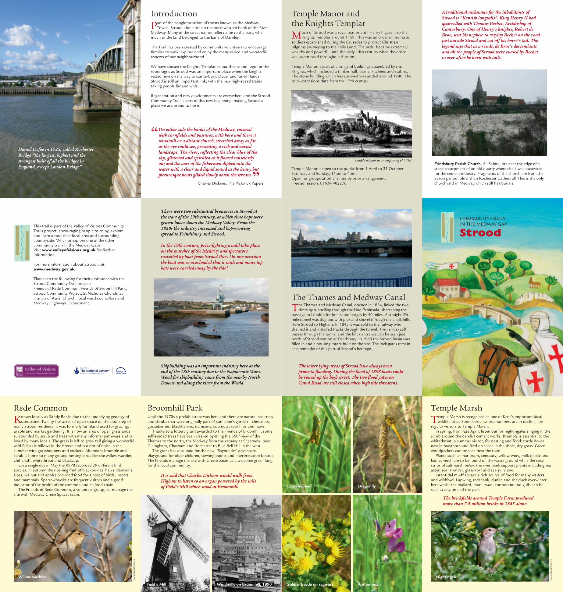
Temple Manor and the Knights Templar
The Thames and Medway Canal
Temple Manor is open to the public from 1 April to 31 OctoberSaturday and Sunday, 11am to 4pm.Open for groups at other times by prior arrangement. Free admission. 01634 402276.
Much of Strood was a royal manor until Henry II gave it to theKnights Templar around 1159. This was an order of monastic
soldiers established during the Crusades to protect Christianpilgrims journeying to the Holy Land. The order became extremelywealthy and powerful until the early 14th century when the orderwas suppressed throughout Europe.
Temple Manor is part of a range of buildings assembled by theKnights, which included a timber hall, barns, kitchens and stables.The stone building which has survived was added around 1240. Thebrick extensions date from the 17th century.
Temple Manor in an engraving of 1767
Introduction
Rede Common Broomhill Park Temple MarshUntil the 1970s a prefab estate was here and there are naturalized treesand shrubs that were originally part of someone’s garden – chestnuts,gooseberries, blackberries, damsons, cob nuts, rose hips and haws.
Thanks to a lottery grant awarded to the Friends of Broomhill, someself-seeded trees have been cleared opening the 360º view of theThames to the north, the Medway from the estuary at Sheerness, pastGillingham, Chatham and Rochester to Blue Bell Hill in the west.
The grant has also paid for the new ‘Playbuilder’ adventureplayground for older children, viewing points and interpretation boards.The Friends manage the site with Greenspaces as a welcome green lungfor the local community.
Temple Marsh is recognised as one of Kent’s important localwildlife sites. Some birds, whose numbers are in decline, are
regular visitors to Temple Marsh.In spring, from late April, listen out for nightingales singing in the
scrub around the derelict cement works. Bramble is essential to thewhitethroat, a summer visitor, for nesting and food; turtle dovesnest in hawthorn and feed on seeds in the short, dry grass. Greenwoodpeckers can be seen near the river.
Plants such as marjoram, centaury, yellow-wort, milk thistle andkidney vetch are to be found on the waste ground while the smallstrips of saltmarsh below the river bank support plants including seaaster, sea lavender, glasswort and sea-purslane.
Inter-tidal mudflats are a rich source of food for many wadersand wildfowl. Lapwing, redshank, dunlin and shelduck overwinterhere whilst the mallard, mute swan, cormorant and gulls can beseen at any time of the year.
The Thames and Medway Canal, opened in 1824, linked the tworivers by tunnelling through the Hoo Peninsula, shortening the
passage to London for boats and barges by 40 miles. A straight 2¼mile tunnel was dug out with pick and shovel through the chalk hillsfrom Strood to Higham. In 1845 it was sold to the railway whodrained it and installed tracks through the tunnel. The railway stillpasses through the tunnel and the brick entrance can be seen justnorth of Strood station at Frindsbury. In 1969 the Strood Basin wasfilled in and a housing estate built on the site. The lock gates remainas a reminder of this part of Strood’s heritage.
Frindsbury Parish Church, All Saints, sits near the edge of asteep escarpment of an old quarry where chalk was excavatedfor the cement industry. Fragments of the church are from theSaxon period, older than Rochester Cathedral! This is the onlychurchyard in Medway which still has burials.
Daniel Defoe in 1725, called RochesterBridge “the largest, highest and thestrongest built of all the bridges inEngland, except London-Bridge”
The brickfields around Temple Farm producedmore than 7.5 million bricks in 1845 alone.
A traditional nickname for the inhabitants ofStrood is “Kentish longtails”. King Henry II hadquarrelled with Thomas Becket, Archbishop ofCanterbury. One of Henry’s knights, Robert deBroc, sent his nephew to waylay Becket on the roadjust outside Strood and cut off his horse’s tail. Thelegend says that as a result, de Broc’s descendantsand all the people of Strood were cursed by Becketto ever after be born with tails.
On either side the banks of the Medway, coveredwith cornfields and pastures, with here and there awindmill or a distant church, stretched away as faras the eye could see, presenting a rich and variedlandscape. The river, reflecting the clear blue of thesky, glistened and sparkled as it flowed noiselesslyon; and the oars of the fishermen dipped into thewater with a clear and liquid sound as the heavy butpicturesque boats glided slowly down the stream.
Part of the conglomeration of towns known as the MedwayTowns, Strood alone sits on the northwestern bank of the River
Medway. Many of the street names reflect a tie to the past, whenmuch of the land belonged to the Earls of Darnley.
The Trail has been created by community volunteers to encouragefamilies to walk, explore and enjoy the many varied and wonderfulaspects of our neighbourhood.
We have chosen the Knights Templar as our theme and logo for theroute signs as Strood was an important place when the knightsrested here on the way to Canterbury, Dover and far-off lands.Strood is still an important link, with the new high-speed trainstaking people far and wide.
Regeneration and new developments are everywhere and the StroodCommunity Trail is part of this new beginning, making Strood aplace we are proud to live in.
The lower lying areas of Strood have always beenprone to flooding. During the flood of 1898 boats couldbe rowed up the high street. The two flood gates onCanal Road are still closed when high tide threatens.
Charles Dickens, The Pickwick Papers
There were two substantial breweries in Strood atthe start of the 19th century, at which time hops weregrown lower down the Medway Valley. From the1830s the industry increased and hop-growingspread to Frindsbury and Strood.
In the 19th century, prize-fighting would take placeon the marshes of the Medway and spectatorstravelled by boat from Strood Pier. On one occasionthe boat was so overloaded that it sank and many tophats were carried away by the tide!
Shipbuilding was an important industry here at theend of the 18th century due to the Napoleonic Wars.Wood for shipbuilding came from the nearby NorthDowns and along the river from the Weald.
Known locally as Sandy Banks due to the underlying geology ofsandstone. Twenty-five acres of open space on the doorstep of
many Strood residents. It was formerly farmland used for grazing,arable and market gardening. It is now an area of open grasslandssurrounded by scrub and trees with many informal pathways and isloved by many locals. The grass is left to grow tall giving a wonderfulwild feel as it billows in the breeze and is a riot of noise in thesummer with grasshoppers and crickets. Abundant bramble andscrub is home to many ground nesting birds like the willow warbler,chiffchaff, whitethroat and blackcap.
On a single day in May the RSPB recorded 29 different birdspecies. In autumn the ripening fruit of blackberries, haws, damsons,sloes, walnut and apples provided food for a host of birds, insectsand mammals. Sparrowhawks are frequent visitors and a goodindicator of the health of the common and its food chain.
The Friends of Rede Common, a volunteer group, co-manage thesite with Medway Green Spaces team.
NightingaleWillow warbler
Dragonfly
Soldier beetle on ragwortWindmills on Broomhill, 1890Field’s Mill Ant on vetch
ww
w.a
ndyv
idle
r.co
.uk
ww
w.a
ndyv
idle
r.co
.uk
StroodCOMMUNITY TRAILSIN THE MEDWAY GAP
It is said that Charles Dickens would walk fromHigham to listen to an organ powered by the sailsof Field’s Mill which stood at Broomhill. Grasshopper
REDEREDECOMMONCOMMON
TEMPLEMARSHRANSCOMBE FARM
RESERVE
TEMPLEMANOR
REDECOMMON
RECREATIONGROUND
BROOMHILLPARK
ROCHESTER BRIDGE
JANE’SCREEK
ALL SAINTSCHURCH
STROODSTATION
TOWN CENTRE
RIV
ER
ME
DW
AY
STROOD
Steps
Steps
Steps
Underpass
High Speed Rail Link
Steps
Steps
Footbridge
Tunnel
Trafficlights
StepsStart
To the Cuxton
Community Trail
Saxon ShoreWay
Albatross Avenue
Bligh Way ScholarsRise
DarnleyClose
Carnation Road
HyacinthRoad
Watling Street
Watling StreetDeanRoad
Leyb
ourn
e Rd
Abbey RoadG
ravesend Road
Broomhill R
oadG
orse Rd
Clarendon Drive
Mill Road
Frin
dsbury Road
Cuxton Road
Bill Street R
oad
Church GreenComm
issioners RoadWingrove
Drive
M2 M
otorway
London Road
Priory Rd
Banks R
d
Rede Court Roa
d
Brom
pton Farm
Road
Kni
gh
t Road
Cuxton R
oad
Rochester Road
High Street
Darnley Road
Gun LaneE
lain
e A
venu
e
Canal
Roa
d
Cliffe R
oad
Route directionsStarting from the Strood side of the motorway underpass continuealong the unmade road passing Knight’s Place Recreation Groundcar park to the left, shortly reaching junction with AlbatrossAvenue. Turn left and continue along Albatross Avenue untiljunction with Bligh Way. Cross Albatross Avenue and proceed downBligh Way for approximately half-a-mile, passing a strip of shops onthe right. Cross Bligh Way at zebra crossing and continue on lefthand footpath, crossing Scholars Rise. Take the next left, DarnleyClose. Proceed to end and ascend flight of steps leading toCarnation Road. Hyacinth Road is visible almost directly ahead.
Cross Carnation Road to walk up Hyacinth Road. This road splitsto right and left, take the left hand turn. Continue past two houseson the left shortly reaching some rustic steps to the right leadinginto Rede Common.
Go up the steps and proceed along the main path through awooded area. Carry on up several small flights of steps. This pathends at a T-junction. Take right hand path which almostimmediately reaches open grassland. At this point turn left andfollow the path along the hedgerow. Continue straight until T-junction, taking time to admire the splendid views on offer. Atjunction take left hand tree-lined path. Continue along this path,keeping to the right to descend a flight of steps onto Watling Street.
Cross Watling Street at the lights. Turn right to walk down tree-lined Watling Street. A public footpath (looking more like anunmade road) is quickly reached on the left, opposite ElaineAvenue. Turn left and walk up this path which soon becomes atarmac road. Continue past the bungalows on the right and followthis made road round to the right, between houses and onto DeanRoad. Dean Road extends directly in front.
At this junction take the path to the left. The road quickly changesto Leybourne Road. Walk to the end, where it joins Abbey Road.
Cross Abbey Road and walk up the narrow pathway just to the rightof the post box. This path passes between houses and then opengrass space with many trees to join the main path along theGravesend Road. Turn left and walk up the Gravesend Road.
Cross Abbey Road again. Almost directly opposite Abbey Road onthe other side of the Gravesend Road is Broomhill Road. This iswhere the trail is heading.
Cross the Gravesend Road. Proceed up Broomhill Road on theright hand path and take the first road to the left, Gorse Road. Thisroad has no footpath so proceed with care. Walk up to the very endand take the second footpath to the left (RR5). Continue past themicrowave masts and reservoir on the right to reach an open, hard-surfaced area with a number of adjoining paths. This is BroomhillPark. The park offers some great views over the rivers Thames andMedway. Take time to explore.
Take the path on the right. Proceed down many steps, straightthrough the park. Exit by a flight of steps to a pathway. Turn rightand walk a short distance before meeting a pathway to the leftleading into a green, open space housing estate. This path runsparallel to Clarendon Drive.
Continue along this almost straight path, catching the great views tothe right when there is a gap between houses.
At the end of Clarendon Drive turn right on to Cliffe Road, crossingover this road at the first island crossing. After a short distance turnleft and walk up the RR3 public footpath. At the end turn right andcontinue down this road (Mill Road) passing Prospect Cottage andthe Millstream Care Home (previously a convent). Approaching theend of Mill Road, English Martyrs Roman Catholic Church is seen onthe left just before the junction with the busy Frindsbury Road.
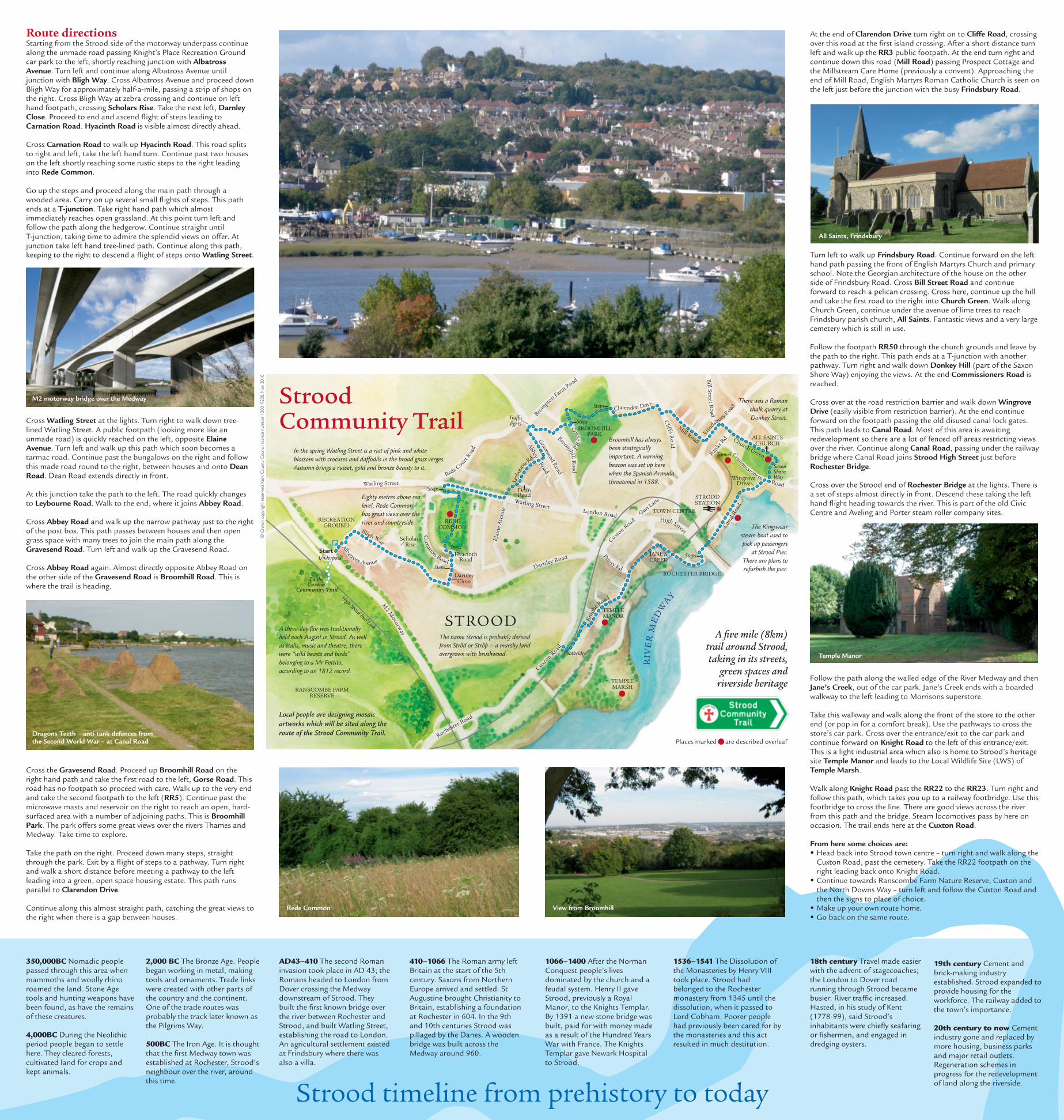
Turn left to walk up Frindsbury Road. Continue forward on the lefthand path passing the front of English Martyrs Church and primaryschool. Note the Georgian architecture of the house on the otherside of Frindsbury Road. Cross Bill Street Road and continueforward to reach a pelican crossing. Cross here, continue up the hilland take the first road to the right into Church Green. Walk alongChurch Green, continue under the avenue of lime trees to reachFrindsbury parish church, All Saints. Fantastic views and a very largecemetery which is still in use.
Follow the footpath RR50 through the church grounds and leave bythe path to the right. This path ends at a T-junction with anotherpathway. Turn right and walk down Donkey Hill (part of the SaxonShore Way) enjoying the views. At the end Commissioners Road isreached.
Cross over at the road restriction barrier and walk down WingroveDrive (easily visible from restriction barrier). At the end continueforward on the footpath passing the old disused canal lock gates.This path leads to Canal Road. Most of this area is awaitingredevelopment so there are a lot of fenced off areas restricting viewsover the river. Continue along Canal Road, passing under the railwaybridge where Canal Road joins Strood High Street just beforeRochester Bridge.
Cross over the Strood end of Rochester Bridge at the lights. There isa set of steps almost directly in front. Descend these taking the lefthand flight heading towards the river. This is part of the old CivicCentre and Aveling and Porter steam roller company sites.
Follow the path along the walled edge of the River Medway and thenJane’s Creek, out of the car park. Jane’s Creek ends with a boardedwalkway to the left leading to Morrisons superstore.
Take this walkway and walk along the front of the store to the otherend (or pop in for a comfort break). Use the pathways to cross thestore’s car park. Cross over the entrance/exit to the car park andcontinue forward on Knight Road to the left of this entrance/exit.This is a light industrial area which also is home to Strood’s heritagesite Temple Manor and leads to the Local Wildlife Site (LWS) ofTemple Marsh.
Walk along Knight Road past the RR22 to the RR23. Turn right andfollow this path, which takes you up to a railway footbridge. Use thisfootbridge to cross the line. There are good views across the riverfrom this path and the bridge. Steam locomotives pass by here onoccasion. The trail ends here at the Cuxton Road.
From here some choices are:• Head back into Strood town centre – turn right and walk along the
Cuxton Road, past the cemetery. Take the RR22 footpath on theright leading back onto Knight Road.
• Continue towards Ranscombe Farm Nature Reserve, Cuxton andthe North Downs Way – turn left and follow the Cuxton Road andthen the signs to place of choice.
• Make up your own route home.• Go back on the same route.
Strood Community Trail
In the spring Watling Street is a riot of pink and whiteblossom with crocuses and daffodils in the broad grass verges.Autumn brings a russet, gold and bronze beauty to it.
The Kingswearsteam boat used topick up passengers
at Strood Pier.There are plans torefurbish the pier.
350,000BC Nomadic peoplepassed through this area whenmammoths and woolly rhinoroamed the land. Stone Agetools and hunting weapons havebeen found, as have the remainsof these creatures.
4,000BC During the Neolithicperiod people began to settlehere. They cleared forests,cultivated land for crops andkept animals.
2,000 BC The Bronze Age. Peoplebegan working in metal, makingtools and ornaments. Trade linkswere created with other parts ofthe country and the continent.One of the trade routes wasprobably the track later known asthe Pilgrims Way.
500BC The Iron Age. It is thoughtthat the first Medway town wasestablished at Rochester, Strood’sneighbour over the river, aroundthis time.
AD43–410 The second Romaninvasion took place in AD 43; theRomans headed to London fromDover crossing the Medwaydownstream of Strood. Theybuilt the first known bridge overthe river between Rochester andStrood, and built Watling Street,establishing the road to London.An agricultural settlement existedat Frindsbury where there wasalso a villa.
410–1066 The Roman army leftBritain at the start of the 5thcentury. Saxons from NorthernEurope arrived and settled. StAugustine brought Christianity toBritain, establishing a foundationat Rochester in 604. In the 9thand 10th centuries Strood waspillaged by the Danes. A woodenbridge was built across theMedway around 960.
1066–1400 After the NormanConquest people’s livesdominated by the church and afeudal system. Henry II gaveStrood, previously a RoyalManor, to the Knights Templar.By 1391 a new stone bridge wasbuilt, paid for with money madeas a result of the Hundred YearsWar with France. The KnightsTemplar gave Newark Hospitalto Strood.
1536–1541 The Dissolution ofthe Monasteries by Henry VIIItook place. Strood hadbelonged to the Rochestermonastery from 1345 until thedissolution, when it passed toLord Cobham. Poorer peoplehad previously been cared for bythe monasteries and this actresulted in much destitution.
18th century Travel made easierwith the advent of stagecoaches;the London to Dover roadrunning through Strood becamebusier. River traffic increased.Hasted, in his study of Kent(1778-99), said Strood’sinhabitants were chiefly seafaringor fishermen, and engaged indredging oysters.
19th century Cement andbrick-making industryestablished. Strood expanded toprovide housing for theworkforce. The railway added tothe town’s importance.
20th century to now Cementindustry gone and replaced bymore housing, business parksand major retail outlets.Regeneration schemes inprogress for the redevelopmentof land along the riverside.
Strood timeline from prehistory to today
A five mile (8km)trail around Strood,taking in its streets,
green spaces andriverside heritage
Places marked are described overleaf
Broomhill has always been strategicallyimportant. A warningbeacon was set up herewhen the Spanish Armadathreatened in 1588.
There was a Romanchalk quarry atDonkey Street.
A three-day fair was traditionallyheld each August in Strood. As wellas stalls, music and theatre, therewere “wild beasts and birds”belonging to a Mr Pettito,according to an 1812 record.
The name Strood is probably derivedfrom Strõd or Strõþ – a marshy landovergrown with brushwood.
Eighty metres above sealevel, Rede Commonhas great views over theriver and countryside.
Dragons Teeth – anti-tank defences fromthe Second World War – at Canal Road
M2 motorway bridge over the Medway
Rede Common View from Broomhill
Temple Manor
All Saints, Frindsbury
© C
row
n c
opyr
ight
rese
rved
. Ken
t C
ounty
Counci
l lic
ence
num
ber
100019238. N
ov
2010
Local people are designing mosaic
artworks which will be sited along the
route of the Strood Community Trail.