Embed Size (px)
Citation preview
INSIDE THIS ISSUE:n ENVIRONMENT: How to keep your grass green, and the Lake blue.......................3n WILDFIRE: How Tahoe neighborhoods are becoming fire-adapted..........................5n COLLABORATION: New group tackles an array of challenges .............................6n STREAM PROFILE: Taylor Creek offers a unique viewpoint..................................7n WATER TRAIL: Shoreline route offers paddlers another option............ ...............17n MEEKS BAY: Resort reunites tribe with ancestral homeland.................................19n NEW VIEW: A new 3-D film explores the depths of Tahoe......................................20n CHAINING UP: In 1911, stakes were high for autos in a race to Tahoe.................24Tahoe In DepthPO Box 5310Stateline, NV 89449
PRSRT STDU.S. POSTAGE
PAIDRENO, NV
PERMIT #765
Continued on page 9Continued on page 12
Drought offersgood news, badnews for Lake
TAHOE’S SEVEN SUMMITS
Summer 2014
By Jeff CowenTahoe In Depth
The Lake may be this Region’s most famous geographic feature, but it is Tahoe’s peaks that define our landscapes and, at times, the course of our lives. Daily, we glimpse them towering over our tedium, indelible reminders of nature’s greatness and our own impermanence. Succumbing to their power, we climb them.
Some climbers are peak collectors, “bagging” the major summits one by one. Others climb on a lark, impulsively joining friends and unprepared for the experience ahead. Regardless of our paths, once we reach their summits, we feel at once tiny and expansive, earth and time stretching in all directions below us, the experience undeniably empowering.
There is no sacred circle of peaks around the Lake. Yet seven of the mountains encircling Tahoe’s blue surface contain a combination of beauty, historic tradition, pure height and, some will argue, spiritual power: Tahoe’s Seven Summits. Atop these mountains, everything is different. The birds are not the same birds, nor are the flowers
and rodents. Trees become shorter and wider, until they disappear entirely. Our bodies change too. Legs tremble, lungs call the air a fraud, and equilibrium finds a new orientation. What it does to our minds is incalculable.
The journeys to these seven summits are different in every case and in every season. They range from lung-seizing climbs to four-wheel drive convenience. Many can be reached via the Tahoe Rim Trail and, increasingly, via connector trails from the heart of our towns and
neighborhoods. Climbers of even our most benign
peaks should know that Tahoe’s backcountry, summer and winter, can be foe as much as friend. Knowledge, experience, and common sense are more valuable in the mountains than brute strength or daring.
While there are a number of published backcountry guides that contain more detailed information on the mountains of this Region, the
Photo © Steve Dunleavy
By Jim SloanTahoe In Depth
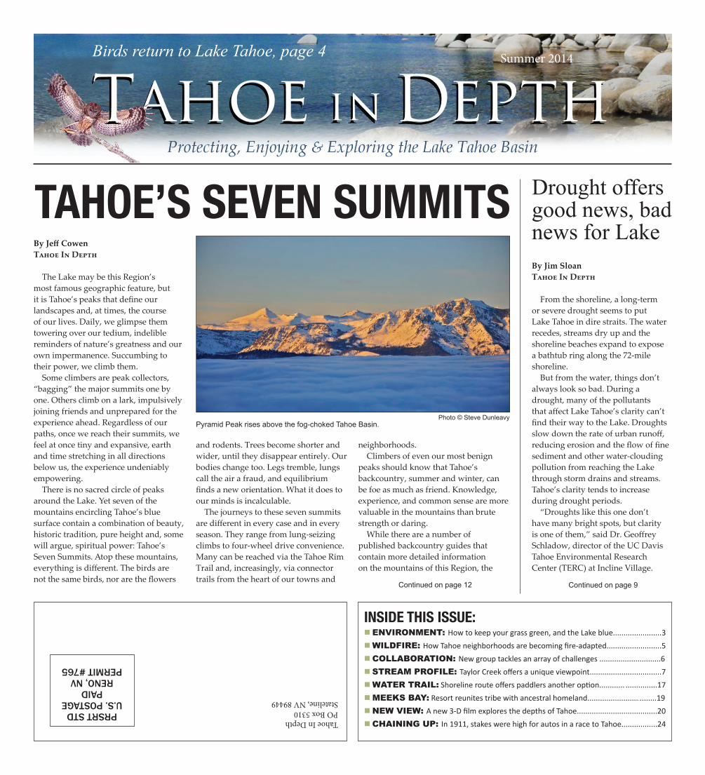
From the shoreline, a long-term or severe drought seems to put Lake Tahoe in dire straits. The water recedes, streams dry up and the shoreline beaches expand to expose a bathtub ring along the 72-mile shoreline.
But from the water, things don’t always look so bad. During a drought, many of the pollutants that affect Lake Tahoe’s clarity can’t find their way to the Lake. Droughts slow down the rate of urban runoff, reducing erosion and the flow of fine sediment and other water-clouding pollution from reaching the Lake through storm drains and streams. Tahoe’s clarity tends to increase during drought periods.
“Droughts like this one don’t have many bright spots, but clarity is one of them,” said Dr. Geoffrey Schladow, director of the UC Davis Tahoe Environmental Research Center (TERC) at Incline Village.
Birds return to Lake Tahoe, page 4
Pyramid Peak rises above the fog-choked Tahoe Basin.
PAGE 2 n TAHOE IN DEPTH TAHOE IN DEPTH n PAGE 3
How you can support Tahoe
IN THIS ISSUE
Major funding provided by:
Tahoe In Depth Publisher and contributors: The Tahoe Regional Planning Agency publishes Tahoe In Depth in partnership with various state and federal agencies. Contributors include the California Tahoe Conservancy, U.S. EPA, U.S. Fish & Wildlife Service, Incline Village General Improvement District, Lahontan Regional Water Quality Control Board, League to Save Lake Tahoe, Nevada Department of Wildlife, Nevada Division of Environmental Protection, Nevada Division of State Lands, Tahoe City Public Utility District, Tahoe Fund, Tahoe Resource Conservation District, Tahoe Transportation District, Tahoe Water Suppliers Association, University of California, Davis, University of Nevada, Reno, and the Washoe Tribe.Executive Editor: Julie ReganManaging Editor: Jim SloanProject Manager and Copy Editor: Sarah Underhill Contributors: Amy Berry, Kristi Boosman, Jeff Cowen, Madonna Dunbar, Carl Hasty, Sheryl Ferguson, Jack Landy, Jean Norman, Gary Noy, Dana Olson, Victoria Ortiz, Kelsey Poole, Forest Schafer, Heather Segale, Ashley Sommer, Patrick Stone, Steve Teshara.Photography: Michael Drum, Steve Dunleavy, Jeff Moser, Corey Rich, Mike Vollmer, U.S. Forest Service, Tahoe Resource Conservation District, U.S. Fish & Wildlife Service.Copyright 2014 © – All rights reserved.
With federal funds dwindling, private sector becomes key
The benefit of bikesThe plan to encircle Lake Tahoe with a separate bike and pedestrian path is moving ahead with some key projects planned for the East Shore.
Tahoe’s troubled plantThe Tahoe yellow cress is found on Lake Tahoe’s beaches and nowhere else in the world. But it’s facing a tough time. Find out how you can help protect this delicate, beautiful plant.
Beneath the surfaceFor more than 40 years, the Stream Profile Chamber at Taylor Creek has delighted visitors with its wondrous look at the creatures swimming beneath the surface.
Fire-adapted communitiesLake Tahoe communities are learning what it takes to live in a wildfire-prone area and how to become more self-reliant about removing fuels and taking responsibility for themselves when a fire breaks out.
5
7
11
15
Spirit of StewardshipEight individuals were honored by the Tahoe Regional Planning Agency for their quiet efforts to help protect the Lake.
21
Chaining up, 1911 styleThe auto race over Donner Summit in 1911 offered only a 3-foot trophy. But that didn’t stop a team from Grass Valley from pulling out all the stops to win.
24
Water TrailPaddlers are finding out the Water Trail is a convenient way to get out on the water and explore the Tahoe shoreline.
17
Breathe in. Breathe out. Smile. Repeat. The smell of sun-baked pine sap is in the air at Tahoe, which means summer is well on its way.
Thank you for continuing to look to Tahoe In Depth for information on how to protect and enjoy this wonderful place. We had a record number of supporters
who responded to our last issue (see page 22), and thanks to our underwriters and subscribers, we have enough funding to publish two issues of Tahoe In Depth in 2014.
As you leaf through the paper, keep in mind that many of the restoration programs at Lake Tahoe have been funded by the federal government, and those funds are soon running dry. We are eternally grateful to our congressional champions for fighting for Tahoe over the last 15 years to deliver more than $550 million to help restore the Lake’s clarity, manage
our forests, enhance recreation, and improve air quality. The Lake Tahoe Restoration Act is up for reauthorization in Congress (S. 1451 and H.R. 3390), so if you care about continuing this investment in Lake Tahoe, let your elected representatives know this legislation is vital to both Tahoe’s environment and economy, which depends on a healthy ecosystem. California and Nevada and local governments have also contributed hundreds of millions in environmental funding for Tahoe. With these funds also dwindling, private-sector contributions are more important than ever. See how you can help on pages 21 and 23.
We hope this issue of Tahoe In Depth helps you enjoy the beautiful summer. Thanks for your passion and concern for Lake Tahoe.
– Julie Regan, executive editor
PAGE 2 n TAHOE IN DEPTH TAHOE IN DEPTH n PAGE 3
By Madonna DunbarIncline Village General Improvement District
Tahoe’s alpine environment makes residential and commercial landscaping challenging. During the summer, municipal water use doubles or triples, with most of the water use going to turf grass irrigation. Applying too much water and fertilizer on the landscape is expensive, and fertilizer runoff contributes to declining water quality and algae growth at Lake Tahoe.
Most people treat their lawn like a crop, watering and fertilizing to encourage maximum growth. But then the “harvested crop” (lawn clippings) are bagged and sent to the landfill. It is more efficient and better for the environment if turf is managed for low to moderate growth.
The best placement for turf is close to a home or building so it can be enjoyed and serve as defensible space in the event of wildfire. For residents in South Lake Tahoe, the South Tahoe Public Utility District has a Turf Buy Back Program that provides rebates for replacing turf. Visit www.stpud.us/turf-buy-back.html for more information.
Replace that difficult-to-maintain grass with porous “hardscaping” – such as a paver patio – or low-growing native plants. Keep remaining lawn green and healthy by following certain “best practices” when mowing, watering, and fertilizing.Mowing
■■ Allow grass to grow tall before mowing it, or mow more often but cut only the top third of the blades. Allowing the grass to grow taller will keep it cooler, thus requiring less water. ■■ Keep mower blades sharp, and mow only in dry conditions. ■■ Leave the short clippings on the lawn for “grass recycling” nutrients back into the soil.
Watering ■■ Each spring, make sure your backflow device is working properly, leaks are fixed, water coverage is even, the system has proper pressure
regulation, and the irrigation timer is set to come on early in the morning (only a few days a week) to allow for deep irrigation. ■■ Most turf grass requires 1 inch of water every 5 to 7 days during the growing season and less during slow-growth months. Watering too often stunts deep root development.
Fertilizing■■ Amend the soil with compost or mulch. Tahoe soils can be very compacted. Turf is often planted on top of hard, compressed soil. Without the ability to grow roots to a depth of 6 to 8 inches, turf grass will always struggle. ■■ Over-fertilization weakens a lawn by causing excessive top growth. Plants can only absorb their required nutrients if they are present in easily dissolved chemical compounds. The most typical form of fertilizer is granulated or powdered forms. Liquid fertilizer delivers immediate effect and wide coverage.■■ Although organic fertilizers usually contain a lower concentration of nutrients, this lower concentration
avoids complication of nitrogen burn harming the plants. In addition, organic fertilizers such as compost and worm castings break down slowly into complex organic structures (humus), which build the soil’s structure and moisture.
Madonna Dunbar is the resource conservationist for the Incline Village General Improvement District and executive director of the Tahoe Water Suppliers Association.
Remember these tips: ■ Choose the right fertilizer and apply in the right amount at the right time.
■ Sweep up any fertilizer spilled on hard surfaces and reapply to the grass or garden area.
■ Do not use any fertilizer within 25 feet of a stream or riparian area.
■ Never apply fertilizers to frozen ground or snow.
■ Leave a natural filter strip of grass, trees, and/or shrubs next to the shoreline.
■ Do not overwater. Too much water will leach nutrients out of the root zone before they can be used.
■ Choose your fertilizer carefully. The label on a fertilizer bag shows the percentage of the primary plant nutrients as a string of three numbers. These numbers indicate the percent by weight of nitrogen (N), phosphorus (P), and potassium (K). Look for a fertilizer in which the middle number is 0. In the Tahoe Basin – “NO P in the Lake = Zero Phosphorus!” Why? Phosphorus is one of the three key pollutants reducing Lake clarity. The other two are fine sediment and nitrogen.
■ To help you calculate how much fertilizer to apply and which type to use, a new fact sheet by University of Nevada Cooperative Extension is available at www.unce.unr.edu/publications/files/nr/2013/fs1337.pdf
Hiring a landscaper?If you hire a landscaper to maintain your property, ask potential service providers about their training, knowledge, and maintenance practices in low-water and low-fertilizer use landscaping. A beautiful landscape need not be wasteful. For the do-it-yourselfer, the “Home Landscaping Guide for Lake Tahoe and Vicinity,” published by University of Nevada Cooperative Extension, covers all aspects of soil preparation, plant selection, irrigation efficiency, defensible space, and BMPs. It is available online at http://tahoebmp.org/FertilizerResources.aspx.
There are many conservation landscape resources available from area agencies such as the Nevada Tahoe Conservation District, Tahoe Resource Conservation District, UNR Cooperative Extension, local Demonstration Gardens, Master Gardener programs, and your community water providers. Check with any of these organizations for more information.
Turf fertilizer greens more than lawnLandscaping at Tahoe requires homeowners take special precautions
The Tahoe Regional Planning Agency recommends the use of phosphorus-free fertilizer except when establishing new turf from seed. Tahoe soils have adequate phosphorus for turf for many years. The best landscaping promotes wildlife habitat, erosion control, water conservation, and clean air and water through the use of composting and native plants, such as Western columbine, below, which will attract hummingbirds and bees.
PAGE 4 n TAHOE IN DEPTH TAHOE IN DEPTH n PAGE 5
Birds are the sound of springAt Tahoe, the silence of winter is replaced in spring with dawn chorusBy Sheryl FergusonSpecial to Tahoe In Depth
Spring is arriving in the Tahoe Basin, and with that brings the return of several of our feathered friends. Spring is a great time to discover bird-watching, as many birds that left for the winter are now returning to northern areas – especially Lake Tahoe.
Birders look forward to spring after a cold, snowy winter when birds are relatively scarce. Now is the time when nature puts on a magnificent show – the vibrant greens of new leaves appearing on plants and trees like the aspen and cottonwood. Next, wildflowers pop up.
Birds these days are busy looking for mates, courting with suitors and building nests with the lucky partner. Because of this, you might have noticed your neighborhood is just a little noisier with birds chirping their hearts out. Birds are master musicians, singing to potential mates, rivals, or predators – everything from “Clear out!” to “Come on!”
Now is the time to start listening for the ‘dawn chorus.’ In spring, birds sing the loudest in the morning. They are trying to attract a mate or are defending a territory. Have you ever been awakened by the raucous call of a steller jay or the mournful coo of a mourning dove?
Most Basin residents and visitors are probably familiar with some of our well-known residents. For example, most know the mountain chickadee, also known as the ‘cheeseburger bird.’ This little black, white, and gray bird lives here year-round and has several songs – one of which sounds like “cheeseburger…hey sweetie…chick-a-dee, dee.” Mountain chickadees are cavity nesters, setting up homes in old woodpecker holes. They sometimes can be seen clinging to the underside of branches and tree trunks looking for food in the bark or opening seeds.
Another famous year-round resident is the blue and black steller jay. This jay is a member of the corvid family, which is a highly intelligent group that includes ravens, crows, magpies, and
the steller’s East Coast cousin, the blue and white blue jay.
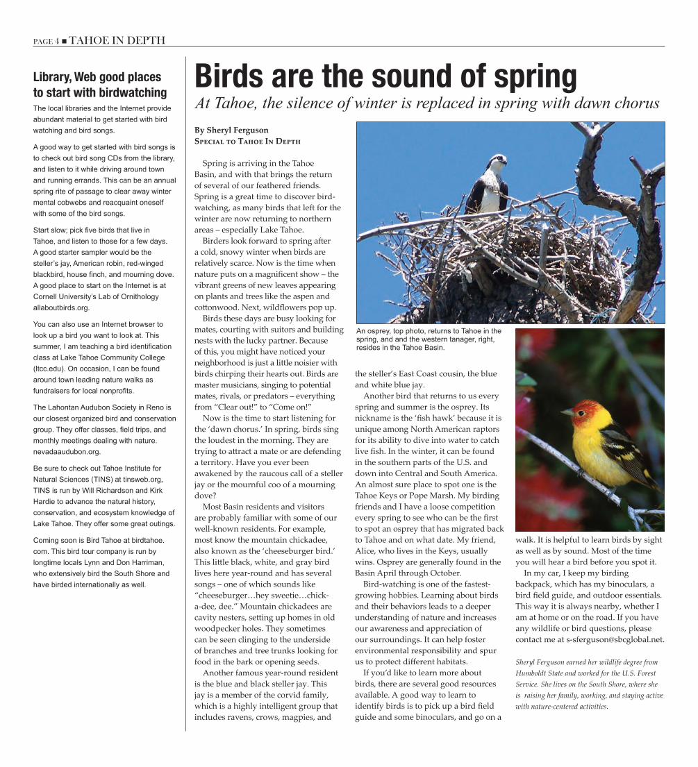
Another bird that returns to us every spring and summer is the osprey. Its nickname is the ‘fish hawk’ because it is unique among North American raptors for its ability to dive into water to catch live fish. In the winter, it can be found in the southern parts of the U.S. and down into Central and South America. An almost sure place to spot one is the Tahoe Keys or Pope Marsh. My birding friends and I have a loose competition every spring to see who can be the first to spot an osprey that has migrated back to Tahoe and on what date. My friend, Alice, who lives in the Keys, usually wins. Osprey are generally found in the Basin April through October.
Bird-watching is one of the fastest-growing hobbies. Learning about birds and their behaviors leads to a deeper understanding of nature and increases our awareness and appreciation of our surroundings. It can help foster environmental responsibility and spur us to protect different habitats.
If you’d like to learn more about birds, there are several good resources available. A good way to learn to identify birds is to pick up a bird field guide and some binoculars, and go on a
walk. It is helpful to learn birds by sight as well as by sound. Most of the time you will hear a bird before you spot it.
In my car, I keep my birding backpack, which has my binoculars, a bird field guide, and outdoor essentials. This way it is always nearby, whether I am at home or on the road. If you have any wildlife or bird questions, please contact me at [email protected].
Sheryl Ferguson earned her wildlife degree from Humboldt State and worked for the U.S. Forest Service. She lives on the South Shore, where she is raising her family, working, and staying active with nature-centered activities.
Library, Web good placesto start with birdwatchingThe local libraries and the Internet provide abundant material to get started with bird watching and bird songs.
A good way to get started with bird songs is to check out bird song CDs from the library, and listen to it while driving around town and running errands. This can be an annual spring rite of passage to clear away winter mental cobwebs and reacquaint oneself with some of the bird songs.
Start slow; pick five birds that live in Tahoe, and listen to those for a few days. A good starter sampler would be the steller’s jay, American robin, red-winged blackbird, house finch, and mourning dove. A good place to start on the Internet is at Cornell University’s Lab of Ornithology allaboutbirds.org.
You can also use an Internet browser to look up a bird you want to look at. This summer, I am teaching a bird identification class at Lake Tahoe Community College (ltcc.edu). On occasion, I can be found around town leading nature walks as fundraisers for local nonprofits.
The Lahontan Audubon Society in Reno is our closest organized bird and conservation group. They offer classes, field trips, and monthly meetings dealing with nature. nevadaaudubon.org.
Be sure to check out Tahoe Institute for Natural Sciences (TINS) at tinsweb.org, TINS is run by Will Richardson and Kirk Hardie to advance the natural history, conservation, and ecosystem knowledge of Lake Tahoe. They offer some great outings.
Coming soon is Bird Tahoe at birdtahoe.com. This bird tour company is run by longtime locals Lynn and Don Harriman, who extensively bird the South Shore and have birded internationally as well.
An osprey, top photo, returns to Tahoe in the spring, and and the western tanager, right, resides in the Tahoe Basin.
PAGE 4 n TAHOE IN DEPTH TAHOE IN DEPTH n PAGE 5
How to become a fire-adapted areaFire-prone neighborhoods learning to accept responsibilityBy Forest SchaferNorth Lake TahoeFire Protection District
With record drought conditions in the West, preparing your home for wildfire is more important than ever. May was designated as “Wildfire Awareness Month” in the Lake Tahoe Basin in an ongoing effort to encourage our communities to be proactive. This year’s theme is “Prepare Your Home For Wildfire,” with a focus on creating and sustaining “fire-adapted communities.”
A fire-adapted community is one located in a fire-prone area but which requires little assistance from firefighters during a wildfire. Residents of these communities accept responsibility for living in a high fire-hazard area. They possess the knowledge and skills to:
■■ Prepare their homes and property to survive wildfire■■ Evacuate early, safely, and effectively■■ Survive if trapped by wildfire.
As part of this year’s theme, Tahoe Basin fire chiefs are encouraging full- and part-time residents to work with their local fire districts and host neighborhood block parties throughout the spring, summer, and fall. These parties create an opportunity for neighbors to get to know each other, meet their fire district and agency representatives, and learn what it means to become a fire-adapted community. It marks an important shift away from being reactionary about protecting our homes once a wildfire starts to being proactive about preparing our homes to survive a wildfire before one begins. Things you can do to become more fire-adapted include:
■■ Talk to your local fire department about how to prepare for a wildfire, when to evacuate, and what you and your community should expect during a response ■■ Contact your local fire department to conduct a risk assessment on your property■■ Develop a personal and family preparedness plan■■ Support land management agencies
by learning about wildfire risk-reduction efforts, such as using prescribed fire to manage local landscapes■■ Contact the local planning or zoning office to find out if your home is in a high wildfire-risk area and if there are specific local or county ordinances you should be following■■ Work with your homeowner association (if you have one) to identify regulations that incorporate proven preparedness landscaping, home design, and building materials, such as the recommendations from the University of Nevada Cooperative Extension publication “Living with Fire for the Lake Tahoe Basin.”
Create a defensible space zone around your property by:
■■ Maintaining a non-combustible area around the perimeter of your home■■ Managing vegetation along fences ■■ Clearing debris from decks and patios, eaves, and porches ■■ Selecting proper landscaping and plants ■■ Knowing the local ecology and fire history ■■ Moving radiant heat sources away from the home (i.e., wood piles, fuel tanks, sheds)
■■ Thinning trees and ladder fuels around the home.Many Tahoe communities are taking
action toward becoming fire-adapted communities. Fire is a natural part of Lake Tahoe’s ecosystem, and its community of plants, animals, and landscapes have adapted to become resilient to wildfires.
A fire-adapted community recognizes this, and takes action to adapt its homes, businesses, landscapes, and infrastructure to withstand a wildfire. In a well-adapted community, most fires are stopped when they are small, and the effects of a large wildfire will be less devastating to neighborhoods and the environment.
The Tahoe Fire and Fuels Team, a combination of several agencies, works together to develop consistent outreach and messaging, recognizing that since fire pays no attention to property lines, neither should the team.
The team is currently working to complete an update to Lake Tahoe’s 10-Year Fuel Reduction and Wildfire Prevention Strategy to establish a process for identifying and prioritizing projects that will have the greatest benefit for Lake Tahoe communities, without regard to boundaries.
Public, government prepare wildfire safeguards Since the Angora Fire in 2007, residents, local businesses, and government agencies have worked together to reduce hazardous fuels on thousands of acres in the Tahoe Basin. The public and the government continue to work together to prepare communities for wildfire, and to safeguard the exceptional natural resources of Lake Tahoe.
The National Cohesive Wildland Fire Management Strategy identified the need to create fire-adapted communities as one of three goals to address the threat of fire in the wildland-urban interface.
Pilot communities have been selected to develop and share best practices and innovations with the nation. Lake Tahoe was selected as one of the pilot communities because of the Region’s history of taking a proactive and innovative approach to wildfire preparation. For more info on pilot communities, visit FACnetwork.org.
By participating in the Fire Adapted Communities Learning Network, local fire agencies are focusing on strategies that help neighborhoods work together, facilitate interagency cooperation, and strengthen communication and support.
The effort includes residents, homeowners, businesses, and elected officials. Defensible space is an important first step toward becoming fire-adapted, but it’s essential that the public prepare for evacuations and educate their neighbors and visitors. When neighborhoods organize themselves, they gain the ability to better communicate their ideas and concerns to local agencies, and can complete projects that cross property lines.
Whether you’re a resident, visitor, business owner, or agency employee, every community member has a role to play in a fire-adapted community. Lake Tahoe Wildfire Awareness Month gave us all a chance to reflect on our roles, and to consider what actions we can take to better fulfill our own responsibilities, and to help others fulfill theirs.
To get started, and to locate your local fire agency, visit LivingWithFire.info/tahoe.
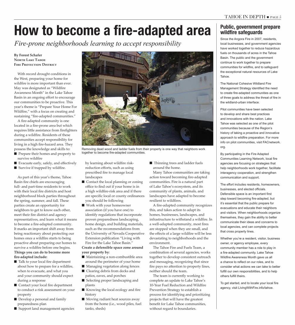
Removing dead wood and ladder fuels from their property is one way that neighbors work together to become fire-adapted communities.
PAGE 6 n TAHOE IN DEPTH TAHOE IN DEPTH n PAGE 7
Group sets ambitious goals for improving life at TahoeCollaborative volunteers for goodBy Jim SloanTahoe In Depth
The Lake Tahoe Sustainability Collaborative, an all-volunteer organization that works to make the Tahoe-Truckee Region a better place to live, celebrated its second anniversary this spring. Over the next few years, the collaborative has a growing list of community improvements and an ambitious plan to cut down waste, protect the environment, and improve the local economy.
In an area with a plethora of public agencies and nonprofit groups, the collaborative stands out because of its approach, its membership, and the breadth of projects it takes on. For example, while one group of volunteers is working to establish community gardens and composting operations at local schools, another group might be working on painting bike lanes or improving job prospects and pay levels for local residents.
Since its launch in May 2012, the number of volunteers has grown from 83 to 142. They come from all walks of life and demographics. Many of them work for local government, agencies, or local resorts.
“Members of the collaborative do not speak for their organizations, but do offer a bridge from the collaborative to their respective organizations and networks,” member Hannah Greenstreet wrote recently in the Tahoe Daily Tribune.
In its first three months, the collaborative identified five “working groups,” each with its own mission and a list of short-, medium- and long-range projects they wanted to tackle. The projects fall into five sectors:
■■ Community Mobility■■ Economy-Education-Culture■■ Energy-Water-Waste-Efficiency■■ Human, Health, and Social Well-being■■ Conservation of Natural Resources■■ Communications and Outreach Since then, the working groups
have developed a detailed “Impact Matrix” of projects and deadlines
(sustainabilitycollaborative.org). For example, the Community Mobility group wants to see a bike path all the way around the Lake by 2021, with shuttles stationed at “tricky points” like Emerald Bay and Spooner Summit. By 2021, the group wants 95 percent of the Basin’s overnight population to have access to a bicycle facility. Using outreach, education and incentives, the working group’s goal is to increase biking by 5 to 10 percent; increase walking by 15 percent; and increase public transit use by 10 percent by 2021.
The other working groups are equally ambitious. For example, the Economy-Education-Culture group wants to see green jobs in the Region increase 10 to 15 percent, with seasonal workers becoming a force as full-time residents and “active ecosystem stewards.” By 2034, the group would like to see 50 percent of the jobs in the Tahoe-Truckee Region be green.
The Energy-Water-Waste-Efficiency group is currently focused on serving as the public input component of a grant-funded Renewable Energy Planning project sponsored by the South Tahoe Public Utility District.
The group, which also supports the Green Business Certification program that recognizes businesses that have installed stormwater Best Management Practices, would like that program deployed throughout the Basin over the next few years. Group members would also like to see local utilities doing more water and energy audits for residential
and commercial properties, and they’d like to see 65 percent of homes and 80 percent of business using less water-intensive landscapes by 2021.
Collaborative member Michael Ward, a certified professional facilitator, said that “communities around the country are building collaborative networks around planning policies and practices designed to promote healthier lifestyles. Community institutions and citizens are essential to the development and implementation of this direction.”
“Collaborative initiatives have attracted a broad cross-section of residents who are engaged, enthusiastic, principled, and committed to accelerate a shift toward a healthier Tahoe-Truckee community, environment, and economy,” Ward said.
Ward noted that collaborative participants recognize that while large-scale policy, funding, infrastructure, and planning are important as a top-down framework for “creating the future,” citizen-led, grassroots mobilizing provides the necessary and frequently overlooked “bottom up” energy that can actually help accelerate the engagement needed to ensure resiliency in response to rapid and turbulent economic, environmental, and social change.
To find out more about participating in the collaborative, or to sign up to join one of the working groups as a volunteer, visit sustainabilitycollaborative.org/how-to-connect, or contact [email protected].
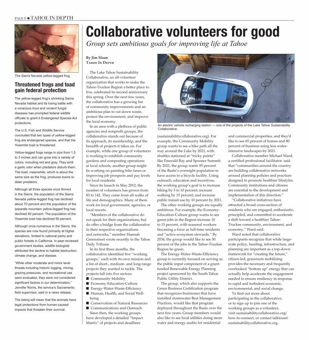
An electric vehicle recharging station — one of the projects of the Lake Tahoe Sustainability Collaborative.
Threatened frogs and toadgain federal protectionThe yellow-legged frog’s shrinking Sierra Nevada habitat and its losing battle with a voracious trout and virulent fungal diseases has prompted federal wildlife officials to grant it Endangered Species Act protections.
The U.S. Fish and Wildlife Service concluded that two types of yellow-legged frog are endangered species, and that the Yosemite toad is threatened.
Yellow-legged frogs range in size from 1.5 to 3 inches and can grow into a variety of colors, including red and gray. They emit a garlic odor when predators disturb them. The toad, meanwhile, which is about the same size as the frog, produces toxins to deter predators.
Although all three species once thrived in the Sierra, the population of the Sierra Nevada yellow-legged frog has declined about 70 percent and the population of the separate mountain yellow-legged frog has declined 80 percent. The population of the Yosemite toad has declined 50 percent.
Although once numerous in the Sierra, the species are now found primarily at higher elevations, limited to national parks and public forests in California. In peer-reviewed government studies, wildlife biologists attributed the decline to habitat destruction, climate change, and disease.
“While other moderate and minor level threats including historic logging, mining, grazing pressures, and recreational use were evaluated, they were not considered significant factors in our determination,” Jennifer Norris, the service’s Sacramento field supervisor, said in a news release.
The listing will mean that the animals have legal protections from human-caused impacts that threaten their survival.
The Sierra Nevada yellow-legged frog.

PAGE 6 n TAHOE IN DEPTH TAHOE IN DEPTH n PAGE 7
Underground viewing area a highlight of the Rainbow Trail
Profile chamber offers nature up close
Kokanee salmon crowd Taylor Creek near the Stream Profile Chamber during their fall spawning run.
By Jean NormanU.S. Forest Service
Fish dart around in the clear water, and from time to time it’s possible to see a bullfrog or two. In the fall, the feisty kokanee can be spotted, and on rare occasions a river otter or black bear jumps in to go fishing.
This is the U.S. Forest Service’s Stream Profile Chamber. The subterranean chamber and the nearby Rainbow Trail at the Taylor Creek Visitor Center are two of the most popular attractions in the Lake Tahoe Basin.
Located 3 miles north of South Lake Tahoe on the lake side of Highway 89, the U.S. Forest Service Lake Tahoe Basin Management Unit created the underground profile chamber adjacent to Taylor Creek in 1969. Over the years, it has been remodeled twice due to flooding that occurred in the spring. The Stream Profile Chamber offers nature up close and personal.
The Stream Profile Chamber entrance leads down a ramp and into an entirely different world of underwater wonder. Floor to ceiling heavy glass windows line the chamber on one side and guests are greeted by fish, bullfrogs, and bird life. A variety of fish dart about in a confined pool that offers a constant flow of freshwater from nearby Taylor Creek. Rainbow and other trout are common occupants of the Stream Profile Chamber. The Forest Service hopes to include the native trout of Lake Tahoe, the Lahontan cutthroat trout, in this enclosure in the future. The Stream Profile Chamber describes the four seasons of the Lake Tahoe Basin using colorful murals, hands-on models, nature exhibits, and informational panels.
The Stream Profile Chamber is located on the Rainbow Trail, a half-mile loop that begins at the visitor center. The Rainbow Trail is paved and accessible with award-winning interpretive signs
that discuss the four ecosystems seen on the way to the Stream Profile Chamber. These diverse ecosystems include forest, meadow, marsh, and stream zones. One can note the ever-changing fauna and flora of these four ecosystems as they stroll along the Rainbow Trail.
Each month showcases a variety of wildlife in this thriving environment. Raptors fly overhead searching for prey, and songbirds flutter about and use their voices to let sightseers know they are in their territory. Wildflowers of all colors line the Rainbow Trail, especially in July. Beaver are very active in and around Taylor Creek, and many signs of their work are visible along the stream bank. Black bears rarely visit the area since they are shy and tend to stay away from people, although during spawning season they can be viewed feasting on salmon in the creek. Jean Norman is an interpretive services specialist with the U.S. Forest Service Lake Tahoe Basin Management Unit.
Autumn a special timeat Taylor Creek During the month of October, tens of thousands of land-locked Kokanee Salmon spawn in Taylor Creek. Typically, a dozen or more brilliant red Kokanee Salmon can be seen in the Stream Profile Chamber, allowing a close-up view of these small, but mighty fish. The Taylor Creek Visitor Center and the Stream Profile Chamber are open from Memorial Day weekend to Oct. 31.
The Rainbow Trail is open year-round during daylight hours. The Forest Service recommends staying on the trail to avoid potential hazards and for the protection of wildlife habitat in the area.
During the colder winter months, snowshoes or cross-country skis may be needed to safely navigate the Rainbow Trail and surrounding trails.
For more information, contact the Taylor Creek Visitor Center at 530-543-2674. Year-round information is available at the Forest Supervisor’s Office at 530-543-2694.
A young visitor gets a clear view of what life in a Tahoe stream is like at the Stream Profile Chamber near the Taylor Creek Visitor Center.
PAGE 8 n TAHOE IN DEPTH TAHOE IN DEPTH n PAGE 9
Warm water fish also a target as researchers try to keep delicate ecosystem in balanceScientists battle invaders to preserve Emerald Bay
By Patrick StoneTahoe Regional Planning Agency
Across the nation, aquatic invasive species are causing damage to property and irreversibly changing our natural environment in ways that are, in a word, unpleasant. Visitors to Lake Tahoe often write home, or tweet, about the clear, blue water and rocky shores they experience here. But sadly, Tahoe is not without its share of aquatic invaders.
The Lake Tahoe Watercraft Inspection Program (tahoeboatinspections.com) has shut the door to new invaders like New Zealand mudsnails and quagga mussels since 2009. But before then, several plants and animals made their way to Tahoe either on boats, in fish-stocking tanks, or in aquariums later emptied into the Lake. A cast of invaders that appeared in Tahoe in the 1980s and ’90s include several species that have flourished and spread from marinas and lagoons to the open Lake and shoreline locations – including Emerald Bay State Park, where they threaten the natural environment.
That’s why biologists and limnologists from around the Basin have teamed up with the California Department of Parks and Recreation and the Lahontan Regional Water Quality Control Board to wage war against two invasive plants (Eurasian watermilfoil and curlyleaf pondweed), a mollusk (Asian clam), and a suite of warm water fish like brown bullhead and bluegill in Emerald Bay.
Starting in 2011, the U.S. Fish & Wildlife Service and TRPA have supported a collaborative effort between California and Nevada wildlife agencies to suppress the warm water fish in Emerald Bay and Lake Tahoe. Fisheries biologists have removed brown bullhead and bluegill sunfish from Emerald Bay and future removal efforts will focus on breeding and rearing habitat in lagoons like the Tahoe Keys.
Fish and plants are two areas of invasive species ecology that are relatively well-established and practiced nationwide. However, Asian clams are another story. Efforts to eliminate
them have been experimental and unproven.
Undaunted, the team of researchers have recently focused their efforts on the possibility of controlling and even eliminating the Asian clam infestation at the mouth of Emerald Bay. Since 2009, the team has been researching the population growth, environmental impacts, human health impacts, and the available control methods for the Asian clam population in Marla Bay, on the Nevada side of the Lake. Then in 2010, the research shifted its attention when the invasive clam was discovered in Emerald Bay State Park.
This location offered researchers and land managers an opportunity to treat a population and reduce the clam’s distribution within the Lake. A pilot project to investigate the effectiveness of prototype “bottom barriers” was launched with two test barriers in 2011. These bottom barriers are rubber mats constructed of pond liners stretched flat across the Lake bed. When installed, the mats restrict gas and water from moving between the sandy bottom and the
water above. The purpose of the barriers is to restrict food and oxygen from getting to the Asian clam adults, killing them in place.
Based on the small pilot, the barriers were modified and a large plot was installed to test the method as a large-scale and long-term control tool against clams. The University of California, Davis has led a research effort to monitor the barriers, and the team will determine the effectiveness of the barriers after they are removed this fall. Today, research teams in Idaho, Washington, and New York are replicating Tahoe’s methods to control Asian clams in their own lakes and rivers.
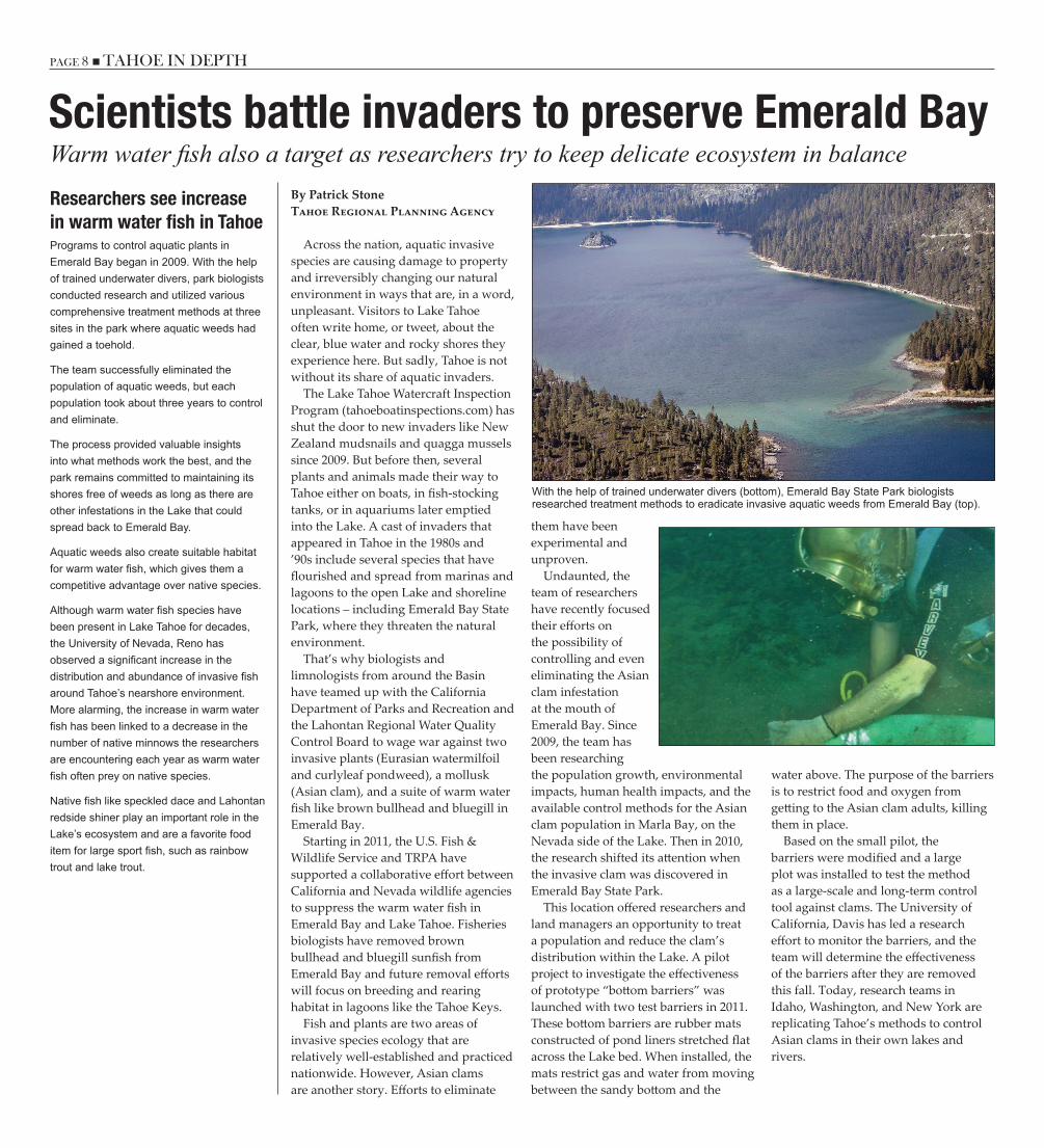
With the help of trained underwater divers (bottom), Emerald Bay State Park biologists researched treatment methods to eradicate invasive aquatic weeds from Emerald Bay (top).
Researchers see increasein warm water fish in TahoePrograms to control aquatic plants in Emerald Bay began in 2009. With the help of trained underwater divers, park biologists conducted research and utilized various comprehensive treatment methods at three sites in the park where aquatic weeds had gained a toehold.
The team successfully eliminated the population of aquatic weeds, but each population took about three years to control and eliminate.
The process provided valuable insights into what methods work the best, and the park remains committed to maintaining its shores free of weeds as long as there are other infestations in the Lake that could spread back to Emerald Bay.
Aquatic weeds also create suitable habitat for warm water fish, which gives them a competitive advantage over native species.
Although warm water fish species have been present in Lake Tahoe for decades, the University of Nevada, Reno has observed a significant increase in the distribution and abundance of invasive fish around Tahoe’s nearshore environment. More alarming, the increase in warm water fish has been linked to a decrease in the number of native minnows the researchers are encountering each year as warm water fish often prey on native species.
Native fish like speckled dace and Lahontan redside shiner play an important role in the Lake’s ecosystem and are a favorite food item for large sport fish, such as rainbow trout and lake trout.
PAGE 8 n TAHOE IN DEPTH TAHOE IN DEPTH n PAGE 9
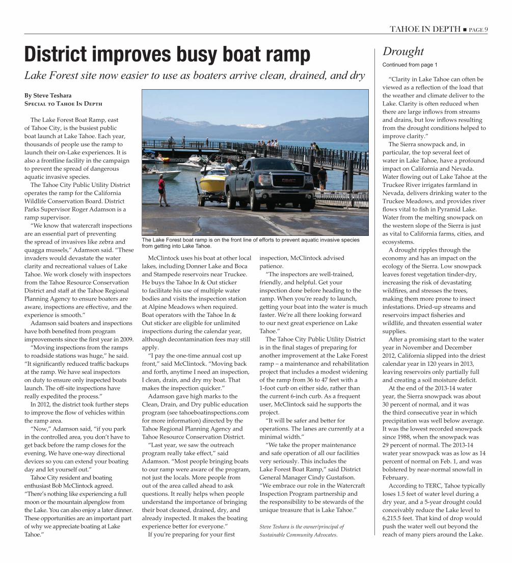
Lake Forest site now easier to use as boaters arrive clean, drained, and dryDistrict improves busy boat rampBy Steve TesharaSpecial to Tahoe In Depth
The Lake Forest Boat Ramp, east of Tahoe City, is the busiest public boat launch at Lake Tahoe. Each year, thousands of people use the ramp to launch their on-Lake experiences. It is also a frontline facility in the campaign to prevent the spread of dangerous aquatic invasive species.
The Tahoe City Public Utility District operates the ramp for the California Wildlife Conservation Board. District Parks Supervisor Roger Adamson is a ramp supervisor.
“We know that watercraft inspections are an essential part of preventing the spread of invasives like zebra and quagga mussels,” Adamson said. “These invaders would devastate the water clarity and recreational values of Lake Tahoe. We work closely with inspectors from the Tahoe Resource Conservation District and staff at the Tahoe Regional Planning Agency to ensure boaters are aware, inspections are effective, and the experience is smooth.”
Adamson said boaters and inspections have both benefited from program improvements since the first year in 2009.
“Moving inspections from the ramps to roadside stations was huge,” he said. “It significantly reduced traffic backups at the ramp. We have seal inspectors on duty to ensure only inspected boats launch. The off-site inspections have really expedited the process.”
In 2012, the district took further steps to improve the flow of vehicles within the ramp area.
“Now,” Adamson said, “if you park in the controlled area, you don’t have to get back before the ramp closes for the evening. We have one-way directional devices so you can extend your boating day and let yourself out.”
Tahoe City resident and boating enthusiast Bob McClintock agreed. “There’s nothing like experiencing a full moon or the mountain alpenglow from the Lake. You can also enjoy a later dinner. These opportunities are an important part of why we appreciate boating at Lake Tahoe.”
McClintock uses his boat at other local lakes, including Donner Lake and Boca and Stampede reservoirs near Truckee. He buys the Tahoe In & Out sticker to facilitate his use of multiple water bodies and visits the inspection station at Alpine Meadows when required. Boat operators with the Tahoe In & Out sticker are eligible for unlimited inspections during the calendar year, although decontamination fees may still apply.
“I pay the one-time annual cost up front,” said McClintock. “Moving back and forth, anytime I need an inspection, I clean, drain, and dry my boat. That makes the inspection quicker.”
Adamson gave high marks to the Clean, Drain, and Dry public education program (see tahoeboatinspections.com for more information) directed by the Tahoe Regional Planning Agency and Tahoe Resource Conservation District.
“Last year, we saw the outreach program really take effect,” said Adamson. “Most people bringing boats to our ramp were aware of the program, not just the locals. More people from out of the area called ahead to ask questions. It really helps when people understand the importance of bringing their boat cleaned, drained, dry, and already inspected. It makes the boating experience better for everyone.”
If you’re preparing for your first
inspection, McClintock advised patience.
“The inspectors are well-trained, friendly, and helpful. Get your inspection done before heading to the ramp. When you’re ready to launch, getting your boat into the water is much faster. We’re all there looking forward to our next great experience on Lake Tahoe.”
The Tahoe City Public Utility District is in the final stages of preparing for another improvement at the Lake Forest ramp – a maintenance and rehabilitation project that includes a modest widening of the ramp from 36 to 47 feet with a 1-foot curb on either side, rather than the current 6-inch curb. As a frequent user, McClintock said he supports the project.
“It will be safer and better for operations. The lanes are currently at a minimal width.”
“We take the proper maintenance and safe operation of all our facilities very seriously. This includes the Lake Forest Boat Ramp,” said District General Manager Cindy Gustafson. “We embrace our role in the Watercraft Inspection Program partnership and the responsibility to be stewards of the unique treasure that is Lake Tahoe.”
Steve Teshara is the owner/principal of Sustainable Community Advocates.
The Lake Forest boat ramp is on the front line of efforts to prevent aquatic invasive species from getting into Lake Tahoe.
DroughtContinued from page 1
“Clarity in Lake Tahoe can often be viewed as a reflection of the load that the weather and climate deliver to the Lake. Clarity is often reduced when there are large inflows from streams and drains, but low inflows resulting from the drought conditions helped to improve clarity.”
The Sierra snowpack and, in particular, the top several feet of water in Lake Tahoe, have a profound impact on California and Nevada. Water flowing out of Lake Tahoe at the Truckee River irrigates farmland in Nevada, delivers drinking water to the Truckee Meadows, and provides river flows vital to fish in Pyramid Lake. Water from the melting snowpack on the western slope of the Sierra is just as vital to California farms, cities, and ecosystems.
A drought ripples through the economy and has an impact on the ecology of the Sierra. Low snowpack leaves forest vegetation tinder-dry, increasing the risk of devastating wildfires, and stresses the trees, making them more prone to insect infestations. Dried-up streams and reservoirs impact fisheries and wildlife, and threaten essential water supplies.
After a promising start to the water year in November and December 2012, California slipped into the driest calendar year in 120 years in 2013, leaving reservoirs only partially full and creating a soil moisture deficit.
At the end of the 2013-14 water year, the Sierra snowpack was about 30 percent of normal, and it was the third consecutive year in which precipitation was well below average. It was the lowest recorded snowpack since 1988, when the snowpack was 29 percent of normal. The 2013-14 water year snowpack was as low as 14 percent of normal on Feb. 1, and was bolstered by near-normal snowfall in February.
According to TERC, Tahoe typically loses 1.5 feet of water level during a dry year, and a 5-year drought could conceivably reduce the Lake level to 6,215.5 feet. That kind of drop would push the water well out beyond the reach of many piers around the Lake.

PAGE 10 n TAHOE IN DEPTH TAHOE IN DEPTH n PAGE 11
5 watershed projects aim to reduce pollution on community-wide scaleBy Jack LandyEnvironmental Protection Agency
It is a well-known fact that Lake Tahoe has two seasons: winter and construction. Construction season has officially begun, and community water quality projects are under way. From the revitalization of Kings Beach to the Harrison Avenue Streetscape Project and the Bijou Area Erosion Control Project in South Lake Tahoe, crews seem to be working around the clock.
Unlike years past when roadway construction projects meant more dirt flowing into Lake Tahoe, these construction projects are designed to cut down on the amount of pollution flowing into the Lake.
“These improvements are the beginning of an exciting new chapter for us here at Lake Tahoe,” said Tyler Cannon, owner of South Lake Tahoe community staple Sprouts Café. “We’re all having to put up with some inconvenience from construction, but these projects will benefit the Lake.”
These projects are examples of public-private partnerships designed to improve Lake Tahoe for everyone. They are also the trailblazer projects that have led to the creation of environmental improvement plans for neighborhoods with a variety of land uses.
The Community Watershed Partnerships (CWP) program will develop community-wide plans to promote erosion-resistant landscaping and runoff-infiltrating retrofits on private parcels in conjunction with public stormwater improvements. The resulting projects will allow local jurisdictions to meet implementation goals set forth in the Lake Tahoe Total Maximum Daily Load (TMDL)—a long-term program to restore deep-water clarity to the Lake.
The watershed projects are planned by local governments, assisted by the California and Nevada resource conservation districts, for five urban areas around the Basin, including the Tahoe Valley/South “Y” area of South Lake Tahoe; the Meyers commercial core in El Dorado County; Tahoma; the Lower Country Club Drive area of Incline Village; and the Cave Rock General Improvement District in Douglas County. They aim to dramatically reduce the amount of sediment that flows into the Lake from streets, parking lots, driveways, and other staples of urban neighborhoods.
The CWP program provides a mechanism by which property owners can obtain technical assistance with site evaluations and conceptual designs, from resource conservation districts for
implementing onsite Best Management Practices (BMPs) –infiltration and treatment systems and Lake-friendly landscaping that helps minimize runoff and pollution. Neighborhoods receiving these area-wide strategies will provide homeowners with solutions for implementing their BMPs that involve participating in larger, multi-property projects. This coordination is especially useful if individual properties are constrained by rocky or steep terrain, high groundwater, or limited space.
These types of neighborhood-scale projects are a key strategy for reducing the water-clouding fine sediment particles that have caused a large decline in the clarity of Lake Tahoe in the last 50 years. The projects support implementation of the TMDL, which identifies urban runoff as the largest contributor to Tahoe’s clarity loss.
The five targeted areas are funded by the last phase of federal support under the Southern Nevada Public Land Management Act. An additional goal of the CWP program is to build capacity in the resource conservation districts so they can help other local jurisdictions determine the most cost-effective, feasible means of controlling their runoff and restoring Lake clarity.
Clarity takes a communityMonitoring program to measure Tahoe pollutionBy Andrea BuxtonTahoe ResouRce conseRvaTion DisTRicT Robert LarsenLahonTan WaTeR BoaRD
The Tahoe Resource Conservation District is leading an effort to measure pollutants in urban stormwater runoff that are contributing to Lake Tahoe’s declining clarity through a new initiative called the Regional Stormwater Monitoring Program, or RSWMP for short.
This new effort brings together the experience of academic researchers, environmental agencies, and private consultants to develop a scientifically sound, cost-effective regional approach to monitoring stormwater runoff entering Lake Tahoe. The project partnership will recommend several monitoring methods to guide urban stormwater monitoring efforts, including tracking the status and trends of urban stormwater pollutant loads, measuring the effectiveness of Best Management Practices, and assisting jurisdictions with regulatory compliance.
RSWMP will also provide an administrative structure for prioritizing urban stormwater monitoring expenditures, including recommending cost-effective monitoring methods, gathering data to answer key resource management questions, and tracking Basin-wide progress toward achieving Lake Tahoe clarity goals.
RSWMP received initial funding totalling over $1.5 million from the Southern Nevada Public Land Management Act and California Proposition 84, and is supported by regulatory agencies, local government representatives, and scientists in the Lake Tahoe Region.
Lake Tahoe’s legendary transparency was historically the result of very little fine sediment and nutrients reaching the Lake. However, development of impervious surfaces like roads, buildings, and parking lots over the years has accelerated pollutant runoff reaching Lake Tahoe. State highway departments and local governments are implementing infiltration practices, installing stormwater treatment facilities, and changing the way they maintain our roadways to help reduce the amount of fine sediment and nutrients that flow into the Lake.
The lower Country Club Drive area of Incline Village is one of five urban areas around the Lake where watershed projects are planned.
PAGE 10 n TAHOE IN DEPTH TAHOE IN DEPTH n PAGE 11
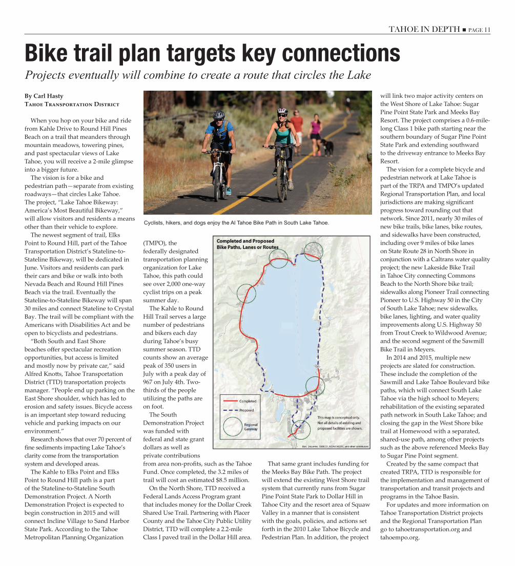
Projects eventually will combine to create a route that circles the LakeBike trail plan targets key connectionsBy Carl HastyTahoe Transportation District
When you hop on your bike and ride from Kahle Drive to Round Hill Pines Beach on a trail that meanders through mountain meadows, towering pines, and past spectacular views of Lake Tahoe, you will receive a 2-mile glimpse into a bigger future.
The vision is for a bike and pedestrian path—separate from existing roadways—that circles Lake Tahoe. The project, “Lake Tahoe Bikeway: America’s Most Beautiful Bikeway,” will allow visitors and residents a means other than their vehicle to explore.
The newest segment of trail, Elks Point to Round Hill, part of the Tahoe Transportation District’s Stateline-to-Stateline Bikeway, will be dedicated in June. Visitors and residents can park their cars and bike or walk into both Nevada Beach and Round Hill Pines Beach via the trail. Eventually the Stateline-to-Stateline Bikeway will span 30 miles and connect Stateline to Crystal Bay. The trail will be compliant with the Americans with Disabilities Act and be open to bicyclists and pedestrians.
“Both South and East Shore beaches offer spectacular recreation opportunities, but access is limited and mostly now by private car,” said Alfred Knotts, Tahoe Transportation District (TTD) transportation projects manager. “People end up parking on the East Shore shoulder, which has led to erosion and safety issues. Bicycle access is an important step toward reducing vehicle and parking impacts on our environment.”
Research shows that over 70 percent of fine sediments impacting Lake Tahoe’s clarity come from the transportation system and developed areas.
The Kahle to Elks Point and Elks Point to Round Hill path is a part of the Stateline-to-Stateline South Demonstration Project. A North Demonstration Project is expected to begin construction in 2015 and will connect Incline Village to Sand Harbor State Park. According to the Tahoe Metropolitan Planning Organization
(TMPO), the federally designated transportation planning organization for Lake Tahoe, this path could see over 2,000 one-way cyclist trips on a peak summer day.
The Kahle to Round Hill Trail serves a large number of pedestrians and bikers each day during Tahoe’s busy summer season. TTD counts show an average peak of 350 users in July with a peak day of 967 on July 4th. Two-thirds of the people utilizing the paths are on foot.
The South Demonstration Project was funded with federal and state grant dollars as well as private contributions from area non-profits, such as the Tahoe Fund. Once completed, the 3.2 miles of trail will cost an estimated $8.5 million.
On the North Shore, TTD received a Federal Lands Access Program grant that includes money for the Dollar Creek Shared Use Trail. Partnering with Placer County and the Tahoe City Public Utility District, TTD will complete a 2.2-mile Class I paved trail in the Dollar Hill area.
That same grant includes funding for the Meeks Bay Bike Path. The project will extend the existing West Shore trail system that currently runs from Sugar Pine Point State Park to Dollar Hill in Tahoe City and the resort area of Squaw Valley in a manner that is consistent with the goals, policies, and actions set forth in the 2010 Lake Tahoe Bicycle and Pedestrian Plan. In addition, the project
will link two major activity centers on the West Shore of Lake Tahoe: Sugar Pine Point State Park and Meeks Bay Resort. The project comprises a 0.6-mile-long Class 1 bike path starting near the southern boundary of Sugar Pine Point State Park and extending southward to the driveway entrance to Meeks Bay Resort.
The vision for a complete bicycle and pedestrian network at Lake Tahoe is part of the TRPA and TMPO’s updated Regional Transportation Plan, and local jurisdictions are making significant progress toward rounding out that network. Since 2011, nearly 30 miles of new bike trails, bike lanes, bike routes, and sidewalks have been constructed, including over 9 miles of bike lanes on State Route 28 in North Shore in conjunction with a Caltrans water quality project; the new Lakeside Bike Trail in Tahoe City connecting Commons Beach to the North Shore bike trail; sidewalks along Pioneer Trail connecting Pioneer to U.S. Highway 50 in the City of South Lake Tahoe; new sidewalks, bike lanes, lighting, and water quality improvements along U.S. Highway 50 from Trout Creek to Wildwood Avenue; and the second segment of the Sawmill Bike Trail in Meyers.
In 2014 and 2015, multiple new projects are slated for construction. These include the completion of the Sawmill and Lake Tahoe Boulevard bike paths, which will connect South Lake Tahoe via the high school to Meyers; rehabilitation of the existing separated path network in South Lake Tahoe; and closing the gap in the West Shore bike trail at Homewood with a separated, shared-use path, among other projects such as the above referenced Meeks Bay to Sugar Pine Point segment.
Created by the same compact that created TRPA, TTD is responsible for the implementation and management of transportation and transit projects and programs in the Tahoe Basin.
For updates and more information on Tahoe Transportation District projects and the Regional Transportation Plan go to tahoetransportation.org and tahoempo.org.
Cyclists, hikers, and dogs enjoy the Al Tahoe Bike Path in South Lake Tahoe.
PAGE 12 n TAHOE IN DEPTH TAHOE IN DEPTH n PAGE 13
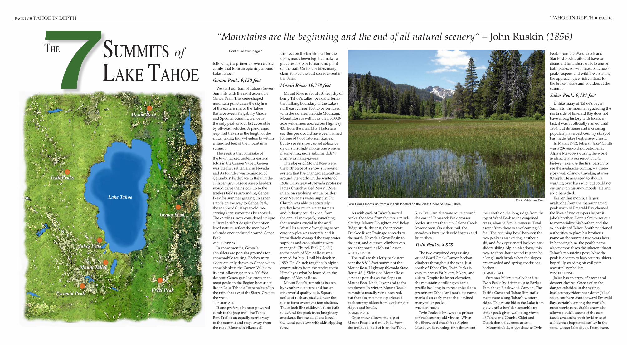
following is a primer to seven classic climbs that form an epic ring around Lake Tahoe.
Genoa Peak: 9,150 feetWe start our tour of Tahoe’s Seven
Summits with the most accessible: Genoa Peak. This cone-shaped mountain punctuates the skyline of the eastern rim of the Tahoe Basin between Kingsbury Grade and Spooner Summit. Genoa is the only peak on our list accessible by off-road vehicles. A panoramic jeep trail traverses the length of the ridge, taking four-wheelers to within a hundred feet of the mountain’s summit.
The peak is the namesake of the town tucked under its eastern folds in the Carson Valley. Genoa was the first settlement in Nevada and its founder was reminded of Columbus’ birthplace in Italy. In the 19th century, Basque sheep herders would drive their stock up to the treeless fields surrounding Genoa Peak for summer grazing. In aspen stands on the way to Genoa Peak, the shepherds’ 100-year-old tree carvings can sometimes be spotted. The carvings, now considered unique cultural artifact despite their often lewd nature, reflect the months of solitude once endured around Genoa Peak.WINTER/SPRING
In snow months, Genoa’s shoulders are popular grounds for snowmobile touring. Backcountry skiers are only drawn to Genoa when snow blankets the Carson Valley to its east, allowing a rare 4,000-foot descent. Genoa gets less snow than most peaks in the Region because it lies in Lake Tahoe’s “banana belt,” in the rain-shadow of the Sierra Crest to the west.SUMMER/FALL
If one prefers a human-powered climb to the jeep trail, the Tahoe Rim Trail is an equally scenic way to the summit and stays away from the road. Mountain bikers call
this section the Bench Trail for the eponymous hewn log that makes a great rest stop or turnaround point on the trail. On foot or bike, many claim it to be the best scenic ascent in the Basin.
Mount Rose: 10,778 feetMount Rose is about 100 feet shy of
being Tahoe’s tallest peak and forms the hulking boundary of the Lake’s northeast corner. Not to be confused with the ski area on Slide Mountain, Mount Rose is within its own 30,000-acre wilderness area across Highway 431 from the chair lifts. Historians say this peak could have been named for one of two historical figures, but to see its snowcap set ablaze by dawn’s first light makes one wonder if something more sublime didn’t inspire its name-givers.
The slopes of Mount Rose were the birthplace of a snow surveying system that has changed agriculture around the world. In the winter of 1904, University of Nevada professor James Church scaled Mount Rose intent on resolving annual battles over Nevada’s water supply. Dr. Church was able to accurately predict how much water farmers and industry could expect from the annual snowpack, something that remains crucial in the arid West. His system of weighing snow core samples was accurate and it immediately changed the way water supplies and crop planting were managed. Church Peak (10,661) to the north of Mount Rose was named for him. Until his death in 1959, Dr. Church taught sub-alpine communities from the Andes to the Himalayas what he learned on the slopes of Mount Rose.
Mount Rose’s summit is beaten by weather exposure and has an otherworld quality to it. Square scales of rock are stacked near the top to form overnight tent shelters. These look like children’s forts built to defend the peak from imaginary attackers. But the assailant is real—the wind can blow with skin-rippling force.
As with each of Tahoe’s sacred peaks, the view from the top is mind-altering. Mount Houghton and Relay Ridge stride the east, the intricate Truckee River Drainage spreads to the north, Nevada’s Great Basin to the east, and at times, climbers can see as far north as Mount Lassen.WINTER/SPRING
The trails to this lofty peak start near the 8,800-foot summit of the Mount Rose Highway (Nevada State Route 431). Skiing on Mount Rose is not as popular as the slopes of Mount Rose Knob, lower and to the southwest. In winter, Mount Rose’s summit is usually wind-scoured, but that doesn’t stop experienced backcountry skiers from exploring its ridges and bowls.SUMMER/FALL
Once snow allows, the top of Mount Rose is a 6-mile hike from the trailhead, half of it on the Tahoe
Rim Trail. An alternate route around the east of Tamarack Peak crosses feeder streams that join Galena Creek lower down. On either trail, the meadows burst with wildflowers and butterflies.
Twin Peaks: 8,878 The two conjoined crags rising
out of Ward Creek Canyon beckon climbers throughout the year. Just south of Tahoe City, Twin Peaks is easy to access for hikers, bikers, and skiers. Despite its lower elevation, the mountain’s striking volcanic profile has long been recognized as a prominent Tahoe landmark, its name marked on early maps that omitted many taller peaks. WINTER/SPRING
Twin Peaks is known as a primer for backcountry ski virgins. When the Sherwood chairlift at Alpine Meadows is running, first-timers cut
their teeth on the long ridge from the top of Ward Peak to the conjoined crags, about a 3-mile traverse. Total ascent from there is a welcoming 80 feet. The reclining bowl between the two peaks is an exciting, aesthetic ski, and for experienced backcountry sliders skiing Alpine Meadows, this two- to three-hour round trip can be a long lunch break when the slopes are crowded and spring conditions beckon. SUMMER/FALL
Summer hikers usually head to Twin Peaks by driving up to Barker Pass above Blackwood Canyon. The Pacific Crest and Tahoe Rim trails meet there along Tahoe’s western ridge. This route hides the Lake from view until a boulder-scramble up either peak gives walloping views of Tahoe and Granite Chief and Desolation wilderness areas.
Mountain bikers get close to Twin
Peaks from the Ward Creek and Stanford Rock trails, but have to dismount for a short walk to one or both peaks. As with most of Tahoe’s peaks, aspens and wildflowers along the approach give rich contrast to the broken shale and boulders at the summit.
Jakes Peak: 9,187 feetUnlike many of Tahoe’s Seven
Summits, the mountain guarding the north side of Emerald Bay does not have a long history with locals; in fact, it wasn’t officially named until 1984. But its name and increasing popularity as a backcountry ski spot has made Jakes Peak a new classic.
In March 1982, Jeffery “Jake” Smith was a 28-year-old ski patroller at Alpine Meadows during the worst avalanche at a ski resort in U.S. history. Jake was the first person to see the avalanche coming – a three-story wall of snow traveling at over 80 mph. He managed to shout a warning over his radio, but could not outrun it on his snowmobile. He and six others died.
Earlier that month, a larger avalanche from the then-unnamed peak north of Emerald Bay claimed the lives of two campers below it. Jake’s brother, Dennis Smith, set out to memorialize his brother, and the skier-spirit of Tahoe. Smith petitioned authorities to place his brother’s name on the summit two years later. In honoring him, the peak’s name also memorializes the inherent threat Tahoe’s mountains pose. Now the peak is a totem to backcountry skiers, hopefully warding off evil with ancestral symbolism.WINTER/SPRING
Jakes has an array of ascent and descent choices. Once avalanche danger subsides in the spring, backcountry riders soar down Jakes’ steep southern chute toward Emerald Bay, certainly among the world’s most scenic runs. Stable snow also allows a quick ascent of the east face’s avalanche path (evidence of a slide that happened earlier in the same winter Jake died). From there,
The 7SummiTSLake Tahoe
of
Freel Peak
Mount Tallac
Jakes Peak
Twin Peaks
Mount Rose
Lake Tahoe
Genoa Peak
Pyramid Peak
“Mountains are the beginning and the end of all natural scenery” – John Ruskin (1856)Continued from page 1
Photo © Michael DrumTwin Peaks looms up from a marsh located on the West Shore of Lake Tahoe.

PAGE 14 n TAHOE IN DEPTH TAHOE IN DEPTH n PAGE 15
they can choose from a number of drop-ins along the ridge that stretches north to Rubicon Peak.
The views from Jakes are not all that makes this one of Tahoe’s great backcountry ski peaks. Snowplow drivers clear a large parking area just outside of Emerald Bay’s north closure gate. Along this narrow stretch of highway, finding a safe staging ground is key and this spot at Jakes is far more amenable than other West Shore hikes (such as Rubicon Peak).SUMMER/FALL
Jakes Peak is not accessed by a maintained trail in summer and therefore not heavily visited. Hikers can reach the summit from Desolation Wilderness near Stony Ridge Lake, or by popping along the granite ridge from Rubicon Peak, which has a maintained trail from Highway 89.
Mount Tallac: 9,735 feetRising sharp from the southwest
corner of the Tahoe Basin is Tahoe’s most recognizable peak. Mount Tallac’s magisterial North Bowl and identifying cross-shaped patch of snow make this peak a magnet for thousands of climbers in all seasons.
Tallac is the only Tahoe peak to keep its native Washoe descriptor—ta-lah-act – which translates simply as mountain, although early Euro-Americans assumed from Tallac’s towering presence it meant “Great Mountain.” Its sheer eastern face is close enough to Lake Tahoe’s shore to give the sensation from the summit of floating 3,500 feet above the Basin. The peak stands atop the western half of the fault responsible for Tahoe’s formation more than 30 million years ago. The eastern Carson Range slipped down and to the east, creating a valley that was filled in much later on the north by volcanic Mount Rose.WINTER/SPRING
Winter ascents of Mount Tallac are a tradition for residents and visitors alike, and the boot tracks up in spring become a highway of sorts. The Cross chute is an extreme descent through a tight corridor of granite, where a fall can be fatal. The North Bowl is much more skier-friendly, resembling a lopsided volcanic crater full of wind-blown snow. This bowl empties onto a wide slide path pitched at least
35 degrees that drops you straight back to your car. Needless to say, untracked terrain is hard to find on Tallac.SUMMER/FALL
Mount Tallac is Tahoe’s most heavily visited peak in the summer, accessed by an energetic trail leading up from Fallen Leaf Lake. Summer ascents give down-the-nose vistas of this oval gem of water nestled into its massive glacial bowl.
Fallen Leaf was a summer camp for early naturalists and scientists – William Price led natural history tours of Desolation Wilderness and Mount Tallac around the turn of the 20th century. The head of the National Parks Department took one of Price’s tours and soon had park rangers across the country giving similar tours—a duty rangers have to this day.
Approaching Tallac the long way through Glen Alpine Springs south of Fallen Leaf gives a sense of why naturalists fell in love with the area. Blooming meadows and old growth trees give way to typically tough Sierra wildflowers near the peak. Dark, metamorphic blocks litter Tallac’s peak giving the impression of a mountain that is still young, still growing.
Pyramid Peak: 9,983 feetThe stoic pinnacle of Pyramid
Peak might spring to mind when a meditating guru tranquilly asks you to picture a mountain. With its perfectly planed sides and enduring snowcap, Pyramid is simply what a peak is supposed to look like.
The first recorded ascent of Pyramid Peak was by surveyor William Brewer in 1863. Brewer is not credited with naming the peak, however. Its name is so obvious that it may have been first uttered when General Frémont’s famous exploration team passed beneath it in 1848.
Pyramid does not lie within the Tahoe Basin, but its prominence in the Tahoe landscape and its top-rank among Desolation Wilderness summits make it one of Tahoe’s definitive backcountry climbs. From any vantage point, Pyramid’s perfection and height taunt climbers to bring a lunch and their best legs. The northern view from the summit encompasses an area with more lakes per square mile than any other designated wilderness in the nation.WINTER/SPRING
In winter, backcountry skiers will sometimes approach Pyramid via Echo Lakes, but this route is an overnight trip, so a more common ascent is from Highway 50 at Twin Bridges. When snow reaches low enough, this northern flank provides a 4,000-foot run back down to the American River Canyon.SUMMER/FALL
The approach through Desolation Wilderness from Echo Lakes crosses miles of the glacier-scoured granite for which the Sierra is rightly famous. Hikers also ascend Pyramid from the south via Horsetail Falls. Either approach can be perilous, however. The final run up to the summit is a steep scramble over loose shale with no run-out to stop you.
Freel Peak: 10,881 feetFreel Peak is the Lake’s bald, southern
giant. It is the highest peak in the Tahoe Basin and comprises, along with its 10,000-foot relatives, Job’s Peak and Job’s Sister, one third of the grand Freel massif. Early settlers and travelers referred to the three as the Job’s Group, but a squatter who happened to be living at its base when the 1874 survey came to town somehow planted his name on the tallest.
A competitive backcountry spirit alone would make Tahoe’s highest peak a must-climb, but the moonscape quality and the gripping panorama on Freel’s summit make it, for many, an annual ritual.
From the top, Freel feels closer to the farm-gridded Carson Valley far below its eastern side than to the Lake. Nevada’s basins and ranges ripple away to the east and Mammoth Mountain sometimes appears through the haze to the south. Freel also has a birds-eye view of Desolation Wilderness. Unlike the bouldered peaks to the west, the dramatic freeze-thaw cycle at Freel’s higher elevation grinds much of the rock to sand, making its slopes barren and smooth.WINTER/SPRING
In winter, Freel’s summit is a 12-mile ski in and that, along with its rigid winds, keep it relatively unvisited. Skiers who make the trip are rewarded by solitude and the broad, treeless bowl between Freel and Job’s Sister. Laps on this open snow field are hard to resist, but the usual route down is back to the south.SUMMER/FALL
Hikers and mountain bikers in summer usually drive to within a few miles of the summit on one of two Forest Service roads—Fountain Place Road near Meyers and Willow Creek Road off Highway 88 near Luther Pass. The longer, northern route on the Tahoe Rim Trail from Kingsbury Grade travels through Heavenly Ski Resort’s back canyons and past Star Lake—Tahoe’s highest fishing hole.
Backcountry skiers, hikers and bikers consulted in the compiling of this list include Peter Underwood, Olympic Bike Shop (530) 581-2500; Gary Bell, Sierra Cycle Works (530) 541-7505; and Mike Schwartz, The Backcountry (530) 581-5861.
Continued from page 13
Photo © Jeff MoserA hiker pauses to enjoy the view of Lake Tahoe from Freel Peak.
PAGE 14 n TAHOE IN DEPTH TAHOE IN DEPTH n PAGE 15
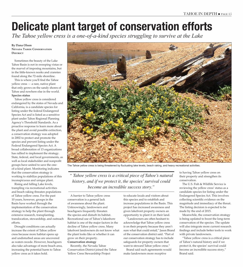
The Tahoe yellow cress is a one-of-a-kind species struggling to survive at the LakeDelicate plant target of conservation effortsBy Dana OlsonNevada Tahoe Conservation District
Sometimes the beauty of the Lake Tahoe Basin is not in sweeping vistas or the marvel of imposing mountains, but in the little-known nooks and crannies found along the 72-mile shoreline.
This is where you’ll find the Tahoe yellow cress — a rare, native plant that only grows on the sandy shores of Tahoe and nowhere else in the world. Species status
Tahoe yellow cress is considered endangered by the states of Nevada and California, is a candidate species for listing under the federal Endangered Species Act and is listed as a sensitive plant under Tahoe Regional Planning Agency’s Threshold Standards. As a proactive response to learn more about the plant and avoid possible extinction, a conservation strategy was adopted in 2002 to protect and promote the species and prevent listing under the Federal Endangered Species Act. A broad collaboration of 13 organizations has rallied to implement the strategy. State, federal, and local governments, as well as local stakeholder and nonprofit groups have united to save the one-of-a-kind plant. Monitoring indicates that the conservation strategy is working to stabilize populations of this inconspicuous and unique plant.
Rising and falling Lake levels, trampling via recreational activities and beach raking threaten populations of Tahoe yellow cress. For the past 10 years, however, groups in the Basin have worked through the implementation of the conservation strategy to help the plant through extensive research, transplanting, translocation, stewardship, and outreach efforts.
Drought conditions can actually increase the extent of Tahoe yellow cress because more habitat opens up and undisturbed areas are uncovered as waters recede. However, beachgoers also take advantage of more beach area, increasing the potential harm to Tahoe yellow cress as it takes hold.
A barrier to Tahoe yellow cress conservation is a general lack of awareness about the plant. Unknowingly, landowners and beachgoers frequently threaten the species and disturb its habitat. Recreational use of Tahoe’s lakeshore habitat is one of the major factors in the decline of Tahoe yellow cress. Many lakefront landowners do not know what the plant looks like or whether it can grow on their property. Conservation strategy
Recently, the Nevada Tahoe Conservation District joined the Tahoe Yellow Cress Stewardship Project
to educate locals and visitors about this species and to establish and increase populations in the Basin. This project has increased awareness and given lakefront property owners an opportunity to plant it on their land.
“Landowners are often hesitant to acknowledge that Tahoe yellow cress is on their property because they aren’t sure what that could entail,” Jason Brand of the conservation district said. “Part of our conservation strategy has to include safeguards for property owners that want to steward Tahoe yellow cress.”
Brand said such agreements would make landowners more receptive
to having Tahoe yellow cress on their property and strengthen its conservation.
The U.S. Fish & Wildlife Service is reviewing the yellow cress’ status as a candidate species for listing under the Endangered Species Act. This involves collecting scientific evidence on the magnitude and immediacy of the threat. The listing decision is expected to be made by the end of 2015.
Meanwhile, the conservation strategy is being updated to boost the long-term conservation of the species. The update will also integrate more current research findings and include better tools to work with private landowners.
“Tahoe yellow cress is a critical piece of Tahoe’s natural history and if we protect it, the species’ survival could become an incredible success story,” Brand said.
The Tahoe yellow cress is being threatened by fluctuating lake levels, beach raking, and heavy recreational activities.
“ Tahoe yellow cress is a critical piece of Tahoe’s natural history, and if we protect it, the species’ survival could
become an incredible success story.”
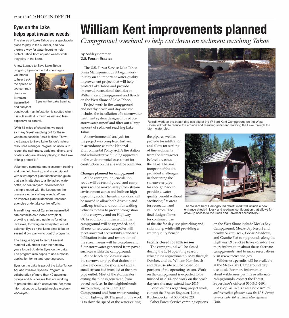
PAGE 16 n TAHOE IN DEPTH TAHOE IN DEPTH n PAGE 17
Campground overhaul to help cut down on sediment reaching TahoeWilliam Kent improvements plannedBy Ashley SommerU.S. Forest Service
The U.S. Forest Service Lake Tahoe Basin Management Unit began work in May on an important water-quality improvement project that will help protect Lake Tahoe and provide improved recreational facilities at William Kent Campground and Beach on the West Shore of Lake Tahoe.
Project work in the campground and nearby beach and day-use site includes the installation of a stormwater treatment system designed to reduce stormwater runoff and filter out a large amount of sediment reaching Lake Tahoe.
An environmental analysis for the project was completed last year in accordance with the National Environmental Policy Act. A fire station and administrative building approved in the environmental assessment for construction on the site will be built later.
Changes planned for campgroundAt the campground, circulation
roads will be reconfigured, and camp spurs will be moved away from stream environment zones and built on high-capability soils. The entrance kiosk will be moved to allow both drive-up and walk-up traffic, and room for waiting vehicles to pass to prevent congestion in the entryway and on Highway 89. In addition, utilities within the campground will be upgraded, and all new or relocated campsites will meet universal accessibility standards. Infiltration basins and restoration of the stream areas will help capture and filter stormwater generated from paved surfaces within the campground.
At the beach and day-use area, the stormwater pipe that drains into Lake Tahoe will be shortened and a small stream bed installed at the new pipe outlet. Most of the stormwater exiting the pipe is generated from paved surfaces in the neighborhoods surrounding the William Kent Campground and from water running off of Highway 89. The goal of this work is to slow the speed of the water exiting
the pipe, as well as provide for infiltration and allow for settling of fine sediments from the stormwater before it reaches the Lake. The small footprint of the site provided challenges in shortening the stormwater pipe far enough back to provide a water-quality benefit without sacrificing flat areas for recreation and valued trees. The final design allows for continued use of the site for day-use picnicking and swimming, while still providing a water-quality benefit.
Facility closed for 2014 seasonThe campground will be closed
during the 2014 operating season, which runs approximately May through October, and the William Kent beach and day-use site will be closed for portions of the operating season. Work on the campground is expected to be finished in 2014, and work on the beach day-use site may extend into 2015.
For questions regarding project work, contact the Project Engineer, Katie Kuchenbecker, at 530-543-2620.
Other Forest Service camping options
on the West Shore include Meeks Bay Campground, Meeks Bay Resort and nearby Silver Creek, Goose Meadows, and Granite Flat campgrounds along the Highway 89 Truckee River corridor. For more information about these alternate campgrounds, and to make reservations, visit www.recreation.gov.
Wilderness permits will be available at the Meeks Bay Campground day use kiosk. For more information about wilderness permits or alternate campgrounds, contact the Forest Supervisor’s office at 530-543-2694.
Ashley Sommer is a landscape architect and recreation planner with the U.S. Forest Service Lake Tahoe Basin Management Unit.
Retrofit work on the beach day-use site at the William Kent Campground on the West Shore will help to reduce the erosion and resulting sediment reaching the Lake through the stormwater pipe.
The William Kent Campground retrofit work will include a new entrance check-in kiosk and roadway configuration that allows for drive-up access to the kiosk and universal accessibility.
Eyes on the Lakehelps spot invasive weedsThe shores of Lake Tahoe are a spectacular place to play in the summer, and now there’s a way for water lovers to help protect Tahoe from aquatic weeds while they play in the Lake.
A new League to Save Lake Tahoe program, Eyes on the Lake, engages volunteers to help track the spread of two common plants — Eurasian watermilfoil and curlyleaf pondweed. If an infestation is spotted when it is still small, it is much easier and less expensive to control.
“With 72 miles of shoreline, we need as many ‘eyes’ watching out for these weeds as possible,” said Melissa Thaw, the League to Save Lake Tahoe’s natural resources manager. “A great solution is to recruit the swimmers, paddlers, divers, and boaters who are already playing in the Lake to help protect it. ”
Volunteers complete one classroom training and one field training, and are equipped with a waterproof plant identification guide that easily attaches to a life jacket, water bottle, or boat lanyard. Volunteers file a simple report with the League on the presence or lack of any weeds. When an invasive plant is identified, resource agencies undertake control efforts.
A small fragment of Eurasian watermilfoil can establish as a viable new plant, providing shade and nutrients for other invasives, throwing an ecosystem out of balance. Eyes on the Lake aims to be an essential companion to control programs.
The League hopes to recruit several hundred volunteers over the next few years to participate in Eyes on the Lake. The program also hopes to use a mobile application for instant reporting soon.
Eyes on the Lake is part of the Lake Tahoe Aquatic Invasive Species Program, a collaboration of more than 40 agencies, groups and businesses that are working to protect the Lake’s ecosystem. For more information, go to keeptahoeblue.org/our-work/eyes/.
Eyes on the Lake training.

PAGE 16 n TAHOE IN DEPTH TAHOE IN DEPTH n PAGE 17
Shoreline paddling route offers alternative way to view the wonders of Lake TahoeWater Trail offers affordable recreationBy Victoria OrtizCalifornia Tahoe Conservancy
The paddling season is back. It’s the time of year when kayakers, canoers, and stand-up paddlers take to the water of Lake Tahoe for some human-powered, waterborne sightseeing and travel.
Although paddle sports have been increasing in popularity in recent years, only a small percentage of the 3 million-plus visitors expected to visit Lake Tahoe this year will ever have a chance to experience the scenic shoreline, sandy beaches, and rocky inlets from beyond the water’s edge.
Traditionally, the lack of recreational support facilities and a coordinated way to access them limited non-motorized use on Lake Tahoe.
Today, the Lake Tahoe Water Trail offers locals and visitors a way to escape the crowds and intimately experience the stunning clarity and spectacular vistas that the Tahoe Basin flaunts daily.
The Lake Tahoe Water Trail is a network of lakefront launch sites, picnic areas, restaurants, campgrounds, and overnight lodging facilities for paddlers. The water trail follows the 72 miles of shoreline in Nevada and California, linking public beaches and shoreline facilities that highlight notable natural, historic, and cultural features.
The water trail models sustainable recreation and eco-tourism in the Basin. Paddle sports are low-impact – easy on the body, the environment, and the wallet.
In 2003, a group of dedicated community volunteers sought to enhance the network of public Lake access sites by better coordinating information so that more users could easily get on the water.
The team first published a water trail map and trip planning guide in 2005, and that publication has since been updated and is currently for sale throughout the Region. Day trip and overnight trip information, along with navigational tips, safety advice, and interpretive information, can be found
at laketahoewatertrail.org.The California Tahoe Conservancy
supports the Lake Tahoe Water Trail and has invested over $46 million in the acquisition and development of lakefront public access points around the Basin.
Popular sites such as Patton/Waterman’s Landing, Commons Beach, Lakeview Commons, and North Tahoe Beach were purchased or redeveloped with Conservancy funds to encourage sustainable recreation within Tahoe’s many communities.
The Tahoe Fund, in partnership with
all shoreline public land managers, developed an app for iPhone and Android that enables users to locate Lake Tahoe’s public beach access sites and their amenities. (Details on page 21.)
The Conservancy works with numerous organizations throughout the Region to support the Tahoe Keepers program. This regional effort for non-motorized watercraft prevents the spread of aquatic invasive species. Find out how to keep your watercraft clean, drained, and dry, and become a Tahoe Keeper at tahoekeepers.org.
Kayaks float over the clear waters along the East Shore of Lake Tahoe.
New program planned for protecting nearshore By Daniel SussmanLahonTan WaTeR BoaRD
In the wake of a 2013 report evaluating the state of Lake Tahoe’s nearshore water quality, the Lahontan Water Board and other regulatory agencies have unveiled a new program to restore and maintain the nearshore zone.
The ribbon of shallow water around the perimeter of Lake Tahoe is where residents and visitors are most likely to notice ecological changes such as algae on submerged rocks, aquatic invasive plants and animals, and reduced visibility. Water clarity at Tahoe has historically been measured in the center of the Lake, but an increasing amount of attention is now being paid to the nearshore.
According to the Water Board, the goal of its new Nearshore Water Quality Protection Plan is to ensure that the nearshore area is improved “to reflect conditions consistent with an exceptionally clean and clear Lake for current and future human appreciation and use.”
To accomplish this, they will be working with the Tahoe Regional Planning Agency, the Nevada Division of Environmental Protection, and the U.S. Environmental Protection Agency by:
■ Continuing existing programs and policies that protect the nearshore
■ Implementing a monitoring program to track and report nearshore conditions
■ Investigating the causes of and potential approaches to address nearshore “hotspots;” localized areas with high levels of algae or other environmental change in the nearshore
■ Investigating the influence of climate change on the nearshore environment
■ Continuing to implement existing nearshore standards and assess whether additional standards may be beneficial.
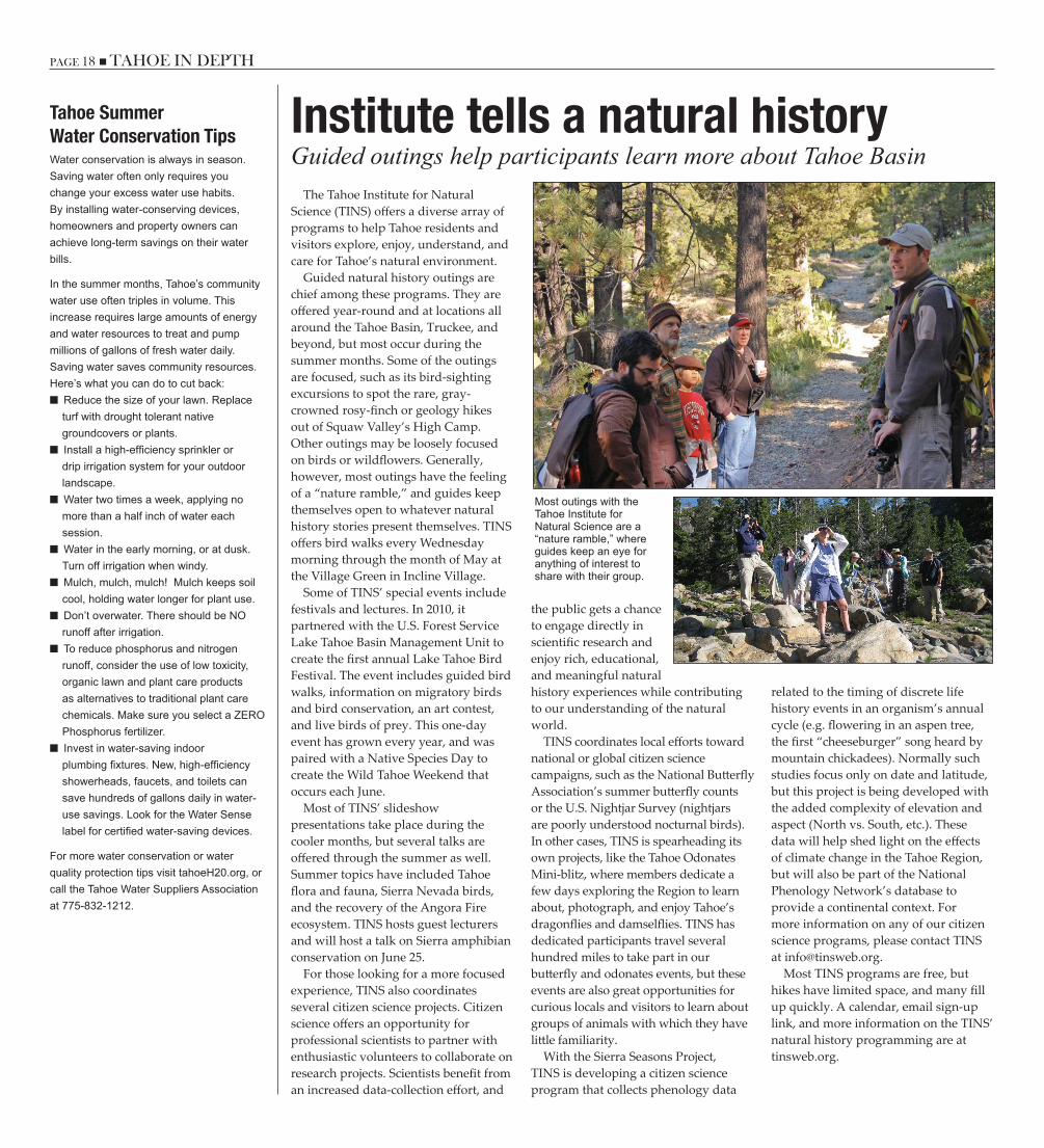
PAGE 18 n TAHOE IN DEPTH TAHOE IN DEPTH n PAGE 19
Guided outings help participants learn more about Tahoe BasinInstitute tells a natural history
The Tahoe Institute for Natural Science (TINS) offers a diverse array of programs to help Tahoe residents and visitors explore, enjoy, understand, and care for Tahoe’s natural environment.
Guided natural history outings are chief among these programs. They are offered year-round and at locations all around the Tahoe Basin, Truckee, and beyond, but most occur during the summer months. Some of the outings are focused, such as its bird-sighting excursions to spot the rare, gray-crowned rosy-finch or geology hikes out of Squaw Valley’s High Camp. Other outings may be loosely focused on birds or wildflowers. Generally, however, most outings have the feeling of a “nature ramble,” and guides keep themselves open to whatever natural history stories present themselves. TINS offers bird walks every Wednesday morning through the month of May at the Village Green in Incline Village.
Some of TINS’ special events include festivals and lectures. In 2010, it partnered with the U.S. Forest Service Lake Tahoe Basin Management Unit to create the first annual Lake Tahoe Bird Festival. The event includes guided bird walks, information on migratory birds and bird conservation, an art contest, and live birds of prey. This one-day event has grown every year, and was paired with a Native Species Day to create the Wild Tahoe Weekend that occurs each June.
Most of TINS’ slideshow presentations take place during the cooler months, but several talks are offered through the summer as well. Summer topics have included Tahoe flora and fauna, Sierra Nevada birds, and the recovery of the Angora Fire ecosystem. TINS hosts guest lecturers and will host a talk on Sierra amphibian conservation on June 25.
For those looking for a more focused experience, TINS also coordinates several citizen science projects. Citizen science offers an opportunity for professional scientists to partner with enthusiastic volunteers to collaborate on research projects. Scientists benefit from an increased data-collection effort, and
the public gets a chance to engage directly in scientific research and enjoy rich, educational, and meaningful natural history experiences while contributing to our understanding of the natural world.
TINS coordinates local efforts toward national or global citizen science campaigns, such as the National Butterfly Association’s summer butterfly counts or the U.S. Nightjar Survey (nightjars are poorly understood nocturnal birds). In other cases, TINS is spearheading its own projects, like the Tahoe Odonates Mini-blitz, where members dedicate a few days exploring the Region to learn about, photograph, and enjoy Tahoe’s dragonflies and damselflies. TINS has dedicated participants travel several hundred miles to take part in our butterfly and odonates events, but these events are also great opportunities for curious locals and visitors to learn about groups of animals with which they have little familiarity.
With the Sierra Seasons Project, TINS is developing a citizen science program that collects phenology data
related to the timing of discrete life history events in an organism’s annual cycle (e.g. flowering in an aspen tree, the first “cheeseburger” song heard by mountain chickadees). Normally such studies focus only on date and latitude, but this project is being developed with the added complexity of elevation and aspect (North vs. South, etc.). These data will help shed light on the effects of climate change in the Tahoe Region, but will also be part of the National Phenology Network’s database to provide a continental context. For more information on any of our citizen science programs, please contact TINS at [email protected].
Most TINS programs are free, but hikes have limited space, and many fill up quickly. A calendar, email sign-up link, and more information on the TINS’ natural history programming are at tinsweb.org.
Most outings with the Tahoe Institute for Natural Science are a “nature ramble,” where guides keep an eye for anything of interest to share with their group.
Tahoe Summer Water Conservation TipsWater conservation is always in season. Saving water often only requires you change your excess water use habits. By installing water-conserving devices, homeowners and property owners can achieve long-term savings on their water bills.
In the summer months, Tahoe’s community water use often triples in volume. This increase requires large amounts of energy and water resources to treat and pump millions of gallons of fresh water daily. Saving water saves community resources. Here’s what you can do to cut back:
■ Reduce the size of your lawn. Replace turf with drought tolerant native groundcovers or plants.
■ Install a high-efficiency sprinkler or drip irrigation system for your outdoor landscape.
■ Water two times a week, applying no more than a half inch of water each session.
■ Water in the early morning, or at dusk. Turn off irrigation when windy.
■ Mulch, mulch, mulch! Mulch keeps soil cool, holding water longer for plant use.
■ Don’t overwater. There should be NO runoff after irrigation.
■ To reduce phosphorus and nitrogen runoff, consider the use of low toxicity, organic lawn and plant care products as alternatives to traditional plant care chemicals. Make sure you select a ZERO Phosphorus fertilizer.
■ Invest in water-saving indoor plumbing fixtures. New, high-efficiency showerheads, faucets, and toilets can save hundreds of gallons daily in water-use savings. Look for the Water Sense label for certified water-saving devices.
For more water conservation or water quality protection tips visit tahoeH20.org, or call the Tahoe Water Suppliers Association at 775-832-1212.
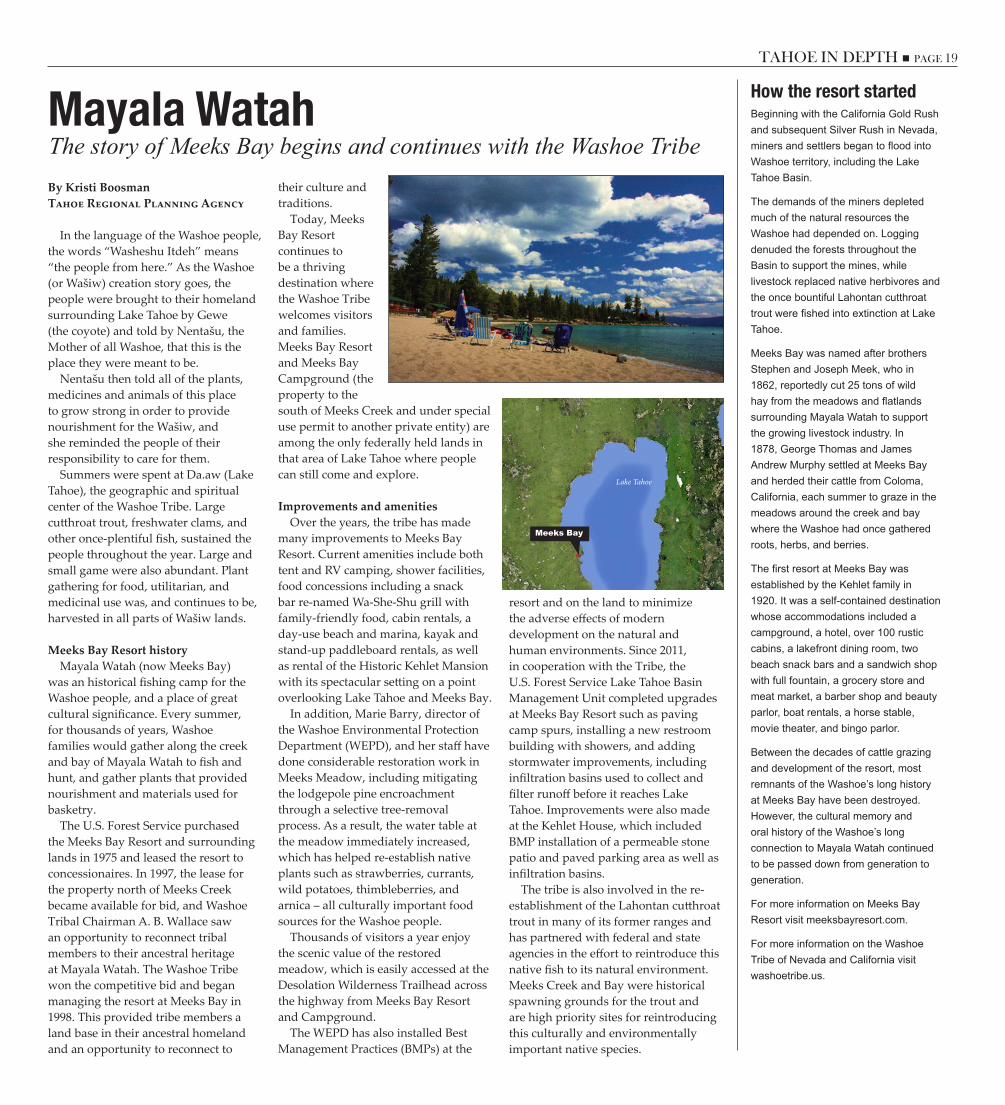
PAGE 18 n TAHOE IN DEPTH TAHOE IN DEPTH n PAGE 19
The story of Meeks Bay begins and continues with the Washoe TribeMayala WatahBy Kristi BoosmanTahoe Regional Planning Agency
In the language of the Washoe people, the words “Washeshu Itdeh” means “the people from here.” As the Washoe (or Wašiw) creation story goes, the people were brought to their homeland surrounding Lake Tahoe by Gewe (the coyote) and told by Nentašu, the Mother of all Washoe, that this is the place they were meant to be.
Nentašu then told all of the plants, medicines and animals of this place to grow strong in order to provide nourishment for the Wašiw, and she reminded the people of their responsibility to care for them.
Summers were spent at Da.aw (Lake Tahoe), the geographic and spiritual center of the Washoe Tribe. Large cutthroat trout, freshwater clams, and other once-plentiful fish, sustained the people throughout the year. Large and small game were also abundant. Plant gathering for food, utilitarian, and medicinal use was, and continues to be, harvested in all parts of Wašiw lands.
Meeks Bay Resort historyMayala Watah (now Meeks Bay)
was an historical fishing camp for the Washoe people, and a place of great cultural significance. Every summer, for thousands of years, Washoe families would gather along the creek and bay of Mayala Watah to fish and hunt, and gather plants that provided nourishment and materials used for basketry.
The U.S. Forest Service purchased the Meeks Bay Resort and surrounding lands in 1975 and leased the resort to concessionaires. In 1997, the lease for the property north of Meeks Creek became available for bid, and Washoe Tribal Chairman A. B. Wallace saw an opportunity to reconnect tribal members to their ancestral heritage at Mayala Watah. The Washoe Tribe won the competitive bid and began managing the resort at Meeks Bay in 1998. This provided tribe members a land base in their ancestral homeland and an opportunity to reconnect to
their culture and traditions.
Today, Meeks Bay Resort continues to be a thriving destination where the Washoe Tribe welcomes visitors and families. Meeks Bay Resort and Meeks Bay Campground (the property to the south of Meeks Creek and under special use permit to another private entity) are among the only federally held lands in that area of Lake Tahoe where people can still come and explore.
Improvements and amenitiesOver the years, the tribe has made
many improvements to Meeks Bay Resort. Current amenities include both tent and RV camping, shower facilities, food concessions including a snack bar re-named Wa-She-Shu grill with family-friendly food, cabin rentals, a day-use beach and marina, kayak and stand-up paddleboard rentals, as well as rental of the Historic Kehlet Mansion with its spectacular setting on a point overlooking Lake Tahoe and Meeks Bay.
In addition, Marie Barry, director of the Washoe Environmental Protection Department (WEPD), and her staff have done considerable restoration work in Meeks Meadow, including mitigating the lodgepole pine encroachment through a selective tree-removal process. As a result, the water table at the meadow immediately increased, which has helped re-establish native plants such as strawberries, currants, wild potatoes, thimbleberries, and arnica – all culturally important food sources for the Washoe people.
Thousands of visitors a year enjoy the scenic value of the restored meadow, which is easily accessed at the Desolation Wilderness Trailhead across the highway from Meeks Bay Resort and Campground.
The WEPD has also installed Best Management Practices (BMPs) at the
How the resort startedBeginning with the California Gold Rush and subsequent Silver Rush in Nevada, miners and settlers began to flood into Washoe territory, including the Lake Tahoe Basin.
The demands of the miners depleted much of the natural resources the Washoe had depended on. Logging denuded the forests throughout the Basin to support the mines, while livestock replaced native herbivores and the once bountiful Lahontan cutthroat trout were fished into extinction at Lake Tahoe.
Meeks Bay was named after brothers Stephen and Joseph Meek, who in 1862, reportedly cut 25 tons of wild hay from the meadows and flatlands surrounding Mayala Watah to support the growing livestock industry. In 1878, George Thomas and James Andrew Murphy settled at Meeks Bay and herded their cattle from Coloma, California, each summer to graze in the meadows around the creek and bay where the Washoe had once gathered roots, herbs, and berries.
The first resort at Meeks Bay was established by the Kehlet family in 1920. It was a self-contained destination whose accommodations included a campground, a hotel, over 100 rustic cabins, a lakefront dining room, two beach snack bars and a sandwich shop with full fountain, a grocery store and meat market, a barber shop and beauty parlor, boat rentals, a horse stable, movie theater, and bingo parlor.
Between the decades of cattle grazing and development of the resort, most remnants of the Washoe’s long history at Meeks Bay have been destroyed. However, the cultural memory and oral history of the Washoe’s long connection to Mayala Watah continued to be passed down from generation to generation.
For more information on Meeks Bay Resort visit meeksbayresort.com.
For more information on the Washoe Tribe of Nevada and California visit washoetribe.us.
Lake Tahoe
Meeks Bay
resort and on the land to minimize the adverse effects of modern development on the natural and human environments. Since 2011, in cooperation with the Tribe, the U.S. Forest Service Lake Tahoe Basin Management Unit completed upgrades at Meeks Bay Resort such as paving camp spurs, installing a new restroom building with showers, and adding stormwater improvements, including infiltration basins used to collect and filter runoff before it reaches Lake Tahoe. Improvements were also made at the Kehlet House, which included BMP installation of a permeable stone patio and paved parking area as well as infiltration basins.
The tribe is also involved in the re-establishment of the Lahontan cutthroat trout in many of its former ranges and has partnered with federal and state agencies in the effort to reintroduce this native fish to its natural environment. Meeks Creek and Bay were historical spawning grounds for the trout and are high priority sites for reintroducing this culturally and environmentally important native species.
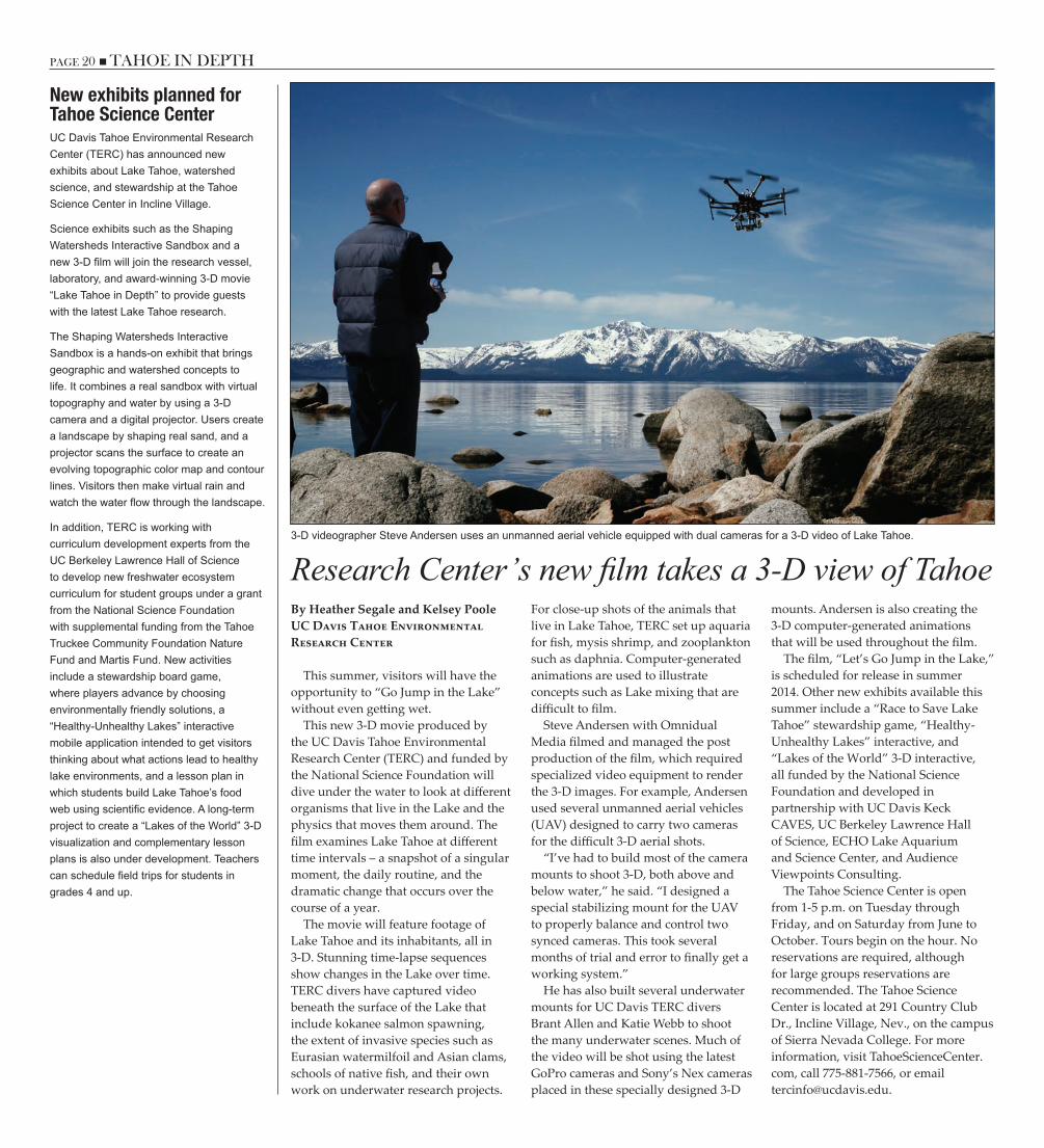
PAGE 20 n TAHOE IN DEPTH TAHOE IN DEPTH n PAGE 21
Research Center’s new film takes a 3-D view of TahoeBy Heather Segale and Kelsey PooleUC Davis Tahoe Environmental Research Center
This summer, visitors will have the opportunity to “Go Jump in the Lake” without even getting wet.
This new 3-D movie produced by the UC Davis Tahoe Environmental Research Center (TERC) and funded by the National Science Foundation will dive under the water to look at different organisms that live in the Lake and the physics that moves them around. The film examines Lake Tahoe at different time intervals – a snapshot of a singular moment, the daily routine, and the dramatic change that occurs over the course of a year.
The movie will feature footage of Lake Tahoe and its inhabitants, all in 3-D. Stunning time-lapse sequences show changes in the Lake over time. TERC divers have captured video beneath the surface of the Lake that include kokanee salmon spawning, the extent of invasive species such as Eurasian watermilfoil and Asian clams, schools of native fish, and their own work on underwater research projects.
For close-up shots of the animals that live in Lake Tahoe, TERC set up aquaria for fish, mysis shrimp, and zooplankton such as daphnia. Computer-generated animations are used to illustrate concepts such as Lake mixing that are difficult to film.
Steve Andersen with Omnidual Media filmed and managed the post production of the film, which required specialized video equipment to render the 3-D images. For example, Andersen used several unmanned aerial vehicles (UAV) designed to carry two cameras for the difficult 3-D aerial shots.
“I’ve had to build most of the camera mounts to shoot 3-D, both above and below water,” he said. “I designed a special stabilizing mount for the UAV to properly balance and control two synced cameras. This took several months of trial and error to finally get a working system.”
He has also built several underwater mounts for UC Davis TERC divers Brant Allen and Katie Webb to shoot the many underwater scenes. Much of the video will be shot using the latest GoPro cameras and Sony’s Nex cameras placed in these specially designed 3-D
mounts. Andersen is also creating the 3-D computer-generated animations that will be used throughout the film.
The film, “Let’s Go Jump in the Lake,” is scheduled for release in summer 2014. Other new exhibits available this summer include a “Race to Save Lake Tahoe” stewardship game, “Healthy-Unhealthy Lakes” interactive, and “Lakes of the World” 3-D interactive, all funded by the National Science Foundation and developed in partnership with UC Davis Keck CAVES, UC Berkeley Lawrence Hall of Science, ECHO Lake Aquarium and Science Center, and Audience Viewpoints Consulting.
The Tahoe Science Center is open from 1-5 p.m. on Tuesday through Friday, and on Saturday from June to October. Tours begin on the hour. No reservations are required, although for large groups reservations are recommended. The Tahoe Science Center is located at 291 Country Club Dr., Incline Village, Nev., on the campus of Sierra Nevada College. For more information, visit TahoeScienceCenter.com, call 775-881-7566, or email [email protected].
3-D videographer Steve Andersen uses an unmanned aerial vehicle equipped with dual cameras for a 3-D video of Lake Tahoe.
New exhibits planned for Tahoe Science CenterUC Davis Tahoe Environmental Research Center (TERC) has announced new exhibits about Lake Tahoe, watershed science, and stewardship at the Tahoe Science Center in Incline Village.
Science exhibits such as the Shaping Watersheds Interactive Sandbox and a new 3-D film will join the research vessel, laboratory, and award-winning 3-D movie “Lake Tahoe in Depth” to provide guests with the latest Lake Tahoe research.
The Shaping Watersheds Interactive Sandbox is a hands-on exhibit that brings geographic and watershed concepts to life. It combines a real sandbox with virtual topography and water by using a 3-D camera and a digital projector. Users create a landscape by shaping real sand, and a projector scans the surface to create an evolving topographic color map and contour lines. Visitors then make virtual rain and watch the water flow through the landscape.
In addition, TERC is working with curriculum development experts from the UC Berkeley Lawrence Hall of Science to develop new freshwater ecosystem curriculum for student groups under a grant from the National Science Foundation with supplemental funding from the Tahoe Truckee Community Foundation Nature Fund and Martis Fund. New activities include a stewardship board game, where players advance by choosing environmentally friendly solutions, a “Healthy-Unhealthy Lakes” interactive mobile application intended to get visitors thinking about what actions lead to healthy lake environments, and a lesson plan in which students build Lake Tahoe’s food web using scientific evidence. A long-term project to create a “Lakes of the World” 3-D visualization and complementary lesson plans is also under development. Teachers can schedule field trips for students in grades 4 and up.
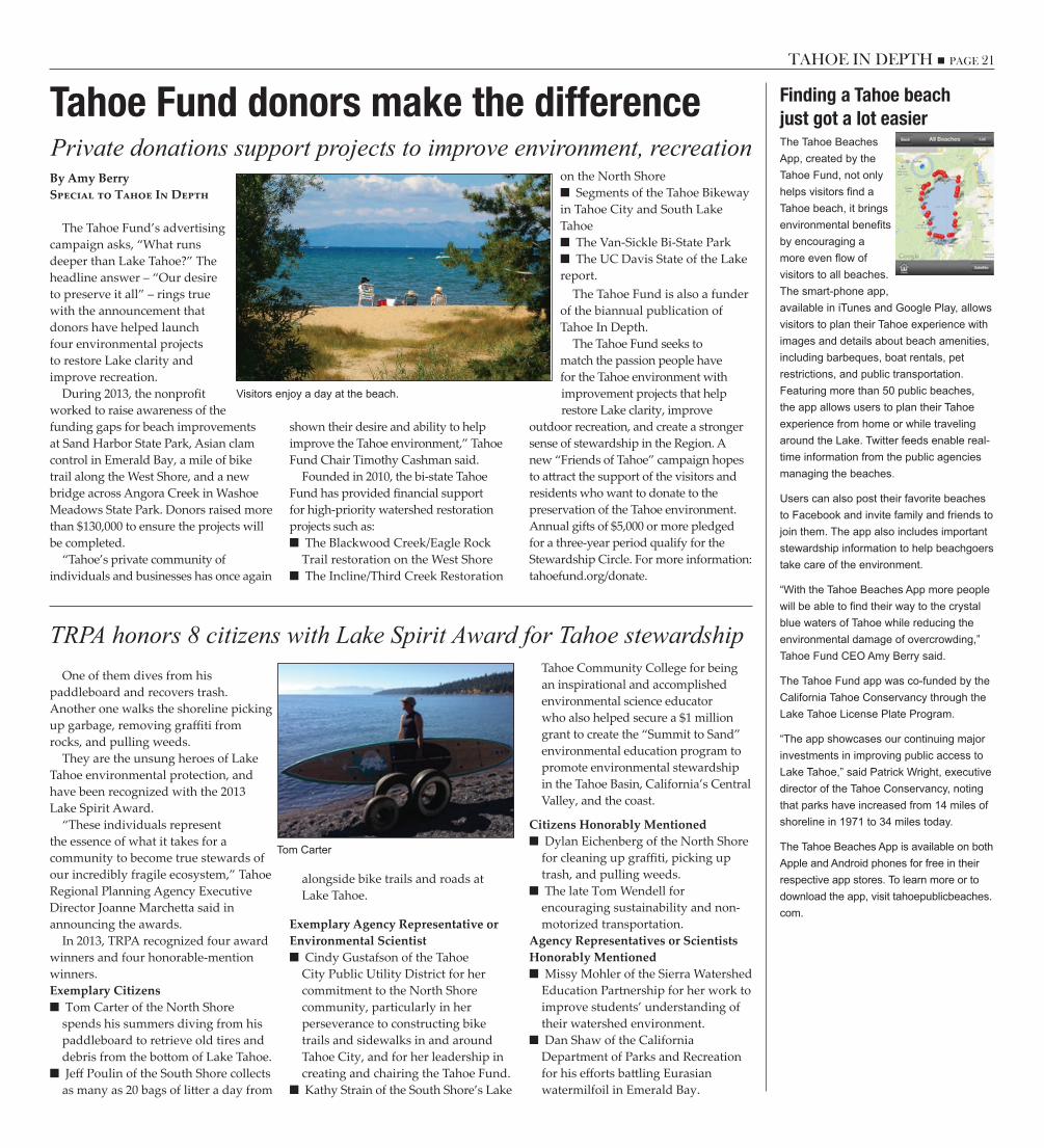
PAGE 20 n TAHOE IN DEPTH TAHOE IN DEPTH n PAGE 21
Private donations support projects to improve environment, recreation
TRPA honors 8 citizens with Lake Spirit Award for Tahoe stewardship
Tahoe Fund donors make the differenceBy Amy BerrySpecial to Tahoe In Depth
The Tahoe Fund’s advertising campaign asks, “What runs deeper than Lake Tahoe?” The headline answer – “Our desire to preserve it all” – rings true with the announcement that donors have helped launch four environmental projects to restore Lake clarity and improve recreation.
During 2013, the nonprofit worked to raise awareness of the funding gaps for beach improvements at Sand Harbor State Park, Asian clam control in Emerald Bay, a mile of bike trail along the West Shore, and a new bridge across Angora Creek in Washoe Meadows State Park. Donors raised more than $130,000 to ensure the projects will be completed.
“Tahoe’s private community of individuals and businesses has once again
shown their desire and ability to help improve the Tahoe environment,” Tahoe Fund Chair Timothy Cashman said.
Founded in 2010, the bi-state Tahoe Fund has provided financial support for high-priority watershed restoration projects such as:
■■ The Blackwood Creek/Eagle Rock Trail restoration on the West Shore■■ The Incline/Third Creek Restoration
on the North Shore■■ Segments of the Tahoe Bikeway
in Tahoe City and South Lake Tahoe
■■ The Van-Sickle Bi-State Park■■ The UC Davis State of the Lake
report. The Tahoe Fund is also a funder
of the biannual publication of Tahoe In Depth.
The Tahoe Fund seeks to match the passion people have for the Tahoe environment with improvement projects that help restore Lake clarity, improve
outdoor recreation, and create a stronger sense of stewardship in the Region. A new “Friends of Tahoe” campaign hopes to attract the support of the visitors and residents who want to donate to the preservation of the Tahoe environment. Annual gifts of $5,000 or more pledged for a three-year period qualify for the Stewardship Circle. For more information: tahoefund.org/donate.
Finding a Tahoe beachjust got a lot easierThe Tahoe Beaches App, created by the Tahoe Fund, not only helps visitors find a Tahoe beach, it brings environmental benefits by encouraging a more even flow of visitors to all beaches. The smart-phone app, available in iTunes and Google Play, allows visitors to plan their Tahoe experience with images and details about beach amenities, including barbeques, boat rentals, pet restrictions, and public transportation. Featuring more than 50 public beaches, the app allows users to plan their Tahoe experience from home or while traveling around the Lake. Twitter feeds enable real-time information from the public agencies managing the beaches.
Users can also post their favorite beaches to Facebook and invite family and friends to join them. The app also includes important stewardship information to help beachgoers take care of the environment.
“With the Tahoe Beaches App more people will be able to find their way to the crystal blue waters of Tahoe while reducing the environmental damage of overcrowding,” Tahoe Fund CEO Amy Berry said.
The Tahoe Fund app was co-funded by the California Tahoe Conservancy through the Lake Tahoe License Plate Program.
“The app showcases our continuing major investments in improving public access to Lake Tahoe,” said Patrick Wright, executive director of the Tahoe Conservancy, noting that parks have increased from 14 miles of shoreline in 1971 to 34 miles today.
The Tahoe Beaches App is available on both Apple and Android phones for free in their respective app stores. To learn more or to download the app, visit tahoepublicbeaches.com.
One of them dives from his paddleboard and recovers trash. Another one walks the shoreline picking up garbage, removing graffiti from rocks, and pulling weeds.
They are the unsung heroes of Lake Tahoe environmental protection, and have been recognized with the 2013 Lake Spirit Award.
“These individuals represent the essence of what it takes for a community to become true stewards of our incredibly fragile ecosystem,” Tahoe Regional Planning Agency Executive Director Joanne Marchetta said in announcing the awards.
In 2013, TRPA recognized four award winners and four honorable-mention winners. Exemplary Citizens
■■ Tom Carter of the North Shore spends his summers diving from his paddleboard to retrieve old tires and debris from the bottom of Lake Tahoe.■■ Jeff Poulin of the South Shore collects as many as 20 bags of litter a day from
alongside bike trails and roads at Lake Tahoe.
Exemplary Agency Representative or Environmental Scientist
■■ Cindy Gustafson of the Tahoe City Public Utility District for her commitment to the North Shore community, particularly in her perseverance to constructing bike trails and sidewalks in and around Tahoe City, and for her leadership in creating and chairing the Tahoe Fund.■■ Kathy Strain of the South Shore’s Lake
Tahoe Community College for being an inspirational and accomplished environmental science educator who also helped secure a $1 million grant to create the “Summit to Sand” environmental education program to promote environmental stewardship in the Tahoe Basin, California’s Central Valley, and the coast.
Citizens Honorably Mentioned■■ Dylan Eichenberg of the North Shore for cleaning up graffiti, picking up trash, and pulling weeds.■■ The late Tom Wendell for encouraging sustainability and non-motorized transportation.
Agency Representatives or Scientists Honorably Mentioned
■■ Missy Mohler of the Sierra Watershed Education Partnership for her work to improve students’ understanding of their watershed environment.■■ Dan Shaw of the California Department of Parks and Recreation for his efforts battling Eurasian watermilfoil in Emerald Bay.
Tom Carter
Visitors enjoy a day at the beach.

ThankYouPAGE 22 n TAHOE IN DEPTH
Become a Tahoe In Depthsubscriber or supporter
We hope you’ve enjoyed this edition of Tahoe In Depth. Feedback for our first three issues was so overwhelming that we are looking for sustainable funding. You can help! Consider becoming a subscriber to Tahoe In Depth so that you and others can continue to receive ideas on “Protecting, Enjoying & Exploring the Lake Tahoe Basin” in your mailbox.
All subscribers are entered in a drawing to win a gift certificate from a local nursery. Just cut out and mail in the subscriber form and your check made out to the Tahoe Regional Planning Agency. Please add the Tahoe In Depth account number 0000552 on the note line.
YES! I want to become a subscriber to Tahoe In Depth and continue “Protecting, Enjoying & Exploring the Lake Tahoe Basin.” Please find enclosed my check for _________________________________Subscriber Levels:o $1 - $99 Friend o $100 - $249 Supporter o $250 - $499 Benefactor o $500 - $999 Advocate o $1,000 - $2,499 Champion o $2,500 and up Philanthropist
Name:_________________________
Address:_______________________
______________________________
City:__________________________
State:_______________Zip:_______
Phone:________________________
Email:_________________________Mail to: Tahoe In Depth, PO Box 5310, Stateline, NV 89449
Our subscribers: Readers who have subscribed to Tahoe In Depth since our last issue
Tahoe In Depth is made possible by the generous support of subscribers and underwriters. From the entire team at
Tahoe In Depth, thank you for contributing to the publication.
Thanks to the following sponsors: Platinum level sponsor
Tahoe Regional Planning AgencyTahoe Fund
Gold level sponsorU.S. Forest Service
Nevada Division of State LandsSilver level sponsor
Aquatic Invasive Species Program(Environmental Improvement Program)
Tahoe City Public Utility DistrictBronze level sponsor
Incline Village General Improvement DistrictLeague to Save Lake Tahoe
Subscriber Funds
If you are interested in becoming an underwriter, please contact Sarah Underhill, design and project manager at the Tahoe Regional Planning Agency, at 775-589-5211
Enter our drawing!For every issue of Tahoe In Depth, all subscribers are entered to win a $100 gift certificate from a local nursery for a native plant.
This issue’s winnerCongratulations to Bonnie Fitzgerald of Bakersfield, California!
What readers are saying: I absolutely love Tahoe in Depth! What a great idea, I look forward to future publications… S.H. – Incline Village, NV
Hurrah!!!! What a great publication! Everything I wanted to know and more and more. Please keep up the good work and keep it coming. Of course I would subscribe. W.R. – San Mateo, CA
It is nice to see that someone has begun to carry on the traditions of supplying environmental/scientific information
on Tahoe to the layperson audience. This publication is in the same vein as earlier work by Leo Poppoff in his
newspaper series “Basin Watch” and the current annual report, “State of the Lake” by TERC/U.C. Davis. Keep up the good work, varied topic selection, and easy to understand articles. I look forward to more issues.
B.R. – Tahoe City, CADrop us a line at [email protected]
Find us online at Tahoeindepth.org
Robert AndersonNancy BaldwinDr. H. Glenn Bell Jr.Richard BergmannDenise FilakoskyJohn BogerCarnelian Woods c/o Les TerryLillian CadenassoKim CaffeseCraig CarsonTimothy CashmanChrystine CooperR.A. CuneoDave DeVoeBrian DonaldDiemer FamilyLewis Figone
Ann FilsonBonnie FitzgeraldJoan FreemanW. James Gosline Jr.Ralph GrunauerRyan HaggertyAnn HarootunianBob & Arzelle HudnallSusan HughesNancy HurtadoVeronica JohnsonRon KlineLillian H. KoenigDino J. Landucci Jr.Gary & Irene LavaysseDaniel LearyLeslie Lonno
Mark MarshallEllen MarshallMolly MarshallPaul MarshallKristina McCarthyNancy McDermidSally MellingerJohn MontagueRichard MurnaneKaryn NewmanJohn NorthTerry OsmonsonShirley PachecoLara PearsonJason ParetteRussell L. ReedJeanette Reed-Lawson
H.G. ReidBob RichardsJames RobertsonAndy & Julie Russell A. & B. Russell-ShapiroVicki SabadDiana SchneiderPaul & Tammy SissonBenjamin & Kathleen SmithTerry StifflerDouglas SwagerVirginia TaylorNancy WeissStephen E. Segale
ARE YOU TRUE BLUE?
SHOW IT. BUY OR RENEW A TAHOE LICENSE PLATE. If these Tahoe views clear your head and soothe your soul, then you might be True Blue. But to make it official, you’ll have to purchase or renew a Lake Tahoe license plate. Like a perfect stroke of the pedal, this modest commitment will go full circle to help fund hiking and biking trails and watershed restoration projects. In fact, 96% of your fee will go directly to projects. For more information or to purchase your license plate online visit: www.tahoeplates.com.
A simple way to make Tahoe better.

PAGE 24 n TAHOE IN DEPTH TAHOE IN DEPTH n PAGE PB
The 1911 Tahoe Tavern Auto Race makes today’s chain controls look like child’s play23 miles in 7 daysBy Gary NoySpecial to Tahoe In Depth
Imagine ascending the western slope of the Sierra, trudging through places as spectacularly remote as Desolation Wilderness, and contending with gorged rivers and massive drifts of spring snow along the way.
Now imagine that instead of a backpack and trekking poles, you are hauling your car with you as you go.
If this sounds like the kind of thing you would only do on a bet, then your enthusiasm for getting to Lake Tahoe could’ve matched the legendary feat of two turn-of-the century Grass Valley residents who in 1911 did just that.
Bear in mind in the early 20th century, most roads in the Sierra were treacherous, not to be traveled by the faint of heart. In 1901, the Bureau of Highways described the skinny tentacle over Sonora Pass as “22 miles over granite formation that is little more than a creek bed.” One wag depicted another highway as so muddy in winter and spring that it measured “130 miles long and 5 feet deep.” Driving a car through the range in the first 15 years of the 20th century was an adventure on par with an attempt at traversing the remote Sierra High Route—a trip both challenging and potentially deadly.
Still, in the early years of car travel, novelty and a rugged spirit drew car enthusiasts to precarious places. Perhaps to capitalize on this, in spring of 1911, the Tahoe Tavern in Tahoe City offered a 3-foot-tall silver trophy to the first party to drive eastward over the Donner Summit Road from California to the luxury resort. The Sierra had just endured a severe winter—by March of that year nearly 40 feet of snow had fallen at 8,000 feet—so it was not until June that anyone dared attempt the exhilarating but arduous race over the trackless, snowy Sierra.
The leading contenders for the prize were a dedicated group of automobile fanatics from Grass Valley led by Arthur B. Foote, assistant superintendent of the North Star Mines Corporation. Joining him on the ride was George Starr, manager of the Empire Mine. They expected brutal physical challenges on the trip, including difficult terrain and serious logistical issues, but they did not anticipate that it would take them seven days to travel the last 23 miles.
When Foote learned of the Tahoe Tavern contest, he instantly decided to undertake the competition in his Model T Ford, and recruited Starr and other Grass Valley citizens as his support crew. On June 2, 1911, Foote and Starr began their journey. Foote, true to his roots as a mining engineer, kept an understated, even terse, diary. His first entry reads: “Packed stuff, took off windshield, Mr. Starr and I left for Emigrant Gap at 4 p.m. with shovels, tackle, etc. Passed Emigrant Gap and got stuck in the soft snow 2.5
miles further on. Walked to Cisco, got there 10:30 p.m.”
Snow blocked their way that night, so the following morning Foote and Starr went scouting. They walked their potential route and discovered a washed-out bridge on the roaring Yuba River. Hiking back to their automobile in Cisco, the intrepid pair started driving across the still-frozen snowpack. Occasionally, the automobile would careen into deep crevices and Foote and Starr would need to haul their car out of the holes using a block and tackle.
After five hours, they finally reached the washed-out bridge, at which point they stretched a metal cable over the torrent, cleverly slid the suspended car over the rapids, and then quickly removed the cable, leaving no evidence of the ingenious technique for the competitors that followed. When their opponents reached the ruined bridge, they were puzzled as to how Foote and Starr had crossed. They were also
unable to continue. With an overwhelming lead,
the dynamic duo from Grass Valley continued onward. Two days later, Foote and Starr were once again stuck in the snow, but, still confident that success was within reach, they returned to Grass Valley by train to retrieve more equipment before pressing on. On June 7, they were back with their stranded auto, which they yanked into position and fitted with wooden runners on the wheels. The car now turned into a sled, the adventurers pushed it over the snowpack, and by June 9, they had reached Soda Springs, where they spent the day making repairs.
The next morning, Foote and Starr pulled their vehicle over Donner Summit and then manhandled it to Donner Lake, where they enjoyed a well-earned breakfast. With nothing left but the open road from Truckee to Tahoe City, the triumphant contestants reached Tahoe Tavern at noon. Overall, the outing had taken eight days. The 3-foot-tall trophy was theirs, and so were bragging rights.
The Tahoe Tavern proprietors were astonished to see Arthur Foote and George Starr. On June 11, the Grass Valley Union reported on the front page: “The victors enjoyed the consternation which they caused by their unexpected arrival. The resort management had not expected these men from Grass Valley to achieve their success by shoving, tugging, and hoisting their Model T over seemingly impassable mountainous terrain.”
May the spectacular allure of Lake Tahoe and the spirit of adventure in getting here live on.
Gary Noy has taught history at Sierra College in Rocklin since 1987. In 2006, the Oregon-California Trails Association named him Educator of the Year. This story is excerpted from Gary’s new book “Sierra Stories: Tales of Dreamers, Schemers, Bigots and Rogues” (Heyday Books and Sierra College Press, 2014)
They stretched a metal cable over the torrent, cleverly slid the suspended car over the rapids, and then quickly removed the cable, leaving no evidence of the ingenious technique for the
competitors that followed.
These competitors used chains and ropes to get a car over Donner Summit in 1911.