Embed Size (px)
Citation preview
MINISTRY OF SUSTAINABLE RESOURCE MANAGEMENT (Coast Region)
SUSTAINABLE RESOURCE MANAGEMENT PLAN
[Biodiversity Chapter for the Upper Lillooet Landscape Unit]
Prepared by:
Revised – July 2004
Upper Lillooet Landscape Unit – Biodiversity 8/19/04
Atticus Resource Consulting Ltd. 2
TABLE OF CONTENTS 1.0 Introduction............................................................................................................. 3 2.0 Upper Lillooet Landscape Unit Description ........................................................... 5
2.1 Biophysical ......................................................................................................... 5 2.2 Upper Lillooet LU Biophysical Description....................................................... 5 2.3 Summary of Land Status..................................................................................... 6
3.0 Key Resource Tenure Holders ................................................................................ 7
3.1 Forest Tenure Holders......................................................................................... 7 3.2 Mining Tenure Holders....................................................................................... 8
4.0 Significant Resource Values ................................................................................... 9
4.1 Fish, Wildlife and Biodiversity........................................................................... 9 4.2 Timber Resources ............................................................................................. 11 4.3 Private Land ...................................................................................................... 12 4.4 Recreation: ........................................................................................................ 12
5.0 Existing Higher level Plans................................................................................... 13 6.0 First Nations.......................................................................................................... 13 7.0 OGMA Methodology............................................................................................ 14
7.1 Existing Planning Processes ............................................................................. 14 7.2 Assessment and Review.................................................................................... 14 7.3 Boundary Mapping ........................................................................................... 15 7.4 Amendment Policy............................................................................................ 15 7.5 Mitigation of Timber Supply Impacts............................................................... 15
8.0 OGMA Analysis ................................................................................................... 17
8.1 Upper Lillooet Landscape Unit......................................................................... 17 9.0 Wildlife Tree Retention ........................................................................................ 19 10.0 Proposed Landscape Unit Plan Objectives ........................................................... 19 Appendices........................................................................................................................ 21
Upper Lillooet Landscape Unit – Biodiversity 8/19/04
Atticus Resource Consulting Ltd. 3
1.0 INTRODUCTION This report provides background information used during the preparation of the Sustainable Resource Management Plan and associated proposed legal objectives for the Upper Lillooet Landscape Unit (LU). Specifically, this report forms the Biodiversity conservation chapter of the plan. A description of the landscape unit, discussion on significant resource values, and an Old Growth Management Area (OGMA) summary and rationale are provided. This report follows the newly developed Ministry framework, as supplied to us by Lucy Stad, Planning Forester with the Ministry of Sustainable Resource Management (MSRM). Biological diversity or biodiversity is defined as: ‘the diversity of plants, animals and other living organisms in all their forms and levels of organisation, and includes the diversity of genes, species and ecosystems as well as the evolutionary and functional processes that link them’1. British Columbia is the most biologically diverse province in Canada. In British Columbia, 115 species or subspecies of known vertebrates and 364 vascular plants are listed for legal designation as threatened or endangered2. The continuing loss of biological diversity will have a major impact on the health and functions of ecosystems and the quality of life in the province (Resources Inventory Committee, 1998). Planning for OGMA and Wildlife Tree Patch (WTP) biodiversity values is recognized as a high priority for the province. LU planning is an important component of the Forest Practices Code of BC Act (FPC) which allows legal establishment of objectives to address landscape level biodiversity values. Implementation of this initiative is intended to help sustain certain biodiversity values. Managing for biodiversity through retention of old growth forests is not only important for wildlife, but can also provide important benefits to ecosystem management, protection of water quality and preservation of other natural resources. Although not all elements of biodiversity can be, or need to be, maintained on every hectare, a broad geographic distribution of old growth ecosystems is intended to help sustain the genetic and functional diversity of native species across their historic ranges. At the same time, the final OGMA placements were looked at from a landscape level basis, and were intended to balance long-term ecological requirements while minimizing the impact on timber harvesting opportunities within the Upper Lillooet LU. The Squamish Forest District has completed draft LU boundaries and assigned draft Biodiversity Emphasis Options (BEO) in accordance with the direction provided by government. There are 20 LUs within the Squamish Forest District.
1 FPC Biodiversity Guidebook, September 1995 2 BC Species and Ecosystems Explorer. 2003. Victoria, British Columbia. Available at: http://srmapps.gov.bc.ca/apps/eswp/
Upper Lillooet Landscape Unit – Biodiversity 8/19/04
Atticus Resource Consulting Ltd. 4
Through a ranking process, the Upper Lillooet LU was rated as an Intermediate BEO, which requires that priority biodiversity provisions, including the delineation of Old Growth Management Areas and wildlife tree retention (WTR), be undertaken immediately. This work was undertaken by Atticus Resource Consulting Ltd. for Squamish Mills Ltd., with guidance from MSRM and area Licensees. Report editing and other guidance was received throughout the process from Lucy Stad and Greg George (MSRM, Coast Region). In addition, Squamish Mills Ltd. (Tim Napier), Terminal Forest Products Ltd. (Dave Marquis) and CRB Logging Ltd. (Bernice Patterson) provided timely review and input. Throughout this process, various Ministry of Forests (MOF) staff also provided useful information. Input from First Nations was gathered during consultation between MSRM and individual First Nations. Comment from the public and other agencies was sought during the 60 day public review and comment period (Appendix 4). Refer to the attached map for location of OGMAs and old growth representation from protected areas. Supporting documentation regarding government policy, planning processes and biodiversity concepts are provided in the 1995 Biodiversity Guidebook, the 1999 Landscape Unit Planning Guide (LUPG), the Vancouver Forest Region Landscape Unit Planning Strategy (1999), as well as Sustainable Resource Management Planning Framework: A Landscape-level Strategy for Resource Development.
Upper Lillooet Landscape Unit – Biodiversity 8/19/04
Atticus Resource Consulting Ltd. 5
2.0 UPPER LILLOOET LANDSCAPE UNIT DESCRIPTION
2.1 BIOPHYSICAL
Note that the OGMAs and WTR levels were proposed only within the Upper Lillooet Landscape Unit, not to a larger ‘aggregate’ area.
2.2 UPPER LILLOOET LU BIOPHYSICAL DESCRIPTION The Upper Lillooet LU, northwest of Pemberton BC, covers a total area of 71,817 ha and encompasses several watersheds flowing into the upper Lillooet River. Larger watersheds within this LU include Manatee, Pebble (Boulder) and Salal Creeks, all of which flow into the Lillooet River. Smaller named watersheds include Mosaic Creek and Job Creek. Several glaciers occur within this LU, including the Mosaic, Job and Lillooet Glaciers. The Upper Lillooet LU lies within the Pacific Ranges Ecoregion, the majority within the Eastern Pacific Ranges Ecosection (EPR). A small area along the extreme western edge falls within the Northern Pacific Ranges Ecosection. Of the total LU area, 12,665 ha (18%) are within the Crown forest landbase (Contrib., Partially Contrib. and Non-Contrib.), and 2,693 ha of Crown forest are within the Timber Harvesting Land Base (THLB). The remaining 59,153 ha (82%) are non-forested or non-Crown (rock, alpine tundra, water, private land, etc.) and have been excluded from any OGMA contributions and calculations. A portion of the productive forest not included within THLB is located within the Upper Lillooet Provincial Park, a large area encompassing the headwaters of the upper Lillooet River. The LU is comprised of the following 5 Biogeoclimatic Ecosystem Classification (BEC) subzone/variants: Coastal Western Hemlock southern dry submaritime variant (CWHds1); Coastal Western Hemlock southern moist submaritime variant (CWHms1); Mountain Hemlock leeward moist maritime variant (MHmm2), Engelmann Spruce–Subalpine Fir moist warm subzone (ESSFmw), and Alpine Tundra/Parkland (ATp). These five BEC subzone/variants represent three different Natural Disturbance Types (NDT), with MHmm2 in NDT 1 (rare stand initiating events); CWHds1, CWHms1 and ESSFmw in NDT 2 (infrequent stand-initiating events); and ATp in NDT 5 (alpine tundra and subalpine parkland). As defined in the Biodiversity Guidebook (MOF 1995), forest ecosystems in NDT 1 were influenced historically by rare stand-initiating events and were generally uneven-aged or multi-storied uneven aged, with regeneration occurring in gaps created by the death of individual trees or small patches of
Upper Lillooet Landscape Unit – Biodiversity 8/19/04
Atticus Resource Consulting Ltd. 6
trees. Disturbances are typically small and result in irregular edge configurations and landscape patterns. Approximately 35% of the productive forest area of the Upper Lillooet LU is within NDT 1 (MHmm2 unit). Avalanching (snow and rock) is also common in this unit. Historically, NDT 2 forest ecosystems were typically even-aged, but extended (post-fire) regeneration periods produced some stands with uneven-aged characteristics. Approximately 63% of the productive forest area in the Upper Lillooet LU is within NDT 2. Ecosystems in NDT 5 are not considered productive forest since they occur above or immediately below the alpine tree line and are characterized by short and harsh growing seasons. At lower elevations, within NDT's 1 and 2, the Upper Lillooet LU has sustained significant levels of disturbance. Forested stands on lower elevation productive sites (typically on slopes with low to moderate gradients within the CWHds1) have been disturbed by extensive past timber harvesting. The relatively low level of old seral forest remaining within the lower elevation BEC variants in the Upper Lillooet LU reflects this disturbance history.
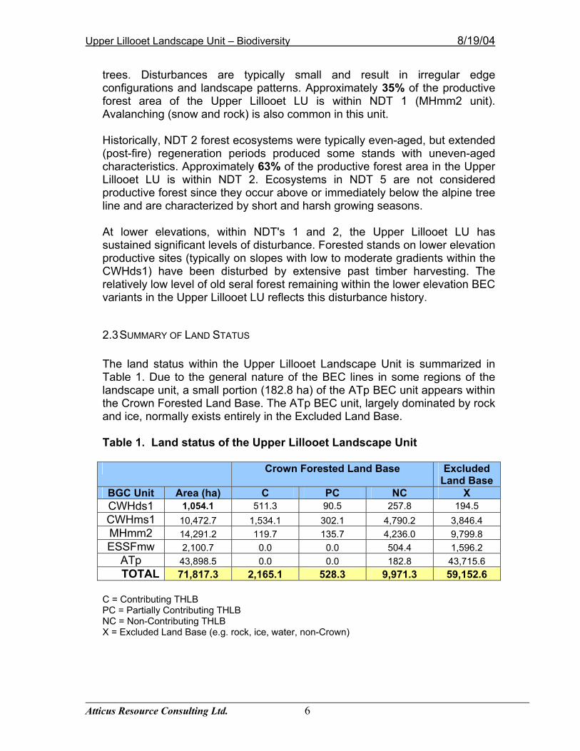
2.3 SUMMARY OF LAND STATUS The land status within the Upper Lillooet Landscape Unit is summarized in Table 1. Due to the general nature of the BEC lines in some regions of the landscape unit, a small portion (182.8 ha) of the ATp BEC unit appears within the Crown Forested Land Base. The ATp BEC unit, largely dominated by rock and ice, normally exists entirely in the Excluded Land Base. Table 1. Land status of the Upper Lillooet Landscape Unit
Crown Forested Land Base Excluded Land Base
BGC Unit Area (ha) C PC NC X CWHds1 1,054.1 511.3 90.5 257.8 194.5 CWHms1 10,472.7 1,534.1 302.1 4,790.2 3,846.4 MHmm2 14,291.2 119.7 135.7 4,236.0 9,799.8 ESSFmw 2,100.7 0.0 0.0 504.4 1,596.2
ATp 43,898.5 0.0 0.0 182.8 43,715.6 TOTAL 71,817.3 2,165.1 528.3 9,971.3 59,152.6
C = Contributing THLB PC = Partially Contributing THLB NC = Non-Contributing THLB X = Excluded Land Base (e.g. rock, ice, water, non-Crown)
Upper Lillooet Landscape Unit – Biodiversity 8/19/04
Atticus Resource Consulting Ltd. 7
3.0 KEY RESOURCE TENURE HOLDERS The general premise applied during the planning process was to identify key resource(s) tenure holdings. This assessment included identification of tenures that are administered by agencies such as the Ministry of Forests (MOF), Ministry of Energy and Mines (MEM) and Crown corporations such as Land and Water British Columbia. For tenure holders, other than those administered by MOF, the management intent generally is to avoid placement of OGMAs within existing tenures. As for tenures administered by MOF, the management intent is to avoid placement of OGMAs over cutblocks and roads that have received approval status and to minimize the amount of overlap in areas that were identified as future harvest interest by licensees.
3.1 FOREST TENURE HOLDERS The tenures within this landscape unit consist of forest licences (FL) and timber licences (TL). The forest licences are volume based and the timber licences are area based, limited to one pass of timber only. Although Squamish Mills Ltd. has the rights to the replaceable forest licence (FL A19214), this FL is held by Squamish Mills Ltd., Weyerhaeuser Canada Ltd. and International Forest Products Ltd. as a joint venture. Brohm Creek Logging, a contractor to Halray Logging Ltd., harvests the Weyerhaeuser share of the allowable annual cut (AAC). Weyerhaeuser maintains the rights to all of the Timber Licences in the LU, and Squamish Mills Ltd. and Halray Logging Ltd. harvest within these TL’s for Weyerhaeuser. The two TL’s in the southern portion of the planning unit are under management contract with CRB Logging Co. Ltd. Weyerhaeuser also holds two TL’s within the area now designated as the Upper Lillooet Provincial Park (TL 0777 and TL 0776). Terminal Forest Products Ltd. has the rights to the replaceable forest licence FL A19215, on the south side of the Lillooet River, opposite Salal Creek. Halray Logging Ltd. operates along Salal Creek under a Timber Sale Major agreement. To the best of our knowledge, the proposed OGMAs do not impact any known approved category “A” cutblocks or roads as approved under 2002 Forest Development Plans. Furthermore, Atticus notified the key licensees of the process and provided each of them with draft OGMA locations early in the process. At that time, Terminal Forest Products Ltd. and Squamish Mills Ltd. provided valuable comments that were used in the determination of final OGMA locations. Overall the intent was to meet the OGMA requirements while minimizing the impacts on future development opportunities. Several
Upper Lillooet Landscape Unit – Biodiversity 8/19/04
Atticus Resource Consulting Ltd. 8
months later, a second draft (interim) product was provided to the licensees to elicit further feedback.
3.2 MINING TENURE HOLDERS Several mineral tenure holders exist within the Upper Lillooet Landscape Unit. Recent maps obtained from the Ministry of Sustainable Resource Management (092J11W & 092J12E) reveal the existence of several mineral tenures along the Lillooet River, located along the junctions of Pebble and Salal Creeks with the Lillooet River. The selection of OGMAs followed the intent of avoiding placement over existing tenure holders. One OGMA was moved to avoid a pumice tenure. However, a small portion of one OGMA (OGMA 22) has been identified for designation within one of the tenures. The establishment of OGMAs will not have an impact on the status of existing aggregate, geothermal, oil and gas, and mineral permits or tenures. Exploration and development activities are permitted in OGMAs. The preference is to proceed with exploration and development in a way that is sensitive to the old growth values of the OGMA; however, if exploration and development proceeds to the point of significantly impacting old growth values, then the OGMA will be moved.
Upper Lillooet Landscape Unit – Biodiversity 8/19/04
Atticus Resource Consulting Ltd. 9
4.0 SIGNIFICANT RESOURCE VALUES
4.1 FISH, WILDLIFE AND BIODIVERSITY This LU contains significant natural resource values and features. Nearly one third of the land base lies within the Upper Lillooet Provincial Park, which was established in 1997. This 19,996 ha park is comprised of valley bottom old growth forests, wetland habitats, high alpine ridges and glaciers. It contains significant conservation values, as it is one of only five remaining undeveloped watersheds over 5,000 ha in the EPR Ecosection. As stated in the Management Direction Statement for the Upper Lillooet Provincial Park (MELP 1999), larger wildlife species known to use the park (and expected within the remainder of the landscape unit) include grizzly bears, black bears, black-tailed deer, wolves, wolverine, moose, mountain goats, resident salmonids and non-sport fish, raptors and waterfowl. Many other smaller species occur within the park and in the remainder of the LU including forest birds, raptors, small mammals, amphibians and furbearers. Some wildlife species habitat requirements, such as ungulates or species at risk, are managed within specific habitat areas identified through inventory performed by MWLAP staff (e.g. mountain goat winter range). Important habitats for designated species at risk (e.g. grizzly bears) can be managed by establishing Wildlife Habitat Areas and applying general wildlife measures. Habitat requirements of smaller or less understood species are generally anticipated to be managed within habitat provisions provided for primary species, in OGMAs, or in protected areas. The high alpine ridges, sub-alpine forests, numerous avalanche chutes and valley bottom forests provide valuable habitat for both grizzly and black bears. Open areas would provide forage opportunities (e.g. berry fields, sub-alpine parkland meadows) while nearby forested areas would provide security and thermal cover, as well as day bedding cover and some forage. A few specific stands of old growth forest provide important winter thermal and snow-interception cover for black-tailed deer; however none of these areas are mapped for inclusion as designated ungulate winter range under the FPC. Extensive tracking of deer in the Lillooet River Valley has shown the deer to be migratory in nature. However, they are unlikely to spend the winter in the Upper Lillooet Landscape Unit (T. Napier, personal communication). Spring and summer forage for deer is provided in many of the small openings or avalanche chutes that support nutritious high quality forage plants (e.g. herbs and forbs). Deer management in this area is restricted to maintaining migration corridors so that deer can move between seasonal habitats.
Upper Lillooet Landscape Unit – Biodiversity 8/19/04
Atticus Resource Consulting Ltd. 10
Several specific areas of the LU are also important for mountain goats. Many of the rocky, south facing slopes and adjacent rock bluffs provide key habitats for mountain goats. Timbered areas interspersed with this escape terrain provide thermal and snow interception cover. Goat winter range (GWR) mapping has already been completed by MWLAP and the resulting management plan has been approved. The low elevation wetland, marsh and fen areas, together with riparian forested areas, provide valuable winter moose habitat. In addition, the upper Lillooet River (above the falls) contains spawning habitat for a resident salmonid population (MELP 1999). The Upper Lillooet LU (including the Upper Lillooet Prov. Park) is within the Southern Chilcotin Grizzly Bear Population Unit Management Area and, as reported by Apps (2001) and the provincial Grizzly Bear Conservation Strategy (1995), the bears within this area are within a threatened population unit. Apps mentions that ‘further upstream, the valley bottom associated with the upper Lillooet River appears to provide some potential for (grizzly bear) population linkage, largely a result of the relatively low levels of human influence in that part of the Sea to Sky Planning Area. More extensive linkage appears to exist further up the Lillooet River valley to the northwest.’ Habitat suitability maps, prepared in 2001 for the Sea to Sky LRMP area by the Ministry of Water, Land & Air Protection (& plotted by MSRM), indicate areas of superior habitat suitability for both northern goshawk and spotted owl (these maps are not used for wildlife management purposes and were developed solely for general use at the LRMP table). The maps also depict a deer migration corridor and moose winter range polygon along the Lillooet River, both of which just enter the southeast corner of the landscape unit. As stated within the Management Direction Statement for the Upper Lillooet Provincial Park (MELP 1999), an almost pure stand of Douglas-fir (considered rare in this geographic area) exists on the north side of the Lillooet River, opposite Job Creek. The park also contains the blue-listed Cottonwood-Willow-Thimbleberry plant community, and may contain other rare plant communities associated with the CWHms1 variant. Smooth willowherb (Epilobium glaberrimum), a blue-listed species, occurs near the headwaters of the Lillooet River. All of the mapped or otherwise known wildlife or plant community resource information was considered during the planning and OGMA selection stages. For instance, ungulate winter ranges and rare plant communities were priority candidates for OGMA wherever they met biodiversity criteria.
Upper Lillooet Landscape Unit – Biodiversity 8/19/04
Atticus Resource Consulting Ltd. 11
4.2 TIMBER RESOURCES
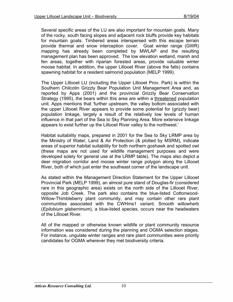
The presence of substantial timber harvesting operations establishes the importance of timber resource values in this LU. Continued access to commercially valuable timber, including current first and future second growth, is a significant concern. First pass harvesting of accessible mature timber is well underway – with most of the lower valley having already been developed. Based on current forest cover information, Table 2 provides the age composition of forests within the Upper Lillooet Landscape Unit (park landbase included). Although unconfirmed with ground sampling, forested areas within the Upper Lillooet LU are predominantly (57%) old forest (based on the forest cover information). However, some of the forest cover polygons classified as old did not appear old when viewed on the air photos nor from the helicopter during the OGMA overview flight. Although we believe the current forest cover classification has overestimated the extent of old forest within this LU, it should have little impact on the locations of the OGMAs since most of the forest appears to be of similar age throughout the landscape unit. Ground data of both stand age and stand attributes would be useful in confirming important OGMAs for the landscape unit. Table 2. Age distribution of forests within the Upper Lillooet Landscape Unit.
Age Area (ha) % of Crown Forested Landbase0-60 1,726.4 13.6 %
61-140 938.6 7.4 % 141-250 2,722.2 21.5 %
251+ 7,277.4 57.5 %
Commercially valuable tree species in the Upper Lillooet LU include Douglas fir, western red cedar and western hemlock (with some subalpine fir) at lower elevations, and mountain hemlock, subalpine fir, Engelmann spruce and western red cedar at mid to higher elevations. Most of the forests within this LU have medium to low site productivity. Forest management activities occur throughout all phases of forest development. Operational work includes pre-harvest planning, harvesting and stand regeneration. Post harvest activities include planting, brushing, juvenile spacing, pruning and thinning.
Upper Lillooet Landscape Unit – Biodiversity 8/19/04
Atticus Resource Consulting Ltd. 12
4.3 PRIVATE LAND A review of the ownership classes for this landscape unit revealed no private lands.
4.4 RECREATION:
Due to its distance from the popular recreation centres of Pemberton and Whistler, the Upper Lillooet Landscape Unit currently receives less recreational use than areas closer to population centres. There are no roads extending into the Upper Lillooet Provincial Park, and, as stated in its Management Direction Statement, ‘the lack of facilities, difficulty of access within the park, and high biodiversity values means Upper Lillooet Provincial Park will not be encouraged as a destination park, except to those wishing to experience remote wilderness’. Most of the recreation in the area includes ‘backcountry’ hiking or skiing, and requires hiking or helicopter access. Commercial recreation activities (e.g. heli-skiing, heli-hiking) in several areas of the LU have recently been proposed. The remnants of a stone hut exist on Polychrome Ridge. Other recreational activities include wildlife viewing and nature interpretation. Although the road that accesses the popular Meager Creek Hot Springs (also used to gain access into the landscape unit) is closed and gated through the winter months, it is likely that it is still frequented by snowmobiles. Snowmobile use within the park has been reported as occasional, primarily in the northeast portion along the Lillooet River. The area is open to recreational hunting and most hunters would target black-tailed deer or black bears. One commercial tenure (trapping) is known to pre-exist the park. This tenure includes park area within the overall trap line area, but it is not known if active trapping occurs in the park.
Upper Lillooet Landscape Unit – Biodiversity 8/19/04
Atticus Resource Consulting Ltd. 13
5.0 EXISTING HIGHER LEVEL PLANS Higher Level Plan objectives are one provision under the FPC that enables specific forest resource management objectives to be made legally binding. Operational plans must be consistent with higher level plan objectives. At the time of writing, there are no Higher Level Plans that apply to the Landscape Unit. However, the Sea to Sky Land and Resource Management Plan (LRMP) is an ongoing higher-level plan that includes the Upper Lillooet Landscape Unit. For more information, refer to the Sea-to-Sky LRMP website: (http://srmwww.gov.bc.ca/cr/resource_mgmt/lrmp/s2s/) Landscape Unit objectives also are Higher Level Plan objectives. To the extent possible, objectives from both processes are intended to be compatible. 6.0 FIRST NATIONS The Upper Lillooet LU is located within the traditional territory of the Lil’wat Nation. The landscape unit may contain important cultural or archaeological sites though no archaeological sites are presently registered with the Archaeology Branch. Between 1996 and 1997, an Archaeological Overview Assessment model was developed by Millenia Research on behalf of MOF to indicate where archaeological sites are most likely to be located. This was done to minimize potential impacts by forestry operations on culturally important areas. The model was useful in predicting the potential location (i.e. high or moderate potential) of habitation sites, trails and Culturally Modified Trees (CMTs). The maps from the model were reviewed to determine if archaeological potential sites or travel routes were captured in OGMAs. In the Upper Lillooet LU, there are only a few OGMAs that overlap with old forest stands that exhibit a moderate or high potential for habitation sites, these are located on lower slope or valley bottom areas along the upper Lillooet River. Only one OGMA overlaps with forest that shows a moderate to high potential for CMTs. There are no OGMA overlaps with potential trails.
Upper Lillooet Landscape Unit – Biodiversity 8/19/04
Atticus Resource Consulting Ltd. 14
7.0 OGMA METHODOLOGY
7.1 EXISTING PLANNING PROCESSES Each LU contains varying amounts of mature/old forested habitat provided by existing processes (e.g. some LUs have spotted owl Special Resource Management Zones, many have ungulate winter range) from which to build on for ecosystem management. Specific to the Upper Lillooet LU, the recently completed FPC ungulate winter range process for mountain goats (and existing park) help to provide a foundation for ecosystem management. In addition, Wildlife Habitat Areas that may be established in future will also improve connectivity. In the long-term, re-establishment of riparian reserve zones to old forest may improve upon ecosystem integrity. The habitat provided by these various processes, together with OGMAs, provide the fundamental components to achieve a functioning ecosystem. In some cases OGMAs were placed within or adjacent to ungulate winter range to overlap constraints and to increase patch size. These larger patches allow greater opportunity to improve connectivity between adjacent patches. The intent is to maintain a series of old forest habitat patches across probable movement corridors to allow wildlife dispersal and gene flow. Using this approach with stand level biodiversity measures (e.g. Wildlife Tree Patches) will increase the likelihood of sustaining ecosystems and viable wildlife populations well distributed across their natural range.
7.2 ASSESSMENT AND REVIEW In general, OGMAs were selected based on a review of stand attributes in an effort to maximize their value from a biodiversity standpoint while minimizing timber supply impact. They were selected so as to achieve as uniform spatial representation as possible throughout the landscape unit. The specific rationale for the selection of each proposed OGMA is presented in Appendix 1. In general, opportunities to recruit larger patches to provide for forest interior habitat conditions (minimum OGMA width of 600m, as defined in the Biodiversity Guidebook) were favoured over smaller patches. In this search, an effort was extended to minimize the impact on the timber supply by combining areas in the non-contributing (parks, ecological reserves) with areas within the timber harvesting landbase. Upper Lillooet Provincial Park was also identified to contribute toward old growth targets. Through discussions with, and as recommended by Ministry staff, the percentage of OGMAs delineated within the park (by BEC unit) should be in approximate proportional representation to the percentage of forested landbase (again, by BEC unit) within the park. Note that some of the
Upper Lillooet Landscape Unit – Biodiversity 8/19/04
Atticus Resource Consulting Ltd. 15
Licensees expressed concerns about this process, and suggested that nowhere does it state that there needs to be proportional representation within the park. For most of the BEC units, there was sufficient old growth forest (250+ years) to meet the required OGMA targets. In addition, most of the targets could be met within the non-contributing (NC) landbase. Within the CWHds1 variant, the lack of suitable old forest meant that some of the OGMAs were designated within age class 8 (141-250 years) as recruitment OGMAs and an OGMA within the CWHms1 variant (OGMA 65) was used towards the CWHds1 target. As a result of extensive harvesting at lower elevations (CWHds1) and patchy forest conditions at higher elevations (resulting from frequent slide activity in the MHmm2) it was difficult to achieve connectivity between the proposed OGMAs.
7.3 BOUNDARY MAPPING OGMA boundaries used natural features, such as creek boundaries or obvious ridge breaks, wherever possible to ensure they could be located on the ground. In addition, the OGMAs were delineated to include complete forest stands (forest cover polygons) wherever possible to reduce operational uncertainty and increase ease of OGMA mapping. OGMAs were mapped using a 1:20,000 scale TRIM base, which forms the legal standard for measurement. Procedures for operating within OGMAs are discussed in the OGMA Amendment policy.
7.4 AMENDMENT POLICY An MSRM Coast Region policy has been developed and approved to give direction to proponents (forest tenure holders) when applying for amendments to OGMA legal objectives. Amendment procedures cover such things as minor or major amendments for resource development (e.g. roads, bridges, boundary issues, rock quarries & gravel pits) or relocation of OGMAs. The policy also discusses acceptable management activities and review procedures, and forms an integral part of this of this LU plan.
7.5 MITIGATION OF TIMBER SUPPLY IMPACTS During delineation of OGMAs for priority biodiversity provisions an attempt was made to mitigate the short and long-term impacts on timber supply. For
Upper Lillooet Landscape Unit – Biodiversity 8/19/04
Atticus Resource Consulting Ltd. 16
example, OGMAs were delineated first in the non-contributing forested land base (in total 96 percent of the proposed OGMAs are located in the NC landbase). Since representation must be at the variant level, the non-contributing land base could not always satisfy old forest requirements. Where this occurred, portions of the timber harvesting land base from most constrained to least constrained were assessed and included as OGMAs. Generally, more THLB was required in lower elevation variants due to a longer disturbance history and lesser amounts of non-contributing forest land. OGMAs were chosen in the oldest available age class first, however, old forest stands that were approved or proposed for harvesting on Forest Development Plans (FDP) were excluded from candidate OGMAs following direction outlined in the Landscape Unit Planning Guide. Licensees also reviewed the maps and identified future harvesting opportunities so that timber supply impacts could be reduced wherever possible.
The OGMA summary table (Table 3, shown below in Section 8.1) shows that one hundred (100) percent of the required OGMAs are located in the Non-Contributing landbase for the ESSFmw BEC unit. The MHmm1 has 99.9% in the Non-Contributing landbase. Also, 93 percent of the required target area in the CWHms1 BEC variant is located in the Non-Contributing landbase, the remainder is located in the partial contributing (40 ha) and contributing (3 ha). As well, 64 and 49 percent respectively of the required OGMAs targets for the MHmm2 and CWHms1 are located in the Provincial Park. Conversely, the CWHds1 is located entirely outside the Provincial Park, and has also experienced the most timber harvesting, relative to available BEC area. Therefore, in order to meet the required OGMA targets, some OGMAs had to be established in the partially contributing landbase (27.1 ha). Overall, we anticipate the actual effect on timber supply is low to moderate. This is because several of the OGMAs (mapped as non-contributing) are deemed potentially operable. However, these OGMAs are also small in size and distributed throughout the LU to offset potential impact to any one area disproportionately. The impact may be magnified by the fact that there is a relatively small amount of forested area in the landscape unit, the drainage is designated as intermediate BEO, and there has been significant harvesting history in the drainage.
Upper Lillooet Landscape Unit – Biodiversity 8/19/04
Atticus Resource Consulting Ltd. 17
8.0 OGMA ANALYSIS
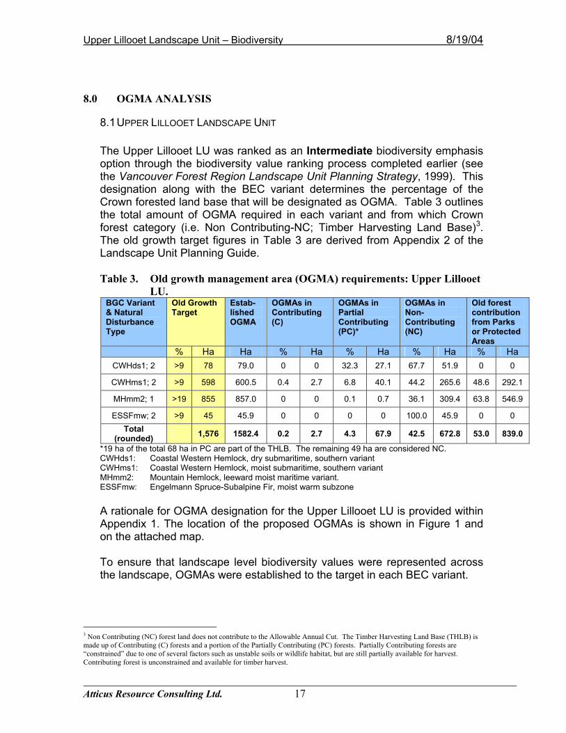
8.1 UPPER LILLOOET LANDSCAPE UNIT The Upper Lillooet LU was ranked as an Intermediate biodiversity emphasis option through the biodiversity value ranking process completed earlier (see the Vancouver Forest Region Landscape Unit Planning Strategy, 1999). This designation along with the BEC variant determines the percentage of the Crown forested land base that will be designated as OGMA. Table 3 outlines the total amount of OGMA required in each variant and from which Crown forest category (i.e. Non Contributing-NC; Timber Harvesting Land Base)3. The old growth target figures in Table 3 are derived from Appendix 2 of the Landscape Unit Planning Guide. Table 3. Old growth management area (OGMA) requirements: Upper Lillooet
LU. BGC Variant & Natural Disturbance Type
Old Growth Target
Estab-lished OGMA
OGMAs in Contributing (C)
OGMAs in Partial Contributing (PC)*
OGMAs in Non-Contributing (NC)
Old forest contribution from Parks or Protected Areas
% Ha Ha % Ha % Ha % Ha % Ha CWHds1; 2 >9 78 79.0 0 0 32.3 27.1 67.7 51.9 0 0
CWHms1; 2 >9 598 600.5 0.4 2.7 6.8 40.1 44.2 265.6 48.6 292.1
MHmm2; 1 >19 855 857.0 0 0 0.1 0.7 36.1 309.4 63.8 546.9
ESSFmw; 2 >9 45 45.9 0 0 0 0 100.0 45.9 0 0 Total
(rounded) 1,576 1582.4 0.2 2.7 4.3 67.9 42.5 672.8 53.0 839.0
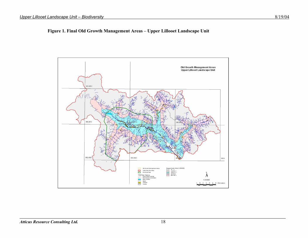
*19 ha of the total 68 ha in PC are part of the THLB. The remaining 49 ha are considered NC. CWHds1: Coastal Western Hemlock, dry submaritime, southern variant CWHms1: Coastal Western Hemlock, moist submaritime, southern variant MHmm2: Mountain Hemlock, leeward moist maritime variant. ESSFmw: Engelmann Spruce-Subalpine Fir, moist warm subzone A rationale for OGMA designation for the Upper Lillooet LU is provided within Appendix 1. The location of the proposed OGMAs is shown in Figure 1 and on the attached map. To ensure that landscape level biodiversity values were represented across the landscape, OGMAs were established to the target in each BEC variant.
3 Non Contributing (NC) forest land does not contribute to the Allowable Annual Cut. The Timber Harvesting Land Base (THLB) is made up of Contributing (C) forests and a portion of the Partially Contributing (PC) forests. Partially Contributing forests are “constrained” due to one of several factors such as unstable soils or wildlife habitat, but are still partially available for harvest. Contributing forest is unconstrained and available for timber harvest.
Upper Lillooet Landscape Unit – Biodiversity 8/19/04
Atticus Resource Consulting Ltd. 18
Figure 1. Final Old Growth Management Areas – Upper Lillooet Landscape Unit
Upper Lillooet Landscape Unit – Biodiversity 8/19/04
Atticus Resource Consulting Ltd. 19
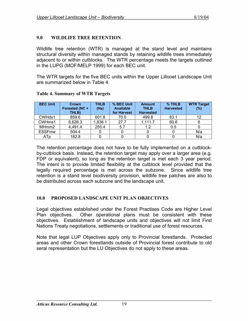
9.0 WILDLIFE TREE RETENTION Wildlife tree retention (WTR) is managed at the stand level and maintains structural diversity within managed stands by retaining wildlife trees immediately adjacent to or within cutblocks. The WTR percentage meets the targets outlined in the LUPG (MOF/MELP 1999) for each BEC unit. The WTR targets for the five BEC units within the Upper Lillooet Landscape Unit are summarized below in Table 4. Table 4. Summary of WTR Targets
BEC Unit Crown Forested (NC +
THLB)
THLB (Ha)
% BEC Unit Available
for Harvest
Amount THLB
Harvested
% THLB Harvested
WTR Target (%)
CWHds1 859.6 601.8 70.0 499.8 83.1 12 CWHms1 6,626.3 1,836.1 27.7 1,111.7 60.6 6 MHmm2 4,491.4 255.4 5.7 1.2 0.5 0 ESSFmw 504.4 0 0 0 0 N/a
ATp 182.8 0 0 0 0 N/a The retention percentage does not have to be fully implemented on a cutblock-by-cutblock basis. Instead, the retention target may apply over a larger area (e.g. FDP or equivalent), so long as the retention target is met each 3 year period. The intent is to provide limited flexibility at the cutblock level provided that the legally required percentage is met across the subzone. Since wildlife tree retention is a stand level biodiversity provision, wildlife tree patches are also to be distributed across each subzone and the landscape unit. 10.0 PROPOSED LANDSCAPE UNIT PLAN OBJECTIVES Legal objectives established under the Forest Practises Code are Higher Level Plan objectives. Other operational plans must be consistent with these objectives. Establishment of landscape units and objectives will not limit First Nations Treaty negotiations, settlements or traditional use of forest resources. Note that legal LUP Objectives apply only to Provincial forestlands. Protected areas and other Crown forestlands outside of Provincial forest contribute to old seral representation but the LU Objectives do not apply to these areas.
Upper Lillooet Landscape Unit – Biodiversity 8/19/04
Atticus Resource Consulting Ltd. 20
REFERENCES Apps, C.D. 2001. Grizzly Bear Population Linkage Zones in the Sea to Sky
Planning Area of southwestern British Columbia. Prepared for Wildlife Section, Ministry of Water, land and Air Protection, Surrey, BC.
Ministry of Environment, Lands and Parks (MELP) 1995. British Columbia Grizzly
Bear Conservation Strategy. Victoria Ministry of Environment, Lands and Parks (MELP) 1999. Management Direction
Statement for Upper Lillooet Landscape Unit. Garibaldi/Sunshine Coast District.
Ministry of Forests (MOF) 1995. Forest Practices Code – Biodiversity
Guidebook. Victoria; Ministry of Forests. Ministry of Forests / Ministry of Environment, Lands and Parks (MOF/MELP)
1999. Landscape Unit Planning Guide. Victoria: Ministry of Forests and Environment, Lands and Parks.
Ministry of Sustainable Resource Management (MSRM) 2002. Sustainable
Resource Management Planning: A Landscape-level Strategy for Resource Development. Resource Planning Branch, Ministry of Sustainable Resource management.
Ministry of Forests, 1999. Vancouver Forest Region - Regional Landscape Unit
Planning Strategy. Nanaimo. Napier, T. 2003. Intensive Forest Management. Personal Communication.
Upper Lillooet Landscape Unit – Biodiversity 8/19/04
Atticus Resource Consulting Ltd. 21
APPENDICES The Appendices listed below appear on the following pages: Appendix 1 OGMA Summary and Rationale Table Appendix 2 Final OGMA Polygons (1:30,000 scale plot) Appendix 3 List of Acronyms used in Report Appendix 4 Public Consultation Summary
Upper Lillooet Landscape Unit – Biodiversity 8/19/04
Atticus Resource Consulting Ltd. 22
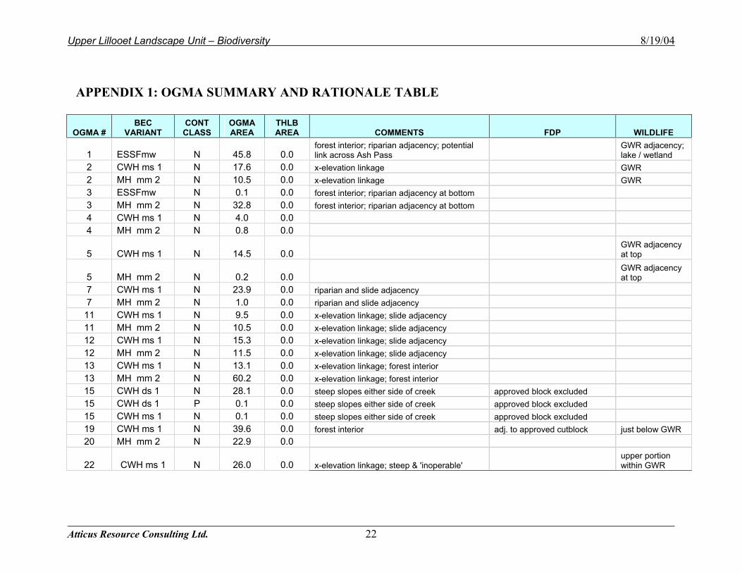
APPENDIX 1: OGMA SUMMARY AND RATIONALE TABLE
OGMA # BEC
VARIANT CONT CLASS
OGMA AREA
THLB AREA COMMENTS FDP WILDLIFE
1 ESSFmw N 45.8 0.0 forest interior; riparian adjacency; potential link across Ash Pass
GWR adjacency; lake / wetland
2 CWH ms 1 N 17.6 0.0 x-elevation linkage GWR 2 MH mm 2 N 10.5 0.0 x-elevation linkage GWR 3 ESSFmw N 0.1 0.0 forest interior; riparian adjacency at bottom 3 MH mm 2 N 32.8 0.0 forest interior; riparian adjacency at bottom 4 CWH ms 1 N 4.0 0.0 4 MH mm 2 N 0.8 0.0
5 CWH ms 1 N 14.5 0.0 GWR adjacency at top
5 MH mm 2 N 0.2 0.0 GWR adjacency at top
7 CWH ms 1 N 23.9 0.0 riparian and slide adjacency 7 MH mm 2 N 1.0 0.0 riparian and slide adjacency 11 CWH ms 1 N 9.5 0.0 x-elevation linkage; slide adjacency 11 MH mm 2 N 10.5 0.0 x-elevation linkage; slide adjacency 12 CWH ms 1 N 15.3 0.0 x-elevation linkage; slide adjacency 12 MH mm 2 N 11.5 0.0 x-elevation linkage; slide adjacency 13 CWH ms 1 N 13.1 0.0 x-elevation linkage; forest interior 13 MH mm 2 N 60.2 0.0 x-elevation linkage; forest interior 15 CWH ds 1 N 28.1 0.0 steep slopes either side of creek approved block excluded 15 CWH ds 1 P 0.1 0.0 steep slopes either side of creek approved block excluded 15 CWH ms 1 N 0.1 0.0 steep slopes either side of creek approved block excluded 19 CWH ms 1 N 39.6 0.0 forest interior adj. to approved cutblock just below GWR 20 MH mm 2 N 22.9 0.0
22 CWH ms 1 N 26.0 0.0 x-elevation linkage; steep & 'inoperable' upper portion within GWR
Upper Lillooet Landscape Unit – Biodiversity 8/19/04
Atticus Resource Consulting Ltd. 23
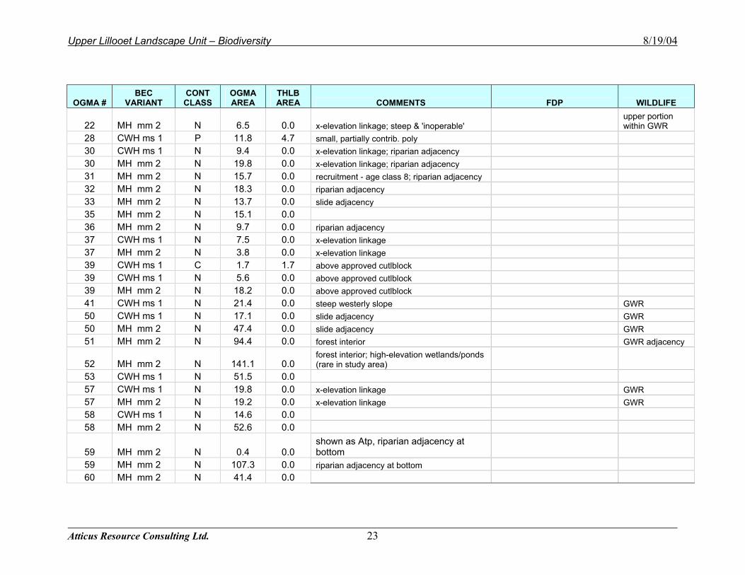
OGMA # BEC
VARIANT CONT CLASS
OGMA AREA
THLB AREA COMMENTS FDP WILDLIFE
22 MH mm 2 N 6.5 0.0 x-elevation linkage; steep & 'inoperable' upper portion within GWR
28 CWH ms 1 P 11.8 4.7 small, partially contrib. poly 30 CWH ms 1 N 9.4 0.0 x-elevation linkage; riparian adjacency 30 MH mm 2 N 19.8 0.0 x-elevation linkage; riparian adjacency 31 MH mm 2 N 15.7 0.0 recruitment - age class 8; riparian adjacency 32 MH mm 2 N 18.3 0.0 riparian adjacency 33 MH mm 2 N 13.7 0.0 slide adjacency 35 MH mm 2 N 15.1 0.0 36 MH mm 2 N 9.7 0.0 riparian adjacency 37 CWH ms 1 N 7.5 0.0 x-elevation linkage 37 MH mm 2 N 3.8 0.0 x-elevation linkage 39 CWH ms 1 C 1.7 1.7 above approved cutlblock 39 CWH ms 1 N 5.6 0.0 above approved cutlblock 39 MH mm 2 N 18.2 0.0 above approved cutlblock 41 CWH ms 1 N 21.4 0.0 steep westerly slope GWR 50 CWH ms 1 N 17.1 0.0 slide adjacency GWR 50 MH mm 2 N 47.4 0.0 slide adjacency GWR 51 MH mm 2 N 94.4 0.0 forest interior GWR adjacency
52 MH mm 2 N 141.1 0.0 forest interior; high-elevation wetlands/ponds (rare in study area)
53 CWH ms 1 N 51.5 0.0 57 CWH ms 1 N 19.8 0.0 x-elevation linkage GWR 57 MH mm 2 N 19.2 0.0 x-elevation linkage GWR 58 CWH ms 1 N 14.6 0.0 58 MH mm 2 N 52.6 0.0
59 MH mm 2 N 0.4 0.0 shown as Atp, riparian adjacency at bottom
59 MH mm 2 N 107.3 0.0 riparian adjacency at bottom 60 MH mm 2 N 41.4 0.0
Upper Lillooet Landscape Unit – Biodiversity 8/19/04
Atticus Resource Consulting Ltd. 24
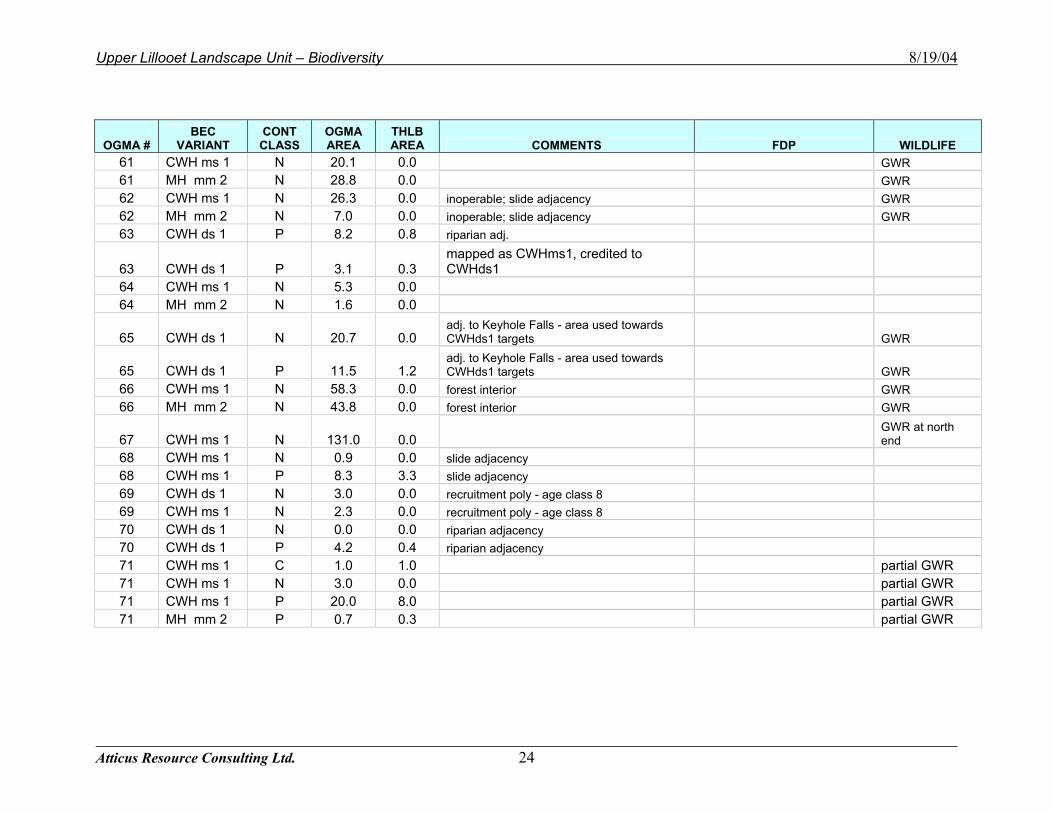
OGMA # BEC
VARIANT CONT CLASS
OGMA AREA
THLB AREA COMMENTS FDP WILDLIFE
61 CWH ms 1 N 20.1 0.0 GWR 61 MH mm 2 N 28.8 0.0 GWR 62 CWH ms 1 N 26.3 0.0 inoperable; slide adjacency GWR 62 MH mm 2 N 7.0 0.0 inoperable; slide adjacency GWR 63 CWH ds 1 P 8.2 0.8 riparian adj.
63 CWH ds 1 P 3.1 0.3 mapped as CWHms1, credited to CWHds1
64 CWH ms 1 N 5.3 0.0 64 MH mm 2 N 1.6 0.0
65 CWH ds 1 N 20.7 0.0 adj. to Keyhole Falls - area used towards CWHds1 targets GWR
65 CWH ds 1 P 11.5 1.2 adj. to Keyhole Falls - area used towards CWHds1 targets GWR
66 CWH ms 1 N 58.3 0.0 forest interior GWR 66 MH mm 2 N 43.8 0.0 forest interior GWR
67 CWH ms 1 N 131.0 0.0 GWR at north end
68 CWH ms 1 N 0.9 0.0 slide adjacency 68 CWH ms 1 P 8.3 3.3 slide adjacency 69 CWH ds 1 N 3.0 0.0 recruitment poly - age class 8 69 CWH ms 1 N 2.3 0.0 recruitment poly - age class 8 70 CWH ds 1 N 0.0 0.0 riparian adjacency 70 CWH ds 1 P 4.2 0.4 riparian adjacency 71 CWH ms 1 C 1.0 1.0 partial GWR 71 CWH ms 1 N 3.0 0.0 partial GWR 71 CWH ms 1 P 20.0 8.0 partial GWR 71 MH mm 2 P 0.7 0.3 partial GWR
Upper Lillooet Landscape Unit – Biodiversity 8/19/04
Atticus Resource Consulting Ltd. 25
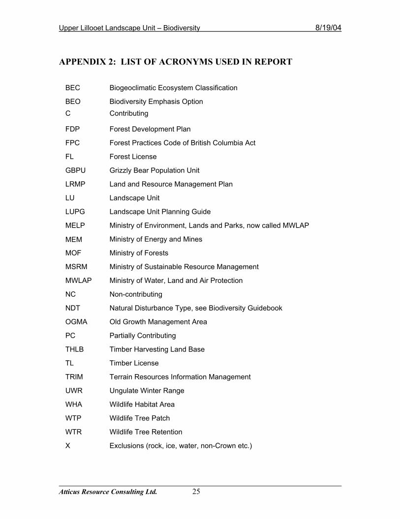
APPENDIX 2: LIST OF ACRONYMS USED IN REPORT
BEC Biogeoclimatic Ecosystem Classification
BEO Biodiversity Emphasis Option C Contributing
FDP Forest Development Plan
FPC Forest Practices Code of British Columbia Act
FL Forest License
GBPU Grizzly Bear Population Unit
LRMP Land and Resource Management Plan
LU Landscape Unit
LUPG Landscape Unit Planning Guide
MELP Ministry of Environment, Lands and Parks, now called MWLAP
MEM Ministry of Energy and Mines
MOF Ministry of Forests
MSRM Ministry of Sustainable Resource Management
MWLAP Ministry of Water, Land and Air Protection
NC Non-contributing
NDT Natural Disturbance Type, see Biodiversity Guidebook
OGMA Old Growth Management Area
PC Partially Contributing
THLB Timber Harvesting Land Base
TL Timber License
TRIM Terrain Resources Information Management
UWR Ungulate Winter Range
WHA Wildlife Habitat Area
WTP Wildlife Tree Patch
WTR Wildlife Tree Retention
X Exclusions (rock, ice, water, non-Crown etc.)
Upper Lillooet Landscape Unit – Biodiversity 8/19/04
Atticus Resource Consulting Ltd. 26
APPENDIX 3: FINAL OGMA POLYGONS Please refer to the appended hardcopy maps to view the final Old Growth Management Areas (OGMAs) within the Upper Lillooet Landscape Unit.
Upper Lillooet Landscape Unit – Biodiversity 8/19/04
Atticus Resource Consulting Ltd. 27
APPENDIX 4: PUBLIC CONSULTATION SUMMARY This Landscape Unit was advertised for public review and comment for 60 days from April 1, 2004 to June 1, 2004. Prior to the public consultation period, MSRM met with the local forest licensees and consulted with First Nations. Meetings or conversations were also held with Ministry of Forests and Ministry of Water, Land and Air Protection during the development of the LU plan. Mineral tenure holders were advised of OGMA placement. No comments from the general public were received during this time.