Embed Size (px)
Citation preview

TD 884.5 R45 1990 v. 2
SURVEY OF SOIL MAP UNIT SENSITIVITY TO
ACID DEPOSffiON IN THE
SIERRA NEVAD~ CALIFORNIA
APPENDIX A - SOIL SURVEYS OF PORTIONS OF YOSEMITE, KINGS CANYON, AND SEQUOIA NATIONAL PARKS
APPENDIX B - TAXONOMIC UNIT AND MAP UNIT A1TRIBlITE DATABASE
Prepared For:
CALIFORNIA AIR RESOURCES BOARD Under Contract No.
A732-037
Prepared By:
NORTH STATE RESOURCES, Inc. Redding, California
In Association With
University of California, .Davis Deparment of Land, Air, and Water Resources
February 1990
L\BRfl.RY uRCES BOMU>CALIFORNIA MR RESO P(\ BOX 2815 . -rnl'I
S~CR/l.Mf.N10, CA ':j:)OU•
APPENDIX A
SOIL SURVEYS OF PORTIONS OF
YOSEMITE NATIONAL PARK KINGS CANYON NATIONAL PARK
SPQlJOTA NATIONAL PARK
Supplemental Text To
. SURVEY OF SOIL MAP UNIT SENSITIVITY TO ACID DEPOSITION
IN THE SIERRA NEV ADA, CALIFORNIA

APPENDIX A: SOIL SURVEYS TABLE OF CONTENTS
Page
INTRODUCTION 1
METHODS , . . 2
HOW TO USE THIS REPORT, , . , ... , .. , , , . , .... , 3
REPORT ORGANIZATION , .. , , , 4
SOIL SURVEY - YOSEMITE NATIONAL PARK, . Y-1
SOIL SURVEY - KINGS CANYON NATIONAL PARK KC-1
SOIL SURVEY - SEQUOIA NATIONAL PARK .. , S-1

SOIL SURVEYS CONDUCTED WITHIN YOSEMITE, KINGS CANYON, AND SEQUOIA
NATIONAL PARKS
INTRODUCTION
Soil survey information is available for the majority of the cryic
and frigid western slope of the Sierra Nevada, with the notable
exception of the National Parks. Approximately 680,500 unsurveyed
acres occur within Yosemite; approximately 223,000 acres occur
within Sequoia; and approximately 454,700 acres occur within Kings
Canyon.
An important element of this project was to complete as much soil
survey in these areas as financially possible and to use these
resulting baseline data to rank soil map units in terms of their
sensitivity response to acid deposition.
Potential survey areas were selected based upon a review of A-.ca.unsurveyed high alpine Study proximity tor.l,~ ........ '
alpine lakes sampled by other researchers, and anticipated
sensitivity. Two or three alternatives were selected within each
National Park. The final determination was based on:
o Availability of aerial photographs
o Availability of physical access into each area
o Permission by the National Park Service
o Approval by the Air Resources Board
Approximately 106,000 acres were selected for Order 3 soil survey,
distributed among the parks in the following manner:
o Tuolumne Meadows area, Yosemite National Park (43,000 acres)
1

o Dougherty Peak area, Kings Canyon National Park (25,000 acres)
o Kern Canyon area, Sequoia National Park (38,000 acres)
METHODS
The surveys were conducted by professional soil scientists who
applied the standards of the National Cooperative Soil Survey.
Soils were classified according to the USDA Soil Taxonomy.
Available information describing the physical and biological
characteristics of each survey area was collected and reviewed in
detail. Nearby soil surveys were also reviewed as available. Map
unit legends for adjacent areas served as a guide for developing
the preliminary map unit legend for each area. Soil families were
used as the basic taxonomic component.
Topographic maps and aerial photography for the study area were
obtained prior to field activities. Mapping photos for the Sequoia
and Kings Canyon areas were 1:22,000 scale black-and-white photos
obtained from the National Park Service National Cartographic
Center. Mapping photos for the Yosemite area were 1:15,000 scale
color infrared photos obtained from the Yosemite Park Naturalist.
The survey area boundaries were transferred to frosted acetate
photo overlays.
For the Order 3 surveys, the minimum size delineation was 50 acres.
Map units were identified by transecting representative land units.
Soil scientists examined and identified the soil at selected
intervals to record soil characteristics and document other field
observations. The observations were recorded on a standard form
to maintain consistency in the data collection.
2
The results of a number of transects were summarized to verify the
relative proportions of dominant and included soils e.g., taxonomic
units) occurring within each mapping unit. Mapping unit boundaries
were then plotted by observation and interpretation of aerial
photographs. Observations were field-verified whenever necessary
to maintain accuracy.
The specific information collected during the field survey includes
the following:
o Detailed descriptions of the dominant taxonomic units
o Results of field transects
o Descriptions of the environmental characteristics of both individual soil profiles and mapping units
o Frosted, acetate overlays of mapping photos with mapping unit boundaries plotted on the overlays
o Soil samples of typifying soil profiles for laboratory analysis
o Description of the occurrence and density of plant species
The mapping unit boundaries from the mapping photos were trans
ferred to clear overlays of the photo mylar quadrangle maps.
Because of photo distortion in mountainous terrain, the information
was transferred by viewing stereo photo pairs and placing the
boundaries on corresponding landscape features noted on the
topographic base.
After mapping unit boundaries were transferred to the quadrangle
base, a conversion legend was created which placed each mapping
unit into a sensitivity class.
HOW TO USE THIS REPORT
First, the user refers to the Index to Map Sheets to identify the
map sheet that provides coverage of the area of interest.
Utilizing the map sheets, the user identifies the map unit symbol
3

assigned to a specific location. Once the map unit symbol is
identified, the user refers to the Map Unit Description section of
the appropriate soil survey report to find a characterization of
the soils and landscape characteristics of the map unit.
More specific information regarding the components can be found in
the section entitled Taxonomic Unit Descriptions.
REPORT ORGANIZATION
The soil survey reports which follow contain information on the
106,000 acres mapped under this effort. The mapping performed
is presented separately for each National Park. Each report
contains the following elements:
Description of the Area
Alphabetical List of Soil Taxonomic Units
Classification Table of Taxonomic Units
Taxonomic Unit Descriptions
Descriptions of Map Units
Additional data, including chemical and physical characterization
which is a basis for the assignment of sensitivity rankinas, are
included in Appendix B, Data Tables.
4
SOIL SURVEY OF TUOLUMNE MEADOWS STUDY AREA
YOSEMITE NATIONAL PARK
DESCRIPTION OF THE AREA
LOCATION
The study area consists of about 43 1 000 acres in the east-central
part of Yosemite National Park in the Sierra Nevada of California
(Tuolumne Meadows 15 1 quadrangle and Mono Craters 15' quadrangle),
It lies between the coordinates of latitude 37° 49' and 37° 57'
north, and longitudes 119° 13' and 119° 30' west.
The area is bounded on the northwest and east by the park boundary
that lies along the Sierra Crest between Tuolumne and Mono ~n11nt-;oa., .PT"nm wh;t-o Mn11nt-a;n an11t-h to Kuna Peak .. From White
Mountain, the study area boundary runs approximately west-south
west along the ridge lines connecting Ragged Peak, Tuolumne Peak
and southwest to the intersection of the ridgeline with the
Mariposa County Line. It follows this county line for a short
distance and continues south along a ridgeline to the Tioga Road
(Highway 120) immediately southwest of Tenaya Lake. The southern
boundary continues along the ridgelines connecting Tressidor, Echo,
and Cathedral Peaks. It continues north a short way to Fairview
Dome and Tuolumne Meadows. It follows Lyell Fork Creek for a
distance and then continues along the ridgeline to Mammoth Peak and
along the Kuna Crest to Kuna Peak, where it intersects the park
boundary,
TERRAIN
The study area is primarily gently sloping to very steep alpine
country lying just west of the Sierra Nevada Crest. Elevations
y - 1

range from about 7900 feet at a point just below Tuolomne Falls,
to more than 13,050 feet at the summit of Mount Dana on the Sierra
Crest. The topography is predominantly complex and very bouldery;
a result of extensive glaciation of the area. This glaciation has
also served to carve the many peaks, lake basins and meadows, and
dome-like rock structures that are so notable in the Yosemite area
of the High Sierra.
GENERAL GEOLOGY
A large portion of the survey area is comprised of the massive
granitic Tuolomne intrusive suite, much of which is overlain by a
relatively thin mantle of glacial fill from the last Pleistocene
episode. This acid intrusive granitic rock is mostly granodiorite,
often characterized by large phenocrysts. At one time glacial ice
covered much of the area below the higher peaks that are at
elevations greater than about 11,000 feet. On the eastern margin
of the survey area are metamorphosed volcanic and sedimentary rocks
that were disrupted by the intrusion of granitic rocks of the
Tuolomne Suite. The metasedimentary and metavolcanic rocks are
mostly hornfels, local graywackes, and volcanic tuffs and flows.
VEGETATION
The natural vegetation of the study area is an expression of the
upper reaches of the west side of the Sierra Nevada Crest. Below
timberline, the coniferous forest is dominated by lodgepole pine
with some mountain hemlock. Red fir and western white pine is
found on some northerly slopes below 10,000 feet, with whitebark
pine gradually replacing the lodgepole at elevations above 10,000
feet. The understory consists mostly of regenerating conifers,
grasses, sedges, and scattered shrubs, most notably current and red
mountain heather. The meadows support a wide variety of grasses,
y - 2

sedges, and wildflowers, with lodgepole pine often encroaching
around the margins. Higher alpine areas support mostly grasses,
willows, and scattered white bark pine.
y - 3

TABLE 1-Y
SOIL TAXONOMIC UNITS (Alphabetical Order)
Tuolumne Meadows Study Area
Yosemite National Park
Aerie Cryaquepts, fine-loamy, mixed
Dystric Cryochrepts, coarse-loamy, mixed
Dystric Cryochrepts, loamy-skeletal, mixed
Lithic Cryochrepts, loamy, mixed
Lithic Cryochrepts, loamy-skeletal, mixed
Lithic Cryumbrepts, loamy, mixed
Lithic Xerumbrepts, loamy, mixed, frigid
Pachic Cryoborolls, loamy-skeletal, mixed
Typic Cryofluvents, coarse-loamy, mixed
Typic Cryofluvents, sandy-skeletal, mixed
Typic Cryumbrepts, loamy-skeletal, mixed
Typic Xerumbrepts, loamy-skeletal, mixed, frigid

TABLE 2-Y
CLASSIFICATION TABLE OF TAXONOMIC UNITS
'1'11n 1 nmn,::ll, M,:.Arlnua ~t_11.-fy A,-.~A
Yosemite National Park
ENTISOLS
Cryofluvents
Typic Cryofluvents, coarse-loamy, mixed Typic Cryofluvents, sandy-skeletal, mixed
INCEPT I SOLS
Cryaquepts
Aerie Cryaquepts, fine-loamy, mixed
Cryochrepts
Dystric Cryochrepts, coarse-loamy, mixed Dystric Cryochrepts, loamy-skeletal, mixed Lithic Cryochrepts, loamy, mixed Lithic Cryochrepts, loamy-skeletal, mixed
Cryumbrepts
Typic Cryumbrepts, loamy-skeletal, mixed Lithic Cryumbrepts, loamy, mixed
Xerumbrepts
Typic Xerumbrepts, loamy-skeletal, mixed, frigid Lithic Xerumbrepts, loamy, mixed, frigid
MOLLI SOLS
Cryoborolls
Pachic Cryoborolls, loamy-skeletal, mixed
y - 5

TAXONOMIC UNITS OF THE TUOLUMNE MEADOWS STUDY AREA
DESCRIPTION OF TAXONOMIC UNITS
Aerie Cryaquepts, fine-loamy, mixed
This soil family consists of moderately deep soils forming in mixed
alluvium and underlain by glacial till, or deep soils in recent
alluvium. These soils are poorly drained and occur in kettles,
depressions, and adjacent to drainageways on subalpine wet meadow
areas. Slopes are Oto 10 percent.
Typically, these soils have a thin dark surface layer, a gravelly
to very gravelly loamy subsoil, underlain by a dense brittle
gravelly hardpan of glacial till.
Following is a profile description of a representative pedon
(7039-11) found in map unit 102 Dystric Cryochrepts Aerie
Cryaquepts complex, 0 to 15 percent slopes. It is located in upper
Dana Meadows about 1 mile south-southeast of the Tioga Pass Entry
Station of Yosemite National Park; slope is 5 percent north;
elevation is 9850 ft.; vegetation is grasses and sedges (colors are
for dry soil unless otherwise noted):
Al--0 to 3 inches; dark grayish brown (lOYR 4/2) silt
loam, black (lOYR 2/1) moist; massive; slightly
hard, friable, slightly sticky and nonplastic; many
very fine, fine, and few medium roots; clear smooth
boundary.
A2--3 to 9 inches; grayish brown (lOYR 5/2) silt loam,
very dark brown (lOYR 2/2) moist; weak fine sub
angular blocky structure; slightly hard, friable,
y - 6

slightly sticky and slightly plastic; many very
fine, fine, and few medium roots; 5 percent pebbles;
clear smooth boundary.
2Bwl--9 to 16 inches; yellowish brown (l0YR 5/4) very
gravelly loam, dark yellowish brown (l0YR 3/4)
moist; few fine prominent mottles of dark yellowish
brown (moist); weak fine and medium subangular
blocky structure; slightly hard, friable, slightly
sticky and slightly plastic; common very fine, fine,
and medium roots; 35 percent pebbles and 5 percent
cobbles; abrupt smooth boundary.
2Bw2--16 to 24 inches; light yellowish brown (2.5Y 6/4)
gravelly loam, olive brown (2.5Y 4/4) moist; common
medium prominent mottles of dark yellowish brown
(moist); weak fine subangular blocky structure;
slightly hard, friable, slightly sticky and slight
ly plastic; common very fine, fine, and few medium
roots; 20 percent pebbles and 5 percent cobbles;
abrupt smooth boundary.
2Bxl--24 to 30 inches; light yellowish brown (2.5Y 6/4)
dense and brittle hardpan that parts to gravelly
loam, light olive brown (2.5Y 5/4) moist; many
medium prominent mottles of yellowish brown (moist);
massive; hard, firm, slightly sticky and slightly
plastic; few very fine roots; 15 percent pebbles and
5 percent cobbles; abrupt smooth boundary.
2Bx2--30 to 60 inches; pale yellow (2,SY 7/4) dense
hardpan parting to gravelly sandy loam, light olive
brown (2.SY 5/4) moist; common medium prominent
y - 7

mottles of light yellowish brown (moist); massive;
hard, very firm, nonsticky and nonplastic; 25
percent pebbles and 5 percent cobbles.
Remarks: The particle-size control section averages 18 to 27
percent clay and 15 to 35 percent rock fragments. Depth to hardpan
is 20 to 40 inches
Dystric Cryochrepts, coarse-loamy, mixed
This soil family commonly consists of deep, moderately well to well
drained soils that formed in granitic colluvium and glacial till,
with an influential component of volcanic ash in the solum. This
soil is most often found on concave mountain benches, footslopes,
and between joints in association with granitic rock outcrop. Less
commonly, this family consists of moderately deep soils on glacial
moraines underlain by a dense glacial till hardpan or rhyolitic
tuff. Slopes are complex and range from 5 to 25 percent.
Typically the soils have a thin dark surface over a moderately
developed subsoil characterized by a light bulk density.
Following is a profile description of a representative pedon
(7228-5) found in the map unit 11 Jointed granitic outcrop - Lithic
Cryumbrepts - Dystric Cryochrepts complex, 5 to 30 percent slopes,
It is located about 0.6 miles northwest of Tuolomne Falls; slope
is 7 percent north; elevation is 8400 ft.; vegetation is mainly
lodgepole pine with mountain hemlock, grass, sedge, ribes, and
mountain heather (colors are for dry soil unless otherwise noted):
Oi--3 inches to O; slightly decomposed needles, twigs,
and bark.
y - 8

A--0 to 5 inches; brown (lOYR 5/3) fine sandy loam, very
dark brown (lOYR 2/2) moist; weak fine and medium
granular structure; soft, very friable, nonsticky
and nonplastic; common very fine, fine, and few
medium roots; clear wavy boundary,
Bwl--5 to 13 inches; brown (7,5YR 5/4) sandy loam, very
dark brown ( 7. 5YR 3/4) moist; moderate fine and
medium subangular blocky structure; soft, very
friable, nonsticky and nonplastic; common very fine,
fine, and few medium roots; gradual wavy boundary.
Bw2--13 to 24 inches; brown (7,5YR 5/4) sandy loam, very
dark brown ( 7. 5YR 3/4) moist; moderate fine and
medium subangular blocky structure; soft, very
friable, nonsticky and nonplastic; few very fine,
fine, and medium roots; 5 percent pebbles; gradual
wavy boundary,
Bw3--24 to 60 inches; reddish yellow (7.5YR 6/6) cobbly
sandy loam, strong brown (7.5YR 4i6) moist; weak
fine and medium subangular blocky structure; soft,
very friable, nonsticky and nonplastic; few fine
and medium roots; 10 percent pebbles and 20 percent
cobbles.
Remarks: The particle-size control section averages 5 to 35
percent rock fragments. Textures are fine sandy loam and sandy
loam.
y - 9

Dystric Cryochrepts, loamy-skeletal, mixed
In general, this soil family occurs on more northerly aspects and
at higher elevations in the ::surv~y area than Typic Cryumbrepts
(loamy-skeletal), but they are often associated in complex mapping
units. Loamy-skeletal Dystric Cryochrepts commonly are well
drained, moderately deep soils. They formed primarily in colluvium
and residuum from granitic rocks, granitic glacial till, and are
influenced by volcanic ash in the solum, However, in the Parker
Pass Creek area, both the till and the colluvium has a mixed source
of granitic, metavolcanic, and metasedimentary rock, A dense
brittle hardpan or granodiorite bedrock commonly occurs between 20
to 40 inches. Less commonly, the till is unconsolidated or bedrock
is at a depth of 40 to greater than 60 inches, especially on
steeper colluvial soils, The surface is almost always very stony
to extremely bouldery, Slopes are complex and range from 5 to 75
percent,
Typically the soils have a thin, dark, fine sandy loam surface
layer. A moderately developed very gravelly to very stony subsoil
with brighter colors overlies a dense till hardpan, or in some
cases, granodiorite,
Following is a profile description of a representative pedon
(7038-1) found in the map unit 100 Dystric Cryoohrepts, 15 to 45
percent slopes. It is located approximately 1.5 miles northwest
of Mammoth Peak; slope is 32 percent north; elevation is 9800 ft,;
vegetation is lodgepole pine with mountain hemlock, grass, sedge,
and ribes (colors are for dry soil unless otherwise noted):
Oi--1 in to O; slightly decomposed needles, leaves, and
twigs,
Y - 10

A--0 to 6 inches; dark grayish brown (lOYR 4/2) cobbly
fine sandy loam, very dark brown (lOYR 2/2) moist;
weak fine granular structure; soft, very friable,
,,uu~ti~h~ and nonplastic; many very fine, fine, and
common medium roots; 5 percent stones, 15 percent
cobbles, and 10 percent pebbles; clear wavy boun
dary.
Bwl--6 to 11 inches; yellowish brown (lOYR 5/4) very
stony sandy loam, dark brown (7,5YR 3/4) moist; weak
very fine granular structure; soft, very friable,
nonsticky and nonplastic; many very fine, fine,
common medium and coarse roots; 20 percent stones,
15 percent cobbles, and 15 percent pebbles; abrupt
wavy boundary.
Bw2--11 to 25 inches; light brown (7.5YR 6/4) extremely
stony sandy loam, reddish brown (5YR4/4) moist; weak
and moderate fine subangular blocky structure; soft,
very friable, nonsticky and nonplastic; many very
fine, common fine and medium roots; 30 percent
stones, 15 percent cobbles, and 15 percent pebbles;
clear wavy boundary.
2BC--25 to 37 inches; light yellowish brown (2.5Y 6/4)
and (lOYR 6/4) very gravelly fine sandy loam, olive
brown (2.5Y 4/4) and dark yellowish brown (lOYR-
4/4) moist; common black organic staining on peds;
weak fine and medium subangular blocky structure;
slightly hard, very friable, nonsticky and nonplas
tic; common very fine and fine roots; 10 percent
cobbles and 30 percent pebbles; abrupt smooth
boundary.
y - 11
2Cr--37 to 60+ inches; light yellowish brown (2.5Y 6/4)
dense hardpan parting to very gravelly sandy loam,
olive brown (2.5Y 4/4) moist; common black organic
~t~iuiu~ uu peds; massive; firm, friable, nonsticky
and nonplastic; common very fine and fine roots
matting on top of horizon; 5 percent cobbles and 35
percent pebbles.
Remarks: The particle-size control section averages 35 to 60
percent rock fragments. Textures are fine sandy loam or sandy loam
throughout. A discontinuous alluvial surface horizon is present
in some pedons.
Lithic Cryochrepts, loamy, mixed
This soil family is found throughout the survey area and always
associated with rock outcrop. It consists of shallow and very
shallow, well drained soils over mostly granodiorite. In the
Parker Pass Creek area the bedrock may be metamorphic. These soils
are formed in colluvium and residuum, with the addition of slope-
wash material and volcanic ash. They occur on glacially scoured
basins, cirques, mountain sideslopes, and around rock outcrops,
primarily on benches, ledges, and rock joints and crevices. Slopes
are complex and range from 5 to 75 percent.
Typically these soi ls have a thin dark surface with a slightly
developed subsoil over land granodiorite.
Following is a profile description of a representative pedon
(7121-1) found in map unit 80 Lithic Cryochrepts - Jointed granitic
outcrop - Typic Cryumbrepts complex, 5 to 30 percent slopes. It
is located about 0.5 miles northwest of Soda Springs; slope is 8
percent northeast; elevation is 8700 feet; vegetation is sedge and
Y - 12

grass with a 5 percent canopy of lodgepole pine (colors are for dry
soil unless otherwise noted):
A--0 to 4 inches; brown (lOYR 5/3) gravelly sandy loam,
very dark grayish brown (lOYR 3/2) moist; weak very
fine granular structure; soft, very friable, non
sticky and nonplastic; many very fine and fine
roots; 5 percent cobbles and 20 percent pebbles;
clear wavy boundary,
Bw--4 to 15 inches; yellowish brown (lOYR 5/4) gravelly
sandy loam, dark yellowish brown (lOYR 3/4) moist;
weak fine and medium subangular blocky structure;
soft, very friable, nonsticky and nonplastic; common
very fine and fine roots; 5 percent cobbles and 25
percent pebbles; abrupt smooth boundary,
R--15+ inches; hard granodiorite.
Remarks: The particle-size control section averages O to 35
percent rock fragments, Depth to bedrock ranges from 5 to 20
inches.
Lithic Cryochrepts, loamy-skeletal, mixed
This soil family consists of shallow and very shallow well to
somewhat excessively drained soils forming in colluvium and
residuum from metamorphic rocks. The soils occur on mountain
ridges and sideslopes. Slopes are 45 to 75 percent.
Typically, these soils have a thin dark surface layer, a weakly
developed subsoil of extremely flaggy and extremely channery coarse
sandy loam, overlying metavolcanic bedrock.
Y - 13

Following is a profile description of a representative pedon
( 7041-4) found in map unit 70 Metamorphic talus - Li thic Cryo
chrepts - Jointed metamorphic outcrop complex, 45 to 75 percent
slopes. It is located on Gaylor Peak about 0.6 miles northwest of
the Tioga Pass Entry Station of Yosemite National Park; slope is
55 percent; elevation is 10,800 feet; vegetation is widely scat
tered whitebark pine, mountain heather, and sedges (colors are for
dry soil unless otherwise noted):
Oi--1/4 inch to O; slightly decomposed needles.
A--0 to 4 inches; brown ( lOYR 5/3) extremely flaggy
coarse sandy loam, very dark grayish brown (lOYR
3/2) moist; weak very fine granular structure; soft,
very friable, nonsticky and nonplastic; common very
fine and fine roots; 25 percent flags, 20 percent
channers, and 20 percent pebbles; abrupt wavy
boundary.
Bw--4 to 15 inches; light yellowish brown (lOYR 6/4)
extremely channery coarse sandy loam, dark yellowish
brown (lOYR 4/4) moist; moderate fine and medium
subangular blocky structure; soft, very friable,
nonsticky and nonplastic; common very fine, fine,
and medium roots; 10 percent flags, 30 percent
channers, and 30 percent pebbles; abrupt irregular
boundary.
R--15 to 17+ inches; fractured, hard metavolcanic rock.
Remarks: Particle-size control section commonly averages 60 to 75
percent rock fragments. Depth to bedrock is 7 to 20 inches.
Y - 14

Lithic Cryumbrepts, loamy, mixed
This soil family consists of well to somewhat excessively drained
shallow and very shallow soils. They formed in slope wash and
colluvium and residuum from granitic rocks, with an influence of
volcanic ash. They occur on benches, ledges, rock fissures, and
steep slopes in complex with jointed granitic rock outcrop. Slopes
are 10 to 55 percent.
Typically the soils have a dark surface layer and a weakly develop
ed subsoil over hard granodiorite.
Following is a profile description of a representative pedon
(7297-1) found in the map unit 11 Jointed granitic outcrop - Lithic
Cryumbrepts - Dystric Cryochrepts complex, 5 to 30 percent slopes.
It is located about 1 mile northwest of Tenaya Lake, approximately
0.5 miles north on Murphy Creek trail and 0.5 miles west of the
creek; slope is complex 10 percent north-northwest; elevation is
8400 feet; vegetation is sparse lodgepole pine and grass (colors
are for dry soil unless otherwise noted):
Oi--1 inch to O; slightly decomposed pine litter.
Al--0 to 2 inches; dark grayish brown (l0YR 4/2) fine
sandy loam, very dark brown (l0YR 2/2) moist; weak
fine subangular blocky structure; soft, very fri
able, nonsticky and nonplastic; common very fine
and fine roots; 5 percent pebbles; abrupt smooth
hnunrlary.
A2--2 to 9 inches; grayish brown (l0YR 5/2) very fine
sandy loam, very dark grayish brown ( l0YR 3/2)
moist; weak fine subangular blocky structure; soft,
Y - 15
very friable, nonsticky and nonplastic; many very
fine, fine, medium, and coarse roots; 5 percent
pebbles; abrupt smooth boundary.
Bw--9 to 18 inches; yellowish brown (l0YR 5/4) gravelly
sandy loam, dark yellowish brown (l0YR 3/4) moist;
weak fine and medium subangular blocky structure;
many very fine, fine, common medium, and few coarse
roots; 20 percent pebbles; abrupt irregular boun
dary.
R--18+ inches; hard fractured granodiorite.
Remarks: The particle-size control section averages 15 to 35
percent rock fragments. It should be noted, however, that there
are dissimilar shallow soils that average more than 35 percent rock
fragments, but occur in a pattern too complex to map separately.
Lithic Xerumbrepts, loamy, mixed, frigid
This soil family consists of shallow, well drained soils forming
in colluvium and residuum over granodiori te. They occur on
southerly aspects on glacially quarried sideslopes of granitic
mountains and are associated with rock outcrop. Slope ranges from
30 to 60 percent.
Typically, the soils have a dark surface layer and brighter colored
subsoil over granodiorite.
Following is a profile description of a representative pedon
(7228-8) found in the map unit 60 Typic Xerumbrepts - Lithic Xerum
brepts - Jointed granitic outcrop complex, 30 to 60 percent slopes.
Traveling approximately 1 mile west along Highway 120 from the
Y - 16
southwest corner of Tuolomne Meadows, it is located north an
upslope about 0.25 miles from the road; slope is 30 percent
southeast; elevation is 8700 feet; vegetation is manzani ta with
scattered western juniper and lodgepole pine (colors are for dry
soil unless otherwise noted):
Al--0 to 3 inches; grayish brown (lOYR 5/2) gravelly fine
sandy loam, very dark brown (lOYR 2/2) moist; weak
fine granular structure; soft, very friable, nonsticky
and nonplastic; 15 percent pebbles; clear wavy boundary.
A2--3 to 9 inches; grayish brown (lOYR 5/2) gravelly fine
sandy loam, very dark grayish brown ( lOYR 3/2)
moist; weak fine and medium subangular blocky struc
ture; soft, very friable, nonsticky and nonplastic;
common very fine, fine, and medium roots; 5 percent
cobbles and 15 percent pebbles; abrupt wavy boun
dary.
Bw--9 to 12 inches; yellowish brown (lOYR 5/4) cobbly
fine sandy loam, dark yellowish brown ( lOYR 3/4)
moist; moderate fine and medium subangular blocky
structure; soft, very friable, nonsticky and
nonplastic; common very fine, fine, and medium
roots; 15 percent cobbles and 15 percent pebbles;
abrupt irregular boundary.
R--12+ inches; hard fractured granodiorite.
Remarks: The particle-size control section averages 15 to 35
percent rock fragments.
Y - 17
Miscellaneous land type
Pachic Cryoborolls, loamy-skeletal, mixed
This soil family consists of deep, moderately well to somewhat
poorly drained soils forming in colluvium. They occur on steep
mountain sides lopes near tree line. They are found in concave
positions and are associated with drainages, springs, seeps, and
late spring snow melt. Slope ranges from 30 to 70 percent.
Typically the soils have a deep dark surface layer and lighter
subsoil.
Following is a profile description of a representative pedon
( 7038-2) found in the map unit 40 Pachic Cryoborolls - Dystric
Cryochrepts - Rock outcrop complex, 30 to 70 percent slopes. It
is located on the north face approximately 1 mile northwest of
Mammoth Peak; slope is 40 percent north; elevation is 10,300 feet;
vegetation is grass, willow, ribes, with scattered mountain hemlock
and whi tebark pine (colors are for dry soil unless otherwise
noted) :
Oi--2 inches to 0; sod mat with leaves, dead grass.
Al--0 to 9 inches; dark gray (l0YR 4/1) very stony fine
sandy loam, black (l0YR 2/1) and very dark brown
Y - 18

( lOYR 2/2) moist; weak very fine granular structure;
soft, very friable, nonsticky and nonplastic; many
very fine, fine, common medium, and coarse roots;
15 percent stones, 15 percent cobbles, and 10
percent pebbles; clear smooth boundary.
A2--9 to 22 inches; dark grayish brown (lOYR 4/2) ex
tremely stony sandy loam, very dark brown (lOYR 2/2)
moist; weak fine subangular blocky structure; soft,
very friable, nonsticky and nonplastic; many very
fine, fine, and common medium roots; 30 percent
stones, 15 percent cobbles, 15 percent pebbles;
clear wavy boundary,
Bw--22 to 60 inches; yellowish brown ( lOYR 5/4) very
cobbly sandy loam, dark yellowish brown (lOYR 3/4)
moist; weak to moderate fine and medium subangular
blocky structure; soft, very friable, nonsticky and
nonplastic; common very fine and fine roots; 5
percent stones, 10 percent cobbles, and 30 percent
pebbles.
Remarks: The particle-size control section averages 35 to 60
percent rock fragments, and twelve to 25 percent clay. Textures
are loam, fine sandy loam, and sandy loam, and may be very gravel
ly, very cobbly, very channery, very stony, or extremely stony.
Mottles below 30 inches are common.
Tvnic Crvofluvents. coarse-loamv. mixed
This soil family consists of very deep, poorly to somewhat poorly
drained soils forming in recent alluvial valley fill material.
Commonly, these soils are underlain by sand and gravel derived from
Y - 19

glacial outwash deposits. It is found in the wet meadow areas
(Tuolomne and Dana), and along streams and drainages. Slopes are
0 to 5 percent.
Typically, the soils have a dark surface layer moderately high in
organic matter. Below the surface layer, layers are stratified
with medium to coarse textures.
Following is a profile description of a representative pedon
(7228-1) found in the map unit 110 Typic Cryofluvents, 0 to 5
percent slopes. It is located in a meadow adjacent to the Tuolomne
River about 1,25 miles upstream (southeast) from Tuolomne Falls;
slope is 1 percent northwest; elevation is 8350 feet; vegetation
is grass, sedge, forbs (colors are for dry soil unless otherwise
noted):
Oi--1/4 to O inches; partially decomposed grass and
leaves of forbs.
A--0 to 8 inches; grayish brown (lOYR 5/2) loam, very
dark grayish brown (lOYR 3/2) moist; weak fine
granular structure; soft, very friable, nonsticky
and nonplastic; many very fine and fine roots; clear
smooth boundary.
AC--8 to 18 inches; light brownish gray (lOYR 6/2) fine
sandy loam, dark brown (lOYR 3/3) moist; few fine
prominent mottles of strong brown (moist); weak fine
and medium subangular blocky structure; soft, very
friable, nonsticky and nonplastic; common very fine
and fine roots; gradual smooth boundary.
Y - 20

Cl--18 to 35 inches; light brownish gray (lOYR 6/2) fine
sandy loam, dark grayish brown ( lOYR 4/2) moist;
common fine prominent mottles of strong brown
(moist); weak fine and medium subangular blocky
structure; soft, very friable, nonsticky and nonplas
tic; few very fine and fine roots; abrupt wavy
boundary.
C2--35 to 60 inches; multicolored gravelly coarse sand;
brown iron stains on pebbles; single grained; loose,
nonsticky and nonplastic; few very fine and fine
roots; 25 percent pebbles.
Remarks: Depth to sand and gravel ranges from 32 to greater than
60 inches. Buried surface horizons and thin layers of volcanic ash
are common.
Typic Cryofluvents, sandy-skeletal, mixed
This soil family consists of very deep, somewhat poorly to poorly
drained soils forming in recent alluvial material overlying sand
and gravel. It is found in wet meadow areas, along streams and
drainages, and in low depressions between ridges of glacial
moraines. Slopes are Oto 3 percent.
Typically, the surface and subsurface layers are dark with medium
to moderately coarse textures. The substratum is stratified very
gravelly or very cobbly loamy sand to extremely gravelly coarse
sand,
Following is a profile description of a representative pedon
( 7039-4) found in the map unit 51 Typic Cryumbrepts - Typic
Cryofluvents complex, 0 to 20 percent slopes, It is located in
Y - 21

Dana Meadows about 2 miles south of the Tioga Pass entry station
of Yosemite National Park; slope is 1 percent west; elevation is
9350 ft.; vegetation is sedge and grass (colors are for dry soil
unless otherwise noted):
Oi--4 to 3 inches; sod root mat of grass and sedge.
Oa--3 inches to O; very decomposed sapric material.
Al--0 to 2 inches; grayish brown (lOYR 5/2) silt loam,
dark brown ( 7. 5YR 3/2) moist; moderate fine and
medium granular structure; soft, very friable,
nonsticky and nonplastic; many very fine and fine
roots; abrupt smooth boundary.
A2--2 to 6 inches; brown (lOYR 5/3) silt loam, dark brown
(lOYR 3/3) moist; moderate fine subangular blocky
structure; soft, very friable, nonsticky and non
plastic; common very fine and fine roots; abrupt
smooth boundary.
Cl--6 to 11 inches; yellowish brown (lOYR 5/4) and light
g~ay (lOYR 7/2) loam, dark yellowish brown (lOYR 3/4)
and grayish brown (lOYR 5/2) moist; weak fine suban
gular blocky structure; soft, very friable, nonsticky
and nonplastic; common very fine and fine roots; 10
percent pebbles; clear smooth boundary,
C2--11 to 17 inches; yellowish brown (lOYR 5/4) very
cobbly sandy loam, dark yellowish brown (lOYR 3/4)
moist; weak fine subangular blocky structure; soft,
very friable, nonsticky and nonplastic; few very
Y - 22

fine and fine roots; 25 percent cobbles and
25 percent pebbles; clear wavy boundary.
C3--17 to 60 inches; yellowish brown (l0YR 5/4) extremely
cobbly loamy sand, dark yellowish brown (l0YR 3/4}
moist; single grained; loose, nonsticky and nonplas
tic; few very fine roots; 25 percent cobbles and 60
percent pebbles.
Remarks: Depth to sand and gravel is 15 to 25 inches, Many pedons
have a buried surface horizon. Water table at 17 inches,
Typic Cryumbrepts, loamy-skeletal, mixed
This soil family is the most well represented family in the survey
area, and is a component of several map units. Commonly, these are
moderately deep, moderately well drained soils forming in granitic
colluvium and glacial till, with a component of volcanic ash,
overlying a dense, compact till hardpan. They are on ridges and
sideslopes of lateral and ground moraines. In some cases, similar
soils are underlain by granodiorite or localized rhyolitic tuff
where glacial deposition is thin or has been eroded away. Less
commonly, these soils are deep and well drained, forming in similar
materials, but often characterized by a greater component of
volcanic ash. They occur on steep colluvial mountain sideslopes
and somewhat concave areas of moraines on benches, toeslopes, and
along drainages. In the Parker Pass Creek area, similar deep soils
are forming in colluvium and till of mixed granitic and metamorphic
origin; slope ranges from 5 to 65 percent.
Typically the soils have a dark surface layer. The subsoil is
weakly to moderately well developed with brighter colors, overlying
a dense till hardpan.
Y - 23

Following is a profile description of a representative pedon
( 7062-3) found in the map unit 52 Typic Cryumbrepts - Dystric
Cryochrepts complex, 5 to 30 percent slopes. It is located on
Moraine Flat, approximately 1.2 miles north of Highway 120, and
just west of the Gaylor Lakes Trail; slope is 16 percent south
southeast; elevation is 9800 feet; vegetation is lodgepole pine,
grass, and sedge (colors are for dry soil unless otherwise noted):
Oi--1 inch to O; slightly decomposed grass, needles, and
twigs.
Al--0 to 4 inches; grayish brown (lOYR 5/2) very stony
sandy loam, very dark grayish brown (lOYR 3/2) moist;
moderate very fine granular structure; soft, very
friable, nonsticky and nonplastic; many very fine
and fine roots; 15 percent stones, 10 percent cob
bles, and 10 percent pebbles; clear wavy boundary,
A2--4 to 13 inches; brown (lOYR 5/3) very stony fine
sandy loam, dark brown (lOYR 3/3) moist; moderate
very fine granular structure; soft, very friable,
nonsticky and nonplastic; many very fine, fine, and
common medium roots; 20 percent stones, 20 percent
cobbles, and 15 percent pebbles; clear wavy boundary.
2Bw--13 to 29 inches; yellowish brown (lOYR 5/4) extreme
ly stony sandy loam, dark yellowish brown (lOYR 3/6)
moist; moderate medium and fine subangular blocky
!=It. -ru~t.urP; J;tnf't., very friable; nnn!-tT. i ~ky Rnrl nnnp l A.s:i
tic; common very fine, fine and medium roots; 25
percent stones, 20 percent cobbles, 15 percent
pebbles; abrupt wavy boundary.
Y - 24

2Bx--29 to 41+ inches; brownish yellow (lOYR 6/6) dense,
brittle till parting to gravelly sandy loam, dark
yellowish brown (lOYR 4/6) moist; common medium
prominent mottles of strong brown and light olive
brown; massive; hard, firm, nonsticky and nonplastic;
few very fine roots; 5 percent cobbles and 20 percent
pebbles.
Remarks: The particle-size control section averages 35 to 65
percent rock fragments. Surface and subsurface textures range from
loam to sandy loam and may be gravelly to extremely stony sandy
loams or coarse sandy loams.
Typic Xerumbrepts, loamy-skeletal, mixed, friSid
This soil family consists of moderately deep, well drained soils
formed in colluvium, till, and rhyolitic tuff over granodiorite.
They occur on southerly aspects on slightly concave, mid and lower
sideslopes of glacially quarried granitic mountains. Slopes range
from 30 to 60 percent.
Typically, the soils have a dark surface and a somewhat developed
lighter subsoil over a paralithic contact of hard rhyolitic tuff.
Following is a profile description of a representative pedon
(7263-2) found in map unit 60 Typic Xerumbrepts - Lithic Xerum
brepts - Jointed Granitic Outcrop Complex, 30 to 60 percent slopes.
It is located upslope from Highway 120 approximately 1 mile
northeast of the north end of Tenaya Lake; slope is 50 percent
southeast; elevation is 8500 feet; vegetation is mainly chinquapin
with western juniper, Jeffrey pine, lodgepole pine, ribes, sage
brush, manzani ta, and fescue (colors are for dry soil unless
otherwise noted):
Y - 25

Oi--2 inches to 0; slightly and moderately decomposed
leaves, twigs, and needles,
Al--0 to 7 inches; dark gray ( l0YR 4/1) cobbly sandy
loam, very dark brown (l0YR 2/2) moist; weak very
fine and fine granular structure; soft, very friable,
nonsticky and nonplastic; many very fine and fine
roots; 15 percent cobbles; clear wavy boundary,
A2--7 to 10 inches; dark grayish brown (l0YR 4/2) cobbly
sandy loam, very dark brown (l0YR 2/2) moist; weak
fine subangular blocky structure; soft, very friable,
nonsticky and nonplastic; many very fine, fine, and
medium roots; 10 percent cobbles and 10 percent
pebbles; abrupt wavy boundary,
Bwl--10 to 17 inches; yellowish brown (l0YR 5/6) very
cobbly sandy loam, dark brown (7.5YR 3/4), moist;
moderate fine and medium subangular blocky structure;
slightly hard, very friable, nonsticky and nonplas
tic; common very fine, fine, medium, and coarse
roots; 20 percent cobbles and 20 percent pebbles;
abrupt wavy boundary,
Bw2--17 to 24 inches; yellowish brown (l0YR 5/4) very
cobbly fine sandy loam, dark yellowish brown (l0YR-
3/4) moist; moderate fine and medium subangular
blocky structure; slightly hard, very friable,
nons:1.t_;~ky s=tnti nnnpl.R~t.;~; ~nmmnn mPrlinm 1 C'"!nR-r~P 1 -fpu
fine, and very fine roots; 15 percent cobbles and 25
percent pebbles; abrupt irregular boundary.
2Cr--24 to 32+ inches; hard, ashy tuff,
Y - 26
Remarks: The particle-size control section averages 35 to 60
percent rock fragments. Textures are fine sandy loam and sandy
loam.
Y - 27
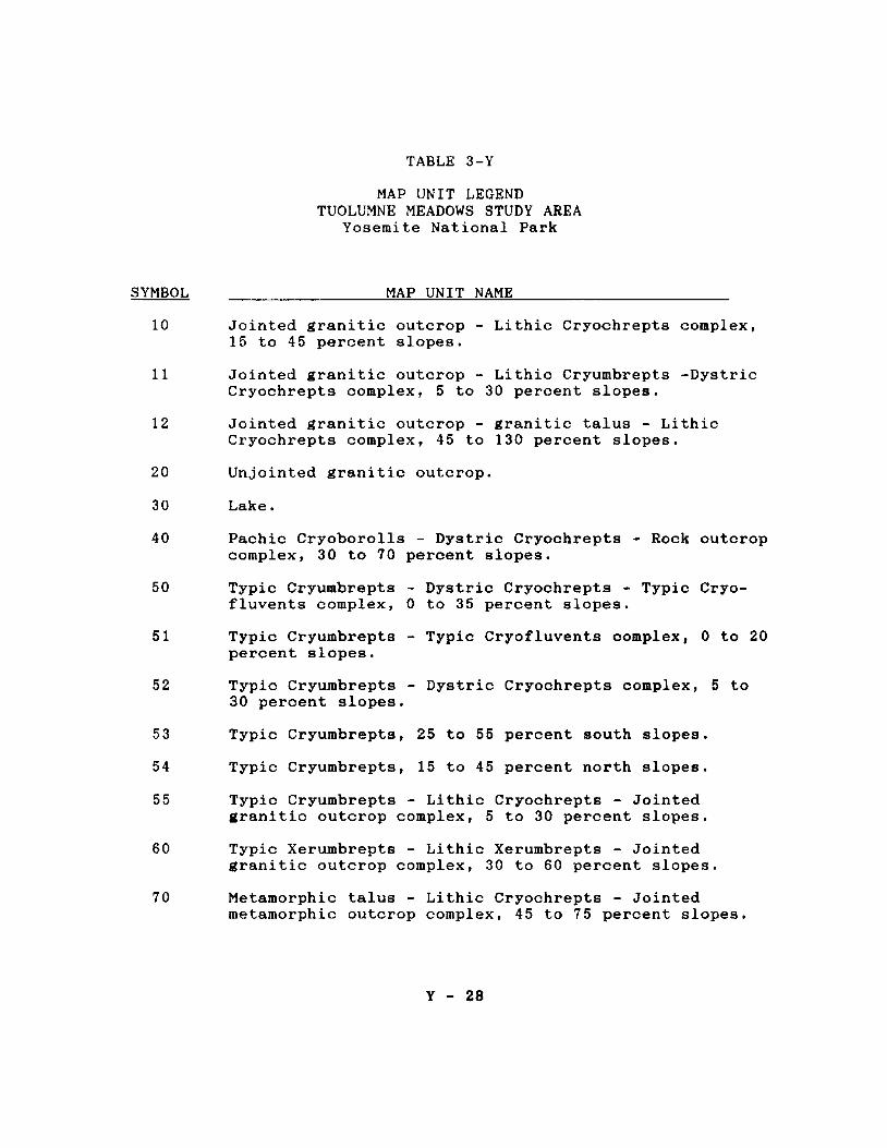
TABLE 3-Y
MAP UNIT LEGEND TUOLUMNE MEADOWS STUDY AREA
Yosemite National Park
SYMBOL MAP UNIT NAME
10 Jointed granitic outcrop 15 to 45 percent slopes.
-
11 Jointed granitic outcrop -Cryochrepts complex, 5 to
12 Jointed granitic outcrop -Cryochrepts complex, 45 to
Lithic Cryochrepts complex,
Lithic Cryumbrepts -Dystric 30 percent slopes.
granitic talus - Lithic 130 percent slopes.
20 Unjointed granitic outcrop.
30 Lake.
40 Pachic Cryoborolls - Dystric Cryochrepts - Rock outcrop complex, 30 to 70 percent slopes.
50 Typic Cryumbrepts - Dystric Cryochrepts - Typic Cryofluvents complex, 0 to 35 percent slopes.
51 Typic Cryumbrepts -percent slopes.
52 Typic Cryumbrepts -30 percent slopes.
53 Typic Cryumbrepts,
54 Typic Cryumbrepts,
55 Typic Cryumbrepts -
Typic Cryofluvents complex, 0 to 20
Dystric Cryochrepts complex, 6 to
25 to 55 percent south slopes.
15 to 45 percent north slopes.
Lithic Cryochrepts - Jointed granitic outcrop complex, 5 to 30 percent slopes.
60 Typic Xerumbrepts - Lithic Xerumbrepts - Jointed granitic outcrop complex, 30 to 60 percent slopes.
70 Metamorphic talus - Lithic Cryochrepts - Jointed metamorphic outcrop complex, 45 to 75 percent slopes.
Y - 28

82
MAP UNIT LEGEND, Continued
SYMBOL MAP UNIT NAME
71 Metamorphic outcrop -Cryumbrepts complex,
72 Metamorphic outcrop -brepts complex, 35 to
80 Lithic Cryochrepts -Cryumbrepts complex,
81 Lithic Cryumbrepts -
Lithic Cryochrepts - Typic 15 to 75 percent slopes.
metamorphic talus - Typic Cryum130 percent slopes.
Jointed granitic outcrop - Typic 5 to 30 percent slopes.
Dystric Cryochrepts - Jointed granitic outcrop complex, 30 to 55 percent slopes,
Lithic Cryochrepts - Jointed granitic outcrop complex, 5 to 30 percent slopes.
90 Dystric Cryochrepts -talus complex, 45 to
91 Dystric Cryochrepts,
100 Dystric Cryochrepts,
101 Dystric Cryochrepts -Cryochrepts complex,
102 Dystric Cryochrepts -percent slopes,
110 Typic Cryofluvents, 0
w Lakes and Other Water
Typic Cryumbrepts - metamorphic 75 percent slopes.
15 to 60 percent slopes.
15 to 45 percent slopes,
Jointed granitic outcrop -Lithic 40 to 75 percent slopes.
Aerie Cryaquepts complex, 0 to i5
to 5 percent slopes.
Bodies
Y - 29

MAP UNITS OF THE TUOLOMNE MEADOW STUDY AREA
DESCRIPTIONS OF MAP UNITS
10 Jointed sranitic outcrop - Lithic Cryochrepts complex, 15 to
45 percent slopes
The mapping unit is found on glacially quarried cirque basins and
valley floors, and footslopes and toes lopes of mountains. The
rock is predominantly granodiorite of Cathedral Peak.
This map unit is on sideslopes of Kuna Crest, Ragged Peak, and the
vicinity of Cathedral Peak and Medicott Dome. It is composed of
9 delineations.
80% Jointed granitic outcrop
15% Lithia Cryochrepts, loamy, mixed; 20 to 45 percent
slopes.
The Lithia Cryochrepts are shallow, well drained soils that occur
in joints, crevices, and on ledges associated with the rock
outcrop, It formed in colluvium and residuum from granodiorite
with an influence of volcanic ash, Vegetative cover is sparse,
consisting of clumps and individual trees of whitebark pine with
some lodgepole pine and mountain hemlock. Canopy cover is 10
percent or less,
Included in this unit are:
4% Lithia Cryorthents, loamy-skeletal, mixed; 20 to 45
percent slopes
1% Cryofluvents, 5 to 15 percent slopes
Y - 30

11 Jointed granitic outcrop - Lithia Cryumbrepts - Dystric Cryo
chrepts complex, 5 to 30 percent slopes
The map unit occurs on topographically complex glacially scoured
mountain footslopes and valley floors. The parent rock is pre
dominantly Half-Dome and Cathedral Peak granodiorite. The rock
outcrop is prominent and steep.
This map unit has 4 delineations near Murphy Creek, Tuolomne
Falls, and Medicott Dome.
45% Jointed granitic outcrop
25% Lithic Cryumbrepts, loamy, mixed; 10 to 30 percent
slopes
20% Dystric Cryochrepts, coarse-loamy, mixed; 5 to 15
percent slopes
The Lithia Cryumbrepts are shallow, well-drained soils occupying
benches, ledges and crevices between rock joints. The Dystric
Cryochrepts typically are deep moderately well drained soils found
in concave sideslopes between widely spaced joints. In addition,
there are moderately deep well drained soils in slightly higher,
more convex positions, These soils formed in volcanic ash and
granitic colluvium and residuum.
Vegetation is predominantly lodgepole pine with some mountain
hemlock and an occasional whitebark pine, The canopy cover varies
from 5 to 10 percent on Lithic Cryumbrepts to 15 to 25 percent on
Dystric Cryochrepts, The understory contains grasses, sedges,
ribes, phlox, and red mountain heather.
Y - 31

Included in this unit are:
8% Skeletal soils-Lithic Cryumbrepts and Dystric
Cryochrepts that contain more than 35 percent rock
fragments and are loamy-skeletal
2% Cryofluvents, 0 to 10 percent slopes
12 Jointed granitic outcrop - aranitic talus - Lithia Cryochrepts
complex, 45 to 130 percent slopes
The map unit is found on crests and ridges of mountains and
headwalls of cirque basins, It is near or above treeline. The
rock is granodiorite of the Cathedral Peak, Half Dome, and Kuna
Crest formations.
This map unit has 4 delineations that occur on higher elevations
near Ragged Peak, White Mountain, Mammoth Peak, and Kuna Crest,
50% Jointed granitic outcrop
20% Granitic talus
i5% Lithic Cryochrepts, loamy, mixed, 45 to 75 percent
slopes
The Lithia Cryochrepts are shallow, well-drained soils in joints,
crevices, and on ledges.
Vegetation cover is sparse or non-existent, Stunted whitebark
pine and heather occupy soil portions of this unit.
Included in this unit are:
5% Typic Cryorthents, sandy-skeletal, mixed, 30 to 50 percent slopes.
Y - 32

5% Cryaquepts
5% Felsenmeer
20 Unjointed granitic outcrop
This miscellaneous map unit consists of at least 80 percent
exposed outcrops of granite or granodiorite with a spacing of 100
meters or more between vertical joints that are 2 meters or
greater in depth. Sheet jointing parallel to the surface is
common, as is evidence of glacial polish.
Included in this unit are:
10% Jointed granitic outcrop
5% Lithic Cryochrepts, loamy, mixed
5% Dystric Cryochrepts, loamy, mixed
The latter two inclusions support sparse clumps and stands of
lodgepole and whitebark pine.
Examples of this unit are Pywiak, Polly, and Medicott Domes,
40 Pachic Cryoborolls - Dystric Cryochrepts - Jointed rock outcrop
complex, 30 to 70 percent slopes
This map unit occurs on steep glaciated shoulders and backslopes
of mountains near treeline. The unit is often characterized by
avalanche chutes, debris flows, rock slides, seeps, and larie
boulders. There are 7 delineations near Mammoth Peak, Gaylor
Lakes, and northeast of the Kuna Crest. The first two areas have
soils dominated by granitic rocks. The latter area has soils
influenced by granitic and metamorphic rocks.
Y - 33

45% Pachic Cryoborolls, loamy-skeletal, mixed, 30
to 60 percent slopes
20% Dystric Cryochrepts, loamy-skeletal, mixed, 36 to 'In'V
_,... __ ,... ...... .... , ................... j-lC.LVCU\., O:,.LV}J''l:.O:,
15% Jointed rock outcrop
The Pachic Cryoborolls are deep, moderately well to somewhat
poorly drained soils forming in colluvium. Slopes on the unit are
complex and these soils tend to occupy concave positions that are
both parallel and perpendicular to slope contour. The Dystric
Cryochrepts are deep and moderately deep, well drained soils
formed in colluvium and residuum on mostly convex slopes,
Included in this unit are:
13% Miscellaneous areas of talus, avalanche and
landslide debris, rubbleland, and felsenmeer
5% Lithic Cryochrepts, loamy-skeletal, mixed
2% Poorly drained Cryofluvents and seeps
50 Typic Cryumbrepts - Dystric Cryochrepts - Tzyic Cryofluvents
complex, 0 to 35 percent slopes
The map unit occurs on benched, bouldery sideslopes of moraines
and valley floors. There are 4 delineations in the western part
of the survey area.
50% Typic Cryumbrepts, loamy-skeletal, mixed, 10 to 35
percent slopes
20% Dystric Cryochrepts, coarse-loamy, mixed, 5 to 25
percent slopes
15% Typic Cryofluvents, coarse-loamy, mixed, 0 to 10
percent slopes.
Y - 34

The Typic Cryumbrepts are commonly deep, well and moderately well
drained soils forming in granitic colluvium and glacial till,
They are found on mainly north to east facing sideslopes of
moraines on slightly concave to smooth slopes. Less commonly,
they are moderately deep to granodiorite around rock outcrops.
The Dystric Cryochrepts have a notable volcanic ash influence
mixed with granitic colluvium, These soils are well to moderate
ly well drained, deep or moderately deep, often overlying a dense
till or rhyoli tic tuff. They are found on benches and lower
sideslopes of moraines adjacent to the valley floor. The Typic
Cryofluvents are commonly somewhat poorly drained, deep soils
forming in finer
recent alluvium over older, coarse glacial outwash, These soils
are found on valley floors and drainageways,
Overstory vegetation is predominantly lodgepole pine throuthout
the map unit, especially on the Typic Cryofluvents. However,
western white pine, red fir, and mountain hemlock are often well
represented on the Typic Cryumbrepts and Dystric Cryochrepts.
Below a good canopy cover of the latter two soils, the understory
1s often sparse grass, sedge, and ribes. Typic Cryofluvents have
an understory of sedges, grass, ribes, geraniums, and azaleas.
Included in this unit are:
5% Jointed granitic outcrop
3% Granitic talus (especially below Tenaya Peak)
2% Wet meadow areas
5% Typic Cryofluvents, sandy-skeletal, mixed, 0 to 3
percent slopes
Y - 35

51 Typic Cryumbrepts - Typic Cryofluvents complex, 0 to 20
percent slopes
The map unit is found on very stony to extremely bouldery ground
moraines of glacially scoured valleys and footslopes of granitic
mountains. The morainal deposits have complex, hilly topography
commonly with an east-west orientation of ridges. In between
morainal ridges are concave areas, mostly trending the same
direction, that contain kettles, small wet meadows, drainageways,
and old outwash terraces that contain a variety of soils, Small
lakes, ponds, and scoured granitic outcrops are also representa
tive. There are 12 delineations of this unit, many of which are
found on Moraine Flat and the lower end of Dana Meadows.
Included in this unit are:
65% Typic Cryumbrepts, loamy-skeletal, mixed, 5 to
20 percent slopes
15% Typic Cryofluvents, coarse-loamy and sandy
skeletal, mixed, 0 to 8 percent slopes
The Typic Cryumbrepts are moderately deep, moderately well and
well drained soils forming in bouldery glacial till with an
influence of volcanic ash in the upper solum. These soils are
commonly underlain by a dense, weakly brittle hardpan or localized
material from rhyolitic tuff. Less commonly, they are underlain
by granodiori te. This occurs on ridges and shoulders where
morainal deposits are thin, and in areas where morainal material
has been eroded away, such as along streams and channels. The
Typic Cryofluvents are very deep, somewhat poorly and poorly
drained soils forming in Holocene alluvium, sometimes underlain
by glacial outwash.
Y - 36
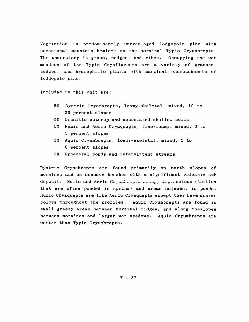
Vegetation is predominantly uneven-aged lodgepole pine with
occasional mountain hemlock on the morainal Typic Cryumbrepts.
The understory is grass, sedges, and ribes. Occupying the wet
meadows of the Typic are a variety of grasses,
sedges, and hydrophilic plants with marginal encroachments of
lodgepole pine.
Included in this unit are:
5% Dystric Cryochrepts, loamy-skeletal, mixed, 10 to
25 percent slopes
5% Granitic outcrop and associated shallow soils
5% Humic and Aerie Cryaquepts, fine-loamy, mixed, 0 to
3 percent slopes
3% Aquic Cryumbrepts, loamy-skeletal, mixed, 2 to
8 percent slopes
2% Ephemeral ponds and intermittent streams
Dystric Cryochrepts are found primarily on north slopes of
moraines and on concave benches with a significant volcanic ash
deposit, Humic and Aerie Cryochrepts occupy depressions (kettles
that are often ponded in spring) and areas adjacent to ponds.
Humic Cryaquepts are like Aerie Cryaquepts except they have irayer
colors throughout the profiles. Aquic Cryumbrepts are found in
small grassy areas between morainal ridges, and along toeslopes
between moraines and larger wet meadows. Aquic Cryumbrepts are
wetter than Typic Cryumbrepts,
Y - 37
52 Typic Cryumbrepts - Dystric Cryochrepts complex, 5 to 30
percent slopes
This map unit is on very stony to extremely bouldery moraines with
complex benched, dissected, hilly topography. There are 4
delineations found on Moraine Flat and west of Cathedral Peak.
65% Typic Cryumbrepts, loamy-skeletal, mixed, 5 to 30
percent slopes
15% Dystric Cryochrepts, loamy-skeletal, mixed, 5 to 30
percent slopes
The Typic Cryumbrepts are moderately deep, moderately well and
well drained soils. Typically, they formed in granitic glacial
till with an influence of volcanic ash, over a dense, compact
hardpan and localized material from rhyoli tic tuff, Less com-
monly, these soils formed in colluvium and residuum with an
influence of till and ash, and are underlain by granodiori te.
Soils underlain by bedrock are usually found on shoulders and
scoured ridgetops with thin morainal deposits, or on footslopes
and adjacent to drainages removed these de-
posits. The formation and parent material of the Dystric Cryo
chrepts do not differ significantly from the Typic Cryumbrepts
other than the former have a greater influence of volcanic ash in
the solum. Dystric Cryochrepts are found on ridges, concave
areas, and more northerly slopes of moraines where accumulation
of ash has been favored by position, and erosion off of rock
outcrops and boulders.
Vegetation is predominantly uneven-aged lodgepole pine, occasion
ally with mountain hemlock and western white pine on more norther
ly aspects and near drainages and wet areas. Canopy cover varies
Y - 38

from about 35 to 60 percent. The understory is mostly grasses,
sedges, and ribes,
Included in this unit are:
10% Sandy-skeletal, mixed, Dystric Cryochrepts and Typic
Cryorthents, 5 to 30 percent slopes
5% Granitic rock outcrop
5% Typic Cryofluvents
53 Typic Cryumbrepts, 25 to 55 percent south slopes
This map unit has 4 delineations on steep, bouldery, south-facing
slopes of lateral moraines. They are in the Moraine Flat area and
east of Lembert Dome,
85% Typic Cryumbrepts, loamy-skeletal, mixed, 25 to 55
percent slopes.
The Typic Cryumbrepts are well drained soils formine in eranitic
glacial till with an admixture of volcanic ash. These soils are
commonly moderately deep to hardpan till, rhyoli tic tuff, or
granodiorite bedrock. Less commonly, they are deep in unconsoli
dated morainal till.
Vegetation is lodgepole pine, grass, sedge, and ribes.
Included in this unit are:
5% Granitic outcrop
5% Lithic Cryumbrepts, loamy-skeletal, mixed, 25 to 45
percent slopes
Y - 39

5% Typic Cryorthents, sandy-skeletal, mixed, 25 to 55
percent slopes
54 Typic Cryumbrepts, 15 to 45 percent north slopes
The map unit is found on complex, benched, north-facing backslopes
and often slightly concave footslopes of bouldery moraines on
glacially eroded granitic mountainsides. There are 7 delinea-
tions, all in the southwestern portion of the survey area near
Tenaya Peak, and Medicott, Polly, and Fairview Domes,
85% Typic Cryumbrepts, loamy-skeletal, mixed, 15 to 45
percent slopes
The Typic Cryumbrepts are well drained, deep soils forming in
granitic colluvium over glacial till with an influence of volcanic
ash in the upper solum.
Vegetation is a mixed coniferous forest of red fir, lodgepole
pine, mountain hemlock, and western white pine. The understory
cunt~in~ ~p~r~~ grass and sedges but good regeneration of coni
ferous species.
Included in this unit are:
5% Granitic outcrop
5% Talus, rubble land, and Cryorthents resulting from
landslides
5% Dystric Cryochrepts, loamy-skeletal, mixed, 15 to 45
percent slopes
Y - 40

55 Ty-pie Cryµmbrepts - Lithic Cryochrepts - Jointed granitic
outcrop complex, 5 to 30 percent slopes
The mapping unit is on extremely bouldery shoulders, footslopes,
and valleys of glacially scoured granitic mountains. There are
13 delineations of this map unit.
40% Typic Cryumbrepts, loamy-skeletal, mixed, 5 to 30
percent slopes
25% Lithic Cryochrepts, loamy, mixed, 5 to 30 percent
slopes
20% Jointed granitic outcrop
The Typic Cryumbrepts are moderately well and well drained soils
that occupy mostly concave depositional areas along drainageways,
and on benches and footslopes between glacially scoured outcrops
of granitic rocks. They are moderately deep or deep soils forming
in colluvium, glacial till, or rhyolitic tuff, with an influence
of volcanic ash in the upper solum. The Lithic Cryochrepts are
well to somewhat excessively drained shallow soils formed in
colluviuw and residuum from glacially scoured granitic rocks with
a component of volcanic ash. These soils are found in joints and
crevices of rock outcrops and on ledges, benches, and sideslopes.
The granitic rock is granodiorite and granodiorite porphyry.
Vegetation is uneven-aged lodgepole pine with grasses, sedges, and
a few low shrubs such as ribes and chinquapin. Canopy cover is
fair on the Typic Cryumbrepts and sparse on the Li thic Cryo
chrepts.
Y - 41

Included in this map unit are:
5% Lithic Cryorthents, sandy or sandy-skeletal, mixed,
5 to 30 percent slopes
5% Typic Cryorthents, sandy or sandy-skeletal, mixed,
5 to 30 percent slopes
4% Cryofluvents
1% Kettles and small ponds
60 TyPic Xerumbrepts - Lithic Xerumbrepts - Jointed aranitic
outcrop complex, 30 to 60 percent slopes
The map unit is on extremely bouldery south-facing sideslopes of
glacially scoured granitic mountains, There are 4 delineations
in the vicinity of Fairview, Polly, and Lembert Domes,
45% Typic Xerumbrepts, loamy-skeletal, mixed, frigid, 30
to 60 percent slopes
30% Lithic Xerumbrepts, loamy, mixed, frigid, 30 to 60
percent slopes
20% Jointed granitic outcrop
The Typic Xerumbrepts are moderately deep, well drained soils
forming in colluvium, till, and rhyolitic tuff over granodiorite.
They are on slightly concave mid and lower sideslopes. The Lithic
Xerumbrepts are shallow, well drained soils over •ranodiorite.
They are associated with rock outcrop.
Vegetation is western juniper, Jeffrey pine, lodgepole pine, and
chinquapin on the Typic Xerumbrepts. Manzanita, Phlox, and
western juniper is characteristic of the Lithic Xerumbrepts.
Y - 42

Included with this unit are:
5% Lithic Cryochrepts loamy-skeletal, mixed, 30 to 60
70 Metamorphic talus - Lithic Cryochrepts - Jointed metamorphic
outcrop complex, 45 to 75 percent slopes
The map unit has 3 delineations on the flanks of Gaylor Peak, and
Mounts Dana and Gibb. This unit is on mountain ridges and
sideslopes. The exposed brownish metamorphosed volcanic and
sedimentary rock is high in quartz and pyroclastic material.
60% Metamorphic talus
15% Lithic Cryochrepts, loamy-skeletal, mixed, 45 to 75
percent slopes
15% Jointed metamorphic outcrop
The talus is composed of channers, flags, and stone-size fragments
with less than 5 percent soil material. The Lithic Cryochrepts
are shallow, somewhat excessively drained soils forming in
colluvium and residuum from metamorphic rock. The outcrop
consists of exposed, mainly vertically jointed metavolcanic or
metasedimentary rock,
Vegetation is scattered, clumped and prostrate whitebark pine and
sagebrush, with grass, sedges, phlox, and mountain heather.
Included with this unit are:
5% Lithic Cryorthents, loamy-skeletal, mixed, 5 to 45
percent slopes
Y - 43

5% Dystric Cryochrepts, loamy skeletal, mixed, 35 to 55
percent slopes
The Lithic Cryorthents are very shallow soils, mostly on exposed
ridges and saddles. The Dystric Cryochrepts are deep soils on
colluvial fans.
71 Metamorphic outcrop - Lithic Cryochrepts - Typic Cryuabrepts
complex, 15 to 75 percent slopes
The map unit is located on mountain ridges, shoulders and sides
lopes, along the contact between granitic and metamorphic rocks.
There are 4 delineations near Gaylor Peak and above Parker Pass
Creek.
60% Metamorphic outcrop
20% Lithia Cryochrepts, loamy, mixed, 25 to 75 percent
slopes
15% Typic Cryumbrepts, loamy-skeletal, mixed, 15 to 40
percent slopes
The outcrop is mostly vertically jointed metavolcanic and meta
sedimentary rocks such as tuffs and hornfels. The Lithic Cryo
chrepts formed in residuum and colluvium from mostly metavolcanic
rocks in cracks, fissures, and around rock outcrop. The Typic
Cryumbrepts are mostly deep, well drained soils that formed in
mixed colluvium from metamorphic and granitic rocks. They occur
on concave benches and around bases of rock outcrops. Both soils
also contain a component of volcanic ash.
Vegetation is scattered, stunted whitebark pine growinl in shallow
pockets of soil associated with rock outcrop. Grass and sedge out
competes trees and shrubs on the deep soil on benches.
Y - 44

Included in this unit are:
4% Metamorphic talus
1% Cryofluvents and seeps
72 Metamorphic outcrop - Metamorphic talua - TyPic CrYUllbrepts
complex, 35 to 130 percent slopes
There are 5 delineations of this map unit along the Sierra Crest.
The unit is located on mountain ridges, shoulders, and sideslopes,
mainly above tree-line.
35% Metamorphic outcrop, 45 to 130 percent slopes
30% Metamorphic talus, 45 to 75 percent slopes
25% Typic Cryumbrepts, loamy-skeletal, mixed, 35 to 50
percent slopes
The metamorphic rocks include volcanic tuffs and flows, shale,
local graywackes, and calc-silicate hornfels. The talus consists
of angular channers, flags, and boulders found below rock outcrop.
The Typic Cryumbrepts formed in colluvium. They are well drained,
deep and moderately deep soils.
Vegetation is mainly low growing shrubs like mountain heather,
with phlox, buckwheat, and sedges. Scattered, stunted clumps of
whitebark pine are also present.
Included in this map unit are:
10% Li thic Cryorthents, loamy-skeletal, mixed located
around rock outcrops
Y - 45

80 Lithic Cryochrepts - Jointed 1ranitic outcrop - TyPic
Cryumbrepts complex, 5 to 30 percent slopes
There are 3 delineations of this map unit that occurs on glacial-
ly scoured valley floors and plateaus.
40% Li thic Cryochrepts, loamy, mixed, 5 to 15 percent
slopes
30% Jointed granitic outcrop
20% Typic Cryumbrepts, loamy-skeletal, mixed, 10 to 30
percent slopes
The Lithic Cryochrepts are well drained soils forming in a thin
mantle of volcanic ash and glacial till over granodiorite. They
are on ledges, benches, fissures, and joints on and around rock
outcrop. The rock outcrop is sparsely jointed, glacially modified
and mostly smooth with a gently rolling surface of exposed Cathe-
dral Peak or Half Dome granodiorite, The Typic Cryumbrepts are
mainly well drained, moderately deep soils forming in mixed
colluvium, slopewash, glacial till, and volcanic ash, underlain
by dense, compacted glacial till or volcanic tuff. They occur
mainly in concave areas associated with larger joints. Areas
along drainages and lower sideslopes are deep, moderately well
drained, and have fewer coarse fragments.
Vegetation is uneven-aged lodgepole pine, grass, sedge, manzanita,
sagebrush, and ribes. Canopy cover is about 10 percent on shallow
soils, and about 25 to 50 percent on deeper soils,
Included in this map unit are:
5% Typic Cryorthents, sandy-skeletal, mixed, 6 to 30
percent slopes
Y - 46

5% Typic Cryofluvents, loamy-skeletal, mixed, 0 to 15
percent slopes. Poorly and somewhat poorly drained
alluvial soils
81 Lithic CrYUJDbrepts - Dystric Cryochrepts - Jointed granitic
outcrop complex, 30 to 55 percent slopes
The map unit is on glacially scoured shoulders and backslopes of
granitic mountains. There are 9 delineations that occur in the
western portion of the survey area,
35% Lithic Cryumbrepts, loamy, mixed, 30 to 55 percent
slopes
25% Dystric Cryochrepts, loamy-skeletal, mixed, 30 to 55
percent slopes
25% Jointed granitic outcrop
The Lithia Cryumbrepts are well to somewhat excessively drained
soils formed in colluvium and residuum from granitic rocks with
an influence of volcanic ash. They occupy ledges, benches, rock
fl~~ur~~, and steep slopes in complex association with rock
outcrop. The Dystric Cryochrepts are moderately deep and deep,
moderately well to well drained soils. They formed in colluvium
and residuum from granitic rocks, granitic glacial till, weather
ed tuff, and volcanic ash, They occupy concave positions in small
drainageways, and are on benches, sideslopes, and colluvial fans.
The rock outcrop is Half Dome and Cathedral Peak granodiorite.
Vegetation is uneven-aged lodgepole pine. The canopy varies from
5 to 15 percent on Lithic Soils in association with rock outcrop,
to 25 to 50 percent on deeper soils in concave positions. The
understory includes fescue and sedges, with ribes, manzanita, and
sagebrush.
Y - 47

Included with this unit are:
10% Lithic Cryumbrepts, loamy-skeletal, mixed, 30 to 55
4% Lithic Cryorthents, sandy-skeletal, mixed, 30 to 55
percent slopes
1% Cryofluvents
82 Lithic Cryochrepts - Jointed sranitic outcrop complex, 5 to 30
percent slopes
There are 4 delineations of this map unit near the northern survey
boundary below Ragged Peak and White Mountain. The unit is on
glacially scoured cirque basins.
60% Lithic Cryochrepts, loamy, mixed, 5 to 30 percent
slopes
20% Jointed granitic outcrop
The Li thic Cryochrepts formed in thin layers of residuu■ and
glacial till overlying scoured, sparsely jointed aranodiorite.
The surface is usually extremely bouldery,
Vegetation is small stands of lodgepole and whitebark pine with
sedge, phlox, and buckwheat.
Included in this unit are:
10% Sandy-skeletal soils, Lithic and Typic Cryorthents,
mixed, 5 to 30 percent slopes
10% Typic Cryumbrepts, loamy-skeletal, mixed, 5 to 30
percent slopes
Y - 48

90 Dystric Cryochrepts - TyPic Cryµabrepts - aetaaorphic talus
complex, 45 to 75 percent slopes
.. 1 ..This map unit has 2 delineations UIJ .:t\..VU,Y t unstable,e'h.\.,I..IO'W"e.l..Y
middle and lower sideslopes below Mount Dana and Mount Gibbs.
40% Dystric Cryochrepts, loamy-skeletal, mixed, 45 to 65
percent slopes
25% Typic Cryumbrepts, loamy-skeletal, mixed, 45 to 65
percent slopes
20% Metamorphic talus, 50 to 75 percent slopes
The Dystric Cryochrepts are deep, well drained soils found on
lower convex sideslopes. The Typic Cryumbrepts are on upper and
middle sideslopes. Both soils are deep and well drained, forming
in colluvium and volcanic ash. The talus is composed of flags,
channers, stones, and boulders from metamorphic rocks such as
volcanic tuffs, quartzite, and calc-silicate hornfels.
Vegetation is mainly lodgepole pine on lower sideslopes and
whitebark pine on upper sideslopes, with sedges and grasses.
Included in this unit are:
5% Metamorphic outcrop
10% Pachic Cryoborolls, loamy-skeletal, mixed, 46 to 60
percent slopes
The Pachic Cryoborolls have thick dark surfaces, are somewhat
poorly drained, and occur on lower concave sideslopes in associ
ation with seeps.
Y - 49

91 Dystric Cryochrepts, 15 to 60 percent slopes
This map unit has 2 delineations located on backslopes and foot-
slopes of the glacially carved Parker Pass Creek valley, The
complex dissected and benched morainal slopes are mostly 25 to 45
percent, but slope limits widened to accommodate benches and steep
dissections. Surface is very stony to extremely bouldery.
85% Dystric Cryochrepts, loamy-skeletal, mixed, 15 to 60
percent slopes
These are well drained, deep and moderately deep soils forming in
colluvium and glacial till, with the influence of volcanic ash.
Rock fragments are from mixed granitic and metamorphic sources.
On lower sideslopes and benches, a dense, brittle till pan may
occur between 20 to 40 inches,
Vegetation is predominantly lodgepole pine with minor amounts of
mountain hemlock and whitebark pine on upper slopes, Understory
is mostly grasses, sedges, and ribes,
Included with this unit are:
5% Metamorphic rock outcrop
10% Typic Cryumbrepts, loamy-skeletal, mixed, 20 to 45
percent slopes.
100 Dystric Cryochrepts, 15 to 45 percent slopes
There are 6 delineations of this map unit. They occur on more or
less northerly slopes on extremely bouldery dissected lateral
moraines and sideslopes of granitic mountains.
Y - 50

80% Dystric Cryochrepts, loamy-skeletal, mixed, 15 to 45
percent slopes
These soils are well drained, forming in colluvium and residuum
from granitic rocks, glacial till, and influenced by volcanic ash
in the upper solum. They may be deep in glacial till, but
commonly are moderately deep over granodiorite or dense till pan.
Vegetation is primarily lodgepole pine with mountain hemlock and
minor western white pine. Understory is grass, sedges, and ribes.
Canopy cover varies from 35 to 65 percent.
Included in this map unit are:
10% Typic Cryumbrepts, loamy-skeletal, mixed, 15 to 45
percent slopes
5% Sandy-skeletal, Typic Cryorthents and Dystric
Cryochrepts, 15 to 45 percent slopes
3% Cryofluvents, wet meadows, and Pachic Cryoborolls
along drainages and seeps
2% Granitic rock outcrop or rubbleland from landslides
101 Dystric Cryochrepts - Jointed aranitic outcrop - Lithia Cryo
chrepts complex, 40 to 75 percent slopes
This map unit has 11 delineations that occur on the upper timbered
sideslopes of granitic mountains.
40% Dystric Cryocbrepts, lnAmy-~kPlP~Al, mixed, 40 to 75
percent slopes
25% Jointed granitic outcrop
15% Lithic Cryochrepts, loamy, mixed, 40 to 75 percent
slopes
Y - 51

The Dystric Cryochrepts are deep, well drained soils forming in
colluvium, glacial till, and volcanic ash, which are underlain by
granodiorite, They occur on slightly concave sideslopes with very
bouldery surfaces. The Lithic Cryochrepts are formed in the same
material and occur between rock joints and crevices,
Vegetation is whitebark pine and lodgepole pine, with sedges,
ribes, mountain heather, and mountain sagebrush.
Included in this map unit are:
10% Typic Cryumbrepts and Li thic Cryumbrepts, loa.my
skeletal, mixed, 40 to 75 percent slopes
7% Granitic talus
3% Cryofluvents, 15 to 35 percent slopes
102 Dystric Cryochrepts - Aerie Cr7aguepts complex, 0 to 15
percent slopes
This map unit is on hummocky, alpine meadows at elevations above
9400 feet. The unit is characterized by morainal ridges and
depressions, often dotted with large boulders, and a number of
small lakes or kettles are prominent. The unit has 9 delinea
tions.
65% Dystric Cryochrepts, loamy-skeletal and coarse-loamy,
mixed, 5 to 15 percent slopes
20% Aerie Cryaquepts, fine-loamy, mixed, 0 to 10 percent
slopes
The Dystric Cryochrepts are moderately deep to a brittle till pan.
They are moderately well drained soils forming on convex slopes
Y - 52

and ridges of morainal deposits. Commonly, these soils contain
many rock fragments (>35%) in the profile and the surface is very
stony to extremely bouldery, Less commonly, the soil profile
averages 15 to 35 percent rock fragments, and it may be somewhat
poorly drained in areas adjacent to depressions. The Aerie
Cryaquepts are poorly and very poorly drained soils in depressions
and along drainageways, They are also underlain by a hardpan and
are moderately deep. The morainal deposits are primarily gran
itic, but metamorphic rocks influence the till alon1 Parker Pass
Creek,
Vegetation is mainly water tolerant sedges and grasses, but
includes encroaching whitebark and lodgepole pine, and willow on
wetter sites.
Included in this unit are:
5% Sandy-skeletal, mixed Typic Cryorthents and Dystric
Cryochrepts
5% Sandy-skeletal, mixed Typic Cryofluvents
5% Small lakes and ponds
The sandy-skeletal Typic Cryorthents and Dystric Cryochrepts are
found on coarse poorly sorted outwash and morainal deposits. The
Typic Cryofluvents are along drainageways and creeks,
110 Typic Cryofluvents, 0 to 5 percent slopes
There are 5 delineations of this map unit. These are the wet
alluvial areas of Tuolomne and Dana Meadows. They are on glacial
ly eroded valley floors.
Y - 53

70% Typic Cryofluvents, coarse-loamy, mixed, 0 to 5
percent slopes
20% Typic Cryofluvents, sandy-skeletal, mixed, 0 to 3
percent slopes
These are the very deep, somewhat poorly to poorly drained soils
forming in Holocene valley fill material in glaciated sub-alpine
meadow areas. The material ranges from loamy to very coarse and
depth to sand and gravel ranges from 12 to greater than 60 inches.
Vegetation is grasses, sedges, and hydrophilic plants. Lodgepole
pine is often encroaching on the better drained meadow edges.
Included in this unit are:
5% Humic and Aerie Cryaquepts, fine-loamy, mixed, 0 to
2 percent slopes
3% Granitic outcrop (especially western Tuolomne
Meadows)
2% Streams and channels
W Lakes and Other Water Bodies
This miscellaneous unit has 14 delineations. These are kettles
or tarns of 5 acres or more that are all associated with glacial
scouring and depositions.
Examples are Tenaya, Dog, Polly, Cathedral, and Helen Lakes.
Y - 54

SOIL SURVEY OF DOUGHERTY PEAK STUDY AREA
KINGS CANYON NATIONAL PARK
DESCRIPTION OF THE AREA
LOCATION
The Dougherty Peak study area encompasses approximately 25,000
acres within the west-central portion of the Kings Canyon National
Park (Marion Peak 15' quadrangle. Located within the Sierra Nevada
of California, the study area lies between the coordinates of
latitudes 36° 48' and 37° 00' north and longitudes 118° 31' and 118°
38' west.
The Kings River forms the northern boundary; Murray Ridge, Cirque f"'!y.,oct- j anr1 f:.nat- Crest the east hn11nrla-ry; a.nrl no.An Pi no R_; rlg,::. t,h,:a
west boundary. The southern boundary begins at Kennedy Pass,
continues east along Comb Spur before crossing Granite Basin and
continuing north to Goat Crest. The Dougherty Peak study area is
located in southeastern Fresno County,
TERRAIN
The complex terrain is characterized by deeply incised canyons,
glacial basins and valleys, mountain summits, cirques, and tarns,
The terrain is very rugged with elevations ranging from 5,900 to
12,600 feet. The topography is predominantly complex with very
steep to extremely steep slopes. The terrain reflects the land-
forming influence of extensive glaciation so characteristic of the
High Sierra. Cirque lakes, deeply incised basins and expanses of
exposed granitic peaks and walls are common features,
KC - 1

GENERAL GEOLOGY
Typical of the western slope of the Southern Sierra Nevada,
Cretaceous age granite, granodiori te, and similar acid-igneous
rocks comprise the vast majority of the Dougherty Peak study area,
Remnant mafic plutonic and metavolcanic rocks (Mesozoic) occur as
small islands south and east of State Lakes, along the southeast
corner of Dead Pine Ridge and around Windy Peak.
The area has been heavily glaciated. Only a few small alpine peaks
and summits occurring at elevations of 11,000 feet or higher remain
unglaciated. The glaciers left relatively little debris behind
them. This is supported by the large amount of shallow soils in
this area. Many traces of past glaciation remain including the
presence of moraines, erratic boulders, chain lakes, cirques,
tarns, and glacial polish on rocks,
VEGETATION
The natural vegetation reflects the soil and climatic patterns of
the area. There are six communities in this area:
0 Mountain Chaparral
0 Jeffrey Pine Forest
0 Red Fir Forest
0 Lodgepole Pine Forest
0 Subalpine Forest
0 Subalpine and Alpine Meadow
The Mountain Chaparral and Jeffrey Pine Forest communities occupy
the lowest and warmest areas, elevation from 5,900 feet to 8,000
feet on the warmer aspects. Wildfires are common, Brush thickets
composed of plants such as snow brush, bitter cherry, manzanita,
sagebrush, chinquapin and canyon oak comprise the mountain
chaparral community. They occupy dry and rocky slopes often in
KC - 2

association with talus. The soils are predominantly shallow and
skeletal, commonly having well developed subsoils. Jeffrey pine
along with black oak, incense cedar, sugar pine, white fir and
western juniper make up the primary plants in the Jeffrey o; n.o
Forest. This community often has a shrub understory, The soils
tend to be moderately deep and deep, and typically skeletal and
coarse textured.
Red Fir Forest community occurs on cool, well drained soils at
elevations from 7,000 to 9,000 feet. They occur in even-aged
stands with few associates. The sites they occupy often receive
high amounts of snowfall.
The largest community in the survey area is the Lodgepole Forest.
It ranges from 8,000 to 11,000 feet and occurs on glacially scoured
ridges, valleys and basins and lower mountain sides lopes. The
soils are cold and normally poorly developed but range greatly in
depth. Typically the understory is sparse and consequently, litter
accumulation is low.
The next higher community, the Subalpine Forest, is found uu J.-ut...;h..r
mountain ridges, crests and sideslopes at elevations from 9,500 to
12,000 feet. The trees appear stunted and sparsely scattered.
They include lodgepole pine, western white pine, and whitebark pine
with very little understory or litter. Soils are shallow and very
shallow.
The highest community, the Alpine Community, occurs on the upper
glacial basins and upper mountain ridges and sideslopes above
timberline. Plants are low growing and consist of alpine herbs
such as pussypaws, dwarf Lewisia, buckwheat, and shrubs such as
currant and willow. Soils are very shallow and shallow and very
cold.
KC - 3

The last community is the Subalpine and Alpine Meadows. They are
dominated by various species of sedges, meadow grasses, and
willows. Soils are mostly deep and are very poorly and poorly
drained.
KC - 4
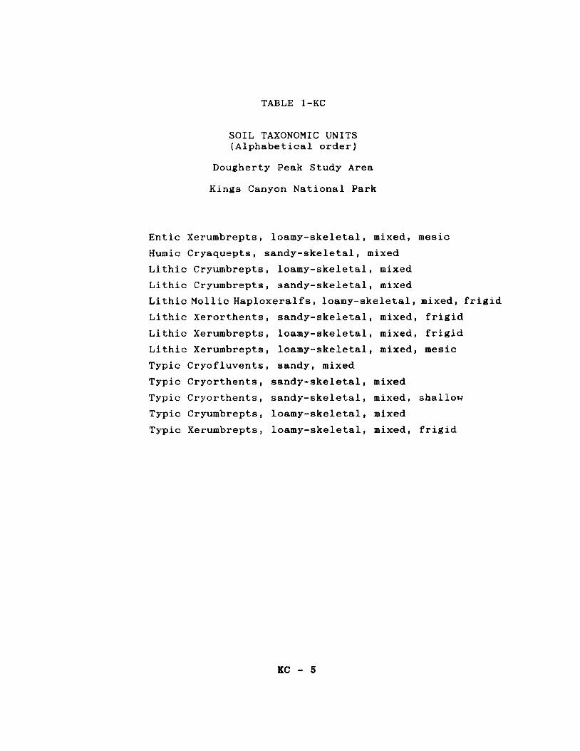
TABLE 1-KC
SOIL TAXONOMIC UNITS (Alphabetical order)
Dougherty Peak Study Area
Kings Canyon National Park
Entic Xerumbrepts, loamy-skeletal, mixed, mesic
Humic Cryaquepts, sandy-skeletal, mixed
Lithic Cryumbrepts, loamy-skeletal, mixed
Lithic Cryumbrepts, sandy-skeletal, mixed
Lithic Mollie Haploxeralfs, loamy-skeletal, mixed, frigid
Lithic Xerorthents, sandy-skeletal, mixed, frigid
Lithic Xerumbrepts, loamy-skeletal, mixed, frigid
Lithic Xerumbrepts, loamy-skeletal, mixed, mesic
Typic Cryofluvents, sandy, mixed
Typic Cryorthents, sandy-skeletal, mixed
Typic Cryorthents, sandy-skeletal, mixed, shallow
Typic Cryumbrepts, loamy-skeletal, mixed
Typic Xerumbrepts, loamy-skeletal, mixed, frigid
KC - 5

TABLE 2-KC
CLASSIFICATION TABLE OF TAXONOMIC UNITS
Dougherty Peak Study Area
Kings Canyon National Park
ALFISOLS
Haploxeralfs
Lithic Mollie Haploxeralfst loamy-skeletal, mixed, frigid
ENTISOLS
Cryofluvents
Typic Cryofluvents, sandy, mixed
Cryorthents
Typic Cryorthents, sandy-skeletal, mixed Typic Cryorthents, sandy-skeletal, mixed, shallow
Xerorthents
Lithic Xerorthents, loamy-skeletal, mixed, frigid
Cryaquepts
Humic Cryaquepts, sandy-skeletal, mixed
Cryumbrepts
Typic Cryumbrepts, loamy-skeletal, mixed Lithic Cryumbrepts, loamy-skeletal, mixed Lithic Cryumbrepts, sandy-skeletal, mixed
Xerumbrepts
Typic Xerumbrepts, loamy-skeletal, mixed, frigid Entic Xerumbrepts, loamy-skeletal, mixed, mesic Lithic Xerumbrepts, loamy-skeletal, mixed, mesic Lithic Xerumbrepts, loamy-skeletal, mixed, frigid
KC - 6

TAXONOMIC UNITS IN THE DOUGHERTY PEAK STUDY AREA
DESCRIPTION OF TAXONOMIC UNITS
Entic Xerumbrepts, loamy-skeletal, mixed, mesic
This soil family consists of moderately deep and deep, somewhat
excessively drained soils that formed in colluvium from granitic
rock sources, They occur on canyon sideslopes. Slopes range from
45 to 75 percent slopes.
These soils are poorly developed and have moderately coarse
textures. Typically they have a moderately thick dark colored
surface layer over a lighter colored substratum.
Following is a profile description of a representative pedon
( 88-2K-27) found in the map unit 29 Jointed daci tic outcrop -
Lithic Xerumbrepts - Typic Xerumbrepts complex, 45 to 130 percent
slopes. It is located near the Simpson Meadow about 1 mile
southwest of Windy Peak on the Marion Peak 15' quadrangle.
Elevation is approximately 6700 feet.
Oi--0.5 to O inches; slightly decomposed conifer needles
and shrubs leaves and twigs,
Al--0 to 5 inches; brown (lOYR 4/3) very stony coarse
sandy loam, very dark grayish brown (lOYR 3/2) moist;
moderate very fine and fine granular structure; soft
very friable, nonsticky and nonplastic; many very fine
and fine roots; many fine and medium interstitial
pores; 30 percent pebbles, 10 percent cobbles, and 10
percent stones; abrupt wavy boundary,
KC - 7

AC--5 to 19 inches; yellowish brown (l0YR 5/4) very
cobbly coarse sandy loam, dark brown (l0YR 3/3) moist;
weak very fine and fine subangular blocky structure;
common very fine, fine and medium roots; common very
fine and fine interstitial pores; 20 percent pebbles,
20 percent cobbles, and 10 percent stones; clear wavy
boundary.
C--19 to 42 inches; yellowish brown (l0YR 5/4) very
cobbly coarse sandy loam, brown ( l0YR 4/3) moist;
massive; few fine and medium roots; common very fine
and medium interstitial pores; 20 percent pebbles, 30
percent cobbles, and 10 percent stones.
Remarks: About a third of the soils surfaces have litter on them.
The soil temperature taken at 20 inches on 7/13/88 at 1:00 p.m.
was 68°F.
Humic Cryaguepts, sandy-skeletal, mixed
This soil family consists of deep, very poorly and poorly drained
soils that formed in alluvium and some morainal material weathered
from granitic rock sources. They occur on drainageways and around
seeps. Slopes range from 5 to 15 percent.
Typically they have very dark colored surface layers over lighter
colored stratified substratums that are frequently mottled.
Following is a profile description of a representative pedon
(88-2K-04) found on map unit 90 Humic Cryaquepts-Typic Cryofluvents
complex, 0 to 15 percent slopes. It is located north of Glacier
Lakes about 7,054 feet S20°E of bench mark (BM) 9652 on the Marion
Peak Quadrangle, USGS (photo 7-222). The elevation is 32,710 m
(9,970 feet), 15 percent slope on a southeast aspect.
KC - 8

Oa--0 to 9 inches; dark gray (lOYR 4/1) "silty" muck held
together by many very fine and fine roots, very dark
brown (lOYR 2/2) moist; structureless; friable,
slightly sticky and slightly plastic; many very fine
interstitial pores; abrupt wavy boundary,
A--9 to 12 inches; dark gray (lOYR 4/1) silt loam, black
(lOYR 2/1) moist; massive; many very fine roots; many
very fine interstitial pores; abrupt wavy boundary.
2Cg--12 to 23 inches; gray (5Y 5/1) gravelly coarse sandy
loam, dark gray (5Y 4/1) moist; massive; friable,
nonsticky and nonplastic; common very fine inter
stitial pores; gradual wavy boundary.
3Cg--23 to 60 inches; gray ( 5Y 5/1) extremely cobbly
coarse sand, dark gray i5Y 4/1) moist, few medium dis
tinct yellowish brown (lOYR 5/6) iron mottles; single
grained; loose, loose, nonsticky and nonplastic; 15
percent pebbles, 40 percent cobbles, and 10 percent
stones.
Remarks: The water table was at 25 inches on 7/5/88.
Lithic Cryumbrepts, loamy-skeletal, mixed
This soil map unit consists of very shallow and shallow, well and
somewhat excessively drained soils that formed in residuum and some
colluvium weathered from granitic rock sources.
Typically they have a dark surface layer over a brighter (higher
chroma) subsoil resting over granitic rock,
Following is a profile description of a representative pedon
( 88-2K-17) found in the map unit 22 Jointed granitic outcrop -
KC - 9

Lithia Cryumbrepts complex, 15 to 45 percent slopes, It is located
north of Granite Lake about 0,5 mile south of Granite Pass on the
Marion Peak 15' quadrangle, Elevation is approximately 10200 feet,
Oi--0. 5 to O inches; slightly decomposed conifer needles,
twigs and cones,
Al--0 to 4 inches; very dark grayish brown (lOYR 3/2)
extremely bouldery coarse sandy loam, very dark brown
(lOYR 2/2) moist; moderate very fine granular struc
ture; soft, very friable, nonsticky and nonplastic;
many very fine and fine roots; many fine and medium
interstitial pores; 20 percent pebbles, 15 percent
cobbles, 15 percent stones, and 20 percent boulders;
abrupt wavy boundary,
A2--4 to 11 inches; dark yellowish brown ( lOYR 3/4)
extremely stony coarse sandy loam, dark yellowish
brown (lOYR 3/4) moist; moderate very fine subangular
blocky structure; soft, very friable, nonsticky and
nonplastic; many very fine and fine roots; many fine
and medium interstitial pores; 15 percent pebbles, 15
percent cobbles, 20 percent stones, and 15 percent
boulders; abrupt wavy boundary,
A3--ll to 18 inches; dark yellowish brown (lOYR 4/4) ex
tremely stony coarse sandy loam, dark yellowish brown
(lOYR 3/4) moist; weak very fine subangular blocky
structure; soft, very friable, nonsticky and nonplas
tic; common very and fine roots; common fine and
medium pores; 10 percent pebbles, 30 percent cobbles,
30 percent stones, and 20 percent boulders; abrupt
wavy boundary,
2R--18 inches; fractured granitic rock,
KC - 10

Remarks: The soil temperature taken at 18 inches on 7/9/88 at
10:00 a,m, was 60°F,
Lithic Cryumbrepts, sandy-skeletal, mixed
This soil family consists of very shallow and shallow, excessively
drained soils that formed in residuum and colluvium from granitic
rock sources. They occur on unglaoiated canyon sideslopes. Slopes
range from 45 to 75 percent slopes.
Typically they have a dark surface layer resting on top of hard
granitic rock,
Following is a profile description of a representative pedon
(88-2K-20) found in the map unit 110 Lithic Cryumbrepts - Lithic
Xerorthents - Jointed granitic outcrop complex, 45 to 75 percent
slopes. It is located near Windy Peak about 1.5 miles southeast
of Simpson Meadow on the Marion Peak 15' quadrangle. Elevation is
approximately 8400 feet.
Oi--0. 5 to O inches; slightly decomposed conifer needles,
twigs and cones,
Al--0 to 3 inches; brown (l0YR 5/3) extremely gravelly
loamy coarse sand, very dark grayish brown (l0YR 3/2)
moist; moderate very fine granular structure; common
very fine roots; common very fine interstitial pores;
65 percent pebbles, 5 percent cobbles; clear wavy
boundary.
A2--3 to 7 inches; brown (lOYR 5/3) extremely gravelly
loamy coarse sand, dark brown (lOYR 3/3) moderate fine
and medium subangular blocky structure; many very fine
KC - 11

gravelly
and common fine roots; common very fine interstitial pores;
60 percent pebbles, 5 percent cobbles; clear wavy boundary,
loamy sand, brown (lOYR 5/3) moist; weak fine and
medium subangular blocky structure; soft, very fri
able, nonsticky and nonplastic; common very fine, fine
and medium roots; common very fine interstitial pores;
50 percent pebbles, 5 percent cobbles; abrupt wavy
boundary,
ZR--13 inches; hard, fractured granitic rock,
Remarks: The soil temperature taken at 13 inches on 7/12/88 was
59°F.
Lithia Mollie Haploxeralfs, loamy-skeletal, mixed, friSid
This soil family consists of very shallow and shallow, well drained
soils that formed in residuum and colluvium from granitic rock
sources. Thc.1 v.._,1..;u.L vu. .... a.u.1vu sides lopes around jointed arani tic
outcrop, Slopes range from 45 to 75 percent.
Typically these soils have dark colored layers and a well developed
subsoil that rests on granite,
Following is a profile description of a representative pedon (88-
2K-24) found in the map unit 60 Lithic Xerumbrepts - Lithic Mollie
Haploxeralfs - Typic Xerumbrepts complex, 45 to 75 percent slopes.
It is located 1. 5 miles northeast of Windy Peak on the north
northwest facing slopes of Windy Ridge on the Marion Peak 15'
quadrangle. Elevation is approximately 8,000 feet.
KC - 12
Al--0 to 2 inches; grayish brown (l0YR 5/2) extremely
gravelly coarse sandy loam, very dark brown (l0YR
2/2) moist; weak fine granular structure; soft,
very friable, nonsticky and nonplastic; common very
fine roots; common very fine interstitial pores;
45 percent pebbles, 20 percent cobbles, and 5
percent stones; clear wavy boundary,
A2--2 to 6 inches; grayish brown (l0YR 5/2) very cobbly
coarse sandy loam, very dark brown ( l0YR 2/2)
moist, weak fine and medium subangular blocky
structure; soft, very friable, nonsticky and non
plastic; common very fine roots; common very fine
interstitial and few fine tubular pores; 20 percent
pebbles, 20 percent cobbles, and 10 percent stones;
abrupt wavy boundary,
Bt--6 to 10 inches; brown (l0YR 5/3) cobbly loam, brown
(l0YR 3/3) moist; moderate medium and coarse
angular blocky structure; slightly hard, friable,
slightly sticky and slightly plastic; common very
fine and fine tubular pores; common thin clay films
on ped faces and few moderately thick clay films
lining pores; 10 percent pebbles, 15 percent
cobbles, and 5 percent stones; abrupt smooth boun
dary,
2R--10 inches; hard granitic rock,
Remarks: The Bt horizon has 18 to 27 percent clay,
Lithic Xerorthents 1 sandy-skeletal, mixed, frigid
This soil family consists of very shallow and shallow, excessively
drained soils that formed in colluvium and residuum from granitic
KC - 13

rock sources. They occur on unglaciated canyon sideslopes. Slopes
range from 45 to 75 percent slopes.
These soils are little developed. They have light colored coarse
textured layers over granitic rock.
Following is a profile description of a representative pedon
(88-2K-23) found in the map unit 110 Lithic Cryumbrepts - Lithia
Xerorthents - Jointed granitic outcrop complex, 45 to 75 percent
slopes. It is located east of Dougherty Creek about 1, 5 miles
southeast of Simpson Meadow on the Marion Peak 15' quadrangle.
Elevation is approximately 7800 feet.
Al--0 to 2 inches; light brownish gray ( lOYR 6/2)
extremely gravelly coarse sandy loam, brown (lOYR
5/3) moist; weak very fine granular structure;
soft, very friable, nonsticky and nonplastic;
common very fine roots; common very fine inter
stitial pores; 65 percent pebbles; abrupt wavy
boundary.
Cl--2 to 12 inches; very pale brown (10YR 7/2) extreme
ly gravelly loamy coarse sand, pale brown (lOYR
6/3) moist; weak fine subangular blocky structure;
common very fine roots; many very fine interstitial
pores; 60 percent pebbles; clear wavy boundary.
2Cr--12 to 16 inches; granitic grus.
2R--16 inches; hard granitic rock.
Remarks: Depth to rock ranges from 4 to 16 inches. A thin layer
of grus is commonly present. Coarse fragments are mainly small
pea size pebbles. The soil temperature taken at 12 inches on
7/14/88 was 67°F.
KC - 14

Lithic Xerumbrepts, loamy-skeletal, mixed, frigid
This soil family consists of shallow, somewhat excessively drained
soils that formed in colluvium and residuum weathered from granitic
rock sources. They occur on rocky crests and ridges of canyons.
Slopes range from 15 to 75 percent.
These soils have moderately coarse textures. They have a dark
surface layer overlying a lighter colored and brighter chroma
subsoil which rests on granitic rock.
Following is a profile description of a representative pedon
(88-2K-26) found in the map unit 60 Lithic Xerumbrepts - Lithic
Mollie Haploxeralfs - Typic Xerumbrepts complex, 45 to 75 percent
slopes. It is located northeast of Windy Peak on the north
northwest facing slopes of Windy Ridge on the Marion Peak 15'
quadrangle. Elevation is approximately 8600 feet.
Oi--2 to O inches; slightly decomposed manzanita and
canyon live oak leaves and conifer needles.
Al--0 to 3 inches; dark grayish brown (lOYR 4/2) very
cobbly coarse sandy loam, very dark brown (lOYR
2/2) moist; weak very fine granular blocky struc
ture; soft, very friable, nonsticky and nonplastic;
common very fine and few medium and coarse roots;
common very fine interstitial pores; 15 percent
pebbles, 20 percent cobbles, and 10 percent ston
es; clear wavy boundary.
A2--3 to 7 inches; grayish brown (lOYR 5/2) very cobbly
sandy loam, very dark grayish brown (lOYR 3/2)
moist; weak moderate subangular blocky structure;
soft, very friable, nonsticky and nonplastic;
common very fine and few medium and coarse roots;
KC - 15
common very fine interstitial and tubular pores;
25 percent pebbles, 20 percent cobbles, and 15
percent stones; clear wavy boundary.
Bw--7 to 17 inches; pale brown (lOYR 6/3) very cobbly
coarse sandy loam, brown (lOYR 4/3) moist; moder
ate fine subangular blocky structure; soft, very
friable, nonsticky and nonplastic; common very fine
and fine roots; common very fine tubular pores; 25
percent pebbles, 20 percent cobbles, and 15 percent
stones; abrupt wavy boundary,
2R--17 inches; fractured granitic rock.
Remarks: Depth to bedrock ranees from 10 to 20 inches. About a
third of these soils have a litter cover.
Lithic Xerumbrepts, loamy-skeletal, mixed, ■esic
This soil family consists of very shallow and shallow to granitic
rock, somewhat excessively drained soils that formed in residuum
and some colluvium weathered from arani tic rock sources, They
occur on rocky crests and ridges of canyons and glacial basin
sideslopes, Slopes range from 45 to 75 percent.
Typically these soils have a dark colored soil surface layer over
a brighter chroma subsoil, in turn resting on hard granitic rock.
Following is a profile description of a representative pedon
( 88-2K-28) found in the map unit 29 Jointed daci tic outcrop -
Lithic Xerumbrepts - Typic Xerumbrepts complex, 45 to 130 percent
slopes. It is located south of the Simpson Meadow about 1 mile
southwest of Windy Peak on the Marion Peak 15' quadrangle.
Elevation is approximately 6500 feet.
KC - 16

Oi--0.5 to O inches; slightly decomposed conifer
needles and oak leaves, twigs and grass.
Al--0 to 4 inches; brown (lOYR 5i3) extremely gravelly
coarse sandy loam, very dark brown (lOYR 2/2)
moist; moderate fine and fine granular structure;
soft, very friable, nonsticky and nonplastic; many
very fine and fine roots; many very fine and medium
interstitial pores; 55 percent pebbles, 15 percent
cobbles, and 10 percent stones; abrupt wavy boun
dary.
A2--4 to 10 inches; brown (lOYR 5/3) extremely cobbly
sandy loam, very dark grayish brown ( lOYR 3/2)
moist; weak medium subangular blocky parting to
moderate very fine and fine granular structure;
soft, very friable, nonsticky and nonplastic; many
very fine and fine roots; common very fine, fine
and medium interstitial pores; 45 percent pebbles,
15 percent cobbles, and 10 percent stones; abrupt
wavy boundary.
Bw--10 to 15 inches; yellowish brown (lOYR 5/4)
extremely cobbly coarse sandy loam, dark yellowish
brown (lOYR 3/4) moist; moderate fine and medium
subangular blocky structure; soft, friable, non
sticky and nonplastic; common very fine and fine
and few medium roots; common very fine, fine and
coarse interstitial pores; abrupt wavy boundary.
2R--15 inches; hard, fracture slightly metamorphosed
granitic rock.
Remarks: The soil temperature taken at 15 inches on 7/13/88 at
3:00 p.m. was 62°F,
KC - l'f

Typic Cryofluvents, sandy, mixed
This soil family consists of deep, moderately well drained soils
that formed in alluvium, colluvium and some morainal material
weathered from granitic rock sources. They occur on stream outwash
deposits in glacial basins, Slopes range from nearly level to
10 percent.
Typically they have stratified light and slightly dark alluvial
layers of coarse textures.
Following is a profile description of a representative pedon
(88-2K-18) found in the map unit 90 Humic Cryaquepts - Typic Cryo
fluvents complex, 0 to 15 percent slopes. It is located southeast
of the Lake of the Fallen Moon about one mile northwest of Glacial
Lakes, on the Marion Peak 15' quadrangle. Elevation is approxi
mately 9500 feet.
Oi--1 to O inches; slightly decomposed conifer needle,
twigs and cones,
Al--0 to 4 inches; brown (l0YR 5/3) gravelly coarse
sandy loam, dark brown (l0YR 3/3) moist; moderate
very fine granular structure; soft, very friable,
nonsticky and nonplastic; many very fine and fine
roots; common very fine and fine tubular pores; 15
percent pebbles; abrupt wavy boundary.
A2--4 to 8 inches; pale brown ( l0YR 6/3) gravelly
coarse sand, dark brown (l0YR 3/3) moist; weak very
fine and fine subangular blocky structure; soft,
very friable, nonsticky and nonplastic; common very
fine, fine and few medium roots; common very fine
and fine tubular pores; 20 percent pebbles; abrupt
boundary,
KC - 18

ZC--8 to 15 inches; light yellowish brown (lOYR 6/4)
very gravelly loamy coarse sand, brown (lOYR 3/3)
moist; single grained; loose, loose, nonsticky and
nonplastic; few fine and medium roots; common very
fine and fine interstitial pores; 40 percent peb
bles; abrupt wavy boundary,
3Abg--15 to 31 inches; yellowish brown (lOYR 5/4)
gravelly loamy sand, brown (lOYR 4/3) moist;
moderate fine, medium and coarse subangular blocky
structure; soft, very friable, nonsticky and
nonplastic; many medium distinct dark yellowish
brown ( lOYR 4/6) iron mottles; common fine and
medium roots; common very fine and fine tubular
pores; 15 percent pebbles; abrupt wavy boundary,
4C--31 to 40 inches; light yellowish brown (lOYR 6/4)
very gravelly coarse sand, dark yellowish brown
(lOYR 4/4) moist; single grained; loose, loose,
nonsticky and nonplastic; few very fine intersti
tial pores; 35 percent pebbles; abrupt wavy boun
dary.
5C--40 to 62 inches; stratified silt loam to very
gravelly coarse sand; massive to single grained;
friable to loose.
Remarks: The soil has a very thin ash layer at 3 inches. The soil
temperature taken at 20 inches on 9/11/88 was 46°F.
Typic Cryorthents, sandy-skeletal, mixed
This soil family consists of moderately deep to granitic rock,
excessively drained soils that formed in colluvium and morainal
material weathered from granitic rock sources. They occur on
KC - 19

scoured glacial basins and glaciated and unglaciated mountain
sideslopes, Slopes range from 15 to 45 percent.
Typically it has a thin slightly darkened surface layer over a
light colored substratum,
Following is a profile description of a representative pedon
(88-2K-10) found in the map unit 40 Typic Cryorthents - Jointed
granitic outcrop complex, 15 to 45 percent slopes. It is located
on the Dead Pine Ridge about one mile northeast of West Kennedy
Lake, on the Marion Peak 15' quadrangle, Elevation is approximate
ly 9800 feet.
Oi--1 to O inches; slightly decomposed conifer needles,
twigs and cones.
Al--0 to 4 inches; grayish brown (lOYR 5/2) very
gravelly loamy sand, dark brown ( lOYR 3/3)
moist; weak very fine subangular and granular
structure; soft, very friable, nonsticky and
nonplastic; common very fine and fine roots,
common very fine and fine interstitial pores;
40 percent pebbles and 5 percent cobbles;
abrupt smooth boundary.
A2--4 to 9 Inches; grayish brown (lOYR 5/2) gravelly
loamy sand, brown ( lOYR 4/3) moist; weak fine
subangular blocky structure; soft very friable,
nonsticky and nonplastic; common very fine and fine
roots; common very fine and fine interstitial
pores; 20 percent pebbles and 5 percent cobbles; abrupt
smooth boundary,
C--9 to 40 inches; light olive brown (2.5Y 5/4) very
gravelly coarse sand, olive brown (lOYR 4/4) moist;
KC - 20

single grained; loose, loose, nonsticky and non
plastic; few fine and medium roots; few very fine
interstitial pores; 40 percent pebbles and 10
percent cobbles.
Typic Cryorthents, sandy-skeletal, mixed, shallow
This soil family consists of very shallow and shallow, excessively
drained soils that formed in residuum and some colluvium from
weathered granitic rock sources. They occur on unglaciated
mountain sideslopes and ridges and on glacial basin sideslopes.
Slopes range from 15 to 45 percent.
Typically they are light colored soil horizons over soft granitic
rock or grus. Textures are coarse.
Following is a profile description of a representative pedon
(88-2K-07) found in the map unit 10 Typic Cryorthents - Jointed
granitic outcrop complex, 15 to 45 percent slopes. It is located
north of the Glacial Lakes about 0.5 mile west of Glacier Valley
on the Marion Peak 15' quadrangle. Elevation is approximately
10400 feet. The slope faces southwest.
(The soil surface is covered by 80 percent pea-size pebbles).
A--0 to 3 inches; light brownish gray ( lOYR 6/2)
extremely gravelly loamy coarse sand, dark grayish
brown (lOYR 4/2) moist; massive; soft, loose,
nonsticky and nonplastic; few very fine and fine
roots; common very fine interstitial pores j 65
percent pebbles; abrupt wavy boundary.
C--3 to 7 Inches; light brownish gray ( lOYR 6/2)
extremely gravelly coarse sand, grayish brown ( lOYR
5/2) moist; single grained; loose, loose, nonsticky
KC - 21

and nonplastic; few fine and medium roots; few very
fine interstitial pores; 70 percent pebbles; abrupt
wavy boundary.
2Cr--7 to 25 inches; light gray (l0YR 7/2) granitic
grus; can be excavated by hand with difficulty.
3R--25 inches; hard, slightly fractured granite.
Remarks: Depth to paralithic contact varies from 4 to 20 inches,
Typic Cryµmbrepts, loamy-skeletal, mixed
This soil family consists of moderately deep to granitic rock, well
drained soils that formed in residuum and colluvium weathered from
granitic rock sources. They occur on glacial basin floors. Slopes
range from 5 to 35 percent.
Typically they have dark surface layers overlying a brighter chroma
subsoil. The subsoil rests upon granitic rock,
Following is a profile description of a representative pedon
(88-2K-13) found in the map unit 50 Lithic Cryumbrepts - Jointed
granitic outcrop - Typic Cryumbrepts complex, 15 to 36 percent
slopes. It is located in the Volcanic Lakes area about 1 mile
southeast of Lake of the Fallen Moon on the Marion Peak 15'
quadrangle, Elevation is approximately 9500 feet.
Oi--0.5 to 0 inches; slightly decomposed conifer need
les, twigs and cones.
Al--0 to 3 inches; very dark gray (l0YR 3/1) extremely
boundary coarse sandy loam, very dark brown (l0YR
2/2) moist; moderate fine granular structure; soft,
very friable, nonsticky and nonplastic; many very
KC - 22

fine and fine roots; common very fine and intersti
tial pores; 25 percent pebbles, 10 percent cobbles,
20 percent stones, and 20 percent boulders; abrupt
wavy boundary,
A2--3 to 8 inches; dark brown (lOYR 3/3) very cobbly
sandy loam, very dark grayish brown ( lOYR 3/2)
moist; moderate fine and medium subangular blocky
structure; soft, very friable, nonsticky and non
plastic; common very fine and fine roots; common
very fine and fine interstitial pores; 15 percent
pebbles and 20 percent cobbles; abrupt wavy boun
dary,
Bwl--8 to 15 inches; dark yellowish brown (lOYR 3/4)
very cobbly sandy loam, dark brown ( lOYR 3/3)
moist; weak fine and medium subangular blocky
structure; soft, very friable, nonsticky and non
plastic; common fine and medium roots; common very
fine and fine interstitial pores; 15 percent
pebbles and 30 percent cobbles; clear wavy boun
dary,
Bw2--15 to 21 inches; liiht yellowish brown (lOYR 6/4)
very cobbly sandy loam, dark yellowish brown (lOYR
3/4) moist; weak fine subangular blocky structure;
soft, very friable, nonsticky and nonplastic;
common fine and medium roots; common very fine and
fine interstitial pores; 25 percent pebbles and 30
percent cobbles; abrupt wavy boundary,
2C--21 to 28 inches; dark yellowish brown (lOYR 4/6)
very gravelly loamy sand, dark yellowish brown
( lOYR 3/6) moist; single grained; loose, loose,
nonsticky and nonplastic; few fine and medium
KC - 23

roots; 2 5 percent pebbles and 15 percent cobbles;
abrupt smooth boundary.
2R--28 inches; hard, granitic rock,
Remarks: The soil temperature taken at 20 inches on 7/6/88 was
49°F.
Typic Xerumbrepts, loamy-skeletal, mixed, frigid
This soil family consists of moderately deep to rock, somewhat
excessively drained soils that formed in colluvium and morainal
material weathered from granitic rocks. They occur on canyon
sideslopes. Slopes range from 15 to 75 percent slopes.
Typically they have a dark surface layer overlying a lighter
colored, higher chroma subsoil. The subsoil, in turn, rests on
granitic rock.
Following is a profile description of a representative pedon
(88-2K-25) found in the map unit 60 Lithic Xerumbrepts - Lithic
Mollie Haploxeralfs - Typic Xerumbrepts complex, 45 to 75 percent
slopes. It is located 1.5 miles northeast of Windy Peak on the
northwest-facing slopes of Windy Ridge on the Marion Peak 15'
quadrangle. Elevation is approximately 8000 feet.
Oi--2 to 0 inches; slightly decomposed conifer needles,
bark and twigs, and manzanita leaves.
Al--0 to 3 inches; dark grayish brown (l0YR 4/2) very
gravelly fine sandy loam, very dark brown (l0YR
2/2) moist; weak medium subangular blocky parting
to moderate very fine granular structure; soft,
very friable, nonsticky and nonplastic; many very
fine and common fine and medium roots; common very
KC - 24

fine interstitial pores; 40 percent pebbles, 5
percent cobbles, and 10 percent stones; clear wavy
boundary.
A2--3 to 8 inches; brown (l0YR 5/3) very gravelly fine
sandy loam, very dark grayish brown ( l0YR 3/2)
moist; weak fine and medium subangular blocky
structure; soft, very friable, nonsticky and non
plastic; common fine and medium roots; common very
fine and fine interstitial pores; 30 percent peb
bles, 10 percent cobbles, and 5 percent stones;
clear wavy boundary.
Bw--8 to 21 inches; pale brown (l0YR 6/3) very cobbly
fine sandy loam, dark yellowish brown (l0YR 4/4)
moist; moderate fine and medium subangular blocky
structure; soft, very friable, nonsticky and non
plastic; common fine and few medium and coarse
roots; common very fine and fine tubular pores; 20
percent pebbles, 15 percent cobbles, and 5 percent
stones; abrupt wavy boundary.
2R--21 inches; hard, fractured granitic rock.
Remarks: The cambic horizon (Bw) generally has a little more clay
than the A horizon but not quite enough for an argillio.
KC - 25

TABLE 3-KC
MAP UNIT LEGEND DOUGHERTY PEAK STUDY AREA
Kings Canyon National Park
SYMBOL MAP UNIT NAME
10 Typic Cryorthents - Jointed granitic outcrop complex, 15 to 45 percent slopes.
21 Jointed granitic outcrop - Lithic Cryumbrepts complex, 10 to 25 percent slopes.
22 Jointed granitic outcrop - Lithic Cryumbrepts complex, 15 to 45 percent slopes.
23 Jointed granitic outcrop - Granitic talus - Lithic Cryumbrepts complex, 45 to 130 percent slopes.
24 Jointed granitic outcrop - Lithic Cryumbrepts oomplex, 45 to 130 percent slopes.
25 Jointed granitic outcrop - Granitic talus - Felsenmeer complex, 45 to 130 percent slopes.
26 Jointed granitic outcrop - Granitic talus - Felsenmeer complex, i5 to 75 percent slopes.
27 Jointed granitic outcrop - Granitic talus - Lithia Xerumbrepts complex, 60 to 130 percent slopes.
28 Jointed granitic outcrop - Lithic Cryumbrepts complex, 15 to 45 percent slopes.
29 Jointed daci tic outcrop - Li thic Xerumbrepts - Typic Xerumbrepts complex, 45 to 130 percent slopes.
40 Typic Cryorthents - Jointed granitic outcrop complex, 15 to 45 percent slopes.
50 Li thic Cryumbrepts - Jointed granitic outcrop - Typic Cryumbrepts complex, 15 to 35 percent slopes.
51 Li thic Cryumbrepts - Jointed granitic outcrop - Typic Cryorthents complex, 30 to 75 percent slopes.
60 Lithic Xerumbrepts - Lithic Mollie Haploxeralfs - Typic Xerumbrepts complex, 45 to 75 percent slopes.
KC - 28

MAP UNIT LEGEND, Continued
SYMBOL MAP UNIT NAME
61 Lithic Xerumbrepts - Typic Xerumbrepts - Jointed granitic outcrop complex, 15 to 50 percent slopes.
70 Typic Cryumbrepts - Humic Cryaquepts complex, 5 to 30 percent slopes.
- Lithic Cryumbrepts
71 Typic Cryumbrepts - Lithic Cryumbrepts - Jointed granitic outcrop complex, 5 to 45 percent slopes,
80 Granitic talus - Jointed granitic outcrop brepts complex, 30 to 60 percent slopes.
- Lithia Xerum
81 Granitic talus - jointed granitic outcrop complex, 130 percent slopes,
45 to
90 Humic Cryaquepts percent slopes.
- Typic Cryofluvents complex, 0 to 15
100 Entic Xerumbrepts - Jointed granitic outcrop complex, to 65 percent slopes.
25
110 Lithia Cryumbrepts Lithic granitic outcrop complex, 45 to
Xerorthents Jointed 75 percent slopes.
w Lakes and Other Water Bodies
KC - 27

MAP UNITS OF THE DOUGHERTY PEAK STUDY AREA
DESCRIPTIONS OF MAP UNITS
10 Typic Cryorthents - Jointed granitic outcrop co ■plex, 15 to 45
percent slopes.
This map unit occurs on unglaciated sideslopes and ridges. Slopes
are complex. This unit is composed of two components.
50% Typic Cryorthents, sandy-skeletal, mixed, shallow;
15 to 45 percent slopes
30% Jointed granitic outcrop
The Typic Cryorthents are very shallow and shallow to grus,
excessively drained soils that occur on dissected mountain side
slopes and ridges. Typically the soil surface is covered by 80
percent pebbles, mostly pea-size. The jointed granitic outcrop
commonly has a very thin mantle of pea-size pebbles on its surface.
It occurs mostly on the middle and upper parts of the unit on
convex slopes and ridges.
Vegetative cover is scattered lodgepole pines with about 5 to 10
percent canopy cover with very little understory plants and plant
litter.
There are two inclusions.
10% Lithia Cryorthents, sandy-skeletal, mixed; 15 to 45
percent slopes
10% Typic Cryumbrepts, loamy-skeletal, mixed; 15 to 35
percent slopes
Lithia Cryorthents occur around the jointed granitic outcrop and
are very shallow to granitic bedrock. The Typic Cryumbrepts occur
KC - 28
in the lower, slightly concave mountain sideslopes and glacial
basins, They are moderately deep to granitic rock,
21 Jointed granitic outcrop - Lithic Cryumbrepts complex, 10 to 25
percent slopes.
This map unit is on ground till overlying scoured glacial basins.
Slopes are complex. The unit is composed of two components.
60% Jointed granitic outcrop.
30% Lithic Cryumbrepts, loamy-skeletal, mixed.
The Lithic Cryumbrepts are shallow, somewhat excessively drained
soils that occur on undulating bottoms of scoured glacial basins,
It occurs between rock joints and crevices. The surface is covered
with 65 percent rock fragments, dominantly small pebbles,
Vegetative cover is lodgepole pine with 10 to 20 percent canopy
cover. There are very few understory plants.
There are two inclusions in this map unit,
5% Typic Cryumbrepts, loamy-skeletal, mixed; 5 to 15
percent slopes.
5% Cryofluvents; 0 to 10 percent slopes.
Typic Cryumbrepts are moderately deep to bedrock, somewhat exces
sively drained soils that occur in lower sideslopes. The Cryoflu
vents occur around drainageways and seeps. They are deep and are
poorly drained.
KC - 29
22 Jointed granitic outcrop - Lithic Cryumbrepts complex, 15 to 45
percent slopes.
This map unit occurs on glacial basins and cirques. Slopes are
complex. The unit is composed of two components.
60% Jointed granitic outcrop.
30% Lithic cryumbrepts, loamy-skeletal, mixed; 16 to 45
percent slopes.
The Lithic Cryumbrepts are shallow, somewhat excessively drained
soils that occur between rock joints and crevices on lower side
slopes of glacial basins and cirques. The soil surface is covered
by about 80 percent rock fragments, dominantly pea-size pebbles.
Vegetative cover is dominantly lodgepole pine with smaller amounts
of whitebark and white pines. The canopy cover is 5 to 15 percent.
The small amount of understory plant existing are chinquapin,
willow and sedges.
There is one inclusion in this map unit.
10% Typic Cryumbrepts, loamy-skeletal, mixed; 15 to 45
percent slopes.
These soils are moderately deep and occur in slightly concave lower
sideslopes.
23 Jointed granitic outcrop - Granitic talus - Lithic Cryumbrepts
complex, 45 to 130 percent slopes.
This soil map unit occurs on cirque basins. Slopes are complex.
The unit is composed of three components.
KC - 30

60% Jointed granitic outcrop
20% Granitic talus
15% Lithic Cryumbrepts, loamy-skeletal, mixed, 45 to 75
percent slopes.
The Lithic Cryumbrepts are shallow, well drained soils that occur
on sideslopes of cirque basins between rock joints and crevices.
Vegetative cover is widely scattered whitebark and white pines with
less than one percent understory plants.
There are two inclusions in this map unit.
4% Typic Cryumbrepts, loamy-skeletal, mixed; 15 to 45
percent slopes.
1% Cryofluvents; 0 to 10 percent slopes.
24 Jointed granitic outcrop - Lithic Cryµmbrepts complex, 45 to 130
percent slopes,
This map unit is on sides lopes of cirque basins. Slopes are
complex. The unit is composed of two components.
75% Jointed granitic outcrop.
20% Lithic Cryumbrepts, loamy-skeletal, mixed; 45 to 75
percent slopes.
The Lithic Cryumbrepts are shallow, somewhat excessively drained
soils that occur on sideslopes of cirque basins between rock joints
and crevices,
Vegetative cover is scattered whitebark and white pines with less
than 5 percent canopy cover. A few shrubs include mount mahogany,
currant and willows.
KC - 31

There are two inclusions in this map unit.
3% Granitic talus.
2% Felsenmeer.
25 Jointed granitic outcrop - Granitic talus - Felsenmeer complex,
45 to 130 percent slopes.
This map unit is on cirque headwalls and talus cones above tree-
line. Slopes are complex. The unit is composed of three com-
ponents.
55% Jointed granitic outcrop
20% Granitic talus
15% Felsenmeer
There are three inclusions in this map unit.
6% Typic Cryorthents, sandy-skeletal, mixed
3% Lithic Cryumbrepts
1% Cryaquepts
The Typic Cryorthents are moderately deep and deep, excessively
drained soils that occur within the granitic talus. The Li thic
Cryumbrepts are shallow and very shallow, excessively drained soils
that occur around rock outcrop. The Cryaquepts are poorly drained
soils around seeps and drainages.
26 Jointed granitic outcrop - Granitic talus - Felsenmeer complex,
15 to 75 percent slopes.
This map unit occurs on high cirque basins, unglaciated divides and
glacial terraces above treeline. Slopes are complex. The unit is
composed of three components.
KC - 32

55% Jointed granitic outcrop
20% Granitic talus
15% Felsenmeer
Glacial debris in the form of stones and boulders cover about a
third of the jointed granitic outcrop surface.
There are two inclusions in this map unit.
5% Typic Cryorthents, sandy-skeletal, mixed
5% Lithic Cryumbrepts
The Typic Cryorthents occur in between the stones and boulders in
the talus. The Lithic Cryumbrepts occur between the rock joints
and crevices and on ledges,
27 Jointed 1ranitic outcrop - Granitic talus - Lithic Xeruabrepts
complex, 60 to 130 percent slopes.
This map unit occurs on glacial basins sidewalls and river canyon
walls. Slopes are complex. The unit is composed of three com-
ponents.
55% Jointed granitic outcrop
20% Granitic talus
15% Lithia Xerumbrepts, loamy-skeletal, mixed, mesic,
60 to 75 percent slopes
The Li thic Xerumbrepts are very shallow and shallow, somewhat
excessively drained soils that occur in between rock joints and
crevices and on rock ledges.
Vegetative cover is scattered Jeffrey pine, incense cedar and black
oak with a canopy cover of less than 10 percent. Also there is
about 5 percent low sagebrush and 10 percent manzanita coverage.
KC - 33

There are two inclusions in this map unit,
5% Lithic Xerumbrepts, loamy-skeletal, mixed, frigid
5% Typic Xerumbrepts, loamy-skeletal, mixed, frigid
The Lithic Xerumbrepts are very shallow and shallow, somewhat
excessively drained soils that occur in the rock outcrop in the
higher elevations. The Typic Xerumbrepts are moderately deep and
deep, somewhat excessively drained soils that occur commonly on
slightly concave sideslopes.
28 Jointed sranitic outcrop - Lithia Cryumbrepts complex, 15 to 45
percent slopes.
This map unit occurs on glacial basins sideslopes. Slopes are
complex. There are two components in this map unit,
60% Jointed granitic outcrop
30% Lithia cryumbrepts, loamy-skeletal, mixed; 15 to 45
percent slopes
This map unit is composed of bench-like patterns of rectangular
blocks of jointed granitic outcrop orientated in a northeast
direction. A block of rock alternates with soil in a series of
steps. The Lithia Cryumbrepts are very shallow and shallow,
somewhat excessively drained soils that occur between rock joints,
crevices and on rock ledges.
Vegetative cover is mostly lodgepole pine, white pine and whitebark
pine.
There are three inclusions in this map unit.
4% Lithic Cryorthents, sandy-skeletal, mixed
4% Typic Cryumbrepts, loamy-skeletal, mixed
KC - 34
2% Cryaquepts
The Lithic Cryorthents occur in the upper part of the unit. The
Typic Cryumbrepts are moderately deep, somewhat excessively drained
soils that occur on the lower and slightly concave sideslopes. The
Cryaquepts are poorly drained soils around seeps and drainages.
29 Jointed dacitic outcrop - Lithic Xerumbrepts - Typic Xerumbrepts
complex, 45 to 130 percent slopes.
This map unit occurs on canyon walls. Slopes are complex. The
unit is composed of three components.
50% Jointed dacitic outcrop
35% Lithic Xerumbrepts, loamy-skeletal, mixed, mesic;
45 to 75 percent slopes
15% Entic Xerumbrepts, loamy-skeletal, mixed, mesic; 45
to 75 percent slopes
The Lithic Xerumbrepts are very shallow and shallow, somewhat
excessively drained soils that occur on sideslopes of canyon walls
in between rock joints, crevices and on rock ledges. The Entic
Xerumbrepts are moderately deep and deep, somewhat excessively
drained soils that occur on slightly concave lower sideslopes of
canyons.
There are three inclusions in this map unit.
5% Lithic Xerumbrepts, loamy-skeletal, mixed, frigid;
45 to 75 percent slopes
5% Typic Xerumbrepts, loamy-skeletal, mixed, frigid;
45 to 75 percent Slopes
5% Dacitic talus
KC - 36

Both of these soils are similar to the mesic component soils. They
have slightly cooler temperatures however.
40 Typic Cryorthents - Jointed 1ranitic outcrop compiex, i5 to 45
percent slopes.
This map unit is on scoured glacial basins. Slopes are complex.
The unit is composed of three components.
45% Typic Cryorthents, sandy-skeletal, mixed; 15 to 45
percent slopes
25% Jointed granitic outcrop
20% Typic Cryorthents, sandy-skeletal, mixed, shallow;
15 to 45 percent slopes
The first component are moderately deep to granitic rock, exces
sively drained soils that occur in depressions. The third com
ponent are very shallow and shallow to granitic grus, excessively
drained soils that occur in between rock joints and crevices and
on rock ledges.
Vegetative cover is lodgepole pine with some whitebark pine and
white pine. Canopy cover is 10 to 20 percent. Very few plants are
in the understory.
There are two inclusions in this map unit.
5% Felsenmeer
5% Granitic talus
50 Litbic CrYUlllbrepts - Jointed cranitic outcrop - T71>ic Cryµa
brepts complex, 15 to 35 percent slopes,
This map unit is on glacial basin floors and lower sideslopes.
Slopes are complex. The unit is composed of three components,
KC - 36

45% Lithic Cryumbrepts, loamy-skeletal, mixed; 15 to 35
percent slopes
35% Jointed granitic outcrop
15% Typic Cryumbrepts, loamy-skeletal, mixed; 15 to 35
percent slopes
The Li thic Cryumbrepts are very shallow and shallow I somewhat
excessively drained soils that occur between rock joints and
crevices and on rock ledges. The Typic Cryumbrepts are moderately
deep, well drained soils that occur in depressions on glacial basin
floors.
Vegetative cover is lodgepole, whitebark and foxtail pines. The
canopy cover is 10 to 20 percent. The understory amounts to 10 to
20 percent.
There is one inclusion in this map unit.
5% Humic Cryaquepts, sandy-skeletal, mixed; 5 to 15
percent slopes
The Humic Cryaquepts are very poorly and poorly drained soils that
support meadow vegetation.
51 Lithic Cryµmbrepts - Jointed granitic outcrop - TyPic Cryor
thents complex, 30 to 75 percent slopes.
This map unit is on glaciated and unglaciated cirque walls,
mountain ridges and sideslopes. Slopes are complex. The unit is
composed of three components.
35% Lithic Cryumbrepts, loamy-skeletal, mixed; 45 to 75
percent slopes
30% Jointed granitic outcrop
KC - 37

20% Typic Cryorthents, sandy-skeletal, mixed; 30 to 45
percent slopes
The Li thic Cryumbrepts are very shallow and shallow, somewhat
excessively drained soils that occur on ridges and on the upper
mountain sideslopes. The Typic Cryorthents are mostly moderately
deep, excessively drained soils that occur on the lower mountain
sideslopes associated with talus.
Vegetative cover is whitebark pine and white pine in the higher and
cooler sites and lodgepole pine in the lower and warmer sites.
There is very little understory plants.
There are two inclusions in this map unit.
12% Granitic talus
3% Felsenmeer
60 Lithia Xerumbrepts - Lithic Mollie Haploxeralfs - TyPic Xerum
brepts complex, 45 to 75 percent slopes.
This map unit is on canyon sideslopes. Slopes are complex and are
unstable with many loose rock fragments on the surface. The unit
is composed of three components.
30% Lithia Xerumbrepts, loamy-skeletal, mixed, frigid;
45 to 75 percent slopes
25% Lithia Mollie Haploxeralfs, loamy-skeletal, mixed,
frigid; 45 to 75 percent slopes
25% Typic Xerumbrepts, loamy-skeletal, mixed, frigid;
45 to 75 percent slopes
The Lithia Xerumbrepts are mostly shallow, somewhat excessively
drained soils that occur on rocky crests and ridges. The Lithia
Mollie Haploxeralfs are mostly shallow, somewhat excessively
KC - 38

drained soils that occur on canyon sideslopes around rock outcrops,
The Typic Xerumbrepts are moderately deep, somewhat excessively
drained soils that occur on smooth to slightly convex canyon
sideslopes.
Vegetative cover is mostly manzanita, canyon liveoak and ceanothus
on the first component. The second component has low sagebrush,
phlox and Idaho fescue on it. The third has mostly manzanita and
ceanothus with a few scattered Jeffrey and sugar pines and western
juniper. This area has been subjected to a repeated number of
burnings.
There are two inclusions in this map unit.
14% Jointed granitic outcrop
6% Entic Cryumbrepts; 30 to 60 percent slopes
The Entic Cryumbrepts are on north and east aspects often in
slightly concave pockets. The vegetation includes willows,
snowberry and western white fir,
61 Lithia Xerumbrepts - Typic Xeruabrepts - Jointed jranitic
outcrop complex, 15 to 50 percent slopes.
This map unit is on canyon and glacial basins sideslopes. Slopes
are complex. The unit is composed of three components.
40% Lithia Xerumbrepts, loamy-skeletal, mixed, frigid;
15 to 50 percent slopes
35% Typic Xerumbrepts, loamy-skeletal, mixed, frigid;
15 to 50 percent slopes
20% Jointed granitic outcrop
The Lithic Xerumbrepts are shallow, somewhat excessively drained
soils that occur in between rock joints and crevices around rock
KC - 39
outcrops. The Typic Xerumbrepts are moderately deep and deep,
somewhat excessively drained soils that occur on canyon sideslopes,
Vegetative cover is mainly manzanita, ceanothus and low sagebrush
on the Lithic Xerumbrepts. Jeffrey pine with some white fir with
an understory of similar shrubs occurs on the Typic Xerumbrepts,
There are two inclusions in this map unit.
7% Entic Xerumbrepts, sandy-skeletal, mixed, frigid;
30 to 60 percent slopes
3% Aquents
The Entic Xerumbrepts are moderately deep and deep, excessively
drained soils that occur in sheltered, commonly north and east
facing lower sideslopes. They support red fir. The Aquents are
poorly drained soils that occur around seeps and drainages.
70 Typic Cryumbrepts - Humic Cryaquepts - Lithia Cryumbrepts
complex 5 to 30 percent slopes.
This map unit is on undulating glacial basin floors. Slopes are
complex. The unit is composed of three components.
35% Typic Cryumbrepts, loamy-skeletal, mixed; 5 to 15
percent slopes
25% Humic Cryaquepts, sandy-skeletal, mixed; 5 to 15
percent slopes
25% Lithia Cryumbrepts, loamy-skeletal, mixed; 15 to 30
percent slopes
The Typic Cryumbrepts are moderately deep, well drained soils that
occur on gently rolling glacial basin floors. The Humic Cryaquepts
are deep, very poorly and poorly drained soils that occur around
seeps and drainageways, The Li thic Cryumbrepts are shallow,
KC - 40

somewhat excessively drained soils that occur on short sideslopes.
It has about 60 percent rock fragments on the surface of which 15
to 40 percent are stones and boulders.
Vegetative cover is mainly lodgepole pine and lesser amounts of
white pine on the first and third components. Subalpine vegetation
including willow, sedges, mountain heather and some lodgepole pine
occur on the second component.
There are two inclusions in this map unit.
13% Jointed granitic outcrop
2% Rubbleland (glacial)
71 Typic Cryumbrepts - Lithia Cryumbrepts - Jointed sranitic
outcrop complex, 5 to 45 percent slopes.
This map unit is on glacial basins and lower mountain sideslopes,
Slopes are complex. The unit is composed of three components.
45% Typic Cryumbrepts, loamy-skeletal, mixed; 5 to 15
percent slopes
30% Lithic Cryumbrepts, loamy-skeletal, mixed; 15 to 45
percent slopes
15% Jointed granitic outcrop
The Typic Cryumbrepts are moderately deep to granitic rock, well
drained soils that occur on the ~lacial basin floors. The Lithic
Cryumbrepts are very shallow and shallow, somewhat excessively
drained soils that occur on mountain sideslopes associated with
rock outcrop.
Vegetative cover is mainly lodgepole pine with lesser amounts of
western white pine and whitebark pine. There are very few under
story associates.
KC - 41

There are two inclusions in this map unit.
5% Cryaquepts
5% Rubbleland (glacial)
The Cryaquepts are very poorly and poorly drained soils that
support meadow vegetation.
80 Granitic talus - Jointed aranitic outcrop - Lithic Xerumbrepts
complex, 30 to 60 percent slopes.
This map unit is on canyon sideslopes and alluvial fans. Slopes
are complex. The unit is composed of three components.
55% Granitic talus
20% Jointed granitic outcrop
15% Lithic Xerumbrepts, loamy-skeletal, mixed, frigid;
30 to 60 percent slopes
The Li thic Xerumbrepts are very shallow and shallow soils to
granitic rock, somewhat excessively drained soils that occur on
glacial basins, rocky crests, and ridges of canyons.
Vegetative cover is mainly shrubs such as ceanothus, manzanita,
willow, choke cherry, and canyon liveoak. Trees cover less than
5 percent of the unit.
There is one inclusion in this map unit.
10% Entic Xerumbrepts, loamy-skeletal, mixed, mesic
The inclusion are moderately deep and deep, somewhat excessively
drained soils that occur on the lower sideslopes.
KC - 42
81 Granitic talus - Jointed granitic outcrop co ■plex, 45 to 130
percent slopes.
This map unit is on cirque head walls, avalanche chutes and ridges.
Slopes are complex, The unit is composed of two components.
45% Granitic talus
40% Jointed granitic outcrop
There is three inclusions in this map unit,
7% Cryaquepts, 15 to 75 percent slopes
5% Lithic Cryumbrepts, loamy-skeletal, mixed; 50 to 75
percent slopes
3% Typic Cryorthents, sandy-skeletal, mixed; 50 to 75
percent slopes
The Cryaquepts are very poorly drained and are covered by sedges,
grasses, and some willows. The Lithia Cryumbrepts are very shallow
and shallow to granitic rock, well drained soils. The Typic
Cryorthents are moderately deep and deep, excessively drained soils
that occur between the talus.
90 Humic Cryaguepts - TyPic Cryofluvents complex, 0 to 15 percent
slopes.
This map unit is on drainageways and stream outwash deposits and
around seeps, The unit is composed of three components,
40%
25%
20%
Humic Cryaquepts,
percent slopes
Typic Cryofluvents,
slopes
Humic Cryaquepts,
percent slopes
sandy-skeletal,
sandy, mixed;
sandy-skeletal,
mixed;
0 to 10
mixed;
0
p
5
to
erce
to
5
nt
15
KC - 43

The first component are deep, very poorly drained soils that occur
in drainageways. The second component are deep, moderately well
drained soils that occur on the stream outwash deposits. The third
component are deep, somewhat poorly and poorly drained soils that
occur in drainageways and around seeps.
Vegetative cover is wet and dry meadow vegetation such as sedges,
cinquefoil, buttercup, currant and willows on the first and third
component soils. The second component has large lodgepole pines
with very little understory,
There are three inclusions in this map unit.
8% Lithic Cryumbrepts, loamy-skeletal, mixed; 5 to 20
percent slopes
6% Typic Cryumbrepts, loamy-skeletal, mixed; 5 to 20
percent slopes
1% Surface water
100 Bntio Xeruabrepta - Jointed cranitic outcrop complex, 25 to 65 percent slopes,
This map unit is on canyon sideslopes. Slopes are complex. The
unit is composed of two components.
50% Entic Xerumbrepts, loamy-skeletal, mixed, mesic; 25
to 45 percent slopes
30% Jointed granitic outcrop
The Entic Xerumbrepts are moderately deep, somewhat excessively
drained soils that occur on the lower and warmer canyon sideslopes.
Vegetative cover is Jeffrey pine, black oak, incense cedar and
canyon live oak.
KC - 44

There are three inclusions in this map unit.
10% Entic Xerumbrepts, sandy-skeletal, mixed, frigid;
45 to 65 percent slopes
7% Lithic Xerumbrepts, loamy-skeletal, mixed, mesic
3% Granitic talus
The Entic Xerumbrepts are moderately deep and deep, somewhat
excessively drained soils that occur on the upper and cooler
sideslopes. The vegetation is mainly red fir with some sugar pine
and Jeffrey pine. The Li thic Xerumbrepts are very shallow and
shallow, somewhat excessively drained soils that occur around
jointed granitic outcrop.
110 Lithic Cryumbrepts - Lithic Xerorthents - Jointed 1ranitic
outcrop complex, 45 to 75 percent slopes.
This map unit is on unglaciated canyon sides lopes. Slopes are
complex. The unit is composed of three components,
35% Lithic Cryumbrepts, sandy-skeletal, mixed; 45 to 75
percent slopes
35% Lithic Xerorthents, sandy-skeletal, mixed, fritid;
45 to 75 percent slopes
20% Jointed granitic outcrop
The Lithic Cryumbrepts are very shallow and shallow to granitic
rock, excessively drained RoilR t.hat. c,ommonly nr,c,n,- nn t.h.,. nn,-t-h
and east aspects. The Li thic Xerorthents are very shallow and
shallow to granitic rock, excessively drained soils that commonly
occur on the west and south aspects.
Vegetative cover is red fir, western white pine and lodgepole pine
with 20 to 40 percent canopy cover on the Li thic Cryumbrepts.
KC - 45

Jeffrey pine, sugar pine and a small amount of red fir cover the
Lithic Xerorthents, Cover is about 5 to 15 percent.
There is one inclusion in this map unit.
5% Entic Xerumbrepts, sandy-skeletal, mixed; 45 to 75
percent slopes
This inclusion are moderately deep and deep, somewhat excessively
drained soils that are on the lower northerly aspects.
W Lakes and Other Water Bodies.
KC - 46